Embed Size (px)
Citation preview
A PREVIEW OF PRELIMINARY RESULTS FROM THE
TroCCiBras, TROCCINOX AND HIBISCUS CAMPAIGN 2004
G. Held1*, R.V. Calheiros1, J.-P. Pommereau2 and A.M. Gomes1
TroCCiBras, TROCCINOX and HIBISCUS Teams
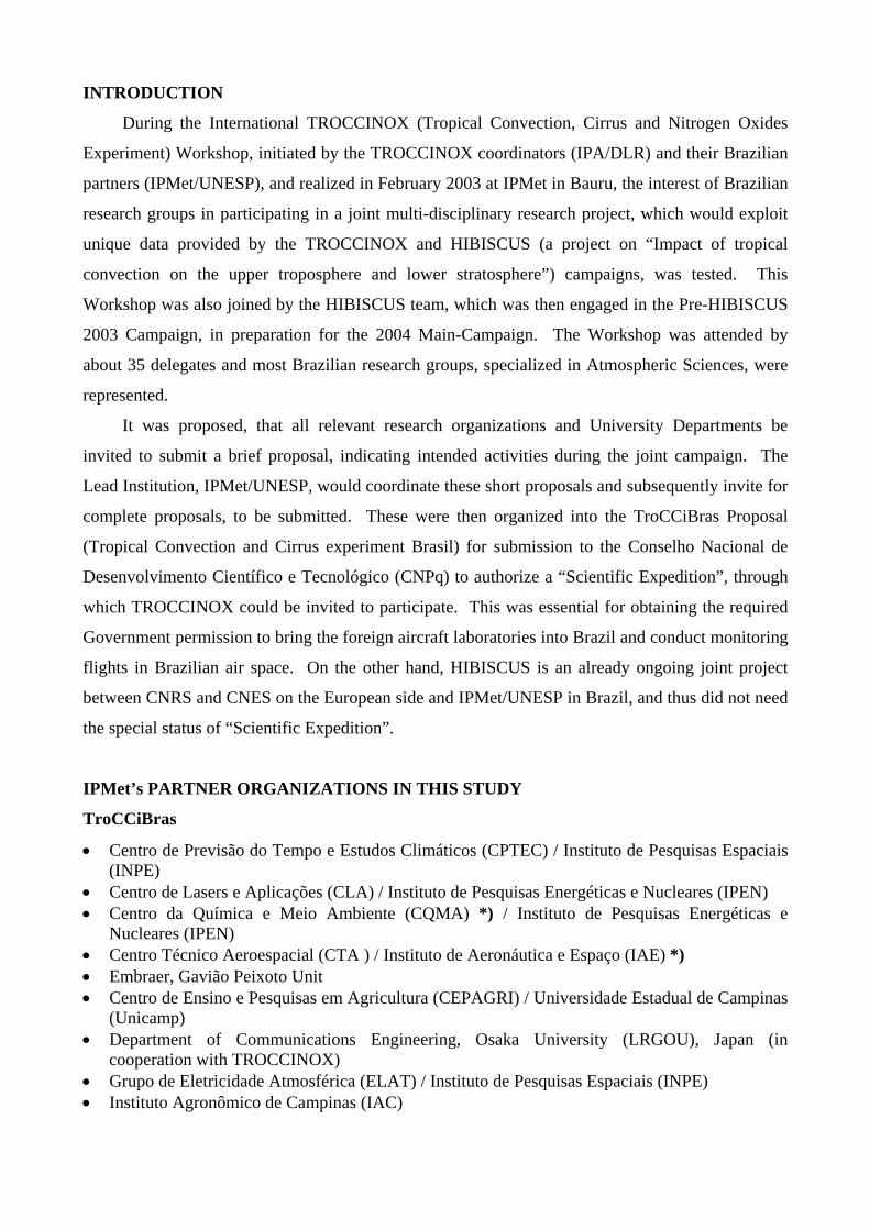
Abstract: The TroCCiBras (Tropical Convection and Cirrus experiment Brasil) campaign was conducted jointly with the European HIBISCUS and TROCCINOX projects from 21 January to 11 March 2004. The general objective of TroCCiBras, coordinated by IPMet/UNESP, is to obtain a set of special measurements throughout the troposphere and the lower stratosphere, to meet specific research needs of Brazilian research institutions, through the realization of the EU projects. Besides IPMet, six other Brazilian research institutions, as well as the German Max Planck Institute for Chemistry, participated actively in the field campaign. A unique data base has been established, which is of outstanding value for scientists in the State of São Paulo and Brazil. The most important preliminary findings are: vertical profiles of water vapor are absolutely essential for the validation of satellite-borne monitors; satellite-borne ozone monitors have been found to be relatively inaccurate, highlighting the importance of in-situ measurements by stratospheric balloons and high-flying aircraft (≥20km altitude); preliminary results indicate, that the production of NO by lightning discharges in the tropics could have been underestimated. Key Words: TroCCiBras, State of São Paulo, radar observations, radiosoundings, lidar, aircraft measurements, trace gases, aerosols, lightning, automatic weather stations, Meso-Eta model, TROCCINOX, HIBISCUS, water vapor, satellite validation, ozone, NOx, Tropical Tropopause Layer. Resumo: As atividades da campanha do projeto TroCCiBras (Tropical Convection and Cirrus experiment Brasil) foram realizadas em conjunto com os experimentos de campo dos projetos europeus HIBISCUS e TROCCINOX no período de 21 de janeiro a 11 de março de 2004. O objetivo geral do projeto TroCCiBras, coordenado pelo IPMet/UNESP, é a obtenção de um conjunto de medidas especiais através da troposfera e baixa estratosfera, para necessidades específicas de instituições de pesquisas brasileiras, através da realização de projetos com a União Européia. Além do IPMet , outras seis instituições de pesquisas brasileiras, assim como o Instituto Max Planck de Química da Alemanha, participaram ativamente da campanha de coleta de dados. Uma base de dados única foi adquirida, de inestimável valor para cientistas do Estado de São Paulo e do Brasil. Os resultados preliminares mais importantes são: perfis verticais de vapor d´água são absolutamente essenciais para validação de plataformas embarcadas em satélite; as informações de monitores de ozônio embarcados em satélite são de baixa acurácia, evidenciando a importância de medidas in-situ através de balões estratosféricos e aeronaves voando a altitudes ≥20km; resultados ainda preliminares indicam, que a produção de NO por descargas elétricas nos trópicos pode estar sendo subestimada. Palavras Chave: TroCCiBras, Estado de São Paulo, observações de radar, radiossondagen, lidar, medidas de aeronave, gases traço, aerossóis, descargas elétricas, estações automáticas de superfície, modelo Meso-Eta, TROCCINOX, HIBISCUS, vapor d´água, validação de satélite, ozônio, NOx, Camada de Tropopausa Tropical (TTL). _______________________________ 1 Instituto de Pesquisas Meteorológicas – Universidade Estadual Paulista – IPMet/UNESP CxP. 281 – CEP 17001-970, Bauru/S.P.; Tel: (14) 3103-6030; Fax: (14) 3203-3649 *E-mail: [email protected] 2 Service d’Aéronomie - Centre National de la Recherche Scientifique - SA/CNRS
INTRODUCTION
During the International TROCCINOX (Tropical Convection, Cirrus and Nitrogen Oxides
Experiment) Workshop, initiated by the TROCCINOX coordinators (IPA/DLR) and their Brazilian
partners (IPMet/UNESP), and realized in February 2003 at IPMet in Bauru, the interest of Brazilian
research groups in participating in a joint multi-disciplinary research project, which would exploit
unique data provided by the TROCCINOX and HIBISCUS (a project on “Impact of tropical
convection on the upper troposphere and lower stratosphere”) campaigns, was tested. This
Workshop was also joined by the HIBISCUS team, which was then engaged in the Pre-HIBISCUS
2003 Campaign, in preparation for the 2004 Main-Campaign. The Workshop was attended by
about 35 delegates and most Brazilian research groups, specialized in Atmospheric Sciences, were
represented.
It was proposed, that all relevant research organizations and University Departments be
invited to submit a brief proposal, indicating intended activities during the joint campaign. The
Lead Institution, IPMet/UNESP, would coordinate these short proposals and subsequently invite for
complete proposals, to be submitted. These were then organized into the TroCCiBras Proposal
(Tropical Convection and Cirrus experiment Brasil) for submission to the Conselho Nacional de
Desenvolvimento Científico e Tecnológico (CNPq) to authorize a “Scientific Expedition”, through
which TROCCINOX could be invited to participate. This was essential for obtaining the required
Government permission to bring the foreign aircraft laboratories into Brazil and conduct monitoring
flights in Brazilian air space. On the other hand, HIBISCUS is an already ongoing joint project
between CNRS and CNES on the European side and IPMet/UNESP in Brazil, and thus did not need
the special status of “Scientific Expedition”.
IPMet’s PARTNER ORGANIZATIONS IN THIS STUDY
TroCCiBras
• Centro de Previsão do Tempo e Estudos Climáticos (CPTEC) / Instituto de Pesquisas Espaciais (INPE)
• Centro de Lasers e Aplicações (CLA) / Instituto de Pesquisas Energéticas e Nucleares (IPEN) • Centro da Química e Meio Ambiente (CQMA) *) / Instituto de Pesquisas Energéticas e
Nucleares (IPEN) • Centro Técnico Aeroespacial (CTA ) / Instituto de Aeronáutica e Espaço (IAE) *) • Embraer, Gavião Peixoto Unit • Centro de Ensino e Pesquisas em Agricultura (CEPAGRI) / Universidade Estadual de Campinas
(Unicamp) • Department of Communications Engineering, Osaka University (LRGOU), Japan (in
cooperation with TROCCINOX) • Grupo de Eletricidade Atmosférica (ELAT) / Instituto de Pesquisas Espaciais (INPE) • Instituto Agronômico de Campinas (IAC)
• Instituto de Astronomia, Geofisica e Ciências Atmosféricas (IAG) / Universidade de São Paulo (USP)
• Instituto de Física (IF) / Universidade de São Paulo (USP) in collaboration with the Max Planck Institute for Chemistry, Mainz, Germany
• Instituto Nacional de Meteorologia (INMET) • Universidade Estadual do Ceará (UECE) *) *) These Institutions could not participate in the 2004 field experiment due to a lack of funds
(funding for the Brazilian participants in TroCCiBras had been requested from FAPESP, but was
not available).
Partner Organizations: TROCCINOX Field Campaign 2004
The lead organization for TROCCINOX is the “Institut für Physik der Atmospäre” (IPA) of
the “Deutsches Zentrum für Luft- und Raumfahrt” (DLR). The following partner organizations
participated in the past field campaign:
• Eidgenössische Technische Hochschule Zürich, Switzerland • Université Paul Sabatier / Laboratoire d’Aérologie, Toulouse, France
An additional 15 partner organizations from Russia, Germany, Italy, United Kingdom, Switzerland
and France did not actively participate in the 2004 field experiment in Brazil, mostly due to the
Russian aircraft Geophysica not being able to arrive on time. The complete list of partner
organizations can be found at the TROCCINOX Website - http://www.pa.op.dlr.de/troccinox/
Partner Organizations: HIBISCUS
The scientific lead organization for HIBISCUS is the Service d’Aéronomie of the Centre
National de la Recherche Scientifique (SA-CNRS), in close collaboration with the Centre National
d'Études Spatiales, Toulouse (CNES), which is responsible for the stratospheric balloons. Other
scientific partners, all of which participated in the 2004 campaign, are:
• Laboratoire de météorologie dynamique (LMD-CNRS), France • University of Cambridge, Department of Chemistry (UCAM-DCHEM), United Kingdom • National Physical Laboratory (NPL), United Kingdom • Danmarks Meteorologiske Institut (DMI), Danmark • Istituto di Scienze dell’Atmosfera e del Climat (ISAC-CNR), France • Laboratoire de Physique et Chimie de l'Environnement (LPCE), France • University of Manchester, Institute of Science and Technology (UMIST), United Kingdom • Norsk Institutt for Luftforskning (NILU), Norway • Ente per le Nuove tecnologie, l'Energia e l'Ambiente (ENEA), Italy • Laboratoire de météorologie physique, Clermont Ferrand (LAMP), France • Laboratoire de physique atmosphérique (LPA), La Reunion • Laboratoire d'aérologie / Université Paul Sabatier (LA/UPS), France • Laboratoire d'astrodynamique, d'astrophysique et d'aéronomie de Bordeaux (L3AB), France • Centre d’etude de l’Environnement Terrestre et Planetaires (CNRS-CETP), France
OBJECTIVES
The general objective of the TroCCiBras project is thus to obtain a set of special
measurements throughout the troposphere and the lower stratosphere, to meet specific research
needs of Brazilian research institutions, through the realization of the EU project TROCCINOX and
the joint Brazilian / European project HIBISCUS in Brazil.
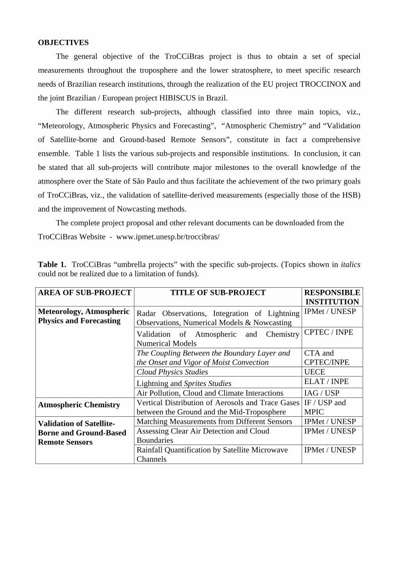
The different research sub-projects, although classified into three main topics, viz.,
“Meteorology, Atmospheric Physics and Forecasting”, “Atmospheric Chemistry” and “Validation
of Satellite-borne and Ground-based Remote Sensors”, constitute in fact a comprehensive
ensemble. Table 1 lists the various sub-projects and responsible institutions. In conclusion, it can
be stated that all sub-projects will contribute major milestones to the overall knowledge of the
atmosphere over the State of São Paulo and thus facilitate the achievement of the two primary goals
of TroCCiBras, viz., the validation of satellite-derived measurements (especially those of the HSB)
and the improvement of Nowcasting methods.
The complete project proposal and other relevant documents can be downloaded from the
TroCCiBras Website - www.ipmet.unesp.br/troccibras/
Table 1. TroCCiBras “umbrella projects” with the specific sub-projects. (Topics shown in italics could not be realized due to a limitation of funds). AREA OF SUB-PROJECT TITLE OF SUB-PROJECT RESPONSIBLE
INSTITUTIONRadar Observations, Integration of Lightning Observations, Numerical Models & Nowcasting
IPMet / UNESP
Validation of Atmospheric and Chemistry Numerical Models
CPTEC / INPE
The Coupling Between the Boundary Layer and the Onset and Vigor of Moist Convection
CTA and CPTEC/INPE
Cloud Physics Studies UECE Lightning and Sprites Studies ELAT / INPE
Meteorology, Atmospheric Physics and Forecasting
Air Pollution, Cloud and Climate Interactions IAG / USP Atmospheric Chemistry Vertical Distribution of Aerosols and Trace Gases
between the Ground and the Mid-Troposphere IF / USP and MPIC
Matching Measurements from Different Sensors IPMet / UNESP Assessing Clear Air Detection and Cloud Boundaries
IPMet / UNESP Validation of Satellite-Borne and Ground-Based Remote Sensors
Rainfall Quantification by Satellite Microwave Channels
IPMet / UNESP
The main objectives of TROCCINOX, which is an RTD Program of the European
Community, can be summarized as follows:
• To improve the knowledge about lightning-produced NOx (LNOx) in tropical thunderstorms by quantifying the produced amounts, by comparing it to other major sources of NOx and by assessing its global impact, and
• to improve the current knowledge on the occurrence of other trace gases (including water vapor and halogens) and particles (ice crystals and aerosols) in the upper troposphere and lower stratosphere in connection with tropical deep convection, as well as large-scale upwelling motions.
Thus, the project TROCCINOX will perform first measurements of the combined properties
of convection, aerosol and cirrus particles and chemical air composition (nitrogen oxides in
particular) in the tropics over oceanic and continental regions (State of São Paulo and adjoining
areas) in the upper troposphere and lower stratosphere, including troposphere-stratosphere
exchange. Bauru was identified as the ideal base point, due to its proximity to observed high
lightning frequencies over the South American continent. A modeling component aims in
providing improved descriptions of processes relevant to global climate problems. Details about the
TROCCINOX project can be found at the following Website -
http://www.pa.op.dlr.de/troccinox/
The general objective of the HIBISCUS project, which is also an RTD Program of the
European Community, is to investigate the impact of tropical convection on the upper troposphere
and lower stratosphere at local and global scale. Thus, more specific objectives of the HIBISCUS
project can be summarized as follows:
• Past and present meteorological analyses • Vertical and horizontal transport • Clouds and microphysics
• Source of stratospheric water vapor • Chemistry, impact of lightning and pollution • Satellite validation (ENVISAT, SAGE-III)
Further specific objectives will characterize the impact of convection on the tropical upper
troposphere and lower stratosphere, the transport pattern, radiation, micro-physics and atmospheric
chemistry. Details about the HIBISCUS project can be found at the following Website -
http://www.aero.jussieu.fr/projet/HIBISCUS/
TroCCiBras DATA BASE
The campaign period extended from 21 January to 11 March 2004, and all data that have been
collected under the TroCCiBras project have been assembled in a special, PassWord-protected, data
base to which all participating organizations and researchers have access via FTP. This data base
contains the following information/data, but not necessarily all of them for the full period:
IPMet radars: Bauru + Presidente Prudente integrated surveillance PPI (450km); individually for
each radar a surveillance PPI (450km), 3.5km CAPPI (240km) of reflectivity (Z) and radial
velocities (v), as well as echo tops. These have been generated in GIF-format for ALL recorded
radar data.
Radiosoundings at IPMet: In total, 105 soundings were made (PTU), of which 93 also have wind
speed and direction; 3 ozone soundings and 8 DMI backscatter sondes were also flown. ASCII data
files, as well as graphs for each sounding, together with a detailed catalogue, are included.
Aerosol Lidar at IPMet: A total of 67 profiles were obtained, of which about 30% reached up to
18-36km. The diurnal variation was captured by profiling in the morning, afternoon and evening
(21, 20, 25 profiles each).
Bandeirante: All together 7 flights were made out of Gavião Peixoto (GPX) Embraer Airport on 5
days up to a height of 4,5km. The following monitors and samplers were installed on the aircraft:
temperature & humidity sensor, CO, CO2, H2O, NO, NO2, O3, SMPS particulates, Nephelometer,
Aethalometer (black carbon), OPC (Optical condensation Particle Counter), aerosol filter sampler.
Maps of the flight tracks, as well as the actual GPS data are available, but the raw data can only be
loaded after having been calibrated, etc.
Lightning data: The complete set of RINDAT flash records for the campaign period has been
transferred by ELAT; the 2- and 3-dimensional lightning observations from the LRGOU VHF
broadband interferometer network will only be available for a few cases from mid-February
onwards.
Surface Automatic Weather Stations (State of São Paulo): The complete set of 22 stations has been
transferred by IAC Campinas for the campaign period.
Radiosoundings from INMET/CPTEC network: ASCII files have been prepared for all available
stations south of 12ºS for the campaign period, with “Skew T – Log P” diagrams in GIF-format for
7 stations in and around the State of São Paulo.
Meso-Eta model output: Three-hourly outputs of all products (10x10km grid, centered on Bauru) up
to 48 hours are stored on the data base, but the complete runs up to 96 hours are available off-line.
TROCCINOX: The Falcon flew 14 missions out of GPX Embraer Airport on 13 days between 13
February and 10 March 2004. However, only flight tracks (maps) are stored in the TroCCiBras data
base, but project partners can access the TROCCINOX data base after signing the Data Protocol.
HIBISCUS: From 31 January until 11 March 2004, the following stratosphere balloons were
launched from IPMet: 6 short-duration ZL and SF, as well as 2 NILU cubes; 8 BP long-duration
and 3 MIR balloons. However, only tabulated flight information and payloads are stored in the
TroCCiBras data base, but project partners can access the HIBISCUS data base after signing the
respective Data Protocol.
FIRST RESULTS OF RELEVANCE FOR BRAZIL
Although the start of the campaign had been delayed by about two weeks due to
administrative problems around the TROCCINOX project (late publication of the Presidential
Decree on 30 December 2003; very late publication of the MCT Portaria on 27 January 2004 in the
Diário Oficial da União) and some good tropical thunderstorms had thus been missed, the month of
February, nevertheless provided ample opportunities for sampling with the Falcon and Bandeirante
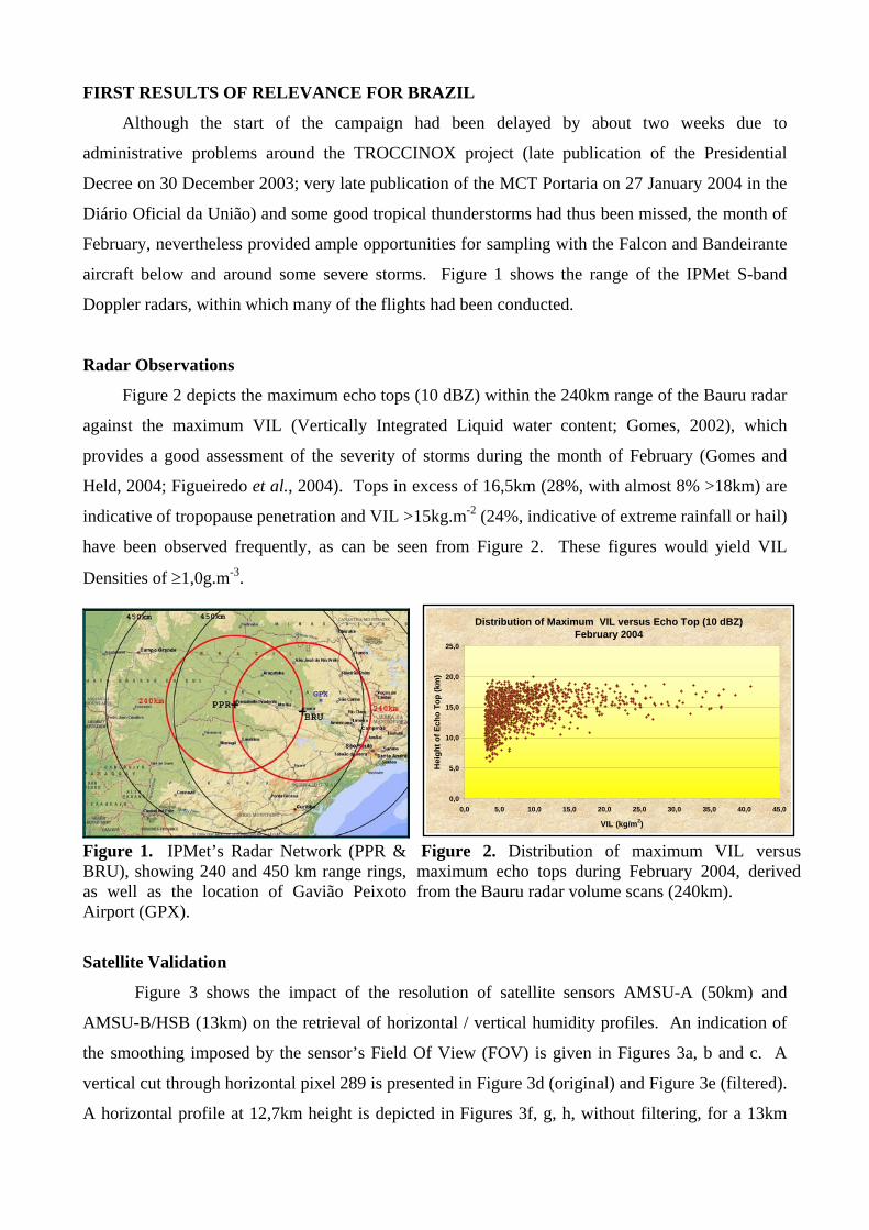
aircraft below and around some severe storms. Figure 1 shows the range of the IPMet S-band
Doppler radars, within which many of the flights had been conducted.
Radar Observations
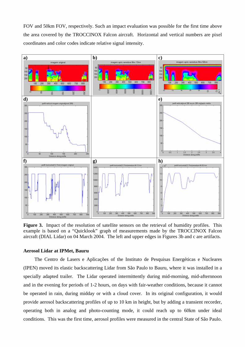
Figure 2 depicts the maximum echo tops (10 dBZ) within the 240km range of the Bauru radar
against the maximum VIL (Vertically Integrated Liquid water content; Gomes, 2002), which
provides a good assessment of the severity of storms during the month of February (Gomes and
Held, 2004; Figueiredo et al., 2004). Tops in excess of 16,5km (28%, with almost 8% >18km) are
indicative of tropopause penetration and VIL >15kg.m-2 (24%, indicative of extreme rainfall or hail)
have been observed frequently, as can be seen from Figure 2. These figures would yield VIL
Densities of ≥1,0g.m-3.
Figure 1. IPMet’s Radar Network (PPR & BRU), showing 240 and 450 km range rings, as well as the location of Gavião Peixoto Airport (GPX).
Figure 2. Distribution of maximum VIL versus maximum echo tops during February 2004, derived from the Bauru radar volume scans (240km).
Distribution of Maximum VIL versus Echo Top (10 dBZ) February 2004
0,0
5,0
10,0
15,0
20,0
25,0
0,0 5,0 10,0 15,0 20,0 25,0 30,0 35,0 40,0 45,0
VIL (kg/m2)
Hei
ght o
f Ech
o To
p (k
m)
Satellite Validation
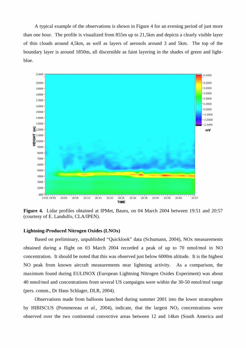
Figure 3 shows the impact of the resolution of satellite sensors AMSU-A (50km) and
AMSU-B/HSB (13km) on the retrieval of horizontal / vertical humidity profiles. An indication of
the smoothing imposed by the sensor’s Field Of View (FOV) is given in Figures 3a, b and c. A
vertical cut through horizontal pixel 289 is presented in Figure 3d (original) and Figure 3e (filtered).
A horizontal profile at 12,7km height is depicted in Figures 3f, g, h, without filtering, for a 13km
FOV and 50km FOV, respectively. Such an impact evaluation was possible for the first time above
the area covered by the TROCCINOX Falcon aircraft. Horizontal and vertical numbers are pixel
coordinates and color codes indicate relative signal intensity.
a)
b) c)
d)
e)
f)
g) h)
Figure 3. Impact of the resolution of satellite sensors on the retrieval of humidity profiles. This example is based on a “Quicklook” graph of measurements made by the TROCCINOX Falcon aircraft (DIAL Lidar) on 04 March 2004. The left and upper edges in Figures 3b and c are artifacts.
Aerosol Lidar at IPMet, Bauru
The Centro de Lasers e Aplicações of the Instituto de Pesquisas Energéticas e Nucleares
(IPEN) moved its elastic backscattering Lidar from São Paulo to Bauru, where it was installed in a
specially adapted trailer. The Lidar operated intermittently during mid-morning, mid-afternnoon
and in the evening for periods of 1-2 hours, on days with fair-weather conditions, because it cannot
be operated in rain, during midday or with a cloud cover. In its original configuration, it would
provide aerosol backscattering profiles of up to 10 km in height, but by adding a transient recorder,
operating both in analog and photo-counting mode, it could reach up to 60km under ideal
conditions. This was the first time, aerosol profiles were measured in the central State of São Paulo.
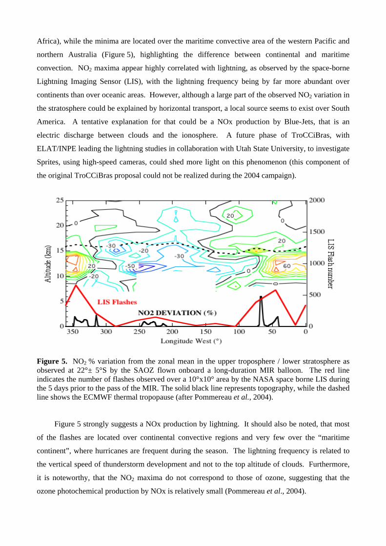
A typical example of the observations is shown in Figure 4 for an evening period of just more
than one hour. The profile is visualized from 855m up to 21,5km and depicts a clearly visible layer
of thin clouds around 4,5km, as well as layers of aerosols around 3 and 5km. The top of the
boundary layer is around 1850m, all discernible as faint layering in the shades of green and light-
blue.
Figure 4. Lidar profiles obtained at IPMet, Bauru, on 04 March 2004 between 19:51 and 20:57 (courtesy of E. Landulfo, CLA/IPEN).
Lightning-Produced Nitrogen Oxides (LNOx)
Based on preliminary, unpublished “Quicklook” data (Schumann, 2004), NOx measurements
obtained during a flight on 03 March 2004 recorded a peak of up to 70 nmol/mol in NO
concentration. It should be noted that this was observed just below 6000m altitude. It is the highest
NO peak from known aircraft measurements near lightning activity. As a comparison, the
maximum found during EULINOX (European Lightning Nitrogen Oxides Experiment) was about
40 nmol/mol and concentrations from several US campaigns were within the 30-50 nmol/mol range
(pers. comm., Dr Hans Schlager, DLR, 2004).
Observations made from balloons launched during summer 2001 into the lower stratosphere
by HIBISCUS (Pommereau et al., 2004), indicate, that the largest NO2 concentrations were
observed over the two continental convective areas between 12 and 14km (South America and
Africa), while the minima are located over the maritime convective area of the western Pacific and
northern Australia (Figure 5), highlighting the difference between continental and maritime
convection. NO2 maxima appear highly correlated with lightning, as observed by the space-borne
Lightning Imaging Sensor (LIS), with the lightning frequency being by far more abundant over
continents than over oceanic areas. However, although a large part of the observed NO2 variation in
the stratosphere could be explained by horizontal transport, a local source seems to exist over South
America. A tentative explanation for that could be a NOx production by Blue-Jets, that is an
electric discharge between clouds and the ionosphere. A future phase of TroCCiBras, with
ELAT/INPE leading the lightning studies in collaboration with Utah State University, to investigate
Sprites, using high-speed cameras, could shed more light on this phenomenon (this component of
the original TroCCiBras proposal could not be realized during the 2004 campaign).
Figure 5. NO2 % variation from the zonal mean in the upper troposphere / lower stratosphere as observed at 22°± 5°S by the SAOZ flown onboard a long-duration MIR balloon. The red line indicates the number of flashes observed over a 10°x10° area by the NASA space borne LIS during the 5 days prior to the pass of the MIR. The solid black line represents topography, while the dashed line shows the ECMWF thermal tropopause (after Pommereau et al., 2004). Figure 5 strongly suggests a NOx production by lightning. It should also be noted, that most
of the flashes are located over continental convective regions and very few over the “maritime
continent”, where hurricanes are frequent during the season. The lightning frequency is related to
the vertical speed of thunderstorm development and not to the top altitude of clouds. Furthermore,
it is noteworthy, that the NO2 maxima do not correspond to those of ozone, suggesting that the
ozone photochemical production by NOx is relatively small (Pommereau et al., 2004).
Preliminary results from HIBISCUS
As most results from the HIBISCUS 2004 campaign are not yet available, it seems appropriate
to refer to some of the major findings based on the Pre-HIBISCUS 2003 campaign, which will most
likely be confirmed, once all data from the last campaign have been analyzed.
In terms of vertical transport in the “Tropical Tropopause Layer” (TTL), it was found that
N2O and CFCs profiles measured in February 2003 by gas chromatography show very similar
concentrations above and below the tropopause, but a sharp drop-off around 19 km, not seen in the
3D model. This suggests that tropospheric air is lifted more rapidly than expected in the TTL, but in
contrast, far slower in the lower stratosphere. This finding could have significant implication for the
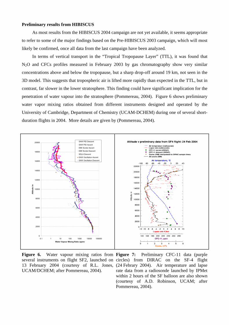
penetration of water vapour into the stratosphere (Pommereau, 2004). Figure 6 shows preliminary
water vapor mixing ratios obtained from different instruments designed and operated by the
University of Cambridge, Department of Chemistry (UCAM-DCHEM) during one of several short-
duration flights in 2004. More details are given by (Pommereau, 2004).
Figure 6. Water vapour mixing ratios from several instruments on flight SF2, launched on 13 February 2004 (courtesy of R.L. Jones, UCAM/DCHEM; after Pommereau, 2004).
Figure 7: Preliminary CFC-11 data (purple circles) from DIRAC on the SF-4 flight (24 Febrary 2004). Air temperature and lapse rate data from a radiosonde launched by IPMet within 2 hours of the SF balloon are also shown (courtesy of A.D. Robinson, UCAM; after Pommereau, 2004).
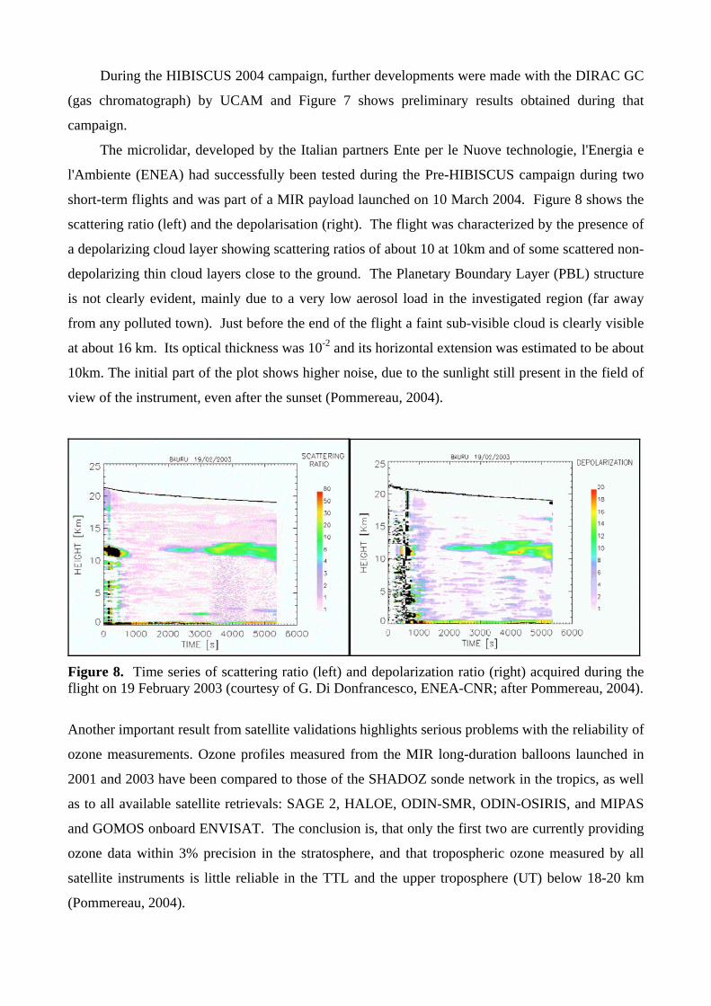
During the HIBISCUS 2004 campaign, further developments were made with the DIRAC GC
(gas chromatograph) by UCAM and Figure 7 shows preliminary results obtained during that
campaign.
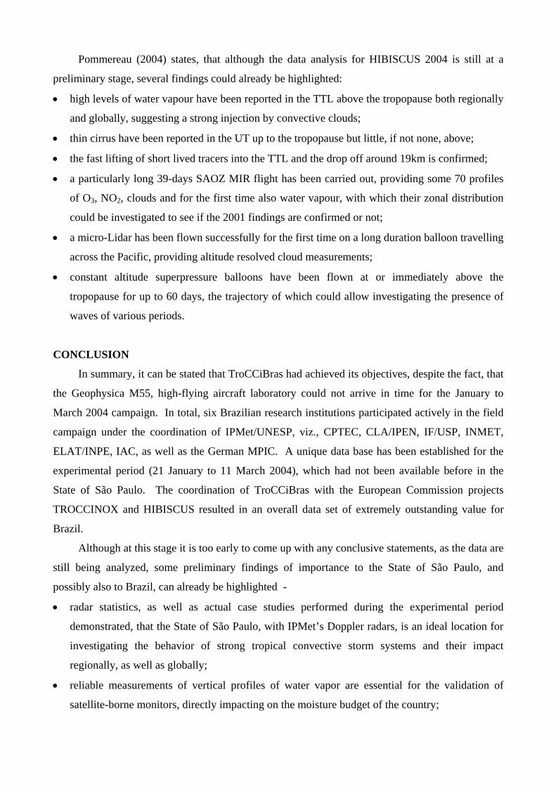
The microlidar, developed by the Italian partners Ente per le Nuove technologie, l'Energia e
l'Ambiente (ENEA) had successfully been tested during the Pre-HIBISCUS campaign during two
short-term flights and was part of a MIR payload launched on 10 March 2004. Figure 8 shows the
scattering ratio (left) and the depolarisation (right). The flight was characterized by the presence of
a depolarizing cloud layer showing scattering ratios of about 10 at 10km and of some scattered non-
depolarizing thin cloud layers close to the ground. The Planetary Boundary Layer (PBL) structure
is not clearly evident, mainly due to a very low aerosol load in the investigated region (far away
from any polluted town). Just before the end of the flight a faint sub-visible cloud is clearly visible
at about 16 km. Its optical thickness was 10-2 and its horizontal extension was estimated to be about
10km. The initial part of the plot shows higher noise, due to the sunlight still present in the field of
view of the instrument, even after the sunset (Pommereau, 2004).
Figure 8. Time series of scattering ratio (left) and depolarization ratio (right) acquired during the flight on 19 February 2003 (courtesy of G. Di Donfrancesco, ENEA-CNR; after Pommereau, 2004).
Another important result from satellite validations highlights serious problems with the reliability of
ozone measurements. Ozone profiles measured from the MIR long-duration balloons launched in
2001 and 2003 have been compared to those of the SHADOZ sonde network in the tropics, as well
as to all available satellite retrievals: SAGE 2, HALOE, ODIN-SMR, ODIN-OSIRIS, and MIPAS
and GOMOS onboard ENVISAT. The conclusion is, that only the first two are currently providing
ozone data within 3% precision in the stratosphere, and that tropospheric ozone measured by all
satellite instruments is little reliable in the TTL and the upper troposphere (UT) below 18-20 km
(Pommereau, 2004).
Pommereau (2004) states, that although the data analysis for HIBISCUS 2004 is still at a
preliminary stage, several findings could already be highlighted:
• high levels of water vapour have been reported in the TTL above the tropopause both regionally
and globally, suggesting a strong injection by convective clouds;
• thin cirrus have been reported in the UT up to the tropopause but little, if not none, above;
• the fast lifting of short lived tracers into the TTL and the drop off around 19km is confirmed;
• a particularly long 39-days SAOZ MIR flight has been carried out, providing some 70 profiles
of O3, NO2, clouds and for the first time also water vapour, with which their zonal distribution
could be investigated to see if the 2001 findings are confirmed or not;
• a micro-Lidar has been flown successfully for the first time on a long duration balloon travelling
across the Pacific, providing altitude resolved cloud measurements;
• constant altitude superpressure balloons have been flown at or immediately above the
tropopause for up to 60 days, the trajectory of which could allow investigating the presence of
waves of various periods.
CONCLUSION
In summary, it can be stated that TroCCiBras had achieved its objectives, despite the fact, that
the Geophysica M55, high-flying aircraft laboratory could not arrive in time for the January to
March 2004 campaign. In total, six Brazilian research institutions participated actively in the field
campaign under the coordination of IPMet/UNESP, viz., CPTEC, CLA/IPEN, IF/USP, INMET,
ELAT/INPE, IAC, as well as the German MPIC. A unique data base has been established for the
experimental period (21 January to 11 March 2004), which had not been available before in the
State of São Paulo. The coordination of TroCCiBras with the European Commission projects
TROCCINOX and HIBISCUS resulted in an overall data set of extremely outstanding value for
Brazil.
Although at this stage it is too early to come up with any conclusive statements, as the data are
still being analyzed, some preliminary findings of importance to the State of São Paulo, and
possibly also to Brazil, can already be highlighted -
• radar statistics, as well as actual case studies performed during the experimental period
demonstrated, that the State of São Paulo, with IPMet’s Doppler radars, is an ideal location for
investigating the behavior of strong tropical convective storm systems and their impact
regionally, as well as globally;
• reliable measurements of vertical profiles of water vapor are essential for the validation of
satellite-borne monitors, directly impacting on the moisture budget of the country;
• satellite-borne ozone monitors have been found to be relatively inaccurate, highlighting the
importance of in-situ measurements by stratospheric balloons (HIBISCUS) and the high-flying
Geophysica aircraft (≥20km altitude) of TROCCINOX, to obtain accurate vertical profiles for
investigating the exchange of ozone and other trace gases and aerosols between the upper
troposphere and the stratosphere;
• the production of NO by lightning discharges in the tropics could have been underestimated,
based on some in-situ neasurements near thunderstorms. This would not only impact on
environmental policy issues in Brazil, but also changes the global perception of LNOx
contributions to the total NOx budget, especially when considered in view of the global
distribution of lightning discharges observed by satellite-borne systems (e.g., LIS) and other
global networks;
• it would be extremely beneficial to install an aerosol lidar and a regular radiosonde station (or at
least a vertical wind profiler with RASS capability, such as proposed for SIHESP) in Bauru, in
order to monitor various important parameters in the troposphere, which would directly benefit
the medium-term forecasting (modeling), as well as the nowcasting capabilities of IPMet, for
the benefit of the community in the State of São Paulo.
ACKNOWDLEDGEMENTS
UNESP and FUNDUNESP are thanked for their generous financial support to enable at least
the most important subprojects and activities of the TroCCiBras project to be executed jointly with
TROCCINOX and HIBISCUS during the experimental campaign, as initially proposed. CTA
provided invaluable logistic support for obtaining the necessary permissions from central
Government in connection with the temporary importation of foreign aircraft, while Embraer is
gratefully acknowledged for opening their facilities at Gavião Peixoto, to be used as a base for the
TroCCiBras and TROCCINOX aircraft, at no cost.
REFERENCES
FIGUEIREDO, J.C., A.M. GOMES, G. HELD, A.A. CORREIA, J.L. GOMES e R.S. PAZ, 2004:
Desempenho do modelo Meso-Eta durante os experimentos TroCCiBras, TROCCINOX e
HIBISCUS para a previsão de ventos e perfis verticais. Proceedings, XIII Congresso
Brasileiro de Meteorologia, (CD ROM), Fortaleza, 29 August – 3 September 2004, SBMET,
9pp.
GOMES, A.M., 2002: Utilização do parâmetro densidade de VIL no alerta de tempestades severas
na área central do Estado de São Paulo. Proceedings, XII Congresso Brasileiro de
Meteorologia, (CD ROM), Foz do Iguaçu, 4-9 August 2002, SBMET, pp 3149-3154.
GOMES, A.M. e G. HELD, 2004: Determinação e avaliação do parâmetro densidade VIL para
alerta de tempestades. Proceedings, XIII Congresso Brasileiro de Meteorologia, (CD ROM),
Fortaleza, 29 August – 3 September 2004, SBMET, 12pp.
POMMEREAU J.-P., 2004: Impact of tropical convection of the upper troposphere and lower
stratosphere at global scale (HIBISCUS, EVK2-2001-000111). Progress Report #2 (February
2003 – March 2004), CNRS, 65pp.
POMMEREAU, J.-P., A. GARNIER, F. BORCHI, M. NUNES-PINHARANDA, 2004: Ozone and
NO2 zonal distribution in the tropical UTLS from SAOZ circumnavigating MIR balloon
flights: relation to horizontal transport, convection and lightning, Proc. Quad. Ozone
symposium, Kos, June 2004.
SCHUMANN, U., 2004: Experiences from TROCCINOX in February/March 2004. Presentation
during the TROCCINOX Meeting on 18-19 March 2004, DLR, Oberpfaffenhofen, Germany.