Embed Size (px)
Citation preview

HIBISCUS / TroCCiBras / TROCCINOX Workshop
IPMet Auditorium, Bauru, S.P., Brazil 16-19 November 2004
PROCEEDINGS Editor: Gerhard Held

PROCEEDINGS OF
HIBISCUS / TroCCiBras / TROCCINOX Workshop: 16 – 19 November 2004
Instituto de Pesquisas Meteorológicas Universidade Estadual Paulista
Bauru, S.P., Brazil
CONTENTS Page
OBJECTIVES OF WORKSHOP
2PROGRAMME
3ABSTRACTS 7Overview Session of Projects: Campaign 2004 7Session 1. Climatology and observations during the 2004 Campaign 9Session 2: Lightning and NOx 12Session 3: Convection and vertical transport 15Session 4: Meso-scale chemical modelling, particularly on selected days 19Session 5: Water vapour, ozone and tracers in TTL 23Session 6: Cirrus clouds in TTL region 27
PRELIMINARY CONCLUSIONS AND RECOMMENDATIONS FOR FURTHER WORK BY THE WORKSHOP CHAIRMEN
29
LIST OF PARTICIPANTS
32
1

OBJECTIVES OF WORKSHOP
The primary objective of the HTT Workshop was to strengthen the collaboration between Brazilian and European partners in the interpretation of the results of the campaign and the writing of common publications. It focused on meso-scale aspects in the troposphere and the TTL combining small balloons, aircraft and ground-based (radar, radiosondes, lidar, lightning,…) observations and meso-scale modelling of transport, microphysics and chemistry of convective systems, 3D air mass trajectories etc. Stratospheric and global aspects will be treated later during a further workshop in Europe. The Workshop was attended by 35 key scientists, 16 from the European Union (France, United Kingdom, Italy, Germany, as well as from Switzerland) and 19 from Brazil. Overviews of the TroCCiBras, HIBISCUS and TROCCINOX Projects, relevant background studies from Brazil and preliminary results from the 2004 campaigns were summarized in 40 presentations.
Project Coordinators: Jean-Pierre Pommereau, Gerhard Held, Ulrich Schumann and Roberto Vicente Calheiros
2

3
HIBISCUS /TroCCiBras/TROCCINOX Workshop IPMet Auditorium, Bauru, Brazil, 16-19 November 2004
PROGRAMME
TUESDAY, 16 NOVEMBER 2004, 13: 00 Objectives of workshop (Dr Jean-Pierre Pommereau) Overview of IPMet’s International collaborative Projects during the 2004 Campaign Chairman: Prof. R.V. Calheiros Tropical Convection and Cirrus Experiment Brazil - Overview of TroCCiBras and First Results from the Campaign 2004 (Gerhard Held & R.V. Calheiros, Coordinators; J.-P. Pommereau, U. Schumann, A.M. Gomes) - 25min Overview: HIBISCUS (J.-P. Pommereau & A. Garnier, Coordinators) - 30min
• MIR, BP and satellites, the global view - Jean-Pierre Pommereau and A. Garnier • Small balloons and sondes, the local view - Anne Garnier and J.-P. Pommereau
TROCCINOX - Tropical Convection, Cirrus and Nitrogen Oxides Experiment, Overview (Ulrich Schumann, Coordinator) - 30min 14:30 Coffee 14:40 Session 1: Climatology and Observations during the 2004 Campaign Chairman: Dr Jean-Pierre Pommereau & Dr James Levine Synoptic conditions associated with the heavy rainfall episode in the beginning of 2000 over eastern São Paulo - Prakki Satyamurty and Mateus da Silva Teixeira, CPTEC/INPE Radar Climatology during the TroCCiBras Campaign - Ana Maria Gomes and Gerhard Held, IPMet/UNESP Climatology of Lightning in Brazil - Overview and Comparison to the Campaign Period - Kleber P. Naccarato, Osmar Pinto, ELAT / INPE, Gerhard Held, IPMet/UNESP (pres. GH) Trace Gas Measurements during TroCCiBras/TROCCINOX 2004 - Axel Thielmann, Michael Welling and Meinrat O. Andreae, MPIC (pres. GH) Results of Aerosol Measurements during the Bandeirante Flights - Paulo Artaxo, IF / USP (pres. GH) 16:20 Discussion 16:40 Session 2: Lightning and NOx Chairman: Dr Michel Pirre & Prof Pedro Leite da Silva First Results from Lightning Observations with Broadband Digital Interferometer during the TroCCiBras Campaign - Gerhard Held, IPMet/UNESP, Takeshi Morimoto and Zen Kawasaki, LRGOU Comparison of TRMM LIS and PR with ground based lightning and radar observations for the TROCCINOX/TroCCiBras/HIBISCUS field campaign - Thorsten Fehr, H. Höller, G. Held, O. Pinto Jr., Zen-Ichiro Kawasaki, IPA/DLR, IPMet/UNESP, ELAT/INPE & LRGOU (pres. US)
4
Lightning - NO2 Relationship from SAOZ MIR, Small Balloons and ground-Based Observations - Jean-Pierre Pommereau and F. Goutail, SA/CNRS Comparisons between Global Models and Measurements of Trace Gases during TROCCINOX - Heidi Huntrieser, C. Kurz, H. Schlager, U. Schumann, L. Bugliaro, IPA/DLR; M. Lawrence, L. Labrador, MPIC; E. Meijer, KNMI; and M. Schultz, MPI-Hamburg (pres. US) 18:00 Discussion WEDNESDAY, 17 NOVEMBER 2004, 09:00 09:00 Session 3: Convection and vertical transport Chairman: Dr Céline Mari & Dr Virginie Marecal A Preliminary Analysis of the Identification of Severe Thunderstorm Environments in Southern and Southeastern Brazil Utilizing Convective Parameters - Ernani de Lima Nascimento, Instituto Tecnológico SIMEPAR Experiments with Physics Ensemble Forecasting with the Meso Eta Model - Chou Sin Chan, Jorge Gomes and J Bustamante, CPTEC Evaluation of the Surface Wind Speed and Vertical Temperature Profile Predictions from the Meso-Eta Model during the TroCCiBras 2004 Campaign - José Carlos Figueiredo & Adelmo Antonio Correia, IPMet/UNESP, and Jorge Luís Gomes, CPTEC Objective Evaluation of the Meso-NH Simulations during the HIBISCUS - TROCCINOX - TroCCiBras 2004 Campaign Using Satellite Observations - Jean-Pierre Chaboureau, J.-P. Cammas, J. Duron, F. Gheusi, C. Mari, P. Mascart and J.-P. Pinty, Laboratoire d’Aerologie CRM (Cloud Resolving Model) Studies of Tropical Deep ConvectionOobserved during HIBISCUS 2004 - Daniel Grosvenor, T.W. Choularton & H. Coe, UMIST; G. Held, IPMet; A. Robinson, UCAM and J. Gomes, CPTEC 10:40 - 11:00 Coffee A Regional-Model "Climatology" of Vertical Mass and Water-vapor Transport for the HIBISCUS - TROCCINOX - TroCCiBras 2004 Campaign - François Gheusi, J.-P. Cammas, J.-P.Chaboureau, J. Duron, C. Mari, P. Mascart and J.-P. Pinty, Laboratoire d’Aerologie Trajectory Analysis using ECWMF data: Comparison to the measurement - Beiping P. Luo, D. Brunner, C. Schwierz, Thierry Corti, Thomas Peter, ETHZ The influence of convection on atmospheric variability in a Lagrangean perspective - Marcos Longo, Rodrigo Gevaerd, Saulo Ribeiro de Freitas, John Lin, Christoph Gerbig, Maria Assunção Faus da Silva Dias, Pedro Leite da Silva Dias, IAG/USP & CPTEC The relevance of spatial distribution of soil moisture field for mesoscale convective system simulation - Rodrigo Gevaerd, Marcos Longo, Saulo Ribeiro de Freitas, Maria Assunção Faus da Silva Dias, Pedro Leite da Silva Dias, IAG/USP & CPTEC 12:20 Lunch 14:00 Discussion of Session 3

5
15:00 Session 4: Meso-scale chemical modelling, particularly on selected days Chairman: Prof Ulrich Schumann & Dr Natalie Huret An overview of the current environmental modeling activities on CPTEC and its linkage with HIBISCUS / TROCCINOX experiment - Saulo Freitas and Karla Longo, CPTEC/INPE (pres. P Dias) Regional Modelling of Lightning NOx and Ozone: A Case Study during the Joint HIBISCUS-TROCCINOX-TROCCIBRAS 2004 Campaign - Celine Mari, P. Mascart, J.-P. Pinty, J.-P. Chaboureau, F. Gheusi, J.-P.Cammas, Laboratoire d’Aerologie; T. Fehr, H. Schlager, V.-H. Peuch, A. Roiger, M. Lichtenstein and P. Stock, IPA/DLR Application of the Meso-Eta Model to Predict a Flash-Flood in Bauru - Gerhard Held, IPMet/UNESP and Jorge Luis Gomes, CPTEC 16:00 - 16:15 Coffee Study of the Impact of the 8th of February 2001 Convective System on the UTLS Air Composition - Virginie Marécal, E. Riviere, CNRS-Orleans; G. Held, IPMet; S. Freitas, CPTEC; N. Larsen, DMI; and S.Cautenet, LAMP-Clermont Ferrand The town energy budget (TEB) – implementation in RAMS high resolution simulations of air pollution of a mega-city (Sao Paulo) - Edmilson Dias de Freitas & P.L. da S. Dias, IAG/USP CTM and Trajectory Studies of Transport to and from the TTL - James Levine, UCAM Um Estudo do Evento de Tempestade Local Ocorrida no Vale do Paraíba em fevereiro de 2002: Aspectos Observacionais e Numéricos utilizando o RAMS e o BRAMS - Wallace Figueiredo Menezes, Daniele Rodrigues Ornelas de Lima, UFRJ & P. L. da S. Dias, IAG/USP (pres. P Dias) 17:15 Discussion THURSDAY, 18 NOVEMBER 2004, 09:00 09:00 Session 5: Water vapour, ozone and tracers in TTL Chairman: Dr Rod Jones & Dr Anne Garnier Comparison of H2O-DIAL Water Vapour Observations with ECMWF analysis during TROCCINOX 2004 - H. Flentje, A. Amediek, A. Dörnbrack, G. Ehret, A. Fix, U. Schumann and M. Wirth, IPA/DLR (pres. US) Humidity Profiles Determined from Satellite Sensors and Lidar - Roberto V Calheiros & Roberto Machado, IPMet/UNESP; H. Flentje, IPA/DLR; and C.A.F. Thompson Leite, IP/UERJ In Situ Measurements of H2O, CH4 and CO2 in the Upper Troposphere and the TTL with the Micro-SDLA Balloon-Borne Diode Laser sensor - Georges Durry, N. Amarouche, A. Hauchecorne, N. Huret, M. Pirre and S. Freitas, SA/CNRS, INSU, LPCE/CNRS & CPTEC Measurements of Water Vapour Using the UCAM SAW Hygrometer Onboard the SF Flights during Hibiscus 2004 - Louise Eden, G.M. Hansford, R.A. Freshwater and R.L. Jones - UCAM Zonal distribution of ozone, water vapour in the tropical TTL and lower stratosphere from MIR-SAOZ measurements, comparison to ECMWF and satellite observations - J. P. Pommereau, SA/CNRS 10:40 - 11:00 Coffee

6
Modelling Interpretation of in Situ H2O, CH4 and CO2 Measured byµSDLA Balloon-borne Instrument (SF2 and SF4 flights) - Natalie Huret, G. Durry, S. Freitas, A. Hauchecorne, LPCE/CNRS, SA/CNRS & CPTEC Short Duration and Sonde Measurements of Ozone during Hibiscus 2004 - Graeme Hansford, R.A. Freshwater and R. L. Jones, UCAM UCAM Halocarbon Observations on SF Balloons during HIBISCUS (2003/2004) - Andrew D. Robinson, McIntyre J.D., Gostlow B.G., Levine J., Harris N.R.P. and Pyle J.A., UCAM 12:00 Discussion 12:30 Lunch 14:00 Continue Discussion of Session 5 14:30 Session 6: Cirrus clouds in TTL region Chairman: Dr Anne Garnier & François Gheusi Thin cirrus in the TTL over Bauru from Backscatter sonde measurements during Hibiscus - Niels Larsen, DMI (pres. J-PP) Cloud and Aerosol Detections by Balloon-borne Lidars and Backscattersondes: Results from Short- and Long-Duration flights - Guido Di Donfrancesco (ENEA-Clim), F. Cairo, C. Buontempo, M. Snels, L. Liberti,, F.Fierli (CNR-ISAC) - (45 min) Lidar Measurements with IPEN’s Aerosol Lidar during the TroCCiBras 2004 Campaign - Eduardo Landulfo, A.Z. Freitas, A. Papayannis and IPEN Students, CLA/IPEN & Nat.Techn.Univ.Athens 15:55 Discussion (including Proposal for S.P. Lidars) 16:30 Coffee 16:45 Wrap-up of Workshop Chairman: Jean-Pierre Pommereau FRIDAY, 19 NOVEMBER 2004, 09:00 09:00 Individual Group Discussions WORKSHOP COORDINATORS: Jean-Pierre Pommereau (HIBISCUS) Gerhard Held (TroCCiBras) Ulrich Schumann (TROCCINOX)

7
SESSION: OVERVIEW OF PROJECTS: CAMPAIGN 2004
TROPICAL CONVECTION AND CIRRUS EXPERIMENT BRASIL - Overview of TroCCiBras and First Results from the Campaign 2004
G. Held1, R.V. Calheiros1, J.-P. Pommereau2, U. Schumann3 and A.M. Gomes1
TroCCiBras, TROCCINOX and HIBISCUS Teams
1 Instituto de Pesquisas Meteorológicas, Universidade Estadual Paulista, Bauru S.P., Brazil 2 Service d’Aéronomie, Centre National de la Recherche Scientifique, Verrières le Buisson, France
3 Institut für Physik der Atmosphäre, Deutsches Zentrum für Luft- und Raumfahrt, Oberpfaffenhofen, Germany
The TroCCiBras (Tropical Convection and Cirrus experiment Brasil) campaign was conducted jointly with the European HIBISCUS and TROCCINOX projects from 21 January to 11 March 2004. The general objective of TroCCiBras, coordinated by IPMet/UNESP, is to obtain a set of special measurements throughout the troposphere and the lower stratosphere, to meet specific research needs of Brazilian research institutions, through the realization of the EU projects. Besides IPMet, six other Brazilian research institutions, as well as the German Max Planck Institute for Chemistry, participated actively in the field campaign. A unique data base has been established, which is of outstanding value for scientists in the State of São Paulo and Brazil. The most important preliminary findings are: thunderstorms during February 2004 had echo tops (10 dBZ) well above the climatological averages, with 28 % of volume scans exceeding 16.5 km and almost 8% >18km; however, the electrical activity of the convective systems was below average; the position of lightning discharges could be related to the three-dimensional radar structure of thunderstorms in the State of São Paulo for the first time; Lidar observations of aerosols and thin clouds were made in the interior of in the State of São Paulo for the first time; vertical profiles of water vapor are absolutely essential for the validation of satellite-borne monitors; satellite-borne ozone monitors have been found to be relatively inaccurate, highlighting the importance of in-situ measurements by stratospheric balloons and high-flying aircraft (≥20km altitude); preliminary results indicate, that the production of NO by lightning discharges in the tropics could have been underestimated.
OVERVIEW: HIBISCUS (1) MIR, BP and Satellites, the Global View
Jean-Pierre Pommereau and Anne Garnier
Service d’Aéronomie, CNRS, Verrières le Buisson, France
The objective of HIBISCUS is to study the impact of convection on the composition of the Upper Troposphere and Lower Stratosphere (UT-LS). The approach is twofold: process studies at local scale over Brazil and the global view on ozone, NOx, clouds and water vapour at global scale at tropical latitude. The last makes use of satellite observations from ENVISAT/GOMOS and ODIN, remote measurements from 25 to 7 km by solar occultation from IR Montgolfier long duration balloons, in-situ measurements on constant level super-pressure balloons at 18 and 19 km. Example of zonal distribution will be shown displaying the strong relationship between the chemical composition of the tropopause region and convection, as well as differences between maritime and continental convection. The objective is now to compare these results to global model simulations (ECMWF, REPROBUS, TOMCAT, LMDz) to see for example how well are understood the NOx production by lightning or the water vapour stratospheric fountain mechanism.

8
OVERVIEW: HIBISCUS (2) Small Balloons and Sondes, the Local View
Anne Garnier and Jean-Pierre Pommereau
Service d’Aéronomie, CNRS, Verrières le Buisson, France
Among processes in the TTL region, most interesting and little known are the uplifting of tropospheric chemical species (e.g. COVs) and aerosols, the volume of NOx produced by lightning, the injection of water vapour across the tropopause, and the formation of thin cirrus clouds, in association with convective storms. These processes have been investigated during HIBISCUS by a combination of small balloon flights carrying several complementary instruments together for a few hours across the upper troposphere and the lower stratosphere and simultaneous sonde ascents for clouds and ozone measurements. The measurements performed in a variety of meteorological situations are being compared to mesoscale chemical simulations models (LES clouds, RAMS, and Meso-NH) to explore how well are understood the mechanisms. The presentation will summarize the balloon and sonde flights, the meteorological conditions in which they were performed, the instruments flown and the resulting available data.
TROCCINOX - TROPICAL CONVECTION, CIRRUS AND NITROGEN OXIDES EXPERIMENT, OVERVIEW
Ulrich Schumann (TROCCINOX Coordinator)
DLR Institute of Atmospheric Physics, Germany
The EU project TROCCINOX (Tropical Convection, Cirrus, and Nitrogen Oxides Experiment), http://www.pa.op.dlr.de/troccinox/, is being performed in 2002-2005 in cooperation with the Brazilian project TROCCIBRAS and in coordination with the EU-project HIBISCUS. The project investigates the contributions of tropical continental deep convection to lightning-produced nitrogen oxides (NOx) and to other trace gases (including water vapour) and particles (ice crystal and aerosols). A first field campaign has been performed with the DLR Falcon aircraft during February and March 2004. Eight transfer flights between Oberpfaffenhofen (Germany) and Gaviao Peixoto (S. P. , Brazil) and 14 local flights have been performed. The aircraft was instrumented with in-situ sensors for NO, NOy, O3, CO, H2O, T, NO2 photolysis rate, and various aerosols. A differential absorption Lidar measures aerosol properties and H2O profiles above or below the aircraft (see Flentje et al., this workshop). Quality controlled data are available from the TROCCINOX data bank. Lightning induced NOx has been measured in or near tropical and subtropical thunderstorms at altitudes up to 12.5 km. In addition several model studies and studies with satellite data are being performed. Data are available for validation of ENVISAT (MIPAS and SCIAMACHY) and ICESAT (GLAS) observations. The in-situ data show high NO and CO background mixing ratios in the mid troposphere. In the anvil outflow of thunderstorms, spiky NO structures (maximum 65 nmol/mol) above background were observed. Some of the spikes were notably wide (order several 10 km) indicating outflow from a thunderstorm anvil, others were narrow (order 200 m) clearly originating from fresh lightning events. Model studies (see Huntrieser et al: this workshop) and some preliminary analysis indicate global lightning-NOx production rates between 2 and 9 Tg(N) yr-1. These are lower limit estimates because of missing data above 12.5 km altitude. A second field experiment is now being planned to be performed in Brazil between mid-January and end of February 2005 including measurements with the Falcon and the high-flying (up to 21 km altitude) Geophysica aircraft.

9
SESSION 1: CLIMATOLOGY AND OBSERVATIONS DURING THE 2004 CAMPAIGN
SYNOPTIC CONDITIONS ASSOCIATED WITH THE HEAVY RAINFALL EPISODE IN THE BEGINNING OF 2000
OVER EASTERN SÃO PAULO
Prakki Satyamurty and Mateus da Silva Teixeira
Center for Weather Forecasts and Climate Studies (CPTEC), National Institute for Space Research (INPE), São José dos Campos, SP, Brazil
The heavy rainfall episode in the beginning of the year 2000 was responsible for more than 20 deaths and heavy damages to the property in northeastern São Paulo state and adjoining Minas Gerais and Rio de Janeiro states. A continental thermal low with sea-level pressure falling to below 1005 hPa and equivalent potential temperatures at 850 hPa rising to 345°K developed over Mato Grosso do Sul, Paraná and São Paulo states and adjoining regions. The low-level jet attained values greater than 15 m s-1 over MG, the nucleus of strong winds moved from western MG state to the Atlantic during the period. The convergence of humidity was very high during the period, rising from 0.3x10⁻⁷ s-1 on 30 Dec 1999 to almost 2.0x10⁻⁷ s-1 on 02 Jan 2000 and remaining high through 06 Jan over Southeast Brazil. The satellite imagery showed a cold frontal cloud band approaching from northern Argentina on 30 Dec, and later there is no appreciable frontal boundary (in terms of lower tropospheric temperatures) during the period. Thus the thermal advections did not play any role in the development of the event. The divergence at 250 hPa level rose to 16x10-6 s-1 over Minas Gerais on 01 Jan. An upper level cyclonic vortex over the South Atlantic adjoining Northeast Brazil restricted the convective cloud band to northern São Paulo, southern Minas Gerais and Rio de Janeiro states. The evolution described is useful for guiding the operational meteorologists of the region.
RADAR CLIMATOLOGY DURING THE TroCCiBras CAMPAIGN
Ana Maria Gomes and Gerhard Held
Instituto de Pesquisas Meteorológicas, Universidade Estadual Paulista, Bauru, S.P., Brazil
As a result of the campaign having been delayed by about two weeks due to administrative problems around the TROCCINOX project, some good tropical thunderstorms had thus been missed by the aircraft operations. Nevertheless, the month of February provided ample opportunities for sampling with the Falcon and Bandeirante aircraft below and around some relatively severe storms within the range of the IPMet S-band Doppler radars, within which many, but not all of the flights had been conducted. The maximum echo tops (10 dBZ) within the 240km range of the Bauru radar will be presented against the maximum VIL (Vertically Integrated Liquid water content), which provides a good assessment of the severity of storms during the month of February. Tops in excess of 16,5km were observed in 28% of the volume scans, with almost 8% >18km, which is considerably more than the 10-year average of 17 % > 15 km and indicative of frequent tropopause penetration (± 16 km). VIL of >15kg.m-2 was observed in 24% of the volume scans, indicative of extreme rainfall or hail. These figures would yield VIL Densities of ≥1,0g.m-3. For comparison, during the 10-year period of 1993 – 2002, 78% of the storms had VIL varying between 5.0 and 21 kg.m-2, with 12% > 21 kg.m-2. It should be noted, that VIL Densities in 2004 were below average of 25% being between 1.0 and 1.8 g.m-3 and 7% between 1.8 and 2.6 g.m-3, being indicative of extremely severe storms.

10
The analysis of the storm climatology in the State of São Paulo is still in progress and up-to-date results will be presented during the Workshop, depending on the successful implementation of certain modules in the TITAN Program suite, provided by NCAR in September/October 2004.
LIGHTNING CLIMATOLOGY IN THE STATE OF SÃO PAULO IN COMPARISON TO THE TroCCiBras EXPERIMENTAL PERIOD
IN 2004
Kleber P. Naccarato1, Osmar Pinto Jr.1 and Gerhard Held2
1 Grupo de Eletricidade Atmosférica, Instituto de Pesquisas Espaciais, São José dos Campos, S.P., Brazil
2 Instituto de Pesquisas Meteorológicas, Universidade Estadual Paulista, Bauru S.P., Brazil The average lightning frequency within the surveillance range of IPMet’s S-band Doppler radar in Bauru (450 km radius), the most important parameters of flash characteristics, as well as the cloud-to-ground (CG) flash density have been determined for the period from 1999 to 2003. These results are then compared to the TroCCiBras experimental period, which formally extended from 21 January to 11 March 2004. However, for the purpose of this study, data in blocks of individual calendar months, viz., January, February and March, had been extracted from the RINDAT Data Base and the respective means calculated, in order to characterize the experimental period. Furthermore, it is important to note that the extracted data were not yet corrected for the detection efficiency of the RINDAT network within the area of interest. The ground flash density (GFD) values are given in flashes per km2 per year, with a map resolution of 4x4 km. Based on other studies, it can be assumed, that the 5-year means from 1999 – 2003 are representative of the lightning climatology in the State of São Paulo, showing a pronounced maximum over the Metropolitan Region of São Paulo (MRSP) during all three months, as well as “hot-spots” of varying intensities in the Paraiba Valley (mostly São José dos Campos). During 2004, the lightning activity within the 450 km range of Bauru was significantly below the 5-year average, viz., 37, 58 and 75 % of the means during January, February and March, respectively. The lower occurrence of CG flashes was more pronounced in the central and western part of the State of São Paulo, than over MRSP and the Paraiba Valley. It is noteworthy, that approximately 5% more positive flashes were recorded during January to March 2004, but with slightly lower Mean Positive Peak Current (except February, when it was marginally higher), while the Mean Negative Peak Current was > 10% below the means. The Mean Negative Multiplicity was about 10 % above the mean values. The exact implications of these findings are still being studied.
11
TRACE GAS MEASUREMENTS DURING TroCCiBras / TROCCINOX 2004
Axel Thielmann, Michael Welling and Meinrat O. Andreae
Max Planck Institute for Chemistry, Biogeochemistry Dept. [email protected]
In order to extend the trace gas measurements of the DLR Falcon down to the boundary layer and lower troposphere, the INPE Bandeirante was deployed with a suite of trace gas instruments (NO + NO2, O3, CO, H2O and CO2). This extension allows to get complete profiles from just above ground up to 12 km height. With respect to NOx, budgets for single convective systems will be derived in view of the NO produced by lightning. Additionally, we will quantify the NOx enhancement in the boundary layer due to large scale convection (NO preduced by lightning and subsequent downward transport). Furthermore, the suite of trace gases measured allows to assess the amount of boundary layer air uplifted and those of free tropospheric air transported downwards. We find that the boundary layer air in the region is quite clean, showing neither signatures from major anthropogenic sources nor evidence for NOx enhancement by convective activity. This is ascribed to a combination of circumstances: the small scale of the systems encountered, weak downdrafts and efficient mixing during convection. For the oncoming campaign TROCCINOX II, it is intended to track a medium scale system and to fly around it in a spiral. This spiral is to be flown from 0-3km by the Bandeirante, from 3-12km by the Falcon and from 12-20km by the Geophysica. We look forward to the campaign!
AEROSOL MEASUREMENTS WITH THE INPE BANDEIRANTE DURING THE TroCCiBras / TROCCINOX EXPERIMENT 2004
Paulo Artaxo, Luciene Lara, Gilberto Nishioka and Alcides C. Ribeiro
Instituto de Física, Universidade de São Paulo, Rua do Matão, Travessa R, 187, CEP05508-900, São Paulo, S.P., Brazil. [email protected]
CENA/USP, Lab. de Ecologia Isotópica, Av. Centenário 303, Piracicaba, SP, 13416-000, Brasil During the TroCCiBRas sampling campaign, the INPE Bandeirante was instrumented for aerosol measurements. Aerosol light scattering was measured with an TSI Nephelometer TSI 3563, aerosol light absorption was measured with a 7 wavelengths aethalometer, from Magee Scientific. PM10 was measured with an DATARAM instrument, while aerosol size distribution was measured with an TSI SMPS 3080 coupled with a CPC TSI 3010. Concentration of larger particles were observed with an Optical particle counter OPC Lasair II. Very low aerosol concentrations were observed, in the range of 5 to 10 µg/m³. Ozone also shows low values at about 15 ppb from 500 to 4000 meters altitude. Aerosol light scattering was in the range 10-15 Mm-1, also a very low value. We observed sporadic high concentrations, up to 40 ppb of ozone for some flights, and these could be related to long-range air mass transport. A flight from Gavião Peixoto to São José dos Campos, passing over the urban area of São Paulo shows ozone values of around 60 ppb, and PM10 around 100 µg/m³, indicating the large impact of emissions from the metropolitan area of São Paulo.

12
SESSION 2: LIGHTNING AND NOx
FIRST RESULTS FROM LIGHTNING OBSERVATIONS WITH BROADBAND DIGITAL INTERFEROMETER DURING THE
TROCCIBRAS CAMPAIGN
Gerhard Held1, Takeshi Morimoto2 and Zen Kawasaki2
1 Instituto de Pesquisas Meteorológicas, Universidade Estadual Paulista, Bauru, S.P., Brazil 2 Department of Communication Engineering, Graduate School of Engineering, Osaka University, Japan The Lightning Research Group of Osaka University (LRGOU) got on board of the TroCCiBras / TROCCINOX campaign at a late stage, but still managed to install 2 sets of receivers within close range of IPMet’s Bauru S-band Doppler radar, viz. at Usina São José (USJ) near Macatuba, and on top of the Informatics building of UNIP, just south of the Bauru radar. The baseline between the two stations is about 26 km from west-north-west to east-south-east. These sites had been in operation from 13 February 2004 until mid-May 2004, after which thunderstorms occur only infrequently in the State of São Paulo. The LRGOU has been developing a VHF Broadband Digital Interferometer (DITF) to image precise lightning channels and to monitor lightning activity widely. The main feature of broadband DITF is its bandwidth (from 20MHz to 100MHz) and implicit redundancy for estimating VHF source locations. Based on phase differences for all Fourier components of a broadband EM signal, captured by two properly separated antennas, the incident angle of the EM signal against the baseline can be estimated. In other words, to obtain one VHF source location, a few tens Fourier components contribute, and this “implicit redundancy” is the noticeable superiority to any other source location technique. According to initial observations and numerical calculations, the accuracy of 0.01 radians may be feasible. Since it is known that VHF impulses are mainly radiated from the tip of the breakdown-like stepped leader, the VHF impulse source location is equivalent to imaging the lightning channel development, even within a thunderstorm. A single system can detect EM waves radiated from lightning discharges at few kilometers distant from the station. The exact distance is unknown, because it depends on the environment, influence from radio noises, etc. From a one-system operation one can only get azimuth & elevation mapping of lightning channels. If an area is covered by two or more systems, then it can be used for 3-D imaging. Results from three single-station observations from site USJ, viz. cloud-to-ground (CG), as well as intra-cloud (IC) and cloud-to-cloud (CC) flashes, which were recorded on 20 February 2004 between 20:03.39 UT (17:03 LT) and 20:05.44 UT (17:05 LT), when scattered storms occurred, will be presented in relation to the radar echoes.

13
COMPARISON OF TRMM LIS AND PR WITH GROUND BASED LIGHTNING AND RADAR OBSERVATIONS FOR THE
TROCCINOX/TroCCiBras/HIBISCUS FIELD CAMPAIGN
Thorsten Fehr1, Hartmut Höller1, Gerhard Held2, Osmar Pinto3 and Zen-Ichiro Kawasaki4
1 Institut für Physik der Atmosphäre, Deutsches Zentrum für Luft- und Raumfahrt, Oberpfaffenhofen, Germany 2 Instituto de Pesquisas Meteorológicas, Universidade Estadual Paulista, Bauru, S.P., Brazil
3 Grupo de Eletricidade Atmosférica, Instituto de Pesquisas Espaciais, São José dos Campos, S.P., Brazil 4 Department of Communication Engineering, Graduate School of Engineering, Osaka University, Japan
The total lightning activity in storms, the fraction of cloud-to-ground (CG) flashes, as well as the dependence of the lightning activity with cloud properties will be addressed in this presentation. The total electrical activity for storms over southern Brazil as observed by the Lightning Imaging Sensor (LIS) on-board of the TRMM satellite is compared to the CG lightning measurements of the Brazilian Lightning Network (BLN) operated by INPE for the period of the TROCCINOX/TroCCiBras/HIBISCUS campaign. In addition, for the convective cells identified by LIS, the electrical activity is correlated with the measurements of the space-borne TRMM Precipitation Radar (PR) and the IPMet/UNESP weather radar located at Bauru, SP.
LIGHTNING - NO2 RELATIONSHIP FROM SAOZ MIR, SMALL BALLOONS AND GROUND-BASED OBSERVATIONS
J. P. Pommereau and F. Goutail
Service d’Aéronomie, CNRS, Verrières le Buisson, France An important objective of HIBISCUS is the evaluation of the volume of NOx, which could be produced by lightning in the upper troposphere and eventually by electric discharges between clouds and the ionosphere, still uncertain within a factor 100. This has been explored by nitrogen dioxide (NO2) measurements by UV-Vis spectrometry using ground-based and balloons borne SAOZ instruments which could be compared to flashes observed by the Lightning Imaging Sensor onboard TRMM and the TroCCiBras lightning networks. Experimental results include: NO2 tropospheric column measurements from the SAOZ instrument in operation at Bauru since 1995, displaying a strong NO2 variability highly correlated with lightning frequency during the Hibiscus campaign; profile measurements at sunset from small short duration balloons providing an indication of the altitude at which the NOx production occurs; and MIR long duration balloon profiles measurements around the world showing where the NOx emission is maximum. The measurements are being or will be used to adjust the parametrisation of NOx production by lightning in global (TOMCAT, LMDz) or mesoscale (RAMS, Meso-NH) models.

14
COMPARISON BETWEEN GLOBAL MODELS AND MEASUREMENTS OF TRACE GASES DURING TROCCINOX
H. Huntrieser1, C. Kurz1, H. Schlager1, U. Schumann1, L. Bugliaro1, M. Lawrence2,
L. Labrador2, E. Meijer3 and M. Schultz4
1 Institut für Physik der Atmosphäre, Deutsches Zentrum für Luft- und Raumfahrt (DLR), Oberpfaffenhofen, Weßling, Germany
2 Max-Planck Institute for Chemistry, Mainz, Germany 3 Royal Netherlands Meteorological Institute (KNMI), Atmospheric Composition Research, De Bilt, The Netherlands
4 Max-Planck Institute for Meteorology, Hamburg, Germany One of the main objectives of the TROCCINOX project is to quantify the amount of nitrogen oxides (NOx = NO+NO2) produced by lightning. This important nitrogen source in the upper troposphere is included in most regional and global models of atmospheric transport and chemistry. A frequently used value for lightning-produced NOx in the models is 5 TgN yr-1. The uncertainties are still large (1-20 TgN yr-1) and a more accurate quantification is needed since lightning-produced NOx has a strong impact on the production of ozone in the models. Most global lightning occurs in tropical continental regions and Brazil was selected as a representative tropical/subtropical region for the TROCCINOX measurements. From the first TROCCINOX field phase in February and March 2004 six Falcon flights were selected and compared to model results from four global models: ECHAM5/NUDGE/CHEM (from DLR), MATCH-MPIC (from MPI-Mainz), TM (from KNMI), and MOZART (from MPI-Hamburg). Measurements of NO, NOy, CO, and O3 were compared to model results along flight routes from 14, 17, 20 February and 3, 4, and 7 March 2004. Two of the flights were performed in a narrow box with radar coverage to investigate the outflow from active thunderstorms (14 February and 3 March). Most of the other flights were long-range cross sections or triangle patterns to investigate the contrast between air masses affected/unaffected by tropical convection. Different vertical distribution profiles and parameterizations of lightning-produced NOx based on (1) cloud-top height, (2) convective mass flux, or (3) convective precipitation were used in the models. The model-calculated flash densities over South America were compared to a OTD/LIS flash climatology.

15
SESSION 3: CONVECTION AND VERTICAL TRANSPORT
A PRELIMINARY ANALYSIS OF THE IDENTIFICATION OF SEVERE
THUNDERSTORM ENVIRONMENTS IN SOUTHERN AND SOUTHEASTERN BRAZIL UTILIZING CONVECTIVE PARAMETERS
Ernani de Lima Nascimento
Instituto Tecnológico SIMEPAR, Curitiba, PR, Brazil
Given that the occurrence of severe convective storms in southern and southeastern Brazil is not as rare as previously thought, there is an increasing need for the assessment of operational strategies aiming at the identification of atmospheric conditions conducive to severe weather in that part of the world, as a support for disaster mitigation. This article addresses an initiative in this context, where severe weather parameters, originally conceived for the mid-latitudes of North America, are evaluated for severe thunderstorm forecasting in southern and southeastern Brazil. Convective indices analyzed include storm-relative-helicity, bulk Richardson number shear, storm-relative winds at different levels, energy-helicity-index and supercell composite index, along with more classic parameters such as surface-based CAPE and the lifted-index. In this study, data from rawinsondes in southern and southeastern Brazil are used. For at least a few episodes during the short period studied, the severe weather indices did capture atmospheric conditions associated with the actual occurrence of strong to severe convective storms in the regions being considered. However, our preliminary analysis also suggests a relatively high false alarm ratio for the parameters examined. Despite the somewhat mixed (and not fully conclusive) results, our findings strongly encourage further study in this topic.
EXPERIMENTS WITH PHYSICS ENSEMBLE FORECASTING WITH THE MESO ETA MODEL
Sin Chan Chou, Jorge L. Gomes and Josiane F. Bustamante
Center for Weather Prediction and Climate Studies – CPTEC, National Institute for Space Research – INPE Cachoeira Paulista, SP, 12630-000, Brazil
Numerical experiment on short-range ensemble forecasting based on physics perturbation was carried out using the mesoscale Eta Model for a case study. It was a heavy rainfall event that hit the central part of State of São Paulo and accumulated over 80 mm on the 1200 UTC 15 February 2004, during the Troccibras field campaign. The mesoscale Eta Model was configured with 10 km horizontal resolution and 38 layers, in the hydrostatic mode. The domain covered was from about 15o S and 30o S and 57o W and 42o W. A set of forecasts from 48 hours and 72 hours were produced from different initial conditions. The 10-km Eta was nested into the 40-km Eta Operational Model. The latter was nested into the CPTEC GCM at T126L28 resolution. The boundary conditions were updated every 6 hours, in a one-way fashion. The Meso Eta used the Betts-Miller-Janjic convection parameterization scheme. The ensemble of forecasts was generated by perturbing the convective relaxation time and the deficit of saturation pressure that controls the moisture reference profile. The combination produced a set of about 15 short-range runs for the case study. Small spread can be noticed among the forecast members. The large scale pattern was well represented in the forecasts, however, all members showed an underestimate of the maximum rains and a small displacement of those rains. Evaluation of the forecasts against observations based on rmse and bias will be shown.
16
EVALUATION OF THE SURFACE WIND SPEED AND VERTICAL TEMPERATURE PROFILE PREDICTIONS FROM THE Meso-Eta
MODEL DURING THE TroCCiBras 2004 CAMPAIGN
José Carlos Figueiredo1, Adelmo Antonio Correia1 and Jorge Luis Gomes2
1 Instituto de Pesquisas Meteorológicas, Universidade Estadual Paulista, Bauru S.P., Brazil 2 Centro de Previsão do Tempo e Estudos Climáticos – CPTEC/INPE, Cachoeira Paulista, S.P.
The TroCCiBras Campaign was to commence about mid-January and finish by 20 February 2004. The Centro de Previsão do Tempo e Estudos Climáticos (CPTEC/INPE) participated during this period in the campaign by providing a variety of operational model forecasts to the project meteorologists at IPMet in Bauru (HIBISCUS) and at Gavião Peixoto Airport (TROCCINOX). A research component was added by centering the Meso-Eta model, in non-hydrostatic mode, with a resolution of 10x10 km, over the Bauru radar and run it with 3-hourly outputs. In order to assure proper functioning, the model runs were initially driven from CPTEC at Cachoeira Paulista until full coordination with IPMet could be assured. From early February, the graphics outputs were generated at IPMet, while various new modules, such as a Bauru radiosounding, were added. The goal of this paper is to analyze the performance of the Meso-Eta Model (non-hydrostatic mode, resolution 10x10 km), when centered over Bauru and covering slightly more than the State of São Paulo (domain 1300x840 km), during the field experiments of the TroCCiBras, HIBISCUS and TROCCINOX projects. The vertical temperature and humidity profiles, as well as the wind speed and velocity at 10m, generated by the model, have been analyzed and compared to the actual synoptic situations, radiosoundings launched at IPMet, as well as the observed wind speed at IPMet’s site. Accurate prediction of especially wind speed and direction is extremely important for the decision to launch one of the HIBISCUS balloons, as well as for the operational strategy. OBJECTIVE EVALUATION OF THE MESO-NH SIMULATIONS DURING
THE HIBISCUS - TROCCINOX - TroCCiBras 2004 CAMPAIGN USING SATELLITE OBSERVATIONS
J.-P. Chaboureau, J.-P. Cammas, J. Duron, F. Gheusi, C. Mari, P. Mascart and J.-P. Pinty
Laboratoire d'Aerologie, Toulouse, France
During the Hibiscus - Troccinox - Troccibras 2004 campaign, the Laboratoire d'Aerologie produced once a day a 48-h Meso-NH forecast. For the real-time purpose, the model set-up is in a regional mode with a grid-mesh of 30 km. Therefore the model includes a parameterization for shallow and deep subgrid-scale convective transport and precipitation. The 30 simulations obtained during the campaign have been objectively evaluated against GOES-E observation using the model-to-satellite approach. By calculating synthetic brightness temperatures (BT) from the model outputs, this approach allows a direct comparison between simulation and observation. It results in a poor correlation between GOES-E and Meso-NH BT. However, the use of a subgrid cloud parameterization demonstrates a clear improvement in the representation of the cloud and precipitation fields by increasing dramatically the correlation and between BT and by yielding a rain rate amplitude of the same order than the TRMM retrievals. Preliminary results on the three case studies selected from the 2004 campaign will be also shown.

17
CRM (CLOUD RESOLVING MODEL) STUDIES OF TROPICAL DEEP CONVECTION OBSERVED DURING HIBISCUS 2004
Daniel Grosvenor1, Thomas W. Choularton1, Hugh Coe1, Gerhard Held2, Andrew Robinson3 and
Jorge Gomes4
1 The University of Manchester, United Kingdom
2 Instituto de Pesquisas Meteorológicas, Universidade Estadual Paulista, Bauru S.P., Brazil 3 University of Cambridge, United Kingdom
4 Centro de Previsão do Tempo e Estudos Climáticos – CPTEC/INPE, Cachoeira Paulista, S.P., Brazil
The UK Met Office Large Eddy Model (LEM) Cloud Resolving Model (CRM) was used to simulate tropical deep convection that occurred on two case study days of the HIBISCUS project (13th and 24th February, 2004). The aim was to simulate the transport of material from the boundary layer into the upper troposphere via deep convection in order to estimate amounts of water vapour, hydrometeors and passive tracer gases that are likely to be detrained by such clouds. To test the validity of such predictions the CRM needs to be compared to reality to ensure adequate performance and allow improvements to be made if necessary. Various cloud statistics were compared to radar observations made at the IPMET radar sites in Bauru and Presidente Prudente. For example, simulated echo tops were compared to those observed and precipitation rate statistics were compared to precipitation rates estimated from PPI (Plan Position Indicator) images and also to ground station and TRMM satellite data. Simulated passive tracer mixing ratios were compared to balloon borne measurements of a medium lifetime tracer (CFC-11) to test the simulated vertical material transport and outflow heights. Sensitivity tests have been performed to get an idea of the variability of the model and the detrainment process to factors such as resolution, domain size, convection initialisation procedure and the microphysical parameterisations.
A REGIONAL-MODEL "CLIMATOLOGY" OF VERTICAL MASS AND WATER-VAPOR TRANSPORT FOR THE HIBISCUS - TROCCINOX -
TrCCiBras 2004 CAMPAIGN
F. Gheusi, J.-P. Cammas, J.-P.Chaboureau, J. Duron, C. Mari, P. Mascart and J.-P. Pinty
Laboratoire d'Aerologie, Toulouse, France During the Hibiscus/Troccinox/Troccibras 2004 campaign, a set of 30 MesoNH simulations in forecast mode was performed, that contributed daily to the meteorological support to the field campaign. These simulations involved the transport of 3 passive tracers initialized with the Cartesian coordinates. This techique enables to retrieve a large spectrum of Lagrangian diagnoses by simple and low-cost post-processing (all the present study was carried out on a PC, with computations of only few seconds, on the basis of already run MesoNH simulations). Here the tracer of initial altitude serves to capture the vertical motion of the air-parcels under the effect of the diurnal convection. The tracer is initialized daily at 06 UTC (03 local, summer time). On average over 30 days (5 February - 5 March) the total vertical displacement at 00 UTC (21 local) reveals the largest ascent occurring over land, north of the SACZ, and at (final) altitudes just below the tropopause (15-16km). Above, the motion is found slighly subsident, implying vertical convergence of mass and humidity in the TTL but excluding injection of humidity in the stratosphere. Another interesting feature is a global subsidence in the mid-troposphere (between 3 and 7 km) south of the SACZ. The initial altitude tracer was also used to establish vertical mass budgets at regularly-spaced levels within the Troccinox "rectangle" around Bauru. Upward (or downward) fluxes across a reference altitude level can be obtained as follows: any air-parcel that has crossed upward (downward) the reference level was initially below (above) but finally above (below). Thus a simple mass integration over the parcel satisfying

18
this criterion yields the sought mass flux. Net fluxes are found on average upward in the whole troposphere and maximum at 9000m. Although weak (but with very weak dispersion of the data) the mean flux is downward at 21000m . Unsurprisingly the vertical flux is found divergent (implying horizontal convergence) in the lower half of the troposphere, and convergent (implying horizontal divergence) in its upper half - especially in the TTL.
TRAJECTORY ANALYSIS USING ECWMF DATA: COMPARISON TO THE MEASUREMENT
B.P. Luo, D. Brunner, C. Schwierz, T. Corti, Th. Peter
Eidgenössische Technische Hochschule Zürich, Switzerland In the present study, influence of deep convection has been analysed using Satellite images and ECMWF trajectories for all the flights during the TROCCINOX field campaign 2004. This influence parameter is compared with the in-situ NOx/NOy measurements. Best agreement with measurements is achieved, when one took also the neighbouring deep convections into account. An altitude-dependent lightning efficiency of convection leads to further improvements. The wind data measured by Falcon were compared with the ECMWF data. Major deviation has been found both in wind speed and wind direction. We estimated the magnitude of deviation of ECWMF trajectories. Implication to field measurements is addressed. In addition, comparisons of other quantities (e.g. T, relative humidity and IWC) between FALCON measurements and ECMWF are shown. THE INFLUENCE OF CONVECTION ON ATMOSPHERIC VARIABILITY
IN A LAGRANGEAN PERSPECTIVE
Marcos Longo, Rodrigo Gevaerd, Saulo Ribeiro de Freitas1, John Lin, Christoph Gerbig, Maria Assunção Faus da Silva Dias and Pedro Leite da Silva Dias
Institute of Astronomy, Geophysics and Atmospheric Sciences, Universidade de São Paulo, S.P., Brazil 1 Centro de Previsão do Tempo e Estudos Climáticos – CPTEC/INPE, Cachoeira Paulista, S.P., Brazil
The air pollution is a recognized mechanism of atmospheric property changes, such as visibility reduction, precipitation frequency and intensity change, and solar incident radiation reduction, besides the great human health impact. Therefore, the quantitative understanding of how and where these materials are produced, as well as which transport mechanisms are acting over the emitted products are extremely important in order to correctly describe the pollutant variability in both emission and remote areas. This work aims at the evaluation of the importance of convective activity in the air transport, using for this purpose a Lagrangean Particle Dispersion Model (LPDM) coupled to RAMS. Some sensitivity tests were performed in two different cases. The first one was a meso-scale convective system developed in Southern Venezuela on March 18, 1998. In this case, a source-receptor framework was applied, with particles dispersed from western Roraima state. The LPDM revealed that many particles were pumped up by the convective system, entering in the high-tropospheric flow. The second case was a typical dry to wet season transition in Mato Grosso state on October 17, 2002, when the convective activity in eastern Mato Grosso changed the air origin in Cuiabá and Sinop some hours later, although no convective activity was observed neither simulated over these areas. In this case, the LPDM showed that the downdrafts associated to the convection transported the air from middle levels to the boundary layer close to Cuiabá and Sinop.

19
THE RELEVANCE OF SPATIAL DISTRIBUTION OF SOIL MOISTURE FIELD FOR MESOSCALE CONVECTIVE SYSTEM SIMULATION
Rodrigo Gevaerd, Marcos Longo, Saulo Ribeiro de Freitas1, John Lin, Christoph Gerbig,
Maria Assunção Faus da Silva Dias and Pedro Leite da Silva Dias
Institute of Astronomy, Geophysics and Atmospheric Sciences, Universidade de São Paulo, S.P., Brazil 1 Centro de Previsão do Tempo e Estudos Climáticos – CPTEC/INPE, Cachoeira Paulista, S.P., Brazil
Moist convection represents an important link between the surface characteristics and the atmosphere, and also has a significant contribution on the budget of both trace-gas and biomass burning product. A realistic representation of convective systems in numerical atmospheric models depends on representative initial and boundary conditions. While several efforts have been performed in order to well represent the initial atmospheric state, some surface features, such as soil moisture and soil temperature fields are still lacking improvement. The focus of this presentation is the discussion of the impact of initializing a numerical simulation with RAMS based on a more realistic soil moisture distribution within the domain in tropical mesoscale convective systems. Two cases were analysed. The first one was a multi-cell system developed in Southern Venezuela on March 18, 1998 afternoon with a southwestward propagation. Only the run with the spatial soil moisture distribution correctly simulated the system propagation: the rougher soil moisture field induced to a steady and weak convection. The second one was a tropical dryline which developed in Mato Grosso/Goiás boundary on October 16, 2002 afternoon and propagated westward. While the simulation with a heterogeneous soil moisture distribution reproduced well the squall line position and displacement, the simulation with homogeneous field produced only scattered, non-propagating convection. SESSION 4: MESO-SCALE CHEMICAL MODELLING,
PARTICULARLY ON SELECTED DAYS
AN OVERVIEW OF THE CURRENT ENVIRONMENTAL MODELING
ACTIVITIES ON CPTEC AND ITS LINKAGE WITH HIBISCUS / TROCCINOX EXPERIMENT
Saulo Freitas and Karla Longo
Center for Weather Forecasting and Climate Studies, INPE – Brazil
Current numerical modeling on the environmental problems on CPTEC will be introduced. The main tool utilized for this proposal is the Brazilian developments on the Regional Atmospheric Modeling System (B-RAMS). RAMS is a powerful tool for atmospheric simulation originally developed on the Colorado State University (USA). B-RAMS is derived from the most recent version 5 of RAMS, with many improvements. We have coupled to B-RAMS, an on-line aerosol and tracer transport model, named CATT-BRAMS. CATT-BRAMS is an Eulerian transport that includes plume rise parameterization, sub-grid transport by shallow and deep convective systems, dry and wet deposition, and is fully consistent with the atmospheric dynamics of the host model. An in-line coupling of MOZART (Model of Ozone and Related Chemical Tracers) chemical mechanism with CATT-BRAMS is under implementation and will provide a tool to simulate the formation of reactive chemical species, such as ozone and nitrogen oxides. This system was implemented at an operational mode, for real time air quality forecasting on South America (www.cptec.inpe.br/meio_ambiente).

20
REGIONAL MODELLING OF LIGHTNING NOX AND OZONE: A CASE STUDY DURING THE JOINT TROCCINOX-TroCCiBras CAMPAIGN
C. Mari1, P. Mascart1, J.-P. Pinty, J.-P. Chaboureau1, F. Gheusi1, J.-P. Cammas1, T. Fehr,
J. Duron1, H. Schlager2, A. Roiger2, M. Lichtenstein2, P. Stock2 and V.H. Peuch2
1 Laboratoire d'Aerologie, Toulouse, France 2 Institut für Physik der Atmosphäre, Deutsches Zentrum für Luft- und Raumfahrt, Oberpfaffenhofen, Germany
On 3-4 Mars 2004, aircraft measurements of ozone and NOx were made by the DLR from the Falcon 20 over the region of Bauru. The survey flight sampled very high NOy mixing ratios, up to 2 ppbv, at 10 km altitude near convective clouds. A few hours later, an afternoon local flight took place to document in details a mesoscale convective system and its close environment. The flight on March 4th was designed to sample the chemical composition of the air masses perturbed by the convection the day before. The mesoscale model Meso-NH coupled on-line with chemistry is used at low resolution (30 km) to compute the regional distribution of ozone and precursors during these two days. The dynamical setting is the same as the one implemented during the field phase. The model is initialized and coupled with the ARPEGE-MOCAGE analysis for dynamics and chemistry. Sources of nitrogen oxides in the model include anthropogenic, biomass burning and emissions by the soils. The production of NOx by lightning is fully coupled with the deep convective transport and scavenging. Preliminary results of the NOx distribution during the 3-4 March episode as well as comparisons of the model results with the aircraft measurements will be presented.
APLICATION OF THE Meso-Eta MODEL TO PREDICT A FLASH-FLOOD IN BAURU ON 8 FEBRUARY 2001
Gerhard Held1 and Jorge Luis Gomes2
1 Instituto de Pesquisas Meteorológicas, Universidade Estadual Paulista, Bauru S.P., Brazil
2 Centro de Previsão do Tempo e Estudos Climáticos – CPTEC/INPE, Cachoeira Paulista, S.P.
The beginning of February 2001 was characterized by weather conditions typical for summer in the central State of São Paulo. On three days, relatively isolated, almost stationary storms developed into intense cells, accumulating vast amounts of precipitation above cloud base by means of a cyclonic shear, which created strong updrafts, as observed in the radial velocity field of the Bauru S-band Doppler radar, resulting in parts of Bauru being flooded. The most severe flood was caused by a storm occurring on 8 February 2001, between 18:16 and 19:31 (all times in LT=UT-3), over the southern and western catchment of the Rio Bauru. Storms already began to develop within the radar range around noon, growing in size and intensity, and merging into large complexes, especially in the north-north-east to east-south-east sector between 60-200 km range. The severe storms observed on 8 February 2001 by the Bauru radar, resulting in a flash flood in urban Bauru, causing the death of 8 people, provided an ideal opportunity to test the forecasting ability of the Meso-Eta Model in order to extend the nowcasting range of the radar observations from a couple of hours to about two days. As expected, the operational Regional Eta model is too coarse to capture such extreme local rainfalls. However, the Meso-Eta model, run in non-hydrostatic mode with a resolution of 10x10 km, and covering slightly more than the State of São Paulo (domain 1300x840 km), could predict the accumulated precipitation reasonably well up to 48 hours ahead and also provide good estimates of the region where extreme convective development would take place, when considering the various dynamic and thermodynamic predictors. Accumulated areal radar-measured and actually observed rainfall were used for varying periods to verify the model-generated rainfall estimates. For this test all model parameters were set to defaults and outputs were 6-hourly. Thus, based on more case studies, some fine-tuning will still be required, which could lead to improved forecasting capabilities.
21
STUDY OF THE IMPACT OF THE 8TH OF FEBRUARY 2001 CONVECTIVE SYSTEM ON THE UTLS AIR COMPOSITION
Virginie Marécal1, E. Rivière1, G. Held2, S. Freitas3, N. Larsen4 and S. Cautenet5
1Laboratoire de Physique et Chimie de l'Environnement, Orléans, France
2 Instituto de Pesquisas Meteorológicas, Universidade Estadual Paulista, Bauru S.P., Brazil 3 Centro de Previsão do Tempo e Estudos Climáticos – CPTEC/INPE, Cachoeira Paulista, S.P., Brazil
4 Danish Meteorological Institute, Copenhagen, Denmark 5 Laboratoire de Météorologie Physique, Clermont-Ferrand, France
The aim of this work is to study the local impact on the UTLS air composition of the deep convective system observed in the Bauru area on 8th of February 2001. For this purpose we performed a 42-hour simulation with the 3D-mesoscale model RAMS coupled on-line with a chemistry model. The meteorological results were validated using comparison with the rainfall rate estimates from the Bauru radar. The chemistry results show that ozone precursors are lifted rapidly by convective motions from the low levels to the upper troposphere. The vertical distribution of NOx is largely enhanced in the upper troposphere by the production of NOx by lightning associated with convection. The model is also able to produce the ozone increase observed in the TTL (Tropical Transitional Layer). In the simulation, this ozone enhancement in the TTL is mainly due to large scale and mesoscale transport, chemistry being of lesser importance. The mesoscale transport contribution is associated with convection-generated waves near the tropopause. Those gravity waves lead, on average, to a downward flux of ozone from the lower stratosphere into the TTL.
THE TOWN ENERGY BUDGET (TEB) – IMPLEMENTATION IN RAMS HIGH RESOLUTION SIMULATIONS OF AIR POLLUTION OF A
MEGA-CITY (SAO PAULO)
Edmilson Dias de Freitas and Pedro Leite da Silva Dias
Institute of Astronomy, Geophysics and Atmospheric Sciences, University of São Paulo, S.P., Brazil A physically appropriate parameterization for the representation of urban heat island effects, the Town Energy Budget (TEB), is applied to study pollution dispersion in the Metropolitan Area of São Paulo (MASP) during the wintertime. During this period, very effective mechanisms for pollution dispersion such as thunderstorms and frontal systems occur with less intensity and thermally induced local circulations become very important in these processes. One example of such local circulations is the sea breeze and it will be addressed in this presentation. The model used in this study is the Regional Atmospheric Modeling System (RAMS) coupled with the parameterization cited above. Comparisons between model results and surface observed data during a period of 72 hours of simulation during the winter of 1999 show that the parameterization provides excellent results with correlation coefficients greater than 0.9 for temperature and greater than 0.8 for relative humidity in all stations analyzed, capturing most of the features observed in MASP. The use of a simple dispersion model coupled with RAMS for Carbon Monoxide showed that with the propagation of the sea breeze front to the countryside (in the direction SE-NW), pollutants emitted in MASP are transported to remote areas, causing a decrease in the concentration of these pollutants in the source region. Although it was not the subject of this work, model’s results suggest that, in a similar way, pollutants emitted in other areas, like the products generated by biomass burning in the country side of São Paulo State and Central part of Brazil, can be transported to the MASP. Other additions to the model such as photochemical reactions for ozone concentrations forecast are in progress at University of São Paulo and will be briefly presented.

22
CTM AND TRAJECTORY STUDIES OF TRANSPORT TO AND FROM THE TTL
J. Levine 1, N. Savage 1, J. Pyle 1, N. Harris 2 and P. Braesicke 1
1 The Centre for Atmospheric Science, University of Cambridge
2 The European Ozone Research Coordinating Unit At tropical latitudes, convection rapidly transports air to the tropical tropopause layer (TTL). If convective detrainment occurs in a region of positive radiative heating, this air may subsequently ascend into the stratosphere. 'Deep' convection occasionally penetrates the cold point and carries tropospheric air into the stratosphere. In both cases, air may be transported relatively quickly from the boundary layer to the stratosphere. If this transport is sufficiently quick, short-lived species may reach the stratosphere and contribute to the depletion of ozone. The results to a TTL tracer experiment, using the tropospheric CTM p-TOMCAT, will be presented in addition to preliminary results from a similar trajectory-based experiment. The aims of the TTL tracer experiment were to identify in what region/s most air enters the stratosphere and from what region/s of the TTL this air has come. The intention is to carry out an analogous trajectory-based experiment; the results to a similar but non-identical experiment will be presented to illustrate what information can be obtained. In addition to the comparison of tracer- and trajectory-based statistics, the trajectory experiment should provide additional quantitative information on the timescales associated with troposphere-to-stratosphere transport from the TTL. The plan is to put these calculations into the context of the Hibiscus campaign through a number of focussed CTM and trajectory experiments.
UM ESTUDO DO EVENTO DE TEMPESTADE LOCAL OCORRIDA NO VALE DO PARAÍBA EM FEVEREIRO DE 2002: ASPECTOS
OBSERVACIONAIS E NUMÉRICOS UTILIZANDO O RAMS E O BRAMS
Wallace Figueiredo Menezes1, Daniele Rodrigues Ornelas de Lima1 and P. L. da S. Dias2
1 Departemento de Meteorologia, UFRJ, Rio de Janeiro, Brazil
2 Institute of Astronomy, Geophysics and Atmospheric Sciences, Universidade de São Paulo, S.P., Brazil Uma tempestade convectiva de caráter local atingiu a região do Vale do Paraíba, próximo a divisa entre os Estados do Rio de Janeiro e São Paulo, no dia 2 de fevereiro de 2002. Esta área é de grande importancia economica visto que ali está instalada uma importante usina hidrelétrica operada por Furnas Centrais Elétricas S.A. A região do Vale do Paraíba Muitas vezes é atingida por fenômenos que provocam eventos de fortes chuvas. Muitos destes eventos são de caráter local, provenientes de sistemas de mesoescala, como a tempestade em estudo deste trabalho. As fortes chuvas associadas aos sistemas de tempo influenciam bastante no funcionamento da usina e, consequentemente, na geração de energia elétrica. Sendo assim, um melhor conhecimento do caráter dos sistemas de tempo que atingem a área, e dos padrões dinâmicos e termodinâmicos destes, é de vital importância para uma melhor previsibilidade do tempo para esta área. Neste trabalho o caso de tempestade local, que atingiu uma área muito próxima a usina hidrelétrica, foi estudado do ponto de vista observacional e numérico. Os estudos de modelagem numérica em alta resolução foram realizados utilizando os modelos RAMS, em sua versão 4.3, e BRAMS, em sua versão 2.0.

23
Os resultados mostraram que ambos os modelos conseguiram simular a chuva forte de caráter local que ocorreu na data do evento. Na comparação entre as simulações dos dois modelos, foi verificado que o BRAMS 2.0 detectou com uma melhor qualidade os aspectos da tempestade, incluindo sua estrutura vertical de caráter profundo e sua dinâmica interna. O BRAMS teve a habilidade de simular, com resolução horizontal de grade de 3 Km, as estruturas de correntes ascendentes e descendentes associadas a tempestade e, consequentemente, a formação de uma estrutura de "piscina de ar frio" abaixo da base do sistema. SESSION 5: WATER VAPOUR, OZONE AND TRACERS IN TTL COMPARISON OF H2O-DIAL WATER VAPOUR OBSERVATIONS WITH
ECMWF ANALYSIS DURING TROCCINOX 2004
H. Flentje, A. Amediek, A. Dörnbrack, G. Ehret, A. Fix, U. Schumann and M. Wirth
Institut für Physik der Atmosphäre, Deutsches Zentrum für Luft- und Raumfahrt, Oberpfaffenhofen, Germany Airborne differential absorption lidar (DIAL) measurements of tropospheric water vapor and aerosol between Central Europe and Brazil in mid-March 2004 are presented. The sections reach from mid-latitudes (37°N) across the sub-tropical- towards the tropical Atlantic (5°S) and reflect the synoptic-scale dynamical activity. The water vapour fields are compared to operational T511/L60 analysis of the European Centre for Medium Range Weather Forecast (ECMWF). The source regions relevant for the signatures of the observed structures are examined with aid of ECMWF-based backward trajectories. An intrusion of upper tropospheric/lower stratospheric (UT/LS) air to the lower troposphere, evident as a downward tilting dry layer near the north-west African coast, is generated by shear-induced contour-stretching in a cyclone forming over Gibraltar. The ECMWF analysis captures it’s main structure but misses the large gradients and the water vapour minimum in it’s centre, where q ≈ 0.1 g/kg is measured in a shallow layer directly above the planetary boundary layer. The deviation increases from a factor of two at the intrusion’s funnel shaped entrance region to about five times too large values at the tapered tip. Above the intrusion, an extended humid air mass, emerging from the Caribbean lower troposphere, extends towards the SW, such that most of the troposphere between 4 and 8 km exhibits water vapour mixing ratios around 1 g/kg. Back-trajectories at 500 hPa circle around the Azores high till 45 °N before reaching the flight track. Between 5°S and 15°N the Hadley circulation cell reflects in a humid layer inclining from the Cape Verde Island towards the equator up to 9 km and an extended upper tropospheric water vapor outflow above 8 km, reaching northward to 15°N. According to backward-trajectories, this cell reaches higher than 200 hPa. In between the layers a dry region is found, caused by a southward pointing wedge-shaped air mass intruding from the sub-tropical subsidence belt with typical UT/LS mixing ratios below 0.2 g/kg. While the general structures are captured by the ECMWF analyses, details are blurred or displaced by roughly 1 km vertically and 1-2° horizontally. The deviation between the water vapour values increases with decreasing scales of dry regions in humid environment, which suggests that the limited resolution of the initial water vapour- and the transporting wind fields is a primary source for inaccuracies in the ECMWF water vapour analyses.

24
HUMIDITY PROFILES DETERMINED FROM SATELLITE SENSORS AND LIDAR
Roberto V Calheiros1, R. Machado1, H. Flentje2 and C.A.F. Thompson Leite3
1 Instituto de Pesquisas Meteorológicas, Universidade Estadual Paulista, Bauru, S.P., Brazil 2 Institut für Physik der Atmosphäre, Deutsches Zentrum für Luft- und Raumfahrt, Oberpfaffenhofen, Germany
3 Instituto Politécnico da Universidade Estadual do Rio de Janeiro
Vertical profiles of water vapor are absolutely essential for the validation of satellite-borne monitors. Results from the Pre-HIBISCUS Campaign in 2003 have already demonstrated, that satellite-borne ozone monitors have been found to be relatively inaccurate, highlighting the importance of in-situ measurements by stratospheric balloons and high-flying aircraft (≥20km altitude), which would then also take care of water vapor profiles. This study demonstrates the application of an actual water vapor profile observed by the DIAL H2O Lidar during a flight of the TROCCINOX Falcon aircraft on 04 March 2004 for a comparison with various satellite sensors. The impact of the resolution of satellite sensors AMSU-A (50km) and AMSU-B/HSB (13km) on the retrieval of horizontal / vertical humidity profiles has been investigated. An indication of the smoothing imposed by the sensor’s Field Of View (FOV), based on a vertical cut through horizontal pixel 289 and a horizontal profile at 12,7km height, will be shown for a 13km FOV and 50km FOV, respectively. Such an impact evaluation was possible for the first time above the area covered by the Falcon, as part of the TroCCiBras / TROCCINOX field campaign in February and March 2004. A verification of the smearing effect resulting from the “on-the-fly” mode of scan used with the AMSU-B/HSB was performed; and Gabor filtering was applied as an optimization of the joint 2D resolution of the sensor FOV.
IN SITU MEASUREMENTS OF H2O, CH4 AND CO2 IN THE UPPER TROPOSPHERE AND THE TTL WITH THE MICRO-SDLA BALLOON
BORNE DIODE LASER SENSOR
G. Durry1, N. Amarouche2, A. Hauchecorne1, N. Huret3, M. Pirre3, S. Freitas4
1 IPSL, Service d’Aéronomie, France 2 INSU, Division Technique, France
3 Laboratoire de Physique et Chimie de l'Environnement, Orléans, France 4 Centro de Previsão do Tempo e Estudos Climáticos – CPTEC/INPE, Cachoeira Paulista, S.P., Brazil
Within the framework of HIBISCUS, the micro-SDLA diode laser spectrometer was flown twice from small-size 3SF balloons (SF2 and SF4 flights) to provide in situ measurements of H2O, CH4 and CO2 in the upper troposphere and the tropopause by near-infrared absorption spectroscopy. The achieved in situ vertical concentration profiles are reported and discussed.
25
MEASUREMENTS OF WATER VAPOUR USING THE UCAM SAW HYGROMETER ONBOARD THE SF FLIGHTS DURING HIBISCUS 2004
L. Eden*, G. M. Hansford, R. A. Freshwater, R. L. Jones
Department of Chemistry, University of Cambridge, UK
The UCAM Surface Acoustic Wave (SAW) Hygrometer was flown on the four 3SF flights during the Hibiscus 2004 campaign. An overview of the water vapour profiles obtained during these flights is presented. The flight data is compared to the water vapour profiles obtained by instruments on the same flight train and radiosondes flown in parallel with the 3SF flights. Preliminary interpretations of the features in the profiles deduced from trajectory models and tracer measurements are given. *Presenting author Additional Contributions through Provision of Data and Discussions: Georges Durry (SDLA) Tom Gardiner (NPL TDLAS) Niels Larsen (DMI backscatter and radiosondes) Gerhard Held, José Mauricio Leite, Bruno Biazon, Pierre Dedieu (preparation and processing of IPMet RS80 sondes) Alain Hauchcorne (MIMOSA) Nathalie Huret (RAMS Trajectories)
ZONAL DISTRIBUTION OF OZONE, WATER VAPOUR IN THE TTL AND LOWER STRATOSPHERE FROM MIR-SAOZ MEASUREMENTS,
COMPARISON TO ECMWF AND SATELLITE OBSERVATIONS
J. P. Pommereau, A. Garnier, F. Borchi and M. Nunes-Pinharanda
Service d’Aéronomie, CNRS, Verrières le Buisson, France Infra-Red Montgolfier (MIR) long duration balloons are being used for exploring the impact of convection on ozone, NO2, cirrus clouds and most recently water vapour at global scale in the upper troposphere and the Tropical Tropopause layer. With the support of CNES and the European Commission, several balloons have been flown in 2001 and 2003 and finally in 2004 within the HIBISCUS project, carrying a SAOZ UV-Visible spectrometer. In the most recent version flown in 2004, the measurements include that of water vapour by solar occultation from 25 km down to 7 km or cloud top. The objective of the presentation is to show some of the MIR remote sensing measurements such as the large zonal variation of ozone concentration in the upper troposphere associated to stratosphere-troposphere exchange (STE) and ozone destruction in maritime convective areas, the NOx production by thunderstorms, and finally the maximum water vapour together with the coldest temperature and the maximum presence of thin cirrus clouds in the tropopause region over most convective areas.

26
MODELLING INTERPRETATION OF IN SITU H2O, CH4 AND CO2 MEASURED BY µSDLA BALLOON BORNE INSTRUMENT (SF2 AND SF4
FLIGHTS)
N. Huret1, G. Durry2, S. Freitas3, M.Pirre1, A. Hauchcorne2
1 Laboratoire de Physique et Chimie de l'Environnement, Orléans, France 2IPSL, Service d’Aéronomie du CNRS,France
3 Centro de Previsão do Tempo e Estudos Climáticos – CPTEC/INPE, Cachoeira Paulista, S.P., Brazil
The µSDLA balloon borne instrument has flown on February 13 (SF2 flight) and 24, 2004 (SF4 flight) in the frame of the HIBISCUS 2004 campaign. This instrument provides in situ measurements of H2O, CH4 and CO2 with a very high vertical resolution (few meters) from 2 km to 20 km. The vertical profiles obtained are analysed in using the 3D trajectory code (Freitas et al., 2000) associated with the CPTEC RAMS mesoscale model and the MIMOSA Potential Vorticity contour advection model (Hauchecorne et al., 2001). The RAMS mesoscale model allows us to investigate processes associated with convective clouds, whereas isentropic transport at global scale is investigated with MIMOSA. Backward 3D trajectories have been calculated every km for the two flights. It appears that a very strong uplifting from the ground to 17.5 km has occurred 80 hours before the SF4 flight. This uplifting is associated with a perturbation in the vertical water vapour observed at this altitude. This perturbation can be qualified as a “water bubble” compared with the SF2 water vapour measured at this altitude. Also, a very dry layer has been observed during the SF4 flight between 8km and 10 km. Using MIMOSA PV map on the isentropic surface 340K, it corresponds to an air mass intrusion from mid-latitude at the location and time of the measurements.
SHORT DURATION AND SONDE MEASUREMENTS OF OZONE DURING HIBISCUS 2004
G. M. Hansford*, R. A. Freshwater, R. L. Jones
Department of Chemistry, University of Cambridge, UK
During the Hibiscus 2004 campaign a total of thirteen ECC ozonesondes were launched from IPMet in Bauru. In addition, the O3-SSS instrument, based on a solid-state ozone sensor, made measurements on the four SF balloon flights. An overview of the ozone profiles from these flights is presented. The flight data is assessed alongside other available data such as tracer measurements. An initial interpretation of the features in the profiles in terms of the origin of air, deduced from PV and trajectory calculations, is given. *Presenting author Additional Contributions through Provision of Data and Discussions: Niels Larsen (DMI ozonesondes) Gerhard Held, José Mauricio Leite, Bruno Biazon, Pierre Dedieu (preparation and processing of IPMet RS80 & O3 sondes) Alain Hauchcorne (MIMOSA) Nathalie Huret (RAMS Trajectories)

27
UCAM HALOCARBON OBSERVATIONS ON SF BALLOONS DURING HIBISCUS (2003/2004)
A. D. Robinson1, J. D. McIntyre1, B. Gostlow1, J. Levine1, N. R. P. Harris1,2, J. A. Pyle1,3
1 Centre for Atmospheric Science, Cambridge University, Cambridge, UK ([email protected])
2 European Ozone Research Coordinating Unit, Cambridge, UK 3 NCAS-ACMSU, Cambridge University, Cambridge, UK
A primary aim of the HIBISCUS project is to investigate vertical and horizontal transport in the tropical tropopause layer (TTL). The TTL is broadly defined as the region between the lapse rate minimum and the cold point tropopause. To maximise sampling time in the TTL, a new type of open balloon (3SF, volume 3000 m3) was tested successfully during the pre-HIBISCUS campaign (20030219). The balloon can lift a 120 kg payload to a height of ~22 km and is launched at sunset when the loss of helium at float initialises a slow descent (0.5-1.0 ms-1) through the TTL to an altitude of ~14 km. During the pre-HIBISCUS campaign, two instruments (a grab sampler and an in situ GC) designed to measure long and short lived tracers, flew beneath the 3SF balloon. Data from pre-HIBISCUS includes profiles of chloroform and methylchloroform in addition to longer lived compounds. A new grab sampler was also available for the 2004 campaign, designed to sample large air volumes in seconds rather than minutes. All three instruments were flown on five balloons during HIBISCUS 2004. We aimed to measure more halocarbons with short lifetimes in the 2004 campaign including dibromomethane and bromoform. Here we present preliminary results from both campaigns. The profiles of long lived tracers (e.g. CFC-11) begin to drop only at altitudes in excess of 18 km, indicating very slow vertical transport above this level. In contrast, profiles of some (though not all) of the shorter lived tracers (eg dibromomethane) exhibit drop off across the TTL between 15 and 17 km (360 to 390 K). To aid further interpretation, we will use various modelling techniques, including CTMs and trajectory studies. We plan use a 3D CTM to investigate isentropic transport and mixing in the tropical lower stratosphere. We hope also to use models to characterise the “age” of air in the TTL (using observations of short lived tracers) to examine vertical transport.
SESSION 6: CIRRUS CLOUDS IN TTL REGION
THIN CIRRUS IN THE TTL OVER BAURU FROM BACKSCATTER SONDE MEASUREMENTS DURING HIBISCUS
Niels Larsen
Danish Meteorological Institute, Copenhagen, Denmark
(No Abstract Received)

28
CLOUD AND AEROSOL DETECTIONS BY BALLOON-BORNE LIDARS AND BACKSCATTERSONDES: RESULTS FROM SHORT- AND
LONG-DURATION FLIGHTS
G. Di Donfrancesco1, F. Cairo2, C. Buontempo2, M.Snels2, L. Liberti2 and F.Fierli2
1 Ente per le Nuove tecnologie, l'Energia e l'Ambiente-Clim, Itália 2 Instituto di Scienze dell’Atmosfera e del Clima, Consiglio Nazionale delle Ricerche, Roma, Itália
A survey of the results achieved during 2003-2004 Hibiscus campaigns is presented. Optical observations of clouds and aerosol, acquired during four lidar flights and three backscattersonde flight on short-duration balloons, are discussed. Depolarization ratio and extinction-to-backscatter ratio for the high altitude clouds observed by the lidar will be analysed, in conjunction with satellite data, that will be presented to give synoptic view of the meteorological conditions where the flights took place. A particular emphasis is posed on the microphysical and dynamical processes related to the observed parameters. TTL aerosol origin will be investigated with the aid of mesoscale trajectory analyses. A case study of (dust?) aerosol layer observed in and above the tropopause region is discussed, in order to investigate its origin and fate. Finally, results from the lidar long-duration experiment will be presented and compared with satellite observations.
LIDAR MEASUREMENTS WITH IPEN´S AEROSOL LIDAR DURING THE TroCCiBras 2004 CAMPAIGN
E. Landulfo1, A. Z. Freitas1, A. Papayannis2, R.F. Souza1, L.M.V. Pozzetti1, E. Lima1,
A.R.P. Biral1, A.S. Torres1, C. A. Matos1, P. Sawamura1 and J. Zeferino1
1 Instituto de Pesquisas Energéticas e Nucleares – Av. Lineu Prestes, 2242 – São Paulo – SP – 05508-000 - Brazil 2 National Technical University of Athens - Physics Department - Heroon Polytechniou 9 - 15780 Zografou - Greece
During the months of January though March, Lidar measurements with an aerosol backscattering LIDAR were made within the frame of the TroCCiBras Campaign. The Lidar system comprises a Nd:YAG laser in the 532 nm wavelength, with a repetition rate of 20 Hz and energy pulse as high 120 mJ. The backscattering signal was captured by a Newtonian telescope with 1,3 m of focal length. Attached to the telescope was a photomultiplier optimized for the visible spectrum with a 1 nm FWHM interference filter. In the beginning of the campaign, the data was digitized with a digital oscilloscope with 1 GHz bandwidth and 11-bit resolution; shortly afterwards, this device was replaced with a transient recorder with the capability of simultaneous analog and photon counting measurements with a better resolution (12 bit). During the entire campaign, the system could be operated on 31 different days, during periods of about 4 hours in the morning, 4 in the afternoon and 6-8 hours during the night, which varied depending of the cloud/precipitation occurrences. Measurements were carried out during 6 days in January, 21 days in February and 4 days in March. The daytime measurements had a 15-30 m spatial resolution and maximum altitude of 10 km, while the night measurements had a 30-60 m resolution, reaching up to 30-35 km maximum altitude. The data to be presented will summarize these measurements with special emphasis to the planetary boundary layer altitude and its time evolution, cloud base height and some instances of calculated aerosol backscattering coefficient in the 532 nm.

29
PRELIMINARY CONCLUSIONS AND RECOMMENDATIONS FOR FURTHER WORK BY THE WORKSHOP CHAIRMEN
compiled by Anne Garnier, at Bauru, Nov. 18, 2004
SESSION 1: Climatology and observations during 2004 campaign 2004 was an anomalous summer: frequent maritime flux from the Atlantic, abnormal in term of aerosols, lightning less frequent than average (37.4, 58.2 and 75.1% in Jan/Feb/Mar 2004). Domain of interest : SACZ extending sometimes far South Recommendation of construction of times series during the full campaign, day 30 to 75
- Troccibras RS, HIBISCUS and TROCCINOX : Temp, wind, O3, and H2O (IPMet /SA) - Radar top height (10 dBZ definition) A M Gomes/GH - time series of models outputs : ECMWF, Meso-NH, Temp mean and deviation compared to
observations, Francois Gheusi + ETHZ - Brazilian Lidar G/B : time series of backsc. ratio profiles, E. Landulfo
Comparison of local and satellite measurements:
- RINDAT (C to G) vs LIS (total) geographic distribution T. Fehr - Cloud top height RADAR vs TRMM, GLAS end Feb/early March 04, GOMOS (SA),
microlidar, DMI backscatter sonde: SF4 , DMI Feb 20th, DMI Feb 21st - Specific comparison of cloud top : RADAR vs balloon-borne lidar, DMI profiles, GLAS
GH / G. Didonfrancesco Differences between forecast and observations increases with forecast time and altitude (Jose Carlos Figueiredo)
MIMOSA PV advection model meridional cross-sections at several levels every 5K, 6 hours over 2 months: Copy of data on CD. JPP/Anne Larger use of satellite data, ex. MODIS for AOT or cloud top, emissivity, MSG.. MOPITT Chemistry (C.Mari) Statistical definition of TTL over Bauru cf Graeme’s presentation G. Hansford / Rod Jones Mean vertical transport in TTL (F. Gheusi) NO2 total and tropospheric column since 1995 (SAOZ) (NDSC data base): seasonal change, QBO, ENSO ..explore impact of lightning and other meteorological / convection indices JPP / Pedro da Silva prepare documentation JPP Compute NO2 tropospheric column from models (ECHAM and others) SESSION 2: NOx and lightning - CG RINDAT lightning more frequent over cities and mountains (K. Naccarato), impact of aerosols? - Bandeirante flights. Low NO, trace gases (Thielmann) and aerosols (Artaxo) in boundary layer. - Correction of SAOZ NO2 balloon profiles for photochemical change at twilight, through MIPLASMO. Calculation of NOx. JPP / F. Goutail - RANDAT G/B data vs AIRS electric field (SF1 and SF4). Electric field / clouds relationship. JPP to
contact CETP.

30
SESSION 3 and SESSION 4: Meso-scale models incl. chemistry Meso-NH SF4: impact of cloud fraction. Microlidar from SF4 Put together radar and Meso-NH observations CRM : further comparisons with radar observations, cloud top, D. Grosvenor All meso-scale models:
Inter-comparisons case : C. Mari Strategy : wait for new results How to improve initialisation from global models ? Use CPTEC chemistry ? soil moisture ? U. Schumann writes a letter Use of CPTEC emission inventories above South America and Sao Paulo in Meso-NH and RAMS. V. Marécal coordinates with Saulo Freitas
Use of trace gases (CO,..) and aerosols from Bandeirante flights Improve resolution of meso-scale models esp. in the TTL for few cases (SF2, SF4,..) goal 200 m steps, Meso-NH OK Coupling Mesoscale/CRM when possible (current simulations not for the same case) V. Marecal / D. Grosvenor
Link between meso-scale and global scale models (ideas of Celine) Choice of Case study: for chemistry: March 3-4
: clouds, water vapour, CRM coupling, microphysical model: SF4 : for chemistry: balloon + aircraft (Feb 13 and 14) SF2 + Falcon Impact of aerosols on formation of storms (microphysics) U. Schumann, D. Grovesnor Ozone formation due to lightning U. Schumann Correlation between lightning, updraft speed and cloud top height. T. Fehr et al. Transport from TTL to Stratosphere: where ? extend study to ± 30 ° For several years (2001, 2003 and 2004) for comparisons with available measurements. TOMCAT.interest for definition of TTL, James Levine Gravity waves: cf Troccibras RS + G/B lidar series F. Dalaudier/A. Hertzog/E. Landulfo SESSION 5 & SESSION 6: Water vapour, ozone & tracers and cirrus in TTL Methodology for satellite/local measurements comparison R. Jones / L. Eden Assessment of various water vapour measurements R. Jones, L. Eden, H. Flentje, U. Schumann, … Ozone: impact of H and V transport on O3 ? Link with definition of TTL G. Hansford / JPP High tropospheric ozone episodes related to H. transport (PV at 350 K) Similar observations by Falcon. Variability of short lived species: interpretation ? A. Robinson, J. Levine Microphysics / H2O: SF4 case study :
SF4 data set + DMI flight RAMS back-trajectories / microphysical model (DMI) or RAMS model or FLEXTRA CRM (aerosols)/microphysical model Improve resolution in the TTL N. Huret, SF4, SF3 Impact of gravity waves on temperature Particle size retrieval
31
High resolution back-trajectory and fields for SF3 (H2O), SF4 (including final balloon descent), DMI 20 Feb, DMI 21 Feb, Falcon cases + SF2 ? => N. Huret/S. Freitas
High altitude particles (Feb 20th by DMI and Feb 26th by LABS, GLAS): Luo GENERAL TROCCINOX needs continued TroCCiBras and HIBISCUS cooperation: Bauru radar, Lightning observations, Weather predictions, Data analysis, etc. Presentations in pdf-format will be posted on the TROCCINOX WEB site + link on HIBISCUS web site. http://www.pa.op.dlr.de/troccinox/Meetings/HTT-WS_Bauru_Nov04/ Websites for general information: http://www.aero.jussieu.fr/projet/HIBISCUS/
http://www.pa.op.dlr.de/troccinox/ http://www.ipmet.unesp.br/troccibras/
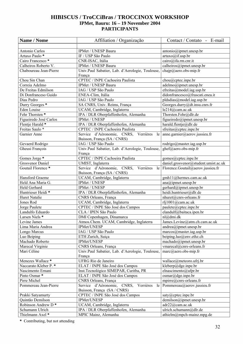
32
HIBISCUS / TroCCiBras / TROCCINOX WORKSHOP IPMet, Bauru: 16 – 19 November 2004
PARTICIPANTS Name / Nome Affiliation / Organização Contact / Contato - E-mail
Antonio Carlos IPMet / UNESP Bauru [email protected] Artaxo Paulo * IF / USP São Paulo [email protected] Cairo Francesco * CNR-ISAC, Itália [email protected] Calheiros Roberto V. IPMet / UNESP Bauru [email protected] Chaboureau Jean-Pierre Univ.Paul Sabatier, Lab. d’Aerologie, Toulouse,
França [email protected]
Chou Sin Chan CPTEC / INPE Cachoeira Paulista [email protected] Correia Adelmo IPMet / UNESP Bauru [email protected] De Freitas Edmilson IAG / USP São Paulo [email protected] Di Donfranceso Guido ENEA-Clim, Itália [email protected] Dias Pedro IAG / USP São Paulo [email protected] Durry Georges * SA CNRS, Univ. Reims, França [email protected] Eden Louise UCAM, Cambridge, Inglaterra [email protected] Fehr Thorsten * IPA / DLR Oberpfaffenhofen, Alemanha [email protected] Figueiredo José Carlos IPMet / UNESP [email protected] Flentje Harald * IPA / DLR Oberpfaffenhofen, Alemanha [email protected] Freitas Saulo * CPTEC / INPE Cachoeira Paulista [email protected] Garnier Anne Service d’Aéronomie, CNRS, Verrières le
Buisson, França (SA / CNRS) [email protected]
Gevaerd Rodrigo IAG / USP São Paulo [email protected] Gheusi François Univ.Paul Sabatier, Lab. d’Aerologie, Toulouse,
França [email protected]
Gomes Jorge * CPTEC / INPE Cachoeira Paulista [email protected] Grosvenor Daniel UMIST, Inglaterra [email protected] Goutail Florence * Service d’Aéronomie, CNRS, Verrières le
Buisson, França (SA / CNRS) [email protected]
Hansford Graeme UCAM, Cambridge, Inglaterra [email protected] Held Ana Maria G. IPMet / UNESP [email protected] Held Gerhard IPMet / UNESP [email protected] Huntrieser Heidi * IPA / DLR Oberpfaffenhofen, Alemanha [email protected] Huret Natalie CNRS Orleans, França [email protected] Jones Rod UCAM, Cambridge, Inglaterra [email protected] Jorge Paulete CPTEC / INPE São José dos Campos [email protected] Landulfo Eduardo CLA / IPEN São Paulo [email protected] Larsen Niels * DMI Copenhagen, Dinamarca [email protected] Levine James Atmos.Chem. UCAM, Cambridge, Inglaterra [email protected] Lima Maria Andrea IPMet/UNESP [email protected] Longo Marcus IAG / USP São Paulo [email protected] Luo Beiping ETH Zurich, Suiça [email protected] Machado Roberto IPMet/UNESP [email protected] Marecal Virginie CNRS Orleans, França [email protected] Mari Céline Univ.Paul Sabatier, Lab. d’Aerologie, Toulouse,
França [email protected]
Menezes Wallace * UFRG Rio de Janeiro [email protected] Naccarato Kleber P. * ELAT / INPE São José dos Campos [email protected] Nascimento Ernani Inst.Tecnológico SIMEPAR, Curitba, PR [email protected] Pinto Osmar * ELAT / INPE São José dos Campos [email protected] Pirre Michel CNRS Orleans, França [email protected] Pommereau Jean-Pierre Service d’Aéronomie, CNRS, Verrières le
Buisson, França (SA / CNRS) [email protected]
Prakki Satyamurty CPTEC / INPE São José dos Campos [email protected] Quintão Demilson IPMet/UNESP [email protected] Robinson Andrew D * UCAM, Cambridge, Inglaterra [email protected] Schumann Ulrich IPA / DLR Oberpfaffenhofen, Alemanha [email protected] Thielmann Axel * MPIC Mainz, Alemanha [email protected]
* Contributing, but not attending


![Crescimento de Grão [18] - Unesp](https://img.pdfslide.us/doc/110x75/619944920bf8714cef62f2b3/crescimento-de-gro-18-unesp.jpg)


![Bonding between Atoms [4] - Unesp](https://img.pdfslide.us/doc/110x75/61c7749506afd0620067c2dc/bonding-between-atoms-4-unesp.jpg)