Embed Size (px)
Citation preview

CONTENTS CHAPTER
NO. PARTICULARS PAGE
NO. PART I REGIONAL SETTING AND HISTORICAL BACKGROUND 1-15 1 REGIONAL SETTING 1-9
1.1 STATE OF PUNJAB 1 1.2 RAPID URBAN GROWTH 2 1.3 LOCAL PLANNING AREA, HOSHIARPUR 5 1.3.1 Geography 5 1.3.2 Climate 5 1.3.3 Rainfall 5 1.4 BROAD PLANNING INTERVENTIONS FOR LPA, HOSHIARPUR 6
2 HISTORICAL BACKGROUND 6-9 3 LEGAL FRAMEWORK FOR MASTER PLAN 10-15
3.1 LEGAL SETUP 10 3.2 MAIN PROVISIONS OF THE LAW 10 3.2.1 The Punjab Regional and Town Planning and Development
(Amendment) Act, 2006 10
3.3 PREVIOUS ATTEMPTS 15 PART II EXISTING SITUATION 16-42 4 POPULATION GROWTH AND CHARACTERISTICS 16-19
4.1 POPULATION GROWTH 16 4.2 POPULATION DENSITY 17 4.3 SEX RATIO 17 4.4 CASTE COMPOSITION 18 4.5 LITERACY 18 4.6 OCCUPATIONAL STRUCTURE 19
5 ECONOMY & EMPLOYMENT 19-24 5.1 SALIENT FEATURES OF ECONOMIC GROWTH IN PUNJAB 19 5.2 MAJOR BUSINESS TREND & RETAIL 21 5.3 EMPLOYMENT 22 5.4 MANUFACTURING INDUSTRIES 22 5.5 TRADE & COMMERCE 23 5.6 AGRICULTURE ACTIVITIES 23 5.7 KEY ISSUES 23 5.8 EMERGING ECONOMIC DRIVERS OF LOCAL PLANNING AREA 24
6 REVIEW OF MAJOR EXISTING LAND USES 24-32 6.1 RESIDENTIAL USE 25 6.2 COMMERCIAL USE 26 6.3 INDUSTRIAL USE 27 6.4 TRAFFIC & TRANSPORTATION 28 6.5 RECREATIONAL 29 6.6 PUBLIC & SEMI-PUBLIC 29 6.6.1 Educational 29 6.6.2 Medical 30 6.6.3 Public Utilities 31 6.6.4 Cremation 31 6.6.5 Government Use 31 6.6.6 Religious & Heritage 31

6.7 Rural/ Agirculture 32 7 PLANNING PROBLEMS & OBJECTIVES 32-35
7.1 PLANNING PROBLEMS 32 7.1.1 Residential Areas and Housing Problems 33 7.1.2 Mixed Land Use 33 7.1.3 Faulty Road Pattern 33 7.1.4 Environmental Pollution 33 7.2 PLANNING OBJECTIVES 33
PART III POPULATION PROJECTIONS & DISTRIBUTION 36-38 8.1 POPULATION PROJECTION 36 8.2 PROPOSED POPULATION DISTRIBUTION 38
9 CONSTITUTION OF THINK TANK 39-42 9.1 S W O T ANALYSIS 40 9.2 VISION 2031 41
PART IV THE MASTER PLAN 43-76 10 PROPOSED LAND USE PLAN (2009-2031) 43-56
10.1 PROPOSED LAND USE PLAN 44 10.1.1 Residential Use 44 10.1.2 Commercial Use 46 10.1.3 Industrial Use 47 10.1.4 Recreational 47 10.1.5 Traffic & Transportation 47 10.1.6 Mixed Land Use Zones 50 10.1.7 Designated Use 55 10.1.8 Agriculture ad Water Bodies 56
11 SPECIAL AND DEVELOPMENT CONTROLS 57-76 11.1 ZONING REGULATIONS 57 11.1.1 Use and Development of Land to be in Conformity with Master Plan 57 11.1.2 Short Title, Scope, Extent and Commencement 58 11.2 LAND USE ZONES 61 11.2.1 Use Provisions in Land Use Zones 61 11.3 DESIGNATED AREAS 65 11.3.1 Traffic & Transportation: Permissible Uses 65 11.3.2 Utilities: Permissible Uses 65 11.3.3 Public and Semi-Public Activities: Permissible Uses 65 11.3.4 Protected Conservation Sites: Permissible Uses 65 11.3.5 Other Special Areas: Permissible Uses 65 11.3.6 Forest Areas: Permissible Uses 66 11.3.7 Special Conditions 66 11.3.8 Exceptions 66 11.3.9 Residential Densities 67 11.3.10 Implementation of these Regulations 67 11.4 SECTION II: DEVELOPMENT CONTROL & REGULATIONS 67 11.4.1 Residential 67 11.4.2 Group Housing 68

11.4.3 Farm House 69 11.4.4 Commercial 69 11.4.5 No Construction Zone along Major Roads 71 11.4.6 Institutional Buildings 71 11.4.7 Sports and Recreational Zone 71 11.4.8 Industrial 72 11.4.9 Environmental Consideration 73 114.10 Other Development Controls and Guidelines required 73 11.4.11 Use and Development of land to be in conformity with Master Plan 74 11.4.12 Transferable Development Rights 74 11.5 EXCEPTIONS 75 ANNEXURE I ANNEXURE II ANNEXURE III ANNEXURE IV ANNEXURE V

LIST OF TABLES Table No. PARTICULARS Page
No. 1.1 Trends in Urbanization-Punjab (1971-2001) 3 1.2 Trends in Urban Population in Different Size/Categories 3 1.3 Net State Domestic Product 4 4.1 Population Growth of Local Planning Area 16
4.2 Growth Trends – Urban Population in Punjab & Hoshiarpur 17
4.3 Population Density 17 4.4 Sex Ratio 17 4.5 Caste Composition 18 4.6 Literacy Rate in Hoshiarpur City 18 4.7 Occupational Structure 19 5.1 Key Economic Indicator 20
5.2 Detail of Workers 21
6.1 Existing Land Use of Municipal Area of Hoshiarpur – 2009 24
6.2 Existing Land Use of Local Planning Area of Hoshiarpur-2009 25 8.1 Population Projection for Local Planning Area Hoshiarpur 37 8.2 Planning Norms for Informal Sectors 38 10.1 Proposed Land Use of Local Planning Area of Hoshiarpur-2031 44 10.2 Proposed Width of Regional Roads 49
1
PART 1
REGIONAL SETTING & HISTORICAL BACKGROUND
1 REGIONAL SETTING
1.1. State of Punjab
Punjab is one of the advanced states in the country, with highly productive
agriculture, a well-developed physical infrastructure and a high human development index
with industrious, painstaking and entrepreneur skills. It accounts for only 1.53 per cent of
India’s geographical area and 2.37 per cent of its population. State represents a unique
example of a fast developing economy based on agriculture despite all physical and
developmental odds. State is credited with ushering in the green revolution and white
revolution in the country. It today contributes nearly 35% of the wheat and 70% of rice
procured for distribution through the public distribution system. An agro-based and agro-
oriented industrialization is another prominent feature of the state economy. No less
commendable are the efforts to strengthen the infrastructure, particularly irrigation and
power. The cumulative effect of all this is manifest in the high per capita income of the
state, a position which Punjab has been holding for most of the years since its formation in
1966.
Development in the state of Punjab has been the outcome of the interplay of a
variety of factors including physical, political, economic, demographic and geographic.
Being a border state, both external and internal changes have influenced the path of
development. Historically, Punjab has experienced many upheavals and turmoil, which, in
turn, have influenced building brave and unique character of Punjabis and opened its path of
development. The contours of administrative map of Punjab have undergone extraordinary
changes in the past. The nomenclature ‘Punjab’ was widely used during the reign of Akbar
(A.D. 1556-1605). It was known as the Kingdom of Lahore during the reign of Maharaja
Ranjit Singh (1700-1839). The British occupied it in 1849 and merged Delhi and the Hissar
division of the former Northwest Province (united province) with Punjab in 1858. In 1901,
Punjab’s border districts situated across the Indus were taken away to form the Northwest
Frontier Province. Subsequently, Delhi was separated from Punjab and made capital of
British India replacing Calcutta.
At the time of the partition of the India sub-continent in 1947, Punjab was bifurcated
into two parts as per the finding of Red Cliff Commission, West Punjab (Pakistan) and East
Punjab (India). Of its 3, 59,179 square kilometers and 29 districts, only 1, 52,649 square

2
kilometers and 13 districts were left with Indian Punjab. The two Punjab’s were formed on
religious grounds. The most fertile, prosperous and developed western part went to Pakistan
and the relatively backward eastern part remained in India.
With massive migration, post-partition Punjab was faced with the daunting task of
providing basic infrastructure necessary to accommodate 40 lakh displaced persons. They
were put in refugee camps, institutions and other available structures in sanitary conditions.
The immediate task was to create the infrastructure to accommodate the refugee population.
New colonies known as Model Town were developed to rehabilitate migrant coming from
Pakistan. The pattern, established during the period, has continued to guide the path of
development in the state.
In 1956, at the time of the reorganization of states, Patiala and East Punjab State
Union (PEPSU) was merged with Punjab. In 1966, the state was further reorganized under
the Reorganization Act -1966 with creation of new state of Haryana and merger of hilly
districts of Punjab State into union territory of Himachal Pradesh which got full status of a
state in 1971.
1.2. Rapid Urban Growth
Punjab is urbanizing rapidly and its future seems to be urban. With urbanization
standing at 33.95%, Punjab is ranked fifth major urbanized state of India after Tamil Nadu
(43.86%), Maharashtra (42.40%), Gujarat (37.35%) and Karnataka (33.98%) and most
urbanized states in the northwest region of the country. The percentage of urban population
in Punjab has been on the rise continuously.
Looking at the growth of urban population vis-à-vis total population of state during
last century (1991-2001) it has been observed that while total population of the state
increased approximately 3 times (7.5 to 24.28 millions), during this very period urban
population recorded enormous increase of 9 times (0.9 to 8.25 million) However, during the
same period rural population grew only by 2.5 times (6.61 to 16.2 million). In 1901 when
every 8th person was an urbanite, in 2001 every 3rd person came to live in the cities/ towns.
The trends of urbanization were slow in the first half of century when urban population
merely doubled (0.93 to 1.98 million) in the space of 5 decades (1901-1951). However, it
picked up in the post-independence era and urban population grew by more than 4 times
(1.98 to 8.25 million) during the second half of century (1951-2001). In absolute numbers,
increase in urban population recorded during the last century was 73.11 lakh persons
whereas level of urbanization increased from 12.39% to 33.95% indicating the massiveness
of the state’s urbanization. Last decade witnessed a sharp rise of 37.38% in urban

3
population whereas in absolute number the addition to the urban centers was of the order of
22, 52,341 persons. From the ongoing trend it can be envisaged that urban growth will be
much faster in years to come.
Table 1.1: Trends in Urbanization - Punjab (1971 - 2001)
Census year
Total number of
UA’s/ Towns
Total population
Total urban
population
Percentage of urban
population
Decennial growth Annual exponential growth rate
(urban)
Absolute Percent
1971 106 13551060 3216179 23.73 648873 25.27 2.28 1981 134 16788915 4647757 27.68 1431578 44.51 3.75 1991 120 20281969 5993225 29.55 1345468 28.95 2.58 2001 157 24289296 8245566 33.95 2252341 37.58 3.24
(Census of India)
State of Punjab recorded a population of 24289296 in 2001. During 1991-2001,
population of state increased by 40.07 lakhs out of which addition to urban population was
of the order of 22.52 lakhs (56%) due to the fact that number of urban centers recorded a
sharp increase from 120 to 157. Concentration of population in urban areas of Punjab is
very high as compared to rural areas. Villages recorded low density as compared to urban
areas giving a density ratio of 1:12 in favor of urban centers. Apparently, Punjab is one of
the most densely populated states in India.
It is expected that by 2011, population of the state would be of the order of 276.78
lakhs out of which urban component would be 38.59% i.e. 106.18 lakhs people will be the
urban residents. This would further result in excessive concentration of urban populalation.
Table 1.2: Trends in Urban Population in Different Size/ Categories
Year Class I Class II Class III Class IV Class V Class VI All classes 1971 4
[40.52] (1303128)
8 [15.84]
(509389)
22 [22.20]
(714176)
31 [13.32]
(428413)
29 [6.84]
(219911)
12 [1.28]
(41162)
106 [100.00]
(3216179) 1981 7
[46.38] (2155714)
10 [14.39]
(668780)
27 [20.24]
(940.482)
36 [11.28]
(524505)
40 [6.50]
(301905)
14 [1.21]
(56371)
134 [100.00]
(4647757) 1991 10
[54.16] (3246224)
18 [19.91]
(1193171)
25 [12.92]
(774453)
46 [10.82]
(648230)
14 [1.72]
(102945)
7 [0.47]
(28202)
120 [100.00]
(5993225) 2001 14
[58.38] (4814405)
19 [16.45]
(1356386)
35 [12.50]
(1030623)
54 [9.82]
(809366)
28 [2.52]
(207891)
7 [0.33]
(26895)
157 [100.00]
(8245566) (Source: Census of India, 1971, 1981, 1991 and 2001) Note: i. Number of towns in each category (without bracket)
ii. Percentage population in each class [ ] iii. Total population in each class ( )

4
Increase in share of Class I towns in total urban population of Punjab has resulted in
over concentration of population and resources in few larger towns majority of which are
situated on the NH-1,1A & 15. The Net State Domestic Product is tabulated as followed
Table 1.3: Net State Domestic Products
Sr. No.
Sector Rs. (in Lacs) 1999-2000
2000-2001
2001-2002
2002-2003
2003-2004
2004-2005
2005-2006
2006-2007
1 Agriculture 2403771 2559626 2644008 2555356 2785312 2915231 3165630 3617231 2 Forestry and
Logging 20843 17055 21342 20184 19838 32285 32522 37101
3 Fishing Agri and Allied
15210 2439824
16616 2593297
18147 2683497
21191 2596731
25463 2830613
22769 2970285
27615 3225767
30904 3685236
4 Mining and Quarrying
429 351 1194 2614 2807 2640 2902 3026
Sub total of Primary
2440253 2593648 2684691 2599345 2833420 2972925 3228669 3688262
5 Manufacturing Manu – registered Manu – unregistered
824963 495366 329597
875874 524193 351681
817157 472389 344768
896175 514154 382021
956934 520815 436119
1066040 583085 482955
1221776 671227 550549
1352700 733718 618982
6 Construction 286176 349307 386182 357921 438918 552564 703393 881140 7 Electricity, Gas
and Water Supply
129602 151740 187201 177551 208112 146721 188230 201105
Sub total of Secondary Industry
1240741
1241170
1376921
1377272
1390540
1391734
1431647
1434261
1603964
1606771
1765325
1767965
2113399
2116301
2434945
2437971 8 Transport,
Storage and Communication Railways Transport by other means
248847
248847
283576
283576
340504
340504
368182
368182
416423
416423
455417
455417
519489
519489
577516
577516
9 Trade, Hotels and Restaurants
798461 1052177 1161192 1267789 1332332 1501375 1791833 2013662
10 Banking and Insurance
289762 309139 351329 407832 441021 471011 510670 549532
11 Real Estate, Ownership of dwellings and business services
242920 250244 251727 261205 269797 279991 284619 292361
12 Public Administration
275955 289163 304030 341854 366852 388153 425839 458884
13 Other Services 572417 619010 643428 673457 700179 790845 864075 930782 Sub Total of
Tertiary 2428362 2803309 3052210 3320319 3526604 3886792 4396525 4822737
14 State Domestic Product (Rs. Lacs)
6109356 6773878 7127441 7351311 7963988 8625042 9738593 10945944
15 Calculated State Domestic Product (Rs. Lacs)
6109356 6773878 7127441 7351311 7963988 8625042 9738593 10945944
16 Population 23854000 24310000 24621000 25076000 25540000 26012000 26493000 26983000 17 State Per Capita
Income (Rs.) 25611 27865 28949 29316 31182 33158 36759 40566
5
1.3. LOCAL PLANNING AREA HOSHIARPUR
As a first step towards the preparation of Master Plan, Hoshiarpur, Local Planning
Area has been delineated and notified u/s 56(1) of “The Punjab Regional and Town
Planning and Development (Amendment) Act, 2006” in the official gazette. The Local
Planning Area Hoshiarpur was notified vide notification No. 12/75/2006/4 HG1/4385 dated
07.07.2008 No of villages includes are 29 villages. Total area 10118 hectare shown on the
Drawing No. DTP (H) 96/2008 dated 04.01.2008.
1.3.1. Geography
Hoshiarpur district is located in the north-east part of the Indian state of Punjab with
coordinates lying between North Latitude 30o-09’ and 32o-05’ and East Longitude 75o-32’
and 76o-12’. It has an average elevation of 296 metres (971 feet). It falls in the Jalandhar
Revenue Division and is situated in the Bist Doab portion of the Doaba region. Hoshiarpur
shares a common boundary with Kangra and Una districts of Himachal Pardesh in the north
east. In the southwest, it borders the Jalandhar and Kapurthala districts of Punjab and in the
northwest it borders Gurdaspur District of Punjab.
1.3.2. Climate
The district of Hoshiarpur has a mild climate compared to other districts in the state
of Punjab. Much of this is due to the abundance of hilly terrain and sizeable forest cover.
Temperatures drop as low as -5oC in the winter.
The pattern of seasons in the district is similar to that of other districts in Punjab,
except slight variations at the terminals. The year may be divided into three main seasons in
the district of Hoshiarpur. The summer season sets in April and lasts up to end of June, to be
taken over by the rainy season (during which time it becomes hot and humid). The rainy
season sets in the beginning of July and lasts up till September's end. The winter season
starts after the rains are over from October and lasts up until March's end. May and June are
the hottest months of the year in Hoshiarpur (during which time mercury is known to cross
45 °C).
1.3.3. Rainfall
The total average rain fall within Hoshiarpur is 1125mm. Broadly speaking, 75% of
the rainfall is experienced within the period between July and September. 15% of the total
rainfall is experienced in the winter months of January and February during which time the
climate is under the influence of western disturbances in the Persian Gulf. Hail storms may
occur in the closing period of winter.

6
1.4. Broad Planning Interventions for LPA, Hoshiarpur
Master Plan is an important instrument for guiding and regulating development of
towns and cities over a period of time and contributes to planned development. It is an
instrument to workout land and infrastructure requirements for various urban and rural uses
and allocates land for various uses to result in harmonious and sustainable distribution of
activities so that cities are provided with form and structure.
The local planning area of Hoshiarpur comprising of 29 rural settlements and
Hoshiarpur urban areas, spreading over an area of 10118 hectares was notified w/s 56 ( I )
of the Punjab Regional & Town Planning & Development Act, 1995 (amended 2006) on
07.7.2008. After the declaration of a Planning Area the designated Planning Agency shall
prepare Master Plan for the Local Planning Area and the Master Plan so prepared shall:-
(a) Indicate broadly the manner in which the land in the area should be used;
(b) Allocate areas or zones of land for use for different purposes.
(c) Indicate, define and provide the existing and proposed highways, roads, major
streets and other lines of communication.
(d) Indicate areas covered under heritage sites and the manner in which protection,
preservation and conservation of such site including its regulation and control of
development, which is either affecting the heritage site or its vicinity, shall be
carried out.
(e) Indicate regulations (hereinafter called "Zoning Regulations") to regulate within
each zone the location, height, number of storey and size of buildings and other
structures open spaces and the use of building, structures and land.
2 HISTORICAL BACKGROUND
Hoshiarpur town is located in the North- East of the Punjab. It falls proximity to
Shiwalik foot hills. The city is located on Jalandhar-Dharmshala N.H.70 at the Distance of
40 Km from Jalandhar and 135 Km from Chandigarh. Shiwalik foot rains at the distance of
about 8 to 10 Km. to the North- East of the city. The Bhangi Choe and its branches flow
through the city. As census 2001 the population of city was 1, 49,668 persons.
Hoshiarpur is situated at North latitude 31’-35’-0” to 27’-30’-0”and East longitude
of 75’-50-30” to75’-59’-0” with the general elevation of 299.03 m above the sea level
.Hoshiarpur is also connected with Tanda, Phagwara, Garhshankar, Dasuya. It is also
gateway to H.P. Distt. Dharmshala, Una, Hamirpur and others religious such as Mata
Chintapurni Mandir, Dera Baba Badbhag Singh, Mandir Baba Balak Nath and etc. are
connected to Punjab through Hoshiarpur.
7
The area of present Hoshiarpur District was also part of Indus Valley Civilization.
Recent excavations at various sites in the district have revealed that the entire area near the
Shiwalik foothills was selected for habitation not only by the early Paleolithic man but also
by those in the protohistoric and historic periods. In the explorations, seven early Stone Age
sited a Atbarapur, Rehmanpur and Takhni, 30-40 km north of Hoshiarpur District in the
foothills of Shiwalik, have been discovered where the stone artifacts have been found.
Besides these excavations, among the archaeological remains in the Hoshiarpur District, the
remains of temples at Dholbaha, 24 km north of Hoshiarpur, and especially the local
legends throw valuable light on the ancient history of the district.
The legends associate several places in the district with pandavas. Dasua is
mentioned in epic of Mahabharata as the seat of Raja Virat in whose services the Pandavas
remained for thirteen years during their exile. Bham, about 11 km west of Mahalpur is said
to be the place where the Pandavas passed their exile. Lasara, about 19 km north Jaijon, also
contains a stone temple stated to date back to the time of Pandavas. According to the
chinese pilgrim, Hieun Tsang, the area of Hoshiarpur was dominated by a tribe of
Chandrabansi Rajputs, who maintained an independent existence for centuries before the
Muhammadan conquest.
In the Hoshiarpur District, Shiwaliks from Talwara on the Beas to Rupnagar on the
Satluj have revealed the presence of Acheolian and Soanian cultures. From the shiwalik
frontal range in the Hoshiarpur District, sixteen sites have been reported to have yielded
Stone Age tools. Out of these, besides the Soanian tools, these sited in Hoshiarpur District
have yielded Acheolian assemblage.
The Atbarapur group has yielded a large number of Stone Age tools. This group
consisting of Atbarapur, Rehamanpur and Takhni close to the dry beds of the choe are
located at the foothills of the Shiwaliks, about 8 km north-east from the town of Hariana,
Atbarapur has yielded 80 tools consisting of 9 hand axes, 19 cleavers, 17 pebble-tools, 28
flakes and 7 cores/core choppers. All the tools in the collection are either on flakes or cores.
The raw material is quartzite of varying colures, viz. Green, blue, brown, etc. The tools are
fashioned mainly out of fine to medium grained quartzite. In the recent archaeological
excavations, some fine pieces of sculptures of Gandhara dating back to 1000 AD and after
have been discovered hare.
8
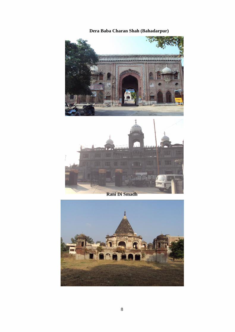
Dera Baba Charan Shah (Bahadarpur)
Rani Di Smadh

9
The archaeological explorations made during the recent years have revealed the
antiquity of the Hoshiarpur District to the Harappan Period. On the basis of surface
exploration, the few sites have been brought on the Archaeological map of India and the
traces of the selfsame people as at Harappa and Mohenjo-Daro have also been detected in
the Hoshiarpur District at varios places.
Places of interest & tourist interest also includes fort of Raja Sansar Chand at
Bajwara, Ancient Shiva Temple, Mata Rajni Devi Temple and Gurdwara Bhai Joga Singh.
Gurdwara Bahi Joga Singh Ji

10
3 LEGAL FRAMEWORK FOR MASTER PLAN
3.1. Legal Set Up
Legislative support is an essential tool to control the planning and development
activity in a state. Some states like Goa, Gujarat, Himachal Pradesh, Karnataka, Madhya
Pradesh, Maharashtra, Manipur and Mizoram etc have comprehensive legislation which
provided for urban planning and development in a regional perspective beyond the city
limits and coordinated with the overall framework of economic development, priorities and
resource availabilities.
Punjab state is the new entrant in this field. The first ever legal tool namely The
Punjab Regional and Town Planning and Development Act, 1995 was enacted in the year
1995 (Punjab Act No.11 of 1995) which has been amended in the year 2006 and now this
act is known as “The Punjab Regional and Town Planning and Development (Amendment)
Act 2006” (Punjab Act No. of 2006). This is an act to make provision for better planning
and regulating the development and use of land in planning areas delineated for that
purpose, for preparation of Regional Plans and Master Plans and implementation thereof,
for the constitution of a State Regional and Town Planning and Development Board, for
guiding and directing the planning and development processes in the State, for the
constitution of a State Urban Planning and Development Authority. Special Urban Planning
and Development Authorities and New Town Planning and Development Authorities, for
the effective and planned development of planning areas and for undertaking urban
development and housing programs and schemes for establishing new towns and for matters
connected therewith or incidental thereto.
Prior to the enactment of the Act ibid the Town Planning Activity within urban areas
was being governed by different legislations such as The Town Improvement Act 1922, The
Punjab Municipal Act 1911, The Punjab Municipal Corporation Act 1976, The Punjab
Urban Estates (Development and Regulation) Act 1964 etc but no comprehensive
legislation was available for the overall control and development at local and regional level.
3.2. MAIN PROVISIONS OF THE LAW
3.2.1. The Punjab Regional & Town Planning & Development (Amendment) Act
2006
The act is the sole legal framework available for preparing Master Plans and
Regional Plans. It is a comprehensive act and provides for the manner in which the use of
land in the area of a planning authority shall be regulated. The act also prescribes specific
time period for various steps in the plan preparation process.

11
The act intends to achieve the following main objectives:
I. To consolidate, with suitable modifications, in one place laws dealing with the
different aspects of urban development.
II. To set up a high powered Board to advise the State Government and to guide and
direct planning and development agencies, with respect to matters pertaining to the
planning, development and use of urban and rural land.
III. To set up a State level Urban Planning and Development Authority and to provide
for the setting up of a Special Urban Planning and Development Authorities and
New Town Planning and Development Authorities to promote and secure better
planning and development of different regions, areas and cities.
IV. To create a legal and administrative set up for the preparation and enforcement of
Master Plans for regions, areas and for existing and new cities.
V. To make the whole programme of urban development mainly a self - sustaining and
self - paying process.
VI. To interlink land development and house construction permitting full exploitation of
the urban land resource to provide a boost to the programme of house construction,
especially the Economically Weaker Sections of the Society.
VII. To provide a legal, administrative and financial framework for the preparation and
execution of Town Development Schemes aimed at filling the gaps in the required
civil infrastructure and securing the renewal and redevelopment of congested and
decayed areas in the existing towns
The following sections of the Act ibid deal with the preparation of Master
Plans:
Section 56(1)
Under section 56(1) of this chapter, Local Planning Areas are notified in the
official gazette for preparing Master Plan. Once an area has been declared under section-56
(1), no person can institute or change the use of land for any purpose or carry out any
development in respect of any land without the previous permission of competent authority
until the Master Plan comes into operation. However, this prohibition does not apply to any
area comprised in abadi deh of any village falling inside its lal lakir or phirni.
Section 57
This section deals with the designation of Planning Agencies. As soon as may be,
after declaration of a local planning area or a site for new town, the State Government may
designate planning agency for that area.
12
Section 58
Section 58 of the act states that the
(1) Designated Planning Agency will work under the overall directions and control of
the State Government.
(2) The state Government may assign any or all of the following functions to the
Designated Planning Agency, namely to
(i) Carry out survey of the regional planning area, local planning area or a site for
new town, as the case may be, and prepare reports on the surveys so carried out;
(ii) prepare an existing land use map and such other maps as may be necessary for
the purpose of preparing regional plan and outline master plan, a new town
development plan or a comprehensive master plan, as the case may be;
(iii) Prepare a regional plan, an outline master plan, a new town development plan or
a comprehensive master plan.
(3) Subject to and in accordance with the directions of the Govt., a designated planning
agency shall exercise all such powers as may be necessary or expedient for the
purposes of carrying out its functions under this act and also perform any other
functions which are supplemental, incidental or consequential to any of the functions
specified in sub section (2) or as may be prescribed.
Section 59
This section deals with the preparation of present land use map and fixes six months
time for this purpose which may be extended by the State Govt. from time to time.
Section 60
Section 60 provides for expenses that the State Government may determine for
payment to the designated planning agency as contribution towards the expenses incurred
by it in the discharge of its functions.
CHAPTER X
This chapter deals with the preparation and approval of Master Plans of towns /
cities.
Section 70 (1)
This section states that the planning agency shall not later than one year after
declaration of planning area and after the designation of that agency for that area shall
prepare and submit to the state government a master plan for its approval.

13
Section 70 (2)
Section 70(2) regulates the form and contents of the master plan and shall include
such maps descriptive matter as may be necessary to explain and illustrate the proposals in
the master plan.
Section 70 (3)
This section has the provision for the state government to direct the designated
planning agency to publish the existing land use plan and master plan and the information
regarding the place or places where copies of the same may be inspected by the public for
inviting objections in writing with respect to existing land use plan and master plan within a
period of 30 days from the date of publication.
Section 70 (4)
Under this sub section, the state government after considering the objections and in
consultation with the board may direct the designated planning agency to modify the master
plan or approve it as such.
Section 70 (5)
Under this sub section, the Designated Planning Agency after approval of the state
government shall publish the final master plan in the official gazette after carrying out the
modification if any under intimation to the state government within a period of 30 days
from the date of according approval by the state government.
Section 75
According to this section, the Master Plan shall come into operation from the date of
publication. Refer to sub section 5 0f section 70.
Section 76
This section provides for the amendment in the master plan and says that at any time
after the date on which the master plan for an area comes into operation, and at least once
after every ten years, after that date, the Designated Planning Agency shall after carrying
out such fresh surveys as may be considered necessary or as directed by the government,
prepare and submit to the government, a Master Plan after making alterations or additions as
it considers necessary.
The flow chart showing the process of Master Plan preparation and approval is illustrated
below:
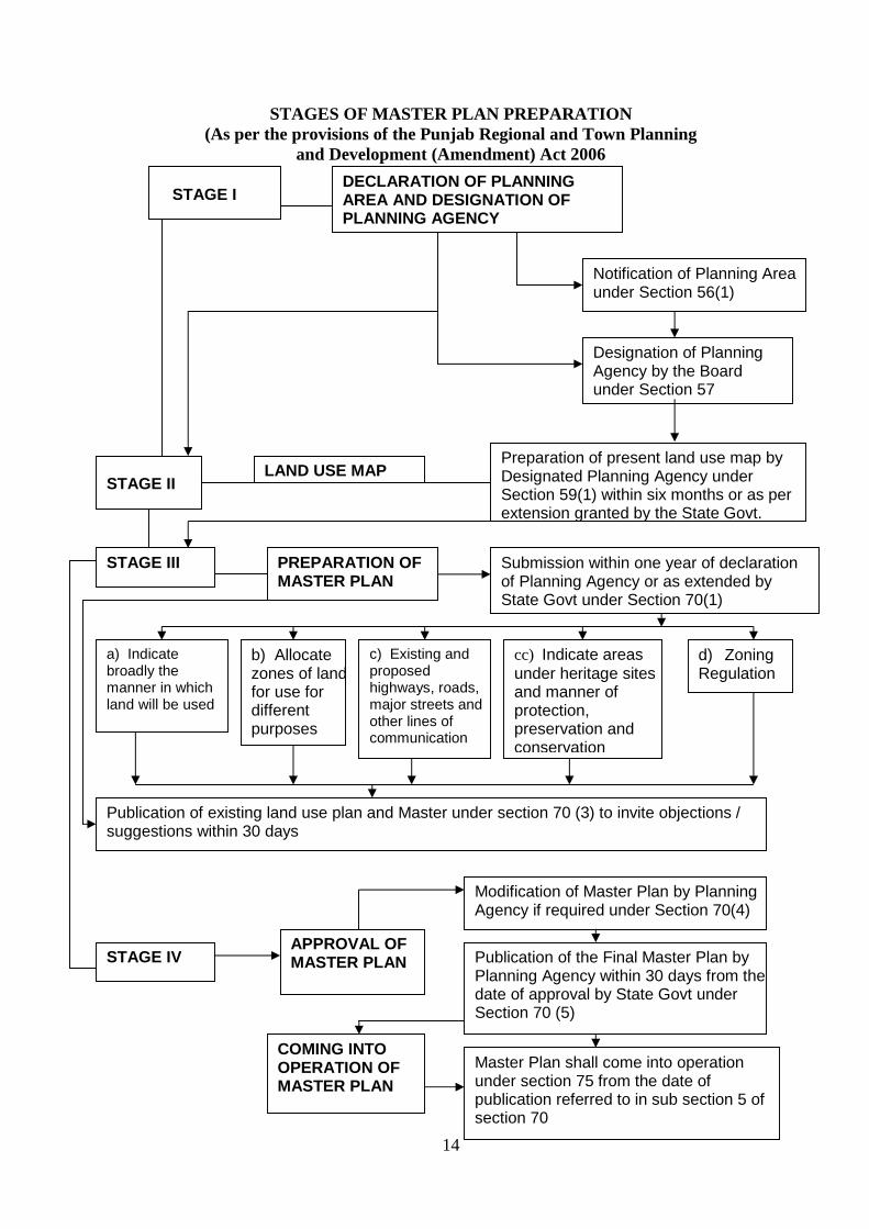
14
STAGES OF MASTER PLAN PREPARATION (As per the provisions of the Punjab Regional and Town Planning
and Development (Amendment) Act 2006 STAGE I
DECLARATION OF PLANNING AREA AND DESIGNATION OF PLANNING AGENCY
Notification of Planning Area under Section 56(1)
Designation of Planning Agency by the Board under Section 57
Preparation of present land use map by Designated Planning Agency under Section 59(1) within six months or as per extension granted by the State Govt.
LAND USE MAP STAGE II
STAGE III
PREPARATION OF MASTER PLAN
Submission within one year of declaration of Planning Agency or as extended by State Govt under Section 70(1)
a) Indicate broadly the manner in which land will be used
b) Allocate zones of land for use for different purposes
c) Existing and proposed highways, roads, major streets and other lines of communication
cc) Indicate areas under heritage sites and manner of protection, preservation and conservation
d) Zoning Regulations
STAGE IV
APPROVAL OF MASTER PLAN
Modification of Master Plan by Planning Agency if required under Section 70(4)
Publication of the Final Master Plan by Planning Agency within 30 days from the date of approval by State Govt under Section 70 (5)
Master Plan shall come into operation under section 75 from the date of publication referred to in sub section 5 of section 70
COMING INTO OPERATION OF MASTER PLAN
Publication of existing land use plan and Master under section 70 (3) to invite objections / suggestions within 30 days

15
Thus it can be concluded that the section titled “Regional Setting and Historical
Background” has deliberated sufficient detail on the various aspects. These aspects gave
clarity about the status of the city with respect to the state and various historical events
which have come in the past history of the city. Hence one come to know that the city has
underwent urbanized trends in the past.
3.3. Previous Attempts
Previously the State Government promulgated the Punjab Regional and Town
Planning Ordinance 1976 vide Notification No. 24 reg/76 dated 7th May 1976 with the
purpose to provide for planning and regulating the development and the use of land in
regions or areas delineated for that purpose, for the constitution of a State Regional and
Town Planning Board for guiding, directing and assisting the entire planning and
development authorities in the state, for the constitution of Planning and Development
Authorities for effective development of particular areas or new towns and for other matters
connected therewith or incidental thereto. But this ordinance could not be converted into an
Act and lapsed after the expiry of six months period and the urban and regional
development of the state continued in an unplanned and haphazard manner and as a result,
slums, uncongenial environment, nominal civic amenities, choked city roads, encroached
public lands, polluted city environment and congested highways have become a common
feature visible everywhere.

16
PART II
EXISTING SITUATION
4 POPULATION GROWTH AND CHARACTERSTICS
4.1 POPULATION GROWTH
According to 2001 census the population of Hoshiarpur city is 1, 49,668 persons.
The male population is 79,454 and females are 70,214. The male are 53.8 Percent and 46.2
percent are females. The population of Hoshiarpur Municipal Committee grew from 57691
persons in 1971 to 149668 in 2001, which comes out to be 2.6 times within a period of 3
decades. Most of the city growth is haphazard and unplanned except few planned colonies
resulting in highly uneconomical use of agriculture land for urban purpose. Outcome of
such a development was visible in serious shortfall in urban infrastructure.
Local Planning Area of Hoshiarpur
Hoshiarpur Local Planning Area spread over Hoshiarpur M.C. and 29 villages,
where Hoshiarpur M.C. includes 12. In local planning area Hoshiarpur. The decadal growth
of population shown in the following Table;
Table 4.1: Population growth rate of Local Planning Area
S. No. Year Population Decadal growth rate(%age) 1. 1971 92337 - 2. 1981 116311 24.10 3. 1991 154041 32.44 4. 2001 187402 21.66
(Source: District Census, Hoshiarpur)
Hoshiarpur City
Hoshiarpur City had a population of 1, 49,668 persons in the year 2001, in the year
1991-2001 decade registered growth rate 21.66%. The city growth is dynamic and
continuous process due to growth of trade and commerce and consequent urbanization. The
city today faces multifarious physic-socio-economic and infrastructural problems. These, in
turn, lead haphazard growth, overcrowding, congestion, insanitation, housing shortage,
acute traffic problems, thereby further deteriorating the healthy living environment.

17
Table 4.2: Growth trends - Urban Population in Punjab and Hoshiarpur
Urban Population Of Punjab Population Of Hoshiarpur City
Year Persons Decadal Growth Rate
Persons Decadal Growth Rate
As %age of Total Urban Population Of Punjab
1971 3216179 25.27 57691 01.79
1981 4647757 44.51 85648 32.64 01.84
1991 5993220 28.95 122705 43.06 02.04
2001 8245566 37.58 149668 22.15 01.82
4.2 POPULATION DENSITY
Table 4.3: Population Density in Hoshiarpur City
Year Population Density Population Area (hectares) Persons/ hectare
1971 57691 1071 53.87 1981 85648 3500 24.47 1991 122528 3500 35.01 2001 149668 3500 42.76
The density of Hoshiarpur City decreases from 53.87 persons per hectare in 1971 to
24.47 in 1981due to expansion of Municipal Committee limit during 1971-1991 and then
increased to 35.01 and 42.76 during 1981-1991 and 1991-2001 respectively.
4.3 SEX RATIO
The following table shows sex ratio
Table 4.4: Sex ratio of Hoshiarpur city
Year Total Males Females Sex ratio 1971 57691 30844 26847 870 1981 85648 46018 39630 861 1991 122705 65378 57327 876 2001 149668 79454 70214 883
(Source: District Census, Hoshiarpur)
The above table shows that according to 1981 census, there were 861 females for
every 1000 males in Hoshiarpur city which shows slight decrease in sex ratio from 1971
when the number of females were 870 as compared to 1000 males. In the following years
sex ratio improved to 876 and 883 in 1991 and 2001, which show that the sex ratio has

18
increased from 1991 to 2001. The sex ratio of Punjab state is 876 in 2001, which is on lower
side as compared to Hoshiarpur city.
4.4 CASTE COMPOSITION
The table given below shows the population of Schedule Caste in Hoshiarpur M.C.
area:
Table 4.5 Schedule Caste Population
Sr. No. Year Total population
Schedule caste population
%age of SC population to total population
1. 1971 57691 7219 12.51 2. 1981 85648 9237 10.78 3. 1991 122705 29750 24.25 4. 2001 149668 36315 24.26
(Source: District Census, Hoshiarpur)
Total population is 1,49,668 persons which is 24.26% of the total population in the
year 2001.Where as the average schedule caste population of Punjab State is 28.85% of the
total population. Which show that the percentage of the schedule caste population in Local
Planning Area is less than state average
4.5 LITERACY
The following table shows the literates in Hoshiarpur M.C. along with the literacy of male and female:
Table 4.6: Literacy Rate in Hoshiarpur City
S. No.
Year Total Pop
Total literates
%age of total pop
Males Females Number %age Number %age
1 1971 57691 35658 61.81 21041 59.01 14617 40.99 2 1981 85648 53488 62.45 31846 59.54 21642 40.46 3 1991 122705 83801 68.29 47593 56.79 36208 43.21 4 2001 149668 115348 77.07 62988 54.61 52360 45.39
(Source: District Census, Hoshiarpur)
Above table depicts that the literacy rate is increasing. According to 2001 census the
total literacy rate of Hoshiarpur city is 77.07%. Out of the total literate population 54.61%
are male and 45.39% are females. In comparison with 1981 and 1991 the rate is growing. In
1991 male literates were 57 % and female were 43% where as in 1981 male literates were
60 % and female were 40% respectively.
Literacy rate is high in comparison with Punjab state i.e. 70 % in 2001; this means
the people of this city are more aware about education. The literacy rate is high in
Hoshiarpur city because its resources are been utilized properly and it is developing at a fast
pace and people of Hoshiarpur are aware. Due to N.R.I status of most of the families which
19
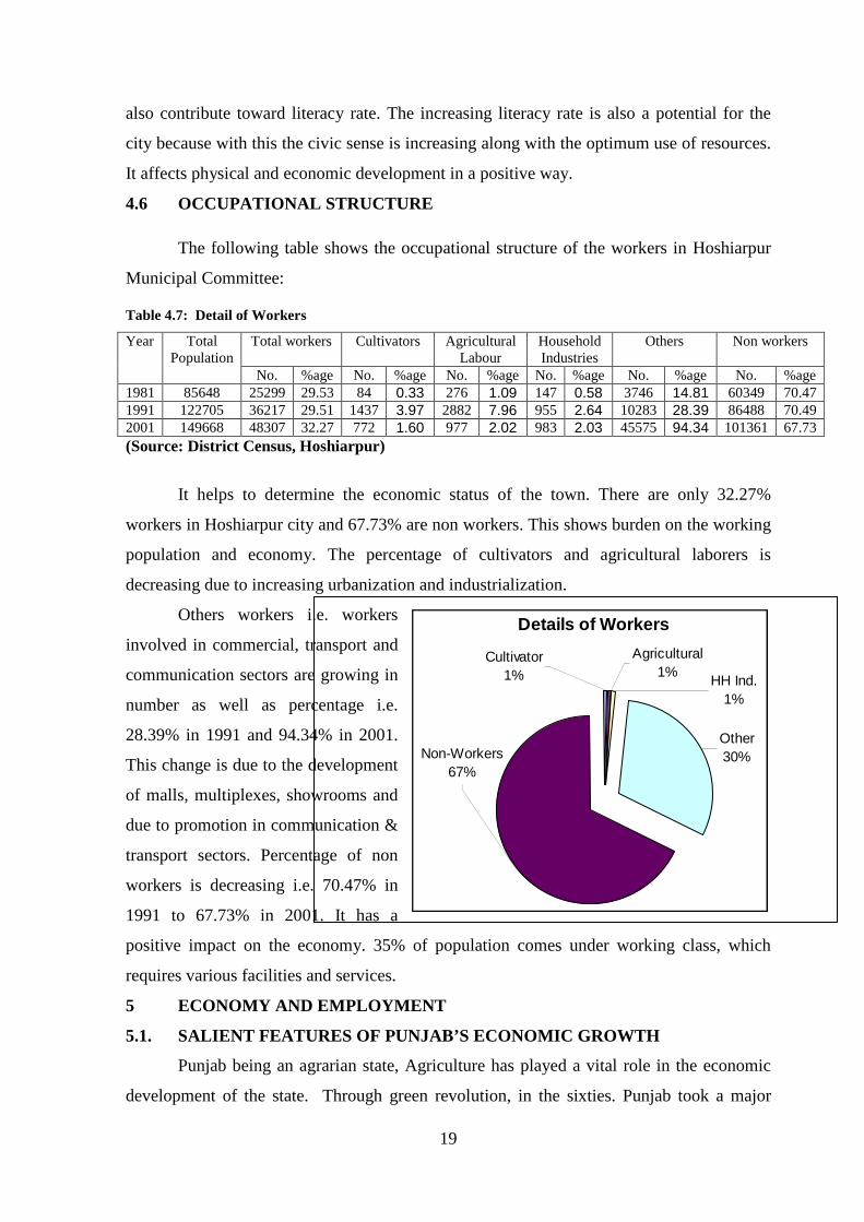
Details of Workers
Other 30%Non-Workers
67%
Agricultural1%
HH Ind.1%
Cultivator1%
also contribute toward literacy rate. The increasing literacy rate is also a potential for the
city because with this the civic sense is increasing along with the optimum use of resources.
It affects physical and economic development in a positive way.
4.6 OCCUPATIONAL STRUCTURE
The following table shows the occupational structure of the workers in Hoshiarpur
Municipal Committee:
Table 4.7: Detail of Workers
Year Total Population
Total workers Cultivators Agricultural Labour
Household Industries
Others Non workers
No. %age No. %age No. %age No. %age No. %age No. %age 1981 85648 25299 29.53 84 0.33 276 1.09 147 0.58 3746 14.81 60349 70.47 1991 122705 36217 29.51 1437 3.97 2882 7.96 955 2.64 10283 28.39 86488 70.49 2001 149668 48307 32.27 772 1.60 977 2.02 983 2.03 45575 94.34 101361 67.73 (Source: District Census, Hoshiarpur)
It helps to determine the economic status of the town. There are only 32.27%
workers in Hoshiarpur city and 67.73% are non workers. This shows burden on the working
population and economy. The percentage of cultivators and agricultural laborers is
decreasing due to increasing urbanization and industrialization.
Others workers i.e. workers
involved in commercial, transport and
communication sectors are growing in
number as well as percentage i.e.
28.39% in 1991 and 94.34% in 2001.
This change is due to the development
of malls, multiplexes, showrooms and
due to promotion in communication &
transport sectors. Percentage of non
workers is decreasing i.e. 70.47% in
1991 to 67.73% in 2001. It has a
positive impact on the economy. 35% of population comes under working class, which
requires various facilities and services.
5 ECONOMY AND EMPLOYMENT
5.1. SALIENT FEATURES OF PUNJAB’S ECONOMIC GROWTH
Punjab being an agrarian state, Agriculture has played a vital role in the economic
development of the state. Through green revolution, in the sixties. Punjab took a major

20
stride in increasing its productivity of food grains, especially of wheat and rice. It
contributed significantly towards strengthening India’s self sufficiency by contributing a
major share in the central pool over time. During 2006-07, it contributed 75.3% wheat and
31.2% rice. However the growth of secondary sector especially of manufacturing sector is
not of satisfactory level. Neighboring states got an edge over Punjab in the growth of
manufacturing sector-due to Location advantages and more incentives offered by other
state. Punjab has grown at the rate of 5.08% during tenth 5-year plan, as compared to 7.77%
at All India level. Its secondary sector has grown at 8.40% as compared to 9.46% at all
India level.
TABLE No.5.1: KEY ECONOMIC INDICATORS
Item Unit 2004-05 2005-06 2006-07
GSDP at 1999-2000 prices Rs. Crores 81229.39 85729.29 91148.12
Growth rate of GSDP at 1990-2000 prices Percent 5.20 5.54 6.32
Per capita income at 1999-00 prices Rs 27851 28872 30158
Food again production 000 Tonne 25662 25180 25309
Contribution to Central pool
Wheat
Rice
Lakh Tonnes
Lakh Tonnes
Lakh Tonnes
92.4
91.1
90.1
88.6
69.5
78.3
%age share to Central pool
Wheat
Rice
Lakh Tonnes
Lakh Tonnes
Lakh Tonnes
55.0
36.9
60.9
32.0
75.3
31.2
Electricity Generated Mk W.h. 21296.00 24641.00 23965.00
Per capita power consumption K.w.h. 871 906 968
Fiscal deficit Crores 4114.94 2653.94 4388.58
Revenue Deficit Crores 3390.55 1240.25 1748.69
Committed Expenditure %age of /Receipt 93.55 77.99 80.15
Net Irrigated area Ooo Hect. 4035 4060 4078
Cropping intensity %age 189.00 189.00 187.88
(Source: Economic survey of India 2007-08) As per provisional estimates, the overall economy of Punjab has witnessed a growth
rate of 54% of constant (1990-00) prices during 2005-06 and it is expected to grow by
6.32% during 2006-07 as per quick estimates.
The Gross state Domestic Product (GSDP) at Constant (1990-00) prices has
increased to Rs. 85779 crores in 2005-06 from Rs. 81229 crores in 2004-05 showing a
growth rate of 5.54% in 2005-06 as compared to 5.20% in 2004-05, quick estimate of
GSDP at constant prices for 2006-07 is Rs. 911.48 crore showing the growth rate of 6.32%.

21
The GSDP from primary sector which comprises mainly of agriculture and livestock
activities has increased from Rs. 27541 crore in 2004-05 to Rs. 28004 crore during 2005-06
registering a growth rate of 1.68% at constant prices as compared to 2.16% in 2004-05
according to quick estimates, it will further increase to Rs. 29138 crore in 2006-07 showing
a growth rate of 4.05 percent.
The GSDP from the secondary sector which covers the manufacturing, construction
and power sectors has increased from Rs. 19086 crore in 2004-05 to Rs. 21408 crore in
2005-06 showing a growth rate of 12.17% at Constant Prices as compared to 9.66% in
2004-05. Its share in 2006-07 is Rs. 23609 crore registering a growth rate of 10.28%.
The tertiary sector which comprises of trade, transport, banking and insurance and
public administration etc. recorded a growth rate of 4.95% during 2005-06 against a growth
rate of 5.34% in 2004-05. Quick estimates show a growth rate of 5.74% during 2006-07.
Under this sector, transport, storage and communication and banking and insurance have
shown the growth rate of 10.45% and 9.00% respectively during 2006-07 over the previous
year.
The per capita income at constant prices in Punjab is Rs. 28872 during 2005-06 as
against Rs. 27851 during 2004-05 registering an increase of 3.67%. It is expected to
increase to Rs. 30158 as per quick estimates in 2006-07 showing a growth rate of 4.45%.
The per capita income at current prices is Rs. 36759 in 2005-06 as against Rs. 331.58 in
2004-05 showing an increase of 10.86%. As per quick estimates, per capita income is
Rs.40566 during 2006-07 registering a growth rate of 10.36 percent.
5.2. MAJOR BUSINESS TREND & RETAIL
Business trend & Economic Base
The function of Hoshiarpur city since its inception had been “Agriculture & Trade”.
Before the reorganization of state in 1, Nov.1966 most of the trade of Hoshiarpur city with
now called Himachal Pradesh. The record of 2001 census shows that 1.6% worker are
Agriculture laborers and 2.0% are in house hold industries 94.3% are other worker. Table
below shows the proportion of various categories of worker during the last three decades
Table 5.2: Details of Workers
Year Total
workers
Cultivators Agricultural
labor
Household
industries
Others
workers
Marginal
workers
Total %age Total %age Total %age Total %age Total %age
1981 23594 947 1.6 1537 2.00 729 2.00 22096 94.5 75 1.7
1991 36217 1437 3.96 2882 7.95 _ _ 10343 28.5 334 0.9
2001 48307 772 1.6 977 2.00 983 2.00 45575 94.3 1025 1.7
22
5.3. EMPLOYMENT
The economy of the town is based mainly trade, services and the economy of local
planning area is based on agriculture activities and industries like Saw Mills, Brick Kilns
and other small scale industries which contribute to the economic wellbeing of people and
its surrounding area. The employment data covering categories such as agriculture,
Forestry, Fishing , Mining and Quarrying, Manufacturing, Construction, Wholesale and
Retail Trade, Transport, Storage and communication, education and Social work, Other
community, Social and personal service activities, Private Households with employed
persons.
5.4. MANUFACTURING INDUSTRIES
Industries have been found to be the Prime movers of the physical and economic
growth of the urban areas. Rapid growth and development of Hoshiarpur experienced after
the establishment of some heavy industries in and around the city. The major industries
which impacts in economy of the city area, Sonalika tractors ltd. J.C.T.Filament division
Chohal, Usha Martin Chohal, Hawkins Presser Cooker ltd. Mahavir Spinning Mills etc. In
other words. The growth rate remained positive over the years. But slowly and gradually
the population growth become positive and now it is moving constantly at the same rate .
Following is the detail of various important activities:
1. BRICK KILNS
a) Bajwara Outside M.C. limit on Hoshiarpur-Una Road.
b) Bajwara Outside M.C. limit on link road.
2. SAW MILLS
a) Jalandhar road near Pharbhat Ch owk 2 No’s.
b) Sutheri road 3 No’s
c) Kamalpur Chowk 1 No.
d) Opp. J.R. Polytechnic College Jalandhar road 1 No.
e) Govt. College Chowk.
3. ICE FACTORY
a) Tanda road 2 No’s
b) Near old Sabji Mandi 1No.
c) Near Shimla Pahari 1 No.
d) Near Govt. College girl hostel on Phagwara rd. 1 No.

23
5.5. TRADE AND COMMERCE
Hoshiarpur city is basically a service town which is catering the service need of
town and its adjoining villages. As per the data collected for the M.C. there are 34
industrial units in the shape of small and medium industries are operating from here,
which shows the dependency of surrounding villages on the town. 16 Marriage Palaces,
35 Banks, 42 Govt. elementary School, 21 high/ Senior Secondary school, 23 Petrol
Pumps and two heavy industries viz. Hawkins Pressure Cookers, Mahavir Sppining Mills
are running in the town.
5.6. AGRICULTURE ACTIVITIES
The main function of the local planning area is still agriculture and allied activities
over 45% workers are totally dependent and agriculture and activities related to agriculture.
5.7. KEY ISSUES
With a view to rationalize the growth and development of industries in Hoshiarpur a
supportive and enabling environment which would attract higher investment, generate more
employment and improve productivity of the industrial units, following key issues have
been identified:-
a) Agro-based planned industrial development needs to be taken up to provide for
existing short fall and future land requirement of the industrial units.
b) The infrastructure and services within the existing Industrial Establishments needs to
be upgraded in order to improve the environment and productivity of the existing
units.
c) Open spaces present within the industrial establishments should be developed /
landscaped. Large scale plantation of trees should be taken up along the road berms
and the open spaces.
d) Approach to the existing industrial establishments needs to be appropriately
upgraded to facilitate the movement of traffic within and outside these units.
e) All polluting industries operating from the residential areas needs to be shifted on
priority to the defined industrial zones.
f) All polluting industries should be provided with Effluent Treatment Plants in order
to treat the toxic industrial waste. The treated industrial waste should be recycled to
be used by the industrial units in order to minimize pollution of the ground water or
surface water sources.
24
g) All polluting industries should be located and segregated from the residential areas
by creating appropriate green buffer so as to maintain the healthy living
environment.
h) Special areas are to be earmarked for brick-kiln, rice shellers & saw mills to utilize
the potential of the area.
5.8. EMERGING ECONOMIC DRIVERS OF THE LOCAL PLANNING AREA
There are numerous economic drivers which will be playing an eminent role in the
near future. These are listed as follows;
1. Strong regional linkages –With the surrounding important places of tourist interest
in Himachal Pardesh and G.T. Road corridor in state of Punjab has opened new
avenue for economical development.
2. Rich heritage related to Ancient period, Sikh history & center of attraction for
large number of pilgrims
3. Integral part of Religious Tourist Circuit which includes large no of pilgrims places
in Himachal Pardesh and other places of scenic beauty along river Beas and
availably of wetland - a potential for tourism development.
4. Rich agricultural hinterland – A potential for industrial, trade and commerce
development
5. Employment – Good employment generator due to Agriculture, Trade and
Commerce.
6. A reasonably good public transport system.
6 REVIEW OF MAJOR EXISTING LAND USES
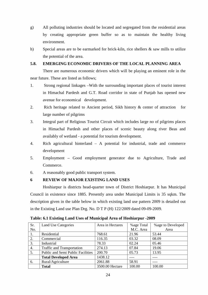
Hoshiarpur is districts head-quarter town of District Hoshiarpur. It has Municipal
Council in existence since 1885. Presently area under Municipal Limits is 35 sqkm. The
description given in the table below in which existing land use pattern 2009 is detailed out
in the Existing Land use Plan Drg. No. D T P (H) 122/2009 dated 09-09-2009.
Table: 6.1 Existing Land Uses of Municipal Area of Hoshiarpur -2009
Sr. No.
Land Use Categories Area in Hectares %age Total M.C. Area
%age to Developed Area
1. Residential 768.61 21.96 53.44 2. Commercial 116.35 03.32 08.09 3. Industrial 78.33 02.24 05.46 4. Traffic and Transportation 274.13 07.84 19.06 5. Public and Semi Public Facilities 200.70 05.73 13.95 Total Developed Area 1438.12 ---- ---- 6. Rural/Agriculture 2061.88 58.91 ---- Total 3500.00 Hectare 100.00 100.00

25
The following table shows the details of area of Hoshiarpur Local Planning Area:
Table: 6.2 Existing Land Use of Local Planning Area of Hoshiarpur -2009
Sr. No.
Land Use Categories Area (in Hectares)
%age to Developed Area
%age to Total Area
1. Residential 825.11 48.83 08.15
2. Commercial 111.94 06.62 01.11
3. Industrial 78.88 04.67 00.78
4. Traffic and Transportation 422.10 24.98 04.17
5. Public and Semi Public Facilities 251.94 14.90 02.49
Total Developed Area 1689.97 ---- ----
6. Rural/Agriculture/Forest/Waste
Land/River/Canal/Orchards
8428.03 ---- 83.30
Total 10118.00 100.00 100.00
Note:
§ Area shown at column No. 6 includes area falling in water bodies including area under
Choes, Waste Land, Vacant land, area under Agriculture use.
§ Area detail for 2009 is as per extended Municipal limits.
6.1 RESIDENTIAL USE
Out of 3500 hectare area falling within municipal limit, 768.61 hectare area falls
under residential use which is 21.96% of the total area falling under municipal limit. Gross
town density comes to 42.76 persons per hectare. In case of local planning area of
Hoshiarpur, residential area contributes to 825.11 hectares accounting to 08.15% of the total
10118 hectares area. But the development is unplanned. The gross density comes to be
18.52 persons per hectare. Interior residential areas are congested and densely populated
whereas the outskirts are comparatively less dense but the growth pattern is unplanned.
26
The major pattern of use of the, existing housing stock is residential which comprise
of nearly 2/3rd of the total housing stock (64.7%). Mixed use of houses has also been
observed in large number of cases. Every 8th house in the city is being used both for
residential and commercial/office purposes. In addition, every 22nd house has been found to
have additional use besides serving for residential purposes. Despite the fact that the
occupation density in the housing is very high, every 11th house in the city remains a vacant
or unoccupied. Thus it has been observed that the available housing stock is also not being
put to optimal use. In order to facilitate the construction of housing, large number of
schemes has been framed by the Department of Housing & Urban Development, PUDA,
Improvement Trust, House fed and
Municipal Council Hoshiarpur
colonies. In Hoshiarpur these
agencies have provided developed
plots by framing Housing Schemes
in. Improvement Trust, Hoshiarpur
has so far promoted 3 number of
development schemes in the city.
Municipal Committee has
contributed by framing 17 Town
Planning Schemes.
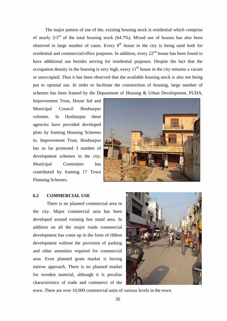
6.2 COMMERCIAL USE
There is no planned commercial area in
the city. Major commercial area has been
developed around existing bus stand area. In
addition on all the major roads commercial
development has come up in the form of ribbon
development without the provision of parking
and other amenities required for commercial
area. Even planned grain market is having
narrow approach. There is no planned market
for wooden material, although it is peculiar
characteristics of trade and commerce of the
town. There are over 10,000 commercial units of various levels in the town.

27
An area of 111.94 hectares is under commercial use within municipal limit which is
03.20% of the total municipal area. It also includes area under grain market and godowns.
6.3 INDUSTRIAL USE
Total area under industrial use is 78.88 hectare which is 2.25% of the total municipal
area. Major industrial concerns are Mahaveer spinning Mill, Hawkins Pressure Cooker. One
Industrial Focal Point is also functioning in the city. Hoshiarpur is also known for Cane
furniture and wooden furniture. Wood carving is a peculiar art in this area. However the
town is considered backward in industrial development, although it has got the potential.
HAWKINS PRESSURE COOKER FACTORY
INDUSTRIAL FOCAL POINT
6.4 TRAFFIC AND TRANSPORTATION:-

28
The road system in
Hoshiarpur is not well defined and
suffers from congestion and
heterogeneous traffic which causes
traffic problems, and economic
loss. Over 270 hectare of land is
covered under the roads.
Bus stand at Hoshiarpur is
short of space and at present it is
functioning in a small site of 0.9
acres. The Bus Stand is situated in the center of the city, which is under renovation. Bus
terminal not only lacks in public facilities & utilities, improper maintenance but its location
and size causes lot of public inconvenience. Detail of major roads in local planning area is
as under:-
1. Hoshiarpur-Garshankar-Chandigarh road.(SH-24) Scheduled Road
2. Hoshiarpur-Dharamshala road.(NH-70) Scheduled Road
3. Hoshiarpur-Jalandhar road.(NH-70) Scheduled Road
4. Hoshiarpur-Una road.(SH-22) Scheduled Road
5. Hoshiarpur-Tanda road.(SH-22) Scheduled Road
6. Hoshiarpur-Dasua road.(SH-24) Scheduled Road
7. Hoshiarpur-Phagwara road.(MDR-Scheduled Road)
Hoshiarpur is properly linked with surrounding area with various levels of link
roads. Because of the presence of number of choes, accessibility becomes difficult during
rainy season when all of these choes are in spate.
Encroachment on Road

29
Mixed Traffic in Shopping Street
City lacks in planned commercial area, it has come up along the major city roads.
Extension of the shops along with the on street parking even on the paved portion of the
roads cause hindrance in the smooth flow of the traffic
6.5 RECREATIONAL:
Hoshiarpur town lacks in
parks, play grounds and open
spaces. One stadium, one indoor
stadium is available. Almost all the
major education institution are
having their own playground. In
addition one Herbal Park, one Van
Chetna Park along with small parks
and open spaces are available but
the facility is inadequate as for as
norms and slandered are concern.
6.6 PUBLIC AND SEMI-PUBLIC FACILITIES
6.6.1 Educational
Hoshiarpur has 42 elementary schools, 21 senior secondary/high schools along with
seven colleges and four industrial training institutes. Department of Sanskrit of Punjab
University is also functioning here .Govt. College, DAV College, SD College, JR
Polytechnic College are the important Institutions in the town. Total area under Educational
use within Municipal limits is 5.57 hectare.

30
Government College
J.R. Government Polytechnic College
6.6.2 Medical
There is one civil hospital with 200 beds capacity; one T.B. hospital, one EHSC,
five homeopathic dispensaries and one police hospital are functioning in Hoshiarpur with
covering an area of 9.28 hectare. Large number of private hospital/nursing home is also
extending health services to the inhabitant of this area.
The town has one veterinary polyclinic & one veterinary dispensary each are located in
Railway Mandi area within M.C. limits. It covers an area of 1.15 hectare. For town level facilities,
the existing situation seems to be satisfactory but people are largely dependant to major surrounding
urban centers like Jalandhar, Ludhiana & Chandigarh for specialized facilities.

31
6.6.3 Public Utilities
Water Supply: Water supply in Hoshiarpur is not up to the mark. There 61 no of tube wells
with 8 no of OSHR available and the town is not fully covered by piped water supply. The
water demand is supplemented by the people through deep wells and hand pumps. The area
under water works located in the town is 2.39 hectare.
Sewerage: Hoshiarpur lacks in underground sewerage systems. About 1/3rd area is not
covered under sewerage system. The solid wastes are carried manually and thrown at
different places in the town which create unhygienic conditions in the town and encourages
breeding of mosquitoes and flies. Overflow from domestic septic tanks can be seen here &
there on the roads and streets.
Electric Power House: One 132 K.V. Electric Grid Station and two 66 K.V. Electric Sub
Station are functioning. This Electric Sub Station covers an area of 1.59 hectare.
Other Utilities: Newly Constructed District Administrative Complex is functioning on
Chandigarh Road. There are 35 Banks, one Telephone Exchange, Post & Telegraph Office,
one police station are functioning in the Town.
6.6.4 Cremation
Hoshiarpur has sufficient cremation ground and grave yard located on various
places. Area under the cremation ground is 4.31 hectare within M.C. limits.
6.6.5 Government Use
Almost all the state offices are hosed in newly constructed District Administrative
Complex with an area of 6.35 hectare. Judicial Complex is yet to be constructed. Certain
other offices of state and centre government are still located in scattered location.
6.6.6 Religious & Heritage
The legends associate several places in the district with pandavas. Dasua is mentioned in
epic of Mahabharata as the seat of Raja Virat in whose services the Pandavas remained for
thirteen years during their exile. Bham, about 11 km west of Mahalpur is said to be the
place where the Pandavas passed their exile. Lasara, about 19 km north Jaijon, also contains
a stone temple stated to date back to the time of Pandavas. According to the chinese pilgrim,
Hieun Tsang, the area of Hoshiarpur was dominated by a tribe of Chandrabansi Rajputs,
who maintained an independent existence for centuries before the Muhammadan conquest.
32
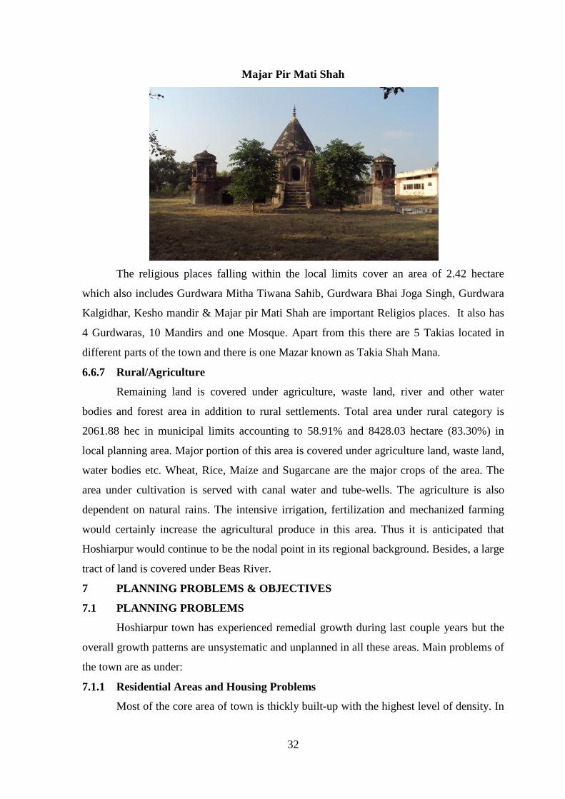
Majar Pir Mati Shah
The religious places falling within the local limits cover an area of 2.42 hectare
which also includes Gurdwara Mitha Tiwana Sahib, Gurdwara Bhai Joga Singh, Gurdwara
Kalgidhar, Kesho mandir & Majar pir Mati Shah are important Religios places. It also has
4 Gurdwaras, 10 Mandirs and one Mosque. Apart from this there are 5 Takias located in
different parts of the town and there is one Mazar known as Takia Shah Mana.
6.6.7 Rural/Agriculture
Remaining land is covered under agriculture, waste land, river and other water
bodies and forest area in addition to rural settlements. Total area under rural category is
2061.88 hec in municipal limits accounting to 58.91% and 8428.03 hectare (83.30%) in
local planning area. Major portion of this area is covered under agriculture land, waste land,
water bodies etc. Wheat, Rice, Maize and Sugarcane are the major crops of the area. The
area under cultivation is served with canal water and tube-wells. The agriculture is also
dependent on natural rains. The intensive irrigation, fertilization and mechanized farming
would certainly increase the agricultural produce in this area. Thus it is anticipated that
Hoshiarpur would continue to be the nodal point in its regional background. Besides, a large
tract of land is covered under Beas River.
7 PLANNING PROBLEMS & OBJECTIVES
7.1 PLANNING PROBLEMS
Hoshiarpur town has experienced remedial growth during last couple years but the
overall growth patterns are unsystematic and unplanned in all these areas. Main problems of
the town are as under:
7.1.1 Residential Areas and Housing Problems
Most of the core area of town is thickly built-up with the highest level of density. In
33
addition dilapidated structure in these areas has become major phenomena. The new
residential areas are coming up without planning and haphazard way.
7.1.2 Mixed Landuse
All major land uses viz. Residential, Commercial and Industrial etc. are mixed with
the other creating more quash confusion in the overall land use pattern of the town. In
laniary areas mainly around the bus stand is greatest prominent areas in this regard.
7.1.3 Faulty Road Pattern
Road pattern is faulty and has developed without any conceived pattern road
junction and geometric are creating more confusion. Mixing of slow and fast vehicles traffic
is creating more problems. Railway crossing is also creating hurdle in smooth flow of
traffic.
7.1.4 Environmental Pollution
All kind of pollution including Noise pollution and Air pollution is the peculiar
characteristics of the area which need to be care. Stagnant water and heaps of garbage can
be seen here and there in the town.
7.2 PLANNING OBJECTIVES
Considering the role, impact, growth and contribution made by the city of
Hoshiarpur to the economy, employment and productivity of the State of Punjab, the future
growth and development strategies of Hoshiarpur city needs to be viewed in the larger
canvas of regional context. Therefore, the task of preparation of Master Plan, Hoshiarpur
with the perspective year 2021 has been undertaken with the following objectives:
i) To make Hoshiarpur city as the most vibrant economic centre to promote the balanced
growth.
ii) To promote state of art, physically planned environmentally sustainable and socially
equitable development of the city.
iii) To minimize haphazard, unplanned and sub-standard growth and development of the
city and to achieve planned growth to create healthy environment.
iv) To effectively manage the traffic and transportation within the city thorough the
mechanism of rationalizing the land use pattern defined in the Master Plan.
v) To ensure safety, mobility and efficiency of inter and intra-city traffic.
vi) To improve regional road, rail and air connectivity of the city to make it a Regional
industrial and economic hub.
vii) To minimize travel within the city by creating self contained and self sufficient
communities.
34
viii) To rationalize the distribution of physical and social infrastructure in order to ensure
appropriate quality of life to all the residents of the city.
ix) To make land market more effective and efficient by making available sufficient
amount of developed land for urban purposes at the most affordable cost.
x) To optimize the use of available land resource through well defined development
norms and to minimize diversion of valuable agricultural land for non-agricultural
purposes.
xi) To check the growth of slums by making informal sector integral part of city planning
and development process.
xii) To create an efficient, comfortable and cost effective road/rail based rapid mass
transportation system to minimize use of personal vehicles and to meet the existing
and future travel needs of the city.
xiii) To improve the capacity of the existing road net work through redesigned, improved
road geometry and removal of encroachments.
xiv) To promote better urban governance and resource generation for urban infrastructure
and planned development.
xv) To provide adequate opportunities for creating affordable and cost effective shelter for
all sections of society through the mechanism of cooperative housing.
xvi) Adequate parking spaces to be created in the city as an integral part of commercial,
industrial and institutional planning and development process.
xvii) To decongest the central core of the city through the mechanism of relocation and
decentralization of economic activities and to rationalize the distribution of
population, community facilities and services across the city.
xviii) The Master Plan Endeavors to promote an improve living environment and micro
climate of the city by :
· Creating city forest on the land available within the city.
· Reducing pollution caused by large movement of vehicles within the core areas.
· Creating green buffer around the city.
xxiii) To identify man-made and natural heritage and to make heritage conservation as
integral part of the city planning and development process.
xxiv) To promote and preserve culture of the city and its special characteristics and to
encourage tourism appropriate to city culture and environment.
xxv) Shifting of dairies from the city to outer areas to make city clean.

35
PART III
VISION 2031
8 POPULATION PROJECTIONS & DISTRIBUTION
8.1 POPULATION PROJECTION
As per census record Hoshiarpur town registered population of 149668 persons in
2001 and 122705 persons in 1991 with net growth rate of 21.60%. This growth rate was
mainly due to construction of bridge across river, various choes & other economic activities
which has given new dimension to the development of this belt which was earlier ignored
because of poor accessibility. It is expected that the town would grow faster in the next 20
years because of its improved connectivity, religious background, rich heritage and fertile
agriculture land. It would also continue to perform commercial, industrial, educational,
medical and administrative function in this region. Thus it is anticipated that there would an
increase in the population due to improved linkages & connectivity
For preparation of Master Plan of Hoshiarpur, the present population of the M.C
.limits of the town and the villages falling in Local Planning Area and their average growth
rate of population has been kept as basis. While formulating this long range plan, the
characteristic of population, sex composition, its employment pattern and migratory status
have also been given the significance.
The analysis of the past population trend, geographical potentialities of the region
have also been kept as the basis for projecting the future population for a period of 20 years.
The population projection has been made by adopting various methods. However, mean of
projected population by different methods have been kept as the projected population for the
purpose of Master Plan. The details of the population projections of the Local Planning
Area are tabulated in the table 10.1 below:

36
Table 8.1 Population Projection for Local Planning Area Hoshiarpur.
Sr. No.
Name of Villages. H.B.No.
Population as per census 1991
Population as per census
2001
Decadal growth
rate
Actual Growth Rate
1991-2001
Population Projection
2011
Population Projection
2021
Population Projection
2031 1 2 3 4 5 6 7 8 9 10 1. Hoshiarpur(MC) -- 122705 149668 26963 21.97 182550 222656 271574 2. Bassi Nau 180 1055 1202 147 13.93 1369 1560 1777 3. Hardo Khanpur 224 2853 3385 532 18.65 4016 4765 5654 4. Dagana Khurd. 230 114 123 9 7.90 134 146 159 5. Dagana Kalan. 231 1317 1474 157 11.92 1650 1847 2067 6. Kahri. 242 1069 1248 179 16.74 1457 1701 1985 7. Korangna 243 195 223 28 14.35 255 292 334 8. Singriwala 245 1964 1991 -53 20.41 Av. 2301 2771 3336 9. Shergarh. 250 2162 2456 294 13.60 2790 3169 3600
10. Dholanwal. 252 736 870 34 4.62 910 952 996 11. Attalgarh 253 354 340 -14 20.41 Av. 409 492 592 12. Kaimpur. 254 322 360 38 11.80 402 449 502 13. Maruli Brahamana 256 1354 1536 182 13.44 1742 1975 2242 14. Bassi Daulatkhan 257 1796 1789 -7 20.41 Av. 2154 2594 3123 15 Punga. 258 74 71 -3 20.41 Av. 85 102 123 16 Chhauni Kalan. 348 1808 2373 565 31.25 3115 4088 5366 17. Kila Berun 350 864 1213 349 40.39 1702 2389 3354 18. Bajwara. 355 5753 7516 1763 30.64 9819 12828 16758 19 Kotla Jhiri. 361 131 7 -124 30.41 Av. 8 10 12 20 Bassi Gulam Husain 362 2599 2741 147 5.58 2892 3059 3230 21 Bassi Purani. 363 717 762 47 6.28 810 860 914 22 Kotla Gonspur 369 522 955 433 82.95 11747 3196 5847 23 Ajjowal 371 1833 2768 935 51.00 4180 6312 9531 24 Bassi Khizar Khan. 372 71 120 49 69.01 203 343 580 25 Brahmjit 373 433 515 82 18.94 612 728 866 26 Akahlaspur 374 186 294 108 58.06 465 735 1162 27 Kakon 375 1301 1333 32 2.46 1366 1400 1434 28 Khakhali. 383 162 146 -16 20.41 Av. 175 210 252 TOTAL -- 154450 187462 -- -- 230023 281630 347370
SAY 3, 50,000 persons

37
The study of population projection reveals that the mean projected population of the
Local Planning Area in the year 2011 works out to be 230023 persons, 281630 in the year
2021 and 347370 persons (say 3,50,000 person) in the year 2031 as shown in the table 10.1.
8.2 PROPOSED POPULATION DISTRIBUTION
The above table reveals that the mean projected population of Hoshiarpur Local
Planning Area for the year 2031 would be 3,50,000 person , out of which the population of
Hoshiarpur M.C. is worked out to be 271574 persons, which is going to be part Urbanisable
area. It is anticipated that 30% population of remaining villages falling in Local Planning
Area would migrate to Urbanisable Area during Plan Period. Thus the total population
which would be required to be accommodated in the Urbanisable limits by the year 2031
worked out to be 3,00,000 persons.
Two residential slabs have been proposed so as to accommodate 3,00,000 persons in
urbanisable Area with high density of above 201 persons per acre and a low density of 151
– 200 persons per acre. Thus the total requirement for residential purpose comes to 275
hectare. However, keeping in view the potential of the area, it is anticipated that almost
equal amount of additional residential area can also be put into same use for giving more
avenues and options to the inhabitants and optimum utilization of land resources. Other land
use zones are also calculated in the same pattern.
As already stated informal sector is proposed to be made an integral part of planning
process. Accordingly the informal sector trade would be incorporated in the planned
development in various use zones. The provision of informal sector trade units should be
ensured at the time of sanction of building plans/layout plans as per the norms given in the
table below:
Table 8.2: Planning Norms for Informal Sectors
Sr. No.
Use zones/use premises No. of informal shops/units
i Retail trade: Metropolitan city centre, district centre, community centre, convenience shopping centre
3 to 4 units per 10 formal shops(to be provided in informal bazaar/service market components)
ii Government and commercial offices 5 to 6 units per 1000 employees iii Wholesale trade and freight complexes 3 to 4 units per 10 formal shops iv Hospital 3 to 4 units per 100 beds v Bus terminal 1 unit for 2 bus bay vi Schools
Primary Secondary/ to 4 units Senior secondary/integrated 5 to 6 units
vii Parks District parks 8 to 10 units at each major entry Neighbourhood parks 2 to 3 units
viii Residential 5 unit/1000 population ix Industrial 5 to 6 units per 1000 employees

38
9 CONSTITUTION OF THINK TANK COMMITITEE
For the Master Plan, it is necessary to develop a long term (2031) vision for the city
that takes in to account the present strengths, opportunities, weaknesses and threats (SWOT)
emanating in the region. For visualizing future city – “Think Tank” under the
chairmanship of Worthy Deputy Commissioner, Hoshiarpur has been constituted. The basic
objective of formulating this committee is to discuss SWOT for the Master Plan, Hoshiarpur
and ensure the stakeholder participation so that the Master Plan so prepared is technically
sound, takes care of the requirements of all sections of the society and is readily acceptable
to the public.
As directed by the Govt., the “Think Tank” has been constituted in such a way that
almost all sections of the society viz., public sector, private economic sector and social
sector had been given due representation.
CONSTITUTION OF THINK TANK
Public Sector Private and Economic Sector
Social Sector
Meetings of Think Tank
SWOT
Vision 2031
Preparation of Issuer Paper

39
9.1. S W O T Analysis
STRENGTHS
· Strategic location in terms of linkages.
· Important Urban centre of district Hoshiarpur and of adjoining districts of Jalandhar,
Kapurthala, Saheed Bhagat Singh Nagar and Gurdaspur in Punjab & Dharamshala ,
Kangra, Chintpurni, Chamunda Devi, Una in Himachal Pardesh.
· Balance growth rate of population.
· Existence of industrial units like Agro based units such as Rice Shellers, Floor Mills
etc.
· Diversified economic activities.
· Rich heritage and various places of tourist importance.
· Important Educational center of Regional Level.
WEAKNESSES
· Located away from Developed belt of state known as G.T Road corridor.
· Lack of cohesive environment for small scale industries and negligible Share of
household industry.
· Unplanned commercial development along main roads.
· Lack of connectivity of infrastructure due to non -existence of proper rail links.
· In- adequate parking spaces.
· 25% population not served by piped water supply.
· Sewerage facility not adequate.
· No sewerage treatment facility available.
· Absence of Storm water drainage.
· Unscientific disposal of solid waste causing pollution and unhealthy environment.
OPPORTUNITIES:
· Strengthening of major roads of LPA such as Hoshiarpur-Jalandhar Hoshiarpur-
Phawara road, Hoshiarpur-Una road, under various projects initiated by central &
state agencies.
· Construction of bridge across Bhangi Choe in the town.
· Development of places of tourist interest.
· Availability of large chunks of land along the various Choes, which can be put into
optimum utilization for various purposes including forestation, leisure valley and
sports activities.
40
THREATS:
· Present Scenario of commercial development along major roads will create more
parking problems.
· Through traffic creates burden on interior roads.
· Unplanned growth in & around town area.
· Large chunks of waste land.
· Flood prone area in & around the town.
9.2. Vision 2031
Hoshiarpur town after partition has recorded a phenomenal increase in population as
well as in physical growth. At the time of partition of the country, a large number of
refugees from Pakistan were rehabilitated in this town as a result of which new industrial
and commercial activities were started. With the passage of time, people from other parts of
the state also came to this town in search of employment and ultimately settled in this town.
In order to come with increasing demand for housing, water supply, sewer, education,
health, shopping etc., new areas was developed. Although in the initial stages, a few
planned colonies like Urban Estates, Model Town, Development Schemes by Improvement
Trust and a few industrial focal points were planned by the govt. but this development was
not sufficient to bear the load of population pressure and subsequently a large number of
unplanned colonies came to be set up which not only resulted in the haphazard growth of
the town but also lacked proper road network, parks and open spaces, spaces for education,
health and other social infrastructure. A number of areas were devoid of portable water
supply and sewerage facilities etc. The town also lacked planned shopping centers with
organized parking which gave birth to mushrooming of commercial activities along the
frontage of important roads/streets and the traditional bazaars came to be set up without
adequate parking and loading and unloading facilities. The new industrial area also came up
in an unplanned manner without required industrial infrastructure.
The area of present Hoshiarpur District was also part of Indus Valley Civilization.
Recent excavations at various sites in the district have revealed that the entire area near the
Shiwalik foothills was selected for habitation not only by the early Paleolithic man but also
by those in the pre-historic and historic periods. In the explorations, seven early Stone Age
sited a Atbarapur, Rehmanpur and Takhni, 30-40 km north of Hoshiarpur District in the
foothills of Shiwalik, have been discovered where the stone artifacts have been found.
Besides these excavations, among the archaeological remains in the Hoshiarpur District, the

41
remains of temples at Dholbaha, 24 km north of Hoshiarpur, and especially the local
legends throw valuable light on the ancient history of the district. Following objectives have
been kept in mind while preparing master plan of Hoshiarpur.
· Developing the town of Hoshiarpur in the light of its heritage and glorious past.
· Preserving natural resources to achieve a more wholesome vibrant and sustainable
lifestyle;
· Introducing critical strategic economic growth initiatives including Agro based
Industries.
· Promoting a comprehensive planned township that will enhance quality living,
ensuring accessibility and managing overall growth
· The key development strategies shall includes all the important place of interest in
the nearby areas.
· Safeguarding and providing land for development to meet all needs.
· Encouraging sustainable economic growth and coordinating infrastructural
development;
· Enhancing the quality of life; Live, Work, Learn and play.

42
PART IV
THE MASTER PLAN
10. PROPOSED LAND USE PLAN – (2009-2031)
The proposed Land Use Plan for Hoshiarpur takes into account the topographical
features, existing road pattern, the built up area and the existing land uses. The natural
features of low lying belt along river Beas have been proposed as recreational track. The
arrangement of all these land use and the manner in which they interact, determine the
distinctive character and form for the projected development of the town.
The land use plan in essence is the translation into physical form of the planning
policies and principles. The land use plan will ensure the success of the urban plan by
positive development of surrounding villages and regulatory measures in the inter mediate
areas.
In order to accommodate the projected population of 350,000 persons in local
Planning Area by the planned period up to 2031, as worked out in the fore going paragraph,
3,00,000 persons population is to be accommodated in the urbanisable area of Hoshiarpur.
The urbanisable area has been conceived by assuming gross town density of 50 persons per
hectare. Thus an urbanisale area of 6602 hectare has been proposed for various land uses so
as to cater to the requirement of projected population by the end of the planned period i.e.
2031.
The draft for Master Plan of Local Planning Area Hoshiarpur 2009-2031 bearing
drawing number DTP (H) 146/ 2010 dated 07-10-2010 was prepared and published on 04-
12-2010 for public objections under Section 70(3) of the Punjab Regional and Town
Planning and Development (Amendment) Act 2006. The publication invited 5 public
objections which were considered in a meeting of “The Punjab Regional and Town
Planning and Development Board” held on 04-04-2011 headed by Honourable Chief
Minister Punjab. After careful consideration of the objections, the Master Plan, Hoshiarpur
was approved with minor changes. In the light of decisions taken in the meeting of “The
Punjab Regional and Town Planning and Development Board” held on 04-04-2011
amendments have been carried out in published Drawing no DTP (H) 146/ 2010 dated
07/10/2010.
The proposed land use plan Drawing No. DTP (H) 151/2011 dated 02-05-2011 has
been prepared which is the amended version of published drawing no. DTP (H) 146/ 2010
dated 07/10/2010. The proposed land use plan illustrates related town functions and
projected land uses for a period of 22 years (2009-2031) with the objective of securing
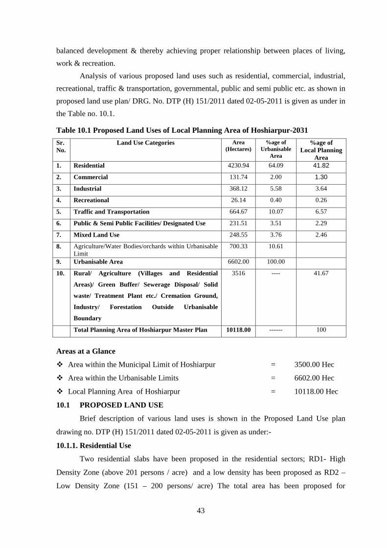
43
balanced development & thereby achieving proper relationship between places of living,
work & recreation.
Analysis of various proposed land uses such as residential, commercial, industrial,
recreational, traffic & transportation, governmental, public and semi public etc. as shown in
proposed land use plan/ DRG. No. DTP (H) 151/2011 dated 02-05-2011 is given as under in
the Table no. 10.1.
Table 10.1 Proposed Land Uses of Local Planning Area of Hoshiarpur-2031
Sr. No.
Land Use Categories Area (Hectares)
%age of Urbanisable
Area
%age of Local Planning
Area 1. Residential 4230.94 64.09 41.82
2. Commercial 131.74 2.00 1.30
3. Industrial 368.12 5.58 3.64
4. Recreational 26.14 0.40 0.26
5. Traffic and Transportation 664.67 10.07 6.57
6. Public & Semi Public Facilities/ Designated Use 231.51 3.51 2.29
7. Mixed Land Use 248.55 3.76 2.46
8. Agriculture/Water Bodies/orchards within Urbanisable Limit
700.33 10.61
9. Urbanisable Area 6602.00 100.00
10. Rural/ Agriculture (Villages and Residential
Areas)/ Green Buffer/ Sewerage Disposal/ Solid
waste/ Treatment Plant etc./ Cremation Ground,
Industry/ Forestation Outside Urbanisable
Boundary
3516 ---- 41.67
Total Planning Area of Hoshiarpur Master Plan 10118.00 ------ 100
Areas at a Glance
v Area within the Municipal Limit of Hoshiarpur = 3500.00 Hec
v Area within the Urbanisable Limits = 6602.00 Hec
v Local Planning Area of Hoshiarpur = 10118.00 Hec
10.1 PROPOSED LAND USE
Brief description of various land uses is shown in the Proposed Land Use plan
drawing no. DTP (H) 151/2011 dated 02-05-2011 is given as under:-
10.1.1. Residential Use
Two residential slabs have been proposed in the residential sectors; RD1- High
Density Zone (above 201 persons / acre) and a low density has been proposed as RD2 –
Low Density Zone (151 – 200 persons/ acre) The total area has been proposed for
44
residential was comes out to 4230.94 hectares.i.e.64.09 % of urbanisable area whereas
41.82% of the local planning area. The proposed residential area has been enhanced to
provide better options & to have a control on land Economics of the area. For earmarking
the residential area existing requirements as well as future requirements and prevailing trend
has been kept in mind. All the areas ripe for development especially on major roads such as
Chandigarh road, Jalandhar road, Dasuya road etc. have been given sue consideration. As
the topography has played an important role in this area, it has been studied for allocating
various land use especially residential areas.
To encourage flatted residential development and to preserve the valuable
agricultural land, residential density @ 60 dwelling units per acre shall be permissible for
stand alone group housing projects, irrespective of the density of zone.
The subdivision of residential use zone into use premises and subsequent approval of layout
plans shall be governed by following norms:
The residential area can have both the plotted and group housing. In case of group and
plotted development, minimum plot size, ground coverage, FAR, Height, Parking standards
and other norms shall be as per building bye laws of the concerned local body / JDA and
Govt. instructions issued from time to time if any. The provision of requisite social
infrastructure shall be governed by the norms prescribed by concerned municipal body /
JDA and as per instructions issued by the State Govt. from time to time. However, the
following will be taken into consideration:
ÿ Rainwater harvesting shall be an integral part of the storm water drainage plan at the
time of sanction of layout plan for all the plots.
ÿ The natural drainage pattern is not to be disturbed.
ÿ Dual pipe system of recycled water is recommended in new areas and redevelopment
schemes.
ÿ Electric sub stations shall be provided as per requirement.
ÿ Pole mounted electric transformers for augmenting electric supply in already developed
areas are recommended.
ÿ Non- conventional sources i.e. solar energy etc is recommended for public areas in all
the establishments.
ÿ Provisions for decentralized sewerage treatment plant and segregated waste disposal
arrangement should ensure that no untreated effluent is allowed to exit/ spill out of the
scheme area.

45
ÿ Suitable landscape plans for the neighborhood shall be prepared, for the landscape
development of the parks and roadside plantation etc
ÿ Suggestive norms/lower norms could be adopted in specially identified built up areas
etc.
Building Controls
Residential plot- plotted housing and Group Housing
Maximum ground coverage, FAR, set backs, height and number of dwelling units
for different size of residential plots shall be as follows:
ÿ Within M.C. Limits: For sites falling within municipal limits area requirement,
planning norms, ground coverage, set backs, height and FAR etc. shall be applicable as
per norms and building bye-laws of the local/municipal body concerned.
ÿ Outside MC limits: For sites falling outside municipal limits area requirement,
planning norms, ground coverage, set backs, height and FAR etc shall be applicable as
per norms and building bye-laws of JDA and instructions / guidelines issued by the
State Govt. from time to time.
Note: The development controls for residential clusters / group housing have been detailed
in Section 14 titled “Special and Detailed Controls”.
Land use zoning regulations:
Uses permissible in residential zone are given in the Part 12.2.2 titled “Use
provisions in land use zones”.
10.1.2. Commercial Use
The existing commercial areas falling around Bus Stand, old district offices, railway
road, Jalandhar road, Phagwara road and their surroundings commercial areas have been
retained where-ever is possible. An area of 131.74 hectare for retail shopping, general
business and commerce has been proposed at various locations. The grain market developed
by the Colonization Department has been spot zoned and an additional area contiguous to
this site has also been [proposed for the expansion of this wholesale business areas. It is
further proposed that the commercial area shall be provided with adequate parking facilities,
open spaces and other public amenities tin the detailed zoning/sector plans. Thus a total area
of 131.74 hectares i.e.2.0% of the urbanisable areas and 1.30 % of the local planning area
has been proposed for commercial use. While preparing the zoning plan adequate area as
per norms and keeping in view the requirements shall be earmarked.

46
10.1.3. Industrial Use
Hoshiarpur is located in an agricultural belt along the Beas River. The town has,
therefore, potential for agro-based industries and the industries based on the long grass
grown on the low-lying banks of the river. Thus Hoshiarpur has potential to develop in the
field of light and service industries. Keeping in view the potentials, an industrial area of
368.12 hectare accounting to 5.58% of urbanisable area and 3.64% of the local planning
area has been proposed including the existing industrial area. The industrial zone has been
proposed keeping in view the prevailing wind direction and location of residential zone.
Green buffer/ belts have also been proposed between the village abadies and the proposed
industrial zone, from environmental point of view.
Incentives for shifting of existing industries:
Industries existing within the non-designated industrial zone, which are in operation
as on date of Master Plan notification, shift outside this zone to any of the designated
industrial zone within the state of Punjab or within the designated industrial zone of the
master plan and generate at least the same number of jobs at the new location, will enjoy the
following benefits:
1) No CLU, EDC or Licence Fee on the present site if used for plotted residential purposes
provided the industry shifts within three years of the notification of the Master Plan. If
used for any permissible land use other than plotted residential, the difference between
CLU, EDC and Licence Fee of the new land use and plotted residential has to be paid.
In case that particular land is put to a land use for which CLU, EDC or Licence Fee is
less than the plotted residential, the difference between these fees/ charges for the
plotted residential and proposed land use shall not be payable by the Government/
Urban Development Authority.
2) If the industry shifts in the subsequent two years of the above mentioned period of three
years, it will enjoy 50% discount on CLU, EDC and Licence Fee on the present site if
used for plotted residential purposes. If used for any permissible land use other than
plotted residential, the difference between the CLU, EDC and Licence Fee of the new
land use and that of 50% of plotted residential has to be paid. In case that particular land
is put to land use for which CLU, EDC or Licence Fee is less than the plotted
residential, the difference between these fees / charges for the plotted residential and
proposed land use shall not be payable by the Government / Urban development
Authority.
47
3) No CLU, EDC or Licence fee on the new industrial site if the industry shifts within five
years of the notification of the Master Plan.
4) After shifting to the new location, the type of such industry may change.
The prescribed distance for residential development in the non-designated industrial zone
from existing red industries shall be as prescribed by the Department of Environment,
Government of Punjab or Punjab Pollution Control Board.
Note:
i. No industry in the Master Plan shall be permitted on a road having less than 40’-0”
ROW. In case, the existing road is less than 40’-0” width, then it shall be widened to
40’-0” by taking equal strip of land from both sides of the road.
ii. A minimum buffer of 15 meters of broad leaf trees shall be provided for segregating
industrial zone from the residential zone. The provision of buffer strip shall be made
by the owner of Land use which comes later.
iii. The standards prescribed by Punjab Pollution Control Board from time to time
would have to be met by all industrial units in addition to other specific conditions
in terms of plot size, ground coverage, F.A.R., height, parking norms etc.
iv. The existing industrial units falling under red category (as classified by Punjab
Pollution Control Board) located in non – designated industrial areas need to
relocate to designated areas themselves within period of 10 years from date of
publication of this Master Plan.
10.1.4. Recreational
Major public Parks/open spaces shall be proposed while preparing Sector zonal plan.
Continuous green belts/buffers have also been proposed almost in all the sectors for
providing better residential facilities and to provide healthy environ. Apart from this
considerable area along the various choes has been proposed for forestation, landscaping
and recreational activities with special emphasis on sports activities.
10.1.5. Traffic and Transportation
The total area proposed under traffic and transportation is 664.67 hectare i.e. 10.07%
of the urbanisable area and 6.57% of the local planning area. It also includes 40.99 hectare
area under railways. The details of this use area described as under: -
Bus Stand
The existing bus stand already functioning in town has been proposed to be retained.
However, for the future requirement, site of bus stand shall be shifted as decided by site

48
selection committee constituted for the above said purpose.
Truck Terminal
A truck terminal shall be proposed in proposed Industrial zone on the northern side
of the Chandigarh Road. With the increase of goods movement, the town is going to have a
huge amount of passenger and goods traffic passing through it. In view of this the truck
terminal has been proposed on an appropriate site. This will serve the town from un-
necessary traffic congestion.
Ring Road Proposed
The present road system in the town is based on major regional roads viz. Jalandhar
Hoshiarpur Dharamshala, Tanda Hoshiarpur Una, Dasua Hoshiarpur Balachaur and
Hoshiarpur Phagwara roads, which are coping with the local and the regional traffic. The
widths of these roads vary at certain points and have a lot of congestion in the interior of the
city. In order to remove congestion in the interior of the town and to provide for smooth and
efficient flow of traffic, a peripheral Ring Road of 60 mtrs width is proposed linking all the
above four regional roads around the urbanisable area, thereby serving as a bye-pass. The
above mentioned road network complete the major traffic system of the town. A ring road
60 mtr wide is proposed to join all the regional links in exterior of the city.
Proposed Road Widening
The categories of the road system proposed in the Master Plan of Hoshiarpur are
given below:
Table No. 10.2: Proposed Width of Regional Roads
Sr. No. Category of Road Right of Way 1. Ring Road National Highway (R-1) 60 mtr wide 2. National Highway (R-1) 60 mtr wide 3. Hoshiarpur Tanda Una (R-2) 45 mtr wide 4. Hoshiarpur Una (R-2) 45 mtr wide 5. Hoshiarpur Dasua (R-2) 45 mtr wide 6. Hoshiarpur Balachaur(R-2) 45 mtr wide 7. Hoshiarpur Phagwara Road ( R-3) 45 mtr wide
Note:
ÿ The existing link roads which are not becoming the part of road hierarchy of R-1 to R-3 shall be
widened to minimum 60’.
ÿ The proposed road widening as shown on the plan shall be equally wide on both sides of the
existing road except where habitation/ settlement come in alignment. In that case, widening shall
be on the other side of habitation/ settlement.
ÿ The road widening wherever proposed along the canal/ drain/ railway line shall be on that side
of the drain as shown on the plans.

49
ÿ Similarly other infrastructural projects to improve connectivity of Local Planning Area by the
Union or State Governments or their instrumentalities shall be incorporated as such.
Proposed Flyovers
Following flyovers are proposed for the smooth flow of traffic in the city:
· Intersection of proposed byepass and the following regional roads:
o Hoshiarpur Tanda Road
o Hoshiarpur Dasayua Road
o Hoshiarpur Dharmshala Road
o Hoshiarpur Una Road
o Hoshiarpur Chandigarh Road
o Hoshiarpur Hoshiarpur Phagwara Road
o Hoshiarpur Jalandhar Road
o Railway Crossing between Phagwara and Jalandhar Road
Note: The location of above mentioned Flyovers/ ROB’s has been shown on drawing No DTP (H)
151/2011 dated 02-05-2011.
10.1.6. Mixed Land Use Zones
The co-existence of residential with commercial and residential with industrial
activities is a common character of our cities. This character is more prevalent in inner zone
of the city. This character of land use generally called “Mixed Land use” has developed
over a period of time necessitated by the socio-economic habits of the people. This
juxtaposed character of land uses have compact built form, narrow street circulation and
low rise-high density development accommodating a mixture of land uses in a single
building. The economic role played by these areas cannot be ignored. Hence an attempt is
made in the present Master Plan to make these areas continue to play an active economic
role and the strategy is to provide suitable framework for allowing mixed use activities
appropriate to the character of the areas with greater flexibility in terms of permitting a
variety of uses like commercial (retail shops), household and green category industry or
outlets for specialized services etc. along with residential use.
Mixed Land Use Zones along Major Roads
The areas along all the major roads i.e. Hoshiarpur Phagwara road, Hoshiarpur
Jalandhar road, Hoshiarpur Tanda road, Hoshiarpur Dasua road, Hoshiarpur Dharmshala
Road, Hoshiarpur Una road and Hoshiarpur Chandigarh road upto the depth of 200 mts. or
as shown on proposed landuse plan Drg. No. DTP (H) 151/2011 dated 02-05-2011is marked
as mixed landuse zone where all the uses are permitted i.e. Residential, Commercial,

50
Industrial (except Red and orange category industries). The area under the Mixed Zone is
248.55 hectares accounting to 3.76% of urbanisable area and 2.46% of total LPA area.
Governing Principles for Mixed Land Use
The principles governing the mixed land use in residential area shall be:-
· Mixed use means the provision for non-residential activity in residential premises.
· The proposal aims to balance the socio-economic need for such activity and minimize
the environmental impact of the said activity on residential areas.
· Mixed use allows access to commercial activity and industrial activity (as permitted by
Punjab Pollution Control Board in non-industrial zone (except approved residential
areas) in the proximity of the residences and reduces the need for commuting across
zones in the city i.e. walk to work principle. However, at the same time, it needs to be
regulated in order to manage and to mitigate the associated adverse impact related to
congestion, increased traffic and increased pressure on civic amenities.
· Mixed use shall not be permitted in approved Town Planning Schemes, residential
development schemes developed by Improvement Trust Hoshiarpur, residential Urban
Estates set up by Punjab Urban Planning and Development Authority (now JDA),
Government housing, Institutional/ staff houses of public and private agencies and
buildings and residential colonies developed by private developers after due approval of
competent authority. However, the streets/ roads declared as commercial by
Department of Local body before the final approval of this Master Plan may continue to
be treated as commercial streets irrespective of the fact that whether they form a part of
Town Planning/ Development Scheme etc.
· The mixed use shall not be permissible in the streets / roads having width less than 10
meters. However the existing mixed use in the streets having width less than 10 meters
may continue (excluding obnoxious, hazardous, inflammable, non-compatible and
polluting substance or process) without any further extension / expansion. These streets
should be declared as pedestrian mixed use streets and should not be open to motorized
transport. However, this need to be debated and the inhabitants of the area are provided
with workable alternatives of mobility. The Municipal Committee may evolve a
package after consensus on the issue.
Note: However, the commercial activity existing in commercial mix use streets / localities
at the time of final approval of this Master Plan may continue to exist without any further

51
extension / expansion. But in case of approval of new commercial activity / any addition to
the existing commercial activity, the condition of minimum width of 10 meters shall apply.
Mixed Use in Residential Areas – Need for differentiated approach:
The need for differentiated approach to mixed use policy arises due to the fact that
Hoshiarpur being a center of economic and industrial activity has a large diversity in the
typology of residential areas. There are unauthorized unplanned residential areas within and
outside the urban limits of the city. There are also regularized unauthorized colonies,
unauthorized colonies as well as slums and jhugi jhompris, cluster in various parts of
Nawanshahr.
Moreover, the extent of non-residential activity, as being necessary or desirable by
the residents themselves, varies from area to area based on the socio economic status of the
residents as well as the past pattern of development in the area. While certain colonies may
need non-residential activity as an integral part of their livelihood, some others may wish to
preserve the residential character of their colonies and neighborhood.
Identification of mixed use in existing urban and urbanizable areas in future:
The identification of mixed use areas/ streets in both the urbanized as well as urbanizable
areas of Hoshiarpur in future would be as follows:
In already urbanized areas/ urban areas, mixed use (except industrial use) shall be
permissible in the following areas:
i) On all streets/ roads already declared commercial by the department of Local
Government Punjab subject to the decision of case/ cases pending in Honorable Court if
any.
ii) Streets/ areas where commercial use was allowed in the previous Master Plan of
Hoshiarpur shall continue to the extent as permissible in the previous Master Plan,
Hoshiarpur.
Future identification and notification of mixed use streets/ areas falling in (i) and (ii) above
shall be based on the criteria and procedure prescribed below and given vide publicity by
the concerned local body/ authority/ any other Competent Authority.
Mixed use Areas/ streets in Urbanizable areas in future
The mixed land use in future shall be permissible in the following areas:
· Roads and localities earmarked in the Master Plan as mixed use streets and areas where
abutting road shall have ROW 18 meters or above.

52
· The layout plan in newly developed urban extension shall earmark such stretches / plots
and notify them under the mixed use category at the time of grant of permission for
layout plan, provided provision of adequate parking as per norms specified is provided.
However in such cases 50% of such area shall be counted towards the commercial area
subject to the overall limit of commercial component permitted.
The notification/ declaration of mixed use areas / streets by the government would
necessitate compliance to the following terms and conditions:
· The layout plan/ scheme for such areas / streets shall be subject to the prior approval of
the local body/ JDA.
· The layout plan / scheme for such areas / streets should indicate adequate provision for
circulation, parking, open spaces and other planning norms.
· Common parking areas shall be provided as per norms considering the additional load
of traffic and parking consequent upon declaration of area/street as mixed use.
· The plot owners / allottee on these areas / streets will have to pay land use conversion
and other fees/ charges at the rates fixed by the government for that particular category
of land use at the time of approval of their building plans from the local body / GLADA
or any other concerned agency.
· Any other condition that may be prescribed by the government from time to time.
· Permission for mixed use can be cancelled or revoked by the concerned local body /
Government in case of violation of any of the conditions under which such mixed use
was permitted or considering the larger interest of the locality / community / city.
General Terms and Conditions Governing Mixed Use in Individual Plots
Mixed land use shall be permitted subject to the following terms and conditions:
· No encroachment shall be permitted on the streets or public land.
· Development controls/ norms as applicable for the particular residential use will
continue to be applicable, even if the plot/ dwelling unit are put to mixed use.
· Where service road is available or provided by the concerned authority then mixed use
premises should have approach from such service road and not directly from the main
road.
· The parking as per prescribed norms by the State Govt./ concerned development
authority from time to time shall be provided within the premises. The existing norms
are as under:

53
Commercial - 2 ECS / 100 square meters covered area
Industrial - 1 ECS / 100 square meters or fraction thereof
Institutional - 1 ECS / 100 square meters
· However, in case the project is approved by Municipal Committee/ Local Body than
the parking norms as prescribed by the local body shall be applicable provided that the
land use proposals of the Master Plan are adhered to.
· If no parking space is available, land / plot on the said street, parking should be made
available by the applicant or trader association either by acquiring additional area for
construction or by creating multilevel parking. Development of such parking facilities
shall be done by either the applicant solely or traders association of that area or by the
local body subject to the payment of the cost by the beneficiaries.
· No industry other than those permitted by Punjab Pollution Control Board shall be
allowed in the industrial mix areas.
· The existing obnoxious, hazardous, inflammable, non-compatible and polluting
industries shall have to move out to the designated industrial zone within a period of ten
years from the publication of notification of the Master Plan.
· However, in case of voluntary shifting of this industry before the specified period, to
designated industrial zones, the owner shall be eligible to put his/her plot, so vacated, to
any other compatible use (including commercial use) subject to the provision of
building bye laws and Master Plan conditions applicable for that particular land use in
that particular area by paying conversion charged as fixed by the Local Body /
government from time to time besides providing incentive as may be decided by the
government.
· The conversion of land use shall be subject to the payment of defined charges.
Mixed use premises and payment of charges
In case of residential premises already under mixed use or intended to be put to
mixed use in mixed land use as earmarked in the Master Plan Nawanshahr, the owner /
allottee of the dwelling unit/plot shall be liable to pay such fee and charges on the rate to
be fixed by the State Government.
No modification to the building for using residential premises for non residential
activities under mixed use zone shall be permitted unless owners/ allottee has obtained
sanction of revised building plans and has paid necessary fee and charges.

54
10.1.7. DESIGNATED USE
All major public & semi public uses including Educational, Medical, Public & Govt.
offices, utilities, facilities and services have been clubbed under designated use. Most of the
existing sites have been spot zoned with proposed enhancement of facilities and levels.
Description is a under:
Water Supply
Presently the 75% town is served by pipes water supply system. There exists 61 tube
well with 8 OHSR are existing within the Municipal Limits of Hoshiarpur. These sites have
been spot-zoned with an area measuring 2.39 hectare at their respective places for water
works. Augmentation of water supply system in the town would be required to be done to
meet the requirements of the existing as well as the projected population, for which new
sites are not being proposed. Such sites would be suitably carved out during detailed
planning.
Sewerage
The under-ground sewerage system in the town is not adequate. One third area is
completely unserved. It is proposed to provide the underground sewerage system along with
effective storm sewer in the town. A site for sewerage Treatment Plant has been proposed
on the outside the Urbanisable Area.
Electricity (Power House, Grid Station)
The expansion of the 132 KV& two 66 KV Electric Sub-Station already existing,
has been spot zoned in the Master Plan on an area of 5.11 hectares.
Governmental
The State government’s offices are already housed in newly constructed District
Administrative complex. However certain offices of state & central Govt. along with
judicial complexes are located at scattered places and are mostly housed in private
buildings. Therefore, sites shall be earmarked for this purpose while preparing.
Medical & Health:-
Existing health facilities have been spot zoned. New areas shall be purposed while
detailing the zonal plan.
Educational:
Existing Educational facilities have been spot zoned. New areas shall be purposed
while detailing the zonal plan.
Religious & Cultural:
The historical and other important religious places have been spot zoned. The area
under this use is 5.30 hectare.
55
10.1.8. AGRICULTURE AND WATER BODIES:
Rural/Agriculture/ Horticulture/ Forest Zone (Village & Residential Area & River)
The remaining area left between the urbanisable area and the planning area
boundary has been left for Rural/Agriculture/Horticulture & Village and Residential abadis.
Area along various choes and waste land along the banks of river has been proposed to be
developed as thick forest. Area under water bodies including canal & distributaries has also
been put in the same category i.e. rural zone.
11 SPECIAL AND DEVELOPMENT CONTROLS
11.1 ZONING REGULATIONS
Chief Town Planner, Punjab being the planning agency designated under Section 57
of the Punjab Regional and Town Planning and Development (Amendment) Act, 2006 for
the Local Planning Area declared under Section 56 of the said Act, following the
requirement under clause (d) of sub section 1 of Section 70 of the Punjab Regional and
Town Planning and Development (Amendment) Act, 2006 hereby makes following Zoning
Regulations as a part of the Master Plan prepared for the Local Planning Area.
The zoning regulations proposed under this Master Plan are primarily concerned with the
control of land use. The proposed land use plan includes following land use zones:
• Residential
• Commercial
• Industrial
• Recreational
• Rural and Agricultural
In addition specific designated uses have been shown in respect of proposed traffic
and transportation, utilities, governmental and public and semi public facilities.
As explained earlier since sub – division of land, design and construction of
buildings is being controlled through well established building byelaws / regulations by the
concerned authorities. The zoning regulations under the Master Plan are seen as the guiding
parameters for these agencies to ensure that the development permitted by them is in
conformity with the Master Plan.
The Development Controls/ Guidelines/ Norms & Standards revised from time to time
by the Government shall have overriding effect on the Development controls
mentioned in the master plan.

56
11.1.1 Use and Development of Land to be in Conformity with Master Plan
As provided under Section 79 of the Punjab Regional and Town Planning and
Development (Amendment) Act 2006, after coming into operation of this Master Plan, no
person shall use or permit to be used any land or carry out any development in any area
otherwise than in conformity with this Master Plan.
Provided that the competent authority may allow the continuance of any use of any
land, for a period not exceeding ten years. Upon such terms and conditions as may be
provided by regulations made in this behalf, for the purpose and to the extent, for and to
which it was being used on the date on which this Master Plan came into operation.
11.1.2 Short Title, Scope, Extent & Commencement
1. Title
These regulations shall be called the Zoning Regulations for Local Planning Area
Hoshiarpur (herein after referred to as “these regulations”).
2. Scope of the regulations
The scope of these regulations is limited to defining permissible land uses in various
land use zones depicted in the proposed land use plan forming part of the Master Plan.
Other aspects of development such as sub - division and layout of land or intensity of
development measured through FAR, ground coverage, parking requirements, building
design and construction etc will be governed by other Acts and regulations promulgated by
Government from time to time. Competent Authorities under such regulations shall ensure
that the developments permitted by them are in conformity with these regulations.
3. Jurisdiction
These regulations shall apply to all “development” in the Local Planning Area
Hoshiarpur declared under Section 56 (i) of the Punjab Regional and Town Planning and
Development (Amendment) Act, 2006 vide Notification No. 12/75/2006-4HG1/4385 dated
07.07.2008.
4. Date of coming in to force
These regulations shall come into force on the day on which the designated Planning
Agency publishes the final Master Plan along with these regulations in the Official Gazette
after obtaining the approval of the State Government under sub section (5) of Section 70 of
the Punjab Regional and Town Planning and Development (Amendment) Act, 2006. Till
such approval, the Authorities considering the application for permission for development
shall give due regard to the draft proposals including these regulations.

57
11.1.3 Definitions
For the purpose of these zoning regulations, the following definitions, unless the
context otherwise requires, shall apply:
a) “Act” means the Punjab Regional and Town Planning and Development (Amendment)
Act, 2006 (Punjab Act No.11 of 1995).
b) “Government” means the Government of the State of Punjab.
c) "Chief Town Planner” means the Chief Town Planner of the Department of Town &
Country Planning, Punjab or any other officer to whom his powers are delegated.
d) “Planning Agency” means the Chief Town Planner, Punjab designated as such under
Section 57 of the Punjab Regional and Town Planning and Development (Amendment)
Act, 2006 for Local Planning Area Hoshiarpur vide notification no. 12/75/2006-4 HG
1/4391 dated 07-07-2008.
e) “Existing Land use Plan” means the plan showing the different land use existing at the
time of preparation of the Existing Land Use Plan of Local Planning Area, Hoshiarpur
and as indicated on Drawing No. DTP (H) 122/09 dated 09.09.09.
f) Local Planning Area” means the Local Planning Area declared under section 56(1) of
the Punjab Regional and Town Planning and Development (Amendment) Act, 2006
vide notification No. 12/75/2006-4HG1/ 4385 dated 07.07.08.
g) “Non-Conforming Building or Use” means use in respect of any land or building in
the Local Planning Area, the existing use of which land or building is contrary to the
prescribed land use in the Master Plan.
h) “Proposed Land use Plan” means the plan showing the proposed / admissible uses for
different areas and land use zones covered in the Local Planning Area, Jalandhar and as
indicated on Drawing No. DTP (H) 151/2011 dated 02-05-2011.
i) “Sector Plan” (Zonal Plan) means the detailed plan of a sector as delineated in the
Master Plan and approved by the Chief Town Planner, Punjab showing all or any of the
following:-
· Major road network, location of main utilities sites, green belts/buffers, water bodies
or other restrictions imposed on the development.
· Area temporarily or permanently prohibited for the building operation.
· Permissible land uses
· Any other detail provided in the layout plan.
j) “Zoning Plan” means the plan of an area or part thereof or supplementary layout plan
approved by the Chief Town Planner, Punjab and maintained in the office of Competent
Authority showing the permitted use of land and such other restrictions on the

58
development of land as may be prescribed in the zoning regulations for any part or
whole of the area such as sub-division of plots, open spaces, streets, position of
protected trees and other features in respect of each plot, permitted land use, building
lands, height, coverage and restrictions with regard to the use and development of each
plot in addition to such other conditions as laid down in these regulations hereafter.
k) “Knowledge Park”: Such parks in residential land use zones can have only such
activities which are absolutely non - polluting, non hazardous environment friendly, free
from noise & vibrations, having no polluting effect on air and water and causing no
public nuisance whatsoever. Uses in such parks will be determined by Chief Town
Planner, Punjab.
l) “Logistic Park” is an integrated facility to serve as a business hub for storage,
insurance and distribution purposes for the trading of manufactured products.
m) “Farm House” means a building allowed on a holding of agricultural land for
residential and agricultural activity of the land holder.
n) “Atta Chakki” is categorized as service industry where:
ÿ Grinding of only food grains is carried out through the process of crushing under the
load and rotational movement of two plates or blocks.
ÿ The maximum electric load does not exceed 20 kW.
ÿ The Atta Chakki shall be used for grinding food grains supplied by the consumers
only and no sale / purchase of food grains / flour shall be carried out by the Atta
Chakki owner at commercial level.
ÿ The Atta Chakki shall only be permitted on roads having minimum 12 m ROW.
o) “House Hold Industry” means house hold occupation / industry conducted only by
family members / persons residing in the dwelling with or without power and not
contrary to the provisions of the Water Pollution (Prevention and Control) Act 1974, Air
Pollution (Prevention and Control) Act 1981 and Environment (Protection) Act 1986.
p) “Industry”: Means a specific branch of manufacture and trade which includes green,
orange and red category and any other category as categorized by PPCB/Department of
Industries or as amended from time to time. It excludes mining and quarrying.
q) “Cottage Industry”: Industrial units employing less than 10 workers, not creating
excessive traffic and not omitting fumes, noise and effluents injurious to the existing
sewers and not contrary to the provisions of the Water Pollution (Prevention and
Control) Act 1974, Air Pollution(Prevention and Control ) Act 1981 and Environment
(Protection) Act 1986.

59
r) “Public and semi public activities” means governmental / semi governmental offices,
educational / cultural, religious and medical / health institutions, community centres etc
excluding privately run establishments.
Terms and phrases used, but not defined in these regulations, shall have the same
meaning as assigned to them in Act.
11.2 LAND USE ZONES
The proposed land use plan incorporated in the Master Plan of Hoshiarpur LPA
depicts the following land use zones
· Residential
· Commercial
· Mixed land use
· Industrial
· Recreational
· Rural and Agricultural
Land Use Classes
For the purposes of these Regulations various land uses are grouped into following
land use classes.
Sr. No. Land Use Class Use Class Code 1 Housing A 2 Trade and Commerce B 3 Manufacturing C 4 Transport, Storage & Warehousing D 5 Offices E 6 Education, Training and Research Institutes F 7 Healthcare facilities G 8 Recreation, Entertainment H 9 Public utilities and services I 10 Agriculture, forestry and fishing J
11.2.1 Use Provisions in Land Use Zones
Following table describe the land use classes and their further sub-classes permitted
in various land use zones. The shaded cells in the table indicate that the use is generally
permissible. A number in the cell indicates the conditions listed at the end of the table
subject to which the use is permissible.
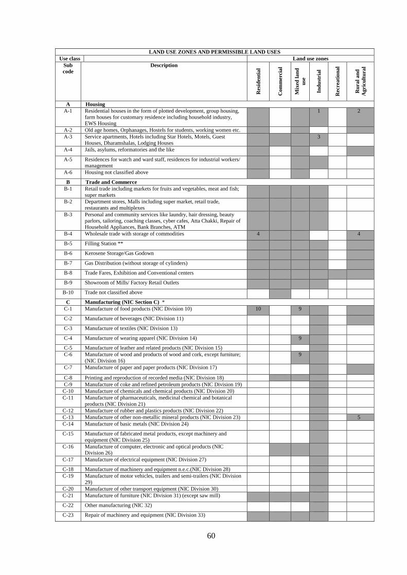
60
LAND USE ZONES AND PERMISSIBLE LAND USES Use class Land use zones
Sub code
Description
Res
iden
tial
Com
mer
cial
Mix
ed la
nd
use
Indu
stri
al
Rec
reat
iona
l
Rur
al a
nd
Agr
icul
tura
l
A Housing A-1 Residential houses in the form of plotted development, group housing,
farm houses for customary residence including household industry, EWS Housing
1 2
A-2 Old age homes, Orphanages, Hostels for students, working women etc. A-3 Service apartments, Hotels including Star Hotels, Motels, Guest
Houses, Dharamshalas, Lodging Houses 3
A-4 Jails, asylums, reformatories and the like
A-5 Residences for watch and ward staff, residences for industrial workers/ management
A-6 Housing not classified above
B Trade and Commerce B-1 Retail trade including markets for fruits and vegetables, meat and fish;
super markets
B-2 Department stores, Malls including super market, retail trade, restaurants and multiplexes
B-3 Personal and community services like laundry, hair dressing, beauty parlors, tailoring, coaching classes, cyber cafes, Atta Chakki, Repair of Household Appliances, Bank Branches, ATM
B-4 Wholesale trade with storage of commodities 4 4
B-5 Filling Station **
B-6 Kerosene Storage/Gas Godown
B-7 Gas Distribution (without storage of cylinders)
B-8 Trade Fares, Exhibition and Conventional centers
B-9 Showroom of Mills/ Factory Retail Outlets
B-10 Trade not classified above
C Manufacturing (NIC Section C) * C-1 Manufacture of food products (NIC Division 10) 10 9
C-2 Manufacture of beverages (NIC Division 11)
C-3 Manufacture of textiles (NIC Division 13)
C-4 Manufacture of wearing apparel (NIC Division 14) 9
C-5 Manufacture of leather and related products (NIC Division 15) C-6 Manufacture of wood and products of wood and cork, except furniture;
(NIC Division 16) 9
C-7 Manufacture of paper and paper products (NIC Division 17)
C-8 Printing and reproduction of recorded media (NIC Division 18) C-9 Manufacture of coke and refined petroleum products (NIC Division 19)
C-10 Manufacture of chemicals and chemical products (NIC Division 20) C-11 Manufacture of pharmaceuticals, medicinal chemical and botanical
products (NIC Division 21)
C-12 Manufacture of rubber and plastics products (NIC Division 22) C-13 Manufacture of other non-metallic mineral products (NIC Division 23) 5 C-14 Manufacture of basic metals (NIC Division 24)
C-15 Manufacture of fabricated metal products, except machinery and equipment (NIC Division 25)
C-16 Manufacture of computer, electronic and optical products (NIC Division 26)
C-17 Manufacture of electrical equipment (NIC Division 27)
C-18 Manufacture of machinery and equipment n.e.c.(NIC Division 28) C-19 Manufacture of motor vehicles, trailers and semi-trailers (NIC Division
29)
C-20 Manufacture of other transport equipment (NIC Division 30) C-21 Manufacture of furniture (NIC Division 31) (except saw mill)
C-22 Other manufacturing (NIC 32)
C-23 Repair of machinery and equipment (NIC Division 33)

61
LAND USE ZONES AND PERMISSIBLE LAND USES Use class Land use zones
Sub code
Description
Res
iden
tial
Com
mer
cial
Mix
ed la
nd
use
Indu
stri
al
Rec
reat
iona
l
Rur
al a
nd
Agr
icul
tura
l
C-24 Milk Chilling(independent plot), Pastuerization plant, Cold Storage 11 C-25 Rice Shellers, Processing of Farm Products, Brick Kilns, Lime/
Charcoal Kilns
C-26 Cottage Industry, Repair of Household Articles, Cycles and scooters C-27 I.T. Parks, Knowledge Park
C-28 Cement, Sand and Concrete Mixing Plant(Batching plant), Bitumen, Sand, Concrete Mixing Plant(Hot Mix Plant)
C-29 Manufacturing and Storage of Fire Works
D Transport Storage and Warehousing D-1 Warehousing and storage activities for transportation (NIC Division 52)
and Loading & unloading yard 6
D-2 Rail and Air Freight Terminals
D-3 Truck Terminals
D-4 Bus Terminals, Auto-Rickshaw/ Taxi Stand
D-5 Warehousing, Logistic Park, Storage & Godowns, Freight complex, Container Yards
E Offices E-1 Publishing of books, periodicals and other publishing activities (NIC
Group 581) Software publishing (NIC Group 582) 9
E-2 Motion picture, video and television programme production, sound recording and music publishing activities (NIC Division 59)
E-3 Broadcasting and programming activities (NIC Division 60) E-4 Telecommunications (NIC Group 61), Govt/ Semi-Govt / Private
Business offices
E-5 Computer programming, consultancy and related activities (NIC Division 62)
E-6 Information service activities (NIC Division 63)
E-7 Finance, Banking and insurance (NIC Section K)
E-8 Real estate activities (NIC Section L)
E-9 Professional, scientific and technical activities (NIC Section M) E-10 Administrative and support services (NIC Section N)
E-11 Public administration and defence; compulsory social security (NIC Section O)
E-12 Professional Services like Lawyers, Accountants, Architects, Charted engineers
F Educational, Training and Research Institutes F-1 Pre-Primary Schools, Play schools Kinder Garten
F-2 Primary Schools,
F-3 Secondary Schools, Colleges, Vocational Training Institutes, F-4 Research and Training Centres, Universities, Centres of Advanced
Education and training like IIM or IIT, Medical Institute
F-5 Educational, Training and Research Institutes not classified above G Health care facilities
G-1 Medical and Dental Clinics and Dispensaries 8
G-2 Hospitals (NIC Group 861) and Health Center 8 8
G-3 Nursing care facilities (NIC Group 871) 8
G-4 Residential care activities for mental retardation, mental health and substance abuse (NIC Group 872)
G-5 Residential care activities for the elderly and disabled (NIC Group 873) G-6 Veterinary services
G-7 Health care facilities not classified above.
H Arts, entertainment, recreation, cultural and religious activities H-1 Arts, entertainment and recreation (NIC Section R) and Multimedia H-2 Libraries, archives, museums and other cultural activities (NIC Division
91)
H-3 Gambling and betting activities (NIC Division 92)e.g. Race Course H-4 Sports activities and amusement and recreation activities (NIC Division

62
LAND USE ZONES AND PERMISSIBLE LAND USES Use class Land use zones
Sub code
Description
Res
iden
tial
Com
mer
cial
Mix
ed la
nd
use
Indu
stri
al
Rec
reat
iona
l
Rur
al a
nd
Agr
icul
tura
l
93) tot-lots, playgrounds, stadia, golf courses etc. H-5 Places of worship
H-6 Marriage Palaces
H-7 Arts, entertainment and recreation activities not classified above I Public Utilities and Services
I-1 Electricity, gas, steam and air conditioning supply (NIC Section D) I-2 Water collection, treatment and supply (NIC Division 36)
I-3 Sewerage (NIC Division 37)
I-4 Waste collection, treatment and disposal activities; materials recovery (NIC Division 38) and Carcass Disposal Site
7
I-5 Postal and courier activities (NIC Division 53)
I-6 Police station
I-7 Fire Station
I-8 Public utilities and Services not classified above
I-9 Cemeteries, Graveyards, Cremation grounds
I-10 Telecommunication Towers / Antenna
J Agriculture, forestry and fishing (NIC Section A) J-1 Crop and animal production, hunting and related service activities (NIC
Division 01) 12
J-2 Land Conservation and Preservation measures such as Storage, Check Dams and other water harvesting measures
J-3 Fishing and aquaculture (NIC Division 03)
J-4 Quarrying of stone, sand and clay (NIC Group 081)
J-5 Plant Nursery and Greenhouses related to Nursery, Floriculture
Notes: NIC National Industrial Classification (All Economic Activities) 2008, Central Statistical Organization, Ministry of Statistics and Programme
Implementation, Government of India, www.mospi.nic.in A Shaded areas indicate that the use class is permissible in the zone B Shaded area with number / notation indicates the conditions attached EWS Housing only 1 Only farm houses permissible 2 Guest Houses and Star hotels only 3 Wholesale trade in agricultural commodities only provided it is minimum 200 m away from village abadies /
residential areas 4
Only Manufacture of bricks, earthen pots, country tiles etc. 5 Warehousing for agricultural commodities only. 6 Permissible till time the residential or any other activity compatible to residential zone occurs within a radius of 500
meters from the site, after which NOC / permission issued to the applicant shall cease to exist and the activity shall relocate itself to another suitable site / zone.
7
Subject to fulfillment of conditions of Pb. Govt. Notification No. 17/17/5-Hg2/311 dated 11.01.08 and instructions issued from time to time
8
Only Green Industries 9 Only bakery 10 Outside M. C. limits with the condition that it is located minimum 100 mtr away from the lal lakir/ phirni or a
village abadi. In case, a cold store is to be set up within a distance of 100 mtr from already approved residential area (other than being a village abadi) or an approved residential colony is to be set within 100 mtr of an existing cold store, then the owner of land use which comes later shall be bound to provide a minimum of 15mtr wide green buffer of broad leaves trees to the site in which approved residential area or cold store is located.
11
Except animal production. 12 * All types of industries permitted in the designated land use zone are subject to the fulfillment of requirements of different departments ** The siting of petrol pumps shall be subject to instruction / guidelines of IRC/ MORTH/TCPO/Punjab govt. issued from time to time.
C Minimum area required for Educational and Health care facilities shall be as prescribed by government or the accrediting authorities from time to time
All developments will be subject to Environmental Clearance wherever required. Minimum width of the access road for all public places and involving “Assembly” occupancy shall be 18 m.

63
The activities/ uses not mentioned in the above table but found compatible for a particular land use zone shall also be permissible with permission of the competent authority. 11.3 DESIGNATED AREAS
Following areas have been specifically designated in the proposed land use plan.
· Traffic and Transportation
· Utilities
· Public & semi public
· Protected Monuments/Conservation Sites
· Other Special Areas
· Prohibited Areas
· Forest Areas
Following uses are permissible in the designated areas mentioned above.
11.3.1 Traffic & Transportation: Permissible uses
Rail yards, Railway station & sidings, Transport Nagar (including, Post & Telegraph
offices & Telephone exchange, Dhabas, Labour yards, Areas for loading and unloading,
Stores, Depots, and Offices of goods booking agencies, Petrol Filling Station & Service
garages, Parking spaces, public utilities and buildings) Bus Terminus & depot, Bus stop
shelter, Taxi/ Tonga/ Rickshaw/Scooter Stands, parking spaces.
11.3.2 Utilities: Permissible uses
Water supply, drainage, storm water, waste processing and disposal, electricity,
communication systems and related installations etc.
11.3.3 Public and semi-public activities: Permissible uses
Governmental and semi governmental offices, Governmental administrative centers,
Secretariat, Educational- Cultural and Religious institutions including Theaters,
Auditoriums etc. Medical Health Institutions, Community Centers, Club, Orphanage, Old
Age Home, Banks, Police Stations etc.
11.3.4 Protected/ Conservation Sites: Permissible uses
Only protected monument/ Heritage Building or conservation sites as notified by the
concerned authority and the related activities are allowed. All other uses are prohibited
11.3.5 Others Special Areas: Permissible uses
All the uses related to Defense Services and any other use as decided by the Ministry
of Defense. No other uses are permitted.

64
11.3.6 Forest Areas: Permissible uses
This area indicates all Reserved Forests as notified by the Forest Department. No
activity other then Forest is permitted in this area unless expressly allowed by the Forest
Department
11.3.7 Special Conditions
i. The siting of Petrol Pump / Filling Stations shall be subject to instructions/guidelines of
IRC/MORTH/TCPO /Punjab Govt. issued from time to time.
ii. Minimum width of access road for warehousing uses shall be 80 feet.
iii. All public and semi-public uses in residential zone shall be located on independent plots
with minimum access of 18 meter.
11.3.8 Exceptions
i. Any use not listed above under a specific zone will not be permissible in the respective
zone
ii. Notwithstanding the above, the uses specifically provided for in the Sector Zoning Plans
shall be permissible or as may be allowed by the Chief Town Planner, Punjab.
iii. Uses determined by the Chief Town Planner, Punjab as compatible with uses
permissible shall be allowed in respective zones.
iv. Uses of land covered under Optimum Utilisation of Vacant Government Land
(OUVGL) Scheme of the State Government shall be determined by the Government at
any appropriate time not withstanding the provisions of these Regulations.
v. Developments approved prior to coming into force of these Regulations shall be deemed
to be in compliance with these Regulations.
11.3.9 Residential Densities
Residential zone is divided into two sub – zones viz. High Density Zone and Low Density
Zone and are shown on the Proposed Land Use Plan Drg. No. DTP (H) 151/2011 dated 02-
05-2011.
The maximum permissible density in these zones shall be as shown in table below:
Table: Proposed Residential Density
Sr. No. Zone Density
1 High Density Zone (RD1) Above 201 persons per acre
2 Low Density Zone (RD2) 151-200 persons per acre
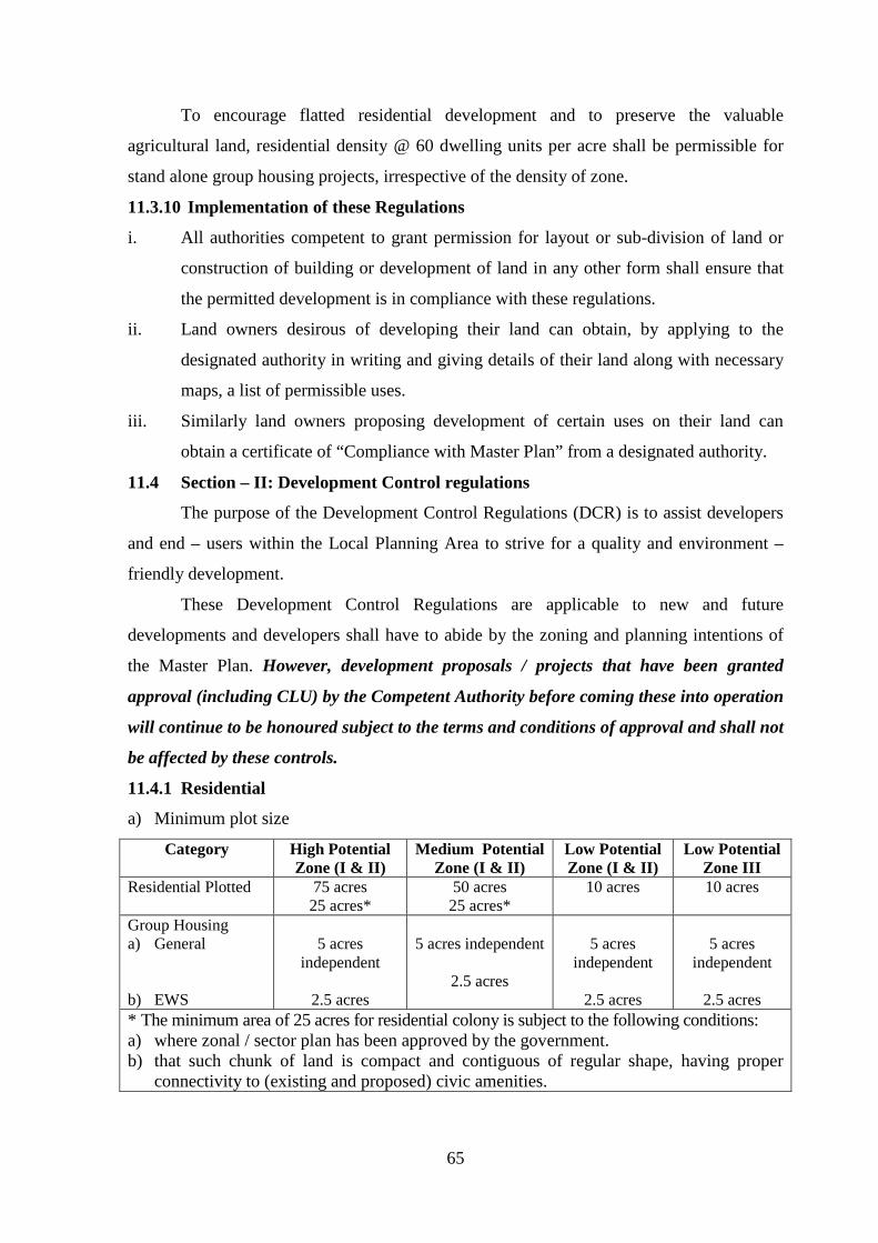
65
To encourage flatted residential development and to preserve the valuable
agricultural land, residential density @ 60 dwelling units per acre shall be permissible for
stand alone group housing projects, irrespective of the density of zone.
11.3.10 Implementation of these Regulations
i. All authorities competent to grant permission for layout or sub-division of land or
construction of building or development of land in any other form shall ensure that
the permitted development is in compliance with these regulations.
ii. Land owners desirous of developing their land can obtain, by applying to the
designated authority in writing and giving details of their land along with necessary
maps, a list of permissible uses.
iii. Similarly land owners proposing development of certain uses on their land can
obtain a certificate of “Compliance with Master Plan” from a designated authority.
11.4 Section – II: Development Control regulations
The purpose of the Development Control Regulations (DCR) is to assist developers
and end – users within the Local Planning Area to strive for a quality and environment –
friendly development.
These Development Control Regulations are applicable to new and future
developments and developers shall have to abide by the zoning and planning intentions of
the Master Plan. However, development proposals / projects that have been granted
approval (including CLU) by the Competent Authority before coming these into operation
will continue to be honoured subject to the terms and conditions of approval and shall not
be affected by these controls.
11.4.1 Residential
a) Minimum plot size
Category High Potential Zone (I & II)
Medium Potential Zone (I & II)
Low Potential Zone (I & II)
Low Potential Zone III
Residential Plotted 75 acres 25 acres*
50 acres 25 acres*
10 acres 10 acres
Group Housing a) General b) EWS
5 acres
independent
2.5 acres
5 acres independent
2.5 acres
5 acres
independent
2.5 acres
5 acres
independent
2.5 acres * The minimum area of 25 acres for residential colony is subject to the following conditions: a) where zonal / sector plan has been approved by the government. b) that such chunk of land is compact and contiguous of regular shape, having proper
connectivity to (existing and proposed) civic amenities.

66
Note:
1. In case of left out pocket, i.e., where on all sides the construction has already taken
place that left out area without any minimum stipulation can be developed as a
residential colony.
2. In category Low III within Municipal Limits any area of land can be developed as a
colony.
Table No. Parking requirements for plotted developments
Plot size Parking requirements
85 sq m and less (100 sq yd and less) 2 scooter parking spaces
86 – 168 sq m (101 – 200 sq yd) 1.5 car parking spaces within plot area
169 – 425 sq m (201 – 500 sq yd) 2 car parking spaces within plot area
425 sq m and more (500 sq yd and more) 3 car parking spaces within plot area
Note:
1. Deviation of up to 10% of this control is allowed, if it is arising from site conditions /
constraints.
2. The minimum width of roads within residential areas shall not be less than 12 m, if the
existing road is less than 12 m, the proportionate land on both sides shall be safeguarded for
widening to comply with the minimum requirement. The height of buildings on these roads
shall not exceed ground plus two (G+2) storeys.
3. Size of the front gate on boundary wall and construction of front boundary wall is optional
to meet the parking requirements.
11.4.2 Group Housing
1 Minimum Plot size
· Within MC limits 4000 square meters
· Outside MC limits
a) For General Category
b) For EWS
5 acres
2.5 acres
2 Minimum Road width For group housing stand alone projects, minimum
width of approach road is 60’ but the promoter is
required to leave space from his own land for
widening it to 80’ and the space so left shall be public
space. In the planned colony, group housing shall not
be permissible on a road less than 60’ wide.

67
3 Minimum Frontage 20 meters
4 Permissible FAR 1:1.75
5 Permissible Height There shall be no restrictions on the height of
building subject to clearance from Air Force
Authority and fulfillment of other rules such as set
backs, distance between building etc. However,
structural safety and fire safety requirements as per
N.B.C. shall be compulsory.
6 Parking provisions For group housing developments, the requisite
parking provision is 1.5 ECS per 100 sq m of covered
area. The maximum provision allowable for group
housing projects is 3 ECS per dwelling unit.
Note:
1. Construction of residential houses sold by promoters on floor basis shall also be
considered as Group / Flatted housing developments and parking requirements shall be
as per the norms applicable to the group housing.
11.4.3 Farm House
Minimum area 2.5 acres
FAR 0.04
Ground Coverage 0.2%
Number of storeys 2
Height Single Storey 18’-0”
Double Storey 28’-0”
Hard Surface 10%
Note:
1. Farm House shall only be allowed to upkeep the farm operations and it shall not be used
for independent residential or any other purpose.
11.4.4 Commercial
Commercial uses in residential zones located within the municipal limits shall be
allowable along 80 feet wide roads with minimum 20 m frontage. The area requirements for
such commercial developments shall be as per the Municipal’s rules and regulations.
For stand alone commercial complexes with height greater than three storeys within as well
as outside the Municipal limits, the additional criteria listed in following table shall apply.

68
Additional criteria for stand – alone commercial complexes (more than three storeys)
Item Permissible Norms / Standards
Minimum Plot size 1000 sq m
Minimum frontage 20 m
FAR 1:1.75
Maximum Ground coverage
40%
Parking
For projects with no multiplexes, the minimum parking shall be 2 ECS per 100
sq m of covered area (including circulation area)
For projects with multiplexes/cinemas/theatres, the minimum parking shall be:
b) 3 ECS per 100 sq m of covered area, in respect of the covered area of the
multiplex component + 30% of the total covered area of that component
and
c) 2 ECS per 100 sq m of covered area, in respect of balance commercial
component and circulation area
Parking norms within the municipal limits shall be the same as that notified by
the Department of Local Government.
Total parking requirement shall be provided in the compulsory front set back
and within the development site boundary or in the basement.
Landscaping If the site area is one acre or above, minimum 15% of the total area is to be
reserved for landscaping purposes
For movement of fire tender
The minimum setback distance is to comply with the existing norms and
standards.
Note: The ECS are counted as below:
· 23 square meters for open parking
· 28 square meters for parking under stilts on ground floor
· 32 square meters for parking in the basement.
At local level
There will be provisions for small scale, double storey commercial facilities at the
local level within as well as outside the Municipal limits, subject to the condition that
abutting road shall have a minimum width of 18 m with minimum 6 m front setback from
road for parking purposes.
These commercial facilities are intended to serve the needs of local residents only
and will not be shown separately on the Draft Master Plan. Instead, they are subsumed
under the predominant residential land use.
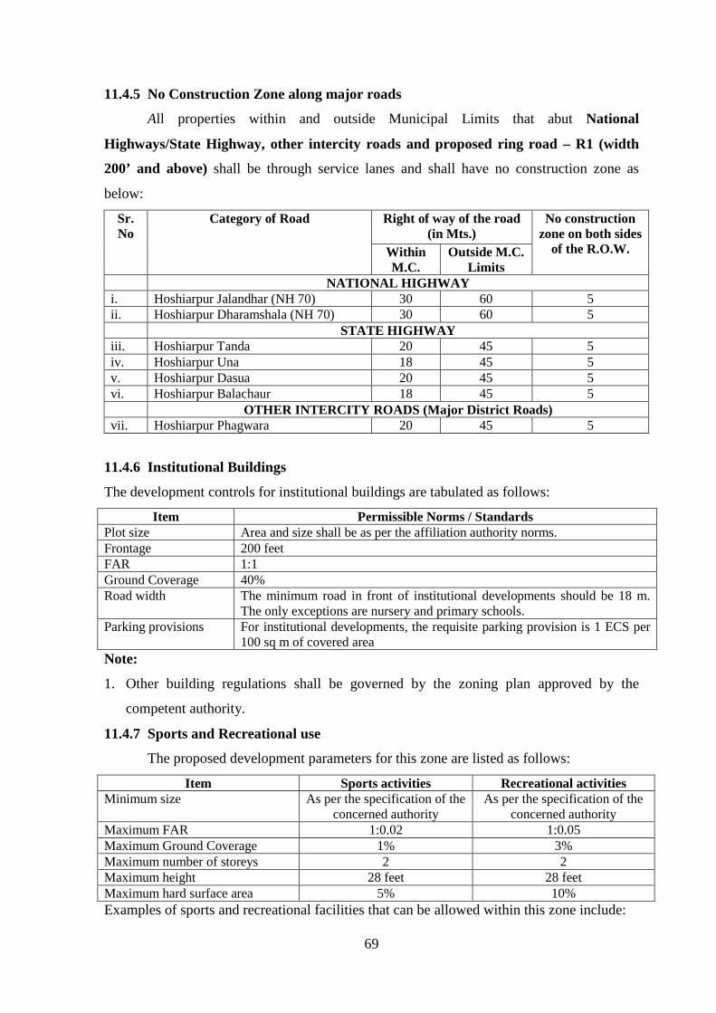
69
11.4.5 No Construction Zone along major roads
All properties within and outside Municipal Limits that abut National
Highways/State Highway, other intercity roads and proposed ring road – R1 (width
200’ and above) shall be through service lanes and shall have no construction zone as
below:
Sr. No
Category of Road Right of way of the road (in Mts.)
No construction zone on both sides
of the R.O.W. Within M.C.
Outside M.C. Limits
NATIONAL HIGHWAY i. Hoshiarpur Jalandhar (NH 70) 30 60 5 ii. Hoshiarpur Dharamshala (NH 70) 30 60 5 STATE HIGHWAY iii. Hoshiarpur Tanda 20 45 5 iv. Hoshiarpur Una 18 45 5 v. Hoshiarpur Dasua 20 45 5 vi. Hoshiarpur Balachaur 18 45 5 OTHER INTERCITY ROADS (Major District Roads) vii. Hoshiarpur Phagwara 20 45 5
11.4.6 Institutional Buildings
The development controls for institutional buildings are tabulated as follows:
Item Permissible Norms / Standards Plot size Area and size shall be as per the affiliation authority norms. Frontage 200 feet FAR 1:1 Ground Coverage 40% Road width The minimum road in front of institutional developments should be 18 m.
The only exceptions are nursery and primary schools. Parking provisions For institutional developments, the requisite parking provision is 1 ECS per
100 sq m of covered area Note:
1. Other building regulations shall be governed by the zoning plan approved by the
competent authority.
11.4.7 Sports and Recreational use
The proposed development parameters for this zone are listed as follows:
Item Sports activities Recreational activities Minimum size As per the specification of the
concerned authority As per the specification of the
concerned authority Maximum FAR 1:0.02 1:0.05 Maximum Ground Coverage 1% 3% Maximum number of storeys 2 2 Maximum height 28 feet 28 feet Maximum hard surface area 5% 10% Examples of sports and recreational facilities that can be allowed within this zone include:

70
· Sports Stadium · Indoor Stadium · Swimming Complex
· Golf Course · Lifestyle Sports Hub · Amusement Park
· Open Air Theatre · Theme Park · Other leisure and
recreational spaces
Ancillary commercial uses (for instance Banking and Finance Outlets) may be
allowed within this zone to cater to the needs of future users. However, this shall be limited
to a maximum of 5% of the total Ground Floor Area. Pure commercial uses such as
shopping malls, cinema halls, multiplexes and the like are not allowed in this zone.
11.4.8 Industrial
Site coverage
For the first 2420 sqyds 50% of the site
For the next 2420 sqyds 33% of the site
In excess of 4840 sqyds 25% of the site
FAR 1:1.0
Parking 1 ECS / 100 sq m of covered area
Road width The minimum road width for industrial unit shall be 12 m.
Height There shall be no restrictions on height of building subject to
clearance from Air Force Authority and fulfillment of other
rules such as set backs, distance between building etc.
However, structural safety and fire safety requirements as
per N.B.C. shall be compulsory.
Note:
1. The minimum road width for each land use shall be as specified in the Master Plan or by
the Government policy/ guidelines issued from time to time. However, in case the
existing road width is less than the minimum specified width in the Master Plan/
Government policy then the proportionate land on both sides shall be safeguarded for
widening to comply with the minimum requirement. In case, where habitation/
settlement comes in alignment, in that case widening shall be on other side of habitation/
settlement.
2. In case the site of any project is situated within Municipal limits and the project is
submitted to Municipal Committee/ Local Body for approval then the building byelaws
of the concerned local body shall be applicable provided the land use is in conformity to
Master Plan.

71
3. Residential component in the industrial plot/ premises shall not exceed 5% of the area of
the site and shall be within the maximum permissible covered area.
4. Industrial/ IT Park shall have minimum 10 acres area. In IT Park, IT component shall
have FAR 2. In industrial park, for an industry component FAR shall be 1 and other
components shall have FAR as mentioned under different uses in the Master Plan.
11.4.9 Environmental considerations
1. All the textile/ dying and electroplating units shall set up treatment plants
individually or collectively to achieve zero liquid discharge.
2. Minimum buffer of 15 meters green belt of broad leaf trees should be provided
around the boundary of village abadies falling in industrial zone of Master Plan. A
buffer strip of 15 meters of broad leaf trees shall also be provided between
residential areas and red category industries falling in industrial zone of Master Plan,
boundaries of which are located within 100 m from the boundary of such areas. It is
clarified that 15 meter buffer shall be provided by the owner of the project who
comes later.
3. All residential colonies, commercial establishments like shopping malls, multiplexes
etc shall maintain a minimum distance of 250 meters from the hazardous (maximum
accident hazardous) industries notified by the competent authority. The distance
should be measured from source of pollution/ hazard in the industrial premises to the
building lines as per zoning plan of the colony/ complex. However for specified type
of industry like Rice Sheller/ sella plants, stone crushers, hot mix plants, brick kilns
etc standards prescribed by PPCB or any other agency shall apply.
11.4.10 Other development controls and guidelines required
1. Expansion of village Abadies: Contiguous expansion of village abadies in non
residential zones and agricultural zones of Master Plan is permissible to
accommodate the natural growth, however, for the village abadies falling in
residential zone of Master Plan no such limit has been earmarked as the area around
them is already earmarked as residential.
2. Regulation for village abadi: Special building regulation shall be prepared for the
development and regulation of an area falling within the Lal Dora or phirni of the
villages falling in the Local Planning Area.
3. The existing High Tension lines shall be shifted along the road but outside the Right
of way to ensure unhindered ROW for traffic and other services for all times.

72
4. Minimum 10 meters wide green strips on each side of minor drain shall be
maintained and other major water bodies shall have minimum 30 meters green strips
on each side. Realignment of water bodies shall be permissible wherever feasible,
subject to the certification by the Drainage / Engineering Department to ensure free
flow of storm water. After any such realignment, the river mouth, the river bed and
the green strip on either side shall be maintained at least to the minimum prescribed
level. In these green strips, golf course, sports and recreational activities shall be
permissible but no construction would be allowed. The supporting facilities for these
activities shall be constructed outside the green strips.
11.4.11 Use and development of land to be in conformity with Master Plan:
As provided under Section 79 of the Punjab Regional and Town Planning and
Development (Amendment) Act 2006, after coming into operation of this Master Plan, no
person shall use or permit to be used any land or carry out any development in any area
otherwise than in conformity with this Master Plan.
Provided that the competent authority may allow the continuance of any use of any
land, for a period not exceeding ten years. Upon such terms and conditions as may be
provided by regulations made in this behalf, for the purpose and to the extent, for and to
which it was being used on the date on which this Master Plan came into operation.
Chief Town Planner, Punjab being the planning agency designated under Section 57
of the Punjab Regional and Town Planning and Development (Amendment) Act, 2006 for
the Local Planning Area declared under Section 56 of the said Act, following the
requirement under clause (d) of sub section 1 of Section 70 of the Punjab Regional and
Town Planning and Development (Amendment) Act, 2006 hereby makes following Zoning
Regulations as a part of the Master Plan prepared for the Local Planning Area.
11.4.12 Transferable Development Rights
A city typically requires 40 to 50% of its area for variety of public purposes. Where
land is owned by the state as in Delhi, Chandigarh or Navi Mumbai it is easier to allocate
land of public purposes. However where private land market is active, how to ensure land
for public purpose is a major challenge in preparing Master Plans. Conventional master
planning relied on the powers of compulsory acquisition of land designated in the master
plan for public purposes. However limitations of this approach have been painfully
exposed. At the same time not addressing the question of land for public purposes may limit
the utility of the master plan itself.
73
An alternative to compulsory acquisition through monetary compensation could be award of
Transfer of Development Rights either to remainder of the land or to a distant location. This
could be in three generic cases viz.
Roads and Road widening: Development rights calculated at the FAR permissible in
adjoining area may be allowed to be used in the remainder of the plot up to a limit.
Development rights that cannot be so consumed can be transferred elsewhere in receiving
areas. If FAR is related to width of the road, resistance to widening may get reduced.
Public purposes on open land or exclusive plots: Lands required for parks and playgrounds
or exclusive uses like secondary school, fire station etc. can receive TDRs in lieu of
compensation. Weight related to price differentials in originating and receiving zones could
be considered as an incentive.
Public purposes that require built-up space but not necessarily exclusive plot: Examples of
this could be municipal vegetable market, library etc. In such cases landowner may be
allowed to fully use his development rights provided that he offers the built up space
required for the public purpose.
11.5 SECTION III: EXCEPTIONS
1. Notwithstanding the above, the uses specifically provided in the Sector Zoning Plans
shall be permissible or as may be allowed by the Chief Town Planner, Punjab.
2. Uses determined by the Chief Town Planner, Punjab as compatible with uses
permissible shall be allowed in respective zones.
3. Use of land covered under Optimum Utilization of Vacant Government Land
(OUVGL) Scheme or any other project of the State / Central Government shall be
determined by the Government at any appropriate time not withstanding the
provisions of this Master Plan.
4. Development / projects approved prior to coming in to force of these regulations
shall be deemed to be in compliance with these Regulations.
5. In the event of conflict in interpretation of data within the study area, the
information in the GIS format will be deemed as the accurate version and will
prevail.
6. In case the area of a project falls partially under no construction zone along a water
body, relaxation of maximum upto 5% on the total area of the project shall be
allowed towards calculation of saleable area in lieu of the area falling under the no

74
construction zone. In case, the area falling under no construction zone is less than
5% of the total area of the project then the relaxation shall be proportionately less.
7. The buildings / premises for which the existing (present) land use has been retained
as such in the Master Plan may continue to operate without time limit. However, in
case the present use of the buildings / premises is discontinued (partially or wholly)
these buildings / premises or part thereof may be put to any compatible use (except
industry) with the surrounding use zone in the Master Plan provided it fulfills the
other development regulations/ controls as laid down in the Master Plan or as
prescribed by the Govt. / Local Body from time to time.
Note : The Development controls/Guidelines/Norms & Standards revised from time to time by the Government shall have overriding effect on the Development controls mentioned in the master plan.

Annexure – 1

Annexure – 2


Annexure – 3 LIST OF VILLAGES OF HOSHIARPUR LPA
Sr. No.
Name of Villages H.B.No. Area in Hectare Population as per census 2001
1 2 3 4 5 1. Hoshiarpur (MC)* -- 3500 149668 2. Bassi Nau 180 27 1202 3. Hardo Khanpur 224 372 3385 4. Dagana Khurd. 230 140 123 5. Dagana Kalan. 231 268 1474 6. Kahri. 242 519 1248 7. Korangna 243 171 223 8. Singriwala 245 325 1911 9. Khwaspur 246 121 - 10. Shergarh. 250 375 2456 11. Purhiran 251 192 Included in MC 12. Dholanwal. 252 208 870 13. Attalgarh 253 120 340 14. Kaimpur. 254 76 360 15. Maruli Brahamana 256 220 1536 16. Bassi Daulatkhan 257 56 1789 17. Punga 258 42 71 18. Chhauni Kalan. 348 344 2373 19. Kila Berun 350 129 1213 20. Bajwara. 355 761 7516 21. Kotla Jhiri. 361 98 07 22. Bassi Gulam Husain 362 634 2744 23. Bassi Purani. 363 236 762 24. Kotla Gonspur 369 260 955 25. Ajjowal 371 323 2768 26. Bassi Khizar Khan. 372 15 120 27. Brahmjit 373 94 515 28. Akahlaspur 374 66 294 29. Kakon 375 305 1333 30. Khakhali. 383 121 146
TOTAL -- 10118 187402 * Hoshiarpur MC includes 12 villages also

Annexure – 4
LIST OF TREES RECOMMENDED FOR PLANTATION ON THE MAIN ROADS WITHIN URBAN LIMITS/ MASTER PLAN AREAS
Sr. No. Name of Tree (Botanical / Common)
Description
1 Alstonia Scholaris (Chhatim)
• Tall tree with columnar shape, evergreen, very ornamental. • Bears greenish-white flowers in October – December.
2 Barringtonia Acuitangula (Smudhar Phal)
• Medium tree with spreading habits, deciduous from April to May.
• Ornamental foliage and flowers in pendulous branches. Bears crimson flowers in April and September.
3 Bauhinia Blackiana (Kachnar)
• Small tree, evergreen with columnar form, highly attractive and ornamental.
• Propagated by layers and cuttings. • Flowers deep pink from January to April and from September
to November. 4 Bauhinia Purpurea
(Kachnar) • Medium tree with columnar form, evergreen • Bears purple coloured flowers in November.
5 Bauhinia Variegata (Kachnar)
• Medium tree with columnar form. • Sheds leaves in January, February, profusely flowering tree,
highly beautiful when in bloom. • Bears pink, white and purple coloured flowers in February,
March and April. 6 Cassia Fistula (Amaltas) • Tall columnar shaped tree, leafless in April – May, very hardy
tree, looks very ornamental when in bloom. • Bright yellow flowers in April – May.
7 Cassia Grandis (Pink Mohur)
• Medium in height with spreading habit. • Highly ornamental tree. • Bears deep carmine flowers in November and December.
8 Cassia Javanica (Java – ki – Rani)
• Medium in height, leafless in April – May. • It is the most beautiful flowering tree. • Bears clusters of pink flowers in May – June.
9 Cassia Marginata (Pink Mohur)
• Medium in height, spreading and graceful tree. • Bears deep pink flowers in May and June.
10 Cedrela Tuna (Tun) • Tall columnar shaped tree, leafless in December – January. • Fairly fast growing and hardy tree with creamy white flowers
in March – April. 11 Chakassia Tabularis • Tall spreading tree, evergreen and hardy.
• Excellent for shade. • Flowers are greenish, white in April – May.
12 Chorisia Speciosa (Mexican Silk Cotton Tree)
• Medium in height, pyramidal in shape, leafless from October to January, fast growing and bottle shaped green trunk.
• Flowers are of pink and yellow colour in October – November. 13 Delonix Regia (Gulmohar) • Tall tree with spreading crown, leafless from January – March.
• Fast growing, very ornamental creates mass effect with orange red flowers from April to June.
14 Ficus Religiosa (Pipal) • Tall columnar shaped tree, leafless in February – March, very hardy and fast growing flowers pale green in April.
15 Ficus Infectoria (Pilkhan) • Tall spreading, fast growing and hardy tree, leafless in March, good for shade, need protection from cattle, green yellow flowers in November and December.

16 Hetrophragma Roxburghii (Marour Phaly)
• Tall columnar tree, evergreen, flowers are of pale, yellow brown colour in March.
17 Jacranda Mimosaefolia (Jakaranada or Neely Gulmohar)
• Medium in height, leafless when in bloom, good for parks and houses, fern like bipinnate leaves.
• Bears flowers of violet-blue colour in April – May. 18 Kigelia Pinnata (Jhar
Phanoos) • Tall and spreading tree, evergreen hardy. • Fast growing flowers are of crimson, yellow and brown colour
in April – May. 19 Lagerstroemia Frosreginae
(Queen’s Flower) • Medium sized tree, columnar shape, very pretty, leafless in
winter (December – February). Purple and pinkish blooms in April – May and July – August.
20 Lagerstroemia Thorelli (Pride of India)
• Medium in height, columnar in shape, beautiful tree, leafless from December – February, flowers of mauve colour from June to December.
21 Lagerstroemia Rosea • Medium in height, columnar tree, very pretty. Leafless in winter (December – February) with deep pink flowers from April to September.
22 Pongamia Glabra (Karanj) • Tall spreading and fast growing tree, leafless in March. • Bears mauve colour coloured flowers in April – May.
23 Pterospermum acerifolium (Kanak Champa)
• Tall columnar tree, ever green, handsome, bear’s sweet scented flowers of creamy white colour in March – April.
24 Putranjaniva Roxburghii (Jiva Pota)
• Medium in height, pyramidal shaped, ever green, handsome and very graceful tree, good for shade and beautiful form.
• Flowers are of pale yellowish colour in March – April. 25 Saraca Indica (Sita Ashok) • Height medium, spreading tree, evergreen, very hardy, foliage
glossy and ornamental. • Highly flow growing takes 30 years to become a good tree. • Bears highly attractive scarlet coloured flowers in large
compact clusters in February and March. 26 Schleichera Frijuga
(Kusum) • Tall columnar shaped tree, evergreen, good for shade, leaves
become red in March and April and again in July and September.
• Flowers are of green colour in February and March. 27 Sweitnia (Mahogany) • Evergreen, shady, attractive foliage, very hardy, tall tree with
columnar shape, blooms in April and tree is slowing growing and very good for avenues.
28 Tabeuia Rosea • Small in height, columnar in shape, deciduous from December to February, scanty foliage and flower colour is purple – pink in February to March.
29 Terminalia Arjuna (Arjan) • Tall, columnar shaped tree sheds leaves in March. • Very hardy tree, flowers of pale – yellowish white colour
appear in September to October. 30 Terminalia Chebula
(Bahera) • Tall, columnar shaped tree, leafless in March, pale – yellow
flowers all the year round.

Annexure 5
COMPARATIVE STATEMENT OF NORMS AND STANDARDS SUGGESTED BY MASTER PLAN ZONING REGULATIONS / PUNJAB GOVT. POLICIES, UDPFI
GUIDELINES AND DELHI MASTER PLAN
Aspect As per zoning regulations and sub division clauses for
Master Plans in Punjab / Govt. Policies
UDPFI Guidelines Delhi Master Plan
Primary School Population: 3,000-4,000 Number of students: 600 Area a) Old city (over 650 ppha):
0.2 ha b) Outer areas (less than 650
ppha): 0.5 ha
Population: 5,000 Number of students: 500 Area per school: 0.4 ha Covered area: 0.20 ha Minimum play field area: 0.20 ha
Population: 10,000 Area: 2000-4000 sq m
Senior Secondary School
Population: 12,000 to 20,000 Number of students: 1000 Area a) Old city (over 650 ppha):
1.00 ha b) Outer areas (less than 650
ppha): 2.5 ha
Population: 7,500 Number of students: 1,000 Area per school: 1.60 ha Covered area: 0.60 ha Minimum play field area: 1.00 ha
Population: 10,000 Area: 6000-8000 sq m
College Population: 30,000 Number of students: 800 Area a) Old city (over 650 ppha):
2.50 ha b) Outer areas (less than 650
ppha): 5.00 ha
Population: 1,25,000 Number of students: 1000-1500 students Area per college: 4.00 ha Covered area: 1.80 ha Play field area: 1.80 ha Residential / hostel area: 0.40 ha
Population: 5,00,000 Area: As per UGC Norms
University N.A. New University Area: 60.00 ha 4 sites in urban extension to be provided at city level Area: Up to 20.00 ha
Technical Education Centre
N.A. Population: 10,00,000 Area per centre: 4.00 ha Area per technical centre: 2.10 ha Area per ITI: 1.40 ha Area per coaching centre: 0.30 ha
Population: 5,00,000 Area: 4000 sq m
New Engineering College
Number of students: 300 Area a) Old city: (over 650 ppha):
1.00 ha b) Outer areas (less than 650
ppha): 2.50 ha
2 numbers to be provided in urban extension Number of students: 1500-1700 Area per college: 60.00 ha
Population: 5,00,000 Area: As per AICTE norms
Medical / Pharmacy College
Area: 5 acres (Rural) Area: 2.5 acres (Distt. Headquarter Corporation Limit)
2 site of 15 ha each in urban extension including space for specialized general hospital.
Population: 10,00,000 Area: As per Medical Council of India / Regulatory Body
Dispensary Population: 5,000 Area: 0.1 ha
Population: 15,000 Area: 0.08 to 0.12 ha
Population: 10,000 Area: 800-1200 sq m
Primary Health Center
Nursing Home N.A. Population: 45,000-1,00,000 Capacity: 25 to 30 beds Area: 0.20 to 0.30 ha
Population: 50,000 Area: 1000-2000 sq m
General Hospital Population: 50,000 Area: 2.5 ha
Population: 2,50,000 Capacity: 500 beds Area for hospital: 4.00 ha Area for resi accommodation: 2.00 ha
Population: 5,00,000 Capacity: 501 beds and above Area: 25,000-45,000 sq m

Total area: 6.00 ha Veterinary Hospital N.A. N.A. Population: 5,00,000
Area: 2,000 sq m Community Hall and Library
N.A. Population: 15,000 Area: 2,000 sq m
N.A.
Club N.A. Population: 1,00,000 Area: 10,000 sq m
Population: 5,00,000 Area: 5000 sq m
Amusement Park N.A N.A Up to 10 ha City level park N.A N.A Population: 5,00,000
Area: 10 acres Neighborhood level park
N.A N.A Population: 10,000 Area: 10,000 sq m
Golf Course N.A N.A Population: 10,00,000 Area: 10-30 ha
Sports Centre / Stadium
N.A N.A Population: 5,00,000 Area: 3-10ha
Post and Telegraph Office
Population: 10,000 Area: 0.1 ha
N.A. Population: 10,00,000 Area: 2,500 sq m
Religious Building Population: 15,000 Area: 0.1 ha
N.A. Population: 10,00,000 Area: 40,000 sq m
Old Age Home N.A. N.A. Population: 5,00, 000 Area: 1,000 sq m
Orphanage / Children Centre
N.A. N.A. Population: 5,00,000 Area: 1,000 sq m
Multipurpose Ground (Exhibition cum Fair Ground)
N.A. N.A. Population: 1,00,000 Area: 20,000 sq m
Burial / Cremation Centre
N.A. N.A. Population: 10,00,000 Area: 10,000 sq m
Electric Sub Station
Population: 50,000 Area: 0.4 ha
N.A. Population: 5,00,000 Area: 29,600 sq m
Police Post N.A. Population: 40,000- 50,000 Area: 0.16 ha (area inclusive of essential residential accommodation)
Population: 1,00,000 Area: 1000 sq m
Police Station / Police Division
Population: 50,000 Area: 0.8 ha
Population: 90,000 Area: 1.5 ha Area inclusive of essential residential accommodation 0.05 ha additional to be provided for civil Defence and home guards
Population: 2,50,000 Area: 10,000 sq m
Police Line N.A. Population: 20,00,000 Area: 4.00 to 6.00 ha
1 for each administrative zone to be provided at city level Area: 2.0 ha
District Jail N.A. Population: 10,00,000 Area: 10.00 ha
Population: 25,00,000 Area: 5.0 ha
Fire Station N.A. 1 fire station or sub-fire station within 1 to 3 km to be provided for 2 lakh population Area for fire station with essential residential accommodation: 1.00 ha Area for sub-fire station with essential residential accommodation: 0.60 ha
3 Fire Stations for 5,00,000 population within radius of 5 to 7 km Area: 10,000 sq m
From the comparative table of norms and space standards as given above, the norms
suggested by UDPFI Guidelines have been found more suitable for the preparation of Master
Plan Jalandhar because of the following reasons:
ÿ The norms and standards suggested by UDPFI Guidelines are more detailed and cover almost
each physical and social infrastructure as compared to Master Plan Zoning Regulations /
Govt. policies.
ÿ Norms and standards suggested by UDPFI Guidelines are more realistic and suit to local
conditions such as prevailing development controls, availability of land, land prices etc.
ÿ UDPFI Guidelines suggest different norms and standards for different category of towns like
small and medium towns, large cities and hill areas which is not available in other guidelines.
ÿ The Norms and standards of Master Plan Zoning Regulations are not detailed and do not
cover the whole range of activities, hence are not being adopted.
ÿ Norms and standards suggested by Delhi Master Plan have not been found suitable for Local
Planning Area Jalandhar because these norms are of higher level, formed especially for Mega
city like Delhi, where development controls are very tight, population is more than 1.25
crores and the land is scarce and costly.
Note:
i. The norms and space standards as suggested by Punjab Govt policies from time to time
shall have the over riding effect on the norms and standards of UDPFI Guidelines
adopted for the preparation of Master Plan, Jalandhar.
ii. For the aspects which are not covered under UDPFI Guidelines, the norms and standards
as suggested by Master Plan Zoning Regulations in Punjab shall be adopted and where
these zoning regulations are also silent, only in that case, the norms and standards
suggested by Delhi Master Plan shall be followed.
iii. For core areas of Jalandhar and Phagwara the norms and standards as suggested by Delhi
Master Plan shall be adopted.
NORMS AND STANDARDS FOR TRAFFIC AND TRANSPORTATION
The norms and standards for Traffic and Transportation as suggested by UDPFI Guidelines are
listed as follows:
Road Hierarchy
R1: 200’ and above
R2: 150’
R3: 100’
Footpath

The width of footpaths is listed as below:
Minimum width 1.5 m Adjoining shopping frontage At least 3.5 m Longer shopping frontage Minimum 4.5 m Width should be increased by 1m in business / shopping areas
Cycle Track
The minimum width of cycle tracks should be 2m. Each additional lane, where required, should
be one meter. The capacity of cycle tracks recommended is as below:
Width of Cycle Track Width in meters Capacity (Cycles / hr) One way Two way
Two lanes 3 250-600 50-250 Three lanes 4 >600 250-600 Four lanes 5 >600 Passenger Car Units (PCU)
Recommended PCU factors for various types of vehicles on urban roads: Sr. No.
Vehicles Equivalent PCU Factors Percentage composition of vehicle type in stream of traffic
10% 10% Fast Vehicles
1 Two wheeler motor cycle or scooter
0.5 0.75
2 Passenger Car, pick up van
1.0 1.0
3 Auto rickshaw 1.2 2.0 4 Light commercial
vehicle 1.4 2.0
5 Truck or bus 2.2 3.7 6 Agricultural Tractor
Trailor 4.0 5.0
Slow Vehicles 7 Cycle 0.4 0.5 8 Cycle rickshaw 1.5 2.0 9 Tonga (Horse drawn
vehicle) 1.5 2.0
10 Hand - Craft 2.0 3.0 (Source: IRC Code: 106-1990)
Design Service Volume
The design service volumes for different categories of urban roads are shown in the table given
below:
Recommended Design Service Volumes (PCU’s per hour)
Sr. No. Type of Carriageway Total Design Service Volume for different road categories
Arterial Sub – arterial Collector

1 2-lane (one way) 2400 1900 1400 2 2-lane (two way) 1500 1200 900 3 3-lane (one way) 3600 2900 2200 4 4-lane undivided (two way) 3000 2400 1800 5 4-lane divided (two way) 3600 2900 - 6 6-lane undivided (two way) 4800 3800 - 7 6-lane divided (two way) 5400 4300 - 8 8-lane divided (two way) 7200 - -
Parking
Group Housing 2 ECS per 100 square meters covered area on all floors subject to maximum 3 ECS per dwelling unit
Commercial 2 ECS per 100 square meters covered area Institutional/Hotel/Hospital/Multi-media center
1 ECS per 100 square meters of the covered area if the project is covered under notification no. 17/171/5-Hg2/311 dated 11-01-08, otherwise the parking norms meant for commercial uses i.e., 3 ECS / 100 square meters covered area shall apply.
Note:
The E.C.S. shall be counted as below:
ÿ 23 square meters per open parking
ÿ 28 square meters for parking under stilts on ground floor
ÿ 32 square meters for parking in the basement
Bus Stand
Area: 20-25 acres
Truck Terminal
Area: 80-100 acres