Embed Size (px)
Citation preview

AUGUST 09 2016
MXD DISTRICT PUBLIC PROGRAMMING
The redesign of Broadway Park and Binney Park create new open space programming opportunities in the MXD District. Broadway Park is at a highly visible location near the center of the MXD District and is envisioned as a key gathering space for employees, residents and visitors. The expanded Broadway Park has a small flexible lawn area and a contiguous paved area which could be the setting for community events such as performances, outdoor cinema, temporary public art installations, market, and other events and gatherings. The community table in Broadway Park is envisioned being used for outdoor dining, as a meeting place, board game table, outdoor classroom as well as other possible programmed events. Existing Binney Park, at the northern edge of the MXD District, is currently a small green space with paths to the parking garage. With new active ground floor uses planned for the edge of Binney Park, the park is envisioned as a more usable public space. There is an expanded range of seating places, including colorful structures that support netting and may be used as informal and relaxing seating structures, appealing to adults as well children. These unique seating structures could be used by employees during the weekday and be used as play structures at other times.
These programming opportunities complement the current programming initiatives that are underway in the MXD District at the Kendall Plaza on Main Street and the Kendall Square Roof Garden above the Green Garage. Programming in these spaces is focused on creating engaging opportunities for all communities including office workers, residents, students, visitors within Kendall Square to connect and interact. Ongoing events on Kendall Plaza include a seasonal farmer’s market on Kendall Plaza, concerts with both Cambridge institution Club Passim and Berklee College of Music, and participatory community art projects and performances with the Community Art Center and the Multicultural Arts Center. In addition, temporary public art installations are sourced annually for the Plaza, and include a sidewalk mural in collaboration with the Cambridge Science Festival this spring, as well as an upcoming collaboration with local non-profit Now + There. Programming on the Kendall Square Roof Garden includes free fitness programming, cooking demonstrations and tastings, urban gardening workshops and available lawn games. Both spaces are programmed with cushions for easy, portable seating and participate in programs through the KSA, including hosting libraries as part of the Kendall Reads promotion. Partnerships with local non-profits enhance activities in these spaces and provide valuable exposure for local community groups and an opportunity for office customers to participate in the community around them.
PUBLIC PROGRAMMING ELEMENTS
KENDALL PLAZA
Outdoor Seating (Collaboration Space) Summer Concerts Public Markets Temporary Public Art Installations Community Partner Programming
BINNEY STREET PARK “Play Valley” Hitching Posts for Hammocks Rock Climbing Walls Sculptural Netting Children’s Play
POINT PARK Outdoor Seating and Gathering Sculpture Park
BROADWAY PARK Outdoor Community Table (Collaboration Space) Outdoor Seating (Collaboration Space) Summer Movies / Concerts Digital WIFI Connection
BINNEY PARK Outdoor Seating (Collaboration Space) Sculptural Netting Interactive Lounge Seating
Children’s Play
6TH STREET CONNECTOR
Outdoor Seating (Collaboration Space)
KENDALL SQUARE ROOF GARDEN
Outdoor Seating (Collaboration Space) Fitness Classes Urban Gardening Workshops Cooking Demonstrations/Tastings Lawn Games
3.2.1 PUBLIC PROGRAMMING
3. OPEN SPACE PLAN

123INFILL DEVELOPMENT CONCEPT PLAN
BINNEY PARK
BROADWAY PARK
6TH STREET CONNECTOR
KENDALL SQUARE ROOF GARDEN
KENDALL PLAZA
POINT PARK
BINNEY STREET PARK

AUGUST 09 2016
The proposed enhancements to the pedestrian network and open spaces between Broadway and Binney Street are planned to logically extend to adjacent areas in East Cambridge. Broadway Park is the northernmost in a sequence of open spaces extending southward to Danny Lewin Park and further southward to Main Street. To reinforce the connectivity of these spaces, a mid-block crosswalk should be considered from the southeast corner of Broadway Park to the south side of Broadway.
The proposed improvements to the Sixth Street Connector for pedestrians and bicyclists are an extension of pedestrian and bicycle paths on Ames Street to the south and Sixth Street to the north.
With the expanded Commercial Building A, along with new active uses at the ground floor that front Broadway, the Broadway streetscape should have a positive impact on east west pedestrian use. The new expanded streetscape design at 145 Broadway will accommodate this new pedestrian volume. This east west pedestrian route along the north side of Broadway could potentially be further enhanced in the future, if and when 105 Broadway redevelops, which could include an expanded streetscape zone and active ground floor uses. Further eastward, the future redevelopment of the Volpe site could continue this activated street edge on the north side of Broadway.
The redevelopment of the Volpe site opens up additional opportunities to break down the scale of the Volpe superblock and extend a network of paths through the site that would logically connect to the enhanced pedestrian connectors to the west in the MXD. White it is difficult to speculate on how this site may get redeveloped, it is possible that the East West Connectors could provide a series of logical pedestrian connections that would facilitate the integration of the Volpe site to the MXD District and East Cambridge.
3. OPEN SPACE PLAN
3.3 PEDESTRIAN ACCESS AND CIRCULATION


AUGUST 09 2016
COMMERCIAL BUILDING A - STREETSCAPE ON BROADWAY AND GALILEO GALILEI
The design of the 145 Broadway streetscape along Broadway and Galileo Galilei Way has been developed in parallel with the design of Broadway Park. The planting zones along Broadway are aligned in front of 145 Broadway and Broadway Park to extend continuity of pedestrian walking zones as well as planting along Broadway. Short term bicycle parking will be located along the Broadway streetscape framed with low planting.
The eastern façade of 145 Broadway is splayed to open up the corner along Broadway at the street leading to the Blue Garage. The concrete unit pavers of Broadway Park extend to meet the eastern façade of 145 Broadway, thereby extending the park westward to position the entry and active use at 145 Broadway as the western edge of Broadway Park.
BLUE GARAGE EAST AND WEST SERVICE STREETS
The existing service streets flanking the Blue Garage have rather narrow sidewalks on the opposite side of each street from the garage, which are constrained by existing buildings, planting and loading areas. There are however opportunities at the north and south ends of these streets, adjacent to the proposed buildings, to expand pedestrian space. There are also some selected opportunities to widen the sidewalk or enhance the planting along these streets beyond the zone of new buildings.The sidewalks along these streets are interrupted by several service drives and parking garage entries which cross the pedestrian paths. The paving of the sidewalks should extend over the driveways to clearly define pedestrian circulation.
STREETSCAPESCOMMERCIAL BUILDING B - STREETSCAPE ON BINNEY STREET
The existing streetscape at 250 Binney Street consists of green space in a setback from the street. The new active ground floor uses proposed for both 250 Binney Street and the new north residential building contribute toward making Binney Street a more vital urban street with multiple entries to build-ings in the streetscape zone. While the Binney Park is predominantly a green space, the design of the streetscape shifts to a more urban expression with paved areas extending to the proposed buildings and to eastward to make a connection to the Sixth Street Connector.
The existing Hubway bike zone is integrated into the streetscape design along Binney Street with planting separating the building lobby from the bike area. Binney Street has a continuous green planting zone with street trees between the sidewalk and the curb which will extended along Binney Street at the park and at 250 Binney Street.
3. OPEN SPACE PLAN
3.3 STREETSCAPE / LANDSCAPE IMPROVEMENTS

127INFILL DEVELOPMENT CONCEPT PLAN
SIDEWALKSIDEWALK SIDEWALKBROADWAY DRIVE BROADWAY DRIVE RESIDNTIAL SIDEWALK COMMUNITY TABLE PLANTINGPLANTING
70’32’26’
123’
65’
BROADWAY PARK
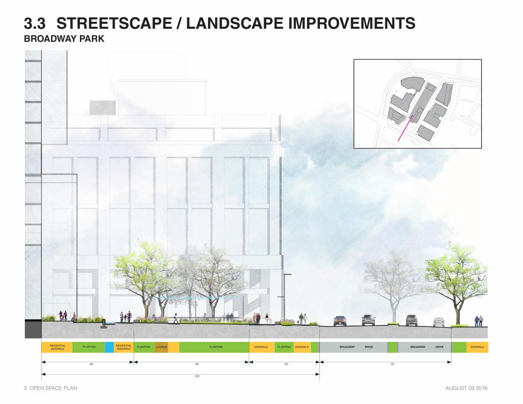
AUGUST 09 2016
3.3 STREETSCAPE / LANDSCAPE IMPROVEMENTS
SIDEWALKSIDEWALK SIDEWALKBROADWAY DRIVE BROADWAY DRIVE RESIDNTIAL SIDEWALK
RESIDNTIAL SIDEWALK
PLANTINGPLANTINGPLANTING LOUNGEPLANTING
70’32’26’
123’
65’
BROADWAY PARK
3. OPEN SPACE PLAN

129INFILL DEVELOPMENT CONCEPT PLAN
SIDEWALK SIDEWALKBROADWAY DRIVE BROADWAY DRIVE PLANTINGPLANTING PLANTING LAYBY / DROP OFF
70’19’ 35’
BROADWAY ALONG 105 BROADWAY

AUGUST 09 2016
3.3 STREETSCAPE / LANDSCAPE IMPROVEMENTS
BIKE SHORT TERM
PARKINGSIDEWALK SIDEWALK SIDEWALKBROADWAY DRIVE BROADWAY DRIVE
70’40’ 15’
145 BROADWAY ALONG BROADWAY
3. OPEN SPACE PLAN

131INFILL DEVELOPMENT CONCEPT PLAN
SIDEWALK SIDEWALK SIDEWALK SIDEWALK SIDEWALK SIDEWALKPLANTING
26’ 56’68’20’
PLANTINGPLANTING PLANTING PLANTING PLANTINGWEST ALLEY EAST ALLEY
BINNEY PARK AND 250 BINNEY STREET

AUGUST 09 2016
3.3 STREETSCAPE / LANDSCAPE IMPROVEMENTS
SIDEWALK SIDEWALKSIDEWALK PLANTINGPLANTING
90’80’
PLANTINGPLANTINGPLANTING PLANTING PLANTINGBINNEY STREETBINNEY STREET
BINNEY PARK AND BINNEY STREET
3. OPEN SPACE PLAN

133INFILL DEVELOPMENT CONCEPT PLAN
SIDEWALKB I C Y C L E PLANTINGPLANTINGPLANTING
12.5’ 12’10’10’20’
6TH STREET CONNECTOR AND 250 BINNEY STREET
6TH STREET CONNECTOR

AUGUST 09 2016
3.3 STREETSCAPE / LANDSCAPE IMPROVEMENTS6TH STREET CONNECTOR AND 105 BROADWAY
SIDEWALK
FUTURE VOLPE DEVELOPEMENT SITE6TH STREET CONNECTOR
B I C Y C L E PLANTINGPLANTINGPLANTING
10’12.5’10’8’ 10’
3. OPEN SPACE PLAN

135INFILL DEVELOPMENT CONCEPT PLAN
SIDEWALKB I C Y C L E PLANTINGPLANTINGPLANTING
12’ 12’10’10’12’
6TH STREET CONNECTOR
FUTURE VOLPE DEVELOPEMENT6TH STREET CONNECTOR

AUGUST 09 2016
KENDALL SQUARE IDENTITY BRANDING AND WAYFINDING
IMAGE 1 BLUE GARAGE PLACEMAKING AND IDENTIFICAITON
3. OPEN SPACE PLAN
The Kendall Square area is in the midst of implementing a new civic wayfinding system, intended to clarify navigation around the area and to enhance its identity as a vibrant, innovative community. This effort, led by the Kendall Square Association (KSA) in partnership with the CRA, is a welcome addition to the community, which has traditionally lacked a comprehensive, district-wide system. Simultaneously, other signage projects, in various stages of completion, create new visual layers and visual complexity. Notably the Biogen campus is revising building and amenity identification, with new freestanding signs, directionals, and building graphics (See image 2 - Biogen Omloop). Surrounding properties, collectively known as Kendall Center, are likewise in the process of revising building identity, tenant signage, and directories. Visible elements, such as large-scale parking structure graphics, bring more visual stimulation. (See image 1- Blue garage)
In this context, the Concept Plan will be sensitive to existing and ongoing efforts. As the site develops, it will align with the visual language and messaging of district-wide wayfinding, while enabling individual buildings and tenants to express their identity. The Concept Plan is an opportunity to not only align with, but also to enhance, district-scale wayfinding. Taking visual cues from the KSA system, the Project can welcome visitors to public spaces clearly marking parks and privately-owned park space (POPS) and enliven the 6th Avenue Connector with environmental graphics. There are additional opportunities for storytelling and interpretive elements that introduce pedestrians to the unique culture of the Kendall Square community while maintaining a sense of continuity within the district. (See Image 3 Lawn On D)
3.3 WAYFINDING
IMAGE 2 BIOGEN OMLOOP
IMAGE 3 LAWN ON D


AUGUST 09 2016
IMAGE 2 KSA DISTRICT SIGNAGE
IMAGE1 KENDALL NORTH CAMPUS SIGNAGE
KENDALL SQUARE IDENTITY BRANDING AND WAYFINDING
3. OPEN SPACE PLAN
3.3 WAYFINDING
A key part of implementing the Concept Plan wayfinding system will be an assessment and inventory of proposed and existing signage. An investi-gation will document all municipal and private signage in order to provide recommendations for enhancing, removing, consolidating, or updating elements. This is essential to contribute to a harmonious, legible, and navigable urban experience, any new signage will be sensitive to existing visual and urban cues -- from streetscape elements to building signs.
An established set of visual guidelines, along with a toolkit, will encourage and enable building tenants to maintain consistency throughout the system. As tenants implement components of the system, the guidelines will govern the overall esthetic, including both stylistic and material aspects, such as the Burlington park signage (See image 3 -- Burlington guidelines). Such a system may also incorporate requirements for individual tenants to maintain and update relevant components, ensuring that the system remains current and functional.
This system is meant to function within established review and approval processes, with oversight from the CRA and KSA. Its intent to enhance current wayfinding and contribute to a strong, coherent sense of place in Kendall Square.

139INFILL DEVELOPMENT CONCEPT PLAN
IMAGE 5 OPEN SPACE SIGNAGE ISLINGTON GREENSPACE - FWDESIGN
IMAGE 3 OPEN SPACE SIGNAGE (BURGESS PARK - FWDESIGN)
IMAGE 4 BURLINGTONS PARKS SIGNAGE AND WAYFINDING GUIDELINES SASAKI

AUGUST 09 2016
ASSESSMENT OVERVIEW
The assessment of existing trees on the project site--MXD Parcel 2 and adjacent Lowry Walkway (also known as 6th Street Connector)--was conducted by Barlett Tree Experts. Barlett assessed the conditions of the said trees based on the species, their growing conditions, and the current constraints impacting the trees. The following points were used in considering the conditions and the future viability of the trees on the site:
1. Life span of species 2. Constraints on soil depth 3. Soil compaction 4. Tree canopy competition 5. Insect damage
6. Impact of Sasaki’s design intent
Additional information regarding diameter at breast height (DBH) of trees are referenced in existing survey (Appendix SV-1).
LOWRY WALKWAY (6TH STREET CONNECTOR)
The red oaks (Quercus rubra) along this portion of the site were assessed to be in good condition. The intended materials of Sasaki’s design for the walkway (primarily concrete pavers with sand joints and pervious asphalt systems) would allow for proper water penetration and gas exchange, while minimizing negative impacts on the existing root structure and system, beneficial to the long-term lifespan of the trees. Additional measures to be taken to ensure the long-term health of the trees along the walkway will be as follows:
1.Maintain a minimum of 10-foot radius of uncovered, natural soil around each tree.
2. Allow for an expanded soil zone for the existing oak trees by raising the sidewalk to the height of the existing curb.
Additional information regarding the management of the trees within the 6th Street Connector are loocated within the management plan from the arborist (Appendix A).
BROADWAY (STREET)
The little-leaf lindens (Tilia cordata) along Broadway were identified to be in poor condition due to their limited root zone and soil compaction.
BROADWAY PARK
The Japanese Elms (Zelkova Serrata) within the existing Broadway Park, in front of the North Garage, were evaluated to be in fair condition, though several of the trees have become constrained due to canopy competition amongst other existing Japanese elm in the area.
EASEMENT C (EXISTING TRACT II)
The birch trees (Betula) north of Commercial Building A were evaluated to be in poor condition. Due to birch trees being an early successional tree species, the trees have lived past their life expectancy.
BLUE GARAGE
The Red Maples (Acer rubrum) along the North Garage were evaluated to be in poor condition, suffering from limited root zone and soil compaction. Due to the red maple trees being an early successional tree species, these trees have lived past their life expectancy.
PROPOSED TREES – GENERAL STRATEGY
Trees being placed in for the proposed landscape will be positioned and located for optimal growing conditions. Larger tree spacing between trees, maximum soil volumes and depth will be employed as part of the design solution. At constrained soil conditions, structural soil will be deemed suitable for use.
3. OPEN SPACE PLAN
3.4 TREE MITIGATION AND PROTECTION PLAN

141INFILL DEVELOPMENT CONCEPT PLAN
Trees for Protection Trees for Removal
TREE PROTECTION PLAN

AUGUST 09 2016
Acer rubrum (Red Maple)
Acer Japonicum (Japanese Maple)
Quercus rubra (Red Oak)
Gleditsia triacanthos (Honey Locust)
Betula papyrifera (White Birch)
Crataegus crus-galli (Thornless Hawthorne)
TREE IDENTIFICATION AND SPECIES TYPE
Zelkova serrata (Zelkova)
Tilia Cordata (Little-Leaf Linden) Platanus occidentalis (Syramore)
Pinus Nigra (Austrian Pine)
Malus coronaria (Crabapple) Prunus serrulata (Cherry)
3. OPEN SPACE PLAN
3.4 TREE MITIGATION AND PROTECTION PLAN

143INFILL DEVELOPMENT CONCEPT PLAN
Good ConditionFair Condition
Poor ConditionDead Condition
TREE CONDITION ASSESSMENT

AUGUST 09 2016
Signficant Tree to Remain (Trees with a DBH of 8” or higher)Removal of Signficant Tree (Trees with a DBH of 8” or higher)
Tree to Remain (DBH of Lower that 8”)Removal of Tree(DBH of Lower that 8”)
SIGNIFICANT TREES (8” DBH+)
3. OPEN SPACE PLAN
3.4 TREE MITIGATION AND PROTECTION PLAN

145INFILL DEVELOPMENT CONCEPT PLAN
Trees for Protection Proposed Trees
PROPOSED CONDITIONS

AUGUST 09 20163. OPEN SPACE PLAN