Embed Size (px)
Citation preview
A method for optimizing collection, transfer and transport routs of waste using
OSGeo software
Sasa Dunovic1, Ljiljana Vukic2, Goran Trbic3
1Civil Engineering Institute „IG“ Ltd, Banja Luka, Kralja Petra I Karađorđevića 92, Republika Srpska,
B&H, [email protected]
2University of Banja Luka,Faculty of Technology, Banja Luka, Republika Srpska, B&H,
3University of Banja Luka Faculty of Sciences, Banja Luka, Republika Srpska, B&H,
Abstract
In developing countries that still do not invest necessary funds into development and upgrade of their
waste management systems these are only based on elementary elements: waste collection, transport and
disposal, which are frequently inefficient and uneconomic. This paper presents a new method for
optimizing the waste collection vehicles routesin the regional system of solid waste management, waste
transfer and transport, based on The Open Source Geospatial Foundation (OSGeo) software tools and data
of OpenStreetMap (OSM) integrated into geographic information system(GIS). This research is based on
a concrete example of communal waste collection and transport in part of the city of Banja Luka, Bosnia
and Herzegovina, (BiH). The implemented research identified waste collection vehicle routes that are
longer than the optimal ones, and the application of the presented methodology proposed new, more
efficient and more economic routes. It was also established that the usage of this methodology can
optimize transport distances in the regional solid waste management system and determine a regional
landfill location that is in traffic termsequally distanced from all municipal centers in the region. For the
municipalities that cannot fit into the pattern of equal distance, construction of transfer stations at
locations that would fit into this pattern was proposed
Keywords: waste collection, optimization collection, transfer and transport routs, OSGeo software,
routing, simulation.
Introduction
Solid communal waste management is inevitable, just like its generation. Economically developed
countries have adopted integrated waste management systems, which have all functional elements defined
in their inter-relations, harmonised with the aspects of efficiency and sustainability. In developing and
transition countries, however, which still do not invest necessary funds into development and
improvement of their waste management systems, these are only based on elementary elements: waste
collection, transport and disposal. Precisely these three elementary functional elements represent activities
that generate the highest costs even in the highly developed systems, whereas in less developed systems
they represent the majority of waste management costs.
Many authors have based their research on increasing efficiency of waste collection and
transport process because they were established to be the most expensive functional elements in the entire
waste management process, and to reach as high as 85% of all costs in the system (Ohri and Singh, 2010).
Waste collection routes optimisation is the principal component in the entire waste management process,
which can achieve the best savings. (Khan and Samadder, 2014).The implementation of these low-cost
processes is very significant, especially in developing countries (Apaydin and Gonullu, 2011). For this
reason the operative level and optimisation that are applied in the planning process are frequently the only
possibility for improvement, which can be accomplished in a time-limited period. At this level, central
issues of optimisation are: problem with waste-transporting vehicles movement routing (which is directly
connected with area creation problem) and determining a waste collection spot (Vojinović et al., 2013).
In the solid waste management optimisation process, equal attention should be paid to both the
collection process and the process of waste transport to the location of final waste treatment or disposal.
Eisted et al. (2009)did a research with the aim of assessing greenhouse gas emission in the waste
collection, transfer and transport process and reached a conclusion that emissions of these gases are
relatively low in the first two processes (collection and transfer)in comparison to the emissions in the
third (waste transport process),to the locations of final treatment or disposal. The same authorsconcluded
that agreenhouse gas emission decrease can be achieved by the selection of adequate transport means and
transport distance optimisation.
Researches implemented in Denmark confirm that the highest emissions of polluting substances,
hence greenhouse gases, occur in the processes of waste transport or collection in rural areas, where
collection vehicles travel long distances. Measuring the consumption of diesel fuel in 14 diverse waste
collection scenarios Larsen et al.(2009)reached a conclusion that the lowest fuel consumption was
registered in scenarios where waste was collected in town areas, whereas the highest is in rural areas due
to long distances and small quantity ofwaste that is collected per stopping.
Solutions to problems with transport distance and transport costs in the regional solid waste
management system can partly be sought in the selection of optimal location for the regional landfill, i.e.
regional waste management centre.
When selecting the location of a new waste landfill, it is necessary to strive for a balance of the
general opposites between economic, social and environmental interests that occur at potential locations
in order to achieve long-term goals and satisfy needs of involved areas, regions and wider (Margeta and
Prskalo, 2006). As this involves a large number of criteria with diverse impact factors that must be taken
into account a new location must be selected applying a multi-criteria analysis method, meaning applying
adequate criteria and constraints;potential locations will be ranked in line with these criteria and the most
convenient one will be selected.
When making the best compromise decision on the location of a new waste landfill, many
criteria are taken into account such as: environment-related criteria, politics, financial and economic
criteria, geological, hydrological and hydro-geological criteria, topographic criteria etc. However, the
position of a landfill in relation to waste source, as well as the position of a landfill within the region from
where the waste is transported, as one of the significant criteria from the aspect of transport distance and
costs is very rarely valuated or not valuated at all. Milosevic and Naunovic (2013), in their multi-criteria
analysis of the location selection for a new waste landfill valuate this criterion next to other thirty criteria,
whereas some authorsfrequently pay less attention to this criterion. Placing this criterion into the group of
criteria that have a great significance to the location selection for a new landfill can significantly
influence the problem with transport distance and transport costs in the regional solid waste management
system.
Second part of the solution to the problem with transport distances and transport costs can be
sought in the optimisation of routes of waste collection vehicles, as well as the routes to the regional
landfill location, meaning regional waste management centre.
Ghose et al.(2006), used the ArcGIS Network Analyst and succeeded in minimising transport
distance and transport costs to the waste landfill in the city of Ansasol, India. They used the data on
population density, waste quantities, traffic network, type of waste collection vehicles etc. in the process
of optimisation.
Karadimas et al. (2008)described, implemented and compared two algorithm solutions to the
identification of optimal waste collection and transport routes, ArcGIS Network Analyst and Ant Colony
System (ACS). Both methods are based on geo-referential spatial database supported by GIS. In both
cases GIS takes into consideration all necessary parameters of waste collection (waste location, road
network and traffic load, waste collection vehicle types and capacity, etc.) and facilitates the modelling of
realistic traffic conditions and different scenarios.
With the same objective, that is pollution emission reduction, Apaydin and
Gonullu(2008)developed the shortest route model using the GIS software, MapInfo. This software helped
them create a model that calculates optimal waste collection routes that are shorter than the existing
routesby up to 44.3%. This has generated the routes for the fasted waste collection and emission of the
lowest polluter quantity. The same authors implemented the research relating to the assessment of
collection time depending on the used route, population density, number and size of waste disposal
containers.
Vojinović et al.(2013)used the example of JKP Mediana in Niš and applied the fleet surveillance
system as a component of the information system (GIS is part of it as well)to solve a problem with waste
transport vehicle movement routing. The establishment of such a work method facilitated the follow up
on the waste collection and transport system exploitation and work results analysis; a saving of about
9.6% in the quantity of consumed fuel distinguishes it from others.
Kovačić (2004) has researched multi-criteria decision-making in traffic within his master's paper;
its results confirmed that traffic problems are mainly poorly structured (multi-attributive). The analysis of
a large number of criteria and conditions and their impacts is very complicated for which reason multi-
criteria decision-making acquires additional incentive for the creation of new and improvement of the
already existing methods and an even closer interaction with computers in order to create as quality
interactive computer programmes as possible based on these methods (Kovačić, 2004).
Materials and methods
Waste collection methods were researched in the territory of the settlement of Obilićevo
andpartly settlement of Starčevica, (Fig. 1), meaning, one of fine territorial units of the City of Banja
Luka,which were formed in line with the Rulebook of the Assembly of the City as units where waste
collection, method and frequency are organised. Waste is removed from this area of the City of Banja
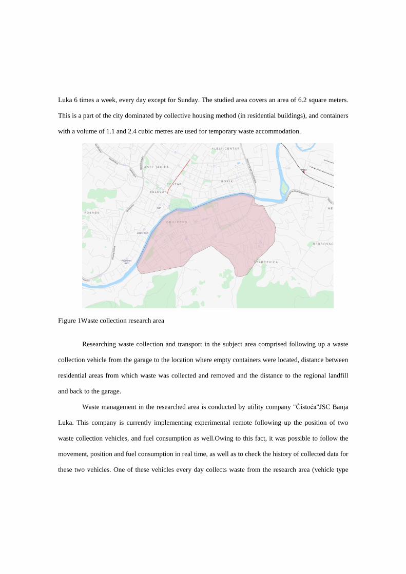
Luka 6 times a week, every day except for Sunday. The studied area covers an area of 6.2 square meters.
This is a part of the city dominated by collective housing method (in residential buildings), and containers
with a volume of 1.1 and 2.4 cubic metres are used for temporary waste accommodation.
Figure 1Waste collection research area
Researching waste collection and transport in the subject area comprised following up a waste
collection vehicle from the garage to the location where empty containers were located, distance between
residential areas from which waste was collected and removed and the distance to the regional landfill
and back to the garage.
Waste management in the researched area is conducted by utility company "Čistoća"JSC Banja
Luka. This company is currently implementing experimental remote following up the position of two
waste collection vehicles, and fuel consumption as well.Owing to this fact, it was possible to follow the
movement, position and fuel consumption in real time, as well as to check the history of collected data for
these two vehicles. One of these vehicles every day collects waste from the research area (vehicle type
SCANIA 124G). Part of the collected data on the movement and fuel consumption of this vehicle was put
at disposal of the authors of this paper; they represent a base for displaying the existing situation.
According to these data, the waste collection vehicle every day collects waste from the subject area,
moving along the same routes and emptying 91 containers for temporary waste disposal.
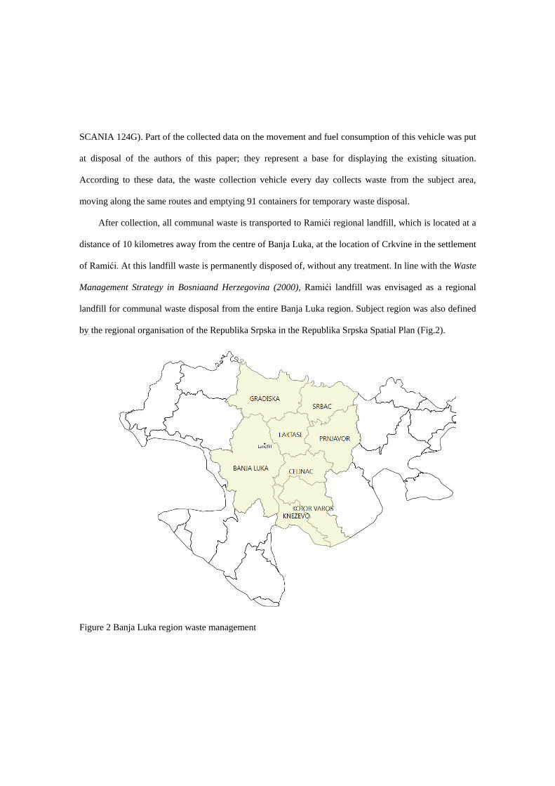
After collection, all communal waste is transported to Ramići regional landfill, which is located at a
distance of 10 kilometres away from the centre of Banja Luka, at the location of Crkvine in the settlement
of Ramići. At this landfill waste is permanently disposed of, without any treatment. In line with the Waste
Management Strategy in Bosniaand Herzegovina (2000), Ramići landfill was envisaged as a regional
landfill for communal waste disposal from the entire Banja Luka region. Subject region was also defined
by the regional organisation of the Republika Srpska in the Republika Srpska Spatial Plan (Fig.2).
Figure 2 Banja Luka region waste management
Researching the optimal regional landfill location with regard to distances from municipal
centres was done in the territory of this region. The region is made up of 8 units of local self-government:
Banja Luka, Prnjavor, Gradiška, Srbac, Laktaši, Čelinac, Kotor Varoš and Kneževo. It covers an area of
4704 km2with 401131 strong populace.
Since according to Ghose et al. (2006)geographic information system (GIS) is an important tool
for solving problems with waste transport from the collection spot to the waste landfill with the aim of
minimising costs it was also used in this city to resolve this problem.
In the concrete case QGISwas used as a tool for data collection, storing, processing and
visualisation, but also other computer programmes such as PostgreSQL to create databases, PostGIS to
enable spatial components of the database and pgRouting,which represents a group of mathematic
algorithms for analysing collected data. Apart from these, GRASS GIS was used to find a more advanced
resolution to certain network analysis problems. All these programmes, except PostgeSQL, are developed
under the umbrella of The Open Source Geospatial Foundation, or OSGeo.
All collected data are unified into one database in PostgreSQL programme that represents
theobject-relational database management system(Smith, 2010). In order to be able to create a database
that can store a lot of spatial data it has been added functionalities that are characteristic of other
programme, notably PostGIS. PostGIS is aFree and open source software (FOSS) that spatially enables
the PostgreSQL object-relational database management system(Obe, 2011).
Upon the provision of the road network data and adequate GIS modulesthat deal with network
analyses, optimisation phase preparation is launched (Zelenović Vasiljević et al., 2012). As a modulethat
handles network analyses, this paper used pgRoutingprogramme. That is a special extension of PostGIS
programme, which enables network structures research (Corti, 2014). That is a programme that contains a
high number of heuristic algorithms for analysing road networks, graphs and similar.
The simulation of optimal waste collection vehicles route was made by reducing collection
problems in the classic travelling salesman problem (TSP),which was solved with one of the functions
from pgrouting extension of geospatial database. However, since pgRoutig is currently solving this
problem taking onlyEuclidean distanceinto account the precision of acquired results was improved by the
analysis with the aid of the GRASS GIS moduletool, v.net.salesman, which calculates optimal routes of
visiting individual location in the network, e.g.roads, taking costs into account.
Driving distance function, one of many functions in the pgRouting programme was used for the
needs of defining optimal regional landfill location, which can be presented as optimised accessibility
from town centres in a region in a certain length of time, length of road etc. With the aid of Dijkstra
algorithm (Dijkstra, 1959)this function calculates the shortest paths along roads to several points that
represent certain junctions on roads.This algorithm finds the shortest paths between the beginning and all
other points in the network for the given starting point in this network such as road network. The function
that the algorithm takes when calculating the shortest path from the beginning point can be different
(velocity, length, costs etc.).
Results and discussion
The analyses of acquired research results were based on a distance passed by a waste collection vehicle in
one cycle of loading and unloading depending on collection efficiency and regional sanitary landfill
position.
Acquired data lead to a conclusion that the existing route of the vehicle from the garage to the
waste collection areas to the regional landfill and back to the garage is 43971.69 m long (Fig.3). Data
from the probe that monitors fuel consumption are acquired simultaneously with vehicle position data;
this leads to a conclusion that the total fuel consumption in the existing daily cycle of waste collection in
the researched area is 26.17 L, meaning 1.68 Lkm-1.
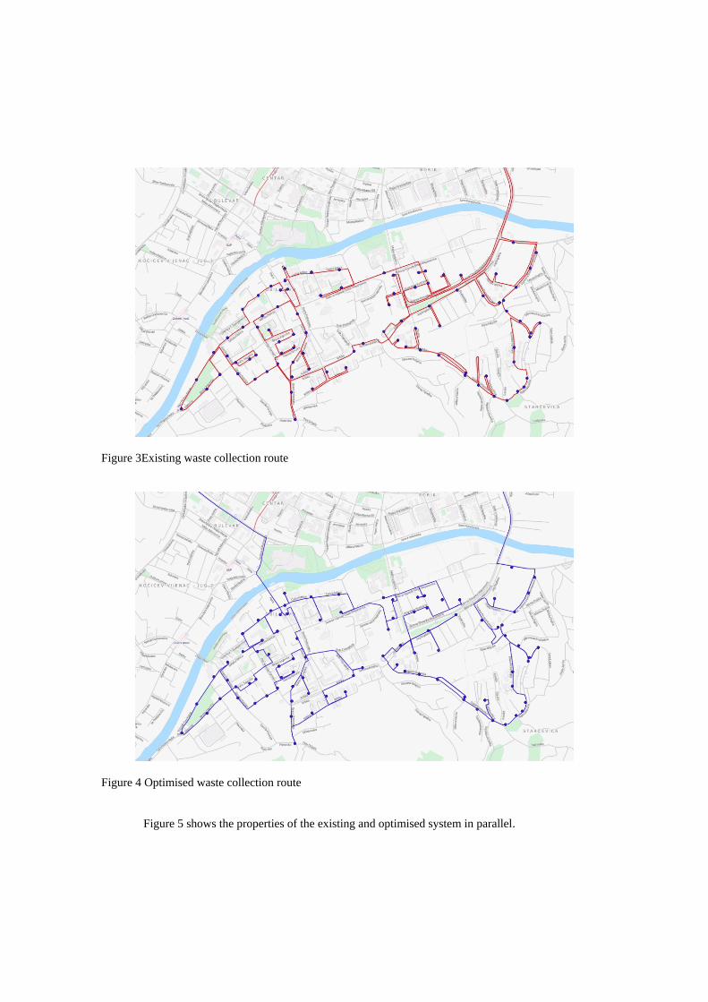
Figure 3Existing waste collection route
Figure 4 Optimised waste collection route
Figure 5 shows the properties of the existing and optimised system in parallel.
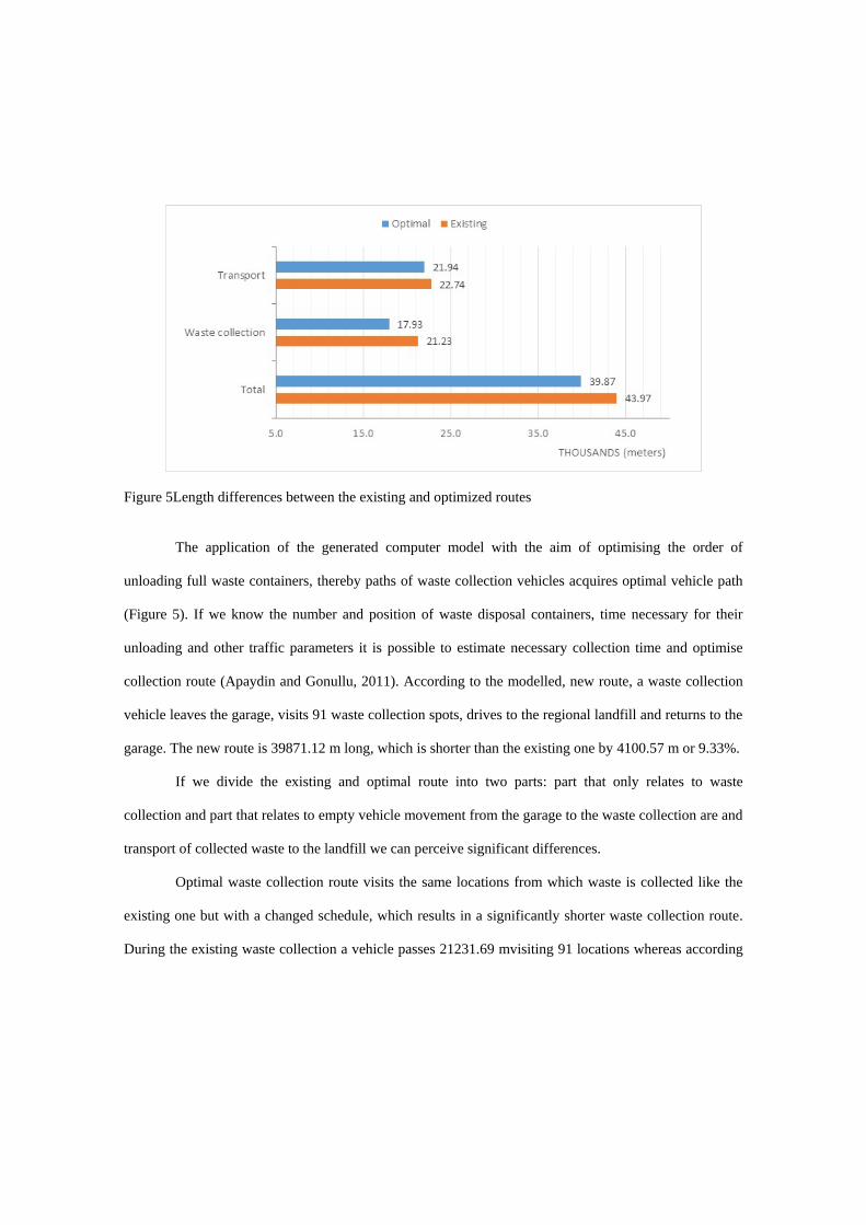
Figure 5Length differences between the existing and optimized routes
The application of the generated computer model with the aim of optimising the order of
unloading full waste containers, thereby paths of waste collection vehicles acquires optimal vehicle path
(Figure 5). If we know the number and position of waste disposal containers, time necessary for their
unloading and other traffic parameters it is possible to estimate necessary collection time and optimise
collection route (Apaydin and Gonullu, 2011). According to the modelled, new route, a waste collection
vehicle leaves the garage, visits 91 waste collection spots, drives to the regional landfill and returns to the
garage. The new route is 39871.12 m long, which is shorter than the existing one by 4100.57 m or 9.33%.
If we divide the existing and optimal route into two parts: part that only relates to waste
collection and part that relates to empty vehicle movement from the garage to the waste collection are and
transport of collected waste to the landfill we can perceive significant differences.
Optimal waste collection route visits the same locations from which waste is collected like the
existing one but with a changed schedule, which results in a significantly shorter waste collection route.
During the existing waste collection a vehicle passes 21231.69 mvisiting 91 locations whereas according
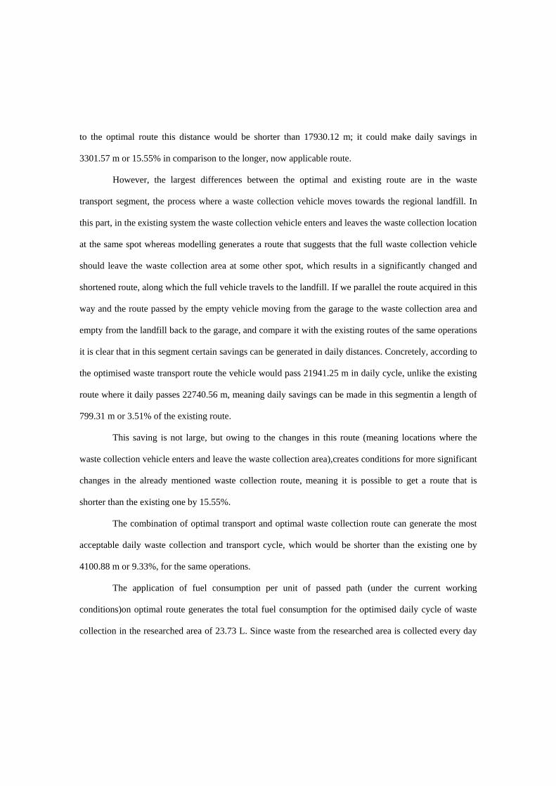
to the optimal route this distance would be shorter than 17930.12 m; it could make daily savings in
3301.57 m or 15.55% in comparison to the longer, now applicable route.
However, the largest differences between the optimal and existing route are in the waste
transport segment, the process where a waste collection vehicle moves towards the regional landfill. In
this part, in the existing system the waste collection vehicle enters and leaves the waste collection location
at the same spot whereas modelling generates a route that suggests that the full waste collection vehicle
should leave the waste collection area at some other spot, which results in a significantly changed and
shortened route, along which the full vehicle travels to the landfill. If we parallel the route acquired in this
way and the route passed by the empty vehicle moving from the garage to the waste collection area and
empty from the landfill back to the garage, and compare it with the existing routes of the same operations
it is clear that in this segment certain savings can be generated in daily distances. Concretely, according to
the optimised waste transport route the vehicle would pass 21941.25 m in daily cycle, unlike the existing
route where it daily passes 22740.56 m, meaning daily savings can be made in this segmentin a length of
799.31 m or 3.51% of the existing route.
This saving is not large, but owing to the changes in this route (meaning locations where the
waste collection vehicle enters and leave the waste collection area),creates conditions for more significant
changes in the already mentioned waste collection route, meaning it is possible to get a route that is
shorter than the existing one by 15.55%.
The combination of optimal transport and optimal waste collection route can generate the most
acceptable daily waste collection and transport cycle, which would be shorter than the existing one by
4100.88 m or 9.33%, for the same operations.
The application of fuel consumption per unit of passed path (under the current working
conditions)on optimal route generates the total fuel consumption for the optimised daily cycle of waste
collection in the researched area of 23.73 L. Since waste from the researched area is collected every day
but Sunday during one year (meaning 313 days) the optimised route for waste transport can make savings
in fuel in an amount of 763.92 L in one year.
This can achieve other diverse savings through the application of GIS technologies for waste
collection routes optimisation such as: reduction of number of waste disposal containers, length of waste
collection route, time necessary for collection and related operative costs such as: wages for workers, fuel
consumption, vehicle depreciation etc.(Zamorano et al., 2009).
Waste collected from the researched area is directly transported to the regional landfill that is 22 km
away from it; waste from other 7 towns from this area is transported to the same landfill. The existing
regional landfill location is not equally distanced from all towns in the region, which results in different
transport costs (with the same price of waste disposal at the landfill). The application of severalcomputer
programmes that are being developed under the umbrella of OSGeo foundation created a spatial and
transport model, which tried to determine the regional landfill ideal location with regard to transport
distances.Analyses were done for assumed distances of 20, 25, 30, 35 and 40 km.
The results of analyses with different, but for all towns equal and acceptable lengths in every model,
showed that within the existing borders and towns in the Banja Luka region, only distances of between 35
and 40 kmhad locations where the regional landfill could be constructed at an equal distance from all 7
towns in transport terms (Fig.6). These are simultaneously distances for which direct transport of
collected waste to the landfill is partially justified without involving transfer stations. No equally
distanced location for the regional landfill exists for assumed shorter transport distances.
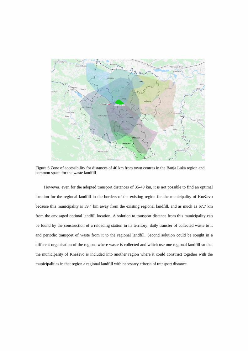
Figure 6 Zone of accessibility for distances of 40 km from town centres in the Banja Luka region and common space for the waste landfill
However, even for the adopted transport distances of 35-40 km, it is not possible to find an optimal
location for the regional landfill in the borders of the existing region for the municipality of Kneževo
because this municipality is 59.4 km away from the existing regional landfill, and as much as 67.7 km
from the envisaged optimal landfill location. A solution to transport distance from this municipality can
be found by the construction of a reloading station in its territory, daily transfer of collected waste to it
and periodic transport of waste from it to the regional landfill. Second solution could be sought in a
different organisation of the regions where waste is collected and which use one regional landfill so that
the municipality of Kneževo is included into another region where it could construct together with the
municipalities in that region a regional landfill with necessary criteria of transport distance.
Conclusion
Acquired data with regard to the waste collection process optimisation and data on distances acquired by
changing the location from which the full vehicle starts towards the regional landfill show that small
changes can make significant savings. Also, a good selection of the regional landfill location in relation to
transport distance from the town centres in this region can optimise distances and regular costs of waste
transport to the regional landfill.
Modelling the ideal regional landfill location in this paper was only done for a simple condition of
equal distances in order to show usability of subject methodology. However, in the created special and
transport model it is possible to make other tests, and include other factors in analyses, which are closely
related to waste management costs such as: fuel consumption on some routes, velocity, transported waste
quantity etc.
The mentioned overview of similar researches leads to a conclusion that many methods are used for
routes optimisation for waste collection, transfer and transport. Some of these methods are used in the
combination with GIS, such as: ArcGIS Network Analyst, MapInfo, MapPoint, whereas others are used
as mathematical algorithms for calculations and quantitative valuation of some solutions. Methods that
are used in the combination with GIS are mostly commercial, computer, programme solutions that often
are not available to a wider circle of users because of their price. Second group of methods, available
mathematic algorithms, are used by a low number of users because of their complexity. Integration of
available mathematic algorithms with free GIS programmes is the field where models should be created
to be easier applied in practice.
Used software tool and data on roads network are free and publicly available, and the presented
optimization methodology is applicable everywhere, which is especially significant for developing
countries. Through the application of described methods, authorized operators and municipalities can
achieve optimal exploitation of their resources having respect for economic, environmental and social
factors that are related to waste management
Acknowledgements
Authors are grateful to technical personnel of AD Čistoća Banja Luka for their aid during research and
data collection, as well as for data they made available.
References
Apaydin, O., and Gonullu, M.T. (2008). Emission control with route optimization in solid waste collection process: A case study. Sadhana 33, 71–82.
Apaydin, O., and Gonullu, M.T. (2011). Route time estimation of solid waste collection vehicles based on population density. Global NEST Journal 13, 162–169.
Corti, P. (2014). PostGIS 2.0 Cookbook (Packt Publishing).
Dijkstra, E.W. (1959). A note on two problems in connexion with graphs. Numer. Math. 1, 269–271.
Eisted, R., Larsen, A.W., and Christensen, T.H. (2009). Collection, transfer and transport of waste: accounting of greenhouse gases and global warming contribution. Waste Management & Research 27, 738–745.
Ghose, M.K., Dikshit, A.K., and Sharma, S.K. (2006). A GIS based transportation model for solid waste disposal--a case study on Asansol municipality. Waste Manag 26, 1287–1293.
Karadimas, N.V., Doukas, N., Kolokathi, M., and Defteraiou, G. (2008). Routing Optimization Heuristics Algorithms for Urban Solid Waste Transportation Management. W. Trans. on Comp. 7, 2022–2031.
Khan, D., and Samadder, S.R. (2014). Municipal solid waste management using Geographical Information System aided methods: A mini review. Waste Manag Res 32, 1049–1062.
Kovačić, B. (2004). Višekriterijsko odlučivanje u prometu. Sveučilište u Zagrebu, Fakultet prometnih znanosti.
Larsen, A.W., Vrgoc, M., Christensen, T.H., and Lieberknecht, P. (2009). Diesel consumption in waste collection and transport and its environmental significance. Waste Management & Research 27, 652–659.
Margeta, J.i Prskalo, G. (2006). Izbor lokacije za sanitarno odlagalište. Građevinar, (Zagreb: Hrvatski savez građevinskih inženjera), pp. 997–1008.
Milosevic, I., and Naunovic, Z. (2013). The application of a multi-parameter analysis in choosing the location of a new solid waste landfill in Serbia. Waste Manag Res 31, 1019–1027.
Ohri, A., and Singh, P.K. (2010). GIS based secondary storage and transportation system planning for municipal solid waste. International International Journal Journal of Civil of Engineering Civil Engineering and Technology (IJCIET) 1, 108–130.
Smith, G. (2010). PostgreSQL 9.0 high performance accelerate your PostgreSQL system and avoid the common pitfalls that can slow it down (Birmingham, U.K.: Packt Pub.).
Vojinović, M., Cvijetinović, Ž., Đokić, M., i Obradović, A. (2013). Primena sistema za nadzor voznog parka u kompanijama koje upravljaju otpadom – primer JKP Mediana Niš. Ka Održivom Transportu 2013, Socijacija Rukovodilaca Transoprta I Logistike TRANSPORTLOG 71–84.
Zelenović Vasiljević, T., Srdjević, Z., Bajčetić, R., and Vojinović Miloradov, M. (2012). GIS and the analytic hierarchy process for regional landfill site selection in transitional countries: a case study from Serbia. Environ Manage 49, 445–458.
(2000). Strategija upravlјanja čvrstim otpadom u Bosni i Hercegovini.


![i Unsupervised Mechanisms for Optimizing On-Time ......passenger transfer time (required time to switch from one route to another route to get to destinations) [8], minimizing transfer](https://img.pdfslide.us/doc/110x75/6055a5386d0cb70151234812/i-unsupervised-mechanisms-for-optimizing-on-time-passenger-transfer-time.jpg)