Embed Size (px)
Citation preview

A Guide to the Role of Standards in Geospatial Information Management
Prepared cooperatively by the
Open Geospatial Consortium (OGC);
The International Organization for Standards (ISO)
Technical Committee 211 Geographic information/Geomatics;
and the
International Hydrographic Organization (IHO).
August 2015
2
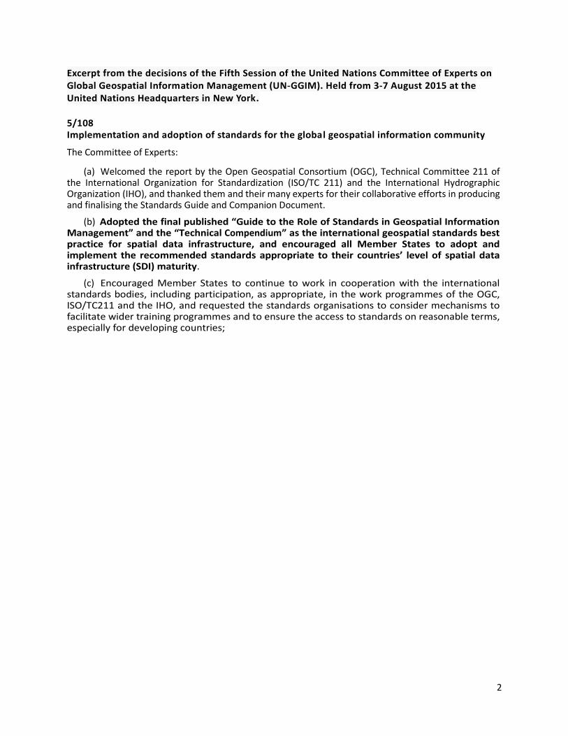
Excerpt from the decisions of the Fifth Session of the United Nations Committee of Experts on Global Geospatial Information Management (UN-GGIM). Held from 3-7 August 2015 at the United Nations Headquarters in New York. 5/108 Implementation and adoption of standards for the global geospatial information community
The Committee of Experts:
(a) Welcomed the report by the Open Geospatial Consortium (OGC), Technical Committee 211 of the International Organization for Standardization (ISO/TC 211) and the International Hydrographic Organization (IHO), and thanked them and their many experts for their collaborative efforts in producing and finalising the Standards Guide and Companion Document.
(b) Adopted the final published “Guide to the Role of Standards in Geospatial Information Management” and the “Technical Compendium” as the international geospatial standards best practice for spatial data infrastructure, and encouraged all Member States to adopt and implement the recommended standards appropriate to their countries’ level of spatial data infrastructure (SDI) maturity.
(c) Encouraged Member States to continue to work in cooperation with the international standards bodies, including participation, as appropriate, in the work programmes of the OGC, ISO/TC211 and the IHO, and requested the standards organisations to consider mechanisms to facilitate wider training programmes and to ensure the access to standards on reasonable terms, especially for developing countries;
3
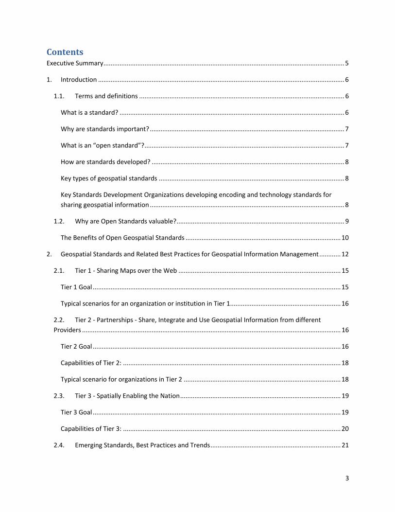
Contents Executive Summary ....................................................................................................................................... 5
1. Introduction .......................................................................................................................................... 6
1.1. Terms and definitions ................................................................................................................... 6
What is a standard? .............................................................................................................................. 6
Why are standards important? ............................................................................................................. 7
What is an “open standard”? ................................................................................................................ 7
How are standards developed? ............................................................................................................ 8
Key types of geospatial standards ........................................................................................................ 8
Key Standards Development Organizations developing encoding and technology standards for
sharing geospatial information ............................................................................................................. 8
1.2. Why are Open Standards valuable? .............................................................................................. 9
The Benefits of Open Geospatial Standards ....................................................................................... 10
2. Geospatial Standards and Related Best Practices for Geospatial Information Management ............ 12
2.1. Tier 1 - Sharing Maps over the Web ........................................................................................... 15
Tier 1 Goal ........................................................................................................................................... 15
Typical scenarios for an organization or institution in Tier 1.............................................................. 16
2.2. Tier 2 - Partnerships - Share, Integrate and Use Geospatial Information from different
Providers ................................................................................................................................................. 16
Tier 2 Goal ........................................................................................................................................... 16
Capabilities of Tier 2: .......................................................................................................................... 18
Typical scenario for organizations in Tier 2 ........................................................................................ 18
2.3. Tier 3 - Spatially Enabling the Nation .......................................................................................... 19
Tier 3 Goal ........................................................................................................................................... 19
Capabilities of Tier 3: .......................................................................................................................... 20
2.4. Emerging Standards, Best Practices and Trends ......................................................................... 21
4
3. Examples of Standards in Use ............................................................................................................. 23
3.1. Tier 1 Use Cases/examples ......................................................................................................... 23
3.2. Tier 2 Use Cases/examples ......................................................................................................... 24
Tier 3 Use Cases/examples ..................................................................................................................... 25
3.3. Future: Spatially enabled Web of data ....................................................................................... 26
4. Next steps ........................................................................................................................................... 26
5. Acknowledgements ............................................................................................................................. 28
6. Annotated Bibliography and References ............................................................................................ 29
6.1. Resources for next steps ............................................................................................................. 29
6.1.1. Cookbooks ................................................................................................................................... 29
6.1.2. Operational Policy ....................................................................................................................... 29
6.1.3. Guides ......................................................................................................................................... 29
6.1.4. Other References ........................................................................................................................ 29

5
Executive Summary The use of geospatial information is increasing rapidly. There is a growing recognition in both government
and the private sector that geography1 is a vital component of effective decision making. Citizens with no
recognized expertise in geospatial information, and who are unlikely to even be familiar with the term,
are increasingly using and interacting with geospatial information; indeed in some cases they are
contributing to its collection – often in an involuntary way.
In order to effectively leverage the value of geospatial information, the information must be easy to access
and use. Given that geospatial information comes from many different sources, and is managed by a very
large number of different providers – from mapping agencies to commercial data providers to volunteered
geographic information - there is an overwhelming requirement to easily discover and share this
information. Standards have a key role in this respect and are essential to delivering authoritative
geospatial services and products which meet the requirements of the wider community of users.
Standards and conformance provide significant value2 to society and government, are essential for an
expanding national economy and vital to the global competitiveness of both industry and nations.
“Geospatial information is the most fundamental tool to support the planet’s joint efforts in resolving
global issues. By interconnecting information on natural disasters, poverty and the environment through
location data, global issues such as sustainable development and poverty eradication can be effectively
managed.” Prime Minister Kim Hwang-Sik, Republic of Korea3.
This guide addresses the role of standards in geospatial information management:
Defines what a standard is;
Makes a case for open standards;
Discusses why such standards are valuable;
Describes geospatial standards and related best practices;
Introduces a goal-based approach to standards adoption and a multi-tiered standardization
maturity model;
Characterizes emerging standards and trends;
Gives concrete examples of standards in use; and
Concludes with suggestions for next steps.
1 Acknowledging that “geography” equates to location, place-based information, geospatial, and other terms. For
the remainder of this report, the term “geospatial information” will be used. 2 ISO, “ISO/IEC Inventory of Studies on the Economic and Social Benefits of Standardization,” 2013, at http://www.standardsinfo.net/info/benefits/benefits_s1.html 3 http://ggim.un.org/forum1.html
6
This guide is accompanied by a detailed “Companion Document on Standards Recommendations by Tier”
which details available standards and their applications.
“Geospatial information is widely used in New Zealand and already contributes over $1.2 billion a year to
the economy. It also forms a part of New Zealand’s knowledge infrastructure and enables innovation and
better decision-making.”4
1. Introduction This guide is intended to:
Articulate the critical role of standards in geospatial information management;
Inform policy makers and program managers in Member States of the value in using and
investing in geospatial standardization; and
Describe the benefits of using “open” geospatial standards to achieve standardization, data
sharing, and interoperability goals.
Information presented in this guide is intended to be useful for a wide variety of readers, especially in
government. These include policy makers, program managers, technical experts and other individuals
involved in geospatial information management.
The need for a document of this type was identified in discussions that have occurred as part of the
extensive consultations with participants in the ongoing United Nations initiative on Global Geospatial
Information Management (UN-GGIM)5.
This guide begins with a discussion of what is meant by an “open standard” and the value of using
standards, specifically geospatial standards, in private sector, government, and citizen interactions.
1.1. Terms and definitions
What is a standard?
There are many definitions but all incorporate the following central elements:
A standard is a documented agreement between providers and consumers, established by consensus,
that provides rules, guidelines, or characteristics ensuring materials, products, and services are fit for
purpose.
4 New Zealand SDI Value: http://www.linz.govt.nz/geospatial-office/about/projects-and-news/spatial-data-infrastructure 5 http://ggim.un.org/
7
Why are standards important?
Other sections in this document will provide details on the business value for standards. Behind the
scenes, standards make everyday life work. They may establish size or shape or capacity of a product,
process or system. They can specify performance of products or personnel. They also can define terms so
that there is no misunderstanding among those using the standard. As general examples, standards help
assure that:
A light bulb fits a socket;
Individuals can withdraw money from their bank accounts through any Automated Teller Machine
anywhere in the world;
Mobile phones work across multiple countries around the world;
Latitude and Longitude provide a standard reference system for the Earth;
GPS coordinates are always provided in the same format.
What is an “open standard”?
In this document, the term “open standard” is often used. What does this term mean? The following are
the essential characteristics of an open standard:
Publicly available;
Unencumbered by patents and other intellectual property;
Anyone can download and use the standard (non-discriminatory);
No license fees;
Vendor neutral;
Data neutral;
Agreed to in a consensus decision making process;
No single entity controls the standard.
Different governments and enterprises may choose to use geospatial information and software
applications which do not rely on open standards. The most immediate drawback of such an approach is
that the organization has created an information and technology silo that presents users with many
hidden challenges such as delays and costs of expanding or adapting data and software tools to work with
other resources, software or organizations. In an ever changing world, open standards help assure that
organizations can more quickly take advantage of new geospatial information sources and new
technology tools. Open standards are a central element in the growing trend to open government.
A goal of open standards is to ensure that "interoperability" (the ability to integrate datasets and related
services of different types and from different sources) will minimize such costs and problems. Further,
the open process of developing and maintaining standards offers governments, universities, research
8
organizations, and business enterprises the opportunity to have a voice in building and learning about the
standards.
How are standards developed?
The majority of international standards are developed in Standards Development Organizations (SDOs)
that use a consensus process guided by documented, repeatable and well proven policies and
procedures. Typically, any organization can join an SDO and participate in the standards development
process. This helps ensure that the standards developed meet the needs of all users and that they are
primarily “demand” rather than “supply” driven.
Key types of geospatial standards
There are two key types of geospatial standards discussed in this document: information (or content)
standards and technology (interface, API6) standards. The following modified definitions of these two key
types of standards are from the GeoConnections website of the Government of Canada7.
“Geospatial information standards8 provide digital coding to locate and describe features on, above or
below the Earth’s surface. Geographically-related features can be naturally occurring (for example: rivers,
rock formations, coastlines), man-made (for example: dams, buildings, radio towers, roads) or intrinsic,
implied and transient information (for example: political boundaries, electoral districts, weather systems,
distribution of population ethnicity).
Technology standards allow different systems and services to work together through standard interfaces9.
Ideally, when the standards are implemented in products or online services independently, the resulting
components ‘plug-and-play’, that is, they work together seamlessly.”
Key Standards Development Organizations developing encoding and technology standards for sharing
geospatial information
There are three key international organizations which have the objective of developing standards for
geospatial information:
The International Organization for Standardization (ISO) Technical Committee 211 Geographic
information/Geomatics10;
The Open Geospatial Consortium (OGC)11;
6 API: application programming interface. APIs specify how software components should interact with each other. 7 http://www.nrcan.gc.ca/earth-sciences/geomatics/canadas-spatial-data-infrastructure/8902 8 This type of standard is also known as “encoding” or “content model” standards. 9 From a more technical perspective, programming to the interface reduces dependency on implementation specifics and makes code more reusable. It gives the programmer the ability to later change the behavior of the system by simply swapping the object used with another implementing the same interface. The net effect is to reduce life cycle maintenance costs. 10 www.isotc211.org 11 www.opengeospatial.org
9
The International Hydrographic Organization (IHO)12.
These international standards organizations have representative members from government, industry,
research, and academia who arrive at decisions through a consensual process. The organizations develop,
maintain and make publicly available open standards that enable the ability to publish, discover, access,
manage and use geospatial information across a range of applications, systems and business enterprises.
These organizations all employ processes and approaches which ensure the development of international
open standards that meet the characteristics described above.
1.2. Why are Open Standards valuable? In 1904, much of the City of Baltimore in the United States was destroyed by a massive fire. Firefighters
from hundreds of kilometers away were sent to assist Baltimore firefighters during the height of the blaze.
They could do little to help because the fire hoses used by different responders were not standardized.
The resultant inability to connect hoses to fire hydrants turned hundreds of firefighters into spectators.
This analogy rings true not just in respect of the need to share geospatial information, such as post-
disaster imagery, during a crisis, but throughout all implementations of geospatial technologies. Open
standards make uniformity, compatibility and interoperability possible for electronic devices, software
applications, and processes in all sectors of a global economy.
Open standards facilitate increased return on geospatial investment through a host of mechanisms.
Return on investment may be realized through direct means such as improved efficiency, which saves
time and effort and thereby money, or through indirect means which allows for new capabilities and
capacities. Without standards, the ability to connect systems, data, people, hardware, software, and
procedures become much like trying to connect hoses with differing threads to a fire hydrant in a
community combating a fire. Loss of time, assets and lives is inevitable.
12 www.iho.int
MapAction
Having operated on every continent since 2006, MapAction works in disaster zones providing
frequently updated situational maps showing where relief help is most urgently needed. MapAction
is a non-governmental organization that exchanges many kinds of geospatial information from
different sources among open source and licensed software products. MapAction and similar
organizations can bring value to crisis situations because their multiple software platforms are based
on open geospatial standards (recommended in this document). Without these open standards, it
would be impossible for MapAction to operate in a cost-effective and timely manner.
10
The Benefits of Open Geospatial Standards
Spatial Data Infrastructure (SDI) initiatives worldwide are implementing a common set of international
standards for geospatial data. These standards encapsulate geospatial data development, production,
management, discovery, access, sharing, visualization, and analysis. As organizations and jurisdictions
develop and agree on a common set of open standards, the ability to share geospatial information is
enhanced, reducing costs, improving service provision, and facilitating new economic opportunities.
Geospatial information, technologies and standards help to enable and improve the sharing, integration
and application of geospatial information for decision making. However, even with these tools in place,
the decision to share information effectively between organizations and governments often depends on
pro-active policy. These policy choices must be made in all jurisdictions and enterprises at many levels,
but particularly at the level of national governments. A multi-national response to a regional disaster is
one example where having clear policy on the sharing of geospatial information is critically important.
The shaping of appropriate geospatial policy is beyond the mandate of this guide but it must be addressed.
For without a suitable policy framework the standards-based approaches described in this guide will be
of limited value.
The remainder of this guide seeks to answer the following questions directly related to the role of
standards in geospatial information management.
What are the common SDI standards adopted by organizations worldwide?
Which of these standards are appropriate for geospatial information management in the context
of the UN initiative on Global Geospatial Information Management?
What are the appropriate geospatial standards for an organization’s needs?
In addition to these questions the overall value proposition associated with open standards should be
considered by all stakeholders. The fundamental questions which should be addressed are:
Examples:
The internet, mobile phone, and banking systems are all heavily reliant on standards in order
for various devices and computerized applications to communicate with one another, and
with the needed efficiency and volume.
The economic value of open standards for geospatial information is realized when they
enable and simplify rapid exchange of the large amounts of place-based information that is
crucial for personal, commercial and public-sector analysis and decision-making.
The provision of nautical charts to mariners, as regulated by the International Convention for
the Safety of Life at Sea (SOLAS), is based on open standards adopted by the IHO in order “to
ensure the greatest possible uniformity”.
11
Can the adoption of open standards be quantified in terms of time and/or money in delivering the
services desired?
How much more productivity or effectiveness can be achieved by using open standards?
How will uncertainty and risk be reduced by using open standards, and if so, can this be
quantified?
These questions have been studied with respect to standards (in general) and with respect to the open
standards which underpin most geospatial infrastructure projects. Goals and methodologies vary from
one study to the next, but interested readers can find many examples of the net benefits that standards,
open geospatial standards in particular, offer.
Examples
The German Institute for Standardization (DIN) estimated benefits of 17 billion euros to the German
economy in 2010: “Standards promote worldwide trade, encouraging rationalization, quality
assurance and environmental protection, as well as improving security and communication.
Standards have a greater effect on economic growth than patents or licenses.” 13
The Joint Research Centre of the European Union collaborated with the Universitat Politècnica de
Catalunya (Spain) in concluding that the establishment of the spatial data infrastructure (SDI) of
Catalonia -- based on open geospatial standards -- generated significant internal (efficiency) benefits
as well as benefits of more effective service delivery. They quantified these benefits and estimated
that the value exceeded four year’s investment in just over six months. 14
NASA Geospatial Interoperability Return on Investment Study: Of the projects considered for this
study, the project that adopted and implemented geospatial interoperability standards had a risk-
adjusted ROI of 119.0%. This ROI is a “Savings to Investment” ratio. This can be interpreted as for
every $1.00 spent on investment, $1.19 is saved on Operations and Maintenance costs.
Overall, the project that adopted and implemented geospatial interoperability standards saved
26.2% compared to the project that relied upon a proprietary standard. One way to interpret this
result is that for every $4.00 spent on projects based on proprietary platforms, the same value could
be achieved with $3.00 if the project were based on open standards.15
13 See DIN, “"Economic Benefits of Standardization," 2010, at http://www.din.de/sixcms_upload/media/2896/DIN_GNN_2011_engl_akt_neu.pdf 14 See Craglia M. (Ed.), “The Socio-Economic Impact of the Spatial Data Infrastructure of Catalonia,” 2008, at http://publications.jrc.ec.europa.eu/repository/handle/111111111/7696 15 NASA Geospatial Interoperability Return on Investment Study (2005) http://www.ec-gis.org/sdi/ws/costbenefit2006/reference/ROI_Study.pdf
12
New Zealand SDI Benefits: Spatial Information in the New Zealand Economy - Realising
Productivity Gains is a report commissioned by Land Information New Zealand, the Department of
Conservation and the Ministry of Economic Development. It provides robust economic analysis that
quantifies the contribution spatial information makes to the New Zealand economy, as well as
opportunities for this contribution to grow. The report concludes that use and re-use of spatial
information is estimated to have added $1.2 billion in productivity related benefits to the New
Zealand economy in 2008.16
Many governmental, non-governmental and commercial enterprises rely on software solutions built on
open geospatial standards. By using such solutions to pursue their various missions, all these organizations
reap the benefits of lower risk, lower cost and better outcomes than they could achieve using solutions
that do not embrace open standards as evidenced by the case studies cited above.
2. Geospatial Standards and Related Best Practices for Geospatial Information
Management The adoption of standards is driven by the desire of organizations and institutions to seamlessly share,
integrate and use geospatial information (i.e. to interoperate) for improved decision making. In this
context, standards for geospatial information can be seen as a continuum enabling the achievement of
increasing levels of interoperability of geospatial information as more standards are adopted to keep pace
with evolving requirements, technologies and tools. Reaping the benefits of standards adoption is a
journey and organizations, institutions and information communities are likely to be starting this journey
at different points in the capability/maturity continuum. This guide provides a model for the phased
implementation of geospatial standards that considers the different levels of experience and expertise of
the players involved. Some organizations and institutions are far advanced, others are just beginning and
some are only considering the use of standards. The model - the standardization maturity model shown
in Figure 1, takes into account the different levels of knowledge and experience and describes a
standardization trajectory.
Over time, user experience has shown that lack of consensus, leadership commitment and a clear
governance structure are the principal factors limiting the full achievement of the benefits of open
standards. Constrained funding, inadequate governance arrangements, a lack of understanding of the
value proposition of using a standards-based approach and a lack of knowledge and experience in
standards implementation are major limiting factors and are often related to a lack of consensus among
stakeholders.
As consensus builds, understanding improves and the willingness of stakeholders to commit resources
and coordinate activities in an open fashion grows. This helps facilitate a continuing, self-sustainable, and
self-governed expansion of open standards. Single agency portrayal of basic information develops into
16 New Zealand http://www.linz.govt.nz/geospatial-office/about/projects-and-news/productivityreport
13
collaborative multi-agency standards development that takes fuller advantage of emerging technological
developments. Recognizing the constraints it is best to implement standards in an incremental fashion.
Full interoperability can take time as an organization or institution matures in both technical and policy
terms.
Community initiatives to share and make geospatial information available are typically oriented around
Spatial Data Infrastructure (SDI) initiatives. Standards are a critical element of SDI implementation. In
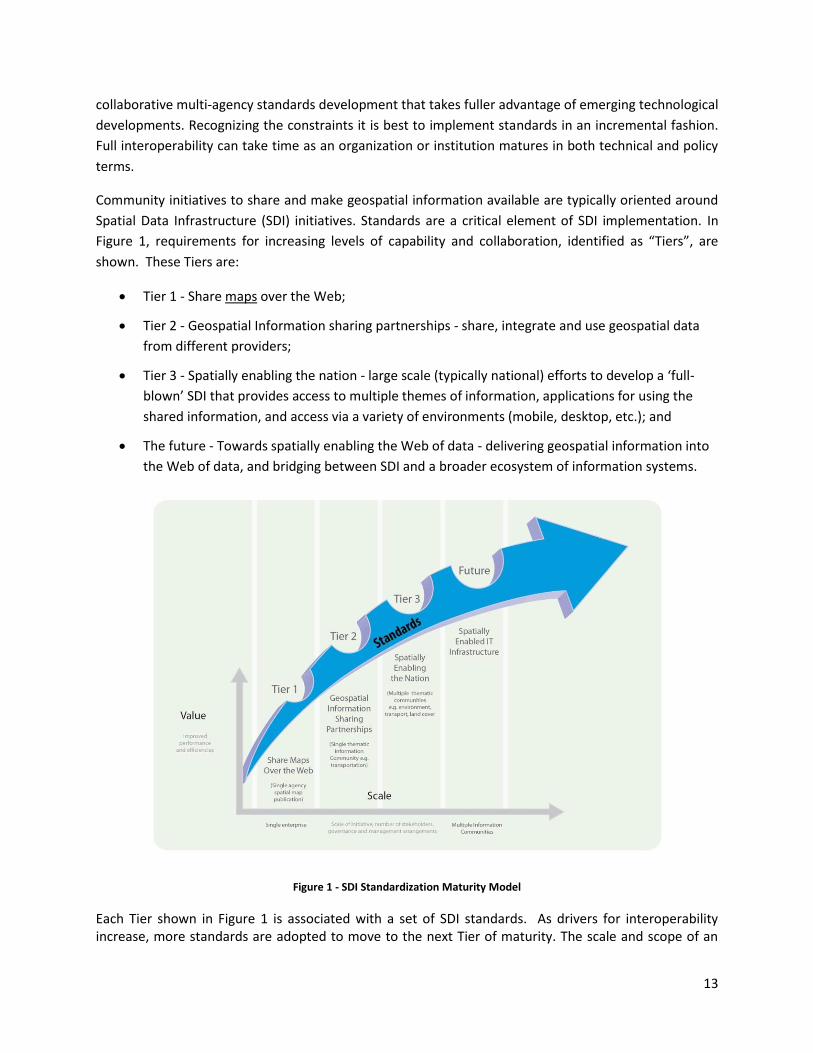
Figure 1, requirements for increasing levels of capability and collaboration, identified as “Tiers”, are
shown. These Tiers are:
Tier 1 - Share maps over the Web;
Tier 2 - Geospatial Information sharing partnerships - share, integrate and use geospatial data
from different providers;
Tier 3 - Spatially enabling the nation - large scale (typically national) efforts to develop a ‘full-
blown’ SDI that provides access to multiple themes of information, applications for using the
shared information, and access via a variety of environments (mobile, desktop, etc.); and
The future - Towards spatially enabling the Web of data - delivering geospatial information into
the Web of data, and bridging between SDI and a broader ecosystem of information systems.
Figure 1 - SDI Standardization Maturity Model
Each Tier shown in Figure 1 is associated with a set of SDI standards. As drivers for interoperability increase, more standards are adopted to move to the next Tier of maturity. The scale and scope of an

14
initiative in terms of the number of stakeholders and the number of information communities are also presented in this diagram. At each Tier, as more stakeholders adopt standards, the scale of the initiative increases. Likewise, as initiatives move from one Tier to the next, from single organization to information communities, the scale of interoperability grows and the value proposition of standards adoption is increasingly realized.
The description of the Tiers provided later in this section depicts the specific suites of SDI standards that
are used to achieve them, in the form of vertical blocks that are stacked on top of each other. A separate
Companion document details the specific standards associated with each suite.
The Tiers represent a series of steps in an organization’s ability to offer increasing levels of geospatial
information and associated services as part of an information community. At the beginning of the process
(Tier 1), an organization may want to provide access to geospatial information delivered as map images
together with a description of them (i.e. metadata). As an initiative matures, multiple organizations may
wish to collaborate to provide a means to share, search for, access, integrate and cooperatively maintain
and use a particular geospatial information layer (such as transportation) from multiple sources using web
services (Tier 2). Larger scale initiatives have a goal of establishing a nation-wide coverage of foundation
or framework17 data as part of their National SDI. Foundation data is an accurate set of key geospatial
data layers needed most by different users (imagery, elevation, administrative boundaries,
transportation, land use, and water features for example). Providing access to this geospatial Foundation
Data for a range of application areas is the next level of maturity (Tier 3).
Finally, to address emerging needs and leverage new technologies and opportunities such as crowd-
sourcing of geospatial information and big data analytics, a community would focus on delivering
geospatial information from SDI environments into the Web of data (the future).
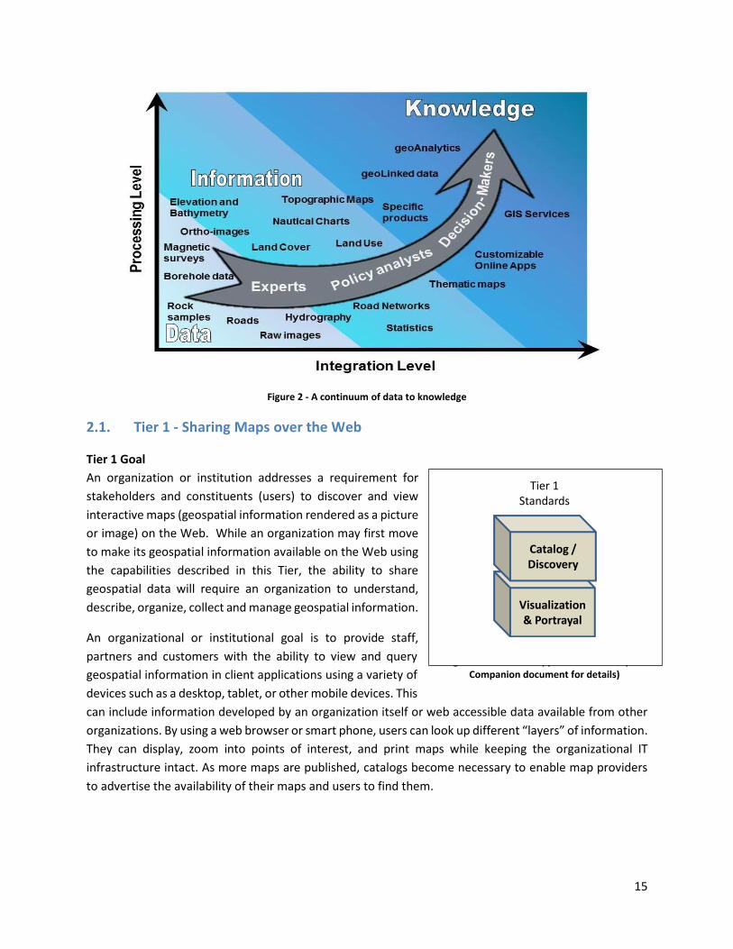
Achieving these increasing levels of interoperability is driven by a desire to provide decision makers with
access to a knowledge environment in which geospatial information is accessed and processed across the
Web and in mobile environments. Thus, data about people, places and things are linked together to
provide a deeper understanding of a given situation (such as a disaster, or social environmental or
economic phenomena). This trajectory from data to geospatial knowledge, enabled by standards
implementation, is shown in Figure 2.
17 For ‘Foundation’ see ANZLIC Australian and New Zealand Foundation Spatial Data Framework http://www.anzlic.gov.au/foundation_spatial_data_framework. For ‘Framework’ - See US Federal Geographic Data Committee Framework, https://www.fgdc.gov/framework/handbook/overview
15
Figure 2 - A continuum of data to knowledge
2.1. Tier 1 - Sharing Maps over the Web
Tier 1 Goal
An organization or institution addresses a requirement for
stakeholders and constituents (users) to discover and view
interactive maps (geospatial information rendered as a picture
or image) on the Web. While an organization may first move
to make its geospatial information available on the Web using
the capabilities described in this Tier, the ability to share
geospatial data will require an organization to understand,
describe, organize, collect and manage geospatial information.
An organizational or institutional goal is to provide staff,
partners and customers with the ability to view and query
geospatial information in client applications using a variety of
devices such as a desktop, tablet, or other mobile devices. This
can include information developed by an organization itself or web accessible data available from other
organizations. By using a web browser or smart phone, users can look up different “layers” of information.
They can display, zoom into points of interest, and print maps while keeping the organizational IT
infrastructure intact. As more maps are published, catalogs become necessary to enable map providers
to advertise the availability of their maps and users to find them.
Figure 3: Standards applicable to Tier 1 (see Companion document for details)
Visualization& Portrayal
Catalog /Discovery
Tier 1Standards

16
Capabilities of Tier 1
Clear description of the digital map data (metadata);
Discovery of digital map data via on-line catalogs; and
The ability to visualize digital geospatial information as maps over the Web;
The ability to visually overlay geospatial information as maps from different sources.
Typical scenarios for an organization or institution in Tier 1
Looking for a simple, low cost way to share geospatial information with all stakeholders and
constituents;
Geospatial information may be stored in more than one system using different geospatial
(Geographic Information System - GIS) technology and organizations do not wish to standardize
on a single technology platform;
Geospatial information is stored in more than one format and the organization(s) does not want
to incur the time and expense of reformatting geospatial information into a single format. The
belief that the data should remain closest to the source (owner) of the data that has maintenance
responsibility to increase the likelihood of update;
Publish one or more maps for government and citizen access;
May be unable or unwilling to distribute the underlying geospatial data but is willing and able to
share images of the data;
At this initial level of capability, policy and governance related to geospatial information
management and operations may be somewhat informal.
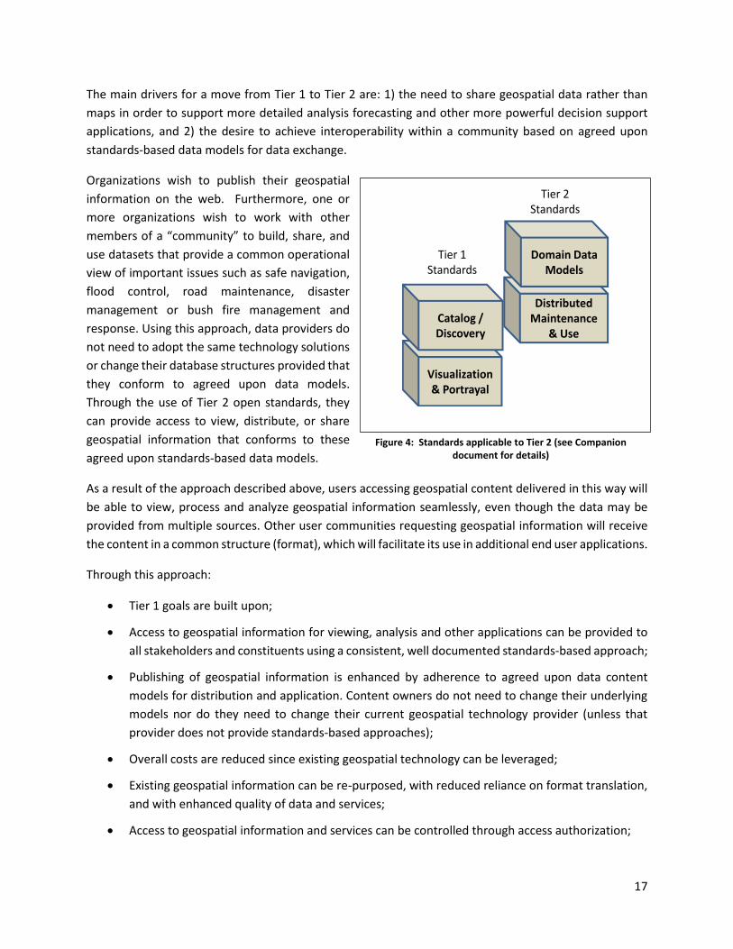
2.2. Tier 2 - Partnerships - Share, Integrate and Use Geospatial Information from
different Providers
Tier 2 Goal
An information community wishes to provide access to geospatial information over the Web, provide
geospatial information download services, and in addition, may provide specific data themes, such as
roads, from multiple sources that conform to agreed upon standards-based data models18 to create a
consistent and integrated definition or meaning of the geospatial information for users.
18 An OGC White Paper on Data Models and Interoperability provides an excellent discussion on standards-based
data models for data sharing and enhancing interoperability.
http://portal.opengeospatial.org/files/?artifact_id=3805&version=2&format=pdf
17
The main drivers for a move from Tier 1 to Tier 2 are: 1) the need to share geospatial data rather than
maps in order to support more detailed analysis forecasting and other more powerful decision support
applications, and 2) the desire to achieve interoperability within a community based on agreed upon
standards-based data models for data exchange.
Organizations wish to publish their geospatial
information on the web. Furthermore, one or
more organizations wish to work with other
members of a “community” to build, share, and
use datasets that provide a common operational
view of important issues such as safe navigation,
flood control, road maintenance, disaster
management or bush fire management and
response. Using this approach, data providers do
not need to adopt the same technology solutions
or change their database structures provided that
they conform to agreed upon data models.
Through the use of Tier 2 open standards, they
can provide access to view, distribute, or share
geospatial information that conforms to these
agreed upon standards-based data models.
As a result of the approach described above, users accessing geospatial content delivered in this way will
be able to view, process and analyze geospatial information seamlessly, even though the data may be
provided from multiple sources. Other user communities requesting geospatial information will receive
the content in a common structure (format), which will facilitate its use in additional end user applications.
Through this approach:
Tier 1 goals are built upon;
Access to geospatial information for viewing, analysis and other applications can be provided to
all stakeholders and constituents using a consistent, well documented standards-based approach;
Publishing of geospatial information is enhanced by adherence to agreed upon data content
models for distribution and application. Content owners do not need to change their underlying
models nor do they need to change their current geospatial technology provider (unless that
provider does not provide standards-based approaches);
Overall costs are reduced since existing geospatial technology can be leveraged;
Existing geospatial information can be re-purposed, with reduced reliance on format translation,
and with enhanced quality of data and services;
Access to geospatial information and services can be controlled through access authorization;
Visualization& Portrayal
Catalog /Discovery
DistributedMaintenance
& Use
Domain Data Models
Tier 1Standards
Tier 2Standards
Figure 4: Standards applicable to Tier 2 (see Companion document for details)

18
Collaborative data maintenance capability is enhanced (see below).
Capabilities of Tier 2:
Capabilities of Tier 1
and
Ability to access and share detailed geospatial information within each organization and with
other cooperating organizations;
Enhanced ability to apply geospatial data for enhanced situational awareness, analysis,
forecasting and decision support;
Ability to maintain and improve quality of common geospatial information between
cooperating organizations and jurisdictions (e.g. transportation, land use data across a
county, province, or state boundary, or between nations);
Through organization agreements to share data using agreed upon standards-based data
models, many more geospatial information sources and users can be integrated into the SDI.
This is important in many situations, such as emergency response, disaster management,
economic sustainability decisions, energy utilization, planning and citizen benefits.
Typical scenario for organizations in Tier 2
The desire to make geospatial information accessible over the web for use online or for download
and offline use;
Improve effectiveness and efficiency of an established information community with identified
common information needs, for example, organizations in neighboring jurisdictions that wish to
share consistent thematic data (for example, nautical charting, roads or forest cover) across their
borders;
Common information structures (data models) to support easy geospatial information exchange
between cooperating organizations and jurisdictions;
The ability for users from different organizations to be able to query, exchange and interact with
similar geospatial datasets in a consistent way (e.g. road networks) forming an aggregated view;
The ability to provide information (by way of metadata) about the context in which geospatial
data has been collected and used. This provenance and data quality information is critical in
allowing users to determine fitness for use of geospatial information within a given application;
At this level of capability, more formal geospatial information management policies and practices
have been adopted, agreed upon data models have been established, and information sharing
agreements have been established between cooperating organizations.
19
2.3. Tier 3 - Spatially Enabling the Nation
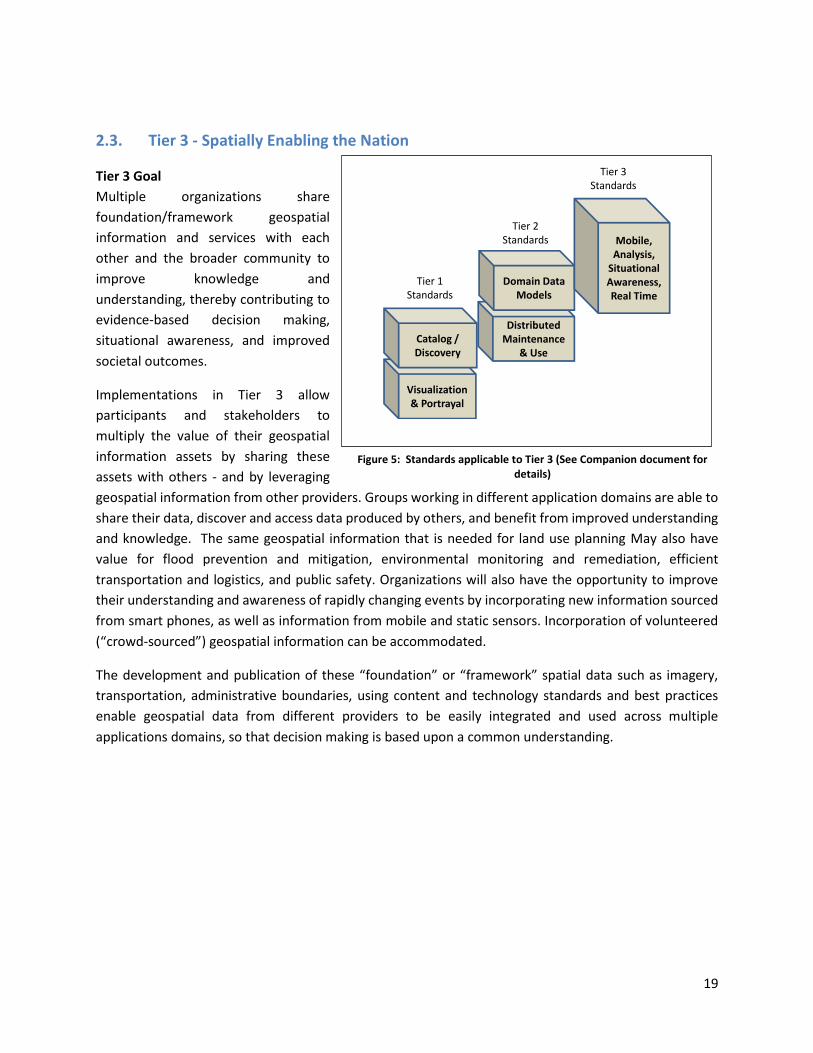
Tier 3 Goal
Multiple organizations share
foundation/framework geospatial
information and services with each
other and the broader community to
improve knowledge and
understanding, thereby contributing to
evidence-based decision making,
situational awareness, and improved
societal outcomes.
Implementations in Tier 3 allow
participants and stakeholders to
multiply the value of their geospatial
information assets by sharing these
assets with others - and by leveraging
geospatial information from other providers. Groups working in different application domains are able to
share their data, discover and access data produced by others, and benefit from improved understanding
and knowledge. The same geospatial information that is needed for land use planning May also have
value for flood prevention and mitigation, environmental monitoring and remediation, efficient
transportation and logistics, and public safety. Organizations will also have the opportunity to improve
their understanding and awareness of rapidly changing events by incorporating new information sourced
from smart phones, as well as information from mobile and static sensors. Incorporation of volunteered
(“crowd-sourced”) geospatial information can be accommodated.
The development and publication of these “foundation” or “framework” spatial data such as imagery,
transportation, administrative boundaries, using content and technology standards and best practices
enable geospatial data from different providers to be easily integrated and used across multiple
applications domains, so that decision making is based upon a common understanding.
Visualization& Portrayal
Catalog /Discovery
DistributedMaintenance
& Use
Domain Data Models
Mobile,Analysis,
Situational Awareness,Real Time
Tier 1Standards
Tier 2Standards
Tier 3Standards
Figure 5: Standards applicable to Tier 3 (See Companion document for details)
20
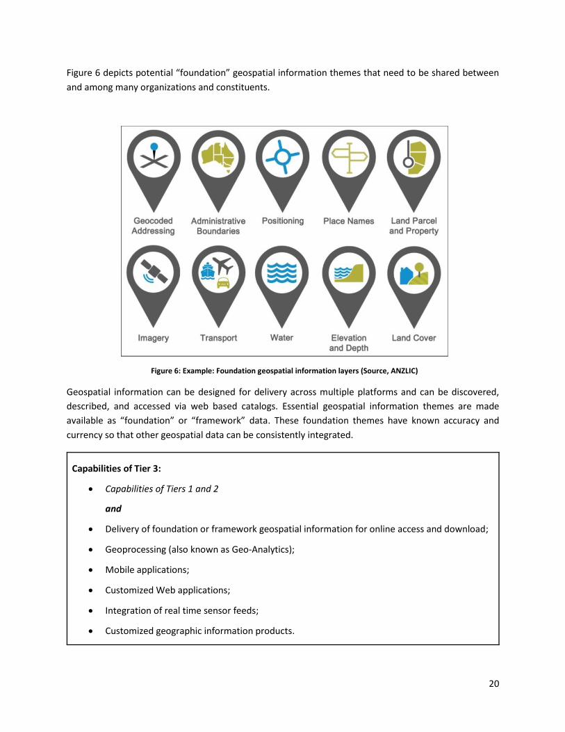
Figure 6 depicts potential “foundation” geospatial information themes that need to be shared between
and among many organizations and constituents.
Geospatial information can be designed for delivery across multiple platforms and can be discovered,
described, and accessed via web based catalogs. Essential geospatial information themes are made
available as “foundation” or “framework” data. These foundation themes have known accuracy and
currency so that other geospatial data can be consistently integrated.
Capabilities of Tier 3:
Capabilities of Tiers 1 and 2
and
Delivery of foundation or framework geospatial information for online access and download;
Geoprocessing (also known as Geo-Analytics);
Mobile applications;
Customized Web applications;
Integration of real time sensor feeds;
Customized geographic information products.
Figure 6: Example: Foundation geospatial information layers (Source, ANZLIC)
21
Typical scenarios
A nation begins the implementation of a National SDI to deliver foundational or framework
geospatial data for the nation. This may be an effort that starts from scratch or builds on domain
specific activities characterized in Tier 2;
Geoprocessing over the web;
Delivery to multiple platforms including desktop and mobile;
Real time data from a variety of sensors is incorporated;
Account for data sovereignty.
A robust framework of geospatial information management policies has been established for
organizations operating from the local to national level. In place are well defined geospatial data
themes, data content models, policies for data access and sharing, as well as service level
agreements between organizations and governments for operations and cooperative
maintenance of data themes.
2.4. Emerging Standards, Best Practices and Trends
This document has identified the levels of capability that are enabled by geospatial information and the
associated technologies and standards that make up a mature local to global Spatial Data Infrastructure.
Through the adoption of standards, increasing levels of interoperability can be achieved, with geospatial
information becoming more easily accessed, managed, shared and used for improved situational
awareness and decision making. Through use of core standards recommended in the Companion
document, the decision to share becomes solely a policy decision; uninhibited by technological limitations
or geospatial information incompatibility issues.
22
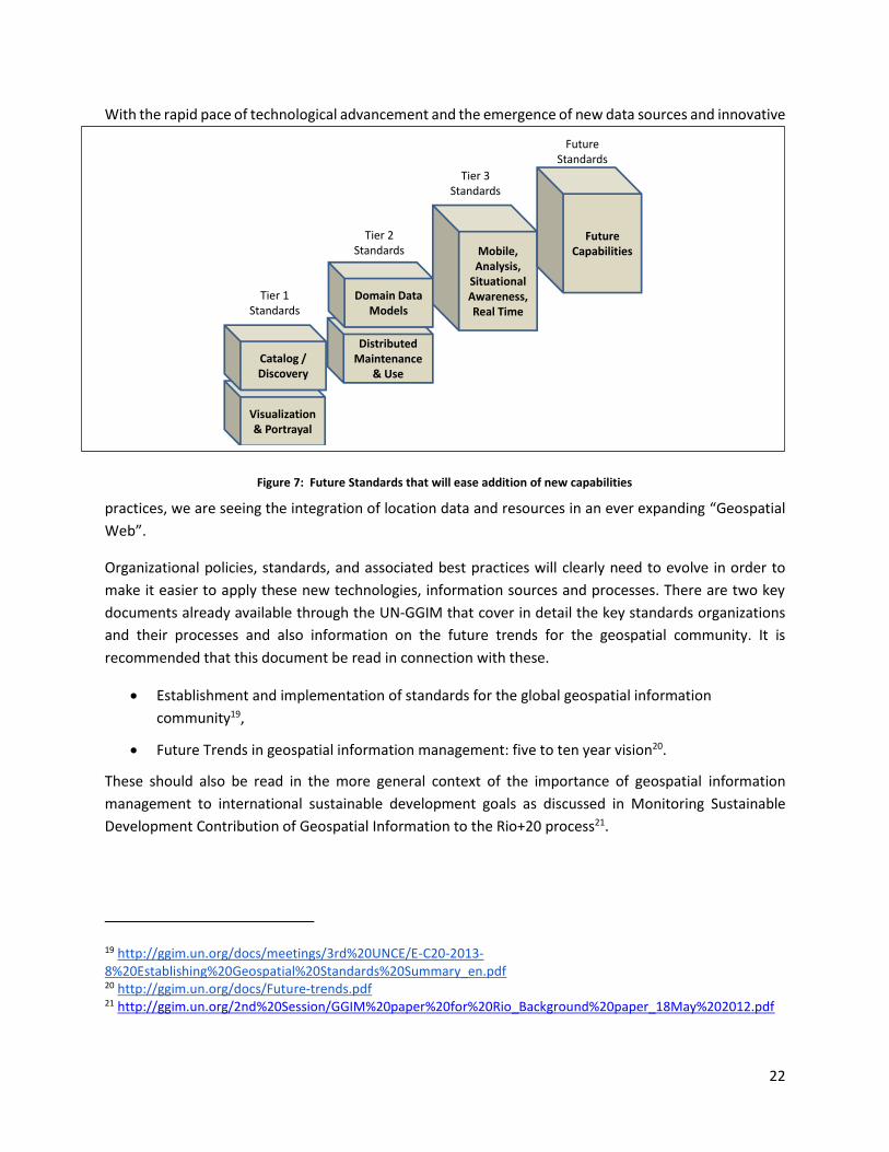
With the rapid pace of technological advancement and the emergence of new data sources and innovative
practices, we are seeing the integration of location data and resources in an ever expanding “Geospatial
Web”.
Organizational policies, standards, and associated best practices will clearly need to evolve in order to
make it easier to apply these new technologies, information sources and processes. There are two key
documents already available through the UN-GGIM that cover in detail the key standards organizations
and their processes and also information on the future trends for the geospatial community. It is
recommended that this document be read in connection with these.
Establishment and implementation of standards for the global geospatial information
community19,
Future Trends in geospatial information management: five to ten year vision20.
These should also be read in the more general context of the importance of geospatial information
management to international sustainable development goals as discussed in Monitoring Sustainable
Development Contribution of Geospatial Information to the Rio+20 process21.
19 http://ggim.un.org/docs/meetings/3rd%20UNCE/E-C20-2013-8%20Establishing%20Geospatial%20Standards%20Summary_en.pdf 20 http://ggim.un.org/docs/Future-trends.pdf 21 http://ggim.un.org/2nd%20Session/GGIM%20paper%20for%20Rio_Background%20paper_18May%202012.pdf
Figure 7: Future Standards that will ease addition of new capabilities
Visualization& Portrayal
Catalog /Discovery
DistributedMaintenance
& Use
Domain Data Models
Mobile,Analysis,
Situational Awareness,Real Time
Future Capabilities
Tier 1Standards
Tier 2Standards
Tier 3Standards
FutureStandards
23
Without wishing to duplicate the existing content of these documents it is important to highlight here
some of the rapidly emerging trends in standards that readers should consider. These include:
Cloud Computing,
Linked Data,
Big Data Analytics,
Semantic web portals,
Mobile devices,
New and dynamic geospatial data collectors,
Social Media / Volunteered Geospatial Information.
The Maturity Model illustration provided earlier in this document (Figure 1) implies a point in the future
when a geospatial infrastructure will be complete or fully realized. The reality, however is that the market
is delivering technology advancements on a continual basis. Many of these advancements will help to
further improve organizational decision making and reduce cost and effort associated with IT
infrastructure. Organizational leadership must be prepared to take advantage of key technology
advancements when they become widely available.
To take advantage of these trends we recommend that appropriate organizational staff:
Leverage the global resources of groups such as the UN-GGIM, standards development
organizations, and other major associations mentioned in this document to identify trends, and
to adopt best practices.
Participate in standards development work of ISO/TC 211, OGC and IHO to understand
implications and assure earliest implementation of standards that will help ease integration of
new technologies. At a minimum, organizations and institutions should consider providing their
interoperability requirements to the OGC, ISO, and/or IHO. This does not require much time but
ensures that these requirements are documented and considered in the ongoing development of
international standards.
3. Examples of Standards in Use This section provides examples of operational implementations for each Tier in the maturity model.
3.1. Tier 1 Use Cases/examples Australia Globe Applications (Uses KML)
Queensland Globe: http://www.dnrm.qld.gov.au/mapping-data/queensland-globe
New South Wales Globe: http://globe.six.nsw.gov.au/
Western Australia Globe: https://mapsengine.google.com/09372590152434720789-00913315481290556980-4/mapview/
24
These “globe” applications are designed to provide free and easy access for viewing of geospatial
information. They utilize free plug-ins to Google Earth and OGC standards for visualizing the information.
These organizations also provide additional tools based on OGC and ISO standards for downloading
specific user requested geospatial information resources.
India Geoportal (https://nsdiindia.gov.in/nsdi/nsdiportal/index.jsp). Implements Tier 1 OGC and ISO
standards for web mapping, metadata and cataloging.
“Encapsulating maps and images into a National Spatial Data Infrastructure (NSDI) has been recognized
and the emphasis is on information transparency and sharing, with the recognition that spatial
information is a national resource and citizens, society, private enterprise and government have a right to
access it, appropriately. Only through common conventions and technical agreements, standards,
metadata definitions, network and access protocols will it be easily possible for the NSDI to come into
existence.”
NC OneMap (http://www.nconemap.com/) Implements several OGC and ISO standards included in Tier
1.
“NC OneMap is a public service providing comprehensive discovery and access to North Carolina USA’s
geospatial data resources. NC OneMap, the State's Clearinghouse for geospatial information, relies on
data sharing and partnerships.”
3.2. Tier 2 Use Cases/examples
AuScope Portal (http://www.auscope.org.au/site/). Implements Tier 2 standards for geospatial data
acquisition and management.
“AuScope Limited is a non-profit company formed to facilitate the implementation of a world-class
infrastructure system for earth science through the delivery of a range of technologies and capabilities in
data acquisition, management, modelling and simulation across the geospatial and geoscience spectrum.”
Baltic Sea Bathymetry Database (http://data.bshc.pro) Implements Tier 2 geospatial standards to acquire
and manage unique bathymetry data used for safety of navigation and other purposes.
The Baltic Sea Bathymetry Database (BSBD) offers authoritative, complete, homogeneous and up-to-date
Baltic Sea bathymetry data from all Baltic Sea national hydrographic offices under the umbrella of the
Baltic Sea Hydrographic Commission. This is a collaboration and partnership between all Baltic Sea
countries.
Geonode (geonode.org) Implements a range of Tier 2 standards to support emergency response and risk
reduction applications
“GeoNode is an Open Source, Content Management System (CMS) for geospatial data. It is a web-based
application and platform for developing geospatial information systems (GIS) and for deploying spatial
data infrastructures (SDI).”
25
IHO Worldwide Electronic Navigational Chart Database (WEND - http://www.iho-wms.net/encat/)
The purpose of the IHO Worldwide Electronic Navigational Chart Database (WEND) is to ensure a world-
wide consistent level of high-quality, updated official ENCs through integrated services that support chart
carriage requirements of SOLAS Chapter V, and the requirements of the IMO Performance Standards for
ECDIS. The IHO worldwide ENC catalog compiles the information provided by the Regional ENC
Coordinating Centres, ENC Producers and ENC Distributor Organizations. It shows ENC data limits
worldwide for each of the 6 ENC usage bands defined by the IHO ENC Product Specification (IHO
Publication S-57, Appendix B1).
Tier 3 Use Cases/examples Canadian Geospatial Data Infrastructure (CGDI)22: (http://geodiscover.cgdi.ca/). The GeoConnections
Discovery Portal leverages Tier 1, Tier 2 and Tier 3 standards to support discovery and publishing of
geospatial data, and to evaluate, access, visualize and publish Canadian geospatial and geoscience data
products and Web services.
New Zealand SDI (http://www.linz.govt.nz/ and www.geodata.govt.nz)
The New Zealand Geospatial Office has developed a comprehensive 2013 to 2015 Work Programme which takes a cross-system view of the implementation of a national Spatial Data Infrastructure (SDI).
All projects relate directly back to the New Zealand Geospatial Strategy and measures for achievement have been put in place. Two areas of focus on accelerating development of an SDI are supporting the Canterbury Earthquake recovery efforts, and the related national view from this work.
SDI of France (www.geoportail.gouv.fr)
The French geoportal allows viewing not only maps and aerial photographs, but also many other geo data
related to the environment, development, public service. This ability to display geographical information
allows creating maps to discover, understand and analyze territory. An excellent presentation on the use
of standards for cataloguing in the French geoportal can be found here: http://www.ign.fr/publications-
de-l-ign/Divers/GIStandardsApproach_Geoportail_2.0.ppt
Norway Digital – Norwegian Spatial Data Infrastructure (NO):
“Norway digital is the Norwegian government's initiative to build the national geographical infrastructure.
It is a nation-wide program for co-operation on establishment, maintenance and distribution of digital
geographic data. The aim is to enhance the availability and use of quality geographic information among
a broad range of users, primarily in the public sector. A broad representation of Norwegian public bodies
22 Permanent Committee for Geospatial Data Infrastructure of the Americas (PC-IDEA) (2013). Spatial Data Infrastructure (SDI) manual for the Americas, Version 1, 203 p., http://unstats.un.org/unsd/geoinfo/RCC/docs/rcca10/E_Conf_103_14_PCIDEA_SDI%20Manual_ING_Final.pdf
26
are participating: Ministries and their Directorates at national level, all Norwegian Municipalities and
different regional public bodies at local and regional level.”
3.3. Future: Spatially enabled Web of data
UK Ordnance Survey linked data platform (http://data.ordnancesurvey.co.uk/)
Linked data constitutes a fast emerging trend leveraging a way to interconnect related data resident on
the web, and deliver it in a more effective manner to increase its value for users. The resulting "Web of
data" has recently started being populated with geospatial data. Ordnance Survey is the first national
mapping agency that has made various kinds of geospatial data from Great Britain available as open linked
data. OS OpenData is the opening up of Ordnance Survey data as part of the drive to increase innovation
and support the "Making Public Data Public" initiative. As part of this initiative Ordnance Survey has
published a number of its products as Linked Data.
4. Next steps Deploying standards-based SDI applications and portals do not just happen. Stakeholder organizations
must agree and commit to the use of standards in their SDI infrastructure. They must make clear
statements regarding the commitment to using standards and if at all possible this commitment should
be documented in procurement policy. To maximize the value of investments, organizations should use
procurement language that requires vendors to offer standards-based solutions.
Before the Internet and the Web, a well-run organization would use in-house experts or consultants to
provide interoperability among the geoprocessing systems used in various offices of the organization.
Policies focused on standardizing on specific vendor solutions, standardizing on certain vendor-specific or
domain-specific proprietary formats and encodings and providing custom or third party tools for
connectivity between geospatial systems and between geospatial and non-geospatial systems.
Now, enterprise information and communication technology (ICT) has evolved dramatically and the model
described above is outdated. Today, a well-run organization can best maximize the value of geospatial
processing systems and geospatial data by using the expanding framework of Internet and Web standards
to enable interoperability both internally and universally.
Standardization is the reason for the success of the Internet, the World Wide Web, e-commerce, and the
emerging wireless revolution. 'Communication' means 'transmitting or exchanging through a common
system of symbols, signs or behavior', and 'standardization' means 'agreeing on a common system'. Thus
we have much more communication today because we have much wider use of common ICT interfaces
and encodings.
Yesterday, interoperability depended on tight coupling of systems under centralized control. Today
interoperability depends on wide use of standard interfaces and encodings that enable loose coupling of
countless systems that can exchange much more information, at much less cost, than was possible
yesterday. Today, because open standards enable 'plug and play', much less expertise is required in
integrating systems. Also, because Web standards such as HTML and XML make user interface design
27
easier, and because widespread implementation of a small number of user interface design patterns has
made millions of people familiar with those patterns, less expertise is required in using the systems.
Policy makers should also keep in mind that advances in technology inexorably change organizational
structures, workflows and business models. Today's SDI is different from yesterday's SDI. SDI 2.0 allows
distributed or centralized approaches to fit the needs of users. It is built on Web services and online
catalogs, not file transfers and manual clearinghouses. It is more adaptable for place-based decision-
making. The pace of change requires new thinking about national SDI roles and investments, and a
commitment to interoperability based on open standards is essential in dealing with this transition.

28
5. Acknowledgements The following individuals provided input into and participated in the development of this document:
Darren Baldyga OMNILINK Pty Ltd (Australia)
Gilles Bessero International Hydrographic Organization (IHO)
Chris Body Department of Communications (Australia)
Paul Box Commonwealth Science and Industrial Research Organisation (CSIRO) (Australia)
Jean Brodeur GeoConnections - Natural Resources Canada
Talbot Brooks Geospatial Information & Technology Association (GITA)
Serena Coetzee University of Pretoria (South Africa)
David Danko Esri (USA)
Jeanne Foust Esri (USA)
Michael Grieco The SI Organization (USA)
John Herring Oracle (USA)
Marten Hogeweg Esri (USA)
Ross Johnson US Geological Survey (USGS) (USA)
Julie Maitra US Geological Survey (USGS) (USA)
Christian Maul State Government Victoria - Department of Environment and Primary Industries (Australia)
Denise McKenzie Open Geospatial Consortium (OGC)
James Norris Ordnance Survey (United Kingdom)
Olaf Magnus Østensen International Organization for Standardization (ISO) - ISO/TC 211 Chair
Steven Ramage what3words (United Kingdom)
Carl Reed Open Geospatial Consortium (OGC)
Mark Reichardt Open Geospatial Consortium (OGC)
Fraser Taylor Geomatics & Cartographic Research Center, Carleton University (Canada)
Trevor Taylor Open Geospatial Consortium (OGC)
Bruce Westcott Independent Consultant (USA)
We wish to express our thanks to all of the volunteers for their time and contributions to this document.
29
6. Annotated Bibliography and References The UN-GGIM inventory of issues and geographic information standardization. Report to the UN
Committee of Experts on GGIM from ISO TC 211, IHO, and the OGC. 6 June 2013
6.1. Resources for next steps
6.1.1. Cookbooks
Global Spatial Data Infrastructure Association, SDI Cookbook,
http://www.gsdidocs.org/GSDIWiki/index.php/Main_Page
This SDI Implementation Guide or Cookbook, through the support of the Global Spatial Data Infrastructure
community, provides geographic information providers and users with the necessary background
information to evaluate and implement existing components of SDI. It also facilitates participation within
a growing (digital) geographic information community known as the Global Spatial Data Infrastructure
(GSDI).
IHO-IOC GEBCO Cook Book - IHO Publication B-1,
http://ibis.grdl.noaa.gov/SAT/GEBCO_Cookbook/index.php
6.1.2. Operational Policy Principles of the Worldwide Electronic Navigational Chart Database (WEND) - IHO Resolution 1/1997 as
amended (in IHO Publication M-3 - http://www.iho.int/iho_pubs/IHO_Download.htm#M-3)
6.1.3. Guides
Spatial Data Infrastructures: “The Marine Dimension” - Guidance for Hydrographic Offices, Edition 1.1.0,
February 2011 (http://www.iho.int/iho_pubs/CB/C-17_e1.1.0_2011_EN.pdf)
Hydrographic Data Policy for SDI
(http://www.iho.int/mtg_docs/com_wg/MSDIWG/MSDIWG_Misc/Marine_SDI_Documents/SDI_Hydrog
raphic_Data_Policy.pdf)
ISO/TC 211 Standards Guide (six different languages),
http://www.isotc211.org/Outreach/Standards_Guide.htm
6.1.4. Other References
Coetzee S., Cooper A.K. and Rautenbach V. (2014). 'Part C: Standards for fundamental geo-spatial
datasets'. In: Clarke D (Ed.), Guidelines of best practice for the acquisition, storage, maintenance and
dissemination of fundamental geo-spatial datasets, in preparation for the Mapping Africa for Africa
initiative.
Kresse W., and Danko, D. (2012). Springer Handbook of Geographic Information. Berlin Heidelberg,
Springer-Verlag

30
Open Geospatial Consortium, OGC Reference Model (ORM),
http://www.opengeospatial.org/standards/orm