Embed Size (px)
Citation preview

Acceptedby WeatherandForecastingManuscriptNo. 2003–75
A Derechoin Europe: Berlin, 10July 2002
ChristophGatzen
DLR–Institutfür PhysikderAtmosphäre,
Oberpfaffenhofen,82234Wessling,Germany
Received 25 June 2003, in revised form 14 November 2003
Correspondingauthor’s address:
ChristophGatzen
DLR–Institutfür PhysikderAtmosphäre,
Oberpfaffenhofen,82234Wessling,Germany.
eMail: [email protected],
Tel: +49–8153–28–2566,Fax: +49–8153–28–1841.

Abstract
TheEuropeanwindstormthataffectedpartsof Germany on 10 July 2002is classifiedasa
derecho.With respectto thesynopticsituation,it wasidentifiedasa dynamicor strongly–
forcedderecho.Examiningdifferentobservationaldata,thiscaseshows many similiarities
to thoseinvestigatedin theUnitedStates,giving evidencethatderechosdooccurin Europe
aswell: A well–definedsurfaceconvergenceline anda thermalboundaryaloft markedthe
derecho’spaththatwasassociatedwith astrongupper–level jet streakaswell asalow–level
jet at theleadingedgeof thestorm.
1

1 Intr oduction
On 10 July 2002,during the VERTIKATOR field experiment(Vertikaler Austausch und Oro-
graphie, vertical transportandorography)in southernGermany, a line of severeconvection
crossedthenortheasternpartof Germany, producingwidespreadwind gusts.Theline reached
Germany’s capital,Berlin, at 1815UTC, at which time a maximumgustof 42 ms��
wasob-
served.TheBerlin Tegelairporthadto beclosed,andhighwaysandrailroadswereblockedby
overturnedtrees.Theweatherservicesaswell asthepublicwerenot well prepared.In Berlin,
4 residentsdiedand39 wereinjured. Within thecity’s periphery, four additionalfatalitiesoc-
curred.Mostof themwerehit by uprootedtrees,asin themosttragiccase,wheretwo children
died at a youth camporganizedby Berlin’s fire departmentin Berlin–Wannsee.All over the
city, thousandsof treesbroke off or wereuprooted;about30000 treeshadto be felled in the
following weeks.Thepresentpapergivesananalysisof this event,classifyingit asa derecho
usingthedefinitionof JohnsandHirt (1987),who developedfour criteria to identify derecho
events:
� Theremustbe a concentratedareaof reportsconsistingof convectively-inducedwind
damageor convective gustsof morethan26 ms��
(50 kt). This areamusthave a major
axislengthof at least400km.
� Thereportswithin thisareamustalsoexhibit anonrandompatternof occurrence.Thatis,
the reportsmustshow a patternof chronologicalprogression,eitherasa singularswath
(progressive)or asaseriesof swaths(serial).
� Within theareatheremustbeat leastthreereports,separatedby 64km or more,of either
F1damageor convectivegustsof 33ms��
(65kt) or greater.
� No morethan3 h canelapsebetweensuccessivewind damage(gust)events.
Thisnomenclaturehasnotbeenusedin Germany before,leastof all thereis noclimatology
that dealswith suchevents,althoughprevious convective windstormsprobablyreachedthe
criteria. The21 July 1992CLEOPATRA squallline (www.pa.op.dlr.de/cleocd/start.htm) may
beoneexampleof a widespreadconvectively–inducedwindstormthatoccurredover Germany
in thepast(Haase–Straubet al., 1997;Meischneret al., 1993). However, theexperiencefrom
thosecaseswasignoredon10July, whenbackgroundknowledgeof organizedconvectionitself
2

wasnot usedto improve the forecasts.Accordingly, Germanmeteorologistsweresurprisedat
thestorm’ssizeandstrength.In fact,gustsupto25ms��hadbeenexpecteddueto therelatively
large synoptic–scalepressuregradientalongthe cold front that waspredictedby operational
modelruns.
This paperis structuredasfollows: section2 givesan overview of the synopticsituation,
while section3 treatsthe evolution of the convective system. In section4, the analysisof
observed wind gustsis usedto classify this severeconvective event asa derecho.Section5
presentstheconclusionsof thiscasestudy.
2 SynopticOverview
In thesecondweekof July, theupperandmid troposphericflow overEuropewasdominatedby
an intensetroughacrossthenorthwesternpartof thecontinent,yielding a deepsouthwesterly
flow over thewesternregions(Fig. 1a).Oversouth–centralEurope,theflow wassplit into two
branches,a northernbranchwhich stretchedfrom FranceandBeneluxto the North Sea,and
a secondbranch,which deviatedtowardsthe centralMediterranean,whereit formeda weak
ridge. Along theperipheryof thenorthwesternmaintrough,severalvorticity maximaaffected
westernEurope.
In associationwith an intenseshort–wave trough, anothervorticity maximumtravelled
aroundthe main troughreachingthe northernborderof the IberianPeninsulalate in the day
of 9 July. At 1500UTC on10July, theaxisof thisnegatively tilted short–wavetroughextended
from southernGreatBritain into southerncentralGermany. At the300hPalevel, themaximum
wind speedreachedmorethan50 ms��
over France. The synoptic–scaleforcing associated
with suchintensejet streakscanbequitestrong,helpingconvectionto develop. Derechosthat
occurunderthosesynopticconditionsarecalleddynamic(JohnsandHirt, 1987)or strongly–
forcedderechos(EvansandDoswell,2001).
At the850hPalevel,anair masscharacterizedby highequivalentpotentialtemperature(���
)
up to 340K wasadvectedfrom southeasternCentralEuropeinto easternGermany (Fig. 1b). In
contrast,intensecoolingdueto coldair advectionandevaporationof stratiformrain tookplace
westof aneastwardmoving cold front in westernCentralEurope.By the afternoon,the 850
hPa���
–gradientreached30K overadistanceof 500km.
3

3 DerechoEvolution
Thelocationsof orographicfeaturesmentionedin thetext areshown in Fig. 2. Thesatelliteim-
age(Fig. 3a)indicatesthefront’spositionat1449UTC, threeandahalf hoursbeforethedere-
chohit Berlin. A persistentline of thunderstormscanbeseenadvancingeastwardoversouthern
Germany. Stratiformprecipitationwasobservedwestof the front underneaththebroadcloud
shieldoverwesternGermany. Eastof thecold front, new thunderstormsarevisible thatformed
rapidly parallelto the BöhmerWald Mountains,OberpfälzerWald Mountains,andThüringer
WaldMountainsbetween1400and1500UTC.As thecoldfront’sconvectiondissipatedduring
thenext hour, thenew line of convectivecellsmergedinto aMCSthatis portrayedat1628UTC
in Fig. 3b. Downstreamof this feature,thenortheasternpartof Germany waspartly clear. At
thesurface,windswereweakwith a northerlydirectionto thewestof Berlin, andsoutherlyto
easterlydirectionseastof it (seeFig. 4). A convergenceline reachingfrom theBaltic Seaeast
of RügenIslandto thewesternErzgebirgeMountainsseparatedbothwind regimesandmarked
thepathof thederecho.Justabove this surfaceconvergenceline, theoperational850hPa���
–
fields of the BolognaLimited Area Model (BOLAM, Buzzi et al., 2003)indicateda thermal
boundaryat the leadingedgeof thesouthernCentralEuropewarmair advectionregime(Fig.
1b). Observationalstudiesin the United Statespoint out that suchpre–existing, line–normal
thermalboundariescanplay a role in the formationandpropagationof bow echoes.Along
thoseboundaries,enhancedlow–level convergencecould leadto moreintenseconvectionand
associatedwind gusts(Davis etal., 2001).
OvereasternGermany, this thermalboundaryis well portrayedby thesurfaceobservations
of theGermanweatherservice:Eastof this boundary, temperatureswereabout3–6K higher,
while thedewpointswereabout3–7K lower. This indicatesthat theboundarylayerwasmore
turbulently mixedeastof the convergenceline thanwestof it, which is confirmedby a 1800
UTC soundingfrom Lindenberg about40km southeastof Berlin (Fig. 5). Thissounding,being
a proximity soundingin termsof the definition given by Evansand Doswell (2001), shows
morepropertiesof the pre–stormenvironment. Relatively dry air nearthe groundandsteep
lapseratesup to 750hPawerepresentwhichenhancedthepotentialfor strongdowndraftgusts
andcold pool formationdueto evaporationinsidethe downdrafts. For the samereason,the
mid–level dry airmassabove 700 hPa that wasalsodetectedby soundingswestandsouthof
Berlin could had beenimportantfor the cold pool formation. Anotherpoint that shouldbe
4

discussedis the instability of the pre–stormenvironment. At Lindenberg, a 50 hPa mean–
layerCAPEof around1000J/kgwasobserved. However, this observationdid not reflectthe
CAPE–valueswestof the convergenceline, whereshallow low–level moisturewasobserved
that wasnot reproducedby availablenumericalmodels.Finally, the verticalwind profile did
not indicatevery stronglow level shearby the time the rawinsondewasstartedat 1645UTC.
But 1290MHz wind profilerandsodarmeasurementsat thesameplaceshow thedevelopment
of low–level shearover Lindenberg during the next hours(Fig. 6) with increasinglow–level
southeasterlywinds. In therangeof the850hPa level, thewind changedfrom about10 ms��
southeastto morethan20ms��
south–southeastbetween1600and1900UTC.Theoperational
1200UTC run of theLocal Model (LM, DomsandSchaettler, 1999)of theGermanweather
serviceshowedthis low–level jet, just downstreamof thenegatively tilted 850hPa troughaxis
extendingto thenorthwith Berlin at its westernflank. At 300hPa,LM outputsuggeststhatthe
strongCentralEuropeanjet streakhadreachedsoutheasternGermany, while its left exit region
affectednortheasternGermany. This regional relationshipof upper–level andlow–level flow
canalsobeidentifiedfrom theoperationalBOLAM 0000UTC + 15h forecastfieldsin Fig. 1a
and1b (cf. www.cmirl.ge.infn.it/map/bolam/bolamin.htm).
Theobservedlow–level jet mayhave formedasa resultof the indirect thermalcirculation
underneaththeexit region of this jet streak(Uccellini andJohnson,1979). Accordingly, isal-
lobaricsurfaceanalysis(not shown) indicatesa synoptic–scaleincreaseof thesurfacepressure
of 4 hPa within 3 h over the CzechRepublicandsoutheasternGermany anda decreaseof 3
hPawithin 3hovernortheasternGermany. Thelow–level jet wasdirectedalongthis isallobaric
gradient.
Theconvectiveline reachedBerlin at1815UTC.TheC–bandDopplerradaratBerlin Tem-
pelhof airport documentedthe mesoscalestructureof the convective line (Fig. 7). The re-
flectivity over Berlin at 1845UTC shows signaturesdescribedin conjunctionwith high wind
eventsin theUnitedStates(Cannonetal.,1998).OvernorthernBerlin, abow–shapedsegment
of the propagatingderechois visible. This featureoriginatedfrom an intenseconvective cell
thatmergedwith theconvective line, andmostlikely producedthestrongwind gustsobserved
between1815and1845UTC. New pre-stormconvective cellsaredetectedto thenortheastof
thecity thatmergedwith theMCS lateron. By this means,a coupleof bow–shapedsegments
developedalongtheleadingedgeof theconvective line asit movednorthward,classifyingthe
derechoasaserialone.Southof thebow echothatis displayedin Fig. 7, thesouthwesternpart
5

of Berlin is coveredby aweakreflectivity regionknown asarearinflow notch(RIN, Przybylin-
ski andGery,1983;BurgessandSmull,1990).Descendingair originatingfrom therearinflow
jet andevaporationis thoughtto leadto this weakradarreflectivity (Burke andSchultz,2003).
Therear–inflow jet pointsfrom therearof theconvectivesystemto theleadingedgeof thebow
echo. It transportsrelatively dry air into thedowndraft,enhancingevaporationandassociated
cooling(Weisman,2001). In this case,therearinflow jet reachedthegroundonly closeto the
bow echo,whereasit waselevatedsomekilometersbehindit, asindicatedby wind profilerdata
from Lindenberg southeastof Berlin (seeFig. 6). It shouldbenotedthatLindenberg wasnot
hit by thederechothatpassedthelocationto thenorthwest.Nonetheless,astrongwesterlyflow
wasmeasured300metersaboveLindenberg after1900UTC thatremainedduringthefollowing
hours.
Without losing intensity, the derechoreachedthe northeasterncoastof Germany shortly
after2000UTC, producingwind gustsup to 35 ms��
at RügenIsland,andthendecayedover
theBaltic Sea.
4 Analysisof observedwind gusts
Fig. 8 showsobservedwind gustsof thederecho,andits position,asindicatedby thewind shift
detectedby two ground-observationnetworks,oneof the Germanweatherservice, the other
of Meteomedia,a privateweathercompany. Combiningthesetwo networks, morethan100
surfacewind observationsdenotethepositionof thewind shift of thecold front andassociated
derechoovernortheasternGermany, which is displayedby solidanddashedlines.As the1200
and1500UTC dataindicate,thecold front propagationwasrestrictedto southernandcentral
Germany while it was stalling over northernGermany. At this time, broadconvection that
marked the cold front positionwas observableon satelliteimages(Fig. 3a). To the east,a
new line of convectionwasforming, leadingto a new outflow boundaryat 1600UTC that is
displayedby adashedline in Fig. 8. Thenew convective line reachedits maturestagebetween
1600and1700UTC asindicatedby thesatelliteimagein Fig. 3bandthesubjectiveanalysisin
Fig. 4: Justbetweentheleadingedgeof theoutflow boundaryandtheremainingsurfacetrough
of thecold front a sharpmesoscaleridgewasanalysed,yielding to theassumptionthata cold
poolhadformedincreasingthepressuregradientaswell astheisallobaricgradientto thesouth
of Berlin. RasmussenandRutledge(1993)foundthatthepropagationspeedof convectivelines
6

increasedby thetime of thetransitionbetweentheintensifyingandmaturestage;thiswasalso
observedon10JulyovereasternGermany, whentheconvectiveline suddenlyacceleratedafter
1600UTC. This wasassociatedwith a strenghteningof observed wind gusts,asdepictedby
crosses,dotsandgrey circles,markingwherewind gustsof morethan22, 26, and34 ms��
occured,respectively (seeFig. 8).
Over southernGermany, no gustsof morethan26 ms��
wereobservedexcepton moun-
tains.In contrast,widespreadmaximumwind gustsupto 34ms��did occuroverbroadpartsof
northeasternGermany, wherefront propagationwasfastest.Nearly two-thirdsof all observed
gustsof more than26 ms��
occurredwithin a strip extendingfrom the westernErzgebirge
Mountainsto Berlin andfurther to the Baltic SeanearRügenIsland. The pathof strongest
wind gustswasabout500 kilometerslong and100 kilometerswide. Insidethis region, five
measuredwind gustsexceeded34ms��
, six moreobservationsattained33ms��. Four of the
gustreportsof morethan34 ms��
wereseparatedby at least100kilometers.Therefore,the
windstormunderconsiderationsatisfiedthecriteria for a derechoproposedby JohnsandHirt
(1987).
5 Conclusions
This casestudy of a derechoover Germany shows that severe convection can attain a size
andintensitycomparableto that in theUnitedStates.EventhoughtheEuropeanlandmassis
smallerandmoreheterogeneous,organizedsevereconvectionover CentralEuropehasshown
to beanappreciablehazardto life andproperty. More precisely, theBerlin derechoof 10 July
2002sharedsomewell establishedsynoptic-andmesoscalefeaturesof derechosin theUnited
States:
� Thesynoptic–scaleflow patternwascharacterizedby an intensenegatively tilted upper
short–wave troughassociatedwith a strongupper–level jet streak.A thermallyindirect
circulationmayhave provideda low–level jet, enhancingwarmair advectionandmois-
turepoolingjustbelow theleft exit regionof theupper–level jet.
� Along theleadingedgeof the low–level jet, a pre–existing frontal boundarymarkedthe
derechopathover northeasternGermany. At the surface,it waspossibleto analyzea
well–definedpre–existingconvergenceline.
7

� The increasein thespeedof observedwind gustsover easternGermany wasassociated
with an accelerationof the leadingedgepropagationof a convective line after it had
reachedits maturestage.
� Radarreflectivity imagesshow signaturesoftendescribedin conjunctionwith high wind
events,includingbow echoes,rearinflow notchesandcell mergersat theleadingedgeof
theline of convection.
� Wind profiler datafrom Lindenberg indicatestronglow–level wind shearaheadof the
derechoandsuggestthepresenceof anelevatedrearinflow jet.
Not only small–scale,but alsolarge–scalesevereconvectionoverEuropebearsmany simi-
laritiesto convectivephenomenain theUnitedStates.As aconsequenceof theBerlin derecho,
theGermanweatherserviceandMeteomediahave developednew conceptsfor severeweather
warnings.In addition,the"EuropeanStormForecastExperiment"(www.estofex.org) wasini-
tiatedby agroupof Europeanmeteorologiststo forecastsevereconvectionoverEurope.
Acknowledgments
Theauthorisgratefultoall whocollecteddatausedfor thiscasestudy:JohannesDahl,Manfred
Wegener, andSebastianUngerfrom theFreeUniversityof Berlin,SusanneDanßmannandSte-
fanKreibohmfrom Meteomedia,andDirk HeizenrederandVolkerLehmannfrom theGerman
weatherservice.Theradarimagesshown in this paperwereprovidedby DennisSchulze,MC
WetterBerlin. George Craig,Nikolai Dotzek,JohannesDahl, andJanHoffmanncontributed
valuablesuggestions.This work waspartly fundedby theGermanMinistry for Educationand
ResearchBMBF undercontract07ATF 45 in theprojectVERTIKATOR (Vertikaler Austausch
und Orographie, vertical transportand orography)within the atmosphericresearchprogram
AFO 2000.
References
Burgess,D. W., andB. F. Smull, 1990: Dopplerradarobservationsof a bow echoassociated
with a long–trackseverewindstorm.16th Conf. on Severe Local Storms. Amer. Meteor. Soc.,
KananaskisPark,AB, Canada,203–208.
8

Burke, P. C., andD. M. Schultz,2003: A climatologyof cold–seasonbow echoesover the
continentalUnitedStates.Submittedto Wea. Forecasting.
Buzzi,A., M. D’Isidoro, andS.Davolio, 2003:A casestudyof anorographiccyclonesouthof
theAlps duringtheMAP SOP. Quart. J. Roy. Meteor. Soc. 129,1795-1818.
Cannon,J.W., 1998:Radarcharacteristicsof the15July1995northeasternU.S.derecho.19th
Conf. on Severe Local Storms. Amer. Meteor. Soc.,Minneapolis,Minnesota,440–443.
Doms,G., andU. Schaettler, 1999:Thenonhydrostaticlimited areamodelLM (Local Model)
of DWD. Part I: ScientificDocumentation.DeutscherWetterdienst,Offenbach
Davis, C. and co-authors,2001: Scienceoverview of the bow echoand MCV experiment
(BAMEX). http://www.mmm.ucar.edu/bamex/science.html
Evans,J.S.,andC. A. DoswellIII, 2001:Examinationof derechoenvironmentsusingproxim-
ity soundings.Wea. Forecasting, 16, 329–342.
Haase–Straub,S.P., M. Hagen,T. Hauf,D. Heimann,M. PeristeriandR. K. Smith,1997:The
squallline of 21 July 1992in southernGermany: An observationalcasestudy. Beitr. Phys.
Atmosph., 70, 147–165.
Johns,R. H., andW. D. Hirt, 1987: Derechos:widespreadconvectively inducedwindstorms.
Wea. Forecasting, 2, 32–49.
Meischner, P. F., M. Hagen,T. Hauf, D. Heimann,H. Höller, U. Schumann,W. Jaeschke, W.
Mauser, and H. R. Pruppacher, 1993: The field projectCLEOPATRA, May July 1992 in
southernGermany. Bull. Amer. Meteor. Soc., 74, 401–412.
Przybylinski,R. W., andW. J. Gery, 1983: The reliability of the bow echoasan important
severeweathersignature.13th Conf. on Severe Local Storms. Amer. Meteor. Soc.,Tulsa,
OK, 270–273.
Rasmussen,E. N. andS.A. Rutledge,1993:Evolutionof quasi–two–dimensionalsqualllines.
Part I: Kinematicandreflectivity structure.J. Atmos. Sci., 50, 2584–2606.
9

Uccellini, L. W. andD. R. Johnson,1979: Thecouplingof upper- andlower–troposphericjet
streaksandimplicationsfor the developmentof severeconvective storms.Mon. Wea. Rev.,
107, 682–703.
WeismanM. L., 2001: Bow echoes:A tribute to T. T. Fujita. Bull. Amer. Meteor. Soc., 82,
97–116.
10
Figurecaptions
Figure1: OperationalBOLAM forecastfor 10July, 1500UTC. (a)300hPageopotential(gpm)
andwind speed(ms��). Geopotentialheightsareshown by blacklines,wind speedis indicated
by grayshading.(b) 850hPa���
–field in K andwind vectorsscaledby the10 ms��
vectorat
thebottomof thefigure.
Figure2: Orographicmapof theaffectedregion. Terrainheightsareshadedin greyscale.
Figure3: NOAA satellitevisiblechannelimagesof Germany at1449(a)and1628UTC (b).
Figure4: Subjectiveanalysisof surfacepressurefield at1700UTC basedonobservationsby
theGermanweatherservice.Temperaturesanddewpointsin � C, wind barbsin kt.
Figure5: 10July, 1800UTC soundingatLindenberg in thepre–stormenvironment40km
southeastof Berlin. Wind barbsaregivenin knots.
Figure6: Wind profiler andsodardatafrom theGermanweatherserviceat Lindenberg. Wind
barbsaregivenin knots.
Figure7: Radarreflectivity in theBerlin region at 1845UTC. Arrows point at therearinflow
notchsouthof thebow echooverBerlin anddevelopingpre–stormconvection.
Figure8: Measuredmaximumwind gusts(symbols)andcold front position(lines)over Ger-
many. Wind gustsabove 22 ms��
aredepictedby crosses,above 26 ms��
by dots,andabove
34ms��
by grey circles.TheUTC timeof cold front positionis shown at theendof eachline.
Solid linesareplottedevery threehours,with dashedlinesof hourly intervals.
11
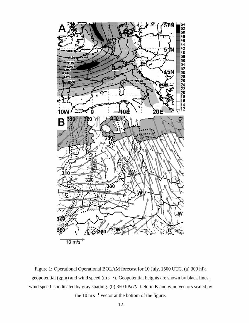
Figure1: OperationalOperationalBOLAM forecastfor 10July, 1500UTC. (a)300hPa
geopotential(gpm)andwind speed(ms��). Geopotentialheightsareshown by blacklines,
wind speedis indicatedby grayshading.(b) 850hPa���
–field in K andwind vectorsscaledby
the10ms��
vectorat thebottomof thefigure.
12

Figure2: Orographicmapof theaffectedregion. Terrainheightsareshadedin greyscale.
13

Figure3: NOAA satellitevisiblechannelimagesof Germany at1449(a)and1628UTC (b).
14

Figure4: Subjectiveanalysisof surfacepressurefield at1700UTC basedonobservationsby
theGermanweatherservice.Temperaturesanddewpointsin � C, wind barbsin kt.
15

Figure5: 10July, 1800UTC soundingatLindenberg in thepre–stormenvironment40km
southeastof Berlin. Wind barbsaregivenin knots.
16
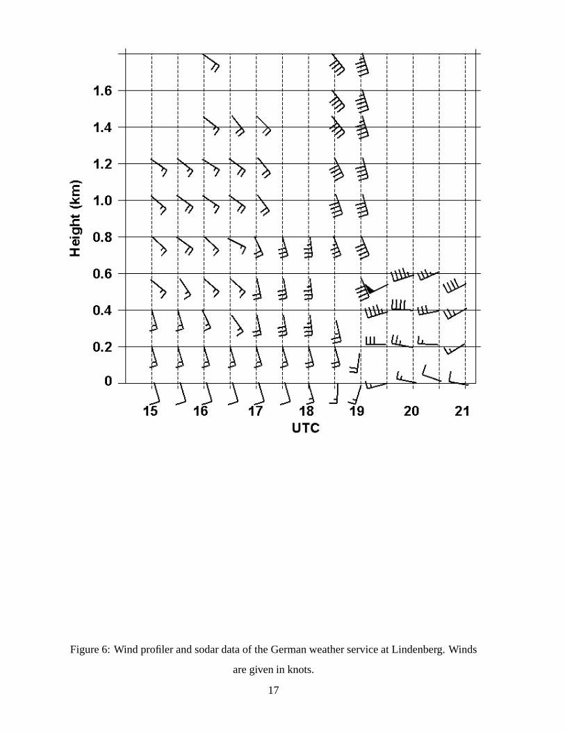
Figure6: Wind profilerandsodardataof theGermanweatherserviceatLindenberg. Winds
aregivenin knots.
17
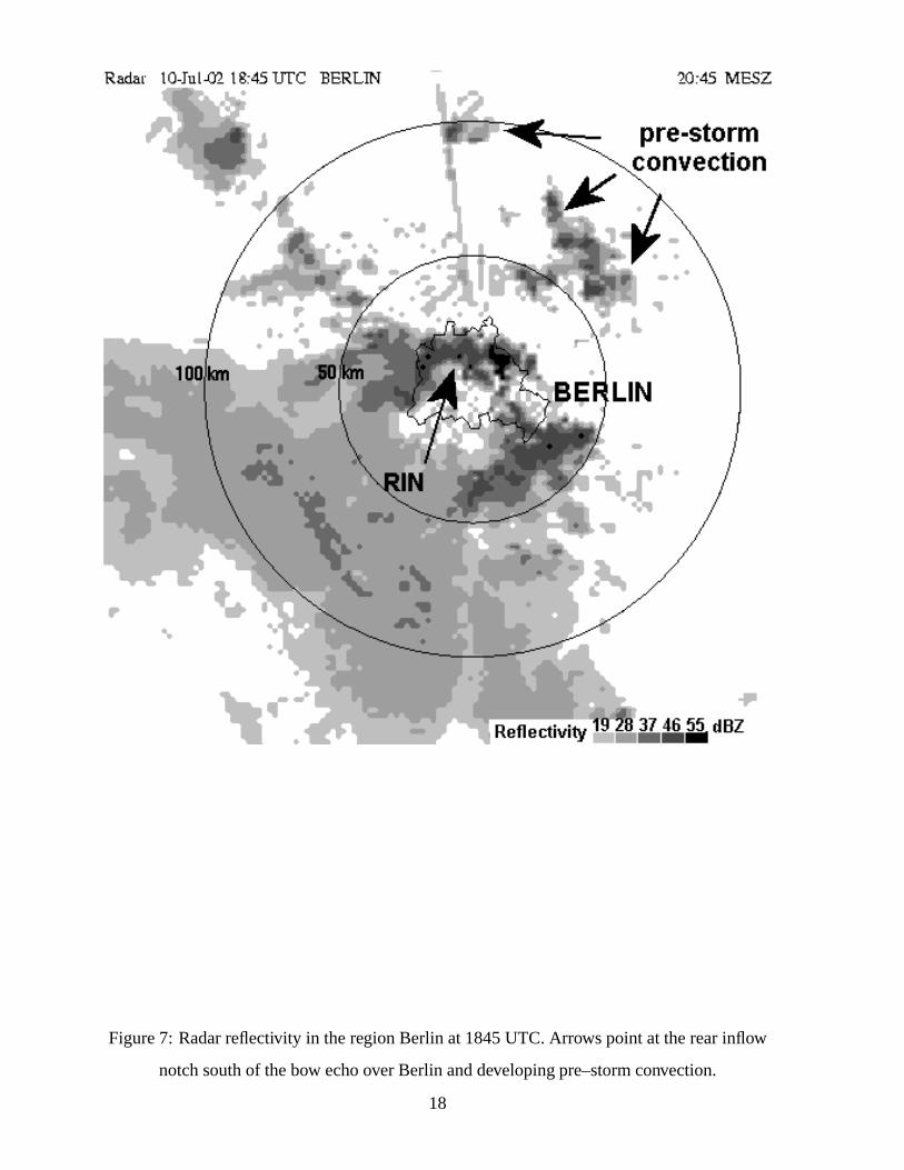
Figure7: Radarreflectivity in theregionBerlin at1845UTC. Arrowspointat therearinflow
notchsouthof thebow echooverBerlin anddevelopingpre–stormconvection.
18

Figure8: Measuredmaximumwind gusts(symbols)andcold front position(lines)over
Germany. Wind gustsabove22ms��
aredepictedby crosses,above26ms��
by dots,and
above34ms��
by grey circles.TheUTC timeof cold front positionis shown at theendof
eachline. Solid linesareplottedevery threehours,with dashedlinesof hourly intervals.
19