Embed Size (px)
Citation preview
RADIOCARBON, Vol 54, Nr 1, 2012, p 91–105 © 2012 by the Arizona Board of Regents on behalf of the University of Arizona
91
DATING THE IRRIGATION SYSTEM OF THE SAMARKAND OASIS: A GEOARCHAEOLOGICAL STUDY
Luca C Malatesta1,2 • Sébastien Castelltort1,3 • Simone Mantellini4 • Vincenzo Picotti5 • Irka Hajdas6 • Guy Simpson7 • Amriddin E Berdimuradov8 • Maurizio Tosi4 • Sean D Willett1
ABSTRACT. The oasis of Samarkand in the Middle Zeravshan Valley (modern Uzbekistan) was a major political and eco-nomic center in ancient western Central Asia. The chronology of its irrigation system was, until now, only constrained by thequality and quantity of archaeological findings and several different hypotheses have been proposed for it. We use a newapproach combining archaeological surveying, radiocarbon dating, sedimentary analysis, and the numerical modeling of aflood event to offer new evidence for, and quantitative dating of, the development of irrigation system on the southern flankof the Middle Zeravshan Valley. We analyzed 13 bones and charcoals from 3 archaeological sites and obtained new 14C agesfrom Afrasiab (ancient Samarkand), a dwelling damaged by flooding in the 2nd century AD (site code: SAM-174) and the for-tress of Kafir Kala. We established the origin of sedimentary deposits at the sites to infer the presence of the 2 most importantcanals of the southern flank: the Dargom and the Yanghiaryk. Finally, we show with a numerical model of overland flow thata natural flood was unlikely to have produced the damage observed at SAM-174. The combined results of the study indicatethat the canals south of Samarkand existed, and were mainly developed, in the 2nd century AD and were not connected to themain feeding canal of Afrasiab at that time.
INTRODUCTION
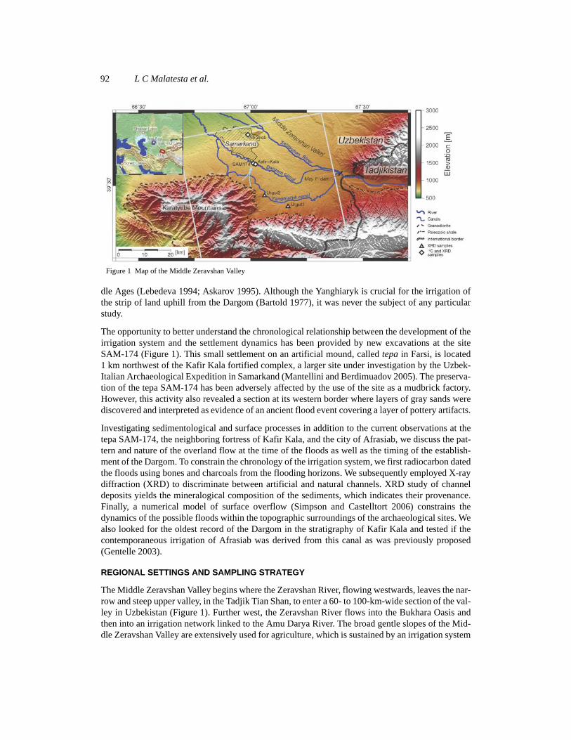
The human development of Central Asia’s main centers was long sustained by large regional-scaleirrigation systems (Lewis 1966; Andrianov 1969, 1995; Francfort and Lecomte 2002). The oasis ofSamarkand in the Middle Zeravshan Valley, Uzbekistan, is no exception. It is based on 2 majorcanals: the Dargom in the south and the Bulungur in the north. Despite the semi-arid conditions ofwestern Central Asia (Oberhänsli et al. 2007), the water supplied by those canals made this regionone of the few agricultural heartlands of Central Asia (Shirinov and Tosi 2003). In the present study,we focus on the southern flank of the Samarkand Oasis, where the irrigation system upstream fromAfrasiab (i.e. ancient Samarkand) consisted of the large—and still preserved today—Dargom Canal,and of its smaller auxiliary, the Yanghiaryk Canal, which was rebuilt during Soviet times (Figure 1).
Recent research shows that the Dargom Canal was built by successively merging the small piedmontstreams of the valley’s southern streams, or sais (we use this Uzbek term hereafter for nonperennialtributary streams) and, finally, by diverting part of the Zeravshan waters into large hillside canals(Isamiddinov 2002; Marconi et al. 2009; Stride et al. 2009; Mantellini et al. 2011). Hypotheses as tothe age of the Dargom Canal are mainly based on archaeological data from regional surveys or, lessfrequently, from stratigraphic excavations. There has been no direct quantitative dating of the Dar-gom. The hypotheses differ widely and propose various construction times: during the 1st half of the1st millennium BC (Isamiddinov 2002), in the Achaemenid period (6th–4th centuries BC) connectedto a strong central state (Shishkina 1987; Grenet 2002), at the turn of the Current Era (Gulyamov1975; Mukhamedjanov 1975, 1996), as a result of a collaborative effort within a noncentralized soci-ety during the 1st half of the 1st millennium AD (Stride et al. 2009), or even as late as the early Mid-
1Institute of Geology, ETH Zurich, Switzerland.2Now at the Division of Geological and Planetary Science, California Institute of Technology, USA. Corresponding author.Email: [email protected].
3Now at the Section of Earth Sciences, University of Geneva, Switzerland.4Department of Archaeology, University of Bologna, Italy.5Department of Earth and Environmental Sciences, University of Bologna, Italy.6Laboratory of Ion Beam Physics, ETH Zurich, Switzerland.7Department of Geology and Paleontology, University of Geneva, Switzerland.8Academy of Sciences of Uzbekistan, Institute of Archaeology of Samarkand, Uzbekistan.
92 L C Malatesta et al.
dle Ages (Lebedeva 1994; Askarov 1995). Although the Yanghiaryk is crucial for the irrigation ofthe strip of land uphill from the Dargom (Bartold 1977), it was never the subject of any particularstudy.
The opportunity to better understand the chronological relationship between the development of theirrigation system and the settlement dynamics has been provided by new excavations at the siteSAM-174 (Figure 1). This small settlement on an artificial mound, called tepa in Farsi, is located1 km northwest of the Kafir Kala fortified complex, a larger site under investigation by the Uzbek-Italian Archaeological Expedition in Samarkand (Mantellini and Berdimuadov 2005). The preserva-tion of the tepa SAM-174 has been adversely affected by the use of the site as a mudbrick factory.However, this activity also revealed a section at its western border where layers of gray sands werediscovered and interpreted as evidence of an ancient flood event covering a layer of pottery artifacts.
Investigating sedimentological and surface processes in addition to the current observations at thetepa SAM-174, the neighboring fortress of Kafir Kala, and the city of Afrasiab, we discuss the pat-tern and nature of the overland flow at the time of the floods as well as the timing of the establish-ment of the Dargom. To constrain the chronology of the irrigation system, we first radiocarbon datedthe floods using bones and charcoals from the flooding horizons. We subsequently employed X-raydiffraction (XRD) to discriminate between artificial and natural channels. XRD study of channeldeposits yields the mineralogical composition of the sediments, which indicates their provenance.Finally, a numerical model of surface overflow (Simpson and Castelltort 2006) constrains thedynamics of the possible floods within the topographic surroundings of the archaeological sites. Wealso looked for the oldest record of the Dargom in the stratigraphy of Kafir Kala and tested if thecontemporaneous irrigation of Afrasiab was derived from this canal as was previously proposed(Gentelle 2003).
REGIONAL SETTINGS AND SAMPLING STRATEGY
The Middle Zeravshan Valley begins where the Zeravshan River, flowing westwards, leaves the nar-row and steep upper valley, in the Tadjik Tian Shan, to enter a 60- to 100-km-wide section of the val-ley in Uzbekistan (Figure 1). Further west, the Zeravshan River flows into the Bukhara Oasis andthen into an irrigation network linked to the Amu Darya River. The broad gentle slopes of the Mid-dle Zeravshan Valley are extensively used for agriculture, which is sustained by an irrigation system
Figure 1 Map of the Middle Zeravshan Valley

Dating the Irrigation System of the Samarkand Oasis 93
tapping its water from the Zeravshan River. Two main irrigation canals, the Dargom and the Yang-hiaryk, are derived from the Zeravshan at the height of the modern May 1st Dam at the Uzbek-Tajikborder and traverse the southern valley slope. The Dargom Canal is still in use today and hasevolved into a meandering channel after incising more than 20 m in its original bed (Mantellini2003; Marconi et al. 2009). The Yanghiaryk Canal has been extensively reworked and is now chan-nelized in a concrete bed. No clear traces of its original bed have been found, but its presence wasinferred by historical sources (Bartold 1977) and the study of sediment deposits (this study).
The development of the irrigation system has consequences for the sedimentary deposits on the cul-tivated southern slopes of the Zeravshan Valley. The canals altered the provenance of the sedimentsdeposited on irrigated land. As a result, the local red sands were covered by dark gray sands, derivedfrom the Zeravshan River, wherever land was irrigated and cultivated (Fedchenko 1870).
The sedimentary facies outcropping in local trenches is always characterized by a strong color dif-ference between local ochre-red sediments of thick hillslope fan deposits (Figure 3d), and dark graysand originating in the Zeravshan River and borne by the canals. This is particularly striking at themodern confluence of small sais and irrigation canals (Figure 2a). It results in a zonation of thestratigraphy as either ochre-red, dark gray, or interfingered ochre-red dark gray sedimentary depos-its (Figure 2b).
Material for 14C dating and XRD analysis was sampled in 3 archaeological sites: the small settle-ment of SAM-174; the fortress of Kafir Kala; and Afrasiab. Two additional samples for XRD anal-ysis of sediment sources were obtained from stream beds (Figure 1). The tepa SAM-174 lay at thefoot of a ~2000-m-asl topographic ridge, the Karatyube Mountains, whose hillslopes are a potentialsource area for the flooding water. The light blue arrow in Figure 1 designates the hypothesizedsource and flow direction of the flooding event.
DESCRIPTION OF SAMPLING SITES
SAM-174 (39.576263N, 67.011871E) is the main investigation site of this study. The tepa liesclose to the Dargom, 7 m above its original bank. Like many other archaeological sites spread overthe territory of Samarkand, it was built with mudbricks and pakhsa, a traditional construction mate-
Figure 2 a) Difference in sediment color at the confluence of the Ilonsai, a side stream, and the Dargom Canal (see Figure 4afor detailed map). The picture was taken looking NNW; the large left bank in the background is the original bed of the Dar-gom Canal. On its left, the higher plateau indicates the position of the site of Kafir Kala. The red rectangle designates theposition of the northern trench dug in Kafir Kala (see Figure 4). The point of view of this picture is marked in Figure 4a. b)Interfingering of the 2 lithologies in the sediments of the modern Dargom: dark gray from the Zeravshan catchment; andochre-red from local side slopes.
northern trench
N 10 c
m
a) b)
original Dargom bedKafir Kala
94 L C Malatesta et al.
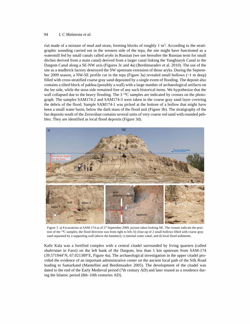
rial made of a mixture of mud and straw, forming blocks of roughly 1 m3. According to the strati-graphic sounding carried out in the western side of the tepa, the site might have functioned as awatermill fed by small canals called aryks in Russian (we use hereafter the Russian term for smallditches derived from a main canal) derived from a larger canal linking the Yanghiaryk Canal to theDargom Canal along a SE-NW axis (Figures 3c and 4a) (Berdimuradov et al. 2010). The use of thesite as a mudbrick factory destroyed the SW upstream extension of those aryks. During the Septem-ber 2009 season, a NW-SE profile cut in the tepa (Figure 3a) revealed small hollows (~1 m deep)filled with cross-stratified coarse gray sand deposited by a single event of flooding. The deposit alsocontains a tilted block of pakhsa (possibly a wall) with a large number of archaeological artifacts onthe lee side, while the stoss side remained free of any such historical items. We hypothesize that thewall collapsed due to the heavy flooding. The 3 14C samples are indicated by crosses on the photo-graph. The samples SAM174-2 and SAM174-3 were taken in the coarse gray sand layer coveringthe debris of the flood. Sample SAM174-1 was picked at the bottom of a hollow that might havebeen a small water basin, below the dark mass of the flood unit (Figure 3b). The stratigraphy of thefan deposits south of the Zeravshan contains several units of very coarse red sand with rounded peb-bles. They are identified as local flood deposits (Figure 3d).
Kafir Kala was a fortified complex with a central citadel surrounded by living quarters (calledshahristan in Farsi) on the left bank of the Dargom, less than 1 km upstream from SAM-174(39.571944N, 67.021389E, Figure 4a). The archaeological investigation in the upper citadel pro-vided the evidence of an important administrative center on the ancient local path of the Silk Roadleading to Samarkand (Mantellini and Berdimuadov 2005). The development of the citadel wasdated to the end of the Early Medieval period (7th century AD) and later reused as a residence dur-ing the Islamic period (8th–10th centuries AD).
Figure 3 a) Excavations at SAM-174 as of 27 September 2009, picture taken looking NE. The crosses indicate the posi-tion of the 14C samples; the flood direction was from right to left; b) close-up of 2 small hollows filled with coarse graysand separated by a supporting wall (above the hammer); c) internal water canal; and d) local flood sediments.
NE
Flood direction
Minimum heightof the flood
basin 1
basin 2
bedrock
wall
aryk(tributary canal)
bedrock
a)
b) c) d)SAM174 1
SAM174 2
SAM174 3
Dating the Irrigation System of the Samarkand Oasis 95
A 30-m-long north-south trench dug in the old canal bank (reference TTN 2001 in Mantellini 2003)was opened between the northern shahristan and the modern Dargom (Figure 4b). The lowest unitis made of sediments of the local hillslope fans. A concave-upward artificial incision surface in thisunit likely indicates the original bank of the Dargom. It is covered by a layer of coarse, poorlysorted, dark gray sand with cross-stratification, interpreted as a flood deposit, in the top of which wesampled a bone (KK1-1). The central section of the profile consists of 2 waste units composed ofabundant bricks, bones, and pottery. A bone was picked in the lower unit (Kafir Kala 3). The toplayer is made of colluvium. A thinner unit between the local sediments and the waste is interpretedas an artificial deposit of pakhsa placed there to protect the northern wall of the shahristan.
A small canal east of the northern shahristan was filled and subsequently re-incised by a small gully,conveniently providing a 4-m-deep view of the stratigraphic section (Figure 4c). After cleaning ofthis section, 3 main stratigraphic units were observed. The deepest unit, U1, is a stratified unit ofred-ochre sands with many horizontal potsherds. U2 is a single unit of sand with some cross-lami-nations and pottery debris floating without organization within the sand. U3 is a stratified section of
Figure 4 a) 1973 aerial picture of the sites Kafir Kala and SAM-174 with location of the sampling sites and of the presumedmain ancient canals; b) profile in the northern trench looking west-northwest; c) section of the eastern small canal filled withat least 4 m of sediments; the picture is taken looking northeast; d) location of the eastern kilns (pottery furnace).
Kafir Kala 7
Kafir Kala 9 & 10
Kafir Kala 5
Kafir Kala 4
Kafir Kala 6
Kafir Kala 8
U3
U2
U1
fan sediments
flood
filling 1
filling 2
colluvium
pakhsa?
Kafir Kala 3
KK1-1
N
Ilong Saï
Canal linking Yanghiarykand Dargom
0 0.5 1 km
SAM174
Kafir Kala
SAM174 main section
Kafir Kala northern trench
Kafir Kala eastern gully
Kafir Kala eastern kilns
fig. 2 a)
fig. 4 d)
Dargom
fig. 3 a)
a)
b)
c) d)KK2-1
eastern kilns
WNW
ESENE
96 L C Malatesta et al.
interfingered ochre-red and gray fine sand. Seven samples were picked along the section for 14C dat-ing. They are indicated by arrows in Figure 4c.
Outside the complex to the east, there is an early Medieval kiln workshop on the edge of the Ilon SaiCanal. This site lies next to an important waste-containing unit (lower in absolute stratigraphy). Abone (KK2-1) was sampled in this unit to assess the period of activity of the workshop.
Finally, Afrasiab (39.671389N, 66.988333E) was an important political and economical center ofwestern Central Asia until its destruction by the army of Genghis Khan in the first half of the 13thcentury AD. The site of Afrasiab was thereafter abandoned and the city was moved to the new siteof Samarkand, a few kilometers to the south. Afrasiab lay close to the Zeravshan River, but it wasbuilt higher on its southern bank and had no direct access to its water. The city was supplied withwater by canals coming from the southern flank of the valley (Grenet 2002). To test the hypothesisof an early connection between the Dargom and the water supply of Afrasiab, we sampled organicmaterial for 14C dating in sediments of the main canals and noted their mineralogy. The charcoalsample Afrasiab 1 was picked after removal of a few centimeters of in situ sediments below the firstceramic layer in a trench dug in 1996–97 through the Magistranlyy Kanal, i.e. the main of the 3canals supplying the city from the south (39.668211N, 66.986556E; Ivanitzkiy and Inevatkina1999). The bone sample Afrasiab 4 was taken at the base of the Hellenic canal below the northerncity wall (39.675755N, 66.988834E).
METHODS
Radiocarbon Dating
As described above, 8 bones and 5 charcoals were sampled for 14C dating from known archaeolog-ical horizons of 3 different archaeological sites around Samarkand. Most of these horizons werealready relatively dated based on ceramic stratigraphy, but no absolute dating was available. Thehorizons were chosen for their proximity with the first traces of the Dargom Canal and the flood ofSAM-174 in the stratigraphic record.
All 14C samples but two (KK1-1 and KK2-1) were analyzed at the Laboratory of Ion Beam Physicsat ETH Zurich; the others were analyzed at the Leibniz-Laboratory for Radiometric Dating and Iso-tope Research. The charcoal samples were prepared following the procedure described by Hajdas etal. (2004). The noncharcoal material was removed from the samples by scraping off and buoyancyseparation in water. The charcoals were then treated with acid: first in 0.5M HCl at 60 C overnight;second in 0.1M NaOH at 60 C for a couple of hours; and finally again in 0.5M HCl at 60 C for30 min. After drying, between 2 and 2.3 mg of charcoal were placed in small aluminum foil basketsfor graphitization.
Carbon was extracted from the bone samples at ETH Zurich following the method described by Haj-das et al. (2009). The bone samples were first cleaned with ultrasound in demineralized water andtheir spongy parts were scrapped off with a scalpel. After drying, 2 g of bone were crushed to a finepowder. The samples were then demineralized in 05.M HCl for 30 min at room temperature. Thematerial was centrifuged and then dissolved in 0.2M HCl at 80 C on a shaker for 48 hr. Collagenwas then purified using an ultrafiltration method (Brown et al. 1988), and finally vacuum-dried priorto graphitization. Eventually, the processed bone and charcoal samples were burned in an elementalanalyzer and graphite was produced from the CO2, with the automated graphitization equipmentdeveloped at ETH Zurich (Nemec et al. 2010; Wacker et al. 2010).
Dating the Irrigation System of the Samarkand Oasis 97
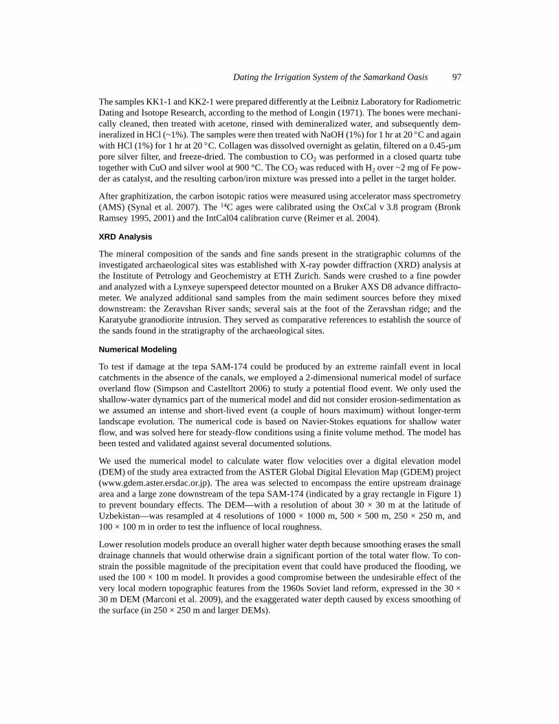
The samples KK1-1 and KK2-1 were prepared differently at the Leibniz Laboratory for RadiometricDating and Isotope Research, according to the method of Longin (1971). The bones were mechani-cally cleaned, then treated with acetone, rinsed with demineralized water, and subsequently dem-ineralized in HCl (~1%). The samples were then treated with NaOH (1%) for 1 hr at 20 C and againwith HCl (1%) for 1 hr at 20 C. Collagen was dissolved overnight as gelatin, filtered on a 0.45-µmpore silver filter, and freeze-dried. The combustion to CO2 was performed in a closed quartz tubetogether with CuO and silver wool at 900 °C. The CO2 was reduced with H2 over ~2 mg of Fe pow-der as catalyst, and the resulting carbon/iron mixture was pressed into a pellet in the target holder.
After graphitization, the carbon isotopic ratios were measured using accelerator mass spectrometry(AMS) (Synal et al. 2007). The 14C ages were calibrated using the OxCal v 3.8 program (BronkRamsey 1995, 2001) and the IntCal04 calibration curve (Reimer et al. 2004).
XRD Analysis
The mineral composition of the sands and fine sands present in the stratigraphic columns of theinvestigated archaeological sites was established with X-ray powder diffraction (XRD) analysis atthe Institute of Petrology and Geochemistry at ETH Zurich. Sands were crushed to a fine powderand analyzed with a Lynxeye superspeed detector mounted on a Bruker AXS D8 advance diffracto-meter. We analyzed additional sand samples from the main sediment sources before they mixeddownstream: the Zeravshan River sands; several sais at the foot of the Zeravshan ridge; and theKaratyube granodiorite intrusion. They served as comparative references to establish the source ofthe sands found in the stratigraphy of the archaeological sites.
Numerical Modeling
To test if damage at the tepa SAM-174 could be produced by an extreme rainfall event in localcatchments in the absence of the canals, we employed a 2-dimensional numerical model of surfaceoverland flow (Simpson and Castelltort 2006) to study a potential flood event. We only used theshallow-water dynamics part of the numerical model and did not consider erosion-sedimentation aswe assumed an intense and short-lived event (a couple of hours maximum) without longer-termlandscape evolution. The numerical code is based on Navier-Stokes equations for shallow waterflow, and was solved here for steady-flow conditions using a finite volume method. The model hasbeen tested and validated against several documented solutions.
We used the numerical model to calculate water flow velocities over a digital elevation model(DEM) of the study area extracted from the ASTER Global Digital Elevation Map (GDEM) project(www.gdem.aster.ersdac.or.jp). The area was selected to encompass the entire upstream drainagearea and a large zone downstream of the tepa SAM-174 (indicated by a gray rectangle in Figure 1)to prevent boundary effects. The DEM—with a resolution of about 30 × 30 m at the latitude ofUzbekistan—was resampled at 4 resolutions of 1000 × 1000 m, 500 × 500 m, 250 × 250 m, and100 × 100 m in order to test the influence of local roughness.
Lower resolution models produce an overall higher water depth because smoothing erases the smalldrainage channels that would otherwise drain a significant portion of the total water flow. To con-strain the possible magnitude of the precipitation event that could have produced the flooding, weused the 100 × 100 m model. It provides a good compromise between the undesirable effect of thevery local modern topographic features from the 1960s Soviet land reform, expressed in the 30 ×30 m DEM (Marconi et al. 2009), and the exaggerated water depth caused by excess smoothing ofthe surface (in 250 × 250 m and larger DEMs).
98 L C Malatesta et al.
RESULTS
Results of 14C Dating
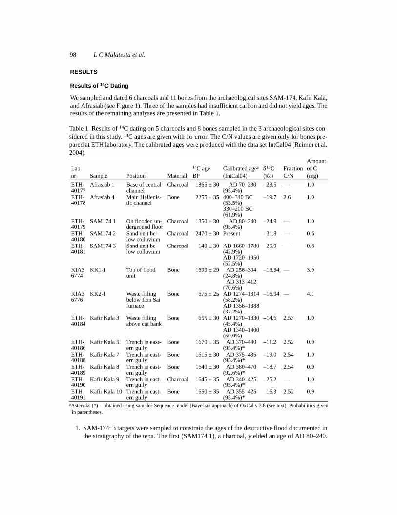
We sampled and dated 6 charcoals and 11 bones from the archaeological sites SAM-174, Kafir Kala,and Afrasiab (see Figure 1). Three of the samples had insufficient carbon and did not yield ages. Theresults of the remaining analyses are presented in Table 1.
1. SAM-174: 3 targets were sampled to constrain the ages of the destructive flood documented inthe stratigraphy of the tepa. The first (SAM174 1), a charcoal, yielded an age of AD 80–240.
Table 1 Results of 14C dating on 5 charcoals and 8 bones sampled in the 3 archaeological sites con-sidered in this study. 14C ages are given with 1 error. The C/N values are given only for bones pre-pared at ETH laboratory. The calibrated ages were produced with the data set IntCal04 (Reimer et al.2004).
Lab nr Sample Position Material
14C ageBP
Calibrated agea
(IntCal04)
aAsterisks (*) = obtained using samples Sequence model (Bayesian approach) of OxCal v 3.8 (see text). Probabilities givenin parentheses.
13C(‰)
FractionC/N
Amountof C(mg)
ETH-40177
Afrasiab 1 Base of central channel
Charcoal 1865 ± 30 AD 70–230(95.4%)
–23.5 — 1.0
ETH-40178
Afrasiab 4 Main Hellenis-tic channel
Bone 2255 ± 35 400–340 BC(33.5%)330–200 BC(61.9%)
–19.7 2.6 1.0
ETH-40179
SAM174 1 On flooded un-derground floor
Charcoal 1850 ± 30 AD 80–240(95.4%)
–24.9 — 1.0
ETH-40180
SAM174 2 Sand unit be-low colluvium
Charcoal –2470 ± 30 Present –31.8 — 0.6
ETH-40181
SAM174 3 Sand unit be-low colluvium
Charcoal 140 ± 30 AD 1660–1780(42.9%)AD 1720–1950(52.5%)
–25.9 — 0.8
KIA36774
KK1-1 Top of flood unit
Bone 1699 ± 29 AD 256–304(24.8%)AD 313–412
(70.6%)
–13.34 — 3.9
KIA36776
KK2-1 Waste filling below Ilon Sai furnace
Bone 675 ± 25 AD 1274–1314(58.2%)AD 1356–1388(37.2%)
–16.94 — 4.1
ETH-40184
Kafir Kala 3 Waste filling above cut bank
Bone 655 ± 30 AD 1270–1330(45.4%)AD 1340–1400(50.0%)
–14.6 2.53 1.0
ETH-40186
Kafir Kala 5 Trench in east-ern gully
Bone 1670 ± 35 AD 370–440(95.4%)*
–11.2 2.52 0.9
ETH-40188
Kafir Kala 7 Trench in east-ern gully
Bone 1615 ± 30 AD 375–435(95.4%)*
–19.0 2.54 1.0
ETH-40189
Kafir Kala 8 Trench in east-ern gully
Bone 1640 ± 30 AD 380–470(92.6%)*
–18.7 2.54 0.9
ETH-40190
Kafir Kala 9 Trench in east-ern gully
Charcoal 1645 ± 35 AD 340–425(95.4%)*
–25.2 — 1.0
ETH-40191
Kafir Kala 10 Trench in east-ern gully
Bone 1650 ± 35 AD 355–425(95.4%)*
–16.3 2.52 0.9
Dating the Irrigation System of the Samarkand Oasis 99
The 2 other charcoals (SAM174 2 and SAM174 3) had much younger ages (AD 1660–1780/1720–1950 and present day).
2. Kafir Kala: 2 bones were sampled in the trench north of the northern shahristan; KK1-1 yieldedan age of AD 255–410 and Kafir Kala 3 gave an age of AD 1270–1400. A series of 7 successivesamples was picked in the gully east of the fortress. This allowed us to use the Bayesian mod-eling of OxCal (Bronk Ramsey 1995, 2001) to calibrate the sequence of 14C ages and minimizethe corresponding calendar ranges. Out of the 7 samples, 5 yielded ages (Kafir Kala 4 and 6 didnot contain enough carbon); the 5 ages are closely distributed between AD 355–425 (Kafir Kala10) and 380–470 (Kafir Kala 8). They span the 3 units (U1, U2, U3) of the small eastern canal.Finally, the bone sampled next to the Medieval kilns (KK 1-2) yielded an age of AD 1274–1314, 1356–1388.
3. Afrasiab: 2 samples were taken from the canals feeding the city with water from the southernhillslopes. The first, Afrasiab 1, had an age of AD 70–230. The second, Afrasiab 4, yielded anage of 400–200 BC.
Sediments Provenance and Surface Processes
The mineralogical signatures of the 2 main sediment types deposited on the southern flank of theZeravshan Valley differ only slightly. The 2 main sources—the Karatyube range (mostly granodior-ite) and the Zeravshan range (mostly shale)—are the 2 end-members of the mixing series found inthe local stratigraphy. In the field, the color contrast between the two is striking. The Zeravshan sed-iments are dark gray and borne by the Dargom and Yanghiaryk canals. They contain primarilyquartz, muscovite, albite, diopside, and chamosite (Fe chlorite). The red sediments, mainly derivedfrom the Karatyube, are the natural hillslope deposits and contain mostly quartz, Mg calcite, albite,muscovite, and chamosite. The discriminating criterion between the two is the lack of Mg calcite inthe Zeravshan sands. Mg calcite is potentially the product of in situ leaching of plagioclase.
In SAM-174, 3 sand samples were collected. The color of the sands was correlated with the presenceor absence of Mg calcite. The red fine sands at the base of the aryks contained Mg calcite, while thegrayer coarser sands of the directly overlying unit lacked any traces of it. The last sample was takenin a flood unit next to the tepa and had the same signature as the upper unit in the aryk with addi-tional calcite and gypsum, both probably derived from soil concretions observed in the field.
In Afrasiab, a sample of red sand from the main canal of the Achaemenid city yielded a compositionof quartz, Mg calcite, anorthite, and muscovite.
Flood Modeling Results
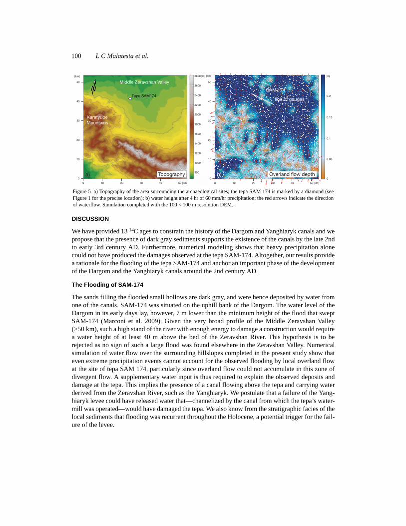
To better understand the origin of flooding at the tepa SAM-174, we simulated an event with 4 hr ofprecipitation at 60 mm/hr and predicted the resulting height of overland flow around the site of thetepa (Figure 5). Such a rain event is comparable to the extreme, but rare, storm events occurring inthe arid climate that prevailed at the time of the SAM-174 flood. Due to its position on a low-ampli-tude topographical shoulder, the tepa is in a zone of divergent flow. The water height predicted atpoints distributed along a 5-km line perpendicular to the flow direction (line on the Figure 5b) doesnot exceed 25 cm after 4 hr of 60 mm/hr precipitation. These simulations show that even a very largeprecipitation event seems unlikely to flood and destroy the tepa by overland flow from the surround-ing hillslopes. To account for the observed destruction, a supplementary source for the flood isrequired.
100 L C Malatesta et al.
DISCUSSION
We have provided 13 14C ages to constrain the history of the Dargom and Yanghiaryk canals and wepropose that the presence of dark gray sediments supports the existence of the canals by the late 2ndto early 3rd century AD. Furthermore, numerical modeling shows that heavy precipitation alonecould not have produced the damages observed at the tepa SAM-174. Altogether, our results providea rationale for the flooding of the tepa SAM-174 and anchor an important phase of the developmentof the Dargom and the Yanghiaryk canals around the 2nd century AD.
The Flooding of SAM-174
The sands filling the flooded small hollows are dark gray, and were hence deposited by water fromone of the canals. SAM-174 was situated on the uphill bank of the Dargom. The water level of theDargom in its early days lay, however, 7 m lower than the minimum height of the flood that sweptSAM-174 (Marconi et al. 2009). Given the very broad profile of the Middle Zeravshan Valley(>50 km), such a high stand of the river with enough energy to damage a construction would requirea water height of at least 40 m above the bed of the Zeravshan River. This hypothesis is to berejected as no sign of such a large flood was found elsewhere in the Zeravshan Valley. Numericalsimulation of water flow over the surrounding hillslopes completed in the present study show thateven extreme precipitation events cannot account for the observed flooding by local overland flowat the site of tepa SAM 174, particularly since overland flow could not accumulate in this zone ofdivergent flow. A supplementary water input is thus required to explain the observed deposits anddamage at the tepa. This implies the presence of a canal flowing above the tepa and carrying waterderived from the Zeravshan River, such as the Yanghiaryk. We postulate that a failure of the Yang-hiaryk levee could have released water that—channelized by the canal from which the tepa’s water-mill was operated—would have damaged the tepa. We also know from the stratigraphic facies of thelocal sediments that flooding was recurrent throughout the Holocene, a potential trigger for the fail-ure of the levee.
Figure 5 a) Topography of the area surrounding the archaeological sites; the tepa SAM 174 is marked by a diamond (seeFigure 1 for the precise location); b) water height after 4 hr of 60 mm/hr precipitation; the red arrows indicate the directionof waterflow. Simulation completed with the 100 × 100 m resolution DEM.
Tepa SAM174
a) b)
line of gauges
SAM 174
KaratyubeMountains
Middle Zeravshan Valley
Topography
N
Overland flow depth
Dating the Irrigation System of the Samarkand Oasis 101
Evidence for the Canals
The study of SAM-174, Kafir Kala, and Afrasiab provided enough new data to establish spatial andtemporal constraints for the irrigation system in the Middle Zeravshan Valley. The Yanghiaryk istraced back to at least AD 80–240 based on dating of material in the flood debris at SAM-174 andour demonstration that the flood itself attests to the existence of the canal.
In Kafir Kala, the existence of the Dargom is documented by gray sedimentary deposits in the north-ern trench and in the eastern gully (albeit indirectly). In the northern trench, the dark gray flood unit,which is the first layer over the artificial cut in the local fan sediments, was derived from the Zer-avshan and borne by the Dargom, and dates from the late 2nd or early 3rd century AD (sample KK1-1, Figure 4b). It is interpreted as the first deposit on what was either the Dargom Canal originalbed or a local early adjustment of its bank. Although the bank is not directly dated, it is likely notmuch older than this first deposit. The eastern gully exposes the stratigraphy of a small canal thatbordered the eastern wall of the citadel. This small canal was connected to the Dargom and the lattercontrolled its water height. The 5 successful 14C ages obtained from this section document the his-tory of a 2-stage fast filling between AD 340–425 and 380–470 (samples Kafir Kala 5, 7, 8, 9, and10). The lowermost unit, U1, a series of layered local hillslope sediments, was the first depositionevent in the canal. The top of U1 is cut by what was probably a man-made re-entrenchment of thecanal. It is directly overlaid by a massive heterogeneous flood unit, U2, rich in debris and potsherdswithout particular orientation. U2 is presumably the result of the destabilization of the canal banksby the cleaning effort. Above U2, the regular deposition of the unit U3 points at a renewed fast fill-ing of the canal until it reached the Dargom water level, at which point the canal was abandoned.However, the last deposits of U3 are made of interfingered ochre-red and dark gray fine sands,revealing an interplay between local sands and Dargom sands. In a later stage, following the naturalentrenchment of the Dargom, the section has been incised by a gully. Hence, this section indirectlydocuments the evolution and water level of the Dargom between AD 340 and 425.
Finally, while there is clear evidence of the Dargom and the Yanghiaryk canals in the 2nd and 3rdcenturies AD, the contemporaneous section of the main feeding canal of Afrasiab (sampleAfrasiab 1: AD 70–230) (Ivanitzkiy and Inevatkina 1999; Gentelle 2003) did not show any link withthe canals. Its sand has a clear local hillslope signature: red with Mg calcite.
In Kafir Kala and SAM-174, the oldest traces of the Dargom and the Yanghiaryk date back to the2nd and 3rd centuries AD, while Afrasiab’s main canal appears to not have been connected to themain irrigation system.
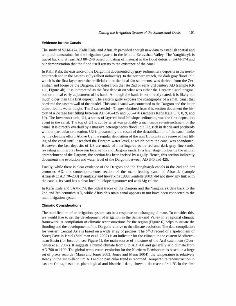
Climatic Considerations
The modification of an irrigation system can be a response to a changing climate. To consider this,we would like to set the development of irrigation in the Samarkand Valley in a regional climaticframework. A compilation of climatic reconstructions for the region (Figure 6) helps to situate theflooding and the development of the Dargom relative to the climate evolution. The data compilationfor western Central Asia is based on a wide array of proxies. The 18O record of a speleothem ofSoreq Cave in Israel (Schilman et al. 2002) is an indicator for the climate in the eastern Mediterra-nean Basin (for location, see Figure 1), the main source of moisture of the Aral catchment (Ober-hänsli et al. 2007). It suggests a humid climate from 0 to AD 700 and generally arid climate fromAD 700 to 1100. The global temperature evolution for the Northern Hemisphere is based on a largeset of proxy records (Mann and Jones 2003; Jones and Mann 2004); the temperature is relativelysteady in the 1st millennium AD and no particular trend is recorded. Temperature reconstruction ineastern China, based on phenological and historical data, shows a decrease of ~1 °C in the first
102 L C Malatesta et al.
Figure 6 From top to bottom: A) 18O speleothem record of Soreq Cave in Israel (Schilman et al. 2002); B) temperaturereconstruction for the Northern Hemisphere based on a large set of proxy records (Mann and Jones 2003; Jones and Mann2004); C) temperature reconstruction in eastern China based on phenological and historical data (Zheng et al. 2001); D)temperature reconstruction in the Aral catchment based on pollen records in the Aral Sea (Sorrel et al. 2007); E) precipita-tion reconstruction in the Aral catchment (Sorrel et al. 2007); F) reconstructed water level of Issik-Kul Lake in Kyrgyzstan(Shnitnikov 1980); G) reconstruction of the Shalkar Lake level in Kazakhstan (Shnitnikov 1975); H) reconstruction of theAral Sea water level (Oberhänsli et al. 2007); and I) calibrated 14C ages from this study and respective general archaeolog-ical periods in western Central Asia.
Dating the Irrigation System of the Samarkand Oasis 103
6 centuries AD (Zheng et al. 2001). On a regional scale, the temperature reconstructions in the Aralcatchment from pollen data (Sorrel et al. 2007) indicate 2 periods of increased variability (fromabout AD 400 to 800 and from about AD 1200 to 1500). However, we note that they are correlatedwith periods of higher data density. An overall rise of the temperature is nevertheless recordedbetween AD 400 and 700. The precipitation reconstruction from pollens in the Aral catchment isbased on the same data as the temperature curves (Sorrel et al. 2007). Combined with the latter, theyindicate an alternation of cold and arid periods with warmer and wetter periods. Further informationis provided by reconstruction of water levels of 3 regional water bodies: Issik-Kul Lake in Kir-ghizstan; Shalkar Lake in Kazakhstan, north of the Caspian Sea; and the Aral Sea (for location, seeFigure 1). The reconstructed water level of the Issik-Kul witnesses a sharp fall between AD 250 and700 (Shnitnikov 1980). The Shalkar Lake level in Kazakhstan, although it is not a complete record,shows a decrease in the first centuries AD (Shnitnikov 1975). Finally, the water level of the Aral Seadocuments a marked fall from 0 to AD 600. However, this reflects both climatic and anthropogenicforcing (Oberhänsli et al. 2007). The climatic reconstructions do not contain elements that couldaccount for a sudden change of the climate potentially explaining the flooding of the tepa SAM-174.Although the climate of the region has remained overall steady, the fall of the lake levels indicatesa likely increased aridity in the region.
CONCLUSIONS
To balance the scarcity of archaeological evidence in the Samarkand region for the development ofirrigation in the early centuries AD, we conducted and presented here a study combining sedimentprovenance, 14C dating, flood modeling, and local stratigraphic analysis of deposits associated withthe Samarkand Oasis canal system. Our work provides important results to constrain the develop-ment of the early irrigation system and the settlement dynamics of one of the most important centralAsian oases. We establish several new spatial and temporal reference points for the history of the 2main canals of the Middle Zeravshan Valley southern slopes:
1. The Yanghiaryk Canal very likely existed between AD 80 and 240 as documented by the flood-ing of SAM-174.
2. In the 2nd century AD, the Magistranlyy Kanal (main canal) in Afrasiab was not connected tothe Dargom Canal.
3. In the late 2nd and early 3rd century AD, the Dargom Canal flowed in Kafir Kala and today’ssouthern bank corresponds to its original bed.
The existence of the Dargom and the Yanghiaryk at the late 2nd to early 3rd centuries AD sets a min-imal age for the large-scale irrigation of the southern flank of the Zeravshan Valley. It likely pro-vided a background for the bloom of the Early Medieval and Islamic settlements (5th–9th centuriesAD) (Stride et al. 2009; Codini 2010).
The extent of the early irrigation system to the west remains largely unknown and archaeologicalfindings are rare at the moment. Further investigations are needed to complete our understanding ofthe role and the extent of the hydraulic work in the Samarkand Oasis. Application of the mixedapproach successfully employed in this research could provide a methodology to address this ques-tion in the future.
ACKNOWLEDGMENTS
We thank the team of the Uzbek-Italian Archaeological Expedition at Samarkand, in particular,Giorgia Codini for the excavation of the section in the gully of Kafir Kala; Serena di Cugno, Elisa-
104 L C Malatesta et al.
betta Sedda, and Cristina Ambrosioni for the excavation of the site SAM-174; Rita Dimartino forthe study of the pottery from the section of the gully in Kafir Kala and the site of SAM-174; ProfGiovanni Gabbianelli for his initial financial support. Lydia Zehnder and Eric Reusser for their sup-port for XRD measurements. A final thanks go to Frantz Grenet, Claude Rapin, Mukhamadjan Isa-middinov, and Olga Inevatkina of the French-Uzbek Archaeological Expedition in Samarkand(MAFOuz) for providing data from Afrasiab.
REFERENCES
Andrianov BV. 1969. Drevnie orositel’nye sistemy pri-aral’ya. Moscow: Izdatel’stvo Nauka.
Andrianov BV. 1995. The history of economic develop-ment in the Aral region and its influence on the envi-ronment. GeoJournal 35:11–6.
Askarov KK. 1995. Selskaya okruga i ee rol v formiro-vanii rannesrednevekovogo Samarkanda (po materi-alam selskoy okrugi Samarkanda). Avtoref. Diss. Inst.Ist. Volume 12. Tashkent: Akademiya NAUK Uzb.
Bartold VV. 1977. Turkestan down to the Mongol Inva-sion. 4th edition. London: E J W Gibb Trust.
Berdimuradov AE, Tosi M, Mantellini S. 2010. Uzbek-Italian Archaeological Project: Samarkand and ItsTerritory; Season 2010, Preliminary Report. Univer-sity of Bologna.
Bronk Ramsey C. 1995. Radiocarbon calibration andanalysis of stratigraphy: the OxCal program. Radio-carbon 37(2):425–30.
Bronk Ramsey C. 2001. Development of the radiocarboncalibration program. Radiocarbon 43(2A):355–63.
Brown TA, Nelson DE, Vogel JS, Southon JR. 1988. Im-proved collagen extraction by modified Longinmethod. Radiocarbon 30(2):171–7.
Codini GB. 2010. Nomads and farmers in an urban con-text. An essay on the settlement of the Middle Zeravs-han Valley at the edges of Samarkand region (Uzbeki-stan) [Nomadi e agricoltori nel contesto urbano. Unsaggio sul popolamento della Media Valle dello Zer-avshan ai margini della regione di Samarcanda(Uzbekistan)]. MA thesis (Tesi di Laurea Magistrale),University of Bologna, Department of Archaeology,Ravenna.
Fedchenko A. 1870. Topographical sketch of the Zarafs-han Valley. Journal of the Royal Geographical Societyof London 40:448–61.
Francfort H-P, Lecomte O. 2002. Irrigation et societe enAsie centrale des origines a l’epoque achemenide. An-nales 57(3):625–63.
Gentelle P. 2003. Traces d’Eau: Un Géographe Chez lesArchéologues. Paris: Editions Belin. p 172–32.
Grenet F. 2002. Samarkand I. History and Archeology.Encyclopaedia Iranica. Online edition.
Gulyamov YaG. 1975. Kushanskoe tsarstvo i drevnyayairrigatsiya sredney azii. In: Trudy mejdunarodnoy kon-ferentsii po istorii, arkheologii i kulture tsentralnoyazii v kushanskuyu epokhu (Dushanbe, 27 sentyabry -6 oktyabrya 1968). Tom I, Dushanbe, 1974, v. 120.
Hajdas I, Bonani G, Thut J, Leone G, Pfenninger R,Maden C. 2004. A report on sample preparation at theETH/PSI AMS facility in Zurich. Nuclear Instrumentsand Methods in Physics Research B 223–224:267–71.
Hajdas I, MichczyÒski A, Bonani G, Wacker L, Furrer H.2009. Dating bones near the limit of the radiocarbondating method: study case mammoth from Niederwe-ningen, ZH Switzerland. Radiocarbon 51(2):675–80.
Isamiddinov MK. 2002. Istoki gorodskoy kul’tury samar-kandskogo sogda. Tashkent: Izd-vo.
Ivanitzkiy ID, Inevatkina ON. 1999. Periodizatziya ietapi razvitiya vodosnabjeniya afrasiaba. Istoriya Ma-terialnoy Kul’tury Uzbekistana 30:96–103.
Jones PD, Mann ME. 2004. Climate over past millennia.Reviews of Geophysics 42: RG2002, doi:10.1029/2003RG000143.
Lebedeva TI. 1994. Selskaya okruga i ee rol v formiro-vanii rannesrednevekovogo Samarkanda (po materi-alam selskoy okrugi Samarkanda). Avtoref. Diss. Inst.Ist. Volume 12. Tashkent: Akademiya NAUK Uzb.p 22–3.
Lewis RA 1966. Early irrigation in West Turkestan. An-nals of the Association of American Geographers 56:467–91.
Longin R. 1971. New method of collagen extraction forradiocarbon dating. Nature 230(5291):241–2.
Mann ME, Jones PD. 2003. Global surface temperaturesover the past two millennia. Geophysical ResearchLetters 30:1820, doi:10.1029/2003GL017814.
Mantellini S. 2003. The Dargom Canal and the Early Set-tlement of the Middle Zeravshan Valley. In: Pagani S,editor. Italo-Uzbek Scientific Cooperation in Archae-ology and Islamic Studies: An Overview (Rome, 30January 2001). Rome: Instituto Italiano per l’Africa el’Oriente. p 41–8.
Mantellini S, Berdimuadov A. 2005. Archaeological Ex-plorations in the Sogdian Fortress of Kafir Kala. An-cient Civilizations from Scythia to Siberia 11(1–2):107–32.
Mantellini S, Rondelli B, Stride S. 2011. Analytical ap-proach for representing the water landscape evolutionin Samarkand oasis (Uzbekistan). In: Jerem E, Redö F,Szeverényi V, editors. On the Road to Reconstructingthe Past. Proceedings of the 36th Annual InternationalConference on Computer Applications and Quantita-tive Methods in Archaeology (CAA). Budapest, Hun-gary, 2–6 April 2008. p 388– 96.
Dating the Irrigation System of the Samarkand Oasis 105
Marconi V, Mantellini S, Picotti V, Gabbianelli G. 2009.The origin of the Dargom canal in the oasis of Samar-kand (Uzbekistan). A new scenario from geoarcheo-logical data. In: EGU General Assembly 2009. 19–24April 2009, Vienna, Austria. p 6195.
Mukhamedjanov AR. 1975. K istorii irrigatsii v kushan-skuyu epokhu. In: Trudy mejdunarodnoy konferentsiipo istorii, arkheologii i kulture tsentralnoy azii v kus-hanskuyu epokhu (Dushanbe, 27 sentyabry - 6 okty-abrya 1968). Tom II, Dushanbe. v 278.
Mukhamedjanov AR. 1996. Economy and social systemin Central Asia in the Kushan Age. In: Harmatta J, ed-itor. History of Civilization of Central Asia. Volume 2.The Development of Sedentary and Nomadic Civiliza-tions: 700 B.C. to A.D. 250. Paris: UNESCO Publish-ing. p 265–90.
Nemec M, Wacker L, Gaeggeler H. 2010. Optimizationof the graphitization process at AGE-1. Radiocarbon52(3):1380–93.
Oberhänsli H, Boroffka N, Sorrel P. 2007. Climate vari-ability during the past 2,000 years and past economicand irrigation activities in the Aral Sea basin. Irriga-tion and Drainage Systems 21(3–4):167–83.
Reimer PJ, Baillie MGL, Bard E, Bayliss A, Beck JW,Bertrand CJH, Blackwell PG, Buck CE, Burr GS, Cut-ler KB, Damon PE, Edwards RL, Fairbanks RG,Friedrich M, Guilderson TP, Hogg AG, Hughen KA,Kromer B, McCormac G, Manning S, Bronk RamseyC, Reimer RW, Remmele S, Southon JR, Stuiver M,Talamo S, Taylor FW, van der Plicht J, WeyhenmeyerCE. 2004. IntCal04 terrestrial radiocarbon age cali-bration, 0–26 cal kyr BP. Radiocarbon 46(3):1029–58.
Schilman B, Ayalon A, Bar-Matthews M. 2002. Sea-landpaleoclimate correlation in the Eastern Mediterraneanregion during the late Holocene. Israel Journal ofEarth Sciences 51:181–90.
Shirinov T, Tosi M. 2003. Land behind Samarkand. In:Pagani S, editor. Italo-Uzbek Scientific Cooperation inArchaeology and Islamic Studies: An Overview
(Rome, 30 January 2001). Rome: Instituto Italiano perl’Africa e l’Oriente. p 13–41.
Shishkina GV. 1987. Ancient Samarkand and its sur-roundings (Drevniy Samarkand i ego okruga). In: Ur-ban Culture of Bactria-Tokharistan and Sogdia: An-tiquity and Early Middle Ages [Gorodskaya kulturabaktrii-tokharistana i sogda: antichnosty, rannee sred-nevekove]. Material of the Soviet-French Colloquium(Samarkand, 1986) [Materialy sovetskogo-frantsuz-kogo kollokviuma (Samarkand, 1986)]. Tashkent.p 167–70.
Shnitnikov AV. 1975. On the History of the Lakes ofNorthern Kazakhstan (Iz Istorii Ozer Severnogo Ka-zakstana). Leningrad: Nauka.
Shnitnikov AV. 1980. Lakes of the Tien Shan and TheirHistory (Ozera Tian’-Shanya i ikh istoriya). Lenin-grad: Nauka.
Simpson G, Castelltort S. 2006. Coupled model of sur-face water flow, sediment transport and morphologi-cal evolution. Computers & Geosciences 32(10):1600–14.
Sorrel P, Popescu S-M, Klotz S, Suc J-P, Oberhänsli H.2007. Climate variability in the Aral Sea basin (Cen-tral Asia) during the late Holocene based on vegeta-tion changes. Quaternary Research 67(3):357–70.
Stride S, Rondelli B, Mantellini S. 2009. Canals versushorses: political power in the oasis of Samarkand.World Archaeology 41(1):73–87.
Synal H-A, Stocker M, Suter M. 2007. MICADAS: anew compact radiocarbon AMS system. Nuclear In-struments and Methods in Physics Research B 259(1):7–13.
Wacker L, Nemec M, Bourquin J. 2010. A revolutionarygraphitisation system: fully automated, compact andsimple. Nuclear Instruments and Methods in PhysicsResearch B 268(7–8):931–4.
Zheng J, Zhang P, Ge Q, Man Z. 2001. Centennialchanges of drought/flood spatial pattern in easternChina for the last 2000 years. Progress in Natural Sci-ence 11(4):280–7.