Embed Size (px)
Citation preview

8.4 Land Use 8.4.1 Introduction The City of Vernon (City) proposes to develop a power plant (VPP) on a 13.7-acre property at the southeast corner of Fruitland and Boyle avenues. The VPP will be a 914-megawatt (MW) net (at 65 degrees Fahrenheit [°F] with duct burners and evaporative cooling)/943-MW (gross) combined-cycle generating facility configured using three natural-gas-fired combustion turbines and one steam turbine. Two transmission line options are being considered to connect the plant to Southern California Edison’s (SCE) Laguna Bell Substation. Natural gas for the facility will be delivered via approximately 2,300 feet of new 24-inch pipeline that will connect to Southern California Gas Company’s (SoCalGas) existing gas transmission line (Line 765). Potable water for drinking, safety showers, fire protection, service water, and sanitary uses will be served from the City’s potable water system through two 10-inch pipelines connecting to the City’s water mains. One would connect in Boyle Avenue and one in Fruitland Avenue. Recycled water for industrial purposes will be provided by the Central Basin Municipal Water District (CBMWD) through a nominal 16-inch carbon steel (or if using high density polyethylene [HDPE], a 20-inch) water line connecting to its recycled water line in Boyle Avenue, adjacent to the plant site. The blowdown will be sent to Sanitation Districts of Los Angeles County (LACSD) via a new 2,400-foot section of City sanitary sewer line.
This subsection provides an inventory of existing and designated land uses at the VPP project site and along the proposed electric transmission routes, natural gas pipeline, recycled water line, potable water line, and sewer line alignments. It also evaluates the project’s conformity with applicable land use plans and policies.
The project site is in the City of Vernon. All the linear project features would also be located in the City of Vernon with the exception of portions of the transmission line. Two transmission line routes are being considered: River Route and the Randolph Route. Depending on which side of Randolph Street the Randolph Route would be located on, the River and the Randolph transmission line routes would be in the cities of Vernon, Huntington Park, Maywood, Bell, Bell Gardens, and Commerce as shown in Table 8.4-1.
TABLE 8.4–1 Summary of Project Feature Jurisdictions
Project Feature Land Use and Planning Jurisdiction
Vernon Power Plant City of Vernon
Natural Gas Line City of Vernon
Recycled Water Line City of Vernon
Potable Water Line City of Vernon
Sewer Line City of Vernon
Electric Transmission Line
River Route
Randolph Route
City of Vernon, Bell, and Commerce
Cities of Vernon, Huntington Park, Maywood, Bell, and Commerce
EY052006001SAC/338307/061630005 (008-04.DOC) 8.4-1

SUBSECTION 8.4: LAND USE
The land use study area includes the following cities: Vernon, Huntington Park, Maywood, Bell, Bell Gardens, Commerce, and Los Angeles as shown on Figure 8.4-1 (figures are located at the end of the subsection) for the proposed project and the alternate transmission line.
8.4.2 Laws, Ordinances, Regulations, and Standards This subsection lists and discusses the land use laws, ordinances, regulations, and standards (LORS) that apply to the project.
8.4.2.1 Federal No federal LORS for land use apply to the site or project.
8.4.2.2 State The AFC process is California Environmental Quality Act (CEQA)-equivalent under the Warren-Alquist Act, so it fulfills the requirements of CEQA. CEQA is codified in the California Public Resources Code, Sections 21000-21178.1. Guidelines for implementation of CEQA are codified in the California Code of Regulations (CCR) Sections 15000-15387.
8.4.2.3 Local 8.4.2.3.1 General Plans and Zoning Ordinances Land use provisions included in every California city and county general plan (California State Planning Law, Government Code §65302 et seq.) reflect the goals and policies that guide the physical development of land in their jurisdiction. For purposes of this AFC, the project is analyzed for its conformity with land use designations and policies described in the general plans of the cities of Vernon (which applies to the project site and linears, including portions of the transmission lines), Huntington Park, Maywood, Bell, Bell Gardens, and Commerce (which apply to either the River or Randolph transmission line corridor). The project is also analyzed for conformity of local zoning ordinance designations. The city zoning ordinances are enforced by their respective planning and building departments. The zoning ordinance is a regulatory tool used to implement the General Plan. It defines zones that dictate permitted uses as well as design requirements such as setbacks and height limits.
Table 8.4-2 presents the local LORS.
TABLE 8.4-2 Laws, Ordinances, Regulations, and Standards Applicable to Vernon Power Plant Land Use
LORS Purpose Regulating Agency
Applicability (AFC Section Explaining
Conformance)
Jurisdiction for the Plant Site and Linears
City of Vernon General Plan (2001)
Comprehensive, long-range plan to serve as the guide for the physical development of the city.
City of Vernon 4305 Santa Fe Avenue Vernon, CA 90058
Table 8.4-6
8.4-2 EY052006001SAC/338307/061630005 (008-04.DOC)

SUBSECTION 8.4: LAND USE
TABLE 8.4-2 Laws, Ordinances, Regulations, and Standards Applicable to Vernon Power Plant Land Use
LORS Purpose Regulating Agency
Applicability (AFC Section Explaining
Conformance)
City of Vernon Zoning Ordinance (2005)
Establishes zoning districts governing land use and the placement of buildings and district improvements.
Same as above Subsection 8.4.6
Additional Jurisdictions Affecting the Alternative Transmission Line
City of Huntington Park General Plan (1996)
Comprehensive, long-range plan to serve as the guide for the physical development of the city.
City of Huntington Park 6570 Miles Avenue Huntington Park, CA 90255
Table 8.4-6
City of Huntington Park Zoning Ordinance (2002)
Establishes zoning districts governing land use and the placement of buildings and district improvements.
Same as above Subsection 8.4.6
City of Maywood General Plan (1993)
Comprehensive, long-range plan to serve as the guide for the physical development of the city.
City of Maywood Building and Planning Department 4319 East Slauson Avenue Maywood, CA 90270
Table 8.4-6
City of Maywood Zoning Ordinance (1991)
Establishes zoning districts governing land use and the placement of buildings and district improvements.
Same as above Subsection 8.4.6
City of Bell General Plan (1996)
Comprehensive, long-range plan to serve as the guide for the physical development of the city.
City of Bell Building and Planning Department 6330 Pine Avenue Bell, CA 90201 (323) 588-6211
Table 8.4-6
City of Bell Zoning Ordinance (1993)
Establishes zoning districts governing land use and the placement of buildings and district improvements.
Same as above Subsection 8.4.6
City of Commerce General Plan (1987)
Comprehensive, long-range plan to serve as the guide for the physical development of the city.
City of Commerce City Hall 2535 Commerce Way Commerce, CA 90040
Table 8.4-6
City of Commerce Zoning Ordinance (2000)
Establishes zoning districts governing land use and the placement of buildings and district improvements.
Same as above Subsection 8.4.6
The City of Vernon General Plan policy that is applicable to the proposed project is Goal 2 in Land Use Element. The City of Commerce General Plan policy that is applicable to part of the alternative transmission line corridor is Policy 4.4 in the Land Use Element.
EY052006001SAC/338307/061630005 (008-04.DOC) 8.4-3

SUBSECTION 8.4: LAND USE
City of Vernon General Plan (Site and All Linears) Land Use Element – Goal 2: Encourage the Modernization or Replacement and Reuse of Aging Industrial Buildings and Sites.
City of Commerce General Plan (Randolph Transmission Line) Land Use Element – Policy 4.4: Establish a program to systematically place existing and proposed utility lines underground. Require all new utilities placed underground in all new developments.
8.4.3 Affected Environment The following text discusses the affected environment for the study area (i.e., for 1 mile surrounding the project site and 0.25 mile from the center line of the linear facilities).
8.4.3.1 General Description of Study Area The project site is located in the City of Vernon, in Los Angeles County, California. The County is bordered by Orange, San Bernardino, Kern, and Ventura counties. Los Angeles County includes a wide variety of land uses including industrial, commercial, residential, agriculture, and others. The historical land use pattern in the study area has resulted in mainly industrial uses. The land use to the north, south, west, and east of the VPP project site is industrial. Six residences are located northeast of the site on the north side of Fruitland Avenue west of Downey road. The Los Angeles River is located to the north and east of the project site and is approximately 0.75 mile from the project site at its closet point. The site is approximately 1.25 miles south of the City of Los Angeles.
Four major transportation corridors, Interstate highways 110, 10, 5, and 710, serve Vernon. Interstate 110 is oriented north-south approximately 3.4 miles from the western boundary of the City of Vernon. Interstate 110 intersects Interstate 10 approximately 2.6 miles northwest of Vernon. Interstate 10, and State Highway 60, are oriented east-west, and are situated approximately 0.6 mile north of Vernon. Interstate 5 is situated approximately 0.6 mile north of Vernon. Interstate 710 is a north-south route located east of the City of Vernon.
There is considerable industrial and commercial development along Interstates 110, 10, 5, and 710. Railroad lines are located in the study area, including a railroad line along Randolph Street. The Laguna Bell electrical substation is located at the east end of the transmission line corridor study area. The predominant uses in the study area are industrial, residential, and commercial.
8.4.3.2 Existing Land Uses, Planning, and Zoning Designations A general plan is a plan for future development that includes goals and policies to guide development. The City of Vernon General Plan (City of Vernon, 2001) is the planning document applicable to this site and all linears. The zoning ordinance is a regulatory tool used to implement the General Plan. It defines zones that dictate permitted uses as well as design requirements such as setbacks and height limits.
Permitted uses associated with the General Plan land use designations for the cities of Vernon, Huntington Park, Maywood, Bell, Bell Gardens, and Commerce in the study area are described in Table 8.4-3. Existing land uses and General Plan land use designations for the study area are presented in Table 8.4-4.
8.4-4 EY052006001SAC/338307/061630005 (008-04.DOC)

SUBSECTION 8.4: LAND USE
No habitat conservation plan or natural community conservation plan applies to the project site.
TABLE 8.4-3 Definitions of Planning Designations in Project Land Use Study Area
General Plan Land Use Designation Permitted Uses
City of Vernon
General Industrial This designation is intended to continue to accommodate the bulk of the varied manufacturing, assembling, and wholesaling uses in the city.
Commercial/Industrial This designation permits retail and wholesale commercial uses as accessory uses to the principal industrial use. This land use designation is intended for businesses that serve industrial uses or their employees but are not associated with a particular firm. Industrial or manufacturing uses are also permitted in this area.
Public Facility This designation refers to those land uses that are operated and maintained for the public benefit, welfare, or use. Permitted public facilities include educational facilities, utilities, and other government buildings or open space areas.
Heavy Industry/Warehousing Transportation Related
The purpose of this land use designation is to encourage certain types of industrial activities that require larger lot areas, involve trucking related activity, or generate noise, odors, or other impacts that might adversely impact neighboring uses, to locate in areas of the city that can accommodate them easily.
Slaughtering Overlay District This designation is intended to indicate the appropriate locations for activities involving the slaughtering of animals.
Rendering Overlay District This designation includes rendering facilities, fertilizer facilities, junk yards, and recycling facilities as allowable uses.
City of Huntington Park
Industrial/Manufacturing This designation permits manufacturing, processing, warehousing, distribution, wholesaling, and related developments of a more intense nature than those uses permitted in the light industry category.
General Commercial This designation permits a wide range of neighborhood and general retail and service establishments, such as stores and repair shops, to accommodate the surrounding community.
Public Facility This designation includes all federal, state, and local government properties, such as post offices, the Civic Center, and fire stations and hospitals.
Schools This designation permits public schools.
High and Medium Density Residential
The high density residential category permits up to 20 dwelling units per acre. Medium-density residential category permits up 17.4 units per acre.
Parks and Recreation This category includes all the public parks in the city.
City of Maywood
Industrial This category promotes the development of a wide range of manufacturing and industrial activities.
Residential This category of land use is characterized by a mix of single-family detached and attached development at densities up to 20 units per acre.
Commercial Uses in this category are characterized by smaller convenience, service, and neighborhood commercial retail and office professional activities.
EY052006001SAC/338307/061630005 (008-04.DOC) 8.4-5

SUBSECTION 8.4: LAND USE
TABLE 8.4-3 Definitions of Planning Designations in Project Land Use Study Area
General Plan Land Use Designation Permitted Uses
Park This land use category corresponds to the two public parks located in the city: Pixley Park and Maywood City Park.
Public Facility The city hall, library, utilities, and other civic, administrative, public schools, and governmental activities are designated as public uses in the General Plan.
City of Bell
Residential Multi Family (medium density)
The maximum density is 21.78 units per acre.
Commercial Land uses within this category are characterized by office, retailing, service, and automotive uses.
Open Space Open space uses include parks, recreational facilities, and other public facilities.
Institutional This category includes public and quasi-public uses including the civic center, and public and private schools.
City of Bell Gardens
Residential This category permits residential development.
Public Institutional This category applies to a wide range of public uses including public schools, private schools, churches, City Hall, and other public and quasi-public uses.
Mixed Use This category permits a combination of commercial and residential uses working in tandem to supply the community with much needed lower-income housing and commercial facilities. Residential densities correspond to high density residential designations and the commercial uses would use a guideline of a 4.0 floor area ratio.
City of Commerce
Public/Quasi-Public This category allows public/quasi-public uses.
Industrial This category allows industrial uses.
Commercial This category allows commercial uses.
Medium Density Residential This category allows medium density residential uses.
City of Los Angeles
Industrial This category allows industrial uses.
Residential This category allows multi-family residential uses.
Public Facilities This category allows public facilities uses such as fire stations, libraries, parks, schools, and police stations.
8.4-6 EY052006001SAC/338307/061630005 (008-04.DOC)

SUBSECTION 8.4: LAND USE
TABLE 8.4-4 Existing Land Uses and General Plan Designations within the Study Area
Project Component
Existing Land Uses General Plan Land Use Designations
Proposed Power Plant Site; potable water line; recycled water line; gas line; sewer line; and transmission (both alternatives)
The site is currently occupied by an aluminum plant that was formerly owned by Alcoa. Under a purchase agreement between the City of Vernon and the property owner, the property owner will be responsible to remove all existing buildings and structures and remediate the site to industrial standards before transferring control to the city.
City of Vernon General Industrial
Site Vicinity
(within 1 mile of proposed power plant project site; including gas line, sewer line and proposed transmission line)
Industrial Commercial Residential Schools Hospital Church Park Roads
City of Vernon General Industrial Heavy Industry-Warehousing Transportation RelatedPublic Facility Slaughtering Overlay District Rendering Overlay District General Industrial Heavy Industry-Warehousing Transportation RelatedSlaughtering Overlay Rendering Overlay
City of Huntington Park Manufacturing Commercial Public Facility Residential
City of Maywood Industrial Residential Commercial Park Public
City of Los Angeles Heavy Industrial/Warehousing
Sewer Line Industrial Road
City of Vernon General Industrial
EY052006001SAC/338307/061630005 (008-04.DOC) 8.4-7

SUBSECTION 8.4: LAND USE
TABLE 8.4-4 Existing Land Uses and General Plan Designations within the Study Area
Project Component
Existing Land Uses General Plan Land Use Designations
Alternative Transmission Line Route
Industrial Residential Railroad Utility (substation and transmission lines)Los Angeles River Park Road
City of Vernon General Industrial
City of Huntington Park Residential Public Facility Commercial Open Space
City of Bell Residential Multi Family (medium density) Commercial Open Space Institutional
City of Bell Gardens Residential Public Institutional
City of Maywood Industrial Residential Town Center Commercial
City of Commerce Public/Quasi-Public Industrial Commercial Medium Density Residential
Sources: City of Vernon (2001); Huntington Park (1996); Bell (1996); Bell Gardens (1996); Maywood (1993); City of Commerce (1987)
8.4.3.2.1 Vernon Power Plant Site The site consists of a 13.7-acre area. It is located in the southeastern part of the city near the intersection of Boyle and Fruitland avenues. The site is currently an aluminum plant that was formerly owned by Alcoa. Under a purchase agreement between the City of Vernon and the property owner, the property owner will be responsible to remove all existing buildings and structures and remediate the site to industrial standards before transferring control to the City of Vernon.
The City of Vernon General Plan land use designation for the project site is General Industrial. This zone is intended to provide for the orderly development and operation of most types of industrial plants and to promote the concentration of such uses in a manner that will foster mutually beneficial relationships with each other. The General Plan Industrial designation allows manufacturing, assembling, and wholesaling uses. In addition, hazardous waste processors, trash to energy facilities, and solid and liquid waste disposal facilities are permitted if a conditional use permit (CUP) is issued. The uses allowable for this designation are also summarized in Table 8.4-3.The Zoning Ordinance designation for the project site is General Industrial (M). The following uses are permitted uses in the General Industrial (M) zone: (a) industry; (b) residential dwelling, single family
8.4-8 EY052006001SAC/338307/061630005 (008-04.DOC)

SUBSECTION 8.4: LAND USE
or independent living facility; (c) residential unit-temporary; (d) public facilities; (e) retail and commercial uses; (f) warehouses; (g) refrigerated warehouses; (h) vehicle sales, fabrication or repair facility and (i) general offices.
8.4.3.2.2 Linear Facilities Transmission Line The VPP will connect to the electrical transmission system via new double-circuit 230-kV transmission line on one set of poles. Two routes are being considered at this time: River Route and Randolph Route. The River Route would exit the site to the east, cross Alcoa and the LADWP right-of-way, and turn north on an easement on the east side of the LADWP right-of-way. It then proceeds east between the south side of the Leonis substation and the north side of the Fire Station to the west side of Downey Road. Once on Downey the route turns north to the Leonis Boulevard and District Boulevard junction. The route crosses Downey Avenue to the northeastern corner of District Boulevard and continues on the north side of District Boulevard, turning northeast (toward the Los Angeles River). The route then crosses the Los Angeles River and railroad facilities, and turns south along the Los Angeles River to Randolph street junction on a right-of-way currently occupied by two 66-kV circuits serving Vernon. Finally, the route turns east, crosses the I-710 freeway, and proceeds to the Laguna Bell Substation along Randolph Street for a total distance of approximately 4.8 miles
The Randolph Route would extend east from the plant’s switchyard to Alcoa Avenue. At Alcoa, the line would head south through Vernon to Randolph Avenue. It would then follow Randolph Avenue to the east to the Laguna Bell Substation (for a total distance of approximately 4.4 miles).
The River Route from the plant’s switchyard, east across the Los Angeles River, and south to Randolph Street is designated and zoned for industrial use. The segment along Randolph Street is aligned through areas designated in the general plans and zoning ordinances as industrial, residential, institutional, park, and commercial uses. For the Randolph Route, the segment between and parallel to Alcoa Avenue and Downey Road is located in an area designated and zoned for industrial use, and the remaining segments along Randolph Street are aligned through areas designated in the General Plans and zoning ordinances as industrial, residential, institutional, park, and commercial uses. General Plan and Zoning Ordinance land use designations are shown on Figure 8.4-1 and Figure 8.4-2 for the proposed project and transmission line routes.
Natural Gas Line Natural gas for the facility would be delivered via approximately 2,300 feet of new 24-inch pipeline that would connect to SoCalGas’ existing gas transmission line (Line #765) in Downey Road.
The natural gas line route along Fruitland Avenue, Alcoa Avenue, and East 50th Street is located in an area designated in the General Plan and Zoning Ordinance as industrial use. General Plan and Zoning Ordinance land use designations are shown on Figure 8.4-1 and Figure 8.4-2 for the proposed project and gas line route.
EY052006001SAC/338307/061630005 (008-04.DOC) 8.4-9

SUBSECTION 8.4: LAND USE
Water Lines For cooling tower make-up, the VPP would use recycled water provided by CBMWD. The recycled water would be delivered to VPP through a recycled water pipeline located in Boyle Avenue, adjacent to the site.
Potable water for drinking, safety showers, fire protection water, service water, and sanitary uses would continue to be served from the City of Vernon’s potable water system. A new line would connect to the existing line in Boyle Avenue adjacent to the project site. Potable water would also be used as an emergency backup supply should the recycled water system be unavailable for longer than 8 hours.
The water line route is located in an area designated in the General Plan and Zoning Ordinance as industrial use. The water lines are not shown on Figure 8.4-1 and Figure 8.4-2 because they are located in Boyle Avenue adjacent to the plant site.
Sewer Line Sanitary wastewater disposal would be to LACSD via the City of Vernon’s sanitary sewer system. An 18-inch sanitary sewer line would exit the plant site from the southeast corner, follow along the edge of the parcel and the railroad right-of-way to Alcoa Avenue, turning south on Alcoa Avenue; from there, the line would be 21 inches in diameter to the point where it connects to the Sanitation Districts of Los Angeles County’s 24-inch line at Alcoa and Slauson avenues. The total distance is about 2,400 feet.
The City of Vernon General Plan land use designation and Zoning Ordinance designation for the sewer line route is General Industrial. The General Plan land use designation and Zoning Ordinance designation information is shown on Figure 8.4-1 and Figure 8.4-2.
8.4.3.2.3 Recreation, Scenic, Agricultural, Natural Resource Protection and Extraction, Educational, Religious, Cultural and Historic and Unique Land Uses Recreation Land Use In general, recreational facilities in the study area are limited to uses in the schools and parks in the cities. Pixley Park in the City of Maywood is located approximately 0.8 mile southeast of the project site. Maywood Park in the City of Maywood is located approximately 1.9 miles east-southeast of the project site and 0.2 mile from the proposed project transmission line. Corona Park is in the City of Huntington Park and is located approximately 1 mile southeast of the project site and 0.2 mile from the alternate transmission line alignment. Adolph Tredder Park is located approximately 1.5 miles southeast of the project site and is 0.13 mile south of the Randolph Street transmission line alignment in the City of Bell. Debs Park is located approximately 1.2 miles southeast of the project site and is approximately 0.25 mile south of the Randolph Street transmission line alignment in the City of Bell. Veterans Park is located approximately 1.25 miles southeast of the project site and is approximately 0.25 mile south of the Randolph Street transmission line alignment in the City of Bell (Thomas Bros. Maps, 1998). The parks located within 1 mile of the project site and 0.25 mile of the transmission line alignments are shown on Figure 8.4-2.
Scenic Land Use No scenic resources exist within the project vicinity. Visual resources are discussed in detail in Subsection 8.11.
8.4-10 EY052006001SAC/338307/061630005 (008-04.DOC)

SUBSECTION 8.4: LAND USE
Agricultural Land Use Based on review of aerial photographs and documentation from a nearby project, there are no active commercial agricultural uses within the proposed VPP site; however, there are limited agricultural uses within the LADWP transmission line corridor between Fruitland Avenue and East 50th Street in the City of Vernon. There are no important farmlands (as defined for the Farmland Mapping and Monitoring Program) mapped within a mile of the proposed project area (California Department of Conservation, 2004). The proposed sewer, gas and electrical corridors will follow existing roadway, railroad, or transmission rights-of-way through urban areas and recycled and potable water supply pipelines will be connected adjacent to the VPP site. (See Subsection 8.9 and Figure 8.9-2 for more information on agricultural uses in the project vicinity).
Natural Resource Protection and Natural Resource Extraction Areas No natural resource protection and extraction areas exist within the study area (City of Vernon, 2001; City of Huntington Park, 1996; City of Bell, 1996; City of Bell Gardens, 1996; City of Maywood, 1993; and City of Commerce, 1987).
Educational and Religious, and Unique Land Uses Sensitive receptors within the project vicinity are discussed in Subsection 8.12. There are no schools, day-care facilities, convalescent centers, or hospitals in the immediate vicinity of the project site. The nearest sensitive receptors are the Huntington Park Senior High School located 0.7 mile from the project site at 6020 Miles Avenue in Huntington Park, and the Pacific Boulevard Special Education Center, also located approximately 0.7 mile from the site at 5714 Pacific Boulevard in Huntington Park. In addition, San Antonio Continuation School, San Antonio Elementary School, and Loma Vista Elementary School are each located approximately 0.8 mile from the site. Community Hospital of Huntington Park is located approximately 0.8 mile from the site at 2623 East Slauson Avenue. First Baptist Christian Preschool is located approximately 0.9 mile from the site. Sensitive receptors within a 6-mile radius of the project site are listed and described in Subsection 8.6, Public Health, which includes figures that show the locations of schools, churches, and medical facilities, within one-mile of the project site. No unique land uses occur in the study area.
Cultural and Historic Land Use CH2M HILL conducted archival research, reviewed all cultural resource investigation reports within the VPP project area; contacted all other interested agencies, Native American groups, and historic societies;, and conducted a complete field investigation. As a result of all these efforts, CH2M HILL did not identify within the project area any historically-significant buildings.
The gas line, sanitary sewer line, and transmission line will be constructed within previously disturbed areas and disturbed city streets. Further, both the California Historical Resources Information System literature search and CH2M HILL’s survey did not identify any significant cultural and historic land use along the River Route. Should the Randolph Route be used, it would also be constructed within previously disturbed areas and within the existing disturbed city streets. In addition, no cultural or historic land uses were identified along the Randolph corridor.
EY052006001SAC/338307/061630005 (008-04.DOC) 8.4-11

SUBSECTION 8.4: LAND USE
8.4.4 Future Growth Trends The portions of the cities of Vernon, Huntington Park, Bell, Bell Gardens, Maywood and Commerce within the land use study area are considered built-out. The cities continue to promote the redevelopment and construction of facilities consistent with existing land uses.
8.4.5 Recent Discretionary Reviews by Public Agencies According to the City of Vernon, no planned or newly approved projects in the City are within 1 mile of the project site.
According to the City of Huntington Park, the Northwest Area Specific Plan is being prepared for two areas that total approximately 80 acres. The primary goal of this Specific Plan is to change existing industrial use to commercial use. The first area is within the westernmost part of the study area and it is bounded by the following streets: 52nd Street to the north, Slauson Avenue to the south, the railroad to the west, and Pacific Boulevard to the east. The other area is outside the land use study area and it is bounded by the following streets: Alameda to the west, Randolph Street to the south, Santa Fe Avenue to the east, and Slauson Avenue to the north. The Draft Environmental Impact Review (EIR) for this Specific Plan is currently being prepared (Aguirre, personal communication, 2005). No other planned or newly approved projects are within 1 mile of the power plant site in the City of Huntington Park.
According to the City of Maywood, the following three projects are planned or in progress within 1 mile of the project site (Hernandez, 2006, pers. comm.):
1. Planned 7-unit condominium project on the northwest corner of 52nd Street and Carmelita (ongoing) (to be completed by December 2006).
2. Planned approximate 8,500-square-foot commercial project on the northwest corner of Slauson Avenue and Maywood Avenue (no start date).
3. 7,500-square-foot commercial project on 3633 Slauson Avenue that is under construction (75 percent complete, has been under construction for 2 years) (to be completed by December 2006).
4. Commercial construction – AutoZone: 3751 East Slauson (under construction) (to be in completed 2007)
No other planned or newly approved projects are within 1 mile of the power plant site in the City of Maywood.
8.4.6 Environmental Analysis 8.4.6.1 Significance Criteria Significance criteria for impacts to land use were determined through review of applicable state and local regulations. Because the Warren-Alquist Act is equivalent to a CEQA review, the following criteria developed from the CEQA Guidelines and the CEQA Checklist were used to evaluate the potential environmental impacts of the project:
• Will the project physically divide an established community?
8.4-12 EY052006001SAC/338307/061630005 (008-04.DOC)

SUBSECTION 8.4: LAND USE
• Will the project conflict with any applicable land use plan, policy, or regulation of an agency with jurisdiction over the project (including, but not limited to, the general plan, specific plan, local coastal program, or zoning ordinance) adopted for the purpose of avoiding or mitigating an environmental effect?
• Will the project conflict with any applicable habitat conservation plan or natural community conservation plan?
• Will the project convert prime farmland, unique farmland, or farmland of statewide importance (Farmland), as shown on the maps prepared pursuant to the Farmland Mapping and Monitoring Program of the California Resources Agency, to nonagricultural use?
• Will the project involve other changes in the existing environment which, given their location and nature, could result in conversion of Farmland to nonagricultural use?
8.4.6.2 Potential Effects on Land Use The proposed power plant project would not physically divide an established community because the power plant project site is located on a portion of a block that is surrounded by roads and other industrial development. Therefore, the plant site would not affect access to the city or the project area and would not introduce incompatible land uses.
The utilities would not physically divide established communities because the utility lines would be installed underground. The proposed aboveground transmission line routes would be along existing roads and railroad tracks and within an existing transmission line corridor and, therefore, would not physically divide a community. The Randolph Route also would not physically divide an established community because the alignment would be along existing roads and railroad tracks adjacent to Randolph Street. In addition, neither alignment would impede traffic flow beneath the transmission line and would not restrict commerce, or cause a change of traffic patterns.
The proposed power plant site is located on land that is designated General Industrial by the City of Vernon General Plan. Allowable uses for the General Industrial land use designation include varied manufacturing, assembling, wholesaling, hazardous waste processors, trash to energy facilities, solid and liquid waste disposal facilities and commercial uses which serve industry. Other permitted uses include transportation-related uses, steels mills, paper mills, rendering plants, junk yards, warehouses, slaughtering, and pressing and stamping operations. Although a power plant is not specifically cited as an allowable use for General Industrial-designated land, this designation allows for heavy industry such as trash to energy facilities and refineries, so the proposed power plant, which is also considered to be a heavy industrial use, is also considered to be consistent with the General Industrial designation.
Although the City of Vernon General Industrial zoning land use designation does not specifically cite power plants as an allowable use, it allows public facilities. The City of Vernon zoning ordinance defines a public facility as any facility, structure, or land owned or operated by a local, state, or federal agency or by a public utility. The proposed power plant and transmission lines are considered to be a public facility because it would be owned and operated by the City of Vernon. A public facility is an allowable use specified in
EY052006001SAC/338307/061630005 (008-04.DOC) 8.4-13
SUBSECTION 8.4: LAND USE
Section 26.3.5-2, Permitted Uses, in the City Zoning Ordinance. Therefore, the proposed power plant and transmission lines would be consistent with the City Zoning Ordinance land use designation.
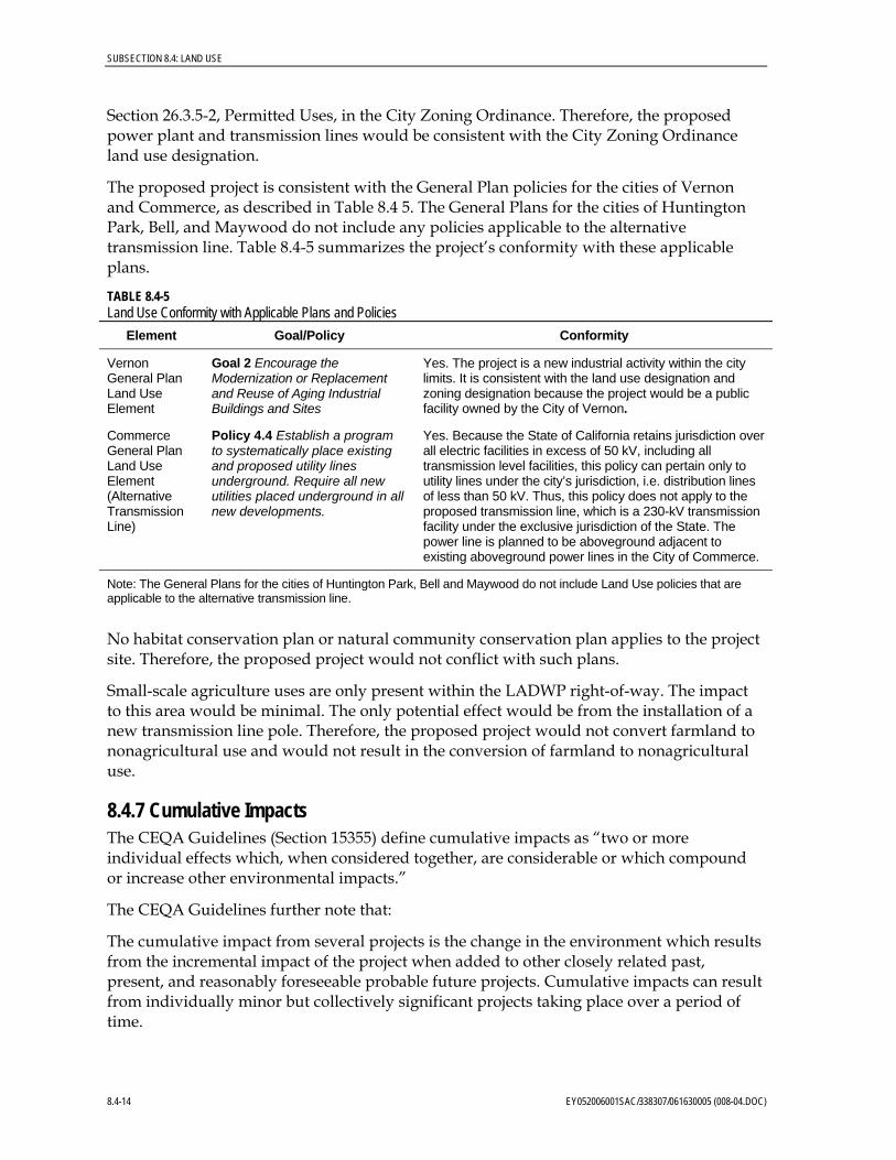
The proposed project is consistent with the General Plan policies for the cities of Vernon and Commerce, as described in Table 8.4 5. The General Plans for the cities of Huntington Park, Bell, and Maywood do not include any policies applicable to the alternative transmission line. Table 8.4-5 summarizes the project’s conformity with these applicable plans.
TABLE 8.4-5 Land Use Conformity with Applicable Plans and Policies
Element Goal/Policy Conformity
Vernon General Plan Land Use Element
Goal 2 Encourage the Modernization or Replacement and Reuse of Aging Industrial Buildings and Sites
Yes. The project is a new industrial activity within the city limits. It is consistent with the land use designation and zoning designation because the project would be a public facility owned by the City of Vernon.
Commerce General Plan Land Use Element (Alternative Transmission Line)
Policy 4.4 Establish a program to systematically place existing and proposed utility lines underground. Require all new utilities placed underground in all new developments.
Yes. Because the State of California retains jurisdiction over all electric facilities in excess of 50 kV, including all transmission level facilities, this policy can pertain only to utility lines under the city’s jurisdiction, i.e. distribution lines of less than 50 kV. Thus, this policy does not apply to the proposed transmission line, which is a 230-kV transmission facility under the exclusive jurisdiction of the State. The power line is planned to be aboveground adjacent to existing aboveground power lines in the City of Commerce.
Note: The General Plans for the cities of Huntington Park, Bell and Maywood do not include Land Use policies that are applicable to the alternative transmission line.
No habitat conservation plan or natural community conservation plan applies to the project site. Therefore, the proposed project would not conflict with such plans.
Small-scale agriculture uses are only present within the LADWP right-of-way. The impact to this area would be minimal. The only potential effect would be from the installation of a new transmission line pole. Therefore, the proposed project would not convert farmland to nonagricultural use and would not result in the conversion of farmland to nonagricultural use.
8.4.7 Cumulative Impacts The CEQA Guidelines (Section 15355) define cumulative impacts as “two or more individual effects which, when considered together, are considerable or which compound or increase other environmental impacts.”
The CEQA Guidelines further note that:
The cumulative impact from several projects is the change in the environment which results from the incremental impact of the project when added to other closely related past, present, and reasonably foreseeable probable future projects. Cumulative impacts can result from individually minor but collectively significant projects taking place over a period of time.
8.4-14 EY052006001SAC/338307/061630005 (008-04.DOC)

SUBSECTION 8.4: LAND USE
As discussed above, the proposed project is consistent with the City of Vernon’s goals and objectives for industrial development and would be sited in an area zoned for public facilities. The proposed project is consistent with the General Plan land use designations and zoning designations for the site, and is also consistent with the applicable General Plan land use policies. The proposed power plant would be installed in an existing industrial area so it would be compatible with adjacent land uses. The River Route transmission line would be installed within an industrial area in the City of Vernon and the Randolph Route would be along Randolph Street in the same corridor as existing power lines so the new transmission line would be compatible with adjacent land uses. The proposed project would not conflict with ongoing and future project planned within the City of Maywood. Therefore, the proposed project would not contribute to a significant impact on land use in the project vicinity. Therefore, the proposed project would not result in a significant cumulative land use impact.
In addition, no farmland is present in the study area and existing agricultural uses are minimal, so implementation of the proposed project would not significantly affect farmland. Therefore, the proposed project would not result in a cumulative farmland impact.
No habitat conservation plan or natural community conservation plan applies to the project area. Therefore, the proposed project would not result in a cumulative conflict with such plans.
The proposed project, including both the River Route and Randolph Route transmission lines, would result in no significant impact to land use; therefore, no significant cumulative impacts to land use would occur.
8.4.8 Permits and Agency Contacts Other than portions of the River Route and Randolph Route, all linears would be located within the City of Vernon. Permits required for the project, the responsible agencies, and proposed schedule (including those for the River and Randolph transmission line routes) are presented in Table 8.4-6. Within the City of Vernon, the proposed project would require a construction permit for the VPP site and an encroachment permit for linear features that would cross any public rights-of-way. Permits and agency contacts for the project are provided in Table 8.4-6.
TABLE 8.4-6 Permits and Agency Contacts
Permit or Approval Schedule Agency Contact Applicability
Project Site and Linears (including River Route Transmission Line)
Approval of Grading Plan; issuance of construction, grading, and encroachment permits
Minimum of 30 days prior to construction
Mr. Kevin Wilson City of Vernon Community Services 4305 Santa Fe Avenue Vernon, CA 90058 (323) 583-8811 ext 243
Site grading, and excavation at site or along linear project features within public rights-of-way
EY052006001SAC/338307/061630005 (008-04.DOC) 8.4-15

SUBSECTION 8.4: LAND USE
TABLE 8.4-6 Permits and Agency Contacts
Permit or Approval Schedule Agency Contact Applicability
Franchise agreement, Encroachment Agreement, and Excavation Permit
Approximately 3 months before construction
Carlos Alvarado City of Bell Engineer Building and Planning Department 6330 Pine Avenue Bell, CA 90201 (323) 588-6211
Installation of electrical transmission facilities within public rights-of-way
Plan Check Two weeks prior to submittal of permits to County of LA, Department of Public Works
Victor San Lucas City Engineer City Hall
City of Commerce 2535 Commerce Way Commerce, CA 90040 (323) 722-4805
Installation of electrical transmission facilities within public rights-of-way
Encroachment Permit and Construction Permit
Minimum 2 months prior to construction
Wu Tan Construction Division, Permit Section County of Los Angeles Department of Public Works P.O. Box 1460 Alhambra, CA 91802 (626) 458-4937
Installation of electrical transmission facilities within City of Bell public rights-of-way
Encroachment Permit Prior to construction Joan M. Preble, Real Estate Manager for LA County, Union Pacific Railroad 1400 Douglas Mail Stop 1690 Omaha, Nebraska 68179 (402)544-8535 http://www.uprr.com/reus/pipeline/install.shtml
Utility encroachments that run parallel or across the UPRR alignment along Randolph Avenue
Randolph Route Transmission Line
Franchise agreement, Encroachment Agreement, and Excavation Permit
Approximately 3 months before construction
Wes Lynd Engineer (contractor) Building and Safety Division City of Huntington Park (626) 447-4274 ext 210
Adrian Gallo, Assistant Planner Planning and Zoning Division City of Huntington Park (323) 584-6250
Installation of electrical transmission facilities within public rights-of-way
Franchise agreement, Encroachment Agreement, and Excavation Permit
Approximately 3 months before construction
Bill Pagett Engineer (contractor) (562) 908-6214
Julia Gomez, Assistant Planner City of Maywood Building and Planning Department 4319 E. Slauson Avenue Maywood, CA 90270 (323) 562-5722
Installation of electrical transmission facilities within public rights-of-way
Franchise agreement, Encroachment Agreement, and Excavation Permit
Approximately 3 months before construction
Carlos Alvarado City of Bell Engineer Building and Planning Department 6330 Pine Avenue Bell, CA 90201 (323) 588-6211
Installation of electrical transmission facilities within public rights-of-way
8.4-16 EY052006001SAC/338307/061630005 (008-04.DOC)

SUBSECTION 8.4: LAND USE
TABLE 8.4-6 Permits and Agency Contacts
Permit or Approval Schedule Agency Contact Applicability
Encroachment Permit and Construction Permit
Minimum 2 months prior to construction
Wu Tan Construction Division, Permit Section County of Los Angeles Department of Public Works P.O. Box 1460 Alhambra, CA 91802 (626) 458-4937
Installation of electrical transmission facilities within City of Bell public rights-of-way
Plan Check Two weeks prior to submittal of permits to County of LA, Department of Public Works
Victor San Lucas City Engineer City Hall
City of Commerce 2535 Commerce Way Commerce, CA 90040 (323) 722-4805
Installation of electrical transmission facilities within public rights-of-way
Encroachment Permit Prior to construction Joan M. Preble, Real Estate Manager for LA County, Union Pacific Railroad 1400 Douglas Mail Stop 1690 Omaha, Nebraska 68179 (402) 544-8535 http://www.uprr.com/reus/pipeline/install.shtml
Utility encroachments that run parallel or across the UPRR alignment along Randolph Avenue
If the 230-kV transmission line is constructed along the Randolph Street route, the following cities would be involved:
• The City of Huntington Park would require a Franchise Agreement for any permanent facility installed within a public right-of-way. These agreements are negotiated with the City Attorney and are voted on by the City Council. The Planning and Zoning Division and Building and Safety Division also review construction plans and issue Encroachment Permits for work in public rights-of-way and Utility Permits for utility projects. The current policy in Huntington Park is that all new utilities (to the degree possible) be constructed below ground (Lynd, personal communication, 2005).
• The cities of Maywood and Bell also require Franchise Agreements for new utilities that are arranged through the City Attorney and the City Council. Encroachment Permits and Excavation Permits are also required in both cities through the Building and Planning Departments. These permits require plan checks by the Engineering Departments along with fees to pay for site inspections during construction (Pagett; Alvarado, personal communication, 2005). It is also likely that the City of Bell will require new utilities along Randolph Street to be located underground. If SCE facilities (poles or rights-of-way) are proposed to be used for the VPP 230-kV transmission line, the City of Bell would require proof of that agreement (Alvarado, personal communication, 2005).
• The City of Commerce does not issue any permits (Gomez, personal communication, 2005). However, the City Engineering Department requires a plan review before the requisite permit applications (encroachment, excavation, and construction) are
EY052006001SAC/338307/061630005 (008-04.DOC) 8.4-17

SUBSECTION 8.4: LAND USE
submitted to the County of Los Angeles Department of Public Works, Construction Division (County of Los Angeles, 2005).
The Union Pacific Railroad would also require an Encroachment Permit for any utility crossing or any utility line that would parallel its railroad line if it would be installed within its right-of-way along Randolph Avenue. This permit is required for either aboveground or underground utilities. An insurance policy covering the installation is also required (Union Pacific Railroad, 2005).
8.4.9 References Aguirre, Mariano. 2005. City Planning Manager, Planning Department, City of Huntington Park, California. Personal communication with CH2M HILL personnel on September 29.
Alvarado, Carlos. 2005. City Engineer, Building and Planning Department, City of Bell, California. Personal communication with CH2M HILL personnel on September 6.
California Department of Conservation (CDC). 2005. Farmland Mapping and Monitoring Program Statistics web page at http://www.consrv.ca.gov/dlrp/FMMP/fmmp_stats.htm.
City of Bell. 1996. General Plan.
City of Bell. 1993. Zoning Ordinance.
City of Bell Gardens. 1996. General Plan.
City of Bell Gardens. 1982. Zoning Ordinance.
City of Commerce. 1987. General Plan.
City of Commerce. 2000. Zoning Ordinance.
City of Huntington Park. 1996. General Plan.
City of Huntington Park. 2002. Zoning Ordinance.
City of Maywood. 1993. General Plan.
City of Maywood. 1991. Zoning Ordinance.
City of Vernon. 2001. General Plan.
City of Vernon. 2005. Comprehensive Zoning Ordinance.
County of Los Angeles, 2005. http://www.ladpw.org/prg/business/page_04.cfm.
Gomez, Marza. 2005. Office Manager for City Engineer, City of Commerce, California. Personal communication with CH2M HILL personnel on September 2.
Hernandez, Connie. 2006. Assistant Planner, City of Maywood, California. Personal communication with CH2M HILL personnel. June 12.
Lynd, Wes. 2005. Engineer on contract to City of Huntington Park from W.R. Lynd and Public Engineering Services. Personal communication with CH2M HILL personnel on September 6.
8.4-18 EY052006001SAC/338307/061630005 (008-04.DOC)
SUBSECTION 8.4: LAND USE
Pagett, Bill. 2005. Engineer on contract to City of Maywood Department of Building and Planning. Personal communication with CH2M HILL personnel on September 2.
Thomas Bros. Maps. 1998. The Thomas Guide Orange/Los Angeles Counties Street Guide and Directory.
Union Pacific Railroad. 2005. http://www.uprr.com/reus/pipeline/install.shtml.
EY052006001SAC/338307/061630005 (008-04.DOC) 8.4-19

Chart
er
River
Ford
Mar lo
w
Moun
ta in V
i ew
Southall
Sal t Lake
Alcoa
Cal ifo
rnia
Maywood
State
State
Boyle
Bissell
Bisse
ll
Down
eyHelio trope
Helio
tr ope
Fruitland
Miles
Miles
Arbu
tusAr
butus
Atlan
tic
Atlant ic
26th
Peachtree
Hartle
Ayers
Flower
San L
uis
Pine
6th
46th
Loma
Vista
PineLo
ma Vi
sta
Chan
slor
45th
Alexa
nder
Live Oak
61st
60th
Live Oak
Miss
ion
44th
61st
54th
Pros
pect
Rivers
ide
Georg
ia
Zamb
rano
44th
El Co
rtez
Ayers
Lucil
le
Pass
aic
WeikBeck
I
Adam
son
Purdy
50th
Scott
Walnut
Fry
Mansfield
Bonni
e Beac
h
Olive
Lanto
Beec
hwoo
d
Evere
tt
Alvina
Gentr
y
Lanto
Kurt
Agra
Lanto
Loma
Vista
Moun
tain Vie
w
Selfla
nd
Agra
60th
Flora
Craft
on
Ches
tnut
Boxfo
rd
Orch
ard
Clarks
on
Pala
Mayw
ood
Wood
ward
Hood
Fishb
urn
Suno
l
61st
Belgrave
55th
60th
Everg
reen
Vinev
a le
Sun
Evere
tt
Mayfl
ower
Pros
pect
Wilco
x
Newe
ll
Bens
on
PalaMa
rconi Randolph
50th
Gran
ger
Cypre
ss
Wood
l awn
Walke
rHo
mePros
pect
Leonis
Vinev
ale
Palm
Casit
as
52nd
Holle
nbec
k
River
Sears57th
Fry
58th
46th
Garde
n View Pu
rdy
Hartle
Nelson
Palm
Plask
a
Ceda
r
Anita
Walke
rBeck
G
South
gate
Rivers
ide
H 5th
Smith Nevada
59th
Toler
Madis
on
Hannon
Benedict
Rickenbacker
Boris
Bicke
tt
26th
Weik
Canning
Yeag
er
Walke
r
Beck
Bissel
l
Dearb
orn
Travers
Ameli
a Earh
art
California
Nelson
Watcher
Trave
rsKres
s
Minnewa
Flora Vista
Broadway
Olive
FlowerLive Oak
Brompton
Hill
El Se
linda
S uda
n
Malt
Clara
Stafford
South
gate
Pass
aic
Clarks
on
Ajax
C oro
na
Col m
ar
Danie
l
Walke
r
O Ne
ill
J abo
n eria
Fitzge
rald
Zoe
Victor
ia
Priory
Grand
Bell Bell
47th
Clara
Hope
Zoe
59th
Orch
ard
Sheila
Giffo
rd
Califo
rnia
Live O
ak
Otto
Newell
Weik
Ludell
BeckWalnut
Bell
Randolph
Eliza
beth
Foster Bridge
Wiley Post
Coron
a
Lubec
Acacia
Sheila
49th
Jardine
Filmore
Weik
Southall
Belgrave
Elkgro
ve
Carm
elita
Packers
Bartmus
Elizabeth
Wood
ward
Clara
53rd
Virgin
ia
Smithway
Califo
rnia
Perry
Lindbergh
Fishb
urn
Federal
Gasp
ar
Bear
Wood
ward
Otis
Pros
pect
KingLoma
Vista
Fidelia
King Ma
y flowe
r
Clarendon
Weik
Beck
Flora
Orch
ard
Leo
Coron
a
Bewle
y
Rivers
ide
Spec
ht
Emil
Clarks
on
Helio
trop e
Califo
rnia
Brompton
Senta
Brompton
Randolph
Oak
Spec
ht
Pine
Bear
56th
Brompton
Acacia
54thJillson
Geph
art
Bell
Mayfl
ower
Live Oak
Leo
Cudahy
Randolph
Eve re
tt
C uda
hy
Loma
Vista
Helio
t rop e
King
Couts
Otis
Suva
52nd
Fishb
urnFlo
ra
Fry
Cowlin
Walnut
58th
Bear
Tube
way
Harbor
Salt Lake
Coron
a
3rd
57th
Zoe
48th
Darw
ell
Comm
erce
60th
Hepw
orth
1st
Santa Ana
Loveland
Mayf l
ower
V inev
ale
Wood
lawn
Garfie
ld
Flora
Carm
elita
Temp
leton
San C
arlos
Bell G
arden
Saturn Bear
Park
Gage
Bell
Exchange
Bandini
Florence
Easte
r n
Wilco
x
Malbu
rg
Alamo
Toler
Telegraph
52nd
Denn
is
Slauson
Live Oak
Fruitland
Gif fo
rd
Washington
Pine
San G
abrie
l Otis
Florence
Watcher
Soto
61st District
Ranso
m
Gaspar
Wilma
Jardine
Slauson
Slauson
Sevil
le
Vernon Ave
Bandini Blvd
Bandini Blvd
LAGUNA BELLSUBSTATION
VERNONPOWERPLANT
Los Angeles River
Bell
Bell
5
710
South Gate
Cudahy
WalnutPark
Downey
Bell GardensFlorence-Graham
Huntington Park
Maywood
Bell
Vernon
Commerce
EastLos
Angeles
LosAngeles
LEGENDLAND USE
GENERAL COMMERCIAL
CENTRAL BUSINESS DISTRICT
NEIGHBORHOOD COMMERCIAL
PROFESSIONAL COMMERCIAL
COMMERCIAL/INDUSTRIAL
GENERAL INDUSTRIAL
HEAVY INDUSTRIAL/WAREHOUSING
MANUFACTURING PLANNED DEVELOPMENT
MIXED USE (COMMERCIAL/RESIDENTIAL)
VERY HIGH DENSITY RESIDENTIAL
RESIDENTIAL
LOW DENSITY RESIDENTIAL
MEDIUM DENSITY RESIDENTIAL
HIGH DENSITY RESIDENTIAL
PUBLIC FACILITY
PUBLIC/INSTITUTIONAL
PUBLIC/QUASI-PUBLIC
SCHOOLS
PARK
VERNON POWER PLANT
LAGUNA BELL SUBSTATION
PROPOSED NATURAL GAS LINE
PROPOSED SEWER LINE
TRANSMISSION LINE - RANDOLPH ROUTE
TRANSMISSION LINE - RIVER ROUTE
CITY LIMITS
1 - MILE BUFFER
1/4 - MILE BUFFER
FIGURE 8.4-1GENERAL PLAN LAND USEDESIGNATIONS FOR PROJECT SITEAND VICINITYVERNON POWER PLANTCITY OF VERNON, CALIFORNIA
RDD \\LOKI\PROJECTS\RDDGIS\VERNON\MXDS\VPP3\VPP3_FIG8_4-1_LANDUSE.MXD 6/2/2006 09:50:27
0 2,000 4,000Feet
SCALE IS APPROXIMATE

Chart
er
River
Ford
Mar lo
w
Moun
ta in V
i ew
Southall
Sal t Lake
Alcoa
Cal ifo
rnia
Maywood
State
State
Boyle
Bissell
Bisse
ll
Down
eyHelio trope
Helio
tr ope
Fruitland
Miles
Miles
Arbu
tusAr
butus
Atlan
tic
Atlant ic
26th
Peachtree
Hartle
Ayers
Flower
San L
uis
Pine
6th
46th
Loma
Vista
PineLo
ma Vi
sta
Chan
slor
45th
Alexa
nder
Live Oak
61st
60th
Live Oak
Miss
ion
44th
61st
54th
Pros
pect
Rivers
ide
Georg
ia
Zamb
rano
44th
El Co
rtez
Ayers
Lucil
le
Pass
aic
WeikBeck
I
Adam
son
Purdy
50th
Scott
Walnut
Fry
Mansfield
Bonni
e Beac
h
Olive
Lanto
Beec
hwoo
d
Evere
tt
Alvina
Gentr
y
Lanto
Kurt
Agra
Lanto
Loma
Vista
Moun
tain Vie
w
Selfla
nd
Agra
60th
Flora
Craft
on
Ches
tnut
Boxfo
rd
Orch
ard
Clarks
on
Pala
Mayw
ood
Wood
ward
Hood
Fishb
urn
Suno
l
61st
Belgrave
55th
60th
Everg
reen
Vinev
a le
Sun
Evere
tt
Mayfl
ower
Pros
pect
Wilco
x
Newe
ll
Bens
on
PalaMa
rconi Randolph
50th
Gran
ger
Cypre
ss
Wood
l awn
Walke
rHo
mePros
pect
Leonis
Vinev
ale
Palm
Casit
as
52nd
Holle
nbec
k
River
Sears57th
Fry
58th
46th
Garde
n View Pu
rdy
Hartle
Nelson
Palm
Plask
a
Ceda
r
Anita
Walke
rBeck
G
South
gate
Rivers
ide
H 5th
Smith Nevada
59th
Toler
Madis
on
Hannon
Benedict
Rickenbacker
Boris
Bicke
tt
26th
Weik
Canning
Yeag
er
Walke
r
Beck
Bissel
l
Dearb
orn
Travers
Ameli
a Earh
art
California
Nelson
Watcher
Trave
rsKres
s
Minnewa
Flora Vista
Broadway
Olive
FlowerLive Oak
Brompton
Hill
El Se
linda
S uda
n
Malt
Clara
Stafford
South
gate
Pass
aic
Clarks
on
Ajax
C oro
na
Col m
ar
Danie
l
Walke
r
O Ne
ill
J abo
n eria
Fitzge
rald
Zoe
Victor
ia
Priory
Grand
Bell Bell
47th
Clara
Hope
Zoe
59th
Orch
ard
Sheila
Giffo
rd
Califo
rnia
Live O
ak
Otto
Newell
Weik
Ludell
BeckWalnut
Bell
Randolph
Eliza
beth
Foster Bridge
Wiley Post
Coron
a
Lubec
Acacia
Sheila
49th
Jardine
Filmore
Weik
Southall
Belgrave
Elkgro
ve
Carm
elita
Packers
Bartmus
Elizabeth
Wood
ward
Clara
53rd
Virgin
ia
Smithway
Califo
rnia
Perry
Lindbergh
Fishb
urn
Federal
Gasp
ar
Bear
Wood
ward
Otis
Pros
pect
KingLoma
Vista
Fidelia
King Ma
y flowe
r
Clarendon
Weik
Beck
Flora
Orch
ard
Leo
Coron
a
Bewle
y
Rivers
ide
Spec
ht
Emil
Clarks
on
Helio
trop e
Califo
rnia
Brompton
Senta
Brompton
Randolph
Oak
Spec
ht
Pine
Bear
56th
Brompton
Acacia
54thJillson
Geph
art
Bell
Mayfl
ower
Live Oak
Leo
Cudahy
Randolph
Eve re
tt
C uda
hy
Loma
Vista
Helio
t rop e
King
Couts
Otis
Suva
52nd
Fishb
urnFlo
ra
Fry
Cowlin
Walnut
58th
Bear
Tube
way
Harbor
Salt Lake
Coron
a
3rd
57th
Zoe
48th
Darw
ell
Comm
erce
60th
Hepw
orth
1st
Santa Ana
Loveland
Mayf l
ower
V inev
ale
Wood
lawn
Garfie
ld
Flora
Carm
elita
Temp
leton
San C
arlos
Bell G
arden
Saturn Bear
Park
Gage
Bell
Exchange
Bandini
Florence
Easte
r n
Wilco
x
Malbu
rg
Alamo
Toler
Telegraph
52nd
Denn
is
Slauson
Live Oak
Fruitland
Gif fo
rd
Washington
Pine
San G
abrie
l Otis
Florence
Watcher
Soto
61st District
Ranso
m
Gaspar
Wilma
Jardine
Slauson
Slauson
Sevil
le
Vernon Ave
Bandini Blvd
Bandini Blvd
LAGUNA BELLSUBSTATION
VERNONPOWERPLANT
Los Angeles River
Bell
Bell
5
710
South Gate
Cudahy
WalnutPark
Downey
Bell GardensFlorence-Graham
Huntington Park
Maywood
Bell
Vernon
Commerce
EastLos
Angeles
LosAngeles
LEGENDZONING
LIGHT AGRICULTURAL
COMMERCIAL GENERAL
COMMERCIAL NEIGHBORHOOD
COMMERCIAL MANUFACTURING
COMMERCIAL PROFESSIONAL
GENERAL INDUSTRIAL
LIGHT MANUFACTURING
LIGHT INDUSTRIAL
HEAVY INDUSTRIAL
MANUFACTURING PLANNED DEVELOPMENT
RESIDENTIAL
LOW DENSITY RESIDENTIAL
MEDIUM DENSITY RESIDENTIAL
HIGH DENSITY RESIDENTIAL
RESTRICTED DENSITY MULTIPLE DWELLING
OPEN SPACE
PACIFIC PASEO
PACIFIC VILLAGE
PUBLIC FACILITY
TRANSPORTATION
VERNON POWER PLANT
LAGUNA BELL SUBSTATION
PROPOSED NATURAL GAS LINE
PROPOSED SEWER LINE
TRANSMISSION LINE - RANDOLPH ROUTE
TRANSMISSION LINE - RIVER ROUTE
CITY LIMITS
1 - MILE BUFFER
1/4 - MILE BUFFER
FIGURE 8.4-2ZONING DESIGNATION FORPROJECT SITE AND VICINITYVERNON POWER PLANTCITY OF VERNON, CALIFORNIA
RDD \\LOKI\PROJECTS\RDDGIS\VERNON\MXDS\VPP3\VPP3_FIG8_4-2_ZONING.MXD 6/2/2006 09:51:49
0 2,000 4,000Feet
SCALE IS APPROXIMATE