Embed Size (px)
Citation preview

6. SITE 318
The Shipboard Scientific Party1
SITE DATA
Date Occupied: 13 December 1973 (0757Z)Date Departed: 16 December 1973 (1300Z)Tinje on Site: 77.05 hoursPosition:
Latitude: 14°49.63'SLongitude: 146°51.51'W
Water Depth (sea level: 2641.0 corrected meters, echo Sound-ing
Water Depth (rig floor): 2656.8 corrected meters, echo sound-ing
Bottom Felt at: 2659.0 meters, drill pipePenetration: 745.0 metersNumber of Holes: 1Number of Cores: 32
Total Length of Cored Section: 298.5 metersTotal Core Recovered: 147.1 metersPercentage Core Recovery: 49.3%Oldest Sediment Cores:
Depth below sea floor: 745.0 metersNature: Foraminiferal volcanogenic sandstoneAge: Early EoceneMeasured velocity: 2.2 km/sec
Basement: Not reachedPrincipal Results: The site was drilled in order to determine if
the northwest part of the Tuamotu chain is coeval with theHawaiian-Emperor bend and to study the history of reefalgrowth and erosion in this area. A simplified geologicalhistory at the site may be given as follows:
(1) Eruption of basaltic edifices on older oceanic seafloor at some time prior to 49-51 m.y.B.P.
(2) Deposition of volcaniclastic sandstones and silt-stones of shallow water origin at rates averaging 65-70m/m.y. as these edifices were eroded.
(3) Formation of reefs, at least as old as 49-50 m.y.B.P.(4) Pelagic sedimentation from early Eocene time to the
present, with at least three interruptions. Floods of reefaldebris entered the basin as turbidite units during middleEocene and early Miocene time.
'S.O. Schlanger, University of California, Riverside, California (Co-chief scientist); E.D. Jackson, U.S. Geological Survey, Menlo Park,California (Co-chief scientist); R.E. Boyce, Scripps Institution ofOceanography, La Jolla, California; H.E. Cook, University ofCalifornia, Riverside, California; H.C. Jenkyns, University of Dur-ham, Durham, England; D.A. Johnson, Woods Hole OceanographicInstitution, Woods Hole, Massachusetts; A.G. Kaneps, ScrippsInstitution of Oceanography, La Jolla, California; K.R. Kelts, Eidg.Technische Hochschule, Zurich, Switzerland; E. Martini, Johann-Wolfgang-Goethe Universitat, Frankfurt-am-Main, Germany; C.L.McNulty, University of Texas at Arlington, Arlington, Texas; E.L.Winterer, Scripps Institution of Oceanography, La Jolla, California.
149" 148° 147 146° 145'
Figure 1. Location of Site 318 plotted on a portion of thebathymetric chart of the South Pacific of Mammerickxetal(1973).
Inasmuch as basaltic basement rocks were not drilled, wecan give only minimum ages of edifice construction. Never-theless, even minimum ages of 49-51 m.y.B.P. are slightlyolder than recent estimates of the age of the Hawaiian-Emperor bend. Comparison with other ages in the Tua-motu chain suggests that volcanism has been episodic, likethat of the Hawaiian chain. Reflectors in the basin areirregular and discontinuous; this irregularity may be due toinflux of sediments from ridges bounding it. Comparison ofreflectors with drilling results at this site is complex butsuggests that the 0.56 to 0.60 (underway) and 0.68(Sonobuoy) sec reflectors, represent an unconformity in theEocene at a depth of approximately 530 meters and the topof very hard limestones at a depth of about 620 meters,respectively. We continued evaluation of the heave com-pensator and continued to conclude that its use results inno better core recovery, nor less drill-induced deformationin cores than conventional drilling. Further comparativetesting in continuously hard rocks seems indicated.
BACKGROUND AND OBJECTIVES
The original objectives of Site 318 (Figure 1) were(1) to determine the date of cessation of volcanism ofnear the bend of the putatively continuous Tua-motu/Line Islands seamount chain; (2) to study thepetrology of the volcanic rocks that have built the prin-cipal Tuamotu edifices; and (3) to attempt to decipherthe geological history of the main group of major atolls
301

SITE 318
on the Tuamotu Ridge crest by a study of the sedimen-tary, presumably turbidite, debris that lies abovevolcanic rocks. The age of volcanism in this area hasdirect bearing on Morgan's (1971, 1972) suggestion thatthis particular area marks a bend in a single Tua-motu/Line Islands chain; a bend that he suggested re-cords a major change in the direction of motion of thePacific plate. Morgan's bend would therefore be similarto, and coeval with, the bend in the Hawaiian-Emperorchain. Whether the nature of formation of Hawaiian-type chains in linear (Morgan, 1971, 1972) or episodic(Shaw and Jackson, 1973), the age of bends in suchchains should be the same according to hypothesis.Clague and Dalrymple (1973) have estimated theHawaiian-Emperor bend age as about 42 m.y.B.P.,although more recent data from Larson, Moberly, et al.,(1973), if correct, would lead to estimated bend ages forthat chain as being somewhat older. Subsequent to ourown drilling in the Line Islands, we believe seriousdoubt has been cast on the hypothesis that a Line Is-lands/Tuamotu connection exists; nevertheless, theTuamotu chain itself has characteristics that resemblethe Hawaiian chain (Dana, 1876; Jackson and Shaw,1975), and it now appears equally important to deter-mine whether or not the birth of the Tuamotu chaincoincided with that of the Hawaiian chain. Existing agedates in this area are sparse. Deep Sea Drilling Site 76(Haws et al., 1972) recovered Eocene reefal debris inPliocene turbidites along the northern flank of the Tua-motu chain, about 175 km north of our proposed site,but only 27 meters of penetration was achieved. Dredgehauls to the northwest of our proposed site yielded fossilages in the range 37.5-43 m.y. (Burckle and Saito, 1966)and 37.5-53.5 m.y. (Repelin, 1919), but in terms of base-ment ages, none of the above data is in any waydefinitive.
In addition to our interest in basement ages at thissite, the Tuamotu Islands in this area form one of themost extensive atoll complexes on earth, and it washoped to reconstruct a history of atoll formation in thisarea by drilling reefal debris that presumably lies abovebasement.
The site considered most likely to meet these objec-tives was chosen on the Conrad-11 refraction profile at1800, 4 September 1967 (Figure 2) at a position of about15.2°S; 146.8°N, where a ridge was observed betweenthe major Tuamotu atolls in this area that appeared tocontain ponded sedimentary rocks in its basined uppersurface. Water depth at this site was measured as about2600 meters; depth to acoustic basement appeared to beabout 0.75 sec.
OPERATIONS
Predrilling Site SurveysThe original site was selected on the basis of a Conrad-
11 seismic profile that crossed the Tuamotu Ridge on 14September 1967 (Figure 2). The bathymetry indicatedthat the Conrad line crossed a basin that could have beenreceiving sediments from five atolls, including Rangiroa,one of the largest in the Tuamotu group.
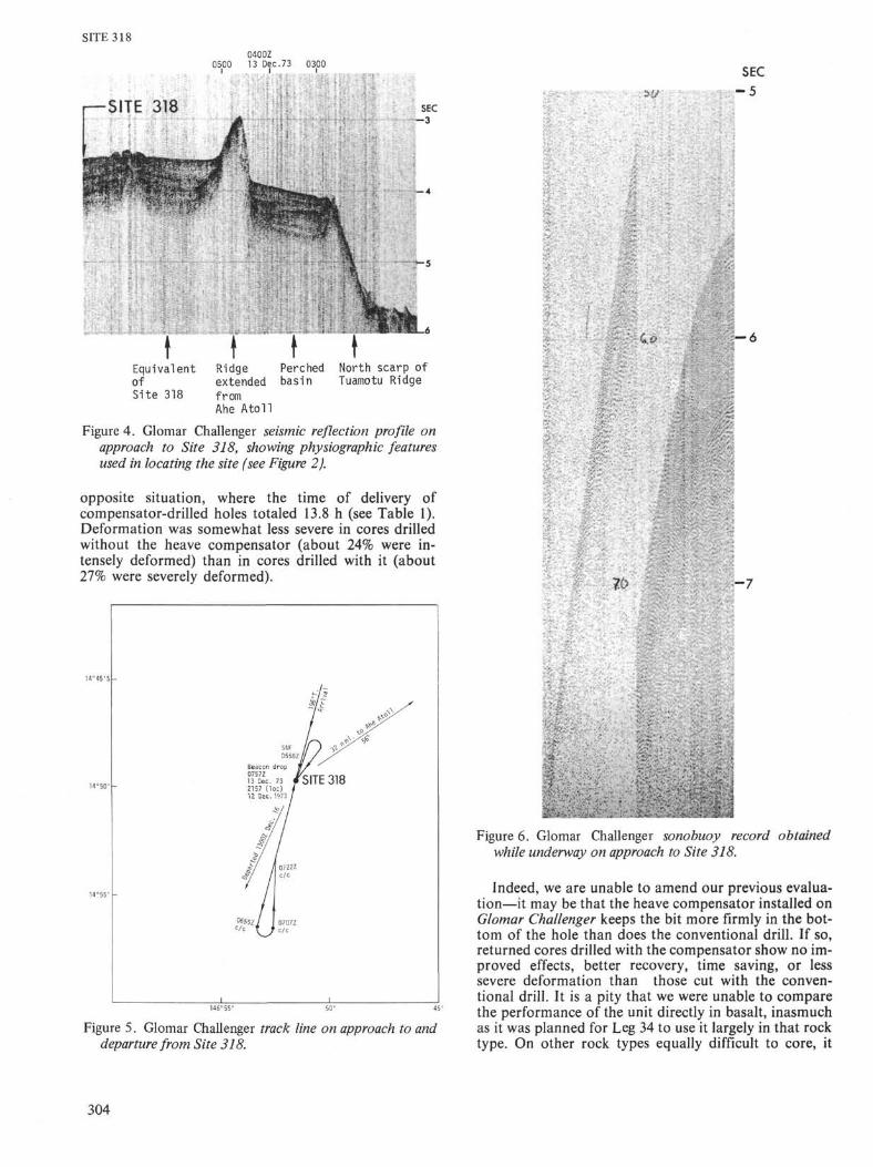
Glomar Challenger approached Site 318 by attemptingto intersect the Conrad line before it crossed the northscarp of the Tuamotu Ridge, northwest of Ahe Atoll
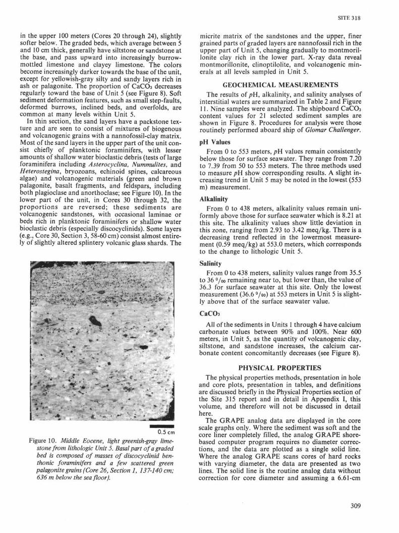
(Figure 3). This approach was made inasmuch as wewere not certain of the location of the Conrad line, ex-cept that it passed close by Ahe Atoll and passed overthe south scarp of the ridge between the Rangiroa andArutua atolls (Figure 3). In this manner we planned tocross the grain of the structure and be able to navigateon the submarine morphology. The assumed intersec-tion with Conrad-\\ was made on a course of 100° Trueand a course change to 215° True was made at 1540(local), 12 December; shortly afterwards (0140Z, 13December) Ahe Atoll was picked up on the radar at 16n. mi. distance, bearing 140°. The north scarp of theTuamotu Ridge was crossed as well as the perched basinshown on the Conrad-11 line (compare Figures 2 and 4).On crossing a high ridge, presumably the northern limitto the trough that we intended to drill, we changedcourse to 196° True and crossed to the major basin thatlies between raised edifices of the Tuamotu Ridge. Onthe Conrad-11 line this basin is 2 hr wide. After steamingfor ~l hr and 15 min, the beginning of another ridge,presumably the one leading up to Rangiroa, appeared.We decided that we were actually east of the Conrad-11line instead of west—the basin being narrower along ourline—course was reversed (Figure 5) and we steamedback to a suitable section and dropped the beacon at2157, 12 December (0757Z, 13 December).
The PDR depth of 1416 fathoms at Site 318 was cor-rected to 2641 meters (Matthew's tables, Area 41), giv-ing a derrick floor to mudline depth of 2656.8 meters.The bottom proved to be solid in this area, and the drillpipe depth was 2659.0 meters; the latter depth was usedfor the site.
Reflectors on both the Conrad-W and GlomarChallenger lines are irregular and show rapid lateralchanges in thickness and strength (Figures 2 and 4). Onthe Conrad-W line reflectors were noted at 0.08?, 0.20,0.40, 0.56, and 0.75 sec. On the Glomar Challenger linereflectors at roughly 0.1, 0.20, 0.40, 0.60, and 0.75 werenoted. The deeper reflectors are quite vague on bothlines.
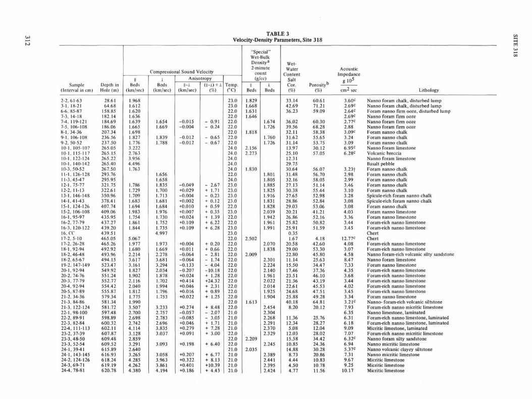
Sonobuoy SurveyInasmuch as current directions in the general area
between the Tuamotu atolls were known to be weak andirregular, a Sonobuoy was released at 0535Z, 13December prior to beacon drop, while underway to thesite (see Figure 6); recording on EDO 2 (4-sec sweep). Aprominent reflector at 0.69 sec corresponds to thedeepest reflector, at approximately 0.71 sec on theprofile (Figure 4). Details of the Sonobuoy survey aregiven below.
Drilling ProgramBecause of the very limited time available at Site 318,
the most reasonable drilling strategy appeared to be(1) to take a punch core at mudline to establish the ageand erosional character of the surface; (2) to retrieveonly every third core drilled, washing the two inter-mediate intervals until such time as this became impossi-ble due to increasing rock coherence; and (3) to corecontinuously once such hard formations were reached.We followed this program through Core 21, but, inwashing the first and second interval following Core 21,
302

SITE 318
1700 1800
14 Sept. 1967
North scarpof
Tuamoto Ridge
PerchedBasin
Ridgefrom
extendedAhe atoll
ProposedSite 33-6
Figure 2. LDGO Conrad-ii seismic reflection profile showing physiographic features used in approach to Site318.
15
16° -
148° 147° 146°
Figure 3. Location of Site 318, with Conrad-77 and GlomarChallenger Leg 33 tracks. Bathymetry from Mammerickxet 0,1(1973).
washing times became long. We were advised by theDrilling Superintendent that we might have a jammedcore catcher. We therefore pulled Core 22 after only onewashing interval, and pulled Core 23 immediatelyfollowing, in response to the Cruise OperationsManagers request for a core at that time. Subsequent toCore 23 we washed as drilling time dictated (in general,washing two cores for one if drilling times were 45 min
or less, one for one if drilling times were 1 to 1 xh hr, andtaking every core that required as long as 1 Vi hr to drill).Penetration rates became very slow subsequent to Core21, and the drilling and coring were finally terminated inhole at 2045 (local), 15 December 1973, in order to meetour arrival schedule in Papeete. Bit wear at that timeseemed nominal; the final cores were nearly fulldiameter.
Heave CompensatorInasmuch as we had accepted the responsibility for a
geologic evaluation of the heave compensation device,and since it had previously been operated only in Ter-tiary rocks, and then with somewhat ambiguous results(see Site 317 report, this volume), we agreed to leave thecompensator in the drill string at all times at Site 318,but to take alternate cores with the device locked outand operating throughout the section cored. Thus, in theearly portion of the hole 10 even-numbered cores weretaken with heave compensation, 10 odd-numbered coreswithout. During the drilling of Core 22, the CruiseOperations Manager ordered that the heave compen-sator be left operating for the remainder of the drillingat this site; as a result we are unable to compare resultsbeyond Core 20. Core recovery in holes drilled with thecompensator locked out (odd-numbered Cores 1-19)was sensibly the same as recovery in the cores with thecompensator operating (even-numbered Cores 2-20). Inthe former cores recovery averaged 52.9%; in the latter,53.2% (see Table 1). Recovery in soupy oozes and rocksinterbedded with cherts was poor in both modes; firmoozes and chalk gave good recovery in both modes.Recovery time was somewhat slower with the heavecompensator operating than without it, no doubtbecause of its operational complexities (see Site 317report); the time from delivery of an even core on deckto the arrival of an odd one totaled 11.9 hr versus the
303
SITE 3180400Z
0500 13 Dec.73 0300
SITE 318
EquivalentofSite 318
RidgeextendedfromAhe Atoll
Perchedbasin
North scarp ofTuamotu Ridge
Figure 4. Glomar Challenger seismic reflection profile onapproach to Site 318, showing physiographic featuresused in locating the site (see Figure 2).
opposite situation, where the time of delivery ofcompensator-drilled holes totaled 13.8 h (see Table 1).Deformation was somewhat less severe in cores drilledwithout the heave compensator (about 24% were in-tensely deformed) than in cores drilled with it (about27% were severely deformed).
4°45'S
14°50'
14°55'
-
0757Z13 Dec.2157 (112 Dec.
/
7 //
1
055811/ / y ×
r°P 1/73 /SITE 318
07Z2Ic/c
O7O7Zc/c
i>•U
SEC
- 5
C o Z-6
- 7
Figure 5. Glomar Challenger track line on approach to anddeparture from Site 318.
Figure 6. Glomar Challenger Sonobuoy record obtainedwhile underway on approach to Site 318.
Indeed, we are unable to amend our previous evalua-tion—it may be that the heave compensator installed onGlomar Challenger keeps the bit more firmly in the bot-tom of the hole than does the conventional drill. If so,returned cores drilled with the compensator show no im-proved effects, better recovery, time saving, or lesssevere deformation than those cut with the conven-tional drill. It is a pity that we were unable to comparethe performance of the unit directly in basalt, inasmuchas it was planned for Leg 34 to use it largely in that rocktype. On other rock types equally difficult to core, it
304

SITE 318TABLE 1
Coring Summary
Core
123456789
1011121314151617181920212223242526272829303132
Total
Date(1973)
13 Dec13 Dec13 Dec13 Dec13 Dec13 Dec13 Dec13 Dec13 Dec13 Dec13 Dec13 Dec13 Dec13 Dec13 Dec14 Dec14 Dec14 Dec14 Dec14 Dec14 Dec14 Dec14 Dec14 Dec14 Dec15 Dec15 Dec15 Dec15 Dec15 Dec15 Dec15 Dec
Total depth 745
Time(local)
05550740084509451055120513101420153016501810193021052230235501200250044506250750095514051625202522450100031006451020143018002045
.0 meters
Depth FromDrill Floor
(m)
2659.0-2666.52695.0-2704.52723.4-2733.02752.0-2761.52780.5-2790.02809.0-2818.52837.5-2847.02866.0-2875.52894.5-2904.02923.0-2932.52951.5-2961.02980.0-2989.53008.5-3018.03037.0-3046.53065.5-3075.03094.0-3103.53122.5-3132.03151.0-3160.53179.5-3189.03208.0-3217.53236.5-3246.03255.5-3265.03265.0-3274.53274.5-3284.03284.0-3293.53293.5-3303.03303.0-3312.53322.0-3331.53341.0-3350.53360.0-3369.53379.0-3388.53398.0-3404.0
Depth BelowSea Floor
(m)
0-7.526.5-36.064.5-74.093.0-102.5
121.5-131.0150.0-159.5178.5-188.0207.0-216.5235.5-245.0264.0-273.5292.5-302.0321.0-330.5349.5-359.0378.0-387.5406.5416.0435.0444.5463.5473.0492.0-501.5520.5-530.0549.0-558.5577.5-587.0596.5-606.0606.0-615.5615.5-625.0625.0-634.5634.5-644.0644.0-653.5663.0-672.5682.0-691.5701.0-710.5720.0-729.5739.0-745.0
LengthCored
(m)
7.59.59.59.59.59.59.59.59.59.59.59.59.59.59.59.59.59.59.59.59.59.59.59.59.59.59.59.59.59.59.56.0
298.5
LengthRecovered
(m)
7.52.01.59.39.29.59.54.52.45.09.52.92.14.42.73.62.02.51.97.03.55.03.26.04.76.22.43.42.04.52.15.1
147.1
Recovery(%)
10021169897
100100472553
100302246283721262074375334684964253621472293
49.3
appears to have little other effect than the conventionalbumper sub that is removed to allow its operation. Inwashing cycles it continues to be detrimental because oftime loss.
Departure
The Captain of Glomar Challenger estimated 26 hrsteaming time for the 230 n. mi. from Site 318 to an 0600rendezvous 17 December with the Papeete pilot boat;the Drilling Superintendent estimated 9 hr were requiredto pull the string and stow the heave compensator (thebottom-hole assembly had been magnafluxed at Site317). We therefore planned to have our last core fromthis site on deck at 1900, 15 December. The final core(Core 32) was on deck at 2040, 15 December. The stringwas pulled and Glomar Challenger got underway at 0300(local), 16 December on a course of 020°, turned back,passed over the beacon and headed for the pass betweenRangiroa and Arutua atolls on a course of 205°. Theprofiler record (Figure 7) shows the southern edge of thedrilled basin, confirming that we drilled near theConrad-W line.
LITHOLOGIC SUMMARYThe stratigraphic column at Site 318 can be sub-
divided into five lithologic units (Figure 8):Unit 1 (0 to between 35.5-64.5 m)—Nannofossil-fora-
minifer firm ooze that contains some graded beds withshallow water skeletal debris of foraminifers, bryo-
zoans, echinoids, corals, mollusks, and altered volcano-genie material.
Unit 2 (between 35.5-64.5 and between 245 and 264m)—Foraminifer and nannofossil firm ooze, changingdownward to soft chalk, with a few graded beds withsand-sized grains of volcanogènic and shallow waterbiogenous origin, and a bed of breccia with basalt, chert,and bioclastic debris.
Unit 3 (between 245-264 m and between 416-435m)—Foraminifer nannofossil chalk, becoming harderwith depth, and with chert nodules in the lower part,below 379.5 meters. Thin laminae of sand with rare vol-canogènic grains.
Unit 4 (between 416-435 m and between 530-549 m)—Yellowish and greenish nannofossil and foraminiferlimestone with chert nodules, clayey laminae and gradedbeds with volcanogènic and shallow water skeletaldebris.
Unit 5 (between 530 to 549-745 m)—Green and green-ish-gray clayey limestone, and volcanogènic siltstoneand sandstone, mainly as graded beds. Shallow waterskeletal debris is abundant in some sandstone layers.
Unit 1—Ooze (0-35.5 m)Pale orange nannofossil-foraminifer ooze and fora-
minifer ooze. Interbedded with these calcareous oozesare graded layers 20 to 60 cm in thickness containingsand- to granule-sized grains of volcanogènic and car-bonate debris. This debris includes palagonite, greenish
305

SITE 318
SEC
— 0
- 3
° 20 α> +->
— 4 0 . 4 0 s- -Q
0 . 6 0 to
——•O . 7 5 to cu
i r-C\J +->
I _ 8
Figure 7. Glomar Challenger seismic reflection profile on departure from Site 318. Anno-tated reflectors are correlative with those on the Conrad-77 profile shown in Figure 13.
glass, rock fragments, and, in some layers, shallow waterskeletal fragments of bryozoans, mollusks, and largeand small foraminifers including Amphistegina andHeterostegina. The volcanogenic and bioclastic materialis mainly concentrated at the base of graded beds; higherparts of the beds consist chiefly of planktonicforaminifers and nannofossils. In thin section, somelayers have a packstone texture, with mainly globi-gerine foraminifers, as whole tests, and a few globo-rotaliids in a matrix of nannofossils.
Other layers have wackestone textures, with about50% nannofossils and 50% planktonic foraminifers. Theforaminifers are either empty or filled with micritematrix. (The terms wackestone and packstone are usedaccording to the classification of Dunham, 1962.)
The ooze is vaguely mottled in color shades bothslightly lighter and darker than the pale orange hostsediment.
As shown by X-ray data (Cook and Zemmels, thisvolume), some of the transported fossils probably con-
306

SITE 318
n
100
200
ouu
400
500
600
700
800
CORESAND
DEPTH(m)
aJπ-
-
••••--
m
l2
3/I
4567
8910i η1 1
1213
14
15
16
17
1819
20212224262829303132
LITHOLOGY
C
n , UNIT 1 . . .Pale orange nannofossi l -
UNITIWhite, bluish-white, andgreenish-white foram-nannofirm ooze to chalk. Somegraded layers palagonitegrains.
UNIT 3Yellowish-gray foram-nannofirm chalk. Redepositedshallow-water material.
— —Yellowish-gray and palegreenish nanno-foram lime-stones with chert nodules.Fucoid burrows. Slumpedbeds and redeposited layers.
UNIT 5Green and greenish-grayclayey l imestones, s i l t -stones, and sandstones.Sand u n i t s are graded andcontain derived shallow-water faunas.
CaC03 {%)
BOMB ANALYSES
) 25 50 75 1(
• • , .
i '
I
4
(
\
I
J
JJ
•)0 1 4
DRILLING TIME(min/m)
12 10 8 6 4
#— —— '"T*" ' '*'
V
1
\
2
I."v\
•)
/
11
1\•!I
ijijiiiijiiji
/y
Figure 8. Graphic log showing lithologic units, carbonate content, and drilling rates at Site 318.
tain aragonite in their shells. About 1% dolomite and atrace of barite were also detected by X-ray diffraction.
Much of the ooze has the firmness of packed sand,and in Core 2, Section 2, near the base of the unit, thesediments have the induration of chalk.
Unit 2—Ooze and Chalk (64.5-265.5 m)
Foraminifer-nannofossil firm ooze, changing down-ward to soft chalk. Some layers are foram-rich and con-tain rare sand-sized grains of palagonite. A few of theselayers show graded bedding. Colors range from white atthe top of the interval to bluish-white and greenish-white in Cores 6, 7, and 8, and white again near the baseof the unit in Core 9. Thin wisps and streaks of grayooze occur throughout. The foram-rich layers tend to beshades of pale yellowish-gray. At the base of the unit is a
thin bed of well-indurated breccia, consisting of pebblesof basalt, chert, and shallow water skeletal debris(Figure 9).
The foram-rich layers in this section have a packstonetexture with sand-sized planktonic (99%) and benthonic(1%) foraminifers. Also present in these packstones arevery rare fragments of bryozoans, tiny calcareoussponge spicules and grains of palagonite, and feldspar,all set in a matrix of nannofossil micrite. The finergrained sediments, in thin section, have wackestone tex-tures, some with a wide range of sizes of planktonicforaminifers (40-600 µm) set in a matrix of nannofossilmicrite. The ratio of matrix to foraminifers ranges fromabout 1 to 2. Most foraminifers are filled with micrite;some are completely empty. In the lower part of theunit, some of the thinner walled globorotaliid foramini-fers have slightly crushed tests.
307

SITE 318
0.5 cm
Figure 9. Lower Miocene, well indurated, brown-ish polygenetic breccia from the base of litho-logic Unit 2. Diverse fragments include roundedaphyric vesicular basalt clasts with ferruginoushalos, gray angular chert clasts, and light yellowskeletal and reef debris (Core 10, Section 1,137-140 cm; 268 m below the sea floor).
X-ray data (Cook and Zemmels, this volume) revealthe presence of small amounts of dolomite in gray oozein Cores 4 and 5, and barite in Cores 4 and 7.
The breccia bed at the base of the unit consists ofangular fragments, up to 1 cm in diameter, of a widevariety of clasts. The proportions of clast types areroughly 50% volcanogenic, 40% sedimentary, and 10%biogenic clasts. Volcanogenic clasts consist of basalt,with plagioclase of Amo-45 composition and augitephenocrysts (15%) in a sideromelane or palagonitegroundmass; quartz syenite, containing quartz, ortho-clase, minor plagioclase, and aegerine augite; trachyte,composed almost entirely of fine-grained sanidine;oligoclase andesite; holocrystalline basalt, with subcal-cic augite microphenocrysts and groundmass pigeonite;palagonite, generally of the gel variety, but also in-cluding fibrous types with abundant spherulites; bio-clastic debris is composed of mollusks, benthonic andplanktonic foraminifers, bryozoans, and sedimentaryrock fragments of silicified foraminifer-nannofossillimestone.
Unit 3—Varicolored Chalk, Chert, and Sandstone(265.5-416.0 m)
Foraminifer-nannofossil chalk in shades of yellowish-gray, yellowish-white, pale orange, grayish-orange,pinkish-white, and white with occasional wisps, streaks,laminae, and burrow mottles of light olive-gray andlight gray. The induration ranges from soft chalk at thetop of the unit to hard chalk at the base. Much of the
chalk has been fractured and crushed in the coringprocess, reducing it to a paste in some intervals. Chert,in the form of olive-gray and yellowish-brown nodulesoccur very sporadically in the lower part of the unit,beginning at 379.5 meters in Core 14.
Within the chalk are occasional thin laminae offoram-rich sand, with about 1% volcanogenic grains ofpale green palagonite and minor feldspar. In thin sec-tion, the sands have a packstone texture, with grains ofboth planktonic (~90%) and benthonic (~10%) fora-minifers in a matrix of nannofossil micrite. These testsare commonly fragmental and partly dissolved and re-crystallized.
X-ray data show barite and analcite in addition tovolcanogenic components in the acid-insoluble fraction.
The bulk of the chalk is wackestone, with planktonicforaminifers of a wide range of sizes (40-500 µm) in anannofossil micrite matrix. The micrite is commonlycharged with tiny calcareous sponge (?) spicules, lying inthe bedding plane.
Unit 4—Limestone and Chert (416.0-530.0 m)Yellowish-gray and pale greenish nannofossil and
foraminifer-nannofossil limestone, with common chertnodules. The unit is characterized by darker, moregreenish colors than Unit 3 and by the prevalance oflaminations, burrows, and mottles. Near the top of theunit these burrows are dark and are set in a lighter host,but lower down the rule is lighter burrows in a darkerhost. Burrows are generally somewhat flattened parallelto bedding.
Evidence of soft sediment deformation is common, es-pecially in Core 16. Recumbent folding and tiny brittle-fracture step faults occur in Section 2 of Core 16.
Streaks and laminae of foram-rich packstone withgreenish palagonite grains occur scattered throughoutthe unit. These are more numerous, thicker, and coarsegrained toward the base of the unit, where they generallyform the lower parts of graded beds. The upper parts ofthese beds consist of nannofossil-foraminifer wacke-stone with decreasing proportion of foraminifers (main-ly planktonic) upward. The limestone is layered on ascale of about 250 µm, marked by changes inforaminifer concentrations in the matrix. Spongespicules and radiolarians are rare in the upper part ofthe unit, but become more common near the base. InCore 18, radiolarians are almost as abundant asforaminifers in one thin section.
Chert nodules are scattered throughout the unit, at afrequency of 1 or 2 per meter.
The base of the unit is chosen at the bottom of Core19, in which an artificial sand or drilling breccia wasrecovered. This breccia consists of volcanogenic grains(mainly palagonite), chert, and bioclastic debris (plank-tonic and large benthonic foraminifers including Num-mulites, Heterostegina, Cycloclepeael, and Astero-cyclina, bryozoans, calcareous algae, corals, andmollusks).
Unit 5—Limestone and Volcaniclastic Sediment(549.0-745.0 m)
Green and greenish-gray clayey limestone, siltstone,and sandstone, mainly as graded beds. Hard and cherty
308
SITE 318
in the upper 100 meters (Cores 20 through 24), slightlysofter below. The graded beds, which average between 5and 10 cm thick, generally have siltstone or sandstone atthe base, and pass upward into increasingly burrow-mottled limestone and clayey limestone. The colorsbecome increasingly darker towards the base of the unit,except for yellowish-gray silty and sandy layers rich inash or palagonite. The proportion of CaCθ3 decreasesregularly toward the base of Unit 5 (see Figure 8). Softsediment deformation features, such as small step-faults,deformed burrows, inclined beds, and overfolds, arecommon at many levels within Unit 5.
In thin section, the sand layers have a packstone tex-ture and are seen to consist of mixtures of biogenousand volcanogenic grains with a nannofossil-clay matrix.Most of the sand layers in the upper part of the unit con-sist chiefly of planktonic foraminifers, with lesseramounts of shallow water bioclastic debris (tests of largeforaminifera including Asterocyclina, Nummulites, andHeterostegina, bryozoans, echinoid spines, calcareousalgae) and volcanogenic materials (green and brownpalagonite, basalt fragments, and feldspars, includingboth plagioclase and anorthoclase; see Figure 10). In thelower part of the unit, in Cores 30 through 32, theproportions are reversed; these sediments arevolcanogenic sandstones, with occasional laminae orbeds rich in planktonic foraminifers or shallow waterbioclastic debris (especially discocyclinids). Some layers(e.g., Core 30, Section 3, 58-60 cm) consist almost entire-ly of slightly altered splintery volcanic glass shards. The
Λ
Figure 10. Middle Eocene, light greenish-gray lime-stone from lithologic Unit 5. Basal part of a gradedbed is composed of masses of discocyclinid ben-thonic foraminifers and a few scattered greenpalagonite grains (Core 26, Section 1, 137-140 cm;636 m below the sea floor).
micrite matrix of the sandstones and the upper, finergrained parts of graded layers are nannofossil rich in theupper part of Unit 5, changing gradually to montmoril-lonite clay rich in the lower part. X-ray data revealmontmorillonite, clinoptilolite, and volcanogenic min-erals at all levels sampled in Unit 5.
GEOCHEMICAL MEASUREMENTS
The results of pH, alkalinity, and salinity analyses ofinterstitial waters are summarized in Table 2 and Figure11. Nine samples were analyzed. The shipboard CaCOacontent values for 21 selected sediment samples areshown in Figure 8. Procedures for analysis were thoseroutinely performed aboard ship of Glomar Challenger.
pH Values
From 0 to 553 meters, p\\ values remain consistentlybelow those for surface seawater. They range from 7.20to 7.39 from 50 to 553 meters. The three methods usedto measure p\l show corresponding results. A slight in-creasing trend in Unit 5 may be noted in the lowest (553m) measurement.
Alkalinity
From 0 to 438 meters, alkalinity values remain uni-formly above those for surface seawater which is 8.21 atthis site. The alkalinity values show little deviation inthis zone, ranging from 2.93 to 3.42 meq/kg. There is adecreasing trend reflected in the lowermost measure-ment (0.59 meq/kg) at 553.0 meters, which correspondsto the change to lithologic Unit 5.
Salinity
From 0 to 438 meters, salinity values range from 35.5to 36 °/oo remaining near to, but lower than, the value of36.3 for surface seawater at this site. Only the lowestmeasurement (36.6 °/oo) at 553 meters in Unit 5 is slight-ly above that of the surface seawater value.
CaCOa
All of the sediments in Units 1 through 4 have calciumcarbonate values between 90% and 100%. Near 600meters, in Unit 5, as the quantity of volcanogenic clay,siltstone, and sandstone increases, the calcium car-bonate content concomitantly decreases (see Figure 8).
PHYSICAL PROPERTIES
The physical properties methods, presentation in holeand core plots, presentation in tables, and definitionsare discussed briefly in the Physical Properties section ofthe Site 315 report and in detail in Appendix I, thisvolume, and therefore will not be discussed in detailhere.
The GRAPE analog data are displayed in the corescale graphs only. Where the sediment was soft and thecore liner completely filled, the analog GRAPE shore-based computer program requires no diameter correc-tions, and the data are plotted as a single solid line.Where the analog GRAPE scans cores of hard rockswith varying diameter, the data are presented as twolines. The solid line is the routine analog data withoutcorrection for core diameter and assuming a 6.61-cm
309

SITE 318
TABLE 2Summary of Shipboard Geochemical Data
Sample Depth Below pH Colorimetric Combination Potentiometer(Interval Sea Floor Punch- Flow- Alkalinity Salinity Electrode Alkalinity
in cm) (m) in through (meq/kg) (%>o) pH (meq/kg)
Surface Seawater1-4, 144-15044,144-1506-4,144-1508-1, 144-150
10-3, 144-15012-1,142-15014-2, 144-15016-2,144-15020-3, 144-150
696
156207.5268.5322.5381438553.5
8.257.857.287.287.347.30
—7.20
-
8.187.537.206.997.207.167.327.197.157.39
2.443.033.233.423.033.032.642.932.050.59
36.335.835.535.535.535.536.036.036.036.6
8.237.807.387.287.407.407.457.35
—
-
2.393.063.243.382.953.022.602.79
-
-
7.0~i—r
100
200
300
400
500
600 -
pH
7.5 8.0
700
• Surface seawaterA Punch-ino Flow-through• Combination
ALKALINITY(meq/kq)
"Surface seawater 2.550 1 2 3 4
α Colorimetric
* Potentiometric
SALINITY
(°/oo)
• Surface seawater 36.3
34 35 36
LITHOLOGY
Unit 1 Pale orange nannofossilforam ooze.
Unit 2White bluish-white, and greenish-white foram-nanno firm ooze tochalk. Some graded layers withvolcanic grains.
Unit 3Yellowish-gray foram-nanno firmchalk. Redeposited shallowwater material.
Unit 4Yellowish-gray and pale greenishlimestone with chert nodules.Some redeposited layers.
Unit 5Green and greenish-gray clayeylimestones, siltstones andsandstones. Sand units aregraded and contain derivedshallow water fauna.
Figure 11. Graphic log of shipboard pH, alkalinity, and salinity measurements at Site 318.
diameter. This line is presented in case it is felt necessaryto consult photographs, measure diameters, and applyother diameter corrections for a discrete interval, orsimply for the manipulation of data. The dotted linerepresents data to which diameter corrections have beenapplied as described in Appendix I, this volume. Whererock segments were very short, the data appear as aseries of peaks; only the maximum density of the peak inthese cases represents good density values, and the den-sity values of the shoulders of the analog peaks shouldbe ignored.
The GRAPE Special wet-bulk density, gravimetricwet-water content, porosity, sound velocity (perpen-dicular and parallel to bedding), absolute velocity aniso-tropy, percentage velocity anisotropy, acoustic im-
pedance, and reflection coefficients are presented inTable 3, with most of these parameters, graphically dis-played in the site plots and core plots.
The physical properties data are primarily presentedin tables and graphs and only briefly discussed. Detaileddiscussion and interpretation about the interrelation-ships of the laboratory physical property data aretreated more thoroughly in Chapter 26, this volume.
Results
Sound velocity, wet-bulk density, wet-water content,porosity, acoustic impedance, and reflection coefficientswere measured or calculated from ooze, chalk, lime-stone, chert, and volcaniclastics, from 0 to 745 metersbelow the sea floor. The physical properties of the sedi-
310

SITE 318
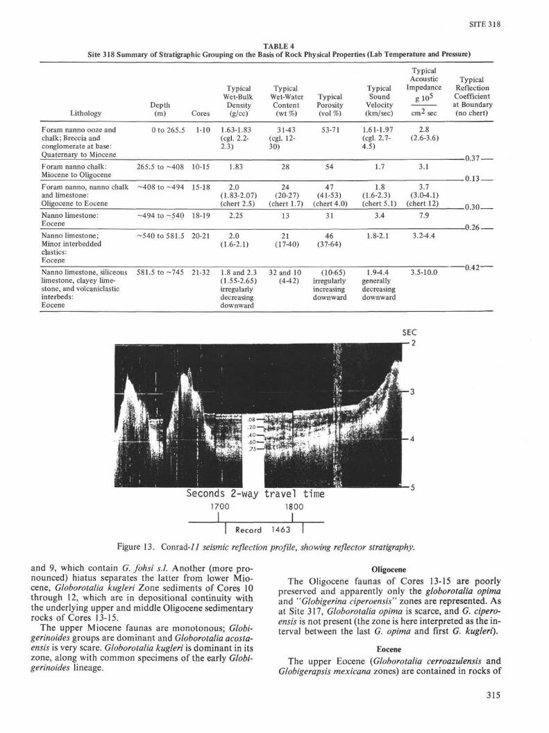
mentary rocks recovered at Site 318 are summarizedinto six stratigraphic groups based primarily on soundvelocity, wet-bulk density, wet-water content, and im-pedance data as shown in Figure 12. The boundaries areindicated by the dashed horizontal lines, and listed inTable 3. This grouping is summarized in Table 4, whichlists the lithology, depth interval, and typical values ofthe characteristic physical properties.
The characteristic physical property intervals at Site318 are as follows: (1) Quaternary to Miocene foram-nanno ooze and chalk from 0 to 265.5 meters below thesea floor; (2) Miocene to Oligocene foram-nanno chalkfrom 265.5 to 408 meters; (3) Oligocene to Eoceneforam-nanno, nanno-chalk and limestone from ~408 to~494 meters; (4) Eocene nanno limestone from ~494 to~540 meters; (5) Eocene nanno limestone with minor in-terbedded elastics from ~540 to 581.5 meters; and (6)Eocene nanno limestone, clayey limestone, silicifiedlimestone, and volcaniclastics from 581.5 to ~745meters. The last three units are rather arbitrary and theycould be possibly lumped. The last unit could also be ar-bitrarily subdivided below 700 or 715 meters.
Interval 1, from 0 to 265.5 meters, has variably lowvelocity wet-bulk density, and impedance with highwater content and porosity. The lower boundary ismarked by conglomerate and breccia with high velocityclasts.
Interval 2, from 265.5 to ~408 meters, has uniformlylow velocity, wet-bulk density, and impedance, and thewet-water content and porosity are high. The lowerboundary is marked by a small but significant increasein velocity, wet-bulk density, and impedance, and a cor-responding decrease in wet-water content and porosity.
The third interval (3) from ~408 to ~494 meters hasfairly uniform parameters, with moderate wet-bulk den-sity and velocity. The lower boundary at 494 meters ismarked by an abrupt change to relatively high velocityand relatively high wet-bulk density limestone from~494 to ~540 meters. However, this fourth (4) interval(~494 to ~540 m) is based only on a few data points andmay not exist in situ as represented here. The lowerboundary of ~540 meters is distinctly marked by asignificant and abrupt decrease in velocity, wet-bulkdensity, and impedance, with a decrease in porosity andwet-water content.
The fifth (5) interval from -540 to 581.5 meters hasmoderate velocity, wet-bulk density, and impedance,probably the result of abundant elastics. Its lowerboundary is marked by an abrupt increase in velocity,wet-bulk density, and impedance, and decreases in wet-water content and porosity.
The sixth and last group from 581.5 to ~745 meters ischaracterized by variably high to low parameters, whichtend to decrease with increasing depth (porosity andwet-water content increase). The contrasting parametersin this interval are the result of interbedding of lime-stone, silicified limestone, clayey limestone, and vol-caniclastics.
Discussion
The reflection coefficients calculated are only typicalof what may be present at the arbitrary boundaries ofmajor groups of physical properties. The few that are
calculated are not any indication of the location ornumber of such impedance mismatches as are present.
Sound velocity has a tendency to be faster parallelrather than perpendicular to bedding. A few negativeanisotropy values were calculated, but it cannot be pre-cluded that these result from error. In general, aniso-tropy in the Quaternary to Eocene sediments and sedi-mentary rock above ~540 meters is very slight (0 to 2%),with an occasional high (6%) anisotropy in a few hardlayers. Below ~540 meters the Eocene limestone andelastics have significantly higher anisotropy of 0 to 20%with 0 to 12% being typical. See Chapter 26, this volume,for more information.
CORRELATION OF REFLECTION PROFILEWITH DRILLING RESULTS
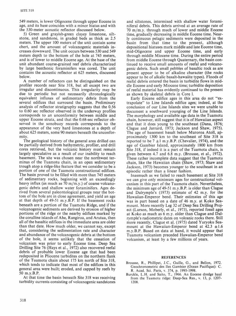
The reflectors in the basin drilled are not regular; theydisplay lateral changes in strength and "thickness"across the basin (Figures 2 and 4). On the Conrad-ll(Figure 13) line, reflectors lie roughly at 0.08, 0.20, 0.40,0.56, and 0.75 sec; on the Glomar Challenger line (Figure7) reflectors could be discerned, after a fashion, at 0.20,0.40, 0.60, and 0.75 sec. The deep reflectors are quitevague and are characterized by wavy and indistinct tops.An underway Sonobuoy was run (Figure 6) and the onlyreally distinct reflector seen lies at 0.68 sec (Figure 14).
Upon drilling, it was found that the upper reflectors(0.08, 0.20, and 0.40 sec) could not be recognized or cor-related with any obvious lithologic breaks. The 0.56-secreflector of the Conrad-ll line and the 0.60-sec reflectorof the Glomar Challenger line may represent an uncon-formity in the section at approximately 530 meters. Us-ing a mean velocity of 1820 m/sec from the mudline to530 meters, a reasonable velocity based on the ship-board data (see Physical Properties section), the two-way travel time to the unconformity should be 0.58 sec,a value that falls between the Conrad-ll and GlomarChallenger 0.56-sec and 0.60-sec reflectors. The 0.68-secreflector, or the 0.75-sec reflector of the Conrad profile(Figure 13), probably represents the shallowest oc-currence of the very hard limestones encountered at ap-proximately 625 to 670 meters depth (Figure 8). Thevelocity of these limestones is quite high; many aregreater than 3 km/sec. If the 0.68-sec reflector lies at adepth of 625 meters, the interval velocity to that depthwould be 1.84 km/sec. Figure 14 is an analysis of theSonobuoy record (see Figure 6 for a photograph of therecord).
PALEONTOLOGY
Biostratigraphic SummarySite 318 was cored intermittently between the mudline
and 745 meters, except for a portion of the middleEocene section (Cores 22 to 27; at depths of 596.5 to653.5 m) which was cored continuously. Nannofossilsare present throughout the cored intervals, providingreliable age control for virtually all of the materialrecovered. Foraminifers are abundant and well pre-served in the middle Miocene through Quaternary, butare generally poorly preserved in the Eocene throughlower Miocene. Radiolarians of sufficient preservation
311
I—»
to
TABLE 3Velocity-Density Parameters, Site 318
Sample(Interval in cm)
2-2,61-633-1, 18-216-6, 85-877-3, 14-187-4, 119-1217-5, 106-1088-1,34-369-1, 106-1089-2, 50-5210-1, 105-10710-1, 115-11710-1, 122-12410-1, 140-14210-3,50-5211-1, 126-12811-3,45-4712-1, 75-7712-2, 11-1313-1, 146-14814-1,41-4315-1, 124-12615-2, 106-10816-1,95-9716-2,77-7916-3. 120-12216, CC17-2,5-1017-2,26-2818-1,92-9418-2,46-4818-2,65-6719-2, 147-14920-1,92-9420-2, 74-7620-3, 77-7920-4, 92-9420-5, 87-8921-2,34-3621-3,84-8621-3, 122-12422-1,98-10022-2,89-9122-3, 82-8422A, 111-11323-2, 37-3923-3, 48-5023-3, 52-5424-1,39-4124-1, 143-14524-2, 124-12624-3,69-7124-4, 78-81
Depth inHole (m)
28.6164.68
158.85182.14184.69186.06207.34236.56237.50265.05265.15265.22265.40267.50293.76295.95321.75322.61350.96378.41407.74409.06435.95437.27439.20439.51465.05465.26492.92493.96494.15523.47549.92551.24552.77554.42555.87579.34581.34581.72597.48598.89600.32602.11607.87609.48609.52615.89616.93618.24619.19620.78
1!Beds
(km/sec)
1.9681.6121.6201.6361.6391.6651.6981.8271.7763.2222.7633.9564.4961.763
1.7861.7291.7091.6831.6941.9831.7541.8611.844
5.0671.9771.6802.2143.6173.1611.8271.9022.1162.0401.8121.7751.9903.5072.7002.6982.7424.1143.1282.8593.2912.6403.2654.2854.2624.380
Compressional Sound Velocity
lBeds
(km/sec)
1.6541.669
1.8391.788
1.6561.6581.8351.7001.7131.6811.6841.9761.7301.7521.7354.997
1.9731.6692.2783.6813.2942.0341.8781.7021.9941.7961.753
3.2332.7572.7832.6963.8353.037
3.093
3.0583.9633.8614.194
AnisotropyII—-L
(km/sec)
-0.015-0.004
-0.012-0.012
-0.049+0.029-0.004+0.002+0.010+0.007+0.024+0.109+0.109
+0.004+0.011-0.064-0.064-0.133-0.207+0.024+0.414+0.046+0.016+0.022
+0.274-0.057-0.085+0.046+0.279+0.091
+0.198
+0.207+0.322+0.401+0.186
(Il-J.) ÷ 1(%)
- 0.91- 0.24
- 0.65- 0.67
- 2.67+ 1.71- 0.23+ 0.12+ 0.59+ 0.35+ 1.39+ 6.22+ 6.28
+ 0.20+ 0.66- 2.81- 1.74- 4.04-10.18+ 1.28+24.32+ 2.31+ 0.89+ 1.25
+ 8.48- 2.07- 3.05+ 1.71+ 7.28+ 3.00
+ 6.40
+ 6.77+ 8.13+ 10.39+ 4.43
Temp.(°C)
23.023.022.022.022.022.022.022.022.024.024.024.024.024.022.024.023.023.023.023.022.023.022.022.023.023.022.022.022.022.022.022.022.022.022.022.022.022.022.022.021.021.021.021.022.022.022.021.021.021.021.021.0
"Special"Wet-BulkDensitya
2-minutecount(g/cc)
IIBeds
1.8291.6681.6311.646
1.818
2.1562.273
1.830
2.502
2.009
1.613
2.209
2.035
l
Beds
1.6741.726
1.7601.726
1.8011.8051.8851.8251.9161.8311.8282.0391.9421.9611.991
2.0701.838
2.3012.2242.1401.9612.0222.0141.9251.904
2.4542.3042.2682.2912.3702.329
2.245
2.3892.4412.3952.424
Wet-Water
ContentSaltCor.(%)
33.1442.6936.23
36.0239.5632.1131.6231.1413.9725.1012.3129.7530.6431.4832.1627.1330.3827.6528.8629.0320.2126.8625.8225.910.351.67
20.5829.0022.8011.1415.5017.4623.5121.3622.6124.6825.8840.18
8.20
11.3612.345.08
12.0315.5810.8514.888.734.444.504.77
Porosityb
(%)
60.6171.2159.09
60.3068.2858.3855.6553.7530.1257.05
56.0756.7058.0551.1455.4452.9852.8453.0641.2152.1650.8251.59
4.1842.6053.3045.8025.6334.4737.3646.1043.1945.5347.5149.2864.8120.12
25.7628.2712.0428.0234.4224.3630.2820.8610.8310.7811.56
AcousticImpedance
g io5
cm2 sec
3.60c2.69C
2.64C
2.69C
2.77C
2.883.09c
3.243.096.95C6.28C
3.23f2.982.993.463.103.283.083.084.033.363.443.45
12.77C
4.083.074.588.477.334.353.683.444.023.453.343.21C
7.936.356.316.189.097.076.32c6.945.37C7.319.679.25
10.17
Lithology
Nanno foram chalk, disturbed lumpNanno foram chalk, disturbed lumpForam nanno firm ooze, disturbed lumpNanno foram firm oozeNanno foram firm oozeNanno foram firm oozeForam nanno chalkForam nanno chalkForam nanno chalkNanno foram limestoneVolcanic brecciaNanno foram limestoneBasalt pebbleForam nanno chalkForam nanno chalkForam nanno chalkForam nanno chalkForam nanno chalkSpicule-rich foram nanno chalkSpicule-rich foram nanno chalkForam nanno chalkForam nanno limestoneForam nanno limestoneForam-rich nanno limestoneForam-rich nanno limestoneChertChertForam-rich nanno limestoneForam-rich nanno limestoneNanno foram-rich volcanic silty sandstoneNanno foram limestoneForam nanno limestoneForam-rich nanno limestoneForam-rich nanno limestoneForam-rich nanno limestoneForam-rich nanno limestoneForam-rich nanno limestoneForam nanno limestoneNanno- foram-rich volcanic siltstoneForam-rich nanno micritic limestoneNanno limestone, laminatedForam-rich nanno limestone, laminatedForam-rich nanno limestone, laminatedMicritic limestone, laminatedForam-rich nanno micritic limestoneNanno foram silty sandstoneNanno micritic limestoneNanno volcanic clayey siltstoneNanno micritic limestoneMicritic limestoneMicritic limestoneMicritic limestone
SITE 318
S S o ouu >>
CN^•σ^•-^>Ol/^fNror-ooooσ^<N'/^vo l•0-HoofNl/•>'^)t—CTN<S( N o o q q N n n o \ o \ i ' i T t ; ' θ N T f r t q N θ N ' - i > t I Λ N I Λ
c^ *"* r̂ • ^J T}* oo f̂ ^o v^ *o c*̂ c*̂ f̂ r~* '~^ CT^ *~̂ f̂ i t̂~• *o t̂ ~ *™̂ ^^
© •w
•a 2
α. as
for age determination are present only in the upperOligocene to upper Miocene, and in a part of the middleEocene section. Sponge spicules dominate the siliceousfraction of the sedimentary rocks. Diatoms and silico-flagellates appear to be absent.
The sediments recovered range in age from Quater-nary to lower Eocene (Zone NP13; approximately 49-51m.y.B.P.). One major unconformity is present betweenCores 9 and 10 (245 to 264 m), and is indicated by theabsence of part of the lower and middle Miocene sec-tion. Another major discontinuity may be present in thebase of Core 15, between mid-Oligocene and upperEocene; and a hiatus, similar or identical to one at Site317, was found between the middle and upper Eocene ofCores 20 and 19, respectively.
Mixed faunal assemblages, which contain specieswhose ranges do not overlap, are characteristic of manyof the samples examined. Middle Eocene radiolarianare commonly reworked into Neogene assemblages.Among the Eocene foraminifers, the presence of A stero-cyclina sp. and a pelagic foraminiferal assemblage show-ing very little dissolution indicates reworking from arelatively shallow source. Thus, reworked debris from ashallower source area (presumably one or more of thenearby Tuamotu edifices) is present within much of thesedimentary material examined at this site.
Foraminifers
A discontinuous and condensed, richly foraminiferalsequence spanning middle Eocene through Quaternarywas cored at Site 318. Foraminifers are abundant andwell preserved in middle Miocene to Quaternary rocks;with a few notable exceptions, they are poorly preservedin Eocene to lower Miocene rocks. In the upper Eocenethrough lower Miocene, poor preservation is a result ofdissolution, while in the middle Eocene preservationdeteriorates downward with increasing lithification(though foraminifers remain common). The faunasthroughout are very similar to those in rocks of similarage at Site 317.
Quaternary
Core 1 is of Quaternary age and contains a typicallow-latitude planktonic fauna, dominated by theGlobigerinoides sacculifer group. Streptochilus tokelauaeis common and extends into the underlying Pliocene andupper Miocene sediments.
Pliocene
Cores 2, 3, and 4 are of Pliocene age and contain atypical Pliocene faunal sequence, including Pulleniatinaspectabilis; the occurrence of this species at Site 318 isthe southernmost yet reported for this areally restrictedspecies.
MioceneThe upper Miocene (Cores 5 and 6) is probably in
depositional continuity with the overlying Pliocene, buta hiatus probably separates the Globorotalia acostaensisZone sediments of Core 6 from the G. menardii Zonesediments of Core 7, which in turn probably discon-formably overlies middle Miocene sediments of Cores 8
313

SITE 318
SITE
DEPTHIN
HOLE
G R A P E WET-BULK DENSITY, g/cc
Special 2-Minute Count
|POROSITY,- %
5 0
"WET" WATER CONTENT% wt
COMPRESSIONAL SOUND VELOCITY® = perpendicular to beds• = parallel to beds
100
200
300
400
500
600
700
800
900
1000
,....,—,.,..,...., ,,...,...,..„
Θ
<Φ
©
©
Θ ©
N _ © _
©©
©
© ^ •
Φ
©
©
COD®©
πfi
fifeW
Φ
Φ©
©
)
tor
©
Φ
©
©
©©
Φ
0
Φ
A
Φ
©
©
©
©
© ©.-
Φ ©
cΦ©
© Φ©© ©
©
A A A /
©
A
áffi
(DA
©AQ<tf) A© A
©4©©&© A
ACOUSTIC IMPEDANCE[g/(cm2 sec)] 105
5 10 15
©
©
©
©
0
©
Φ
ODD
©
Φ
Φ
_£--©©
©Φ©© ©
© ©Φ© ©
I , , , I . I I , . , , ! , . . , I . . . . I I . • • I • I I I I I • . • • I I • • • I • . • . I I • M I H • I I H I • I • • I • I . I I • I I • I I I I I I I I I I I I • I I
*rg = grain density, g/cc
Figure 12. Summary of physical properties at Site 318. GRAPE analog data, both corrected and uncorrected foractual core diameter, are presented at the end of this chapter.
314
SITE 318
TABLE 4Site 318 Summary of Stratigraphic Grouping on the Basis of Rock Physical Properties (Lab Temperature and Pressure)
LithologyDepth
(m) Cores
Typical Typical TypicalWet-Bulk Wet-Water Typical SoundDensity Content Porosity Velocity(g/cc) (wt %) (vol %) (km/sec)
TypicalAcoustic
Impedancegio5
TypicalReflectionCoefficientat Boundary(no chert)
Foram nanno ooze andchalk; Breccia andconglomerate at base:Quaternary to Miocene
0 to 265.5 1-10 1.63-1.83(cgl. 2.2-2.3)
31-43(cgl. 12-30)
53-71 1.61-1.97(cgl. 2.7-4.5)
2.8(2.6-3.6)
*0.37Foram nanno chalk:Miocene to Oligocene
265.5 to -408 10-15 1.83 28 54 1.7 3.1
Foram nanno, nanno chalkand limestone:Oligocene to Eocene
-408 to -494 15-18 2.0(1.83-2.07)(chert 2.5)
24(20-27)
(chert 1.7)
47(41-53)
(chert 4.0)
1.8(1.6-2.3)(chert 5.1)
3.7(3.0-4.1)
(chert 12) ).30-Nanno limestone:Eocene
-494 to -540 18-19 2.25 13 31 3.4 7.9
-o.:Nanno limestone;Minor interbeddedelastics:Eocene
-540 to 581.5 20-21 2.0(1.6-2.1)
21(17-40)
46(37-64)
1.8-2.1 3.2-4.4
-0.42-Nanno limestone, siliceouslimestone, clayey lime-stone, and volcaniclasticinterbeds:Eocene
581.5 to -745 21-32 1.8 and 2.3(1.55-2.65)irregularlydecreasingdownward
32 and 10(4-42)
(10-65)irregularlyincreasingdownward
1.9-4.4generallydecreasingdownward
3.5-10.0
Seconds 2-way travel time1700 1800
1 1Record 1463
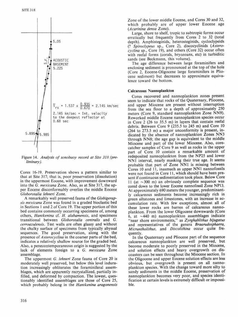
Figure 13. Conrad-ii seismic reflection profile, showing reflector stratigraphy.
and 9, which contain G. fohsi s.l. Another (more pro-nounced) hiatus separates the latter from lower Mio-cene, Globorotalia kugleri Zone sediments of Cores 10through 12, which are in depositional continuity withthe underlying upper and middle Oligocene sedimentaryrocks of Cores 13-15.
The upper Miocene faunas are monotonous; Globi-gerinoides groups are dominant and Globorotalia acosta-ensis is very scare. Globorotalia kugleri is dominant in itszone, along with common specimens of the early Globi-gerinoides lineage.
OligoceneThe Oligocene faunas of Cores 13-15 are poorly
preserved and apparently only the globorotalia opimaand "Globigerina ciperoensis" zones are represented. Asat Site 317, Globorotalia opima is scarce, and G. cipero-ensis is not present (the zone is here interpreted as the in-terval between the last G. opima and first G. kugleri).
EoceneThe upper Eocene (Globorotalia cerroazulensis and
Globigerapsis mexicana zones) are contained in rocks of
315
SITE 318
5.895' 5.985
5.05
ACOUSTICBASEMENT5.225
V r x = 1.537 x 0.935 _0.670 = 2.145 km/sec
2.145 km/sec = Int. velocityto the deepest reflector at0.68 sec
Figure 14. Analysis of Sonobuoy record at Site 318 (pre-liminary).
Cores 16-19. Preservation shows a pattern similar tothat at Site 317; that is, poor preservation (dissolution)in the uppermost Eocene, with improvement downwardinto the G. mexicana Zone. Also, as at Site 317, the up-per Eocene disconformably overlies the middle EoceneGloborotalia lehneri Zone.
A remarkably well preserved fauna of the Globigerap-sis mexicana Zone was found in a graded bioclastic bedin Sections 1 and 2 of Core 19. The upper portion of thisbed contains commonly occurring specimens of, amongothers, Hantkenina cf. H. alabamensis, and specimenstransitional between Globorotalia centralis and G.cerroazulensis. Test walls are often glassy and withoutthe chalky surface of specimens from typically abyssalsequences. The good preservation, along with thepresence of Asterocyclina in the coarser parts of the bed,indicates a relatively shallow source for the graded bed.Also, a penecontemporaneous origin is suggested by thelack of elements foreign to a G. mexicana Zoneassemblage.
The uppermost G. lehneri Zone fauna of Core 20 ismoderately well preserved, but below this level indura-tion increasingly obliterates the foraminiferal assem-blages, which are apparently recrystallized, partially in-filled, and deformed by compaction. The lowest, ques-tionably identified assemblages are those of Core 25,which probably belong in the Hantkenina aragonensis
Zone of the lower middle Eocene, and Cores 30 and 32,which probably are of upper lower Eocene age(Acarinina densa Zone).
Large, shore to shelf, tropic to subtropic forms occurerratically but frequently from Cores 2 to 32 (totaldepth). Amphisteginids, heterosteginids, cycloclypeids(? Spiroclypeus sp., Core 2), discocyclinids {Astero-cyclina sp., Core 19), and others (Core 32) occur oftenwith reefal forms (corals, bryozoans, etc) in turbiditicsands (see Beckmann, this volume).
The age difference between large foraminifers andenclosing sediment is pronounced at the top of the hole(Core 2, Eocene-Oligocene large foraminifers in Plio-cene sediment) but decreases to approximate equiva-lence toward the bottom.
Calcareous NannoplanktonCores recovered and nannoplankton zones present
seem to indicate that rocks of the Quaternary, Pliocene,and upper Miocene are present without interruptionfrom the sea floor to a depth of approximately 250meters (Core 9, standard nannoplankton Zone NN9).Reworked middle Eocene nannoplankton species occurin Core 2 (26 to 35.5 m) in layers that contain reefaldebris. Between Core 9 (235.5 to 245 m) and Core 10(264 to 273.5 m) a major unconformity is present, in-dicated by the absence of nannoplankton Zones NN3through NN8; the age gap is equivalent to the middleMiocene and part of the lower Miocene. Also, core-catcher samples of Core 9 as well as rocks in the upperpart of Core 10 contain a remarkable amount ofredeposited nannoplankton from the NP25 and lowerNN1 interval, nearly masking their true age. It seemsprobable that part of Zone NN1 is missing betweenCores 10 and 11, inasmuch as upper NN1 nannofossilswere not found in Core 11, which should have been pre-sent if continuous sedimentation took place. Below Core11 (at ~300 m) an obviously complete sequence wascored down to the lower Eocene nannofossil Zone NP13.At approximately 690 meters the younger, predominant-ly calcareous sediments become increasingly rich ingreen siltstones and limestones, with an increase in ac-cumulation rate. With few exceptions, almost all ofthese lower rocks are barren of calcareous nanno-plankton. From the lower Oligocene downwards (Core6, at ~440 m) nannoplankton assemblages indicate"near shore environments," as Zyrghablithus bijugatusand representatives of the genera Braarudosphaera,Micrantholithus, and Discolithina occur quite fre-quently.
In the Quaternary and Pliocene part of the sequencecalcareous nannoplankton are well preserved, butbecome moderate to poorly preserved in the Miocene,and solution effects and heavy overgrowth on dis-coasters can be seen throughout the Miocene section. Inthe Oligocene and upper Eocene solution effects are lessobvious, but overgrowth is present on all nanno-plankton species. With the change toward more silty tosandy sediments in the middle Eocene, preservation ofnannoplankton becomes very poor, and species identi-fication at certain levels is extremely difficult or impossi-ble.
316

SITE 318
RadiolariansRadiolarians of sufficient abundance and preserva-
tion for age determination are present in only two inter-vals of the sedimentary column cored at Site 318. Theupper Miocene through upper Oligocene (Cores 5through 13; which range in depth from 131 through 359m) have a siliceous assemblage dominated by spongespicules, but contain a sufficient number of diagnosticradiolarians for reliable age control. The middle EoceneThyrsocyrtis triacantha Zone is represented in a moder-ately to poorly preserved radiolarian assemblage inCores 22 through 25 (depth range 606 to 635 m). The re-mainder of the cored intervals are barren of radio-larians.
Within the radiolarian-bearing intervals, the follow-ing standard radiolarian zones can be recognized: Core5 (121.5 to 131.0 m) is in the Stichocorys peregrina Zone.Core 6 (150.0 to 157.5 m) is in the Ommatartuspenultimus Zone. Core 7 (178.5 to 188.0 m) is in the Om-matartus antepenultimus Zone. Cores 8 and 9 (207.0 to245.0 m) are in the Calocycletta costata Zone. Cores 10and 11 (264.0 to 302.0 m) are in the Calocycletta virginisZone. Core 12 (321.0 to 330.5 m) is in the Lychnocanomaelongata Zone. Core 13 (349.5 to 359.0 m) is in the upperDorcadospyris ateuchus Zone. Cores 14 through 21 arebarren of radiolarians, or contain only unidentifiablefragments. Cores 22 through 25 (596.5 to 634.5 m) are inthe Thyrsocyrtis triacantha Zone. Radiolarians are ab-sent below Core 25.
Reworked radiolarians of middle Eocene age are rareto common in virtually the entire Neogene section(Cores 5 through 13). The physiographic setting of thissite is favorable for the accumulation of erosionalproducts from nearby Tuamotu edifices; thus, the exten-sive reworking of radiolarian debris is not surprising.
ACCUMULATION RATESAs shown in Figure 15, sedimentation rates at Site 318
have been high during the past 50 m.y. Situated in atrough atop a volcanic ridge and surrounded by atolls,the site has been receiving carbonate sediments of bothpelagic and reefal origin as well as abundant volcani-clastic debris of clay to pebble size. Thus the high ratesare not necessarily indicative of high productivity ofplankton in the water column; turbidites are a majorcomponent of the section. From early to middle Eocenetime the accumulation rate was approximately 65 to 70m/m.y.; abundant reefal and volcanic material marksthis part of the section. For the remainder of Eocenetime the rate slowed to approximately 25 m/m.y.Through Oligocene time the rate further slowed to 12m/m.y. as pelagic sedimentation dominated. After for-mation of the early-middle Miocene unconformity, therate increased from about 13 to 25 m/m.y., marked by aheavy influx of reefal and volcanic material.
SUMMARY AND CONCLUSIONSSite 318 was drilled very close to its preplanned loca-
tion along the Conrad-W track, in 2659 meters of water.One hole was drilled to a depth of 745 meters; nearly 300meters were cored, with an average core recovery ofmore than 49%. It was hoped that the lowest reflector
U. M. L. U. M. L. U. M. L. U. L.
10 20 30 40 50 60 70 . 80
Figure 15. Graphic log showing age and rate of sedimentaccumulation at Site 318.
observed on both the Conrad-11 and our own acousticprofiles, which lay at predrilling estimated depthsbetween 650 and 700 meters, was basalt basement. Wereached depths exceeding our original estimates, but didnot succeed in penetrating or sampling basalt basementrocks at the site, although we used all of our remainingleg time in attempting to do so.
The geologic column drilled at the Tuamotu Ridgesite was divided into five lithologic units:
1) Nannofossil-foraminifer ooze that contains somegraded beds of shallow water skeletal debris made up offoraminifera, bryozoans, corals, echinoids, and mol-lusks, and altered volcanogenic material. This unit ex-tends from 0 to between 35.5 and 64.5 meters, and is ofQuaternary to upper Pliocene age; large foraminifers ofEocene to Oligocene(?) age are present as redepositedfaunal elements.
2) Foraminifer and nannofossil firm ooze, changingdownward to soft chalk that contains a few graded bedsof sand-sized material of volcanogenic origin. The unitextends from depths of between 35.5 and 64.5 to be-tween 245 and 264 meters, and is late Pliocene to middleMiocene in age. It is separated from Unit 3 by a middle-lower Miocene hiatus between Cores 9 and 10.
3) Foraminifer-nannofossil, yellowish-gray chalk,that contains a breccia bed with pebbles of basalt, chert,and shallow water skeletal debris of reef and near-reeforigin. This unit extends from depths of between 245and 264 meters to between 416 and 435 meters. The unitis of lower Miocene to lower Oligocene age.
4) Nannofossil and foraminifer limestone, generallyyellowish-gray to pale green in color, with abundantchert nodules and lenses that include some volcanogenicdebris. The base of the unit is a coarse, pebbly sand con-taining abundant shallow water skeletal debris. The unitoccurs between 416 and 435 meters to between 530 and
317
SITE 318
549 meters, is lower Oligocene through upper Eocene inage, and its base coincides with a minor hiatus and withthe 530-meter acoustic reflector discussed below.
5) Green and grayish-green clayey limestone, silt-stone, and sandstone, in graded beds as thick as 2.5meters. The upper 100 meters of the unit contain somechert, and the amount of volcanogenic materials in-creases downward. The unit occurs between 530 and 549meters depth to the bottom of the hole at 745 meters,and is of lower to middle Eocene age. At the base of theunit abundant coarse-grained reef debris characterizedby large benthonic foraminifers was cored. The unitcontains the acoustic reflector at 625 meters, discussedbelow.
A number of reflectors can be distinguished on theprofiler records near Site 318, but all except two areirregular and discontinuous. This irregularity may bedue to periodic but not necessarily chronologicallyequivalent influxes of sedimentary debris from theseveral edifices that surround the basin. Preliminaryanalysis of reflector stratigraphy suggests that the 0.56to 0.60 sec reflector observed in the underway profilescorresponds to an unconformity between middle andupper Eocene strata, and that the 0.68-sec reflector ob-served in the Sonobuoy records corresponds to theappearance of the very hard limestones at a depth ofabout 625 meters, some 90 meters beneath the unconfor-mity.
The geological history of the general area drilled canbe partially derived from bathymetric, profiler, and drillcores retrieved, but the volcanic history must remainlargely speculative as a result of our inability to reachbasement. The site was chosen near the northwest ter-minus of the Tuamotu chain, in an open sedimentarytrough atop a ridge-like feature that we consider to be aportion of one of the Tuamotu constructional edifices.The basin proved to be filled with more than 745 metersof sedimentary rocks, beginning with an exceedinglyheavy influx (as much as 70 m/m.y.) of coarse volcano-genic debris and shallow water foraminifers. Ages de-rived from several paleontological groups near the bot-tom of the hole are in close agreement, and yield an ageat that depth of 49-51 m.y.B.P. If the basement rocksbeneath are a portion of the Tuamotu Ridge, and if thevolcanogenic sediments are derived by erosion of higherportions of the ridge or the nearby edifices marked bythe coralline islands of Ahe, Rangiroa, and Arutua, thenall of the basaltic edifices in the immediate area are olderthan that date. How much older, we cannot say, exceptthat, considering the sedimentation rate and characterand abundance of the volcanogenic debris at the bottomof the hole, it seems unlikely that the cessation ofvolcanism was prior to early Eocene time. Deep SeaDrilling Site 76 (Hays et al., 1972) also recovered reefaldebris of probable lower Eocene age that had beenredeposited in Pliocene turbidites on the northern flankof the Tuamotu chain about 175 km north of Site 318,which tends to indicate that most of the edifices in thisgeneral area were built; eroded, and capped by reefs by50 m.y.B.P.
At that time the basin beneath Site 318 was receivingturbidity currents consisting of volcanogenic sandstones
and siltstones, intermixed with shallow water forami-niferal debris. This debris arrived at an average rate of70 m/m.y. through much of lower and middle Eocenetime, gradually decreasing in middle Eocene time. Near-ly continuous pelagic sediments were deposited in thebasin from that time to the present, althoughdepositional hiatuses mark middle and late Eocene time,mid-Oligocene and upper Eocene time, and earlythrough middle Miocene time. During the entire periodfrom middle Eocene through Quaternary, the basin con-tinued to receive small amounts of reefal and volcano-genic debris. Such small pebbles of basaltic rock as arepresent appear to be of alkaline character (the rocksappear to be of alkalic basalt-hawaiite types). Floods ofreefal debris entered the basin in turbidite flows in mid-dle Eocene and early Miocene time; turbidite depositionof reefal material has evidently continued to the presentas shown by skeletal debris in Core 1.
Early Eocene edifice ages in this area do not "ex-trapolate" to Line Islands edifice ages; indeed, at theconclusion of our Line Islands sites we were unable todocument a southward younging of the Line Islands.The morphology and available age data in the Tuamotuchain, however, still suggest that it is of Hawaiian aspectand that it does young to the southeast (Dana, 1876;Clague and Jarrard, 1973; Jackson and Shaw, 1975).The age of basement basalt below Muroroa Atoll, ap-proximately 1300 km to the southeast of Site 318 isreported to be 7 ±1 m.y.B.P. (Chevalier, 1974), and theage of Gambier Island, approximately 1800 km fromSite 318, if indeed it is a part of the Tuamotu chain, isgiven between 4.7 and 6.8 m.y. (Brousse, et al., 1972).These rather incomplete data suggest that the Tuamotuchain, like the Hawaiian chain (Shaw, 1973; Shaw andJackson, 1973) becomes younger to the southeast in anepisodic rather than a linear fashion.
Inasmuch as we failed to reach basement at Site 318we can give only minimum ages for constructional vol-canism in this part of the Tuamotu chain. Nevertheless,the minimum age of 49-51 m.y.B.P. is older than Clagueand Dalrymple's (1973) estimate of 42 m.y. for theHawaiian-Emperor bend. Their estimates of this agewas in part based on a date of 46 m.y. at Koko Sea-mount. More recently Leg 32 of Deep Sea Drilling Proj-ect (Larson, Moberly, et al., 1973), reported fossil agesat Koko as much as 6 m.y. older than Clague and Dal-rymple's radiometric dates on volcanic rocks there. Stillmore recently, Clague et al. (1975) dated Yuryoku Sea-mount at the Hawaiian-Emperor bend at 42.3 ±1.6m.y.B.P. Based on data at hand, it would appear thatTuamotu volcanism preceded Hawaiian-Emperor bendvolcanism, at least by a few millions of years.
REFERENCESBrousse, R., Phillipet, J.C., Guille, G., and Bellon, 1972.
Geochronometric des lies Gambier (Ocean Pacifique): C.R. Acad. Sci. Paris, v. 374, p. 1995-1998.
Burckle, L.H. and Saito, T., 1966. An Eocene dredge haulfrom the Tuamotu ridge: Deep-Sea Res., v. 13, p. 1207-1208.
318

SITE 318
Chevallier, J.P., 1973. Geomorphology and geology of coralreefs in French Polynesia. In Jones, O.A. and Endean, R.(Eds.), Biology and geology of coral reefs: New York(Academic Press), v. 1, p. 113-141.
Clague, D.A. and Dalrymple, G.B., 1973. Age of Kδkoseamount, Emperor seamount chain: Earth Planet. Sci.Lett., v. 12, p. 411-415.
Clague, D.A. and Jarrard, R.D., 1973. Tertiary Pacific platemotion deduced from the Hawaiian-Emperor chain: Geol.Soc. Am. Bull., v. 84, p. 1135-1154.
Clague, D.A., Dalyrmple, G.B., and Moberly, R., 1975.Petrography and K-Ar ages of dredged volcanic rocks fromthe western Hawaiian Ridge and the southern Emperorseamount chain: Geol. Soc. Am. Bull., v. 86, p. 991-998.
Dana, J.D., 1876. Manual of geology (second ed.: New York(Ivison, Blakeman, Taylor and Co.).
Dunham, R.J., 1962. Classification of carbonate rocks ac-cording to depositional texture: Am. Assoc. Petrol. Geol.Mem. 1, p. 108-121.
Hays, J.D. et al., 1972. Initial Reports of the Deep Sea DrillingProject, Volume 9: Washington (U.S. Government Print-ing Office).
Jackson, E.D. and Shaw, H.R., 1975. Stress fields in the cen-tral portions of the Pacific plate: delineated in time bylinear volcanic chains: J. Geophys. Res., v. 80, p. 1861-1874.
Larson, R.L., Moberly, R. et al., 1973. Leg 32, Deep Sea Drill-ing Project, Geotimes, v. 18, p. 14-17.
Mammerickx, J., Smith, S.M., Taylor, I.L., and Chase, T.E.,1973. Bathymetry of the South Pacific, Chart No. 13:Scripps Inst. Oceanog. IMR Tech. Rept. 46A.
Morgan, W.J., 1971. Convection plumes in the lower mantle:Nature, v. 230, p. 42-43.
Morgan, W.J., 1972. Plate motions and deep mantle convec-tion: Geol. Soc. Am. Mem., v. 132, p. 7-22.
Shaw, H.R., 1973. Mantle convection and volcanic periodicityin the Pacific: evidence from Hawaii: Geol. Soc. Am.Bull., v. 84, p. 1505-1526.
Shaw, H.R. and Jackson, E.D., 1973. Linear island chains inthe Pacific: result of thermal plumes on gravitationalanchors?: J. Geophys, Res., v. 78, p. 8634-8652.
Repelin, J., 1919. Sur un point de 1'histoire de 1'ocean Paci-fique: C.R. Acad. Sci. Paris, v. 168, p. 237-239.
319

too
S i t e
AGE
>.
ERNAR
1
318
ZONE
-—
g.
3 ,_
°- o
s
FORAM
Hoi E
FOSSIL
CHARACTER
1 FOSSIL
N
N
N
F
1 ABUND.
A
A
A
A
1 PRES.
G
G
G
G
Core
SECTIt
0
1
2
3
4
5
METER!
;
0 ^
I1 . 0 -
:
i—
-
-
-
-_
—
z
_
-
z
-~-
Z
CoreCatcher
Cored I
LITH0L0GY
l _ ' _ i '―~'— | ~ H |~—<— — 1 — —
~ l —j -
* ~ ~~1—, ~*"~
<— — 1 — — 1 —
*~l~t~i ~
* — . — * — 1 ~ ^ ~
*— — i — —>—
i l i
—*— * i "^ H 1— -~ l ~ ~ 1 |"~l~~
< — j — < — 1 ~ + 7^— - H — —*—
* 1 | _< — . — < — 1 ~ + ~
- I — — 1 — -–t—1 [ — ) ——'— | — < — , . "
— 1 — — I — ~
' ! ' | I•t~j~1—|—*~
1— —•)— — h -
^― ' — t — | — * -
^ ~ , — * | '
•t— — 1 — —*—
"(— —*— —t—[~1 | ~ 1 |~
— 1 — — 1 — , ~
l~t~|~l~|"
' voirj
-t— — 1 — — 4 -
- 1 — — 1 — — 4 -
| — ) — l — * — { -. — —. —'—, ̂
n e r v a l :
o
DEFORMAT,
11
u
LITHO.SAI
90
140
79
CC
CF
0.0-7.5 m
LITHOLOGIC DESCRIPTION
Very pale orange (10YR 8/2 to10YR 8/4) NANNOFOSSIL FORAM OOZE.Has texture of f i r m l y packed sand.
10YR 8/4 Darker mottles of moderate yellowishbrown (10YR 5/4) NANNO FORAM OOZEat 2.16 and 2.90 m and a layer ofdark yellowish orange (10YR 6/4)NANNO FORAM OOZE, from 3.23 to 4.05m.
A graded foram sand u n i t has i t s10YR 8/3 base at 3.23 m, possibly extending
through section 2; another gradedu n i t begins near 4.5 m and probably
*• 10YR 5/4 extends through the dark-coloredlayer to 3.23 m. Another contactbetween coarser foram sand above
10YR 8/3 and f i n e r sand below occurs at6.44 m.
-«- 10YR 5/4
Smear Slides:1OYR 8/3 Forams D
Nannos C10YR 6/4 Bryozoans R
Mollusks RZeolites RFe-Specks R 2-10µmRadiolarian
10YR 8/3 fragments V. RareVole. Glass
fragments R. I . >l.57
1OYR 8/2 Coarse Fraction >177µm:Forams D
Other constituents include bryozoans,mollusks, zeol i te prisms, o l i v i n e(ore g r a i n ) ; possible milky whitechert fragments; i n t e r i o r walls offoram tests have coarse prismatic
forat ions sometimes f i l l e d withpyr1te(?).
10YR 8/2
10YR 7/3 GRAIN SIZE(3-0 cm): 75.1 Sand
16.9 Si l t8.1 Clay
10YR 8/2 (3-21 cm): 79.7 Sand12.9 Si lt
7.4 Clay
Site
1 AGE
ERI
o
5Q - 2
318
ZONE
limbat
0
Hole
FOSSILCHARACTER
| FOSSIL |
N
N
N
FNR
ABUND. |
A
A
AA
PRES. |
Λ
G
G
GG
Core
|
SECTIC
0
1
2
METER!
:
—
0.5 —
_
1 . 0 -
z-
z—
--
Core
Catcher
Z Cored I
LITHOLOGY
VOID
-' —' -_ — 1 — µT~* , ~ 1 |
^ - ^ -~ —*— —*—- — I — — t —
| j
— * — | ~ l j ~
~~ ) ~l" f ~l~
_ ' l~*~l~
^ ^ -^~ l —) _
^ ~ 1 1 ~ 1
~.—•—, —'—
πter
o
1 DEF0RMAT1
v a l :
α!
klTHO.SAI
6782
26.0-35.5 m
LITHOLOGIC DESCRIPTION
Very pale orange (10YR 8/2) NANNOFORAM OOZE and SHELLY FORAM OOZE,consist ing of graded layers con-ta in ing abundant granule-sized
10YR 8/1 to 10YR 8/2 calcareous algae, echinoids, andmollusks. Small pebbles of nanno-
Eocene age at 2.36 and 2.49 m.
Interbedded wi th white (N9) andgrayish orange (10YR 7/3) nannoforam s o f t chalk and f i r m ooze,preserved as " b i s c u i t s " fragmented
10YR 7/3 during d r i l l i n g .•MQ
— ' " „ , , Smear Slides:— ' " ' lù (2-82 cm) Pebble of zeol i t ic-c laystone;— m a y represent altered volcanic sand-
10YR 8/2 stone; also present are:
N9 Forams RNannos RFe-Specks RZeoli te AClay A
(2-67 cm):Forams ANannos DMicr i te CFe-Specks R
Core catcher >420µm:Fragments of :
Large ForamsBryozoansProbable CoralHalimeda (?)Mollusks (pink
and white)Echinoid Spines
(Pink)
Explanatory notes in Chapter 1
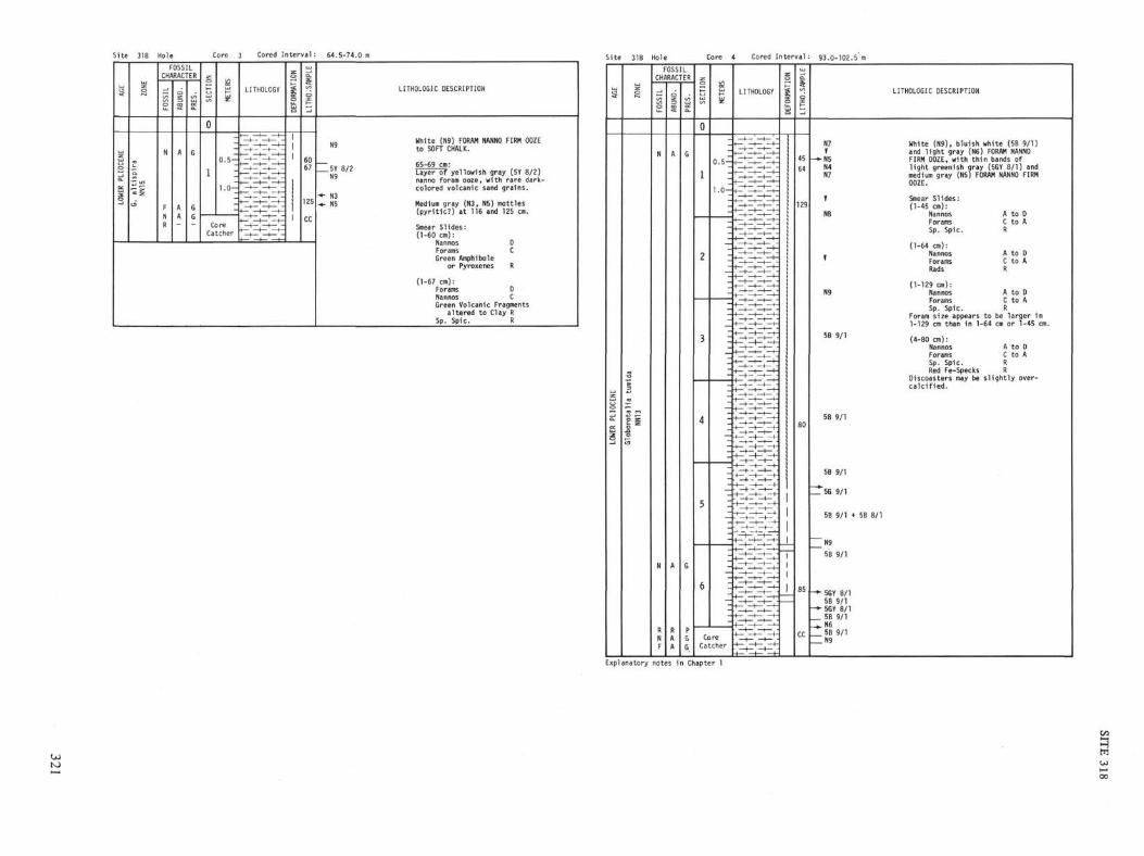
Site 318 Hole Core 3 Cored Interv
AGE
LOWER PLIOCENE
ZONE
G. altispira
NN15
FOSSIL |S |
N
F
N
R
OSSRAC
1
A
A
A
LER
G
G
G
SECT
ION
1
0
1
Cc
CaMETERS
0.5 —
1.0-
recher
LITHOLOGY
—t— |—1— t -
DEFORMATION
|
LITHO.SAMPLE |
60
67
125
CC
LITHOLOGIC DESCRIPTION
White (N9) FORAM NANNO FIRM OOZEN S to SOFT CHALK.
—c v a /
, 65-69 cm:— ?1 *'
£ Layer of yellowish gray (5Y 8/2)
nanno foram ooze, with rare dark-colored volcanic sand grains.
•*• N3-*. N5 Medium gray (N3, N5) mottles
(pyritic?) at 116 and 125 cm.
Smear Slides:(1-60 cm):
Nannos DForams CGreen Amphibole
or Pyroxenes R
(1-67 cm):Forams DNannos CGreen Volcanic Fragments
altered to Clay RSp. Spic. R
Site
S
ENE
R PLIOC
LOWE
318
o
a tumida
orotali
NN13
5
Hole
FOSSILCHARACTER
_i
FOSS
N
N
RNF
1
A
A
RAA
| PRES
G
G
PG
6
Core
CTIC
IΛ
0
1
2
3
4
5
6
0.5-
;
:
;
z
1 1 1
1 M
1 1
1 1 1
1 1
Mill
=
z
-I
z
-_
CoreCatcher
\ Cored I
LITHOLOGY
H— | —–'—, —*—
^ ^
• ^^ ^
•+z+z+z+z*:
| -r| •
:Y
—+ -―i— •
-f- — —h
- —1— —1— •
~^ ̂ ̂
er
o
MAT
DEFOR
val:
5
LITHC
45
64
129
80
85
CC
93.0-102.5 m
LITHOLOGIC DESCRIPTION
N7 White (N9), bluish white (5B 9/1)* and light gray (N6) FORAM NANNO
—»-N5 FIRM OOZE, with thin bands ofN4 light greenish gray (5GY 8/1) andN7 medium gray (N5) FORAM NANNO FIRM
OOZE.
1 Smear Slides:(1-45 cm):
N8 Nannos A to 0Forams C to ASp. Spic. R
(1-64 cm):. Nannos A to D' Forams C to A
Rads R
(1-129 cm):N9 Nannos A to D
Forams C to ASp. Spic. R
Foram size appears to be larger in1-129 cm than in 1-64 cm or 1-45 cm.
5 B 9 / 1 (4-80 cm):
Nannos A to DForams C to ASp. Spic. RRed Fe-Specks R
Discoasters may be slightly over-calcified.
5B 9/1
5B 9/1
ZTδG 9/1
5B 9/1 + 5B 8/1
N9
5B 9/1
-*- 5GY 8/15B 9/1
• - 5GY 8/15B 9/1
— ^ N65B 9/1
Explanatory notes in Chapter 1
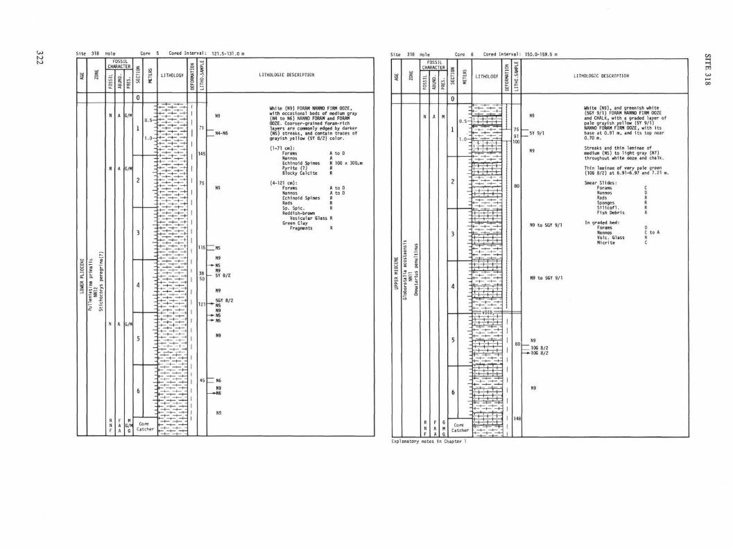
Core 5 Cored Interval: 121.5-131.0 Site 318 Hole Core 6 Cored Interval: 150.0-159.5 m
LITHOLOGIC DESCRIPTION LITHOLOGIC DESCRIPTION
White (N9), and greenish white(5GY 9/1) FORAM NANNO FIRM OOZEand CHALK, with a graded layer ofpale grayish yellow (5Y 9/1)NANNO FORAM FIRM OOZE, with itsbase at 0.91 m, and its top near0.70 m.
White (N9) FORAM NANNO FIRM OOZE,with occasional beds of medium gray(N4 to N6) NANNO FORAM and FORAMOOZE. Coarser-grained foram-richlayers are commonly edged by darker(N5) streaks, and contain traces ofgrayish yellow (5Y 8/2) color.
(1-71 cm):ForamsNannosEchinoid SpinesPyrite (?)Blocky Calcite
Streaks and thin laminae ofmedium (N5) to light gray (N7)throughout white ooze and chalk.
Thin laminae of very pale green(10G 8/2) at 6.91-6.97 and 7.21 m
(4-121 cm):ForamsNannosEchinoid SpinesRadsSp. Sp1c.Reddish-brown
Vesicular Glass RGreen Clay
Fragments R
Smear Slides:ForamsNannosRadsSpongesSilicofl.Fish Debris
In graded bed:ForamsNannosVole. GlassMicrite
GO
H
w
Explanatory notes in Chapter 1
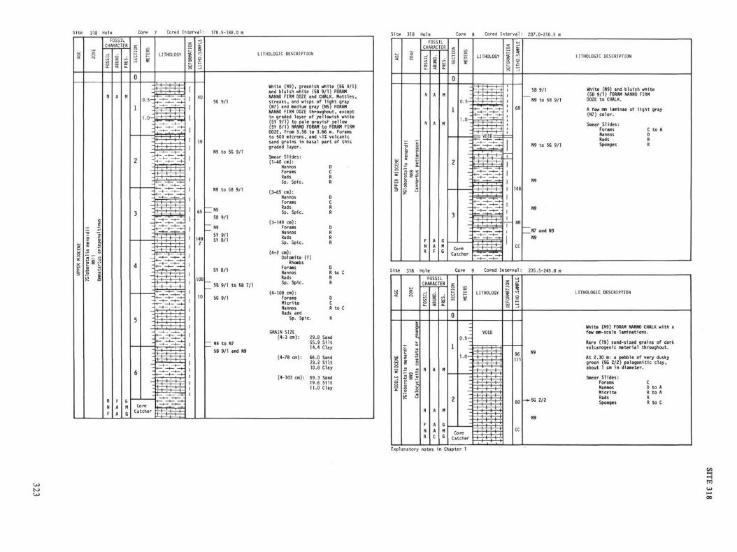
Site 318 Hole Core 7 Cored Interval : 178.5-188.0 m
LITHOLOGIC DESCRIPTION
5G 9/1
N9 to 5G 9/1
White (N9), greenish white (5G 9/1)and bluish white (5B 9/1) FORAMNANNO FIRM OOZE and CHALK. Mottles,streaks, and wisps of light gray(N7) and medium gray (N5) FORAMNANNO FIRM OOZE throughout, exceptin graded layer of yellowish white(5Y 9/1) to pale grayish yellow(5Y 8/1) NANNO FORAM to FORAM FIRMOOZE, from 5.58 to 3.66 m. Foramsto 500 microns, and -vl% volcanicsand grains in basal part of thisgraded layer.
N9 to 5B 9/1
N55B 9/1
N95Y 9/15Y 8/1
5Y 8/1
5B 9/1 to 5B 7/1
5G 9/1
N4 to N7
5B 9/1 and N9
Smear Slides:(1-40 cm):
NannosForamsRadsSp. Spic.
(3-65 cm):NannosForamsRadsSp. Spic.
(3-149 cm):ForamsNannosRadsSp. Spic.
(4-2 cm):Dolomite (
RhombsForamsNannosRadsSp. Spic.
(4-108 cm):ForamsMicriteNannosRads and
DCRR
DCRR
DRRR
:?)
DR to CRR
DCR to C
Sp. Spic. R
GRAIN SIZE(4-3 cm):
(4-78 cm):
(4-103 cm):
29.8 Sand55.9 Silt14.4 Clay
66.0 Sand23.2 Silt10.8 Clay
69.3 Sand19.6 S1lt11.0 Clay
Site 318 Hole Core 8 Cored Interval : 207.0-216.5 m
LITHOLOGIC DESCRIPTION
5B 9/1
~N9 to 5B 9/1
N9 to 5G 9/1
White (N9) and bluish white(5B 9/1) FORAM NANNO FIRMOOZE to CHALK.
A few mm laminae of light gray(N7) color.
Smear Slides:Forams C to ANannos DRads RSponges R
N9
_N7 and N9N9
Site 318 Hole Core 9 Cored Interval: 235.5-245.0 m
LITHOLOGIC DESCRIPTION
White (N9) FORAM NANNO CHALK with afew mm-scale laminations.
Rare (1%) sand-sized grains of darkvolcanogenic material throughout.
At 2.30 m: a pebble of very duskygreen (5G 2/2) palagonitic clay,about 1 cm in diameter.
-56 2/2
Smear Slides:ForamsNannosMicriteRadsSponges
CDRRR
to Ato A
to C
Explanatory notes in Chapter 1
Hm

toSite 318 Hole Core 10 Cored Interval: 264.0-273.5 m Site 318 Hole Core 11 Cored Interval : 292.5-302.0 m
LITHOLOGIC DESCRIPTION
5Y 9/15Y 2/45Y 7/2
5Y 7/2
Yellowish gray (5Y 7/2) FORAM NANNOCHALK, preserved as "biscuits"separated by intervals of drillingpaste. The chalk "biscuits" areshattered by fractures Induced bythe coring process.
From 1.1 to 1.5 m are pieces of:A. BRECCIA, consisting of angular
fragments of various VOLCANICROCKS to 1 cm diam., mainly inshades of very dusky red (5R 2/4,10R 2/2, etc.), vesicular, altered;SHELLY FORAM LIMESTONE, 1n shadesof yellowish gray (5Y 7/2) anddusky yellow (5Y 6/4); and SKELETALDEBRIS, up to 5 mm. About 50% vol-canic, 40% sedimentary, and 10%shell debris. In T.S., scoriafragments, with plagiociase X'ls,palagonite, large benthonic forams,gastropod (?).
B. BASALT, as rounded cm-size pebbles.Thin sections of 2 of these asfollows:1. Plagiociase augite phyric, fine-
grained, sparsely vesicularbasalt with fine, ilmenite-rich,glassy groundmass; intersertaltexture. Est. mode: vesicles(partly filled), 5%; plagiociasephenocrysts, 15%; augite phen.,5%; replaced augite phen., <5%;groundmass plagiociase, 25%;groundmass augite, 20%, groundmassglass (altered), 25%, groundmassilmenite. 5%.
2. Vesicular vitrophyric basalt.Est. mode: vesicles (•̂2 mm),partly filled, 30%; groundmassplagiociase, 25%; groundmasspyroxene, 15%; groundmass glass(altered), 25%; groundmassnmenite, 5%.
LITHOLOGIC DESCRIPTION
Pale yellowish gray (5Y 8/1) FORAMNANNO CHALK, mottled sparsely withpale gray (N8) and light olive gray(5Y 5/1) small (1-5 mm) burrows.
At 2.8 m, a 5-cm layer of white (N9)FORAM NANNO CHALK, with light gray(N6) mottles. Darker material concen-trated at upper and lower contacts.
At 3.3 m, a 5-cm layer of yellowishwhite (5Y 9/1) NANNO FORAM CHALK,with dark-colored (volcanic) grainsmaking up -v-1% of the rock.
At 8.7 to 8.8 m, dark-coloredvolcanic sand grains constitutei.l% of chalk.
Chalk present as "biscuits",internally fractured by the coringprocess, and separated by a drillingpaste.
Smear Slides:(1-25 cm):
NannosForamsRadsSp. Spic.Silicofl.
(core catcher):ForamsNannosRadsSp. Spic.
DR to CRRR
A to DC to ARR
Explanatory notes in Chapter 1
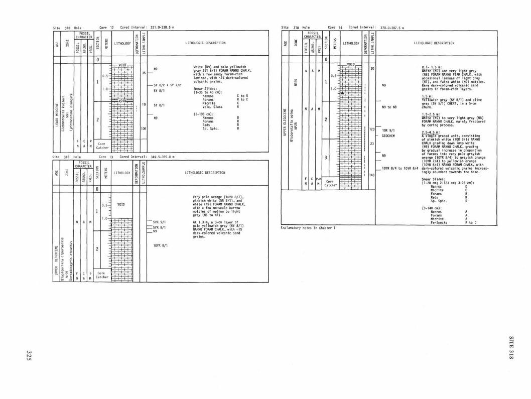
Site 318 Hole Core 12 Cored I n t e r v a l : 321.0-330.5 m Site 318 Hole Core 14 Cored Interval: 378.0-387.5 m
LITHOLOGIC DESCRIPTION
White (N9) and pale yellowishgray (5Y 8/1) FORAM NANNO CHALK,with a few sandy foram-richlaminae, with ->-l% dark-coloredvolcanic grains.
5Y 8/2 + 5Y 7/2
5Y 8/1
5Y 8/1
N9
Smear Slides:(1-35 to 40 cm):
NannosForamsMicriteVole. Glass
(2-108 cm):NannosForamsRadsSp. Spic.
C to AR to CCR
DRRR
Site 318 Hole Core 13 Cored Interval: 349.5-359.0 m
LITHOLOGIC DESCRIPTION
' 5YR 9/1
I5YR 8/1
10YR 8/1
Very pale orange (10YR 8/1),pinkish white (5R 9/1), andwhite (N9) FORAM NANNO CHALK,with a few mm-scale burrowmottles of medium to lightgray (N5 to N7).
At 1.3 m, a 3-cm layer ofpale yellowish gray (5Y 8/1)NANNO FORAM CHALK, with Λ-Udark-colored volcanic sandgrains.
LITHOLOGIC DESCRIPTION
0 . 1 - 1.5 m:White (N9) and very l ight gray(N8) FORAM NANNO FIRM CHALK, withoccasional laminae of l ight gray(N7), and f a i n t white (N9) mottles.Rare dark-colored volcanic sandgrains in foram-rich layers.
1.5 m:YiTTöwish gray (5Y 8/1) and olivegray (5Y 5/1) CHERT, in a 5-cmchunk.
1.5-2.5 m:White (N9) to very light gray (N8)FORAM NANNO CHALK, mainly fracturedby coring process.
10R 9/1GEOCHEM
2.5-4.5 m:A single graded unit, consistingof pinkish white (TOR 9/1) NANNOCHALK grading down into white(N9) FORAM NANNO CHALK, gradingby gradual Increase in proportionof forams into very pale grayishorange (10YR 8/4) to grayish orange(10YR 7/4) to yellowish orange(10YR 6/4) NANNO FORAM CHALK, with
10YR 8/4 to 10YR 6/4 dark-colored volcanic grains increas-ingly abundant towards the base.
N9
Smear Slides:(1-20 cm; 2-123 cm;
NannosMicriteForamsRadsSp. Spic.
(3-140 cm):NannosForamsMicriteFe-Specks
3-23 cm):DCRRR
AAAR to C
Explanatory notes in Chapter 1

Site 318 Hole Core 15 Cored Interval: 406.5-416.0 m Site 318 Hole Core 16 Cored Interval: 435.0-444.5 m
LITHOLOGIC DESCRIPTION
5Y 8/1 and 5Y 6/2
5Y 8/1
5Y 7/2
5Y 8/2
Pale yellowish gray (5Y 8/1, 5Y 8/2)FORAM NANNO HARD CHALK, with mm-scalemottles of light olive gray (5Y 6/1,5Y 5/2) and laminae of light olivegray (5Y 5/2).
0.4-0.6 m:White (N9) NANNO FORAM CHALK, withlaminae of pale orange (10YR 8/3)FORAM CHALK, with rare volcanic sandgrains.
At 2.2 m:A 3-cm chunk of moderate yellowishbrown (10YR 5/4) CHERT.
Smear Slides:(1-55 cm):
NannosForamsMicrite
Foram perforationsfe-specks.
(2-137 cm):NannosFe-SpecksForams
AAA
f i l l e d with red
DR to CR
LITHOLOGIC DESCRIPTION
N9 and N8, N7, N6
N6
5Y 8/1 and N6
5Y 8/1 and N8
5G 9/1
JOGY 8/1
10YR 4/2
0.9-2.1 m:Pale yellowish gray (5Y 8/1) NANNO-FOSSIL and FORAM NANNO LIMESTONE,extensively burrowed and mottledby light olive gray (5Y 5/2).
2.1-3.2 m:Thinly laminated white (N9) andgray (N8, N7, N6, N5) NANNO LIME-STONE. Tiny normal faults displacelaminae, and at 2.6 to 2.7 m is arecumbent fold, with minor shearfolds on the limbs.
3.2-4.5 m:Yellowish gray (5Y 8/1), gray (N7,N8), white (N9), greenish white(5G 9/1) and pale yellowish green(10GY 8/1) NANNO LIMESTONE, withdarker gray (N5, N6) and grayishgreen (10GY 5/2) thin laminae.
At 2.3 m:Two small pebbles of deeply alteredvolcanic material.
In core catcher:A 5-cm chunk of dark yellowish brown(10YR 4/2) CHERT.
Smear Slides:(2-83 cm):
Nannos A to D blackForams R to C concre-Fe-Specks C tion
(1-93 cm) white burrowed area:Micrite DNannos CForams R to C
(1-107 cm) brownish nonburrowed area:Nannos DForams CFe-Specks C v 2um
Explanatory notes in Chapter l
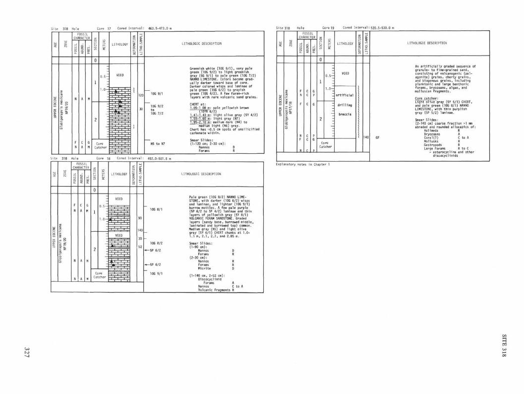
Site 318 Hole Core 17 Cored Interval: 463.5-473.0 m
LITHOLOGIC DESCRIPTION
10G 9/2to1OG 7/2
Greenish white (10G 9/1), very palegreen (10G 9/2) to light greenishgray (5G 9/1) to pale green (10G 7/2)NANNO LIMESTONE. Colors become grad-ually darker toward base of core.Darker colored wisps and laminae ofpale green (10G 6/2) to grayishgreen (10G 4/2). A few foram-richlayers with rare volcanic sand grains.
CHERT at:1.05-1 08 m: pale yellowish brown
1.41-1.43 m: light olive gray (5Y 4/2)1.55-1.60 m: light gray (N7)1.95-2.10 m: medium dark (N4) to
medium light (N6) gray.Chert has M).5 cm spots of unsilicifiedcarbonate within.
Smear Slides:(1-120 cm; 2-30 cm):
Nannos DForams R
Site 318 Hole Core 18 Cored Interval: 492.0-501.5 m
FOSSILCHARACTER
CoreCatcher
LITHOLOGIC DESCRIPTION
10G 8/1
10G 8/2
-5P 6/2
-5P 6/2
10G 9/1
Pale green (10G 8/2) NANNO LIME-STONE, with darker (10G 6/2) wispsand laminae, and lighter (10G 9/1)burrow mottles. A few pale purple(5P 6/2 to 5P 4/2) laminae and thinlayers of yellowish gray (5Y 8/1)VOLCANIC FORAM SANDSTONE. Gradedlayers (sandy base, burrowed middle,laminated and burrowed top) common.Medium gray (N5) and light olivegray (5Y 6/1) CHERT chunks at 1.0-1.1 m, 2.1, 2.7, and 2.85 m.
Smear Slides:(1-90 cm):
NannosForams
(2-30 cm):NannosForamsMicrite
(1-140 cm, 2-52 cm):Discocyclinid
ForamsNannosVolcanic Fragments
DFt
RRD
AC to AR
Site 318
AGE
UPPER EOCENE
ZONE
Globigerapsis
mexicana
NP17/18
Hole
FCHA
FN
F
NF
N
OSSRAC1
CC
c
cc
π
LER
1
GP
G
PG
p
Core 19
SECTION
0
1
2
METERS
1 I
I 1 1
1 1
1o
1 1 1
I 1
1 1
I 1 1
1 1
1 1
1 1
I i
1
CoreCatcher
Cored I
LITHOLOGY
VOID
artificial
drilling
breccia
iter
DEFORMATION
val:
LITHO.SAMPLE
140
520.5-530.0 m
LITHOLOGIC DESCRIPTION
An artificially graded sequence ofgranule- to fine-grained sand,consisting of volcanogenic (pal-agonite) grains, cherty grains,and biogenous grains, includingplanktonic and large benthonicforams, bryozoans, algae, andmolluscan fragments.
Core catcher:Light olive gray (5Y 5/1) CHERT,and pale green (10G 8/1) NANNOLIMESTONE, with thin purplishgray (5P 5/2) laminae.
Smear Slides:(2-140 cm) coarse fraction >l mmabraded and rounded allocapics of:
Halimeda Rßryozoans A
GF Coral(?) C to AMollusks RGastropods RLarge Forams R to C
- asterocyclina and otherdiscocyclinids
Explanatory notes in Chapter 1
HPI

00
Core 20 Cored Interval :549.0-558.5 m Cored Interval :577.5-587.0
LITHOLOGIC DESCRIPTION
5GY 2/1
GEOCHEM
- 10G 6/2, 10G 9/1,5G 8/1
10YR 6/2
10G 8/2, 5GY 4/1,- 5GY 2/1
10G 8/2to5G 7/2
Pale yellowish green (10GY 8/2),pale green (10G 6/2), greenish white(10G 9/1), and light greenish gray(5G 8/1) NANNO LIMESTONE with abun-dant burrows (of light material indarker).
From 2.7-5.5 m, thinly laminated,on mm-scale, with many low-anglefaults and deformed phacoids(burrows), suggesting small-scaleslumping.
A few graded layers, most notablyat 6.25 to 6.45 m.
CHERT at 1.1 and 1.5 m (moderateyellowish brown, 10YR 5/4), andat 2.1-2.2 m (pale yellowishbrown (10YR 6/2). Chert has 1-0.5cm spots of partly silicified lime-stone within.
Smear Slides:(1-80 cm, 3-30 cm, 4-148 cm):
Nannos AMicrite AForams RFe-Specks RVolcanic Fragments R to C
LITHOLOGIC DESCRIPTION
N4
10G 8/2and5G 7/25G 2/1
10G 9/110G 8/2 and5G 7/2
5P 4/25Y 7/25P 4/25Y 7/2
5G 8/1
5G 2/1and5G 8/1
Interbedded and interlaminatedpale green (10G 8/2) and greenishgray (5G 7/2) NANNO LIMESTONE, andCLAYEY LIMESTONE, with occasionalbeds and laminae of yellowish gray(5Y 7/2) and olive gray (5Y 5/2,5Y 4/2) VOLCANIC SILTSTONE andSANDSTONE, rich in forams, andlaminae of grayish purple (5P 4/2).
Grayish black (N2) CHERT at 2.6 and2.9 m, and dark brownish gray(5YR 3/1) CHERT at 3.4, 3.55, 3.8,4.0, 4.35 m.
Many graded layers, silty orsandy at base, and extensivelyburrowed near the top.
Smear Slides:(1-126 cm):
MicriteNannosForams
(2-30 cm) dark graiNannosMicriteForamsGreen Clay
Fragments
DCR
πy bed:CDR
R
Explanatory notes in Chapter 1

Site 318 Hole Core 22 Cored Interval : 596.5-606.0 m Site 318 Hole Core23 Cored Interval :606.0-615.5 m
LITHOLOGIC DESCRIPTION
Alternating pale yellowish green(10GY 7/2), pale green (10G 6/2),grayish green (10GY 5/2), grayisholive green (5GY 3/2) and grayishgreen (10G 4/2) NANNO LIMESTONE andCLAYEY NANNO LIMESTONE.
A few layers of olive black (5Y 2/1)or greenish black (5G 2/1) VOLCANICSANDSTONE and SILTSTONE.
Prevalent burrowing, of lightermaterial in darker, and scatteredexamples of low-angle faulting oflaminae. Burrows in some layersinternally deformed by post-depositional shear. Recumbantfold at 5.67-5.87 m. Gradedsequences common.
At 3.65 m, medium gray (N5) CHERTin pale green limestone.
Chert, blebs at 4.50-4.56, and5.87-6.0 m.
Smear Slides:(2-77 cm):
Volcanic ashaltering togreen clay
Nannos(1-120 cm):
NannosForamsMicrite
DR
A to DCc
LITHOLOGIC DESCRIPTION
Graded beds, generally consisting oflight greenish gray (5G 8/1) NANNOLIMESTONE or CLAYEY NANNO LIMESTONE,commonly with darker-colored olivegray (5Y 4/1, 5Y 3/1) SILTSTONE ordark greenish gray (5G 4/1) fine-grained SANDSTONE, consisting mainlyof volcanic (palagonite) grains andforams, at the base. Sand commonlylaminated and x-strat. Burrowing oflighter into darker material becomesmore intense towards the top of eachgraded unit. Occassional purplishgray (5P 4/2) laminae and streaksnear the tops of graded units.
Occassional internally deformedburrows.
Graded units 1-15 cmthick, averagingabout 5 cm.
Smear Slides:(1-139 cm):
Volcanic GlassMicriteNannos
(1-147 cm):NannosVolcanic GlassRadsSp. Spic.
(2-90 cm):MicriteVolcanic GlassFeldsparGreen Clay
(2-147 cm):MicriteFe-SpecksFeldsparVolcanic Glass
(3-116 cm):MicriteForamsNannosFeldsparVolcanic GlassGreen Clay
Explanatory notes in Chapter 1
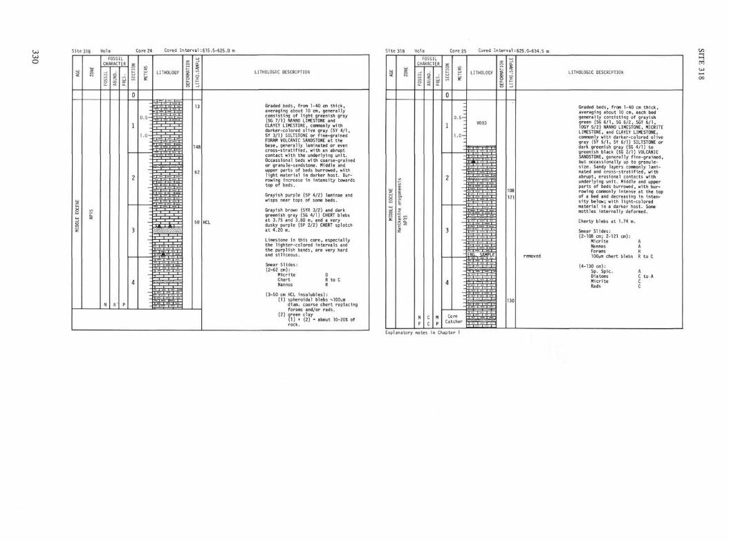
O
Site 318 Hole Cored Interval:615.5-625.0 m Site318 Hole Core 25 Cored Interval : 625.0-634.5
LITHOLOGIC DESCRIPTION
Graded beds, from 1-40 cm t h i c k ,averaging about 10 cm, generallyconsist ing of l i g h t greenish gray(5G 7/1) NANNO LIMESTONE andCLAYEY LIMESTONE, commonly withdarker-colored o l i v e gray (5Y 4 / 1 ,5Y 3/1) SILTSTONE or f ine-grainedFORAM VOLCANIC SANDSTONE at thebase, generally laminated or evenc r o s s - s t r a t i f i e d , with an abruptcontact wi th the underlying u n i t .Occassioπal beds with coarse-grainedor granule-sandstone. Middle andupper parts of beds burrowed, wi thl i g h t material i n darker host. Bur-rowing increase i n i n t e n s i t y towardstop of beds.
Grayish purple (5P 4/2) laminae andwisps near tops of some beds.
Grayish brown (5YR 3/2) and darkgreenish gray (5G 4/1) CHERT blebsat 3.75 and 3.80 m, and a verydusky purple (5P 2/2) CHERT splotchat 4.20 m.
Limestone in th is core, especial lythe l ighter-co lored interva ls andthe purpl ish bands, are very hardand s i l i c e o u s .
Smear Sl ides:(2-62 cm):
Micrite DChert R to CNannos R
(3-50 cm HCL insolubles):(1) spheroidal blebs tlOOµm
diam. coarse chert replacingforams and/or rads.
(2) green clay(1) + (2) = about 10-20* ofrock.
H
LITHOLOGIC DESCRIPTION
Graded beds, from 1-40 cm t h i c k ,averaging about 10 cm, each bedgenerally consist ing of grayishgreen (5G 6 / 1 , 5G 6/2, 5GY 6 / 1 ,10GY 5/2) NANNO LIMESTONE, MICRITELIMESTONE, and CLAYEY LIMESTONE,commonly with darker-colored o l i v egray (5Y 5 / 1 , 5Y 6/1) SILTSTONE ordark greenish gray (5G 4/1) togreenish black (5G 2/1) VOLCANICSANDSTONE, generally f ine-gra ined,but occassionally up to granule-size. Sandy layers commonly lami-nated and c r o s s - s t r a t i f i e d , withabrupt, erosional contacts withunderlying u n i t . Middle and upperparts of beds burrowed, wi th bur-rowing commonly intense at the topof a bed and decreasing i n in ten-s i t y below; wi th l ight-co loredmaterial in a darker host. Somemottles i n t e r n a l l y deformed.
Cherty blebs at 1.74 m.
Smear Sl ides:(2-108 cm; 2-121 cm):
Micr i te ANannos AForams RlOOum chert blebs R to C
(4-130 cm):Sp. Spic. ADiatoms C to AMicri te CRads C
Explanatory notes in Chapter 1
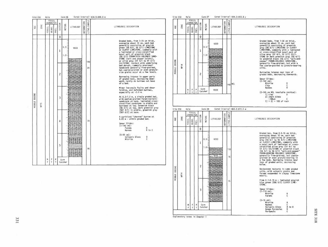
Site 318 Hole Core 26 Cored Interval:634.5-644.0 m Cored Interval:644.0-653.5 r
LITHOLOGIC DESCRIPTION
Graded beds, from 1-70 cm th ick ,averaging about 10 cm, each bedgenerally consisting of grayishgreen (5G 6/2, 5G 5/1) LIMESTONEor CLAYEY LIMESTONE, commonly witha laminated or cross-st rat i f iedbasal uni t of greenish black(5G 2/1) FORAM-RICH VOLCANIC SAND-STONE (sal t and pepper co lors) ,or ol ive gray (5Y 4/1 to 5Y 2/1)SILTSTONE. Contact with underlyingbed abrupt, commonly erosional.Sandstone generally f ine-grained,but coarse-grained or even granule-size grains occur at a few levels.
Burrowing intense in upper partsof graded beds, decreasing down-ward; rarely do burrows cut baseof a bed.
Minor low-angle faul ts and shearfo ld ing , and deformed burrows,especially at -v-3.0 m.
At 6.3-7.0 m, a single graded bed,with medium-grained foram-voclanicsandstone at base, laminated cross-s t r a t i f i ed sandstone in middle andburrowed at top. Greenish black(5G 2/1) at top, dark greenish gray(5GY 4/1) in middle, greenish gray(5GY 6/2) at base.
A pyr i t ized "chevron" burrow at6.65 m - within graded bed.
Smear Slides:(1-140 cm):
ForamsNannos
(5-95 cm):Volcanic GlassMicri te
DR to C
LITHOLOGIC DESCRIPTION
Graded beds, from 1-30 cm thick,averaging about 10 cm, each bedgenerally consisting of greenishgray (5G 5/1) LIMESTONE or CLAYEYLIMESTONE, commonly with a laminatedor cross-stratified basal part ofolive gray (5Y 4/1, 5Y 2/1) SILT-STONE or dark greenish gray (5G 4/1)to greenish black (5G 2/1) "salt-and-pepper" FORAM-VOLCANIC SANDSTONE,generally fine-grained, but with afew coarse-grained to granule-bearingunits.
Burrowing intense near tops ofgraded beds, decreasing downwards.
Smear Slides:(2-142 cm):
Micrite DClay CNannos R
(2-145 cm HCL insoluble residue):1) clay D2) chert blebs
1) + 2) 10* of rock
Site 318 Hole Core 28 Cored Interval:663.0-672.5 m
LITHOLOGIC DESCRIPTION
Graded bes, from 0.5-15 cm thick,averaging about 10 cm, each bedgenerally consisting of greenishgray (5G 6/1 to 5G 4/1) LIMESTONEor CLAYEY LIMESTONE, commonly witha basal part of laminated or cross-stratified olive gray (5Y 4/1 to5Y 2/1) SILTSTONE or greenish black(5G 4/1 to 5G 2/1) "salt-and-pepper"FORAM-BEARING VOLCANIC SANDSTONE,generally fine-grained, but coarse-grained or even granule-bearing ina few beds. Burrowing intense neartops of graded units, decreasingbelow.
Wackestone textures in some gradedunits, with volcanic grains andforams suspended in clayey limestonematrix.
From 2.1-2.15 m - laminated grayishblue green (5BG 5/2) CLAYEY LIME-STONE.
Smear Slides:(1-110 cm):
Micrite AForams C
(3-15 cm):Micrite ANannos CVolcanic Glass A to DGreen Pyroboles RFe-Specks C
Explanatory notes in Chapter 1

Site318 Hole Core 29 Cored Interval :682.0-691.5 Site 318 Hole Core 31 Cored Interval:720.0-729.5 m
FOSSILCHARACTER
LITHOLOGIC DESCRIPTION
Graded beds, from 0.5 to 20 cmthick, averaging about 5 cm, eachbed generally consisting of greenishgray (5GY 5/1, 5G 5/1) and darkgreenish gray (5GY 4/1 to 5GY 2/1)LIMESTONE and CLAYEY LIMESTONE,conπ>only with a basal unit of lightolive gray (5Y 6/1) or olive gray(5Y 4/1) SILTSTONE or greenish black(5G 2/1) "salt-and-pepper" FORAM-BEARING VOLCANIC SANDSTONE.
A few bands of grayish to duskyblue green (5BG 5/2 to 5BG 3/2)CLAYEY LIMESTONE.
Burrowing intense in upper partsof many graded units, decreasingbelow.
Smear Slides:(1-135 cm):
Volcanic GlassClayFeldsparNannos
AGE
LOWE
R EO
CENE
ZONE
NP13
FOSS
IL |£̂
N
F
OSSRAC
C?
LrER
1
P
SECT
ION
0
1
2
METE
RS
0.5-
1.0-
CoreCatcher
LITHOLOGY
VOID
1 l l •• 1 —."
.— i — I .1. T'
— i -1 1 — T"
— T ~i. I *- 1
1 — 1 — 1 —
ΠTITI
VOID
DEFO
RMAT
ION
LITH
O.SA
MPLE
36138
LITHOLOGIC DESCRIPTION
Graded beds, from 0.5-15 cm thick,averaging about 5 cm, each bedconsisting of greenish gray (5G 6/1through 5G 4/1) and grayish bluegreen (5BG 5/2) to dusky blue green(5BG 3/2) CLAYEY LIMESTONE, commonly
to greenish black (5G 2/1) SILTSTONEto SANDSTONE, with forams and vol-canic grains. Sandy parts generallylaminated, with an abrupt, erosionalor load-casted base.
Burrowing common in upper parts ofgraded layers.
Smear Slides:(1-138 cm) base of coarse-grainedgraded bed:
Feldspar AVolcanic Glass AClay CMicrite A
(1-136 cm) top of graded bed:Micrite ANannos AForams R
Site 318 Hole Core 30 Cored Interval:701.0-710.5 m Explanatory notes in Chapter 1
LITHOLOGIC DESCRIPTION
Graded bes, from 0.5 to 40 cmthick, averaging about 8 cm, eachbed generally consisting of greenishgray (5G 6/1) to dark greenish gray(5GY 4/1) LIMESTONE or CLAYEY LIME-STONE, commonly with a basal unitof olive gray (5Y 6/1 to 5Y 2/1)SILTSTONE, or greenish black (5G 2/1)"salt-and-pepper" FORAM-BEARING VOL-CANIC SANDSTONE, commonly laminatedor cross-stratified.
A few layers of dusky blue green(5BG 3/2) CLAYEY LIMESTONE.
Burrowing commonly moderate tointense in upper parts of gradedbeds.
Medium- to coarse-grained sandstonecommon at bases of beds.
Smear Slides:(1-40 cm):
Sp. Spic.Volcanic GlassDiatomsRads
(2-19 cm) base of graded bed:Volcanic Glass AFeldspar AClay C
(2-134 cm) burrowed green limestone:Micrite D to ANannos C to AClay CFe-Specks R
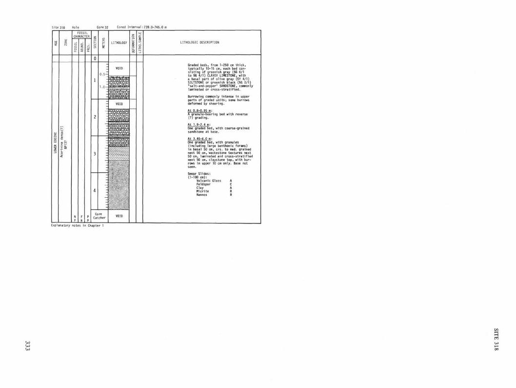
Core 32 Cored Interval:739.0-745.0 m
LITHOLOGIC DESCRIPTION
Graded beds, from 1-250 cm thick,typically 10-15 cm, each bed con-sisting of greenish gray (5G 6/1to 5G 4/1) CLAYEY LIMESTONE, witha basal part of olive gray (5Y 4/1)SILTSTONE or greenish black (5G 2/1)"salt-and-pepper" SANDSTONE, commonlylaminated or cross-stratif ied.
Burrowing commonly intense in upperparts of graded units; same burrowsdeformed by shearing.
At 0.8-0.95 m:A granule-bearing bed with reverse(?) grading.
At 1.9-2.4 m:One graded bed, with coarse-grainedsandstone at base.
At 3.45-6.0 m:One graded bed, with granules(including large benthonic forams)in basal 50 cm, crs. to med. grainednext 50 cm, wackestone textures next50 cm, laminated and cross-stratifiednext 50 cm, claystone top, with bur-rows in upper 10 cm only. Base notseen.
Smear Slides:(1-100 cm):
Volcanic GlassFeldsparClayHicriteNannos
ACARR
Explanatory notes in Chapter 1

318CORE 1
1 2
4 -
5 -
7 -
* r g j
DEPTH POROSITY, %
CORE }°° 5°(m)
O -
1 -
2 -
318
CORE 2
1 2
DEPTH POROSITY, %
CORE ^(m) * r π i
0
2 -
1 -
318CORE 3
318CORE 4
DEPTH POROSITY, %
U "
1 -
4 -
5 -
7 -
318CORE 5
DEPTH POROSITY, %
^r 100 50 0
CORE
. . . , .
-
2 -
3 - j
-
4 -
5 -
6 -
7 -
8 -
9 -
- 3 ^ -
1
2
3
4
5
6
318CORE 6
1 2
DEPTH POROSITY, %N 5° "
1 -
2 -
4-
5-
7-
• • i • i i i i i I
NOTE: The upper scale is GRAPE Wet-Bulk Density (1.0 to 3.0 g/cc): solid lines ( ) are GRAPE analog data assuming a 6.61 cm core diameter; dotted lines ( ) are GRAPE analogdata adjusted for actual core diameter; circled ( G> ) dots are the wet-bulk density calculated from two-minute counts on a stationary sample; the porosity nomogram allows a porosityscale to be determined by selecting the proper grain density (r ) and extrapolating horizontally.
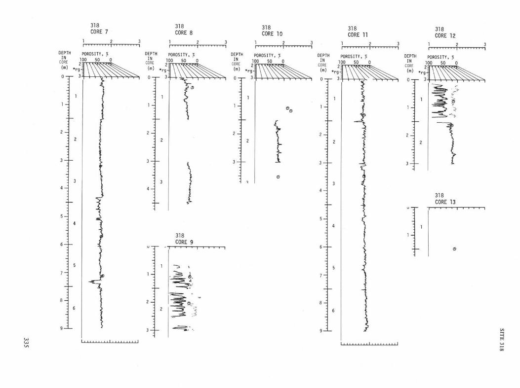
318CORE 7
DEPTH POROSITY, %INCORE(m) *
TOO 50 0
2 A
318CORE 8
DEPTH POROSITY, %1? 0 50 0
u —
1 -
2 -
•
3 -
-
4 -
1
2
3
318CORE 9
lA o...
318CORE 10
DEPTH POROSITY, %
CSE ^ 50
(m) * r g |
*l 0-r- 3^
2A
318CORE 11
1
DEPTH POROSITY, %
CO!E ] ° ° 50
(m) . r g0
2 -
318CORE 12
DEPTH POROSITY, %
CORE l O ? 5 0
1 0-r- 3^
318CORE 13
\A

318CORE 14
DEPTH POROSITY, %IN 100 50
CORE 2 1
(m) *rgJ
H
2A
318CORE 15
318CORE 16
DEPTH POROSITY, %I N 100 50 0
CORE 2 3
H
2-^
e>...
318CORE 17
318CORE 18
1 2
318CORE 20
1
DEPTH POROSITY, %50
23
DEPTH POROSITY, %IN
!CORE òl•(tn)
H
2 H
^Rubb le
Rubble
318
CORE 19
318
CORE 21
DEPTH POROSITY, %IN
CORE(m)
100 50
H
Rubble

318
CORE 22
1 2
DEPTHIN
CORE(m)
0
H
2-q
POROSITY, %
]Λ° 5O
318
CORE 23
1 2
DEPTH POROSITY, X
CORE ^(m) *
r g|
318CORE 24
DEPTH POROSITY, %
318
CORE 25
1 2
DEPTH POROSITY, %1N 100 50 ' 0
LUKt OT
(m) *
0
2-q
318
CORE 26
DEPTH POROSITY, %IN
CORE 100 50 0
1 0
7 -
H
00 318CORE 27
318CORE 29
DEPTH POROSITY, %
CORE
DEPTH POROSITY, %IN
t ..>•••
318CORE 31NO DATA
318CORE 32NO DATA
318CORE 28
318CORE 30
SITE 318
I—Ocm
-25
1—50
I—75
I—100
125
•—150318-1-1 318-1-2 318-1-3 318-1-4 318-1-5 318-2-1
339
SITE 318
Ocm
—25
—50
-—75
— 100
125
150318-2-1 318-3-1 318-4-1 318-4-2 318-4-3 318-4-4
340
SITE 318
I—Ocm
—25
—50
-—75
100
— 125
L—150
318-4-5 318-4-6 318-5-1 318-5-2 318-5-3 318-5-4
341
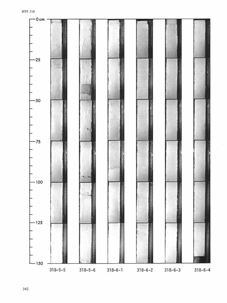
SITE 318
I—Ocm
—25
-50
— 75
— 100
— 125
— 150318-5-5 318-5-6 318-6-1 318-6-2 318-6-3 318-6-4
342

SITE 318
I—Ocm
—25
•50
—75
— 100
— 125
1—150318-6-5 318-6-6 318-7-1 318-7-2 318-7-3 318-7-4
343
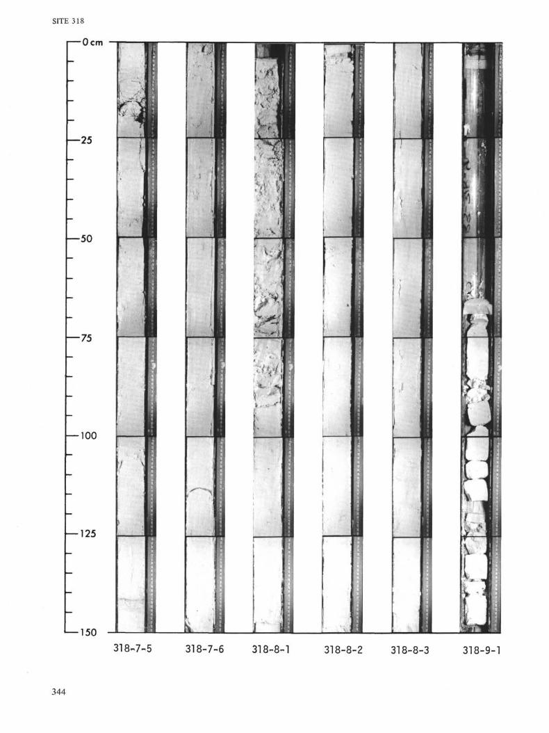
150
318-7-5 318-7-6 318-8-1 318-8-2 318-8-3 318-9-1
344

SITE 318
i—Ocm
25
—50
—75
— 100
— 125
1—150
318-9-2 318-10-1 318-10-2 318-10-3 318-10-4 318-11-1
345

SITE 318
I—Ocm
—25
—50
—75
— 100
— 125
— 150318-11^2 318-11-3 318-11-4 318-11-5 318-11-6 318-12-1
346

SITE 318
I—Ocm
Y-25
\— 50
h-75
—100
•― 150
• • I
1
u i
M:
v r
L
y•
.
•
-
1
1
•1
F~i•H
1i
7i
318-12-2 318-13-1 318-13-2 318-14-1 318-14-2 318-14-3
347

SITE 318
I—Ocm
—25
— 5 0
— 75
— 100
— 125
•―150
318-15-1 318-15-2 318-16-1 318-16-2 318-16-3 318-17-1
348
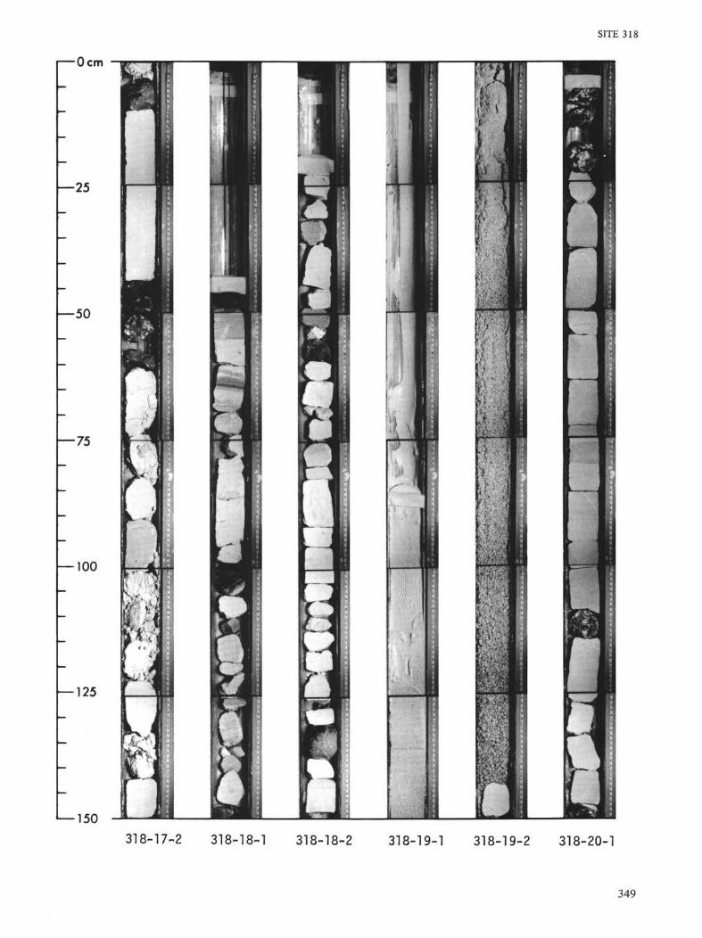
SITE 318
I—Ocm
µ—25
—50
h-100
125
1—150318-17-2 318-18-1 318-18-2 318-19-1 318-19-2 318-20-1
349

1—150318-20-2 318-20-3 318-20-4 318-20-5 318-21-1 318-21-2
350
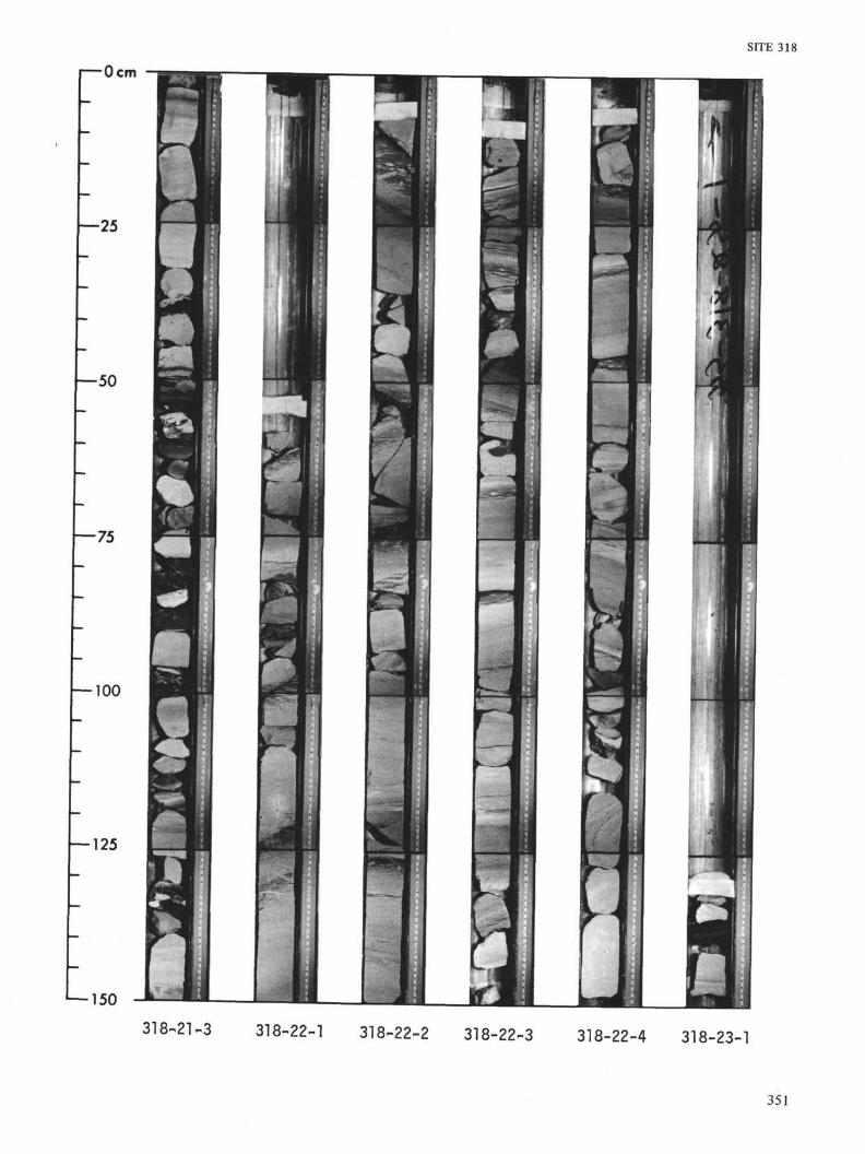
SITE 318
I—Ocm
—25
—50
— 75
-— 100
— 125
150
318-21-3 318-22-1 318-22-2 318-22-3 318-22-4 318-23-1
351

150318-23^2 318-23-3 318-24-1 318-24-2 318-24-3 318-24-4
352

SITE 318
I—Ocm
—25
—50
—75
~IOO
— 125
1—150
318-25-1 318-25-2 318-25-3 318-25-4 318-26-1 318-26-2
353
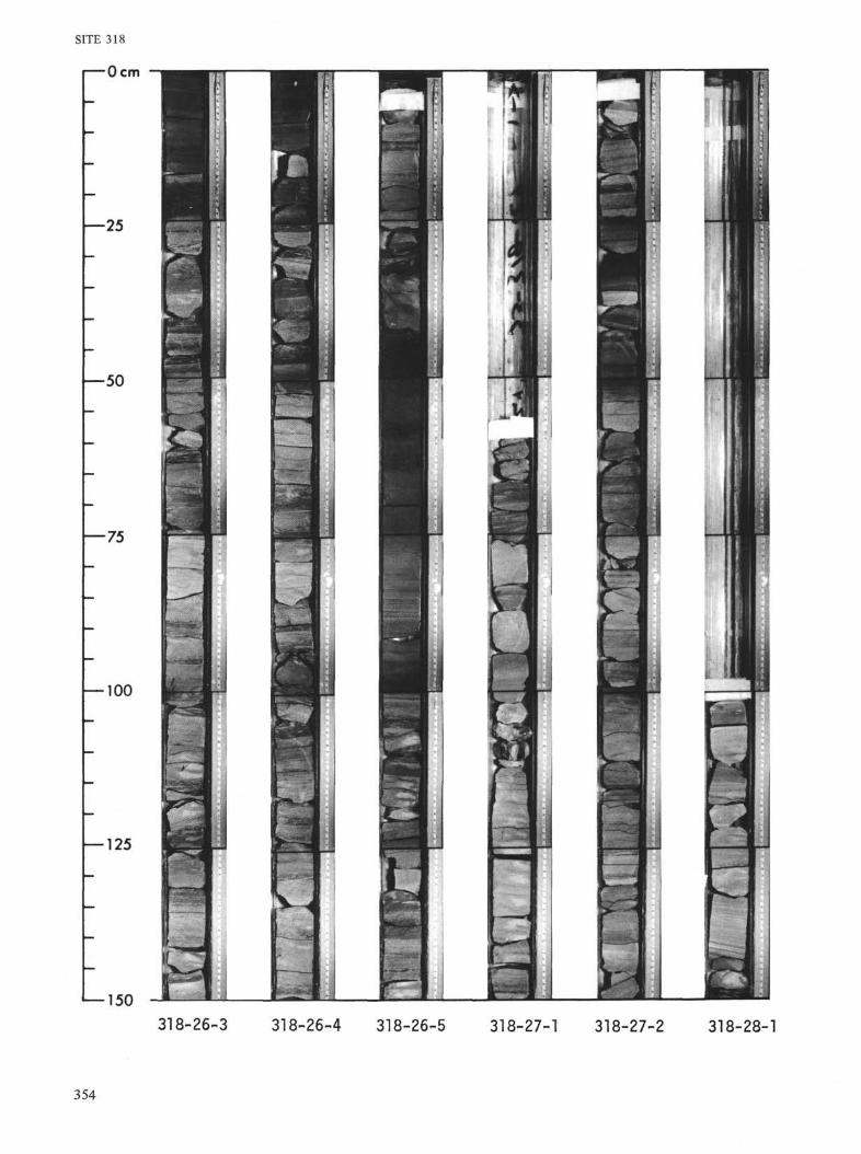
SITE 318
i—Ocm
—25
—50
—75
— 100
— 125
— 150318-26-3 318-26-4 318-26-5 318-27-1 318-27-2 318-28-1
354

SITE 318
Ocm
—25
—50
—75
— 100
— 125
*—150318-28-2 318-28-3 318-29-1 318-29-2 318-30-1 318-30-2
355

318-30-3318-31-1 318-31-2
318-32-l 318-32-2 318-32-3
356
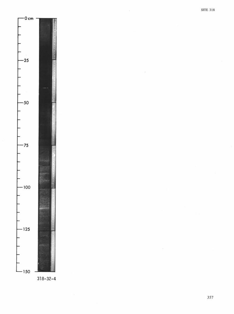
SITE 318
I—Ocm
•50
—100
—125
1—150318-32-4
357