Embed Size (px)
Citation preview
City of Fresno General Plan and Development Code Update Master Environmental Impact Report Hydrology and Water Quality
FirstCarbon Solutions 5.9‐1 M:\DriveT@VOL1\shared\31680016 ‐ Fresno General Plan MEIR\Fresno GP MEIR_FINAL 7.22.14\31680016 Sec 05‐09 HWQ Fresno MEIR 7.22.14.doc
5.9 ‐ Hydrology and Water Quality
5.9.1 ‐ Introduction
This section of the Master EIR evaluates the potential environmental effects related to hydrology and
water quality associated with implementation of the proposed General Plan and Development Code
Update. The analysis includes a review of surface water, groundwater, flooding, stormwater, and
water quality.
The General Plan Update includes policies in the Public Utilities and Services Element and the
Resource Conservation and Resilience Element that guide development and infrastructure practices
to protect surface water and groundwater from the degradation of runoff and pollution.
5.9.2 ‐ Environmental Setting
Study Area for Project Impacts
The study area for project impacts regarding hydrology and water quality is the City of Fresno
Planning Area and the immediate surrounding County of Fresno and City of Clovis areas because
potential development under the City of Fresno General Plan and Development Code Update could
affect areas inside and outside the Planning Area.
Study Area for Cumulative Impacts
The study area for the analysis of cumulative hydrology and water quality impacts is the Fresno‐
Clovis Metropolitan Area because the Fresno Metropolitan Flood Control District (District) includes
an area of approximately 400 square miles and covers the entire portion of the Fresno‐Clovis
Metropolitan Area. The study area for the analysis of cumulative groundwater impacts is the Kings
River Sub‐basin.
Precipitation
Precipitation in the Planning Area occurs mostly as rain during the months of November through
April. Climate data collected from 1948 to 2012 shows that annual rainfall averaged 10.89 inches,
but is variable. Recorded annual rainfall has ranged from a low of 3.01 inches in 2013 to a high of
21.61 inches in 1983 (Western Regional Climate Center, 2014).
Hydrology
The San Joaquin River and the Kings River are the principal rivers that influence the hydrology in the
Planning Area. The western slopes of the Sierra Nevada drain to the west via the San Joaquin and
Kings Rivers. The Kings River is connected to the San Joaquin River by the James Bypass, a man‐
made canal. Floodwater from the Kings River is diverted to the San Joaquin River. Three dams
control flows on the two rivers. The Friant and Mendota Dams are located on the San Joaquin River.
These two dams provide some flood control; however, these two dams were not designed for the
purpose of flood control. The Pine Flat Dam was built for the purpose of flood control. In addition
to the dams on the two rivers, there are reservoirs and detention basins that have been constructed
City of Fresno General Plan and Development Code Update Hydrology and Water Quality Master Environmental Impact Report
5.9‐2 FirstCarbon Solutions M:\DriveT@VOL1\shared\31680016 ‐ Fresno General Plan MEIR\Fresno GP MEIR_FINAL 7.22.14\31680016 Sec 05‐09 HWQ Fresno MEIR 7.22.14.doc
to prevent flooding. These facilities include the Redbank Dam and the Redbank‐Fancher Creeks
Flood Control Project. This Project consists of two dams (Big Dry Creek Dam and Fancher Creek
Dam), three detention basins (Redbank Creek, Pup Creek, and Alluvial Drain Detention Basins), and
canals to convey discharges in and around the City of Fresno. These facilities were designed to
protect developed areas from a 200‐year storm event (County of Fresno, 2000).
Stormwater Drainage
Storm drainage facilities within the Fresno‐Clovis Metropolitan area are planned, implemented,
operated and maintained by the Fresno Metropolitan Flood Control District (FMFCD). The storm
drainage facilities are documented in the Storm Drainage Master Plan (SDMP), which is developed
and updated by FMFCD. The master plan drainage system for the Planning Area consists of over 130
individual drainage areas or urban watersheds. Drainage area boundaries are determined by
geographic and topographic features and the economics of providing storm drainage service to the
watershed. The storm drainage facilities within a drainage area consist of storm drain inlets,
pipeline, retention basins, urban detention (water quality) basins, and stormwater pump stations.
Surface grading improvements such as streets, curbs, gutters, and valley gutters are part of the City
of Fresno infrastructure, but the general grading of these features is governed by the SDMP to
provide a coherent implementation of drainage within the Planning Area.
Storm drain inlets are located at low points in the topography as determined by the SDMP. Pipeline
alignments and sizes are also shown on the SDMP. Pipeline alignments are subject to change as
development proposals are put forward by development projects. Retention basins and urban
detention basins locations and geometry are part of the SDMP as well. Basins are sited in the
topographic low point of the drainage area. All of the storm drainage pipelines are directed to the
retention and urban detention basins. Retention basins store and percolate stormwater from the
drainage area. Urban detention basins provide quiescent (still) conditions for the removal or settling
out of suspended solids prior to discharge of the stormwater to the San Joaquin River.
The Fresno‐Clovis Metropolitan area consists of drainage areas that are completed, e.g., all of the
master planned facilities are constructed and functional; or in the process of being completed, e.g.
portions of the retention basins, pipelines, and inlets are constructed and portions are not. For the
drainage areas that are in the planning stage, e.g., the drainage area is planned and documented, the
retention basin land may have been purchased, but no construction has occurred. Implementation
of the SDMP occurs in response to development activity in newly developing areas and through
Capital Improvement Project (CIP) planning in previously developed areas. Funding for storm
drainage facilities occurs through the collection of drainage fees assessed on parcels as they develop
through grant funding from the State of California and the Federal Government, through low interest
infrastructure improvement bonds, and in the past, through assessment districts. Drainage fees fund
the majority of the construction of master plan facilities in newly developing areas. Grants,
infrastructure loans, and assessment districts fund the majority of construction in previously
developed drainage areas.
City of Fresno General Plan and Development Code Update Master Environmental Impact Report Hydrology and Water Quality
FirstCarbon Solutions 5.9‐3 M:\DriveT@VOL1\shared\31680016 ‐ Fresno General Plan MEIR\Fresno GP MEIR_FINAL 7.22.14\31680016 Sec 05‐09 HWQ Fresno MEIR 7.22.14.doc
Groundwater
The Planning Area is underlain by the Kings River Sub‐basin, which, along with six other sub‐basins,
comprises the San Joaquin Valley Groundwater Basin. In turn, the San Joaquin Basin is located
within the Tulare Lake Hydrologic Region. The Tulare Lake Hydrologic Region spans approximately
10.9 million acres (17,000 square miles) and includes most of Fresno County. The Region
encompasses the southern one‐third of the Central Valley Regional Water Quality Control Board
(RWQCB).
The Kings River Sub‐basin extends from the Sierra Nevada foothills on the east to the San Joaquin
Valley trough on the west, and from the San Joaquin River on the north to roughly the Fresno County
line on the south.
Historically, water demand within the Planning Area obtained its water supply by extracting
groundwater from the Kings Sub‐basin. Groundwater levels in the Planning Area have declined by an
average of 1.5 feet per year since 1990. In the past 80 years, the water level has decreased from 30
feet below ground surface to more than 128 feet below ground surface, according to 2009 data
provided by the City. According to Figures 4.4 and 4.5 provided in the Urban Water Management
Plan adopted in 2008, included in the Urban Plan, there was cone of depression from Herndon
Avenue in the north to Jensen Avenue in the south and from Maple Avenue to Brawley Avenue in
the east‐west direction in both the lower and upper aquifer zones. A groundwater mound is located
near the Fresno‐Clovis Regional Wastewater Reclamation Facility (Regional Facility) as a result of the
disposal of treated effluent at the FCRWRF percolation basins.
Groundwater used by the City to meet its demands is replenished by three different methods:
Natural recharge Subsurface inflow Intentional recharge
Natural recharge occurs through rainfall, irrigation, canal and stream flows that seep into the soil and
replenish the aquifer below. Based on City data, the natural recharge was approximately 24,400 AF
in 2010. According to the Metropolitan Plan Update, the average annual natural recharge is 37,000
AF within the Planning Area. As additional development occurs throughout the Planning Area, there
will be less pervious surfaces to allow natural recharge to occur. However, as the City annexes
portions of the Planning Area, the amount of natural recharge allocated to the City will increase. At
buildout, the natural recharge is estimated to be approximately 27,000 AF/year.
Subsurface recharge occurs from the movement of groundwater from external sources such as the
Sierra Nevada moving into the local aquifer. Since the groundwater table surrounding the Planning
Area is higher than inside the Planning Area, subsurface water tends to flow from surrounding areas
with a higher groundwater table into the aquifer within the Planning Area that has a lower
groundwater table. Based on City data, the annual subsurface inflow to the City is approximately
22,500 AF in 2010. By the year 2025, the City anticipates that groundwater operations (i.e.,
subsurface inflows and outflows) would be balanced and subsurface flows will not be directed to the
City of Fresno General Plan and Development Code Update Hydrology and Water Quality Master Environmental Impact Report
5.9‐4 FirstCarbon Solutions M:\DriveT@VOL1\shared\31680016 ‐ Fresno General Plan MEIR\Fresno GP MEIR_FINAL 7.22.14\31680016 Sec 05‐09 HWQ Fresno MEIR 7.22.14.doc
Planning Area. Therefore, during and after the year 2025, subsurface water flows will not be a water
supply source for the City since the water levels within the Planning Area would match the levels of
the entire region.
Intentional recharge is provided by directing surface water into the underground aquifer by means of
groundwater recharge basins located throughout the Planning Area. Currently, the City’s primary
recharge facility is Leaky Acres, located just northwest of Fresno‐Yosemite International Airport.
Other recharge facilities include Fresno Metropolitan Flood Control District (FMFCD) storm drainage
basins and the Alluvial Groundwater Recharge System (AGRS) owned and operated by the City of
Clovis. Based on the 2008 UWMP, the average intentional recharge between 1985 and 2007 was
approximately 44,200 AF/year. The maximum intentional recharge was approximately 62,000
AF/year in 2003. Based on information provided by City staff. The intentional recharge quantity in
2009 was approximately 54,600 AF and in 2010, the intentional recharge was approximately 53,100
AF.
Based on the natural groundwater recharge (24,400 AF), subsurface inflow (22,500 AF), and
intentional recharge (453,100 AF) that occurred in 2010, the total groundwater recharge during
normal year supply is approximately 100,000 AF. At buildout, the City anticipates that the natural
groundwater recharge will increase to 27,000 AF/year, subsurface inflow will be 0 AF/year, and
intentional groundwater recharge will increase to 75,100 AF/year due to an increase in the capacity
of surface water treatment. The total groundwater recharge at buildout will be approximately
102,100 AF/year.
In 2004, the Northeast Surface Water Treatment Facility (NESWTF) located at Chestnut and Behymer
Avenues began operation. The NESWTF has reduced the dependence on groundwater pumping by
the City needed to meet water demand. Prior to NESWTF operation, 100 percent of the City’s water
demand was met through groundwater pumping. The addition of the NESWTF has reduced the
percentage of total water demand provided by groundwater from 100 percent prior to 2004 to
approximately 87 percent in 2010, according to the 2010 Urban Water Management Plan.
The City currently has approximately 272 active wells, which pump an average of 146 million gallons
of water per day (MGD). Groundwater pumping data provided by the City indicates that
approximately 128,578 AF was pumped in 2010. Between 2006 and 2010, the City pumped an
average of approximately 139,207 AF/year. This average groundwater pumping has exceeded the
current estimated groundwater safe yield of approximately 100,000 AF/year.
In the near future, groundwater will continue to be an important part of the City’s supply but will not
be relied upon as heavily as has historically been the case The 2010 UWMP projects that
groundwater pumped by the City will decrease from approximately 128,578 AF/year in 2010 to
approximately 85,000 AF/year at buildout of the General Plan Update. This would represent a
decrease in the groundwater percentage of total water supply from 87 percent to 36 percent. This
reduction in groundwater pumping will recharge the aquifer by approximately 15,000 acre‐feet per
year because the safe yield is approximately 1000,000 acre‐feet per year. In order to meet this
City of Fresno General Plan and Development Code Update Master Environmental Impact Report Hydrology and Water Quality
FirstCarbon Solutions 5.9‐5 M:\DriveT@VOL1\shared\31680016 ‐ Fresno General Plan MEIR\Fresno GP MEIR_FINAL 7.22.14\31680016 Sec 05‐09 HWQ Fresno MEIR 7.22.14.doc
projection, the City is planning to rely on expanding their delivery and treatment of surface water
supplies and groundwater recharge activities.
Water Quality
Surface Water
San Joaquin River
The primary surface water feature within the General Plan Update Planning Area is the San Joaquin
River, which generally serves as the Planning Area’s northern boundary. At 366 miles long, the San
Joaquin River is the largest river in Central California, spanning from the Sierra Nevada Mountains to
the San Francisco Bay via the San Joaquin Valley. Much of the water that flows through the San
Joaquin River is used for irrigation purposes. Much of the agricultural production in the San Joaquin
Valley depends on water that at least originated from the San Joaquin River.
The San Joaquin River has been identified by the Central Valley RWQCB as having numerous
beneficial uses, including municipal and domestic water supply, agricultural, industrial, recreational,
freshwater and wildlife habitat, and migration and spawning grounds. Water quality in the San
Joaquin River is affected by both natural and anthropogenic sources, including soil erosion;
stormwater runoff; wastewater discharges, industrial, residential, and agricultural runoff;
recreational activity; and flora and fauna. While the segment of the San Joaquin River in the
Planning Area is not considered substantially impaired, significant downstream portions of the River
throughout the Valley and near the Sacramento‐San Joaquin Delta are affected by various
constituents and pollutants, usually as a result of agricultural runoff. However, the portion of the San
Joaquin River in the Planning Area appears on the State Water Resources Control Board’s 2010
Impaired Water Bodies/303(d) List for invasive species (non‐native fish species).
Millerton Lake
Aside from the San Joaquin River, another prominent surface water feature in the general Planning
Area is Millerton Lake, which is located upstream and just outside of the of the Planning Area’s
northeast boundary. The Lake was created by the construction of Friant Dam on the San Joaquin
River by the United States Bureau of Reclamation in 1942. While Millerton Lake’s secondary uses
include recreation, hydroelectric power generation, and flood control, the primary purpose of the
Lake is the storage of irrigation water for the San Joaquin Valley. Millerton Lake is included on the
2010 Impaired Water Bodies/303(d) List for mercury.
Other Surface Waters
In addition to these larger surface water features, a network of agricultural canals and flood control
channels traverse the Planning Area. Numerous agricultural ponds, recharge basins, and other
similar features dot the Planning Area’s landscape.
The City began to use surface water as a source of potable water supply in 2004, when the Surface
Water Treatment Facility (SWTF) became operational and began delivering approximately 20 mgd of
potable water to residents of northeast Fresno. In 2009, the SWTF treated 19,600 AF, which offset
groundwater demand by 12 percent. The City is currently implementing various improvements that
City of Fresno General Plan and Development Code Update Hydrology and Water Quality Master Environmental Impact Report
5.9‐6 FirstCarbon Solutions M:\DriveT@VOL1\shared\31680016 ‐ Fresno General Plan MEIR\Fresno GP MEIR_FINAL 7.22.14\31680016 Sec 05‐09 HWQ Fresno MEIR 7.22.14.doc
would ultimately increase production to near annual design capacity levels of 30,800 AF. Surface
water starts as snow melt in the Sierra Nevada before traveling down the San Joaquin and Kings
Rivers via Millerton Lake and Pine Flat Reservoir. These locations serve as temporary storage
locations before the surface water is delivered via the Enterprise Canal to the SWTF, where the water
is treated to drinking water standards.
Ground Water
Groundwater quality throughout the Tulare Lake Hydrologic Region is generally suitable for most
urban and agricultural uses, and meets primary and secondary drinking water standards for
municipal use. Local impairments are found in the Tulare Lake Hydrologic Region’s groundwater
supply, however, with high TDS, nitrate, arsenic, and organic compounds acting as the primary
constituents of concern within the Region. With the exception of the western portion of the Tulare
Lake Hydrologic Region, the Region lacks any substantial low permeability units that would isolate
deep from shallow aquifers. As such, most of the aquifer underlying the Planning Area is
unconfined. As a single, unconfined aquifer, the groundwater basin within the Planning Area has
been designated as a Sole Source Aquifer as authorized by Section 14246 of the Federal Safe Drinking
Water Act of 1974. This designation means that Planning Area is dependent on a single source of
groundwater and that this sole source must be protected from contamination.
While the groundwater supply within the Kings River Subbasin generally meets drinking water
standards, extensive contamination occurs throughout the Planning Area. Of the City’s 272
groundwater wells, 96 wells are impacted by one contaminant plume, 33 wells are impacted by two
contaminant plumes, and 5 wells are impacted by three contaminant plumes. Thirty‐four of the
City’s active wells currently have wellhead treatment systems.
Several different types of pollutants have contaminated the groundwater in portions of the Planning
Area. Major contaminant plumes include dibromochloropropane (DBCP), ethylene dibromide (EDB),
trichloropropane (TCP), other volatile organic compounds (VOCs) like trichlorethylene (TCE),
tetrachloroethylene (PCE), nitrate, manganese, radon, chloride, and iron. Nitrate, pesticides, and
nutrients in agricultural drainage are currently found within much of the Planning Area’s
groundwater supply, and their levels exceed some drinking water standards established by the State.
While nitrates may occur naturally, their presence is often attributed to anthropogenic reasons.
Leaking septic tanks, which are prevalent in the less dense southeast portion of the City, are also a
substantial source of nitrate contamination.
Another major problem facing the Planning Area’s groundwater supply is the presence of Dibromo‐
Chloropropane (DBCP) in the City’s groundwater wells. This fumigant was widely used in the 1960’s
to control nematodes in vineyards and is now present in down gradient groundwater wells.
Floodplain
The City of Fresno is located in the alluvial fans of numerous foothill streams and creeks that drain
the western slope of the Sierra Nevada foothills. These streams include Big Dry Creek, Alluvial Drain,
Pup Creek, Dog Creek, Redbank Creek, Mud Creek, and Fancher Creek. Numerous smaller, unnamed
drainage courses also drain into the Planning Area from the rural areas east of the Planning Area.
City of Fresno General Plan and Development Code Update Master Environmental Impact Report Hydrology and Water Quality
FirstCarbon Solutions 5.9‐7 M:\DriveT@VOL1\shared\31680016 ‐ Fresno General Plan MEIR\Fresno GP MEIR_FINAL 7.22.14\31680016 Sec 05‐09 HWQ Fresno MEIR 7.22.14.doc
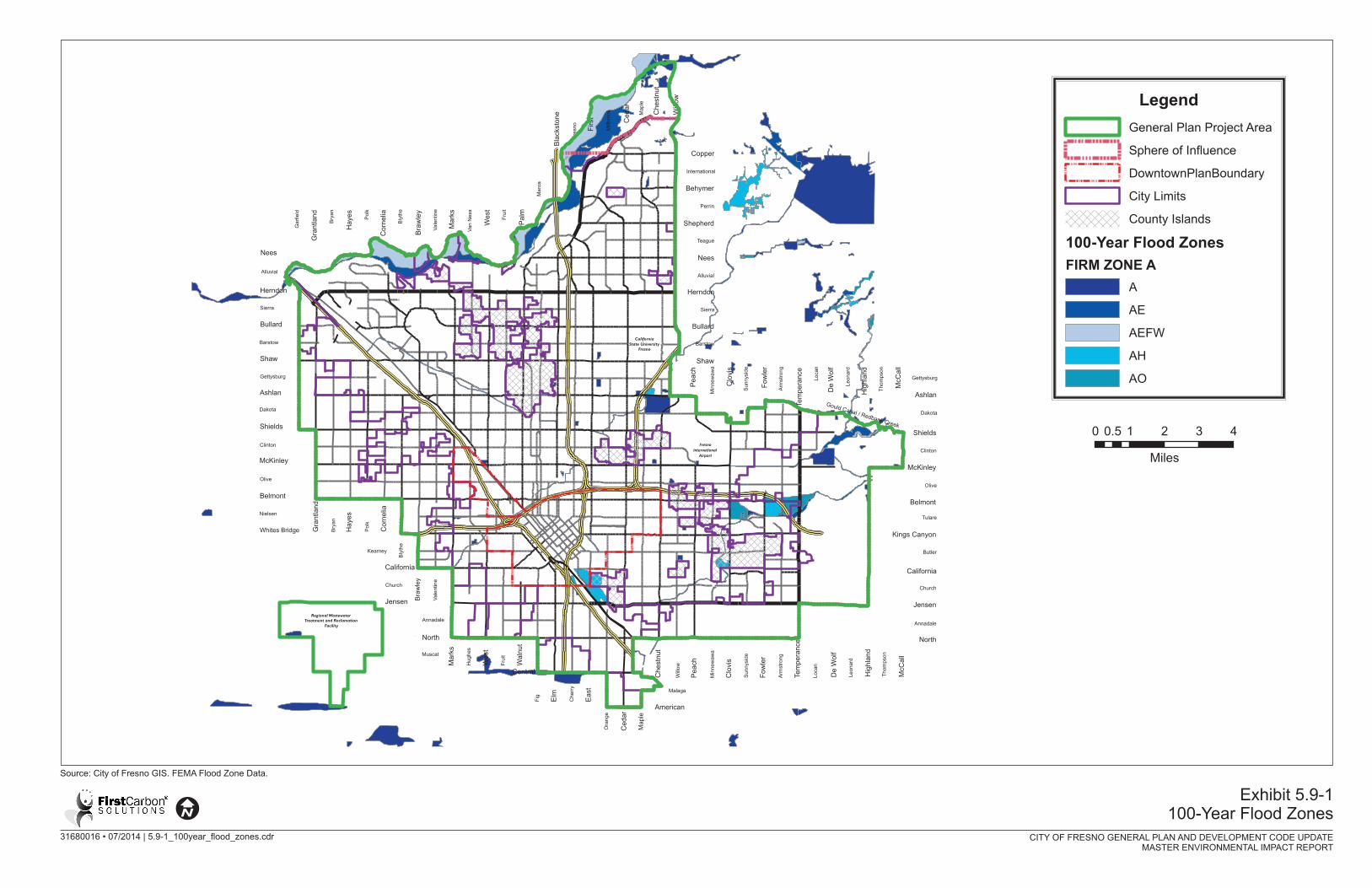
Based on a review of the Federal Emergency Management Agency’s Flood Insurance Rate Maps
(FIRM) for the Planning Area, there are areas that are subject to the 100‐year frequency flood zone
(see Exhibit 5.9‐1). The primary area that is subject to the 100‐year flood zone is along the San
Joaquin River below the bluffs. There are additional areas in the vicinity of the Fresno International
Airport, the Southeast Development Area in the vicinity of the Redbank Creek Dam, adjacent to
Highway 180 east of Clovis Avenue, and within an industrial area east of SR‐99, south of California
Avenue and north of Jensen Avenue. In addition, various detention basins are subject to the 100‐
year flood zone.
5.9.3 ‐ Regulatory Setting
Federal
Clean Water Act
The Clean Water Act (CWA) established a basic structure for regulating discharges of pollutants into
Waters of the United States and regulating quality standards for surface waters. The basis of the
CWA was enacted in 1948 and was called the Federal Water Pollution Control Act, but the Act was
significantly reorganized and expanded in 1972. The “Clean Water Act” became the Act’s common
name with amendments in 1977.
Under the CWA, the Environmental Protection Agency (EPA) has implemented pollution control
programs and established water quality standards for all contaminants in surface waters. The CWA
made it unlawful to discharge any pollutant from a point source into navigable waters, unless a
National Pollutant Discharge Elimination System (NPDES) permit was obtained. Point sources are
discrete conveyances such as pipes or manmade ditches. While residential structures that are either
connected to a municipal system or otherwise do not discharge into surface waters are not required
to obtain a NPDES permit, industrial, municipal, and similar facilities must obtain permits to
discharge directly into surface waters. In California, the NPDES program is administered through the
nine Regional Water Quality Control Boards (RWQCB).
Non‐point sources are similarly regulated through a General Construction Activity Stormwater
NPDES permit. Construction activities subject to this permit include clearing, grading, excavating,
and general disturbances to the ground. Stormwater Pollution Prevention Plans (SWPPPs) are
required for the issuance of a General Construction Activity Stormwater NPDES permit and typically
include the implementation of structural and non‐structural Best Management Practices (BMPs) to
reduce impacts related to surface water quality.
National Pollutant Discharge Elimination System (NPDES) Permit
Section 402 of the CWA established the NPDES to control water pollution by regulating point sources
that discharge pollutants into Waters of the United States. In the State of California, the EPA has
authorized the State Water Resources Control Board (SWRCB) as the permitting authority to
implement the NPDES program. The SWRCB issues two‐baseline general permits; one for industrial
operations, the other for construction activities (General Construction Permit). Additionally, the
NPDES program includes the regulation of stormwater discharges from cities, counties, and other
municipalities under Order No. R8‐2009‐0030 (waste discharge requirements for stormwater).
City of Fresno General Plan and Development Code Update Hydrology and Water Quality Master Environmental Impact Report
5.9‐8 FirstCarbon Solutions M:\DriveT@VOL1\shared\31680016 ‐ Fresno General Plan MEIR\Fresno GP MEIR_FINAL 7.22.14\31680016 Sec 05‐09 HWQ Fresno MEIR 7.22.14.doc
Under the General Construction Permit, stormwater discharges from construction sites with a
disturbed area of one or more acres are required to obtain either individual NPDES permits for
stormwater discharges or be covered by the Construction General Permit. Coverage under the
Construction General Permit is accomplished by completing and filing a Notice of Intent with the
SWRCB. Each Applicant under the Construction General Permit is required to both prepare a SWPPP
prior to the commencement of grading activities and to ensure implementation of the SWPPP during
construction activities. The primary objective of the SWPPP is to identify, construct, implement, and
maintain BMPs to reduce or eliminate pollutants in stormwater discharges and authorized non‐
stormwater discharges from the construction site during construction activities. BMPs may include
programs, technologies, processes, practices, and devices that control, prevent, remove, or reduce
pollution. The SWPPP would also address BMPs developed specifically to reduce pollutants in
stormwater discharges following the completion of construction activities.
Safe Drinking Water Act (Federal)
The Safe Drinking Water Act (SDWA) was established to protect the quality of drinking water in the
United States. This SDWA focuses on all waters either designed or potentially designed for drinking
water use, whether from surface water or groundwater sources. The SDWA and subsequent
amendments authorized the EPA to establish health‐based standards, or maximum contaminant
levels (MCLs), for drinking water to protect public health against both natural and anthropogenic
contaminants. All owners or operators of public water systems are required to comply with these
primary (health‐related) standards. State governments, which can be approved to implement these
primary standards for the EPA, also encourage attainment of secondary (nuisance‐related) standards.
At the federal level, the EPA administers the SDWA and establishes MCLs for bacteriological, organic,
inorganic, and radiological constituents (United States Code Title 42, and Code of Federal Regulations
Title 40). At the state level, California has adopted its own SDWA, which incorporates the federal
SDWA standards with some other requirements specific only to California (California Health and
Safety Code, Section 116350 et seq.).
The 1996 SDWA amendments established source water assessment programs pertaining to
untreated water from rivers, lakes, streams, and groundwater aquifers used for drinking water
supply. According to these amendments, the EPA must consider a detailed risk and cost assessment,
as well as best available peer‐reviewed science, when developing standards for drinking water.
These programs are the foundation of protecting drinking water resources from contamination and
avoiding costly treatment to remove pollutants. In California, the Drinking Water Source Assessment
and Protection (DWSAP) program fulfills these federal mandates. The California Department of
Public Health is the primary agency for developing and implementing the DWSAP program, and is
responsible for performing the assessments of existing groundwater sources.

City of Fresno General Plan and Development Code Update Master Environmental Impact Report Hydrology and Water Quality
FirstCarbon Solutions 5.9‐11 M:\DriveT@VOL1\shared\31680016 ‐ Fresno General Plan MEIR\Fresno GP MEIR_FINAL 7.22.14\31680016 Sec 05‐09 HWQ Fresno MEIR 7.22.14.doc
State
Porter‐Cologne Water Quality Control Act
The Porter‐Cologne Water Quality Control Act of 1969, which became Division 7 of the California
Water Code, authorized the SWRCB to provide comprehensive protection for California’s waters
through water allocation and water quality protection. The SWRCB implements the requirement of
the CWA Section 303, which states that water quality standards must be established for certain
waters through the adoption of water quality control plans under the Porter‐Cologne Act. The
Porter‐Cologne Act established the responsibilities and authorities of the nine RWQCBs, which
include preparing water quality plans within the regions, identifying water quality objectives, and
instituting waste discharge requirements. Water quality objectives are defined as limits or levels of
water quality constituents and characteristics established for reasonable protection of beneficial
uses or prevention of nuisance. Beneficial uses consist of all the various ways that water can be used
for the benefit of people and wildlife. The Porter‐Cologne Act was later amended to provide the
authority delegated from the EPA to issue NPDES permits regulating discharges to Waters of the
United States.
Local
The existing City of Fresno regulations regarding hydrology and water quality are presented below.
City of Fresno General Plan
The City of Fresno General Plan contains goals, objectives, and policies that address hydrology and
water quality. The following General Plan goals, objectives, and policies are applicable to the
proposed project:
Safety Element
I‐5. OBJECTIVE: Protect the lives and property of current and future residents of the Fresno Clovis
Metropolitan Area (FCMA) from the hazards of periodic floods. Recognize and institute adequate
safeguards for the particular flooding hazards of areas on the San Joaquin riverbottom and bluffs.
I‐5‐a. Policy: Support the full implementation of the Fresno Metropolitan Flood Control District
(FMFCD) Storm Drainage and Flood Control Master Plan, the completion of planned flood control
and drainage system facilities, and the continued maintenance of stormwater and floodwater
retention and conveyance facilities and capacities.
I‐5‐b. Policy: The San Joaquin River will not be channelized, and levees will not be used in the river
corridor for flood control, excepting those alterations in river flow that are approved with surface
mining and subsequent reclamation activities for mined sites (e.g., temporary berms and small side
channel diversion to control water flow through ponds).
I‐5‐c. Policy: Ensure implementation of the Fresno Metropolitan Flood Control District control
programs for the Fresno County Stream Group, including completion of the Redbank‐Fancher Creek
Flood Control Project, and the FMFCD rural streams program to provide protection to the urban
community from waters originating outside the urban area.
City of Fresno General Plan and Development Code Update Hydrology and Water Quality Master Environmental Impact Report
5.9‐12 FirstCarbon Solutions M:\DriveT@VOL1\shared\31680016 ‐ Fresno General Plan MEIR\Fresno GP MEIR_FINAL 7.22.14\31680016 Sec 05‐09 HWQ Fresno MEIR 7.22.14.doc
I‐5‐d. Policy: Ensure implementation of the Fresno Metropolitan Flood Control urban drainage
system program, including completion of the urban storm drainage systems to provide protection to
the urban community from waters originating within the urban area.
I‐5‐e. Policy: Ensure implementation of land grading and development policies which protect area
residents from flooding caused by urban runoff produced by events which exceed the capacity of the
Storm Drainage and Flood Control Master Plan system of facilities.
I‐5‐f. Policy: The minimum level of design flood protection shall be the 100‐year (one percent)
event, as established by the best and most current available data from the U.S. Army Corps of
Engineers and the California Department of Water Resources, pursuant to Federal Emergency
Management Agency (FEMA) direction.
I‐5‐g. Policy: Establish special building standards for private structures, public structures, and
infrastructure elements in the San Joaquin riverbottom, which would protect:
construction in this area from being damaged by the intensity of flooding in the riverbottom.
water quality in the San Joaquin River watershed from flood damage‐related nuisances and
hazards (e.g., the release of raw sewage).
public health, safety, and general welfare from the effects of flood events.
I‐5‐h. Policy: Complete studies, addressing the limitations of the area’s geological and hydrological
status and all the relevant features of the proposed project, will be required prior to the approval of
any construction or development project proposed in the San Joaquin riverbottom or below the top
of the San Joaquin River bluffs.
Designated Floodway Map developed by the State Board of Reclamation.
Mapping of the 100‐year floodplain with the best available current data and its relationship to
the finished project.
Central Valley Project easements on the property.
Surrounding topography, river channel configuration and flow characteristics, and on‐ and off‐site drainage features.
The presence of wetlands, natural vegetation, and wildlife, for which the Clean Water Act and
related federal and state legislation may require wit the U.S. Army Corps of Engineers, the U.S.
Fish and Wildlife Service, and the California Department of Fish and Game.
Existing sand and gravel mining and processing facilities in the vicinity.
Grading activity proposed for the construction of the project.
Residential uses, and proposed structures and accessory structures.
City of Fresno General Plan and Development Code Update Master Environmental Impact Report Hydrology and Water Quality
FirstCarbon Solutions 5.9‐13 M:\DriveT@VOL1\shared\31680016 ‐ Fresno General Plan MEIR\Fresno GP MEIR_FINAL 7.22.14\31680016 Sec 05‐09 HWQ Fresno MEIR 7.22.14.doc
Vehicular and pedestrian access for ingress, egress, and emergency response access; primary
and secondary roadway and driveway with appurtenant bridges, trestles, and culverts.
Water wells, septic tanks, and on‐site propane or other fuel tanks.
Utility infrastructure (water, sewer, power, and telecommunication lines).
Fencing and walls.
Ability to provide flood warning and rapid evacuation of the site.
In consideration of these and other relevant factors that may arise during project review, the
proposed construction or development project may be denied, or additional flood protection
measures may be required.
I‐5‐i. Policy: The City of Fresno shall preserve flood‐prone areas within the City of Fresno and its
Sphere of Influence, particularly the San Joaquin riverbottom for uses, which will not have
permanent improvements that would be adversely affected by periodic floods.
I‐5‐j. Policy: The City of Fresno shall continue to assign open space zoning to all undeveloped areas,
which are within the Designated Floodway of the San Joaquin River and the floodway channels of
Dry Creek, Redbank Creek, Francher Creek, and other streams.
I‐5‐k. Policy: Except in the San Joaquin riverbottom (where new residential subdivisions are not
allowed by the multi‐use open space land use designation), the City of Fresno shall require
developers of residential subdivisions to preserve those portions of development sites as open
space, which may be subject to 100‐year flood events, unless the flood hazard can be substantially
mitigated by development project design. This shall be a condition of subdivision map and special
permit approval.
The density of developable adjacent land may be increased to allow the same number of dwelling
units as if the entire site were developed. In such instances, the open space area should be
incorporated into the project design to provide amenity and passive open space for future residents.
This open space should be improved and maintained by the developer, or through the use of
mechanisms as homeowners association fees or maintenance districts.
I‐5‐m. Policy: A valid beneficial use of the San Joaquin River Corridor is to transport floodwater, and
this use must be protected. Riverbottom land uses will be managed with the following objectives:
to control and reduce erosion in the floodway.
to maintain the combined existing flow capacity in the river channel and the designated
floodway by establishing ordinances and policies to prevent nuisance blocking of flood flow.
to maintain the river stage required to pass any given flow, so as not to increase the extent of
flooded area (no increase in the designated floodway), unless any resulting loss in private land
value is first purchased from willing sellers.

City of Fresno General Plan and Development Code Update Hydrology and Water Quality Master Environmental Impact Report
5.9‐14 FirstCarbon Solutions M:\DriveT@VOL1\shared\31680016 ‐ Fresno General Plan MEIR\Fresno GP MEIR_FINAL 7.22.14\31680016 Sec 05‐09 HWQ Fresno MEIR 7.22.14.doc
to coordinate any snagging and clearing activities for river channel enhancement with
resource agencies to minimize conflicts with natural habitat preservation and mineral
extraction activities (including reclamation).
I‐5‐n. Policy: As new information becomes available, maps of record which designate areas subject
to flooding will be amended.
Assist the U.S. Army Corps of Engineers, State Department of Water Resources, FEMA, and the
Fresno Metropolitan Flood Control District, with mapping projects for floodplains. Establish
the updating of floodplain maps in the San Joaquin riverbottoms as a main priority in order to
protect health, safety, and general welfare in the riverbottom.
Maps of the inundation areas for dam failures on the San Joaquin River, Kings River, and the
Fresno Stream Group will also be maintained for city emergency preparedness and other
planning purposes.
Provide and utilize updated flood map and inundation information for review of development
projects.
I‐5‐o. Policy: Pursuant to state law, the city shall prepare and update emergency dam failure
inundation plans, evacuation plans and other emergency response plans for designated flood‐prone
areas, including the San Joaquin riverbottom.
Resource Conservation Element
G‐2. Objective: Maintain a comprehensive, long‐range water resource management plan that
provides for appropriate management of all sources of water available to the Planning Area and
ensures that sufficient and sustainable water supplies of good quality will be economically available
to accommodate existing and planned urban development.
G‐2‐b. Policy: Implement the Fresno Metropolitan Water Resources Management Plan, and update
this plan as necessary, to ensure cost‐effective use of water resources and continued availability of
good‐quality groundwater and surface water supplies.
G‐2‐c. Policy: Continue interagency efforts toward completion of a Groundwater Management Plan,
pursuant to the provisions added to the California Water Code by Assembly Bill 3030.
G‐3. Objective: Protect water resources in the area from further degradation in quality.
G‐3‐a. Policy: Monitor key pollutants to determine directions and rates of contaminant travel, in
order to achieve cost‐effective and timely intervention for containment and remediation of
contamination, and to indicate which areas may require water treatment to supply acceptable‐
quality drinking water.
G‐3‐b. Policy: Continue to participate in interagency committees and task forces (with local, state,
and federal representation, as may be needed) to share information, to efficiently utilize financial
City of Fresno General Plan and Development Code Update Master Environmental Impact Report Hydrology and Water Quality
FirstCarbon Solutions 5.9‐15 M:\DriveT@VOL1\shared\31680016 ‐ Fresno General Plan MEIR\Fresno GP MEIR_FINAL 7.22.14\31680016 Sec 05‐09 HWQ Fresno MEIR 7.22.14.doc
resources devoted to evaluating water quality problems, and to facilitate cost‐effective management
of water pollution.
G‐3‐c. Policy: Support continued efforts to identify and mitigate detriments to surface and ground
water quality that may result from stormwater discharge from urbanized areas.
G‐3‐d. Policy: Continue to implement water system policies that ensure compliance with Federal
and State Safe Drinking Water Standards.
G‐3‐e. Policy: Support and encourage actions of the Regional Water Quality Control Board, the State
Environmental Protection Agency, and the local health department to control and prevent water
contamination, including leaking underground storage tank and abandoned storage tank abatement
programs.
G‐3‐f. Policy: Continue programs to collect and treat sewage to enhance water quality and reclaim
water resources in a manner that protects the Fresno Sole Source Aquifer.
G‐3‐g. Policy: Restrict urban development in areas that are not served by a wastewater
treatment/management system that is capable of preventing the buildup of compounds that would
degrade the aquifer. Oppose the development of new sewage disposal facilities either within the
planning area or upgradient (north and east) of the planning area, unless the treatment produce
effluent that:
will not degrade the aquifer in the long term.
will not introduce contaminants into surface water that would negatively affect its potential
economic use of drinking water.
will not deleteriously affect downstream agricultural and urban uses.
will not degrade sensitive riparian habitat.
G‐4. Objective: Manage, use, and replenish water resources to maintain a balanced “water budget”
in the Fresno area.
G‐4‐b. Policy: In cooperation with other agencies, enhance the recharge of groundwater as may be
necessary.
G‐4‐c. Policy: Address localized groundwater deficiencies and groundwater quality problems that
exist or may arise in portions of the planning area.
Public Facilities Element
E‐22. Objective: Manage and develop the City of Fresno's water facilities to ensure a safe,
economical, and reliable water supply for existing and planned urban development and economic
diversification.
City of Fresno General Plan and Development Code Update Hydrology and Water Quality Master Environmental Impact Report
5.9‐16 FirstCarbon Solutions M:\DriveT@VOL1\shared\31680016 ‐ Fresno General Plan MEIR\Fresno GP MEIR_FINAL 7.22.14\31680016 Sec 05‐09 HWQ Fresno MEIR 7.22.14.doc
H‐22‐g. Policy. Continue to implement water system policies that require the provision of a potable
water supply that complies with the standards of the Federal and State Safe Drinking Water Acts for
consumptive use, and meets applicable standards of volume and pressure for fire suppression
purposes.
H‐22‐h. Policy. Implement appropriate measures consistent with water system policies, including
the removal of pump stations from active use, installation of wellhead treatment facilities,
construction of aboveground storage and surface water treatment facilities, and enhancement of
transmission grid mains to ensure adequate water quality and quantity.
City of Fresno Municipal Code
Chapter 6, Municipal Services and Utilities, Article 7, Urban Storm Water Quality Management and
Discharge Control, of the Fresno Municipal Code establishes provisions regarding stormwater
discharges. The purpose and intent of Article 7 is to ensure the health, safety, and general welfare of
residents, and to protect the water quality of surface water and groundwater resources in a manner
pursuant to and consistent with the Federal CWA by reducing pollutants in urban stormwater,
discharges to the maximum extent practicable, and by effectively prohibiting non‐stormwater
discharges to the storm drain system.
5.9.4 ‐ Thresholds of Significance
In accordance with CEQA, the effects of a project are evaluated to determine if they will result in
significant adverse impacts on the environment. The criteria used to determine the significance of
an impact to hydrology and water quality are based on the Environmental Checklist in Appendix G of
the State CEQA Guidelines and identified below. Accordingly, hydrology and water quality impacts
resulting from the proposed project are considered significant if the project would:
a) Violate any water quality standards or waste discharge requirements? (See Water Quality
Standards and Requirements, Impact HYD‐1)
b) Substantially deplete groundwater supplies or interfere substantially with groundwater
recharge such that there would be a net deficit in aquifer volume or a lowering of the local
groundwater table level (e.g., the production rate of pre‐existing nearby wells would drop
to a level which would not support existing land uses or planned uses for which permits
have been granted? (See Groundwater Supplies and Recharge, Impact HYD‐2)
c) Substantially alter the existing drainage pattern of area, including through the alteration of
the course of a stream or river, in a manner which would result in substantial erosion or
siltation on‐ or off‐site? (See Drainage Pattern: Erosion or Siltation, Impact HYD‐3)
d) Substantially alter the existing drainage pattern of the site or area, including through the
alteration of the course of a stream or river, or substantially increase the rate or amount of
surface runoff in a manner which would result in flooding on‐ or off‐site? (See Drainage
Pattern: Flooding, Impact HYD‐4)
City of Fresno General Plan and Development Code Update Master Environmental Impact Report Hydrology and Water Quality
FirstCarbon Solutions 5.9‐17 M:\DriveT@VOL1\shared\31680016 ‐ Fresno General Plan MEIR\Fresno GP MEIR_FINAL 7.22.14\31680016 Sec 05‐09 HWQ Fresno MEIR 7.22.14.doc
e) Create or contribute runoff water, which would exceed the capacity of existing or planned
stormwater drainage systems or provide substantial additional sources of polluted runoff?
(See Runoff Water and Drainage Systems, Impact HYD‐5)
f) Otherwise substantially degrade water quality? (See Water Quality, Impact HYD‐6)
g) Place housing within a 100‐year flood hazard area as mapped on a federal Flood Hazard
Boundary or Flood Insurance Rate Map or other flood hazard delineation map? (See
Housing Placement: Flood Hazard Area, Impact HYD‐7)
h) Place within a 100‐year flood hazard area structures, which would impede or redirect flood
flows? (See Structures: Flood Hazard Areas, Impact HYD‐8)
i) Expose people or structures to a significant risk of loss, injury or death involving flooding,
including flooding as a result of the failure of a levee or dam? (See Flooding: Failure of
Levee or Dam, Impact HYD‐9)
j) Inundation by seiche, tsunami, or mudflow? (See Sieche, Tsunami, or Mudflow, Impact HYD‐
10)
5.9.5 ‐ Impact Analysis, Mitigation Measures, and Level of Significance After Mitigation
Water Quality Standards and Requirements
Impact HYD‐1 The project would not violate any water quality standards or waste discharge requirements.
Project Specific Impact Analysis
Short‐Term Construction Impacts
Construction activities associated with buildout of the Planning Area would result in ground‐
disturbing activities such as grading, excavation, placing fill, trenching, spoil pile storage, and
backfilling of trenches. Such earthmoving activates would increase the potential for erosion and
sedimentation, particularly during storm events. Additionally, construction equipment and vehicles
could deposit constituents such as diesel fuel, hydraulic fluid, oil, and exhaust into the environment
that could be conveyed within stormwater runoff to surface waters or groundwater. Construction
activities use concrete, solvents, glues, oils, paints, and generate trash, all of which, if they come into
contact with rainfall or stormwater runoff can cause pollution in stormwater. While temporary, all of
these construction activities and products, including ground‐disturbing construction activities could
still result in the pollution of stormwater runoff that leaves the construction site that could
contribute to downstream surface waters or groundwater degradation.
There are regulatory mechanisms in place that would reduce the effects of construction activities on
water quality, including the National Pollutant Discharge Elimination System (NPDES) Construction
General Permit. Development within the Planning Area would be required to comply with the
requirements of the NPDES Construction General Permit. The NPDES Permit Program, which is
administered in the Planning Area region by the Central Valley RWQCB, helps control pollution in
stormwater by regulating sources of pollution at construction sites that would result in the discharge
City of Fresno General Plan and Development Code Update Hydrology and Water Quality Master Environmental Impact Report
5.9‐18 FirstCarbon Solutions M:\DriveT@VOL1\shared\31680016 ‐ Fresno General Plan MEIR\Fresno GP MEIR_FINAL 7.22.14\31680016 Sec 05‐09 HWQ Fresno MEIR 7.22.14.doc
of pollutants into the stormwater and subsequent receiving waters during both construction and
operations activities.
Any development project disturbing one or more acres of soil must obtain coverage under the
General Permit for Discharges of Storm Water Associated with Construction Activity (Construction
General Permit Order 2009‐0009‐DWQ). Construction activities subject to the Construction General
Permit includes clearing, grading, and other ground‐disturbing activities such as stockpiling or
excavation. The Construction General Permit requires development and implementation of a Storm
Water Pollution Prevention Plan (SWPPP). Among other mandated items that are included in a
SWPPP, are features designed to eliminate contact of rainfall and stormwater runoff with sources of
pollution that occur on construction sites, of which a primary source is soil erosion as a result of
unstabilized soils coming in contact with water and wind. These features are known as Best
Management Practices (BMPs). Common BMPs to limit pollution in stormwater runoff from
construction sites include maintaining or creating drainages to convey and direct surface runoff away
from bare areas and installing physical barriers such as berms, silt fencing, waddles, straw bales, and
gabions.
The required preparation, implementation, and participation with the Construction General Permit,
including the SWPPP and BMPs, would reduce project construction impacts on water quality to less
than significant levels. Therefore, short‐term construction impacts associated with water quality
standards and waste discharge requirements would be less than significant.
Long‐Term Project Impacts
Development under the General Plan Update would result in new industrial, commercial, residential,
and mixed‐use land uses that would increase the amount of paved impervious surfaces within the
Planning Area. This increase in impervious surfaces would increase stormwater runoff rates and
volumes over the rates and volumes from undeveloped land. The Fresno Metropolitan Flood Control
District (FMFCD) is responsible for developing and implementing the Storm Drainage Master Plan for
the City of Fresno. As land is developed, the FMFCD works with the developers and the City to
implement the storm drainage system to collect and dispose of the increased runoff rates and
volumes and prevent them from entering local surface waters, including the San Joaquin River, local
creeks, and numerous irrigation canals that cross through the Planning Area. The storm drainage
systems that are implemented for the Planning Area consist of streets, curbs and gutters that direct
runoff to storm drain inlets, which direct runoff to underground pipelines. The underground
pipelines convey stormwater to retention and urban detention (water quality) basins located at
strategic locations within the Planning Area. The stormwater retention basins dispose of runoff
through percolation into the groundwater and, in emergencies, through pumping to designated
irrigation canals. The urban detention (water quality) basins discharge to the San Joaquin River.
Discharges from the retention basins and the urban detention (water quality) basins could affect
water quality in the receiving waters by potentially increasing the concentration of sediment and
pollution found in stormwater.
City of Fresno General Plan and Development Code Update Master Environmental Impact Report Hydrology and Water Quality
FirstCarbon Solutions 5.9‐19 M:\DriveT@VOL1\shared\31680016 ‐ Fresno General Plan MEIR\Fresno GP MEIR_FINAL 7.22.14\31680016 Sec 05‐09 HWQ Fresno MEIR 7.22.14.doc
Typically, stormwater runoff from urban development contains an array of constituents, including
automotive fluids (e.g., fuel, oils, and antifreeze), combustion and exhaust byproducts (e.g., lead,
cadmium, and nickel), sediments, fertilizers, pesticides, herbicides, and nutrients and bacteria
pollutants from domestic and agricultural animal waste. These constituents are expelled into the
environment throughout the year, where they settle onto the ground surface. During the wet
season, stormwater runoff conveys these pollutants downstream, resulting in polluted stormwater
runoff, especially during the first storm events of the season.
The City of Fresno is a co‐permittee with the Fresno Metropolitan Flood Control District, the County
of Fresno, the City of Clovis, and California State University Fresno in the Phase 1 NPDES Permit for
Stormwater Discharges from Municipal Separate Storm Sewer Systems (MS4s). This Phase 1 MS4
Permit requires that the City and its co‐permittees implement water quality and watershed
protection measures for all development projects. The waste discharge requirements contained in
the NPDES Permit have been designed to be consistent with the water quality standards and goals
established in the Central Valley RWQCB’s Basin Plan. The Phase 1 MS4 Permit prohibits discharges
from violating applicable water quality standards or creating a nuisance or water quality impairment
in receiving waters. Participation in the Phase 1 MS4 permit and implementation of the Storm
Drainage Master Plan will reduce impacts to surface waters to acceptable levels and long‐term
project impacts to surface or groundwater quality will not exceed acceptable levels.
Additionally, the General Plan Update includes the following policies designed to reduce water
quality impacts:
Parks, Opens Space, & Schools Element
Policy POSS‐6‐b. Effects of Stormwater Discharge. Support efforts to identify and mitigate
cumulative adverse effects on aquatic life from stormwater discharge to the San Joaquin River.
Avoid discharge of runoff from urbanuses to the San Joaquin River or other riparian corridors.
Approve development on sites having drainage (directly or indirectly) to the San Joaquin River
or other riparian areas only upon a finding that adequate measures for preventing pollution of
natural bodies of water from their runoff will be implemented.
Periodically monitor water quality and sediments near drainage outfalls to riparian areas.
Institute remedial measures promptly if unacceptable levels of contaminant(s) occur.
Public Utilities and Services Element
Policy PU‐5‐a: Mandatory Septic Conversion. Continue to evaluate and pursue where determined
appropriate of the mandatory abatement of existing private wastewater (septic) disposal systems
and mandatory connection to the public sewage collection and disposal system.
Policy PU‐5‐b: Non‐Regional Treatment. Discourage, and when determined appropriate, oppose the
use of private wastewater (septic) disposal systems, community wastewater disposal systems or
other non‐regional sewage treatment and disposal systems within or adjacent to the Metropolitan
City of Fresno General Plan and Development Code Update Hydrology and Water Quality Master Environmental Impact Report
5.9‐20 FirstCarbon Solutions M:\DriveT@VOL1\shared\31680016 ‐ Fresno General Plan MEIR\Fresno GP MEIR_FINAL 7.22.14\31680016 Sec 05‐09 HWQ Fresno MEIR 7.22.14.doc
Area if these types of wastewater treatment facilities would cause discharges that could result in
groundwater degradation.
Policy PU‐5‐c: Satellite Facilities. Work with the Regional Water Quality Control Board to ensure that
approval of any satellite treatment and reclamation facility proposal is consistent with governing
statutes and regulations.
Policy PU‐7‐a: Reduce Wastewater. Identify and consider implementing water conservation
standards and other programs and policies, as determined appropriate, to reduce wastewater flows.
Policy PU‐7‐b: Reduce Stormwater Leakage. Reduce storm water infiltration to the sewer collection
system, where feasible, through a program of replacing old and deteriorated sewer collection
pipeline; eliminating existing stormwater sewer cut‐ins to the sanitary sewer system; and avoiding
any new sewer cut‐ins except when required to protect health and safety.
Policy PU‐7‐c: Biosolid Disposal. Investigate and consider implementing economically effective and
environmentally beneficial methods of biosolids handling and disposal.
Policy PU‐7‐d: Wastewater Recycling. Pursue the development of a recycled water system and the
expansion of beneficial wastewater recycling opportunities, including a timely technical, practicable,
and institutional evaluation of treatment, facility siting and water exchange elements.
Policy PU‐7‐e: Infiltration Basins. Continue to rehabilitate existing infiltration basins, and if
determined appropriate, pursue acquiring additional sites for infiltration basins, as needed.
Policy PU‐7‐f: Food and Drink Industry. Ensure adequate provision of facilities for the appropriate
management of wastewater from wineries and food processing and beverage facilities, including
conformance with Waste Discharge Requirements issued by the Regional Water Quality Control
Board.
Resource Conservation and Resilience
Policy RC‐6‐e: Protect Aquifer. Oppose urban development in unincorporated areas that are not
served by a wastewater treatment/management system capable of preventing the buildup of
compounds that would degrade the aquifer.
Policy RC‐5‐f: Regulate Sewage Disposal Facilities. Oppose the development of new sewage disposal
facilities either within the planning area or up gradient (north and east) of the Planning Area, unless
the treatment facilities produce effluent that:
Will not degrade the aquifer in the long term;
Will not introduce contaminants into surface water that would negatively affect its potential
economic use for drinking water;
Will not deleteriously affect downstream agricultural and urban uses; and
Will not degrade sensitive riparian habitat.
City of Fresno General Plan and Development Code Update Master Environmental Impact Report Hydrology and Water Quality
FirstCarbon Solutions 5.9‐21 M:\DriveT@VOL1\shared\31680016 ‐ Fresno General Plan MEIR\Fresno GP MEIR_FINAL 7.22.14\31680016 Sec 05‐09 HWQ Fresno MEIR 7.22.14.doc
Policy RC‐6‐g: Protect Recharge Areas. Continue to protect areas of beneficial natural groundwater
recharge by preventing uses that can contaminate soil or groundwater.
Policy RC‐6‐h: Conditions of Approval. Include in the Development Code standards for imposing
conditions of approval for development projects to ensure long‐term maintenance of adequate clean
water resources. Require findings that adequate water supply must exist prior to any discretionary
project approval for residential and commercial development requiring annexation (excluding
County Islands), as required by law.
Noise and Safety Element
Policy NS‐3‐e: Pollutants. Work with FMFCD to prevent and reduce the existence of urban
stormwater pollutants pursuant to the requirements of the National Pollution Discharge Elimination
Systems Act.
Policy NS‐3‐i: New Development Must Mitigate Impact. Require new development to not
significantly impact the existing storm drainage and flood control system by imposing conditions of
approval as project mitigation, as authorized by law. As part of this process, closely coordinate and
consult with the FMFCD to identify appropriate conditions that will result in mitigation acceptable
and preferred by FMFCD for each project.
Along with preparation, implementation, and participation of the NPDES Permit, implementation of
the aforementioned General Plan Update polices would reduce long‐term project impacts associated
with water quality standards and wastewater discharge requirements to less than significant levels.
Cumulative Impact Analysis
Short‐Term Construction Impacts
Buildout of the Planning Area, along with construction of related projects in the Planning Area
vicinity, would result in activities that could pollute stormwater runoff, particularly ground‐disturbing
activities that would increase the potential for erosion and sedimentation. Although temporary,
these construction activities could still result in pollution of the runoff, including on‐ and off‐site soil
erosion, sedimentation, and siltation that could contribute to downstream surface waters or
groundwater degradation, ultimately resulting in cumulative impacts.
Construction of projects within the Planning Area would be required to comply with the
requirements of the NPDES Construction General Permit. The NPDES Construction General Permit
program helps control stormwater pollution by controlling the contact of sources of pollution on
construction sites with rainfall and stormwater runoff. Stormwater that is discharged into local
receiving waters would also result in the discharge of those pollutants from the construction and
operations activities into receiving waters. As stated previously, the Construction General Permit
requires that any development project disturbing one or more acres of soil must obtain coverage
under the General Permit for Discharges of Storm Water Associated with Construction Activity
(Construction General Permit Order 2009‐0009‐DWQ) that is issued by the State Water Resources
Control Board. The Construction General Permit requires development and implementation of a
City of Fresno General Plan and Development Code Update Hydrology and Water Quality Master Environmental Impact Report
5.9‐22 FirstCarbon Solutions M:\DriveT@VOL1\shared\31680016 ‐ Fresno General Plan MEIR\Fresno GP MEIR_FINAL 7.22.14\31680016 Sec 05‐09 HWQ Fresno MEIR 7.22.14.doc
SWPPP, which would include implementable features designed to protect rainfall and stormwater
runoff from contact with sources of pollution on construction sites, including unstabilized soil that
would be eroded by the stormwater. The Construction General Permit also requires counter
measures to protect against wind erosion of unstabilized soils. Theseprotection measures, BMPs,
along with the implementation of a SWPPP would reduce construction impacts on water quality,
both individually and collectively, to acceptable levels. As a result, less than significant cumulative
short‐term construction impacts associated with water quality standards and waste discharge
requirements would occur within the Planning Area, and therefore, implementation of the General
Plan Update is not deemed cumulatively considerable and short term impacts are considered to be
less than significant.
Long‐Term Project Impacts
Buildout of the Planning Area, along with construction of related projects in the vicinity of the
Planning Area would increase the amount of paved impervious surfaces. This increase in impervious
surfaces would increase stormwater runoff rates and volumes over those that occur from
undeveloped land. The FMFCD works with the developers of cumulative projects within their
jurisdiction to implement a storm drainage system to collect and dispose of the increased runoff
rates and volumes and prevent them from entering local surface waters, including the San Joaquin
River, local creeks, and numerous irrigation canals that cross through the Planning Area. Because
the County of Fresno and City of Clovis are co‐permittees in the Phase I MS4 Permit, they are
required to implement water quality and watershed protection measures for cumulative projects.
Compliance with the MS4 Permit would result in less than significant cumulative long‐term impacts
associated with water quality standards and waste discharge requirements. Since the
implementation of the General Plan Update would result in less than significant long‐term impacts
on water quality standards and waste discharge requirements, the contribution of the General Plan
Update to cumulative impacts would not be considerable and long term cumulative impacts are
considered to be less than significant.
Mitigation Measures
Project Specific
No mitigation measures are required.
Cumulative
No mitigation measures are required.
Level of Significance After Mitigation
Project Specific
Less than significant impact.
Cumulative
Less than significant impact.
City of Fresno General Plan and Development Code Update Master Environmental Impact Report Hydrology and Water Quality
FirstCarbon Solutions 5.9‐23 M:\DriveT@VOL1\shared\31680016 ‐ Fresno General Plan MEIR\Fresno GP MEIR_FINAL 7.22.14\31680016 Sec 05‐09 HWQ Fresno MEIR 7.22.14.doc
Groundwater Supplies and Recharge
Impact HYD‐2 The project could substantially deplete groundwater supplies or interfere substantially with groundwater recharge such that there would be a net deficit in aquifer volume or a lowering of the local groundwater table level (e.g., the production rate of pre‐existing nearby wells would drop to a level which would not support existing land uses or planned uses for which permits have been granted.
Project Specific Impact Analysis
The City of Fresno relied on groundwater for approximately 87 percent of its domestic water supply
in 2010, which is approximately equal to a 128,578 acre feet. The groundwater was withdrawn from
the Kings Groundwater Sub‐basin of San Joaquin Basin Hydrologic Area. The City projects that
groundwater withdrawal will be reduced to 86,000 AF/year by the Year 2025, according to the 2010
UWMP. In 2010, natural groundwater recharge (24,400 AF), subsurface inflow (22,500 AF), and
intentional recharge (53,100 AF) occurred for a total groundwater recharge of 100,000 AF/year. At
present, the City is creating an overdraft of the Kings Groundwater Sub‐basin aquifer as defined by
the California State Department of Water Resources.
The City of Fresno has adopted a key objective of balancing its groundwater operations by the Year
2025 (West Yost Associates, 2011). According to the 2010 UWMP, achieving this objective includes
implementing a host of strategies, which includes increasing the amount of intentional groundwater
recharge from 43,100 AF in 2010 to 63,700 AF in 2025, and 75,100 AF in 2035. In addition, the
amount of groundwater that would be pumped would be reduced from 128,578 AF in 2010 to
53,500 AF in 2025, and 85,000 in 2035. Reducing groundwater pumping can occur with an increase
in the use of treated surface water from 18,474 AF in 2010 to 123,400 AF/year beginning in 2020. In
addition, groundwater pumping can be reduced due to the expansion of the water conservation
program, and development of a recycled water program, which is anticipated to be implemented by
2025, for irrigating landscaping. The projected groundwater‐pumping rate of 86,000‐acre feet per
year by the Year 2025 can be more than balanced by the estimated natural recharge of 26,900 AF
plus the intentional long‐term recharge rate of 63,700 AF in the Year 2025 for a total of 90,300 AF. In
2035, the total groundwater recharge is estimated at 102,100 AF while the groundwater‐pumping
rate is anticipated to remain at 86,000 AF.
Based on the 2010 UWMP, projected water demand which includes development of the General Plan
Update is based on a per capita target. For the years of 2020 and after, the per capita target is 250
gallons per day per capita (gpcd). The projected water demand for the City of Fresno in the Year
2035, based on a population of 780,600 is 218,596 AF/year. To accommodate the 2035 water
demand, 123,400 AF/year would need to be provided from treated surface water, 25,000 AF/year
would be provided as recycled water, and 70,196 AF/year would be pumped from the groundwater.
Depending on the specific conditions each year, there could be some variability in the amount of
treated surface water and/or recycled water, and in those situations, up to 86,000 AF/year of
groundwater could be pumped while treated surface water and/or recycled water could be reduced.
The projected water demand for the City at full build out of the General Plan Update, based on a
population of 970,000 and a per capita water demand of 250 gpcd from the 2010 UWMP, is 271,594
City of Fresno General Plan and Development Code Update Hydrology and Water Quality Master Environmental Impact Report
5.9‐24 FirstCarbon Solutions M:\DriveT@VOL1\shared\31680016 ‐ Fresno General Plan MEIR\Fresno GP MEIR_FINAL 7.22.14\31680016 Sec 05‐09 HWQ Fresno MEIR 7.22.14.doc
AF/year. Assuming treated water supplies, recycled water supplies, and pumped groundwater
remain the same, the total supply of water would be 234,400 AF/year. This water supply would be
less than the buildout demand by approximately 37,194 AF/year. As discussed in Section 5.15,
Utilities and Service Systems, groundwater pumping would remain at 85,000 AF/year in
approximately 2035 and beyond. To accommodate the buildout population of 970,000 people,
additional water conservation measures would need to be developed to reduce water demand from
250 gpcd to 215 gpcd. At 215 gpcd, the population of 970,000 people would demand 233,606
AF/year of water. This demand would be less than the total water supply of 234,400 AF/year.
To accommodate the buildout water demand, the treated surface water supply would need to be
increase, the recycled water supply would need to be increase, or the amount of groundwater to be
pumped would need to be increased. An increase in water conservation could also accommodate
the buildout demand.
Additionally, the General Plan Update includes the following policies designed to reduce the
potential for groundwater overdraft impacts:
Additionally, the General Plan Update includes the following policies designed to reduce the
potential for groundwater overdraft impacts:
Resource Conservation and Resilience Element
Objective RC‐6: Ensure that the City has a reliable, long‐range source of drinkable water.
Policy RC‐6‐a: Regional Efforts. Support cooperative, multi‐agency regional water resource planning
efforts and activities on developing and implementing the Upper Kings Basin Integrated Regional
Water Management Plan.
Policy RC‐6‐b: Water Plans. Adopt and implement ordinances, standards, and policies to achieve the
intent of the City of Fresno Urban Water Management Plan, Fresno‐Area Regional Groundwater
Management Plan, and City of Fresno Metropolitan Water Resources Management Plan to ensure a
dependable supply of water.
Policy RC‐6‐c: Land Use and Development Compliance. Ensure that land use and development
projects adhere to the objective of the Metropolitan Water Resource Management Plan to provide
sustainable and reliable water supplies to meet the demand of existing and future customers
through 2025.
Policy RC‐6‐d: Recycled Water. Prepare, Adopt, and implement a City of Fresno Recycled Water
Master Plan.
Policy RC‐6‐e: Protect Aquifer. Oppose urban development in unincorporated areas that are not
served by a wastewater treatment/management system capable of preventing the buildup of
compounds that would degrade the aquifer.
City of Fresno General Plan and Development Code Update Master Environmental Impact Report Hydrology and Water Quality
FirstCarbon Solutions 5.9‐25 M:\DriveT@VOL1\shared\31680016 ‐ Fresno General Plan MEIR\Fresno GP MEIR_FINAL 7.22.14\31680016 Sec 05‐09 HWQ Fresno MEIR 7.22.14.doc
Policy RC‐6‐i: Natural Recharge. Support removal of concrete from existing canals and change the
practice of lining new and existing canals with concrete to allow for natural recharge.
Objective RC‐7: Promote water conservation through standards, incentives and capital investments.
Policy RC‐7‐a: Maintain a comprehensive conservation program to help reduce per capita water
usage in the city’s water service area to 243 gallons per capita per day (gpcd) by 2020 and 190 gpcd
by 2035, by adopting conservation standards and implementing a program of incentives, design and
operation standards, and user fees..
Support programs that result in decreased water demand, such as landscaping standards that
require drought‐tolerant plants, rebates for water conserving devices and systems, turf
replacement, xeriscape landscape for new homes, irrigation controllers,
commercial/industrial/institutional water conserving programs, prioritized leak detection
program, complete water system audit, landscape water audit and budget program, and
retrofit upon resale ordinance.
Implement the U.S. Bureau of Reclamation Best Management Practices for water conservation
as necessary to maintain the City’s surface water entitlements.
Adopt and implement policies in the event that an artificial lake is proposed for development.
Work cooperatively toward effective uniform water conservation measures that would apply
throughout the Planning Area.
Expand efforts to educate the public about water supply issues and water conservation techniques.
Policy RC‐7‐b: Water Pricing and Metering. Develop a tiered water cost structure for both residential
and commercial users that will properly price water based on its true cost; require all new
development to be metered for water use; and charge all customers the true, full cost of their water
supply, including costs of acquisition, initial treatment, conveyance, wastewater treatment,
operations, maintenance, and remediation.
Policy RC‐7‐c: Best Practices for Conservation. Require all City facilities and all new private
development to follow U.S. Bureau of Reclamation Best Management Practices for water
conservation, as warranted and appropriate.
Policy RC‐7‐d: Update Standards for New Development. Continue to refine water saving and
conservation standards for new development.
Policy RC‐7‐e: Retrofit City Facilities, and Consider Incentives Programs to Encourage Retrofitting of
Other Existing Public and Private Residential and Non‐Residential Facilities and Sites. Reduce water
use in municipal buildings and City operations by developing a schedule and budget for the retrofit
of existing municipal buildings with water conservation features, such as auto shut‐off faucets and

City of Fresno General Plan and Development Code Update Hydrology and Water Quality Master Environmental Impact Report
5.9‐26 FirstCarbon Solutions M:\DriveT@VOL1\shared\31680016 ‐ Fresno General Plan MEIR\Fresno GP MEIR_FINAL 7.22.14\31680016 Sec 05‐09 HWQ Fresno MEIR 7.22.14.doc
water saving irrigation systems. Prepare a comprehensive incentive program for other existing public
and private residential and non‐residential buildings and irrigation systems..
Policy RC‐7‐f: Implementation and Update Conservation Program. Continue to implement the City
of Fresno Water Conservation Program, as may be updated, and periodically update restrictions on
water uses, such as lawn and landscape watering and the filling of fountains and swimming pools,
and penalties for violations. Evaluate the feasibility of a 2035 conservation target of 190 gpcd in the
next comprehensive update of the City of Fresno Water Conservation Program.
Policy RC‐7‐g: Educate on State Requirements. Educate the residents and businesses of Fresno on
the requirements of the California Water Conservation Act of 2009.
Policy RC‐7‐h: Landscape Water Conservation Standards. Refine landscape water conservation
standards that will apply to new development installed landscapes, building on the State Model
Water Efficient Landscape Ordinance and other state regulations.
Evaluate and apply, as appropriate, augmented xeriscape, “water‐wise,” and “green
gardening” practices to be implemented in public and private landscaping design and
maintenance.
Facilitate implementation of the State’s Water Efficient Landscape Ordinance by developing
alternative compliance measures that are easy to understand and observe.
Public Utilities and Services Element
Policy PU‐7‐d: Wastewater Recycling. Pursue the development of a recycled water system and the
expansion of beneficial wastewater recycling opportunities, including a timely technical, practicable,
and institutional evaluation of treatment, facility siting, and water exchange elements.
Policy PU‐7‐e: Infiltration Basins. Continue to rehabilitate existing infiltration basins, and if
determined appropriate, pursue acquiring additional sites for infiltration basins, as needed.
Objective PU‐8: Manage and develop the City’s water facilities on a strategic timeline basis that
recognizes the long‐life cycle of the assets and the duration of the resources, to promote a safe,
economical, and reliable water supply for existing and planned urban development and economic
diversification.
Policy PU‐8‐a: Forecast Need. Utilize available and innovative tools, such as computerized flow
modeling to determine system capacity, as necessary to forecast demand on water production and
distribution systems by urban development, and to determine appropriate facility needs.
Policy PU‐8‐b: Potable Water Supply and Cost Recovery. Prepare for provision of increased potable
water capacity (including surface water treatment capacity) in a timely manner to facilitate planned
urban development consistent with the General Plan. Accommodate increase in water demand from
the existing community with the capital costs and benefits allocated equitably and fairly between
City of Fresno General Plan and Development Code Update Master Environmental Impact Report Hydrology and Water Quality
FirstCarbon Solutions 5.9‐27 M:\DriveT@VOL1\shared\31680016 ‐ Fresno General Plan MEIR\Fresno GP MEIR_FINAL 7.22.14\31680016 Sec 05‐09 HWQ Fresno MEIR 7.22.14.doc
existing users and new users, as authorized by law, and recognizing the differences in terms of
quantity, quality and reliability of the various types of water in the City’s portfolio.
Policy PU‐8‐c: Conditions of Approval. Set appropriate conditions of approval for each new
development proposal to ensure that the necessary potable water production and supply facilities
and water resources are in place prior to occupancy.
Policy PU‐8‐d: CIP Update. Continue to evaluate capital improvement plans and update the, as
appropriate, to meet the demands of both existing and planned development consistent with the
General Plan.
Policy PU‐8‐e: Repairs. Continue to evaluate existing water production and distribution systems and
plan for necessary repair or enhancement of damaged or antiquated facilities.
Policy PU‐8‐f: Water Quality. Continue to evaluate and implement measures determined to be
appropriate and consistent with water system policies, including prioritize the use of groundwater,
installing wellhead treatment facilities, constructing above‐ground storage and surface water
treatment facilities, and enhancing transmission grid mains to promote adequate water quality and
quantity.
Policy PU‐8‐g: Review Project Impact on Supply. Mitigate the effects of development and capital
improvement projects on the long‐range water budget to ensure an adequate water supply for
current and future uses.
The implementation of the proposed project could result in significant impacts to groundwater levels
within the Kings Sub‐basin if the increase in water demand is met through an increase of water
supply from increased groundwater pumping.
Cumulative Impact Analysis
The Kings Sub‐basin is a source of groundwater for the communities of Clovis, Fresno, Sanger, Del
Rey, Orange Cove, East Orosi, Orosi, Cutler, Dinuba, Reedley, Parlier, London, Traver, Kingsburg,
Selma, Fowler, Easton, Bowles, Laton, Caruthers, Raisin City, Biola, Kerman, Riverdale, Lanare, and
San Joaquin. The aquifer also provides groundwater for agricultural irrigation water and numerous
private domestic wells. The Kings Basin Integrated Regional Water Management Plan (IRWMP) was
developed by the Kings Basin Water Authority to provide regional planning and management of
water resources in the Kings Sub‐basin to maintain a sustainable supply of the surface and
groundwater resources for the water users within the basin (Kings Basin Water Authority, 2012). The
first regional goal (RG1) of the Kings Basin IRWMP is to reduce groundwater overdraft in the Kings
Sub‐basin (Kings Basin Water Authority, 2012). To accomplish this goal, the Kings Basin Water
Authority has developed Measurable Objective, Resource Strategies, and Projects and Programs.
The current planning horizon of the Kings Basin IRWMP is the Year 2032.
The Kings Basin IRWMP has developed strategies to achieve the regional goal to reduce groundwater
overdraft. These include (Kings Basin Water Authority, 2012):
City of Fresno General Plan and Development Code Update Hydrology and Water Quality Master Environmental Impact Report
5.9‐28 FirstCarbon Solutions M:\DriveT@VOL1\shared\31680016 ‐ Fresno General Plan MEIR\Fresno GP MEIR_FINAL 7.22.14\31680016 Sec 05‐09 HWQ Fresno MEIR 7.22.14.doc
1. Increase conjunctive use of water and groundwater storage
2. Precipitation enhancement
3. Increase surface storage
4. Regional conveyance enhancement
5. Increase recycled water use for recharge
6. Remediation of contaminated groundwater and reinjection of the treated water
7. Encourage the use of stormwater runoff for recharge by agencies that collect and discharge
stormwater
8. Increasing number and storage capacities of basins to store flood flows
9. Protect recharge areas from urban development
The Kings Basin Water Authority has developed a project review process to identify projects, rank
their ability to achieve the goals of the Authority as articulated in the Kings Basin IRWMP.
Participating agencies within the Kings Sub‐basin vet projects with the Authority and funds are
allocated to finance all or portions of projects that work to achieve the goals, including Goal RG1,
reduce groundwater overdraft.
While not an instant solution for the cumulative groundwater overdraft in the Kings Sub‐basin, the
coalition of water agencies that make up the Kings Water Authority and their stated goal to reduce
groundwater overdraft through education and providing funding for projects that work to achieve
this goal through implementing the aforementioned strategies will eventually result in a no
cumulative overdraft impact on the aquifer. Short‐term cumulative impacts on the groundwater
aquifer could be significant while long‐term cumulative impacts are considered to be less than
significant. Since the proposed project is projected to increase water use to meet future demands,
this increase could result in significant impacts to groundwater levels within the Kings Sub‐basin if
the increase in water demand is met through an increase of water supply from increased
groundwater pumping. Therefore, the project’s contribution to the potential cumulative effect on
the groundwater basin is cumulatively considerable, and thus a significant cumulative impact.
Mitigation Measures
Project Specific
Implementation of Mitigation Measures USS‐5 and USS‐17 is required.
MM HYD‐1 The City shall develop and implement water conservation measures to reduce the
per capita water use to 215 gallons per capita per day.
MM HYD‐2 The City shall continue to be an active participant in the Kings Water Authority and
the implementation of the Kings Basin IRWMP.
City of Fresno General Plan and Development Code Update Master Environmental Impact Report Hydrology and Water Quality
FirstCarbon Solutions 5.9‐29 M:\DriveT@VOL1\shared\31680016 ‐ Fresno General Plan MEIR\Fresno GP MEIR_FINAL 7.22.14\31680016 Sec 05‐09 HWQ Fresno MEIR 7.22.14.doc
Cumulative
Implementation of Mitigation Measure USS‐5, USS‐17, HYD‐1, and HYD‐2 is required.
Level of Significance After Mitigation
Project Specific
Less than significant impact.
Cumulative
Less than significant impact.
Drainage Pattern: Erosion or Siltation
Impact HYD‐3 The project would not substantially alter the existing drainage pattern of area, including through the alteration of the course of a stream or river, in a manner which would result in substantial erosion or siltation on‐ or off‐site.
Project Specific Impact Analysis
Short‐Term Construction Impacts
As discussed in Impact HYD‐1, construction activities associated with buildout of the proposed
project would result in ground‐disturbing activities such as grading, excavation, placing fill, trenching,
spoil pile storage, and backfilling of trenches. These activities could result in silt laden stormwater
that could contribute to downstream surface waters or groundwater degradation.
Development within the Planning Area could propose the realignment of an existing stream or canal.
The construction activity to realign the stream or canal could result in erosion of soils within the
channel or channel banks during rainfall events that could cause siltation of stormwater runoff that
leaves/enter the stream or canal. Silt laden stormwater could contribute to downstream surface
water degradation.
There are regulatory mechanisms in place that would reduce the effects of construction activities on
drainage patterns and erosion caused by stormwater, including
The City of Fresno grading plan check process (City of Fresno, 2013)
The Fresno Metropolitan Flood Control District Storm Drainage Master Plan
The National Pollutant Discharge Elimination System (NPDES) Construction General Permit
(State Water Resources Control Board, 2013)
Development within the Planning Area would be required to obtain a permit to grade land and
comply with the City of Fresno grading plan check process. The grading plan check process is a
review process that requires anyone who develops property:
1. Properly grade their property in accordance with the California Building Code (CBC)
2. Submit a grading plan showing the proposed grading of the development
City of Fresno General Plan and Development Code Update Hydrology and Water Quality Master Environmental Impact Report
5.9‐30 FirstCarbon Solutions M:\DriveT@VOL1\shared\31680016 ‐ Fresno General Plan MEIR\Fresno GP MEIR_FINAL 7.22.14\31680016 Sec 05‐09 HWQ Fresno MEIR 7.22.14.doc
3. Obtain approval of the Fresno Metropolitan Flood Control District indicating conformance
of the grading plan with the Storm Drainage Master Plan
4. Obtain coverage under the NPDES Construction General Permit and comply with the
requirements of the permit, including developing an erosion control site plan.
The Storm Drainage Master Plan contains proposed elevations for tops of curbs in undeveloped area,
delineation of storm drain inlet watershed areas, collection system pipeline alignments and sizes,
and retention basin or urban detention (water quality) basin locations and geometry. The
development of land in conformance with the Storm Drainage Master Plan ensures that
development within the Planning Area is graded to drain to storm drainage facilities that are
designed to collect and dispose of stormwater from the planned development. Stormwater
retention and urban detention (water quality) basins intercept and remove silt from stormwater
before it can be discharged to surface water features.
The review of the grading plan checklist for a proposed development within the Planning Area will
disclose any plan to alter the course of any creek, stream, or irrigation canal. The City will require
any other reviews, permits, and agreements be obtained prior to allowing the grading to proceed.
Such reviews could include the US Army Corps of Engineers, the US Fish and Wildlife Service, the
California Department of Fish and Game, the Central Valley Flood Protection Agency, the California
State Water Resources Control Board, The Central Regional Water Quality Control Board, the Fresno
Metropolitan Flood Control District, and the Fresno Irrigation District. The list of possible permits
and agreements includes the Clean Water 401 and 404 permits, Endangered Species or Habitat Plan,
Section 1603 Streambed Alternation Agreement, and Irrigation Canal Encroachment Permit. The
Fresno Metropolitan Flood Control District maintains a Master Plan for Redbank Creek, which flows
through the Planning Area and should provide review and approve any development that plans to
alter the channel to ensure that it will pass the design flood event.
The NPDES Construction General Permit program, which is administered in the Planning Area region
by the Central Valley RWQCB, helps control siltation in stormwater by regulating sources of erosion
at construction sites that would result in the discharge of silt laden stormwater from the site and into
subsequent receiving waters during both construction and operations activities.
The requirement to obtain a grading permit and follow the grading plan check process and
requirements would reduce project construction impacts on grading patterns and erosion to
acceptable levels. Therefore, short‐term construction impacts associated with grading land, altering
streams, or erosion will be less than significant.
Long‐Term Project Impacts
Development under the General Plan Update would result in new industrial, commercial, residential,
and mixed‐use land uses that would regrade undeveloped land to new grading patterns, may
propose to alter the alignments of existing creeks, streams, or irrigation canals, and would increase
impervious surfaces that would increase stormwater runoff rates. Higher rates of stormwater runoff
would increase the potential for erosion of soils. FMFCD works with the developers and the City to
City of Fresno General Plan and Development Code Update Master Environmental Impact Report Hydrology and Water Quality
FirstCarbon Solutions 5.9‐31 M:\DriveT@VOL1\shared\31680016 ‐ Fresno General Plan MEIR\Fresno GP MEIR_FINAL 7.22.14\31680016 Sec 05‐09 HWQ Fresno MEIR 7.22.14.doc
implement the storm drainage system to collect and prevent silt laden stormwater from entering
local surface waters, including the San Joaquin River, local creeks, and numerous irrigation canals
that cross through the Planning Area. The above ground storm drainage infrastructure directs runoff
to underground pipelines. The underground pipelines convey stormwater to retention and urban
detention (water quality) basins within the Planning Area. Discharges of stormwater from the
retention basins and the urban detention (water quality) basins could increase the concentration of
sediment in the receiving waters.
Development under the General Plan Update will be required to obtain a grading permit from the
City of Fresno and follow the grading plan check process as described above. As a co‐permittee in
the Phase I NPDES Permit, development associated with the General Plan Update would be reviewed
to ensure coverage under the Construction General Permit.
Additionally, the General Plan Update includes the following policies designed to reduce erosion and
siltation impacts:
Parks, Open Space, & Schools Element
POSS‐6‐b: Effects of Stormwater Discharge. Support efforts to identify and mitigate cumulative
adverse effects on aquatic life from stormwater discharge to the San Joaquin River.
Avoid discharge of runoff from urban uses to the San Joaquin River or other riparian corridors.
Approve development on sites having drainage (directly or indirectly) to the San Joaquin River
or other riparian areas only upon a finding that adequate measures for preventing pollution of
natural bodies of water from their runoff will be implemented.
Periodically monitor water quality and sediments near drainage outfalls to riparian areas.
Institute remedial measures promptly if unacceptable levels of contaminant(s) occur.
Noise and Safety Element
Objective NS‐3: Minimize the risks to property, life, and the environment due to flooding and
stormwater runoff hazards.
Policy NS‐3‐a: Stormwater Drainage and Flood Control Master Plan. Support the full implementation
of the FMFCD Storm Drainage and Flood Control Master Plan, the completion of planned flood
control and drainage system facilities, and the continued maintenance of stormwater and floodwater
retention and conveyance facilities and capacities. Work the FMFCD to make sure its Storm Drainage
and Flood Control Master Plan consistent with General Plan.
Policy NS‐3‐b: Curb and Gutter Installation. Coordinate with the Fresno Metropolitan Flood Control
District (FMFCD) to install curbing, gutters, and other drainage facilities consistent with the Storm
Drainage and Flood Control Master Plan.
Policy NS‐3‐d: Landscaped Buffer. Require the perimeter of all permanent stormwater ponding
basins to have a landscaped buffer.
City of Fresno General Plan and Development Code Update Hydrology and Water Quality Master Environmental Impact Report
5.9‐32 FirstCarbon Solutions M:\DriveT@VOL1\shared\31680016 ‐ Fresno General Plan MEIR\Fresno GP MEIR_FINAL 7.22.14\31680016 Sec 05‐09 HWQ Fresno MEIR 7.22.14.doc
Policy NS‐3‐e: Pollutants. Work with FMFCD to prevent and reduce the existence of urban
stormwater pollutants pursuant to the requirements of the National Pollution Discharge Elimination
Systems Act.
Policy NS‐3‐i: New Development Must Mitigate Impact. Require new development to not
significantly impact the existing storm drainage and flood control system by imposing conditions of
approval as project mitigation, as authorized by law. As part of this process, closely coordinate and
consult with the FMFCD to identify appropriate conditions that will result in mitigation acceptable
and preferred by FMFCD for each project.
Along with the grading plan check process, implementation of the aforementioned General Plan
Update polices would reduce long‐term project impacts associated with alteration of grading
patterns or creeks or streams and erosion to less than significant levels.
Cumulative Impact Analysis
Short‐Term Construction Impacts
Cumulative impacts from erosion and sedimentation due to alteration of existing grading patterns or
streams and irrigation canals could result from construction activities that occur both within the
Planning Area and outside of the Planning Area. Buildout of the Planning Area, along with
construction of related projects beyond the Planning Area vicinity, would result in activities that
could pollute stormwater runoff, particularly ground‐disturbing activities that would increase the
potential for erosion and sedimentation and alter existing grading patterns. Increased erosion and
sedimentation would be temporary, but construction activities could still result in on‐ and off‐site soil
erosion, sedimentation, and siltation that could contribute to downstream surface waters
degradation, ultimately resulting in cumulative impacts. Alteration of grading patterns would be
created by short‐term construction projects, but would be long‐term in effect.
Construction of projects within the Planning Area, whether within the City limits or within Fresno
County (which would be required to annex to the City) would comply with the requirements of the
City of Fresno grading plan check process. This process includes preparation of grading plans, review
and approval of the grading plan for conformance with the Storm Drainage Master Plan, and
conformance with the NPDES Construction General Permit. Construction projects outside of the
Planning Area, but within the watersheds of streams or canal tributary to the Planning Area would
be required to obtain City of Clovis or the County of Fresno grading permits to develop. The
permitting process requires that a grading plan be prepared and reviewed for approval. In Fresno
County, this process includes the requirement to provide erosion control measures for unstabilized
ground, drainage retention basin or basins to store runoff, and conformance with the NPDES
Construction General Permit. (County of Fresno, 2011). In the City of Clovis, the grading permit
process requires that a grading plan be prepared, reviewed, and approved by the Fresno
Metropolitan Flood Control District for conformance with the Storm Drainage Master Plan, that
appropriate erosion control measures will be implemented, and that the development conforms to
the NPDES Construction General Permit (Smith, 2013). In all permitting processes, the need for
additional permits that are required to alter the alignment of a stream or canal are verified.
City of Fresno General Plan and Development Code Update Master Environmental Impact Report Hydrology and Water Quality
FirstCarbon Solutions 5.9‐33 M:\DriveT@VOL1\shared\31680016 ‐ Fresno General Plan MEIR\Fresno GP MEIR_FINAL 7.22.14\31680016 Sec 05‐09 HWQ Fresno MEIR 7.22.14.doc
The NPDES Construction General Permit program helps control stormwater pollution by controlling
erosion on construction site due to rainfall and stormwater runoff. Stormwater that is discharged
into local receiving waters would also result in the discharge of siltation from the construction and
operations activities into receiving waters. The required preparation, implementation, and
participation with the Construction General Permit, including the SWPPP and BMPs, would reduce
construction impacts on water quality, both individually and collectively, to acceptable levels. As a
result, no cumulative short‐term construction impacts associated with silt and sediments in storm
water runoff would occur, within the Planning Area, and therefore, implementation of the General
Plan Update is not deemed cumulatively considerable and short‐term impacts are considered to be
less than significant.
Long‐Term Impacts
Buildout of the Planning Area and development within watersheds that are tributary to the Planning
Area, but not a part of the Planning Area, would increase the amount of paved impervious surfaces
and alteration of grading patterns. The increase in impervious surfaces would increase stormwater
runoff rates and volumes over those that occur from undeveloped land. The alteration of grading
patterns would direct stormwater runoff from its existing path of travel to different locations.
Development within the Planning Area would be required to adhere to the grading plan check
process of the City of Fresno Building and Safety Services Division. The grading plan check process
ensures that developments properly grade developments in accordance with the California Building
Code, the Storm Drainage Master Plan, and the Construction General Permit. Development within
the watersheds tributary to the Planning Area that are within the County of Fresno or the City of
Clovis are also required to adhere to the grading plan check process of those entities. These
processes ensure that the developments within the areas tributary to the Planning Area properly
grade the developments in accordance with their respective ordinances, the Fresno Metropolitan
Flood Control District’s Storm Drainage Master Plan, the Construction General Permit, and any other
permits that are required to alter streams or irrigation canals.
As discussed previously, FMFCD is responsible for developing and implementing the Storm Drainage
Master Plan for the City of Fresno. The implementation of the Plan would reduce the potential for
erosion and siltation because the storm drainage infrastructure would convey stormwater to
retention and urban detention basins where silt could be deposited on the bottom of the basins.
Discharges from the retention basins and the urban detention (water quality) basins should not
increase sedimentation in receiving waters.
As a result of the grading permit processes, the implementation of the Phase 1 MS4 NPDES Permit
and the FMFCD Storm Drainage Master Plan, less than significant cumulative long‐term project
impacts associated with erosion or sedimentation would occur within the Planning Area, and
therefore, implementation of the General Plan Update is not deemed cumulatively considerable and
long‐term impacts are considered to be less than significant.
City of Fresno General Plan and Development Code Update Hydrology and Water Quality Master Environmental Impact Report
5.9‐34 FirstCarbon Solutions M:\DriveT@VOL1\shared\31680016 ‐ Fresno General Plan MEIR\Fresno GP MEIR_FINAL 7.22.14\31680016 Sec 05‐09 HWQ Fresno MEIR 7.22.14.doc
Mitigation Measures
Project Specific
No mitigation measures are required.
Cumulative
No mitigation measures are required.
Level of Significance After Mitigation
Project Specific
Less than significant impact.
Cumulative
Less than significant impact.
Drainage Pattern: Flooding
Impact HYD‐4 The project would not substantially alter the existing drainage pattern of the site or area, including through the alteration of the course of a stream or river, or substantially increase the rate or amount of surface runoff in a manner which would result in flooding on‐ or off‐site.
Project Specific Impact Analysis
Short‐Term Construction Impacts
Construction activities associated with buildout of the Planning Area in accordance with the General
Plan Update would result in ground‐disturbing activities such as grading, excavation, placing fill,
trenching, spoil pile storage, and backfilling of trenches. Such earthmoving activities would change
existing surface drainage patterns and increase the potential for flooding, particularly during storm
events. While temporary, ground‐disturbing construction activities that significantly compact the
development site soils could increase runoff rates and volumes that could result in flooding on the
construction site or off of the construction site.
Development within the Planning Area could propose the realignment of an existing stream or canal.
The construction activity to realign the stream or canal could result in the alteration of drainage
patterns that could result in flooding on or off of the construction site.
There are regulatory mechanisms in place that would reduce the effects of construction activities on
drainage patterns that would result in flooding on or off of the construction site:
The City of Fresno grading plan check process (City of Fresno, 2013)
The Fresno Metropolitan Flood Control District Storm Drainage Master Plan
The National Pollutant Discharge Elimination System (NPDES) Construction General Permit
(State Water Resources Control Board, 2013)
City of Fresno General Plan and Development Code Update Master Environmental Impact Report Hydrology and Water Quality
FirstCarbon Solutions 5.9‐35 M:\DriveT@VOL1\shared\31680016 ‐ Fresno General Plan MEIR\Fresno GP MEIR_FINAL 7.22.14\31680016 Sec 05‐09 HWQ Fresno MEIR 7.22.14.doc
A discussion of each of these regulatory mechanisms is provided in Impact HYD‐3, above.
Compliance with these required mechanisms would reduce project construction impacts on grading
patterns and flooding on and off of the construction site to less than significant.
Long‐Term Project Impacts
Development under the General Plan Update would result in new industrial, commercial, residential,
and mixed‐use land uses that would re‐grade undeveloped land to new grading patterns, may
propose to alter the alignments of existing creeks, streams, or irrigation canals, and would increase
impervious surfaces that would increase stormwater runoff rates and volumes. Higher runoff rates
and greater volumes of stormwater runoff would increase the potential for flooding of the
development site and off site locations. Since the FMFCD is responsible for developing and
implementing the Storm Drainage Master Plan for the City of Fresno, the FMFCD works with the
developers and the City to implement the storm drainage system to collect and dispose of the
increased runoff rates and volumes and prevent flooding as the result of the development and
grading of land. The storm drainage systems that are implemented for the Planning Area consist of
streets, curbs and gutters that direct runoff to storm drain inlets, which direct runoff to underground
pipelines. The underground pipelines convey stormwater to retention and urban detention (water
quality) basins located at strategic locations within the Planning Area. The stormwater retention
basins dispose of runoff through percolation into the groundwater and, in emergencies, through
pumping to designated irrigation canals. The urban detention (water quality) basins discharge to the
San Joaquin River.
As development occurs under the General Plan Update, the grading permit process is required to be
followed. This process would reduce the potential for long‐term flooding impacts to less than
significant. Additionally, the General Plan Update includes the following policies designed to reduce
flooding impacts:
Noise and Safety Element
Objective NS‐3: Minimize the risks to property, life, and the environment due to flooding and
stormwater runoff hazards.
Policy NS‐3‐a: Stormwater Drainage and Flood Control Master Plan. Support the full implementation
of the FMFCD Storm Drainage and Flood Control Master Plan, the completion of planned flood
control and drainage system facilities, and the continued maintenance of stormwater and floodwater
retention and conveyance facilities and capacities. Work the FMFCD to make sure its Storm Drainage
and Flood Control Master Plan consistent with General Plan.
Policy NS‐3‐b: Curb and Gutter Installation. Coordinate with the Fresno Metropolitan Flood Control
District (FMFCD) to install curbing, gutters, and other drainage facilities consistent with the Storm
Drainage and Flood Control Master Plan.
Policy NS‐3‐e: Pollutants. Work with FMFCD to prevent and reduce the existence of urban
stormwater pollutants pursuant to the requirements of the National Pollution Discharge Elimination
Systems Act.
City of Fresno General Plan and Development Code Update Hydrology and Water Quality Master Environmental Impact Report
5.9‐36 FirstCarbon Solutions M:\DriveT@VOL1\shared\31680016 ‐ Fresno General Plan MEIR\Fresno GP MEIR_FINAL 7.22.14\31680016 Sec 05‐09 HWQ Fresno MEIR 7.22.14.doc
Policy NS‐3‐h: Runoff Controls. Implement grading regulations and related development policies that
protect area residents from flooding caused by urban runoff produced from events that exceed the
capacity of the Storm Drainage and Flood Control Master Plan system of facilities. Place all structures
and/or flood‐proofing in a manner that does not cause floodwaters to be diverted onto adjacent
property, increase flood hazards to other property, or otherwise adversely affect other property..
Policy NS‐3‐i: New Development Must Mitigate Impact. Require new development to not
significantly impact the existing storm drainage and flood control system by imposing conditions of
approval as project mitigation, as authorized by law. As part of this process, closely coordinate and
consult with the FMFCD to identify appropriate conditions that will result in mitigation acceptable
and preferred by FMFCD for each project.
Along with the grading plan check process, implementation of the aforementioned General Plan
Update polices would reduce long‐term project flooding impacts associated with alteration of
grading patterns of creeks or streams to less than significant levels.
Cumulative Impact Analysis
Short‐Term Construction Impacts
Cumulative impacts from on‐site and off‐site flooding due to alteration of existing grading patterns
or streams and irrigation canals could result from construction activities that occur both within the
Planning Area and outside of the Planning Area. Buildout of the Planning Area, along with
construction of related projects beyond the Planning Area vicinity, would result in activities that
could result in on‐ and off site flooding, particularly ground‐disturbing activities that would increase
the compaction of the natural ground and alter existing grading patterns. Increased stormwater
runoff due to construction activities would be temporary, but these activities could still result in on‐
and off‐site flooding that could ultimately result in cumulative impacts. Alteration of grading
patterns would be created by short‐term construction projects, but would be long‐term in effect.
Construction of projects within the Planning Area, whether within the City limits or within Fresno
County (which would be required to annex to the City) would comply with the requirements of the
City of Fresno grading plan check process. This process includes preparation of grading plans, review
and approval of the grading plan for conformance with the Storm Drainage Master Plan, and the
requirement to drain to permanent Fresno Metropolitan Flood Control District storm drainage
master plan facilities or provide temporary stormwater runoff facilities if the permanent facilities are
not available. Construction projects outside of the Planning Area, but within the watersheds of
streams, canals or storm drainage systems tributary to the Planning Area would be required to
obtain City of Clovis or the County of Fresno grading permits to develop. The permitting process
requires that a grading plan be prepared and reviewed for approval. In Fresno County, this process
includes the requirement to provide erosion control measures for unstabilized ground, and
construction of drainage retention basin or basins to store runoff. (County of Fresno, 2011). In the
City of Clovis, the grading permit process requires that a grading plan be prepared, reviewed, and
approved by the Fresno Metropolitan Flood Control District for conformance with the Storm
Drainage Master Plan. In addition, FMFCD also ensures that appropriate erosion control measures
be implemented and that the development drains to permanent FMFCD storm drainage master plan
City of Fresno General Plan and Development Code Update Master Environmental Impact Report Hydrology and Water Quality
FirstCarbon Solutions 5.9‐37 M:\DriveT@VOL1\shared\31680016 ‐ Fresno General Plan MEIR\Fresno GP MEIR_FINAL 7.22.14\31680016 Sec 05‐09 HWQ Fresno MEIR 7.22.14.doc
facilities or to temporary storm drainage facilities (Smith, 2013). In all permitting processes, the
need for additional permits that are required to alter the alignment of a stream or canal are verified.
As a result, no cumulative short‐term construction impacts associated with on or off site flooding
would occur within the Planning Area, and therefore, implementation of the General Plan Update is
not deemed cumulatively considerable and short‐term impacts are considered to be less than
significant.
Long‐Term Impacts
Buildout of the Planning Area and development within watersheds that are tributary to the Planning
Area, but not a part of the Planning Area, would increase the amount of paved impervious surfaces
and alteration of grading patterns. The increase in impervious surfaces would increase stormwater
runoff rates and volumes over those that occur from undeveloped land. The alteration of grading
patterns would direct stormwater runoff from its existing path of travel to different locations.
Development within the watersheds or drainage areas tributary to the Planning Area that are within
the County of Fresno or the City of Clovis are also required to adhere to the grading plan check
process of those entities. These processes ensure that the developments within the areas tributary
to the Planning Area properly grade the developments in accordance with their respective
ordinances, the Fresno Metropolitan Flood Control District’s Storm Drainage Master Plan, the
Construction General Permit, and any other permits that are required to alter streams or irrigation
canals. Compliance with these requirements would reduce potential cumulative flooding impacts to
less than significant. Since development associated with the proposed project would require
compliance with the City’s grading plan check process to reduce potential flooding impacts, the
project’s contribution to cumulative flooding impacts is less than cumulatively considerable and
therefore, less than cumulatively significant.
Mitigation Measures
Project Specific
No mitigation measures are required.
Cumulative
No mitigation measures are required.
Level of Significance After Mitigation
Project Specific
Less than significant impact.
Cumulative
Less than significant impact.
City of Fresno General Plan and Development Code Update Hydrology and Water Quality Master Environmental Impact Report
5.9‐38 FirstCarbon Solutions M:\DriveT@VOL1\shared\31680016 ‐ Fresno General Plan MEIR\Fresno GP MEIR_FINAL 7.22.14\31680016 Sec 05‐09 HWQ Fresno MEIR 7.22.14.doc
Runoff Water and Drainage Systems
Impact HYD‐5 The project could create or contribute runoff water which would exceed the capacity of existing or planned stormwater drainage systems or provide substantial additional sources of polluted runoff.
Project Specific Impact Analysis
Development under the General Plan Update would result in new industrial, commercial, residential,
and mixed‐use land uses that would re‐grade undeveloped land to new grading patterns and would
increase impervious surfaces that would increase stormwater runoff rates and volumes.
Redevelopment of existing land uses, such as changing a residential land use area to a multi‐family
land use area, which has a greater level of imperviousness, will also increase stormwater runoff rates
and volume. Increased runoff rates and greater volumes of stormwater runoff could exceed the
capacity of existing or planned stormwater drainage systems or could increase polluted runoff
FMFCD’s Storm Drainage Master Plan divides the Planning Area into a number of drainage areas or
urban watersheds. Each drainage area has its own Master Planned pipeline collection system and
retention or urban detention basin. One hundred thirty (130) master planned drainage areas are
completely or partially within the Planning Area. Three of the master planned drainage areas have
collection systems, but do not have retention basins. The disposal of stormwater from these
drainage areas occurs by pumping the stormwater directly into a nearby irrigation canal. Eight of the
master planned drainage areas discharge to the San Joaquin River. One drainage area discharges
directly to the river. Seven discharge to the river from urban detention (water quality) basins. The
storm drainage master plan for the proposed Southeast Growth Area has been developed to a
preliminary state. Final master planning will be completed when the General Plan Update process
has been approved.
The storm drainage master plan is used to develop costs for the proposed facilities that are used to
develop drainage fees. The drainage fees are paid by project proponents at the time they obtain
entitlements. The fees are used to pay for the cost of constructing the Master Plan pipeline
collection and obtaining land and constructing retention or urban detention basin disposal facilities
within each drainage area.
The potential impacts on the existing storm drain facilities from the buildout of the land use
identified in the General Plan Update are identified below. These impacts are categorized as impacts
that would occur with the buildout of the current 2025 General Plan land uses. After determining
the potential impacts that would occur from 2025 General Plan land uses, an evaluation of potential
additional impacts from the development of full buildout under the General Plan Update was
assessed. The two separate evaluations identify the potential impacts that would occur from full
buildout of the General Plan Update compared to existing conditions.
Existing Condition to 2025 General Plan
Runoff Rates and Volumes
The buildout of the Fresno metropolitan area to the 2025 General Plan would result in the
development of permeable land uses such as farming or vacant land to impervious land uses such as
residential, multifamily residential, commercial, and industrial. Conversion of land to more
City of Fresno General Plan and Development Code Update Master Environmental Impact Report Hydrology and Water Quality
FirstCarbon Solutions 5.9‐39 M:\DriveT@VOL1\shared\31680016 ‐ Fresno General Plan MEIR\Fresno GP MEIR_FINAL 7.22.14\31680016 Sec 05‐09 HWQ Fresno MEIR 7.22.14.doc
impervious land uses that are unmitigated, always results in higher peak stormwater runoff rates and
greater volumes of runoff from that land. Where development is an infill condition, such as within
existing urbanized areas, master planned storm drainage facilities are generally available and are
designed to provide service to the site as long as the development is consistent with the 2025
General Plan land uses. There are locations within the urbanized area where master planned storm
drainage facilities are not fully available and runoff from the proposed developments would exceed
the ability of existing storm drainage facilities to provide service to the developments. Likewise,
there may be cases where the proposed development would result in a greater level of
imperviousness than what was planned in the Storm Drainage Master Plan. In these cases, the
stormwater runoff from the proposed development would exceed the ability of the existing storm
drainage facilities to provide service to the developments.
Much of the area that is planned to be developed within the non‐urbanized Planning Area has been
master planned for storm drainage, such as the non‐urbanized areas have been divided into drainage
areas, master plan grading patterns have been documented, and the collection systems and
retention basins have been located and sized. In most cases, the retention basins sites for the
planned drainage areas have been purchased by FMFCD, but have not been excavated, and there are
no existing storm drainage collection systems in place due to the low level of development. The
existing storm drainage facilities in these areas consist of roadside drainage swales that follow the
natural gradient of the land and they convey and store the runoff from the roadway only. The
increased stormwater runoff rates and volumes from development projects within these areas would
exceed the capacity of these existing facilities. The master planned storm drainage facilities are
designed to collect, convey, and dispose of the runoff from the planned land uses for the 2025
General Plan at full buildout.
One hundred‐nineteen drainage areas have projected increases in imperviousness due to the
planned land uses in the 2025 General Plan. The drainage areas are illustrated in Appendix B of
Appendix G‐1. The increase in imperviousness is expressed in Appendix G‐1 as increases in
equivalent area (CA). Ninety drainage areas will have increases in imperviousness that are equal to
or exceed 5 percent. The change in planned land use in the 90 drainage areas would significantly
exceed the capacity of the existing drainage collection facilities in these drainage areas, and
therefore, would result in potential significant impacts on the existing drainage collection facilities.
The change in the planned land use for the remaining 29 drainage areas are not expected to exceed
the capacity of the existing drainage collection facilities as the change in imperviousness is projected
to be less than five percent. The 119 drainage areas are listed in Table 3 in Appendix G‐1. The table
is sorted from least to greatest change in imperviousness expressed as change in equivalent area
(CA) by percent from the Existing Condition to the 2025 General Plan.
Of the 119 drainage areas that have projected increases in imperviousness, 37 drainage areas are
projected to have increases that will result in runoff volumes that would exceed the design capacity
of the retention basins for those drainage areas. These exceedances would result in potential
significant impacts on the storage capacities of the retention basins. There are 82 drainage areas in
which the increases in land uses would not affect the storage capacity provided by the retention
City of Fresno General Plan and Development Code Update Hydrology and Water Quality Master Environmental Impact Report
5.9‐40 FirstCarbon Solutions M:\DriveT@VOL1\shared\31680016 ‐ Fresno General Plan MEIR\Fresno GP MEIR_FINAL 7.22.14\31680016 Sec 05‐09 HWQ Fresno MEIR 7.22.14.doc
basins. The 37 basins are listed in Table 3 in Appendix G‐1. The table is sorted from greatest to least
storage deficit in the retention basin design capacity.
Three drainage areas that have urban detention basins that are projected to have increases in
imperviousness expressed at equivalent area (CA) in Appendix G‐1. The increases are 1.1 percent for
Drainage Area DG, 12 percent for Drainage Area DK, and 13 percent for Drainage Area DI. The
change in land use could have a significant impact on the weir overflow rates and residence times
provided by the detention basins in Drainage Areas DK and DI.
Three drainage areas have pump systems for disposal of stormwater. Of the three drainage areas,
Drainage Areas: WW and UU1 have projected increases in imperviousness that could exceed the
capacity of the existing pump station. This exceedance would be a significant impact. Drainage Area
WW has a projected increase in imperviousness of 4 percent and Drainage Area UU1 has a projected
increase of 10 percent.
Sources of Polluted Runoff
The change in land uses from the Existing Condition to the 2025 General Plan would substantially
increase the sources of pollution in stormwater runoff by converting undeveloped, agricultural uses
to urban uses. The increase in sources would result from the increased number of landowners and
uses that would occur within the Planning Area.
Typically, stormwater runoff from urban development contains an array of constituents, including
automotive fluids (e.g., fuel, oils, and antifreeze), combustion and exhaust byproducts (e.g., lead,
cadmium, and nickel), sediments, fertilizers, pesticides, herbicides, and nutrients and bacteria
pollutants from domestic and agricultural animal waste. These constituents are expelled into the
environment throughout the year, where they settle onto the ground surface. During the wet
season, stormwater runoff conveys these pollutants downstream, resulting in polluted stormwater
runoff, especially during the first storm events of the season.
The City of Fresno is a co‐permittee with the Fresno Metropolitan Flood Control District, the County
of Fresno, the City of Clovis, and California State University Fresno in the Phase 1 NPDES Permit for
Stormwater Discharges From Municipal Separate Storm Sewer Systems (MS4s). This Phase 1 MS4
Permit requires that the City and its co‐permittees implement water quality and watershed
protection measures for all development projects. The waste discharge requirements contained in
the NPDES Permit have been designed to be consistent with the water quality standards and goals
established in the Central Valley RWQCB’s Basin Plan. The Phase 1 MS4 Permit prohibits discharges
from violating applicable water quality standards or creating a nuisance or water quality impairment
in receiving waters. Participation in the Phase 1 MS4 permit and implementation of the Storm
Drainage Master Plan would reduce impacts to surface waters to acceptable levels, and long‐term
project impacts to surface or groundwater quality would not exceed acceptable levels.
Additionally, the General Plan Update includes the following policies designed to reduce impacts on
the capacities of existing storm drain facilities and reduce water quality impacts:
City of Fresno General Plan and Development Code Update Master Environmental Impact Report Hydrology and Water Quality
FirstCarbon Solutions 5.9‐41 M:\DriveT@VOL1\shared\31680016 ‐ Fresno General Plan MEIR\Fresno GP MEIR_FINAL 7.22.14\31680016 Sec 05‐09 HWQ Fresno MEIR 7.22.14.doc
Noise and Safety Element
Policy NS‐3‐a: Stormwater Drainage and Flood Control Master Plan. Support the full implementation
of the FMFCD Storm Drainage and Flood Control Master Plan, the completion of planned flood
control and drainage system facilities, and the continued maintenance of stormwater and floodwater
retention and conveyance facilities and capacities. Work the FMFCD to make sure its Storm Drainage
and Flood Control Master Plan consistent with General Plan.
Policy NS‐3‐b: Curb and Gutter Installation. Coordinate with the Fresno Metropolitan Flood Control
District (FMFCD) to install curbing, gutters, and other drainage facilities consistent with the Storm
Drainage and Flood Control Master Plan.
Policy NS‐3‐e: Pollutants. Work with FMFCD to prevent and reduce the existence of urban
stormwater pollutants pursuant to the requirements of the National Pollution Discharge Elimination
Systems Act.
Policy NS‐3‐h: Runoff Controls. Implement grading regulations and related development policies that
protect area residents from flooding caused by urban runoff produced from events that exceed the
capacity of the Storm Drainage and Flood Control Master Plan system of facilities. Place all structures
and/or flood‐proofing in a manner that does not cause floodwaters to be diverted onto adjacent
property, increase flood hazards to other property, or otherwise adversely affect other property.
Policy NS‐3‐i: New Development Must Mitigate Impact. Require new development to not
significantly impact the existing storm drainage and flood control system by imposing conditions of
approval as project mitigation, as authorized by law. As part of this process, closely coordinate and
consult with the FMFCD to identify appropriate conditions that will result in mitigation acceptable
and preferred by FMFCD for each project.
Parks, Open Space, & Schools Element
POSS‐6‐b: Effects of Stormwater Discharge. Support efforts to identify and mitigate cumulative
adverse effects on aquatic life from stormwater discharge to the San Joaquin River.
Avoid discharge of runoff from urban uses to the San Joaquin River or other riparian corridors.
Approve development on sites having drainage (directly or indirectly) to the San Joaquin River
or other riparian areas only upon a finding that adequate measures for preventing pollution of
natural bodies of water from their runoff will be implemented.
Periodically monitor water quality and sediments near drainage outfalls to riparian areas.
Institute remedial measures promptly if unacceptable levels of contaminant(s) occur.
Along with preparation, implementation, and participation of the NPDES Permit, implementation of
the aforementioned General Plan Update polices would reduce long‐term project impacts associated
with significant impacts on the capacities of existing storm drain facilities and reduce potential storm
water quality to less than significant.
City of Fresno General Plan and Development Code Update Hydrology and Water Quality Master Environmental Impact Report
5.9‐42 FirstCarbon Solutions M:\DriveT@VOL1\shared\31680016 ‐ Fresno General Plan MEIR\Fresno GP MEIR_FINAL 7.22.14\31680016 Sec 05‐09 HWQ Fresno MEIR 7.22.14.doc
2025 General Plan to General Plan Update
Runoff Rates and Volume
The land use changes between the 2025 General Plan to the General Plan Update are projected to
increase the imperviousness in 39 drainage areas over the increase in the Existing Condition to 2025
General Plan. Of these 39 drainage areas, 10 would have projected increases in imperviousness that
would exceed the capacity of the storm drainage collection systems. The change in land use is not
projected to increase imperviousness to the point where the capacity of the storm drainage
collection systems would be exceeded for 29 drainage area collection systems. The 39 drainage
areas are listed in Table 4 of Appendix G‐1. The table is sorted from least to greatest change in
imperviousness expressed at equivalent area (CA) by percent from the 2025 General Plan to the
General Plan Update.
The land use changes between the 2025 General Plan to the General Plan Update would reduce the
number of drainage areas retention basins that are impacted by increases in imperviousness from 37
to 35. Three drainage areas, CH, L, and P would no longer have storage deficits. Drainage Area U
would, however, experience a deficit in storage capacity due to land use changes to the drainage
area from the 2025 General Plan land uses to the General Plan Update land uses. Therefore, the
project would significantly impact the storage capacity of the retention basins in Drainage Area U.
The information for the retention basin in Drainage Area U is provided in Table 4 in Appendix G‐1.
Two drainage areas that have urban detention basins are projected to have increases in
imperviousness. The increases are small, ranging from 0.6 percent for Drainage Area EK to 1 percent
for Drainage Area DG and are projected to have a less than significant impact on the overflow weir
rates or residence times in the detention basins.
Of the three drainage areas that have pump systems for disposal of stormwater, only one, Drainage
Area VV has a projected increase in imperviousness. The projected increase is 10.7 percent, which
could result in stormwater runoff rates exceeding the pump station capacity of the Drainage Area VV
pump system. This potential exceedence would be a significant impact on the capacity of the pump
station.
Sources of Polluted Runoff
The change in land uses from the 2025 General Plan to the General Plan Update would not
substantially increase the sources of pollution in stormwater runoff, as the Planning Area boundaries
are identical. Therefore, along with preparation, implementation, and participation of the NPDES
Permit, implementation of the aforementioned General Plan Update polices would reduce project
specific impacts on water quality associated with the significant increase in stormwater runoff to less
than significant.
Cumulative Impact Analysis
Five drainage areas, DN, CZ, Q, T and BU have watershed area and drainage systems that convey
runoff that originates outside of the Planning Area into the Planning Area. Drainage Areas CZ, Q, and
T straddle the Planning Area boundary and are partially within the City of Fresno and partially within
the City of Clovis sphere of influence (City of Clovis, 2013). Drainage Area DN is partially within
City of Fresno General Plan and Development Code Update Master Environmental Impact Report Hydrology and Water Quality
FirstCarbon Solutions 5.9‐43 M:\DriveT@VOL1\shared\31680016 ‐ Fresno General Plan MEIR\Fresno GP MEIR_FINAL 7.22.14\31680016 Sec 05‐09 HWQ Fresno MEIR 7.22.14.doc
Fresno County’s planning area (Mintier Harnish, 2013). Two drainage areas, CL and BW have
watershed area and drainage systems that convey runoff that originates within the Planning Area out
of the Planning Area and into the City of Clovis sphere of influence. Changes to the land uses within
the portions of the drainage areas that are outside of the Planning Area could result in changes to
runoff rates and volumes that exceed the capacity of existing or planned stormwater drainage
systems. This potential exceedence would be a significant cumulative impact. Since the proposed
project would result in potential significant impacts on the capacities of existing storm drain facilities,
the project’s contribution to potential cumulative impacts on the capacities of stormwater facilities
would be considerable and a significant cumulative impact.
Buildout of the Planning Area, along with construction and operation of related projects in the
Planning Area vicinity, would increase the amount of paved impervious surfaces within the Planning
Area. This increase in impervious surfaces would increase stormwater runoff rates and volumes over
those that occur from undeveloped land. This increase in runoff would have the potential to
increase the amount of polluted runoff; however, all development projects within the Fresno‐Clovis
area would be required to comply with the MS4 Permit that requires the implementation of water
quality and watershed protection measures. Compliance with the MS4 Permit would reduce
potential impacts from cumulative projects to less than significant. Since the development under
the proposed project would also need to comply with the MS4 Permit and includes specific General
Plan Update policies identified above, the project’s contribution to potential cumulative impacts
would not be considerable, and the project would result in a less than significant cumulative impact.
Mitigation Measures
Project Specific
MM HYD‐5.1 The City shall implement the following measures to reduce the impacts on the
capacity of existing or planned storm drainage Master Plan collection systems to less
than significant.
Implement the existing Storm Drainage Master Plan (SDMP) for collection systems
in drainage areas where the amount of imperviousness is unaffected by the
change in land uses.
Update the SDMP in those drainage areas where the amount of imperviousness
increased due to the change in land uses to determine the changes in the
collection systems that would need to occur to provide adequate capacity for the
stormwater runoff from the increased imperviousness.
Implementation of the updated SDMP to provide stormwater collection systems
that have sufficient capacity to convey the peak runoff rates from the areas of
increased imperviousness.
Require developments that increase site imperviousness to install, operate, and
maintain FMFCD approved on‐site detention systems to reduce the peak runoff
rates resulting from the increased imperviousness to the peak runoff rates that
will not exceed the capacity of the existing stormwater collection systems.
City of Fresno General Plan and Development Code Update Hydrology and Water Quality Master Environmental Impact Report
5.9‐44 FirstCarbon Solutions M:\DriveT@VOL1\shared\31680016 ‐ Fresno General Plan MEIR\Fresno GP MEIR_FINAL 7.22.14\31680016 Sec 05‐09 HWQ Fresno MEIR 7.22.14.doc
MM HYD‐5.2 The City shall implement the following measures to reduce the impacts on the
capacity of existing or planned storm drainage Master Plan retention basins to less
than significant.
Update the SDMP to analyze the impacts to existing and planned retention basins
to determine remedial measures required to reduce the impact on retention basin
capacity to less than significant. Remedial measures would include:
1. Increase the size of the retention basin through the purchase of more land or
deepening the basin or a combination for planned retention basins.
2. Increase the size of the emergency relief pump capacity required to pump
excess runoff volume out of the basin and into adjacent canal that convey the
stormwater to a disposal facility for existing retention basins.
3. Require developments that increase runoff volume to install, operate, and
maintain, Low Impact Development (LID) measures to reduce runoff volume
to the runoff volume that will not exceed the capacity of the existing retention
basins.
MM HYD‐5.3 The City shall implement the following measures to reduce the impacts on the
capacity of existing or planned storm drainage Master Plan urban detention
(stormwater quality) basins to less than significant.
Updating the SDMP to determine the impacts to the urban detention basin weir
overflow rates and determine remedial measures required to reduce the impact
on the detention basin capacity to less than significant. Remedial measures would
include:
1. Modify overflow weir to maintain the suspended solids removal rates adopted
by the FMFCD Board of Directors.
2. Increase the size of the urban detention basin to increase residence time by
purchasing more land. The existing detention basins are already at the
adopted design depth.
3. Require developments that increase runoff volume to install, operate, and
maintain, Low Impact Development (LID) measures to reduce peak runoff
rates and runoff volume to the runoff rates and volumes that will not exceed
the weir overflow rates of the existing urban detention basins.
MM HYD‐5.4 The City shall implement the following measures to reduce the impacts on the
capacity of existing or planned storm drainage Master Plan pump disposal systems
to less than significant.
1. Update the SDMP to determine the extent and degree to which the capacity of
the existing pump system will be exceeded.
City of Fresno General Plan and Development Code Update Master Environmental Impact Report Hydrology and Water Quality
FirstCarbon Solutions 5.9‐45 M:\DriveT@VOL1\shared\31680016 ‐ Fresno General Plan MEIR\Fresno GP MEIR_FINAL 7.22.14\31680016 Sec 05‐09 HWQ Fresno MEIR 7.22.14.doc
2. Require new developments to install, operate, and maintain FMFCD design
standard on‐site detention facilities to reduce peak stormwater runoff rates to
existing planned peak runoff rates.
3. Provide additional pump system capacity to maximum allowed by existing
permitting to increase the capacity to match or exceed the peak runoff rates
determined by the SDMP update.
MM HYD‐5.5 The City shall develop and adopt a storm drainage master plan update to the SDMP
for the Southeast Growth Area that is designed to collect, convey and dispose of
runoff rates and volumes based on the planned land uses of the General Plan
Update.
Cumulative
Implementation of Mitigation Measures HYD‐5.1 through HYD‐5.5 shall be implemented.
Level of Significance After Mitigation
Project Specific
Less than significant impact.
Cumulative
Less than significant impact.
Water Quality
Impact HYD‐6 The project would not otherwise substantially degrade water quality.
Project Specific Impact Analysis
See water quality discussion under Impact HYD‐1. As discussed, short‐term construction impacts on
water quality would be less than significant with the required preparation, implementation, and
participation with the Construction General Permit, including the SWPPP and BMPs. Long‐term
impacts to surface water and groundwater would be less than significant with participation in the
Phase 1 MS4 permit and implementation of the Storm Drainage Master Plan. Additionally, the
General Plan Update includes various policies to reduce water quality impacts.
Cumulative Impact Analysis
See water quality discussion under Impact HYD‐1. As discussed, the project’s contribution to
cumulative short‐term construction and cumulative long‐term operation impacts on water quality
would not be considerable because the project would be required to comply with the NPDES
Construction General Permit program and the MS4 Permit to reduce impacts to water quality.
Therefore, the project would result in less than cumulative significant water quality impacts.
City of Fresno General Plan and Development Code Update Hydrology and Water Quality Master Environmental Impact Report
5.9‐46 FirstCarbon Solutions M:\DriveT@VOL1\shared\31680016 ‐ Fresno General Plan MEIR\Fresno GP MEIR_FINAL 7.22.14\31680016 Sec 05‐09 HWQ Fresno MEIR 7.22.14.doc
Mitigation Measures
Project Specific
No mitigation measures are required.
Cumulative
No mitigation measures are required.
Level of Significance After Mitigation
Project Specific
Less than significant impact.
Cumulative
Less than significant impact.
Housing Placement: Flood Hazard Area
Impact HYD‐7 The project would not place housing within a 100‐year flood hazard area as mapped on a federal Flood Hazard Boundary or Flood Insurance Rate Map or other flood hazard delineation map.
Project Specific Impact Analysis
Development of housing in floodplains places those homes in danger of repeated flooding from
sources of flooding. The sources of flooding include the San Joaquin River and a number of foothill
creeks that flow into the Planning Area. These include Big Dry Creek and its associated Dry Creek
Canal, Redbank Creek, and Fancher Creek. Pup Creek, Alluvial Drain, and Dog Creek are tributaries of
these three main creeks. Big Dry Creek is regulated by the Big Dry Creek Dam and Reservoir.
Fancher Creek is regulated by Fancher Creek Dam and Fancher Creek Detention Basin. Redbank
Creek is regulated by Redbank Dam and Redbank Creek Detention Basin.
The San Joaquin River forms the northern boundary of the Planning Area as well as the northern
boundary of Fresno County, in this area. The San Joaquin River is regulated by Friant Dam, which
creates Millerton Lake reservoir. The dam was constructed in 1942 to provide flood control to the
San Joaquin River and to harvest runoff from the San Joaquin River for irrigation purposes. The dam
is administered by the US Bureau of Reclamation.
Big Dry Creek Dam, located north of Shepherd Avenue on the DeWolf Avenue alignment was
originally constructed in 1948 by the U.S. Army Corps of Engineers to protect the Cities of Clovis and
Fresno from this significant source of flooding. The dam was enlarged in 1993 by the U.S. Army
Corps of Engineers as part of the Redbank and Fancher Creek Flood Control Project to provide
protection to the communities from the probable maximum flood event from Big Dry Creek. The
dam is administered by the Fresno Metropolitan Flood Control District. The Redbank Creek Dam,
located on the north side of East Shaw Avenue on the North Indianola Avenue alignment, was
constructed in 1961 by the Fresno Metropolitan Flood Control District to reduce flood damage to the
City of Fresno resulting from Redbank Creek. The dam and reservoir provide a 0.5 percent
exceedence probability, also known as the 200‐year recurrence interval, level of protection for the
City of Fresno General Plan and Development Code Update Master Environmental Impact Report Hydrology and Water Quality
FirstCarbon Solutions 5.9‐47 M:\DriveT@VOL1\shared\31680016 ‐ Fresno General Plan MEIR\Fresno GP MEIR_FINAL 7.22.14\31680016 Sec 05‐09 HWQ Fresno MEIR 7.22.14.doc
community. However, the dam does not control significant inflow to Redbank Creek below the dam.
Therefore, the U.S. Army Corps of Engineers constructed the Redbank Creek Detention Basin in 1990,
which is located north of East McKinley Avenue and on the west side of North DeWolf Avenue. The
Redbank Detention Basin provides the community with a 0.5 percent exceedence probability, also
known as the 200‐year recurrence interval, level of protection. Fancher Creek Dam located at the
intersection of East Bullard Avenue alignment and North Newmark Avenue alignment, and along the
east side of the Friant Kern Canal, was constructed by the U.S. Army Corps of Engineers in 1991. It
provides protection to the community for the 0.5 percent exceedence probability, also known as the
200‐year recurrence interval, level of protection on Fancher Creek upstream of the Friant Kern Canal.
Significant watershed exists on Fancher Creek below the dam, which could still produce significant
flood flows in Fancher Creek. Therefore, the Fresno Metropolitan Flood Control District constructed
the Fancher Creek Detention Basin in 2002. The detention basin provides the community with a 0.5
percent exceedence probability, also known as the 200‐year recurrence interval, level of protection.
The City of Fresno has participated in the Federal Emergency Management Agency (FEMA) Flood
Insurance Program (FIP) since its inception in the early 1970’s. Participation on the FIP requires that
the community adopt the Flood Insurance Rate Maps (FIRMs), appoint a trained Floodplain
Administrator, adopt a floodplain ordinance modeled after the FIP model ordinance, and enforce the
ordinance and the requirements of Title 40 of the Code of Federal Regulations, Part 60. The
40CFR60 regulations and the floodplain ordinance of the City of Fresno require that all new
construction and substantial reconstruction of buildings located within an adopted floodplain be
flood proofed and that the Community Floodplain Administrator review for conformance with the
floodplain ordinance and 40CFR60, and approve the flood proofing. The City of Fresno has a
Community Floodplain Administrator and has adopted a floodplain ordinance that complies with the
model ordinance promulgated by FEMA.
FEMA has prepared and the City of Fresno has adopted the Flood Insurance Rate Maps (FIRMs) for
the Planning Area. The effective FIRM maps were last revised February 18, 2009. Numerous Letters
of Map Revision (LOMRs) have been issued since that revision date. The FIRMS show portions of the
Planning Area are within numbered and un‐numbered Special Flood Hazard Area (SFHA) Zone A.
SFHA Zone A means that these areas are within the floodplain of the base flood or 1 percent
exceedence probability flood event. The 1 percent exceedence probability flood event is also known
as the 100‐year recurrence interval flood event (see Exhibit 5.9‐1).
The SFHA zone A areas within the Planning Area are located below the bluff line of the San Joaquin
River; along Redbank Creek between the Planning Area boundary and Redbank Detention Basin
(North DeWolf Avenue and East Clinton Avenue alignment); northeast of State Route 99 between
Ventura Avenue on the north, East Jensen Avenue on the south and South Orange Avenue on the
east; and north of West Central Avenue between South Walnut Avenue and South East Avenue.
Developing within these areas would require flood proofing the development in accordance with the
City of Fresno floodplain ordinance and 40CFR60. Existing housing within these areas would be
required to flood proof at such time as significant reconstruction of the housing occurs. Significant
City of Fresno General Plan and Development Code Update Hydrology and Water Quality Master Environmental Impact Report
5.9‐48 FirstCarbon Solutions M:\DriveT@VOL1\shared\31680016 ‐ Fresno General Plan MEIR\Fresno GP MEIR_FINAL 7.22.14\31680016 Sec 05‐09 HWQ Fresno MEIR 7.22.14.doc
reconstruction is defined as improving the house to a value that meets or exceeds 50 percent of its
assessed value.
Additionally, the General Plan Update includes the following policies designed to reduce flood
hazards to housing.
Noise and Safety Element
Objective NS‐3: Minimize the risks to property, life, and the environment due to flooding and
stormwater runoff hazards.
Policy NS‐3‐a: Stormwater Drainage and Flood Control Master Plan. Support the full implementation
of the FMFCD Storm Drainage and Flood Control Master Plan, the completion of planned flood
control and drainage system facilities, and the continued maintenance of stormwater and floodwater
retention and conveyance facilities and capacities. Work the FMFCD to make sure its Storm Drainage
and Flood Control Master Plan consistent with General Plan.
Policy NS‐3‐b: Curb and Gutter Installation. Coordinate with the Fresno Metropolitan Flood Control
District (FMFCD) to install curbing, gutters, and other drainage facilities consistent with the Storm
Drainage and Flood Control Master Plan.
Policy NS‐3‐f: Flooding Emergency Response Plans: Work with responsible agencies to update
emergency dam failure inundation plans, evacuation plans and other emergency response plans for
designated flood‐prone areas, including the San Joaquin riverbottom.
Policy NS‐3‐h: Runoff Controls. Implement grading regulations and related development policies that
protect area residents from flooding caused by urban runoff produced from events that exceed the
capacity of the Storm Drainage and Flood Control Master Plan system of facilities. Place all structures
and/or flood‐proofing in a manner that does not cause floodwaters to be diverted onto adjacent
property, increase flood hazards to other property, or otherwise adversely affect other property.
Policy NS‐3‐i: New Development Must Mitigate Impact. Require new development to not
significantly impact the existing storm drainage and flood control system by imposing conditions of
approval as project mitigation, as authorized by law. As part of this process, closely coordinate and
consult with the FMFCD to identify appropriate conditions that will result in mitigation acceptable
and preferred by FMFCD for each project.
Policy NS‐3‐j: National Federal Flood Insurance Program. Continue to participate in the National
Flood Insurance Program (NFIP) by ensuring compliance with applicable requirements. Review NFIP
maps periodically to determine if areas subject to flooding have been added or removed and make
adjustments to the Land Use Diagram Figure LU‐1.
Policy NS‐3‐k: 100‐Year Floodplain Policy. Require developers of residential subdivisions to preserve
those portions of development sites as open space that may be subject to 100‐year flood events,
unless the flood hazard can be substantially mitigated by development project design.

City of Fresno General Plan and Development Code Update Master Environmental Impact Report Hydrology and Water Quality
FirstCarbon Solutions 5.9‐49 M:\DriveT@VOL1\shared\31680016 ‐ Fresno General Plan MEIR\Fresno GP MEIR_FINAL 7.22.14\31680016 Sec 05‐09 HWQ Fresno MEIR 7.22.14.doc
Policy NS‐3‐l: 200‐Year Floodplain Protection. Promote flood control measures that maintain natural
conditions within the 200‐year floodplain of rivers and streams and, to the extent possible, combine
flood control, recreation, water quality, and open space functions. Discourage construction of
permanent improvements that would be adversely affected by periodic floods within the 200‐year
floodplain, particularly in the San Joaquin riverbottom.
Policy NS‐3‐m: Flood Risk Public Awareness. Continue public awareness programs to inform the
general public and potentially affected property owners of flood hazards and potential dam failure
inundation. Remind households and businesses located in flood‐prone areas of opportunities to
purchase flood insurance.
Along with the Flood Plain Ordinance, implementation of the aforementioned General Plan Update
policies would reduce project impacts associated with housing located in a 100‐year flood hazard
area to less than significant.
Cumulative Impact Analysis
The City of Fresno, the City of Clovis, and the County of Fresno are participants in the FIP and have
adopted the FEMA FIRMs. Each has adopted floodplain ordinances that conform to the model
floodplain ordinance promulgated by FEMA and have appointed Community Floodplain
Administrators to review and approve proposed developments within proposed floodplains in
conformance with the floodplain ordinances and 40CFR60 (City of Clovis) (County of Fresno, 2011).
The City of Clovis has adopted the following polices regarding development in floodplains in the
City’s 1993 General Plan (DCE The Planning Center, 1993):
Policy 1.1: Minimize risks of personal injury and property damage associated with natural hazards.
Policy 1.2: Provide flood protection for existing development and for areas planned for new
development.
Policy 1.3: Utilize the unprotected 100‐year floodplain for low density uses such as agriculture, open
space, recreation, and for reclaiming water and wetlands.
The County of Fresno has adopted the following policies regarding development in floodplains in the
2000 General Plan Policy Document (County of Fresno, 2000):
Policy HS‐A.3: The County shall ensure that the siting of critical emergency response facilities such
as hospitals, fire stations, sheriffs’ offices and substations, dispatch centers, emergency operations
centers, and other emergency service facilities and utilities are sited and designed to minimize their
exposure and susceptibility to flooding, seismic and geological effects, fire, avalanche, and
explosions as required by State regulations. Exception to this policy shall be allowed on the condition
that the only alternative location would be so distant as to jeopardize the safety of the community,
given that precautions are taken to protect the facility.
City of Fresno General Plan and Development Code Update Hydrology and Water Quality Master Environmental Impact Report
5.9‐50 FirstCarbon Solutions M:\DriveT@VOL1\shared\31680016 ‐ Fresno General Plan MEIR\Fresno GP MEIR_FINAL 7.22.14\31680016 Sec 05‐09 HWQ Fresno MEIR 7.22.14.doc
Policy HS‐C.1: The County shall encourage the Fresno Metropolitan Flood Control District to control
stormwater flows originating in the streams of the Fresno County Stream Group, generally located
east and north of the Fresno‐Clovis urban area, by dams or other storage means prior to entering the
Fresno‐Clovis Metropolitan area.
Policy HS‐C.2: The County shall require that the design and location of dams and levees be in
accordance with applicable design standards and specifications and accepted design and
construction practices.
Policy HS‐C.3: The County shall promote a floodplain management approach in flood hazard areas
that are presently undeveloped by giving priority to regulation of land uses over development of
structural controls as a method of reducing flood damage.
Policy HS‐C.4: The County shall encourage the performance of appropriate investigations to
determine the 100‐year water surface elevations for the San Joaquin River, taking into account
recent storm events and existing channel conditions, to identify the potential extent and risk of
flooding. New development, including public infrastructure projects, shall not be allowed along the
river until the risk of flooding at the site has been determined and appropriate flood risk reduction
measures identified.
Policy HS‐C.5: Where existing development is located in a flood hazard area, the County shall
require that construction of flood control facilities proceed only after a complete review of the
environmental effects and a project cost/benefit analysis.
Policy HS‐C.6: The County shall promote flood control measures that maintain natural conditions
within the 100‐year floodplain of rivers and streams and, to the extent possible, combine flood
control, recreation, water quality, and open space functions. Existing irrigation canals shall be used
to the extent possible to remove excess stormwater. Retention‐recharge basins should be located to
best utilize natural drainage patterns.
Policy HS‐C.7: The County shall continue to participate in the Federal Flood Insurance Program by
ensuring compliance with applicable requirements.
Policy HS‐C.8: During the building permit review process, the County shall ensure project
compliance with applicable Federal Emergency Management Agency (FEMA) standards pertaining to
residential and non‐residential development in the floodplain, floodway, or floodway fringe.
Policy HS‐C.9: The County shall prohibit the construction of essential facilities in the 100‐year
floodplain, unless it can be demonstrated that the facility can be safely operated and accessed
during flood events.
Policy HS‐C.10: The County shall require that all placement of structures and/or flood proofing be
done in a manner that will not cause floodwaters to be diverted onto adjacent property, increase
flood hazards to other property, or otherwise adversely affect other property.
City of Fresno General Plan and Development Code Update Master Environmental Impact Report Hydrology and Water Quality
FirstCarbon Solutions 5.9‐51 M:\DriveT@VOL1\shared\31680016 ‐ Fresno General Plan MEIR\Fresno GP MEIR_FINAL 7.22.14\31680016 Sec 05‐09 HWQ Fresno MEIR 7.22.14.doc
Policy HS‐C.11: The County shall encourage open space uses in all flood hazard areas. Land
Conservation contracts, open space and scenic easements should be made available to property
owners.
Policy HS‐C.12: The County shall consider dam failure inundation maps of all reservoirs in making
land use and related decisions.
Policy HS‐C.13: The County shall continue public awareness programs to inform the general public
and potentially affected property owners of flood hazards and potential dam failure inundation.
The participation of the Cities of Fresno, Clovis, and Fresno County in the FIP, their adoption of
floodplain ordinances, and the implementation of their respective General Plan policies will not
place housing that is not flood proofed within documented 100‐year floodplains as mapped by the
FIP FIRMs and as a result, no cumulative long‐term project impacts associated with placing housing
in floodplains would occur. Therefore, implementation of the General Plan Update would not be
cumulatively considerable, and the impacts would be considered less than significant.
Mitigation Measures
Project Specific
No mitigation measures are required.
Cumulative
No mitigation measures are required.
Level of Significance After Mitigation
Project Specific
Less than significant impacts.
Cumulative
Less than significant impacts.
Structures: Flood Hazard Area
Impact HYD‐8 The project would not place within a 100‐year flood hazard area structures which would impede or redirect flood flows.
Project Specific Impact Analysis
Placing structures in floodplains puts those structures in danger of repeated flooding from sources of
flooding. The sources of flooding within the Planning Area include the San Joaquin River and a
number of foothill creeks that flow into the Planning Area. These include Big Dry Creek and its
associated Dry Creek Canal, Redbank Creek, and Fancher Creek. Pup Creek, Alluvial Drain, and Dog
Creek are tributaries of these three main creeks. Big Dry Creek is regulated by the Big Dry Creek
Dam and Reservoir. Fancher Creek is regulated by Fancher Creek Dam and Fancher Creek Detention
Basin. Redbank Creek is regulated by Redbank Dam and Redbank Creek Detention Basin.
City of Fresno General Plan and Development Code Update Hydrology and Water Quality Master Environmental Impact Report
5.9‐52 FirstCarbon Solutions M:\DriveT@VOL1\shared\31680016 ‐ Fresno General Plan MEIR\Fresno GP MEIR_FINAL 7.22.14\31680016 Sec 05‐09 HWQ Fresno MEIR 7.22.14.doc
As discussed in Impact HYD‐7, the San Joaquin River is regulated by Friant Damto provide flood
control to the San Joaquin River and to harvest runoff from the San Joaquin River for irrigation
purposes. Big Dry Creek Dam protects the Cities of Clovis and Fresno from significant sources of
flooding. The dam and reservoir provide a 0.5 percent exceedence probability, also known as the
200‐year recurrence interval, level of protection for the community. The Redbank Detention Basin
provides the community with a 0.5 percent exceedence probability Fancher Creek Dam also provides
protection to the community for the 0.5 percent exceedence probability. The Fancher Creek
Detention Basin also provides the community with a 0.5 percent exceedence probability.
Title 40 of the Code of Federal Regulations, Part 60 regulations and the floodplain ordinance of the
City of Fresno require that placement and flood provision structures within a floodplain not result in
a cumulative change in the floodplain water surface that exceeds one foot. In addition, the
regulations under 40CFR60 do not allow placement of structures within a regulatory floodway unless
that placement will not result in any increase in the floodplain water surface elevation, meaning that
there is no displacement or redirection of the floodway. The City’s floodplain ordinance requires
that a registered Civil Engineer in the State of California certify that no displacement of floodwater
will result from the flood proofing of a structure within a floodplain or a regulatory floodway.
Additionally, the General Plan Update includes the following policies designed to reduce flood
hazards to structures.
Noise and Safety Element
Objective NS‐3: Minimize the risks to property, life, and the environment due to flooding and
stormwater runoff hazards.
Policy NS‐3‐a: Stormwater Drainage and Flood Control Master Plan. Support the full implementation
of the FMFCD Storm Drainage and Flood Control Master Plan, the completion of planned flood
control and drainage system facilities, and the continued maintenance of stormwater and floodwater
retention and conveyance facilities and capacities. Work the FMFCD to make sure its Storm Drainage
and Flood Control Master Plan consistent with General Plan.
Policy NS‐3‐g: Essential Facilities Siting Outside of Floodplains. Avoid siting emergency response and
essential public facilities, such as fire and police stations, within a 100‐year floodplain, unless it can
be demonstrated that the facility can be safely operated and accessed during flood events.
Policy NS‐3‐h: Runoff Controls. Implement grading regulations and related development policies
that protect area residents from flooding caused by urban runoff produced from events that exceed
the capacity of the Storm Drainage and Flood Control Master Plan system of facilities. Place all
structures and/or flood‐proofing in a manner that does not cause floodwaters to be diverted onto
adjacent property, increase flood hazards to other property, or otherwise adversely affect other
property
Policy NS‐3‐i: New Development Must Mitigate Impact. Require new development to not
significantly impact the existing storm drainage and flood control system by imposing conditions of

City of Fresno General Plan and Development Code Update Master Environmental Impact Report Hydrology and Water Quality
FirstCarbon Solutions 5.9‐53 M:\DriveT@VOL1\shared\31680016 ‐ Fresno General Plan MEIR\Fresno GP MEIR_FINAL 7.22.14\31680016 Sec 05‐09 HWQ Fresno MEIR 7.22.14.doc
approval as project mitigation, as authorized by law. As part of this process, closely coordinate and
consult with the FMFCD to identify appropriate conditions that will result in mitigation acceptable
and preferred by FMFCD for each project.
Policy NS‐3‐j: National Federal Flood Insurance Program. Continue to participate in the National
Flood Insurance Program (NFIP) by ensuring compliance with applicable requirements. Review NFIP
maps periodically to determine if areas subject to flooding have been added or removed, and make
adjustments to the Land Use Diagram Figure LU‐1.
Policy NS‐3‐k: 100‐Year Floodplain Policy. Require developers of residential subdivisions to preserve
those portions of development sites as open space that may be subject to 100‐year flood events,
unless the flood hazard can be substantially mitigated by development project design.
Policy NS‐3‐l: 200‐Year Floodplain Protection. Promote flood control measures that maintain
natural conditions within the 200‐year floodplain of rivers and streams and, to the extent possible,
combine flood control, recreation, water quality, and open space functions. Discourage construction
of permanent improvements that would be adversely affected by periodic floods within the 200‐year
floodplain, particularly in the San Joaquin riverbottom.
Policy NS‐3‐m: Flood Risk Public Awareness. Continue public awareness programs to inform the
general public and potentially affected property owners of flood hazards and potential dam failure
inundation. Remind households and businesses located in flood‐prone areas of opportunities to
purchase flood insurance.
Along with the Flood Plain Ordinance, implementation of the aforementioned General Plan Update
policies would reduce project impacts associated with structures located in a 100‐year flood hazard
area to less than significant.
Cumulative Impact Analysis
The City of Fresno, the City of Clovis, and the County of Fresno are participants in the FIP and have
adopted the FEMA FIRMs. They have adopted floodplain ordinances that conform to the model
floodplain ordinance promulgated by FEMA and have appointed Community Floodplain
Administrators to review and approve proposed developments within proposed floodplains in
conformance with the floodplain ordinances and 40CFR60 (City of Clovis) (County of Fresno, 2011).
These floodplain ordinances require that flood proofing of structures does not divert or
displacement of floodwater within a floodplain so as to increase the size of the floodplain.
The City of Clovis has adopted the following polices regarding development in floodplains in the
City’s 1993 General Plan (DCE The Planning Center, 1993):
Policy 1.1: Minimize risks of personal injury and property damage associated with natural hazards.
Policy 1.2: Provide flood protection for existing development and for areas planned for new
development.

City of Fresno General Plan and Development Code Update Hydrology and Water Quality Master Environmental Impact Report
5.9‐54 FirstCarbon Solutions M:\DriveT@VOL1\shared\31680016 ‐ Fresno General Plan MEIR\Fresno GP MEIR_FINAL 7.22.14\31680016 Sec 05‐09 HWQ Fresno MEIR 7.22.14.doc
Policy 1.3: Utilize the unprotected 100‐year floodplain for low density uses such as agriculture, open
space, recreation, and for reclaiming water and wetlands.
The County of Fresno has adopted the following policies regarding development in floodplains in the
2000 General Plan Policy Document (County of Fresno, 2000):
Policy HS‐C.3: The County shall promote a floodplain management approach in flood hazard areas
that are presently undeveloped by giving priority to regulation of land uses over development of
structural controls as a method of reducing flood damage.
Policy HS‐C.4: The County shall encourage the performance of appropriate investigations to
determine the 100‐year water surface elevations for the San Joaquin River, taking into account
recent storm events and existing channel conditions, to identify the potential extent and risk of
flooding. New development, including public infrastructure projects, shall not be allowed along the
river until the risk of flooding at the site has been determined and appropriate flood risk reduction
measures identified.
Policy HS‐C.5: Where existing development is located in a flood hazard area, the County shall
require that construction of flood control facilities proceed only after a complete review of the
environmental effects and a project cost/benefit analysis.
Policy HS‐C.6: The County shall promote flood control measures that maintain natural conditions
within the 100‐year floodplain of rivers and streams and, to the extent possible, combine flood
control, recreation, water quality, and open space functions. Existing irrigation canals shall be used
to the extent possible to remove excess stormwater. Retention‐recharge basins should be located to
best utilize natural drainage patterns.
Policy HS‐C.7: The County shall continue to participate in the Federal Flood Insurance Program by
ensuring compliance with applicable requirements.
Policy HS‐C.8: During the building permit review process, the County shall ensure project
compliance with applicable Federal Emergency Management Agency (FEMA) standards pertaining to
residential and non‐residential development in the floodplain, floodway, or floodway fringe.
Policy HS‐C.9: The County shall prohibit the construction of essential facilities in the 100‐year
floodplain, unless it can be demonstrated that the facility can be safely operated and accessed
during flood events.
Policy HS‐C.10: The County shall require that all placement of structures and/or flood proofing be
done in a manner that will not cause floodwaters to be diverted onto adjacent property, increase
flood hazards to other property, or otherwise adversely affect other property.
Policy HS‐C.11: The County shall encourage open space uses in all flood hazard areas. Land
Conservation contracts, open space and scenic easements should be made available to property
owners.
City of Fresno General Plan and Development Code Update Master Environmental Impact Report Hydrology and Water Quality
FirstCarbon Solutions 5.9‐55 M:\DriveT@VOL1\shared\31680016 ‐ Fresno General Plan MEIR\Fresno GP MEIR_FINAL 7.22.14\31680016 Sec 05‐09 HWQ Fresno MEIR 7.22.14.doc
The participation of the Cities of Fresno, Clovis, and Fresno County in the FIP, their adoption of
floodplain ordinances, and the implementation of their respective General Plan policies would not
result in structures diverting or displacing floodwater. As a result, no cumulative long‐term project
impacts associated with structures in floodplains would occur, and therefore, implementation of the
General Plan Update would not be cumulatively considerable. Thus, the proposed project would
result in a less than significant cumulative impact.
Mitigation Measures
Project Specific
No mitigation measures are required.
Cumulative
No mitigation measures are required.
Level of Significance After Mitigation
Project Specific
Less than significant.
Cumulative
Less than significant.
Flooding
Impact HYD‐9 The project would not expose people or structures to a significant risk of loss, injury or death involving flooding, including flooding as a result of the failure of a levee or dam.
Project Specific Impact Analysis
Development could occur within flood inundation areas where a dam or levee failure could place
structures and people at risk of damage, injury and death due to the sudden nature of the release of
floodwater during a failure and the resulting depths and velocities of the floodwater. Sources of
flooding due to the failure of a dam or levee within the Planning Area include the San Joaquin River
floodplain as a result of the failure of Friant Dam, the Redbank Creek floodplain as a result of the
failure of Redbank Creek Detention Basin Dam and levee, and the Fancher Creek floodplain as a
result of the failure of Fancher Creek Detention Basin Dam and levee.
Annual inspections of the dams and detention basins are conducted by FMFCD personnel and by
DSOD personnel of each jurisdictional dam and detention facility. Annual inspection by the U.S.
Army Corps of Engineers and FMFCD are conducted of each facility constructed by the U.S. Army
Corps of Engineers as part of the Redbank and Fancher Creeks Flood Control Project. Reports
prepared for each inspection note deficiencies that are to be rectified. FMFCD personnel or
contractors hired by FMFCD make the repairs noted in the inspection reports each year. In addition,
annual maintenance operations include mowing of the dams and detention basins to aid in the
visual inspection of the facilities, rodent abatement, and repair of eroded areas (FMFCD, 2013).
City of Fresno General Plan and Development Code Update Hydrology and Water Quality Master Environmental Impact Report
5.9‐56 FirstCarbon Solutions M:\DriveT@VOL1\shared\31680016 ‐ Fresno General Plan MEIR\Fresno GP MEIR_FINAL 7.22.14\31680016 Sec 05‐09 HWQ Fresno MEIR 7.22.14.doc
The City of Fresno has participated in the Federal Emergency Management Agency (FEMA) Flood
Insurance Program (FIP) since its inception in the early 1970’s. Participation on the FIP requires that
the community adopt the Flood Insurance Rate Maps (FIRMs), appoint a trained Floodplain
Administrator, adopt a floodplain ordinance modeled after the FIP model ordinance, and enforce the
ordinance and the requirements of Tile 40 of the Code of Federal Regulations, Part 60. The 40CFR60
regulations and the floodplain ordinance of the City of Fresno require that all new construction and
substantial reconstruction of buildings located within an adopted floodplain be flood proofed and
that the Community Floodplain Administrator review for conformance with the floodplain ordinance
and 40CFR60 and approve the flood proofing. The City of Fresno has a Community Floodplain
Administrator and has adopted a floodplain ordinance that complies with the model ordinance
promulgated by FEMA.
FEMA has prepared and the City of Fresno has adopted the Flood Insurance Rate Maps (FIRMs) for
the Planning Area. The effective FIRM maps were last revised February 18, 2009. Numerous Letters
of Map Revision (LOMRs) have been issued since that revision date. The FIRMS show portions of the
Planning Area are within numbered and un‐numbered SPHA Zone A. SPHA Zone A means that these
areas are within the floodplain of the base flood or 1 percent exceedence probability flood event.
The 1 percent exceedence probability flood event is also known as the 100‐year recurrence interval
flood event.
The SFHA Zone A areas within the Planning Area are located below the bluff line of the San Joaquin
River; along Redbank Creek between the Planning Area boundary and Redbank Detention Basin
(North DeWolf Avenue and East Clinton Avenue alignment); northeast of State Route 99 between
Ventura Avenue on the north, East Jensen Avenue on the south and South Orange Avenue on the
east; and north of West Central Avenue between South Walnut Avenue and South East Avenue.
Development within dam inundation areas would be required to be flood proof in accordance with
the City of Fresno floodplain ordinance and 40CFR60. Existing structures within these areas would
be required to be flood proofed at such time as significant reconstruction of the structures occur.
Significant reconstruction is defined as improving the structure to a value that meets or exceeds 50
percent of its assessed value.
Additionally, the General Plan Update includes the following policies designed to reduce potential
flooding impacts to structures:
Noise and Safety Element
Objective NS‐3: Minimize the risks to property, life, and the environment due to flooding and
stormwater runoff hazards.
Policy NS‐3‐f: Flooding Emergency Response Plans. Work with responsible agencies to update
emergency dam failure inundation plans, evacuation plans and other emergency response plans for
designated flood‐prone areas, including the San Joaquin riverbottom.
City of Fresno General Plan and Development Code Update Master Environmental Impact Report Hydrology and Water Quality
FirstCarbon Solutions 5.9‐57 M:\DriveT@VOL1\shared\31680016 ‐ Fresno General Plan MEIR\Fresno GP MEIR_FINAL 7.22.14\31680016 Sec 05‐09 HWQ Fresno MEIR 7.22.14.doc
Policy NS‐3‐g: Essential Facilities Siting Outside of Floodplains. Avoid siting emergency response and
essential public facilities, such as fire and police stations, within a 100‐year floodplain, unless it can
be demonstrated that the facility can be safely operated and accessed during flood events.
Policy NS‐3‐i: New Development Must Mitigate Impact. Require new development to not
significantly impact the existing storm drainage and flood control system by imposing conditions of
approval as project mitigation, as authorized by law. As part of this process, closely coordinate and
consult with the FMFCD to identify appropriate conditions that will result in mitigation acceptable
and preferred by FMFCD for each project.
Policy NS‐3‐j: National Federal Flood Insurance Program. Continue to participate in the National
Flood Insurance Program (NFIP) by ensuring compliance with applicable requirements. Review NFIP
maps periodically to determine if areas subject to flooding have been added or removed, and make
adjustments to the Land Use Diagram Figure LU‐1.
Policy NS‐3‐l: 200‐ Year Floodplain Protection. Promote flood control measures that maintain
natural conditions within the 200‐year floodplain of rivers and streams and, to the extent possible,
combine flood control, recreation, water quality, and open space functions. Discourage construction
of permanent improvements that would be adversely affected by periodic floods within the 200‐year
floodplain, particularly in the San Joaquin river bottom.
Policy NS‐3‐m: Flood Risk Public Awareness. Continue public awareness programs to inform the
general public and potentially affected property owners of flood hazards and potential dam failure
inundation. Remind households and businesses located in flood‐prone areas of opportunities to
purchase flood insurance.
Policy NS‐3‐n: Precipitation Changes. Work with FMFCD to evaluate the planned and existing
stormwater conveyance system in light of possible changes to precipitation patterns in the future.
Implementation of the regulatory requirements to operate and maintain dams that are jurisdictional,
annual inspections and ongoing maintenance of the dams, participation in the FIP, enforcement of
the floodplain ordinance, and implementation of the aforementioned General Plan Update polices
would reduce exposure of buildings and people to loss, injury, or loss of life to less than significant.
Cumulative Impact Analysis
There are additional sources of flooding due to levee and dam failure from flood control features
that are located east of the Planning Area. These features include Big Dry Creek Dam and reservoir,
Little Dry Creek Diversion Levee, Alluvial Drain Detention Basin, Redbank Dam and reservoir, and
Fancher Creek Dam and reservoir. Potential failure of these flood control features could result in
substantial inundation that could result in significant flooding impacts on existing structures and to
people.
Annual inspections of the dams and detention basins are conducted by FMFCD personnel and by
DSOD personnel of each jurisdictional dam and detention facility. Annual inspection by the U.S Army
Corps of Engineers and FMFCD are conducted of each facility constructed by the U.S. Army Corps of

City of Fresno General Plan and Development Code Update Hydrology and Water Quality Master Environmental Impact Report
5.9‐58 FirstCarbon Solutions M:\DriveT@VOL1\shared\31680016 ‐ Fresno General Plan MEIR\Fresno GP MEIR_FINAL 7.22.14\31680016 Sec 05‐09 HWQ Fresno MEIR 7.22.14.doc
Engineers as part of the Redbank and Fancher Creeks Flood Control Project. Reports are prepared
for each inspection that note deficiencies that are to be rectified. FMFCD personnel or contractors
hired by FMFCD make the repairs noted in the inspection reports each year. In addition, annual
maintenance operations include mowing of the dams and detention basins to aid in the visual
inspection of the facilities, rodent abatement, and repair of eroded areas (FMFCD, 2013).
The City of Fresno, the City of Clovis, and the County of Fresno are participants in the FIP and have
adopted the FEMA FIRMs. They have adopted floodplain ordinances that conform to the model
floodplain ordinance promulgated by FEMA and have appointed Community Floodplain
Administrators to review and approve proposed developments within proposed floodplains in
conformance with the floodplain ordinances and 40CFR60 (City of Clovis) (County of Fresno, 2011).
The City of Clovis has adopted the following polices regarding development in floodplains in the
City’s 1993 General Plan (DCE The Planning Center, 1993):
Policy 1.1: Minimize risks of personal injury and property damage associated with natural hazards.
Policy 1.2: Provide flood protection for existing development and for areas planned for new
development.
Policy 1.3: Utilize the unprotected 100‐year floodplain for low density uses such as agriculture, open
space, recreation, and for reclaiming water and wetlands.
The County of Fresno has adopted the following policies regarding development in floodplains in the
2000 General Plan Policy Document (County of Fresno, 2000):
Policy HS‐A.3: The County shall ensure that the siting of critical emergency response facilities such
as hospitals, fire stations, sheriffs’ offices and substations, dispatch centers, emergency operations
centers, and other emergency service facilities and utilities are sited and designed to minimize their
exposure and susceptibility to flooding, seismic and geological effects, fire, avalanche, and
explosions as required by State regulations. Exception to this policy shall be allowed on the condition
that the only alternative location would be so distant as to jeopardize the safety of the community,
given that precautions are taken to protect the facility.
Policy HS‐C.1: The County shall encourage the Fresno Metropolitan Flood Control District to control
stormwater flows originating in the streams of the Fresno County Stream Group, generally located
east and north of the Fresno‐Clovis urban area, by dams or other storage means prior to entering the
Fresno‐Clovis Metropolitan area.
Policy HS‐C.2: The County shall require that the design and location of dams and levees be in
accordance with applicable design standards and specifications and accepted design and
construction practices.

City of Fresno General Plan and Development Code Update Master Environmental Impact Report Hydrology and Water Quality
FirstCarbon Solutions 5.9‐59 M:\DriveT@VOL1\shared\31680016 ‐ Fresno General Plan MEIR\Fresno GP MEIR_FINAL 7.22.14\31680016 Sec 05‐09 HWQ Fresno MEIR 7.22.14.doc
Policy HS‐C.3: The County shall promote a floodplain management approach in flood hazard areas
that are presently undeveloped by giving priority to regulation of land uses over development of
structural controls as a method of reducing flood damage.
Policy HS‐C.4: The County shall encourage the performance of appropriate investigations to
determine the 100‐year water surface elevations for the San Joaquin River, taking into account
recent storm events and existing channel conditions, to identify the potential extent and risk of
flooding. New development, including public infrastructure projects, shall not be allowed along the
river until the risk of flooding at the site has been determined and appropriate flood risk reduction
measures identified.
Policy HS‐C.5: Where existing development is located in a flood hazard area, the County shall
require that construction of flood control facilities proceed only after a complete review of the
environmental effects and a project cost/benefit analysis.
Policy HS‐C.6: The County shall promote flood control measures that maintain natural conditions
within the 100‐year floodplain of rivers and streams and, to the extent possible, combine flood
control, recreation, water quality, and open space functions. Existing irrigation canals shall be used
to the extent possible to remove excess stormwater. Retention‐recharge basins should be located to
best utilize natural drainage patterns.
Policy HS‐C.7: The County shall continue to participate in the Federal Flood Insurance Program by
ensuring compliance with applicable requirements.
Policy HS‐C.8: During the building permit review process, the County shall ensure project
compliance with applicable Federal Emergency Management Agency (FEMA) standards pertaining to
residential and non‐residential development in the floodplain, floodway, or floodway fringe.
Policy HS‐C.9: The County shall prohibit the construction of essential facilities in the 100‐year
floodplain, unless it can be demonstrated that the facility can be safely operated and accessed
during flood events.
Policy HS‐C.10: The County shall require that all placement of structures and/or flood proofing be
done in a manner that will not cause floodwaters to be diverted onto adjacent property, increase
flood hazards to other property, or otherwise adversely affect other property.
Policy HS‐C.11: The County shall encourage open space uses in all flood hazard areas. Land
Conservation contracts, open space and scenic easements should be made available to property
owners.
Policy HS‐C.12: The County shall consider dam failure inundation maps of all reservoirs in making
land use and related decisions.
Policy HS‐C.13: The County shall continue public awareness programs to inform the general public
and potentially affected property owners of flood hazards and potential dam failure inundation.
City of Fresno General Plan and Development Code Update Hydrology and Water Quality Master Environmental Impact Report
5.9‐60 FirstCarbon Solutions M:\DriveT@VOL1\shared\31680016 ‐ Fresno General Plan MEIR\Fresno GP MEIR_FINAL 7.22.14\31680016 Sec 05‐09 HWQ Fresno MEIR 7.22.14.doc
Implementation of the regulatory requirements to operate and maintain dams that are jurisdictional,
annual inspections, and ongoing maintenance along with participation FIP and enforcement of the
floodplain ordinance, and implementation of the aforementioned General Plan Update polices would
reduce potential flooding impacts from dam or levee failure to structures to less than significant. As
a result, less than significant cumulative long‐term project impacts associated with the exposure of
buildings and people to loss, injury, or loss of life to due to flooding or as the result of dam or levee
failure would occur. Therefore, implementation of the General Plan Update would not be
cumulatively considerable and cumulative impacts would be less than significant.
Mitigation Measures
Project Specific
No mitigation measures are required.
Cumulative
No mitigation measures are required.
Level of Significance After Mitigation
Project Specific
Less than significant impact.
Cumulative
Less than significant impact.
Seiche, Tsunami, or Mudflow
Impact HYD‐10 The project would not create inundation by seiche, tsunami, or mudflow.
Project Specific Impact Analysis
Official Statewide Tsunami Inundation Maps, coordinated by California Emergency Management
Agency (CalEMA), are developed for all populated areas at risk to tsunamis in California. According
to CalEMA’s MY HAZARD website and Official Statewide Tsunami Inundation Maps, the Planning Area
is located outside a tsunami hazard zone.
A seiche is a “standing” wave oscillating in a body of water. This phenomenon occurs in large bodies
of water such as bays and lakes. A seiche may occur in any semi‐ or fully‐enclosed body of water.
They can be caused by strong winds and earthquakes. The nearest body of water capable of
producing a seiche is Big Creek Dry Dam and Reservoir located northeast of the Planning Area. The
General Plan Update would not introduce new land uses near the reservoir that could be inundated.
Additionally, this is a relatively small reservoir and would not be subject to strong oscillations during
an earthquake event.
Fresno is not susceptible to soil erosion with the exception of the San Joaquin River Bluffs. The
Bluffs steep slopes and soil composition predispose it to instability and erosion. Adoption of the
General Plan Update would not result in a significant increase in development along the Bluffs. The

City of Fresno General Plan and Development Code Update Master Environmental Impact Report Hydrology and Water Quality
FirstCarbon Solutions 5.9‐61 M:\DriveT@VOL1\shared\31680016 ‐ Fresno General Plan MEIR\Fresno GP MEIR_FINAL 7.22.14\31680016 Sec 05‐09 HWQ Fresno MEIR 7.22.14.doc
General Plan Update Noise and Safety Element includes the following objective and implementing
policies that would minimize potentially hazardous conditions posed by geologic and soils risks:
Noise and Safety Element
Objective NS‐2: Minimize risks of property damage and personal injury posed by geologic and
seismic risks.
Policy NS‐1‐a: Seismic Protection. Ensure seismic protection is incorporated into new and existing
construction, consistent with the Fresno Municipal Code.
Policy NS‐2‐b: Soil Analysis Requirement. Identify areas with potential geologic and/or soils hazards,
and require development in these areas to conduct a soil analysis and mitigation plan by a registered
civil engineer (or engineering geologist specializing in soil geology) prior to allowing on‐site drainage
or disposal for wastewater, stormwater runoff, or swimming pool/spa water.
Policy NS‐2‐d: Bluff Preservation Overlay Zone. Maintain the requirements of the Bluff Preservation
Overlay Zone District, which will include provisions to:
Require proposed development within 300 feet of the toe of the San Joaquin River bluffs to
undertake an engineering soils investigation and evaluation report that demonstrates that the
site is sufficiently stable to support the proposed development, or provide mitigations to
provide sufficient stability; and
Establish a minimum setback of 30 feet from the San Joaquin River bluff edge for all future
structures and rear yards.
The implementation of the above objective and implementing policies would reduce impacts from
mudflows to less than significant.
Cumulative Impact Analysis
Future development in areas outside of the Planning Area would not create a potential for
inundation of the Planning Area by seiche, tsunami or mudflow. Since no impacts from seiche and
tsunami hazards would occur and less than significant mudflow impacts would occur with the
implementation of the proposed project, the project’s contribution to cumulative impacts would not
be considerable. Therefore, no cumulative seiche or tsunami impacts would occur and less than
significant cumulative mudflow impacts would occur with the project.
Mitigation Measures
Project Specific
No mitigation measures are required.
Cumulative
No mitigation measures are required.
City of Fresno General Plan and Development Code Update Hydrology and Water Quality Master Environmental Impact Report
5.9‐62 FirstCarbon Solutions M:\DriveT@VOL1\shared\31680016 ‐ Fresno General Plan MEIR\Fresno GP MEIR_FINAL 7.22.14\31680016 Sec 05‐09 HWQ Fresno MEIR 7.22.14.doc
Level of Significance After Mitigation
Project Specific
Less than significant impact.
Cumulative
Less than significant impact.