Embed Size (px)
Citation preview

Bradley Landfill and Recycling Center Transition Master Plan 4.8 Hydrology and Water Quality Draft Environmental Impact Report Page 4.8-1
4.0 ENVIRONMENTAL IMPACT ANALYSIS 4.8 HYDROLOGY AND WATER QUALITY
The following section addresses impacts to surface water and drainage, surface and groundwater quality, and flooding. During the preparation of the initial study, it was determined that impacts associated with groundwater supply, housing in flood hazard areas, flood flows, and seiche/tsunamis/mudflow would be less than significant and therefore no further analysis of these issues is required. A copy of the Initial Study is provided in Appendix A-3.
ENVIRONMENTAL SETTING
Existing Conditions
Surface Water and Drainage
The San Fernando Valley is in general, an elliptical shaped alluvium-filled basin approximately 23 miles long and 12 miles wide. The valley is part of the Upper Los Angeles River Area water basin (Figure 4.8-1) and based on physiographic and geologic features, has been divided into several hydrogeologic subareas. These are commonly referred to as the San Fernando Subarea, the Sylmar Subarea, the Verdugo Subarea, the Eagle Rock Subarea, and the Hansen Subarea. The project site is located within the Hansen Subarea, defined as an irregular shaped piece of land that is bounded on the north by the crest of Hansen Dam, on the west by the topographic-drainage divide of the Pacoima Hills, and on the south-west by the surface trace of the buried geologic feature called the Verdugo fault (Figure 4.8-2).1 The easterly boundary is formed by the topographic-drainage divide in the Verdugo Mountains that would include all tributary drainage below the La Tuna Canyon Debris Dam. The Hansen Subarea contains a total of 6,720 acres. Approximately 3,335 acres of the Hansen Subarea consists of hills and mountain lands that are traversed by streets and storm drains.
The majority of rainfall that runs off the hills and mountains in the Hansen Subarea is immediately conducted out of the subarea by lined channels such as the La Tuna Channel and the Hansen Heights Channel. The majority of runoff from the tributary portion of the Pacoima Hills is intercepted at Osborne Street.
1 Geosyntec, Draft Joint Technical Document, December 2001.

City of Los Angeles December 2005
Bradley Landfill and Recycling Center Transition Master Plan 4.8 Hydrology and Water Quality Draft Environmental Impact Report Page 4.8-2
Figure 4.8-1, Upper Los Angeles River Area: Location of Individual Procedures

City of Los Angeles December 2005
Bradley Landfill and Recycling Center Transition Master Plan 4.8 Hydrology and Water Quality Draft Environmental Impact Report Page 4.8-3
Figure 4.8-2, General Vicinity of Hansen Subarea

City of Los Angeles December 2005
Bradley Landfill and Recycling Center Transition Master Plan 4.8 Hydrology and Water Quality Draft Environmental Impact Report Page 4.8-4
Nearly all of the 209 acres of the project property ultimately drains to a storm water basin located off of the landfill footprint on the southwest corner of the property (Figure 4.8-3). Stormwater runoff from Bradley West/West Extension is directed to the storm water basin by way of a series of berms, lined down drains, benches, and an asphalt perimeter drainage ditch which drains into the basin. The perimeter drainage ditch receives storm water from the lower slopes of the northern and western portion of the landfill. The top of the landfill is graded to direct storm water to low points where it is conveyed to lined down drains or benches. Earthen berms are constructed at the top of side slopes to protect them from erosion and to channel storm water to the low points. Earthen berms are used to direct runoff around the active areas of the landfill. The runoff collected in the retention basin evaporates and/or infiltrates into the ground. This water has on occasion been used for dust control on internal unpaved access roads.
The area of the site denoted as Bradley East is graded to drain to down drains or along access roads to a paved perimeter road. The perimeter road conveys runoff from the Gas Recovery plant, inside the fence line in a southeasterly direction along Glenoaks Boulevard then southwesterly along Peoria Street then to the south along Tujunga Avenue. At the main entrance to the landfill, the flow is diverted with sand bags, asphalt berms and a k-rail so that it flows past the scale house and into a temporary retention pond. The pond is equipped with a pair of float-actuated pumps that pump storm water to an upper road from where it drains to the storm water basin. The block wall along the Bradley East perimeter road was built with drainage weep holes between sections of the wall. The weep holes along Tujunga Avenue are sealed with asphalt to prevent drainage to the street while sandbags are used to prevent drainage through the weep holes along Glenoaks Boulevard and Peoria Street.
The capacity of the site drainage courses are more than sufficient to accommodate flows from the 50-year return frequency, 96-hour duration storm2. Drainage control is currently designed and constructed to limit, to the greatest extent possible, ponding, infiltration, inundation, erosion slope failure, washout, and overtopping.
Currently temporary stormwater control practices are used in conjunction with active stage development and during seasonal periods of precipitation. These practices, including use of temporary earthen dikes and drainage swales, silt fences, sandbag barriers, and hay bales, are used to supplement permanent features for erosion prevention, sediment control, and flow of water.
2 The on-site drainage system handled runoff from the winter of 2004-2005 (2nd highest rainfall total on record in the City of Los Angeles) without discharging to the City storm drain system, and with capacity to spare. Typically, City storm drainage systems are designed to accommodate runoff from a 50-year storm.

City of Los Angeles December 2005
Bradley Landfill and Recycling Center Transition Master Plan 4.8 Hydrology and Water Quality Draft Environmental Impact Report Page 4.8-5
Figure 4.8-3, Site Stormwater Management Plan

City of Los Angeles December 2005
Bradley Landfill and Recycling Center Transition Master Plan 4.8 Hydrology and Water Quality Draft Environmental Impact Report Page 4.8-6
Permanent stormwater control features are constructed to control the flow of water, and minimize erosion and sedimentation, so that off-site drainage is not overburdened. These control practices are designed to remain in-place and functioning following landfill completion and final closure. Grading, drainage ditches, downchutes including corrugated steel pipe (CSP) drains, channels, collection pits, an infiltration basin and energy dissipaters are used to handle surface runoff originating on-site, and from perimeter tributary drainage areas.3
Sun Valley Stormwater Runoff/Flooding
The project site is located in the Sun Valley Watershed (located in the San Fernando Valley), an urban watershed that drains into the Los Angeles River. The watershed is approximately 2,800 acres in area and is approximately 6 miles in length from north to south. The Sun Valley Watershed has a relatively moderate slope with drainage patterns flowing in a southerly direction. The watershed is highly developed and is not currently served by a comprehensive underground storm drain system. Stormwater is primarily conveyed by gravity on street surfaces with relatively flat slopes. As a result, light rainfall leads to moderate to severe flooding. Street flooding above the top of curbs causes traffic congestion, pedestrian inconvenience, and property damage during storms throughout the basin. Even light rainfall causes flooding of Sheldon Street, Tuxford Street, Glenoaks Boulevard, Penrose Street, Tujunga Avenue, and Cahuenga Boulevard.4
Groundwater
Groundwater within the Hansen Subarea occurs within the Pleistocene alluvium. Groundwater in the vicinity of the project site is currently encountered at a depth of approximately 250 feet to 280 feet beneath the ground surface on the east side of the Verdugo fault. West of the Verdugo Fault, groundwater depth in the vicinity of the project site is approximately 405 feet. The direction of regional groundwater flow is historically from northwest to southeast.5 The Verdugo fault acts as a barrier to the southwesterly movement of groundwater in the project area, and for at least the last three years, the elevation of the groundwater to the west of the fault has been over 100 feet lower than the elevation of groundwater to the east.6
Groundwater levels within the Hansen Subarea are influenced primarily by water spreading practices at the Hansen Spreading Grounds. The movement of water in the Pleistocene aquifer of the Hansen Subarea is influenced principally by five factors: 1) underflow from Hansen dam, 2) spreading at Hansen Spreading Grounds, 3) infiltration of direct precipitation, 4) withdrawal from industrial supply wells, and;
3 Geosyntec, Draft Joint Technical Document, December 2001. 4 County of Los Angeles Department of Public Works, Sun Valley Watershed Management Plan, May 2004.
website: www.sunvalleywatershed.org/ceqa_docs/plan.asp, April 13, 2005. 5 Waste Management, Bradley Landfill and Recycling Center’s Report of Disposal Site Information, August 2002. 6 Geosyntec, Draft Joint Technical Document, December 2001.

City of Los Angeles December 2005
Bradley Landfill and Recycling Center Transition Master Plan 4.8 Hydrology and Water Quality Draft Environmental Impact Report Page 4.8-7
5) outflow to the Main San Fernando Basin. Local groundwater levels are reported to fluctuate annually by 10 to 70 feet, which, to a large extent is the result of recharge at the Hansen Spreading Grounds.7
Groundwater under the project site also occurs within the Pleistocene alluvium, and monitoring wells at the landfill are screened within this unit. Groundwater in the vicinity of the project site flows generally toward the south/southwest. The hydraulic conductivity beneath the site is estimated to be 900 gallons per day per foot (gpd/ft) or 120 feet per day (ft/day). The soil types encountered in the project site wells have an estimated effective porosity of 22.5 percent.8
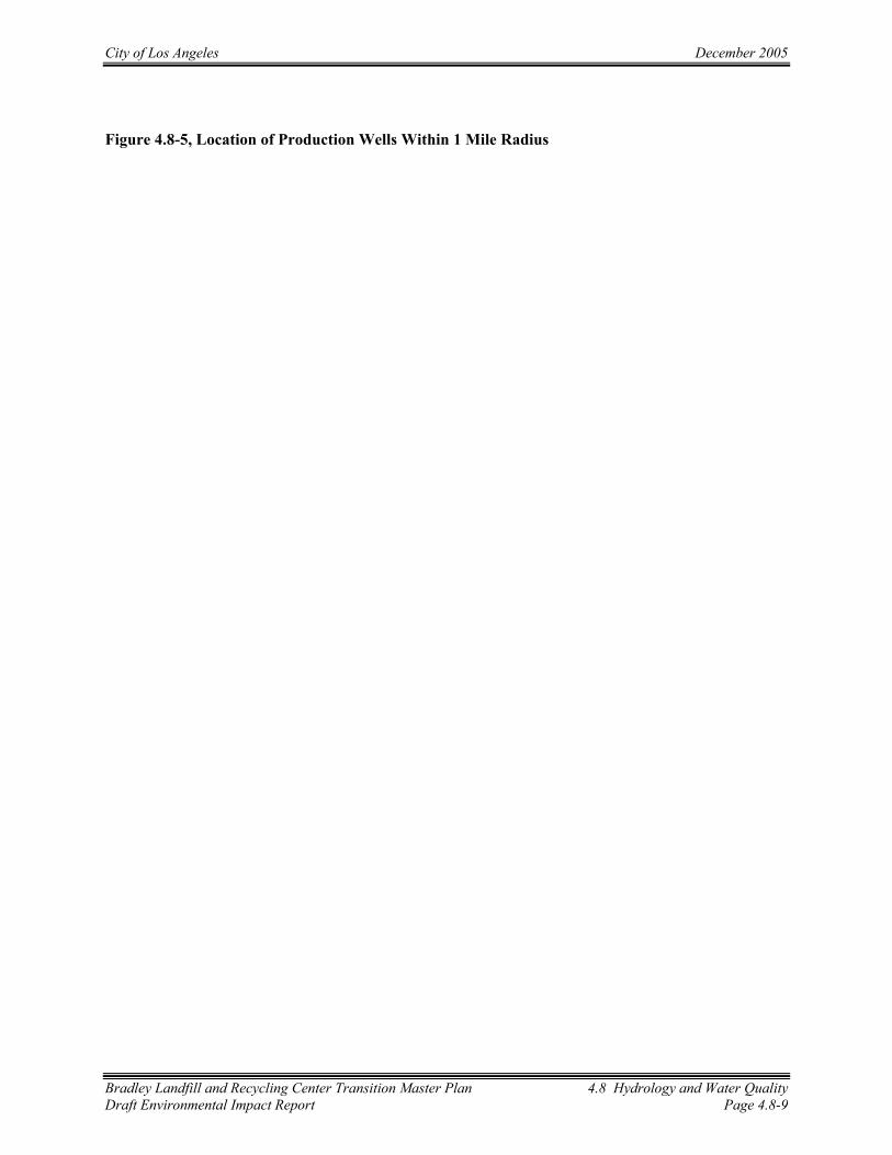
Groundwater contour maps for the project site are prepared on a quarterly basis and included with the semi-annual monitoring reports.9 Measured groundwater elevations are used to estimate flow at the site, which has been southerly, and gradient, which has averaged 0.012 feet/foot in recent years (Figure 4.8-4). Groundwater flow in the southern portion of the site appears to be influenced by pumping from Calmat water production wells.10 Water produced by Calmat is used for gravel washing. Calmat wells are not a source of drinking water (Figure 4.8-5).
Water spreading operations at the Hansen Spreading Grounds have the potential to raise water levels in the vicinity of the project site. “Alert levels” have been established for several of the site groundwater monitoring wells. Alert levels are approximately 25 feet below the base of the landfill. If water levels in these wells reach these elevations, the Los Angeles Department of Water and Power (LADWP) would cease spreading operations and allow water levels to subside. Water levels are measured weekly in key wells by Waste Management and data is submitted to the Los Angeles County Department of Public Works, the Upper Los Angeles River Area Watermaster, and the LADWP.
7 Geosyntec, Draft Joint Technical Document, December 2001. 8 SCS Engineers, Groundwater Monitoring Report, Summer-Fall 2004 Monitoring Period Ending September 30,
2004, Bradley Landfill and Recycling Center, Sun Valley, California, October 2004. 9 SCS Engineers, Groundwater Monitoring Report, Summer-Fall 2004 Monitoring Period Ending September 30,
2004, Bradley Landfill and Recycling Center, Sun Valley, California, October 2004. 10 Kerfoot and Associates, Evaluation Monitoring Report, Bradley Landfill and Recycling Center, Sun Valley,
California, March 1994.

City of Los Angeles December 2005
Bradley Landfill and Recycling Center Transition Master Plan 4.8 Hydrology and Water Quality Draft Environmental Impact Report Page 4.8-8
Figure 4.8-4, Bradley Landfill Groundwater Contours
City of Los Angeles December 2005
Bradley Landfill and Recycling Center Transition Master Plan 4.8 Hydrology and Water Quality Draft Environmental Impact Report Page 4.8-9
Figure 4.8-5, Location of Production Wells Within 1 Mile Radius

City of Los Angeles December 2005
Bradley Landfill and Recycling Center Transition Master Plan 4.8 Hydrology and Water Quality Draft Environmental Impact Report Page 4.8-10
Water Quality
Federal Water Pollution Control Act
The 1972 amendments to the Federal Water Pollution Control Act, later referred to as the Clean Water Act (CWA), prohibit the discharge of any pollutant to navigable waters of the United States from a point source unless the discharge is authorized by a National Pollution Discharge Elimination System (NPDES) permit. In 1990, the EPA promulgated final regulations that established Phase 1 requirements for the NPDES program to address: (1) specific industrial categories, (2) construction sites greater than five acres, and (3) municipal separate storm sewer systems (MS4s) serving populations greater than 100,000 persons. The recently enacted NPDES Phase II regulations expand the existing NPDES storm water program (Phase I) to address storm water discharges from small MS4s (those serving less than 100,000 persons) and construction sites that disturb one to five acres.11
Porter Cologne Water Quality Control Act
In California, the NPDES program is administered by the State Water Resources Control Board (SWRCB) through the nine Regional Water Quality Control Boards (RWQCBs). The SWRCB and the RWQCBs were established in 1969 by the Porter-Cologne Water Quality Control Act, the principal law governing California water quality regulation.
Surface Runoff Water Quality
For non-point source discharges, the NPDES program establishes a comprehensive stormwater quality program to manage urban stormwater and minimize pollution of the environment to the maximum extent practicable. The reduction of pollutants in urban stormwater discharge to the maximum extent practicable through the use of structural and nonstructural Best Management Practice’s (BMPs) is one of the primary objectives of the water quality regulations.
The City of Los Angeles has adopted regulatory requirements which are set forth in Ordinance 173,494. This ordinance incorporates standards from the Los Angeles Regional Water Quality Control Board (LARWQCB)’s Standard Urban Storm Water Mitigation Plan (SUSWMP) to ensure that storm water pollution is addressed by incorporating BMPs in the design phase of development.12 These BMPs include a variety of practices to reduce pollutant loadings in runoff to the maximum extent practicable.
11 Part II - Environmental Protection Agency 40 CFR Parts 9, 122, 123, and 124 National Pollutant Discharge Elimination System—Regulations for Revision of the Water Pollution Control Program Addressing Storm Water Discharges; Final Rule Report to Congress on the Phase II Storm Water Regulations, Federal Register Vol. 64, No. 235 / Wednesday, December 8, 1999 / Rules and Regulations.
12 The Regional Board Executive Officer approved the Final SUSWMP on March 8, 2000.

City of Los Angeles December 2005
Bradley Landfill and Recycling Center Transition Master Plan 4.8 Hydrology and Water Quality Draft Environmental Impact Report Page 4.8-11
In 1999, the SWRCB adopted the General Permit for Dischargers of Storm Water Associated with Construction Activity which is"…required for all storm water discharges associated with construction activity where clearing, grading, and excavation results in a land disturbance of one or more acres (small construction) of a common plan of development, or five or more acres of soil (large construction)."
The existing operations at the BLRC are subject to the provisions of the Statewide General Industrial Stormwater Discharge Permit No. CAS 000001 issued by the SWRCB. This permit requires the development and implementation of a Stormwater Pollution Prevention Plan and Stormwater Monitoring Plan for each facility. In addition, requirements for the protection of surface water quality are established in the Waste Discharge Requirements (WDR) Permit No. 94-059 issued to BLRC by the LARWQCB. These requirements are listed below.
Groundwater Quality
Groundwater quality is monitored at the project site by 14 groundwater wells located upgradient and downgradient of the facility. Seven wells (4915A, 4915B, 4915C, 4915D, 4915E, 4915M and 4914G) serve as upgradient wells for the BLRC and seven wells (4916D, 4916F, 4916G, 4916H, 4916J, 4916L, and 4926C) are located downgradient of the site (Figure 4.8-4). Groundwater Monitoring Well 4915G is not depicted on Figure 4.8-4, as it is located approximately 2,500 feet north and 1,000 east of Well 4915B. In addition, monitoring occurs at well 4916C, located in a separate groundwater body west of the Verdugo fault.
The groundwater monitoring well network is maintained and modified as necessary to protect the underlying groundwater and to ensure compliance with applicable regulations. Any modifications to the monitoring well network require LARWQCB approval.
The groundwater elevation in each monitoring well is measured on a weekly or monthly basis to ensure that there is adequate separation between the landfill base and the groundwater table. Samples from each of the monitoring wells are collected and analyzed on a semiannual basis, and the results are reported to the LARWQCB in accordance with the Facility WDR No. 94-059 and Monitoring and Reporting Program (MRP) No. 6434, dated November 1, 1996.
The monitoring results have not indicated the presence of any leachate releases from the landfill to groundwater. Leachate within lined portions of the landfill is controlled by a collection and recovery system that includes six on-site leachate collection sumps, which are pumped out as necessary and the liquid discharged to the sewer pursuant to a wastewater discharge permit from the Los Angeles Bureau of Sanitation.
In 1991, low levels of Volatile Organic Compounds (VOCs) were detected in six ground water monitoring wells. This was identified as a limited problem linked to the landfill gas system and not a

City of Los Angeles December 2005
Bradley Landfill and Recycling Center Transition Master Plan 4.8 Hydrology and Water Quality Draft Environmental Impact Report Page 4.8-12
leachate release.13 A corrective action program was submitted by the operator and approved by the LARWQCB in 1994. By June of 1994, three of the six monitoring wells tested clean and the levels of organic compounds in the other three wells had been reduced by 90% due to improvements in the gas collection system. For the VOC species detected in 1991, general downward or stable trends have continued to the present day and these substances, if detected, are generally at trace concentrations.14
Flooding
Much of the project site has a Flood Insurance Rate Map (FIRM) zone designation of A15. According to the Federal Emergency Management Agency (FEMA), Flood Zone A is the flood insurance rate zone that corresponds to the 100-year floodplains (Figure 4.8-6). The term "100-year flood" is the flood elevation that has a 1- percent chance of being equaled or exceeded each year. The reason for the Flood Zone A designation is because this area was a topographic depression at the time of the flood mapping. Although the FIRM indicates the site is Zone A, it should be noted that the areas that were depressions have been filled and are now approximately 30 to 70 feet above the surrounding grade. Studies conducted by the U.S. Army Corps of Engineers reportedly indicate the site is not within the boundaries of a 100-year storm event.16 The landfill has been designed in a way that, upon closure, no washout of solid waste will occur during a flood event.
Existing Permitted Levels of Operation
For a description of the existing levels of operation, please see Section 3.0 and Table 3-4.
13 Kerfoot and Associates, Evaluation Monitoring Report for the Bradley Landfill and Recycling Center, Sun Valley, California, March 1994.
14 SCS Engineers, Groundwater Monitoring Report, Summer-Fall 2004 Monitoring Period Ending September 30, 2004, Bradley Landfill and Recycling Center, Sun Valley, California, October 2004.
15 Flood Insurance Rate Map (FIRM), Base map data is from the GDT Dymamap/2000 data set. Website, http://www.esri.com/hazards/makemap.html, August 2004.
16 Geosyntec, Draft Joint Technical Document, December 2001.

City of Los Angeles December 2005
Bradley Landfill and Recycling Center Transition Master Plan 4.8 Hydrology and Water Quality Draft Environmental Impact Report Page 4.8-13
Figure 4.8-6, Flood Zone Map Near BLRC

City of Los Angeles December 2005
Bradley Landfill and Recycling Center Transition Master Plan 4.8 Hydrology and Water Quality Draft Environmental Impact Report Page 4.8-14
Regulatory Requirements/Permit Conditions Applicable to the Existing Landfill Operation
According to WDR Permit No. 94-059 and MRP No. 6434 from the Los Angeles Regional Water Quality Control Board dated June 13, 1994, the following measures are implemented at the BLRC in regards to hydrology and water quality impacts:
B4. The discharge of wastes or waste byproducts (leachate, for example) to natural surface drainage courses or to ground water is prohibited.
B8. No water shall be used at this site except for landscape irrigation, for road surface dust control and fire fighting. Water used on disposal areas shall be applied only on completed lifts in quantities not to exceed those necessary to support plant life and shall be confined to the irrigated areas. The ponding of irrigation water is prohibited.
B9. Washing of landfill equipment or vehicles shall be confined to areas where the wastewater will not percolate into the landfill or enter the storm water collection system unless specifically permitted by waste discharge requirements.
B10. Except for unadulterated tap water, any waters used for landscape irrigation, dust control or other non-emergency uses shall be subject to waste discharge requirements.
B12. No polluted surface waters shall leave this site except as permitted by a National Pollutant Discharge Elimination System (NPDES) permit issued in accordance with the Federal Clean Water Act and the California Water Code (CWC).
Ground Water Protection Standards
C1. In accordance with Section 2552 of Chapter 15, the following water quality protection standards are established for this waste management facility:
Parameter Units Maximum Value Total dissolved solids mgL 800 Sulfate mgL 300 Chloride mgL 100 Total organic halogens mgL 0.5 Carbon tetrachloride µgL 0.5 Tetrachlorethylene (PCE) µgL 5.0 Trichloroethylene (TCE) µgL 5.0 Vinyl chloride µgL 0.5 Source: California Regional Water Quality Control Board Los Angeles Region, June 22, 1994.
C2. Water quality protection standards may be modified by the Board based on more recent or complete ground water monitoring data, changes in background water quality, or for any other valid reason.
City of Los Angeles December 2005
Bradley Landfill and Recycling Center Transition Master Plan 4.8 Hydrology and Water Quality Draft Environmental Impact Report Page 4.8-15
C3. The compliance point(s) where the water quality protection standards shall apply shall be between the property line of the facility and the downgradient edge of the waste management area. (all three portions of the site: Bradley East, Bradley West and Bradley West Extension; together comprise the waste management facility). At least three monitoring wells shall be in service at all times, downgradient of the waste management area, which meet this requirement.
C4. Bradley Landfill shall comply with “Standard Provisions for implementing Subtitle D” for a detection monitoring program: in determining if a statistically significant increase is observed for any Constituent of Concern (COC); in the establishment of an evaluation monitoring program; and in the institution of a corrective action monitoring program.
C5. The compliance period for which water quality protection standards are applicable shall be the entire active life of the site, and during the closure and post-closure maintenance periods.
General Requirements for Disposal of Wastes
D6. The migration of gases from disposal site shall be controlled as necessary to prevent water pollution or nuisance.
D7. Any abandoned water wells under the control of the site owner or operator, and situated within the influence of the site, must be located and properly modified or sealed to prevent mixing of any water between adjacent water bearing zones. A notice of intent to decommission a water well must be filed with the appropriate regulatory agencies prior to decommissioning. Procedures used to decommission these wells, or to modify wells still in use, must conform to the specifications of the local health department or other applicable agencies.
D8. In any area within the disposal site where seepage water is observed, provisions shall be made, and/or facilities shall be provided, to ensure that seep water will not come in contact with decomposable refuse in this waste management unit. The location of all springs and seeps found during, prior to, or after placement of waste material, shall be reported to the Board.
D9. Bradley Landfill shall have containment structures which are capable of preventing degradation of waters of the state as a result of waste discharges to the landfill.
D15. Drainage controls, structures, and facilities shall be designed to divert any precipitation or tributary runoff and prevent ponding and percolation of water at the site in compliance with Section 2546 of Chapter 15.
D16. The waste management unit shall be graded and maintained to promote proper runoff of precipitation and to prevent ponding of water.
D17. Erosion or washout of deposited materials by surface flow shall be prevented.

City of Los Angeles December 2005
Bradley Landfill and Recycling Center Transition Master Plan 4.8 Hydrology and Water Quality Draft Environmental Impact Report Page 4.8-16
Water Quality Monitoring
E1. Bradley Landfill shall furnish, under penalty of perjury, technical monitoring reports. Monitoring reports shall be submitted in accordance with specifications contained in a MRP prepared by the Executive Officer. This MRP is subject to periodic revisions as warranted.
E2. The effectiveness of all monitoring wells, monitoring devices, and leachate and gas collection systems shall be maintained for the active life of this site. If any of these wells and/or monitoring devices, etc., are damaged, destroyed or abandoned for any reason, the discharger shall provide a substitute to meet the monitoring requirements of this Order. For the purpose of this requirement, “active life shall mean the entire period during which waste materials will be deposited at the site, plus the closure and post-closure maintenance periods.
E3. Bradley Landfill has submitted detailed plans and equipment specifications for compliance with the ground water monitoring requirements of Article 5 of Chapter 15, as referenced in their “Construction and Testing of Monitoring Wells, Bradley Landfill, Sun Valley District, Los Angeles, California, for the Valley Reclamation Company” dated December 2, 1986, and January 31, 1992. These reports were accompanied by:
a. a map showing the locations of proposed monitoring facilities; and b. Drawings and data showing construction details of proposed monitoring facilities.
These data include:
a. Casing and test hole diameter b. Casing materials (PVC, stainless steel, etc.); c. Depth of each test hole; d. Size and position of perforations; e. Method of joining sections of casing; f. Nature of filter material; g. Depth and composition of seals; h. Method and length of time of development;
The monitoring facilities described in this report have been installed and are currently in operation. For any new or replacement monitoring wells or piezometers installed in the future, the discharger shall submit a similar technical report, to be approved by the Executive Officer, prior to installation. This technical report shall also provide for the installation of any new monitoring wells required by the MRP.
E4. Bradley Landfill shall ensure that all of the monitoring wells and/or piezometers are in proper operating order at all times. Bradley Landfill shall maintain a Monitoring Well Preventative Maintenance Program approved by the Executive Officer. Elements of the Program should include at least, periodic visual inspections of the well integrity, pump removal and inspection, etc., plus appropriate inspection frequencies. If a well or pieziometer is found to be

City of Los Angeles December 2005
Bradley Landfill and Recycling Center Transition Master Plan 4.8 Hydrology and Water Quality Draft Environmental Impact Report Page 4.8-17
inoperative, the Regional Board and any other interested agencies shall be so informed in writing within seven days after such discovery. When the Board is so informed, the notification shall contain a time schedule for returning the well or piezometer to operating order. The initial Monitoring Well Preventative Maintenance Program will be due to the Board within 60 days after the adoption of this Order. Changes to the Program should be submitted for Executive Officer approval at least 30 days prior to implementing the change(s).
E5. Bradley Landfill shall provide for the proper handling and disposal of water purged from the wells during sampling. Water pumped from the wells shall not be returned to that (or any other) well unless appropriate water discharge requirements have been prescribed, nor shall it be used for dust control or irrigation without waste discharge requirements.
According to Zone Variance Case No. 94-0792(ZV)(PAD) from the City of Los Angeles dated June 2, 1998, the following measures must be implemented at the BLRC in regards to hydrology and water quality impacts:
14. Compliance with permit conditions pertaining to landfill development operation and maintenance, including installation of leachate and gas migration control systems, shall be maintained in accordance with the City of Los Angeles Environmental Affairs Department, Regional Water Quality Control Board and the South Coast Air Quality Management District.
15. The herein approved refuse disposal operations on the subject property shall be filled to an elevation and slope as shown on Exhibit “D”, dated May 1998. The final cover shall be constructed in accordance with the Closure Plan(s) per CCR Title 14 and Title 2317, as approved by the City of Los Angeles Environmental Affairs Department, Regional Water Quality Control Board and California Integrated Waste Management Board and the South Coast Air Quality Management District.
21. All requirements of the South Coast Air Quality Management District, State Water Resources Control Board, the State Regional Water Quality Control Board, the County Health Department, and the City Departments of Water and Power and Fire and other concerned public agencies shall be strictly complied with in connection with the use of the property for the purposes herein approved.
24. Provisions shall be made for the necessary temporary and permanent control of the surface and drainage waters in or near the project in a manner satisfactory to the Bureau of Engineering.
33. The final closure of the landfill shall be performed in accordance with the Final Closure Plan(s) as approved by the City of Los Angeles Environmental Affairs Department, Regional
17 California Code of Regulations Title 14 and Title 23 are now combined as Title 27.

City of Los Angeles December 2005
Bradley Landfill and Recycling Center Transition Master Plan 4.8 Hydrology and Water Quality Draft Environmental Impact Report Page 4.8-18
Water Quality Board and the California Integrated Waste Management Board, and in accordance with the CCR Title 14 and 2318.
ENVIRONMENTAL IMPACTS
Thresholds of Significance
The City of Los Angeles Draft CEQA Thresholds Guide uses the following thresholds for significance in regards to surface water and hydrology, surface and ground water quality, and flooding19:
A Proposed Project would normally have a significant impact if it would:
• Cause flooding during the projected 50-year storm event20 which would have the potential to harm people or damage property or sensitive biological resources;
• A project would normally have a significant impact on surface water quality if discharges associated with the project would create pollution, contamination or nuisance as defined in Section 13050 of the CWC or that cause regulatory standards to be violated, as defined in the applicable NPDES stormwater permit on Water Quality Control Plan for the receiving water body.
• Expand the area affected by contaminants;
• Result in an increased level of groundwater contamination (including that from direct percolation, injection or salt water intrusion); or
• Cause regulatory water quality standards at an existing production well to be violated, as defined in the California Code of Regulations (CCR), Title 22, Division 4, Chapter 15 and in the Safe Drinking Water Act.
Appendix G of the CEQA Guidelines uses the following thresholds for significance in regards to surface water and drainage, surface and groundwater quality, and flooding:
A Proposed Project would normally have a significant impact if it would:
• Violate any water quality standards or waste discharge requirements;
18 California Code of Regulations Title 14 and Title 23 are now combined as Title 27. 19 Draft L.A. CEQA Thresholds Guide, Hydrology and Water Quality May 14, 1998. 20 A 50-year storm event is a storm whose intensity is seen, on average, once every 50 years. This does not mean
that once every 50 years there will be a storm of this intensity. In fact, there could be a much greater time interval between such storms, or they could occur in consecutive years. Each year there is a 1 in 50 or 2% chance of such a storm (www.archive.ncsa.uiuc.edu, June 27, 2005.)

City of Los Angeles December 2005
Bradley Landfill and Recycling Center Transition Master Plan 4.8 Hydrology and Water Quality Draft Environmental Impact Report Page 4.8-19
• Substantially deplete groundwater supplies or interfere substantially with groundwater recharge such that there would be a net deficit in aquifer volume or a lowering of the local groundwater table level;
• Substantially alter the existing drainage pattern of the site or area, including through the alteration of the course or a stream or river, in a manner which would result in substantial erosion or siltation on- or off-site;
• Substantially alter the existing drainage pattern of the site or area, including through the alteration of the course of a stream or river, or substantially increase the rate or amount of surface water runoff in a manner which would result in flooding on- or off-site;
• Create or contribute to runoff water which would exceed the capacity of existing or planned stormwater drainage systems or provide substantial additional sources of polluted runoff;
• Otherwise substantially degrade the water quality;
• Place within a 100-year flood hazard area structures which would impede or redirect flood flows;
• Expose people or structures to a significant risk of loss, injury or death involving flooding, including flooding as a result of the failure or a levee or dam;
• Inundation by seiches, tsunami or mudflow.

City of Los Angeles December 2005
Bradley Landfill and Recycling Center Transition Master Plan 4.8 Hydrology and Water Quality Draft Environmental Impact Report Page 4.8-20
Project Impacts and Mitigation
Phase I
Bradley West/West Extension – Vertical Expansion
Under Phase I of the Proposed Project, the applicant proposes to increase the maximum height of the landfill from 1,010 to 1,053 feet above msl21, in order to allow time for transition to the TS/MRF operation. The height increase will create an additional 4.7 million cy of disposal capacity and allow the landfill to operate until the established closure date of April 14, 2007 (see Section 3.0, Project Description, for description and calculations). Approximately 163,500 cy of fill dirt would be required for construction of the TS/MRF (see Section 3.0, Project Description, for calculations). The importation of fill dirt for the TS/MRF construction would occur during Phase I of the Proposed Project and comes from various construction sites in the Los Angeles area. These trips have been accounted for in Section 4.3, Transportation/Circulation. The appearance of the site with the proposed height increase will be the same as the current appearance, only higher.
During Phase I, the landfill will continue to use existing facilities and environmental controls. No changes to existing landfill operations or procedures will be required. The landfill will continue to operate under the conditions set forth under City Case No. 94-0792 (ZV), WDR Permit No. 94-059, MRP No. 6434, and SWF Permit No. 19-AR-0008.
Impact 4.8-1: The proposed vertical landfill expansion would maintain the current amount of pervious surfaces subject to runoff and would not increase the amount of impervious surface area or the volume of surface water runoff or degrade surface water quality. (Less Than Significant)
Current landfilling operations take place only on the top deck of the fill area and this is the only portion of the landfill where relatively pervious daily cover surfaces exist. The side slopes all have somewhat less pervious intermediate cover. The vertical expansion would continue this method of filling and the relative ratio of daily to intermediate cover would not change. Although no change in existing operations would occur, additional waste disposal within the transitional vertical expansion area would take place until landfill capacity or the end date of permitted operations (April 14, 2007) is reached, whichever occurs first. During this transition period, the amount of pervious and impervious surfaces subject to run
21 All references to the maximum height of the landfill refer to the maximum elevation to which the top of the landfill is permitted to extend, including the final cover. When the top of the landfill reaches this maximum elevation, landfill operations would no longer be permitted and the landfill would be closed in accordance with regulatory requirements that govern landfill closures. The maximum height of the landfill, including any cover required during closure activities will not exceed 1,053 feet above msl. Subsequent to closure, natural settlement would continue to take place within the landfill, such that the elevation of the top of the landfill would actually reduce below the maximum permitted elevation over time. Once the landfill is closed, no further disposal will be permitted even if the top of the landfill settles below the maximum permitted elevation. All references in this document to the maximum elevation pertain to the landfill height prior to post-closure settlement.

City of Los Angeles December 2005
Bradley Landfill and Recycling Center Transition Master Plan 4.8 Hydrology and Water Quality Draft Environmental Impact Report Page 4.8-21
off would not change from existing conditions as a result of the proposed transitional vertical expansion and therefore this component of Phase I would not increase the volume of surface water runoff.
Surface runoff would continue to be managed by existing drainage facilities at Bradley West/Bradley West Extension and Bradley East. The capacity of the site drainage courses are more than sufficient to accommodate flows from the 50-year return frequency, 96-hour peak rainfall.22 Drainage control is currently designed and constructed to limit, to the greatest extent possible, ponding, infiltration, inundation, erosion slope failure, washout, and overtopping. The following current stormwater control measures are used and will continue to be used to implement erosion prevention and sediment control during landfill operations.
• Continue using siltation fences installed at intervals in on-site drainage ditches.
• Continue replacing the siltation fences on an as needed basis.
• Continue using drainage ditches lined with appropriate erosion resistant materials (e.g., concrete, clay, or synthetic alternative [ABS, PVC, HDPE]) to convey run-off in areas prone to erosion.
• Continue using appropriate water conveyance devices and materials (e.g., CMP culverts, ABS pipe, etc.) to pass water under temporary roads and down steep slopes.
• Continue maintaining fill slope benches for proper drainage, including adequate sizing for maximum anticipated flow conditions. In addition, bench ditches should be constructed with adequate soil depth to prevent washout of underlying waste.
• Continue seeding the slope face with grasses to aid in controlling erosion.
• Properly grade all slopes to convey run-off to the lined channels.
• Line steep drainage channels with appropriate erosion resistant materials.
• Continue controlling the velocity of run-off with energy dissipators, particularly in the perimeter channels.
• Continue diverting all surface water from the landfill to the on-site sedimentation basin/retention structure in the southwest portion of the landfill. This basin will hold twice the volume of flows from a 50-year, 96-hour design storm event. This ensures that no storm water or sediments leave
22 A comparison of the required 100-year, 24-hour design storm rainfall depth for the state landfill regulation (Title 27) of 6.2 inches (15.7 cm) to the 50-year 96-hour peak rainfall used in CIVILDESIGN of 6.01 to 9.00 inches (153 to 229 mm), indicates that the peak flow resulting from the 50-year 96 hour design storm event exceeds that of the 100-year 24-hour design storm event. Therefore, the storm used in CIVILDESIGN also satisfies the state regulations and this 50-year 96 hour design storm event was employed as the design basis for the surface water management system for final closure of the BLRC.

City of Los Angeles December 2005
Bradley Landfill and Recycling Center Transition Master Plan 4.8 Hydrology and Water Quality Draft Environmental Impact Report Page 4.8-22
the site and that the capacity and quality of water in the down stream urban storm water system is not impacted by the landfill.
• Complete surface grading prior to the rainy season.
• Construct temporary berms prior to the rainy season to divert surface run-off around the working area to preclude contact with exposed waste. (Only rain falling directly onto the working face would be allowed to seep into the waste material.)
• Continue proper maintenance (both during the active life of the landfill and after closure) of slopes, drainage courses, and culverts. Maintenance includes removal of accumulated sediments from traps, basins, and other drainage works as necessary. Removal of accumulated sediments would be performed more than once per year.
• Continue regular inspections, particularly following rainfall, to determine the effectiveness of the maintenance program.
• Update and continue implementing the site’s SWPPP including annual assessments and revisions to the Plan, as needed.
Some of these control practices are designed to remain in-place and functioning following landfill completion and final closure.
The proposed transitional vertical expansion would have approximately the same drainage patterns as the existing conditions. Because the landfill footprint is not changing and there are no proposed excavation areas or changes to operational landfilling procedures, no new drainage control measures are needed. Construction and extension of existing landfill slopes upward will be accommodated by additional benching and extension of existing down drains. These will be properly designed and maintained to prevent erosion, and/or washout of cover material, thereby preventing degradation of water quality. Since there is no proposed change in operating methods and controls, the proposed transitional vertical expansion will not have a significant impact on surface water quality or cause regulatory standards to be violated, as defined in the applicable NPDES stormwater permit or Water Quality Control Plan for the receiving water body.
The proposed transitional vertical expansion would not substantially alter the existing drainage pattern of the site or area, nor the course of a stream or river, in a manner which would result in substantial erosion or siltation on- or off-site. The proposed transitional vertical expansion would not substantially alter the existing drainage pattern of the site or area, nor the course or a stream or river, or substantially increase the rate or amount of surface runoff in a manner which would result in flooding on- or off-site. The proposed transitional vertical expansion would not create or contribute to runoff water which would exceed the capacity of existing or planned stormwater drainage systems or provide substantial additional sources of polluted runoff. Therefore, the impact of this component of the Proposed Project on surface water and drainage would be less than significant.

City of Los Angeles December 2005
Bradley Landfill and Recycling Center Transition Master Plan 4.8 Hydrology and Water Quality Draft Environmental Impact Report Page 4.8-23
Mitigation: No mitigation measures are required.
Impact 4.8-2: The proposed vertical expansion of the landfill could impact groundwater quality if the Leachate Collection and Recovery System (LCRS) would be unable to handle increased leachate generation or if the increased weight of landfilled material would affect the landfill liner, LCRS or landfill gas collection and control systems. (Less Than Significant)
Under the proposed transitional vertical expansion, no change in existing operations would occur. The project will continue to be designed and operated in compliance with LARWQCB’s WDR Order #94-059 dated June 13, 1994 (or revised WDR issued by the LARWQCB); MRP #6434 dated November 1, 1996 (or revised MRP); Corrective Action Program dated June 1, 1994 as amended by LARWQCB letter dated July 12, 1994; and Title 27 Code of California Regulations (CCR) regulations for water quality protection related to disposal to land.
Groundwater quality could be impacted by the proposed transitional height increase in the landfill in four possible ways: (1) if the additional waste that would be disposed at the landfill if the vertical expansion was approved would generate leachate volume that would exceed the capacity of the LCRS; (2) if the increased weight of the additional waste would undermine the integrity of the landfill liner system; (3) if the increased weight of the additional waste would undermine the integrity of the LCRS; or (4) if the increased weight of additional waste would affect the integrity or operation of the landfill gas collection and recovery system.
Potential Impacts Related to Leachate Volume
Leachate production under the proposed vertical expansion was analyzed using the U.S. EPA Hydrological Evaluation of Landfill Performance (HELP) model.23 The purpose of the HELP analysis, which models the movement of water through landfills, was to determine if the existing leachate collection facilities were adequate to handle the proposed expansion. The calculated peak daily leachate production for the vertical expansion, for the 10-year period modeled (1974 to 1983)24, was actually less than for existing conditions. To calibrate the model, the existing conditions were modeled and the calculated leachate production rates were compared with the observed leachate production rate for the year 2000. The total annual leachate production for the year 2000 was approximately 25,500 cubic feet (ft3). The moisture content of the existing waste found by the calibration procedure was 26.9 percent. The calculated peak daily leachate production for the existing conditions for the ten-year simulation period was 48,399 ft3/day. The calculated peak daily leachate production for the proposed vertical expansion for the ten-year simulation period was 20,607 ft3/day. The detailed calculations for the leachate production analysis are provided in Appendix I-1. Based on the HELP analysis, it was concluded that the proposed vertical expansion would not increase the leachate production rate for the facility. Since the leachate generation rate is not expected to increase due to the
23 Geosyntec, Draft Joint Technical Document, December 2001. HELP Model results are contained in Appendix I-1 to this EIR.
24 This ten year period from 1974 to 1983 reflects the wettest ten year period on record based on rainfall data from the Burbank Valley Pump Plant weather station.

City of Los Angeles December 2005
Bradley Landfill and Recycling Center Transition Master Plan 4.8 Hydrology and Water Quality Draft Environmental Impact Report Page 4.8-24
vertical expansion and therefore would not exceed the capacity of the existing LCRS, the project will not increase the risk of groundwater quality degradation from this source.
Potential Impacts to Landfill Liners
GeoSyntec Consultants prepared an analysis addressing the potential for the increased weight of the additional waste that would be permitted under the proposed vertical expansion to affect the integrity of the landfill liner and LCRS systems (see Appendix I-2). The BLRC consists of three areas and was developed in phases starting in 1958. As a consequence of this phasing development over a 46-year period, different base liner systems have been installed. Based on the base liner grading plan and the final grading plan, including the proposed transitional landfill height increase, the maximum design column of waste would be 325 feet high over the base and 70 feet high over the slope area. Static and seismic evaluations were conducted for a final elevation of 1,053 feet above msl. The results of the seismic site response analyses were expressed in terms of maximum calculated permanent displacements of the waste mass and landfill cover.
The results of the static and seismic stability evaluations (Appendix I-2 to this EIR) indicate that the proposed vertical expansion of the BLRC to an elevation of 1,053 feet above msl will meet the regulatory mandated stability criteria. In particular, the calculated static factors of safety are in excess of 1.5 and the maximum calculated permanent seismic displacements were less than 6 inches for surfaces engaging the landfill liner and less than 3 feet for the surfaces engaging the landfill cover. Therefore, the increased weight of solid waste that would be permitted under the proposed transitional vertical expansion would not undermine the integrity of the landfill liner systems.

City of Los Angeles December 2005
Bradley Landfill and Recycling Center Transition Master Plan 4.8 Hydrology and Water Quality Draft Environmental Impact Report Page 4.8-25
Potential Impacts to LCRS Piping
The LCRS is constructed of schedule 80 PVC pipe with an outside diameter of four inches. Pipe wall buckling and pipe wall crushing calculations were performed for the loading conditions that would result from the proposed transitional landfill height increase. The analysis concluded that the existing LCRS system can withstand the effect of the overburden pressure imposed by the proposed vertical expansion to an elevation of 1,053 feet above msl (Appendix I-2). The results of the static and pseudo-static stability analyses carried out in the Joint Technical Document indicate that static and seismic criteria are met.25 Therefore, the proposed transitional vertical expansion would not undermine the integrity of the LCRS piping.
Potential Impacts to Operation of the Landfill Gas Collection and Recovery System
SCS Engineers also prepared an analysis addressing the potential for the increased weight of the additional waste that would be permitted under the proposed transitional vertical expansion to affect the landfill gas collection and recovery system (see Appendix I-3 to this EIR). The analysis calculated that short term settlement associated with the increased weight of the additional waste would produce an additional flow of 30 cubic feet per minute of landfill gas, which is well within the daily fluctuations experienced by the landfill gas collection and recovery system seen due to barometric and other ongoing impacts and well within the design capacity of the system. This analysis concludes that “the additional depth of refuse contemplated by the (proposed transitional vertical expansion) will not impact the ability of the gas collection and control system to prevent the migration of landfill gas”. The landfill gas management system at the facility is designed and constructed to contain, collect, and process gas generated in the waste mass in compliance with regulations contained in 27 CCR 20919 and in South Coast Air Quality Management District (SCAQMD) Rule 1150.1. The landfill gas management system is continuously monitored and maintained and upgraded to meet gas control needs. Continued operation of this system through the active life of the landfill and through the post-closure period will assure that groundwater quality is protected from impacts by landfill gas migration. As discussed in Section 4.9 and Appendix I-1 of this Draft EIR, the landfill gas management system would have sufficient capacity to collect, process and dispose through flaring, if necessary, the additional volume of landfill gas that would be generated by the increased waste mass of the expansion.
Conclusion
Because the proposed transitional vertical expansion would not adversely affect the control systems that prevent the migration of contaminants from the landfill to groundwater, the proposed vertical expansion would not cause regulatory standards at an existing production well to be violated, as defined in CCR
25 Geosyntec Consultants, Memorandum from Tarik Hadj-Hamou, Ph.D., P.E. to Paul Willman, Western Group Environmental Protection Manager, Waste Management Industries, Inc., regarding the Evaluation of the Proposed Vertical Expansion Impact on Liner Design and LCRS Pipes, Bradley Landfill, Los Angeles County, California, February 11, 2005.

City of Los Angeles December 2005
Bradley Landfill and Recycling Center Transition Master Plan 4.8 Hydrology and Water Quality Draft Environmental Impact Report Page 4.8-26
Title 22 and in the Safe Drinking Water Act. There are no drinking water production wells within one mile of the project site. The nearest water production well, located approximately 1,000 feet south of the landfill, is that used by Calmat for processing mined sand and gravel. This is the only active production well within one mile of the project site. Groundwater quality would continue to be monitored at the project site by groundwater wells located upgradient and downgradient of the facility. Groundwater monitoring, which is conducted under the corrective action program, would continue to be implemented to ensure the previously identified area affected by organic compounds from landfill gas continues to diminish. Based on the gas generation curve for the proposed expansion, ongoing upgrades and operations adjustments to the landfill gas collection and control system would be implemented to accommodate any increased gas generation. Leachate which reaches the bottom of the landfill would continue to be collected in the sumps and pumped out and disposed of properly. The groundwater elevation in each monitoring well would continue to be measured on a monthly basis to ensure that there is adequate separation between the landfill base and the groundwater table. On a semiannual basis, samples from each of the monitoring wells would continue to be collected and analyzed, and the results reported to the LARWQCB in accordance with the Facility WDR and MRP No. 6434 or the requirements of the U.S. EPA and the State of California.
In summary, based on the analyses presented above, under the proposed transitional vertical expansion, leachate production will not increase; the landfill liner and LCRS will not be compromised by the increased waste mass; the landfill gas collection system will be able to collect and control the increased landfill gas produced; and groundwater will continue to be monitored, Thus, the proposed transitional vertical expansion would not have a significant impact on ground water quality and would not create pollution, contamination or nuisance as defined in Section 13050 of the CWC or cause regulatory standards to be violated, as defined in the Water Quality Control Plan for the receiving water body. The proposed transitional vertical expansion would not expand the area affected by contaminants; result in an increased level of groundwater contamination; or cause regulatory water quality standards at an existing production well to be violated, as defined in the CCR, Title 22, Division 4, Chapter 15 and in the Safe Drinking Water Act. The proposed transitional vertical expansion would not violate any water quality standards or waste discharge requirements, or otherwise substantially degrade the water quality. Therefore, impacts to groundwater quality from the proposed transitional vertical expansion would be less than significant.
Mitigation: No mitigation measures are required.
Impact 4.8-3: The proposed vertical expansion of the existing landfill would not expose people to significant impacts related to flooding. (Less Than Significant)
Under the proposed transitional vertical expansion, no change in existing landfill operations would occur. The proposed transitional height increase would increase only the vertical height of the project site and would not increase the amount of impervious surface subject to precipitation, resulting in no increase in the volume of surface water runoff. As noted above, drainage facilities are more than sufficient to handle runoff from the 50-year, 96-hour storm. All runoff from the landfill is retained on-site in the storm water

City of Los Angeles December 2005
Bradley Landfill and Recycling Center Transition Master Plan 4.8 Hydrology and Water Quality Draft Environmental Impact Report Page 4.8-27
basin. Therefore, this component of the Proposed Project would not result in or expose people to significant impacts related to flooding and impacts related to flooding at the project site would be less than significant.
Mitigation: No mitigation measures are required.
Bradley East and Construction of New TS/MRF on Bradley West/West Extension
Transfer Station/MRF
As part of Phase I of the Proposed Project, a 4,000 tpd TS and 1,000 tpd MRF are proposed to be constructed on Bradley West/West Extension. The construction activities will occur near the end of Phase I (2006-2007) and will include the importation of approximately 163,500 cy26 of fill dirt to provide a pad for constructing the foundation of the TS/MRF, associated grading activities, installation of paving and curbing, and erection of the pre-engineered metal building for the TS/MRF. Additional paved or covered (roofed) areas added as a result of this component of Phase I will be approximately 375,000 square feet (see Table 4.8-1 for a breakdown of the square footages of impervious surfaces that would be introduced on the project site for each component of the proposed project). Although the volume of runoff would increase as a result of this component of Phase I, design of the proposed TS/MRF would include provisions for handling increased runoff in conjunction with the existing drainage facilities located within the BLRC site. The applicant is also required to obtain a General Permit from the LARWQCB for construction activities.
Table 4.8-1 Impervious Surfaces Summary
Component of Proposed Project Amount of Impervious Surfaces Added Construction of new transfer station/MRF 375,000 square feet Increase in green/wood waste processing 60,000 square feet Expansion of existing MRF 40,000 square feet
26 Calculations for the amount of fill dirt required for the building pad of the TS/MRF are provided in Section 3.0, Project Description. The importation of fill dirt for the TS/MRF construction would occur during Phase I of the Proposed Project and comes from various construction sites in the Los Angeles area. These trips have been accounted for in Section 4.3, Transportation/Circulation

City of Los Angeles December 2005
Bradley Landfill and Recycling Center Transition Master Plan 4.8 Hydrology and Water Quality Draft Environmental Impact Report Page 4.8-28
Impact 4.8-4: Construction of the new TS/MRF could impact the ability of the facility to handle surface water flows. (Less Than Significant)
The construction of the new TS/MRF would increase the amount of paved impervious surfaces at the TS/MRF site. The proposed construction (TS/MRF, Support Building, and associated parking) comprise approximately 9 acres, or approximately 4.3 percent of the project site. Although the volume of runoff would increase as a result of constructing the new TS/MRF, design of the proposed TS/MRF would include provisions for handling increased runoff in conjunction with the existing drainage facilities located within the BLRC site and implementation of BMPs. The drainage from the TS/MRF would continue to be directed to the adjacent on-site retention basin which has sufficient capacity to accommodate all flows from the 50-year return frequency, 96-hour duration storm, including the additional flows that would result from construction of the new TS/MRF.
Construction of the new TS/MRF would not have a significant impact on the ability of the facility to handle surface water flows or cause regulatory standards to be violated, as defined in the applicable NPDES stormwater permit on Water Quality Control Plan for the receiving water body. The construction of the new TS/MRF would not substantially alter the existing drainage pattern of the site or area, nor the course of a stream or river, in a manner which would result in substantial erosion or siltation on- or off-site. The construction of the new TS/MRF would not create or contribute to runoff water which would exceed the capacity of existing or planned stormwater drainage systems. Additionally, the construction of the new TS/MRF would not contribute flooding in the area because all stormwater is contained on-site. Therefore, impacts on surface water drainage from the construction of the TS/MRF would be less than significant.
Mitigation: No mitigation measures are required.
Impact 4.8-5: Construction of the TS/MRF could impact surface and groundwater quality. (Less Than Significant)
Surface Water
Construction of the new TS/MRF would include the importation of approximately 163,500 cy of fill dirt to provide a pad for constructing the foundation, associated grading activities, installation of paving and curbing, and erection of the pre-engineered metal building. Construction of the new TS/MRF would take place on approximately 9 acres of the project site.
Three general sources of short-term construction-related storm water pollution associated with the construction of the TS/MRF are: 1) the handling, storage, and disposal of construction materials containing pollutants; 2) earth moving activities which, when not controlled, may generate soil erosion and transportation, via storm runoff or mechanical equipment; and 3) the maintenance and operation of construction equipment.

City of Los Angeles December 2005
Bradley Landfill and Recycling Center Transition Master Plan 4.8 Hydrology and Water Quality Draft Environmental Impact Report Page 4.8-29
The project construction site will contain a variety of construction materials that are potential sources of storm water pollution. Categories of such materials include: adhesives; cleaning agents; landscaping, plumbing, painting, heating/cooling, and masonry materials; floor and wall coverings; and construction debris. Construction material spills can be a source of storm water pollution and/or soil contamination. Generally, routine safety precautions for handling and storing toxic and hazardous materials may effectively mitigate the potential pollution of storm water by these materials. These same types of common sense, "good housekeeping" procedures can be extended to non-hazardous storm water pollutants such as sawdust and other solid wastes. With the implementation of the BMPs described below, short-term water quality impacts would be less than significant.
Soil erosion is the process by which soil particles are removed from the land surface by wind, water and/or gravity. Soil particles removed by storm water runoff are considered pollutants that when discharged to the storm drainage system can have negative impacts on aquatic habitat. Grading activities can greatly increase erosion processes.
Poorly maintained vehicles and heavy equipment that leak fuel, oil, antifreeze or other fluids on a construction site are also common sources of storm water pollution and soil contamination.
Since the construction of the new TS/MRF involves clearing, grading, and excavation of one or more acres, a General Construction Activity Storm Water Permit must be obtained for each project from the State Water Resources Control Board (SWRCB) prior to the start of construction. Alternatively, a consolidated permit may be obtained to cover both construction projects. As discussed previously, the NPDES requires that a Notice of Intent (NOI) be filed with the SWRCB. By filing an NOI, the applicant agrees to conditions outlined in the General Permit. The SWPPP identifies which structural and nonstructural BMPs will be implemented, such as sandbag barriers, temporary desilting basins near inlets, gravel driveways, dust controls, employee training, and general good housekeeping practices. With the implementation of the BMPs as mitigation measures, water quality impacts would be less than significant.
• Clean up leaks, drips and spills immediately to prevent contaminated soil on paved surfaces that can be washed away into the storm drains.
• Do not hose down pavement at material spills. Use dry cleanup methods whenever possible.
• Cover and maintain dumpsters.
• Use gravel approaches, of adequate length, width, and rock size; and rumble strips, of adequate length and width, where truck traffic is frequent to reduce soil compaction and limit the tracking of sediment into streets.
• Conduct all vehicle/equipment maintenance, repair, and washing away from storm drains. All major repairs are to be conducted off-site. Use drip pans or drop cloths to catch drips and spills.

City of Los Angeles December 2005
Bradley Landfill and Recycling Center Transition Master Plan 4.8 Hydrology and Water Quality Draft Environmental Impact Report Page 4.8-30
• The project shall comply with Ordinance No. 172,176 to provide for Stormwater and Urban Runoff Pollution Control which requires the application of BMPs, including the following mitigation measures:
o Any connection to the sanitary sewer must have authorization from the Bureau of Sanitation.
o Reduce impervious surface area by using permeable pavement materials where appropriate, including: pervious concrete/asphalt; unit pavers, i.e. turf block; and granular materials, i.e. crushed aggregates, cobbles.
Groundwater
The BMPs listed above that would be required to be part of the project by existing regulations, would also work to limit the infiltrations of contaminants to groundwater as a result of construction of the proposed new TS/MRF. Furthermore, groundwater quality would continue to be monitored at the project site. The groundwater elevation in each monitoring well would continue to be measured on a monthly basis to ensure that there is adequate separation between the landfill base and the groundwater table. On a semiannual basis, samples from each of the monitoring wells would continue to be collected and analyzed, and the results are reported to the LARWQCB in accordance with the Facility WDR and MRP No. 6434 or the requirements of the U.S. EPA and the State of California. Therefore, impacts to water quality would be less than significant.
Mitigation: No mitigation measures are required.
Impact 4.8-6: Construction of the TS/MRF would not expose people to significant impacts related to flooding. (Less Than Significant)
The construction of the new TS/MRF would increase the amount of impervious surfaces and the amount of surface run off area. Although the volume of run off would increase, as discussed above in Impact 4.8-4, the capacity of the site drainage courses are sufficient to accommodate the volume of flows from the 50-year return frequency, 96-hour duration storm. The actual design storm peak flow exceeds that of the 50-year 96-hour storm.27 The drainage from the TS/MRF construction would be directed to the adjacent on-site retention basin which is sufficient to accommodate twice the volume of flows from the 50-year return frequency, 96-hour duration storm. Therefore, the construction of the new TS/MRF would not result in or expose people to significant impacts related to flooding and impacts related to flooding at the project site would be less than significant.
Mitigation: No mitigation measures are required.
27 Geosyntec, Draft Joint Technical Document, February 2002.
City of Los Angeles December 2005
Bradley Landfill and Recycling Center Transition Master Plan 4.8 Hydrology and Water Quality Draft Environmental Impact Report Page 4.8-31
Green and Wood Waste and MRF Operations
Impact 4.8-7: Expansion of operations at the green and wood waste facility and existing MRF could increase the amount of impervious surfaces and impact the ability of the facility to handle surface water flows or introduce new sources of surface/groundwater contamination. (Less Than Significant)
Green and Wood Waste Processing
The proposed change to the green and wood waste operation would be an increase in the permitted operation to 2,500 tpd, an increase of 1,240 tpd over the existing level of operation. This increase would provide additional capacity to process green and wood waste materials that are currently processed at another facility in the Sun Valley area. The proposed change to the green and wood waste processing operation would add another green waste enclosure and increase impervious surface area by approximately 60,000 square feet (1.4 acres) or less than one percent of the area of the project site. Operating procedures will not change and no new sources of surface or groundwater contamination will be introduced.
Materials Recovery Facility (MRF) Expansion
The proposed change to the existing MRF operation would increase processing of recyclable materials to a maximum of 99 tpd (maximum 7.6 percent increase), until the new TS/MRF is operational. The existing MRF would close at that time and its operations would be subsumed by the new TS/MRF (4,000 tpd/1,000 tpd, respectively). No significant change in MRF operations would occur. Additional paved or covered areas associated with the expanded operations will be approximately 40,000 square feet (less than one acre) or less than one half percent of the area of the project site. The same dry commercial loads and recyclable materials would continue to be handled so that no new sources of surface or groundwater contamination would be introduced to the area.
Summary
Although the volume of runoff would increase due to the combined increase in impervious areas (100,000 square feet or 2.3 acres equivalent to 1.1% of the entire site), design of the green waste and existing MRF expansion would include provisions for handling increased runoff in conjunction with the existing drainage facilities located within the BLRC site. The drainage from these areas would continue to be directed to the temporary retention pond and pumped to the on-site retention basin which can accommodate twice the volume of flows from the 50-year return frequency, 96-hour duration storm. Additionally, no new sources of surface or ground water contamination would be introduced and so impacts of these components of the proposed project related to surface water runoff would be less than significant.
Mitigation: The following mitigation measure shall be implemented in order to ensure that increased runoff is properly directed to the existing on-site drainage facilities and that adequate capacity remains available in the existing system to handle all flows generated on-site:

City of Los Angeles December 2005
Bradley Landfill and Recycling Center Transition Master Plan 4.8 Hydrology and Water Quality Draft Environmental Impact Report Page 4.8-32
4.8-1 During the design phase of the additional facilities described above, the applicant will re-calculate drainage flows based on additional impervious surfaces to ensure drainage facilities can continue to accommodate the 50-year, 96-hour storm. The applicant shall document the results of the calculations for the City of Los Angeles Department of Public Works, Bureau of Engineering and the LARWQCB.
Phase II – Landfill Closure and TS/MRF Operation
Landfill Closure and Post Closure
Phase II of the Proposed Project would include activities associated with final closure of the landfill after waste is no longer accepted for disposal (i.e., when the landfill reaches capacity or end of permitted operations on April 14, 2007, which ever occurs first.. These would include: (1) installing a 4-foot soil cap over all surfaces of the landfill; (2) planting vegetation on all slopes, as well as the landfill cap; and (3) constructing surface water controlling structures. The importation of approximately 500,000 cy of soil, and up to 500 tons of inert materials per day, is anticipated for the closure of the landfill (see Table 3-12). These materials would come from various locations around the Los Angeles area and these trips are accounted for in the traffic analysis contained in Section 4.3, Transportation/Circulation. The RWQCB requires the construction of final cover systems to be carried out in accordance with the construction quality assurance program (“COA”) pursuant to Title 27 Sections 20323-20324 of the California Code of Regulations.
Once closure activities are complete, the post-closure period begins, during which environmental controls, such as storm water and groundwater monitoring and leachate and landfill gas control, will continue.28 Post-closure monitoring and maintenance activities at landfills typically continue for several decades pursuant to the requirements of Title 27, Subchapter 4.
28 Rust Environment and Infrastructure, Final Closure and Post-Closure Maintenance Plan, Bradley Landfill and Recycling Center, Los Angeles County, California, 1995.

City of Los Angeles December 2005
Bradley Landfill and Recycling Center Transition Master Plan 4.8 Hydrology and Water Quality Draft Environmental Impact Report Page 4.8-33
Impact 4.8-8: Landfill final closure and post-closure activities would not create or contribute to runoff water which would exceed the capacity of existing or planned stormwater drainage systems. (Less Than Significant)
Landfill final closure activities would be designed to meet the requirements of CCR Title 27 and would be subject to a Final Closure Plan approved by the City of Los Angeles Environmental Affairs Department Local Enforcement Agency (the LEA), Regional Water Quality Control Board and California Integrated Waste Management Board. This would include design and construction of additional permanent surface water runoff drainage facilities capable, in conjunction with existing permanent onsite drainage facilities, of accommodating runoff from the 50-year, 96-hour storm. All runoff from the facility would continue to be retained on-site in the retention basin during the closure and post-closure period. In light of the above, the Proposed Project would not substantially alter the existing drainage pattern of the site or area, nor the course of a stream or river, in a manner which would result in substantial erosion or siltation on- or off-site. The Proposed Project would not create or contribute to runoff water which would exceed the capacity of existing or planned stormwater drainage and retention systems or provide substantial additional sources of polluted runoff. Therefore, impacts related to surface water and drainage would be less than significant.
Mitigation: No mitigation measures are required.
Impact 4.8-9: Landfill closure and post-closure activities would not violate any water quality standards or waste discharge requirements, or otherwise substantially degrade water quality. (Less Than Significant)
During Phase II landfill closure and post-closure activities, surface runoff quality would be protected by applicable erosion control practices and retention of all storm water in the on-site basin as described above under Phase I. Because no additional waste will be added to the landfill during Phase II and current proposed transitional vertical expansion impacts on water quality are less than significant (see Impact 4.8-2 above), less than significant impacts on groundwater quality will occur from Phase II activities. During Phase II closure and post-closure the following current activities will remain in place to ensure landfill gas and leachate resulting from waste previously deposited at the site continue to be controlled. Ongoing maintenance and operational adjustments to the landfill gas collection and control system would continue to be implemented to preclude groundwater impacts from gas migration. Leachate which reaches the bottom of the landfill would continue to be collected in the sumps and pumped out and disposed of properly. The groundwater elevation in each monitoring well would continue to be measured monthly to ensure that there is adequate separation between the landfill base and the groundwater table. Samples from each of the monitoring wells would continue to be collected and analyzed, and the results reported to the LARWQCB on a semi-annual basis, in accordance with the Facility WDR and MRP No. 6434.
Based on the above discussion, the closure and post-closure maintenance of the landfill would have less than significant impacts on surface water quality and would not create pollution, contamination or

City of Los Angeles December 2005
Bradley Landfill and Recycling Center Transition Master Plan 4.8 Hydrology and Water Quality Draft Environmental Impact Report Page 4.8-34
nuisance as defined in Section 13050 of the CWC or that cause regulatory standards to be violated, as defined in the applicable NPDES stormwater permit on the Water Quality Control Plan for the receiving water body. The Phase II closure and post-closure of the landfill would not expand the area affected by contaminants; result in an increased level of groundwater contamination; or cause regulatory water quality standards at an existing production well to be violated, as defined in the CCR, Title 22, Division 4, Chapter 15 and in the Safe Drinking Water Act. The Phase II closure and post-closure of the landfill would not violate any water quality standards or waste discharge requirements, or otherwise substantially degrade the water quality. Therefore, impacts to surface and ground water quality would be less than significant.
Mitigation: No mitigation measures are required.
Impact 4.8-10: Landfill closure and post-closure activities associated with the Proposed Project would not expose people or property to flooding impacts. (Less Than Significant)
Although the project site is located within a 100-year floodplain, the Phase II closure and post-closure of the landfill would not result in or expose people to significant impacts related to flooding because it would include on-site drainage facilities capable of handling runoff from the 50-year, 96-hour storm as discussed above. The Phase II closure and post-closure of the landfill would also not cause flooding during the projected 50-year, 96-hour storm event due to retention of stormwater in the on-site drainage basin that has capacity to accommodate twice the volume of runoff from a 50-year, 96-hour storm. Therefore this component of Phase II would not cause any significant impacts related to flooding at the project site.
Mitigation: No mitigation measures are required.
Transfer Station/MRF Operations
Under Phase II, the applicant proposes to operate a 4,000 tpd TS and 1,000 tpd MRF to replace the current landfill operation. The existing MRF, expanded to 99 tpd in Phase I, would be closed when the new TS/MRF becomes operational.
Impact 4.8-11: Operation of the new TS/MRF could create or contribute to runoff water which would exceed the capacity of existing or planned stormwater drainage systems. (Less Than Significant)
Runoff generated during operation of the proposed TS/MRF would be handled by the modifications to the storm drainage system that would be constructed when the TS/MRF is constructed in Phase I (see Impact 4.8-4 above). No additional runoff beyond that associated with the construction of the TS/MRF would result from operation of the TS/MRF (i.e., no additional impervious surfaces would be introduced at the TS/MRF after construction is completed). The operation of the proposed TS/MRF would not substantially alter the existing drainage pattern of the site or area, nor the course of a stream or river, in a manner which would result in substantial erosion or siltation on- or off-site. The operation of the

City of Los Angeles December 2005
Bradley Landfill and Recycling Center Transition Master Plan 4.8 Hydrology and Water Quality Draft Environmental Impact Report Page 4.8-35
proposed TS/MRF would not create or contribute to runoff water which would exceed the capacity of existing or planned stormwater drainage systems or provide substantial additional sources of polluted runoff. Therefore, impacts of this component of Phase II would be less than significant.
Mitigation: No mitigation measures are required.
Impact 4.8-12: Operation of the TS/MRF would not violate any water quality standards or waste discharge requirements, or otherwise substantially degrade the water quality. (Less Than Significant)
Operation of the proposed TS/MRF would be incorporated into the existing SWPPP for the landfill and will identify which structural and nonstructural BMPs will be implemented (see Table 4.8-2 for examples of BMPs). The TS/MRF will be located in an entirely enclosed structure designed to provide for odor, dust, and litter control. Items pulled from the wastestream (e.g., household hazardous waste, medical waste, etc) as a result of load checks would be stored in a hazardous materials locker located inside the building with appropriate secondary containment until properly disposed. This locker would be located inside the TS/MRF. Since the operation will be enclosed and under roof, no storm water will contact materials being stored or sorted inside. On occasion, baled recyclables awaiting shipment to market may have to be temporarily stored outside. The storage area for recyclable materials is approximately 3 feet wide by 30 feet long. A maximum of 24 bales (each bale is 5 feet long by 3 feet wide) can be stored at any given time. The maximum storage time for these bales would be 30 days. However, the BMPs identified in Table 4.8-2 are designed to minimize storm water contact. Storm water running off the building and surrounding paved area of the TS/MRF will be directed to the on-site retention basin. Operation inside the building combined with BMPs for the facility will result in less than significant impacts to surface water quality. Because the TS/MRF does not involve deposition of waste below ground, no impacts to groundwater quality will occur. Surface water quality would continue to be monitored at the project site under the California General Industrial Storm Water Permit.
The operation of the TS/MRF would not have a significant impact on groundwater or surface water quality and would not create pollution, contamination or nuisance as defined in Section 13050 of the CWC or that cause regulatory standards to be violated, as defined in the applicable NPDES stormwater permit on the Water Quality Control Plan for the receiving water body. The operation of the TS/MRF would not expand the area affected by contaminants; result in an increased level of groundwater contamination; or cause regulatory water quality standards at an existing production well to be violated, as defined in the CCR, Title 22, Division 4, Chapter 15 and in the Safe Drinking Water Act. The operation of the TS/MRF would not violate any water quality standards or waste discharge requirements, or otherwise substantially degrade the water quality. Therefore, impacts to water quality would be less than significant.
Mitigation: No mitigation measures are required.
Impact 4.8-13: Operation of the TS/MRF would not expose people or property to flooding impacts. (Less Than Significant)

City of Los Angeles December 2005
Bradley Landfill and Recycling Center Transition Master Plan 4.8 Hydrology and Water Quality Draft Environmental Impact Report Page 4.8-36
As discussed above, during the design of the proposed TS/MRF, drainage facility modifications would be included to accommodate runoff from the 50-year 96-hour storm. The operation of the TS/MRF would also not cause flooding during the projected 50-year, 96-hour storm event. Impacts related to flooding would be less than significant.
Mitigation: No mitigation measures are required.
CUMULATIVE IMPACTS
Implementation of the Proposed Project along with the related projects listed in Section 2.0 would not have a potential cumulative impact on storm drainage and surface water quality. In part because of the existing storm water runoff problems the Sun Valley area faces during storm events, all of the facility’s run-off is retained on-site and there will be no increase in run-off from the site under the Proposed Project. In accordance with State CEQA Guidelines (California Code of Regulations, Title 14, Chapter 3) Section 15130(a)(1), an EIR need not discuss potential cumulative impacts which do not result in part from the project evaluated in the EIR. Because the Proposed Project will not have an incremental contribution to the local storm drainage system, it would not contribute to a cumulatively considerable effect in the event that any off-site areas served by local storm drains were to increase peak flows to the system.
LEVEL OF SIGNIFICANCE AFTER MITIGATION
Impacts of the Proposed Project related to hydrology and water quality would be less than significant.

City of Los Angeles December 2005
Bradley Landfill and Recycling Center Transition Master Plan 4.8 Hydrology and Water Quality Draft Environmental Impact Report Page 4.8-37
Table 4.8-2 Assessment of Potential Pollution Sources and Corresponding Best Management Practices Summary
Bradley TS/MRF
Area Activity Pollutant Source Pollutant Best Management Practices Load-Out Tunnel Solid waste loading Liquids from waste during
storm season Contact water • Tunnels are covered with drainage at bottom of ramps to
prevent rainwater from entering loading area. Drainage is automatically pumped to prevent harborage of vectors.
• Any incidental contact water from wet waste during storm season is captured in scale pits and routed to clarifier and discharged to sewer.
• Regular maintenance of clarifier. Parking Lot Truck parking Leaking trucks Fuel, Oil • Inspect parking lot weekly to detect leaking trucks.
• Implement adequate preventative maintenance program to prevent trucks from leaking.
• Clean drips from trucks that are leaking with absorbent and dry sweeping methods until the leaks are fixed.
• Routinely clean and sweep the parking lot. Parking Lot Temporary
Recyclable Storage Storm water contact with recyclables
Organics, metals • Normal operating practice is to store inside building. Outside storage only on occasion when inside is at capacity. Cover recyclables prior to rain.
• Store the recyclables in an area which will minimize run-on storm water contact. Household hazardous waste, medical waste removed from loads will be stored in a locker inside the building with appropriate secondary containment until properly disposed.
• Load and ship outside materials before inside materials. • Routinely clean outside storage area (street sweeper or hand).
Source: Waste Management 2005.