Embed Size (px)
Citation preview

Chapter 7
Hydrology and Water Resources
Chapter 7: Hydrology and Water Resources
Glenlee Substation Extension Environmental Impact Assessment Report 7-1 September 2019
7 Hydrology and Water Resources
Introduction
7.1 This chapter considers the potential effects of the proposed development on hydrology and water
resources. It details the baseline environment, based on desk-based studies supplemented by site
surveys of the study area. A description of potential effects and their significance, together with
mitigation measures is also provided, including an assessment of cumulative effects.
7.2 The chapter is supported by a Flood Risk Assessment (Appendix 7.1) and Construction Run-off
Management Plan (Appendix 7.2).
7.3 Planning policies of relevance to this assessment are provided in Chapter 5: Planning Policy Context.
7.4 The hydrology and water resources assessment was undertaken by Kaya Consulting.
Scope of the Assessment
Effects Assessed in Full
7.5 As noted in Chapter 2: Approach to the EIA, a separate EIA scoping exercise was not undertaken for
the proposed development therefore the scope of the assessment has been informed by the Scoping
Opinion received for the KTR Project, together with the professional judgement of the assessment team.
The following effects have been assessed in full:
Direct effects during construction on hydrology, morphology and water quality.
Direct effects during construction on quality and quantity of private water supplies (PWS).
Direct effects during operation on hydrology and morphology.
Effects Scoped Out
7.6 Based on the desk based and field survey work undertaken, the professional judgement of the EIA team,
experience from other relevant projects, policy guidance and feedback received from consultees, the
following topic areas have been ‘scoped out’ of detailed assessment
Construction and operational effects on hydrogeology, geology and peat. There is no peat on the
site, and hydrogeology and geology are not anticipated to be affected by the proposed development
as detailed further in Chapter 2.
Assessment Methodology
Legislation and Guidance
Legislation
7.7 This assessment is carried out in accordance with the principles contained within the following
legislation:
The Flood Risk Management (Scotland) Act 2009;
The Water Environment (Controlled Activities) (Scotland) Regulations 2011 (as amended) (CAR);
The Water Framework Directive (2000/60/EC) (WFD), and Water Environment and Water (Scotland)
Act (WEWS Act) 2003;
The Pollution Prevention and Control (Scotland) Regulations 2012;
The Town and Country Planning (Environmental Impact Assessment) (Scotland) Regulations 2017;
The Control of Pollution Act 1974 (as amended) Part II: Pollution of Water;
The Surface Waters (Fish life) (Classification) (Scotland) Directions 2007;
The Water Supply (Water Quality) (Scotland) Regulations 2001;
The European Drinking Water Directive (Council Directive 98/83/EC);
The Private Water Supplies (Scotland) Regulations 2006;
The Water Environment (Drinking Water Protected Areas) (Scotland) Order 2007;
The Groundwater Daughter Directive (2006/118/EC) (GWDD);
The Scotland River Basin District (Classification of Water Bodies) Directions 2009; and
The Scotland River Basin District (Surface Water Typology, Environmental Standards, Condition
Limits and Groundwater Threshold Values) Directions 2009.
Guidance
7.8 This assessment is carried out in accordance with the guidance and principles contained within the
following documents:
The Scottish Environment Protection Agency (SEPA)’s Guidance for Pollution Prevention (GPPs) and
Pollution Prevention Guidelines (PPGs), including:
- PPG1: Understanding your environmental responsibilities – good environmental practices;
- GPP2: Above ground oil storage tanks;
- GPP4: Treatment and disposal of wastewater where there is no connection to the public foul
sewer;
- GPP5: Works and maintenance in or near water;
- PPG6: Working at construction and demolition sites;
- GPP8: Safe storage and disposal of used oils;
- GPP21: Pollution incident response planning;
- GPP22: Dealing with spills; and
- GPP26: Safe storage – drums and intermediate bulk containers.
Scottish Government Planning Advice Notes (PANs) and Guidance (including PAN 51 Planning,
Environmental Protection and Regulation; PAN 1/2013 Environmental Impact Assessment, as
amended; PAN 69 Planning and Buildings Standards Advice on Flooding; and PAN 79 Water and
Drainage);
Scottish Executive: River crossings & migratory fish: Design guidance, 2012;
SEPA: Technical Flood Risk Guidance for Stakeholders, version 10 (SEPA, July 2018);
SEPA: Water Environment (Controlled Activities) (Scotland) Regulations 2011 - A Practical Guide,
Version 8.2 February 2018;
SEPA: Position Statement to support the implementation of the Water Environment (Controlled
Activities) (Scotland) Regulations 2005, WAT-PS-06-02: Culverting of Watercourses - Position
Statement and Supporting Guidance, Version 2, June 2015.
SEPA: Engineering in the Water Environment Good Practice Guide – River Crossings, WAT-SG-25,
2010;
SEPA: Engineering in the Water Environment Good Practice Guide – Temporary Construction
Methods, WAT-SG-29, 2009;
SEPA: Sector Specific Guidance: Construction Sites, WAT-SG-75, 2018;
SEPA: Policy No. 19, Groundwater protection policy for Scotland, 2009;
SEPA: Special requirements for civil engineering contracts for the prevention of pollution, WAT-SG-
31, 2006;
SEPA: Land Use Planning System, SEPA Guidance Note 31: Guidance on Assessing the Impacts of
Development Proposals on Groundwater Abstractions and Groundwater Dependent Terrestrial
Ecosystems, 2017;
SEPA: Flood Risk and Land Use Vulnerability Guidance, version 3, February 2018;
Chapter 7: Hydrology and Water Resources
Glenlee Substation Extension Environmental Impact Assessment Report 7-2 September 2019
SEPA: Climate change allowances for flood risk assessment in land use planning, Land Use Planning
System SEPA Guidance. Version 1, April 2019;
Scottish Water standards and policies, including Sewers for Scotland 3rd edition, 2015 and Water for
Scotland 3rd edition, 2015;
CIRIA: The SUDS Manual (C753) 2015;
CIRIA: Control of water pollution from construction sites: Guidance for consultants and contractors
(C532) 2001; and
Marine Scotland: Scoping advice on information required in environmental impact assessment
reports in relation to assessing risk to freshwater and diadromous fish and associated fisheries
(Scottish Government, April 2018).
Consultation
7.9 As noted above, and in the absence of a Scoping Opinion specifically for the proposed development, in
undertaking the assessment, consideration has been given to the scoping responses for the wider KTR
Project and other consultation as detailed in Table 7.1.
Table 7.1: Consultation Responses
Consultee
and Date
Scoping/Other
Consultation
Issue Raised Response/Action Taken
D&GC, 3rd
August 2017
Scoping Opinion for
KTR Project
Noted that surface run-off from the site
needs to be managed during and after construction. Run-off should mimic that of
existing conditions and not be increased. The rate of run-off into the watercourses
which are located within the site should be considered. Any significant increase may
increase the flood risk downstream.
Surface run-off is managed by
the site drainage system and will be attenuated to greenfield
run-off rate during and after construction.
SEPA, August
2017
Scoping Opinion for
KTR Project
Note that it is likely that construction site
licences (CSL) will be required to be obtained under the Water Environment
(Controlled Activities) (Scotland) Regulations 2011 (as amended) (CAR).
SEPA recommend that discussions take place with them during the period of
appointing a construction contractor or earlier.
Noted. SPEN has held a
number of meetings with SEPA including to discuss CAR
licencing for the substation extension (see below).
SEPA, Meeting at
Dumfries Office, 3rd
October 2017
Consultation to discuss proposed
substation extension plan,
particularly drainage design and
proposed diversion
and culverting of
small unnamed watercourse to
facilitate works.
SEPA asked that SPEN demonstrate why the proposed solution has to be highly
engineered, rather than a ‘natural’ open cut option. This should consider effects on
ecology and fisheries.
SEPA also highlighted requirement to
consider potential effects of the
development on Private Water Supplies
(PWS) in the area.
Drainage assessment and subsequent
design should consider post construction effects on flow rates from the outfall into
the existing road ditch.
SEPA noted that given the depth of the proposed filter drains around the toe of
the proposed batter, this may pick up additional groundwater leading to an
increased volume of water entering the outfall.
There is a requirement for a draft biosecurity plan (part of the environmental
management plan) for the site to consider mitigation for aquatic invasive species
such as American signal crayfish.
Works on the watercourse would be under
a simple license (under 3m width) for
This has been addressed in the assessment.
There are two PWS within 0.5km of the proposed
development. Effects on nearby PWS are assessed in this
chapter.
This is considered and assessed
in the Flood Risk Assessment (Appendix 7.1)
This is considered in the
assessment.
The requirement for a
biosecurity management plan is detailed further in Chapter 8:
Ecology.
A CAR license for the
watercourse works will be obtained before construction
Consultee
and Date
Scoping/Other
Consultation
Issue Raised Response/Action Taken
CAR. However, there may be a
requirement for a separate CSL.
An FRA will need to be submitted to SEPA
Flood Risk team. Flood risk (and possible
erosion) downstream of the culvert outfall
should be considered.
SEPA note that SuDs will be required as part of the proposed drainage scheme for
the tarmac road.
commences.
A CSL will also be required. Initial design of construction
site drainage and mitigation
have been undertaken.
A FRA (Appendix 7.1) has
been submitted to SEPA for pre-planning comments and
will be submitted with the planning application as part of
this EIA Report.
SuDs on road is included in
permanent drainage design.
SEPA, 18th
April 2019
Pre-planning
consultation on Flood Risk
Assessment (FRA)
The FRA for the Glenlee Substation
Extension, dated March 2019, was submitted to SEPA for pre-planning
comments. The SEPA response covered:
Flood Risk: SEPA have no objection to
the proposals on flood risk grounds. SEPA are happy with the modelling work
undertaken and view the proposal for the culvert realignment as being compliant
with the principles of Scottish Planning Policy (SPP). SEPA note that climate
change has been considered in line with good practice.
Culvert Realignment Works: SEPA advise that the proposed engineering
works as described in Chapter 4: Project Description are potentially consentable,
as per the requirements of The Water Environment (Controlled Activities)
(Scotland) Regulations 2011 (as amended) (CAR). However, SEPA will
require to see additional design details as well as a supporting statement justifying
why the preferred the culverting option should be approved. Issues relating to
CAR authorisation should be the subject of discussion with the local operations team.
Regulatory requirements:
Authorisation is required under CAR
Regulations to carry out engineering works in or in the vicinity of inland surface
waters or wetlands
Management of surplus peat or soils may require an exemption under The Waste
Management Licensing (Scotland) Regulations 2011
Proposed crushing or screening will require a permit under The Pollution Prevention
and Control (Scotland) Regulations 2012
A CAR CSL will be required for
management of surface water run-off from a construction site, including access
tracks, which is more the 4ha.
No action required.
Additional design details were taken forward to a meeting
with the local SEPA operations team (see below).
Discussions are ongoing with
SEPA local office re. CAR authorisation for culvert
realignment.
There is no peat at the site of
the Glenlee substation extension. A Soil Resources
Management Plan will be prepared to manage surplus
soils generated during construction. This will include
a number of topsoil storage
areas within the site boundary.
Crushing or screening of rock
may be required, the need for this will be determined prior to
construction. An appropriate permit will be sought.
SPEN is aware of the requirement for a CSL.
Construction site drainage to
manage surface water run-off
has been designed to relevant standards.
Chapter 7: Hydrology and Water Resources
Glenlee Substation Extension Environmental Impact Assessment Report 7-3 September 2019
Consultee
and Date
Scoping/Other
Consultation
Issue Raised Response/Action Taken
SEPA,
Meeting, 2nd August 2019
Pre-planning
meeting with local SEPA operations
staff (on site at Glenlee substation)
Key issues discussed include:
permanent drainage layout, including culvert realignment works;
temporary SuDs arrangements during construction; and
CAR CSL requirements.
The proposed permanent drainage and construction drainage drawings were
tabled and discussed with SEPA. SEPA were happy with the proposals and no
changes were required. SEPA also provided guidance on the information that
will required for the CSL application.
Meeting confirmed that the
drainage designs (permanent and construction drainage) are
acceptable to SEPA.
Marine
Scotland, Scottish
Government, 26th May 2017
Scoping Opinion for
KTR Project
Marine Scotland notes that the River Dee
catchment supports salmon and trout populations and advises SPEN to consider
all fish of economic and conservation value throughout the course of the
development, including construction and decommissioning stages.
Marine Scotland recommends consulting their generic scoping guidelines in relation
to the potential impacts on water quality and fish populations associated with the
proposed activities.
The potential cumulative impacts on water
quality and fish populations as a result of the present proposal and adjacent
developments (including fish farms) should be considered.
Marine Scotland advise contacting the Dee District Salmon Fishery Board.
Marine Scotland note that the proposal is unlikely to have a significant impact on the
water quality and fish populations along the route of the proposed project provided
the above potential impacts are fully addressed and appropriate site-specific
mitigation measures are implemented along with adherence to current best
practice construction techniques and published guidance.
Fish populations and indirect
effects on fish are considered in Chapter 8: Ecology.
The Marine Scotland (2018)
guidance was consulted in
relation to assessing and
mitigating the potential effects on water quality (this chapter)
and fish (see Chapter 8: Ecology).
Noted.
The Dee District Salmon
Fishery Board was contacted as part of the wider KTR Project
consultation (see Chapter 8 – Ecology)
Potential impacts on water quality and fish are addressed
within this chapter and Chapter 8: Ecology,
respectively. Current best practice construction
techniques and relevant guidance have been followed.
Flood Risk
Management
Team,
Dumfries and Galloway
Council, Email 25th October
2017
Contacted by Kaya
to request data and
information relating
to flood risk for watercourses close
to Glenlee Power Station
The council noted that they carried out a
joint FRA for Castle Douglas with Scottish
Power that may include the Glenlee area.
The council has records of some historical flood events in this area from November
2009 at Court Hill and October 2010 at Dickson’s Strand, both are fluvial flooding,
but little information thereafter.
The information was used to
inform the FRA and baseline.
Environmental
Health Officer,
Dumfries and Galloway
Council, Email 21st March
2017 and 30th July 2019
Contacted by KAYA
to request data on Private Water
Supplies (PWS) and groundwater
abstractions close to the proposed KTR
route (including Glenlee).
The council provided a list of 16 PWS, with
data in 2017. There are two PWS source locations listed within 500m of the
proposed development
In 2019, the council provided an updated
list of property locations supplied by PWS.
Used to inform baseline (see
Table 7.6) and effects assessment.
Study Area
7.10 The study area (Figure 7.1) comprises the proposed development and numerous watercourses that are
located close to, within and downstream of the site. A 250m buffer round the permanent and
construction phase infrastructure is shown on Figure 7.1, which is used to assess the effects on
hydrological features and PWS. A 250m buffer has also been added round the existing access road,
where 11 new passing places are proposed. A small unnamed watercourse (Burn 1) flows through the
site at the hydro power station. The A762 road crosses the Coom Burn and Glenlee Tailrace channel and
three unnamed watercourses via existing crossings. The entire site currently drains to the Water of Ken.
Desk Based Research and Data Sources
7.11 The following data sources have informed the assessment:
Ordnance Survey mapping at 1:10000 and 1:25000 scales;
Aerial imagery of the site and surrounds;
Flood Estimation Handbook (FEH) Web Service;
SEPA Flood Maps;
Scotland's Environment Website and Interactive Map;
Scottish Natural Heritage Interactive Map;
Topographic Survey of site;
1m Light Detection and Ranging (LiDAR) topographic data of the site and surrounding areas;
List of private water supplies (PWS) from Dumfries and Galloway Council;
Scottish Water Utility Information;
Kaya Consulting (2019) Glenlee Substation Extension Development, St John’s Town of Dalry: Flood
Risk Assessment (see Appendix 7.1); and
DRM Consulting Engineers (2019) Glenlee Substation Extension: Construction Run-off Management
Plan (see Appendix 7.2).
Field Survey
7.12 Site walkover surveys by a hydrologist to observe watercourses, culverts and ground conditions were
undertaken on:
15th September 2017. The weather was dry, sunny and warm. Conditions underfoot were mostly dry
and water levels in rivers were low.
2nd November 2018. The weather was dry, sunny but cold. Conditions were slightly frosty and water
levels were fairly low.
Assessing Significance
Sensitivity
7.13 The criteria used to assess the sensitivity of water features is summarised in Table 7.2. The sensitivity
or the vulnerability of the water features was determined in terms of the physical attributes and
processes encompassed by surface water hydrology (including flood risk), morphology and water quality.
Table 7.2: Criteria for Determining the Importance/Sensitivity of the Water Environment
Sensitivity of Receptor
Typical Indicators
Chapter 7: Hydrology and Water Resources
Glenlee Substation Extension Environmental Impact Assessment Report 7-4 September 2019
Sensitivity
of Receptor
Typical Indicators
High Receptor is of national or international value i.e. Site of Special Scientific Interest (SSSI),
Special Area of Conservation (SAC), Special Protection Area (SPA), and RAMSAR.
Overall water quality classified by SEPA as high and salmonid spawning grounds present.
Abstractions for public water supply.
The flooding of property (or land use of great value) that has been susceptible to flooding in the
past.
Watercourse floodplain/hydrological feature that provides critical flood alleviation benefits.
Natural channel and of high morphological diversity.
Medium Receptor is of regional or local value.
Overall water quality classified by SEPA as good or moderate, salmonid species may be present,
and may be locally important for fisheries.
Smaller watercourse lying upstream of larger river which is a SSSI, SAC SPA or RAMSAR. May
be subject to improvement plans by SEPA.
Abstractions for private water supplies.
Environmental equilibrium copes well with natural fluctuations but cannot absorb some changes greater than this without altering part of its present character.
The flooding of property (or land use of great value) that may be susceptible to flooding.
Watercourse/floodplain/hydrological feature that provide some flood alleviation benefits.
Semi-natural channel, with morphological diversity. May have some minor morphological constraints.
Low Receptor is of low environmental importance (e.g. water quality classified by SEPA as bad or poor, fish sporadically present or restricted).
Not subject to water quality improvement plans by SEPA.
Environmental equilibrium is stable and is resilient to changes which are considerably greater
than natural fluctuations, without detriment to its present character.
No abstractions for public or private water supplies. No flooding of property or land use of great
value.
Watercourse/floodplain/hydrological feature that provides minimal flood alleviation benefits.
Heavily engineered or artificially modified and may dry up during summer months.
Magnitude
7.14 The magnitude of change has been assessed based on the criteria presented in Table 7.3. These criteria
are based on professional judgement and experience of other similar studies.
Table 7.3: Criteria for Estimating the Magnitude of Impact
Magnitude Criteria/Typical example
Major Fundamental changes to the hydrology, morphology, water quality or hydrogeology.
A >10% change in average or >5% change in flood flows.
The extent of ‘high risk’ areas (classified by the Risk Framework contained in SPP – i.e. at risk from flooding by 1 in 200-year or greater event) will be significantly increased.
Change that would render water supply unusable for longer than month.
Moderate Material but non-fundamental changes to the hydrology, morphology, water quality or
hydrogeology.
A >5% change in average and minimal change in flood flows. Extent of ‘high risk’ areas (1 in
200-year - SPP) will be moderately increased/or decreased.
Change that would render water supply unusable for days or weeks with no alternative.
Magnitude Criteria/Typical example
Minor Detectable but non-material changes to the hydrology, morphology, water quality or hydrogeology.
A >1% change in average flows and no increase in flood flows.
Change that would render water supply unusable for short period (days) or for longer period if
alternative supply put in place.
Negligible No perceptible changes to the hydrology, morphology, water quality or hydrogeology.
A <1% change in average and no change in flood flows.
No change in water supply or minor change (days) where alternative is put in place.
Significance
7.15 The predicted significance of the effect was determined through a standard method of assessment based
on professional judgement, considering both sensitivity of receptor and magnitude of change as detailed
in Table 7.4 below. Effects can either be adverse or beneficial. Major and moderate effects are
considered significant in the context of the EIA Regulations.
Table 7.4: Significance Criteria
Magnitude Sensitivity
High Medium Low
Major Major Major - Moderate Moderate - Minor
Moderate Major - Moderate Moderate Minor
Minor Moderate - Minor Minor Minor - None
Negligible None None None
Assessment Limitations
7.16 The assessment was based on existing, available data, supplemented by field walkover survey of the site
and watercourses.
7.17 It is considered that there is sufficient information to enable an informed decision to be taken in relation
to the identification and assessment of likely significant environmental impacts on the water
environment.
Existing Conditions
Climate
7.18 The average annual temperature within south-west Scotland is around 8.0 to 9.0°C (Met Office website).
The average annual rainfall on the site is approximately 1,638mm (Flood Estimation Handbook (FEH)
web-service).
Topography
7.19 The topography of the site and surrounds is shown in Figure 7.1. Levels within the site in the vicinity of
the hydro power station range between highs of approximately 82m AOD (metres Above Ordnance
Datum) at the western boundary to approximately 50.5m AOD adjacent to the Tailrace channel. Ground
levels generally fall in a north-easterly direction within the power station site. The local U2S road is
around 52-53m AOD and the section of A762 is undulating and ranges from 53-61m AOD.
7.20 Glenlee Hill to the south-west of the hydro power station has a peak elevation of approximately 270m
which slopes steeply in a north-easterly direction towards the site, levelling out close to the site. The
low-lying area north of the power station and local road ranges in elevation from approximately 53m
AOD to 50m AOD and likely represents the historic floodplain of the Coom Burn prior to construction of
the power station. Gradients in this area generally slope to the east, in line with the trajectory of the
Coom Burn towards the Water of Ken.
Chapter 7: Hydrology and Water Resources
Glenlee Substation Extension Environmental Impact Assessment Report 7-5 September 2019
Watercourses and Surface Water
7.21 There are several watercourses located within or close to the site. These are shown in Figure 7.1 and
described below.
7.22 The Water of Ken is a large watercourse located 550m east of the hydro power station site at its
nearest point, which flows in a southerly direction before turning towards the east at its confluence with
the Coom Burn. The Water of Ken has a catchment area of approximately 373km² at the site and drains
several large reservoirs upstream including Kendoon and Earlstoun lochs. The Water of Ken has a
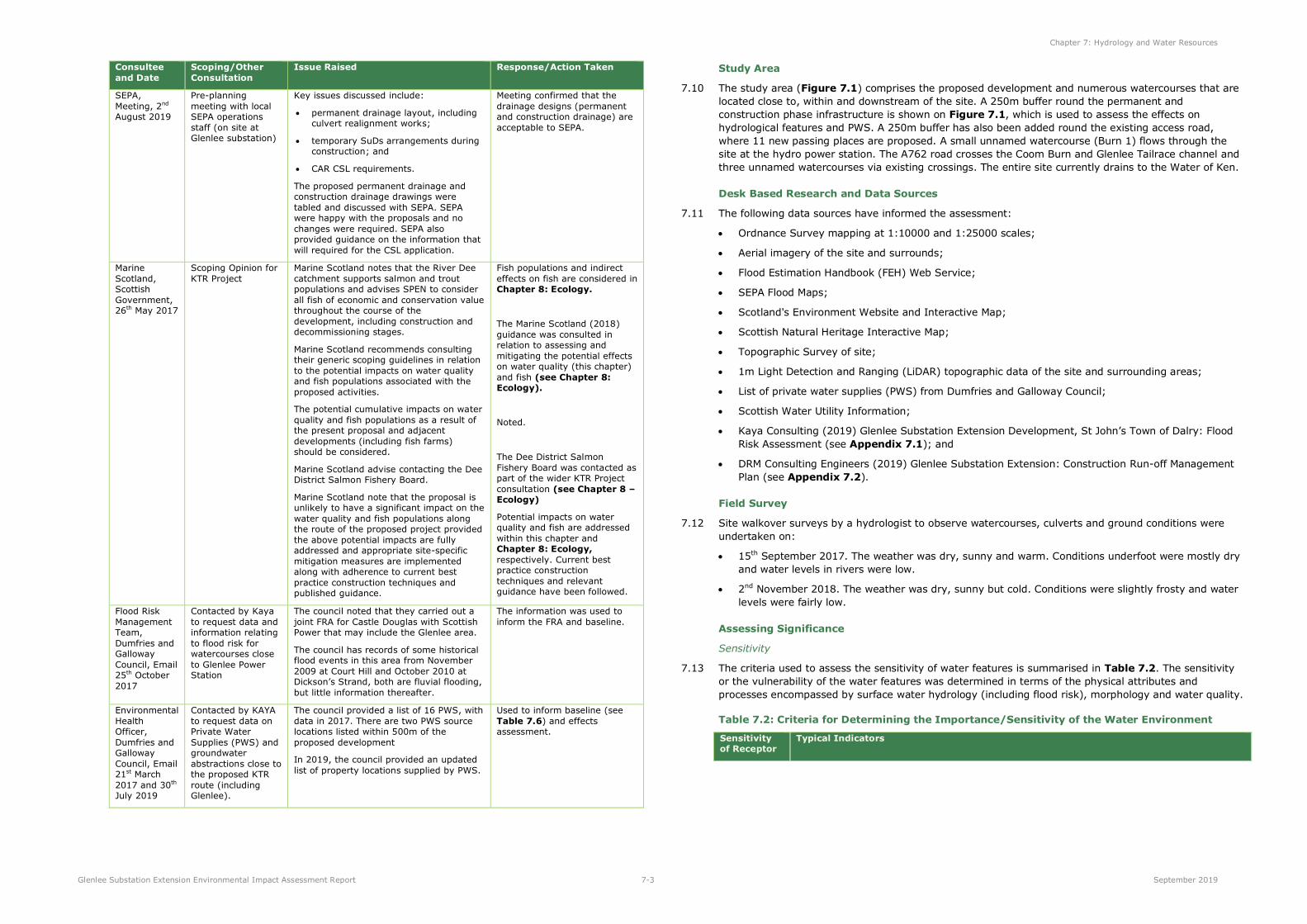
channel width of approximately 45m close to the site. Photo 7.1 shows the Water of Ken at its
confluence with the Tailrace looking downstream.
Photo 7.1: Water of Ken at its confluence with the Tailrace looking downstream
7.23 The Coom Burn lies to the north of the hydro power station and flows in an easterly direction before
discharging into the Water of Ken. The A762 crosses the Coom Burn via an existing bridge. This
watercourse drains a catchment area of approximately 21km².
7.24 Glenlee hydro power station generates energy through hydro power and so has a Tailrace channel, via
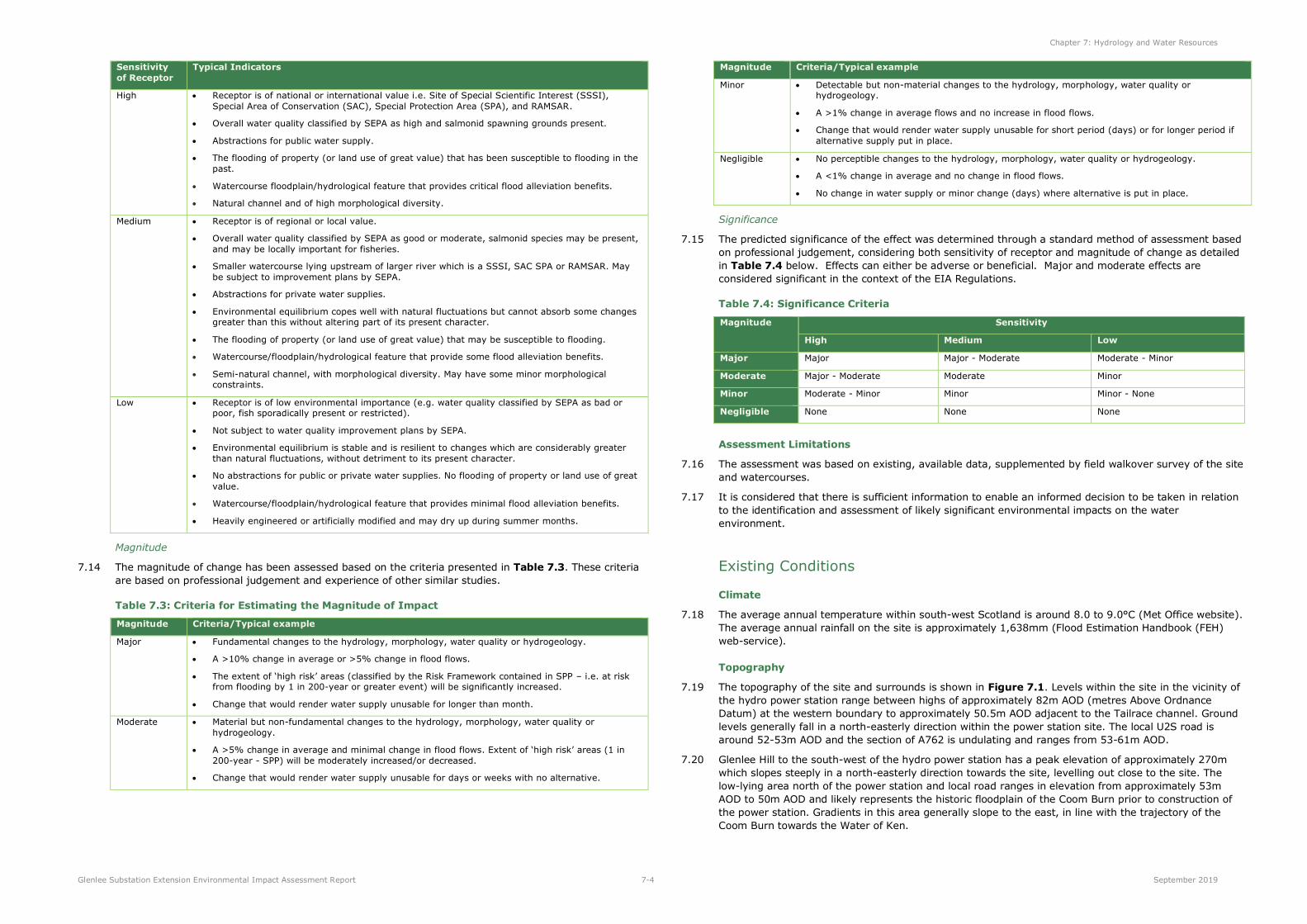
which flows are discharged. The Tailrace exits the power station flowing in a north-easterly direction
before turning south-east and flowing parallel to the Coom Burn and discharging into the Water of Ken
(Figure 7.1 and Photo 7.1). The A762 crosses the Tailrace channel via an existing bridge. Flows that
feed the hydro power station are abstracted from upstream and conveyed down the penstock to
generate electricity. Photo 7.2 shows the Tailrace looking upstream from Coom Bridge. The northern
site boundary is adjacent to the Tailrace.
Photo 7.2: Tailrace looking upstream from Coom Bridge
7.25 The Park Burn lies some 170m to the east and south-east of the site. This watercourse conveys flows in
a north-easterly direction and discharges into the Tailrace just upstream of its confluence with the Water
of Ken. The Park Burn drains a catchment of 7.2km2.
7.26 Dickson’s Strand is a smaller watercourse that lies to the east of the site. It has its source at Glenlee Hill
and drains a small catchment of 0.2km². This small watercourse passes under the local road via an
existing culvert and discharges into the marshland area and then onto the Glenlee Tailrace.
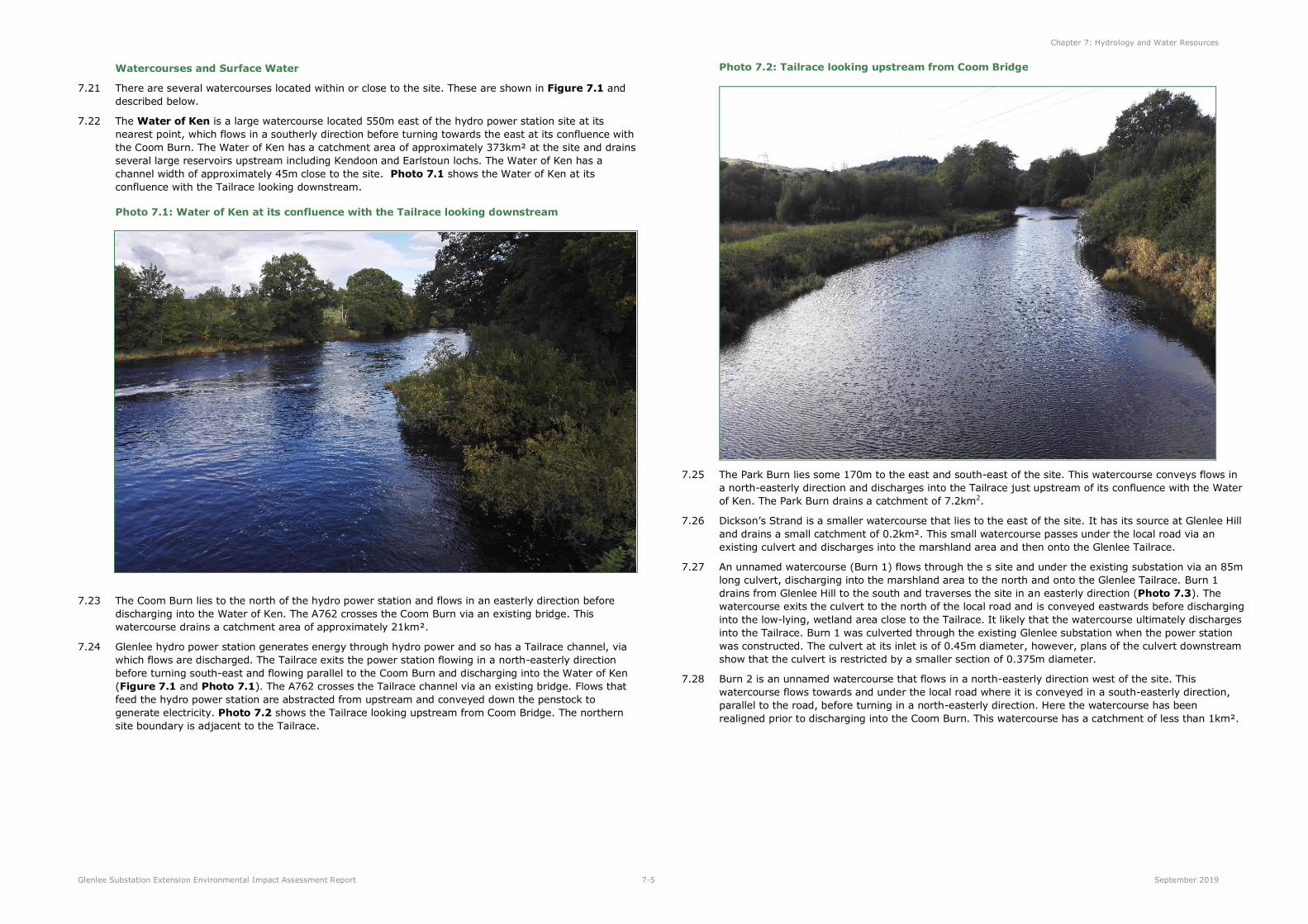
7.27 An unnamed watercourse (Burn 1) flows through the s site and under the existing substation via an 85m
long culvert, discharging into the marshland area to the north and onto the Glenlee Tailrace. Burn 1
drains from Glenlee Hill to the south and traverses the site in an easterly direction (Photo 7.3). The
watercourse exits the culvert to the north of the local road and is conveyed eastwards before discharging
into the low-lying, wetland area close to the Tailrace. It likely that the watercourse ultimately discharges
into the Tailrace. Burn 1 was culverted through the existing Glenlee substation when the power station
was constructed. The culvert at its inlet is of 0.45m diameter, however, plans of the culvert downstream
show that the culvert is restricted by a smaller section of 0.375m diameter.
7.28 Burn 2 is an unnamed watercourse that flows in a north-easterly direction west of the site. This
watercourse flows towards and under the local road where it is conveyed in a south-easterly direction,
parallel to the road, before turning in a north-easterly direction. Here the watercourse has been
realigned prior to discharging into the Coom Burn. This watercourse has a catchment of less than 1km².
Chapter 7: Hydrology and Water Resources
Glenlee Substation Extension Environmental Impact Assessment Report 7-6 September 2019
Photo 7.3: Burn 1 within the site, looking downstream towards the north-east and existing substation
7.29 There is a low-lying, wetland area north of the local road, located between the local road and the Tailrace
channel. OS maps show a pond and marshland vegetation. While relatively dry during the site visit this
area has some vegetation typical of a marsh or a wetland area and is likely part of the historic Coom
Burn/Water of Ken floodplain.
7.30 While most of the site itself is relatively dry, areas in the southern part of the site at the base of the
steep slopes of Glenlee Hill comprise marshy grassland.
Hydrology and Flood Risk
7.31 The SEPA flood maps show the likely extent of flooding for high, medium and low likelihood for fluvial,
pluvial (surface water) and tidal flows.
7.32 Review of the online SEPA flood maps indicates flooding from fluvial sources at the confluence of the
Water of Ken, Coom Burn and the Tailrace close to the site. The online SEPA maps show the floodplain
extends to the edge of the Tailrace channel close to the northern boundary of the site and parts of the
low-lying marsh area north of the local road are shown to be at flood risk. However, it is noted that SEPA
flood maps are indicative and a detailed assessment of flooding risk is required for sites close to or within
the SEPA flood extent.
7.33 A Flood Risk Assessment (FRA) for the existing substation was undertaken by Halcrow in 2011 to support
the development of flood mitigation measures. The Halcrow report included a 1D ISIS (Flood Modeller
Pro) mathematical model to represent the Water of Ken, Coom Burn and Tailrace and peak water levels
near the site were predicted.
7.34 A subsequent FRA was prepared by Kaya Consulting Limited in 2019 for the substation extension1
(Appendix 7.1). The Kaya FRA updated the hydrological analysis and used a 2D mathematical
modelling approach using LiDAR DTM data to confirm the predicted flood levels and extents in the
Halcrow (2011) assessment. The main findings of the FRA are summarised below.
1 The site considered in the FRA comprises the area of proposed permanent development only (i.e. the substation extension and associated
infrastructure, permanent drainage, including the culvert realignment works). The wider site area considered in the planning application and EIA
covers a much wider area, which will be used during construction of the development.
7.35 Hydrological analysis was carried out to estimate design flows for all watercourses close to the site
(Table 7.5); full details of the hydrological analysis are provided in Chapter 4 of Appendix 7.1.
Table 7.5: Summary of Watercourse Hydrology Assessment – Design Flows (m3/s)
Watercourse
Catchment Area
(km2)
1 in 200-year
(m3/s)
1 in 1000-year
(m3/s)
Water of Ken 372.8 565.5 720.7
Coom Burn 21.5 75 106.5
Park Burn 7.2 29.1 37.6
Dickson's Strand 0.2 1.2 1.7
Burn 1 0.2 1.4 2
Burn 2 0.4 2.6 3.7
7.36 The Tailrace is not a natural watercourse with flows conveyed through the structure controlled by the
hydro power station. It is understood that the hydro power station passes a maximum flow of 25.5m3/s,
with normal operating peak flows averaging between 21m3/s and 22m3/s.
7.37 2D modelling of the watercourses produced similar flood extents and peak water levels to those
published in the Halcrow (2011) FRA. It is noted that a 1D mathematical model better represents the
conveyance capacity within watercourses and is considered more accurate in this instance. Hence the
peak water levels predicted by Halcrow for the site are used to assess flood risk from the large
watercourses near the site (see Table 13 of Appendix 7.1). The peak water levels at the site are
53.79m AOD for the 1 in 200-year event and 54.51m AOD for the 1 in 200-year + climate change event.
7.38 The substation extension is not at risk in a 1 in 200-year flood event and the majority of the wider site
area (for construction) is above the predicted 1 in 200-year + climate change flood level (see Figure 13,
Appendix 7.1). A small area of the construction site area, north of the local road (U2S) is potentially at
risk of flooding.
7.39 SPEN has confirmed that the hydro power station and existing substation is protected against flooding by
flood defences up to the 1 in 1,000-year plus climate change flood levels estimated in the Halcrow
(2011) Flood Risk Assessment2. As the substation extension is located to the south of the existing
substation and at a higher elevation, it is considered that these flood defences would continue to protect
the substation extension so long as they are maintained. The substation extension is therefore not at risk
of flooding from the Water of Ken, Coom Burn, Tailrace and Park Burn up to the 1 in 1,000-year plus
30% climate change flood event.
7.40 Flood risk to the site from Dickson’s Strand and Burn 2 was assessed by developing a 2D mathematical
model of the watercourses. Modelling showed that the site is not at risk of flooding from Dickson’s Strand
and Burn 2 (see Figures 14 and 15 in Appendix 7.1).
7.41 Burn 1 flows in an easterly direction through the site and passes under the penstock. It is culverted
under the existing substation. A 1D mathematical model was developed to provide further information on
the culvert. The burn and culvert were represented using existing site plans and topographic survey and
the model was run for several scenarios including the 1 in 200-year event.
7.42 The substation extension can be considered ’essential infrastructure’ under the SEPA Land Use
Vulnerability Classification (SEPA, 2018). According to SEPA guidance, development of ’essential
infrastructure’ can proceed if an alternative lower-risk location is not available and so long as the
proposed development is designed and constructed to remain operational during floods (i.e. in a 1 in
200-year event) and does not impede the flow of water.
7.43 Details of the model set up are provided in Appendix 7.1. The results of the modelling indicate that the
existing culvert cannot convey the 1 in 200-year flow of approximately 1.4m3/s. In a 1 in 200-year flood
event, the model predicts that only 0.3m3/s can be conveyed by the existing culvert with overland flows
of around 1.1m3/s spilling out of the culvert and flowing through the existing substation across the local
road and back into Burn 1 and the low-lying, wetland area north of the local road. Thus, there is an
2 Email from SPEN, 26th October 2017.
Chapter 7: Hydrology and Water Resources
Glenlee Substation Extension Environmental Impact Assessment Report 7-7 September 2019
existing flood risk to the substation extension due to the undersized culvert on Burn 1. This was also
noted in the Halcrow (2011) FRA.
Existing Site Drainage and Surface Water Flooding
7.44 A flow pathway analysis was undertaken in GIS, based on the LiDAR data to assess potential overland
flow routes within and outside of the main construction site (see Section 5.4 of Appendix 7.1). The
results show that surface water run-off can enter the site from higher land to the south and south-west
(Figure 20, Appendix 7.1); however, this run-off will be mostly intercepted by Burn 1.
7.45 Existing ground levels of the site fall to the north-east; hence existing surface water run-off from the site
is to the north-east towards the Tailrace and low-lying wetland area north-east of the site, mainly via
Burn 1. The area of the site west of the penstock currently drains to the north-east towards the local
road, where it will either be intercepted by the local road drainage system or enter Burn 2 north of the
road, which then discharges into Coom Burn. The entire site is within the catchment of the Water of
Ken, as both Coom Burn and the Tailrace enter the Water of Ken approximately 0.5km downstream of
the site.
7.46 SEPA flood maps indicate two very small areas of pluvial (surface water) flood risk close to and just
within the main construction site boundary. These are associated with local low points in the topography;
one low point is close to the course of Burn 1 as it enters the site at the south-west corner and the other
is immediately east of the main construction site at the junction of the local roads. Neither of these areas
will be affected nor will they affect the proposed development and are not considered further.
Water Supplies, Discharges and Abstractions, and Services
7.47 D&GC provided information on private water supplies (PWS) from their database. There are two PWS
source locations close to the application site boundary (Figure 7.1 and Table 7.6). The properties
supplied by each PWS are shown in Figure 7.1.
7.48 The Waterside property is around 50m west of the A762 road and is supplied by the Waterside PWS; the
source location for Waterside is understood to be a surface watercourse some 330m west of the
property. The Glenlee PWS is approximately 200m south of the main construction site. It is a
groundwater spring and a ‘Type A supply’ which means it provides water for 50 or more people in
domestic premises and is subject to regular testing by D&GC. It must meet relevant drinking water
standards to be considered acceptable for drinking. The data from D&GC notes that the sample from the
Glenlee PWS passed and is acceptable for drinking (Table 7.6). The Glenlee PWS supplies ten properties
located to the south-east of the site (see Figure 7.1).
Table 7.6: Private Water Supplies (PWS) within 0.5km of site
Source
Name
Source
Ref Source Type Easting Northing
No of persons
served
No of
properties Sample
TYPE A
OR B1
Waterside 100069 Surface
Watercourse 260942 581115 Not known 1 Domestic - B
Glenlee 97995 Groundwater
spring 260500 580100 30 6 Holiday lets,
4 Domestic Pass A
1Type: Type A supplies are larger PWS, or those with a commercial activity, and are defined as Regulated supplies,
which supply either a commercial activity or 50 or more people in domestic premises. These supplies are subject to regular testing by D&GC. Type B supplies are smaller supplies that serve only domestic properties (<50 persons).
7.49 Data provided by SEPA on licenced groundwater abstractions indicted that there are no licenced
groundwater abstractions within 1km of the site.
7.50 There are Scottish Water services along the local road from the A762 to the residential properties located
to the east of the site, indicating that these properties are supplied by Scottish Water and do not rely on
a PWS. There is an existing foul water drain close to the site, which connects the former power station
properties to a septic tank. This requires to be diverted and will be undertaken as part of the enabling
works for the substation extension. The diversion will be planned, installed and connected in such a way
that ensures minimal disruption to properties.
Water Quality and Protected Areas
7.51 Under the terms of the WFD, all river basin districts require to be characterised. The characterisation
process requires SEPA to produce an initial assessment of the impact of all significant pressures acting
on the water environment.
7.52 Surface water bodies are defined as being whole or parts of rivers, canals, lochs, estuaries or coastal
waters. The main purpose of identifying water bodies is so that their status can be described accurately
and compared with environmental objectives.
7.53 The WFD applies to all surface waters, but for practical purposes SEPA has defined a size threshold above
which a river or loch qualifies automatically for characterisation. Rivers must have a catchment area of
10km2 or more. In addition to these larger water bodies, smaller waters have been characterised where
there is justification due to environmental concerns and to meet the requirements of regulatory
legislation such as for drinking water supplies.
7.54 Classification of status by SEPA considers water quality, hydromorphology, biological elements including
fish, plant life and invertebrates, and specific pollutants known to be problematic. The classification
grades through High, Good, Moderate, Poor and Bad status. This provides a holistic assessment of
ecological health. Heavily modified waterbodies, which can no longer be considered to be natural, are
classified on the basis of 'ecological potential'.
7.55 In terms of the study area, two watercourses are large enough to be classified:
The Water of Ken (Water Body ID 10761) was classified by SEPA in 2017 as Bad ecological potential.
The Coom Burn (Water Body ID 10570) was classified by SEPA in 2017 as Moderate status.
7.56 The Loch Ken and River Dee Marshes Special Protection Area (SPA)/RAMSAR site is located on the Water
of Ken approximately 4km downstream of Glenlee. The Water of Ken Woods Site of Special Scientific
Interest (SSSI) is around 300m south-west of the site at its nearest point.
7.57 The River Dee catchment supports salmon and trout populations and the entire site area drains indirectly
to the Water of Ken/River Dee catchment (Marine Scotland consultation response; Table 7.1).
Groundwater
7.58 The groundwater body underlying the site is the Galloway waterbody and was classified by SEPA as
having an overall classification of Good. The aquifer was classified as Class 2C, a low productivity aquifer,
with all flow through fractures and other discontinuities. The aquifer comprises highly indurated
greywackes with limited groundwater in the near surface weathered zone and secondary fractures3.
7.59 SEPA ground water flood maps suggest that the site is not at risk of groundwater flooding. Given the
proximity of the site to the Water of Ken and Coom Burn, it is likely that groundwater levels are
controlled by water levels in the watercourse. The site is located above the surrounding area and above
the watercourses, thus groundwater flooding is considered unlikely. Groundwater monitoring is normally
undertaken as part of the site investigations. If locally raised groundwater levels are identified during site
investigations, suitable mitigation measures would need to be employed.
Groundwater Dependent Terrestrial Ecosystems (GWDTEs)
7.60 No GWDTEs were found within or adjacent to the site area and this is therefore not considered further
(full details of the habitats present on the site are provided in Chapter 8: Ecology).
Implications of Climate Change
7.61 Scottish Planning Policy states that “the planning system should promote a precautionary approach to
flood risk from all sources, including coastal, water course (fluvial), surface water (pluvial), groundwater,
reservoirs and drainage systems (sewers and culverts), taking account of the predicted effects of climate
change.”
7.62 Until recently, SEPA recommended a 20% increase in peak flow for the 0.5% Annual Exceedance
Probability (AEP) (1 in 200 year) event, in accordance with DEFRA (Department of Environment, Food
and Rural Affairs) and Scottish Government research. Climate change has been incorporated in peak flow
3 Scotland’s Environment website (https://map.environment.gov.scot/sewebmap/).
Chapter 7: Hydrology and Water Resources
Glenlee Substation Extension Environmental Impact Assessment Report 7-8 September 2019
estimates in the FRA (see Appendix 7.1) using guidance available at the time of writing; Halcrow
(2011) used a 30% increase in peak flows to be conservative.
7.63 In April 2019, SEPA published new guidance on climate change in Scotland which provides a regional
based approach, based on the UKCP18 projections4. This guidance was issued after the initial FRA report
had been prepared and submitted to SEPA for pre-planning consultation. SEPA noted in their pre-
planning response that climate change had been considered in line with good practice (Table 7.1).
However, to comply with the new SEPA guidance on climate change uplift, the FRA was updated and
reflects the new guidance on climate change and its implications for peak flows.
7.64 The 2018 climate change projections (UKCP18) predict that the Solway River Basin will experience
hotter, drier summers and milder, wetter winters. The new SEPA guidance recommends that the peak
(200 year) design flow should be increased by 44% in the Solway River Basin to account for projected
climate change increases to the year 2100 (for river catchments over 50km2). In addition, the peak
rainfall intensity allowance for the west region of Scotland is 55% to the year 2100. Thus, this part of
Scotland is likely to get wetter with higher peak flows in the rivers in the future.
7.65 Peak flows have been estimated in the FRA for the 200-year + climate change, based on the new SEPA
(2019) guidance. Peak flows are lower than the 1 in 1000-year + 30% climate change event for all
watercourses (see Section 4, Appendix 7.1), meaning peak water levels would be lower than the 1 in
1000-year + 30% event. The hydro power station and substation is protected against flooding by
defences up to the 1 in 1000-year + 30% event levels.
7.66 Any site drainage design will consider future estimates of increased precipitation and follow an adaptive
approach.
The ‘Do Nothing’ Scenario
7.67 If the proposed development did not proceed, the baseline conditions described above would not be
expected to change significantly. The main change in the baseline is related to climate change. Climate
change projections indicate that the site will experience hotter, drier summers and milder, wetter
winters. SEPA have provided guidance on the expected increases to rainfall intensities and peak river
flows (see Section above), which has been considered in the FRA.
7.68 In the absence of the development, climate change may result in an increase in the magnitude of fluvial
and groundwater flooding and the increase in rainfall could affect the operation of existing drainage and
sewer systems.
7.69 It is noted that the predicted flood risk is the best-available prediction at the time of assessment.
Hydrological analyses changes over time, as the prediction of peak flows is based on the time-series of
flow and rainfall data which change as more data becomes available. Hence, the extent of flooding may
change over time, given the potential for events exceeding design conditions and the inherent
uncertainty associated with estimating hydrological parameters for any given site and the effects of
climate change.
7.70 It is noted that the existing culvert on Burn 1 through the existing substation is under-sized and the site
is currently at flood risk from the burn in a 1 in 200-year event (see Section 5.3 of the FRA, Appendix
7.1).
Micrositing
7.71 The proposed development layout has been designed to avoid effects on hydrology and water resources
as far as possible, but it is possible that further micrositing of temporary works may be required. The
design of the substation extension is considered to be sufficiently progressed that micrositing of the
permanent infrastructure is unlikely to be required. Any minor (non-material) changes would be within
the site boundary, and would be agreed with D&GC.
4 SEPA (2019). Climate change allowances for flood risk assessment in land use planning, Land Use Planning System SEPA Guidance. Version 1.
Design Considerations and Good Practice Measures
7.72 During initial design, a buffer of at least 10m from all watercourses was recommended for infrastructure
and construction activities. With the exception of Burn 1 (which forms part of the proposed development)
there will be no construction activity or infrastructure within 10m of any watercourse. Watercourse
crossings were avoided during design and there are no new or existing watercourse crossings within the
hydro power station site. Five watercourses are crossed by the existing road access to the site (local
road and A762), which is part of the site. These crossings are shown for reference on Figure 7.1, but as
no construction, road upgrades or development are proposed at or within 10m of the crossing locations
they are not considered further in the assessment5.
7.73 In addition, a number of good practice pollution prevention and control measures will be put in place
during construction. These are incorporated into the project design and reflect best practice guidance
and recognised industry standards, as well as SPEN’s recent experience of constructing substations.
7.74 Good practice will be followed to minimise the impact of construction activities on the receiving water
environment. As a minimum, the contractor will be required to follow the guidance contained in SEPA
GPPs and PPGs ,and to follow SEPA’s general binding rules (GBR) under the Water Environment
(Controlled Activities) (Scotland) Regulations 2011, as amended (CAR Regulations). Details of the good
practice measures to be adhered to are provided in Appendix 4.3.
7.75 A CSL will also be required from SEPA under the CAR Regulations in advance of the works which will
include a detailed Pollution Prevention Plan (PPP) to ensure that any surface run-off from the site does
not cause pollution or increase flood risk. This will be prepared, and authorisation sought from SEPA,
before construction commences.
7.76 A CAR licence for the culvert realignment of Burn 1 will be required from SEPA in advance of the works.
The contractor will be required to adhere to the licence during the works to ensure there is minimal
impact on the water environment and the realignment/culverting works will be carried out following best
practice guidelines and industry standards. This will include isolating the reach of the channel during the
works and incorporating silt fences and SuDs measures during construction.
7.77 A Construction Environmental Management Plan (CEMP) will also be developed and agreed with D&GC
and SEPA in advance of the works. The CEMP will establish a framework to ensure that health and safety
and environmental best practices are adopted throughout the works. The CEMP will include the
approved PPP. An extract from a SPEN CEMP is provided as Appendix 4.1.
7.78 Many of the good practice measures mitigate several potential effects (e.g. mitigation to minimise
sedimentation and pollution such as SuDs can also serve to attenuate surface water run-off and minimise
flood risk).
7.79 An initial design of site drainage and a construction run-off management plan has been prepared
(Appendix 7.2). The construction drainage design includes a number of settlement ponds, cut-off
drains, silt barriers, and anti-scour surface discharge points. Greenfield run-off rates and pond sizes were
calculated for 1 in 5-year, 1 in 10-year and 1 in 30-year return period rainfall events, but as this is for
temporary construction works the pond design is based on attenuating the 1 in 5-year run-off rate to
greenfield rates. The ponds were also sized to accommodate treatment of run-off (through settling) and
the total pond volume is the sum of the attenuation volume and the treatment storage volume. Sufficient
land has been set aside for SuDs ponds during construction and initial drainage designs are included in
Appendix 7.2. Additional good practice mitigation is recommended in the construction run-off
management plan (Section 5, Appendix 7.2) and these measures will be adhered to during
construction.
Assessment of Effects
7.80 The assessment of effects is based on the project description as outlined in Chapter 4: Project
Description and Construction, Operation and Maintenance. Unless otherwise stated, potential
effects identified are considered to be adverse.
5 It is noted that passing place 11 is close to the exiting culverted road crossing of Dickson’s Strand watercourse, however the existing road
junction here will be used as a passing place and no road upgrade works are proposed.
Chapter 7: Hydrology and Water Resources
Glenlee Substation Extension Environmental Impact Assessment Report 7-9 September 2019
Construction Effects
Predicted Construction Effects
7.81 The following construction effects have been assessed in full:
Effects on water quality and private water supplies (PWS);
Effects on channel morphology (bank erosion and channel form); and
Effects on run-off rates and flood risk.
7.82 The sensitivity of receptors (within the study area) has been assessed in Table 7.7, using the criteria in
Table 7.2.
Table 7.7: Sensitivity of Receptors
Receptor Sensitivity Comment
Watercourses/ Surface Water
Bodies
(Hydrology, Flood
Risk and Water Quality)
Water of Ken
Coom Burn
Tailrace
Unnamed
Watercourses (Burn 1 and Burn 2)
High
All watercourses drain, either directly or indirectly, to the Water of Ken/River Dee catchment. There is a designated site of international
importance (SPA and RAMSAR site) on the Water of Ken approximately 4km downstream of the site. In addition, the River Dee catchment is
known to support salmon and trout populations, hence the sensitivity of all watercourses is high.
The Water of Ken was classified by SEPA as of bad ecological potential.
The Coom Burn was classified by SEPA as of moderate potential.
SEPA Flood Maps show large areas of flooding on the Coom Burn and Water of Ken downstream of the site. Results of the FRA for the site
showed that the existing culvert on the unnamed watercourse (known as Burn 1 for this assessment) is undersized for the 200-year flow and
there is an existing risk of flooding at the site. There are no properties immediately downstream of the project infrastructure that are at
currently at flood risk.
Watercourses/
Surface Water Bodies
(Morphology)
Unnamed
Watercourse – Burn 1
Low
The morphology of Burn 1 has been modified in the past, as it passes through an 85m long culvert under the existing substation. The reach
upstream of the culvert appears to be natural, with some meanders and vegetated banks (Photo 7.3). However, given the morphological
constraints (existing culvert) on Burn 1, its sensitivity is classed as low.
Groundwater Low to Medium The site is located on low productivity aquifers and groundwater quality
is classified by SEPA as good.
Private Water
Supplies
Medium There is one abstraction for a private water supply 200m south of the southern site boundary (Glenlee), which supplies ten properties. Another
PWS property (Waterside) is located close to the access road, although this is sourced from surface water over 300m west of the road.
Effects during construction on surface and ground water quality and private water supplies
7.83 The potential effects on surface water quality during construction are:
Pollution of surface waters caused by the release of sediment to watercourses from excavated
material during construction, heavy plant movement on the access tracks and construction
compounds, realignment and culverting of the small watercourse (Burn 1) and the removal of
vegetation.
Pollution of surface water caused by the release of hydrocarbon pollution resulting from accidental oil
or fuel leaks or spillages. There is also a risk posed by concrete (and other construction material)
spillages during the formation of hardstanding areas.
7.84 The potential effects on groundwater quality include:
The risk of hydrocarbon pollution of groundwater resulting from accidental oil or fuel leaks from
construction traffic and construction works. There are also potential pollution effects caused by silt
and sediment disturbed during construction infiltrating into shallow groundwater and concrete
spillages.
7.85 Risks to surface water quality will be greatest during construction when works involve the exposure of
bare earth which could result in increased erosion and sedimentation. The increase in sediment
concentration in run-off from construction areas and tracks may result in excessive levels of suspended
sediment in watercourses, which can have an indirect effect on watercourse ecology.
7.86 Pollutants can enter the watercourses in the event of accidental spills or leaks from machinery and
vehicles and in the event of an accidental release of concrete or other building materials. Pollutants could
enter watercourses directly or via overland flow pathways. Shallow groundwater could also be affected.
7.87 Good practice measures have been incorporated into the project design and include a range of
construction SuDs and standard construction good management (described above). The SuDs ponds
have been sized to accommodate the required treatment (i.e. settlement) volume and also to attenuate
flows to the 1-year greenfield rate. Discharge of attenuated and treated water will be either overground
via anti-scour beds or to the realigned Burn 1. With good practice, the magnitude of the effect of
increased sediment/silt run-off causing a deterioration in surface water quality in waterbodies and
watercourses within and downstream of the site during construction is considered to be minor and
temporary, which results in an effect of minor significance.
7.88 Good practice measures to minimise the risk of pollution and accidental spillage will minimise the
likelihood and severity of such incidents happening, however, there is still a residual risk. The magnitude
of effect of pollution of surface water and groundwater caused by the release of hydrocarbon pollution
and concrete resulting from accidental oil or fuel leaks or spillages is considered to be minor and of
short duration, which would result in an effect of minor significance.
7.89 There are two PWS within 0.5km of the application site boundary (see Table 7.6 and Figure 7.1). The
Waterside PWS property is 50m west of the A762 road and its source over 300m west and both are
upgradient of the road. The works on the road comprise adding a number of passes places, to be located
on the road verge. There will be minimal excavation and given that the PWS source is a surface
watercourse located over 300m west of the road, there will be no impact on the PWS or the property it
supplies.
7.90 The Glenlee PWS sources its water from a groundwater spring. Given that construction can potentially
affect both surface and groundwater quality, it follows that construction can potentially affect nearby and
downgradient PWS.
7.91 Based on SEPA Guidancei for assessing impacts of development proposals on groundwater abstractions
and PWS, a 250m buffer zone is used for the proposed works at the construction site at Glenlee hydro
power station. This is a conservative approach which assumes all ground excavations are deeper than
1m. The Glenlee PWS source and two of the supplied properties (Blackbank and Garden Cottage) are
within the 250m buffer (Figure 7.1). The other supplied properties are just outside the buffer. Given the
proximity of the PWS to the infrastructure, analysis of flow paths analysis was carried out and the results
are discussed below. In the absence of data on groundwater levels and flow paths, topography and
surface water flow paths have been used to infer groundwater flow paths.
7.92 The Glenlee PWS source is located 200m south of the southern planning application site boundary, where
the temporary construction vehicle holding area and topsoil storage area will be located. The PWS source
is upgradient of the site, at an elevation of 110m AOD compared to ground levels at the southern site
boundary of approximately 70m AOD. The Glenlee PWS supplies ten domestic properties (six holiday
lets and four domestic), which are located over 120m south-east of the site (Figure 7.1). Flow routing
analysis shows that flow paths from the site are to the north-east and will not impact the PWS source or
the properties. Given that the PWS source is at least 40m higher that the proposed work and flow paths
from the works are to the north-east away from the PWS, it is considered that works at the site will not
impact groundwater quality or quantity at the PWS source location. The magnitude of effect on the PWS
source and properties is considered to be negligible and the significance of the effect is none.
Effects on channel morphology (bank erosion and channel form) during construction
7.93 There are no new watercourse crossings as part of the proposed development. There are five existing
crossings of the local road and A762 (see Figure 7.1), however as there are no road upgrades proposed
at or within 10m of the crossings they will not be impacted by the development.
7.94 Part of the works require realigning and culverting an 80m reach of a small watercourse (Burn 1)
upstream of where it enters an existing 85m long culvert under the existing substation. The proposed
works are described in detail in Chapter 4: Project Description and Construction, Operation and
Maintenance and shown on Figure 4.5.
7.95 The watercourse will be realigned and diverted to the east to enter a new culvert which will pass under
the new access road discharging to the ditch on the north side of the local road. Mathematical modelling
Chapter 7: Hydrology and Water Resources
Glenlee Substation Extension Environmental Impact Assessment Report 7-10 September 2019
of the new culvert and realigned reach upstream of the new culvert has been undertaken (see Appendix
1 of the FRA report (Appendix 7.1)).
7.96 Burn 1 is a natural watercourse of approximately 2m width, with vegetated banks (Photo 7.3). To
enable the watercourse to enter the new culvert to the east, a realigned and steeper channel is required.
The final design of the channel will be carried out during detailed design stage, however initial designs of
the realigned channel have been prepared and modelled (Appendix 7.1). A natural rock-cut stepped
design is proposed, which is less engineered and a more natural design than a concrete spillway. The
design has been modelled using hydraulic equations and works hydraulically with predicted flood levels
staying within bank, with a suitable freeboard. After passing through the realigned (and steepened)
section, the watercourse will enter the new culvert, through a trash-screen (designed to keep culvert
free from blockage).
7.97 Pre-planning discussions and consultation have been ongoing with the SEPA flood team and the SEPA
local office regarding the channel realignment and culvert design with respect to the obtaining a CAR
licence for the works and also being compliant with the principles of SPP in terms of flood risk (see
section below). A CAR licence for the realignment and new culvert will be obtained prior to construction.
7.98 The effect on channel morphology during construction is assessed to be of moderate magnitude, as the
form of the channel over an 80m reach will change considerably from a semi-natural channel with
vegetated banks to a stepped rock-cut channel entering a culvert. However, this reach of the
watercourse has already been modified immediately downstream as it enters a culvert under the existing
substation and is considered to be of low sensitivity in terms of morphology (Table 7.7). The effect on
channel morphology is assessed to be of minor significance.
Effects during construction on run-off rates and flood risk
7.99 In accordance with the Risk Framework within SPP, new development should be limited to areas outside
the medium risk 200-year (0.5% Annual Probability (AP)) functional floodplain. The development in this
case is a substation extension and is classified as ‘essential infrastructure’ under the SEPA Flood Risk and
Land Use Vulnerability Guidance. The guidance notes that ‘essential infrastructure’ can be in medium to
high risk flood areas (i.e. >0.5% AP) if a flood risk location is required for operational reasons and an
alternative lower-risk location is not available.
7.100 The FRA prepared for the site (Appendix 7.1) shows that the footprint of the substation extension itself
is not at flood risk and its development will not increase flood risk elsewhere. Part of the area within the
site boundary set aside for the enabling works and temporary works during construction (i.e. a small
area of the site fronting the local road and the low-lying area within the construction site boundary north
of the local road) are at risk of flooding in extreme events. However, no development is proposed in
these areas. The contractor will sign up to SEPA Floodline which provides advance warning for flooding in
the Dumfries and Galloway, including the Water of Ken/River Dee.
7.101 Compaction of soils and increased areas of hardstanding (e.g. construction compound, vehicle holding
area, substation base and access tracks) reduces the infiltration rate leading to a greater rate and
volume of surface water run-off. Felling of trees and removal of other vegetation can also lead to an
increase in surface water run-off rates. This results in a ’flashier’ catchment response and could increase
flood risk downstream if surface run-off is not attenuated. Drainage design during construction
incorporates SuDs including ponds, which are designed to attenuate flows to the greenfield run-off rate.
Thus, the increase in run-off rates and flood risk during construction with good practice in place, is
considered to be of negligible magnitude and the significance of the effect is none.
Proposed Mitigation
7.102 With good practice incorporated into project design, including SuDs pollution control and attenuation
measures, there are no potentially significant effects on hydrology, water quality or PWS. Details of the
good practice measures will be set out in detail prior to construction in the PPP, CEMP and construction
method statements. The PPP will require approval by SEPA to obtain a CAR CSL. The contractor will be
legally obliged to comply with the pollution control and drainage measures agreed in the PPP and CSL.
7.103 The SuDs measures to manage the construction site run-off have been designed to attenuate and treat
flows up to the 1 in 5-year rainfall event. Extreme storms greater than this could exceed the capacity of
the drainage system. If an event exceeds the design capacity of the system (which is unlikely but
remains a risk with all drainage systems) an emergency area for water treatment has been reserved on
site in the area north of the local road. During construction, the discharge from site will be monitored
and additional pollution prevention measures will be installed in this area as required (see Drainage
Drawing in Appendix 7.2).
Residual Construction Effects
7.104 With good practice, including monitoring of the discharge from the site and additional (emergency) areas
set aside for pollution control and SuDs downstream of the site, all residual construction effects are
assessed as either minor or none and are not significant. This is summarised in Table 7.8.
Operational Effects
Predicted Operational Effects
7.105 The potential operational effects of the proposed development are associated with the permanent
infrastructure, including the new permanent access on the east part of the site, the substation extension
and permanent drainage of the substation platform, the realigned and culverted watercourse and any
required maintenance work during operation (i.e. maintaining the site drainage system and regular
clearing of the culvert trash-screen).
7.106 Predicted effects during operation are related to effects on hydrology (and flood risk) and channel
morphology.
7.107 During operation, the increase in hardstanding area comprises the permanent access road (bitumen
surface) and the substation platform (which is semi-permeable). Without attenuation, the additional
hardstanding could result in a very minor increase in the rate and volume of surface water run-off,
leading to a potential increase in flood risk in watercourses downstream. The permanent drainage design
incorporates filter drains round the substation platform which link to the existing drainage. The new
road has been designed with SuDs to attenuate surface water run-off, including a new road verge filter
drain along the east side of the access road. The magnitude of the effect of increased hardstanding on
flood risk downstream is considered to be negligible and the effect is none and thus is not significant.
7.108 Mathematical modelling described in detail in the FRA report (Appendix 7.1) indicates that the existing
culvert is undersized to pass the 1 in 200-year flow. Thus, there is a flood risk to the existing substation
due to the undersized culvert on Burn 1. However, due to space constraints and gradients at the site, the
new proposed culvert could not be designed to pass the 200-year flow and a new culvert was designed
that will convey most flood events, with any overtopping flows conveyed through the site via a carefully
designed overland flow pathway.
7.109 The new culvert has a greater flow capacity (between 0.7 m³/s and 0.8 m³/s) compared to the existing
culvert peak capacity (see Appendix 7.1 for details) and in extreme events overland flows will be
contained within the new access road and conveyed to a new filter drain along the eastern side of the
road. Excess flows that cannot be conveyed by the filter drain will need to be conveyed along the access
road and across the local road and into the wetland area to the north-east of the site. The FRA indicates
in extreme events there is still a minor flood risk downstream of the site on the local road. However, this
will not affect any residential properties and as the predicted flood depths are less than 0.3m and
velocities do not exceed 1 m/s the local road will remain navigable by emergency vehicles in a 1 in 200-
year flood event.
7.110 Overall the new culvert provides additional capacity compared to the existing culvert, providing
betterment to the existing case such that the flood risk to the existing substation and local road is
improved by the new culvert proposals.
7.111 Based on pre-planning consultation, SEPA view the proposal for the culvert realignment as being
compliant with the principles of SPP (see Table 7.1). In terms flood risk, the culvert works are
considered to have a minor (positive) effect, as the new culvert provides betterment compared to the
existing case.
7.112 The effects on channel morphology of Burn 1 were considered during the construction phase. During
operation the realigned and culverted channel will remain in place. The realigned reach is steeper than
the existing channel, but as the channel will be graded into the realigned section, no significant effects
on channel morphology upstream are anticipated.
7.113 The new culvert design splits into two culverts just upstream of the local road, hence there will be two
discharge locations into the existing watercourse north of the local road (see Figure 4.5). Flows will
come out of the existing discharge location and also a new discharge location approximately 15m
downstream. As the culvert discharges into the existing watercourse, the flow turns an almost 90-degree
Chapter 7: Hydrology and Water Resources
Glenlee Substation Extension Environmental Impact Assessment Report 7-11 September 2019
bend, the same as the existing case. As a result, there is a potential concern of bank erosion on the
northern bank of the watercourse, due to the angle of the outlet. Without mitigation, the magnitude of
effect on channel morphology (i.e. bank erosion at discharge location) is considered to be of minor
magnitude, resulting in an effect of minor significance.
Proposed Mitigation
7.114 Bank protection, either using geotextiles or harder protection (e.g. ‘rip-rap’), will be put in place on the
banks of the watercourse at the location of the new culvert outlet to mitigate any potential erosion of the
outer bank at the discharged location.
Residual Operational Effects
7.115 With additional mitigation, the residual effect on channel morphology (Burn 1) is of negligible magnitude
and not significant. All other effects remain as outlined above and are either not significant or of
minor (positive) significance.
Cumulative Construction Effects
7.116 There are a number of wind farm developments within the Water of Ken catchment, which all drain
(indirectly) into the Water of Ken/River Dee. In addition, construction of the KTR Project is also
considered. Assuming these wind farm schemes and the KTR Project have been designed and will be
constructed in line with relevant licencing requirements, SPP and national guidelines with respect to
SuDs and pollution control, there will be no cumulative effect on downstream catchments.
Cumulative Operational Effects
7.117 During operation of the Glenlee substation extension there will be no negative effects on hydrology and
water resources. In terms flood risk, the culvert works are considered to have a minor (positive) effect
at the substation site, as the new culvert provides betterment compared to the existing case. The
substation extension will result in no overall increase to flood risk to downstream watercourses.
Assuming the other wind farm schemes and the KTR Project within the Water of Ken catchment have
been designed and will be constructed in line with SPP and national guidelines with respect to SuDs, no
cumulative effects are considered likely.
Interrelationship between Effects
7.118 The realigned reach of Burn 1 upstream of the new culvert will be much steeper than the existing reach
and is a potential constraint to the passage of fish along this part of the burn (see discussion on effect on
channel morphology). However, as Burn 1 is already culverted through an 85m long culvert under the
existing hydro power station immediately downstream of this reach, there already is a blockage to fish
passage downstream of the realignment works. The effects on fish are covered in Chapter 8: Ecology.
7.119 Excessive levels of suspended sediment in watercourses as a result of construction activities can have an
indirect effect on watercourse ecology. However, management of construction site run-off, including
appropriately sized SuDs and monitoring of the site discharge, there is considered to be no residual
effect on water quality of the downstream watercourses.
Further Survey Requirements and Monitoring
7.120 Ground water monitoring will be carried out as part of standard ground investigations prior to the
construction works. If raised ground water levels are found suitable mitigation will be employed and
SuDs ponds will not be located on areas with raised ground water levels.
7.121 Monitoring of the discharge from the site during construction will be undertaken. A monitoring plan and
programme will be prepared as part of the CEMP and PPP.
Summary of Effects
7.122 Table 7.8 below summarises the predicted effects of the Glenlee substation extension on hydrology and
water resources.
Table 7.8: Summary of Effects
Predicted Effect Significance before mitigation, but including
good practice and standard SUDS
Mitigation Significance of Residual Effect
Construction
Effect on water quality of downstream watercourses
and waterbodies and groundwater
Minor
Monitoring of discharge
and provision of emergency SuDs and pollution control
measures downstream of
the site
None
Effect on water quality and
quantity in Glenlee and Waterside PWS
None None
None
Effects on channel
morphology (Burn 1) Minor None Minor
Effects on run-off rates, flood risk
None None None
Operation
Effects on run-off rates and flood risk (downstream
watercourses)
None None None
Effects on flood risk (Burn
1) Minor (positive) None Minor (positive)
Effects on channel morphology (Burn 1)
Minor
Installation of bank
protection at new discharge outlet.
None
i SEPA (2017) Land Use Planning System SEPA Guidance Note 31. Guidance on Assessing the Impacts of Development Proposals on
Groundwater Abstractions and Groundwater Dependent Terrestrial Ecosystems.
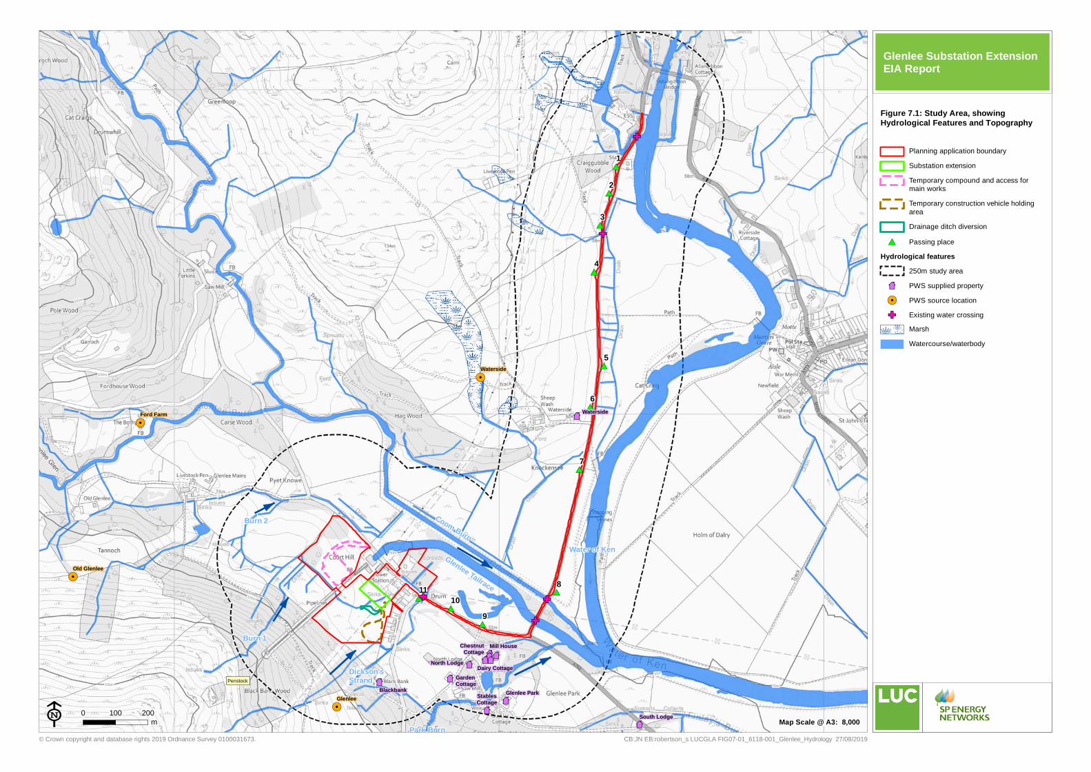
#*#*
#*
#*
#*
#*
#*
#*
#*
#*
#*
87
!.
!.87
87
87
87
8787878787
87
87
!.
!.
GF
GF
GF
GF
GF
Coom Burn
Park Burn
Glenlee Tailrace
Burn 1
Burn 2
Dickson's Strand
Water of Ken
Penstock
100m
50m
150m
200m
150m
150m
100m
100m
100m
1 00m
100m
10 0m
100m
50m
50m
Waterside
Glenlee ParkStablesCottage
North Lodge
GardenCottage
Mill HouseChestnutCottage
Dairy Cottage
Blackbank
South Lodge
Waterside
Glenlee
Old Glenlee
Ford Farm
1110
9
8
7
6
5
4
3
2
1
© Crown copyright and database rights 2019 Ordnance Survey 0100031673.
0 100 200m
CB:JN EB:robertson_s LUCGLA FIG07-01_6118-001_Glenlee_Hydrology 27/08/2019E
Planning application boundarySubstation extensionTemporary compound and access formain worksTemporary construction vehicle holdingareaDrainage ditch diversion
#* Passing placeHydrological features
250m study area87 PWS supplied property!. PWS source locationGF Existing water crossing
MarshWatercourse/waterbody
Figure 7.1: Study Area, showingHydrological Features and Topography
Map Scale @ A3: 8,000
Glenlee Substation Extension EIA Report