Embed Size (px)
Citation preview
1
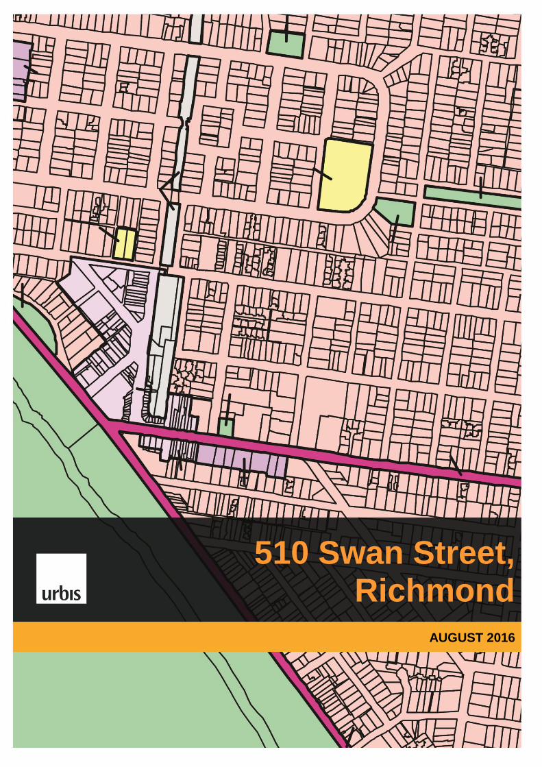
510 Swan Street, Richmond
AUGUST 2016
2
510 Swan Street, Richmond
AUGUST 2016
1 INTRODUCTION
The Department of Education and Training (DET) is the owner land located at 510 Swan Street, Richmond, locally known as Ryan’s Reserve. DET has determined that this site is now surplus to their requirements. This report has been prepared by Urbis Pty Ltd on behalf of the DET and provides a review of the subject land and its physical and policy context, to determine the most appropriate future planning provisions for the site.
Records indicate the land was purchased by the former Department of Education and Training in 1912, and was part of the former Burnley Primary School. Historic aerial photographs of the site indicate the land being extensively vacant between 1931 and 1991. The existing recreation facilities were established in the 1990s.
In 2006 the Department of Education and Training entered into a Development and Licence Agreement for a period of 10 years to enable Council to continue to use the land for the playing, performing or conducting of community recreation and sporting activities.
The land is contained in a Freehold Title and is not reserved for any purpose. Separate to the planning process it is proposed that the existing sporting facilities be relocated within the City of Yarra.
2 BACKGROUND
Surplus Government Land and Government Policy
The Victorian Government is a major land holder in the state and the Victorian Government Landholding Policy 2015 requires Government departments and agencies to regularly review their land assets. Any land that is no longer required for current or future service delivery must be sold.
The site at 510 Swan Street, Richmond is surplus to Department of Education and Training’s (DET’s) requirements. This site has been identified by the Department of Health and Human Services (DHHS) as being suitable for the provision of affordable housing. Richmond is a high need area for public housing, and the Swan Street site is strategically located to take advantage of existing infrastructure and facilities to serve future residents.
Proposed Land Exchange between Department of Education and Training (DET) and Department of Health and Human Services (DHHS)
The Department of Health and Human Services (DHHS) currently own a site at the corner of Highett Street and Griffiths Street, Richmond, which was previously earmarked for a mixed use development including public housing. This site has now been identified by the Department of Education and Training (DET) as being essential in the delivery of the new high school for Richmond. The site at Highett and Griffiths Streets will double the area available to develop the new school and will increase opportunities for future expansion and recreation, including new netball facilities.
It is proposed that a land exchange takes place between DET and DHHS involving the site at 510 Swan Street, and the site at the corner of Highett Street and Griffiths Street, Richmond. By exchanging the sites, there will continue to be land available for housing, as well as consolidated sports and education facilities for the community. To facilitate the land swap, the planning provisions at 510 Swan Street need to change to allow DHHS to pursue the mixed residential development.

3
510 Swan Street, Richmond
AUGUST 2016
Netball Facilities
The new Richmond high school will include a high quality sports precinct which will include both indoor and outdoor netball facilities. The Department of Education and Training is liaising closely with Sport and Recreation Victoria (SRV) and Netball Victoria (NV) to ensure the new facilities are designed to competition standard. It is proposed to relocate the existing netball users from 510 Swan Street, to the new facilities at the secondary collage.
The existing Swan Street netball courts will continue to operate until the new facilities are available. The ongoing provision of the netball facilities will be subject to negotiation with the land owner and Council (as the lessee) and the users. The proposed rezoning of the Swan Street site from the Public Use and Recreation Zone will not impact upon the ability for the site to be used for netball courts until the facilities are available, due to the establishment of existing use rights.
3 SITE DETAILS
Address: 510 Swan Street, Richmond
Municipality: Yarra City Council
Size: 5,540.9sq.m
Covenants/Easements: None apply
Current Zoning: Public Park and Recreation Zone (PPRZ)
Current Overlays: Design and Development Overlay - Schedule 5 (DDO5 – City Link
Exhaust Stack Environs
Design and Development Overlay – Schedule 2 (DDO2 – Main Roads and Boulevards
SITE LOCATION (MELWAYS)
4
510 Swan Street, Richmond
AUGUST 2016
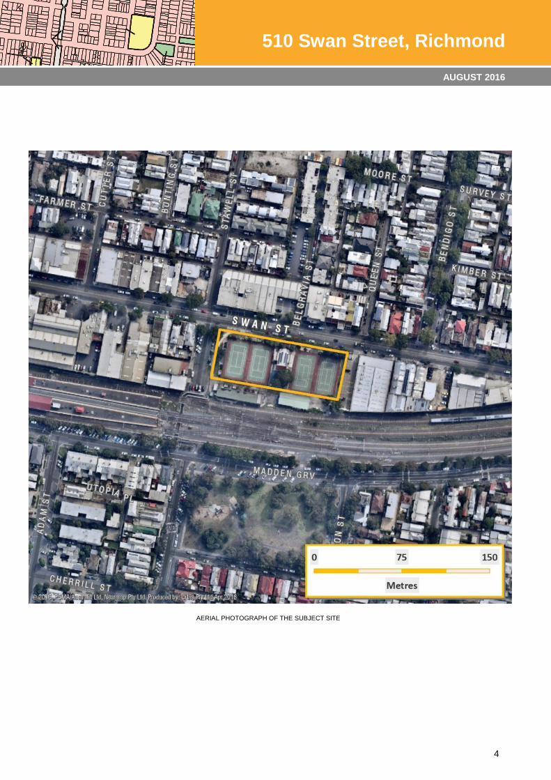
AERIAL PHOTOGRAPH OF THE SUBJECT SITE
5
510 Swan Street, Richmond
AUGUST 2016
4 SITE & SURROUNDS
The Site
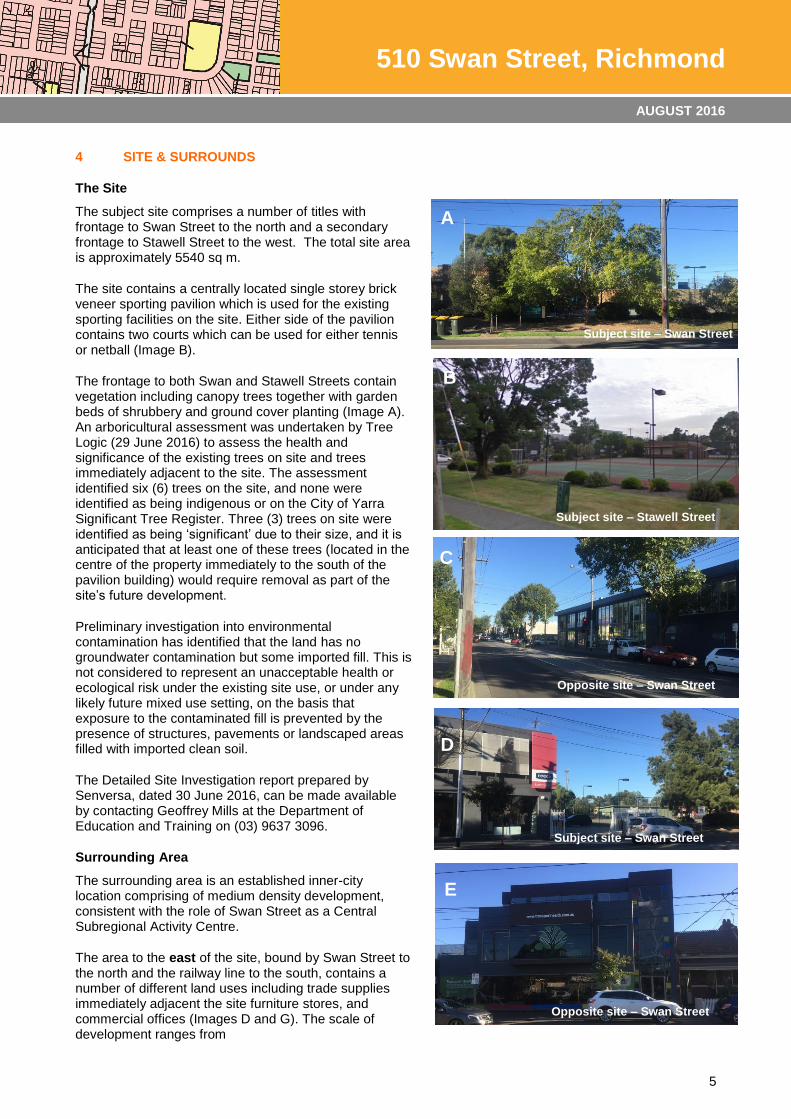
The subject site comprises a number of titles with frontage to Swan Street to the north and a secondary frontage to Stawell Street to the west. The total site area is approximately 5540 sq m.
The site contains a centrally located single storey brick veneer sporting pavilion which is used for the existing sporting facilities on the site. Either side of the pavilion contains two courts which can be used for either tennis or netball (Image B).
The frontage to both Swan and Stawell Streets contain vegetation including canopy trees together with garden beds of shrubbery and ground cover planting (Image A). An arboricultural assessment was undertaken by Tree Logic (29 June 2016) to assess the health and significance of the existing trees on site and trees immediately adjacent to the site. The assessment identified six (6) trees on the site, and none were identified as being indigenous or on the City of Yarra Significant Tree Register. Three (3) trees on site were identified as being ‘significant’ due to their size, and it is anticipated that at least one of these trees (located in the centre of the property immediately to the south of the pavilion building) would require removal as part of the site’s future development.
Preliminary investigation into environmental contamination has identified that the land has no groundwater contamination but some imported fill. This is not considered to represent an unacceptable health or ecological risk under the existing site use, or under any likely future mixed use setting, on the basis that exposure to the contaminated fill is prevented by the presence of structures, pavements or landscaped areas filled with imported clean soil.
The Detailed Site Investigation report prepared by Senversa, dated 30 June 2016, can be made available by contacting Geoffrey Mills at the Department of Education and Training on (03) 9637 3096.
Surrounding Area
The surrounding area is an established inner-city location comprising of medium density development, consistent with the role of Swan Street as a Central Subregional Activity Centre.
The area to the east of the site, bound by Swan Street to the north and the railway line to the south, contains a number of different land uses including trade supplies immediately adjacent the site furniture stores, and commercial offices (Images D and G). The scale of development ranges from
C
A
Subject site – Swan Street
B
Subject site – Stawell Street
Opposite site – Swan Street
C
D
E
Opposite site – Swan Street
Subject site – Swan Street
Opposite site – Swan Street
6
510 Swan Street, Richmond
AUGUST 2016
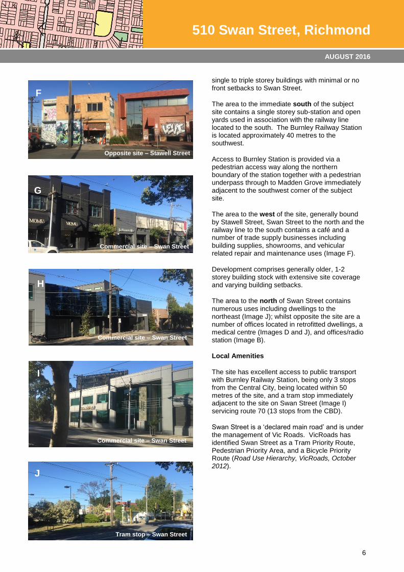
single to triple storey buildings with minimal or no front setbacks to Swan Street.
The area to the immediate south of the subject site contains a single storey sub-station and open yards used in association with the railway line located to the south. The Burnley Railway Station is located approximately 40 metres to the southwest.
Access to Burnley Station is provided via a pedestrian access way along the northern boundary of the station together with a pedestrian underpass through to Madden Grove immediately adjacent to the southwest corner of the subject site.
The area to the west of the site, generally bound by Stawell Street, Swan Street to the north and the railway line to the south contains a café and a number of trade supply businesses including building supplies, showrooms, and vehicular related repair and maintenance uses (Image F).
Development comprises generally older, 1-2 storey building stock with extensive site coverage and varying building setbacks.
The area to the north of Swan Street contains numerous uses including dwellings to the northeast (Image J); whilst opposite the site are a number of offices located in retrofitted dwellings, a medical centre (Images D and J), and offices/radio station (Image B).
Local Amenities
The site has excellent access to public transport with Burnley Railway Station, being only 3 stops from the Central City, being located within 50 metres of the site, and a tram stop immediately adjacent to the site on Swan Street (Image I) servicing route 70 (13 stops from the CBD).
Swan Street is a ‘declared main road’ and is under the management of Vic Roads. VicRoads has identified Swan Street as a Tram Priority Route, Pedestrian Priority Area, and a Bicycle Priority Route (Road Use Hierarchy, VicRoads, October 2012).
F
Opposite site – Stawell Street
G
Commercial site – Swan Street
H
Commercial site – Swan Street
I
Commercial site – Swan Street
J
Tram stop – Swan Street
Tram stop – Swan Street
7
510 Swan Street, Richmond
AUGUST 2016
LOCATION OF AMENITIES IN THE SURROUNDING AREA
8
510 Swan Street, Richmond
AUGUST 2016
5 ZONING & OVERLAYS
Zoning
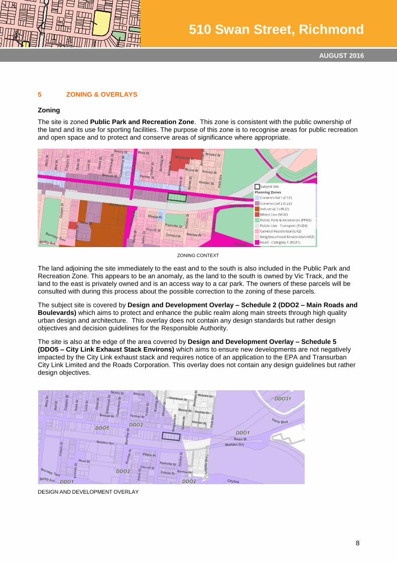
The site is zoned Public Park and Recreation Zone. This zone is consistent with the public ownership of the land and its use for sporting facilities. The purpose of this zone is to recognise areas for public recreation and open space and to protect and conserve areas of significance where appropriate.
ZONING CONTEXT
The land adjoining the site immediately to the east and to the south is also included in the Public Park and Recreation Zone. This appears to be an anomaly, as the land to the south is owned by Vic Track, and the land to the east is privately owned and is an access way to a car park. The owners of these parcels will be consulted with during this process about the possible correction to the zoning of these parcels.
The subject site is covered by Design and Development Overlay – Schedule 2 (DDO2 – Main Roads and Boulevards) which aims to protect and enhance the public realm along main streets through high quality urban design and architecture. This overlay does not contain any design standards but rather design objectives and decision guidelines for the Responsible Authority.
The site is also at the edge of the area covered by Design and Development Overlay – Schedule 5 (DDO5 – City Link Exhaust Stack Environs) which aims to ensure new developments are not negatively impacted by the City Link exhaust stack and requires notice of an application to the EPA and Transurban City Link Limited and the Roads Corporation. This overlay does not contain any design guidelines but rather design objectives.
DESIGN AND DEVELOPMENT OVERLAY

9
510 Swan Street, Richmond
AUGUST 2016
Surrounding Zoning and Overlays
The zoning context plan illustrates the zoning of land surrounding the site, which reflects the primary commercial nature of the area. The site is surrounded by Commercial 2 Zone land (main purpose is for commercial areas for offices, appropriate manufacturing and industries and large format retail), and land zoned Commercial 1 (mix of uses including retail, office, entertainment and higher density residential development) to the northern side of Swan Street. Further east, to the north of Swan Street, the zoning is Neighbourhood Residential.
Land to the north east on the opposite side of Swan Street is affected by Heritage Overlay HO309. Land to the South of the Railway line is included in Heritage Overlay HO322. These overlays are precinct based.
Heritage Overlay Schedule 309 – Bendigo Street Precinct, Richmond relates to an area that was sold to J M Chisholm in 1840. By 1895, three quarters of the area was developed with housing and in the Edwardian era, the Wertheim Piano Factory which was once the largest piano factory in Australia and the GTV9 television studios dominated the area. The main architectural styles in the precinct are Victorian and Edwardian and the contributory buildings in the precinct are predominantly small single storey attached and detached Victorian and Edwardian era dwellings and include the Edwardian era Wertheim Piano Factory building.
Heritage Overlay Schedule 322 – Golden Square Heritage Overlay Area is a precinct that was originally part of the Colonial Police Reserve or Police Paddocks used for the agistment of horses by the police force. The area was subdivided in the 1860s and 1870s. The Terry’s Burnley Brewery was built in 1893 with visually distinctive concrete silos added in the 20
th century. The predominant architectural eras in the precinct are
the Victorian and Edwardian periods. Contributory buildings are generally single storey but some are two storey row houses.
HERITAGE OVERLAY
10
510 Swan Street, Richmond
AUGUST 2016
6 STRATEGIC POLICY CONTEXT
The strategic policy context for the site is summarised below.
State Planning Policy Framework
The area along Swan Street has been identified as an important Major Activity Centre by the City of Yarra and has since been classified as a Central Subregional Activity Centre within the 2015 Activity Centres Overview by DELWP. Clause 11.01 (Settlement) of the Yarra Planning Scheme aims to build up activity centres as a focus for high-quality development, activity and living for the whole community. The SPPF aims to develop a network of activity centres that:
Are a focus for business, shopping, working, leisure, and community facilities.
Provide different types of housing, including forms of higher density housing.
Are connected by public transport and social interaction.
Maximise choices in services, employment, and social interaction.
The Built Environment and Heritage provisions of Clause 15 aims to ensure planning achieves high quality urban design and architecture by:
Ensuring new development or redevelopment contributes to community and cultural life by improving safety, diversity and choice, the quality of living and working environments, accessibility and inclusiveness and environmental sustainability.
Ensuring transport corridors integrate land use planning, urban design and transport planning and are developed and managed with particular attention to urban design aspects.
Local Planning Policy Framework
The Municipal Strategic Statement (MSS) contained within the Local Planning Policy Framework outlines the key strategic planning, land use and development objectives for the municipality; and the strategies and actions for achieving them. The MSS Municipal Profile contained within Clause 21.02 identifies key characteristics of the Municipality including:
The residential population is projected to increase to 90,000 by 2031.
A total of 32.4% of all households within the municipality are single person households.
An additional 12,800 dwellings will be required by 2030 to house the increased population.
Industrial uses are moving away from “heavy” industry and towards printing, publishing, recorded media and business services and office activities.
The main local policies of relevance are as follows:
Clause 21.04 (Land Use) includes a number of objectives in relation accommodating housing growth whilst protecting neighbourhood character and heritage elements including the following of direct relevance:
- To accommodate forecast increases in population
- To maintain the long term viability of activity centres.
Clause 21.08-2 (Neighbourhood) outlines the area as being located within the “Burnley-Cremorne-South Richmond” neighbourhood. It is anticipated that future development in this area would result in ‘Ensuring that the development of land around the Burnley train station enhances access and the amenity of the area.’
11
510 Swan Street, Richmond
AUGUST 2016
Other Strategic Considerations
The Swan Street Structure Plan represents Yarra Council’s current thinking in relation to the future land use and built form outcomes for Swan Street. The Structure Plan was adopted by Council on 17 December 2013, following community consultation. The subject site is located within the Burnley Station Village Precinct of the Structure Plan. The objectives and strategies of this precinct include:
Objectives:
To intensify land uses in the precinct.
To establish a precinct that supports retail, commercial and residential uses.
To encourage transit-orientated development focused around Burnley Station.
To improve the quality of the connections to Burnley Station.
Strategies:
Investigate appropriate zoning to achieve land use outcomes for the precinct.
Accommodate housing growth in the precinct.
Provide active frontages to the street.
Develop a public plaza linking Swan Street and entrance to Burnley Station as part of any redevelopment.
Investigate upgrades to the railway underpass connecting Madden Grove and Stawell Street.
The Swan Street Structure Plan identifies the preferred heights for the areas surrounding the subject site. The Structure Plan does not include a preferred height or the subject site as it is located in a Public Park and Recreation Zone. Preferred heights in the surrounding area range from 4 storeys on the north side of Swan Street (Commercial 1 Zone) where it adjoins residential areas, up to 12 storeys on the southeast corner of Swan Street and Burnley Street.
Through discussions with Council’s Strategic Planning Department, Urbis has been made aware that a Planning Scheme Amendment is to be prepared by Council later this year to implement the recommendations of the Swan Street Structure Plan. This will likely include the proposed rezoning of land along Swan Street in the vicinity of the site from Commercial 2 Zone to Commercial 1 Zone, and the introduction of built form controls via a Design and Development Overlay, based on the recommended heights contained within the Structure Plan.
7 OPEN SPACE CONTEXT
The existing site is within a Public Park and Recreation Zone (PPRZ) and currently occupied with tennis/netball courts.
The City of Yarra’s Open Space Strategy 2006 has been adopted by Council but is not included within the Yarra Planning Scheme. This document provides a guide for the future provision, planning, design, and management of public land reserved for recreation and nature conservation purposes. Ryan’s Reserve has been identified for formal sporting uses. At the time of preparing the strategy, the Council were not aware of this proposal to rezone the site.
The overall recommendations for East Richmond (which includes the subject site) identify a requirement for new/improved facilities in existing open space, rather than the provision of additional open space. The Burnley/Cremorne area, immediately south of the railway line, is also noted as having an adequate provision of open space and Loys Paddock and Twickenham Crescent Reserves are identified for further improvements to assist the greater utilisation of these areas.
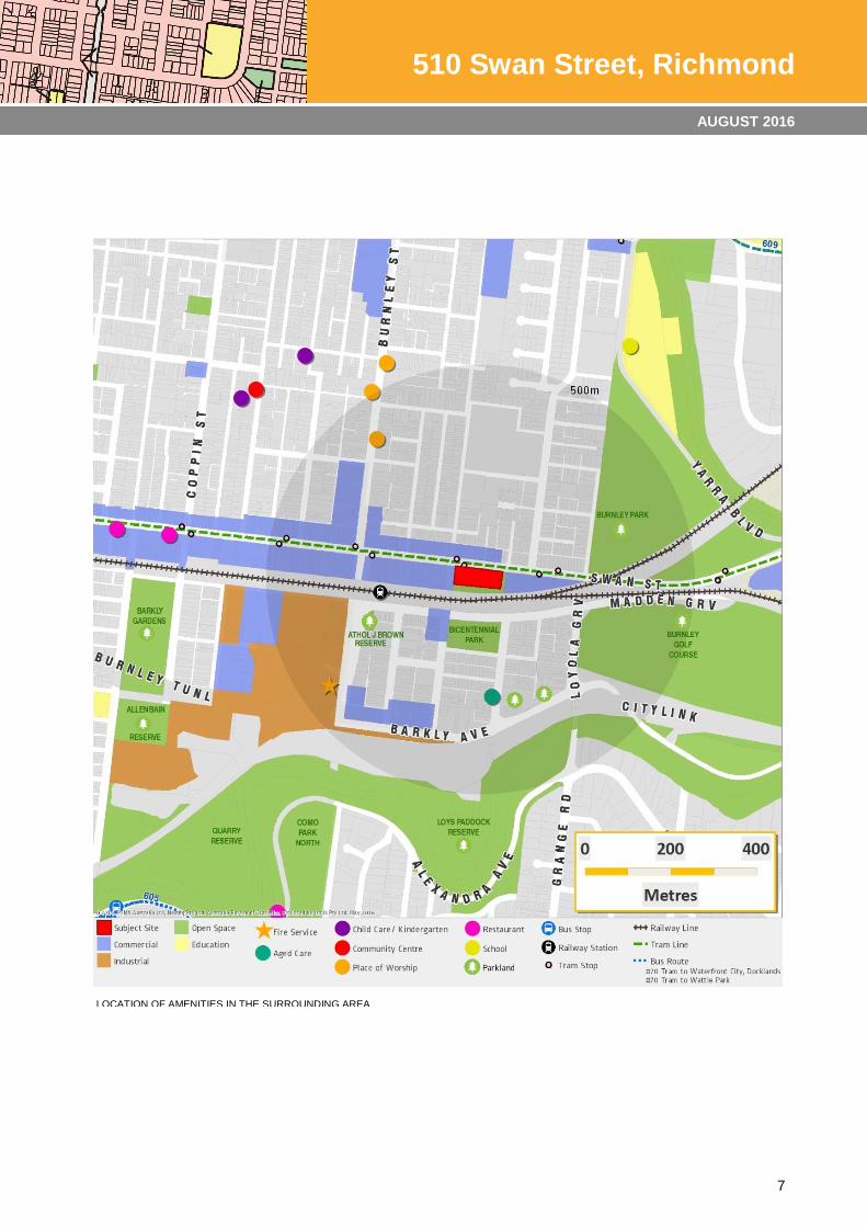
The surrounding area is well serviced by both passive open space and recreational areas with more than 5 formally recognised parks or reserves within a 750m radius of the site, including:
12
510 Swan Street, Richmond
AUGUST 2016
Passive Open Space
Bicentennial Park/Golden Square is approximately 80m to the south of the site, and contains playgrounds, seating, BBQs and a dog off-leash area.
Loys Paddock Reserve, approximately 460m to the south, contains a dog off-leash area and access to the main Yarra Trail and other parks and reserves.
Athol J Brown Reserve is located approximately 200m to the west and contains vegetated areas of trees and grassed areas.
Barkly Gardens is located approximately 650m to the west of the site. The Gardens are highly landscaped and include play equipment, public toilets shelter, seating and dog off-leash areas.
Recreation
Allan Bain Reserve is located south of Barkly Gardens, approximately 710m to the southwest of the site and contains a sporting ground with infrastructure for both soccer and cricket.
Burnley Park provides both passive and recreational open space for the immediate and wider Richmond area. The 6 hectare park is located approximately 200m to the east of the site and contains BBQ facilities, dog off-leash area together with formal recreational infrastructure including a basketball court and sporting grounds used for football, cricket, and soccer.
The Burnley Public Golf Course is located approximately 200m to the east of the site, south of Swan Street. The 9-hole course includes practice putting and chipping greens and nets.
Other open space
Twickenham Crescent is approximately 240m to the south of the site and contains two areas of open space occupied with grassed areas and scattered canopy trees. These areas are zoned General Residential but are identified within the City of Yarra’s Open Space Strategy.
8 ANALYSIS
The site’s locational and policy context can be summarised as follows:
Excellent locational attributes, due to its location within an Activity Centre, with immediate access to
fixed rail and trams, and a range of services and facilities;
Physically separated from sensitive ‘residential’ uses;
Frontage to two roads including Swan Street, providing excellent vehicle access;
Within an area identified for growth;
Located on a main street with a range of commercial uses with activation at ground floor, which is
supported by planning policy;
Within a strip of land identified to be rezoned to Commercial 1 to enable the development of residential
uses (which is currently prohibited under this land’s Commercial 2 zoning);
Strong policy support to increase densities in the area, particularly on sites which will not impact on
established residential areas.
The rezoning of the site would allow for development of the land for commercial and residential purposes and subsequently the loss of a formal recreation area. The City of Yarra has identified that there is adequate open space within East Richmond generally and that additional facilities will be accommodated within existing open space areas. Further, by way of a separate government process it is proposed that the existing sporting clubs and courts be relocated elsewhere within the Municipality.
13
510 Swan Street, Richmond
AUGUST 2016
The loss of the open space is considered to be offset by an opportunity to deliver an affordable housing outcome on a large inner-city parcel of land within a Central Subregional Activity Centre, as supported within the State and Local Planning Policy Framework. Planning policy supports increased development and increased residential density within close proximity to public transport and activity centres.
The surrounding Commercial 2 Zone does not allow residential uses. Work undertaken in the preparation of the Swan Street Structure Plan has identified that the Commercial 2 Zone is generally redundant in this area and does not make the best use of the area’s locational opportunities. The recommendation of the Structure Plan is that land on the south side of Swan Street in this location be rezoned to the Commercial 1 Zone, consistent with the zoning on the northern side of Swan Street.
From an investigation of the site in the context of the objectives and provisions of the Yarra Planning Scheme, together with a site inspection to establish the prevailing local character of the area, it is considered that the Commercial 1 Zone would be the ‘best fit’ for the future zoning of the land.
A rezoning of the land to Commercial 1 and its subsequent redevelopment for infill commercial and residential purposes would be in keeping with the existing and preferred future character and use of the immediate area. This zone would enable a range of as of right land uses including housing at the upper levels and active uses at ground level which would include retail, food and drink fronting Swan Street.
A Development Plan Overlay (DPO) should also be applied to the site to guide the form of future development. A DPO requires that a Development Plan be approved for the site before a planning permit is issued (subject to some exclusions). A Development Plan Overlay Schedule which relates specifically to this site is proposed.
The DPO for the subject site should require the preparation of a Development Plan that has regard to a range of factors including the objectives of the Swan Street Structure Plan, in relation to building scale, and uses.
The Development Plan Overlay also includes:
A requirement for public exhibition of a proposed Development Plan, or amended Development Plan, at the discretion of the Responsible Authority.
Decision guidelines for approval of Development Plans and Planning Permits.
Future planning permit applications that are generally in accordance with an approved Development Plan will be exempt from the public notice and review requirements of the Planning and Environment Act.
Requirements for traffic and car parking analysis in preparation of a Development Plan
Recognition of the desire for a mix of residential densities and higher density housing in this location.
Preferred maximum heights derived from the Swan Street Structure Plan, including a street wall height of 3 storeys and overall heights of 7 – 10 storeys.
Council’s strategic work for the surrounding area has identified a potential future height in the precinct of between 4 – 12 storeys. The preferred height for the southern side of Swan Street transitions from 4 storeys (13m) in the east to 10-12 storeys on the strategic redevelopment site on the southeast corner of Swan Street and Burnley Street.
The sites immediately adjacent the subject site are identified for a scale of 5-6 storeys (19m) to the east and 7-10 (30m) storeys to the west. The size of the site and the lack of sensitive land uses adjacent to the site, support the adoption of a height of 10 storeys for the subject site. This approach would be consistent with the work undertaken for the surrounding precinct and the desire for higher density housing forms in this strategic location.
The potential impact of higher buildings has been tested in terms of their general suitability with respect to the City Link Vent Stack requirements (DDO5) and overshadowing of Bicentennial Park and have been
14
510 Swan Street, Richmond
AUGUST 2016
found to be acceptable. These considerations, and the general policy provisions of the Yarra Planning Scheme will continue to apply to future proposals.
The Development Plan Overlay is an appropriate tool for a site in one ownership with limited sensitive adjoining interfaces and facilitates a strategic approach to future development. In the event that the Council proceeds to rezone surrounding land along Swan Street (and apply design based overlays), the proposed Commercial 1 Zone and DPO will remain relevant and consistent with the strategic vision for the area.
9 RECOMMENDATIONS
In light of the physical and policy context of the site, there is strategic justification for the rezoning of the land to a Commercial 1 Zone. A Development Plan Overlay that encourages the development of the land for medium or high-density, mixed use development is recommended.
This outcome would be consistent with Yarra Council’s strategic directions for Swan Street, and their forthcoming amendment to implement the recommendations of the Swan Street Structure Plan.