Embed Size (px)
Citation preview
44thth AOR W/S on GNSS AOR W/S on GNSSKuala Lumpur, MalaysiaKuala Lumpur, Malaysia
Dec. 8-10, 2012Dec. 8-10, 2012
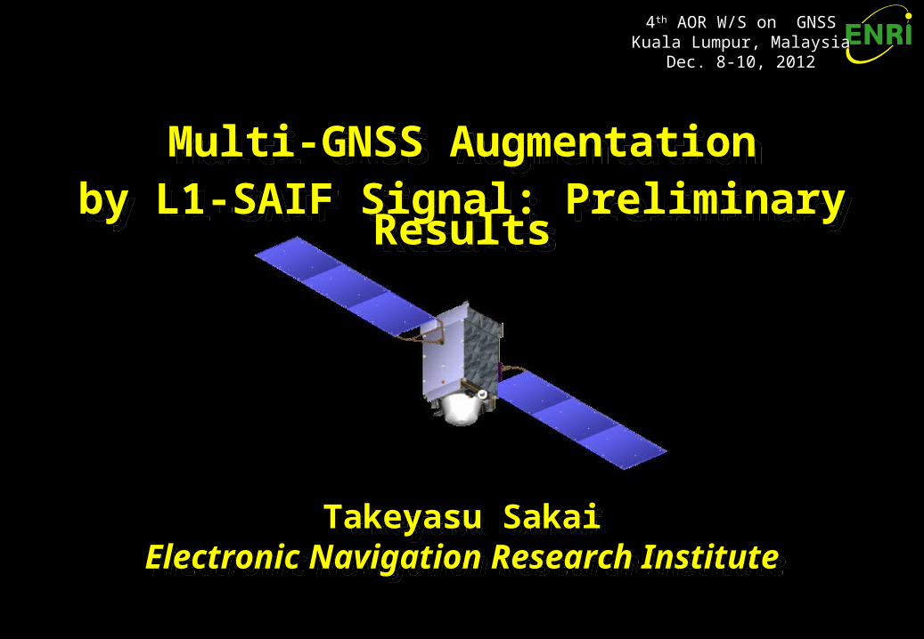
Multi-GNSS Augmentationby L1-SAIF Signal: Preliminary Results
Multi-GNSS Augmentationby L1-SAIF Signal: Preliminary Results
Takeyasu SakaiElectronic Navigation Research Institute
Takeyasu SakaiElectronic Navigation Research Institute
AOR W/S Dec. 2012AOR W/S Dec. 2012 - Slide - Slide 22
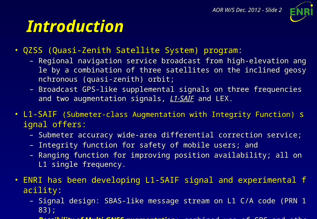
IntroductionIntroduction• QZSS (Quasi-Zenith Satellite System) programQZSS (Quasi-Zenith Satellite System) program::
– Regional navigation service broadcast from high-elevation angle by a combination Regional navigation service broadcast from high-elevation angle by a combination of three satellites on the inclined geosynchronous (quasi-zenith) orbit;of three satellites on the inclined geosynchronous (quasi-zenith) orbit;
– Broadcast GPS-like supplemental signals on three frequencies and two augmentatiBroadcast GPS-like supplemental signals on three frequencies and two augmentation signals, on signals, L1-SAIFL1-SAIF and LEX. and LEX.
• L1-SAIF L1-SAIF (Submeter-class Augmentation with Integrity Function) (Submeter-class Augmentation with Integrity Function) signal offers:signal offers:– Submeter accuracy wide-area differential correction service;Submeter accuracy wide-area differential correction service;– Integrity function for safety of mobile users; andIntegrity function for safety of mobile users; and– Ranging function for improving position availability; all on L1 single frequency.Ranging function for improving position availability; all on L1 single frequency.
• ENRI has been developing L1-SAIF signal and experimental facilityENRI has been developing L1-SAIF signal and experimental facility::– Signal design: SBAS-like message stream on L1 C/A code (PRN 183);Signal design: SBAS-like message stream on L1 C/A code (PRN 183);– Possibility of Multi-GNSS augmentationPossibility of Multi-GNSS augmentation: combined use of GPS and other conste: combined use of GPS and other conste
llations would improve the availability of position solutions.llations would improve the availability of position solutions. Especially where visibility is limited.Especially where visibility is limited. Upgraded L1-SAIF experimental facility and conducted a Multi-GNSS trial.Upgraded L1-SAIF experimental facility and conducted a Multi-GNSS trial.
AOR W/S Dec. 2012AOR W/S Dec. 2012 - Slide - Slide 33
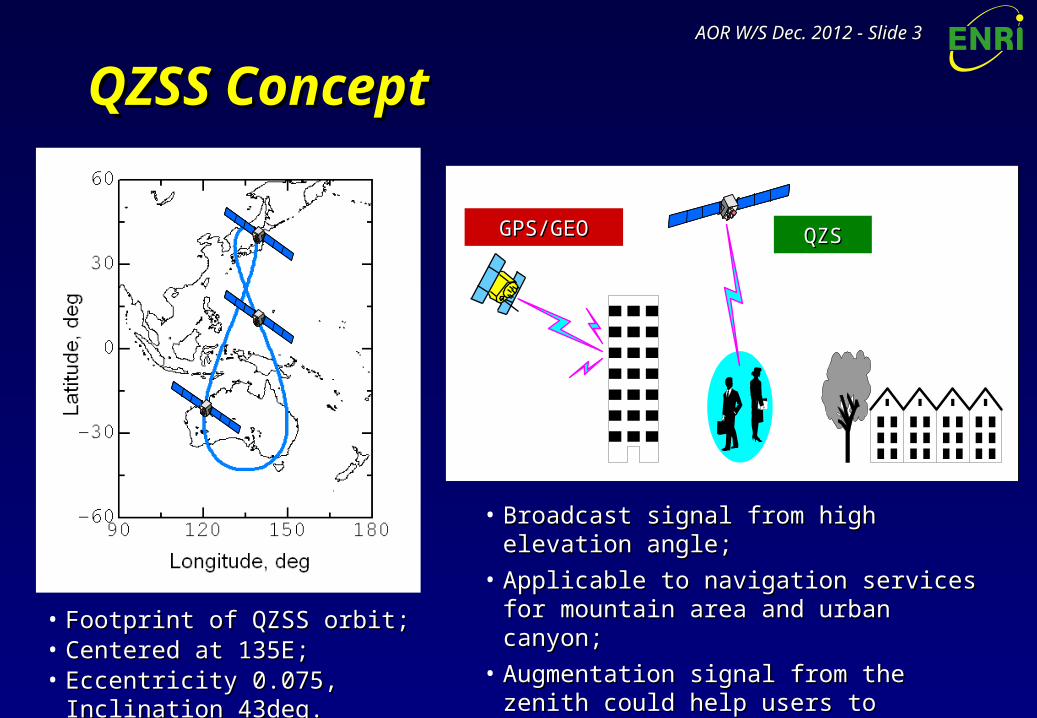
QZSS ConceptQZSS Concept
• Broadcast signal from high elevation angle;Broadcast signal from high elevation angle;
• Applicable to navigation services for Applicable to navigation services for mountain area and urban canyon;mountain area and urban canyon;
• Augmentation signal from the zenith could Augmentation signal from the zenith could help users to acquire other GPS satellites at help users to acquire other GPS satellites at any time.any time.
• Footprint of QZSS orbit;Footprint of QZSS orbit;• Centered at 135E;Centered at 135E;• Eccentricity 0.075, Inclination 43deg.Eccentricity 0.075, Inclination 43deg.
QZSQZSGPS/GEOGPS/GEO
AOR W/S Dec. 2012AOR W/S Dec. 2012 - Slide - Slide 44
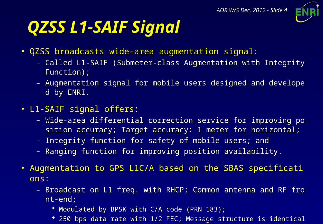
QZSS L1-SAIF SignalQZSS L1-SAIF Signal• QZSS broadcasts wide-area augmentation signalQZSS broadcasts wide-area augmentation signal::
– Called L1-SAIF (Submeter-class Augmentation with Integrity Function);Called L1-SAIF (Submeter-class Augmentation with Integrity Function);– Augmentation signal for mobile users designed and developed by ENRI.Augmentation signal for mobile users designed and developed by ENRI.
• L1-SAIF signal offersL1-SAIF signal offers::– Wide-area differential correction service for improving position accuracy; TargeWide-area differential correction service for improving position accuracy; Targe
t accuracy: 1 meter for horizontal;t accuracy: 1 meter for horizontal;– Integrity function for safety of mobile users; andIntegrity function for safety of mobile users; and– Ranging function for improving position availability.Ranging function for improving position availability.
• Augmentation to GPS L1C/A based on the SBAS specificationsAugmentation to GPS L1C/A based on the SBAS specifications::– Broadcast on L1 freq. with RHCP; Common antenna and RF front-end;Broadcast on L1 freq. with RHCP; Common antenna and RF front-end;
Modulated by BPSK with C/A code (PRN 183);Modulated by BPSK with C/A code (PRN 183); 250 bps data rate with 1/2 FEC; Message structure is identical with SBAS;250 bps data rate with 1/2 FEC; Message structure is identical with SBAS; Differences from SBAS: PRN, large Doppler, and some additional messages.Differences from SBAS: PRN, large Doppler, and some additional messages.
– Developed easily if one has the experience to develop SBAS-capable receiver;Developed easily if one has the experience to develop SBAS-capable receiver;– Specification of L1-SAIF: See IS-QZSS document (Available at JAXA HP).Specification of L1-SAIF: See IS-QZSS document (Available at JAXA HP).
AOR W/S Dec. 2012AOR W/S Dec. 2012 - Slide - Slide 55
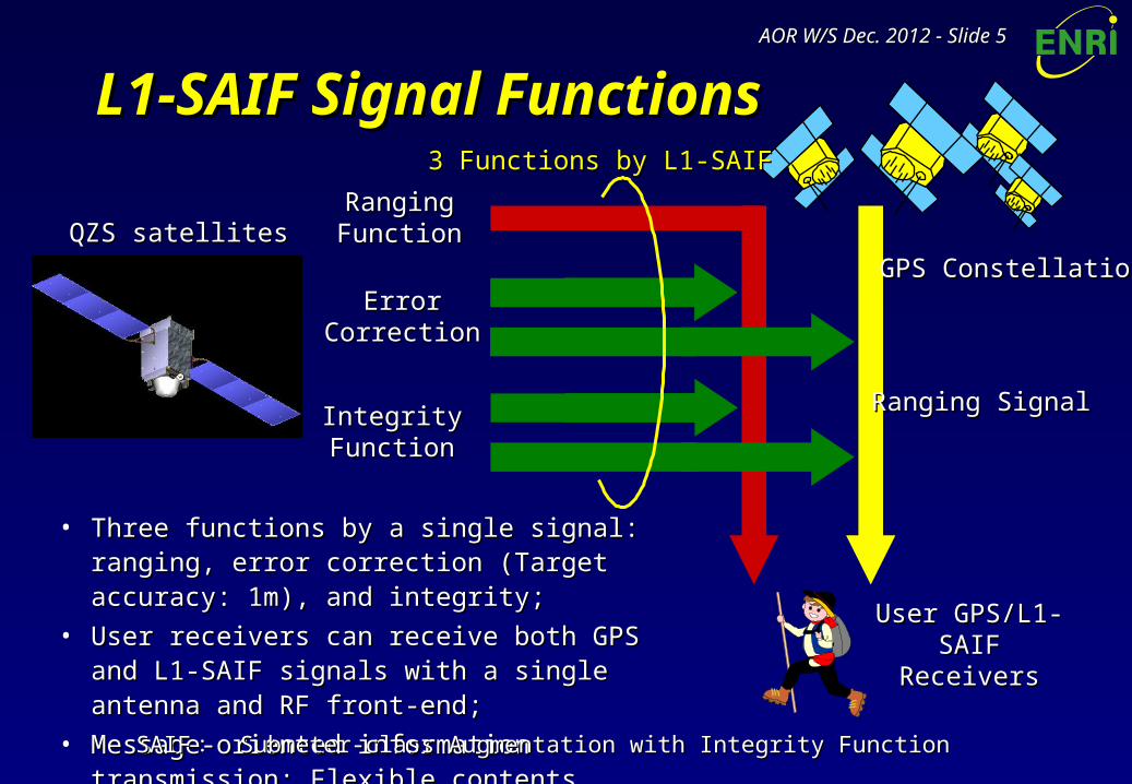
L1-SAIF Signal FunctionsL1-SAIF Signal Functions
User GPS/L1-SAIFUser GPS/L1-SAIFReceiversReceivers
• Three functions by a single signal: ranging, error Three functions by a single signal: ranging, error correction (Target accuracy: 1m), and integrity;correction (Target accuracy: 1m), and integrity;
• User receivers can receive both GPS and L1-SAIF User receivers can receive both GPS and L1-SAIF signals with a single antenna and RF front-end;signals with a single antenna and RF front-end;
• Message-oriented information transmission: Message-oriented information transmission: Flexible contents.Flexible contents.
SAIFSAIF : : Submeter-class Augmentation with Integrity FunctionSubmeter-class Augmentation with Integrity Function
RangingRangingFunctionFunction
ErrorErrorCorrectionCorrection
IntegrityIntegrityFunctionFunction
QZS satellitesQZS satellites
GPS ConstellationGPS Constellation
Ranging SignalRanging Signal
3 Functions by L1-SAIF3 Functions by L1-SAIF

AOR W/S Dec. 2012AOR W/S Dec. 2012 - Slide - Slide 66
ENRI L1-SAIF Master StationENRI L1-SAIF Master Station• L1-SAIF Master Station (L1SMS):L1-SAIF Master Station (L1SMS):
– Generates L1-SAIF message stream in realtime and transmits it to QZSS MCS deGenerates L1-SAIF message stream in realtime and transmits it to QZSS MCS developed by and installed at JAXA;veloped by and installed at JAXA;
– Installed at ENRI, Tokyo; 90km from JAXA Tsukuba Space Center;Installed at ENRI, Tokyo; 90km from JAXA Tsukuba Space Center;– Dual frequency GPS measurements at some locations in Japan necessary to geneDual frequency GPS measurements at some locations in Japan necessary to gene
rate L1-SAIF messages are sent from GEONET in realtime.rate L1-SAIF messages are sent from GEONET in realtime.
L1SMSL1SMSGEONETGEONET
QZSQZS
QZSS MCSQZSS MCS
GPSGPSSatellitesSatellites
Measure-Measure-mentsments
L1-SAIFL1-SAIFMessageMessage
GSI ServerGSI Server(Tokyo)(Tokyo)
ENRIENRI(Tokyo)(Tokyo)
JAXA TKSCJAXA TKSC(Tsukuba)(Tsukuba)
L1-S
AIF S
ignal
L1-S
AIF S
ignal
Ranging Signal
Ranging SignalRan
ging
Signal
Rangin
g Signa
l
K-band Uplink
K-band Uplink
AOR W/S Dec. 2012AOR W/S Dec. 2012 - Slide - Slide 77
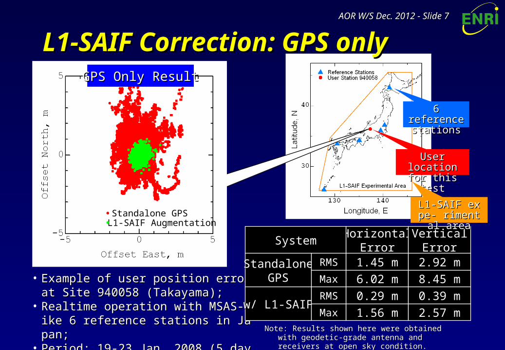
L1-SAIF Correction: GPS onlyL1-SAIF Correction: GPS only
• Example of user position error at Site 94Example of user position error at Site 940058 (Takayama);0058 (Takayama);
• Realtime operation with MSAS-like 6 refeRealtime operation with MSAS-like 6 reference stations in Japan;rence stations in Japan;
• Period: 19-23 Jan. 2008 (5 days).Period: 19-23 Jan. 2008 (5 days).
HorizontalHorizontalErrorError
VerticalVerticalErrorError
1.45 m1.45 m 2.92 m2.92 m
6.02 m6.02 m 8.45 m8.45 m
SystemSystem
StandaloneStandaloneGPSGPS
0.29 m0.29 m 0.39 m0.39 m
1.56 m1.56 m 2.57 m2.57 mw/ L1-SAIFw/ L1-SAIF
RMSRMS
MaxMax
RMSRMS
MaxMax
Note: Results shown here were obtained with geodetic-Note: Results shown here were obtained with geodetic-grade antenna and receivers at open sky condition.grade antenna and receivers at open sky condition.
User location User location for this testfor this test
6 reference6 referencestationsstations
L1-SAIF expe- L1-SAIF expe- rimental arearimental areaStandalone GPS
L1-SAIF Augmentation
GPS Only ResultGPS Only Result
AOR W/S Dec. 2012AOR W/S Dec. 2012 - Slide - Slide 88
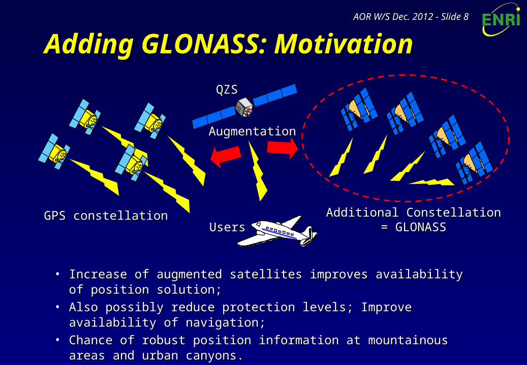
Adding GLONASS: MotivationAdding GLONASS: Motivation
• Increase of augmented satellites improves availability of position solution;Increase of augmented satellites improves availability of position solution;• Also possibly reduce protection levels; Improve availability of navigation;Also possibly reduce protection levels; Improve availability of navigation;• Chance of robust position information at mountainous areas and urban Chance of robust position information at mountainous areas and urban
canyons.canyons.
QZSQZS
GPS constellationGPS constellation Additional ConstellationAdditional Constellation= GLONASS= GLONASS
AugmentationAugmentation
UsersUsers
AOR W/S Dec. 2012AOR W/S Dec. 2012 - Slide - Slide 99
GLONASS: Differences from GPSGLONASS: Differences from GPS• FDMA signals:FDMA signals:
– Change carrier frequency settings with regard to ranging sources.Change carrier frequency settings with regard to ranging sources.
• Reference time and coordinates:Reference time and coordinates:– Time: broadcast time offset information by an L1-SAIF message; Avoids increase Time: broadcast time offset information by an L1-SAIF message; Avoids increase
of unknowns in user receivers;of unknowns in user receivers;
– Coordinates: convert PZ-90.02 to WGS-84.Coordinates: convert PZ-90.02 to WGS-84.
• PRN numbers and insufficient capacity of mask pattern:PRN numbers and insufficient capacity of mask pattern:– Assign PRN numbers of 38 to 61 as GLONASS slot numbers of 1 to 24;Assign PRN numbers of 38 to 61 as GLONASS slot numbers of 1 to 24;
– Introduce dynamic PRN mask solution to broadcast augmentation information supIntroduce dynamic PRN mask solution to broadcast augmentation information supporting more than 51 ranging sources, reflecting the actual visibility.porting more than 51 ranging sources, reflecting the actual visibility.
• Missing IOD (Issue of Data):Missing IOD (Issue of Data):– IOD is used to identify ephemeris information in order to match ephemerides betwIOD is used to identify ephemeris information in order to match ephemerides betw
een L1-SAIF Master Station and users; Currently using IODE for GPS;een L1-SAIF Master Station and users; Currently using IODE for GPS;
– Identify ephemeris information based on the time of broadcast.Identify ephemeris information based on the time of broadcast.
• Satellite position computation: Satellite position computation: based on PVA as described in GLONASS ICD.based on PVA as described in GLONASS ICD.
AOR W/S Dec. 2012AOR W/S Dec. 2012 - Slide - Slide 1010
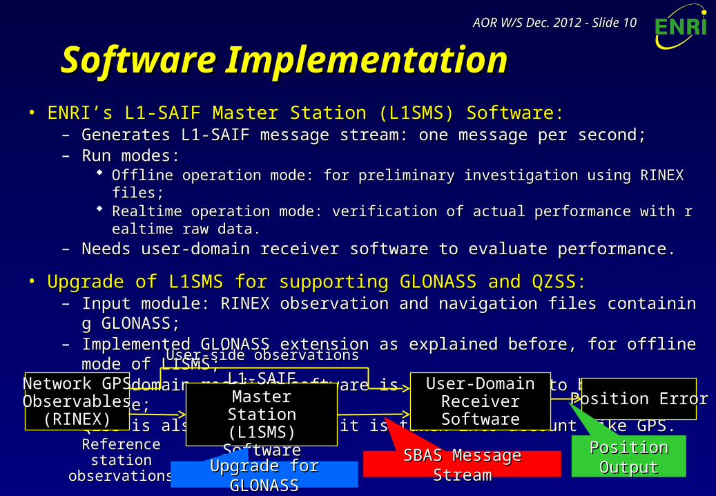
Software ImplementationSoftware Implementation• ENRI’s L1-SAIF Master Station (L1SMS) Software:ENRI’s L1-SAIF Master Station (L1SMS) Software:
– Generates L1-SAIF message stream: one message per second;Generates L1-SAIF message stream: one message per second;– Run modes:Run modes:
Offline operation mode: for preliminary investigation using RINEX files;Offline operation mode: for preliminary investigation using RINEX files; Realtime operation mode: verification of actual performance with realtime raw data.Realtime operation mode: verification of actual performance with realtime raw data.
– Needs user-domain receiver software to evaluate performance.Needs user-domain receiver software to evaluate performance.
• Upgrade of L1SMS for supporting GLONASS and QZSS:Upgrade of L1SMS for supporting GLONASS and QZSS:– Input module: RINEX observation and navigation files containing GLONASS;Input module: RINEX observation and navigation files containing GLONASS;– Implemented GLONASS extension as explained before, for offline mode of L1SMS;Implemented GLONASS extension as explained before, for offline mode of L1SMS;– User-domain receiver software is also upgraded to be GLONASS-capable;User-domain receiver software is also upgraded to be GLONASS-capable;– QZSS is also supported as it is taken into account like GPS.QZSS is also supported as it is taken into account like GPS.
L1-SAIFL1-SAIFMaster StationMaster Station
(L1SMS) Software(L1SMS) Software
User-Domain User-Domain ReceiverReceiverSoftwareSoftware
Network GPSNetwork GPSObservablesObservables
(RINEX)(RINEX)Position ErrorPosition Error
SBAS Message StreamSBAS Message StreamPosition Position OutputOutput
User-side observationsUser-side observations
Reference station Reference station observationsobservations
Upgrade for GLONASSUpgrade for GLONASS
AOR W/S Dec. 2012AOR W/S Dec. 2012 - Slide - Slide 1111
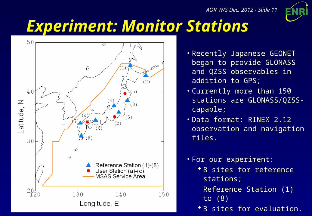
Experiment: Monitor StationsExperiment: Monitor Stations
• Recently Japanese GEONET Recently Japanese GEONET began to provide GLONASS and began to provide GLONASS and QZSS observables in addition to QZSS observables in addition to GPS;GPS;
• Currently more than 150 stations Currently more than 150 stations are GLONASS/QZSS-capable;are GLONASS/QZSS-capable;
• Data format: RINEX 2.12 Data format: RINEX 2.12 observation and navigation files.observation and navigation files.
• For our experiment:For our experiment: 8 sites for reference stations;8 sites for reference stations;
Reference Station (1) to (8)Reference Station (1) to (8) 3 sites for evaluation.3 sites for evaluation.
User Station (a) to (c)User Station (a) to (c)• Period: 12/7/18 – 12/7/20 (3 days).Period: 12/7/18 – 12/7/20 (3 days).
AOR W/S Dec. 2012AOR W/S Dec. 2012 - Slide - Slide 1212
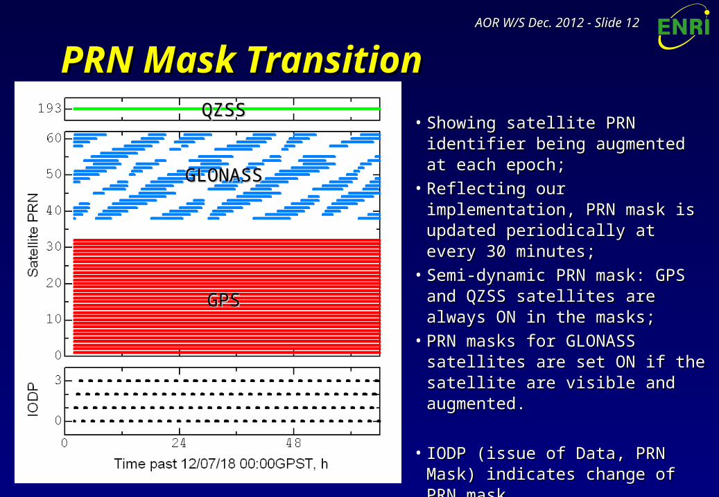
PRN Mask TransitionPRN Mask Transition
• Showing satellite PRN identifier being Showing satellite PRN identifier being augmented at each epoch;augmented at each epoch;
• Reflecting our implementation, PRN Reflecting our implementation, PRN mask is updated periodically at every mask is updated periodically at every 30 minutes;30 minutes;
• Semi-dynamic PRN mask: GPS and Semi-dynamic PRN mask: GPS and QZSS satellites are always ON in the QZSS satellites are always ON in the masks;masks;
• PRN masks for GLONASS satellites PRN masks for GLONASS satellites are set ON if the satellite are visible are set ON if the satellite are visible and augmented.and augmented.
• IODP (issue of Data, PRN Mask) IODP (issue of Data, PRN Mask) indicates change of PRN mask.indicates change of PRN mask.
GPSGPS
GLONASSGLONASS
QZSSQZSS
AOR W/S Dec. 2012AOR W/S Dec. 2012 - Slide - Slide 1313
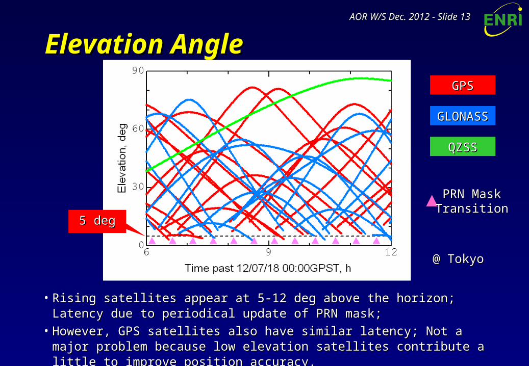
Elevation AngleElevation Angle
• Rising satellites appear at 5-12 deg above the horizon; Latency due to periodical Rising satellites appear at 5-12 deg above the horizon; Latency due to periodical update of PRN mask;update of PRN mask;
• However, GPS satellites also have similar latency; Not a major problem because However, GPS satellites also have similar latency; Not a major problem because low elevation satellites contribute a little to improve position accuracy.low elevation satellites contribute a little to improve position accuracy.
GPSGPS
GLONASSGLONASS
QZSSQZSS
PRN MaskPRN MaskTransitionTransition
5 deg5 deg
@ Tokyo@ Tokyo
AOR W/S Dec. 2012AOR W/S Dec. 2012 - Slide - Slide 1414
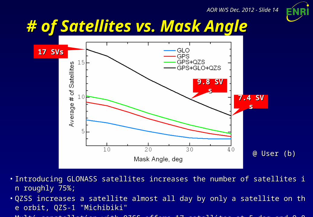
# of Satellites vs. Mask Angle# of Satellites vs. Mask Angle
• Introducing GLONASS satellites increases the number of satellites in roughly 75%;Introducing GLONASS satellites increases the number of satellites in roughly 75%;• QZSS increases a satellite almost all day by only a satellite on the orbit, QZS-1 "Michibiki" QZSS increases a satellite almost all day by only a satellite on the orbit, QZS-1 "Michibiki" • Multi-constellation with QZSS offers 17 satellites at 5 deg and 9.8 satellites even at 30 deg.Multi-constellation with QZSS offers 17 satellites at 5 deg and 9.8 satellites even at 30 deg.
9.8 SVs9.8 SVs
17 SVs17 SVs
7.4 SVs7.4 SVs
@ User (b)@ User (b)
AOR W/S Dec. 2012AOR W/S Dec. 2012 - Slide - Slide 1515
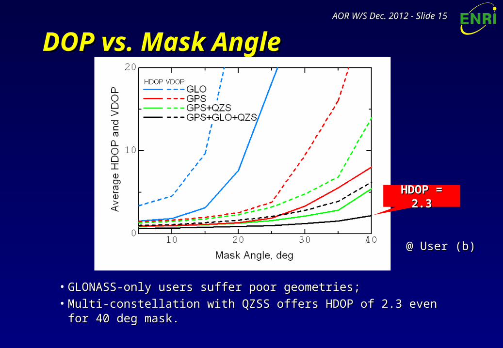
DOP vs. Mask AngleDOP vs. Mask Angle
• GLONASS-only users suffer poor geometries;GLONASS-only users suffer poor geometries;• Multi-constellation with QZSS offers HDOP of 2.3 even for 40 deg mask.Multi-constellation with QZSS offers HDOP of 2.3 even for 40 deg mask.
@ User (b)@ User (b)
HDOP = 2.3HDOP = 2.3
AOR W/S Dec. 2012AOR W/S Dec. 2012 - Slide - Slide 1616
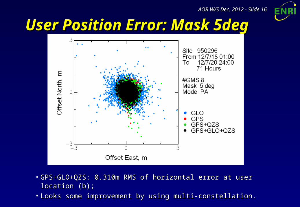
User Position Error: Mask 5degUser Position Error: Mask 5deg
• GPS+GLO+QZS: 0.310m RMS of horizontal error at user location (b);GPS+GLO+QZS: 0.310m RMS of horizontal error at user location (b);• Looks some improvement by using multi-constellation.Looks some improvement by using multi-constellation.
AOR W/S Dec. 2012AOR W/S Dec. 2012 - Slide - Slide 1717
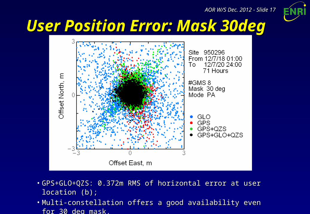
User Position Error: Mask 30degUser Position Error: Mask 30deg
• GPS+GLO+QZS: 0.372m RMS of horizontal error at user location (b);GPS+GLO+QZS: 0.372m RMS of horizontal error at user location (b);• Multi-constellation offers a good availability even for 30 deg mask.Multi-constellation offers a good availability even for 30 deg mask.
AOR W/S Dec. 2012AOR W/S Dec. 2012 - Slide - Slide 1818
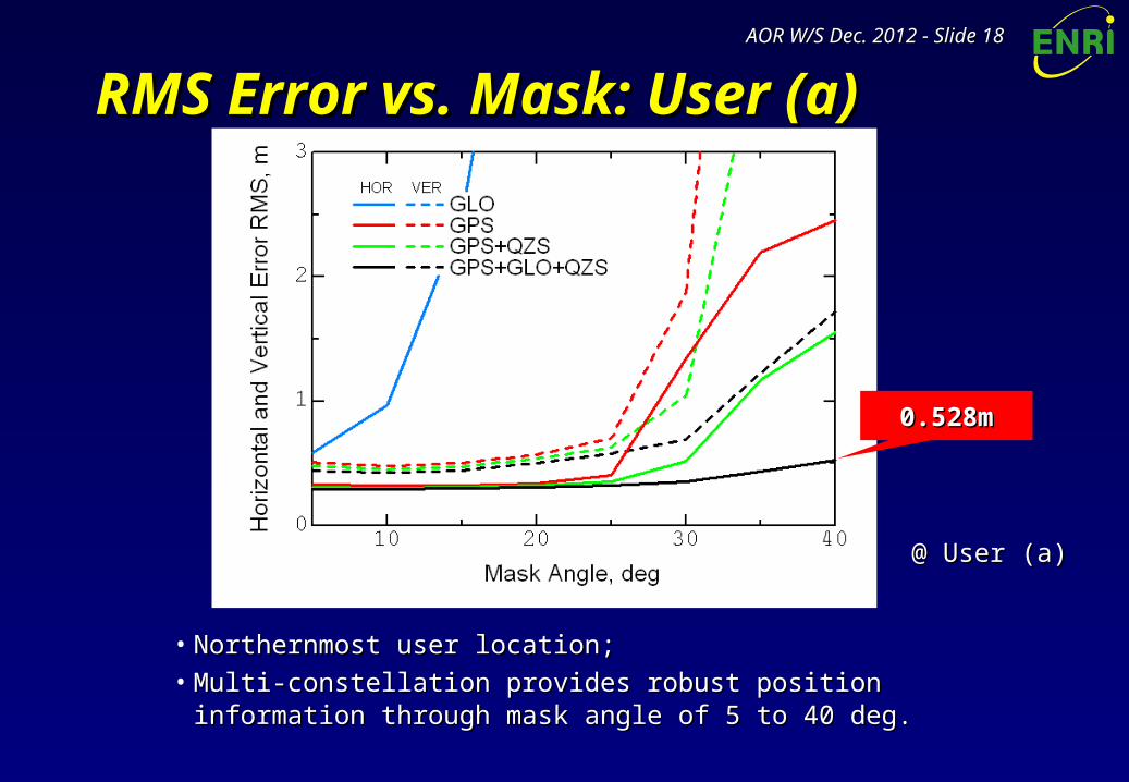
RMS Error vs. Mask: User (a)RMS Error vs. Mask: User (a)
• Northernmost user location;Northernmost user location;• Multi-constellation provides robust position information through Multi-constellation provides robust position information through
mask angle of 5 to 40 deg.mask angle of 5 to 40 deg.
@ User (a)@ User (a)
0.528m0.528m
AOR W/S Dec. 2012AOR W/S Dec. 2012 - Slide - Slide 1919
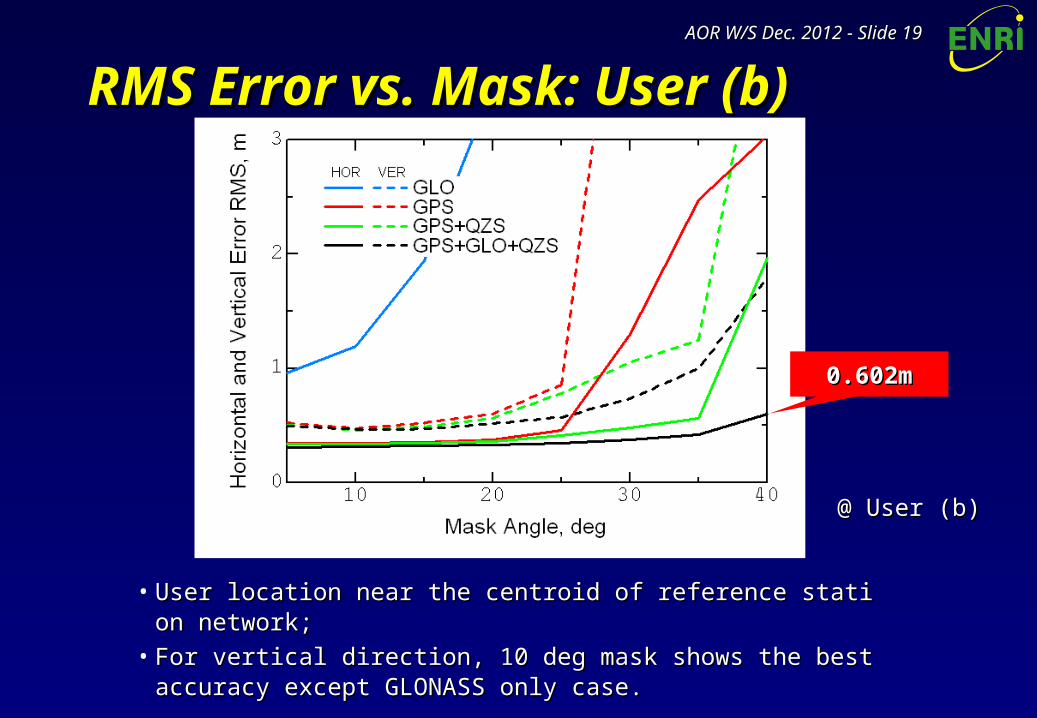
RMS Error vs. Mask: User (b)RMS Error vs. Mask: User (b)
• User location near the centroid of reference station network;User location near the centroid of reference station network;• For vertical direction, 10 deg mask shows the best accuracy except For vertical direction, 10 deg mask shows the best accuracy except
GLONASS only case.GLONASS only case.
@ User (b)@ User (b)
0.602m0.602m
AOR W/S Dec. 2012AOR W/S Dec. 2012 - Slide - Slide 2020
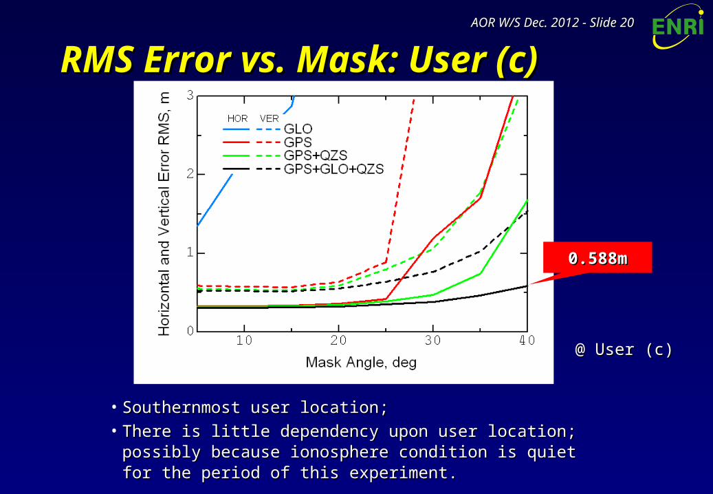
RMS Error vs. Mask: User (c)RMS Error vs. Mask: User (c)
• Southernmost user location;Southernmost user location;• There is little dependency upon user location; possibly because There is little dependency upon user location; possibly because
ionosphere condition is quiet for the period of this experiment.ionosphere condition is quiet for the period of this experiment.
@ User (c)@ User (c)
0.588m0.588m
AOR W/S Dec. 2012AOR W/S Dec. 2012 - Slide - Slide 2121
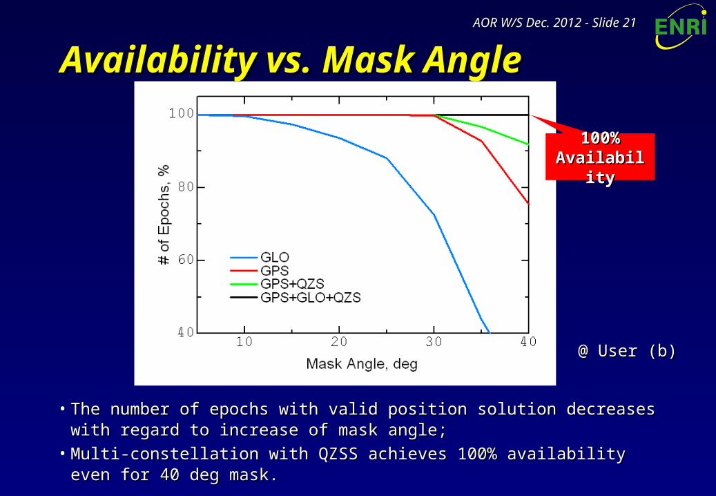
Availability vs. Mask AngleAvailability vs. Mask Angle
• The number of epochs with valid position solution decreases with regard to The number of epochs with valid position solution decreases with regard to increase of mask angle;increase of mask angle;
• Multi-constellation with QZSS achieves 100% availability even for 40 deg mask.Multi-constellation with QZSS achieves 100% availability even for 40 deg mask.
100% 100% AvailabilityAvailability
@ User (b)@ User (b)
AOR W/S Dec. 2012AOR W/S Dec. 2012 - Slide - Slide 2222
ConclusionConclusion• Combined use of GPS and GLONASS with L1-SAIF:Combined use of GPS and GLONASS with L1-SAIF:
– Potential problems and solutions on realizing a Multi-GNSS L1-SAIF, capable of auPotential problems and solutions on realizing a Multi-GNSS L1-SAIF, capable of augmenting GPS, GLONASS, and QZSS simultaneously were investigated;gmenting GPS, GLONASS, and QZSS simultaneously were investigated;
– L1-SAIF Master Station is upgraded for supporting Multi-GNSS augmentation and tL1-SAIF Master Station is upgraded for supporting Multi-GNSS augmentation and tested successfully; Currently only for offline mode using RINEX files;ested successfully; Currently only for offline mode using RINEX files;
– It is confirmed that the performance of L1-SAIF augmentation is certainly improved It is confirmed that the performance of L1-SAIF augmentation is certainly improved by adding GLONASS and QZSS, especially when satellite visibility is limited.by adding GLONASS and QZSS, especially when satellite visibility is limited.
• Ongoing and future works:Ongoing and future works:– Support of realtime operation mode;Support of realtime operation mode;– Broadcast of augmentation information for both GPS and GLONASS on QZS-1 real Broadcast of augmentation information for both GPS and GLONASS on QZS-1 real
signal; signal; Plan fromPlan from the second half of this monththe second half of this month;;– Use of GLONASS/QZSS observables in generation of ionospheric correction;Use of GLONASS/QZSS observables in generation of ionospheric correction;– Further extension to support Galileo.Further extension to support Galileo.
For further information, contact to [email protected] further information, contact to [email protected]