Embed Size (px)
Citation preview
www.fugromarinestar.com
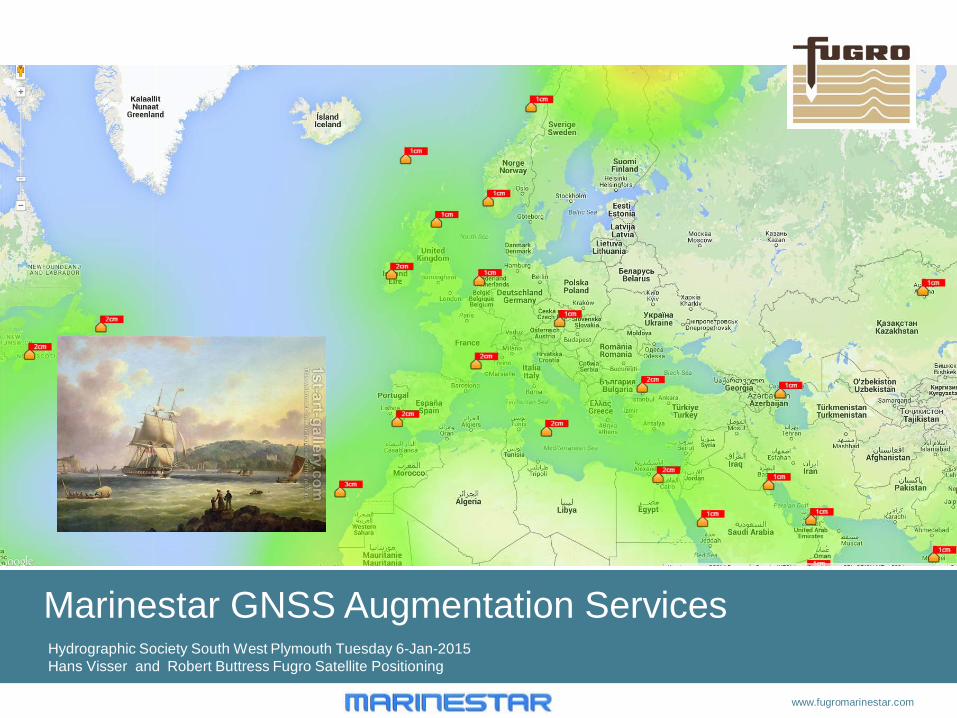
Marinestar GNSS Augmentation Services Hydrographic Society South West Plymouth Tuesday 6-Jan-2015 Hans Visser and Robert Buttress Fugro Satellite Positioning
2 www.fugromarinestar.com
Contents
• Fugro as a Company • Fugro-Marinestar: New Worldwide Multi-constellation GNSS Positioning,
• VBS L1 code and carrier with Reference station • HP L1/L2 code and carrier with Reference station • G2/XP Orbit and Clock Solutions • HPG2 Melting solutions • G4 GPS, Glonass, Beidou and Galileo
• Convergence times • Accuracy of orbit and Clock • Interference • Scintillations • Marinestar Applications Robert Butress
• Questions: (or during the presentation!)
www.fugromarinestar.com 3
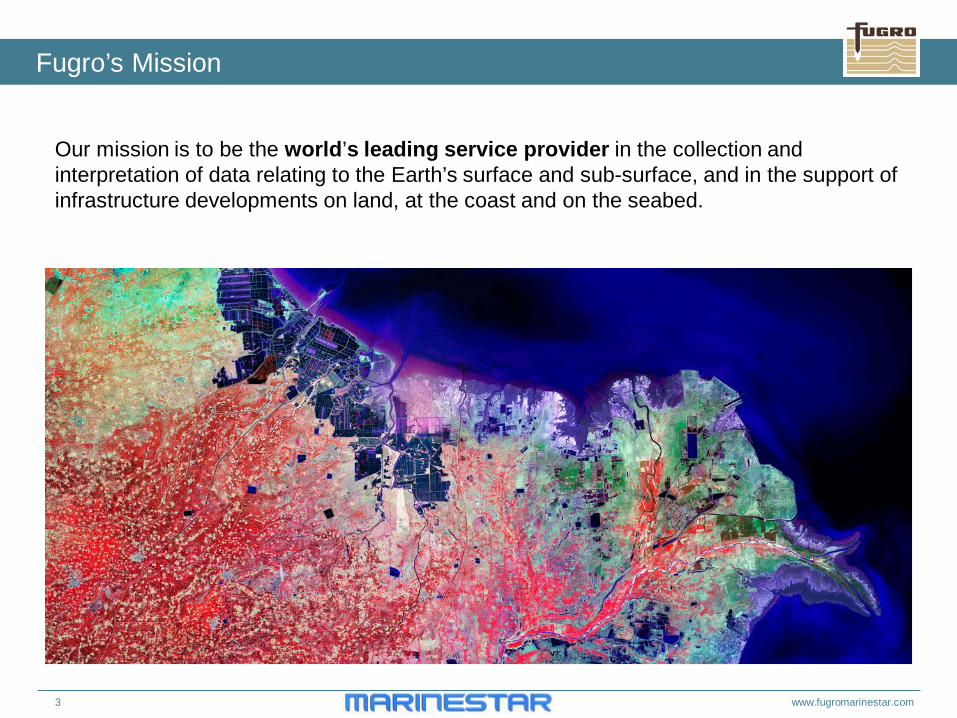
Our mission is to be the world’s leading service provider in the collection and interpretation of data relating to the Earth’s surface and sub-surface, and in the support of infrastructure developments on land, at the coast and on the seabed.
Fugro’s Mission
www.fugromarinestar.com 4
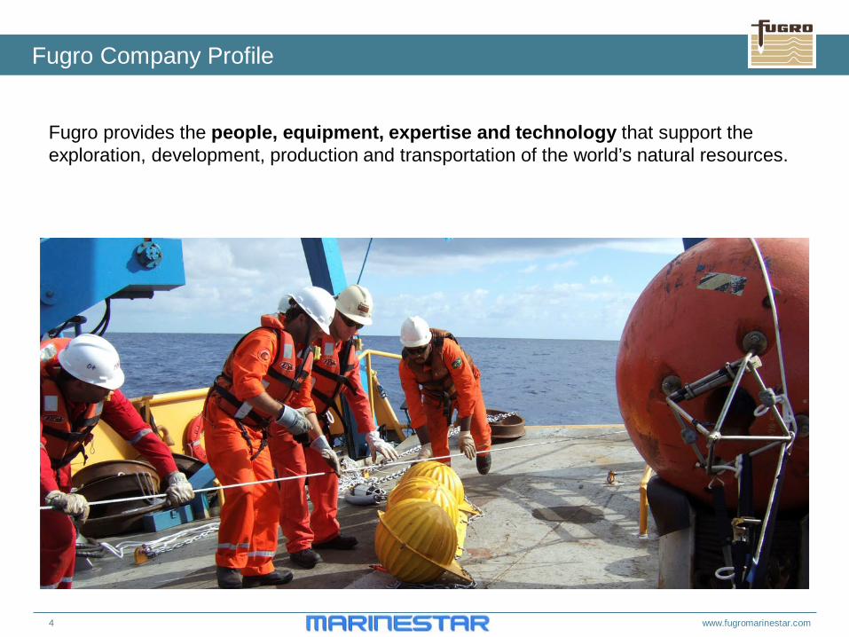
Fugro provides the people, equipment, expertise and technology that support the exploration, development, production and transportation of the world’s natural resources.
Fugro Company Profile
5 www.fugromarinestar.com
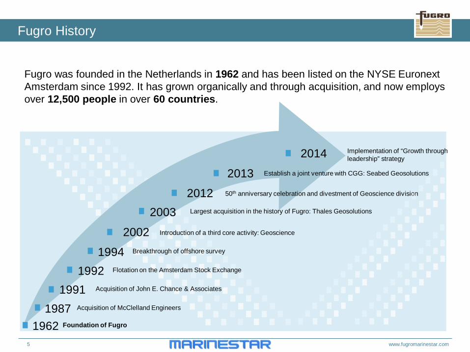
Fugro History
Fugro was founded in the Netherlands in 1962 and has been listed on the NYSE Euronext Amsterdam since 1992. It has grown organically and through acquisition, and now employs over 12,500 people in over 60 countries.
1962
Acquisition of McClelland Engineers
Acquisition of John E. Chance & Associates
Flotation on the Amsterdam Stock Exchange
Breakthrough of offshore survey
Introduction of a third core activity: Geoscience
Largest acquisition in the history of Fugro: Thales Geosolutions
Foundation of Fugro
1987 1991
1992 1994
2002
2003 2012
2013 50th anniversary celebration and divestment of Geoscience division
Establish a joint venture with CGG: Seabed Geosolutions
2014 Implementation of “Growth through leadership” strategy
6 www.fugromarinestar.com
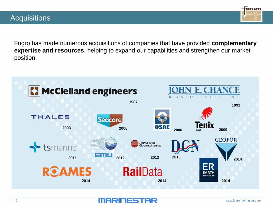
Acquisitions
Fugro has made numerous acquisitions of companies that have provided complementary expertise and resources, helping to expand our capabilities and strengthen our market position.
1987 1991
2003 2006 2006 2009
2011 2012 2013 2013 2014
2014 2014 2014
www.fugromarinestar.com 7
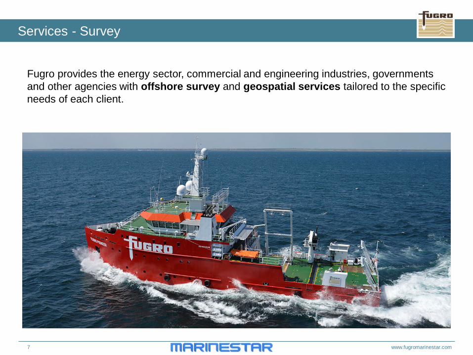
Fugro provides the energy sector, commercial and engineering industries, governments and other agencies with offshore survey and geospatial services tailored to the specific needs of each client.
Services - Survey
8 www.fugromarinestar.com
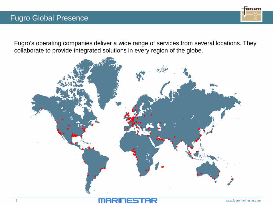
Fugro Global Presence
Fugro’s operating companies deliver a wide range of services from several locations. They collaborate to provide integrated solutions in every region of the globe.
9 www.fugromarinestar.com
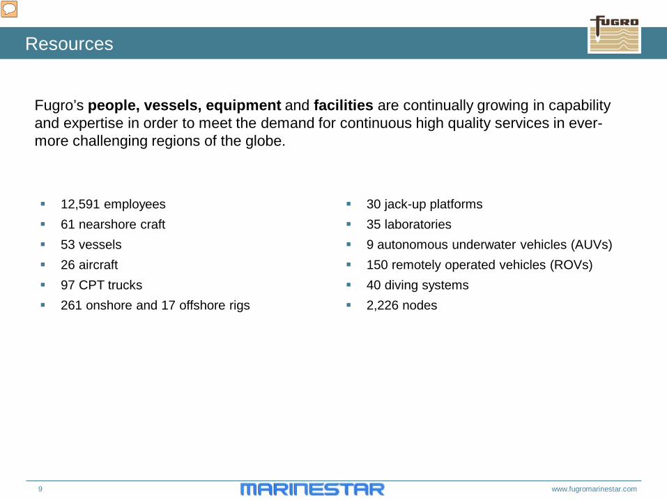
Resources
Fugro’s people, vessels, equipment and facilities are continually growing in capability and expertise in order to meet the demand for continuous high quality services in ever-more challenging regions of the globe. 30 jack-up platforms
35 laboratories 9 autonomous underwater vehicles (AUVs) 150 remotely operated vehicles (ROVs) 40 diving systems 2,226 nodes
12,591 employees 61 nearshore craft 53 vessels 26 aircraft 97 CPT trucks 261 onshore and 17 offshore rigs
10 www.fugromarinestar.com
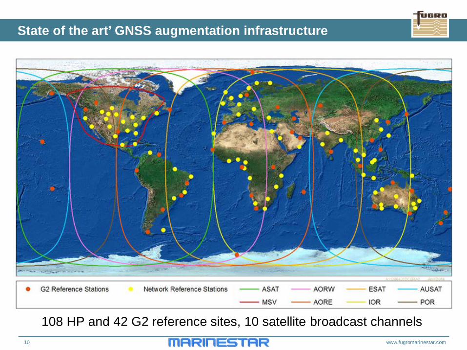
State of the art’ GNSS augmentation infrastructure
108 HP and 42 G2 reference sites, 10 satellite broadcast channels
11 www.fugromarinestar.com
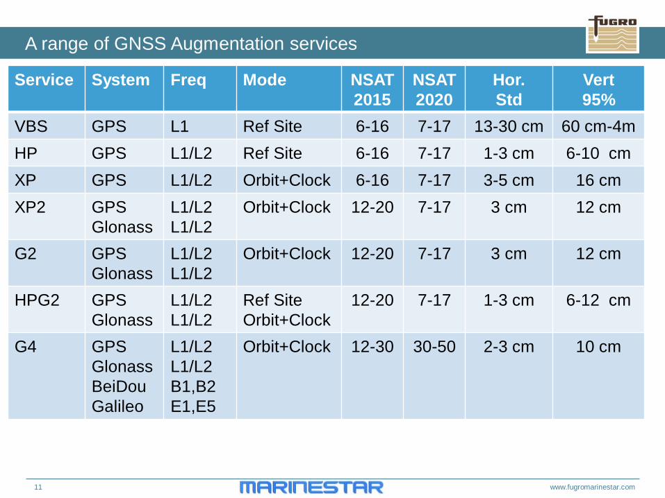
A range of GNSS Augmentation services
Service System Freq Mode NSAT 2015
NSAT 2020
Hor. Std
Vert 95%
VBS GPS L1 Ref Site 6-16 7-17 13-30 cm 60 cm-4m HP GPS L1/L2 Ref Site 6-16 7-17 1-3 cm 6-10 cm XP GPS L1/L2 Orbit+Clock 6-16 7-17 3-5 cm 16 cm XP2 GPS
Glonass L1/L2 L1/L2
Orbit+Clock
12-20 7-17 3 cm 12 cm
G2 GPS Glonass
L1/L2 L1/L2
Orbit+Clock
12-20 7-17 3 cm 12 cm
HPG2 GPS Glonass
L1/L2 L1/L2
Ref Site Orbit+Clock
12-20 7-17 1-3 cm 6-12 cm
G4 GPS Glonass BeiDou Galileo
L1/L2 L1/L2 B1,B2 E1,E5
Orbit+Clock 12-30 30-50 2-3 cm 10 cm
12 www.fugromarinestar.com
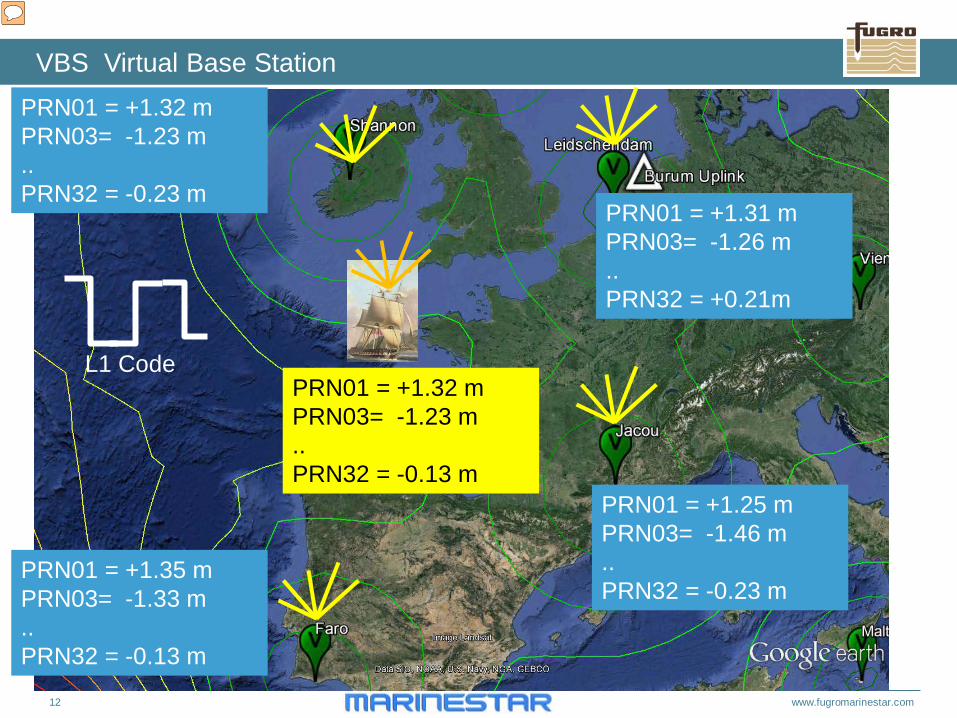
VBS Virtual Base Station PRN01 = +1.32 m PRN03= -1.23 m .. PRN32 = -0.23 m
PRN01 = +1.35 m PRN03= -1.33 m .. PRN32 = -0.13 m
PRN01 = +1.25 m PRN03= -1.46 m .. PRN32 = -0.23 m
PRN01 = +1.32 m PRN03= -1.23 m .. PRN32 = -0.13 m
PRN01 = +1.31 m PRN03= -1.26 m .. PRN32 = +0.21m
L1 Code
13 www.fugromarinestar.com
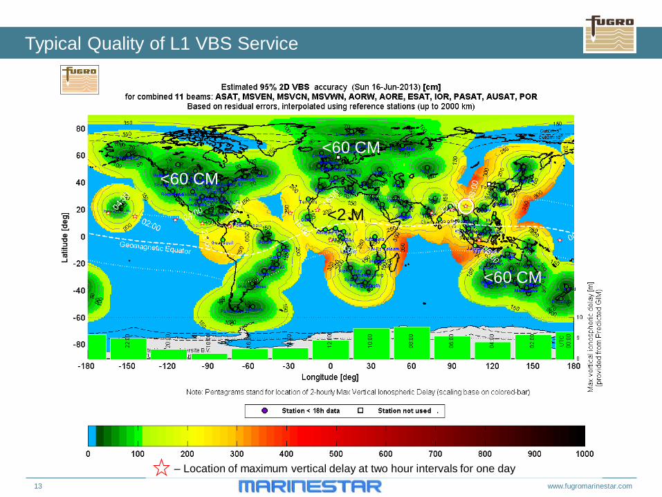
Typical Quality of L1 VBS Service
– Location of maximum vertical delay at two hour intervals for one day
<60 CM
<60 CM
<60 CM
<2 M
14 www.fugromarinestar.com
Advantages of VBS
1) Accuracy horizontal : 15-30 cm standard deviation 2) Only 4 L1 GPS CA code measurements are needed 3) Instant positioning 4) No convergence time, other than code smoothing 5) Is more accurate than WAAS and EGNOS 6) Lower price hardware cost
15 www.fugromarinestar.com
Limitations of VBS
1) A network of VBS Reference stations is needed 2) Maximum distance up to 1000 km from reference station 3) Does not work in the equatorial zone during local day time 4) L1 Code multipath errors 0.5-2 meter
5) Accuracy degrades as distance to reference station due to
1) Ionospheric variation 0 Mostly – (1 meter per 100 km Max) 2) Orbit errors 10 cm per 100 km 3) Tropospheric errors 0- 30 cm per 100 km (Rain Weather front)
6) Degradation of error as age of corrections increase 1) Satellite Clock errors 10 cm per minute typical, 50 cm per minute (Extreme) 2) Ionospheric variation 3) Troposphere 0-30 cm per minute (Rain Weather front extreme)
16 www.fugromarinestar.com
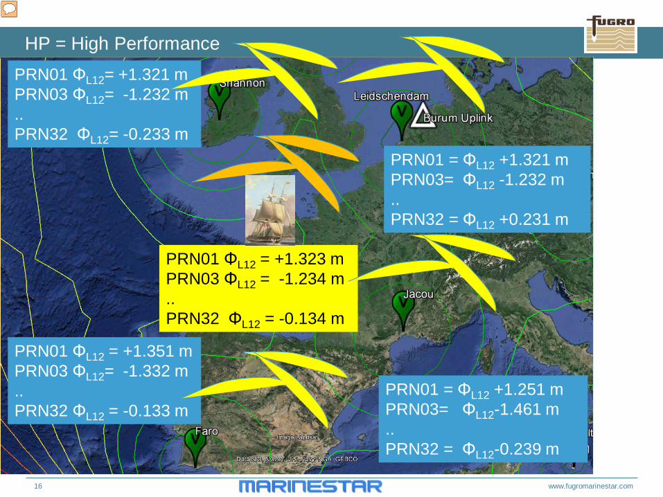
HP = High Performance PRN01 ΦL12= +1.321 m PRN03 ΦL12= -1.232 m .. PRN32 ΦL12= -0.233 m
PRN01 ΦL12 = +1.351 m PRN03 ΦL12= -1.332 m .. PRN32 ΦL12 = -0.133 m
PRN01 = ΦL12 +1.251 m PRN03= ΦL12-1.461 m .. PRN32 = ΦL12-0.239 m
PRN01 ΦL12 = +1.323 m PRN03 ΦL12 = -1.234 m .. PRN32 ΦL12 = -0.134 m
PRN01 = ΦL12 +1.321 m PRN03= ΦL12 -1.232 m .. PRN32 = ΦL12 +0.231 m
17 www.fugromarinestar.com
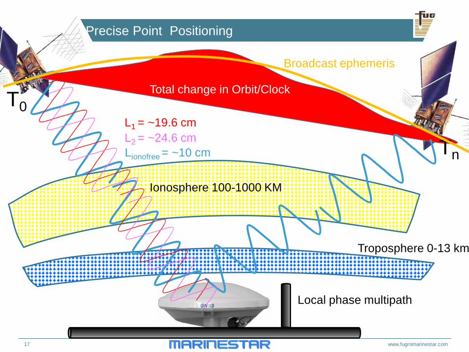
Principle of Precise Point Positioning
T0
Tn
Ionosphere 100-1000 KM
Troposphere 0-13 km
Lionofree = ~10 cm
L1 = ~19.6 cm L2 = ~24.6 cm
Broadcast ephemeris
Total change in Orbit/Clock
Local phase multipath
18 www.fugromarinestar.com
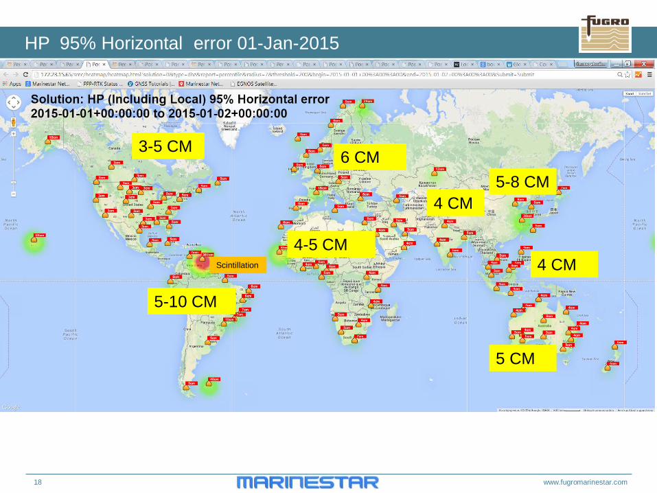
HP 95% Horizontal error 01-Jan-2015
3-5 CM 6 CM
5-10 CM
4-5 CM
4 CM 5-8 CM
4 CM
5 CM
Scintillation
19 www.fugromarinestar.com
Advantages HP
Accuracy Horizontal 2-3 cm standard deviation Vertical 4 cm standard deviation 6 cm 95% Ionospheric delay is resolved using dual frequencies (Up to 1%)
20 www.fugromarinestar.com
Example of HP accuracy
00H 02 04 06 08 10 12 14 16 18 20 22 24
60
50
40
30
20
10
0
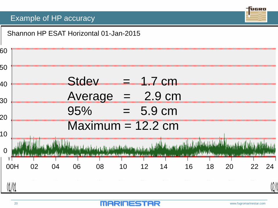
Shannon HP ESAT Horizontal 01-Jan-2015
Stdev = 1.7 cm Average = 2.9 cm 95% = 5.9 cm Maximum = 12.2 cm
21 www.fugromarinestar.com
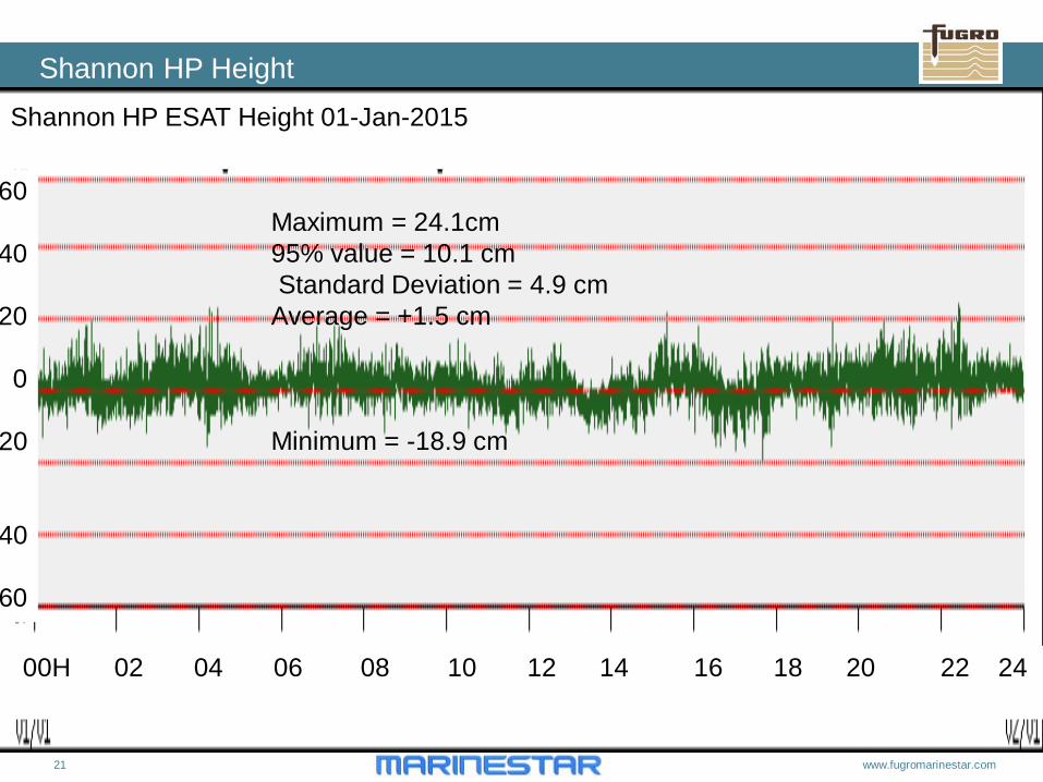
Shannon HP Height
00H 02 04 06 08 10 12 14 16 18 20 22 24
60
40
20
0
20
40
60
Shannon HP ESAT Height 01-Jan-2015
Maximum = 24.1cm 95% value = 10.1 cm Standard Deviation = 4.9 cm Average = +1.5 cm Minimum = -18.9 cm
22 www.fugromarinestar.com
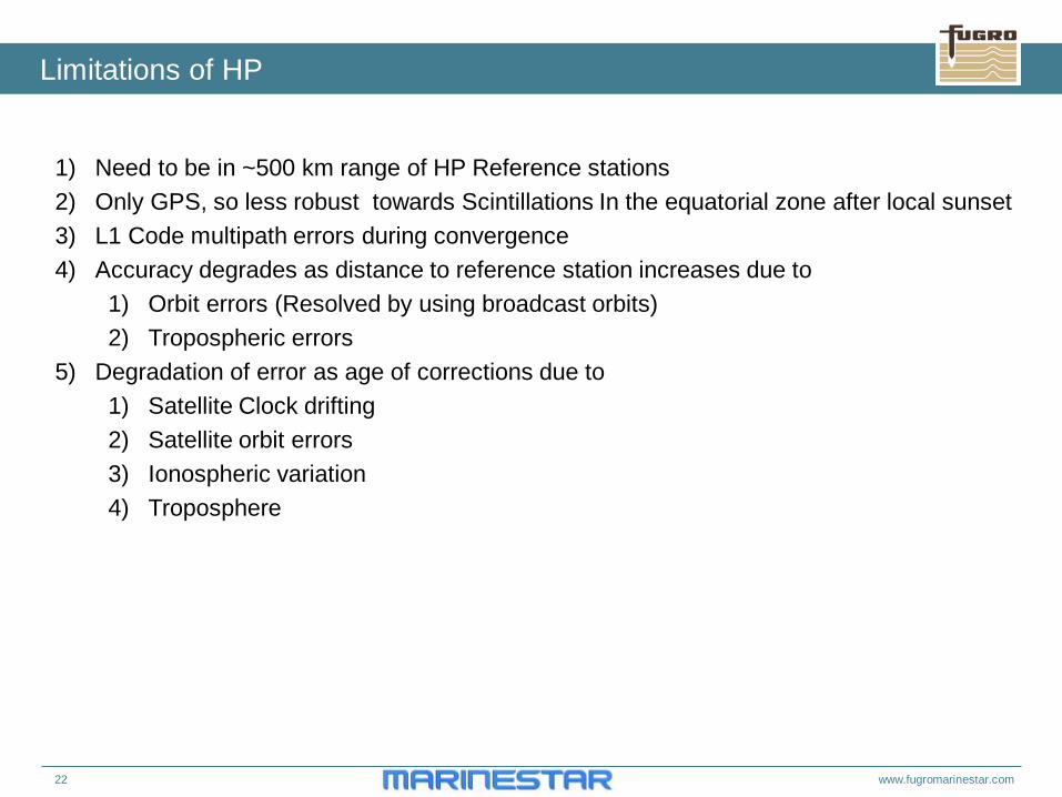
Limitations of HP
1) Need to be in ~500 km range of HP Reference stations 2) Only GPS, so less robust towards Scintillations In the equatorial zone after local sunset 3) L1 Code multipath errors during convergence 4) Accuracy degrades as distance to reference station increases due to
1) Orbit errors (Resolved by using broadcast orbits) 2) Tropospheric errors
5) Degradation of error as age of corrections due to 1) Satellite Clock drifting 2) Satellite orbit errors 3) Ionospheric variation 4) Troposphere
23 www.fugromarinestar.com
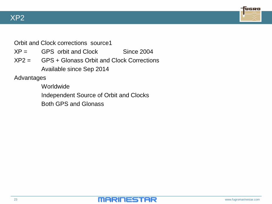
XP2
Orbit and Clock corrections source1 XP = GPS orbit and Clock Since 2004 XP2 = GPS + Glonass Orbit and Clock Corrections Available since Sep 2014 Advantages Worldwide Independent Source of Orbit and Clocks Both GPS and Glonass
24 www.fugromarinestar.com
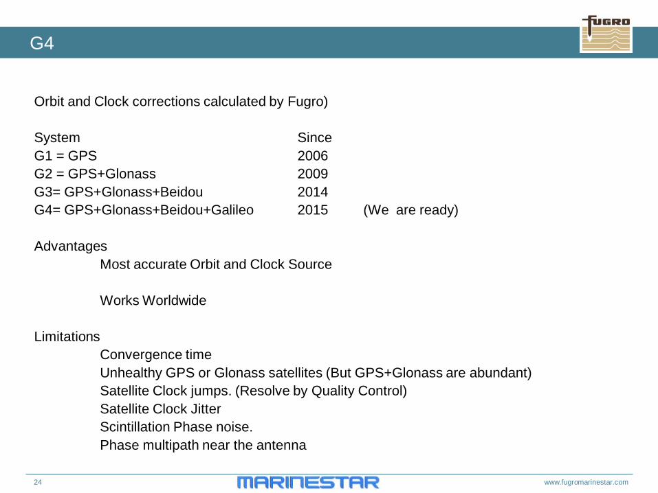
G4
Orbit and Clock corrections calculated by Fugro) System Since G1 = GPS 2006 G2 = GPS+Glonass 2009 G3= GPS+Glonass+Beidou 2014 G4= GPS+Glonass+Beidou+Galileo 2015 (We are ready) Advantages Most accurate Orbit and Clock Source Works Worldwide Limitations Convergence time Unhealthy GPS or Glonass satellites (But GPS+Glonass are abundant) Satellite Clock jumps. (Resolve by Quality Control) Satellite Clock Jitter Scintillation Phase noise. Phase multipath near the antenna
25 www.fugromarinestar.com
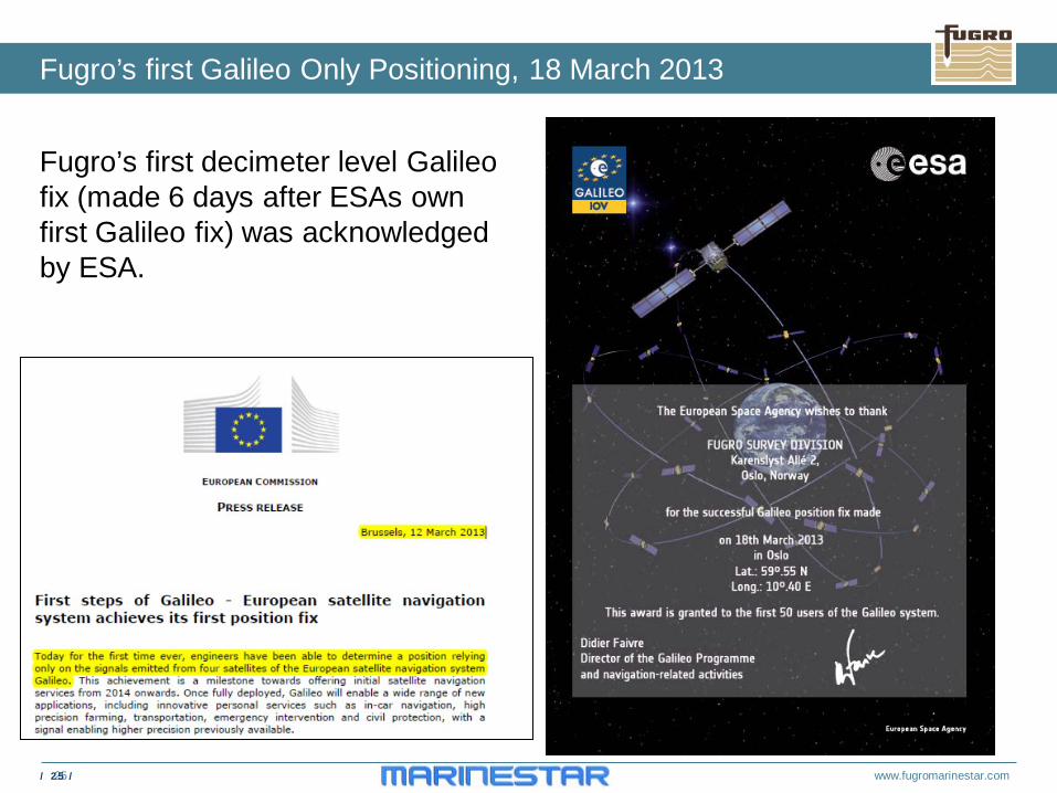
Fugro’s first decimeter level Galileo fix (made 6 days after ESAs own first Galileo fix) was acknowledged by ESA.
Fugro’s first Galileo Only Positioning, 18 March 2013
/ 25 /
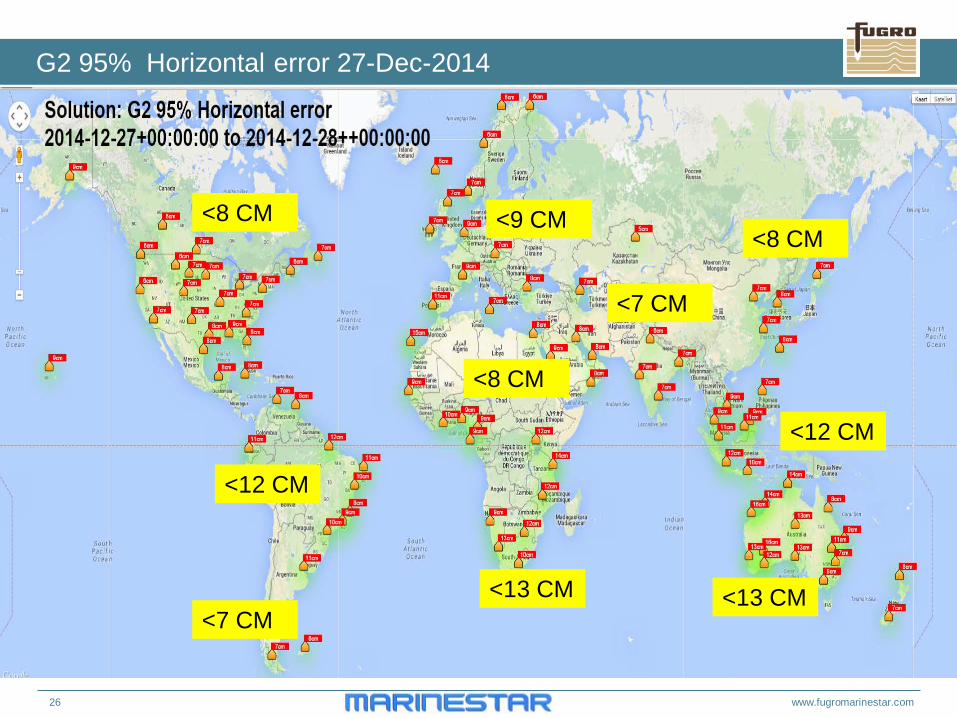
26 www.fugromarinestar.com
G2 95% Horizontal error 27-Dec-2014
<8 CM <9 CM
<12 CM
<8 CM
<13 CM
<7 CM
<8 CM
<12 CM
<13 CM <7 CM
27 www.fugromarinestar.com
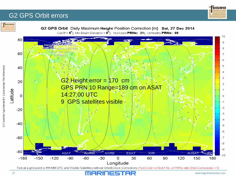
G2 GPS Orbit errors
G2 Height error = 170 cm GPS PRN 10 Range=189 cm on ASAT 14:27:00 UTC 9 GPS satellites visible
28 www.fugromarinestar.com
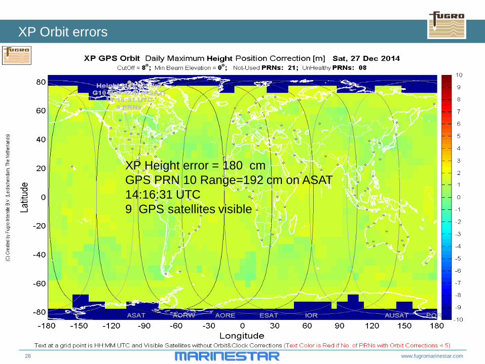
XP Orbit errors
XP Height error = 180 cm GPS PRN 10 Range=192 cm on ASAT 14:16:31 UTC 9 GPS satellites visible
29 www.fugromarinestar.com
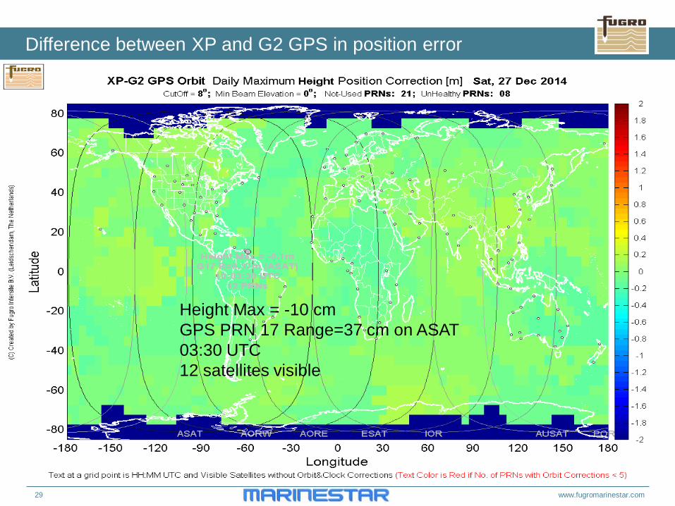
Difference between XP and G2 GPS in position error
Height Max = -10 cm GPS PRN 17 Range=37 cm on ASAT 03:30 UTC 12 satellites visible
30 www.fugromarinestar.com
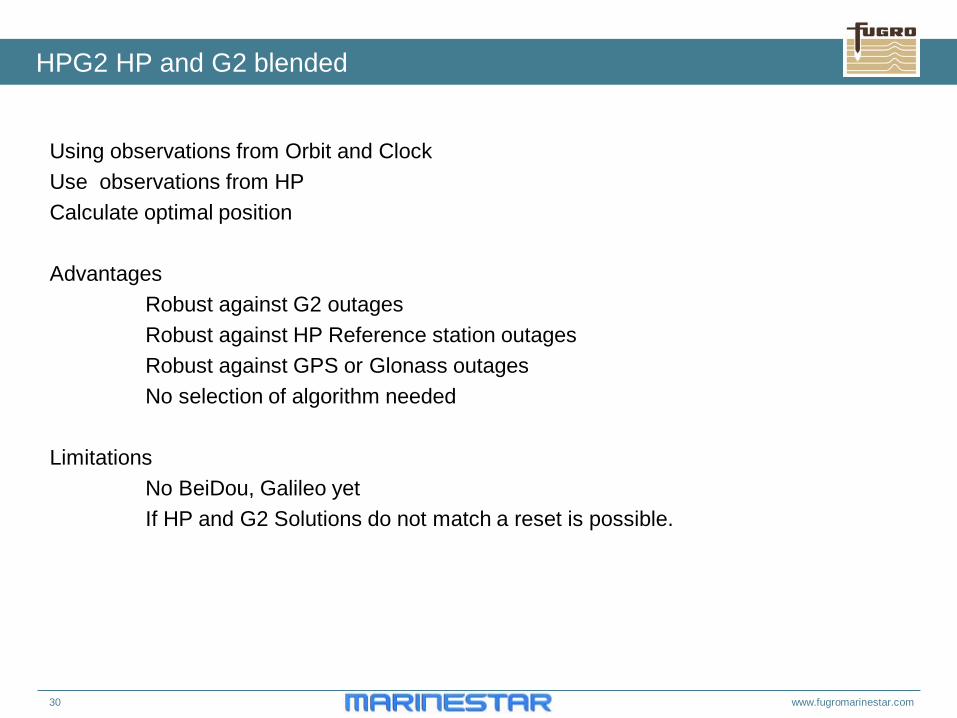
HPG2 HP and G2 blended
Using observations from Orbit and Clock Use observations from HP Calculate optimal position Advantages Robust against G2 outages Robust against HP Reference station outages Robust against GPS or Glonass outages No selection of algorithm needed Limitations No BeiDou, Galileo yet If HP and G2 Solutions do not match a reset is possible.
31 www.fugromarinestar.com
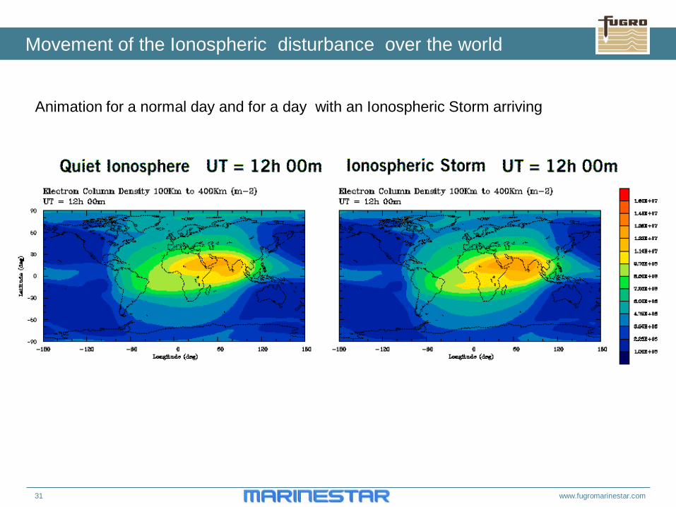
Movement of the Ionospheric disturbance over the world
Animation for a normal day and for a day with an Ionospheric Storm arriving
32 www.fugromarinestar.com
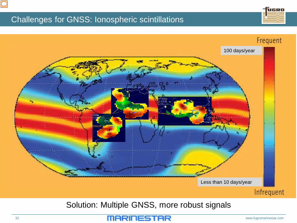
100 days/year
Less than 10 days/year
Solution: Multiple GNSS, more robust signals
Challenges for GNSS: Ionospheric scintillations
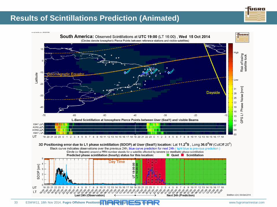
33 www.fugromarinestar.com
Results of Scintillations Prediction (Animated)
ESWW11, 18th Nov 2014, Fugro Offshore Positioning: Sailing through the solar maximum
34 www.fugromarinestar.com
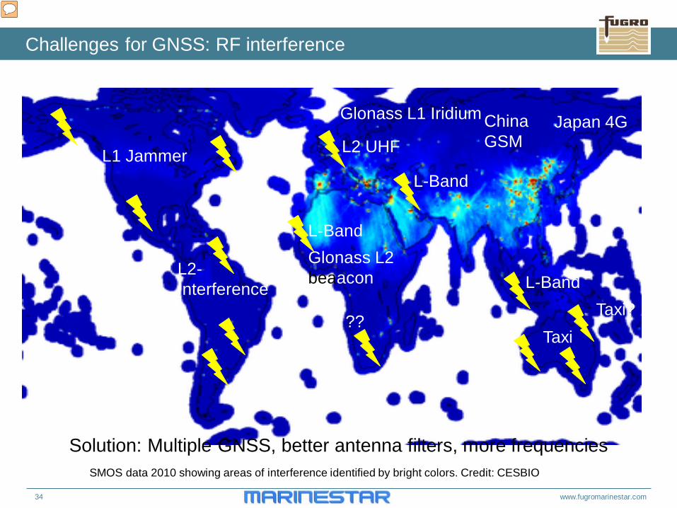
Challenges for GNSS: RF interference
Solution: Multiple GNSS, better antenna filters, more frequencies
Japan 4G China GSM L2 UHF
?? Taxi?
L-Band
SMOS data 2010 showing areas of interference identified by bright colors. Credit: CESBIO
L-Band L1 Jammer
L2- Interference
Taxi
L-Band
Glonass L1 Iridium
Glonass L2 beaacon
35 www.fugromarinestar.com
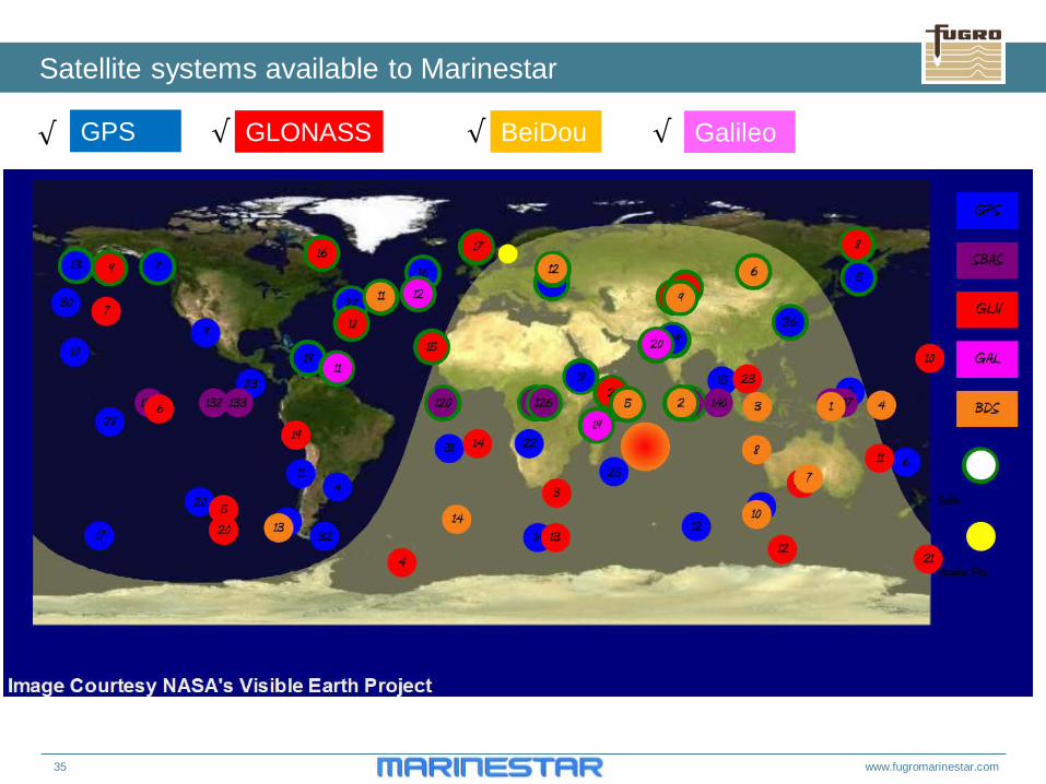
Satellite systems available to Marinestar
GPS GLONASS Galileo BeiDou √ √ √ √
36 www.fugromarinestar.com
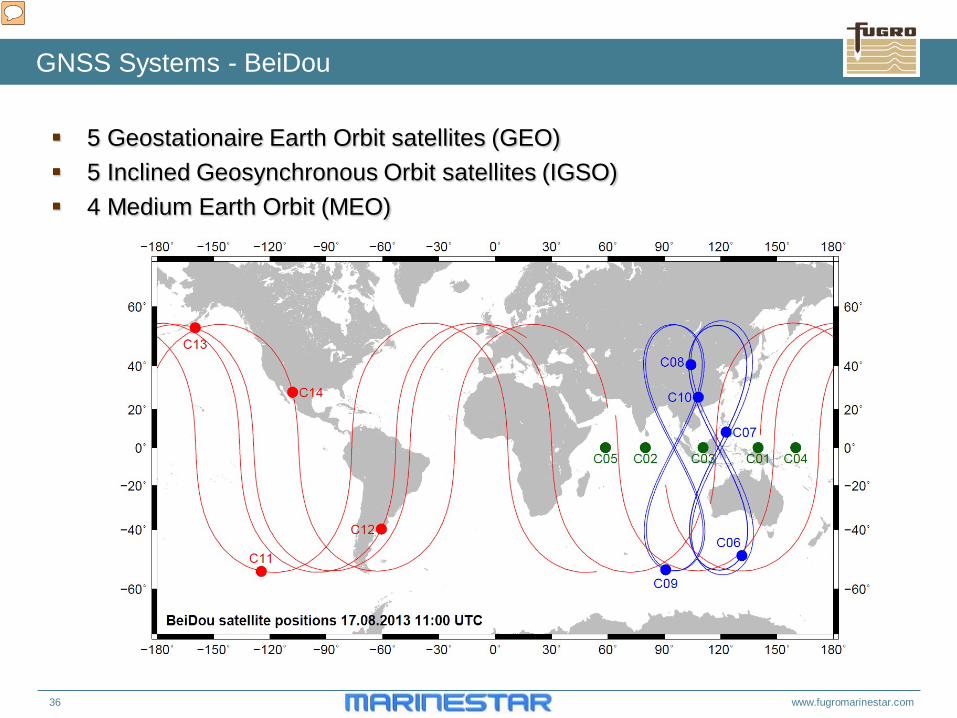
GNSS Systems - BeiDou
5 Geostationaire Earth Orbit satellites (GEO) 5 Inclined Geosynchronous Orbit satellites (IGSO) 4 Medium Earth Orbit (MEO)
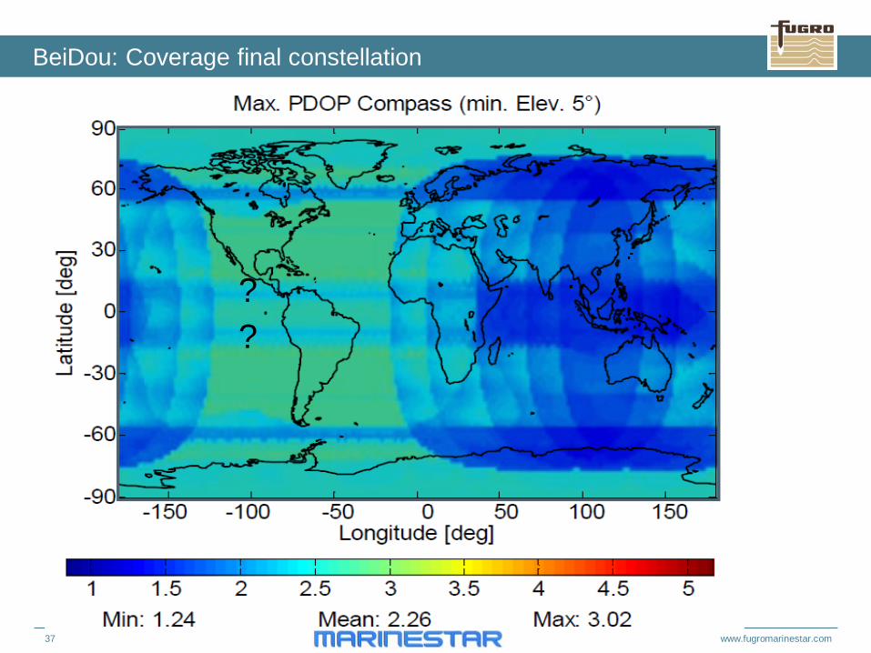
37 www.fugromarinestar.com
BeiDou: Coverage final constellation
? ?
38 www.fugromarinestar.com
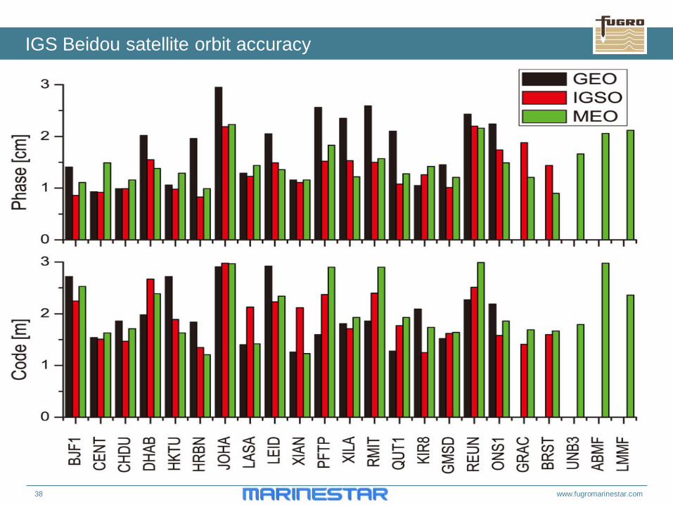
IGS Beidou satellite orbit accuracy
39 www.fugromarinestar.com
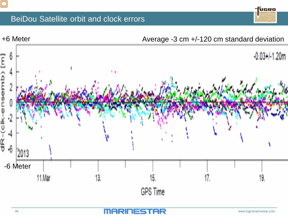
BeiDou Satellite orbit and clock errors
Average -3 cm +/-120 cm standard deviation +6 Meter
-6 Meter
40 www.fugromarinestar.com
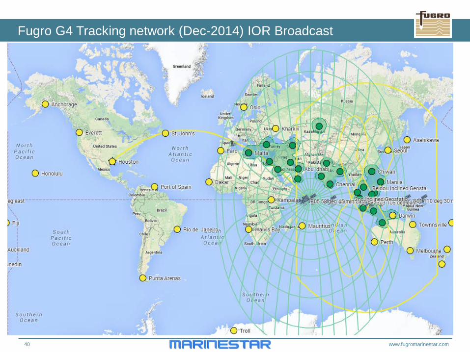
Fugro G4 Tracking network (Dec-2014) IOR Broadcast
41 www.fugromarinestar.com
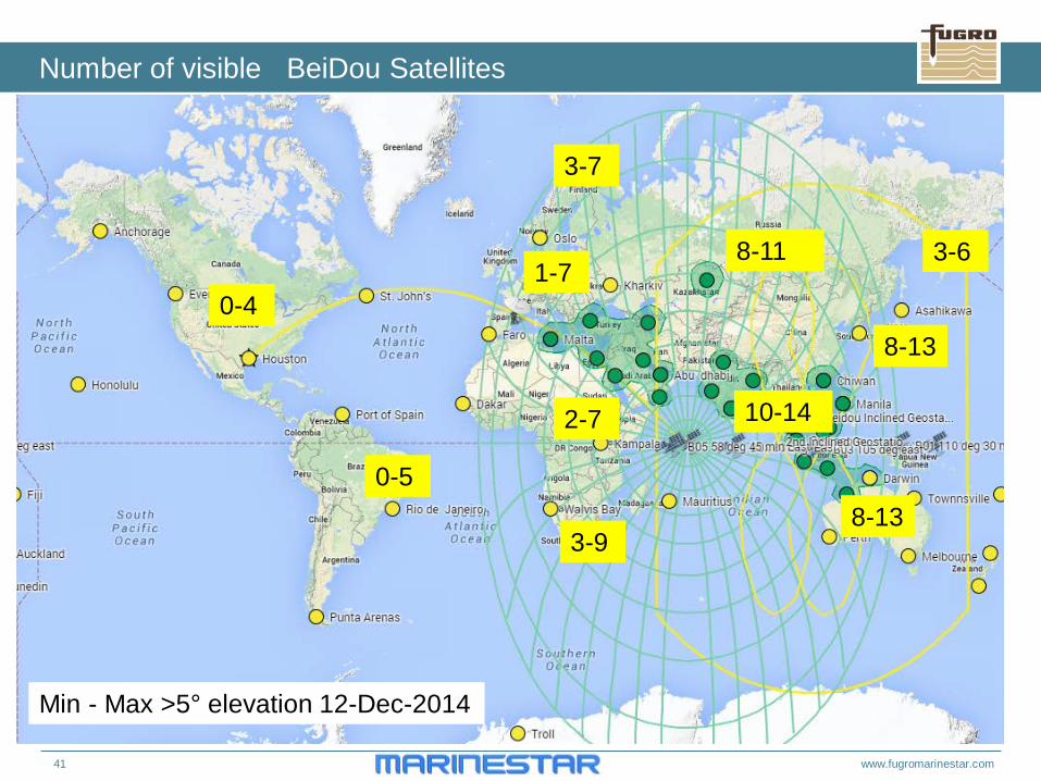
Number of visible BeiDou Satellites
10-14 2-7
0-5
0-4 1-7
8-13
8-13
8-11
3-9
3-6
3-7
Min - Max >5° elevation 12-Dec-2014
42 www.fugromarinestar.com
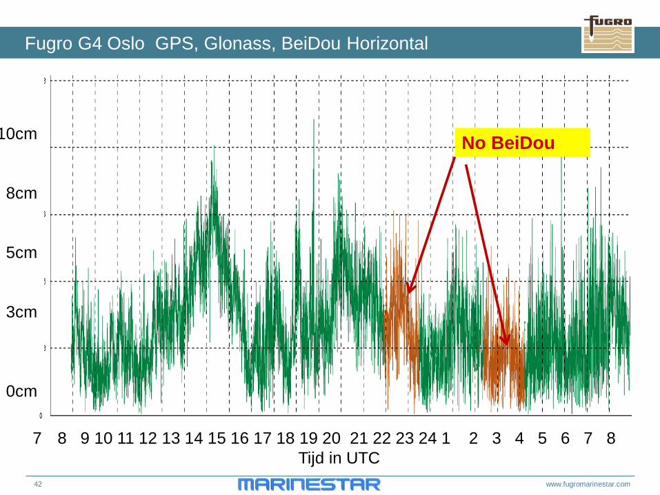
Fugro G4 Oslo GPS, Glonass, BeiDou Horizontal
7 8 9 10 11 12 13 14 15 16 17 18 19 20 21 22 23 24 1 2 3 4 5 6 7 8 Tijd in UTC
10cm
8cm
5cm
3cm
0cm
No BeiDou
43 www.fugromarinestar.com
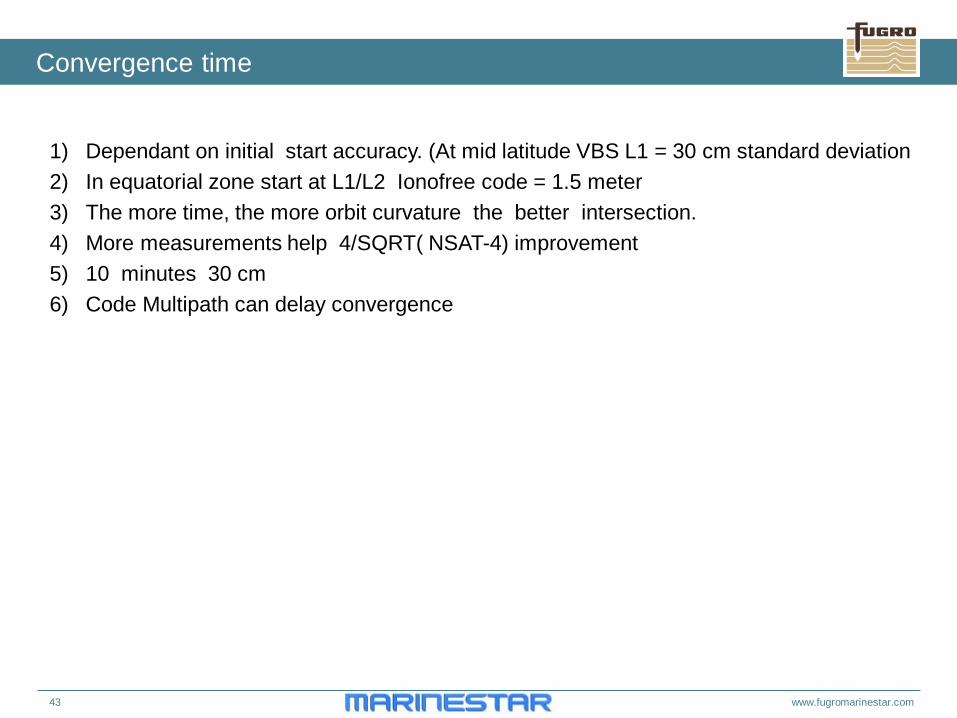
Convergence time
1) Dependant on initial start accuracy. (At mid latitude VBS L1 = 30 cm standard deviation 2) In equatorial zone start at L1/L2 Ionofree code = 1.5 meter 3) The more time, the more orbit curvature the better intersection. 4) More measurements help 4/SQRT( NSAT-4) improvement 5) 10 minutes 30 cm 6) Code Multipath can delay convergence
44 www.fugromarinestar.com
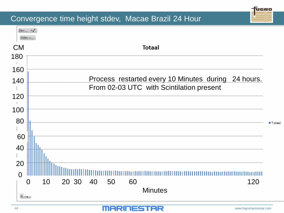
Convergence time height stdev, Macae Brazil 24 Hour
0 10 20 30 40 50 60 120 Minutes
180
160 140
120
100 80
60 40
20 0
CM
Process restarted every 10 Minutes during 24 hours. From 02-03 UTC with Scintilation present
45 www.fugromarinestar.com
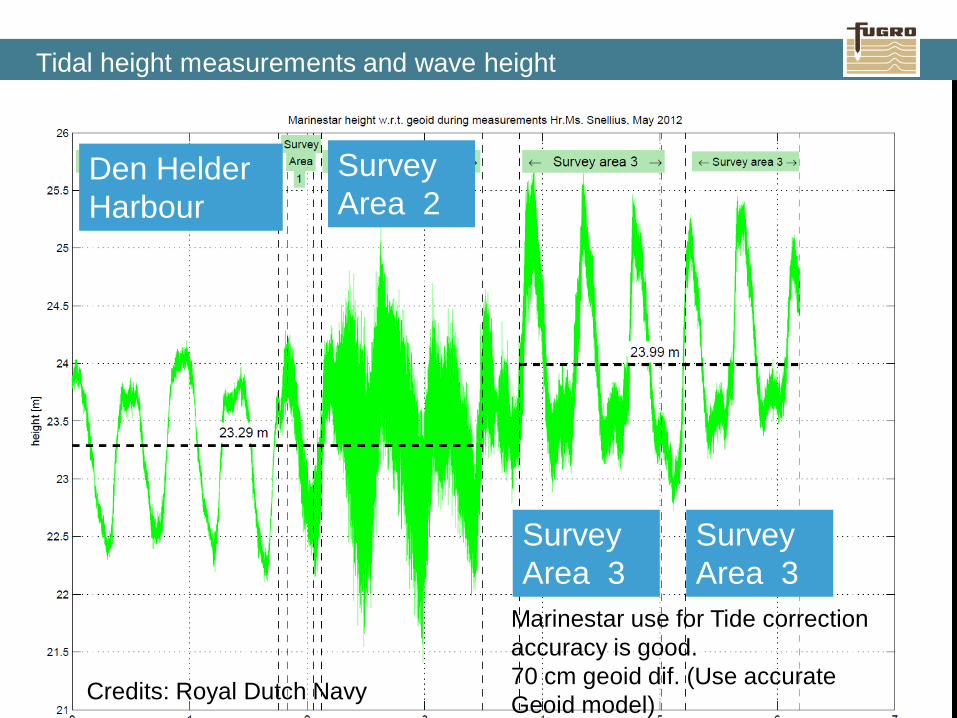
Tidal height measurements and wave height
Credits: Royal Dutch Navy
Marinestar use for Tide correction accuracy is good. 70 cm geoid dif. (Use accurate Geoid model)
Den Helder Harbour
Survey Area 2
Survey Area 3
Survey Area 3
47 www.fugromarinestar.com
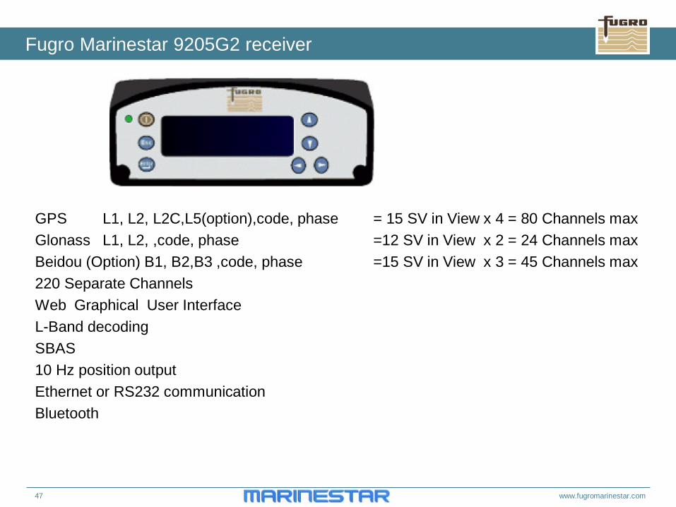
Fugro Marinestar 9205G2 receiver
GPS L1, L2, L2C,L5(option),code, phase = 15 SV in View x 4 = 80 Channels max Glonass L1, L2, ,code, phase =12 SV in View x 2 = 24 Channels max Beidou (Option) B1, B2,B3 ,code, phase =15 SV in View x 3 = 45 Channels max 220 Separate Channels Web Graphical User Interface L-Band decoding SBAS 10 Hz position output Ethernet or RS232 communication Bluetooth
48 www.fugromarinestar.com
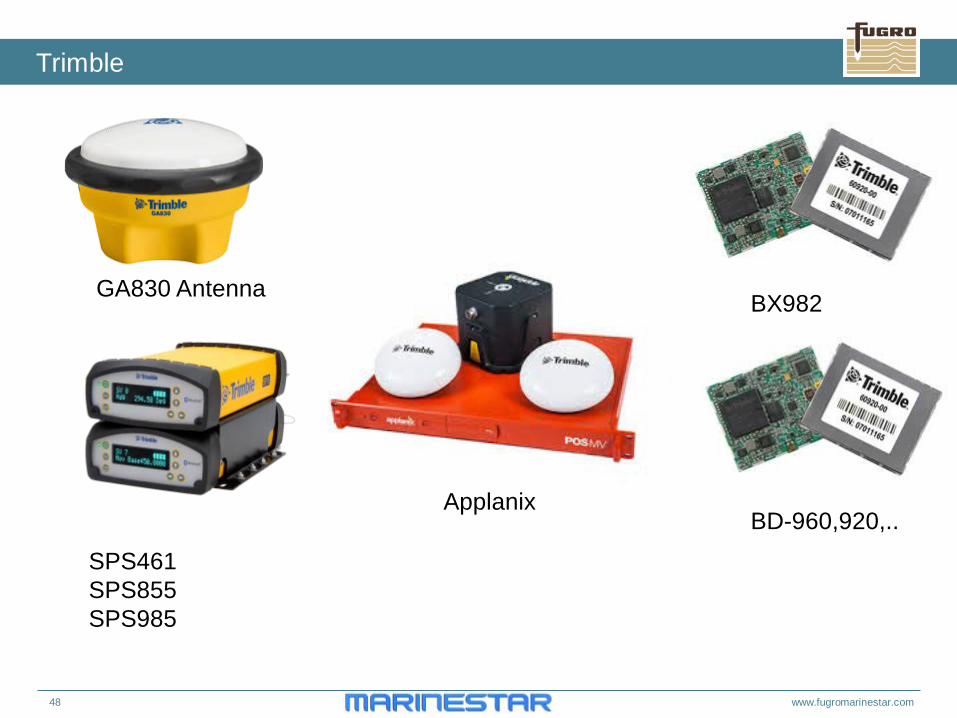
Trimble
SPS461 SPS855 SPS985
BX982
BD-960,920,..
GA830 Antenna
Applanix
49 www.fugromarinestar.com
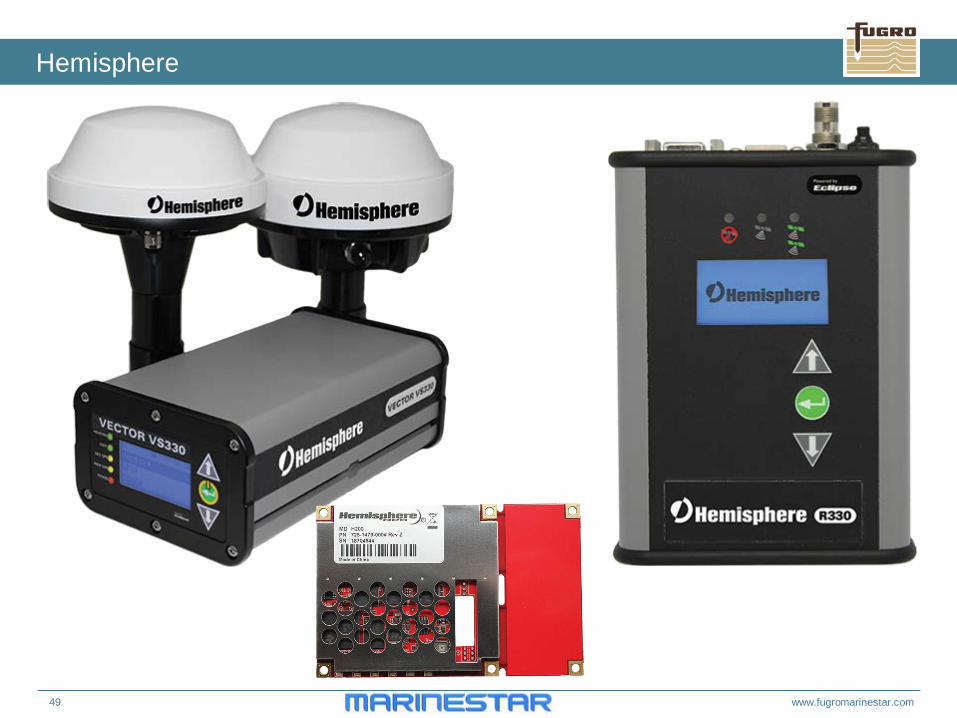
Hemisphere
52 www.fugromarinestar.com
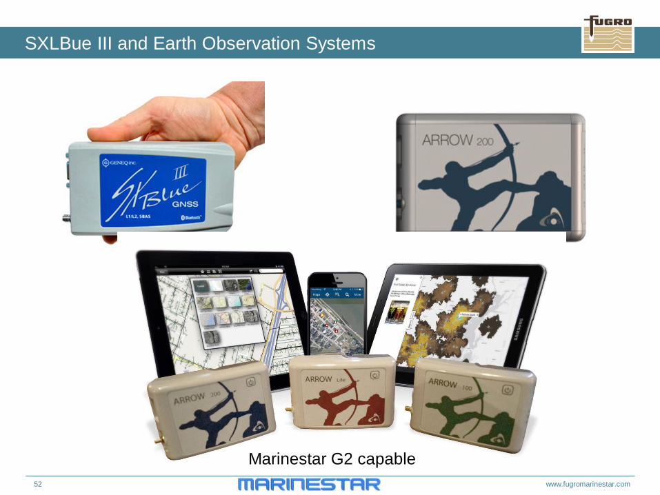
SXLBue III and Earth Observation Systems
Marinestar G2 capable
53 www.fugromarinestar.com
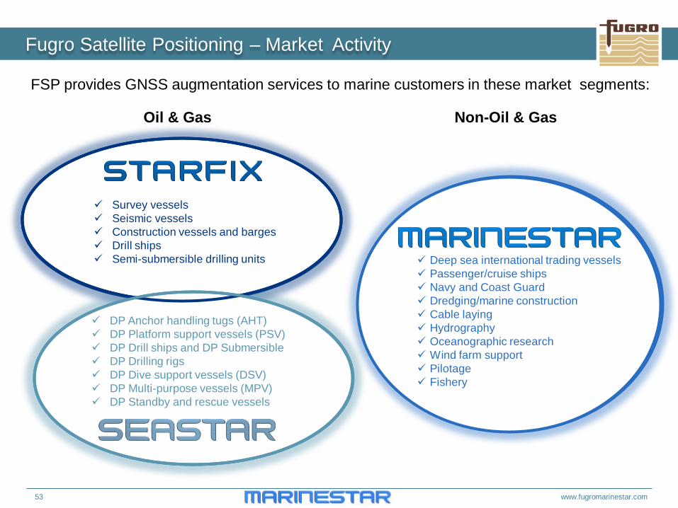
Fugro Satellite Positioning – Market Activity
FSP provides GNSS augmentation services to marine customers in these market segments:
Survey vessels Seismic vessels Construction vessels and barges Drill ships Semi-submersible drilling units
DP Anchor handling tugs (AHT) DP Platform support vessels (PSV) DP Drill ships and DP Submersible DP Drilling rigs DP Dive support vessels (DSV) DP Multi-purpose vessels (MPV) DP Standby and rescue vessels
Oil & Gas Non-Oil & Gas
Deep sea international trading vessels Passenger/cruise ships Navy and Coast Guard Dredging/marine construction Cable laying Hydrography Oceanographic research Wind farm support Pilotage Fishery
54 www.fugromarinestar.com
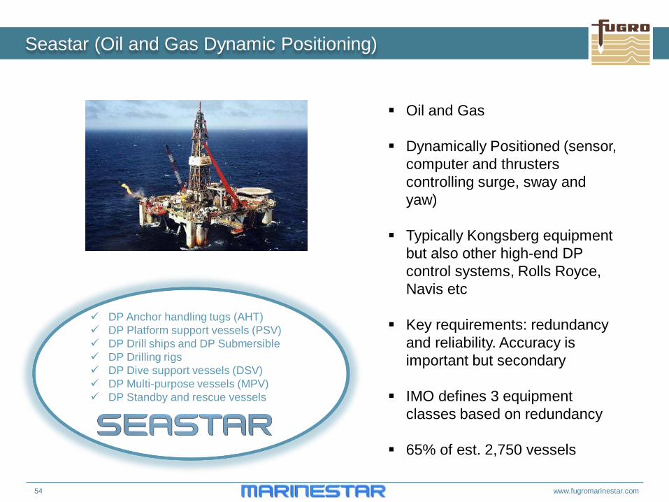
Seastar (Oil and Gas Dynamic Positioning)
DP Anchor handling tugs (AHT) DP Platform support vessels (PSV) DP Drill ships and DP Submersible DP Drilling rigs DP Dive support vessels (DSV) DP Multi-purpose vessels (MPV) DP Standby and rescue vessels
Oil and Gas
Dynamically Positioned (sensor, computer and thrusters controlling surge, sway and yaw)
Typically Kongsberg equipment but also other high-end DP control systems, Rolls Royce, Navis etc
Key requirements: redundancy and reliability. Accuracy is important but secondary
IMO defines 3 equipment classes based on redundancy
65% of est. 2,750 vessels
55 www.fugromarinestar.com
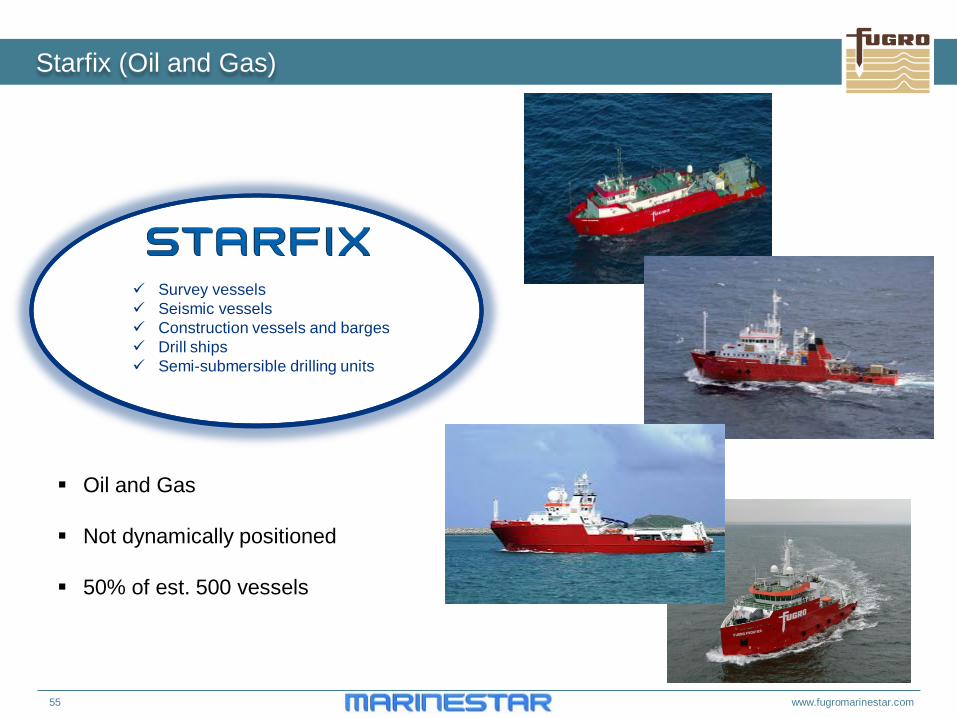
Starfix (Oil and Gas)
Survey vessels Seismic vessels Construction vessels and barges Drill ships Semi-submersible drilling units
Oil and Gas
Not dynamically positioned
50% of est. 500 vessels
56 www.fugromarinestar.com
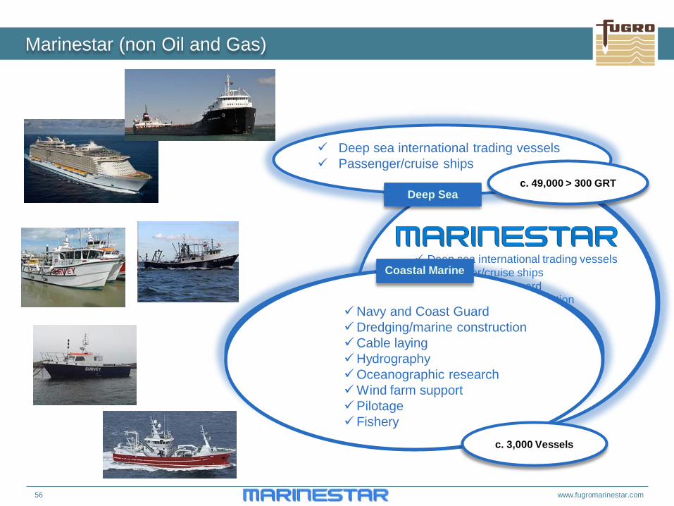
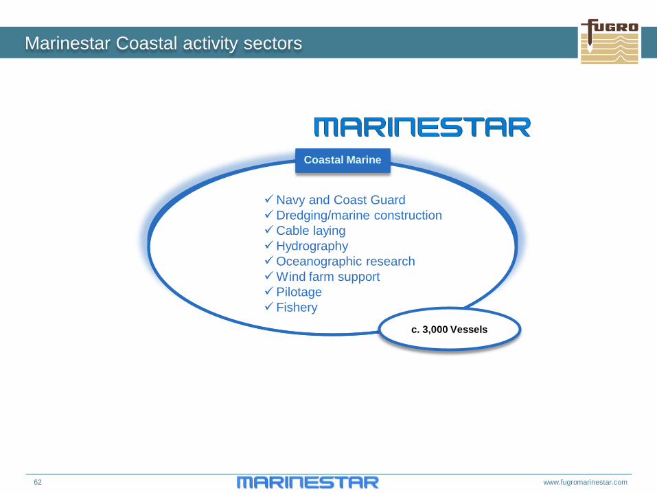
Deep sea international trading vessels Passenger/cruise ships Navy and Coast Guard Dredging/marine construction Cable laying Hydrography Oceanographic research Wind farm support Pilotage Fishery
Marinestar (non Oil and Gas)
Deep sea international trading vessels Passenger/cruise ships
Deep Sea
Navy and Coast Guard Dredging/marine construction Cable laying Hydrography Oceanographic research Wind farm support Pilotage Fishery
Coastal Marine
c. 49,000 > 300 GRT
c. 3,000 Vessels
57 www.fugromarinestar.com
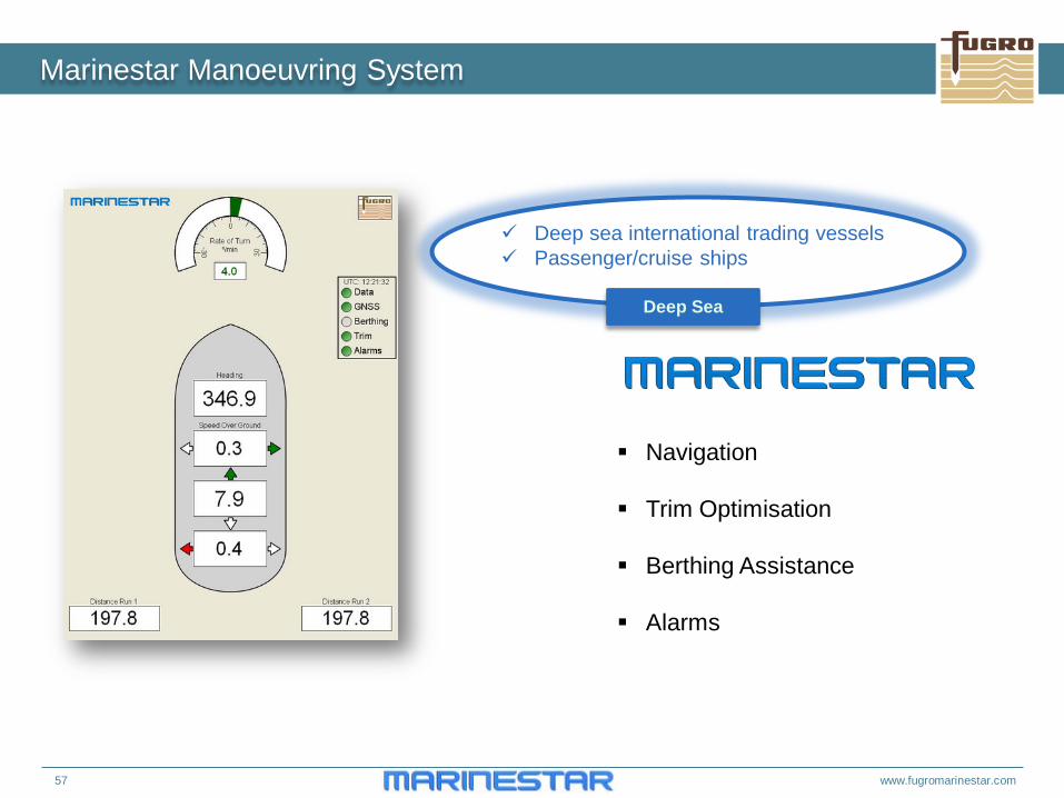
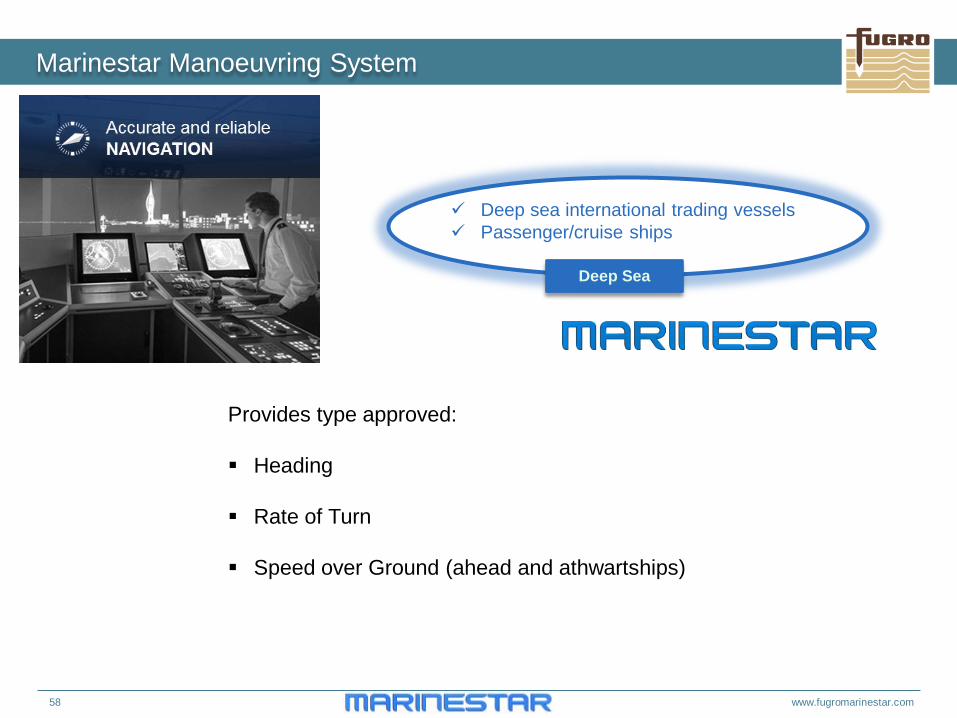
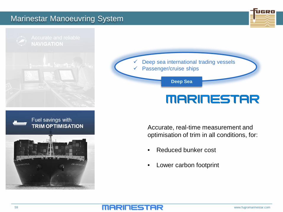
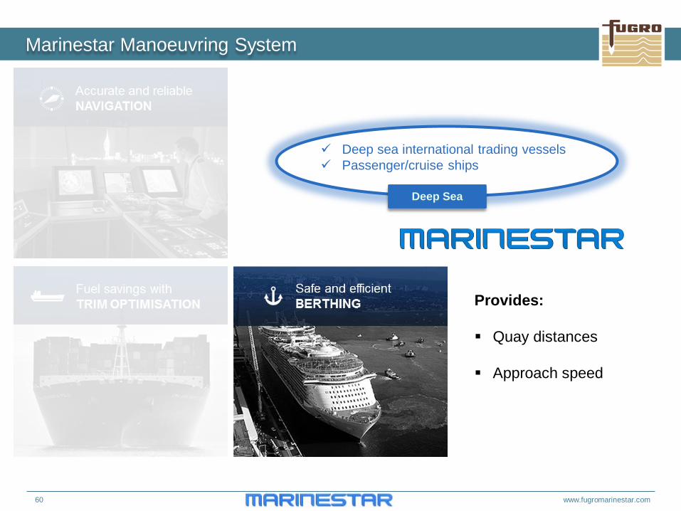
Marinestar Manoeuvring System
Deep sea international trading vessels Passenger/cruise ships
Deep Sea
Navigation
Trim Optimisation
Berthing Assistance
Alarms
58 www.fugromarinestar.com
Marinestar Manoeuvring System
Deep sea international trading vessels Passenger/cruise ships
Deep Sea
Provides type approved: Heading
Rate of Turn
Speed over Ground (ahead and athwartships)
59 www.fugromarinestar.com
Marinestar Manoeuvring System
Deep sea international trading vessels Passenger/cruise ships
Deep Sea
Accurate, real-time measurement and optimisation of trim in all conditions, for: • Reduced bunker cost
• Lower carbon footprint
60 www.fugromarinestar.com
Marinestar Manoeuvring System
Deep sea international trading vessels Passenger/cruise ships
Deep Sea
Provides: Quay distances
Approach speed
61 www.fugromarinestar.com
Marinestar Manoeuvring System
Deep sea international trading vessels Passenger/cruise ships
Deep Sea
62 www.fugromarinestar.com
Marinestar Coastal activity sectors
Navy and Coast Guard Dredging/marine construction Cable laying Hydrography Oceanographic research Wind farm support Pilotage Fishery
Coastal Marine
c. 3,000 Vessels
63 www.fugromarinestar.com
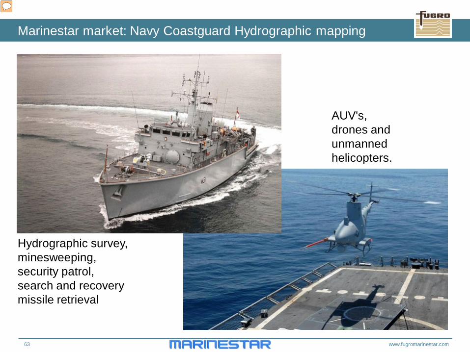
Marinestar market: Navy Coastguard Hydrographic mapping
AUV's, drones and unmanned helicopters.
Hydrographic survey, minesweeping, security patrol, search and recovery missile retrieval
AUV's, drones and unmanned helicopters.
64 www.fugromarinestar.com
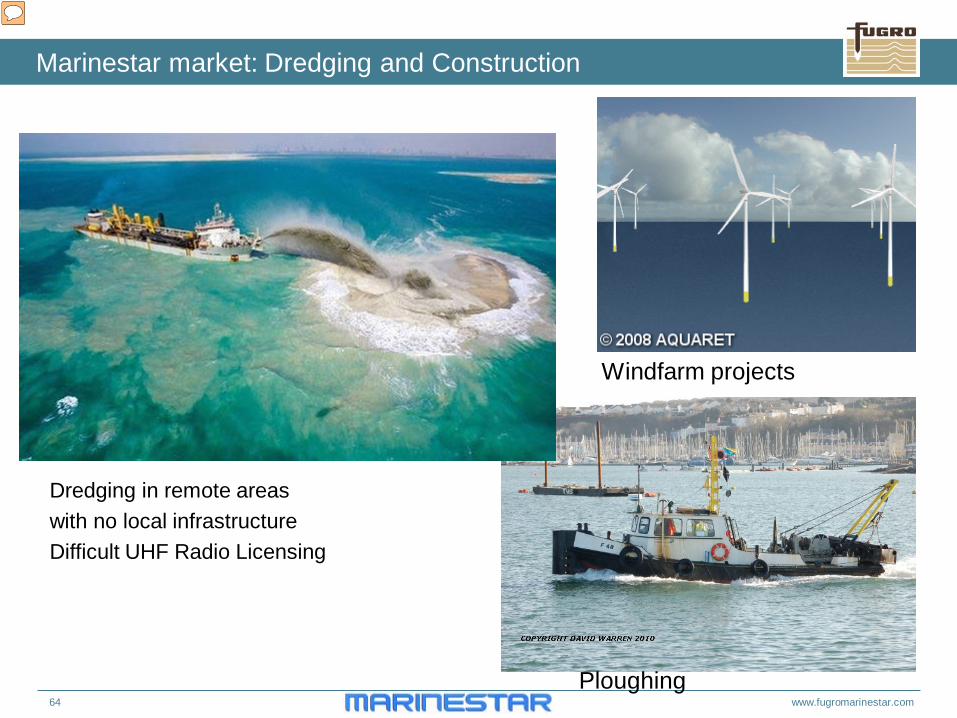
Marinestar market: Dredging and Construction
Dredging in remote areas with no local infrastructure Difficult UHF Radio Licensing
Ploughing
Windfarm projects
65 www.fugromarinestar.com
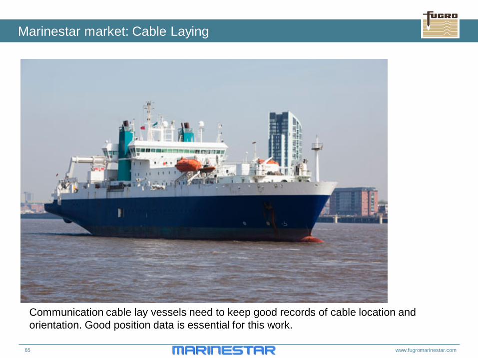
Marinestar market: Cable Laying
Communication cable lay vessels need to keep good records of cable location and orientation. Good position data is essential for this work.
66 www.fugromarinestar.com
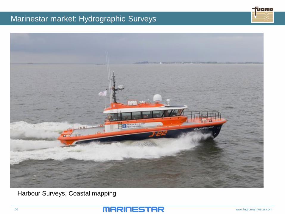
Marinestar market: Hydrographic Surveys
Harbour Surveys, Coastal mapping
67 www.fugromarinestar.com
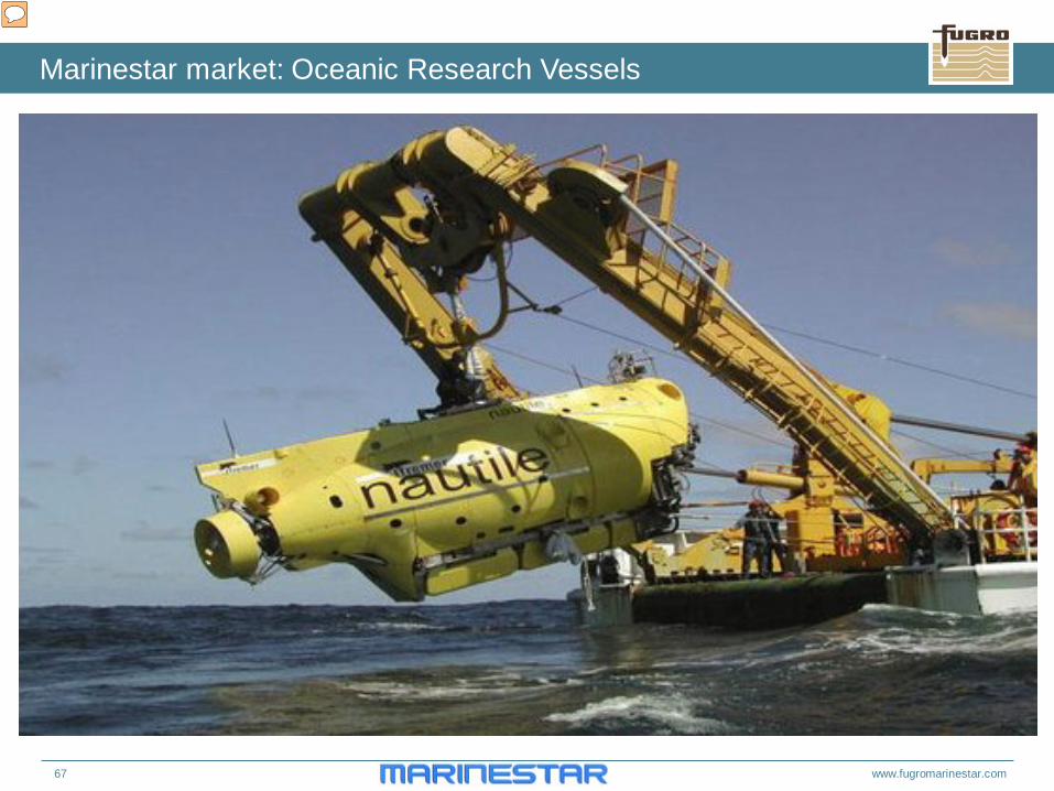
Marinestar market: Oceanic Research Vessels
68 www.fugromarinestar.com
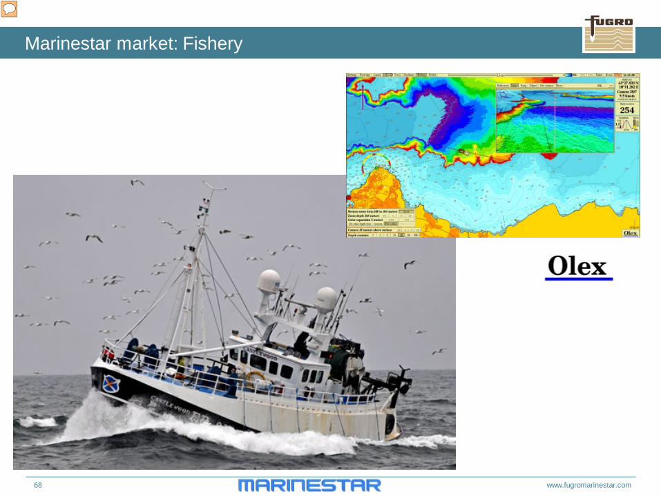
Marinestar market: Fishery
69 www.fugromarinestar.com
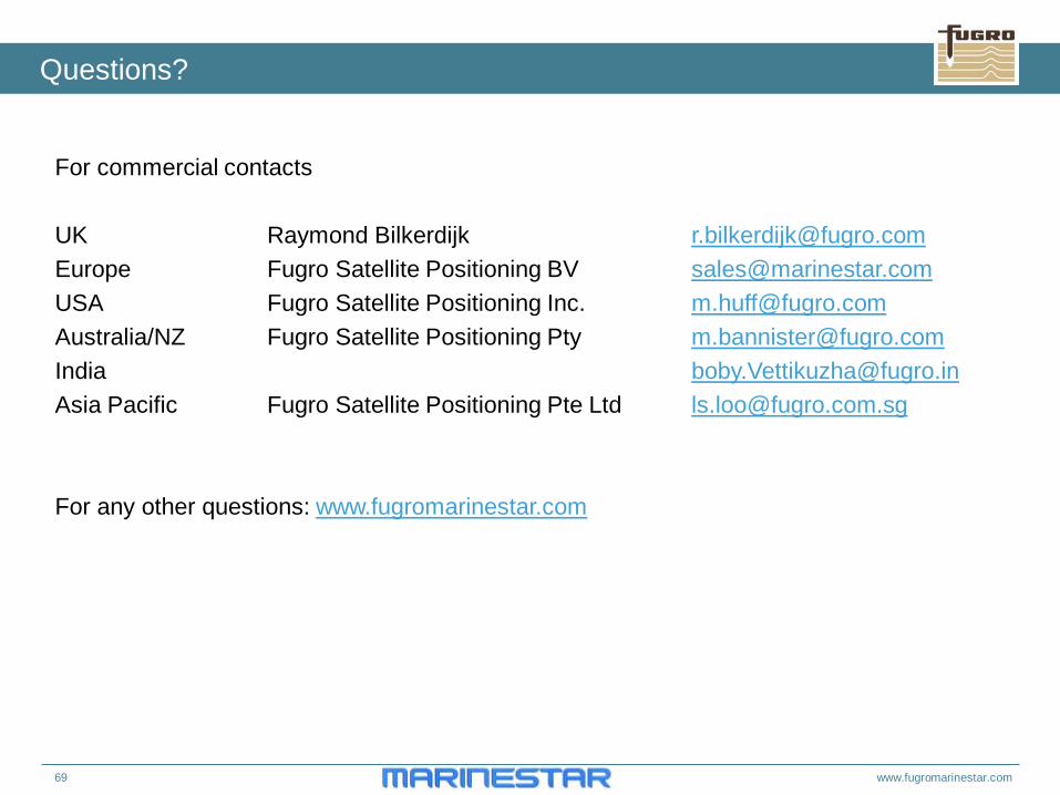
Questions?
For commercial contacts UK Raymond Bilkerdijk [email protected] Europe Fugro Satellite Positioning BV [email protected] USA Fugro Satellite Positioning Inc. [email protected] Australia/NZ Fugro Satellite Positioning Pty [email protected] India [email protected] Asia Pacific Fugro Satellite Positioning Pte Ltd [email protected] For any other questions: www.fugromarinestar.com


![[Sky-Tel] RTK Extend. Navcom Starfire Satcom GNSS Augmentation Extends RTK When Lacks Coverage](https://img.pdfslide.us/doc/110x75/55720524497959fc0b8b66e4/sky-tel-rtk-extend-navcom-starfire-satcom-gnss-augmentation-extends-rtk-when-lacks-coverage.jpg)