Embed Size (px)
Citation preview
Inland hydro‐climatic interaction: Effects of human water useon regional climate
Georgia Destouni,1 Shilpa M. Asokan,1 and Jerker Jarsjö1
Received 30 May 2010; revised 29 July 2010; accepted 9 August 2010; published 22 September 2010.
[1] This study has quantified the regional evaporation andevapotranspiration changes, and the associated latent heatflux and surface temperature changes in the Central Asianregion of the Aral Sea drainage basin and the Aral Sea itselffrom the pre‐1950 period of the 20th century to 1983–2002.The human water use for irrigation yielded an averageregional cooling effect of −0.6 °C due to increased evapo-transpiration and latent heat flux from the irrigated land. Therunoff water diverted for irrigation was more than 80% of thepre‐1950 runoff into the terminal Aral Sea, and was largelylost from the regional water system by the evapotranspirationincrease. The Aral Sea shrank due to this water loss, resultingin decreased evaporation and latent heat flux from the pre‐1950 Aral Sea area extent, with an average regional warmingeffect of 0.5 °C. In general, the endorheic (land‐internal)runoff and relative consumptive use of irrigation water fromthat runoff determine the relative inland water area shrinkage,its warming effect, and to what extent the warming counter-acts the cooling effect of irrigation. Citation: Destouni, G.,S. M. Asokan, and J. Jarsjö (2010), Inland hydro‐climatic interac-tion: Effects of human water use on regional climate, Geophys.Res. Lett., 37, L18402, doi:10.1029/2010GL044153.
1. Introduction
[2] Land use alteration of soil moisture by irrigation canconsiderably affect regional climate [Boucher et al., 2004;Bonfils and Lobell, 2007; Kueppers et al., 2007; Lobell et al.,2009]. The geographic variability of this effect has beensuggested to depend on two main factors that vary betweenregions [Lobell et al., 2009]: 1) the extent of irrigated landarea; and 2) the linkage between the climate regime and theland surface processes [e.g., Koster et al., 2004]. Both ofthese factors also involve to some degree the regional watercycling and its use and alteration by humans.[3] Regarding factor 1, Lobell et al. [2009] found a lack
of agreement between climate simulation results and tem-perature observations in the Aral Sea region in Central Asia.Climate simulations that neglected irrigation yielded a tem-perature bias that shifted to an opposite bias in climatesimulations that accounted for irrigation. Lobell et al. [2009]suggested that the resulting bias in simulations that didaccount for irrigation might depend on inaccuracy withregard to how much water was actually used for irrigation.This explanation indicates a possible direct effect of human
water use on the regional climate, in addition to the effectsof changes in global climate and regional land‐use.[4] Regarding factor 2, Schär et al. [2004] and Seneviratne
et al. [2006] identified an important soil moisture‐precipitation feedback to regional climate as responsible forsignificant correlation between temperature and precipita-tion anomalies, even in regions where low‐resolution globalclimate modeling would indicate weak soil moisture‐atmosphere coupling [Koster et al., 2004]. However, soilmoisture does not only change as a feedback to climatechange, but is also directly altered by human land and wateruse. In irrigated land, soil moisture depends directly on theapplied amount of irrigation water. Dams and engineeredwater diversions also change soil moisture conditions byturning former land areas into surface water areas and viceversa. Also with regard to factor 2, human water use changemay thus have a direct effect on regional climate change.[5] The Aral Sea region in Central Asia is a prime example
of major land and water use changes, in combination withclimatic changes during the 20th century. The former haveled to increased evapotranspiration due to irrigation in theAral Sea drainage basin (ASDB) [Shibuo et al., 2007], and todramatic shrinkage of the Aral Sea itself with effects on thehydrology and local climate at and around it [Small et al.,2001a, 2001b; Jarsjö and Destouni, 2004; Shibuo et al.,2006; Alekseeva et al., 2009]. Previous studies have investi-gated these changes separately in different sub‐areas of theASDB and the Aral Sea. However, the combined effects of allhydro‐climatic interactions and changes over the wholecoupled regional system of the ASDB and the Aral Sea hasyet to be quantified. In this study, we investigate the evapo-ration and evapotranspiration changes, and the associatedlatent heat flux and surface temperature changes in thiscoupled system from the pre‐1950 period of the 20th centuryto 1983–2002. These results are then used for quantifyingand distinguishing the role of human water use for theobserved regional hydro‐climatic changes.
2. Materials and Methods
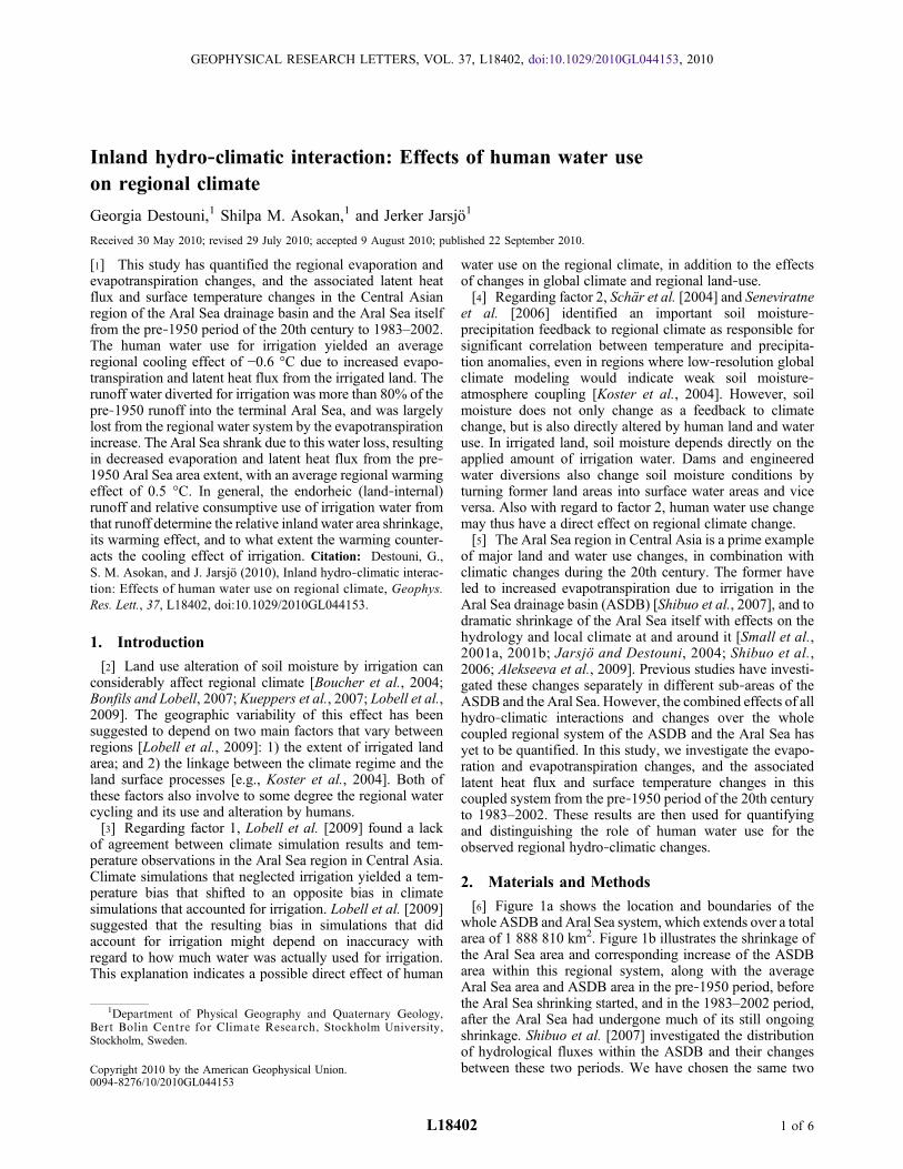
[6] Figure 1a shows the location and boundaries of thewhole ASDB and Aral Sea system, which extends over a totalarea of 1 888 810 km2. Figure 1b illustrates the shrinkage ofthe Aral Sea area and corresponding increase of the ASDBarea within this regional system, along with the averageAral Sea area and ASDB area in the pre‐1950 period, beforethe Aral Sea shrinking started, and in the 1983–2002 period,after the Aral Sea had undergone much of its still ongoingshrinkage. Shibuo et al. [2007] investigated the distributionof hydrological fluxes within the ASDB and their changesbetween these two periods. We have chosen the same two
1Department of Physical Geography and Quaternary Geology,Bert Bolin Centre for Climate Research, Stockholm University,Stockholm, Sweden.
Copyright 2010 by the American Geophysical Union.0094‐8276/10/2010GL044153
GEOPHYSICAL RESEARCH LETTERS, VOL. 37, L18402, doi:10.1029/2010GL044153, 2010
L18402 1 of 6
periods for the present quantification of changes in latent heatflux and surface temperature over the whole regional systemof the ASDB and the Aral Sea.[7] Shibuo et al. [2007] developed their spatially distrib-
uted hydrological model based on observed temperature (T)and precipitation (P) data within the ASDB [see Shibuo et al.,2007, Figure 2], as reported in the CRU TS 2.1 database byMitchell and Jones [2005] for the pre‐1950 period and the1983–2002 period. Furthermore, their hydrological modelingaccounted for the distribution of irrigated area within the
ASDB and engineered water diversions from the rivers forirrigation [see Shibuo et al., 2007, Figure 1 and Table 1]. Inthe present study, we used the spatially distributed results ofShibuo et al. [2007, Figure 3 and Table 1] for evapotranspi-ration (ET), river runoff (R), and their changes from the pre‐1950 period to 1983–2002, by averaging the results from twodifferent ET process representations considered in theirhydrological modeling. This study further extends the pre-vious analysis by quantifying also the changes in evaporation(E) from the Aral Sea itself, and the shift from E to ET in the
Figure 1. (a) The location and boundaries of the Aral Sea Drainage Basin (ASDB, with water divide shown by the red line).The shrinking Aral Sea (AS) is shown at the North‐Western part of the ASDB (green‐blue fields show the AS extent in 2005;surrounding white‐grey fields indicate the earlier, pre‐shrinkage AS extent). (b) The AS and ASDB area development shownalong with the average AS and ASDB areas in the pre‐1950 period and the 1983‐2002 period. The AS area development dataare from the Central Asia Water Information database CAWATERinfo (http://www.cawater‐info.net/aral/index_e.htm), andthe ASDB area development is determined from the drainage basin delineation of Shibuo et al. [2007] in combination with thedried seabed area, which adds to the ASDB area so that it and the AS together cover a constant total area of 1 888 810 km2.
DESTOUNI ET AL.: EFFECTS OF WATER USE ON REGIONAL CLIMATE L18402L18402
2 of 6
dried seabed area (see Text S1, section AI‐1, of the auxiliarymaterial).1
[8] From the changes in ET within the ASDB area, E inthe Aral Sea area, and E and ET in the dried seabed area,the corresponding latent heat flux changes (DF; see Text S1,section AI‐2) were quantified for each sub‐area and nor-malized by averaging over the same, fixed total regional area.The normalization made the separate DF results directlycomparable with each other and representative for the entireregional system of the ASDB and the Aral Sea. For this wholeregional system, the different components of average surfacetemperature change (DT; see Text S1, section AI‐3) werethen calculated and associated with the different causes oflatent heat flux change.[9] For the DT component calculations, the total observed
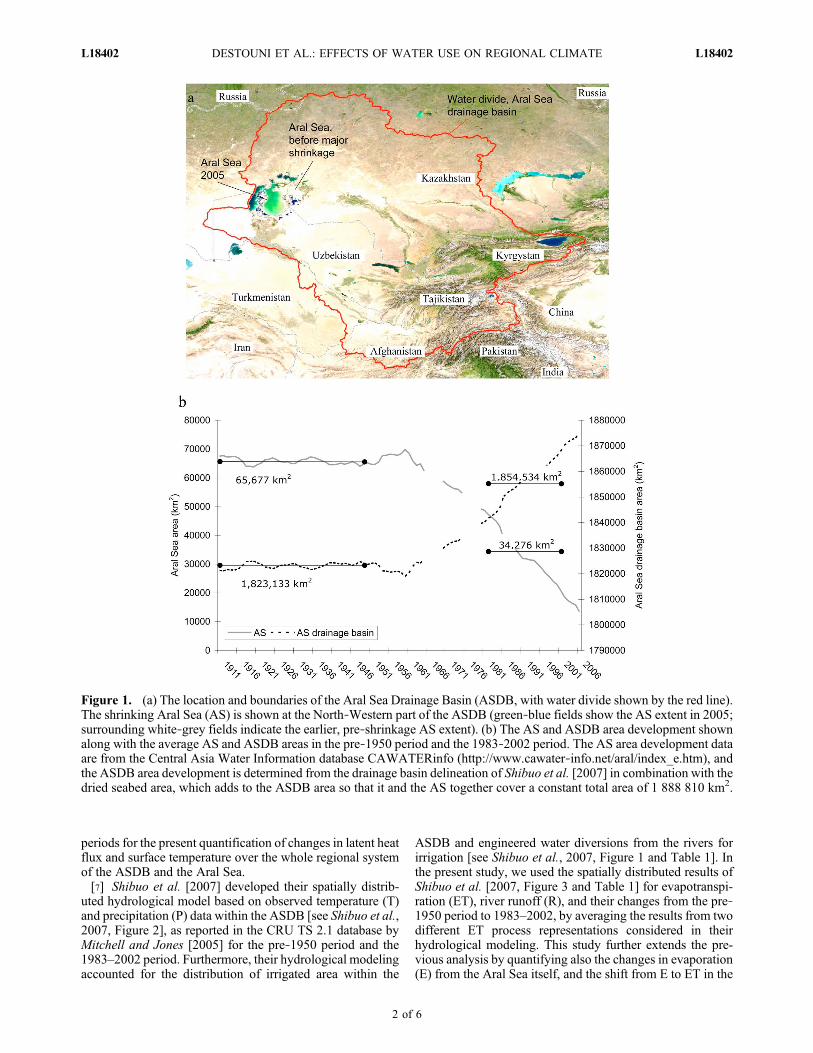
annual and regional average T change DTa = 1.1°C (from7.5°C in the pre‐1950 period to 8.6°C in the 1983–2002period [Mitchell and Jones, 2005; Shibuo et al., 2007]) isexpressed as DTa = DTcl − DTshr + DTirr = 1.1°C, whereDTcl, DTshr and DTirr are the T change components of theregional manifestation of global climate change, the Aral Seashrinkage, and the irrigation in the ASDB, respectively. TheDTirr component must then be zero in the non‐growingseason (DTirr−ngs = 0), when there is no irrigation, and non‐zero only in the growing season (DTirr−gs≠0) when there isirrigation. Figure 2 shows that such seasonality is indeedobserved in the regional temperature change, with theregional average temperature increase of 0.81°C in thegrowing season being much smaller than the increase of1.67°C in the non‐growing season.[10] Assuming that the seasonality of the continuous long‐
term temperature change components DTcl from the globalclimate change and DTshr from the Aral Sea shrinkage ismuch smaller than that of the clearly seasonal irrigationcomponentDTirr implies that the average seasonal T changescan be expressed as DTgs = DTcl − DTshr + DTirr−gs forthe growing season, and DTngs = DTcl + DTshr for thenon‐growing season. Subtracting the latter from the formeryields DTirr−gs = DTgs−DTngs, which can be estimateddirectly from the observed seasonal T changes in Figure 2
as DTirr−gs = (0.81−1.67) °C = −0.86 °C, a result that isinsensitive to the exact season length definition. The annualaverage T change component due to irrigation in the ASDBis then DTirr = −0.86·(8/12) °C = −0.57 °C.[11] Furthermore, assuming that the latent heat flux
change due to the ASDB irrigation, DFASDB−irr, affectsmore or less the same regional air mass as the latent heatflux change due to the Aral Sea shrinkage, DFAS−shr, thetemperature change component DTshr can be estimated asDTshr =DFAS−shrDTirr/DFASDB−irr (see Text S1, section AI‐2).From these estimates and the observed DTa = 1.1°C, thetemperature change component due to the regional manifes-tation of global climate change can be estimated as DTcl =DTa −DTirr −DTshr. Note thatDTcl then quantifies the totalclimate‐driven surface temperature change and not only thelatent heat‐related change contribution, whereas DTirr andDTshr are entirely due to the latent heat flux changes impliedby the regional irrigation development and associated waterdiversions and Aral Sea shrinkage.
3. Results and Discussion
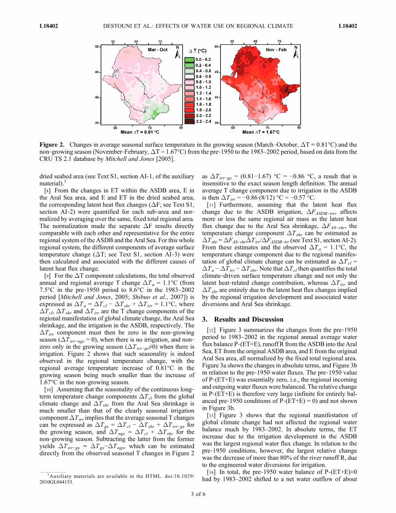
[12] Figure 3 summarizes the changes from the pre‐1950period to 1983–2002 in the regional annual average waterflux balance P‐(ET+E), runoff R from the ASDB into the AralSea, ET from the original ASDB area, and E from the originalAral Sea area, all normalized by the fixed total regional area.Figure 3a shows the changes in absolute terms, and Figure 3bin relation to the pre‐1950 water fluxes. The pre‐1950 valueof P‐(ET+E) was essentially zero, i.e., the regional incomingand outgoing water fluxes were balanced. The relative changein P‐(ET+E) is therefore very large (infinite for entirely bal-anced pre‐1950 conditions of P‐(ET+E) = 0) and not shownin Figure 3b.[13] Figure 3 shows that the regional manifestation of
global climate change had not affected the regional waterbalance much by 1983–2002. In absolute terms, the ETincrease due to the irrigation development in the ASDBwas the largest regional water flux change. In relation to thepre‐1950 conditions, however, the largest relative changewas the decrease of more than 80% of the river runoff R, dueto the engineered water diversions for irrigation.[14] In total, the pre‐1950 water balance of P‐(ET+E)≈0
had by 1983–2002 shifted to a net water outflow of about
Figure 2. Changes in average seasonal surface temperature in the growing season (March–October, DT = 0.81°C) and thenon‐growing season (November‐February,DT = 1.67°C) from the pre‐1950 to the 1983–2002 period, based on data from theCRU TS 2.1 database by Mitchell and Jones [2005].
1Auxiliary materials are available in the HTML. doi:10.1029/2010GL044153.
DESTOUNI ET AL.: EFFECTS OF WATER USE ON REGIONAL CLIMATE L18402L18402
3 of 6
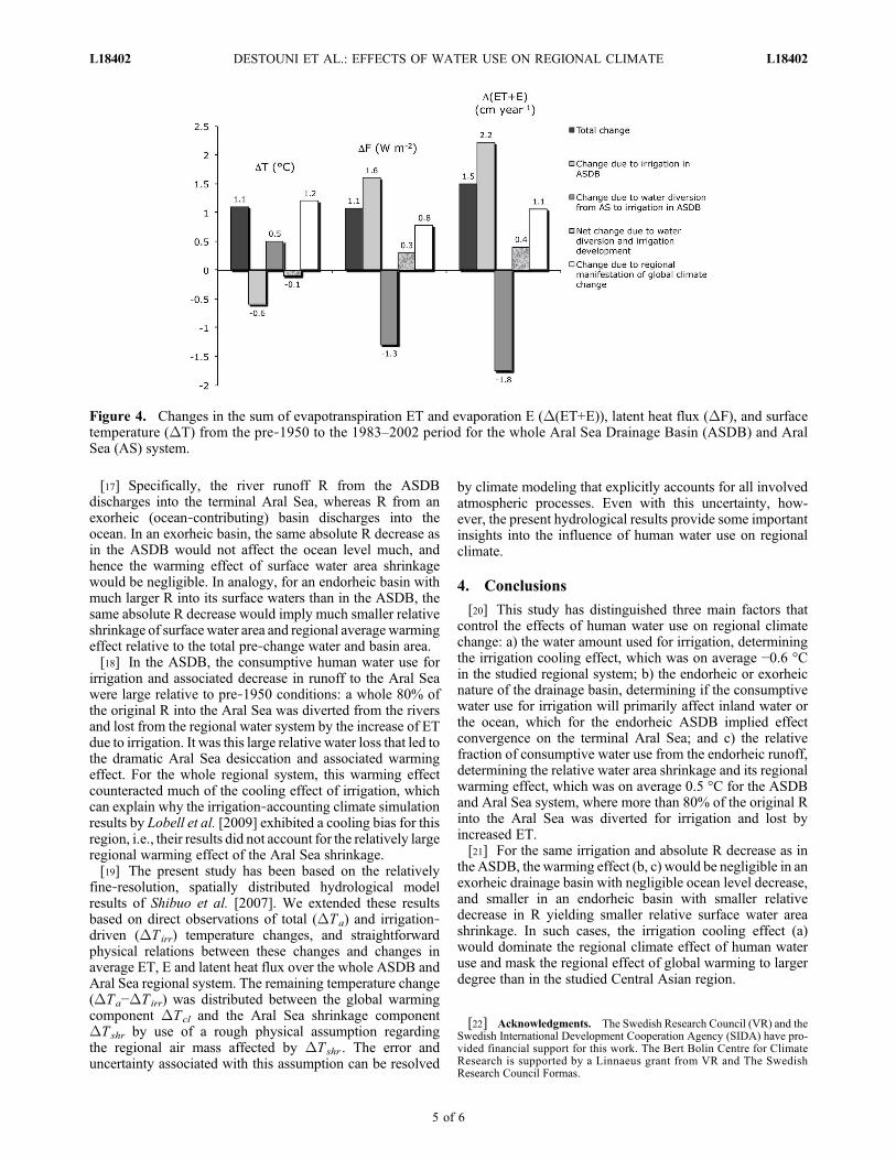
5 mm year−1. This implies that the regional water system wasin transience, so that the Aral Sea had to continue to shrinkalso after 1983–2002 (as it has) in order for this regional waterimbalance to decrease to zero by decreasing E from theshrinking Aral Sea.[15] Figure 4 summarizes the changes in total outgoing
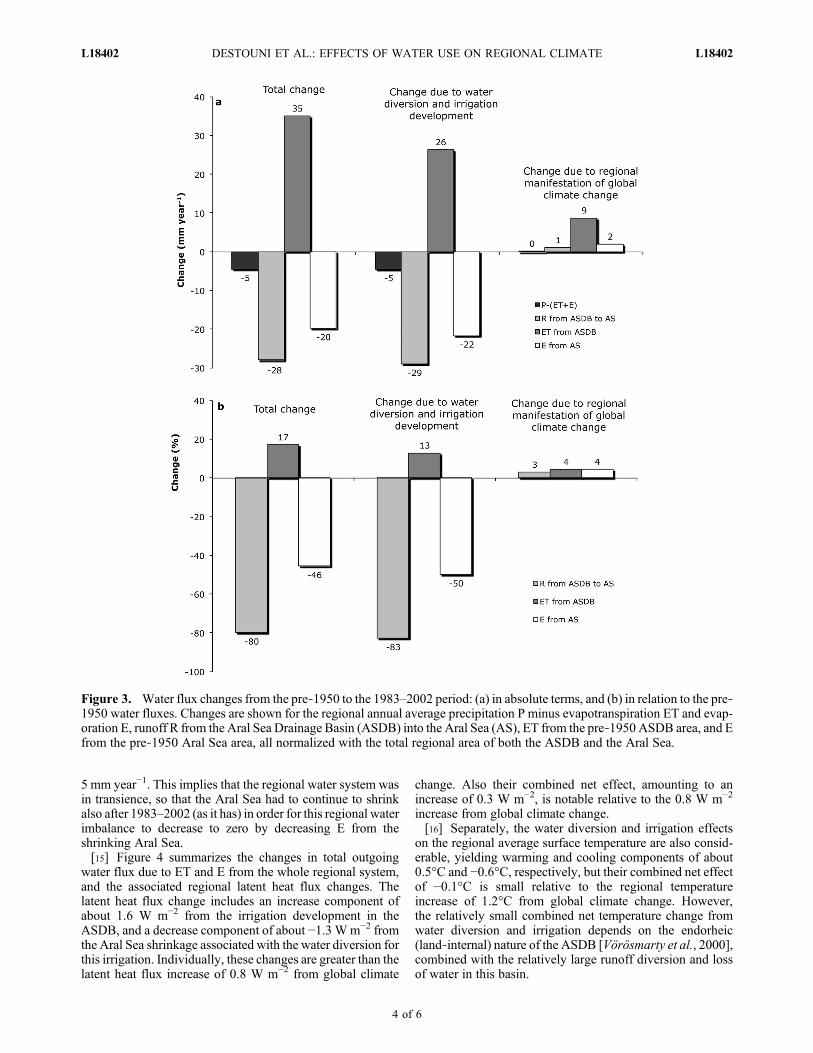
water flux due to ET and E from the whole regional system,and the associated regional latent heat flux changes. Thelatent heat flux change includes an increase component ofabout 1.6 W m−2 from the irrigation development in theASDB, and a decrease component of about −1.3 Wm−2 fromthe Aral Sea shrinkage associated with the water diversion forthis irrigation. Individually, these changes are greater than thelatent heat flux increase of 0.8 W m−2 from global climate
change. Also their combined net effect, amounting to anincrease of 0.3 W m−2, is notable relative to the 0.8 W m−2
increase from global climate change.[16] Separately, the water diversion and irrigation effects
on the regional average surface temperature are also consid-erable, yielding warming and cooling components of about0.5°C and −0.6°C, respectively, but their combined net effectof −0.1°C is small relative to the regional temperatureincrease of 1.2°C from global climate change. However,the relatively small combined net temperature change fromwater diversion and irrigation depends on the endorheic(land‐internal) nature of the ASDB [Vörösmarty et al., 2000],combined with the relatively large runoff diversion and lossof water in this basin.
Figure 3. Water flux changes from the pre‐1950 to the 1983–2002 period: (a) in absolute terms, and (b) in relation to the pre‐1950 water fluxes. Changes are shown for the regional annual average precipitation P minus evapotranspiration ET and evap-oration E, runoff R from the Aral Sea Drainage Basin (ASDB) into the Aral Sea (AS), ET from the pre‐1950 ASDB area, and Efrom the pre‐1950 Aral Sea area, all normalized with the total regional area of both the ASDB and the Aral Sea.
DESTOUNI ET AL.: EFFECTS OF WATER USE ON REGIONAL CLIMATE L18402L18402
4 of 6
[17] Specifically, the river runoff R from the ASDBdischarges into the terminal Aral Sea, whereas R from anexorheic (ocean‐contributing) basin discharges into theocean. In an exorheic basin, the same absolute R decrease asin the ASDB would not affect the ocean level much, andhence the warming effect of surface water area shrinkagewould be negligible. In analogy, for an endorheic basin withmuch larger R into its surface waters than in the ASDB, thesame absolute R decrease would imply much smaller relativeshrinkage of surface water area and regional average warmingeffect relative to the total pre‐change water and basin area.[18] In the ASDB, the consumptive human water use for
irrigation and associated decrease in runoff to the Aral Seawere large relative to pre‐1950 conditions: a whole 80% ofthe original R into the Aral Sea was diverted from the riversand lost from the regional water system by the increase of ETdue to irrigation. It was this large relative water loss that led tothe dramatic Aral Sea desiccation and associated warmingeffect. For the whole regional system, this warming effectcounteracted much of the cooling effect of irrigation, whichcan explain why the irrigation‐accounting climate simulationresults by Lobell et al. [2009] exhibited a cooling bias for thisregion, i.e., their results did not account for the relatively largeregional warming effect of the Aral Sea shrinkage.[19] The present study has been based on the relatively
fine‐resolution, spatially distributed hydrological modelresults of Shibuo et al. [2007]. We extended these resultsbased on direct observations of total (DTa) and irrigation‐driven (DTirr) temperature changes, and straightforwardphysical relations between these changes and changes inaverage ET, E and latent heat flux over the whole ASDB andAral Sea regional system. The remaining temperature change(DTa−DTirr) was distributed between the global warmingcomponent DTcl and the Aral Sea shrinkage componentDTshr by use of a rough physical assumption regardingthe regional air mass affected by DTshr . The error anduncertainty associated with this assumption can be resolved
by climate modeling that explicitly accounts for all involvedatmospheric processes. Even with this uncertainty, how-ever, the present hydrological results provide some importantinsights into the influence of human water use on regionalclimate.
4. Conclusions
[20] This study has distinguished three main factors thatcontrol the effects of human water use on regional climatechange: a) the water amount used for irrigation, determiningthe irrigation cooling effect, which was on average −0.6 °Cin the studied regional system; b) the endorheic or exorheicnature of the drainage basin, determining if the consumptivewater use for irrigation will primarily affect inland water orthe ocean, which for the endorheic ASDB implied effectconvergence on the terminal Aral Sea; and c) the relativefraction of consumptive water use from the endorheic runoff,determining the relative water area shrinkage and its regionalwarming effect, which was on average 0.5 °C for the ASDBand Aral Sea system, where more than 80% of the original Rinto the Aral Sea was diverted for irrigation and lost byincreased ET.[21] For the same irrigation and absolute R decrease as in
the ASDB, the warming effect (b, c) would be negligible in anexorheic drainage basin with negligible ocean level decrease,and smaller in an endorheic basin with smaller relativedecrease in R yielding smaller relative surface water areashrinkage. In such cases, the irrigation cooling effect (a)would dominate the regional climate effect of human wateruse and mask the regional effect of global warming to largerdegree than in the studied Central Asian region.
[22] Acknowledgments. The Swedish Research Council (VR) and theSwedish International Development Cooperation Agency (SIDA) have pro-vided financial support for this work. The Bert Bolin Centre for ClimateResearch is supported by a Linnaeus grant from VR and The SwedishResearch Council Formas.
Figure 4. Changes in the sum of evapotranspiration ET and evaporation E (D(ET+E)), latent heat flux (DF), and surfacetemperature (DT) from the pre‐1950 to the 1983–2002 period for the whole Aral Sea Drainage Basin (ASDB) and AralSea (AS) system.
DESTOUNI ET AL.: EFFECTS OF WATER USE ON REGIONAL CLIMATE L18402L18402
5 of 6
ReferencesAlekseeva, I., J. Jarsjö, C. Schrum, and G. Destouni (2009), Reproducingthe Aral Sea water budget and sea‐groundwater dynamics between1979 and 1993 using a coupled 3‐D sea‐ice‐groundwater model,J. Mar. Syst., 76, 296–309, doi:10.1016/j.jmarsys.2008.03.018.
Bonfils, C., and D. Lobell (2007), Empirical evidence for a recent slow-down in irrigation‐induced cooling, Proc. Natl. Acad. Sci. U. S. A.,104, 13,582–13,587, doi:10.1073/pnas.0700144104.
Boucher, O., G. Myhre, and A. Myhre (2004), Direct human influence ofirrigation on atmospheric water vapor and climate, Clim. Dyn., 22,597–603, doi:10.1007/s00382-004-0402-4.
Jarsjö, J., and G. Destouni (2004), Groundwater discharge into the Aral Seaafter 1960, J. Mar. Syst., 47, 109–120, doi:10.1016/j.jmarsys.2003.12.013.
Koster, R. D., et al. (2004), Regions of strong coupling between soilmoisture and precipitation, Science, 305, 1138–1140, doi:10.1126/science.1100217.
Kueppers, L. M., M. A. Snyder, and L. C. Sloan (2007), Irrigation coolingeffect: Regional climate forcing by land‐use change, Geophys. Res. Lett.,34, L03703, doi:10.1029/2006GL028679.
Lobell, D., G. Bala, A. Mirin, T. Phillips, R. Maxwell, and D. Rotman(2009), Regional differences in the influence of irrigation on climate,J. Clim., 22, 2248–2255, doi:10.1175/2008JCLI2703.1.
Mitchell, T. D., and P. D. Jones (2005), An improved method of construct-ing a database of monthly climate observations and associated high‐resolution grids, Int. J. Climatol., 25, 693–712, doi:10.1002/joc.1181.
Schär, C., P. L. Vidale, D. Lüthi, C. Frei, C. Haberli, M. A. Liniger, andC. Appenzeller (2004), The role of increasing variability in Europeansummer heat waves, Nature, 427, 332–336, doi:10.1038/nature02300.
Seneviratne, S. I., D. Lüthi, M. Litschi, and C. Schär (2006), Land–atmosphere coupling and climate change in Europe, Nature, 443, 205–209, doi:10.1038/nature05095.
Shibuo, Y., J. Jarsjö, and G. Destouni (2006), Bathymetry‐topographyeffects on saltwater‐fresh groundwater interactions around the shrinkingAral Sea,Water Resour. Res., 42, W11410, doi:10.1029/2005WR004207.
Shibuo, Y., J. Jarsjö, and G. Destouni (2007), Hydrological responses toclimate change and irrigation in the Aral Sea drainage basin, Geophys.Res. Lett., 34, L21406, doi:10.1029/2007GL031465.
Small, E. E., L. C. Sloan, and D. Nychka (2001a), Changes in surfaceair temperature caused by desiccation of the Aral Sea, J. Clim., 14(3),284–299, doi:10.1175/1520-0442(2001)014<0284:CISATC>2.0.CO;2.
Small, E. E., F. Giorgi, L. C. Sloan, and S. Hostetler (2001b), The effectsof desiccation and climatic change on the hydrology of the Aral Sea,J. Clim., 14(3), 300–322, doi:10.1175/1520-0442(2001)013<0300:TEO-DAC>2.0.CO;2.
Vörösmarty, C. J., B. M. Fekete, M. Meybeck, and R. B. Lammers (2000),Global system of rivers: Its role in organizing continental land massand defining land‐to‐ocean linkages, Global Biogeochem. Cycles, 14,599–621, doi:10.1029/1999GB900092.
S. M. Asokan, G. Destouni, and J. Jarsjö, Department of PhysicalGeography and Quaternary Geology, Bert Bolin Centre for ClimateResearch, Stockholm University, SE‐106 91 Stockholm, Sweden.([email protected])
DESTOUNI ET AL.: EFFECTS OF WATER USE ON REGIONAL CLIMATE L18402L18402
6 of 6