Embed Size (px)
Citation preview

30 November 2020
Maiden Silica Sand Resource for Cape Flattery Project Key highlights
• Maiden JORC Inferred Resource estimate of 12.85 million tonnes @ 99.28% SiO2 • Resource estimate was based on shallow manually drilled auger holes to 5m depth • Drilling program begins shortly, able to drill >20m depth on white silica sand dunes • Proposed drill area is adjacent to the Port of Cape Flattery (excluded from the Great Barrier
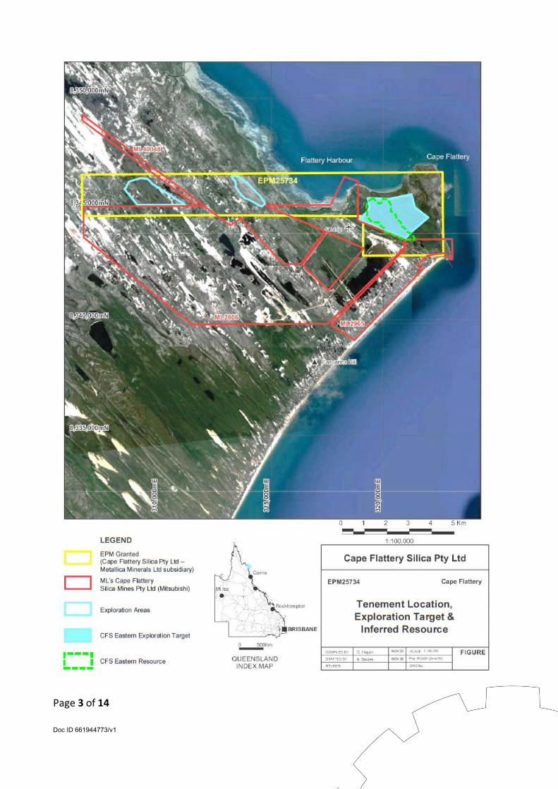
Reef Marine Park) and the world class Cape Flattery Silica sand mine owned by Mitsubishi. Metallica Minerals Limited (Metallica, ASX: MLM) is pleased to announce a Maiden JORC Inferred resource of 12.85 million tonnes @ 99.28% SiO2 for its 100% owned Cape Flattery Silica Sand Project (CFS). This result has been based on hand auger work completed in previous programs. Metallica decided to have the previous auger results examined following COVID-19 delays to the signing of the Conduct & Compensation Agreement (CCA) with Traditional Land Owners, (see ASX release: Conduct & Compensation Agreement signed for the Cape Flattery Silica Sand Project; 25 November 2020). With planning well underway for a drilling program with up to 25 drill holes on the tenement adjacent to Mitsubishi’s world class project, Metallica is encouraged by the initial JORC estimate and is looking forward to the more extensive and deeper drill program results. Resource Summary On 17 January 2020, Metallica advised the ASX that a sampling program completed in the last quarter 2019 at CFS in Far North Queensland had confirmed the presence of high purity silica sands. This exploration program consisted of eight (8) hand auger holes to a maximum depth of 5m within the CFS Eastern Exploration Target area of the tenement (refer to tenement map on page 3). (see ASX Release “High Purity Silica Sands confirmed at Cape Flattery” 17 January 2020). The independent assessment of this auger hole drilling was conducted by consultants Ausrocks Pty Ltd. The final marketable product being sought is a high silica (SiO2) grade sand, the SiO2 content by percentage would be used to quantify in-situ material as a resource. Cut-off grades were adopted based on analysis of raw assay data and grade tonnage plots completed on the block model to optimise the average SiO2 grade and quantity of the resource at varied reporting levels.
Page 2 of 14 Doc ID 661944773/v1
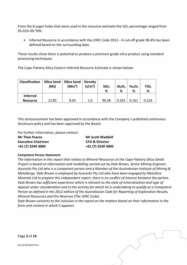
From the 8 auger holes that were used in the resource estimate the SiO2 percentage ranged from 95.01%-99.70%:
• Inferred Resource in accordance with the JORC Code 2012 – A cut-off grade 98.4% has been defined based on the surrounding data.
These results show there is potential to produce a premium grade silica product using standard processing techniques. The Cape Flattery Silica Eastern Inferred Resource Estimate is shown below:
Classification Silica Sand (Mt)
Silica Sand (Mm3)
Density (t/m3)
SiO2
%
AI2O3
%
Fe2O3
%
TiO2
% Inferred Resource
12.85
8.03
1.6
99.28
0.201
0.161
0.226
This announcement has been approved in accordance with the Company’s published continuous disclosure policy and has been approved by the Board. For further information, please contact: Mr Theo Psaros Mr Scott Waddell Executive Chairman CFO & Director +61 (7) 3249 3000 +61 (7) 3249 3000 Competent Person Statement The information in this report that relates to Mineral Resources at the Cape Flattery Silica Sands Project is based on information and modelling carried out by Dale Brown, Senior Mining Engineer, Ausrocks Pty Ltd who is a competent person and a Member of the Australasian Institute of Mining & Metallurgy. Dale Brown is employed by Ausrocks Pty Ltd who have been engaged by Metallica Minerals Ltd to prepare this independent report, there is no conflict of interest between the parties. Dale Brown has sufficient experience which is relevant to the style of mineralisation and type of deposit under consideration and to the activity for which he is undertaking to qualify as a Competent Person as defined in the 2012 edition of the Australasian Code for Reporting of Exploration Results, Mineral Resources and Ore Reserves (The JORC Code). Dale Brown consents to the inclusion in the report on the matters based on their information in the form and context in which it appears.
Page 3 of 14 Doc ID 661944773/v1
Page 4 of 14 Doc ID 661944773/v1
JORC Code, 2012 Edition – Table 1 report template
Section 1 Sampling Techniques and Data (Criteria in this section apply to all succeeding sections.) Criteria JORC Code explanation Commentary
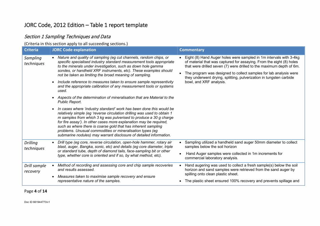
Sampling techniques
• Nature and quality of sampling (eg cut channels, random chips, or specific specialised industry standard measurement tools appropriate to the minerals under investigation, such as down hole gamma sondes, or handheld XRF instruments, etc). These examples should not be taken as limiting the broad meaning of sampling.
• Include reference to measures taken to ensure sample representivity and the appropriate calibration of any measurement tools or systems used.
• Aspects of the determination of mineralisation that are Material to the Public Report.
• In cases where ‘industry standard’ work has been done this would be relatively simple (eg ‘reverse circulation drilling was used to obtain 1 m samples from which 3 kg was pulverised to produce a 30 g charge for fire assay’). In other cases more explanation may be required, such as where there is coarse gold that has inherent sampling problems. Unusual commodities or mineralisation types (eg submarine nodules) may warrant disclosure of detailed information.
• Eight (8) Hand Auger holes were sampled in 1m intervals with 3-4kg of material that was captured for assaying. From the eight (8) holes that were drilled seven (7) were drilled to the maximum depth of 6m.
• The program was designed to collect samples for lab analysis were they underwent drying, splitting, pulverization in tungsten carbide bowl, and XRF analysis.
Drilling techniques
• Drill type (eg core, reverse circulation, open-hole hammer, rotary air blast, auger, Bangka, sonic, etc) and details (eg core diameter, triple or standard tube, depth of diamond tails, face-sampling bit or other type, whether core is oriented and if so, by what method, etc).
• Sampling utilized a handheld sand auger 50mm diameter to collect samples below the soil horizon
• Hand Auger samples were collected in 1m increments for commercial laboratory analysis.
Drill sample recovery
• Method of recording and assessing core and chip sample recoveries and results assessed.
• Measures taken to maximise sample recovery and ensure representative nature of the samples.
• Hand augering was used to collect a fresh sample(s) below the soil horizon and sand samples were retrieved from the sand auger by spilling onto clean plastic sheet.
• The plastic sheet ensured 100% recovery and prevents spillage and
Page 5 of 14 Doc ID 661944773/v1
Criteria JORC Code explanation Commentary
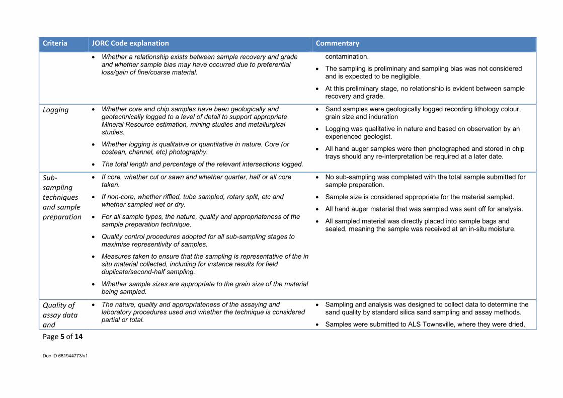
• Whether a relationship exists between sample recovery and grade and whether sample bias may have occurred due to preferential loss/gain of fine/coarse material.
contamination.
• The sampling is preliminary and sampling bias was not considered and is expected to be negligible.
• At this preliminary stage, no relationship is evident between sample recovery and grade.
Logging • Whether core and chip samples have been geologically and geotechnically logged to a level of detail to support appropriate Mineral Resource estimation, mining studies and metallurgical studies.
• Whether logging is qualitative or quantitative in nature. Core (or costean, channel, etc) photography.
• The total length and percentage of the relevant intersections logged.
• Sand samples were geologically logged recording lithology colour, grain size and induration
• Logging was qualitative in nature and based on observation by an experienced geologist.
• All hand auger samples were then photographed and stored in chip trays should any re-interpretation be required at a later date.
Sub-sampling techniques and sample preparation
• If core, whether cut or sawn and whether quarter, half or all core taken.
• If non-core, whether riffled, tube sampled, rotary split, etc and whether sampled wet or dry.
• For all sample types, the nature, quality and appropriateness of the sample preparation technique.
• Quality control procedures adopted for all sub-sampling stages to maximise representivity of samples.
• Measures taken to ensure that the sampling is representative of the in situ material collected, including for instance results for field duplicate/second-half sampling.
• Whether sample sizes are appropriate to the grain size of the material being sampled.
• No sub-sampling was completed with the total sample submitted for sample preparation.
• Sample size is considered appropriate for the material sampled.
• All hand auger material that was sampled was sent off for analysis.
• All sampled material was directly placed into sample bags and sealed, meaning the sample was received at an in-situ moisture.
Quality of assay data and
• The nature, quality and appropriateness of the assaying and laboratory procedures used and whether the technique is considered partial or total.
• Sampling and analysis was designed to collect data to determine the sand quality by standard silica sand sampling and assay methods.
• Samples were submitted to ALS Townsville, where they were dried,
Page 6 of 14 Doc ID 661944773/v1
Criteria JORC Code explanation Commentary
laboratory tests
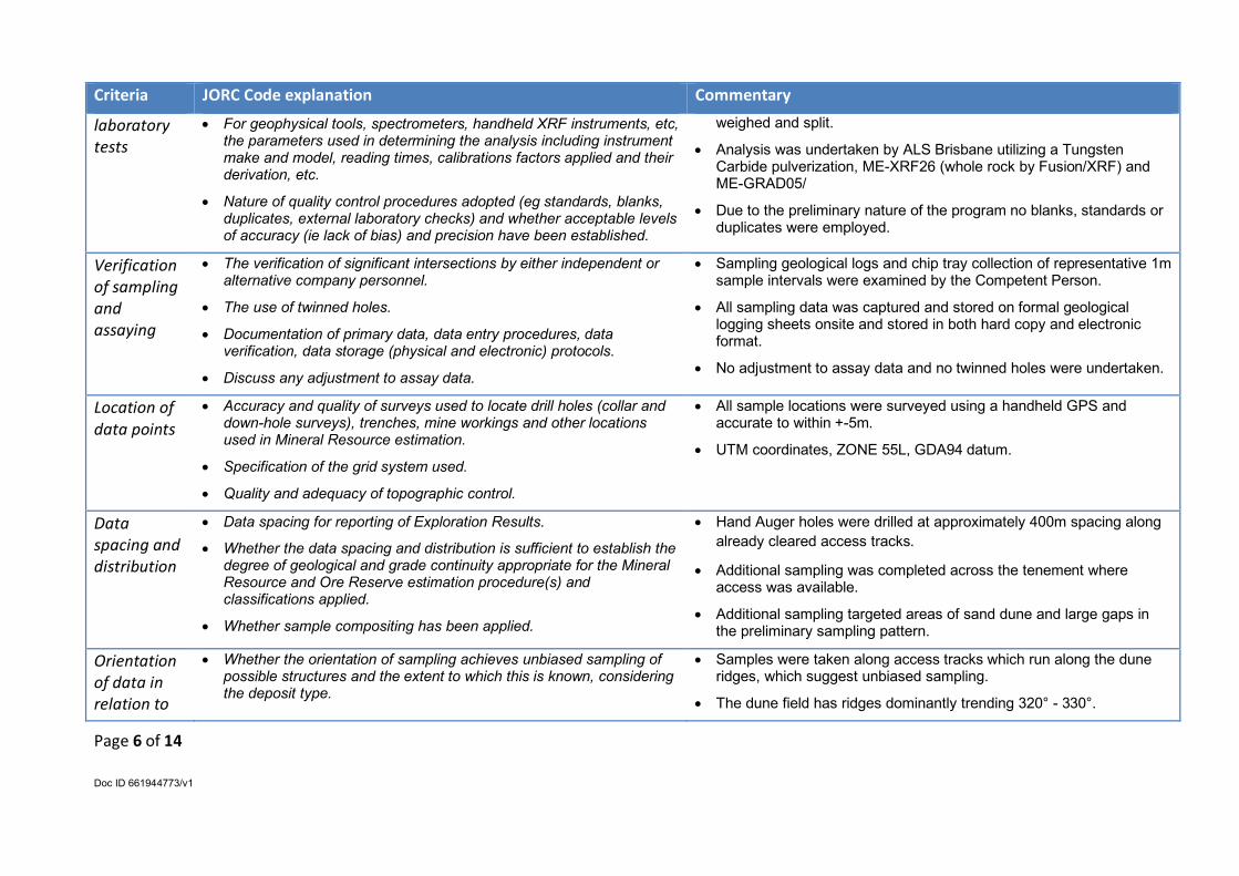
• For geophysical tools, spectrometers, handheld XRF instruments, etc, the parameters used in determining the analysis including instrument make and model, reading times, calibrations factors applied and their derivation, etc.
• Nature of quality control procedures adopted (eg standards, blanks, duplicates, external laboratory checks) and whether acceptable levels of accuracy (ie lack of bias) and precision have been established.
weighed and split.
• Analysis was undertaken by ALS Brisbane utilizing a Tungsten Carbide pulverization, ME-XRF26 (whole rock by Fusion/XRF) and ME-GRAD05/
• Due to the preliminary nature of the program no blanks, standards or duplicates were employed.
Verification of sampling and assaying
• The verification of significant intersections by either independent or alternative company personnel.
• The use of twinned holes.
• Documentation of primary data, data entry procedures, data verification, data storage (physical and electronic) protocols.
• Discuss any adjustment to assay data.
• Sampling geological logs and chip tray collection of representative 1m sample intervals were examined by the Competent Person.
• All sampling data was captured and stored on formal geological logging sheets onsite and stored in both hard copy and electronic format.
• No adjustment to assay data and no twinned holes were undertaken.
Location of data points
• Accuracy and quality of surveys used to locate drill holes (collar and down-hole surveys), trenches, mine workings and other locations used in Mineral Resource estimation.
• Specification of the grid system used.
• Quality and adequacy of topographic control.
• All sample locations were surveyed using a handheld GPS and accurate to within +-5m.
• UTM coordinates, ZONE 55L, GDA94 datum.
Data spacing and distribution
• Data spacing for reporting of Exploration Results.
• Whether the data spacing and distribution is sufficient to establish the degree of geological and grade continuity appropriate for the Mineral Resource and Ore Reserve estimation procedure(s) and classifications applied.
• Whether sample compositing has been applied.
• Hand Auger holes were drilled at approximately 400m spacing along already cleared access tracks.
• Additional sampling was completed across the tenement where access was available.
• Additional sampling targeted areas of sand dune and large gaps in the preliminary sampling pattern.
Orientation of data in relation to
• Whether the orientation of sampling achieves unbiased sampling of possible structures and the extent to which this is known, considering the deposit type.
• Samples were taken along access tracks which run along the dune ridges, which suggest unbiased sampling.
• The dune field has ridges dominantly trending 320° - 330°.
Page 7 of 14 Doc ID 661944773/v1
Criteria JORC Code explanation Commentary
geological structure
• If the relationship between the drilling orientation and the orientation of key mineralised structures is considered to have introduced a sampling bias, this should be assessed and reported if material.
• Hand auger holes were vertical (-90˚)
Sample security
• The measures taken to ensure sample security. • Samples were placed into helicopter when collected for transport back to Cooktown for all exploration target areas. Hand auger samples were collected in a light vehicle (LV) then transferred back to Cooktown.
• On return to Cooktown, samples were sorted and placed into numbered plastic poly-weave bags and secured inside the LV.
• The samples were transported by LV and delivered to the ALS Laboratory in Townsville.
Audits or reviews
• The results of any audits or reviews of sampling techniques and data. • The original exploration target and associated data has been reviewed prior to the preparation of the Inferred Resource in accordance with the JORC Code 2012.
• All inferred resource work has been reviewed internally by Ausrocks.
Section 2 Reporting of Exploration Results (Criteria listed in the preceding section also apply to this section.) Criteria JORC Code explanation Commentary
Mineral tenement and land tenure status
• Type, reference name/number, location and ownership including agreements or material issues with third parties such as joint ventures, partnerships, overriding royalties, native title interests, historical sites, wilderness or national park and environmental settings.
• The security of the tenure held at the time of reporting along with any known impediments to obtaining a licence to operate in the area.
• The tenement is known as EPM 25734 “Cape Flattery” and is located north of the regional town of Cooktown in Far North Queensland.
• The tenement is held 100% by Cape Flattery Silica Pty Ltd which is a wholly owned subsidiary of Metallica Minerals Ltd.
• The EPM encircles the northern boundaries of the Established Mining Lease of Cape Flattery Mineral Sands project at Cape Flattery.
• Due to the square shape of sub blocks, portions of some blocks extend off-shore and overlap Category A environmentally sensitive areas.
Page 8 of 14 Doc ID 661944773/v1
Criteria JORC Code explanation Commentary
• All exploration will be conducted onshore.
Exploration done by other parties
• Acknowledgment and appraisal of exploration by other parties. • The tenement has been previously explored with the last phase of exploration completed in the 1980s.
• Past exploration was primarily by the current silica sand operators Cape Flattery Silica Mines Pty Ltd, with most of the exploration now covered by existing Mining Leases, and accordingly the data is not in the public domain.
Geology • Deposit type, geological setting and style of mineralisation. • The silica sands are part of a Quaternary dune field complex occupying a low coastal plain, with older sandstones of the Laura Basin and Hodgkinson Basin bounding its western edge and forming prominent outliers and headlands.
• The dune field consists predominantly of white, active transgressive parabolic and elongate parabolic dunes, and rounded degraded dunes stabilised by vegetation.
• Interdune sandplain interspersed with dune lakes and swamps. The elongate parabolic dunes have a nose that may reach 90m high, with trailing arms/ ridges parallel to the prevailing south-easterly winds.
• The dunes represent a source of high-quality silica sand, as deep leaching of the sand masses has formed a podzolic soil profile with a thick horizon of white silica sand locally up to 40m thick.
Drill hole Information
• A summary of all information material to the understanding of the exploration results including a tabulation of the following information for all Material drill holes:
o easting and northing of the drill hole collar
o elevation or RL (Reduced Level – elevation above sea level in metres) of the drill hole collar
o dip and azimuth of the hole
o down hole length and interception depth
• Sampling location and results are tabulated in the text (Table 3.1) detailing sample coordinates.
• All auger holes were drilled vertically (-90°)
• Auger holes were samples below 300mm depth to sample the horizon below the topsoil that were included as part of the initial exploration target.
• From the eight (8) hand auger holes, seven (7) ended in sand which shows that the holes have not intersected the underlying basement surface in the majority of holes. CF191007 intersected basement at 3m below the surface topography, this hole was located on the edge
Page 9 of 14 Doc ID 661944773/v1
Criteria JORC Code explanation Commentary o hole length.
• If the exclusion of this information is justified on the basis that the information is not Material and this exclusion does not detract from the understanding of the report, the Competent Person should clearly explain why this is the case.
of the resource area.
• The adjacent sand mine routinely removes and stockpiles 300mm of topsoil for later re-sure for rehabilitation and not included in resource estimates.
Data aggregation methods
• In reporting Exploration Results, weighting averaging techniques, maximum and/or minimum grade truncations (eg cutting of high grades) and cut-off grades are usually Material and should be stated.
• Where aggregate intercepts incorporate short lengths of high grade results and longer lengths of low grade results, the procedure used for such aggregation should be stated and some typical examples of such aggregations should be shown in detail.
• The assumptions used for any reporting of metal equivalent values should be clearly stated.
• Data is reported as received from the laboratory no averaging or other aggregations.
• A cut-off grade of 98.4% SiO2 was used for the Inferred Resource Estimation in accordance with the JORC Code 2012.
Relationship between mineralisation widths and intercept lengths
• These relationships are particularly important in the reporting of Exploration Results.
• If the geometry of the mineralisation with respect to the drill hole angle is known, its nature should be reported.
• If it is not known and only the down hole lengths are reported, there should be a clear statement to this effect (eg ‘down hole length, true width not known’).
• The preliminary nature of sampling infers no relationship between mineralisation and sample interval.
• Sampling is to determine if sand quality has potential mineralisation quality.
Diagrams • Appropriate maps and sections (with scales) and tabulations of intercepts should be included for any significant discovery being reported These should include, but not be limited to a plan view of drill hole collar locations and appropriate sectional views.
• A plan showing sample location is provided relative to the EPM.
• Auger hole collar locations are located on diagrams showing topographical overlay, regional geology and relevant tenure boundaries are shown in Figures 1.2-1.5, 2.1, 3.1 & 4.6 of the report.
• Cross-sections have been generated and have been included in Section 4.4 & Figures 4.7 & 4.8 of the report.
Balanced • Where comprehensive reporting of all Exploration Results is not • All exploration results received have been previously reported. Grab
Page 10 of 14 Doc ID 661944773/v1
Criteria JORC Code explanation Commentary
reporting practicable, representative reporting of both low and high grades and/or widths should be practiced to avoid misleading reporting of Exploration Results.
samples and auger samples that have been taken to report previous Exploration Targets have been included in this report in addition to the hand auger samples that form the basis of the Inferred Resource Estimate.
Other substantive exploration data
• Other exploration data, if meaningful and material, should be reported including (but not limited to): geological observations; geophysical survey results; geochemical survey results; bulk samples – size and method of treatment; metallurgical test results; bulk density, groundwater, geotechnical and rock characteristics; potential deleterious or contaminating substances.
• Geological observations are consistent with aeolian dune mineralisation
• No bulk density measurements have undertaken.
• The mineralisation is unconsolidated sand.
• There are no known deleterious substances at this time.
• No metallurgical test work has been completed at this stage, with plans to complete this in the next drilling/exploration campaign.
Further work • The nature and scale of planned further work (eg tests for lateral extensions or depth extensions or large-scale step-out drilling).
• Diagrams clearly highlighting the areas of possible extensions, including the main geological interpretations and future drilling areas, provided this information is not commercially sensitive.
• Hand auger holes have shown that the underlying horizon of the resource has not been intersected except for in CF191007, implying that there is potential for expansion of the resource at depth over the majority of the area.
• To determine the extent of the resource at depth air core drilling has been proposed as the next stage of exploration.
• Laterally there are additional dunes to the north east which have not been hand augered or drilled it is planned to expand the resource area in this direction.
Section 3 Estimation and Reporting of Mineral Resources (Criteria listed in section 1, and where relevant in section 2, also apply to this section.) Criteria JORC Code explanation Commentary
Database integrity
• Measures taken to ensure that data has not been corrupted by, for example, transcription or keying errors, between its initial collection and its use for Mineral Resource estimation purposes.
• The database was validated through Micromine 2020, which was used to complete the resource modeling. Micromine 2020 requires 3 files to create a drill hole database which are the (Collar, Survey and Interval File) these files cross-reference the data to ensure there are
Page 11 of 14 Doc ID 661944773/v1
Criteria JORC Code explanation Commentary
• Data validation procedures used. no errors in the database prior to modeling.
Site visits • Comment on any site visits undertaken by the Competent Person and the outcome of those visits.
• If no site visits have been undertaken indicate why this is the case.
• A site visit was completed by the Competent Person on the 30/10/2020. During this visit there was identification of previously drilled hand auger holes, planning for future drilling, negotiations with Traditional Landowners and a drone survey of the resource area.
Geological interpretation
• Confidence in (or conversely, the uncertainty of ) the geological interpretation of the mineral deposit.
• Nature of the data used and of any assumptions made.
• The effect, if any, of alternative interpretations on Mineral Resource estimation.
• The use of geology in guiding and controlling Mineral Resource estimation.
• The factors affecting continuity both of grade and geology.
• The deposit extends from surface (less 0.3m vegetation layer) to the base of the hand auger holes.
• The previous exploration in the area, regional geology, the nature of the dune geology, low variance in SiO2 grades and inverse distance weighing block modeling are suitable for an Inferred Resource in accordance with the JORC Code 2012.
Dimensions • The extent and variability of the Mineral Resource expressed as length (along strike or otherwise), plan width, and depth below surface to the upper and lower limits of the Mineral Resource.
• The Resource is approximately 2,200m long by and averages 800m wide with an overall thickness ranging from 2.7m to 4.7m.
• The resource boundary is constrained by the regional geology to the north, existing Mining Leases to the South and by the extent of the hand auger holes’ area of influence to the East and West.
• From the thirty eight (38) hand auger samples there is low resource variability with SiO2 % ranging from 95.01% to 99.70%
Estimation and modelling techniques
• The nature and appropriateness of the estimation technique(s) applied and key assumptions, including treatment of extreme grade values, domaining, interpolation parameters and maximum distance of extrapolation from data points. If a computer assisted estimation method was chosen include a description of computer software and parameters used.
• The availability of check estimates, previous estimates and/or mine production records and whether the Mineral Resource estimate takes
• All resource modeling was completed in Micromine 2020.
• Due to the relatively low number of assayed samples (38) used Kriging was not deemed appropriate and Inverse Distance Weighting (IDW) was used to populate the block model.
• Parent blocks of 100m E (X direction) by 200m N (Y direction) by 1m RL (Z direction) were used with sub-blocking splitting these blocks by 10 in the X direction, 10 in the Y direction and 1 in the Z direction. All sub-blocks have the same interpolated values as their parent blocks.
Page 12 of 14 Doc ID 661944773/v1
Criteria JORC Code explanation Commentary
appropriate account of such data.
• The assumptions made regarding recovery of by-products.
• Estimation of deleterious elements or other non-grade variables of economic significance (eg sulphur for acid mine drainage characterisation).
• In the case of block model interpolation, the block size in relation to the average sample spacing and the search employed.
• Any assumptions behind modelling of selective mining units.
• Any assumptions about correlation between variables.
• Description of how the geological interpretation was used to control the resource estimates.
• Discussion of basis for using or not using grade cutting or capping.
• The process of validation, the checking process used, the comparison of model data to drill hole data, and use of reconciliation data if available.
• A search ellipse was used in Micromine 2020 based on the geometry of the sand dunes.
• The block model was populated using IDW, with each block being assigned a value for Al2O3, Fe2O3, SiO2 and TiO2
• The block model was constrained to the base of the hand auger holes and the base of the vegetation layer (0.3m below topography).
• Assayed values that were used for resource estimation underwent statistical analysis for basic statistics (min, max, range), variance.co-variance, Q-Q Plots and histograms for all assayed variables. All variables showed there were no requirements for top or bottom cutting.
• The block model was validated by comparing basic statistics and histograms of modeled data (block model) against the input data (drilling data) which showed similar means, range of data and data distribution. Additionally cross-section throughout the block model were compared with the same sections through the drillhole data showing that the modeling completed was indicative of the input data and the mineralisation.
• Grade cutting or capping was not applicable as no SiO2 values exceeded 100%.
Moisture • Whether the tonnages are estimated on a dry basis or with natural moisture, and the method of determination of the moisture content.
• All samples were placed into bags and sealed so samples would be received with slightly less than in-situ moisture.
Cut-off parameters
• The basis of the adopted cut-off grade(s) or quality parameters applied.
• A cut-off grade of 98.4% SiO2 was used based on sample statistics.
Mining factors or assumptions
• Assumptions made regarding possible mining methods, minimum mining dimensions and internal (or, if applicable, external) mining dilution. It is always necessary as part of the process of determining reasonable prospects for eventual economic extraction to consider potential mining methods, but the assumptions made regarding mining methods and parameters when estimating Mineral Resources
• Material that was below the water table was not to be considered in this resource assessment, however this was not encountered during exploration.
• The size of the resource would be suited to mining the deposit as a bulk commodity however no specifics have been factored into this
Page 13 of 14 Doc ID 661944773/v1
Criteria JORC Code explanation Commentary may not always be rigorous. Where this is the case, this should be reported with an explanation of the basis of the mining assumptions made.
resource estimate.
Metallurgical factors or assumptions
• The basis for assumptions or predictions regarding metallurgical amenability. It is always necessary as part of the process of determining reasonable prospects for eventual economic extraction to consider potential metallurgical methods, but the assumptions regarding metallurgical treatment processes and parameters made when reporting Mineral Resources may not always be rigorous. Where this is the case, this should be reported with an explanation of the basis of the metallurgical assumptions made.
• The resource is assessed as high-grade silica sand.
• No metallurgical factors have been included or deemed required at this stage of the resource estimation.
Environmen-tal factors or assumptions
• Assumptions made regarding possible waste and process residue disposal options. It is always necessary as part of the process of determining reasonable prospects for eventual economic extraction to consider the potential environmental impacts of the mining and processing operation. While at this stage the determination of potential environmental impacts, particularly for a greenfields project, may not always be well advanced, the status of early consideration of these potential environmental impacts should be reported. Where these aspects have not been considered this should be reported with an explanation of the environmental assumptions made.
• Environmental considerations were made by referencing overlays as provided by the Queensland Government including Category A, B & C Environmentally sensitive areas as well as wetland areas.
Bulk density • Whether assumed or determined. If assumed, the basis for the assumptions. If determined, the method used, whether wet or dry, the frequency of the measurements, the nature, size and representativeness of the samples.
• The bulk density for bulk material must have been measured by methods that adequately account for void spaces (vugs, porosity, etc), moisture and differences between rock and alteration zones within the deposit.
• Discuss assumptions for bulk density estimates used in the evaluation process of the different materials.
• No bulk density sampling has been completed at this stage of the project. Based on literature review and previous experience with this style of deposit, a density of 1.6 t/m3 was used to convert all volumes to tonnes as part of both the exploration target and Inferred Resource Estimate. Density testing using a dormer push tube will be completed as part of the next stage of exploration.
Classificatio • The basis for the classification of the Mineral Resources into varying • An Exploration Target of 20-100 Million tonnes SiO2 has been
Page 14 of 14 Doc ID 661944773/v1
Criteria JORC Code explanation Commentary
n confidence categories.
• Whether appropriate account has been taken of all relevant factors (ie relative confidence in tonnage/grade estimations, reliability of input data, confidence in continuity of geology and metal values, quality, quantity and distribution of the data).
• Whether the result appropriately reflects the Competent Person’s view of the deposit.
estimated across three target areas, this estimation covers only the eastern target area. The Exploration Target was previously announced by Metallica Minerals to the ASX on 18 April 2018.
• An Inferred Resource Estimation of 12.85 Million tonnes @ 99.28% SiO2 prepared in accordance of the JORC Code 2012
• The result appropriately reflects the Competent Persons view of the deposit.
Audits or reviews
• The results of any audits or reviews of Mineral Resource estimates. • All calculations have been reviewed internally by Ausrocks.
Discussion of relative accuracy/ confidence
• Where appropriate a statement of the relative accuracy and confidence level in the Mineral Resource estimate using an approach or procedure deemed appropriate by the Competent Person. For example, the application of statistical or geostatistical procedures to quantify the relative accuracy of the resource within stated confidence limits, or, if such an approach is not deemed appropriate, a qualitative discussion of the factors that could affect the relative accuracy and confidence of the estimate.
• The statement should specify whether it relates to global or local estimates, and, if local, state the relevant tonnages, which should be relevant to technical and economic evaluation. Documentation should include assumptions made and the procedures used.
• These statements of relative accuracy and confidence of the estimate should be compared with production data, where available.
• It is the opinion of the Competent Person that the relative accuracy and confidence level across the reported geological intervals is adequate, given the drill density and the continuity of geochemical samples.
• No production data is available at present as this is a Greenfields Project. However, Cape Flattery Silica Mines lies directly to the south of the resource area, suggesting potential viability.