Embed Size (px)
Citation preview
12J08NW8878 83.1-18 WRIGHT 010
PROGRESS REPORT ON THE MOOSE RIVER BASINKAOLIN - SILICA SAND PROJECT
SEPTEMBER l, 1959 - SEPTEMBER l, . I960
INTRODUCTION
The following report was prepared for submission to the Ontario Department of Mines in partial fulfillment of the agreement between the company (Ventures Limited - American Nepheline Limited) and the Department for the granting of a concession for exclusive exploration of an area in the Moose River Basin, northern Ontario, for clays and silica sand. The work and results obtained during the first year up to September l, I960, are described herein* Accompanying this report, as required in the Concession Agreement, are the logs and sections for holes drilled, and a two mile equals one inch map showing their location. A financial accounting of expenditures incurred on the project is also included.
CONCESSION AGREEMENT
The company is granted permission to carry out exploration activities in the search for kaolin, fireclays, and silica sand, in the following eleven townships: Burstall, McBrien, Garden, Wright, Acres, Kipling, Amery, Hambly, Mccausland, Habel, and Mahoneyo The concession is to be held for a period of three years starting with September l, 1959* In return for the concession the company agrees to pay an annual rent of 01100., payable in advance, the first payment being due on September l, 1959* In addition to which, the company agrees to spend #125,000. over the period of three years, and to submit reports, logs, etc. and to provide an account of expenditures covering the previous twelve months within thirty days of each anniversary date of the signing of the agreement.
LOCATION OF CONCESSION
The eleven townships forming the concession are located in the James Bay lowlands, between the Missinaibi and Mattagami Rivers, about thirty-five miles above their confluence with the Moose River which flows into James Bay. The southern boundary of the concession lies close to the Precambrian escarpment which delimits the lowlands on the south and runs about due east-west in this region.
Page 2 Report
Access to the Concession may be had. by the Spruce Falls Power and Paper Company*s private railroad running between Kapuskasing and Smoky Falls. The latter is a hydro power develop ment on the Mattagami River, about three miles above the south boundary of Kipling township on the south-east corner of the concession. The only practicable method of transportation, however, is by air from Rend. Lake near Kapuskasing, to convenient landing locations along the rivers traversing the concession.
The lowlands area in which the concession occurs is a flat plain, sloping gently northward to James Bay from the Precambrian escarpmento The two major rivers, Missinaibi and Mattagami, with their tributary streams, have cut into this flat surface to depths of over a hundred feet in many places. The only high ground is found adjacent to the river banks and it is here that the timber growth spruce, pine, and poplar, is abundant and fairly heavy. A half mile or so from all stream banks the ground gives way to muskeg, with a sparse to moderate growth of spruce and tamaraco A few small lakes occur in the area, which provide some access by use of aircraft for landing, otherwise, transportation around the concession is difficult except along the main riverso
PRELIMINARY INVESTIGATIONS
Three preliminary trips were made to the area by management and staff of the company to obtain information of value in determining the best course to follow in the exploration work. One of these trips was a two week journey down the Missinaibi in September of 1959 to examine and take samples of Cretaceous outcrops along the river, to become generally familiar with the country, and to investigate the feasibility of moving heavy equip ment along the river.
The conclusions reached on the basis of these preliminary investigations were that drilling, with possibly some geophysical work, were the only approaches that could be efficiently used. Winter operations would be necessary in order to move heavy equip ment around the concession area with some freedom^ It was noted that the muskeg and general conditions along the rivers which prevail during most of the summer would prohibit the use of anything but the lightest of equipment.
A drilling program was subsequently planned which envisaged the systematic drilling of the whole concession on a grid
Page 3 Report
system. The distance between holes was tentatively planned at four miles, although it was planned to drill the first few holes at closer intervals to obtain a more detailed picture of the geology. This was subsequently done and the first seven holes were spaced at half mile intervals in lines two miles apart as shown in the accompanying map. It was also decided to drill the holes to depths of 100*, as this was considered a maximum for economic operations of any kaolinitic deposits that might be foundo However, here again we decided to drill the first holes to greater depths in order to obtain more detailed information oh the subsurface geology*
The Joy Manufacturing Company was employed to do the drilling. It was planned to use only the one drill at first and possibly later a second drill would be brought in. It soon became evident that the problem of drilling the glacial till and Cretaceous deposits in the area was going to be considerably more troublesome than had at first been expected, and it was, therefore, decided that only the one drill would be used on the job*
After drilling was suspended in the spring owing to thawing conditions the program was reappraised in the light of the winter*s experience. Two factors were evident: that this type of drill ing was very expensive, and, continued drilling to depths of more than about fifty feet was not required for the purposes of the program. It was, therefore, decided to investigate the use of a light portable auger drill, which could be used in areas of the concession accessible by canoe, aircraft, or short portages. Furthermore, by drilling from creek and river beds, or close to them, advantage could be taken of the natural erosion of the streams, which might vary up to one hundred feet. A survey of the whole concession was made in July, using a Supercub aircraft to test the feasibility of such a program, and, at the same time, fifteen holes were spotted in the western part of the concession. A small auger drill was obtained, and after preliminary successful trials, a summer auger drilling program was initiated early in August, which is still under way at the writing of this report e
DRILLING PROGRAMS
Winter Drilling
The winter drilling was carried out using a type 22 diamond drill with a hydraulic head . one of the heaviest availablet The large drill was brought in mainly for the purpose of pulling casing. The first holes drilled were started with 6" pipe as a
Page 4 Report
collar, using a 5g" tricone bit. As the hole descended, smaller diameter casing and bits were used down to 2 15/16". The last few holes drilled were started with NX casing, as they were to be limited to shallower depths. Heavy mud was used in all cases during this part of the program, although casing was used at the same time in most cases in an attempt to prevent caving of the holes. The intention was to remove samples at 10* intervals, however, the obtaining of proper samples proved to be very difficult, and so sampling at greater intervals was usually the case. Soil sampling techniques were used with both Shelby and split tubes.
In spite of the fact we were in muskeg in all holes, water for drilling proved to be a problem in a few cases, and it was found necessary to haul water up to a mile in distance. During the course of the winter program the drilling crew occupied three camps which were spaced at about nine mile intervals. First camp was on the Mattagami, and the second two were in the interior of the concession. Servicing of camps and drilling was done by aircraft, although the initial and final moves of heavy equipment were by way of the Spruce Falls Power and Paper Company railroad.
Problems in drilling proved to be mainly penetration of the glacial till, which was extremely hard, and of course made more difficult by the contained cobbles and boulders, and also the continuous caving of the poorly consolidated Cretaceous silica sands. The latter were under hydraulic pressure and rose 25* or more up the hole on the withdrawal of the bit, in spite of the use of the barite loaded mud. The same two probelms resulted in difficulties in obtaining samples. The till in most cases was very difficult to penetrate, using either the Shelby or split tubes. Caving of the hole, of course, made impossible the obtaining of representative samples. Results were that the taking of samples consumed a much larger proportion of time than was anticipated, and often, were only represented by a few cuttings from the tricone bit.
Summer ...Drilling
The auger drill being used is a 7^ horsepower McCullock drive with a chain driven transmission, and chuck which turns the augers. The whole assembly weighs only seventy pounds. The augers are four feet long by three inch in diameter. They are connected one to another as the hole descends to give a continuous flight of augers throughout the hole. A tripod is used with the drill to
Page 5 Report
enable the pulling of the augers from the hole by means of a block and pulley system. In this way holes have been drilled to depths of up to 56* o
Samples are normally taken every eight feet when the augers are pulled from the hole. They are obtained from the bottom 12" of the auger where the clay or other material being penetrated is removed from the flights, and although disturbed, are considered representative of the material at the depths from which they are taken0 The method is not applicable to a coarse till where boulders interfere, although fine till can be penetrated with little difficulty.
The program is being carried out by a party of five which camps on the main rivers, moving down them by canoe as the work proceedso A Supercub aircraft moves men and equipment quickly in and out of the small lakes where a number of holes have been spotted, and also services the camp.
RESULTS
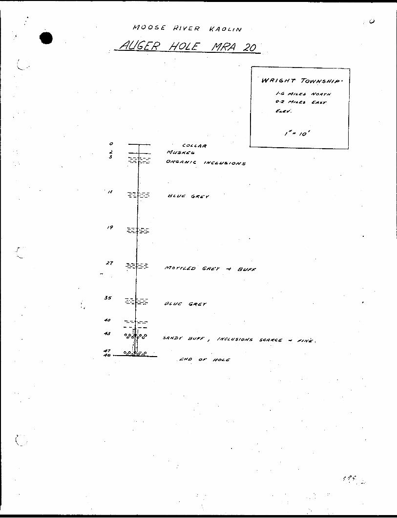
The winter's drilling program was started late in November, 1959* and was discontinued early in April, I960. During the interval thirteen holes were drilled in Kipling, Acres, and Mccausland townships to depths of between 72.0 and 221.5 feet. The last nine holes were terminated at 100 feet. The results of drilling are given in detail in the bore hole logs of the MR series which accompany this report.
Holes numbered l, 3* and 4 intersected Cretaceous horizons at 208.0, 100.0, and 65.0 feet respectively below surface. All other holes were stopped in glacial material* Except for a few thin bands of fireclay the Cretaceous material intersected consisted of a mixture of silica sand and kaolinite. The kaolinite content was found to run about five percent or less throughout most of the intersections, although in hole HR4 some samples contained up to about 20 percent kaolinite.
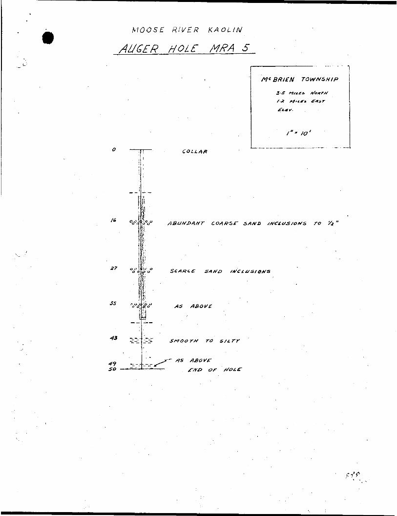
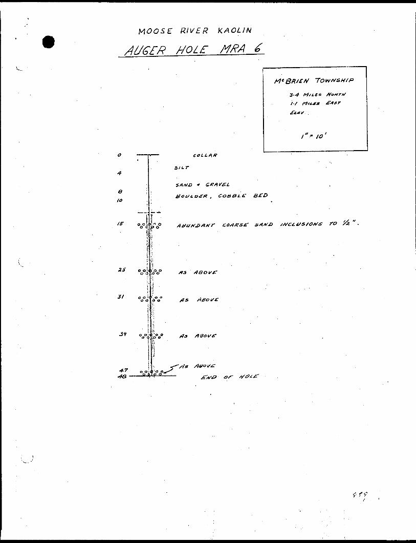
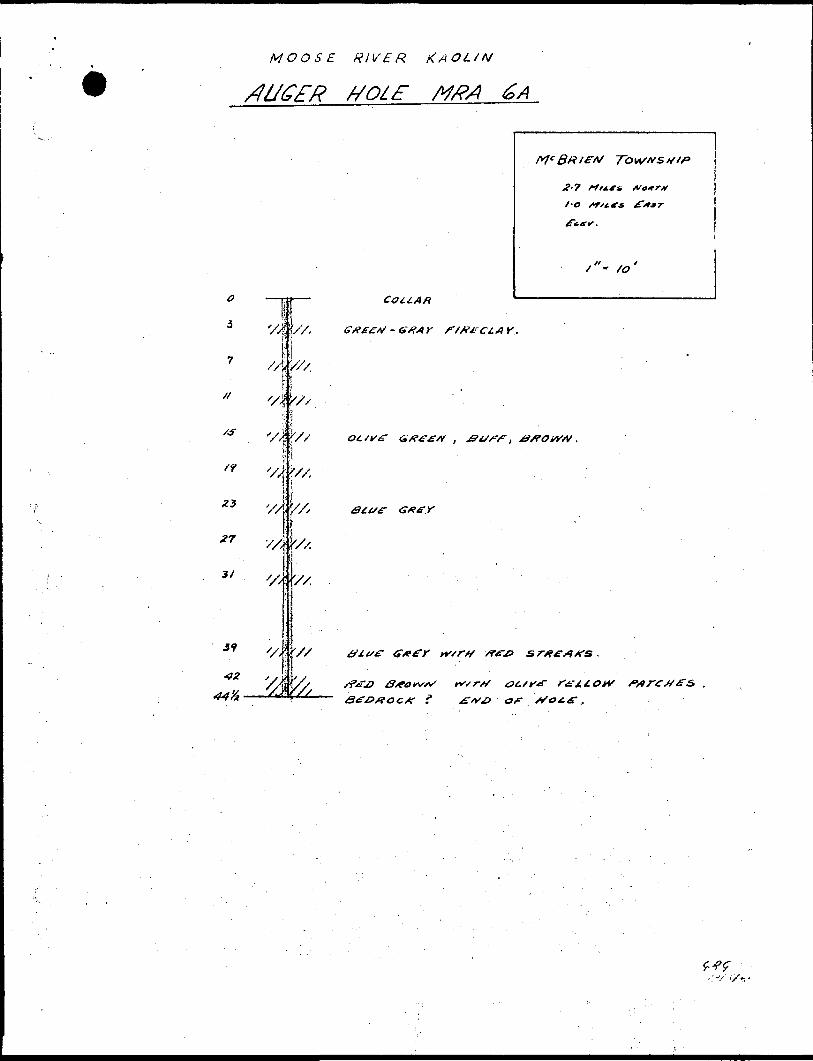
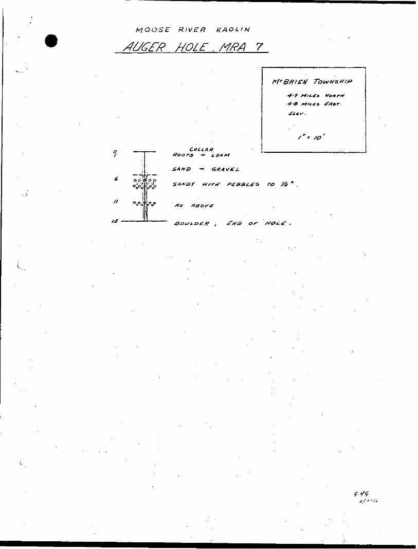
The summer's drilling was started August the 8th and is still underway. Up until September nine holes were completed in Burstall and McBrien townships on the west side of the concession. The drilling results obtained are contained in the accompanying logs of the MRA series. Three of these, numbered 2, 6A, and B were collared in Cretaceous fireclays. Number 2 penetrated 40 feet
Page 6 Report
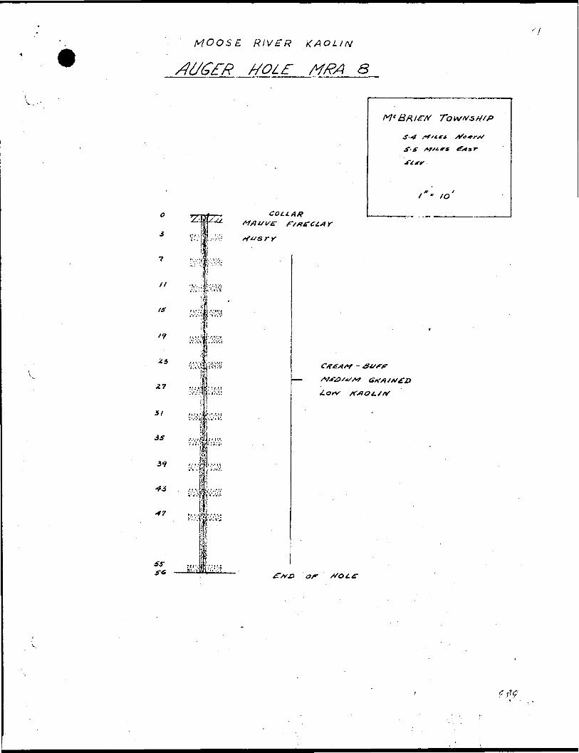
of red fireclay before it was stopped because of the problem of recovering the drill rods in the very sticky clay* Number 6A was drilled to 44 feet through light bluish-grey fireclay and cherty layers before stopping on what was believed to be bed rock. Number 8 broke into kaolinitic sand two feet below the collar and was stopped at 56 feet in the same material. The kaolin content was judged to be less than five percent. All other holes were drilled to various depths up to 52 feet in glacial till, or stoneless clayso
Geology
There were five principal stratigraphic horizons intersected in the drilling completed up to September 1st. These are illustrated in the accompanying sections of each hole.
1. Muskeg - Roots, soil, and other plant life. In depth it normally varied between 5 and 10 feet from surface.
2. Silts, sand and gravel^and marine clay____ - This underlay the muskeg in some
holes and is an, post glacial in age. The marine clay is sometimes difficult to differentiate from the glacial lake clays, but the presence of white shells is always an indication. It is also considered to be structureless compared to the varved glacial lake clays.
3. Glacial till - The till may occur directly below the muskeg or below either silts, sand, etc., or glacial lake clay. Great variations occurred in its appearance. It was found to be all highly calcareous, and with predominantly carbonate pebbles and boulders 0 The till was intersected at different horizons in the same hole, separated by stoneless clay, sand, and gravel. It was encountered at a maximum depth of about 200 feet.
4. Glacial lake stonelessclay, silts and sands - These may occur either directly
below the muskeg, or separating different horizons of glacial till. The clays exhibited the usual varves of light and dark coloured layers. A wide variety of constituents were found in it - bark, roots, plant stems, hair- like inclusions, and peaty, or carbonaceous material. The greater thicknesses were
-Page 7 Report
encountered in the holes located toward the interior of the concession*
5. Kaolin, fireclay, andsilica sand_______ - These belong to the Mattagami
series, Lower Cretaceous in age, described by Keele, Ityer, and Crozier0 The kaolin occurs as a constituent of the silica sand beds which were intersected in drilling to thicknesses of up to 125 feeto The percent kaolin was found to be in the order of five percent or less, with a few exceptions where clayey layers contained up to 20 percent. The fireclay is a very dense, smooth, plastic material, exhibiting bright hues of red, blue, brown, through to off-shades of white* It was found to occur in some cases just below the till in a thin bed overlying the sand, and again below the sand where holes were stopped within two or three feeto In other locations, on the west side of the concession, holes started in fireclay penetrated up to 44 feet in the same material before being stopped* The fireclay was found to be associated with bands of chert in these latter holes.
The silica sand is characteristically composed of clear quartz grains, sub-angular in shape, and medium to coarse grained (mainly between 43 and 10 mesh)* In addition to the associated kaolin, minor feldspar, and dark coloured grains are present.
The concession occupies part of a broad Cretaceous basin- like structure to the north of the Precambrian escarpment. Previous field investigations have shown that the Cretaceous sand and clay deposits were derived from the Precambrian uplands to the south and were transported into their present position by streams. The Cretaceous surface was greatly modified by glacial action and the irregular glaciated level surface was levelled to its present form by the filling of depressions with material of recent age silt, marine clays, etc.
The general picture has been unchanged by the recent drill,i,ngo It is suggested, however, that glaciation irregularly furrowed the originaly Cretaceous surface leaving valleys and hummocks in the upper surface of the existing Cretaceous horizon* This renders the prediction of its depth from surface extremely uncertain when
Page 8 Report
distances in the order of a half mile are being consideredo The only generalization that can, therefore, be made at this time which is of use as a guide to drilling,is that Cretaceous deposits are more likely to be encountered at shallower depths near the periphery of the basin.
Laboratory Results
Samples from the drilling were evaluated in laboratories of American Nepheline Limited, Lakefield Research Limited, and the Mines Branch at Ottawa. The objects of this work were to determine a method of separating the kaolin from the sand^and the physical and chemical properties of the separated productSo
The kaolin-sand separations were first investigated on a laboratory scale in order to develop a method for establishing the kaolin content of small, bore hole samples. A technique involving sedimentation was evolved whereby the sample is dispersed in a solution of sodium carbonate and sodium metaphosphate and thoroughly agitated followed by setting periods of different lengths of time, depending on the size of separation requiredo The size of the settled constituents was calculated on the basis of Stoke*s law and checked with a Bouyoucas hydrometer.
Clay determinations were made for composition, using chemical and differential thermal analyses, and, ceramic properties. Determinations on the sand were made for chemical composition and grading*
The results of this work are tabulated below:
Clay-Sand Separations and Clay Composition
Sample No. "fc Kaolinite * Quartz * _____________- 10 micron_____Content ^ Content
MR1-4921 5.722 4.423 2.224 3.125 1.4
MR3-4937 6.333 24.6 70 1548 12.848A 12.7
MR4-4955 Ho756 14o6 85 H
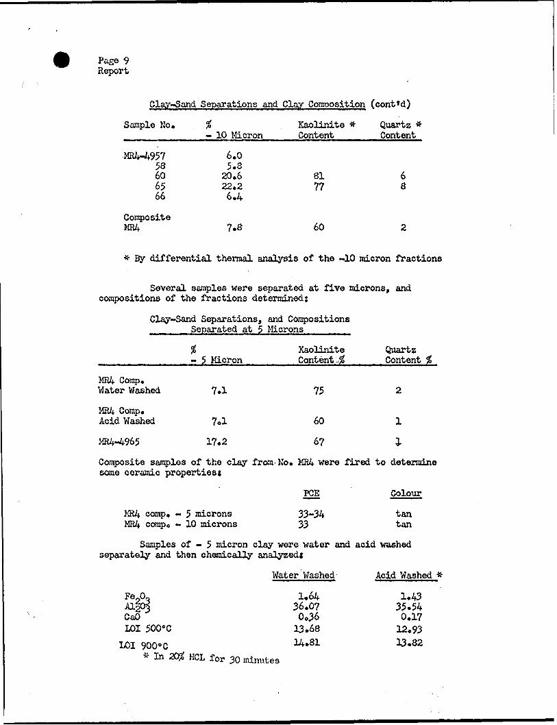
Page 9 Report
Clay-Sand Separations and Clay Composition (cont*d)
Sample No.
MR4-495758606566
CompositeMR4
- 10 Micron
6.05.8
20.622.26.4
7.8
Kaolinite # Content
8177
60
Quartz # Content
68
2
# By differential thermal analysis of the -10 nacron fractions
Several samples were separated at five microns, and compositions of the fractions determined:
Clay-Sand Separations, and Compositions Separated at 5 Microns
MR4 Comp. VJater Washed
MR4 Comp. Acid Washed
MR4-4965
*- 5 Micron
7.1
7ol
17.2
Kaolinite Content.^
75
60
67
Quartz Content H
2
1
l
Composite samples of the clay from'No. MR4 were fired to determine some ceramic properties*
PCE Colour
MR4 camp. - 5 microns 33-34 tan MR4 compo - 10 microns 33 tan
Samples of - 5 micron clay were water and acid washed separately and then chemically analyzed*
Water Washed Acid Washed tt
1.64 1.43 36.07 35.54
CaO Oo36 0.17 LOI 500'C 13.68 12.93
LOI 9000C 14.81 13.82 * In 2C# HCL for 30 minutes
Page 10 Report
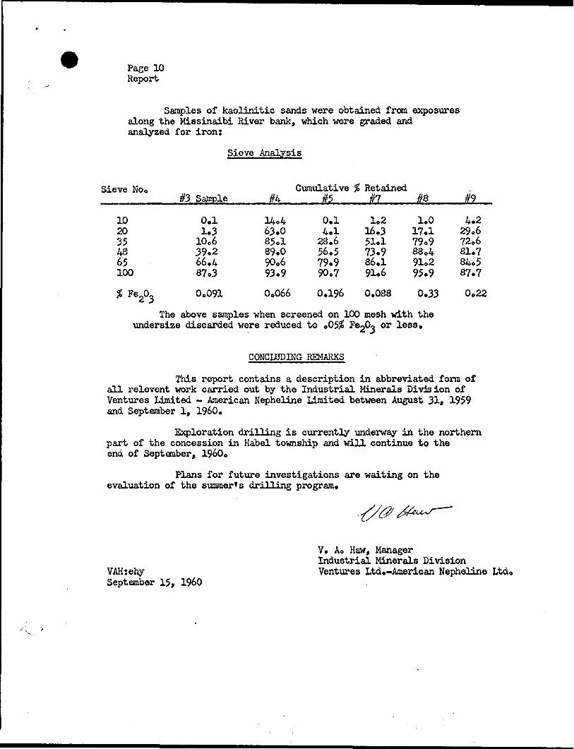
Samples of kaolinitic sands were obtained from exposures along the Missinaibi River bank, which were graded and analyzed for iron:
Sieve Analysis
Sieve No0#3 Sample #k
Cumulative___ #5
Retained#7 #8 #9
1020354865100
FeJX, *
0.1 1.3 10o6 39.2 66.4 87o3
Oo091
63.0 85ol 89.0 90o6 93.9
Oo066
0.14.128.656.579.990.7
1.216.351.173.986.191.6
0.196 0.088
1.0 17.1 79o9 88o4 91o2 95.9
0.33
The above samples when screened on 100 mesh with the undersize discarded were reduced to 005# F or
4.2 29.6 72o6 81.7 84*5 87.7
Oo22
CONCLUDING REMARKS
This report contains a description in abbreviated form of all relevent work carried out by the Industrial Minerals Division of Ventures Limited - American Nepheline Limited between August 31* 1959 and September l, I960.
Exploration drilling is currently underway in the northern part of the concession in Habel township and will continue to the end of September, 19600
Plans for future investigations are waiting on the evaluation of the summer's drilling program.
VAH:ehy September 15, I960
V. Ao Haw, Manager Industrial Minerals Division Ventures Ltd.-American Nepheline Ltd.
BORE HOLE LOGS
WINTER DRILLING, 1959 - 60
MR SERIES
tBORE
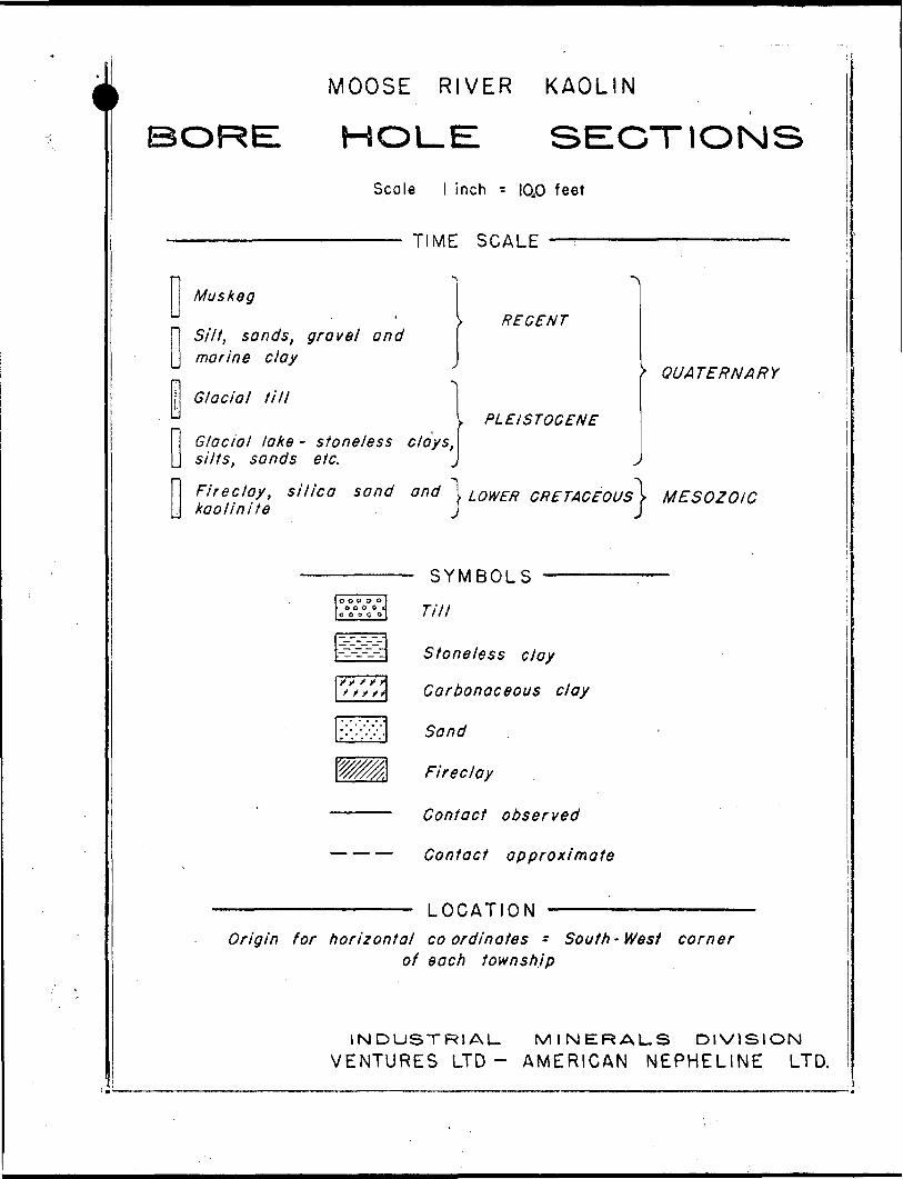
MOOSE RIVER KAOLIN
HOLE: SECTIONSScale l inch - I0j0 feet
TIME SCALE
Muskeg
Silt, sands, gravel and marine clay
Glacial till
Glacial lake- s f one/ess clays,\ silts, sands el c.
RECENT
PLEISTOCENE
QUATERNARY
Fireclay, silica sand and "l LOWER CRETACEOUS\ MESOZOIC kaolin lie J j
SYMBOLS ———
Till
Stoneless day
Carbonaceous clay
Sand
Fireclay
Contact observed
Contact approximate
LOCATIONOrigin for horizontal coordinates - South-West corner
of each township
INDUSTRIAL. MINERALS DIVISION VENTURES LTD- AMERICAN NEPHELINE LTD.
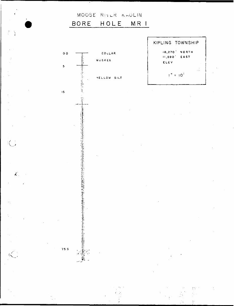
MOOSE RlvcR KAOLIN
BORE HOLE MR
00
i
l. U LL A N
' MUSKEGj
YELLOW SILT
KIPLING TOWNSHIP
18,270 ' NORTH
11,590' EAST
ELE v.
1 " : 10'
15
li!
75 5
lil
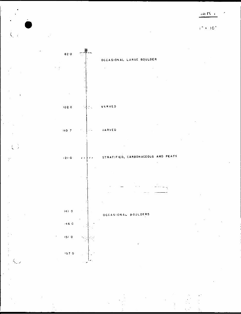
820-J.
OCCASIONAL LARGE BOULDER
l" -- 10'
1020 VARVED
1107 VARVED
1210 STRATIFIED, CARBONACEOUS AND PEATY
14 l O
1460
151 O
OCCASIONAL pOliLDERS
Ib7 O
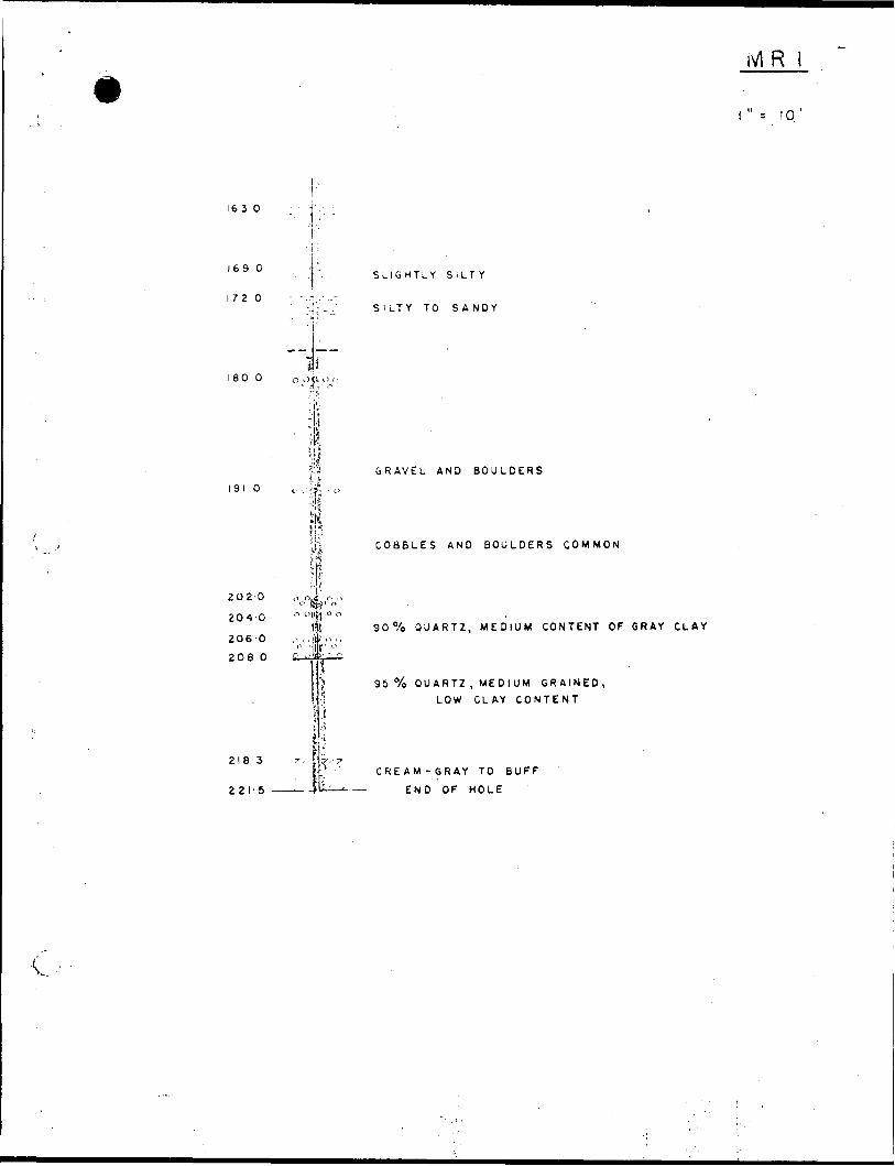
16 30
10
169 O
1720
180 O
1910
2020
204 O
206 O
2080
2183
221-5
lS
d ojrli
,, r. ;t t
SLIGHTLY SILTY
SILTY TO SANDY
GRAVEL AND BOULDERS
COBBLES AND BOULDERS COMMON
90 0Xo QUARTZ, MEDIUM CONTENT OF GRAY CLAY
95 "/o QUARTZ , MEDIUM GRAINED, LOW CLAY CONTENT
11- CREAM-GRAY TO BUFF
END OF HOLE
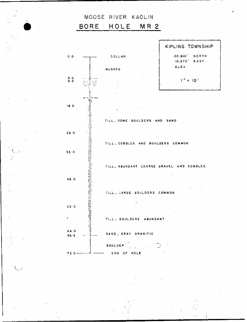
MOOSE RIVER KAOLIN
BORE HOLE MR 2
00
8090
ie o
26 O
35-0
45 O
55-0
64-065-5
720
COLLAR
MUSKEG
KIPLING TOWNSHIP
20,910' NORTH
10,270' EAST
ELEV.
l" * 10'
TiLL , SOME BOULDERS AND SAND
TILL, COBBLES AND BOULDERS COMMON
TILL, ABUNDANT QOARSE GRAVEL AND COBBLES
TILL , LARGE BOULDERS COMMON
TILL, BOULDERS ABUNDANT
SAND, GRAY GRANITIC
BOULDER i '~~^j
END OF HOLE
MOOSE RIVER KAOLIN
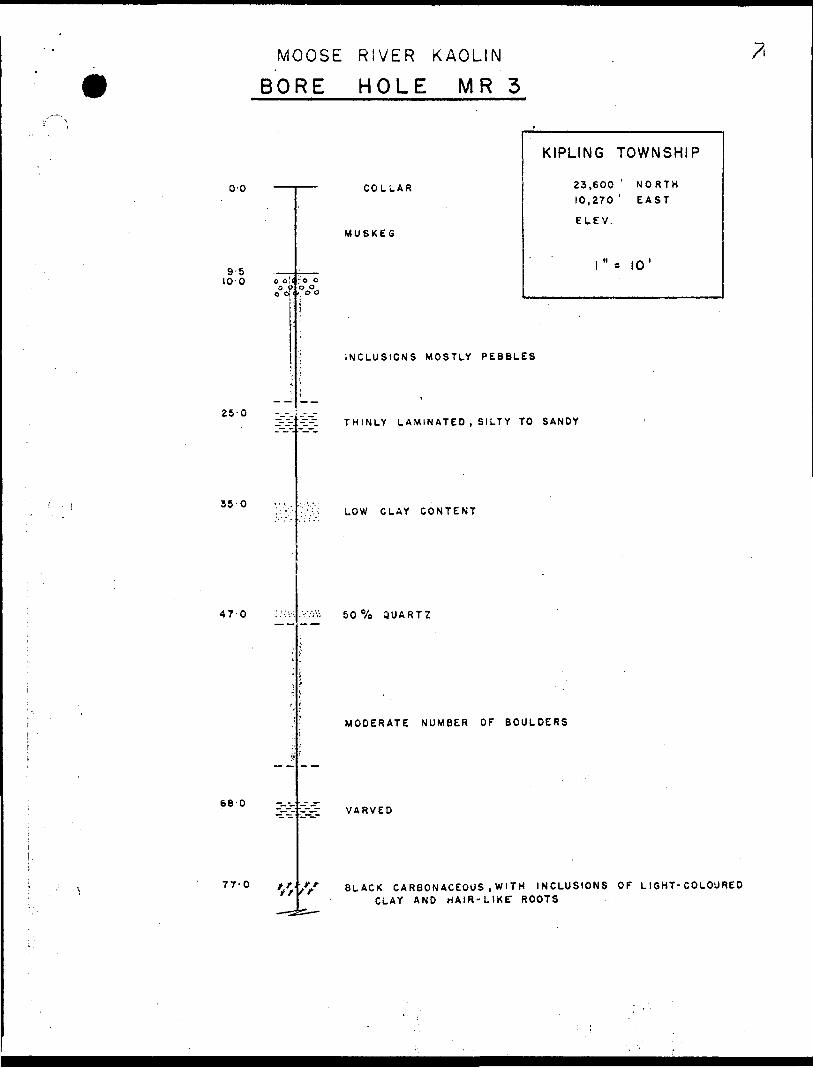
BORE HOLE MR 3
00
9-5 10 O
25 O
35-0
47 O
68 O
COLLAR
MUSKEG
KIPLING TOWNSHIP
23,600 ' NORTH
10,270 ' EAST
ELEV.
l"* 10'
77-0
INCLUSIONS MOSTLY PEBBLES
THINLY LAMINATED , SILTY TO SANDY
LOW CLAY CONTENT
50 "/o QUARTZ
MODERATE NUMBER OF BOULDERS
l//
VARVED
BLACK CARBONACEOUS .WITH INCLUSIONS OF LI6HT-COLOURED CLAY AND HAIR-LIKE1 ROOTS
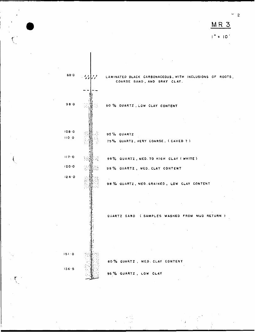
MR 3
88 O
980
1080
1100
II7'0
IZO'O
124-0
151-0
156-5
y , ft LAMINATED BLACK CARBONACEOUS , WITH INCLUSIONS OF ROOTS
COARSE SAND. AND GRAY CLAY.
60 "/o QUARTZ , LOW CLAY CONTENT
95 0Xo QUARTZ
75 0Xo QUARTZ, VERY COARSE, ( CAVED ? )
98 0Xo QUARTZ , MED. TO HIGH CLAY ( WHITE }
D97o QUARTZ, VED.CLAY CONTENT
98 "/o QUARTZ, MED. GRAINED, LOW CLAY CONTENT
QUARTZ SAND ( SAMPLES WASHED FROM MUD RETURN
60 "/o QUARTZ , MED. CLAY CONTENT
96 "/o QUARTZ, LOW CLAY
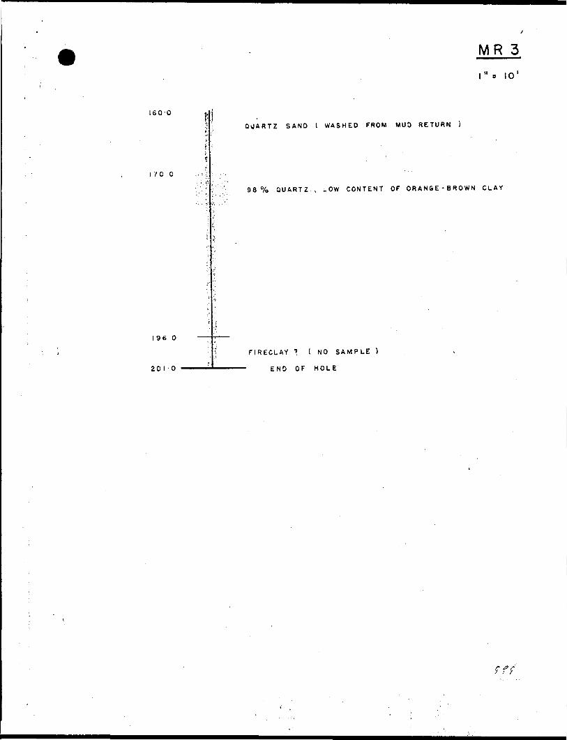
160-0
1700
MR 3l"s 10'
QUARTZ SAND l WASHED FROM MUD RETURN )
98 "/o QUARTZ , LOW CONTENT OF ORANGE-BROWN CLAY
I960
201-0
riRECLAY ? ( NO SAMPLE
END OF HOLE
f f
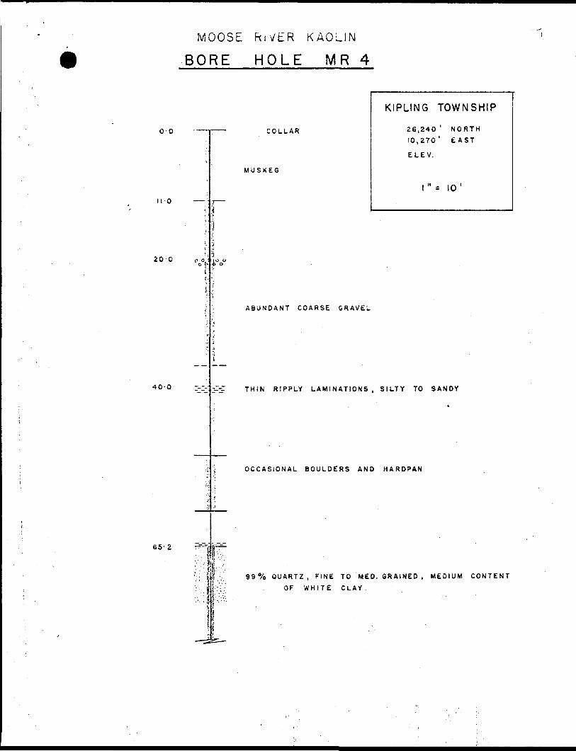
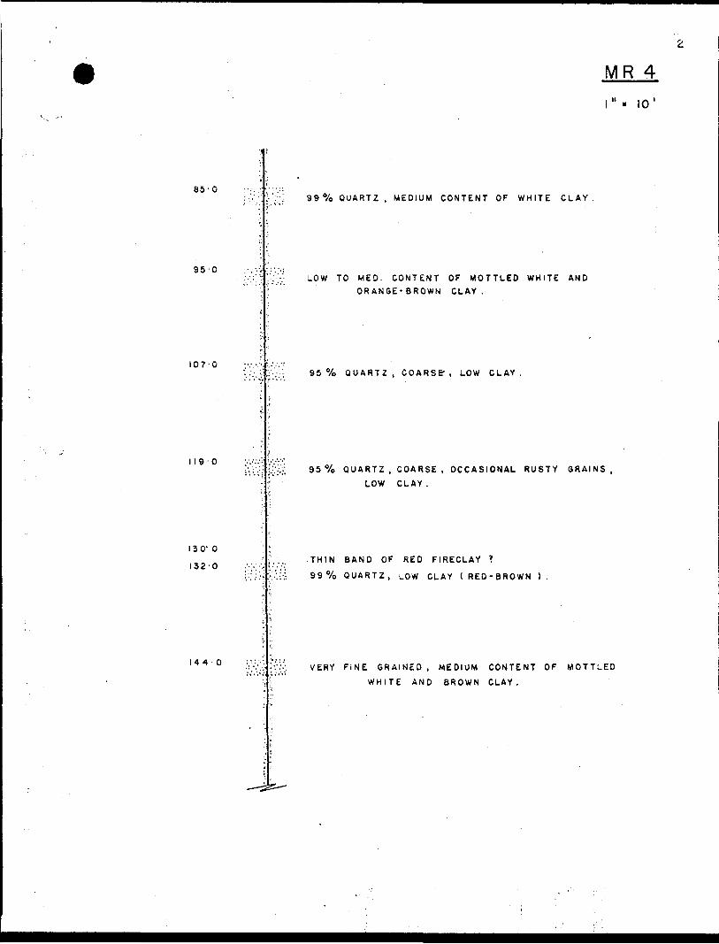
MOOSE RIVER KAOLIN BORE HOLE MR 4
o-o
•11-0
20 O
40-0
—— .-.
l
C O Jo b
i.
f
•:
--
—— ' COLLAR
MJSKE5
, ——
"i
5io o i. o
, (
1
ABUNDANT COARSE GRAVEL
'i.J
i
KIPLING TOWNSHIP
26,240 ' NORTH
10,270' EAST
ELEV.
1" s 10 '
THIN RIPPLY LAMINATIONS, SILTY TO SANDY
OCCASIONAL BOULDERS AND HARDPAN
65-2
99 0Xo QUARTZ, FINE TO MED. GR AINED , MEDIUM CONTENT
OF WHITE CLAY,
MR 4" lo 1
85-0
144-0
99 0Xo QUARTZ , MEDIUM CONTENT OF WHITE CLAY
95 OLOW TO MED. CONTENT OF MOTTLED WHITE AND
ORANGE-BROWN CLAY.
i
107-095 7o QUARTZ, COARSE-, LOW CLAY.
*. '
119-0 .-. .....95 07o QUARTZ , COARSE , OCCASIONAL RUSTY GRAINS,
LOW CLAY.
130-0THIN BAND OF RED FIRECLAY *
99 "/o QUARTZ, LOW CLAY (RED-BROWN J.
VERY FINE GRAINED , MEDIUM CONTENT OF MOTTLED
WHITE AND BROWN CLAY.
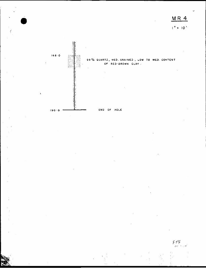
1660
MR 4i". io'
99 "/o QUARTZ, MED. GRAINED , LOW TO MED. CONTENT
OF RED- BROWN CLAY .
190 - O END OF HOLE
MOOSE RIVER KAOLIN
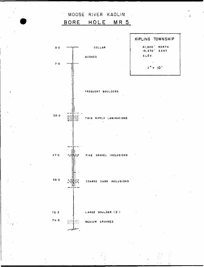
BORE HOLE MR 5
00
70
30-0
47-0
72-3
76-0
58-0 o o:
COLLAR
MUSKEG
FREQUENT BOULDERS
THIN RIPPLY LAMINATIONS
FINE GRAVEL INCLUSIONS
COARSE SAND INCLUSIONS
LARGE BOULDER ( 3'
MEDIUM GRAINED
KIPLING TOWNSHIP
31 .520 ' NORTH 10,270' EAST
ELEV.
l"- 10'
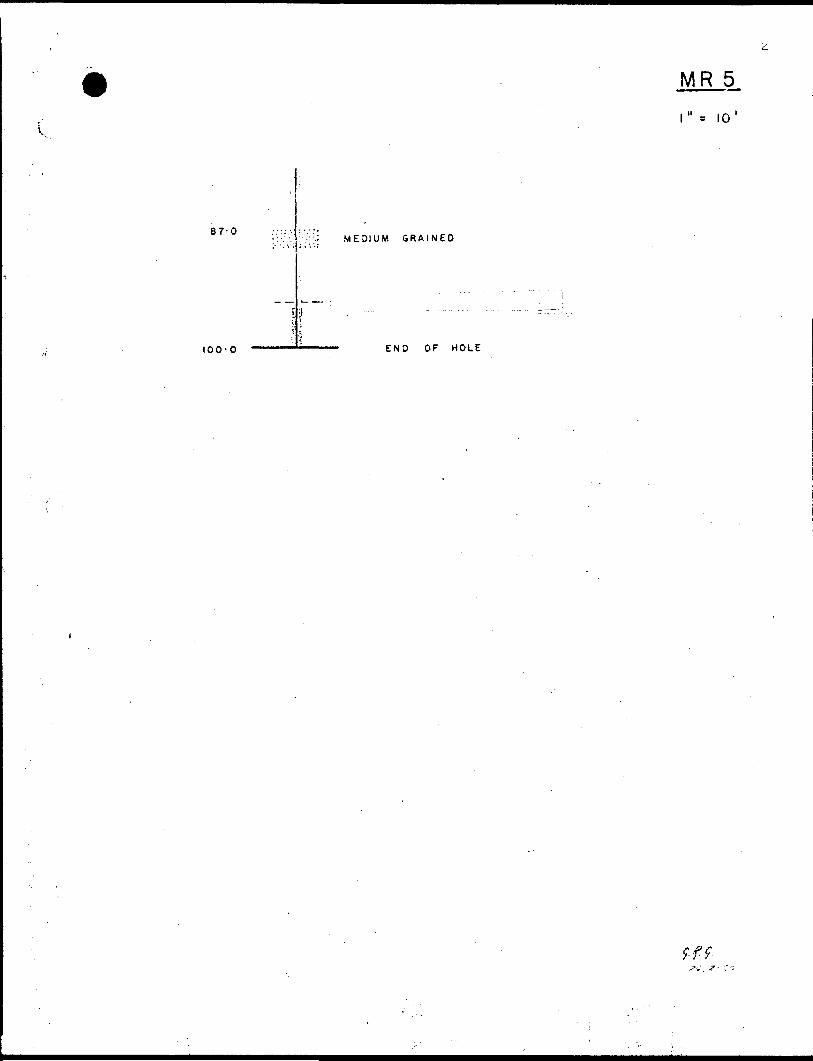
87-0MEDIUM GRAINED
100-0 END OF HOLE
MR 5i" . to 1
9-f f'
MOOSE RIVER KAOLIN
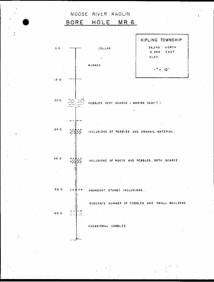
BORE HOLE MR 6
o-o
13 -O
22 O
46*
COLLAR
MUSKEG
KIPLING TOWNSHIP
26,240 ' NORTH
2,350' EAST
ELEV.
l"- 10
-i-
34-0 ac,-
69-0
o o i o o
590 oo
PEBBLES VERY SCARCE l MARINE CLAY T
INCLUSIONS OF PEBBLES AND ORGANIC MATERIAL.
INCLUSIONS OF ROOTS AND PEBBLES, BOTH SCARCE
ABUNDANT STONEY INCLUSIONS.
MODERATE NUMBER OF COBBLES AND SMALL BOULDERS
OCCASIONAL COBBLES
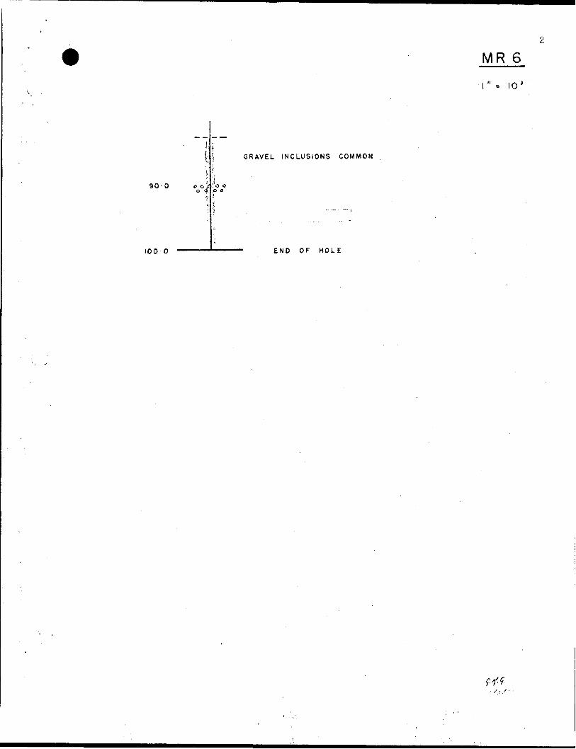
90-0
MR 6" -. 10
GRAVEL INCLUSIONS COMMON
100 O END OF HOLE
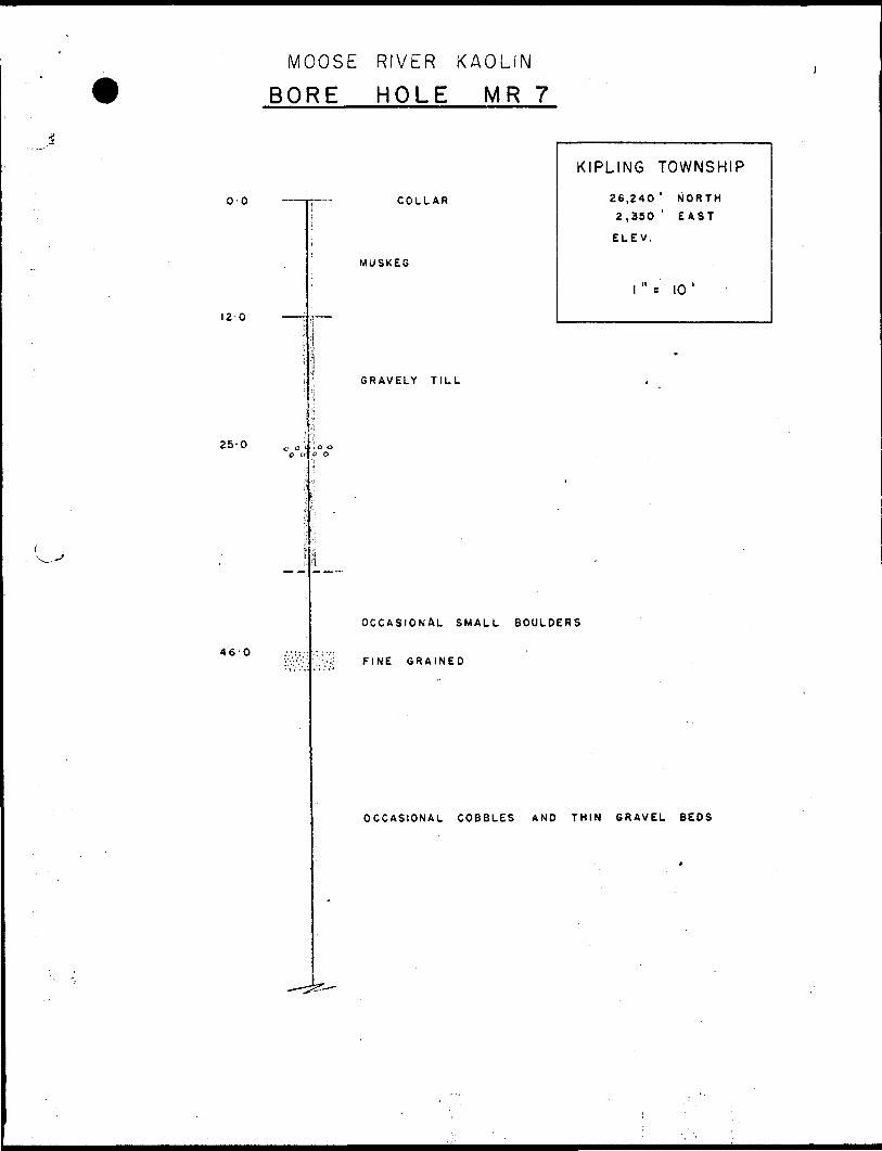
MOOSE RIVER KAOLIN
BORE HOLE MR 7
00
120
COLLAR
MUSKEG
GRAVELY TILL
KIPLING TOWNSHIP
26,240 ' NORTH
2,350 ' EAST
ELE V.
10 '
25-0
460
C o i - O O
OCCASIONAL SMALL BOULDERS
FINE GRAINED
OCCASIONAL COBBLES AND THIN GRAVEL BEDS
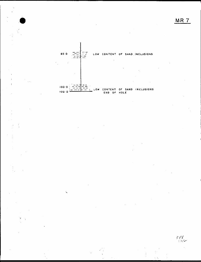
MR 7
85 O ..-^
too-oIOa-0
LOW CONTENT Of SAND INCLUSIONS
LOW CONTENT OF SAND INCLUSIONS END OF HOLE
9-f f-
MOOSE RIVER KAOLIN
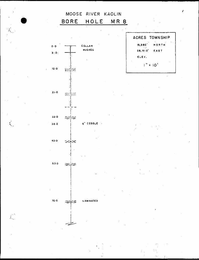
BORE HOLE MR 8
0-0
3.0.
10-0
21-0
COLLAR MUSKEG
ACRES TOWNSHIP
18,880' NORTH
28,910' EAST
CLEV.
l" MO'
32-0
35-2
— -L-—-
6" COBBLE
43-0l
-4.-
70-0 -sj4^--s- LAMINATED --
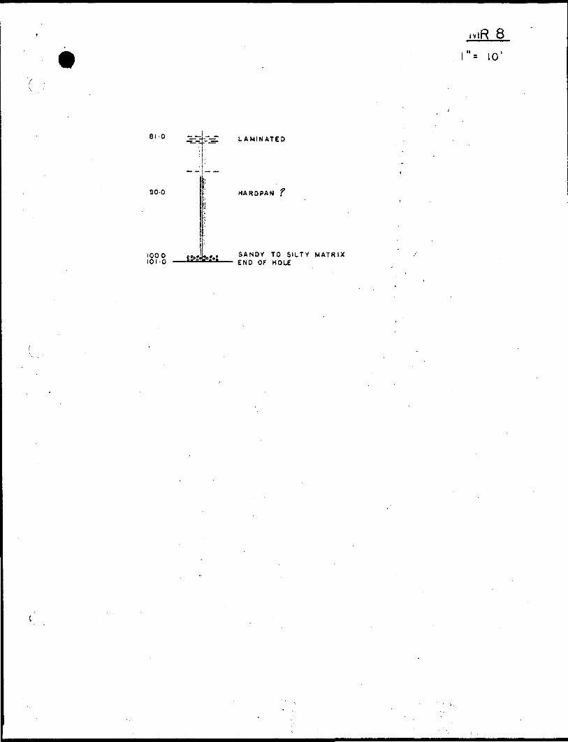
lvl R 6i", lo 1
Si O
90-0
1000 101-0
JKr-JT-dl LAMINATED
HARDPAN f
SANDY TO SILTY MATRIX END OF HOLE
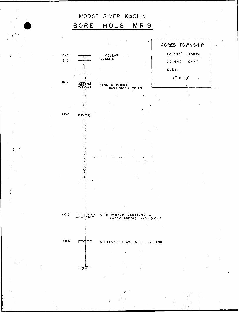
MOOSE RIVER KAOLINBORE HOLE MR 9
0-0
2-0
10-0
22-0
COLLAR MUSKEG
SAND a PEBBLEINCLUSION S TO 1/2"
ACRES TOWNSHIP
38,890' NORTH
2 7, 5 40' EAST
ELEV.
l" -- 10' -
o oo oO 0,1:0 O
60-0
70-0
WITH VARVED SECTIONS aCARBONACEOUS INCLUSIONS
STRATIFIED CLAY, SILT, a SAND
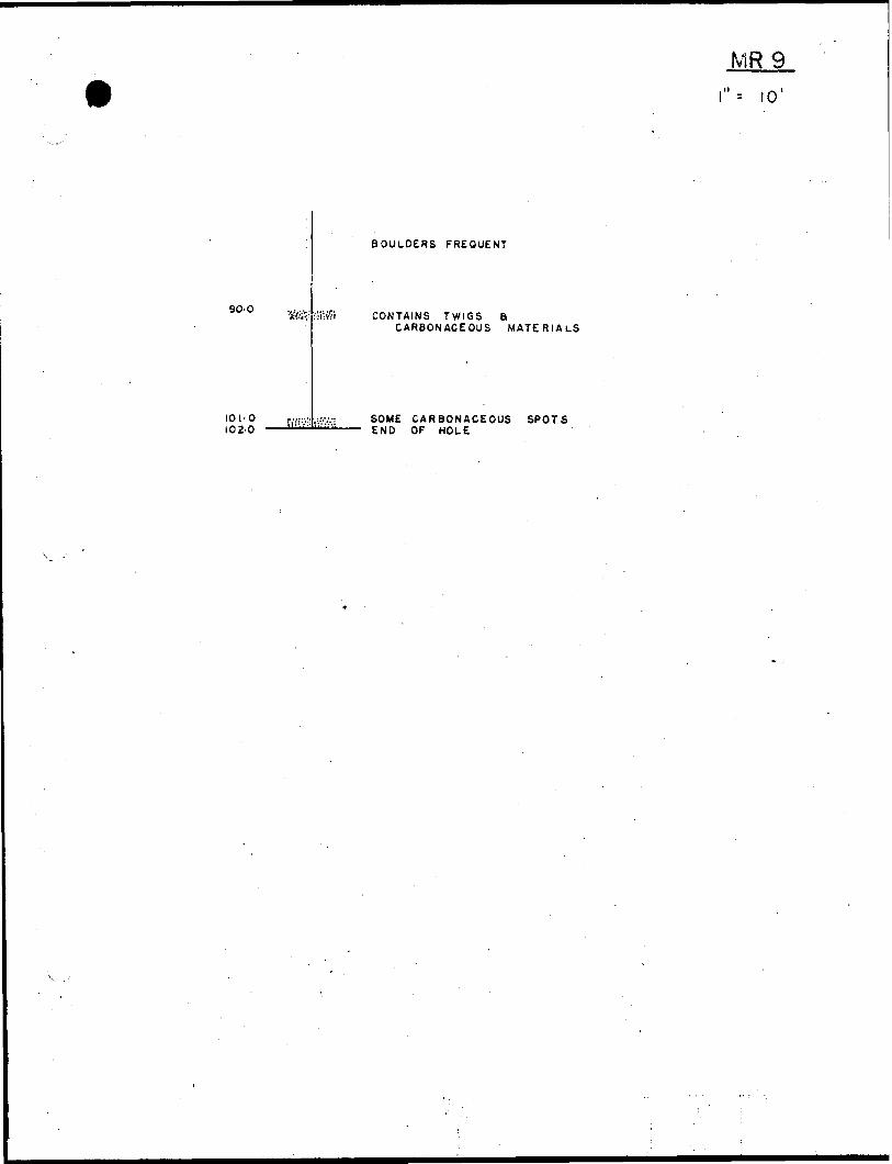
MR 9
90-0
101-0102-0
BOULDERS FREQUENT
CONTAINS TWIGS aCARBONACEOUS MATERIALS
SOME CARBONACEOUS SPOTS END OF HOLE
MOOSE RiVtR KAOLIN
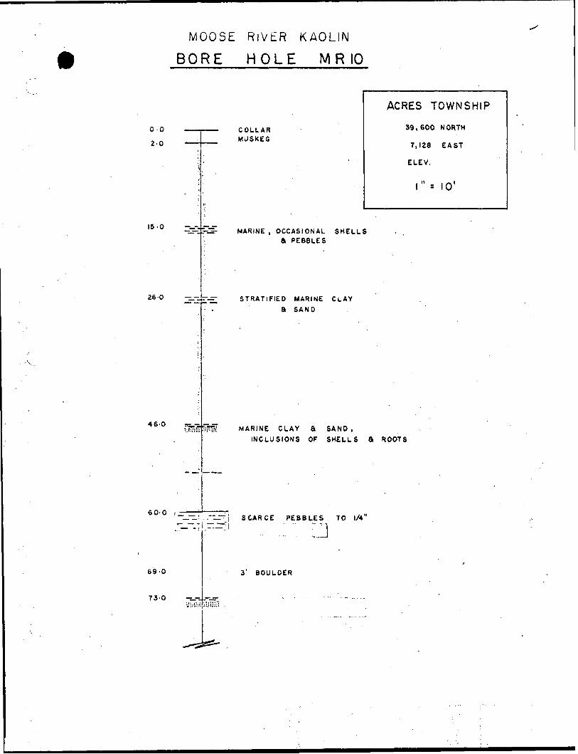
BORE HOLE M R 10
o.o2-0
15-0
46 O
26-0 -i.--.s-
COLLAR MUSKEG
MARINE , OCCASIONAL SHELLS A PEBBLES
STRATIFIED MARINE CLAY
a SAND
ACRES TOWNSHIP
39,600 NORTH
7,128 EAST
ELEV.
l'" x (Q'
MARINE CLAY 8 SAND,
INCLUSIONS OF SHELLS S ROOTS
60-0 r^^, ..~L ~. SCARCE PEBBLES TO 1/4"
69-0
73-0
3' BOULDER
84.0
98-0
100-0STRATIFIED SILT
END OF HOLE
v 1010'
MOOSE RIVER KAOLIN
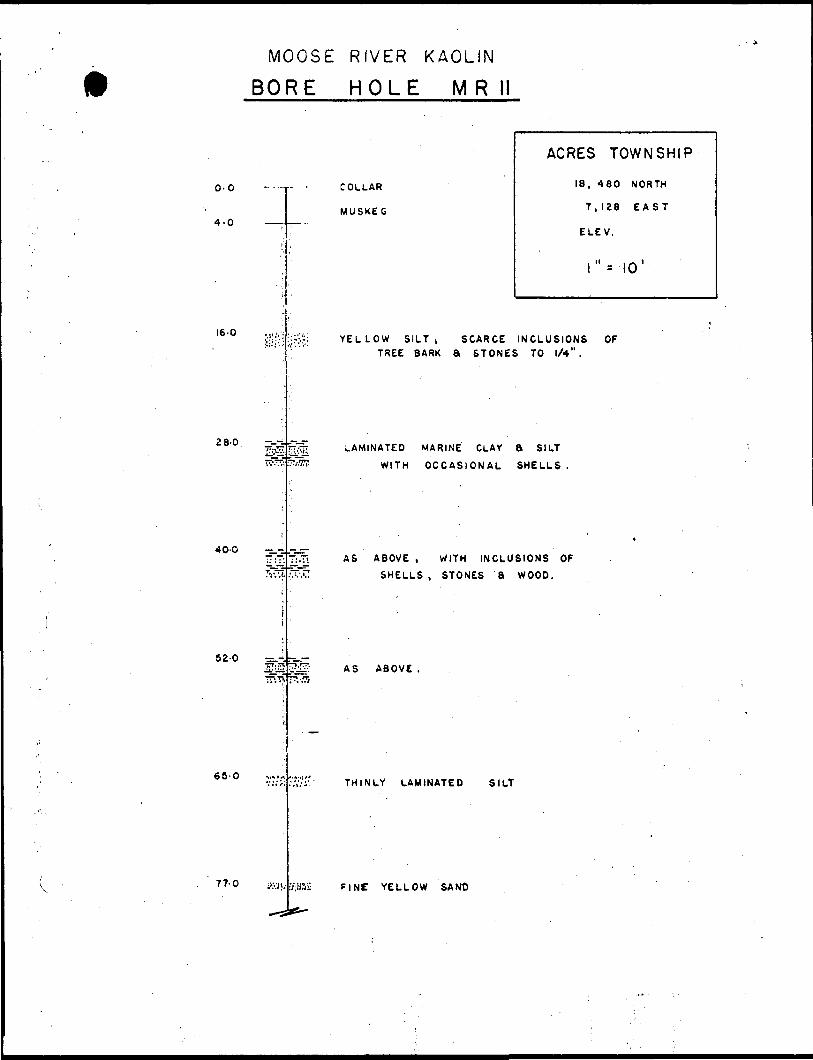
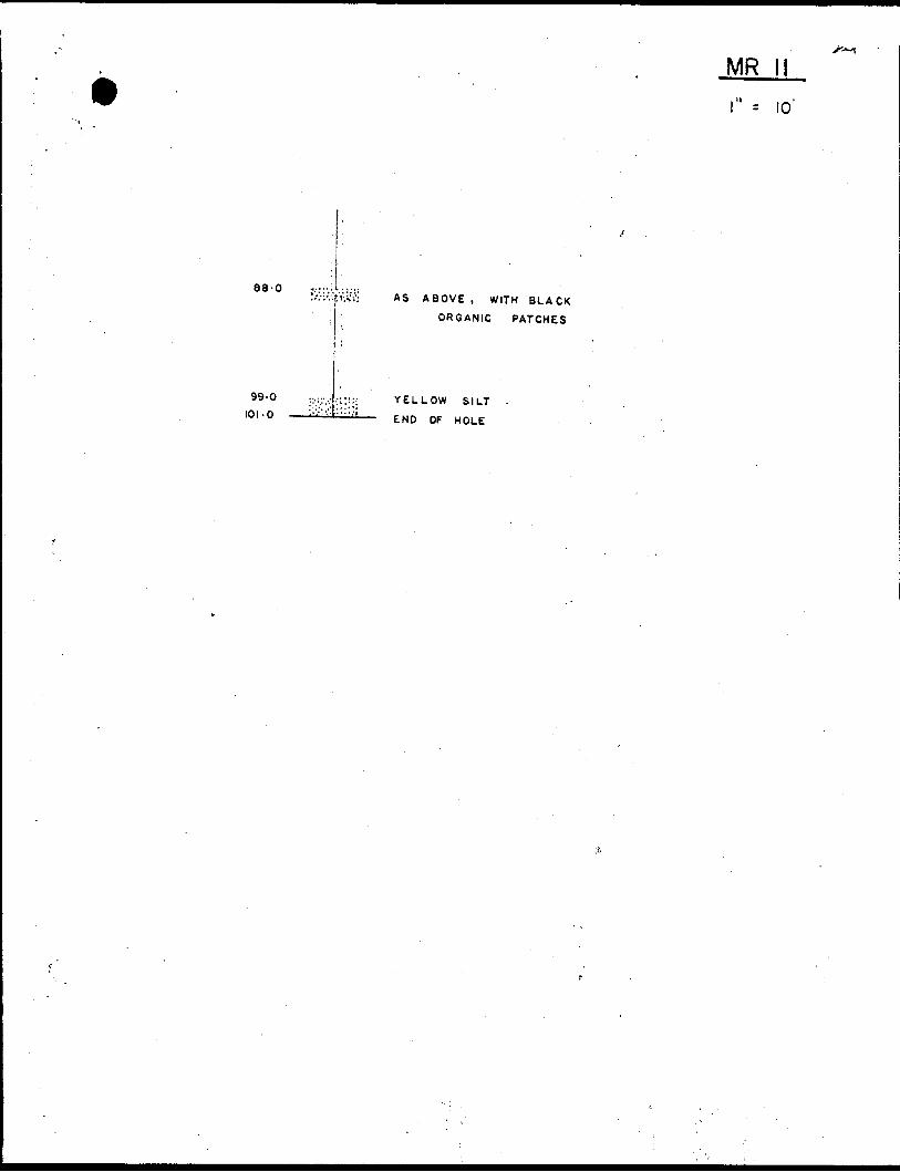
BORE HOLE MR
0-0
4-0
16-0
28-0
65-0
77-0
40-O -^- .-ur-
52-0 ^
l?w
COLLAR
MUSKEG
ACRES TOWNSHIP
18, 480 NORTH
7,128 EAST
ELEV,
r* lo 1
YELLOW SILT, SCARCE INCLUSIONS OF TREE BARK a STONES TO 1/4" .
LAMINATED MARINE CLAY a SILT
WITH OCCASIONAL SHELLS
AS ABOVE , WITH INCLUSIONS OF
SHELLS , STONES a WOOD.
AS ABOVE .
THINLY LAMINATED SILT
F INC YELLOW SAND
MR li
88-0
99-0
101-O
AS ABOVE , WITH BLACK
ORGANIC PATCHES
YELLOW SILT
END OF HOLE
MOOSE RIVER KAOLIN
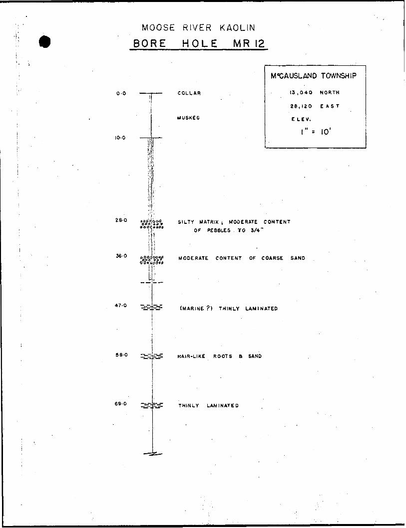
BORE HOLE MR 12
0-0
10-0
28-Q
36-0
j
i1i ,
|
-'•^ft 000 OOP
1.
—— COLLAR
MUSKEG
i
M*CAUSLAND TOWNSHIP
13,040 NORTH
28,120 EAST
E LEV.
l" -- 10'
i{
l 251 SILTY MATRIX j WODERATE CONTENT
*"0* OF PEBBLES TO 3/4"'1
i
47-0
MODERATE CONTENT OF COARSE SAND
(MARINE ?) THINLY LAMINATED
58-0 --~-^Xj^ HAIR-LIKE ROOTS B SAND
69-0 —sj-isnf THINLY LAMINATED
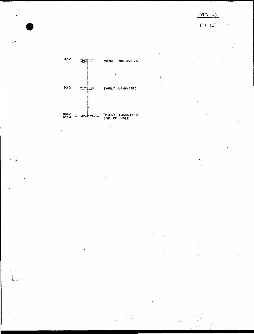
iVir\ .d
\"-- 10'
80-0 -i.--ir.r-•ZttS- WOOD INCLUSIONS
90-0 :^C-~: THINLY LAMINATED
100-0 100-4
THINLY LAMINATED END OF HOLE
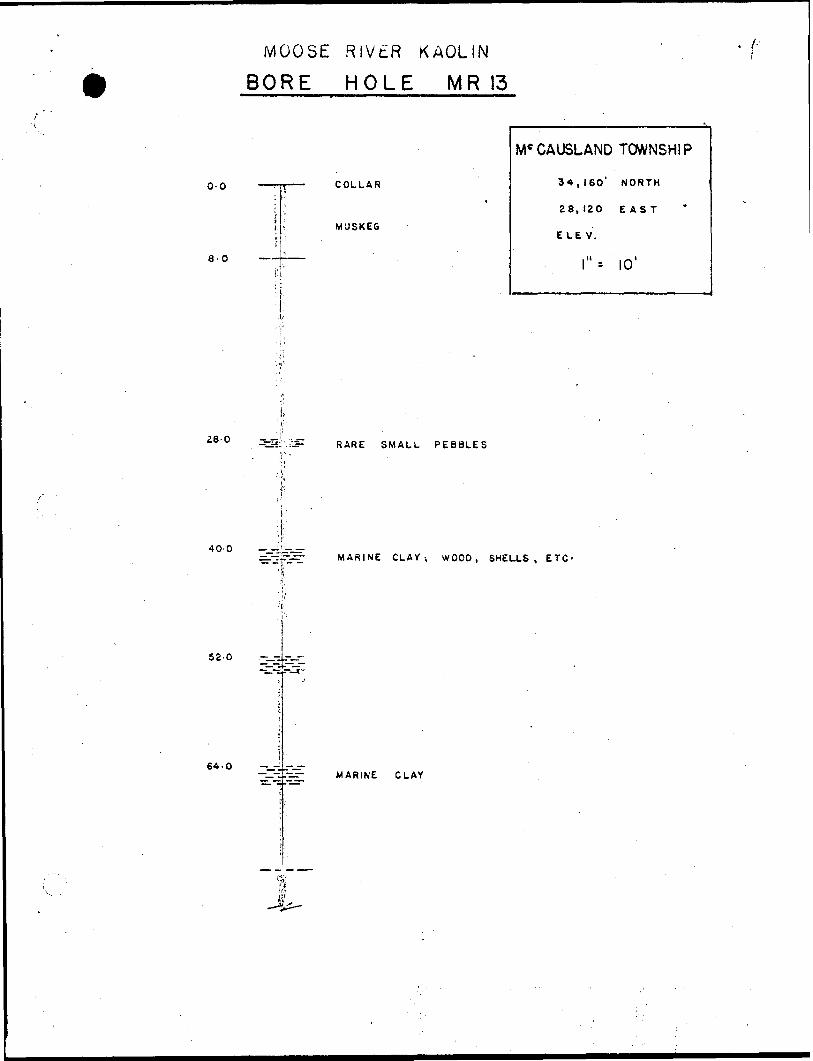
MOOSE RlVtiR KAOLIN
BORE HOLE MR 13
0-0
8-0 ——
COLLAR
MUSKEG
Mc CAUSLAND TOWNSHIP
34,160' MORTH
28, 120 EAST
E L E V.
l" -- 10'
RARE SMALL PEBBLES
400 —--iir-.rrMARINE CLAY; WOOD, SHELLS, ETC'
52-0
64-0MARINE CLAY
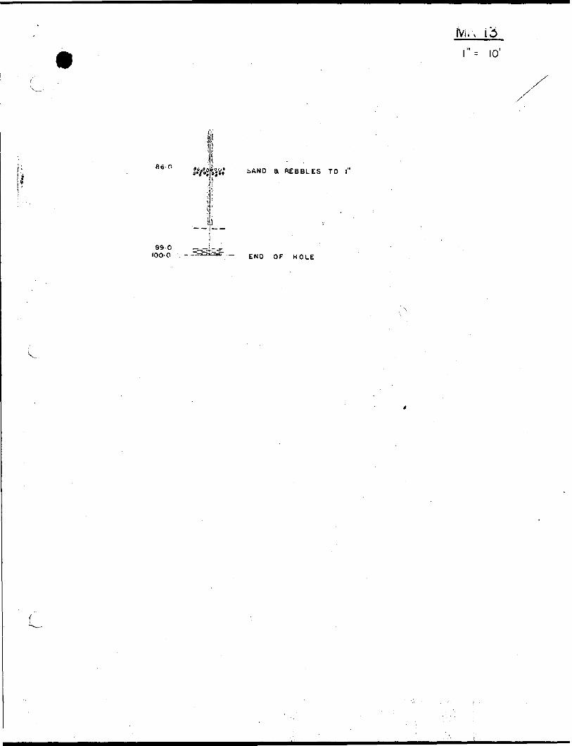
: 10'
li86-0
iAND a RE8BLES TO l"
99-0 IOO-0 - END OF HOLE
-AUGER HOLE LOGS
SUMMER DRILLING I960
MRA SERIES
MOOSE RIVLR KAOLIN
AUGER M O t. Z MM J
8 1/ ft S TALL T O WNS H/P
- 3-4 M tt f s
•f -J M/if*
*- /o'
56,
COLLAR
COARSE, - COLOUKfD
ABO y f: TO
•COARSE, MOSTLY u*?f:srot/*
of /tote: ,
MOOSE RIVER KAOLIN
AUGER HOLE M#A 2
COLLAR
BUHSTALL2- f Mn.es fi/oxrnS'3
/"-/o 1
*w;w
A ae ve w r* srswte
s/ttf* SAA/D
AS A80IS& j
Of
aar s
MOOSE FUVER KAOLIN
AUClTR HOLE MRA 3
27-
W Q
ilo a
COLLAR
S'/ Mf ir*
S-o /v*'/t f"a
of
&0AKSF SA/VD-/IS
S f ̂
AJLTfS OJ. H J- COWS'
3AOS'V
CTfifVS
of ,
s** r t* f-/
dtHSNMOJ.
Of
lion3SOOM
e10
31
MOOSE RIVER KAOLIN
HOLE: MM
'o o,f-3.
COLL A f?
3,4
j./ p)it.*s
10
SILT
COBBLE
s A f a ro
A'B'OV'f
of
f f?f
/t
/s
f?
23
3/
42
MOOSE RIVER
f//.'//g
'/-Ilk//.i i
y/f yxi'//i
//|y/
6A
t* f*, f s/•o
'"- /o'
- 6f!A r f f f?f CI A K.
G K f.y
of
RIVER
"•NT'lo-* i o
' f * ir
ffoo ra t- j. o A M
r 8X1 e tt
-S tv7ft.fi
S A" D y ro 14 * .
Of //O J. f .
/l
IS
'f
27
3f
-r 7
f*
MOOSE RIVER KAOLIN
MftA 8
l,.COLLAR
B H iftf To w** /y/ 'P
S- S
f if r
/O
- 0•ft'f-f
Of
MOOSE RIVER
20
o J.3
•fa
o-a
/"- A?'
M'u-s x-e'fi
c, A?'*- r
Ifl&Po0Of //O*, t?
fft.
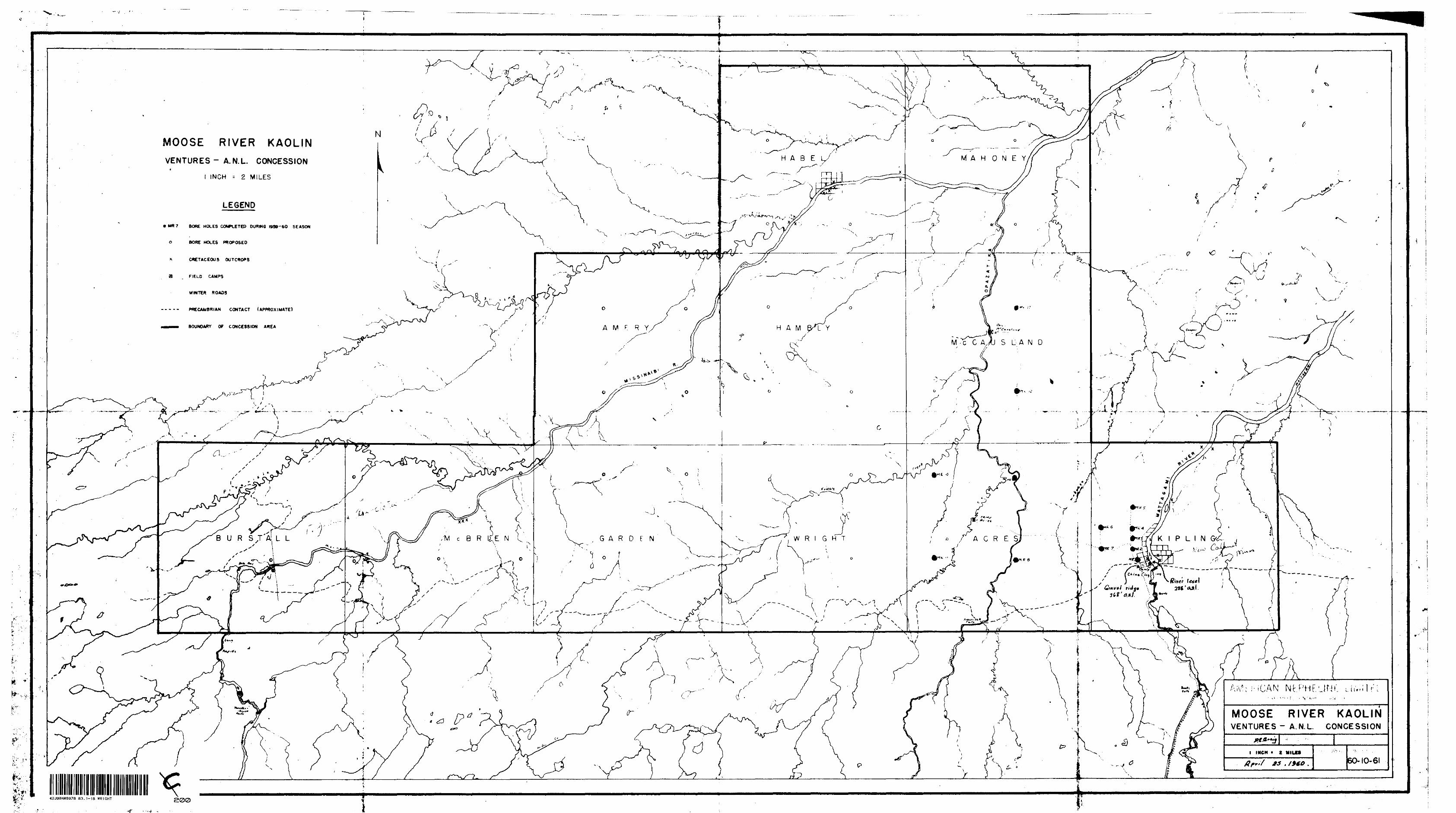
MOOSE RIVER KAOLINVENTURES- A.N.L. CONCESSION
t
INCH -- 2 MILES
M A H OHARE
LEGEND
MR 7 BORE HOLES COMPLETED DURING 1999-60 SEASON
BORE HOLES PROPOSED
CRETACEOUS OUTCROPS
PRECAMBRIAN CONTACT (APPROXIMATE)
BOUNDARY OF CONCESSION AREA A M K R Y
M -C C AAI S L A N D
G A R D F N W R l G H T ACRE


![Recent sculpture U.S.A. : [an exhibition]€¦ · October 12, 1939—November 22, 7959 February 22, i960—April 3, i960 May 3, i960—June 12, i960 September 14, i960—October 16,](https://img.pdfslide.us/doc/110x75/5f7ffba0bfd0417a96649bb5/recent-sculpture-usa-an-exhibition-october-12-1939anovember-22-7959-february.jpg)