Embed Size (px)
Citation preview

Silver, E. A., Rangin, C., von Breymann, M. T., et al., 1991Proceedings of the Ocean Drilling Program, Scientific Results, Vol. 124
3. DEVELOPMENT OF THE CELEBES BASIN IN THE CONTEXTOF WESTERN PACIFIC MARGINAL BASIN HISTORY*
Eli A. Silver2 and Claude Rangin3
ABSTRACT
The Celebes Sea is a marginal basin similar to those found throughout the western Pacific region. These basinsrepresent a number of different origins and histories, including back-arc extension and spreading, entrapment ofolder crust, formation along collisional plate boundaries, and stretching of the margins of the Australian andEurasian continents.
The origin of the Celebes Sea is still uncertain. An origin not far from its present location can be inferred frompaleomagnetic analysis of the sedimentary sections, which show little evidence of latitudinal change; clay mineraldata, which show no change from the red to green claystones; and spreading rate data, which show a factor of twodifference between the Celebes Sea Basin and the Philippine Sea Basin. The stratigraphy of the Eocene andOligocene sediments and comparison of the CCD variation with those of the Pacific Ocean indicate an open oceanorigin for the early history of the basin. If the Celebes Sea formed by rifting of the edge of Southeast Asia, it did soin a way that protected the basin from terrigenous input and allowed free interchange with open ocean waters. If,on the other hand, the basin formed originally as part of a larger open ocean basin, such as the Philippine, Indian,or Molucca Sea basins, it has moved less than 15° in latitude from its initial location. The Celebes Sea is presentlysubducting, as are many of the marginal basins of the western Pacific.
INTRODUCTION
The western Pacific region is characterized by festoons ofisland arcs and continental fragments that enclose a number ofmarginal basins (Fig. 1). These features display a variety ofstructural styles and settings, tectonic activity, sedimentthickness, and proximity to active arcs or continental margins.Earlier workers (Karig, 1970, 1971; Packham and Falvey,1971) viewed the origin of marginal basins solely as a result ofback arc spreading. Taylor and Karner (1983) urged caution,however, stressing the non-back-arc nature of the SouthChina (Taylor and Hayes, 1983), Woodlark (Weissel, Taylor,et al., 1982), Coral (Weissel and Watts, 1979) and TasmanSeas (Weissel and Hayes, 1977), and the unknown nature of anumber of other basins. We summarize the results of drillingand regional geophysics in the Celebes Sea, compare theseresults with studies in the South China and west Philippinebasins, and tabulate what is known of the timing and rate ofdevelopment of the other marginal basins in the westernPacific to evaluate the origin of Celebes Sea in a broadercontext.
ORIGINS OF MARGINAL BASINSThe term "marginal basin" is generally restricted to basins
situated marginally to a continent and underlain by oceaniccrust (Packham and Falvey, 1971; Taylor and Karner, 1983).Several potential origins have been proposed for marginalbasins (Fig. 2), one of which is back-arc spreading (Fig. 2A),as exemplified by the Lau and Mariana basins, initially de-scribed by Karig (1971). A second possible origin is extensionof the global rift system into a continent (Fig. 2B), as sug-
1 Silver, E. A., Rangin, C , von Breymann, M. T., et al., 1991. Proc. ODP,Sci. Results, 124: College Station, TX (Ocean Drilling Program).
2 Earth Sciences Board and Institute for Marine Sciences, University ofCalifornia, Santa Cruz, CA 95064, U.S.A.
3 Université de Pierre et Marie Curie, Laboratoire de Gèologie Structurale,4 Place Jussieu, Paris Cedex 05, France.
gested by Weissel and Hayes (1977) for the Tasman Sea andWeissel and Watts (1979) for the Coral Sea.
A third concept, proposed to explain some Southeast Asianbasins, is the breakup of the margin of East Asia as a result oflndia's collision with Asia. Tapponnier et al. (1982) proposedextrusion tectonics in Asia (Fig. 2C), as a model to explain thedevelopment of the South China Sea, the Thai and Malaybasins, and the Andaman Sea (not shown in Fig. 1).
A fourth concept is entrapment of a fragment of an olderocean basin (Fig. 2D), proposed for the west Philippine(Uyeda and Ben Avraham, 1972), and the Banda, Sulu, andCelebes Seas (Lee and McCabe, 1986). At present, the onlymarginal basin that can be documented as being a trappedfragment of an older plate is the Bering Sea Basin (Cooper etal., 1976a,b).
A fifth concept, transtensional basin formation by themovement of a major plate past a continental margin, mayexplain the Andaman Sea (Curray et al., 1982) and the BandaSea Basins. The latter is composed of an amalgamation ofseveral smaller basins and a displaced continental borderland(Silver et al., 1985).
THE CELEBES SEA BASINThe Celebes Sea covers an area of 400,000 km2. It has a
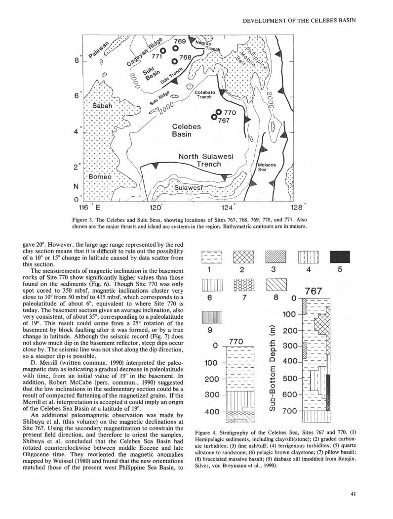
mean depth of somewhat over 5 km, a crustal thickness of 6-7km (Murauchi et al., 1973), and average heat flow of 65mW/m2 (Anderson et al., 1978). The basin is bordered on theeast by the Sangihe Arc and southern Philippines, on the southby the north arm of Sulawesi, on the west by Borneo, and onthe north by the Sulu Archipelago. Subduction zones occur inthe northeastern (the Cotabato Trench) and southern (northSulawesi Trench) parts of the Celebes Basin (Fig. 3).
Magnetic Anomalies A18-A20 have been identified in thebasin (Weissel, 1980), and indicate a middle Eocene age.Skewness analysis of the anomalies indicates no significantdifference in basin latitude between Eocene and the present(Weissel, 1980). Using the geomagnetic time scale summa-rized in Berggren et al. (1985), the whole spreading rateindicated by these anomalies is 47 km/m.y.
39

E. A. SILVER, C. RANGIN
20
N
IndianOcean
Figure 1. Basins of the northwest Pacific region. (1) Sea of Okhotsk;(2) Kurile Basin; (3) Japan Sea; (4) East China and Yellow seas; (5)South China Sea; (6) west Philippine Basin; (7) Shikoku Basin; (8)Parece Vela Basin; (9) Sulu Sea; (10) Celebes Sea; (11) Molucca Sea;(12) Banda Sea; (13) Caroline Basin.
A) Back-arcspreading
C) Collisional
D) Entrapment
Figure 2. Schematic diagram of the origins of marginal basins. (A)Back-arc spreading, (B) continental rifting, (C) extrusion, due tocollision, (D) trapping of part of an older ocean basin.
Sediment thickness varies from about 500 m locally in thenorthern part of the basin to over 3 km in the southern part.Thicknesses in excess of 1 km are widespread throughout thebasin. The sediment fill in the southern part of the basin iscomposed of turbidites that fill the north Sulawesi Trench.Hemipelagics and turbidites form the remainder.
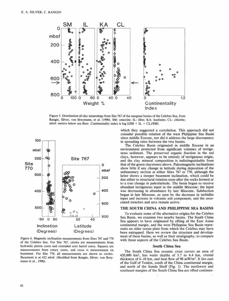
Site 767 penetrated 786 m of sediment and bottomed in 41cm of pillow basalt (Rangin, Silver, von Breymann, et al.,1990). Site 770, which was offset from Site 767 at a locationwhere the sediment cover was thinner, was spot-cored to 300mbsf and then cored continuously through 122 m of the lowersedimentary section and 110 m of basaltic basement.
The late Miocene to Pleistocene sequences in the twoCelebes Sea sites, 767 and 770, are dominantly hemipelagicdeposits derived from a volcanic terrane. They are composed
of smectite-rich clay with silt of crystal, vitric, and lithicvolcanic material (Fig. 4). Thin layers of ash occur throughoutthis sequence. The hemipelagic sediments were depositedbelow the CCD, but calcareous turbidites supplied micro- andnannofossils for dating. Benthic foraminifers, benthic dia-toms, and tunicate spines indicate transport from shallowwater. Turbidites are rare at Site 770. From late early Mioceneto late Miocene the average sedimentation rate was high (109m/m.y.) with the input of abundant turbidites from continentalsources. The sequence is 300 m thick and contains quartz sandand silt, plant debris, and reworked Eocene and lower Mi-ocene nannofossils. The clay in this sequence is dominantlyillite (Rangin, Silver, von Breymann, et al., 1990).
The middle Eocene to early Miocene sequence at Site 767is pelagic, with a sedimentation rate between 2 and 6 m/m.y.,a red-brown color, manganese nodules, and a clay composi-tion typical of western Pacific basin sediments (>50% smec-tite, 25% illite, <10% kaolinite, and <5% chlorite). Thedeposits overlying basement at both sites contain a radiolarianfauna indicating a late middle Eocene age (42 Ma). Site 770was apparently close to the CCD during this time, and itcontains a large amount of carbonate (mainly discoasters).
Clay mineral distribution at Site 767 can be a usefulindicator of the relationship between the red clay unit and theoverlying gray-green clay stone and siltstone. The lower partof Site 767, from 640 to 786 mbsf, has very uniform claymineral composition with about 55% smectite, 30% illite,<10% kaolinite, and about 5% chlorite. The continentalityindex (the log of the sum of smectite plus illite plus chloritedivided by smectite (Rangin, Silver, von Breymann, et al.,1990) is approximately 0.15, with no significant deviation (Fig.5). The top of the red clay unit lies at 700 mbsf at Site 767, yetthe relatively uniform clay mineralogy, just discussed, showsno change until a depth of 640 mbsf. There is a sharp break inthe continentality index at 640 mbsf. Thus the change in thecores from red to green clay at 700 mbsf does not represent achange in clay mineralogy. The observations are consistentwith the suggestion of Smith et al. (1990), that a slightlygreater sedimentation rate in the green clays prevented ferricoxidation. In parallel with this observation, Bertrand et al.(this volume) demonstrated that the organic material at Site767 is largely of terrestrial derivation, and they noted nochange in the character of the organic material across thered/green clay boundary.
Basement was encountered at 786 mbsf at Site 767 and 422mbsf at Site 770. Tholeiitic pillow basalt was recovered at Site767, whereas seven flow units were identified at Site 770,where 106 m of basalt were penetrated. The basalt flows areintruded by two dolerite sills near the base of the section. Theflows are pillow basalts, breccias, and veined and brecciatedbasalts. All samples analyzed are tholeiitic, and geochemistryindicates a strong MORB affinity. The volcanic rocks arePlagioclase and olivine phyric basalts, with the top flowcontaining clinopyroxene as well. Vesicles make up 1-15% ofthe rocks. They are generally 1-3 mm in diameter, spherical,and distributed both randomly and in thin layers. Chemically,the volcanic rocks from Site 770 are tholeiitic basalts, similarto primitive-to-moderately fractionated MORB basalts (Ran-gin, Silver, von Breymann, et al., 1990).
Magnetic measurements at Sites 767 and 770 do not docu-ment any significant change in inclination down the sedimen-tary sections. Values of calculated paleolatitude determinedfor Site 767 are scattered over a range of 0° to 15° in the upper600 mbsf, and range from 0° to 20° below 700 mbsf (Fig. 6).Two values were measured that fall outside of these ranges,one of 42° in the upper section and one of 25° in the lower part.The single value measured on basement material at Site 767
40
DEVELOPMENT OF THE CELEBES BASIN
North SulawesiTrench
116 E 120 124 128
Figure 3. The Celebes and Sulu Seas, showing locations of Sites 767, 768, 769, 770, and 771. Alsoshown are the major thrusts and island arc systems in the region. Bathymetric contours are in meters.
gave 20°. However, the large age range represented by the redclay section means that it is difficult to rule out the possibilityof a 10° or 15° change in latitude caused by data scatter fromthis section.
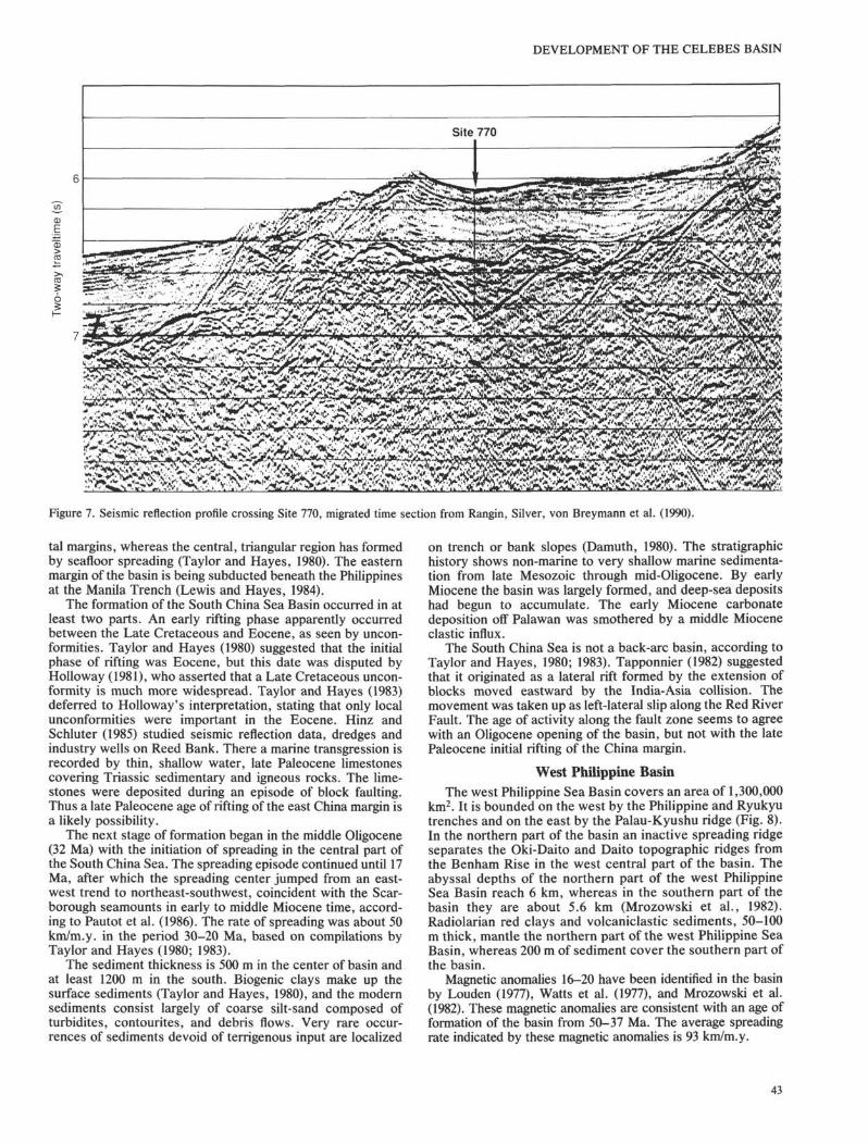
The measurements of magnetic inclination in the basementrocks of Site 770 show significantly higher values than thosefound on the sediments (Fig. 6). Though Site 770 was onlyspot cored to 350 mbsf, magnetic inclinations cluster veryclose to 10° from 50 mbsf to 415 mbsf, which corresponds to apaleolatitude of about 6°, equivalent to where Site 770 istoday. The basement section gives an average inclination, alsovery consistent, of about 35°, corresponding to a paleolatitudeof 19°. This result could come from a 25° rotation of thebasement by block faulting after it was formed, or by a truechange in latitude. Although the seismic record (Fig. 7) doesnot show much dip in the basement reflector, steep dips occurclose by. The seismic line was not shot along the dip direction,so a steeper dip is possible.
D. Merrill (written commun. 1990) interpreted the paleo-magnetic data as indicating a gradual decrease in paleolatitudewith time, from an initial value of 19° in the basement. Inaddition, Robert McCabe (pers. commun., 1990) suggestedthat the low inclinations in the sedimentary section could be aresult of compacted flattening of the magnetized grains. If theMerrill et al. interpretation is accepted it could imply an originof the Celebes Sea Basin at a latitude of 19°.
An additional paleomagnetic observation was made byShibuya et al. (this volume) on the magnetic declinations atSite 767. Using the secondary magnetization to constrain thepresent field direction, and therefore to orient the samples,Shibuya et al. concluded that the Celebes Sea Basin hadrotated counterclockwise between middle Eocene and lateOligocene time. They reoriented the magnetic anomaliesmapped by Weissel (1980) and found that the new orientationsmatched those of the present west Philippine Sea Basin, to
11j
111
1
i
1
9
0
100
200
300
400
770
8 0
100
767
ε 200- -
Q.<DQ
£ooGQ
i.Q=)CO
300
400
500
600
700
Figure 4. Stratigraphy of the Celebes Sea, Sites 767 and 770. (1)Hemipelagic sediments, including clay/silt(stone); (2) graded carbon-ate turbidites; (3) fine ash/tuff; (4) terrigenous turbidites; (5) quartzsiltstone to sandstone; (6) pelagic brown claystone; (7) pillow basalt;(8) brecciated massive basalt; (9) diabase sill (modified from Rangin,Silver, von Breymann et al., 1990).
41
E. A. SILVER, C. RANGIN
0
mbsf
200
400
600
800
SM CL
ooO
100 0 60 0
Weight40 0 40 0 1.2
ContinentalityIndex
100
mbsf
200
Site770
300
400
500
Figure 5. Distribution of clay mineralogy from Site 767 of the marginal basins of the Celebes Sea, fromRangin, Silver, von Breymann, et al. (1990). SM: smectite; IL: illite; KA: kaolinite; CL: chlorite;mbsf: meters below sea floor. Continentality index is log [(SM + IL + CL)/SM].
which they suggested a correlation. This approach did notconsider possible rotation of the west Philippine Sea Basinsince middle Eocene, nor did it address the large discrepancyin spreading rates between the two basins.
The Celebes Basin originated in middle Eocene in anenvironment protected from significant volumes of terrige-nous sediment. The preserved organic fraction in the redclays, however, appears to be entirely of terrigenous origin,and the clay mineral composition is indistinguishable fromthat of the green clay stones above. Paleomagnetic inclinationsshow little if any change in latitude during deposition of thesedimentary section at either Sites 767 or 770, although thelatter shows a steeper basement inclination, which could bedue either to structural rotation soon after the rocks formed orto a true change in paleolatitude. The basin began to receiveabundant terrigenous input in the middle Miocene; the inputwas decreasing in abundance by late Miocene. Subductionbegan in late Miocene, as seen by the decrease in turbiditeinput and increase in volcanic ash component, and the asso-ciated trenches and arcs remain active.
-90 0 90
Inclination(Degrees)
40
Latitude(Degrees)
- 600
800
Figure 6. Magnetic inclination measurements from Sites 767 and 770of the Celebes Sea. For Site 767, circles are measurements fromhydraulic piston cores and extended core barrel cores. Squares aremeasurements from rotary cores, and cross is measurement onbasement. For Site 770, all measurements are shown as circles.Basement is at 422 mbsf. (Modified from Rangin, Silver, von Brey-mann et al., 1990).
THE SOUTH CHINA AND PHILIPPINE SEA BASINSTo evaluate some of the alternative origins for the Celebes
Sea Basin, we examine two nearby basins. The South ChinaSea appears to have originated by rifting of the East Asiancontinental margin, and the west Philippine Sea Basin repre-sents an older ocean plate from which the Celebes may havebeen entrapped. Here we review the structure and develop-ment of these basins, as well as their stratigraphy, to comparewith those aspects of the Celebes Sea Basin.
South China SeaThe South China Sea oceanic crust covers an area of
420,000 km2, has water depths of 3.7 to 4.4 km, crustalthickness of 6-10 km, and heat flow of 90 mW/m2. It lies eastof the Gulf of Tonkin, south of the China continental margin,and north of the Sunda Shelf (Fig. 1). The northwest andsoutheast margins of the South China Sea are rifted continen-
42
DEVELOPMENT OF THE CELEBES BASIN
Site 770
EEkjf^•SüllLt^l**' f C ' ITJ . . , . . ' l4 '1 !* ' " " I ' * " ' 1 ' 1 — V .^_. , . • _ ti ' * J V ' I
§ pç~r•^•^^"-'1';'.,; ̂ '''••" * ''rfw
Figure 7. Seismic reflection profile crossing Site 770, migrated time section from Rangin, Silver, von Breymann et al. (1990).
tal margins, whereas the central, triangular region has formedby seafloor spreading (Taylor and Hayes, 1980). The easternmargin of the basin is being subducted beneath the Philippinesat the Manila Trench (Lewis and Hayes, 1984).
The formation of the South China Sea Basin occurred in atleast two parts. An early rifting phase apparently occurredbetween the Late Cretaceous and Eocene, as seen by uncon-formities. Taylor and Hayes (1980) suggested that the initialphase of rifting was Eocene, but this date was disputed byHolloway (1981), who asserted that a Late Cretaceous uncon-formity is much more widespread. Taylor and Hayes (1983)deferred to Holloway's interpretation, stating that only localunconformities were important in the Eocene. Hinz andSchluter (1985) studied seismic reflection data, dredges andindustry wells on Reed Bank. There a marine transgression isrecorded by thin, shallow water, late Paleocene limestonescovering Triassic sedimentary and igneous rocks. The lime-stones were deposited during an episode of block faulting.Thus a late Paleocene age of rifting of the east China margin isa likely possibility.
The next stage of formation began in the middle Oligocene(32 Ma) with the initiation of spreading in the central part ofthe South China Sea. The spreading episode continued until 17Ma, after which the spreading center jumped from an east-west trend to northeast-southwest, coincident with the Scar-borough seamounts in early to middle Miocene time, accord-ing to Pautot et al. (1986). The rate of spreading was about 50km/m.y. in the period 30-20 Ma, based on compilations byTaylor and Hayes (1980; 1983).
The sediment thickness is 500 m in the center of basin andat least 1200 m in the south. Biogenic clays make up thesurface sediments (Taylor and Hayes, 1980), and the modernsediments consist largely of coarse silt-sand composed ofturbidites, contourites, and debris flows. Very rare occur-rences of sediments devoid of terrigenous input are localized
on trench or bank slopes (Damuth, 1980). The stratigraphichistory shows non-marine to very shallow marine sedimenta-tion from late Mesozoic through mid-Oligocene. By earlyMiocene the basin was largely formed, and deep-sea depositshad begun to accumulate. The early Miocene carbonatedeposition off Palawan was smothered by a middle Mioceneclastic influx.
The South China Sea is not a back-arc basin, according toTaylor and Hayes, 1980; 1983). Tapponnier (1982) suggestedthat it originated as a lateral rift formed by the extension ofblocks moved eastward by the India-Asia collision. Themovement was taken up as left-lateral slip along the Red RiverFault. The age of activity along the fault zone seems to agreewith an Oligocene opening of the basin, but not with the latePaleocene initial rifting of the China margin.
West Philippine BasinThe west Philippine Sea Basin covers an area of 1,300,000
km2. It is bounded on the west by the Philippine and Ryukyutrenches and on the east by the Palau-Kyushu ridge (Fig. 8).In the northern part of the basin an inactive spreading ridgeseparates the Oki-Daito and Daito topographic ridges fromthe Benham Rise in the west central part of the basin. Theabyssal depths of the northern part of the west PhilippineSea Basin reach 6 km, whereas in the southern part of thebasin they are about 5.6 km (Mrozowski et al., 1982).Radiolarian red clays and volcaniclastic sediments, 50-100m thick, mantle the northern part of the west Philippine SeaBasin, whereas 200 m of sediment cover the southern part ofthe basin.
Magnetic anomalies 16-20 have been identified in the basinby Louden (1977), Watts et al. (1977), and Mrozowski et al.(1982). These magnetic anomalies are consistent with an age offormation of the basin from 50-37 Ma. The average spreadingrate indicated by these magnetic anomalies is 93 km/m.y.
43
E. A. SILVER, C. RANGIN
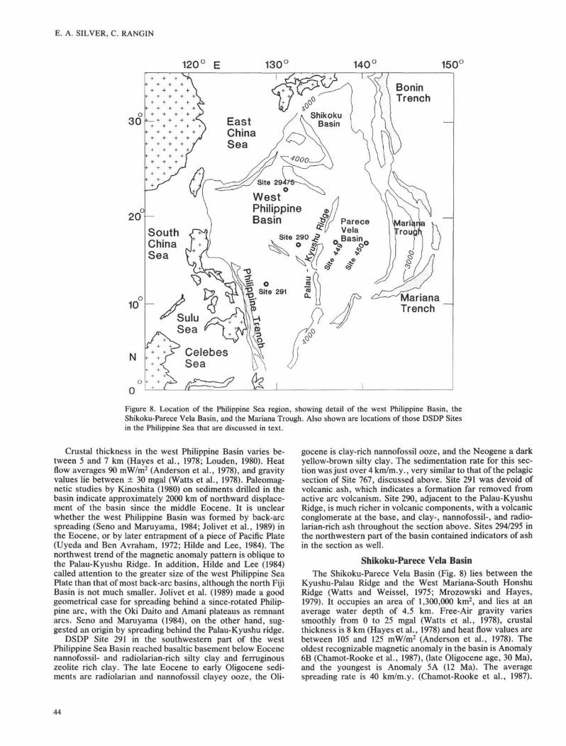
120° E 130° 140° 150(
BoninTrench
WestPhilippineBasin
MarianaTrench
Figure 8. Location of the Philippine Sea region, showing detail of the west Philippine Basin, theShikoku-Parece Vela Basin, and the Mariana Trough. Also shown are locations of those DSDP Sitesin the Philippine Sea that are discussed in text.
Crustal thickness in the west Philippine Basin varies be-tween 5 and 7 km (Hayes et al., 1978; Louden, 1980). Heatflow averages 90 mW/m2 (Anderson et al., 1978), and gravityvalues lie between ± 30 mgal (Watts et al., 1978). Paleomag-netic studies by Kinoshita (1980) on sediments drilled in thebasin indicate approximately 2000 km of northward displace-ment of the basin since the middle Eocene. It is unclearwhether the west Philippine Basin was formed by back-arcspreading (Seno and Maruyama, 1984; Jolivet et al., 1989) inthe Eocene, or by later entrapment of a piece of Pacific Plate(Uyeda and Ben Avraham, 1972; Hilde and Lee, 1984). Thenorthwest trend of the magnetic anomaly pattern is oblique tothe Palau-Kyushu Ridge. In addition, Hilde and Lee (1984)called attention to the greater size of the west Philippine SeaPlate than that of most back-arc basins, although the north FijiBasin is not much smaller. Jolivet et al. (1989) made a goodgeometrical case for spreading behind a since-rotated Philip-pine arc, with the Oki Daito and Amani plateaus as remnantarcs. Seno and Maruyama (1984), on the other hand, sug-gested an origin by spreading behind the Palau-Kyushu ridge.
DSDP Site 291 in the southwestern part of the westPhilippine Sea Basin reached basaltic basement below Eocenenannofossil- and radiolarian-rich silty clay and ferruginouszeolite rich clay. The late Eocene to early Oligocene sedi-ments are radiolarian and nannofossil clayey ooze, the Oli-
gocene is clay-rich nannofossil ooze, and the Neogene a darkyellow-brown silty clay. The sedimentation rate for this sec-tion was just over 4 km/m.y., very similar to that of the pelagicsection of Site 767, discussed above. Site 291 was devoid ofvolcanic ash, which indicates a formation far removed fromactive arc volcanism. Site 290, adjacent to the Palau-KyushuRidge, is much richer in volcanic components, with a volcanicconglomerate at the base, and clay-, nannofossil-, and radio-larian-rich ash throughout the section above. Sites 294/295 inthe northwestern part of the basin contained indicators of ashin the section as well.
Shikoku-Parece Vela BasinThe Shikoku-Parece Vela Basin (Fig. 8) lies between the
Kyushu-Palau Ridge and the West Mariana-South HonshuRidge (Watts and Weissel, 1975; Mrozowski and Hayes,1979). It occupies an area of 1,300,000 km2, and lies at anaverage water depth of 4.5 km. Free-Air gravity variessmoothly from 0 to 25 mgal (Watts et al., 1978), crustalthickness is 8 km (Hayes et al., 1978) and heat flow values arebetween 105 and 125 tnW/ra2 (Anderson et al., 1978). Theoldest recognizable magnetic anomaly in the basin is Anomaly6B (Chamot-Rooke et al., 1987), (late Oligocene age, 30 Ma),and the youngest is Anomaly 5A (12 Ma). The averagespreading rate is 40 km/m.y. (Chamot-Rooke et al., 1987).
44

Chamot- Rook et al. suggested that the basin first underwentlate Oligocene E-W rifting that was followed by early MioceneNE-SW oriented spreading.
The magnetic anomalies in the Shikoku and Parece Velabasins generally trend parallel to the ridges (the South Honshuand Palau-Kyushu ridges that bound the Shikoku Basin, andwest Mariana and Palau-Kyushu ridges that bound PareceVela Basin). In addition, the inactive spreading centers withinthese basins are centrally located, all of which is consistentwith a back-arc spreading origin of the basins that split thebounding ridges. This process is occurring presently to theeast in the Mariana rift zone, where active back-arc spreadinghas split the Mariana arc and west Mariana ridges (Karig,1971; Hussong, Uyeda et al., 1981). Incipient rifting alsooccurs between the Bonin arc and the south Honshu Ridge(Honza and Tamaki, 1985; Tamaki, 1985).
DSDP Site 449 in the eastern Parece Vela Basin (Fig. 8)reached basaltic basement of late Oligocene age beneath anannofossil ooze. The early Miocene deposits were dark-yellow brown pelagic clay with ash layers, pumice fragments,and manganese nodules. Radiolarian and nannofossil ooze
DEVELOPMENT OF THE CELEBES BASIN
with ash layers compose the middle Miocene, and dark-brownpelagic clay forms the upper part of the section. Site 450 in thewestern Parece Vela Basin recovered approximately 250 m ofvitric tuffs above basaltic basement, all of middle Mioceneage. Dark yellow-brown, ash-rich pelagic clay forms the upper83 m of the section. The basalt in both sites are chemicallyN-MORB in composition (Kroenke, Scott et al., 1981), but theabundance of ash at the base of the section near a likelyremnant arc (the Palau-Kyushu Ridge) supports an origin byback-arc spreading.
AREAL DEVELOPMENT OF WESTERN PACIFICMARGINAL BASINS THROUGH TIME
We have examined the temporal history of development ofthe marginal basins floored by oceanic crust in the westernPacific region (Table 1 and Fig. 9). The sources for the inputdata are referred to in Table 1. We determined the growth rateof each basin by dividing the basin area by the duration ofactivity, constrained in most cases by magnetic anomalies.For several of the basins (South China Sea, west PhilippineBasin, and Shikoku Basin) we split their activity into two
Table 1. Ages, areas, and growth rates in the western Pacific marginal basin.
Basin name
1. Japan2. Okinawa3. Kurile4. S China5. S China6. SE Sulu7. Celebes8. W Philippine9. W Philippine
10. Shikoku11. Shikoku12. Parece Vela13. Mariana14. Caroline15. Tasman16. Coral17. New Caledonia18. Woodlark19. South Fiji20. New Hebrides21. North Fiji22. Lau-Havre23. Manus
AgeMa
18-140-2
18-14?32-2323-1619-1550-4255-4747-3926-2020-1530-173-0
36-2882-6062-5665-60?3-0
34-2655-428-03-03-0
Area
0.350.110.110.210.210.070.411.330.80.150.120.920.241.32.20.310.30.130.710.31.00.50.12
*×106 km2
Growth Rate**
0.0870.0550.0270.02550.030.01750.0510.1660.10.0250.0240.0710.080.1620.10.0520.060.0430.0890.0230.1250.1630.04
**×106km2/m.y.
References
1,2,34,5,36,78,98,9,1011,123,11,133,14,15,16,173,14,15,16,173,18,19,20,213,18,19,20,213,18,19,20,2122,233,24,25,2627,282930,3132,3334,3035,3034,36,37,3839,4041
References
1. Tamaki et al., 19892. Pisciotto et al., 19893. Mammerickx et al., 19774. Letouzey and Kimura, 19855. Viallon et al., 19866. Gnibidenko, 19857. Savostinet al., 19838. Taylor and Hayes, 19809. Taylor and Hayes, 1983
10. Pautot et al., 198611. Rangin, Silver et al., 199012. Rangin and Silver, this v.13. Weissel, 198014. Louden, 197715. Watts et al., 197716. Mrozowski et al., 198217. Ingle, Karig et al., 197518. Watts and Weissel, 197519. Mrozowski and Hayes, 197920. Chamot-Rooke et al., 198721. Kroenke, Scott et al.,1981
22. Bibeeetal., 198023. Hussong, Uyeda et al.,198124. Weissel and Anderson, 197825. Hegarty et al., 198326. Hill and Hegarty, 198727. Weissel and Hayes, 197728. Weissel et al., 197729. Weissel and Watts, 197930. Andrews, Packham et al., 197531. Burns, Andrews et al.,197332. Weissel, Taylor, et al., 198233. Taylor and Exon, 198734. Malahoffetal., 198235. Weissel, Watts, et al., 198236. Auzende, Lafoy, et al., 198837. Auzende, Eissen, et al., 198838. Chase, 197139. Sclater et al., 197240. Lawveret al., 197641. Taylor, 1979
45

E. A. SILVER, C. RANGIN
North FijiNW Pacific Basins
SW Pacific Basins
20 m.)Are<
K m * 2 0
100
f. Averages3
_i
I •-ηi i i
Ii i i
i i
D Ma 40 80
Area
x105
Km2
OkinawaMarianaWoodlarkLauManus
West Philippine
New Hebrides
010 20 30 40 50 60 70 80
MaFigure 9. Plot of crustal area vs. age for marginal basins of the western Pacific region. Heavy solid lines show age ranges forindividual basins (from Table 1), whereas histograms below show the aggregate ages for all the basins. Inset on the right givesa plot of crustal area vs. age for marginal basins of the western and southwestern Pacific region, using 20-m.y. averages.
periods. This procedure gives the area accreted by each basinper million years. We have also grouped the basins intowestern Pacific and southwestern Pacific basins for compari-son.
The distribution of activity in the southwestern Pacificmarginal basins falls into three major groupings: 0-8 Ma,25-35 Ma, and 55-80 Ma. The youngest grouping is muchmore widespread than that for the western Pacific, becauseof the activity in the Bismarck, Lau-Havre, Woodlark, andnorth Fiji basins. The 25-35 Ma interval is a result ofactivity in the South Fiji Basin, and the oldest interval is acombination of the Tasman, Coral, New Caledonia, andNew Hebrides basins. The peak at 60-65 Ma is due toseafloor spreading in the New Caledonia Basin, but it is notwell dated. The continued low activity from 40-55 Maresults from opening of the New Hebrides Basin, whoseeffect may in fact have been greater, depending on howmuch of the basin has been destroyed by subduction in thecreation of the north Fiji Basin.
The activity in the western Pacific is more concentrated inthe periods 15-35 Ma and 40-55 Ma. Very young (0-3 Ma)spreading has occurred also in the Mariana and Okinawatroughs. A striking aspect of the western Pacific marginalbasins is the apparent absence of activity between 3 and 14Ma. This period followed the cessation of spreading in theSouth China, Sulu, and Japan seas, and is prior to the activityof the modern spreading basins. The southwestern Pacific alsohas a hiatus in new crustal generation from 9-25 Ma. Thisappears to be the longest quiet period during the past 80 Ma.Two periods of no reported formation of marginal basins ineither the western or southwestern Pacific regions are from9-14 Ma and 36-38 Ma. Because the older basins are morepoorly constrained, we have less confidence in the 36-38 Mahiatus than of the younger one.
There is a weak suggestion of peak activity in the westernPacific approximately every 15 Ma (Fig. 9). The 60-Ma peakis wholly from the southwestern Pacific, the 45-Ma peak
largely from the western Pacific, the 30-Ma peak from both,the 17-Ma peak only from the western Pacific, and themodern peak from both regions. The amplitude of thehighest peak in the last 5 Ma relative to the other peaks maybe misleading because there is less precision in dating theolder basins, a greater focus on actively spreading basins,and a loss of area of older basins by subduction. If weaverage the area vs. time for all basins into 20-Ma agegroupings (Fig. 9), we find that although the formation ofmarginal basins may be episodic, during the past 80 Ma theaveraged aggregate rate of basin formation in the westernPacific has been essentially constant.
Uncertainty in these graphs include measurement error,which should be similar for most of the basins, dating error,which is variable, and destruction of area of some of thebasins by subduction on one or more of their margins.Examples are the Japan Sea (Tamaki and Honza, 1984), theNew Hebrides Basin (Weissel, Watts, et al., 1982), theCelebes Sea Basin (Weissel, 1980; Silver, McCaffrey, et al.,1983), the South China Sea Basin (Taylor and Hayes, 1983;Lewis and Hayes, 1984), the west Philippine Sea Basin (Lewisand Hayes, 1983), the Sulu Sea Basin (Hinz and Block, 1990),the Caroline Basin (Ryan and Marlow, 1988), the Banda Sea(Hamilton, 1979; Silver, Reed, et al., 1983), and the WoodlarkBasin (Taylor and Exon, 1987). Many of these have sufferedonly small amounts of seafloor loss, such as the Japan Sea, butothers, such as New Hebrides and Celebes Basins, may havelost significant area to subduction.
The time of development of both the Celebes (55-42 Ma)and Sulu (19-15 Ma) basins fall on peaks of basin development(Fig. 9). The Sulu Basin formed during the last phases ofactivity in the South China, Japan, and Shikoku-Parece Velabasins. The Celebes Basin formed concurrently with the westPhilippine and New Hebrides basins. The New HebridesBasin was probably too far removed during the Eocene tohave had any effect on the formation of the Celebes Sea, butthe west Philippine Basin would have been nearby.
46
DEVELOPMENT OF THE CELEBES BASIN
DISCUSSION OF THE ORIGIN OF CELEBES SEABASIN
Three alternative origins for the Celebes Sea Basin are: afragment of an older ocean basin, a back-arc basin, or a basinrifted from the Southeast Asian continental margin. If part ofa larger basin, possibilities are the northern Indian Ocean, thewest Philippine Basin, or the Molucca Sea. No crust ofEocene age has been drilled in the Indian Ocean, so we cannotmake direct comparisons with the drilling results. Spreadingrates indicated by magnetic anomalies of Eocene age in thePhilippine Sea Basin (Louden, 1977; Watts et al., 1977;Mrozowski et al., 1982) are faster (about 93 km/m.y.) by afactor of two than those of the Celebes Basin (45 km/m.y.,Weissel, 1980). In addition, both the Indian Ocean and Phil-ippine Sea Plates have moved great distances relative to themagnetic poles, in contrast to the Celebes Sea, which showslittle evidence of such motion throughout the sedimentarycolumn.
Examination of the latest magnetic anomaly compilation ofthe oceans by Cande et al. (1989) indicates that spreading inthe Indian Ocean reorganized at or just prior to Anomaly 20,when the southeast Indian Ocean ridge jumped to a moresouthern position. Earlier, the spreading system could haveextended east to the possible location of the Celebes Basin,but after the jump the ridge connected with spreading south ofAustralia, making it unlikely that the Celebes Sea was createdfrom spreading in the Indian Ocean after Anomaly 20.
Sedimentation in the west Philippine Basin is similar in theEocene and Oligocene to that of the Celebes Sea, althoughmost sites have a higher content of volcanic ash in the red claysection, as well as a significant amount of nannofossils (Ingle,Karig et al., 1975). The basement depth of the west PhilippineBasin is greater than that of Celebes (5.6-6 km for westPhilippine vs. 5 km for Celebes). While not totally ruling outan origin relating the Celebes Basin to either the PhilippineSea or Indian Ocean, these hypotheses fail several tests.
The Molucca Sea may have originally been part of theCelebes Basin (Fig. 3). The Sangihe arc, which separates theMolucca and Celebes Seas, may have developed on an ancienttransform fault within the combined basin (Daly et al., 1987).The advantage of this hypothesis is the proximity of CelebesBasin to the Molucca Sea, and such a connection was sug-gested by Daly et al. (1987). Unfortunately, the idea is noteasily testable, as the Molucca Sea Plate is nearly completelysubducted.
An origin for the Celebes Sea Basin by rifting of theSoutheast Asian margin (Rangin et al., 1990) is consistent withPaleomagnetism (Weissel, 1980; Shibuya et al., 1989; Merrillet al., this volume; Rangin, Silver, von Breymann et al., 1990),as well as with clay mineral data and organic chemistry insome of the cores. These sedimentologic observations supportprevious arguments (Weissel, 1980) against a far-traveledCelebes Sea. Perhaps as an outer borderland basin it wasprotected from significant input of continental sediment.
An argument against a continental margin origin of theCelebes Sea is the retrieval of basalt of N-MORB compositionfrom Site 770 (Rangin, Silver, von Breymann et al., 1990),indicating true oceanic magma genesis. We note, however,that basalts of N-MORB composition were also recoveredfrom the west Philippine Basin, Shikoku Basin, and from thecenter of the Lau Basin, indicating that marginal basins mayhave crustal compositions very similar to those of major oceanbasins (Hawkins, 1976).
We do not favor an origin for the Celebes Sea related to theIndian Ocean or west Philippine Basin because the spreadinghistory and rates in those basins are not consistent with
observations in the Celebes Basin. Also, paleomagnetic dataon the sediments in the Celebes Sea indicate little apparentchange in latitude with time, unlike the data from the Philip-pine Sea and Indian Ocean. Basement samples from Site 770in the Celebes Sea give a paieolatitude of 19°, which couldindicate either a rotation of the basement block or a realchange in latitude.
A change in sediment type from pelagic red clay to hemi-pelagic green claystone in the Celebes Sea appears not tocoincide with differences in clay mineral compositions andratios, indicating that the color change does not represent amajor difference in sedimentary environment. Absence ofchange in clay mineral provenance and abundance of terres-trial organic matter in the red clays are consistent with a morelocal origin of the basin, as opposed to a far-traveled origin,but clay mineralogy does not provide quantitative constraintson the amount of movement.
The available evidence suggests that the Celebes Sea Basinhas not moved more than about 15° relative to Southeast Asiasince its inception. Possible analogous basins are the CoralSea, which differs by having a high carbonate content in thelower sediments and a higher rate of clay sedimentation thanCelebes (Andrews, Packham et al., 1975), or the South ChinaSea, which has not been drilled. With the presently availableevidence we favor an origin for the Celebes Sea as either abasin rifted from the East Asian margin, or one trapped froma once much larger Molucca Sea Plate.
ACKNOWLEDGMENTSE. Silver thanks the U.S. Science Advisory Committee
(USSAC) and both authors thank the National Center forScientific Research of France (CNRS) for their generoussupport of this research. We are grateful for reviews andcomments by Jeff Weissel, Bob McCabe, and Martin Fisk,and to the exceptionally thorough review by Larry Lawver,which have greatly improved (and shortened) this manu-script.
REFERENCES
Anderson, R. N., Langseth, M. G., Hayes, D. E., Watanabe, T., andYasui, M., 1978. Heat Flow, thermal conductivity, thermal gradi-ent. In Hayes, D. E. (Ed.), A Geophysical Atlas of the East andSoutheast Asian Seas: Geol. Soc. Am. Map and Chart Ser.,MC-25, 1:6,442,194.
Andrews, J. E., Packham, G., et al., 1975. Init. Repts. DSDP, 30:Washington (U.S. Govt. Printing Office).
Auzende, J. M., Lafoy, Y., and Marsset, B., 1988a. Recent geody-namic evolution of the north Fiji Basin (southwest Pacific). Geol-ogy, 16:925-929.
Auzende, J. M., Eissen, J. P., Lafoy, Y., Gente, P., and Charlou, J.L., 1988b. Sea-floor spreading in the north Fiji Basin (SW Pacific).Tectonophysics, 146:317-351.
Berggren, W. A., Kent, D. V., Flynn, J. J., and Van Couvering, J. A.,1985. Cenozoic geochronology. Geol. Soc. Am. Bull., 96:1407-1418.
Bibee, L. D., Shor, G. G., and Lu, R. S., 1980. Interarc spreading inthe Mariana trough. Mar. Geol., 35:183-197.
Burns, R. E., Andrews, J. E., et al., 1973. Init. Repts. DSDP, 21:Washington (U.S. Govt. Printing Office).
Cande, S. C , LaBrecque, J. L., Larson, R. L., Pitman III, W. C ,Golovchenko, X., and Haxby, W. F., 1989, Magnetic lineations ofthe world's oceans. AAPG, Map, 1:27,400,000.
Chamot-Rooke, N., Renard, V., and Le Pichon, X., 1987. Magneticanomalies in the Shikoku Basin: a new interpretation. EarthPlanet. Sci. Lett., 83:214-228.
Chase, C. G., 1971. Tectonic history of the Fiji plateau. Geol. Soc.Am. Bull., 82:3087-3110.
Cooper, A. K., Scholl, D. W., and Marlow, M. S., 1976a. Mesozoicmagnetic lineations in the Bering Sea marginal Basin. J. Geophys.Res., 11:1916-1934.
47

E. A. SILVER, C. RANGIN
, 1976b. A plate tectonic model for evolution of the easternBering Sea Basin. Geol. Soc. Am. Bull, 87:1119-1126.
Curray, J. R., Emmel, F. J., Moore, D. G., and Raitt, R. W., 1982.Structure, tectonics and geological history of the northeastern IndianOcean. In Nairn, A.E.M., and Stehli, F. G. (Eds.), The OceanBasinsand Margins (Vol. 6): New York (Plenum), 399-450.
Daly, M. C , Hooper, B.G.D., and Smith, D. G., 1987. Tertiary platetectonics and basin evolution in Indonesia. Proc. IndonesianPetrol. Assoc, 16th Ann. Conv.
Damuth, J. E., 1980. Quaternary sedimentation processes in theSouth China basin as revealed by echo-character mapping andpiston-core studies. In Hayes, D. E. (Ed.), The Tectonic andGeologic Evolution of the Southeast Asian Seas and Islands. Am.Geophys. Union, Geophys. Monogr Ser., 23:105-125.
Gnibidenko, H. S., 1985. The Sea of Okhotsk-Kurile Islands ridge andKurile-Kamchatka trench. In Nairn, A.E.M., Stehli, F. G., andUyeda, S. (Eds.), The Ocean Basins and Margins (Vol. 7): NewYork (Plenum), 377-418.
Hamilton, W., 1979. Tectonics of the Indonesian region. Geol. Surv.Prof. Pap. U.S., No. 1078.
Hawkins, J. W., 1976. Petrology and geochemistry of basaltic rocks ofthe Lau Basin. Earth Planet. Sci. Lett., 28:283-297.
Hayes, D. E., Houtz, R. E., Jarrard, R. D., Mrozowski, C. L., andWatanabe, T., 1978. Crustal structure. In Hayes, D. E. (Ed.), AGeophysical Atlas of the East and Southeast Asian Seas. Geol.Soc. Am. Map and Chart Ser., MC-25, 1:6,442,194.
Hegarty, K. A., Weissel, J. K., and Hayes, D. E., 1983. Convergenceat the Caroline-Pacific plate boundary: collision and subduction.In Hayes, D. E. (Ed.), The Tectonic and Geologic Evolution ofSoutheast Asian Seas and Islands (Vol. 2), Am. Geophys. Union,Geophys. Monogr., 27:326-348.
Hilde, T. W.C., and Lee, C. S., 1984. Origin and evolution of the westPhilippine basin: a new interpretation. Tectonophysics, 102:85-104.
Hill, K. C , and Hegarty, K. A., 1987. New tectonic framework forPNG and the Caroline Plate: implications for cessation of spread-ing in back[00a9]arc basins. Pacific Rim Congress 87, the geol-ogy, structure, mineralization, and economics of the Pacific Rim,Gold Coast Australia. Australian Institute of Mining and Metal-lurgy, 179-182.
Hinz, K., and Block, M., 1990. Summary of geophysical data from theSulu and Celebes Seas. In Rangin, C , Silver, E. A., von Brey-mann, M. T., et al., Proc. ODP, Init. Repts., 124: College Station,TX (Ocean Drilling Program), 87-92.
Hinz, K., and Schluter, H. U., 1985. Geology of the DangerousGrounds South China Sea and the continental margin of South-West Palawan. Results of SONNE cruises SO-23 and SO-27.Energy, 10:297-315.
Holloway, N. H., 1981. The North Palawan Block, Philippines: itsrelation to the Asian Mainland and its role in the evolution of theSouth China Sea. Bull. Geol. Soc. Malays., 14:19-58.
Honza, E., and Tamaki, K., 1985. The Bonin Arc. In Nairn, A.E.M.,Stehli, F. G., and Uyeda, S. (Eds.), The Ocean Basins andMargins (Vol. 7): New York (Plenum), 459-502.
Hussong, D. M., Uyeda, S., et al., 1981. Init. Repts. DSDP, 60:Washington (U.S. Govt. Printing Office).
Jolivet, L., Huchon, P., and Rangin, C , 1989, Tectonic setting ofwestern Pacific Marginal Basins. Tectonophysics, 160:23-47.
Karig, D. E., 1970. Ridges and basins of the Tonga-Kermadec islandarc system. J. Geophys. Res., 75:239-254.
, 1971. Origin and development of marginal basins in thewestern Pacific. J. Geophys. Res., 76:2542-2561.
Karig, D. E., Ingle, J. C , Jr., et al., 1975. Init. Repts. DSDP, 31:Washington (U.S. Govt. Printing Office).
Kinoshita, H., 1980. Paleomagnetism of sediment cores from DeepSea Drilling Project Leg 58, Philippine Sea. In Klein, G. deV.,Kobayashi, K., et al., Init. Repts. DSDP, 58: Washington (U.S.Govt. Printing Office), 765-768.
Kroenke, L., Scott, R., et al., 1981. Init. Repts. DSDP, 59: Washing-ton (U.S. Govt. Printing Office).
Lawver, L. A., Hawkins, J. W., and Sclater, J. G., 1976. Magneticanomalies and crustal dilation in the Lau basin. Earth Planet. Sci.Lett., 33:27-35.
Lee, C. S., and McCabe, R., 1986. The Banda-Celebes-Sulu basin: atrapped piece of Cretaceous-Eocene oceanic crust? Nature,322:51-53.
Letouzey, J., and Kimura, M., 1985. Okinawa trough genesis: struc-ture and evolution of a back arc basin developed in a continent.Mar. Pet. Geol., 2:111-130.
Lewis, S. D., and Hayes, D. E., 1983. The tectonics of northwardpropagating subduction along eastern Luzon, Philippine Islands.In Hayes, D. E. (Ed.), The Tectonic and Geologic Evolution ofSoutheast Asian Seas and Islands (Pt. 2). Am. Geophys. Union,Geophys. Monogr., 27:57-78.
, D. E., 1984. A geophysical study of the Manila Trench,Luzon, Philippines, 2. Fore arc basin structural and stratigraphicevolution. J. Geophys. Res., 89:9196-9214.
Louden, K., 1977. Paleomagnetism of DSDP sediments, phase shift-ing of magnetic anomalies and rotation of the west PhilippineBasin. J. Geophys. Res., 82:2989-3002.
Louden, K. E., 1980. The crustal and lithospheric thickness of thePhilippine Sea as compared to the Pacific. Earth Planet. Sci. Lett.,50:275-288.
Malahoff, A., Feden, R. H., and Fleming, H. S., 1982. Magneticanomalies and tectonic fabric of marginal basins north of NewZealand. J. Geophys. Res., 87:4109-4125.
Mammerickx, J., Fisher, R. L., Emmel, F. J., and Smith, S. M., 1976.Bathymetry of the East and Southeast Asian Seas. Geol. Soc. Am.Map and Chart Ser., MC-17.
Mrozowski, C. L., and Hayes, D. E., 1979. The evolution of theParece Vela basin, eastern Philippine sea. Earth Planet. Sci. Lett.,46:49-67.
Mrozowski, C. L., Lewis, S. D., and Hayes, D. E., 1982. Complex-ities in the tectonic evolution of the west Philippine Basin.Tectonophysics, 82:1-24.
Murauchi, S., Ludwig, W. J., Den, N., Hotta, H., Asanuma, T.,Yoshii, T., Kubotera, A., and Hagiwara, K., 1973. Structure of theSulu Sea and the Celebes Sea. / . Geophys. Res., 78:3437-3447.
Packham, G. H., and Falvey, D. A., 1971. An hypothesis for theformation of marginal seas in the western Pacific. Tectonophysics,11:79-109.
Pautot, G., Rangin, C , Briais, A., Tapponnier, P., Beuzart, P.,Lericolais, G., Mathieu, X., Wu, J., Han, S., Li, H., Lu, Y.,Zhao, J., 1986. Spreading direction in the Central South ChinaSea. Nature, 321:150-154.
Pisciotto, K., Tamaki, K., et al., 1989. ODP Leg 127: sedimentary andOceanographic evolution of the deep sea basins of the easternJapan Sea. Eos, 70:1366. (Abstract)
Rangin, C , Jolivet, L., Pubellier, M., and Tethys Pacific WorkingGroup, 1990. A simple model for the tectonic evolution of South-east Asia and Indonesia regions for the past 43 Ma. Bull. Soc.Geol. Er., t.VI:889-905.
Rangin, C , Silver, E. A., von Breymann, M. T., et al., 1990. Proc.ODP, Init. Repts., 124: College Station, TX (Ocean DrillingProgram).
Ryan, H. F., and Marlow, M. S., 1988. Multichannel seismic-reflection data collected at the intersection of the Mussau andManus trenches, Papua New Guinea. In Marlow, M. S., Dadis-man, S. V., and Exon, N. F. (Eds.), Geology and OffshoreResources of Pacific Island Arcs-New Ireland and Manus Region,Papua New Guinea. Circum-Pacific Council for Energy and Min-eral Resour., Earth Sci. Ser., 9:203-210.
Savostin, L. P., Zonenshain, L. A., and Baranov, B., 1983. Geologyand plate tectonics of the Sea of Okhotsk. In Hilde, T.W.C., andUyeda, S. (Eds.), Geodynamics of the Western Pacific andIndonesian Regions. Am. Geophys. Union, Geodyn. Ser., 11:189-221.
Sclater, J. G., Ritter, U. G., and Dixon, F. S., 1972. Heat flow in thesouthwestern Pacific. J. Geophys. Res., 77:5697-5704.
Seno, T., and Maruyama, S., 1984. Paleogeographic reconstructionand origin of the Philippine Sea. Tectonophysics, 102:53-84.
Shibuya, H., Hsu, V., and Merrill, D., 1989. Paleomagnetic results ofODP Leg 124: Celebes and Sulu Seas. Eos, 70:1365.
Silver, E. A., Gill, J. B., Schwartz, D., Prasetyo, H., and Duncan, R.A., 1985. Evidence for a submerged and displaced continentalborderland, North Banda Sea, Indonesia. Geology, 13:687-691.
48

DEVELOPMENT OF THE CELEBES BASIN
Silver, E. A., McCaffrey, R., Smith, R. B., 1983. Collision, rotation,and the initiation of subduction in the evolution of Sulawesi,Indonesia. J. Geophys. Res., 88:9407-9418.
Silver, E. A., Reed, D. L., McCaffrey, R., and Joyodiwiryo, Y., 1983.Backarc thrusting in the Eastern Sunda Arc, Indonesia: a conse-quence of Arc-Continent collision. J. Geophys. Res., 88:7429-7448.
Smith, R. B., Betzler, C , Brass, G., Huang, Z., Linsley, B., Merrill,D., Muller, C , Nederbragt, A., Nichols, G. J., Pubellier, M.,Sajona, F. G., Scherer, R., Shibuya, H., Shyu, J., Solidum, R. U.,Spadea, P., and Leg 124 Scientific Drilling Party, 1990. Deposi-tional history of the Celebes Sea from ODP Sites 767 and 770.Geophys. Res. Lett., 17:2061-2064.
Tamaki, K., 1985. Two modes of back-arc spreading. Geology,13:475-478.
Tamaki, K., and Honza, E., 1984. Incipient subduction and obductionalong the eastern margin of the Japan Sea. Tectonophysics,119:381-406.
Tamaki, K., Pisciotto, K., et al., 1989. ODP Leg 127: tectonicsynthesis of drilling results of the Japan Sea. Eos, 70:1366.
Tapponnier, P., Peltzer, G., Le Dain, A. Y., Armigo, R., andCobbold, P., 1982. Propagation extrusion tectonics in Asia: newinsights from simple experiments with plasticine. Geology,10:611-616.
Taylor, B., 1979. Bismarck Sea: evolution of a back-arc basin.Geology, 7:171-174.
Taylor, B., and Exon, N. F., 1987. An investigation of ridge subduc-tion in the Woodlark-Solomons region: introduction and overview.In Taylor, B., and Exon, N. F., Marine Geology Geophysics, andGeochemistry of the Woodlark Basin-Solomon Islands. Circum-Pacific Council for Energy and Mineral Resour. Earth Sci. Ser.,7:1-24.
Taylor, B., and Hayes, D. E., 1980. The Tectonic Evolution of theSouth China Basin. In Hayes, D. E. (Ed.), Tectonic and GeologicEvolution of Southeast Asian Seas and Islands: Am. Geophys.Union Mongr., 23:89-104.
, 1983. Origin and history of the South China Sea Basin. InHayes, D. E. (Ed.), Tectonic and Geologic Evolution of SoutheastAsian Seas and Islands (Pt. 2): Am. Geophys. Union Monogr.,27:23-56.
Taylor, B., and Karner, G. D., 1983. On the evolution of marginalbasins. Rev. Geophys. Space Phys., 21:1727-1741.
Uyeda, S., and Ben-Avraham, Z., 1972. Origin and development ofthe Philippine Sea. Nature, 240:176-178.
Viallon, C, Huchon, P., and Barrier, E., 1986. Opening of theOkinawa basin and lateral collision in Taiwan: a retreating trenchmodel with lateral anchoring. Earth Planet. Sci. Lett., 80:145-155.
Watts, A. B., Bodine, J. H., and Bowin, C. O., 1978. Free-Air gravityfield. In Hayes, D. E. (Compiler), A Geophysical Atlas of the Eastand Southeast Asian Seas. Geol. Soc. Am. Map and Chart Ser.MC-25, 1:6,442,194.
Watts, A. B., and Weissel, J. K., 1975. Tectonic history of theShikoku marginal basin. Earth Planet Sci. Lett., 25:239-250.
Watts, A. B., Weissel, J. K., and Larson, R. L., 1977. Sea-floorspreading in marginal basins of the western Pacific. Tectonophys-ics, 37:167-181.
Weissel, J. K., 1980. Evidence for Eocene oceanic crust in theCelebes Basin. In Hayes, D. E. (Ed.), The Tectonic and GeologicEvolution of Southeast Asian Seas and Islands. Am. Geophys.Union, Geophys. Monogr. Ser., 23:37-47.
Weissel, J. K., and Anderson, R. N., 1978. Is there a Caroline plate?Earth Planet. Sci. Lett., 41:143-158.
Weissel, J. K., and Hayes, D. E., 1977. Evolution of the Tasman Seareappraised. Earth Planet. Sci. Lett., 36:77-84.
Weissel, J. K., Hayes, D. E., and Herron, E. M., 1977. Plate tectonicssynthesis: the displacements between Australia, New Zealand,and Antarctica since the late Cretaceous. Mar. Geol., 25:231-277.
Weissel, J. K., Taylor, B., and Karner, G. D., 1982. The opening ofthe Woodlark spreading system, and the evolution of northernMelanesia since Mid-Pliocene time. Tectonophysics, 87:253-277.
Weissel, J. K., and Watts, A. B., 1979. Tectonic evolution of the(Coral Sea Basin. J. Geophys. Res., 84:4572-4582.
Weissel, J. K., Watts, A. B., and Lapouille, A., 1982. Evidence forlate Paleocene to late Eocene sea floor in the southern NewHebrides Basin. Tectonophysics, 87:243-251.
Date of initial receipt: 29 June 1990Date of acceptance: 14 January 1991Ms 124B-121
49