Embed Size (px)
Citation preview

ELSEVIER Sedimentary Geology 127 (1999) 221–236
Trench-slope controlled deep-sea clastics in the exposed lower SurmaGroup in the southeastern fold belt of the Bengal Basin, Bangladesh
M. Royhan Gani, M. Mustafa Alam *
Department of Geology, University of Dhaka, Dhaka 1000, Bangladesh
Received 4 September 1998; accepted 13 April 1999
Abstract
Deltaic to shallow marine (neritic) depositional settings have until now been the accepted interpretation for the NeogeneSurma Group of rocks exposed throughout the southeastern fold belt of the Bengal Basin. The present study revises theearlier views and proposes some new insights. On the basis of detailed field studies carried out in the Sitapahar anticline,Rangamati area, and in the Mirinja anticline, Lama area, it is here proposed that the Surma Group succession representsan overall basinward progradation from deep marine to coastal marine depositional settings. Sedimentological evidencestrongly suggests that the lower part of the Surma Group represents a slope apron, the growth of which is thought to havebeen governed by a westward-migrating accretionary prism complex within the active margin setting of the Indo–Burmeseplate convergence. Thin packages of distinct turbidity-current-generated deposits together with some slump and debris-flowdeposits contained within thicker intervals of mudstone characterize the lowermost exposed unit of the Surma Group in theSitapahar anticline. The overlying slope deposits are essentially mudstone-dominated. Comparable deep-sea clastics withthicker intervals of sandstone turbidites, contained within a submarine canyon, are present in the Mirinja anticline. Thisnew model suggests that it may be timely to re-evaluate the existing stratigraphic and tectonic framework of the easternBengal Basin. 1999 Elsevier Science B.V. All rights reserved.
Keywords: Bengal Basin; Surma Group; accretionary prism; slope apron
1. Introduction
The geological evolution of the Bengal Basin cov-ering Bangladesh and part of eastern India started inthe late Mesozoic with the breakup of Gondwana-land and is still continuing (Alam, 1989). The BengalBasin is well known for the development of one ofthe thickest (about 20 km) sedimentary piles in theworld. The Chittagong–Tripura Fold Belt (hence-forth called CTFB) (Fig. 1a) bordering the eastern
Ł Corresponding author. E-mail: [email protected]
side of the Bengal Basin has exposed a considerablethickness of the Neogene Surma Group of clasticsedimentary rocks (Table 1). The status of the lowerSurma Group (Bhuban Formation) of rocks from thestandpoint of facies analysis has not yet been firmlyestablished. However, in most published accounts(e.g. Ganguly, 1983; Roy, 1986; Johnson and Alam,1991; Shamsuddin and Abdullah, 1997) the deltaicto shallow marine depositional settings (neritic envi-ronment) inferred for the whole of the Surma Groupsuccession has been seen as a paradigm for the strati-graphic, tectonic and sedimentological history of theBengal Basin. For the purpose of the present study,
0037-0738/99/$ – see front matter 1999 Elsevier Science B.V. All rights reserved.PII: S 0 0 3 7 - 0 7 3 8 ( 9 9 ) 0 0 0 5 0 - 0
222 M.R. Gani, M.M. Alam / Sedimentary Geology 127 (1999) 221–236
Fig. 1. (a) Regional tectonic setting of the Bengal Basin showing location of the study area within the Chittagong–Tripura Fold Belt(CTFB). NAP D Neogene accretion prism. The Tertiary volcanic centers are marked by solid dots (modified from Dasgupta and Nandy,1995, and Khan, 1991). The bathymetric contours of the Bay of Bengal are shown in meters.
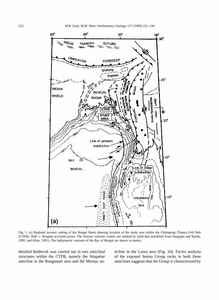
detailed fieldwork was carried out in two anticlinalstructures within the CTFB, namely the Sitapaharanticline in the Rangamati area and the Mirinja an-
ticline in the Lama area (Fig. 1b). Facies analysisof the exposed Surma Group rocks in both theseanticlines suggests that the Group is characterized by
M.R. Gani, M.M. Alam / Sedimentary Geology 127 (1999) 221–236 223
Fig. 1 (continued). (b) Geological sketch map of part of the CTFB (after Alam et al., 1990), showing locations of the studied anticlines.Note that the longitudinal faults are mostly east-dipping thrust faults.
an overall progradation from deep marine to shallowmarine depositional settings.
In this paper, we first discuss the regional tec-tonic evolution of the Bengal Basin, with particularemphasis on the CTFB region, in order to inferthe paleogeographic setting that prevailed duringMiocene time, then we describe the facies and faciesassociations of the studied sequence in an effort tointerpret the depositional environments, and finallystimulate future lines of research for a better un-derstanding of the sedimentological evolution of theTertiary succession in the CTFB.
2. Regional tectonic evolution
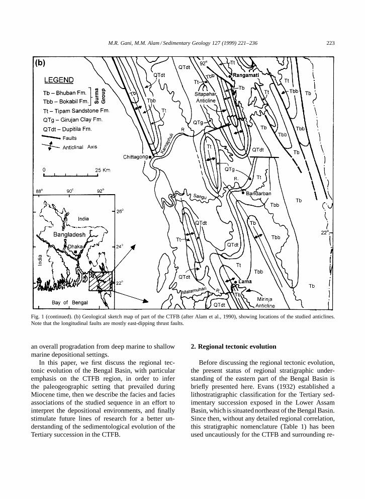
Before discussing the regional tectonic evolution,the present status of regional stratigraphic under-standing of the eastern part of the Bengal Basin isbriefly presented here. Evans (1932) established alithostratigraphic classification for the Tertiary sed-imentary succession exposed in the Lower AssamBasin, which is situated northeast of the Bengal Basin.Since then, without any detailed regional correlation,this stratigraphic nomenclature (Table 1) has beenused uncautiously for the CTFB and surrounding re-
224 M.R. Gani, M.M. Alam / Sedimentary Geology 127 (1999) 221–236
Table 1Traditional stratigraphic classification for the CTFB
For convenience, local stratigraphy of the Sitapahar anticline, with study section indicated, is compared at the right. The Barail Group(Oligocene) and the Disang Group (Late Cretaceous to Eocene), whose spatial distributions are shown in Fig. 2, lie in stratigraphicallylower position below the Surma Group (see text for discussion).a Based on Evans (1932).b Based on Chowdhury (1982).
gion mainly on the basis of a loosely defined litho-logic similarity of the rock types. The base of theSurma Group (Table 1) as well as the contact be-tween the Bhuban and Bokabil Formations within thisgroup is not well defined in the CTFB. Since the strati-graphic nomenclature for the CTFB has not yet beenstandardized, the regional nomenclature shown in Ta-ble 1 has been informally used in this paper. There isan increasing demand among geologists for establish-ing a separate stratigraphic subdivision for the CTFB.
The tectonic framework and structural setting ofthe Bengal Basin has been discussed by severalworkers, including Bakhtine (1966), Raju (1968),Guha (1978), Murphy and staff BOGMC (1988),Lohmann (1995) and Alam (1997). In the context ofthe present study the following discussion concen-trates on the tectonic and structural evolution of theCTFB (Fig. 1).
Various independent lines of evidence demon-strate that the Indian plate was subducting below
M.R. Gani, M.M. Alam / Sedimentary Geology 127 (1999) 221–236 225
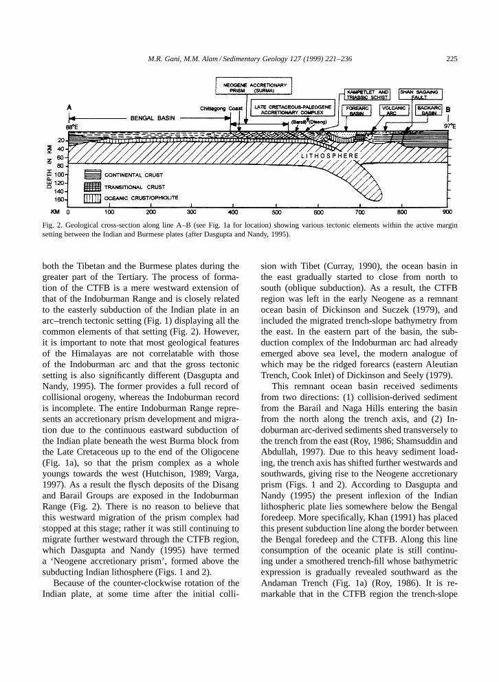
Fig. 2. Geological cross-section along line A–B (see Fig. 1a for location) showing various tectonic elements within the active marginsetting between the Indian and Burmese plates (after Dasgupta and Nandy, 1995).
both the Tibetan and the Burmese plates during thegreater part of the Tertiary. The process of forma-tion of the CTFB is a mere westward extension ofthat of the Indoburman Range and is closely relatedto the easterly subduction of the Indian plate in anarc–trench tectonic setting (Fig. 1) displaying all thecommon elements of that setting (Fig. 2). However,it is important to note that most geological featuresof the Himalayas are not correlatable with thoseof the Indoburman arc and that the gross tectonicsetting is also significantly different (Dasgupta andNandy, 1995). The former provides a full record ofcollisional orogeny, whereas the Indoburman recordis incomplete. The entire Indoburman Range repre-sents an accretionary prism development and migra-tion due to the continuous eastward subduction ofthe Indian plate beneath the west Burma block fromthe Late Cretaceous up to the end of the Oligocene(Fig. 1a), so that the prism complex as a wholeyoungs towards the west (Hutchison, 1989; Varga,1997). As a result the flysch deposits of the Disangand Barail Groups are exposed in the IndoburmanRange (Fig. 2). There is no reason to believe thatthis westward migration of the prism complex hadstopped at this stage; rather it was still continuing tomigrate further westward through the CTFB region,which Dasgupta and Nandy (1995) have termeda ‘Neogene accretionary prism’, formed above thesubducting Indian lithosphere (Figs. 1 and 2).
Because of the counter-clockwise rotation of theIndian plate, at some time after the initial colli-
sion with Tibet (Curray, 1990), the ocean basin inthe east gradually started to close from north tosouth (oblique subduction). As a result, the CTFBregion was left in the early Neogene as a remnantocean basin of Dickinson and Suczek (1979), andincluded the migrated trench-slope bathymetry fromthe east. In the eastern part of the basin, the sub-duction complex of the Indoburman arc had alreadyemerged above sea level, the modern analogue ofwhich may be the ridged forearcs (eastern AleutianTrench, Cook Inlet) of Dickinson and Seely (1979).
This remnant ocean basin received sedimentsfrom two directions: (1) collision-derived sedimentfrom the Barail and Naga Hills entering the basinfrom the north along the trench axis, and (2) In-doburman arc-derived sediments shed transversely tothe trench from the east (Roy, 1986; Shamsuddin andAbdullah, 1997). Due to this heavy sediment load-ing, the trench axis has shifted further westwards andsouthwards, giving rise to the Neogene accretionaryprism (Figs. 1 and 2). According to Dasgupta andNandy (1995) the present inflexion of the Indianlithospheric plate lies somewhere below the Bengalforedeep. More specifically, Khan (1991) has placedthis present subduction line along the border betweenthe Bengal foredeep and the CTFB. Along this lineconsumption of the oceanic plate is still continu-ing under a smothered trench-fill whose bathymetricexpression is gradually revealed southward as theAndaman Trench (Fig. 1a) (Roy, 1986). It is re-markable that in the CTFB region the trench-slope
226 M.R. Gani, M.M. Alam / Sedimentary Geology 127 (1999) 221–236
bathymetry has been smoothed out to shallow-waterconditions probably sometime in the Late Miocene.At present the deep-water subduction zone existsonly southwards from approximately 19ºN as theAndaman–Sunda Trench (the solid portion of the‘line of present subduction’ shown in Fig. 1a), alongwhich the Bengal deep-sea fan sediments are sub-ducting eastward beneath the Burmese plate. A goodaccount of the tectonic and sedimentary history ofthis region is given by Curray et al. (1982), fromwhich readers can get an approximate analogy ofthe depositional setting for the lower Surma Groupproposed in this paper. It should be noted that theophiolitic, exotic blocks found in the Indoburmanridge would be less common in the CTFB due tothe increasing distance of the then trench axis fromthe initial line of subduction (in other words, the in-creasing width of the arc–trench gap); if such blocksare present, they would be at a lower stratigraphichorizon than that exposed in the study area.
The structural developments in the CTFB mayhave been largely controlled by the accretionaryprism and involve east-dipping, high-angle thrustfaults produced by off-scraping of oceanic sedi-ments. Within individual thrust sheets, the sedimentsin the upper part may be deformed by the processof structural infolding (subduction kneading) givingrise to the long, shallow, almost N–S-trending foldsin this region. It is also likely that the accretionarybasins (trench-slope basins) of Dickinson and Seely(1979) developed as structural depressions betweenthe thrust masses.
Duplex accretion is another tectonic feature of thesubduction complex. Lohmann (1995) and Sikder(1998) have pointed out some duplex structures inthe western part of the CTFB. These workers havealso suggested thin-skinned detachment, shear-offtectonics to explain the structural style of the CTFB,but did not relate these processes directly to a sub-duction complex. We believe that the tectonic andstructural development of this region is more readilyexplained by accretionary prism formation. Com-pressive wrench tectonics (as a result of convergent–oblique movement of the Indian plate, mentionedearlier) have also influenced the structural style ofthe CTFB (Murphy and staff BOGMC, 1988). Infuture, the identification of major individual thrustsheets (accretionary wedges) would be of vital sig-
nificance to determine the chronological order of therock strata, since it is well known that the complexas a whole youngs towards the west.
3. Stratigraphic sequence of the lower SurmaGroup in the Sitapahar anticline
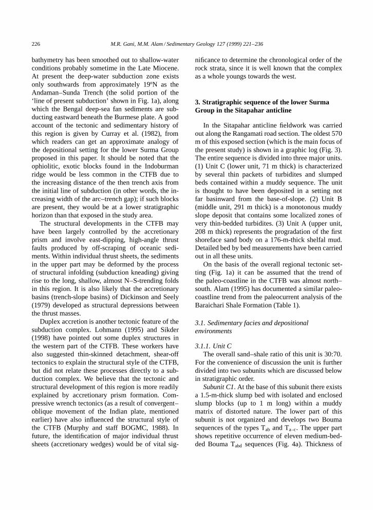
In the Sitapahar anticline fieldwork was carriedout along the Rangamati road section. The oldest 570m of this exposed section (which is the main focus ofthe present study) is shown in a graphic log (Fig. 3).The entire sequence is divided into three major units.(1) Unit C (lower unit, 71 m thick) is characterizedby several thin packets of turbidites and slumpedbeds contained within a muddy sequence. The unitis thought to have been deposited in a setting notfar basinward from the base-of-slope. (2) Unit B(middle unit, 291 m thick) is a monotonous muddyslope deposit that contains some localized zones ofvery thin-bedded turbidites. (3) Unit A (upper unit,208 m thick) represents the progradation of the firstshoreface sand body on a 176-m-thick shelfal mud.Detailed bed by bed measurements have been carriedout in all these units.
On the basis of the overall regional tectonic set-ting (Fig. 1a) it can be assumed that the trend ofthe paleo-coastline in the CTFB was almost north–south. Alam (1995) has documented a similar paleo-coastline trend from the paleocurrent analysis of theBaraichari Shale Formation (Table 1).
3.1. Sedimentary facies and depositionalenvironments
3.1.1. Unit CThe overall sand–shale ratio of this unit is 30:70.
For the convenience of discussion the unit is furtherdivided into two subunits which are discussed belowin stratigraphic order.
Subunit C1. At the base of this subunit there existsa 1.5-m-thick slump bed with isolated and enclosedslump blocks (up to 1 m long) within a muddymatrix of distorted nature. The lower part of thissubunit is not organized and develops two Boumasequences of the types Tab and Ta–c. The upper partshows repetitive occurrence of eleven medium-bed-ded Bouma Tabd sequences (Fig. 4a). Thickness of
M.R. Gani, M.M. Alam / Sedimentary Geology 127 (1999) 221–236 227
Fig. 3. General litho-stratigraphic column of the lower part of the Surma Group exposed in the Sitapahar anticline with detailedsedimentological logs of salient portions.

228M
.R.G
ani,M.M
.Alam
/Sedimentary
Geology
127(1999)
221–236
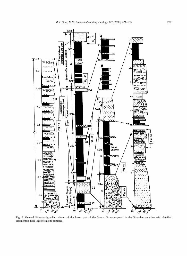
Fig. 4. Outcrop photographs of selected facies from the lower part of the Surma Group in the Sitapahar anticline, Rangamati area — (a–f) see Fig. 3 for stratigraphicpositions of the photographs — and in the Mirinja anticline, Lama area — (g, h). (a) Repetitive occurrence of thickening-upward Bouma Tabd sequences, upper part ofsubunit C (hammer in the center for scale). (b) Upper part of slump bed in division C2a: note small-scale channelized sand bodies within muddy slump (arrowed) (stick forscale is 2 m long). (c) Alternation of massive sandstone beds and wavy–lenticular beds in the upper part of C2a, terminating upwards with hemipelagic mud of subunit C2b(scale division in cm). (d) Typical Bouma Ta–c turbidite in division C2b. Divisions Td and Te broke off this specimen (scale is in cm).
M.R
.Gani,M
.M.A
lam/Sedim
entaryG
eology127
(1999)221–236
229
Fig. 4 (continued). (e) Laterally persistent very thin beds of calcified very fine sand and silt within slope mud in subunit B2 (stick at left is 2 m long). (f) Zoophycosburrows at the base of unit A. (g) Coarse-grained turbidite displaying strong basal scouring and inverse-to-normal grading at the base, from the axial part of the submarinechannel (coin is 2.7 cm in diameter). (h) Turbidite facies with Bouma divisions Ta, Tb and Tc, from the marginal part of the submarine channel (coin is 2.2 cm indiameter).
230 M.R. Gani, M.M. Alam / Sedimentary Geology 127 (1999) 221–236
individual beds varies from 12 to 50 cm. The baseof the Ta division (fine sand) is sharp to slightly ero-sional with associated rip-up mud clasts and somemicro-loading. Almost all the Td divisions char-acteristically show convolution and micro-injectionstructures. The uppermost two sand beds are amal-gamated along an erosional surface (Fig. 3, C1). Thebeds of this overall thickening-upward subunit C1show onlap termination onto local basin relief in thesouthwards direction.
The subunit C1 shows no evidence of major chan-neling and is interpreted here as a small-scale depo-sitional lobe in which the thickening-upward trendresults from a compensation cycle (Mutti and Sor-rino, 1981) due to the progressive smoothing ofsubtle depositional relief or the progressive lateralshifting of the turbidity current axis. The same typesof small-scale (5 to 25 m thick) thickening-upwarddepositional sandstone lobes with onlap terminationwithin an active margin setting have also been de-scribed from the geological record (Cazzola et al.,1985).
Subunit C2. This subunit is further divided intothree divisions: C2a, C2b and C2c (Fig. 3).
Division C2a. This division begins with an evenlarger (nearly 7 m thick) slump bed containing dis-persed slump blocks within mud. The lower part ofthis slump bed contains large blocks (>1 m), somewith preserved bedding characteristics, whereas theupper part (Fig. 4b) is more muddy, enclosing afew small channelized sand bodies (85 cm long, 20cm thick) that nearly retain their original attitude.These channelized sand bodies are filled with veryfine to coarse sand with some mud clasts and coalstreaks, and both their lower and upper boundariesare concave with abrupt thinning of channel margins(Fig. 4b). The top 2.5 m of division C2a is charac-terized by the alternation of massive sandstone beds,with normal grading in the lowermost sand bed, andwavy–lenticular fine sand–mud beds (Fig. 4c). Thisupper part of C2a (above the slump bed) begins witha distinct scoured base containing numerous rip-upmud clasts. It contains three sand beds that show anoverall fining- and thinning-upward trend.
Two alternative explanations can be offered forthe generation of these wavy–lenticular beds (men-tioned above), which do not accord with the divi-sions of the Bouma sequence. The origin of these
beds can be easily comprehended when the top partof division C2a is interpreted as a small channel–levee system. A similar small-scale (6 m thick) as-sociation of massive sand beds and wavy–lenticularbeds from the lower part of the Halifax Formation,Nova Scotia, has been interpreted as a channel–leveesystem (Stow et al., 1984). The structural scheme ofsome parts of the wavy–lenticular (rarely flaser) bedsis thought to match with the fine-grained turbiditemodel of Stow and Shanmugam (1980). Alterna-tively, some of the tractional characteristics of ripplecross-lamination (coupled with? bi-directional cross-lamination observed in one dislocated block) of thewavy–lenticular beds suggest similarities with the‘variant model’ (bottom-current-reworked turbidite)suggested by Stanley (1987). It is to be noted thatthe paleo-Bengal Basin was a deep-water embay-ment opening to the south (see tectonic discussion).In this type of basin internal waves and tides com-monly play a major role in bottom-current reworkingprocesses (e.g. McCave et al., 1980).
Divisions C2b and C2c. These divisions are self-explanatory in the graphic log (Fig. 3). The randomassociation of Bouma sequences Ta, Tabc and Tc
(Fig. 4d) with debris-flow (mostly mud-flow andrarely grain-flow types) deposits characterizes thesedivisions. Two small channels (50 cm wide, 15 cmdeep) (Fig. 3) with conglomeratic fill were encoun-tered in division C2b. The orientations of the channelwalls are east–west. Pebbly mudstone beds in divi-sion C2c, formed by cohesive freezing, contain large(up to 40 cm) rolled-up sandstone clasts, and showconsiderable flowage of matrix mud. Ta divisions inC2b and C2c are frequently load-casted with somedish structures and vertical water escape pipes. Thesand beds in division C2c pinch out laterally afterabout 150 m in a northwards direction.
Division C2b is characteristically dominated byhighly carbonaceous, massive, homogeneous, non-burrowed, and grayish black mudstones of hemipela-gic origin. This thick sequence of hemipelagite indi-cates basin starvation, probably due to a short-termsea-level rise. The turbidite beds within the divisionsC2b and C2c are thought to be mainly of uncon-fined sheet-flow origin. Two down-to-basin synsedi-mentary, high-angle normal faults with sand intrusionalong the fault planes appear to have affected parts ofdivisions C2a and C2b.

M.R. Gani, M.M. Alam / Sedimentary Geology 127 (1999) 221–236 231
3.1.2. Unit BThis unit is a predominantly muddy sequence hav-
ing a typically laminated character, sometimes withsilt streaks and lenticles, and occasionally showinga massive and carbonaceous nature. The unit con-tains four subunits: B1, B2, B3 and B4 (Fig. 3). Insubunits B1 and B2 very thin (1.5 to 3 cm), veryfine-sand to silt beds (calcified) are repeated at 15 to35 cm intervals (Fig. 4e). Primary internal structureswithin these beds might have been obliterated due tocalcification (early diagenetic origin?). Subunit B4also contains eight calcified, sharp-based, thin (5 to8 cm) fine-sand beds. Similar laterally persistent thinsand beds within slope mud have been describedfrom the Eocene Hecho Group, Spain (Mutti, 1977).Subunit B3 is a large-scale slide-body, thought to beof a synsedimentary origin. No evidence of chan-neling was observed within unit B (perhaps throughlack of exposure).
3.1.3. Unit AThis unit begins with a nearly 5-m-thick zone
of extensive Zoophycos burrowing (up to 13 cmlong) (Fig. 4f) with some Rhizocorallium burrowing,which is thought to indicate a shelf–slope transitionzone. Except for the upper subunit A1 (Fig. 3), theremaining part of unit A is dominantly muddy withsilt streaks and very fine-sand lenticles, the frequencyof which gradually increases upwards. Unlike themuddy portions of units C and B, no carbonaceousmud is present and the burrows of Rhizocoralliumand spiral Rosselia occur occasionally in this unit.Some thin (<10 cm), sharp-based very fine-sandbeds with bidirectional cross-lamination are foundsporadically at the upper part of this muddy sequence(below subunit A1). These beds probably formedduring unusually high tides within the inner shelfenvironment.
Subunit A1. A detailed graphic log of subunit A1is presented in Fig. 5. The lower 21 m of this subunitshow a distinct coarsening- and thickening-upwardtrend, erosionally overlain by an upper 9 m showingan indistinct fining-upward trend. The lowermost 6.5m of A1 contains 34 small-scale (5 to 26 cm thick)fining-upward cycles together with a few random andfining-then-coarsening-upward cycles. Fig. 5b showsa representative (15 cm thick) fining-upward cycle.In each cycle the sand is gray and the mud is bluish
Fig. 5. Detailed litho-log of the subunit A1 (a), and one represen-tative fining-upward cycle from the lower 6.5 m of this subunit(b). (For more detailed explanation see text.)
gray in colour. The very fine-sandy lower part ofa cycle is characterized by bipolar cross-laminationwith hair-thin mud drapes, the middle part contains awavy–lenticular structure of silty very fine sand andmud, which is culminated by the upper laminatedmud. The thickness of the sandy portion of the cy-cles increases upwards. This lower part of subunit A1grades up into a 14.5 m thick, apparently massive di-
232 M.R. Gani, M.M. Alam / Sedimentary Geology 127 (1999) 221–236
vision of a fine-sand bed containing faint parallel- tolow-angle cross-lamination, above which a thin (15cm) bed of profuse mud clasts is present as erosionallag deposits (Fig. 5a). The upper 9 m of subunit A1 ischaracterized by monotonous wavy (‘tidal’) bedding(Reineck and Wunderlich, 1968) with the proportionof mud increasing upwards. The fine to very finesand of this part of subunit A1 is yellowish brownin colour, probably indicating intermittent subaerialexposure during the tidal cycles.
The depositional environment of subunit A1(Fig. 5) is inferred to be a tidal sand ridge prograda-tion on the shelf mud followed by tidal flat prograda-tion, within a regressive shelf and open coast setting(e.g. Meckel, 1975; Johnson, 1977) at the time ofhighstand sea-level. The absence of tidal signaturesin the proximal ridge deposits may be due to wavereworking, the indication of which is preserved as anerosional lag at the ridge crest. The overlying tidalflat deposits, with wavy-bedding and bipolar cross-lamination, are thought to have been deposited inthe mixed-flat environment with slight progradation(Fig. 5).
Filed evidence from both the Sitapahar and Mir-inja anticlines suggests that tide-dominated shallowmarine shelfal to coastal depositional settings, withalternating transgressive and regressive pulses, char-acterize the upper Surma Group rocks. For example,Alam (1995) described the tide-dominated sedimen-tation in the Baraichari Shale Formation (Table 1).The Tipam Group and the Dupitila Formation, over-lying the Surma Group, represent a continental–fluvial depositional environment that prevailed at thefinal stage of regional regression aided by tectonicupheaval of the CTFB (Alam and Ferdous, 1995).
3.2. Comparable deep-sea clastics in the Mirinjaanticline
Alam and Karim (1997) have interpreted a tran-sition from a shallow marine muddy shelf (belowwave-base) to tide-dominated coastal settings for theSurma Group rocks exposed in the Mirinja anticline.However, on the basis of our detailed field work were-interpret the lower Surma Group succession in theMirinja anticline as showing evidence of prograda-tion from deep marine to shallow marine settings.Rather than offering a detailed interpretation of the
lower Surma Group in this anticline we emphasizehere some salient features.
A submarine canyon, encased within the slopemud and breaching the shelf edge, is laterally trace-able (in a N–S-oriented cross-sectional view) forabout 400 m as a multiple-stepping erosional featurewith an exposed erosional relief of 15 m. The orien-tation of the channel wall is roughly east–west, andthe current direction within the channel-fill turbidites(about 50 m thick) is towards the west. Repetitiveoccurrence of thick-bedded (average 60 cm) coarsesilt to fine sand with numerous characteristic water-escape marks, such as internal convolution, networkof dish and pillar structures, water-escape pipes, etc.,resulting possibly from liquefied flow, characterizethe lower part of the channel-fill deposits. Someof these beds are typically capped by a thin (2–3cm) sand layer with tractional ripple cross-lamina-tion, the depositional mechanism of which can beexplained by the late-stage reworking of the aqueouscurrents generated within the ambient water abovethe liquefied flows due to the shearing at the flow sur-face (Lowe, 1982). The upper part of the channel-filldeposits consists of an alternation of thick-bedded(average 1 m), fine to medium, massive sandstones(Fig. 4g) containing some water-escape marks at thetop. These beds are thought to have been depositedby high-density turbidity currents. A few of thesebeds show partial amalgamation. Some thin-bedded(10 to 20 cm) partial to complete Bouma sequences(Fig. 4h) occur at the channel margins. The tide-dominated shoreface sand unit occurs above a nearly150-m-thick muddy upper slope to shelfal sequenceoverlying the channel-fill turbidites. It is notable thatfrom the turbidite-fill and for about 140 m down-wards, grazing traces of gently meandering forms ofNereites (probably Scolicia sp.) have been observedon the bases of several thin-bedded sandy turbidites.
4. Discussion
There is no direct evidence for the water depth inwhich the inferred deep-water clastics of the lowerSurma Group in the study area have been deposited.No macrofossils have been encountered in these rocksduring the fieldwork. Likewise, a quest for trace-fos-sils in the rock units C and B was not successful.

M.R. Gani, M.M. Alam / Sedimentary Geology 127 (1999) 221–236 233
It appears that the Surma Group rocks are sparselyfossiliferous in terms of macrofossils. On the otherhand, micro-paleontological work on the lower SurmaGroup in the study area has not yet been conducted. Infact, no data is available on the bathymetrically sen-sitive microfauna=flora from the lower Surma Groupeven in the CTFB region, to verify our interpretationof a deep-water origin of these rocks. We have, there-fore, relied heavily on the sedimentary features andfacies associations presented in Fig. 3, in interpretingthese rocks (units C and B) as deep-sea clastics. Thefollowing discussion explains why we think that thelower Surma Group rocks in the studied sequencesare not of a shallow marine origin.
Generation of turbidity currents on open shelfor deposition of discrete shallow marine ‘tur-biditic’ sandstones have long been debated (e.g.Hamblin and Walker, 1979; Nelson, 1982; Duke,1990; Tokuhashi, 1996). Nelson (1982) suggested anequivalent turbiditic terminology — Sb, Sc, Sd andSe — for the storm-generated sand layers in an openshelf setting. It is noteworthy that no counterpart fora Bouma Ta division (i.e. Sa layer) exists in Nelson’sscheme. Hamblin and Walker (1979) and Tokuhashi(1996) described turbidity-current-generated sand-stone beds in shelfal settings below storm-wave base,in which Ta beds are very rare and, if present, areonly less than a few tens of centimeters thick. Also,if a discrete rock sequence, characterized by trac-tion-generated structures like Tb and Tc beds, isnot associated with a Ta bed, its true turbiditic originmay be questioned (Duke, 1990; Shanmugam, 1997).
With respect to the discussion above, our reasonsfor attributing the rocks of units C and B to deep ma-rine, rather than shallow marine depositional settingsare as follows.
(1) The sandstones of units C and B do not showany hummocky cross-stratification (HCS) or waveripple forms.
(2) The highly carbonaceous and homogeneousmudstones encountered in units C and B are notpresent in unit A.
(3) Trace fossils of Rhizocorallium (with protru-sive spreiten) and spiral Rosselia, belonging to theCruziana ichnofacies that seem to occur in shallow-water shelfal environments, are occasionally encoun-tered within the mudstones of unit A; but these tracefossils are not encountered in units C and B.
(4) The Bouma Ta division is typically presentwithin the turbiditic beds of unit C, with some ofthem passing upwards into nearly complete classicalBouma sequences (e.g. Fig. 4d). Thicknesses of indi-vidual Ta divisions vary from 10 to 150 cm, with anaverage of 40 cm. Shallow marine shelfal turbiditycurrents, even if they occur, do not seem to be strongenough to deposit thick Ta beds (e.g. Tokuhashi,1996). High-energy=high-density turbidity currentsoriginating at the slope base can easily explain thedeposition of these Ta beds encountered in unit C.
(5) The deposits of all the end-member types ofsediment gravity flows — turbidity current flows(that predominates in our case), liquified flows, grainflows (very rare in our case) and cohesive debrisflows (Lowe, 1982) — with associated slump bedsare present in the studied sequence. However, somesort of gravity-related deposits (e.g. slumps, debrites,turbidites, etc.) may exist in front of a rapidly pro-grading river delta within a shallow marine setting;but in the rock record these deposits should be di-rectly associated with the advancing delta front sand.The overall rock context (Fig. 3) suggests that thisis not the case in the studied sequence, since aboveunit C a 465-m-thick sequence of predominant mudoccurs before the advancement of the first shorefacesand unit (which is also not a delta front sand). Fur-thermore, there is no modern or ancient publishedexample of the occurrence of the whole spectrumof gravity-flow deposits within the distal part of anopen shelf.
Therefore, it seems logical to conclude that therocks of units C and B have been deposited beyondthe shelf–slope break, within the deep-water settingsof a bathyal environment.
At our present level of understanding, it wouldbe premature to fit the above-described sequenceinto a specific morphological class of turbidite sys-tems. However, the closest match appears to be withthe ‘mud=sand-rich slope apron’ in the classifica-tion scheme of Reading and Richards (1994). Ourslope apron deposits are characterized by intimateassociation of turbidites with slump and debris-flowdeposits, indicating greater slope instability, withslope failure triggering the turbidity currents. In unitC, three discrete morphological elements (that maybe considered as architectural elements) are inferred(C1, C2a and C2c). Subunit C1 represents a small

234 M.R. Gani, M.M. Alam / Sedimentary Geology 127 (1999) 221–236
submarine depositional lobe occurring near the footof the slope, where the gradient of the slope de-creases significantly. The upper part of division C2aindicates a small channel–levee complex resulting,perhaps, from the lateral shifting of the channel onthe low-gradient part of the basin. Division C2cprobably represents a debris-mass deposited closeto the slope base. These types of small-scale mor-phological features are common in mud=sand-richslope aprons (Reading and Richards, 1994). Geolog-ical records (e.g. Stow et al., 1985) show that slopeaprons along active margins are subjected to consid-erable slumping and other mass movements similarto those described from unit C.
In the studied sequence there is no evidence formore distal basin plain or abyssal plain deposits,such as distal turbidite sands, extremely fine lami-nated silt within mud, etc. Consequently, the 291-m-thick muddy sequence of unit B is interpreted asslope deposits overlying the base-of-slope depositsof unit C. The heterogeneous muds of unit A showshallow marine characteristics described earlier, andthe first tide-dominated shoreface sands (subunit A1)(Figs. 3 and 5) occur at the uppermost part of thisunit. Therefore, the shelfal deposits of unit A expect-edly overlie the slope deposits of unit B as part ofa basin-ward progradational sequence. The consider-able thickness of muddy slope and shelf deposits isprobably indicative of the paleogeographic setting inwhich a wide shelf separated the coastal clastic sys-tem from the deep marine clastic system. This pointalso demonstrates that our studied sequence is differ-ent from the deposits of a delta-fed submarine rampsystem, in which progradational sequence shows ab-breviated slope–shelf deposits directly overlain bydelta front sands (Heller and Dickinson, 1985).
It is notable that no tectonic breaks have been en-countered within the studied sequence (570 m thick).This unbroken nature of the sequence, depositedin environments ranging from base-of-slope to theshoreface, probably indicates a late-stage trench-slope bathymetry, in which the structural reliefs (e.g.structural infoldings) on the inner-slope wall (sim-ilar to the present-day youthful Andaman trench-slope) have been masked by heavy sediment influxfrom two directions (see tectonic discussion). Al-ternatively, but less likely, unit C could be pondedturbidites deposited in the uppermost slope basin
formed by structural infolding. For the validation ofthis inference, more data would be needed from therock sequence lying below unit C, i.e. the lowest partof the Surma Group, which are still not available.
We believe that small-scale deep-sea fans, asso-ciated with the transverse slope channels or gulliesfrom the east (e.g. the submarine canyon in the Mir-inja anticline, described earlier), and=or large-scaleelongate deep-sea fans, associated with the longitu-dinal submarine canyons (inferred) from the north,could have been generated in the more axial sec-tors of the basin, beneath the slope apron depositsdescribed here. Such a possibility may also need tobe borne in mind in future hydrocarbon exploration,in order to encompass the stratigraphic traps com-monly associated with gravity-flow-generated sand-stone bodies enclosed within basinal mudstone.
On the basis of facies analysis, Dasgupta et al.(1991) have interpreted the Barail Group (3500 mthick), in the Lower Assam Basin, north Cachar,as deposits of a basinward migrating progradationalsubmarine fan complex in the active margin of theIndo–Burmese plate convergence, and suggested thatsedimentation appears to have continued into theoverlying Surma Group. It should be noted that ourstudied sequence includes only part of the lowerSurma Group, and that the rocks in the still lowerpart of the group remain undescribed. Therefore, it isof crucial importance to study the lowermost part ofthe Surma Group both from the exposed sections inthe remote eastern anticlinal structures of the CTFBand from the subsurface data, to have a better under-standing of the basinward progradational nature ofthe Group inferred in this study. In addition, detailedpaleocurrent analyses of the Surma Group rocks indifferent areas of the CTFB would be necessary inorder to understand the pattern of facies changeswithin this part of the Bengal Basin. Finally, a mi-cro-paleontological study of the Tertiary successionin the CTFB would enhance the understanding of thestratigraphical and sedimentological evolution of thisregion.
5. Conclusions
A deltaic to shallow marine (neritic) depositionalsetting is the accepted traditional interpretation for
M.R. Gani, M.M. Alam / Sedimentary Geology 127 (1999) 221–236 235
the entire Neogene Surma Group rocks exposed inthe southeastern fold belt of the Bengal Basin. On thebasis of a detailed facies analysis, the present studyrevises the earlier views and concludes that part ofthe lower Surma Group represents a slope apron, de-posited in deep marine (bathyal) environments. Thestudy further suggests that the whole of the SurmaGroup represents an overall basinward progradationfrom deep marine to coastal marine depositionalsettings, and the growth of this progradational se-quence has been governed by a westward-migratingaccretionary prism complex within the active marginsetting of the Indo–Burmese plate convergence.
Acknowledgements
The research reported here represents part of aMaster of Science thesis by the first author at theDepartment of Geology, Dhaka University. We thankGilbert Kelling and Ray Cas for their extensive re-views of the manuscript, and whose valuable sugges-tions have been incorporated in the final version ofthe paper. We are also grateful to Keith A.W. Crookfor his comments and helpful suggestions.
References
Alam, M., 1989. Geology and depositional history of Cenozoicsediments of the Bengal Basin of Bangladesh. Palaeogeogr.,Palaeoclimatol., Palaeoecol. 69, 125–139.
Alam, M.M., 1995. Tide-dominated sedimentation in the UpperTertiary succession of the Sitapahar anticline, Bangladesh. In:Flemming, B.W., Bortholoma, A. (Eds.), Tidal Signatures inModern and Ancient Sediments. Int. Assoc. Sedimentol., Spec.Publ. 24, 329–341.
Alam, M., 1997. Bangladesh. In: Moores, E.M., Fairbridge,R.W. (Eds.), Encyclopedia of European and Asian RegionalGeology. Chapman and Hall, London, pp. 64–72.
Alam, M.M., Ferdous, M.H.S., 1995. Lithofacies analysis anddepositional environment of the Lichubagan Sandstone Forma-tion (Upper Tertiary) in the Sitapahar anticline, south-easternFolded Belt of Bangladesh. J. Indian Assoc. Sedimentol. 14,9–18.
Alam, M.M., Karim, S.M.R., 1997. Facies and environmentalanalysis of the Neogene (Surma Group) clastic successionin the Mirinja anticline, Folded Belt of the Bengal Basin,Bangladesh. Bangladesh Geosci. J. 3, 19–32.
Alam, M.K., Hasan, A.K.M.S., Khan, M.R., Whitney, J.W.,1990. Geological map of Bangladesh. Geological Survey ofBangladesh, Dhaka, Scale 1 : 1,000,000.
Bakhtine, M.I., 1966. Major tectonic features of Pakistan, Part 2.The Eastern Province. Sci. Ind. 4, 89–100.
Cazzola, C., Mutti, E., Vigna, B., 1985. Cengio turbidite system,Italy. In: Bouma, A.H., Normark, W.R., Barnes, N.E. (Eds.),Submarine Fans and Related Turbidite Systems. Springer-Ver-lag, New York, pp. 179–183.
Chowdhury, S.Q., 1982. Palynostratigraphy of the Neogene sed-iments of the Sitapahar anticline (western flank), ChittagongHill Tracts. Bangladesh J. Geol. 1, 35–49.
Curray, J.R., 1990. Geological history of the Bengal Geosyn-cline. Proc. 16th Annu. Conv. Semin. Exploration Geophysics,Seismotectonics of Indian Subcontinent, Dehra Dun, 16 pp.
Curray, J.R., Emmel, F.J., Moore, D.G., Raitt, R.W., 1982. Struc-ture, tectonics and geological history of the northeastern In-dian Ocean. In: Nairn, A.E.M., Stehli, F.G. (Eds.), The OceanBasins and Margins, Vol. 6. The Indian Ocean. Plenum Press,New York, pp. 399–450.
Dasgupta, P.K., Chakrabarti, P.K., Dutta, D., 1991. Basinwardmigrating submarine fan environments from the Barail Groupin the North Cachar Hills, Assam–Arakan Orogen, India. In:Bouma, A.H., Carter, R.M. (Eds.), Facies Models. VSP, pp.195–217.
Dasgupta, S., Nandy, D.R., 1995. Geological framework of theIndo–Burmese convergent margin with special reference toophiolitic emplacement. Indian J. Geol. 67 (2), 110–125.
Dickinson, W.R., Seely, D.R., 1979. Structure and stratigraphyof forearc regions. Am. Assoc. Pet. Geol. Bull. 63, 2–31.
Dickinson, W.R., Suczek, C.A., 1979. Plate tectonics and sand-stone compositions. Am. Assoc. Pet. Geol. Bull. 63, 2164–2182.
Duke, W.L., 1990. Geostrophic circulation or shallow marine tur-bidity currents? The dilemma of paleoflow patterns in storm-influenced prograding shoreline systems. J. Sediment. Petrol.60, 870–883.
Evans, P., 1932. Tertiary succession in Assam. Trans. Min. Geol.Inst. India 27, 155–260.
Ganguly, S., 1983. Geology and hydrocarbon prospects ofTripura–Cachar–Mizoram region. In: Bhandari, L.L. et al.(Eds.), Petroliferous Basins of India, Part 1. Petrol. Asia J.Publ., Dhera Dun, pp. 105–110.
Guha, D.K., 1978. Tectonic framework and oil and gas prospectsof Bangladesh. Proc. 4th Annu. Conf., Bangladesh Geol. Soc.,Dhaka, pp. 65–76.
Hamblin, A.H., Walker, R.G., 1979. Storm-dominated shallowmarine deposits: the Fernie–Kootenay (Jurassic) transition,Southern Rocky Mountains. Can. J. Earth Sci. 16, 1673–1690.
Heller, P.L., Dickinson, W.R., 1985. Submarine ramp faciesmodel for delta-fed, sand-rich turbidite systems. Am. Assoc.Pet. Geol. Bull. 69, 960–976.
Hutchison, C.S., 1989. Geological Evolution of South-East Asia.Clarendon Press, London, 368 pp.
Johnson, H.D., 1977. Shallow marine sand bar sequences: anexample from the late Precambrian of North Norway. Sedi-mentology 24, 245–270.
Johnson, Y.J., Alam, A.M.N., 1991. Sedimentation and tectonicsof the Sylhet Trough, Bangladesh. Geol. Soc. Am. Bull. 103,1513–1527.

236 M.R. Gani, M.M. Alam / Sedimentary Geology 127 (1999) 221–236
Khan, A.A., 1991. Tectonics of the Bengal Basin. J. HimalayanGeol. 2 (1), 91–101.
Lohmann, H.H., 1995. On the tectonics of Bangladesh. SwissAssoc. Pet. Geol. Eng., Bull. 62 (140), 29–48.
Lowe, D.R., 1982. Sediment gravity flows, II. Depositional mod-els with special reference to the deposits of high-densityturbidity currents. J. Sediment. Petrol. 52, 279–297.
McCave, I.N., Lonsdale, P.F., Hollister, C.D., Gardner, W.D.,1980. Sediment transport over the Hatton and Gardar con-tourite drifts. J. Sediment. Petrol. 50, 1049–1062.
Meckel, L.D., 1975. Holocene sand bodies in the Colorado deltaarea, northern Gulf of California. In: Broussard, M.L. (Ed.),Deltas: Models for Exploration. Houston Geological Society,Houston, pp. 239–265.
Murphy, R.W. and staff BOGMC, 1988. Bangladesh enters theoil era. Oil Gas J. Feb. 29, 1988, pp. 76–82.
Mutti, E., 1977. Distinctive thin-bedded turbidite facies andrelated depositional environments in the Eocene Hecho Group(south-central Pyrenees, Spain). Sedimentology 24, 107–131.
Mutti, E., Sorrino, M., 1981. Compensation cycles: a diagnosticfeature of turbidite sandstone lobes. Int. Assoc. Sedimentol.,2nd Eur. Regional Meet., Bologna, Abstr., pp. 120–123.
Nelson, C.H., 1982. Modern shallow water graded sand layersfrom storm surges, Bering Shelf: a mimic of Bouma sequencesand turbidite systems. J. Sedimentol. Petrol. 52, 537–545.
Raju, A.T.R., 1968. Geological evolution of Assam and CambayBasins of India. Am. Assoc. Pet. Geol. Bull. 52, 2422–2437.
Reading, H.G., Richards, M., 1994. Turbidite systems in deep-water basin margins classified by grain size and feeder system.Am. Assoc. Pet. Geol. Bull. 78, 792–822.
Reineck, H.E., Wunderlich, F., 1968. Classification and origin offlaser and lenticular bedding. Sedimentology 11, 99–104.
Roy, T.K., 1986. Petroleum prospects of the frontal foldedbelt and subduction complex associated with the Indian plate
boundary in the northeast. Proc. 6th Offshore Southeast AsiaConf., Singapore.
Shamsuddin, A.H.M., Abdullah, S.K.M., 1997. Geological evo-lution of the Bengal Basin and its implication in hydrocarbonexploration in Bangladesh. Indian J. Geol. 69 (2), 93–121.
Shanmugam, G., 1997. Slope turbidite packets in a fore-arcbasin fill sequence of the Plio–Pleistocene Kakegawa Group:their formation and sea-level changes — discussion. Sediment.Geol. 112, 297–300.
Sikder, A.M., 1998. Tectonic Evolution of Eastern Folded Beltof Bengal Basin. Unpubl. Ph.D. Thesis, Dhaka Univ., 175 pp.
Stanley, D.J., 1987. Turbidite to current-reworked sand contin-uum in Upper Cretaceous rocks, U.S. Virgin Islands. Mar.Geol. 78, 143–151.
Stow, D.A.V., Shanmugam, G., 1980. Sequence of structuresin fine-grained turbidites: comparison of recent deep-sea andancient flysch sediments. Sediment. Geol. 25, 23–42.
Stow, D.A.V., Alam, M., Piper, D.J.W., 1984. Sedimentology ofthe Halifax Formation, Nova Scotia: Lower Paleozoic fine-grained turbidite. In: Stow, D.A.W., Piper, D.J.W. (Eds.), Fine-Grained Sediments: Deep-Water Process and Facies. Geol.Soc. London, Spec. Publ. 15, 127–144.
Stow, D.A.V., Howell, D.G., Nelson, C.H., 1985. Sedimentary,tectonic and sea-level controls. In: Bouma, A.H., Normark,W.R., Barnes, N.E. (Eds.), Submarine Fans and Related Tur-bidite Systems. Springer-Verlag, New York, pp. 15–22.
Tokuhashi, S., 1996. Shallow-marine turbiditic sandstones juxta-posed with deep-marine ones at the eastern margin of the Ni-igata Neogene back-arc basin, central Japan. Sediment. Geol.104, 99–116.
Varga, R.J., 1997. Burma. In: Moores, E.M., Fairbridge, R.W.(Eds.), Encyclopedia of European and Asian Regional Geol-ogy. Chapman and Hall, London, pp. 109–121.


![Thickness-dependent spontaneous dewetting morphology of ...people.wku.edu/mikhail.khenner/LaserPattAg.pdfheterogeneous nucleation or spinodal dewetting [23]. In the case of homogeneous](https://img.pdfslide.us/doc/110x75/60ee61d71c1e3b20b84c0cd4/thickness-dependent-spontaneous-dewetting-morphology-of-heterogeneous-nucleation.jpg)