Embed Size (px)
Citation preview
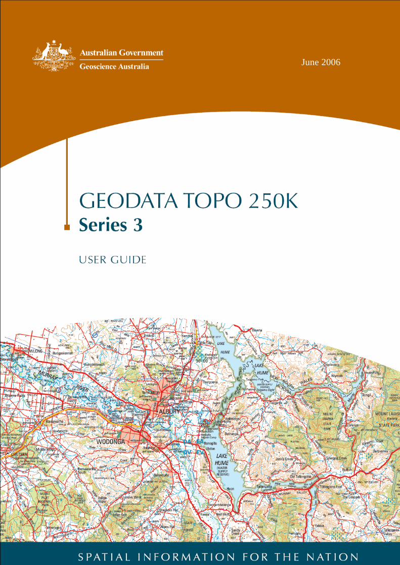
June 2006
Contents
1. General Information................................................................................................................................ 1 1.1 Conditions of Use ............................................................................................................................. 1 1.2 Feedback.......................................................................................................................................... 1 1.3 Geoscience Australia – Geospatial and Earth Monitoring Division.................................................. 1 1.4 Contributors...................................................................................................................................... 1
2. About TOPO 250K National Topographic Database (NTDB) .............................................................. 1 2.1 TOPO 250K NTDB........................................................................................................................... 1 2.2 GEODATA TOPO 250K Series 3 Product Components.................................................................. 2 2.3 GEODATA TOPO 250K Series 3 File Sizes .................................................................................... 3 2.4 GEODATA TOPO 250K Series 3 Source Data................................................................................ 3
3. GEODATA TOPO 250K Series 3 Application Formats ........................................................................ 4 3.1 Delivery Application Formats ........................................................................................................... 4
4. Data Loading ........................................................................................................................................... 5 4.1 Personal Geodatabase..................................................................................................................... 5
4.1.1 Data Structure.............................................................................................................................. 5 4.1.2 File Size ....................................................................................................................................... 5 4.1.3 PGDB Naming Convention .......................................................................................................... 5 4.1.4 Symbolisation - Layer and .mxd Files for PGDB ......................................................................... 6
4.2 Shapefile .......................................................................................................................................... 7 4.2.1 Data Structure.............................................................................................................................. 7 4.2.2 Shapefile Naming Convention ..................................................................................................... 7 4.2.3 Symbolisation - Layer and .mxd Files for Shapefiles................................................................... 8
4.3 MapInfo File Format Option ............................................................................................................. 8 4.3.1 Data Structure.............................................................................................................................. 8 4.3.2 MapInfo Naming Convention ....................................................................................................... 8 4.3.3 Symbolisation - MapInfo Custom Installation Files...................................................................... 9
5. Data Characteristics and Special Features.......................................................................................... 9 5.1 Data Characteristics ......................................................................................................................... 9
5.1.1 Datum, Projection and Coordinate Extents.................................................................................. 9 5.1.2 Cartographic Generalisation ........................................................................................................ 9
5.2 Special Features ............................................................................................................................ 10 5.2.1 Persistent Identifier, Creation Date and Retirement Date ......................................................... 10 5.2.2 Orientation Attribute ................................................................................................................... 10
6. Geodatabase Model and Content ........................................................................................................ 11 6.1 Geodatabase Model ....................................................................................................................... 11 6.2 Geodatabase Model Components ................................................................................................. 12 6.3 Feature Instance Details ................................................................................................................ 12 6.4 GEODATA TOPO 250K Series 3 Content ..................................................................................... 14
7. Data Quality Information ...................................................................................................................... 14 7.1 Lineage........................................................................................................................................... 14 7.2 Positional Accuracy ........................................................................................................................ 14
7.2.1 Absolute Planimetric (horizontal) Accuracy ............................................................................... 14 7.2.2 Absolute Elevation Accuracy ..................................................................................................... 15
7.3 Feature Level Metadata ................................................................................................................. 15 7.4 Data Omission................................................................................................................................ 15
Appendix A: Production Schema/Distribution Schema Cross-Reference Table.................................... 16 Appendix B: Item Formatting and Attribution ............................................................................................ 19 Appendix C: Geodatabase Features............................................................................................................ 21 Appendix D: Metadata................................................................................................................................... 52 Appendix E: Glossary ................................................................................................................................... 56 Appendix F: Installing TAB Custom Symbology........................................................................................ 66
Page 1 of 68
1. General Information
1.1 Conditions of Use
The conditions of use for the GEODATA TOPO 250K Series 3 product are documented in the licence agreement accompanying this product.
1.2 Feedback
Geoscience Australia welcomes feedback on any aspect of this product or services. Please direct your comments or queries regarding this document or data to: Geoscience Australia Sale Centre GPO Box 378 Canberra ACT 2601 Freecall (within Australia): 1800 800 173 Telephone: +61 2 6249 9966 Facsimile: +61 2 6249 9960 Email: [email protected] Internet: www.ga.gov.au
1.3 Geoscience Australia – Geospatial and Earth Monitoring Division
Geoscience Australia is the Commonwealth Government’s national agency for geoscience research and spatial information. It serves government and supports the community through its output areas of geoscience for urban centres, oceans and coasts as well as regional and rural areas. The Geospatial and Earth Monitoring Division (GEMD) of Geoscience Australia was formed in 2005 by the merging of the Geohazards Division and National Mapping Division. The new division’s mission is to provide readily accessible and timely national geographic and geoscientific data, information and knowledge that enable Australians to make well-informed decisions particularly in regards to safeguarding our communities and critical infrastructure.
1.4 Contributors
Geoscience Australia (GA) gratefully acknowledges contributions to map and data content. Information supplied by a range of Commonwealth, State, Territory and Local Government as well as private sector agencies and individuals is utilised to update and enhance the spatial and attribute content of map and digital data products. A comprehensive list is available from the Geoscience Australia website www.ga.gov.au/nmd/mapping/acknowledge.htm.
2. About TOPO 250K National Topographic Database (NTDB)
2.1 TOPO 250K NTDB TOPO 250K NTDB is the third generation of GA’s 1:250 000 (250K) topographic digital data and provides a seamless coverage of topographic data across Australia in a geodatabase structure. The NTDB was developed using the ESRI suite of products Version 8.3. The main characteristics of TOPO 250K NTDB are:
• Seamless Coverage TOPO 250K NTDB is a national seamless dataset compiled by merging 513 250K database tiles which were previously managed and revised individually, into one continuous and complete dataset of Australia.
• Geodatabase Structure GA’s 250K topographic data is stored and provided as a geodatabase. A geodatabase is a relational database that stores the spatial data and related attributes of features.
• Revised Specification The revision GA’s TOPO 250K Topographic Data and Map Specifications v4.0 is reflective of the new geodatabase structure. This includes additional attribution of features, reclassification of some features and removal of void polygons and most boundary line feature classes.
Page 2 of 68
• Currency of Less Than Five Years The development of TOPO 250K NTDB has run in parallel with GA’s revision schedule of 250K data, therefore, the data has a currency of less than five years in any location.
GEODATA TOPO 250K Series 3 is a vector representation of features on the earth’s surface, it uses a feature-based data model to represent the real world. Features such as buildings, roads and lakes are spatially represented as points, lines or polygons, and attributes are used to describe them. The combination of its spatial location and attributes enables a feature to be uniquely identified. The original GEODATA TOPO 250K Series 1 product was sourced from the 250K National Topographic Map Series (NTMS) and supplementary information and contained vector data relating to hydrography (e.g. drainage, waterpoints, and waterbodies), infrastructure and relief. Following the completion of a national coverage in 1994, work began on the second generation product, GEODATA TOPO 250K Series 2. This revised product was built on Series 1 by incorporating additional features using satellite imagery and other supplementary information as revision sources. Geoscience Australia’s TOPO 250K NTDB has been derived from GEODATA TOPO 250K Series 2 and is effectively the third in a series of topographic data released to the public as GEODATA TOPO 250K Series 3. Ten gigabytes of vector data stored as ArcInfo coverages were translated and imported into the new geodatabase structure. This process included data edge matching and the removal of bleed edges which were used for NTMS production. TOPO 250K NTDB delivers ten feature datasets, or themes of features containing 92 feature classes. The geodatabase structure provides greater efficiencies in the management and revision of GA’s 250K topographic data which are now reflected in a more sophisticated data product.
2.2 GEODATA TOPO 250K Series 3 Product Components
The product consists of the following components which combine to give a complete data product:
• Vector Data (Folder: Vector_data) The data is available in three formats: Personal Geodatabase; Shapefiles; and MapInfo file format (*.tab) in the folders Topo250K_PGDB, Topo250K_SHP and Topo250K_TAB respectively. Each format is available as an individual product for purchase. The Personal Geodatabase reflects the stored environment of the data, therefore this User Guide is predominately focused on this format. SDE export format is also available on request to users requiring data in an enterprise database environment.
• Symbol Dictionary (Folder: Symbolisation) The Symbol Dictionary for Topographic Map Production contains all map symbols used by Geoscience Australia for its topographic map production. It lists the symbol, its number and related feature and is a useful reference source.
• Symbol Library (Folder: Symbolisation – For personal geodatabase and Shapefile formats only) The symbol library is a collection of symbols and is provided in an .exe format to assist users in symbolising features in accordance with the TOPO 250K Topographic Data and Map Specifications. Go to Topographic Symbols v1.1 for installation.
• Layer and MXD Files (Folders: Layer_files & mxd_files - for personal geodatabase and Shapefile formats only) An ArcMap .mxd file is supplied which contains a series of layer files that are stored in a separate directory. Separate MXD and corresponding layer file configurations have been built for geodatabase and shapefile formats only.
• Fonts (for Annotation feature classes only) In order to display Annotation in accordance with the specifications, the Zurich and Stymie fonts are required to be installed on the host computer. These fonts are not supplied as part of the GEODATA TOPO 250K Series 3 product. Once acquired, these fonts should be installed through the Font Manager which can be accessed through the Control Panel.
Page 3 of 68
• MapInfo custom symbology installation files (for MapInfo .tab format only) To use symbolisation in the MapInfo .tab format, users will need to install three custom symbology files: • Geoscience MapInfo True Type Font; • update the mires800.dll; and • update the MAPINFOW.PEN file. Full instructions for the installation of MapInfo symbology files are detailed in section 4.3.3 Symbolisation - MapInfo custom installation files.
• 250K User Guide (Folder: Documentation) This User Guide describes the GEODATA TOPO 250K Series 3 data, particularly the geodatabase format, with the aim of describing: • Important and common geodatabase characteristics; • Geodatabase components and data concepts; • Hierarchy of feature structure and attributes; and • Accuracy of the data.
• Licence Agreement Office of Spatial Data Management (Folder: Documentation)
The licence agreement details the conditions of use for the data including any referencing requirements. The conditions of use reflect the Australian Government policy on spatial data access and pricing.
2.3 GEODATA TOPO 250K Series 3 File Sizes
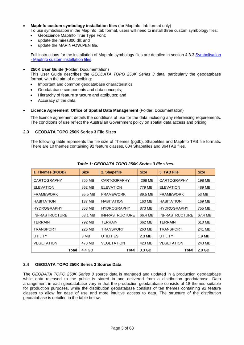
The following table represents the file size of Themes (pgdb), Shapefiles and MapInfo TAB file formats. There are 10 themes containing 92 feature classes, 604 Shapefiles and 364TAB files.
Table 1: GEODATA TOPO 250K Series 3 file sizes.
1. Themes (PGDB) Size 2. Shapefile Size 3. TAB File Size
CARTOGRAPHY 855 MB CARTOGRAPHY 268 MB CARTOGRAPHY 198 MB
ELEVATION 862 MB ELEVATION 779 MB ELEVATION 489 MB
FRAMEWORK 95.5 MB FRAMEWORK 89.5 MB FRAMEWORK 53 MB
HABITATION 137 MB HABITATION 160 MB HABITATION 169 MB
HYDROGRAPHY 853 MB HYDROGRAPHY 873 MB HYDROGRAPHY 755 MB
INFRASTRUCTURE 63.1 MB INFRASTRUCTURE 66.4 MB INFRASTRUCTURE 67.4 MB
TERRAIN 792 MB TERRAIN 662 MB TERRAIN 610 MB
TRANSPORT 226 MB TRANSPORT 263 MB TRANSPORT 241 MB
UTILITY 3 MB UTILITIES 2.3 MB UTILITY 1.9 MB
VEGETATION 470 MB VEGETATION 423 MB VEGETATION 243 MB
Total 4.4 GB Total 3.3 GB Total 2.8 GB
2.4 GEODATA TOPO 250K Series 3 Source Data
The GEODATA TOPO 250K Series 3 source data is managed and updated in a production geodatabase while data released to the public is stored in and delivered from a distribution geodatabase. Data arrangement in each geodatabase vary in that the production geodatabase consists of 18 themes suitable for production purposes, while the distribution geodatabase consists of ten themes containing 92 feature classes to allow for ease of use and more intuitive access to data. The structure of the distribution geodatabase is detailed in the table below.
Page 4 of 68
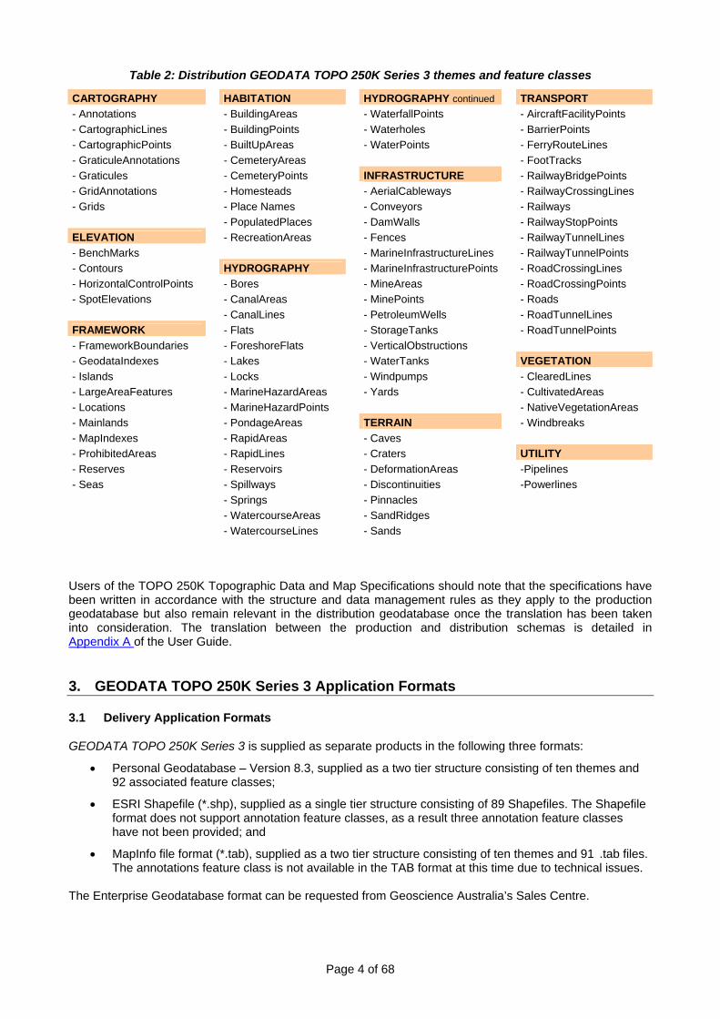
Table 2: Distribution GEODATA TOPO 250K Series 3 themes and feature classes
CARTOGRAPHY HABITATION HYDROGRAPHY continued TRANSPORT - Annotations - BuildingAreas - WaterfallPoints - AircraftFacilityPoints - CartographicLines - BuildingPoints - Waterholes - BarrierPoints - CartographicPoints - BuiltUpAreas - WaterPoints - FerryRouteLines - GraticuleAnnotations - CemeteryAreas - FootTracks - Graticules - CemeteryPoints INFRASTRUCTURE - RailwayBridgePoints - GridAnnotations - Homesteads - AerialCableways - RailwayCrossingLines - Grids - Place Names - Conveyors - Railways - PopulatedPlaces - DamWalls - RailwayStopPoints ELEVATION - RecreationAreas - Fences - RailwayTunnelLines - BenchMarks - MarineInfrastructureLines - RailwayTunnelPoints - Contours HYDROGRAPHY - MarineInfrastructurePoints - RoadCrossingLines - HorizontalControlPoints - Bores - MineAreas - RoadCrossingPoints - SpotElevations - CanalAreas - MinePoints - Roads - CanalLines - PetroleumWells - RoadTunnelLines FRAMEWORK - Flats - StorageTanks - RoadTunnelPoints - FrameworkBoundaries - ForeshoreFlats - VerticalObstructions - GeodataIndexes - Lakes - WaterTanks VEGETATION - Islands - Locks - Windpumps - ClearedLines - LargeAreaFeatures - MarineHazardAreas - Yards - CultivatedAreas - Locations - MarineHazardPoints - NativeVegetationAreas - Mainlands - PondageAreas TERRAIN - Windbreaks - MapIndexes - RapidAreas - Caves - ProhibitedAreas - RapidLines - Craters UTILITY - Reserves - Reservoirs - DeformationAreas -Pipelines - Seas - Spillways - Discontinuities -Powerlines - Springs - Pinnacles - WatercourseAreas - SandRidges - WatercourseLines - Sands
Users of the TOPO 250K Topographic Data and Map Specifications should note that the specifications have been written in accordance with the structure and data management rules as they apply to the production geodatabase but also remain relevant in the distribution geodatabase once the translation has been taken into consideration. The translation between the production and distribution schemas is detailed in Appendix A of the User Guide.
3. GEODATA TOPO 250K Series 3 Application Formats
3.1 Delivery Application Formats
GEODATA TOPO 250K Series 3 is supplied as separate products in the following three formats:
• Personal Geodatabase – Version 8.3, supplied as a two tier structure consisting of ten themes and 92 associated feature classes;
• ESRI Shapefile (*.shp), supplied as a single tier structure consisting of 89 Shapefiles. The Shapefile format does not support annotation feature classes, as a result three annotation feature classes have not been provided; and
• MapInfo file format (*.tab), supplied as a two tier structure consisting of ten themes and 91 .tab files. The annotations feature class is not available in the TAB format at this time due to technical issues.
The Enterprise Geodatabase format can be requested from Geoscience Australia’s Sales Centre.
Page 5 of 68
4. Data Loading 4.1 Personal Geodatabase (PGDB)
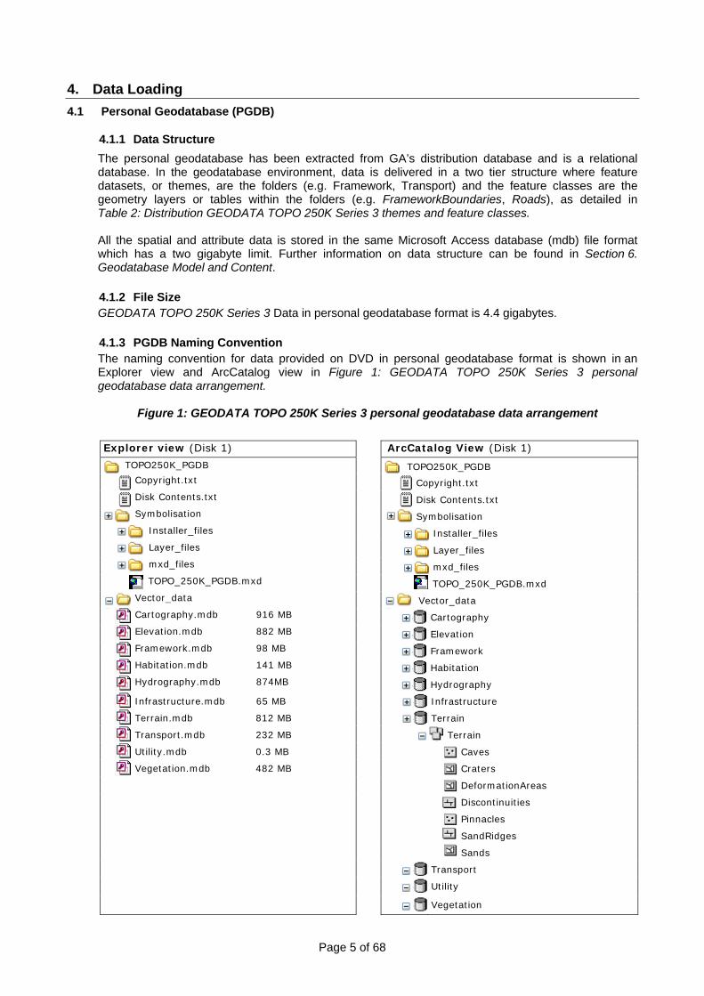
4.1.1 Data Structure The personal geodatabase has been extracted from GA’s distribution database and is a relational database. In the geodatabase environment, data is delivered in a two tier structure where feature datasets, or themes, are the folders (e.g. Framework, Transport) and the feature classes are the geometry layers or tables within the folders (e.g. FrameworkBoundaries, Roads), as detailed in Table 2: Distribution GEODATA TOPO 250K Series 3 themes and feature classes. All the spatial and attribute data is stored in the same Microsoft Access database (mdb) file format which has a two gigabyte limit. Further information on data structure can be found in Section 6. Geodatabase Model and Content. 4.1.2 File Size GEODATA TOPO 250K Series 3 Data in personal geodatabase format is 4.4 gigabytes. 4.1.3 PGDB Naming Convention The naming convention for data provided on DVD in personal geodatabase format is shown in an Explorer view and ArcCatalog view in Figure 1: GEODATA TOPO 250K Series 3 personal geodatabase data arrangement.
Figure 1: GEODATA TOPO 250K Series 3 personal geodatabase data arrangement Explorer view (Disk 1) ArcCatalog View (Disk 1)
TOPO250K_PGDB TOPO250K_PGDB Copyright.txt Copyright.txt Disk Contents.txt Disk Contents.txt
Symbolisation Symbolisation
Installer_files Installer_files
Layer_files Layer_files
mxd_files mxd_files
TOPO_250K_PGDB.mxd TOPO_250K_PGDB.mxd
Vector_data
Vector_data Cartography.mdb 916 MB Cartography Elevation.mdb 882 MB Elevation Framework.mdb 98 MB Framework Habitation.mdb 141 MB Habitation Hydrography.mdb 874MB Hydrography
Infrastructure.mdb 65 MB Infrastructure
Terrain.mdb 812 MB Terrain
Transport.mdb 232 MB Terrain
Utility.mdb 0.3 MB Caves
Vegetation.mdb 482 MB Craters
DeformationAreas
Discontinuities
Pinnacles
SandRidges
Sands
Transport
Utility
Vegetation
Page 6 of 68
Explorer view (Disk 2) ArcCatalog View (Disk 2)
TOPO250K_PGDB TOPO250K_PGDB
Copyright.txt Copyright.txt
Disk Contents.txt Disk Contents.txt
Documentation Documentation
250K Licence Packaged Product.pdf 250K Licence Packaged Product.pdf
250K User Guide.pdf 250K User Guide.pdf
Symbol Dictionary for Topographic Map Prod… Symbol Dictionary for Topographic Map Prod…
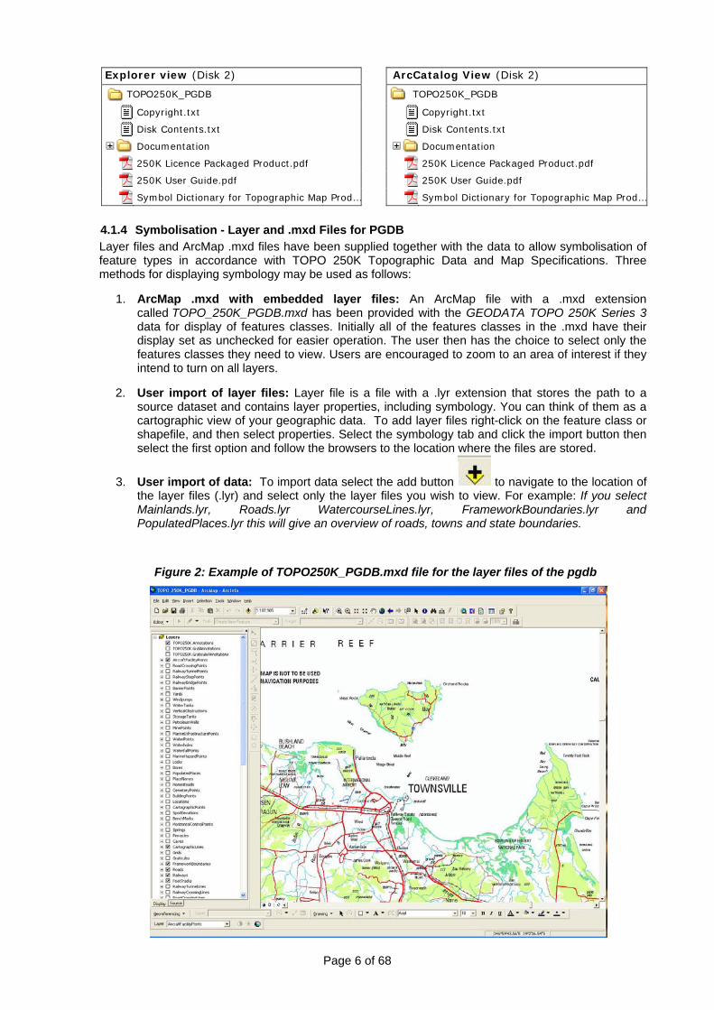
4.1.4 Symbolisation - Layer and .mxd Files for PGDB Layer files and ArcMap .mxd files have been supplied together with the data to allow symbolisation of feature types in accordance with TOPO 250K Topographic Data and Map Specifications. Three methods for displaying symbology may be used as follows:
1. ArcMap .mxd with embedded layer files: An ArcMap file with a .mxd extension
called TOPO_250K_PGDB.mxd has been provided with the GEODATA TOPO 250K Series 3 data for display of features classes. Initially all of the features classes in the .mxd have their display set as unchecked for easier operation. The user then has the choice to select only the features classes they need to view. Users are encouraged to zoom to an area of interest if they intend to turn on all layers.
2. User import of layer files: Layer file is a file with a .lyr extension that stores the path to a
source dataset and contains layer properties, including symbology. You can think of them as a cartographic view of your geographic data. To add layer files right-click on the feature class or shapefile, and then select properties. Select the symbology tab and click the import button then select the first option and follow the browsers to the location where the files are stored.
3. User import of data: To import data select the add button to navigate to the location of the layer files (.lyr) and select only the layer files you wish to view. For example: If you select Mainlands.lyr, Roads.lyr WatercourseLines.lyr, FrameworkBoundaries.lyr and PopulatedPlaces.lyr this will give an overview of roads, towns and state boundaries.
Figure 2: Example of TOPO250K_PGDB.mxd file for the layer files of the pgdb
Page 7 of 68
4.2 Shapefile
4.2.1 Data Structure Shapefiles have been extracted from the geodatabase, however, files delivered in this structure do not store inter-feature topological relationships. Shapefiles are delivered in a single tier structure and are compatible with most Geographic Information Systems (GIS).
A Shapefile is an ESRI vector data storage format and it represents one feature class. Each Shapefile is made up of the following files: • *.shp – Main file contains feature geometry; • *.shx – Index file contains look-up index of the feature geometry; • *.dbf – dBase file contains feature attributes with one record per feature; • *.prj – Projection file contains the coordinate system information; and • *.sbn and *.sbx – Spatial index files contain the spatial index of features.
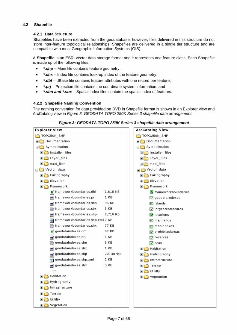
4.2.2 Shapefile Naming Convention The naming convention for data provided on DVD in Shapefile format is shown in an Explorer view and ArcCatalog view in Figure 3: GEODATA TOPO 250K Series 3 shapefile data arrangement.
Figure 3: GEODATA TOPO 250K Series 3 shapefile data arrangement Explorer view ArcCatalog View
TOPO50K_SHP TOPO250K_SHP
Documentation Documentation
Symbolisation Symbolisation
Installer_files Installer_files
Layer_files Layer_files
mxd_files mxd_files
Vector_data Vector_data
Cartography Cartography
Elevation Elevation
Framework Framework
frameworkboundaries.dbf 1,618 KB frameworkboundaries
frameworkboundaries.prj 1 KB geodataIndexes
frameworkboundaries.sbn 95 KB islands
frameworkboundaries.sbx 3 KB largeareafeatures
frameworkboundaries.shp 7,716 KB locations
frameworkboundaries.shp.xml 2 KB mainlands
frameworkboundaries.shx 77 KB mapindexes
geodataindexes.dbf 87 KB prohibitedareas
geodataindexes.prj 1 KB reserves
geodataindexes.sbn 6 KB seas
geodataindexes.sbx 1 KB Habitation
geodataindexes.shp 20, 407KB Hydrography
geodataindexes.shp.xml 2 KB Infrastructure
geodataindexes.shx 5 KB Terrain .......
Utililty
Habitation Vegetation Hydrography Infrastructure
Terrain
Utililty
Vegetation

Page 8 of 68
4.2.3 Symbolisation - Layer and .mxd Files for Shapefiles Layer files and ArcMap .mxd files have been supplied together with the data to allow symbolisation of feature types in accordance with the TOPO 250K Topographic Data and Map Specifications. An ArcMap file with a .mxd extension called TOPO_250K_SHP.mxd. has been provided with the GEODATA TOPO 250K Series 3 data for display of features classes. Please refer to section 4.1.4 Symbolisation - Layer and .mxd Files for PGDB regarding the full range of options available for symbolisation.
4.3 MapInfo File Format Option
4.3.1 Data Structure When a file is saved into MapInfo file format (*.tab), multiple files will be listed in the directory for each map or browser that has been created. The file extensions are: .tab, .id, .dat, .map and .ind. • *.tab - is a text file that describes the structure of the table, and the format of the file that contains
the data. The .tab file is the file shown in the Open Table dialog; • *.id – is a cross reference file that links the data with the geographic objects; • *.dat – is data, the tabular information that is shown in a browser; • *.map – stores the geographic objects. This file is only there if the table is mappable; and • *.ind – is a tabular index. It enables searching for map objects using the Find command. This file is
created if a column in the table is indexed
4.3.2 MapInfo Naming Convention
The naming convention for data provided on DVD in MapInfo TAB file format is shown in an Explorer view and ArcCatalog view in Figure 4: GEODATA TOPO 250K Series 3 MapInfo TAB data arrangement.
Figure 4: GEODATA TOPO 250K Series 3 MapInfo TAB file data arrangement
Explorer view ArcCatalog View
Page 9 of 68
4.3.3 Symbolisation - MapInfo Custom Installation Files
GEODATA TOPO 250K Series 3 data contains symbology that is not included in standard MapInfo symbology libraries. For the correct symbology to appear, users will need to install three custom symbology files: • Geoscience MapInfo True Type Font; • update the mires800.dll; and • update the MAPINFOW.PEN file, as well as copy additional custom bitmap files into the
appropriate directory. This needs to be done once, except for the .PEN file, which will need to be installed once for each new user logon, as it is installed in the user profiles. Detailed instructions for the installation of these files are available at Appendix F: Installing TAB Custom Symbology. The files are located in the ‘Symbolisation\Symbology’ directory on the DVD.
5. Data Characteristics and Special Features
5.1 Data Characteristics
All the vector data within GEODATA TOPO 250K Series 3 share the following characteristics:
5.1.1 Datum, Projection and Coordinate Extents
Datum Geographic Datum of Australia (GDA94)
Projection Geographical (i.e. latitudes and longitudes)
Resolution of coordinates Coordinates of all spatial objects are quoted to the nearest 0.00001 degrees (approx. 1m).
Spatial index Only one spatial index is used for each feature class with a grid of side length 0.5 degrees, for all feature classes except the Sea, Mainland and LargeAreaFeatures feature classes. These feature classes have a side length of 1.5 degrees.
Extent of Geodatabase -8.9 to -44 degrees of latitude and 112.8 to 154.1 degrees of longitude
5.1.2 Cartographic Generalisation
Some features are located on the earth’s surface in such a way that they cannot be separated at the scale of the map. To ensure cartographic clarity, one feature is held in the correct position and the rest are displaced. This is referred to as cartographic generalisation. During data and map compilation, the following hierarchy is used to determine which features are held in the real-world position and which are displaced when one or more are adjacent. The higher a feature is on the list, the more likely that it has been held in the correct position over those lower on the list. Natural features are given precedence over constructed features.
1. Hydrographic features 2. Railways 3. Principal roads 4. Secondary roads
5. Minor roads 6. Vehicular tracks 7. Buildings 8. Vegetation
Features that do not appear on the list may also be displaced. Their displacement may be due to an adjacent feature either appearing on the list above or having a greater landmark value.
Page 10 of 68
When up to three features are close and adjacent, one may be displaced by as much as 225 metres. As far as possible, the displaced features maintain the correct alignment and spatial relationship to other features.
5.2 Special Features
5.2.1 Persistent Identifier, Creation Date and Retirement Date
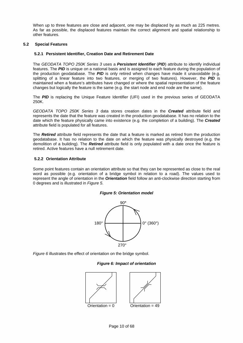
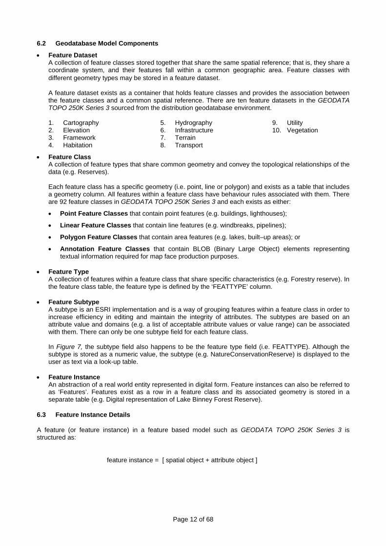
The GEODATA TOPO 250K Series 3 uses a Persistent Identifier (PID) attribute to identify individual features. The PID is unique on a national basis and is assigned to each feature during the population of the production geodatabase. The PID is only retired when changes have made it unavoidable (e.g. splitting of a linear feature into two features, or merging of two features). However, the PID is maintained when a feature’s attributes have changed or where the spatial representation of the feature changes but logically the feature is the same (e.g. the start node and end node are the same). The PID is replacing the Unique Feature Identifier (UFI) used in the previous series of GEODATA 250K. GEODATA TOPO 250K Series 3 data stores creation dates in the Created attribute field and represents the date that the feature was created in the production geodatabase. It has no relation to the date which the feature physically came into existence (e.g. the completion of a building). The Created attribute field is populated for all features. The Retired attribute field represents the date that a feature is marked as retired from the production geodatabase. It has no relation to the date on which the feature was physically destroyed (e.g. the demolition of a building). The Retired attribute field is only populated with a date once the feature is retired. Active features have a null retirement date. 5.2.2 Orientation Attribute Some point features contain an orientation attribute so that they can be represented as close to the real word as possible (e.g. orientation of a bridge symbol in relation to a road). The values used to represent the angle of orientation in the Orientation field follow an anti-clockwise direction starting from 0 degrees and is illustrated in Figure 5.
Figure 5: Orientation model
Figure 6 illustrates the effect of orientation on the bridge symbol.
Figure 6: Impact of orientation
Orientation = 0 Orientation = 49
90°
270°
180° 0° (360°)

Page 11 of 68
6. Geodatabase Model and Content 6.1 Geodatabase Model A geodatabase stores spatial data, both vector and raster, and attribute data in a relational database. A geodatabase can exist as either an enterprise geodatabase or a personal geodatabase. Their structure is generally the same, but the differences are in the size restrictions and the ability to edit in a multi-user environment.
• Enterprise Geodatabase (egdb) The data is stored in a Relational Database Management System (RDBMS) which is accessed through an ArcSDE client via ArcGIS. The powerfulness and potential size of RDBMS’ makes transactions faster and allow the data to be viewed and edited by multiple users at once. Enterprise Geodatabases (egdbs) are generally used by organisations that have large centralised datasets. GA uses Oracle’s RDBMS through SDE to manage and revise its 250K topographic seamless data. The egdb format can be obtained by users as a customised product.
• Personal Geodatabase (pgdb) The data is stored in a Microsoft Access database which can be directly accessed by the ArcGIS suite of products. Unlike an egdb, there is a two gigabyte limit of the size of the pgdb due to Microsoft Access database restrictions. This means that GEODATA TOPO 250K Series 3 format is delivered as a series of pgdb’s. Pgdbs are generally intended for a single user and for organisations that cannot store the data in an RDBMS. Although it supports viewing by multiple users at once, it only enables a single user to edit. GEODATA TOPO 250K Series 3 is provided as a pgdb to users.
The geodatabase structure for GEODATA TOPO 250K Series 3 is a feature based data model and was developed using Unified Mark-up Language (UML). The features are arranged in a hierarchy of feature classifications including features datasets, feature classes and feature types which are described in more detail in Figure 7.
Figure 7: Geodatabase structure and components
TOPO250K.mdb
Workspace Feature dataset or Theme Feature Class
Feature type
Spatial representation
Tabular representation
Subtypes
Page 12 of 68
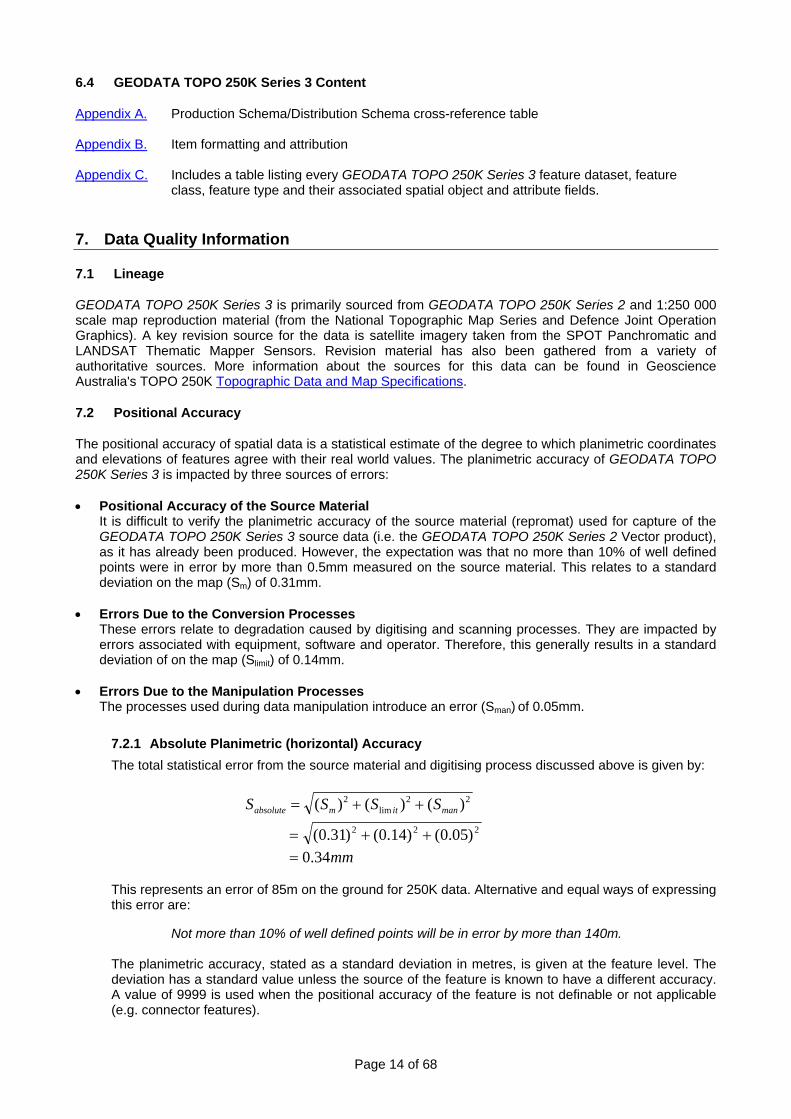
6.2 Geodatabase Model Components
• Feature Dataset A collection of feature classes stored together that share the same spatial reference; that is, they share a coordinate system, and their features fall within a common geographic area. Feature classes with different geometry types may be stored in a feature dataset. A feature dataset exists as a container that holds feature classes and provides the association between the feature classes and a common spatial reference. There are ten feature datasets in the GEODATA TOPO 250K Series 3 sourced from the distribution geodatabase environment. 1. Cartography 2. Elevation 3. Framework 4. Habitation
5. Hydrography 6. Infrastructure 7. Terrain 8. Transport
9. Utility 10. Vegetation
• Feature Class A collection of feature types that share common geometry and convey the topological relationships of the data (e.g. Reserves). Each feature class has a specific geometry (i.e. point, line or polygon) and exists as a table that includes a geometry column. All features within a feature class have behaviour rules associated with them. There are 92 feature classes in GEODATA TOPO 250K Series 3 and each exists as either:
• Point Feature Classes that contain point features (e.g. buildings, lighthouses);
• Linear Feature Classes that contain line features (e.g. windbreaks, pipelines);
• Polygon Feature Classes that contain area features (e.g. lakes, built–up areas); or
• Annotation Feature Classes that contain BLOB (Binary Large Object) elements representing textual information required for map face production purposes.
• Feature Type
A collection of features within a feature class that share specific characteristics (e.g. Forestry reserve). In the feature class table, the feature type is defined by the ‘FEATTYPE’ column.
• Feature Subtype
A subtype is an ESRI implementation and is a way of grouping features within a feature class in order to increase efficiency in editing and maintain the integrity of attributes. The subtypes are based on an attribute value and domains (e.g. a list of acceptable attribute values or value range) can be associated with them. There can only be one subtype field for each feature class. In Figure 7, the subtype field also happens to be the feature type field (i.e. FEATTYPE). Although the subtype is stored as a numeric value, the subtype (e.g. NatureConservationReserve) is displayed to the user as text via a look-up table.
• Feature Instance
An abstraction of a real world entity represented in digital form. Feature instances can also be referred to as ‘Features’. Features exist as a row in a feature class and its associated geometry is stored in a separate table (e.g. Digital representation of Lake Binney Forest Reserve).
6.3 Feature Instance Details
A feature (or feature instance) in a feature based model such as GEODATA TOPO 250K Series 3 is structured as:
feature instance = [ spatial object + attribute object ]

Page 13 of 68
Spatial Object: The spatial object is defined by the locational attributes of the feature in the form of geometry (Table 3) defined by x and y coordinate couplets. The topological relationships are also carried as part of the spatial object whenever the transfer formats support them.
Table 3: Geometry types Point Geometric representation defined by a single 'x, y' co-ordinate couplet. Three special points are used in the data model.
• Entity Point - used to locate point features or area features represented by a point.
• Node - A point that is an intersection of two or more lines or an end point of a line.
• Vertex - A point that is a change of direction along the length of a line. Line A sequence of non-intersecting line segments bounded by nodes (not necessarily distinct) at each end. Lines will reference their start and end nodes. Coordinates along a line are referred to as vertices.
Polygon A defined continuous region consisting of an interior area. Within a feature class the polygons are mutually exclusive. Multi-polygons are two or more polygons, not abutting each other, treated as a single feature. There are three feature classes where multi-polygon features apply, these are Reserves, Built Up Area and Islands.
Attribute Object: The attribute object includes the non-spatial (or aspatial) information about a feature, including the feature type. The attribute object is composed of one or more attributes and is defined by an attribute field(s) and its associated attribute value.
Table 4: Example of attribute object
Spatial Object Attribute Object Attribute Attribute Value OBJECTID 305867 FEATTYPE Road NAME BARRIER HIGHWAY CLASS Principal Road FORMATION Sealed NRN 32 SRN 87 FEATREL 16/11/2004 ATTRREL 16/11/2004 PLANACC 100 SOURCE GEOSCIENCE AUSTRALIA CREATED 9/05/2006 RETIRED <null> PID 3968237 SYMBOL 251 FEATWIDTH 0 TEXTNOTE <null> SHAPE Polyline
Line x1,y1 .....xn,yn)
SHAPE.LEN 0.003552
Page 14 of 68
6.4 GEODATA TOPO 250K Series 3 Content
Appendix A. Production Schema/Distribution Schema cross-reference table Appendix B. Item formatting and attribution Appendix C. Includes a table listing every GEODATA TOPO 250K Series 3 feature dataset, feature
class, feature type and their associated spatial object and attribute fields.
7. Data Quality Information
7.1 Lineage
GEODATA TOPO 250K Series 3 is primarily sourced from GEODATA TOPO 250K Series 2 and 1:250 000 scale map reproduction material (from the National Topographic Map Series and Defence Joint Operation Graphics). A key revision source for the data is satellite imagery taken from the SPOT Panchromatic and LANDSAT Thematic Mapper Sensors. Revision material has also been gathered from a variety of authoritative sources. More information about the sources for this data can be found in Geoscience Australia's TOPO 250K Topographic Data and Map Specifications.
7.2 Positional Accuracy
The positional accuracy of spatial data is a statistical estimate of the degree to which planimetric coordinates and elevations of features agree with their real world values. The planimetric accuracy of GEODATA TOPO 250K Series 3 is impacted by three sources of errors: • Positional Accuracy of the Source Material
It is difficult to verify the planimetric accuracy of the source material (repromat) used for capture of the GEODATA TOPO 250K Series 3 source data (i.e. the GEODATA TOPO 250K Series 2 Vector product), as it has already been produced. However, the expectation was that no more than 10% of well defined points were in error by more than 0.5mm measured on the source material. This relates to a standard deviation on the map (Sm) of 0.31mm.
• Errors Due to the Conversion Processes
These errors relate to degradation caused by digitising and scanning processes. They are impacted by errors associated with equipment, software and operator. Therefore, this generally results in a standard deviation of on the map (Slimit) of 0.14mm.
• Errors Due to the Manipulation Processes
The processes used during data manipulation introduce an error (Sman) of 0.05mm.
7.2.1 Absolute Planimetric (horizontal) Accuracy The total statistical error from the source material and digitising process discussed above is given by:
22
lim2 )()()( manitmabsolute SSSS ++=
222 )05.0()14.0()31.0( ++=
mm34.0=
This represents an error of 85m on the ground for 250K data. Alternative and equal ways of expressing this error are:
Not more than 10% of well defined points will be in error by more than 140m.
The planimetric accuracy, stated as a standard deviation in metres, is given at the feature level. The deviation has a standard value unless the source of the feature is known to have a different accuracy. A value of 9999 is used when the positional accuracy of the feature is not definable or not applicable (e.g. connector features).
Page 15 of 68
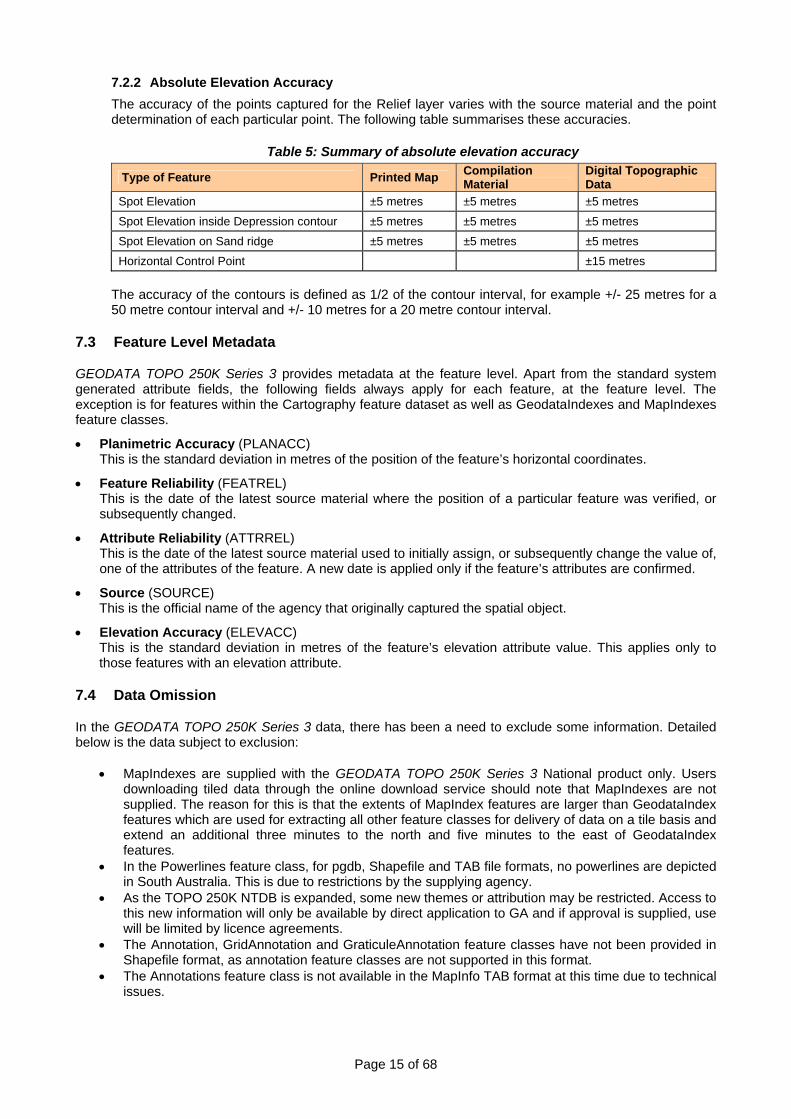
7.2.2 Absolute Elevation Accuracy The accuracy of the points captured for the Relief layer varies with the source material and the point determination of each particular point. The following table summarises these accuracies.
Table 5: Summary of absolute elevation accuracy
Type of Feature Printed Map Compilation Material
Digital Topographic Data
Spot Elevation ±5 metres ±5 metres ±5 metres
Spot Elevation inside Depression contour ±5 metres ±5 metres ±5 metres Spot Elevation on Sand ridge ±5 metres ±5 metres ±5 metres Horizontal Control Point ±15 metres
The accuracy of the contours is defined as 1/2 of the contour interval, for example +/- 25 metres for a 50 metre contour interval and +/- 10 metres for a 20 metre contour interval.
7.3 Feature Level Metadata
GEODATA TOPO 250K Series 3 provides metadata at the feature level. Apart from the standard system generated attribute fields, the following fields always apply for each feature, at the feature level. The exception is for features within the Cartography feature dataset as well as GeodataIndexes and MapIndexes feature classes.
• Planimetric Accuracy (PLANACC) This is the standard deviation in metres of the position of the feature’s horizontal coordinates.
• Feature Reliability (FEATREL) This is the date of the latest source material where the position of a particular feature was verified, or subsequently changed.
• Attribute Reliability (ATTRREL) This is the date of the latest source material used to initially assign, or subsequently change the value of, one of the attributes of the feature. A new date is applied only if the feature’s attributes are confirmed.
• Source (SOURCE) This is the official name of the agency that originally captured the spatial object.
• Elevation Accuracy (ELEVACC) This is the standard deviation in metres of the feature’s elevation attribute value. This applies only to those features with an elevation attribute.
7.4 Data Omission
In the GEODATA TOPO 250K Series 3 data, there has been a need to exclude some information. Detailed below is the data subject to exclusion:
• MapIndexes are supplied with the GEODATA TOPO 250K Series 3 National product only. Users downloading tiled data through the online download service should note that MapIndexes are not supplied. The reason for this is that the extents of MapIndex features are larger than GeodataIndex features which are used for extracting all other feature classes for delivery of data on a tile basis and extend an additional three minutes to the north and five minutes to the east of GeodataIndex features.
• In the Powerlines feature class, for pgdb, Shapefile and TAB file formats, no powerlines are depicted in South Australia. This is due to restrictions by the supplying agency.
• As the TOPO 250K NTDB is expanded, some new themes or attribution may be restricted. Access to this new information will only be available by direct application to GA and if approval is supplied, use will be limited by licence agreements.
• The Annotation, GridAnnotation and GraticuleAnnotation feature classes have not been provided in Shapefile format, as annotation feature classes are not supported in this format.
• The Annotations feature class is not available in the MapInfo TAB format at this time due to technical issues.
Page 16 of 68
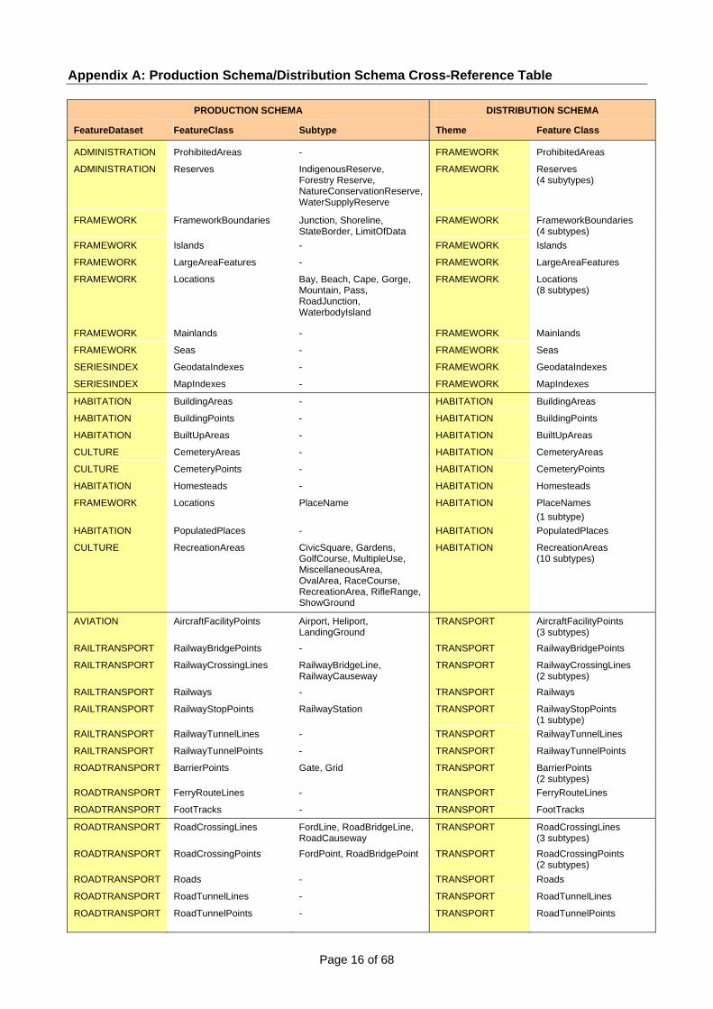
Appendix A: Production Schema/Distribution Schema Cross-Reference Table
PRODUCTION SCHEMA DISTRIBUTION SCHEMA
FeatureDataset FeatureClass Subtype Theme Feature Class
ADMINISTRATION ProhibitedAreas - FRAMEWORK ProhibitedAreas
ADMINISTRATION Reserves IndigenousReserve, Forestry Reserve, NatureConservationReserve, WaterSupplyReserve
FRAMEWORK Reserves (4 subytypes)
FRAMEWORK FrameworkBoundaries Junction, Shoreline, StateBorder, LimitOfData
FRAMEWORK FrameworkBoundaries (4 subtypes)
FRAMEWORK Islands - FRAMEWORK Islands
FRAMEWORK LargeAreaFeatures - FRAMEWORK LargeAreaFeatures
FRAMEWORK Locations Bay, Beach, Cape, Gorge, Mountain, Pass, RoadJunction, WaterbodyIsland
FRAMEWORK Locations (8 subtypes)
FRAMEWORK Mainlands - FRAMEWORK Mainlands
FRAMEWORK Seas - FRAMEWORK Seas
SERIESINDEX GeodataIndexes - FRAMEWORK GeodataIndexes
SERIESINDEX MapIndexes - FRAMEWORK MapIndexes
HABITATION BuildingAreas - HABITATION BuildingAreas
HABITATION BuildingPoints - HABITATION BuildingPoints
HABITATION BuiltUpAreas - HABITATION BuiltUpAreas
CULTURE CemeteryAreas - HABITATION CemeteryAreas
CULTURE CemeteryPoints - HABITATION CemeteryPoints
HABITATION Homesteads - HABITATION Homesteads
FRAMEWORK Locations PlaceName HABITATION PlaceNames (1 subtype)
HABITATION PopulatedPlaces - HABITATION PopulatedPlaces
CULTURE RecreationAreas CivicSquare, Gardens, GolfCourse, MultipleUse, MiscellaneousArea, OvalArea, RaceCourse, RecreationArea, RifleRange, ShowGround
HABITATION RecreationAreas (10 subtypes)
AVIATION AircraftFacilityPoints Airport, Heliport, LandingGround
TRANSPORT AircraftFacilityPoints (3 subtypes)
RAILTRANSPORT RailwayBridgePoints - TRANSPORT RailwayBridgePoints
RAILTRANSPORT RailwayCrossingLines RailwayBridgeLine, RailwayCauseway
TRANSPORT RailwayCrossingLines (2 subtypes)
RAILTRANSPORT Railways - TRANSPORT Railways
RAILTRANSPORT RailwayStopPoints RailwayStation TRANSPORT RailwayStopPoints (1 subtype)
RAILTRANSPORT RailwayTunnelLines - TRANSPORT RailwayTunnelLines
RAILTRANSPORT RailwayTunnelPoints - TRANSPORT RailwayTunnelPoints
ROADTRANSPORT BarrierPoints Gate, Grid TRANSPORT BarrierPoints (2 subtypes)
ROADTRANSPORT FerryRouteLines - TRANSPORT FerryRouteLines
ROADTRANSPORT FootTracks - TRANSPORT FootTracks
ROADTRANSPORT RoadCrossingLines FordLine, RoadBridgeLine, RoadCauseway
TRANSPORT RoadCrossingLines (3 subtypes)
ROADTRANSPORT RoadCrossingPoints FordPoint, RoadBridgePoint TRANSPORT RoadCrossingPoints (2 subtypes)
ROADTRANSPORT Roads - TRANSPORT Roads
ROADTRANSPORT RoadTunnelLines - TRANSPORT RoadTunnelLines
ROADTRANSPORT RoadTunnelPoints - TRANSPORT RoadTunnelPoints

Page 17 of 68
PRODUCTION SCHEMA DISTRIBUTION SCHEMA
FeatureDataset FeatureClass Subtype Theme Feature Class
DRAINAGE CanalLines - HYDROGRAPHY CanalLines DRAINAGE Locks - HYDROGRAPHY Locks
DRAINAGE RapidLines - HYDROGRAPHY RapidLines
DRAINAGE Spillways - HYDROGRAPHY Spillways
DRAINAGE WatercourseLines Connector, Watercourse HYDROGRAPHY WatercourseLines (2 subtypes)
DRAINAGE WaterfallPoints - HYDROGRAPHY WaterfallPoints
WATERBODIES Bores - HYDROGRAPHY Bores
WATERBODIES CanalAreas - HYDROGRAPHY CanalAreas
WATERBODIES Flats LandSubjectToInundation, MarineSwamp, SalineCoastalFlat, Swamp
HYDROGRAPHY Flats (4 subtypes)
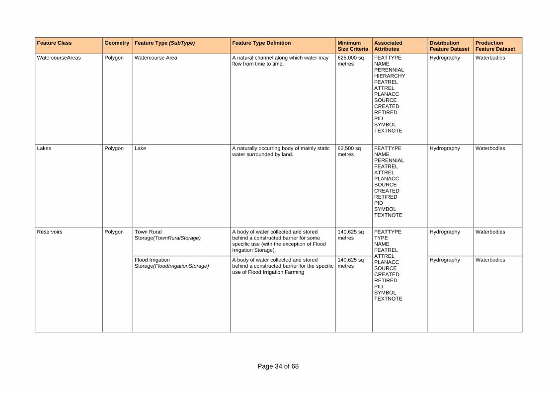
WATERBODIES Lakes - HYDROGRAPHY Lakes
WATERBODIES PondageAreas AquacultureArea, SaltEvaporator, SettlingPond
HYDROGRAPHY PondageAreas (3 subtypes)
WATERBODIES RapidAreas - HYDROGRAPHY RapidAreas
WATERBODIES Reservoirs FloodIrrigationStorage, TownRuralStorage
HYDROGRAPHY Reservoirs (2 subtypes)
WATERBODIES Springs - HYDROGRAPHY Springs
WATERBODIES WatercourseAreas - HYDROGRAPHY WatercourseAreas
WATERBODIES Waterholes - HYDROGRAPHY Waterholes
WATERBODIES WaterPoints GnammaHole, NativeWell, Pool, Rockhole, Soak
HYDROGRAPHY WaterPoints (5 subtypes)
MARINE MarineHazardAreas Reef, Shoal HYDROGRAPHY MarineHazardAreas (2 subtypes)
MARINE MarineHazardPoints OffshoreRock, Wreck HYDROGRAPHY MarineHazardPoints (2 subtypes)
MARINE ForeshoreFlats - HYDROGRAPHY ForeshoreFlats
CARTOGRAPHY Annotations - CARTOGRAPHY Annotations
CARTOGRAPHY CartographicLines - CARTOGRAPHY CartographicLines
CARTOGRAPHY CartographicPoints - CARTOGRAPHY CartographicPoints
CARTOGRAPHY GraticuleAnnotations - CARTOGRAPHY GraticuleAnnotations
CARTOGRAPHY Graticules - CARTOGRAPHY Graticules
CARTOGRAPHY GridAnnotations - CARTOGRAPHY GridAnnotations
CARTOGRAPHY Grids - CARTOGRAPHY Grids
CULTURE AerialCableways - INFRASTRUCTURE AerialCableways
CULTURE DamWalls - INFRASTRUCTURE DamWalls
CULTURE Fences - INFRASTRUCTURE Fences
MARINE MarineInfrastructureLines Breakwater, Jetty, SeaWall, WharfLine
INFRASTRUCTURE MarineInfrastructureLines (4 subtypes)
MARINE MarineInfrastructurePoints Lighthouse INFRASTRUCTURE MarineInfrastructurePoints (1 subtype)
CULTURE VerticalObstructions - INFRASTRUCTURE VerticalObstructions
CULTURE WaterTanks - INFRASTRUCTURE WaterTanks
CULTURE Windpumps - INFRASTRUCTURE Windpumps
CULTURE Yards - INFRASTRUCTURE Yards
INDUSTRY Conveyors - INFRASTRUCTURE Conveyors
INDUSTRY MineAreas - INFRASTRUCTURE MineAreas
INDUSTRY MinePoints - INFRASTRUCTURE MinePoints
INDUSTRY PetroleumWells - INFRASTRUCTURE PetroleumWells
INDUSTRY StorageTanks - INFRASTRUCTURE StorageTanks
Page 18 of 68
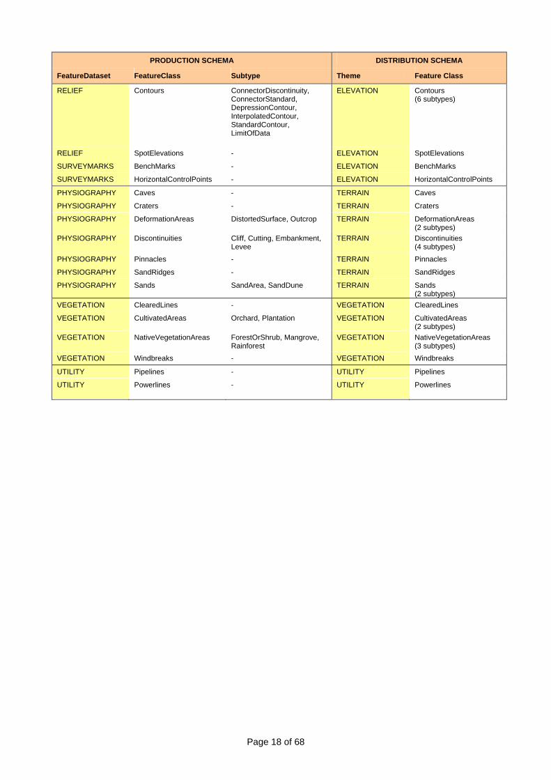
PRODUCTION SCHEMA DISTRIBUTION SCHEMA
FeatureDataset FeatureClass Subtype Theme Feature Class
RELIEF Contours ConnectorDiscontinuity, ConnectorStandard, DepressionContour, InterpolatedContour, StandardContour, LimitOfData
ELEVATION Contours (6 subtypes)
RELIEF SpotElevations - ELEVATION SpotElevations
SURVEYMARKS BenchMarks - ELEVATION BenchMarks
SURVEYMARKS HorizontalControlPoints - ELEVATION HorizontalControlPoints
PHYSIOGRAPHY Caves - TERRAIN Caves
PHYSIOGRAPHY Craters - TERRAIN Craters
PHYSIOGRAPHY DeformationAreas DistortedSurface, Outcrop TERRAIN DeformationAreas (2 subtypes)
PHYSIOGRAPHY Discontinuities Cliff, Cutting, Embankment, Levee
TERRAIN Discontinuities (4 subtypes)
PHYSIOGRAPHY Pinnacles - TERRAIN Pinnacles
PHYSIOGRAPHY SandRidges - TERRAIN SandRidges
PHYSIOGRAPHY Sands SandArea, SandDune TERRAIN Sands (2 subtypes)
VEGETATION ClearedLines - VEGETATION ClearedLines
VEGETATION CultivatedAreas Orchard, Plantation VEGETATION CultivatedAreas (2 subtypes)
VEGETATION NativeVegetationAreas ForestOrShrub, Mangrove, Rainforest
VEGETATION NativeVegetationAreas (3 subtypes)
VEGETATION Windbreaks - VEGETATION Windbreaks
UTILITY Pipelines - UTILITY Pipelines
UTILITY Powerlines - UTILITY Powerlines
Page 19 of 68
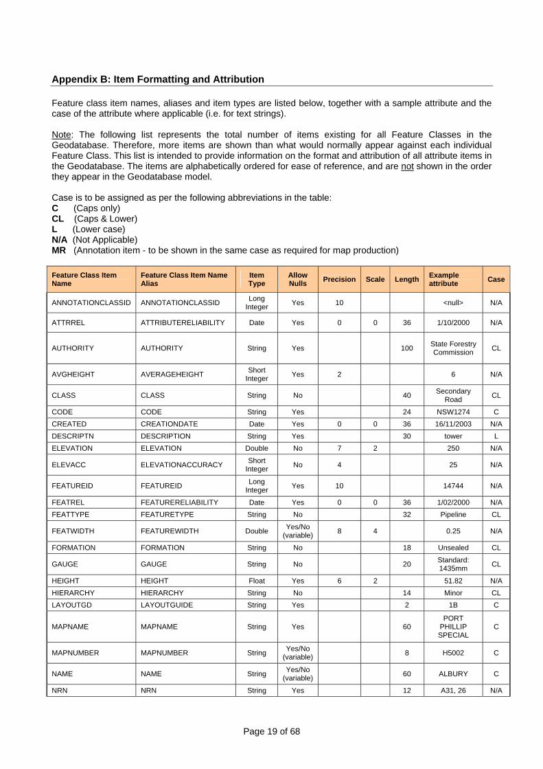
Appendix B: Item Formatting and Attribution Feature class item names, aliases and item types are listed below, together with a sample attribute and the case of the attribute where applicable (i.e. for text strings). Note: The following list represents the total number of items existing for all Feature Classes in the Geodatabase. Therefore, more items are shown than what would normally appear against each individual Feature Class. This list is intended to provide information on the format and attribution of all attribute items in the Geodatabase. The items are alphabetically ordered for ease of reference, and are not shown in the order they appear in the Geodatabase model. Case is to be assigned as per the following abbreviations in the table: C (Caps only) CL (Caps & Lower) L (Lower case) N/A (Not Applicable) MR (Annotation item - to be shown in the same case as required for map production) Feature Class Item Name
Feature Class Item Name Alias
Item Type
Allow Nulls Precision Scale Length Example
attribute Case
ANNOTATIONCLASSID ANNOTATIONCLASSID Long Integer Yes 10 <null> N/A
ATTRREL ATTRIBUTERELIABILITY Date Yes 0 0 36 1/10/2000 N/A
AUTHORITY AUTHORITY String Yes 100 State Forestry Commission CL
AVGHEIGHT AVERAGEHEIGHT Short Integer Yes 2 6 N/A
CLASS CLASS String No 40 Secondary Road CL
CODE CODE String Yes 24 NSW1274 C CREATED CREATIONDATE Date Yes 0 0 36 16/11/2003 N/A DESCRIPTN DESCRIPTION String Yes 30 tower L ELEVATION ELEVATION Double No 7 2 250 N/A
ELEVACC ELEVATIONACCURACY Short Integer No 4 25 N/A
FEATUREID FEATUREID Long Integer Yes 10 14744 N/A
FEATREL FEATURERELIABILITY Date Yes 0 0 36 1/02/2000 N/A FEATTYPE FEATURETYPE String No 32 Pipeline CL
FEATWIDTH FEATUREWIDTH Double Yes/No (variable) 8 4 0.25 N/A
FORMATION FORMATION String No 18 Unsealed CL
GAUGE GAUGE String No 20 Standard: 1435mm CL
HEIGHT HEIGHT Float Yes 6 2 51.82 N/A HIERARCHY HIERARCHY String No 14 Minor CL LAYOUTGD LAYOUTGUIDE String Yes 2 1B C
MAPNAME MAPNAME String Yes 60 PORT
PHILLIP SPECIAL
C
MAPNUMBER MAPNUMBER String Yes/No (variable) 8 H5002 C
NAME NAME String Yes/No (variable) 60 ALBURY C
NRN NRN String Yes 12 A31, 26 N/A

Page 20 of 68
Feature Class Item Name
Feature Class Item Name Alias
Item Type
Allow Nulls Precision Scale Length Example
attribute Case
OBJECTID OBJECTID (system generated) Object ID 2453 N/A
OCEANNAME OCEANNAME String Yes 60 INDIAN OCEAN C
ORDEROFACC ORDEROFACCURACY String Yes 6 3 N/A
ORIENTATN ORIENTATION Short Integer Yes 3 135 N/A
OTHWATERNM OTHERWATERNAME String Yes 60 <null> C
PERENNIAL PERENNIALITY String No 14 Non-perennial CL
PID PID Long Integer Yes 8 83202692 N/A
PLANACC PLANIMETRICACCURACY Short Integer No 4 100 N/A
PRODUCT PRODUCT String Yes 35 Gas CL
RELATION RELATIONSHIP String Yes 12 Underground CL
RETIRED RETIREMENTDATE Date Yes 0 0 36 12/01/2004 N/A
SEANAME SEANAME String Yes 60 TIMOR SEA C
SHAPE SHAPE Geometry Yes Polygon N/A SHAPE.AREA SHAPE.AREA Double No 0 0 0.738476 N/A SHAPE.LEN SHAPE.LEN Double No 0 0 0.409136 N/A
SOURCE SOURCE String No 0 0 50 GEOSCIENCE AUSTRALIA C
SOURCETYPE SOURCETYPE String No 24 PRINTED MAP C
SRN SRN String Yes 12 M13, 64 N/A STATE STATE String No 3 NSW C STATUS STATUS String No 18 Operational CL
SYMBOL SYMBOL Short Integer No 4 209 N/A
TEXTNOTE TEXTNOTE String Yes 50 gauge 1435mm L
TILENAME TILENAME String Yes 60 MELBOURNE C
TILENUMBER TILENUMBER String No 8 F5416 C TRACKS TRACKS String No 8 One CL
TYPE TYPE Long Integer No 5 2 N/A
ZORDER ZORDER Long Integer Yes 10 0 N/A
Page 21 of 68
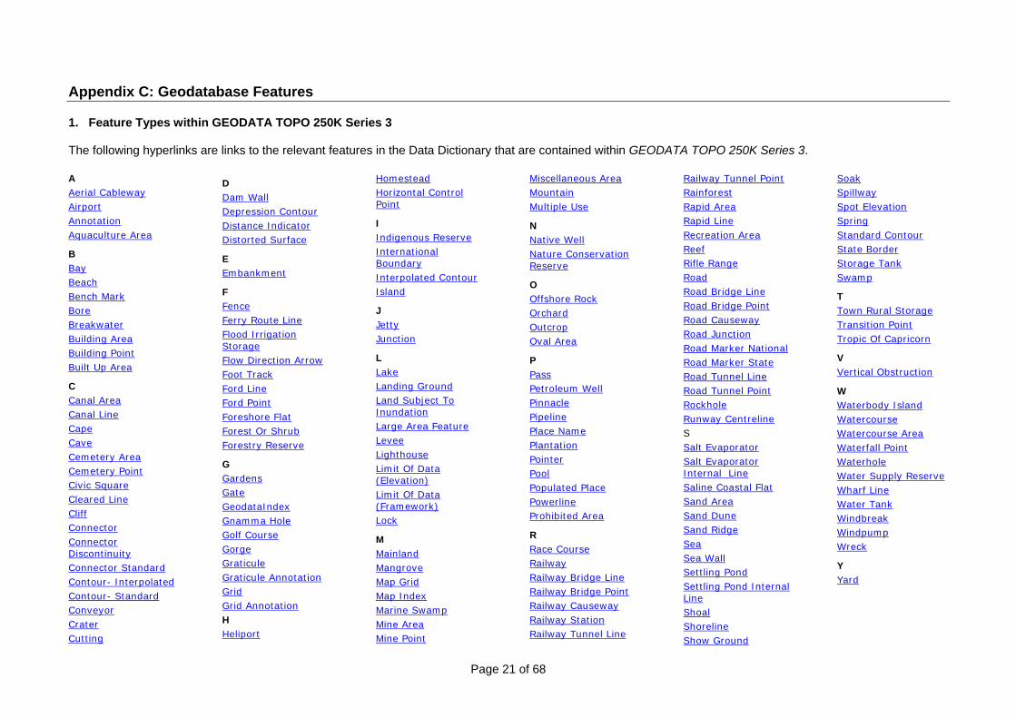
Appendix C: Geodatabase Features 1. Feature Types within GEODATA TOPO 250K Series 3 The following hyperlinks are links to the relevant features in the Data Dictionary that are contained within GEODATA TOPO 250K Series 3.
A Aerial Cableway Airport Annotation Aquaculture Area
B Bay Beach Bench Mark Bore Breakwater Building Area Building Point Built Up Area
C Canal Area Canal Line Cape Cave Cemetery Area Cemetery Point Civic Square Cleared Line Cliff Connector Connector Discontinuity Connector Standard Contour- Interpolated Contour- Standard Conveyor Crater Cutting
D Dam Wall Depression Contour Distance Indicator Distorted Surface
E Embankment
F Fence Ferry Route Line Flood Irrigation Storage Flow Direction Arrow Foot Track Ford Line Ford Point Foreshore Flat Forest Or Shrub Forestry Reserve
G Gardens Gate GeodataIndex Gnamma Hole Golf Course Gorge Graticule Graticule Annotation Grid Grid Annotation H Heliport
Homestead Horizontal Control Point
I Indigenous Reserve International Boundary Interpolated Contour Island
J Jetty Junction
L Lake Landing Ground Land Subject To Inundation Large Area Feature Levee Lighthouse Limit Of Data (Elevation) Limit Of Data (Framework) Lock
M Mainland Mangrove Map Grid Map Index Marine Swamp Mine Area Mine Point
Miscellaneous Area Mountain Multiple Use
N Native Well Nature Conservation Reserve
O Offshore Rock Orchard Outcrop Oval Area
P Pass Petroleum Well Pinnacle Pipeline Place Name Plantation Pointer Pool Populated Place Powerline Prohibited Area
R Race Course Railway Railway Bridge Line Railway Bridge Point Railway Causeway Railway Station Railway Tunnel Line
Railway Tunnel Point Rainforest Rapid Area Rapid Line Recreation Area Reef Rifle Range Road Road Bridge Line Road Bridge Point Road Causeway Road Junction Road Marker National Road Marker State Road Tunnel Line Road Tunnel Point Rockhole Runway Centreline S Salt Evaporator Salt Evaporator Internal Line Saline Coastal Flat Sand Area Sand Dune Sand Ridge Sea Sea Wall Settling Pond Settling Pond Internal Line Shoal Shoreline Show Ground
Soak Spillway Spot Elevation Spring Standard Contour State Border Storage Tank Swamp
T Town Rural Storage Transition Point Tropic Of Capricorn
V Vertical Obstruction
W Waterbody Island Watercourse Watercourse Area Waterfall Point Waterhole Water Supply Reserve Wharf Line Water Tank Windbreak Windpump Wreck
Y Yard
Page 22 of 68
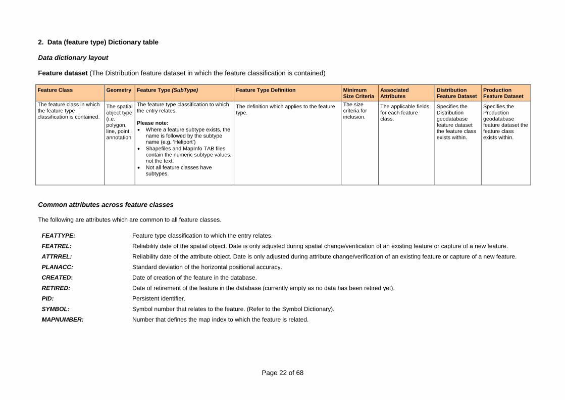
2. Data (feature type) Dictionary table Data dictionary layout Feature dataset (The Distribution feature dataset in which the feature classification is contained) Feature Class Geometry Feature Type (SubType) Feature Type Definition Minimum
Size Criteria Associated Attributes
Distribution Feature Dataset
Production Feature Dataset
The feature class in which the feature type classification is contained.
The spatial object type (i.e. polygon, line, point, annotation
The feature type classification to which the entry relates. Please note: • Where a feature subtype exists, the
name is followed by the subtype name (e.g. ‘Heliport’)
• Shapefiles and MapInfo TAB files contain the numeric subtype values, not the text.
• Not all feature classes have subtypes.
The definition which applies to the feature type.
The size criteria for inclusion.
The applicable fields for each feature class.
Specifies the Distribution geodatabase feature dataset the feature class exists within.
Specifies the Production geodatabase feature dataset the feature class exists within.
Common attributes across feature classes The following are attributes which are common to all feature classes.
FEATTYPE: Feature type classification to which the entry relates.
FEATREL: Reliability date of the spatial object. Date is only adjusted during spatial change/verification of an existing feature or capture of a new feature.
ATTRREL: Reliability date of the attribute object. Date is only adjusted during attribute change/verification of an existing feature or capture of a new feature.
PLANACC: Standard deviation of the horizontal positional accuracy.
CREATED: Date of creation of the feature in the database.
RETIRED: Date of retirement of the feature in the database (currently empty as no data has been retired yet).
PID: Persistent identifier.
SYMBOL: Symbol number that relates to the feature. (Refer to the Symbol Dictionary).
MAPNUMBER: Number that defines the map index to which the feature is related.

Page 23 of 68
Data dictionary Cartography
Feature Class Geometry Feature Type (SubType) Feature Type Definition Minimum Size Criteria
Associated Attributes
Distribution Feature Dataset
Production Feature Dataset
Annotations Annotation Type that appears on the map not related to the graticule or grid feature classes.
Cartography Cartography
GraticuleAnnotations Graticule Annotation Type that appears on the map related to the Graticule feature class.
Cartography Cartography
GridAnnotations
Anno
Grid Annotation Type that appears on the map related to the Map Grid feature type.
FEATTYPE MAPNUMBER CREATED RETIRED PID
Cartography Cartography
International Boundary(InternationalBoundary)
Boundaries defining the territorial sovereignty of a country. The international boundary will be taken to be the line of sea bed jurisdictions.
Cartography Cartography
Pointer(Pointer) A symbol used to graphically link text to a feature where the density of detail may result in ambiguity.
Cartography Cartography
Runway Centreline (RunwayCentreline) A symbol used to indicate the length and orientation of an airport’s runway.
Cartography Cartography
Salt Evaporator Internal Line(SaltEvaporatorInternalLine)
A levee bank or small canal within a salt evaporator.
1,250 metres Cartography Cartography
Settling Pond Internal Line(SettlingPondInternalLine)
Levee banks within settling ponds. 1,250 metres Cartography Cartography
CartographicLines Line
Tropic Of Capricorn(TropicOfCapricorn) The parallel of latitude 23°26.5'S.
FEATTYPE TYPE MAPNUMBER CREATED RETIRED PID SYMBOL TEXTNOTE
Cartography Cartography
Distance Indicator(DistanceIndicator) A symbol used to indicate points between which road distances are given (in kilometres).
Cartography Cartography
Flow Direction Arrow(FlowDirectionArrow)
A symbol used to indicate the direction of flow of water through a river system where it is unclear using the topological relationships shown on the map face.
Cartography Cartography
CartographicPoints Point
Road Marker National (RoadMarkerNational)
The symbol printed over a road indicating a national route.
FEATTYPE TYPE MAPNUMBER CREATED RETIRED PID SYMBOL FEATWIDTH ORIENTATN TEXTNOTE
Cartography Cartography

Page 24 of 68
Feature Class Geometry Feature Type (SubType) Feature Type Definition Minimum Size Criteria
Associated Attributes
Distribution Feature Dataset
Production Feature Dataset
Road Marker State(RoadMarkerState) The symbol printed over a road indicating a state route.
Cartography Cartography
Transition Point(TransitionPoint) The point where a road or railway enters/exits a tunnel.
Cartography Cartography
Graticules Graticule A line on a map or chart representing a parallel of latitude or a meridian of longitude including cross ticks.
Cartography Cartography
Grids
Line
Map Grid A line forming part of a rectangular Cartesian coordinate system that is superimposed on maps and charts to permit identification of ground locations with respect to other locations and the computation of direction and distance to other points.
FEATTYPE MAPNUMBER CREATED RETIRED PID SYMBOL
Cartography Cartography
Page 25 of 68
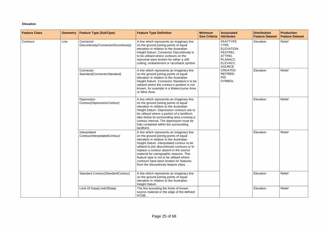
Elevation
Feature Class Geometry Feature Type (SubType) Feature Type Definition Minimum Size Criteria
Associated Attributes
Distribution Feature Dataset
Production Feature Dataset
Connector Discontinuity(ConnectorDiscontinuity)
A line which represents an imaginary line on the ground joining points of equal elevation in relation to the Australian Height Datum. Connector Discontinuity is to be utilised where contours on the repromat were broken for either a cliff, cutting, embankment or razorback symbol.
Elevation Relief
Connector Standard(ConnectorStandard)
A line which represents an imaginary line on the ground joining points of equal elevation in relation to the Australian Height Datum. Connector Standard is to be utilised where the contour’s position is not known, for example in a Watercourse Area or Mine Area.
Elevation Relief
Depression Contour(DepressionContour)
A line which represents an imaginary line on the ground joining points of equal elevation in relation to the Australian Height Datum. Depression contours are to be utilised where a portion of a landform dips below its surrounding area crossing a contour interval. The depression must be fully contained within the surrounding landform.
Elevation Relief
Interpolated Contour(InterpolatedContour)
A line which represents an imaginary line on the ground joining points of equal elevation in relation to the Australian Height Datum. Interpolated contour to be utilised to join discontinued contours or to replace a contour absent in the source material for cartographic reasons. This feature type is not to be utilised where contours have been broken for features from the discontinuity feature class.
Elevation Relief
Standard Contour(StandardContour) A line which represents an imaginary line on the ground joining points of equal elevation in relation to the Australian Height Datum.
Elevation Relief
Contours Line
Limit Of Data(LimitOfData) The line bounding the limits of known source material or the edge of the defined NTDB.
FEATTYPE TYPE ELEVATION FEATREL ATTREL PLANACC ELEVACC SOURCE CREATED RETIRED PID SYMBOL
Elevation Relief

Page 26 of 68
Feature Class Geometry Feature Type (SubType) Feature Type Definition Minimum Size Criteria
Associated Attributes
Distribution Feature Dataset
Production Feature Dataset
SpotElevations Point Spot Elevation A point on the earth’s surface, of known elevation, above or below the Australian Height Datum (AHD66).
FEATTYPE CLASS ELEVATION SOURCETYPE FEATREL ATTREL PLANACC ELEVACC SOURCE CREATED RETIRED PID SYMBOL FEATWIDTH ORIENTATN
Elevation Relief
BenchMarks Point Bench Mark A permanently marked point, the elevation of which above sea level has been determined by levelling.
FEATTYPE ELEVATION CODE FEATREL ATTREL PLANACC ELEVACC SOURCE CREATED RETIRED PID SYMBOL FEATWIDTH ORIENTATN TEXTNOTE
Elevation SurveyMarks
Page 27 of 68
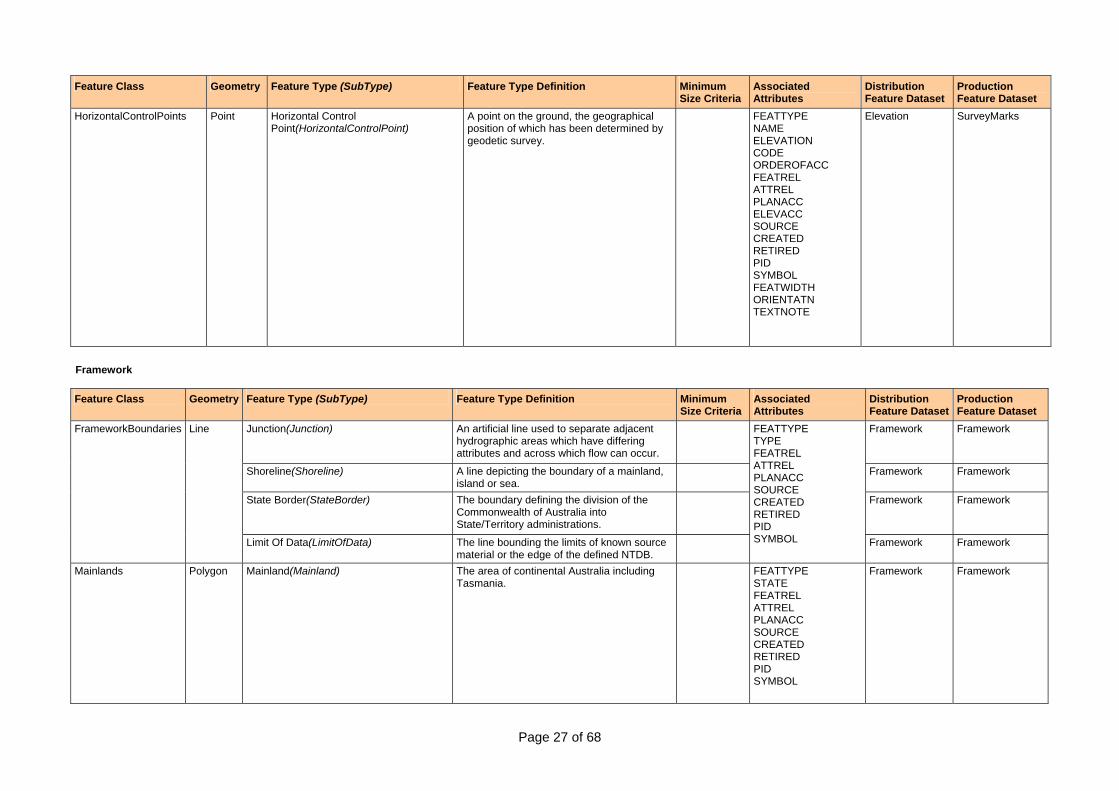
Feature Class Geometry Feature Type (SubType) Feature Type Definition Minimum Size Criteria
Associated Attributes
Distribution Feature Dataset
Production Feature Dataset
HorizontalControlPoints Point Horizontal Control Point(HorizontalControlPoint)
A point on the ground, the geographical position of which has been determined by geodetic survey.
FEATTYPE NAME ELEVATION CODE ORDEROFACC FEATREL ATTREL PLANACC ELEVACC SOURCE CREATED RETIRED PID SYMBOL FEATWIDTH ORIENTATN TEXTNOTE
Elevation SurveyMarks
Framework Feature Class Geometry Feature Type (SubType) Feature Type Definition Minimum
Size Criteria Associated Attributes
Distribution Feature Dataset
Production Feature Dataset
Junction(Junction) An artificial line used to separate adjacent hydrographic areas which have differing attributes and across which flow can occur.
Framework Framework
Shoreline(Shoreline) A line depicting the boundary of a mainland, island or sea.
Framework Framework
State Border(StateBorder) The boundary defining the division of the Commonwealth of Australia into State/Territory administrations.
Framework Framework
FrameworkBoundaries Line
Limit Of Data(LimitOfData) The line bounding the limits of known source material or the edge of the defined NTDB.
FEATTYPE TYPE FEATREL ATTREL PLANACC SOURCE CREATED RETIRED PID SYMBOL Framework Framework
Mainlands Polygon Mainland(Mainland) The area of continental Australia including Tasmania.
FEATTYPE STATE FEATREL ATTREL PLANACC SOURCE CREATED RETIRED PID SYMBOL
Framework Framework
Page 28 of 68
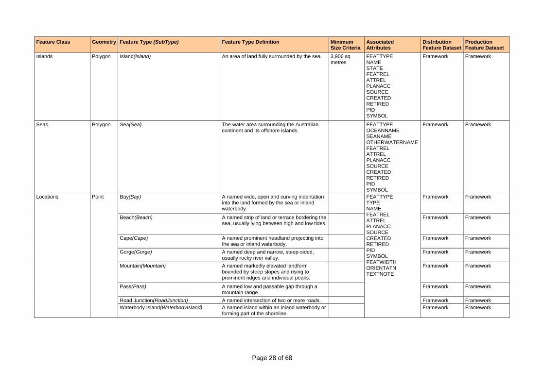
Feature Class Geometry Feature Type (SubType) Feature Type Definition Minimum Size Criteria
Associated Attributes
Distribution Feature Dataset
Production Feature Dataset
Islands Polygon Island(Island) An area of land fully surrounded by the sea. 3,906 sq metres
FEATTYPE NAME STATE FEATREL ATTREL PLANACC SOURCE CREATED RETIRED PID SYMBOL
Framework Framework
Seas Polygon Sea(Sea) The water area surrounding the Australian continent and its offshore islands.
FEATTYPE OCEANNAME SEANAME OTHERWATERNAMEFEATREL ATTREL PLANACC SOURCE CREATED RETIRED PID SYMBOL
Framework Framework
Bay(Bay) A named wide, open and curving indentation into the land formed by the sea or inland waterbody.
Framework Framework
Beach(Beach) A named strip of land or terrace bordering the sea, usually lying between high and low tides.
Framework Framework
Cape(Cape) A named prominent headland projecting into the sea or inland waterbody.
Framework Framework
Gorge(Gorge) A named deep and narrow, steep-sided, usually rocky river valley.
Framework Framework
Mountain(Mountain) A named markedly elevated landform bounded by steep slopes and rising to prominent ridges and individual peaks.
Framework Framework
Pass(Pass) A named low and passable gap through a mountain range.
Framework Framework
Road Junction(RoadJunction) A named intersection of two or more roads. Framework Framework
Locations Point
Waterbody Island(WaterbodyIsland) A named island within an inland waterbody or forming part of the shoreline.
FEATTYPE TYPE NAME FEATREL ATTREL PLANACC SOURCE CREATED RETIRED PID SYMBOL FEATWIDTH ORIENTATN TEXTNOTE
Framework Framework
Page 29 of 68
Feature Class Geometry Feature Type (SubType) Feature Type Definition Minimum Size Criteria
Associated Attributes
Distribution Feature Dataset
Production Feature Dataset
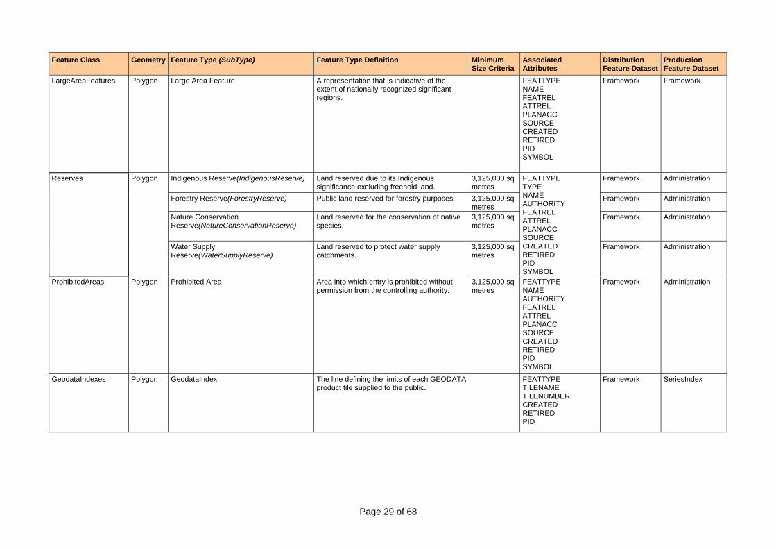
LargeAreaFeatures Polygon Large Area Feature A representation that is indicative of the extent of nationally recognized significant regions.
FEATTYPE NAME FEATREL ATTREL PLANACC SOURCE CREATED RETIRED PID SYMBOL
Framework Framework
Indigenous Reserve(IndigenousReserve) Land reserved due to its Indigenous significance excluding freehold land.
3,125,000 sq metres
Framework Administration
Forestry Reserve(ForestryReserve) Public land reserved for forestry purposes. 3,125,000 sq metres
Framework Administration
Nature Conservation Reserve(NatureConservationReserve)
Land reserved for the conservation of native species.
3,125,000 sq metres
Framework Administration
Reserves Polygon
Water Supply Reserve(WaterSupplyReserve)
Land reserved to protect water supply catchments.
3,125,000 sq metres
FEATTYPE TYPE NAME AUTHORITY FEATREL ATTREL PLANACC SOURCE CREATED RETIRED PID SYMBOL
Framework Administration
ProhibitedAreas Polygon Prohibited Area Area into which entry is prohibited without permission from the controlling authority.
3,125,000 sq metres
FEATTYPE NAME AUTHORITY FEATREL ATTREL PLANACC SOURCE CREATED RETIRED PID SYMBOL
Framework Administration
GeodataIndexes Polygon GeodataIndex
The line defining the limits of each GEODATA product tile supplied to the public.
FEATTYPE TILENAME TILENUMBER CREATED RETIRED PID
Framework SeriesIndex
Page 30 of 68
Feature Class Geometry Feature Type (SubType) Feature Type Definition Minimum Size Criteria
Associated Attributes
Distribution Feature Dataset
Production Feature Dataset
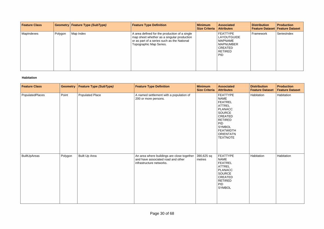
MapIndexes Polygon Map Index A area defined for the production of a single map sheet whether as a singular production or as part of a series such as the National Topographic Map Series.
FEATTYPE LAYOUTGUIDE MAPNAME MAPNUMBER CREATED RETIRED PID
Framework SeriesIndex
Habitation
Feature Class Geometry Feature Type (SubType) Feature Type Definition Minimum Size Criteria
Associated Attributes
Distribution Feature Dataset
Production Feature Dataset
PopulatedPlaces Point Populated Place A named settlement with a population of 200 or more persons.
FEATTYPE NAME FEATREL ATTREL PLANACC SOURCE CREATED RETIRED PID SYMBOL FEATWIDTH ORIENTATN TEXTNOTE
Habitation Habitation
BuiltUpAreas Polygon Built Up Area An area where buildings are close together and have associated road and other infrastructure networks.
390,625 sq metres
FEATTYPE NAME FEATREL ATTREL PLANACC SOURCE CREATED RETIRED PID SYMBOL
Habitation Habitation
Page 31 of 68
Feature Class Geometry Feature Type (SubType) Feature Type Definition Minimum Size Criteria
Associated Attributes
Distribution Feature Dataset
Production Feature Dataset
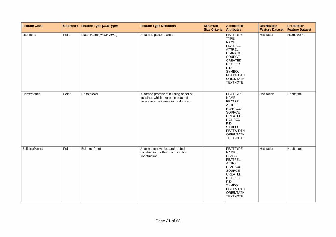
Locations Point Place Name(PlaceName) A named place or area. FEATTYPE TYPE NAME FEATREL ATTREL PLANACC SOURCE CREATED RETIRED PID SYMBOL FEATWIDTH ORIENTATN TEXTNOTE
Habitation Framework
Homesteads Point Homestead A named prominent building or set of buildings which is/are the place of permanent residence in rural areas.
FEATTYPE NAME FEATREL ATTREL PLANACC SOURCE CREATED RETIRED PID SYMBOL FEATWIDTH ORIENTATN TEXTNOTE
Habitation Habitation
BuildingPoints Point Building Point A permanent walled and roofed construction or the ruin of such a construction.
FEATTYPE NAME CLASS FEATREL ATTREL PLANACC SOURCE CREATED RETIRED PID SYMBOL FEATWIDTH ORIENTATN TEXTNOTE
Habitation Habitation
Page 32 of 68
Feature Class Geometry Feature Type (SubType) Feature Type Definition Minimum Size Criteria
Associated Attributes
Distribution Feature Dataset
Production Feature Dataset
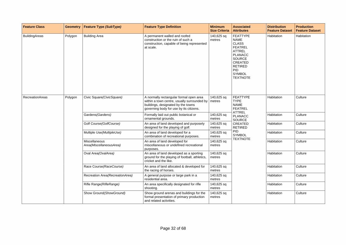
BuildingAreas Polygon Building Area A permanent walled and roofed construction or the ruin of such a construction, capable of being represented at scale.
140,625 sq metres
FEATTYPE NAME CLASS FEATREL ATTREL PLANACC SOURCE CREATED RETIRED PID SYMBOL TEXTNOTE
Habitation Habitation
Civic Square(CivicSquare) A normally rectangular formal open area within a town centre, usually surrounded by buildings, designated by the towns governing body for use by its citizens.
140,625 sq metres
Habitation Culture
Gardens(Gardens) Formally laid out public botanical or ornamental grounds.
140,625 sq metres
Habitation Culture
Golf Course(GolfCourse) An area of land developed and purposely designed for the playing of golf.
140,625 sq metres
Habitation Culture
Multiple Use(MultipleUse) An area of land developed for a combination of recreational purposes.
140,625 sq metres
Habitation Culture
Miscellaneous Area(MiscellaneousArea)
An area of land developed for miscellaneous or undefined recreational purposes.
140,625 sq metres
Habitation Culture
Oval Area(OvalArea) An area of land developed as a sporting ground for the playing of football, athletics, cricket and the like.
140,625 sq metres
Habitation Culture
Race Course(RaceCourse) An area of land allocated & developed for the racing of horses.
140,625 sq metres
Habitation Culture
Recreation Area(RecreationArea) A general purpose or large park in a residential area.
140,625 sq metres
Habitation Culture
Rifle Range(RifleRange) An area specifically designated for rifle shooting.
140,625 sq metres
Habitation Culture
RecreationAreas Polygon
Show Ground(ShowGround) Show ground arenas and buildings for the formal presentation of primary production and related activities.
140,625 sq metres
FEATTYPE TYPE NAME FEATREL ATTREL PLANACC SOURCE CREATED RETIRED PID SYMBOL TEXTNOTE
Habitation Culture
Page 33 of 68
Feature Class Geometry Feature Type (SubType) Feature Type Definition Minimum Size Criteria
Associated Attributes
Distribution Feature Dataset
Production Feature Dataset
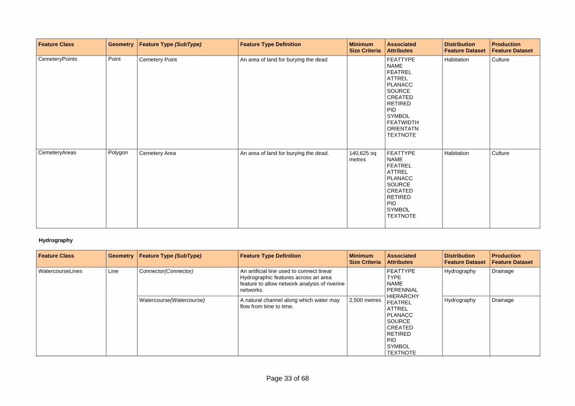
CemeteryPoints Point Cemetery Point An area of land for burying the dead FEATTYPE NAME FEATREL ATTREL PLANACC SOURCE CREATED RETIRED PID SYMBOL FEATWIDTH ORIENTATN TEXTNOTE
Habitation Culture
CemeteryAreas Polygon Cemetery Area An area of land for burying the dead. 140,625 sq metres
FEATTYPE NAME FEATREL ATTREL PLANACC SOURCE CREATED RETIRED PID SYMBOL TEXTNOTE
Habitation Culture
Hydrography
Feature Class Geometry Feature Type (SubType) Feature Type Definition Minimum Size Criteria
Associated Attributes
Distribution Feature Dataset
Production Feature Dataset
Connector(Connector) An artificial line used to connect linear Hydrographic features across an area feature to allow network analysis of riverine networks.
Hydrography Drainage WatercourseLines Line
Watercourse(Watercourse) A natural channel along which water may flow from time to time.
2,500 metres
FEATTYPE TYPE NAME PERENNIAL HIERARCHY FEATREL ATTREL PLANACC SOURCE CREATED RETIRED PID SYMBOL TEXTNOTE
Hydrography Drainage
Page 34 of 68
Feature Class Geometry Feature Type (SubType) Feature Type Definition Minimum Size Criteria
Associated Attributes
Distribution Feature Dataset
Production Feature Dataset
WatercourseAreas Polygon Watercourse Area A natural channel along which water may flow from time to time.
625,000 sq metres
FEATTYPE NAME PERENNIAL HIERARCHY FEATREL ATTREL PLANACC SOURCE CREATED RETIRED PID SYMBOL TEXTNOTE
Hydrography Waterbodies
Lakes Polygon Lake A naturally occurring body of mainly static water surrounded by land.
62,500 sq metres
FEATTYPE NAME PERENNIAL FEATREL ATTREL PLANACC SOURCE CREATED RETIRED PID SYMBOL TEXTNOTE
Hydrography Waterbodies
Town Rural Storage(TownRuralStorage)
A body of water collected and stored behind a constructed barrier for some specific use (with the exception of Flood Irrigation Storage).
140,625 sq metres
Hydrography Waterbodies Reservoirs Polygon
Flood Irrigation Storage(FloodIrrigationStorage)
A body of water collected and stored behind a constructed barrier for the specific use of Flood Irrigation Farming
140,625 sq metres
FEATTYPE TYPE NAME FEATREL ATTREL PLANACC SOURCE CREATED RETIRED PID SYMBOL TEXTNOTE
Hydrography Waterbodies
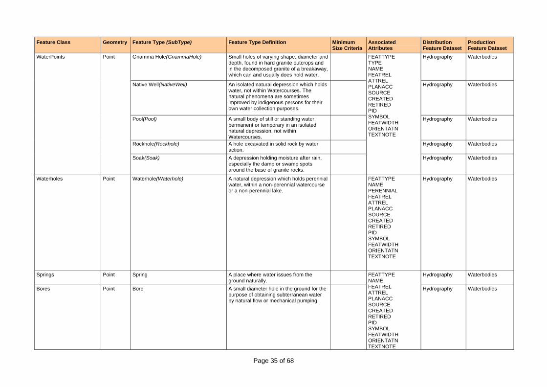
Page 35 of 68
Feature Class Geometry Feature Type (SubType) Feature Type Definition Minimum Size Criteria
Associated Attributes
Distribution Feature Dataset
Production Feature Dataset
Gnamma Hole(GnammaHole) Small holes of varying shape, diameter and depth, found in hard granite outcrops and in the decomposed granite of a breakaway, which can and usually does hold water.
Hydrography Waterbodies
Native Well(NativeWell) An isolated natural depression which holds water, not within Watercourses. The natural phenomena are sometimes improved by indigenous persons for their own water collection purposes.
Hydrography Waterbodies
Pool(Pool) A small body of still or standing water, permanent or temporary in an isolated natural depression, not within Watercourses.
Hydrography Waterbodies
Rockhole(Rockhole) A hole excavated in solid rock by water action.
Hydrography Waterbodies
WaterPoints Point
Soak(Soak) A depression holding moisture after rain, especially the damp or swamp spots around the base of granite rocks.
FEATTYPE TYPE NAME FEATREL ATTREL PLANACC SOURCE CREATED RETIRED PID SYMBOL FEATWIDTH ORIENTATN TEXTNOTE
Hydrography Waterbodies
Waterholes Point Waterhole(Waterhole) A natural depression which holds perennial water, within a non-perennial watercourse or a non-perennial lake.
FEATTYPE NAME PERENNIAL FEATREL ATTREL PLANACC SOURCE CREATED RETIRED PID SYMBOL FEATWIDTH ORIENTATN TEXTNOTE
Hydrography Waterbodies
Springs Point Spring A place where water issues from the ground naturally.
Hydrography Waterbodies
Bores Point Bore A small diameter hole in the ground for the purpose of obtaining subterranean water by natural flow or mechanical pumping.
FEATTYPE NAME FEATREL ATTREL PLANACC SOURCE CREATED RETIRED PID SYMBOL FEATWIDTH ORIENTATN TEXTNOTE
Hydrography Waterbodies
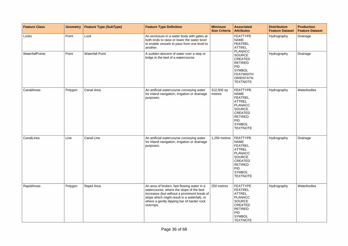
Page 36 of 68
Feature Class Geometry Feature Type (SubType) Feature Type Definition Minimum Size Criteria
Associated Attributes
Distribution Feature Dataset
Production Feature Dataset
Locks Point Lock An enclosure in a water body with gates at both ends to raise or lower the water level to enable vessels to pass from one level to another.
Hydrography Drainage
WaterfallPoints Point Waterfall Point A sudden descent of water over a step or ledge in the bed of a watercourse.
FEATTYPE NAME FEATREL ATTREL PLANACC SOURCE CREATED RETIRED PID SYMBOL FEATWIDTH ORIENTATN TEXTNOTE
Hydrography Drainage
CanalAreas Polygon Canal Area An artificial watercourse conveying water for inland navigation, irrigation or drainage purposes.
312,500 sq metres
FEATTYPE NAME FEATREL ATTREL PLANACC SOURCE CREATED RETIRED PID SYMBOL TEXTNOTE
Hydrography Waterbodies
CanalLines Line Canal Line An artificial watercourse conveying water for inland navigation, irrigation or drainage purposes.
1,250 metres FEATTYPE NAME FEATREL ATTREL PLANACC SOURCE CREATED RETIRED PID SYMBOL TEXTNOTE
Hydrography Drainage
RapidAreas Polygon Rapid Area An area of broken, fast flowing water in a watercourse, where the slope of the bed increases (but without a prominent break of slope which might result in a waterfall), or where a gently dipping bar of harder rock outcrops.
250 metres FEATTYPE FEATREL ATTREL PLANACC SOURCE CREATED RETIRED PID SYMBOL TEXTNOTE
Hydrography Waterbodies

Page 37 of 68
Feature Class Geometry Feature Type (SubType) Feature Type Definition Minimum Size Criteria
Associated Attributes
Distribution Feature Dataset
Production Feature Dataset
RapidLines Line Rapid Line An area of broken, fast flowing water in a watercourse, where the slope of the bed increases (but without a prominent break of slope which might result in a waterfall), or where a gently dipping bar of harder rock outcrops.
250 metres Hydrography Drainage
Spillways Line Spillway A channel or duct formed around the side of a reservoir past the end of the dam, to convey flood discharge from the watercourse above the reservoir into the watercourse below the dam.
250 metres
FEATTYPE FEATREL ATTREL PLANACC SOURCE CREATED RETIRED PID SYMBOL TEXTNOTE
Hydrography Drainage
Aquaculture Area(AquacultureArea) Shallow beds, usually segmented by constructed walls, for the use of aquaculture.
390,625 sq metres
Hydrography Waterbodies
Salt Evaporator(SaltEvaporator) A flat area, usually segmented, used for the commercial production of salt by evaporation.
390,625 sq metres
Hydrography Waterbodies
PondageAreas Polygon
Settling Pond(SettlingPond) Shallow beds, usually segmented by constructed walls, for the treatment of sewage or other wastes.
390,625 sq metres
FEATTYPE TYPE FEATREL ATTREL PLANACC SOURCE CREATED RETIRED PID SYMBOL TEXTNOTE
Hydrography Waterbodies
Land Subject To Inundation(LandSubjectToInundation)
Low lying land usually adjacent to lakes or watercourses, which is regularly covered with flood water for short periods.
390,625 sq metres
Hydrography Waterbodies
Marine Swamp(MarineSwamp) That low lying part of the backshore area of tidal waters, usually immediately behind saline coastal flat, which maintains a high salt water content, and is covered with characteristic thick grasses and reed growths.
250,000 sq metres
Hydrography Waterbodies
Saline Coastal Flat(SalineCoastalFlat) That nearly level tract of land between mean high water and the line of the highest astronomical tide.
390,625 sq metres
Hydrography Waterbodies
Flats Polygon
Swamp(Swamp) Land which is so saturated with water that it is not suitable for agricultural or pastoral use and presents a barrier to free passage.
1,562,500 sq metres
FEATTYPE TYPE NAME FEATREL ATTREL PLANACC SOURCE CREATED RETIRED PID SYMBOL TEXTNOTE
Hydrography Waterbodies

Page 38 of 68
Feature Class Geometry Feature Type (SubType) Feature Type Definition Minimum Size Criteria
Associated Attributes
Distribution Feature Dataset
Production Feature Dataset
ForeshoreFlats Polygon Foreshore Flat That part of the seabed or estuarine areas, between mean high water and the line of lowest astronomical tide.
390,625 sq metres
FEATTYPE FEATREL ATTREL PLANACC SOURCE CREATED RETIRED PID SYMBOL
Hydrography Marine
Reef(Reef) An area of rock or coral that is exposed between mean high water and lowest tide, or just below approximate lowest tide, which is visually prominent or a hazard to shipping.
390,625 sq metres
Hydrography Marine MarineHazardAreas Polygon
Shoal(Shoal) A detached area of any material the depth over which constitutes a danger to surface navigation of marine craft. The term shoal is not generally used for dangers which are composed entirely of rock or coral.
390,625 sq metres
FEATTYPE TYPE NAME RELATION FEATREL ATTREL PLANACC SOURCE CREATED RETIRED PID SYMBOL TEXTNOTE
Hydrography Marine
Offshore Rock(OffshoreRock) A rock located offshore that represents a hazard to shipping.
Hydrography Marine MarineHazardPoints Point
Wreck(Wreck) A disabled vessel, either submerged or visible, which is attached to, or foul of, the bottom or cast up on the shore.
FEATTYPE TYPE NAME RELATION FEATREL ATTREL PLANACC SOURCE CREATED RETIRED PID SYMBOL FEATWIDTH ORIENTATN TEXTNOTE
Hydrography Marine
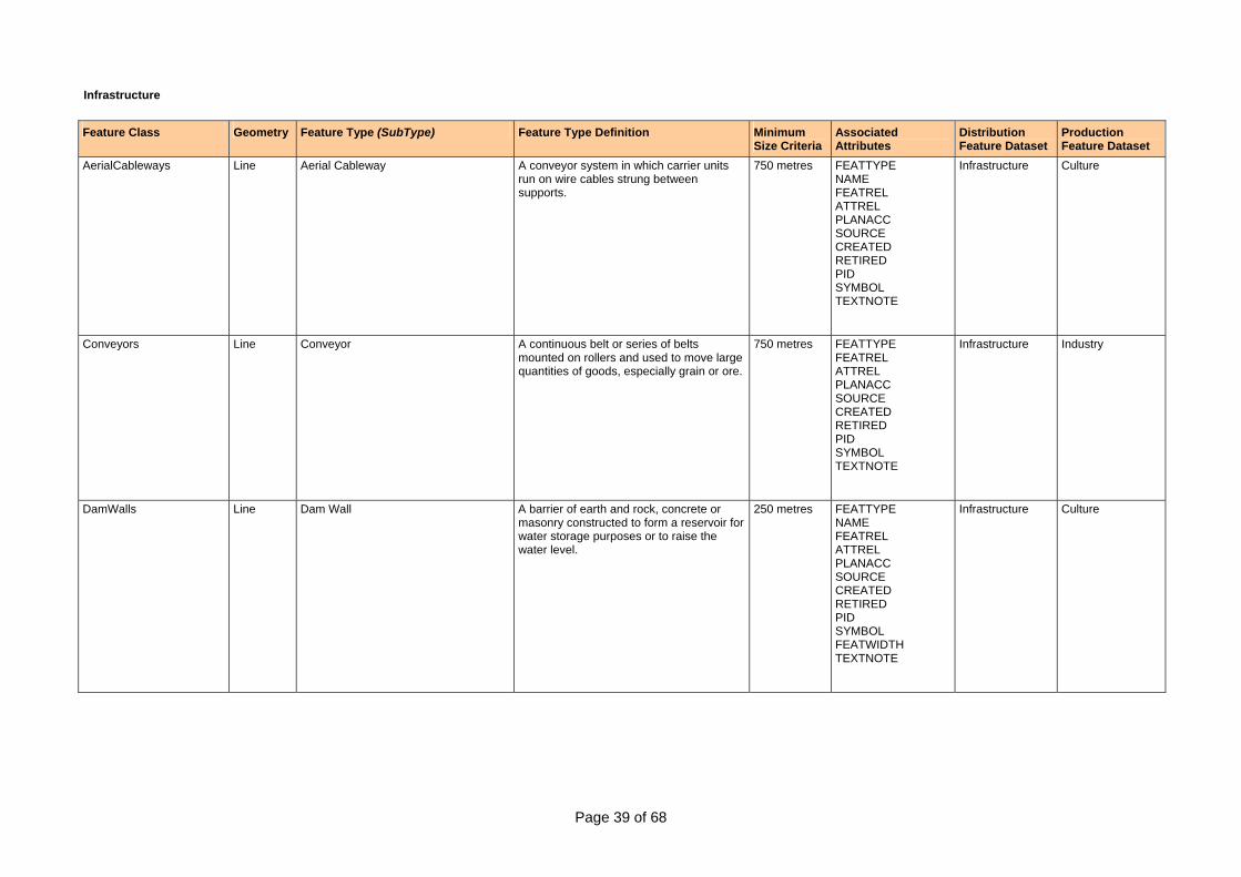
Page 39 of 68
Infrastructure Feature Class Geometry Feature Type (SubType) Feature Type Definition Minimum
Size Criteria Associated Attributes
Distribution Feature Dataset
Production Feature Dataset
AerialCableways Line Aerial Cableway A conveyor system in which carrier units run on wire cables strung between supports.
750 metres FEATTYPE NAME FEATREL ATTREL PLANACC SOURCE CREATED RETIRED PID SYMBOL TEXTNOTE
Infrastructure Culture
Conveyors Line Conveyor A continuous belt or series of belts mounted on rollers and used to move large quantities of goods, especially grain or ore.
750 metres FEATTYPE FEATREL ATTREL PLANACC SOURCE CREATED RETIRED PID SYMBOL TEXTNOTE
Infrastructure Industry
DamWalls Line Dam Wall A barrier of earth and rock, concrete or masonry constructed to form a reservoir for water storage purposes or to raise the water level.
250 metres FEATTYPE NAME FEATREL ATTREL PLANACC SOURCE CREATED RETIRED PID SYMBOL FEATWIDTH TEXTNOTE
Infrastructure Culture
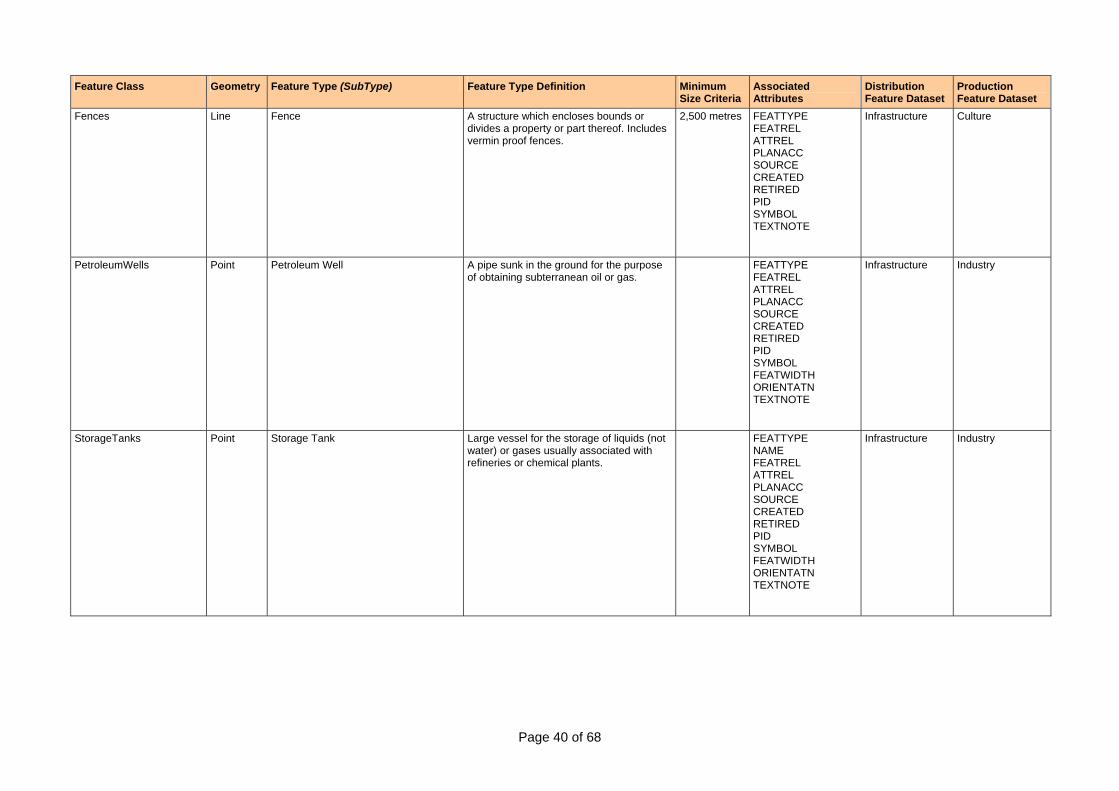
Page 40 of 68
Feature Class Geometry Feature Type (SubType) Feature Type Definition Minimum Size Criteria
Associated Attributes
Distribution Feature Dataset
Production Feature Dataset
Fences Line Fence A structure which encloses bounds or divides a property or part thereof. Includes vermin proof fences.
2,500 metres FEATTYPE FEATREL ATTREL PLANACC SOURCE CREATED RETIRED PID SYMBOL TEXTNOTE
Infrastructure Culture
PetroleumWells Point Petroleum Well A pipe sunk in the ground for the purpose of obtaining subterranean oil or gas.
FEATTYPE FEATREL ATTREL PLANACC SOURCE CREATED RETIRED PID SYMBOL FEATWIDTH ORIENTATN TEXTNOTE
Infrastructure Industry
StorageTanks Point Storage Tank Large vessel for the storage of liquids (not water) or gases usually associated with refineries or chemical plants.
FEATTYPE NAME FEATREL ATTREL PLANACC SOURCE CREATED RETIRED PID SYMBOL FEATWIDTH ORIENTATN TEXTNOTE
Infrastructure Industry
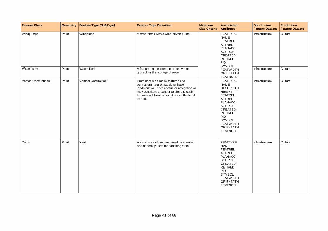
Page 41 of 68
Feature Class Geometry Feature Type (SubType) Feature Type Definition Minimum Size Criteria
Associated Attributes
Distribution Feature Dataset
Production Feature Dataset
Windpumps
Point Windpump A tower fitted with a wind-driven pump. Infrastructure Culture
WaterTanks Point Water Tank A feature constructed on or below the ground for the storage of water.
FEATTYPE NAME FEATREL ATTREL PLANACC SOURCE CREATED RETIRED PID SYMBOL FEATWIDTH ORIENTATN TEXTNOTE
Infrastructure Culture
VerticalObstructions Point Vertical Obstruction Prominent man-made features of a permanent nature that either have landmark value are useful for navigation or may constitute a danger to aircraft. Such features will have a height above the local terrain.
FEATTYPE NAME DESCRIPTN HIEGHT FEATREL ATTREL PLANACC SOURCE CREATED RETIRED PID SYMBOL FEATWIDTH ORIENTATN TEXTNOTE
Infrastructure Culture
Yards Point Yard A small area of land enclosed by a fence and generally used for confining stock.
FEATTYPE NAME FEATREL ATTREL PLANACC SOURCE CREATED RETIRED PID SYMBOL FEATWIDTH ORIENTATN TEXTNOTE
Infrastructure Culture
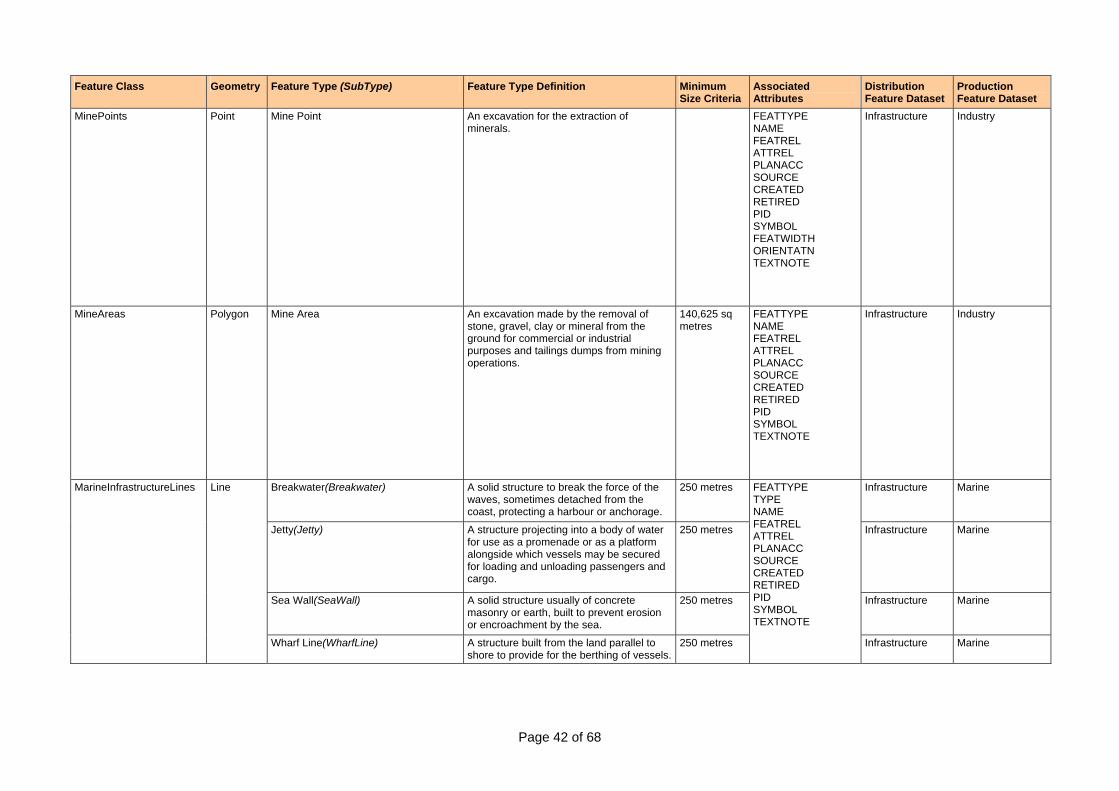
Page 42 of 68
Feature Class Geometry Feature Type (SubType) Feature Type Definition Minimum Size Criteria
Associated Attributes
Distribution Feature Dataset
Production Feature Dataset
MinePoints Point Mine Point An excavation for the extraction of minerals.
FEATTYPE NAME FEATREL ATTREL PLANACC SOURCE CREATED RETIRED PID SYMBOL FEATWIDTH ORIENTATN TEXTNOTE
Infrastructure Industry
MineAreas Polygon Mine Area An excavation made by the removal of stone, gravel, clay or mineral from the ground for commercial or industrial purposes and tailings dumps from mining operations.
140,625 sq metres
FEATTYPE NAME FEATREL ATTREL PLANACC SOURCE CREATED RETIRED PID SYMBOL TEXTNOTE
Infrastructure Industry
Breakwater(Breakwater) A solid structure to break the force of the waves, sometimes detached from the coast, protecting a harbour or anchorage.
250 metres Infrastructure Marine
Jetty(Jetty) A structure projecting into a body of water for use as a promenade or as a platform alongside which vessels may be secured for loading and unloading passengers and cargo.
250 metres Infrastructure Marine
Sea Wall(SeaWall) A solid structure usually of concrete masonry or earth, built to prevent erosion or encroachment by the sea.
250 metres Infrastructure Marine
MarineInfrastructureLines Line
Wharf Line(WharfLine) A structure built from the land parallel to shore to provide for the berthing of vessels.
250 metres
FEATTYPE TYPE NAME FEATREL ATTREL PLANACC SOURCE CREATED RETIRED PID SYMBOL TEXTNOTE
Infrastructure Marine
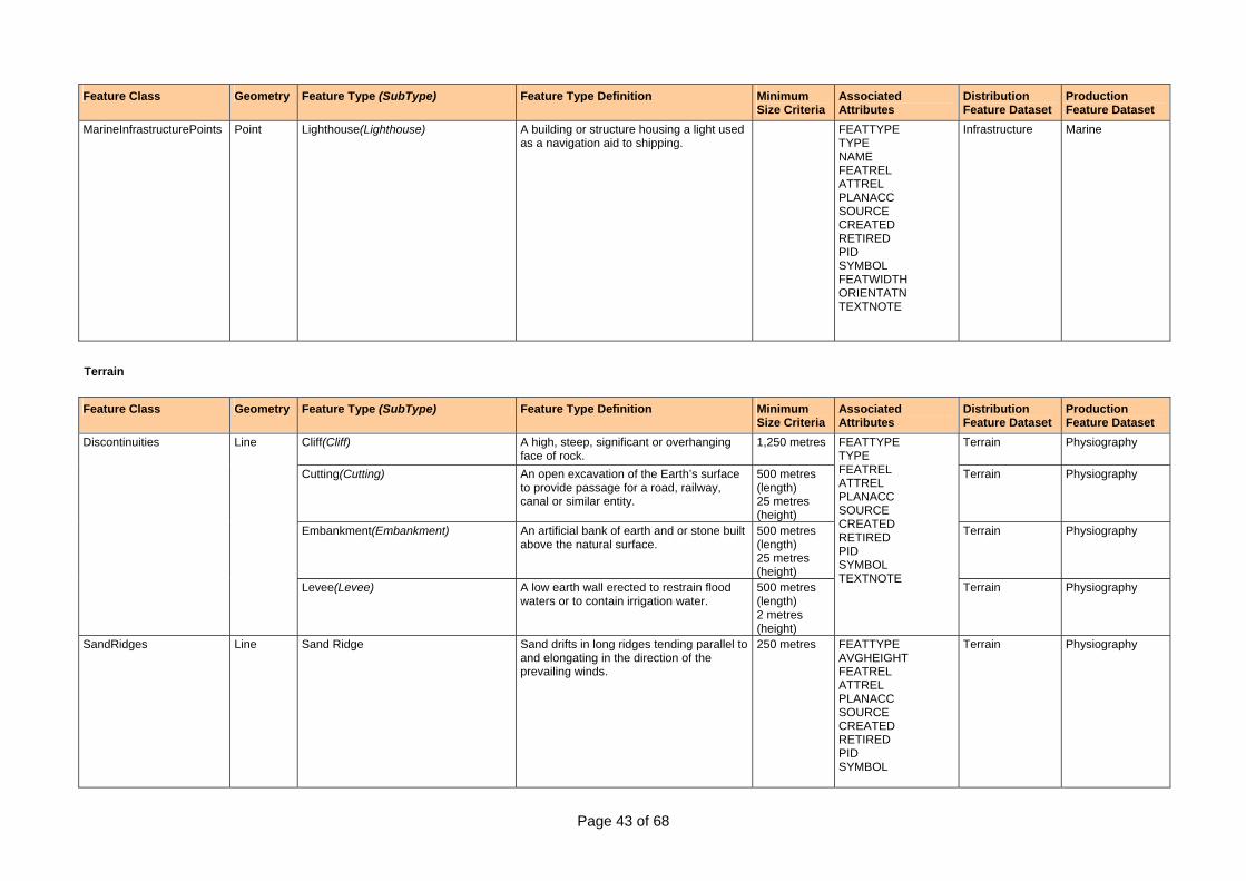
Page 43 of 68
Feature Class Geometry Feature Type (SubType) Feature Type Definition Minimum Size Criteria
Associated Attributes
Distribution Feature Dataset
Production Feature Dataset
MarineInfrastructurePoints Point Lighthouse(Lighthouse) A building or structure housing a light used as a navigation aid to shipping.
FEATTYPE TYPE NAME FEATREL ATTREL PLANACC SOURCE CREATED RETIRED PID SYMBOL FEATWIDTH ORIENTATN TEXTNOTE
Infrastructure Marine
Terrain Feature Class Geometry Feature Type (SubType) Feature Type Definition Minimum
Size Criteria Associated Attributes
Distribution Feature Dataset
Production Feature Dataset
Cliff(Cliff) A high, steep, significant or overhanging face of rock.
1,250 metres Terrain Physiography
Cutting(Cutting) An open excavation of the Earth’s surface to provide passage for a road, railway, canal or similar entity.
500 metres (length) 25 metres (height)
Terrain Physiography
Embankment(Embankment) An artificial bank of earth and or stone built above the natural surface.
500 metres (length) 25 metres (height)
Terrain Physiography
Discontinuities Line
Levee(Levee) A low earth wall erected to restrain flood waters or to contain irrigation water.
500 metres (length) 2 metres (height)
FEATTYPE TYPE FEATREL ATTREL PLANACC SOURCE CREATED RETIRED PID SYMBOL TEXTNOTE
Terrain Physiography
SandRidges Line Sand Ridge Sand drifts in long ridges tending parallel to and elongating in the direction of the prevailing winds.
250 metres FEATTYPE AVGHEIGHT FEATREL ATTREL PLANACC SOURCE CREATED RETIRED PID SYMBOL
Terrain Physiography
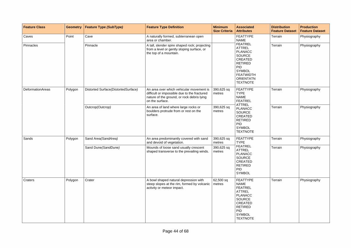
Page 44 of 68
Feature Class Geometry Feature Type (SubType) Feature Type Definition Minimum Size Criteria
Associated Attributes
Distribution Feature Dataset
Production Feature Dataset
Caves Cave A naturally formed, subterranean open area or chamber.
Terrain Physiography
Pinnacles
Point
Pinnacle A tall, slender spire shaped rock; projecting from a level or gently sloping surface, or the top of a mountain.
FEATTYPE NAME FEATREL ATTREL PLANACC SOURCE CREATED RETIRED PID SYMBOL FEATWIDTH ORIENTATN TEXTNOTE
Terrain Physiography
Distorted Surface(DistortedSurface) An area over which vehicular movement is difficult or impossible due to the fractured nature of the ground, or rock debris lying on the surface.
390,625 sq metres
Terrain Physiography DeformationAreas Polygon
Outcrop(Outcrop) An area of land where large rocks or boulders protrude from or rest on the surface.
390,625 sq metres
FEATTYPE TYPE NAME FEATREL ATTREL PLANACC SOURCE CREATED RETIRED PID SYMBOL TEXTNOTE
Terrain Physiography
Sand Area(SandArea) An area predominantly covered with sand and devoid of vegetation.
390,625 sq metres
Terrain Physiography Sands Polygon
Sand Dune(SandDune) Mounds of loose sand usually crescent shaped transverse to the prevailing winds.
390,625 sq metres
FEATTYPE TYPE FEATREL ATTREL PLANACC SOURCE CREATED RETIRED PID SYMBOL
Terrain Physiography
Craters Polygon Crater A bowl shaped natural depression with steep slopes at the rim, formed by volcanic activity or meteor impact.
62,500 sq metres
FEATTYPE NAME FEATREL ATTREL PLANACC SOURCE CREATED RETIRED PID SYMBOL TEXTNOTE
Terrain Physiography
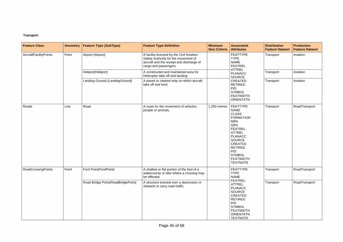
Page 45 of 68
Transport Feature Class Geometry Feature Type (SubType) Feature Type Definition Minimum
Size Criteria Associated Attributes
Distribution Feature Dataset
Production Feature Dataset
Airport (Airport) A facility licensed by the Civil Aviation Safety Authority for the movement of aircraft and the receipt and discharge of cargo and passengers.
Transport Aviation
Heliport(Heliport) A constructed and maintained area for Helicopter take off and landing.
Transport Aviation
AircraftFacilityPoints Point
Landing Ground (LandingGround) A paved or cleared strip on which aircraft take off and land.
FEATTYPE TYPE NAME FEATREL ATTREL PLANACC SOURCE CREATED RETIRED PID SYMBOL FEATWIDTH ORIENTATN
Transport Aviation
Roads Line Road A route for the movement of vehicles, people or animals.
1,250 metres FEATTYPE NAME CLASS FORMATION NRN SRN FEATREL ATTREL PLANACC SOURCE CREATED RETIRED PID SYMBOL FEATWIDTH TEXTNOTE
Transport RoadTransport
Ford Point(FordPoint) A shallow or flat portion of the bed of a watercourse or lake where a crossing may be effected.
Transport RoadTransport RoadCrossingPoints Point
Road Bridge Point(RoadBridgePoint) A structure erected over a depression or obstacle to carry road traffic.
FEATTYPE TYPE NAME FEATREL ATTREL PLANACC SOURCE CREATED RETIRED PID SYMBOL FEATWIDTH ORIENTATN TEXTNOTE
Transport RoadTransport
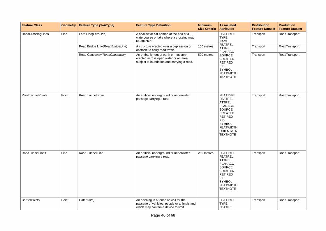
Page 46 of 68
Feature Class Geometry Feature Type (SubType) Feature Type Definition Minimum Size Criteria
Associated Attributes
Distribution Feature Dataset
Production Feature Dataset
Ford Line(FordLine) A shallow or flat portion of the bed of a watercourse or lake where a crossing may be effected.
Transport RoadTransport
Road Bridge Line(RoadBridgeLine) A structure erected over a depression or obstacle to carry road traffic.
100 metres Transport RoadTransport
RoadCrossingLines Line
Road Causeway(RoadCauseway) An embankment of earth or masonry erected across open water or an area subject to inundation and carrying a road.
500 metres
FEATTYPE TYPE NAME FEATREL ATTREL PLANACC SOURCE CREATED RETIRED PID SYMBOL FEATWIDTH TEXTNOTE
Transport RoadTransport
RoadTunnelPoints Point Road Tunnel Point An artificial underground or underwater passage carrying a road.
FEATTYPE FEATREL ATTREL PLANACC SOURCE CREATED RETIRED PID SYMBOL FEATWIDTH ORIENTATN TEXTNOTE
Transport RoadTransport
RoadTunnelLines Line Road Tunnel Line An artificial underground or underwater passage carrying a road.
250 metres FEATTYPE FEATREL ATTREL PLANACC SOURCE CREATED RETIRED PID SYMBOL FEATWIDTH TEXTNOTE
Transport RoadTransport
BarrierPoints Point Gate(Gate) An opening in a fence or wall for the passage of vehicles, people or animals and which may contain a device to limit
FEATTYPE TYPE FEATREL
Transport RoadTransport
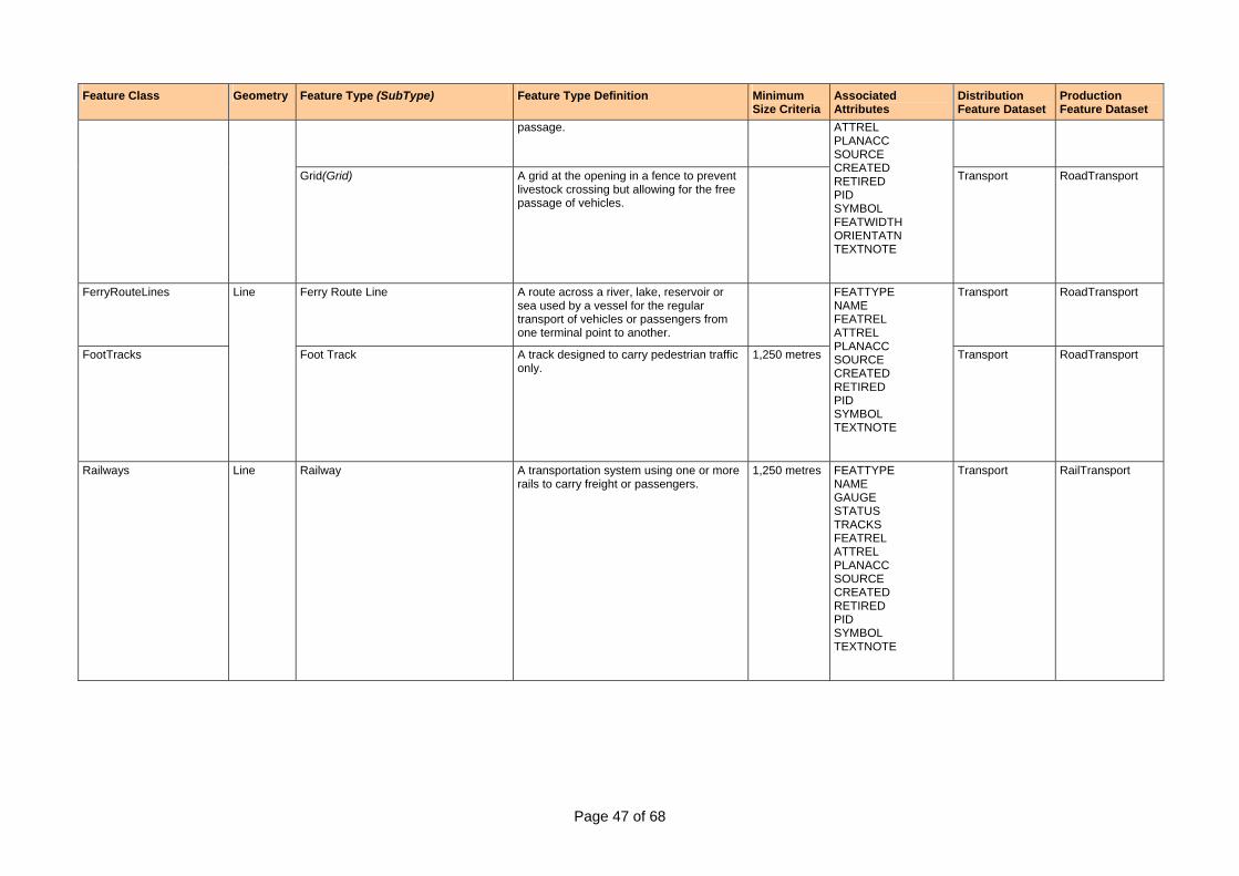
Page 47 of 68
Feature Class Geometry Feature Type (SubType) Feature Type Definition Minimum Size Criteria
Associated Attributes
Distribution Feature Dataset
Production Feature Dataset
passage.
Grid(Grid) A grid at the opening in a fence to prevent livestock crossing but allowing for the free passage of vehicles.
ATTREL PLANACC SOURCE CREATED RETIRED PID SYMBOL FEATWIDTH ORIENTATN TEXTNOTE
Transport RoadTransport
FerryRouteLines Ferry Route Line A route across a river, lake, reservoir or sea used by a vessel for the regular transport of vehicles or passengers from one terminal point to another.
Transport RoadTransport
FootTracks
Line
Foot Track A track designed to carry pedestrian traffic only.
1,250 metres
FEATTYPE NAME FEATREL ATTREL PLANACC SOURCE CREATED RETIRED PID SYMBOL TEXTNOTE
Transport RoadTransport
Railways Line Railway A transportation system using one or more rails to carry freight or passengers.
1,250 metres FEATTYPE NAME GAUGE STATUS TRACKS FEATREL ATTREL PLANACC SOURCE CREATED RETIRED PID SYMBOL TEXTNOTE
Transport RailTransport
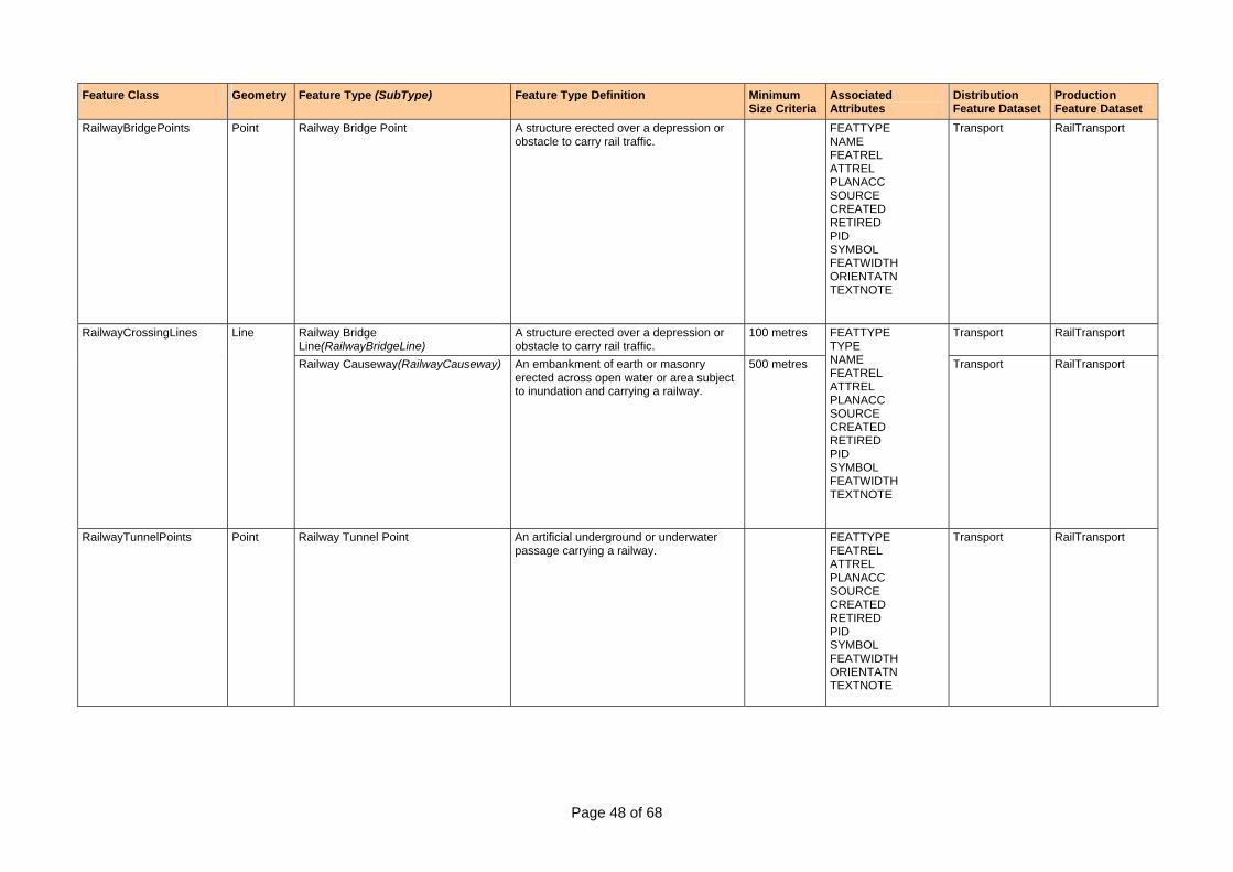
Page 48 of 68
Feature Class Geometry Feature Type (SubType) Feature Type Definition Minimum Size Criteria
Associated Attributes
Distribution Feature Dataset
Production Feature Dataset
RailwayBridgePoints Point Railway Bridge Point A structure erected over a depression or obstacle to carry rail traffic.
FEATTYPE NAME FEATREL ATTREL PLANACC SOURCE CREATED RETIRED PID SYMBOL FEATWIDTH ORIENTATN TEXTNOTE
Transport RailTransport
Railway Bridge Line(RailwayBridgeLine)
A structure erected over a depression or obstacle to carry rail traffic.
100 metres Transport RailTransport RailwayCrossingLines Line
Railway Causeway(RailwayCauseway) An embankment of earth or masonry erected across open water or area subject to inundation and carrying a railway.
500 metres
FEATTYPE TYPE NAME FEATREL ATTREL PLANACC SOURCE CREATED RETIRED PID SYMBOL FEATWIDTH TEXTNOTE
Transport RailTransport
RailwayTunnelPoints Point Railway Tunnel Point An artificial underground or underwater passage carrying a railway.
FEATTYPE FEATREL ATTREL PLANACC SOURCE CREATED RETIRED PID SYMBOL FEATWIDTH ORIENTATN TEXTNOTE
Transport RailTransport
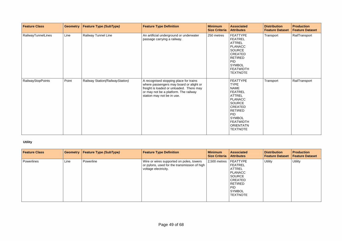
Page 49 of 68
Feature Class Geometry Feature Type (SubType) Feature Type Definition Minimum Size Criteria
Associated Attributes
Distribution Feature Dataset
Production Feature Dataset
RailwayTunnelLines Line Railway Tunnel Line An artificial underground or underwater passage carrying a railway.
250 metres FEATTYPE FEATREL ATTREL PLANACC SOURCE CREATED RETIRED PID SYMBOL FEATWIDTH TEXTNOTE
Transport RailTransport
RailwayStopPoints Point Railway Station(RailwayStation) A recognised stopping place for trains where passengers may board or alight or freight is loaded or unloaded. There may or may not be a platform. The railway station may not be in use.
FEATTYPE TYPE NAME FEATREL ATTREL PLANACC SOURCE CREATED RETIRED PID SYMBOL FEATWIDTH ORIENTATN TEXTNOTE
Transport RailTransport
Utility Feature Class Geometry Feature Type (SubType) Feature Type Definition Minimum
Size Criteria Associated Attributes
Distribution Feature Dataset
Production Feature Dataset
Powerlines Line Powerline Wire or wires supported on poles, towers or pylons, used for the transmission of high voltage electricity.
2,500 metres FEATTYPE FEATREL ATTREL PLANACC SOURCE CREATED RETIRED PID SYMBOL TEXTNOTE
Utility Utility

Page 50 of 68
Feature Class Geometry Feature Type (SubType) Feature Type Definition Minimum Size Criteria
Associated Attributes
Distribution Feature Dataset
Production Feature Dataset
Pipelines Line Pipeline A pipe used for carrying gases and/or liquids.
1,250 metres FEATTYPE NAME PRODUCT RELATION FEATREL ATTREL PLANACC SOURCE CREATED RETIRED PID SYMBOL TEXTNOTE
Utility Utility
Vegetation Feature Class Geometry Feature Type (SubType) Feature Type Definition Minimum
Size Criteria Associated Attributes
Distribution Feature Dataset
Production Feature Dataset
Forest Or Shrub(ForestOrShrub) An area of land with woody vegetation greater than 10% foliage cover (includes trees and shrubs).
250,000 sq metres
Vegetation Vegetation
Mangrove(Mangrove) A dense growth of mangrove trees, which grow to a uniform height on mud flats in estuarine or salt waters. The land upon which the mangrove is situated is a nearly level tract of land between the low and high water lines.
390,625 sq metres
Vegetation Vegetation
NativeVegetationAreas Polygon
Rainforest(Rainforest) Vegetation community which contains key rainforest species, with foliage cover greater than 70%.
390,625 sq metres
FEATTYPE TYPE FEATREL ATTREL PLANACC SOURCE CREATED RETIRED PID SYMBOL TEXTNOTE Vegetation Vegetation
Orchard(Orchard) An area covered by an orderly planting of trees, vines or bushes which yield fruits, nuts or other edible products.
390,625 sq metres
Vegetation Vegetation CultivatedAreas Polygon
Plantation(Plantation) Intensively managed stands of trees of either native or exotic species, created by the regular placement of seedlings or seeds.
390,625 sq metres
FEATTYPE TYPE FEATREL ATTREL PLANACC SOURCE CREATED RETIRED PID SYMBOL TEXTNOTE
Vegetation Vegetation

Page 51 of 68
Feature Class Geometry Feature Type (SubType) Feature Type Definition Minimum Size Criteria
Associated Attributes
Distribution Feature Dataset
Production Feature Dataset
Windbreaks Line Windbreak A narrow strip of natural or planted trees, or scrub, positioned so as to break the force of the prevailing wind.
1,250 metres FEATTYPE FEATREL ATTREL PLANACC SOURCE CREATED RETIRED PID SYMBOL
Vegetation Vegetation
ClearedLines Line Cleared Line A graded path in a straight line. 2,500 metres FEATTYPE FEATREL ATTREL PLANACC SOURCE CREATED RETIRED PID SYMBOL TEXTNOTE
Vegetation Vegetation
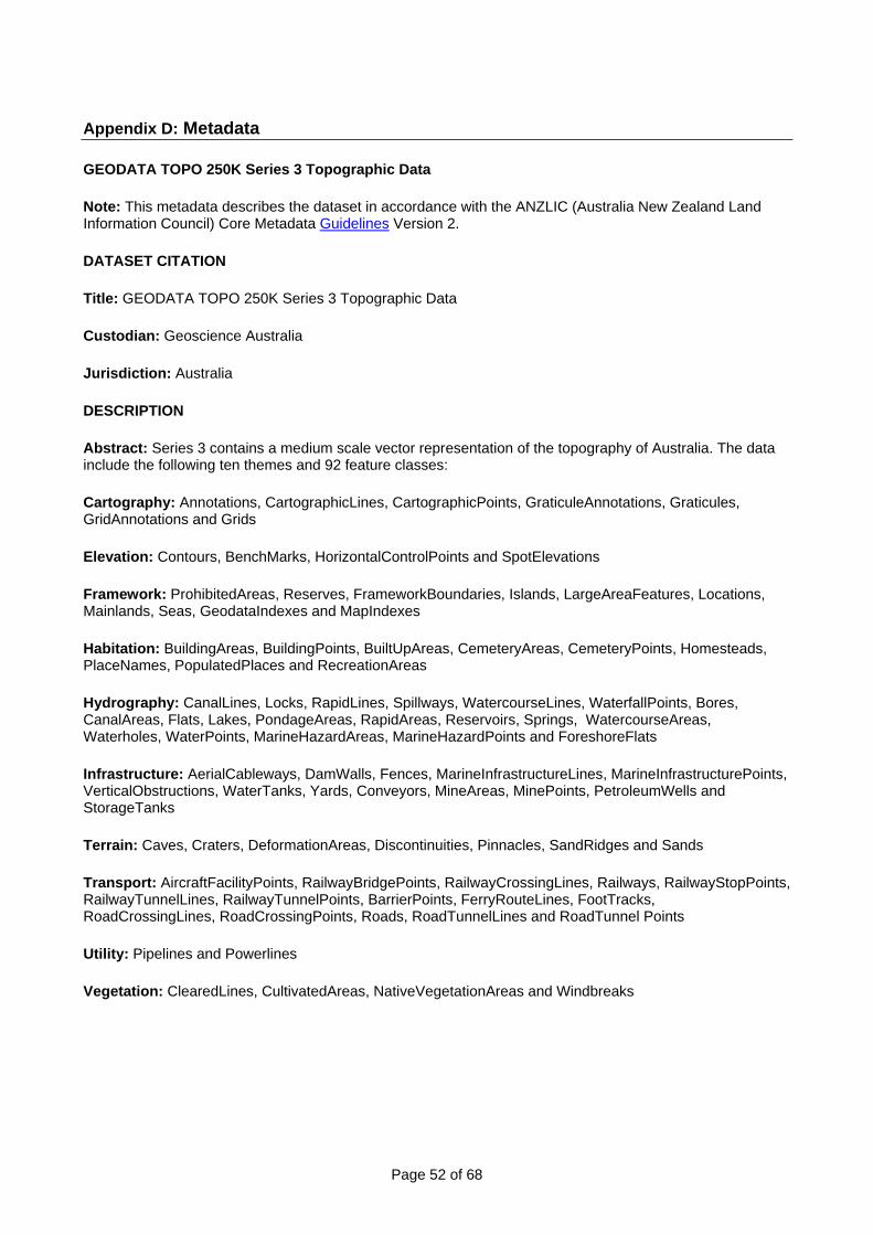
Page 52 of 68
Appendix D: Metadata
GEODATA TOPO 250K Series 3 Topographic Data
Note: This metadata describes the dataset in accordance with the ANZLIC (Australia New Zealand Land Information Council) Core Metadata Guidelines Version 2.
DATASET CITATION
Title: GEODATA TOPO 250K Series 3 Topographic Data
Custodian: Geoscience Australia
Jurisdiction: Australia
DESCRIPTION
Abstract: Series 3 contains a medium scale vector representation of the topography of Australia. The data include the following ten themes and 92 feature classes:
Cartography: Annotations, CartographicLines, CartographicPoints, GraticuleAnnotations, Graticules, GridAnnotations and Grids
Elevation: Contours, BenchMarks, HorizontalControlPoints and SpotElevations
Framework: ProhibitedAreas, Reserves, FrameworkBoundaries, Islands, LargeAreaFeatures, Locations, Mainlands, Seas, GeodataIndexes and MapIndexes
Habitation: BuildingAreas, BuildingPoints, BuiltUpAreas, CemeteryAreas, CemeteryPoints, Homesteads, PlaceNames, PopulatedPlaces and RecreationAreas
Hydrography: CanalLines, Locks, RapidLines, Spillways, WatercourseLines, WaterfallPoints, Bores, CanalAreas, Flats, Lakes, PondageAreas, RapidAreas, Reservoirs, Springs, WatercourseAreas, Waterholes, WaterPoints, MarineHazardAreas, MarineHazardPoints and ForeshoreFlats
Infrastructure: AerialCableways, DamWalls, Fences, MarineInfrastructureLines, MarineInfrastructurePoints, VerticalObstructions, WaterTanks, Yards, Conveyors, MineAreas, MinePoints, PetroleumWells and StorageTanks
Terrain: Caves, Craters, DeformationAreas, Discontinuities, Pinnacles, SandRidges and Sands
Transport: AircraftFacilityPoints, RailwayBridgePoints, RailwayCrossingLines, Railways, RailwayStopPoints, RailwayTunnelLines, RailwayTunnelPoints, BarrierPoints, FerryRouteLines, FootTracks, RoadCrossingLines, RoadCrossingPoints, Roads, RoadTunnelLines and RoadTunnel Points
Utility: Pipelines and Powerlines
Vegetation: ClearedLines, CultivatedAreas, NativeVegetationAreas and Windbreaks
Page 53 of 68
ANZLIC SEARCH WORDS:
• BOUNDARIES Mapping • ENERGY Mapping • FORESTS Mapping • HERITAGE Natural Mapping • HUMAN ENVIRONMENT Mapping • LAND Mapping • MARINE Mapping • TRANSPORTATION Mapping • UTILITIES Mapping • VEGETATION Mapping • WATER Mapping
SPATIAL DOMAIN - In a Geodatabase environment the spatial domain is set as:
Minimum X: 108.000000 Minimum Y: -48.000000 Maximum X: 21582.83645 Maximum Y: 21426.83645 Precision: 100000.000000 The precision of the NTDB is 0.00001 degrees, which equates to approximately 1 metre on the ground. This value is determined by dividing 1 coordinate system unit (degree) by the scale of the data. 1 degree / 100000 = 0.00001 degrees.
GEOGRAPHIC EXTENT NAME: AUSTRALIA EXCLUDING EXTERNAL TERRITORIES - AUS - Australia - Australia
Note: The format for each Geographic extent name is: Name - Identifier - Category - Jurisdiction (as appropriate) See GEN Register
GEOGRAPHIC BOUNDING BOX: North bounding latitude: -8.9 ° South bounding latitude: -44 ° East bounding longitude: 154.1 ° West bounding longitude: 112.8 °
DATA CURRENCY
Beginning date: 9/05/06
Ending date: Current
DATA STATUS
Progress: 9/05/06
Maintenance and update frequency: Irregular
Page 54 of 68
ACCESS
Stored data format: DIGITAL - Personal Geodatabase (pgdb) Geographic GDA94 DIGITAL - MapInfo file format (.tab) MapInfo Geographic GDA94 DIGITAL - ArcView shape file (.shp) Geographic GDA94
Available format type: DIGITAL - Personal Geodatabase (pgdb) Geographic GDA94 DIGITAL - MapInfo file format (.tab) MapInfo Geographic GDA94 DIGITAL - ArcView shape file (.shp) Geographic GDA94
Access constraints:
The data are subject to Commonwealth of Australia Copyright. A licence agreement is required and a licence fee is also applicable for packaged data (included in the purchase price). GEODATA TOPO 250K Series 3 replaces Series 1 and 2.
Download or Order Product
DATA QUALITY
Lineage:
GEODATA TOPO 250K Series 3 is primarily sourced from GEODATA TOPO 250K Series 2 and 1:250 000 scale map reproduction material (from the National Topographic Map Series and Defence Joint Operation Graphics). A key revision source for the data is satellite imagery taken from the SPOT Panchromatic and LANDSAT Thematic Mapper Sensors. Revision material has also been gathered from a variety of authoritative sources. More information about the sources for this data can be found in Geoscience Australia's Topographic Data and Map Specifications.
Positional accuracy:
Geoscience Australia has carried out both error budget analysis and limited field tests to verify the positional accuracy of the data. GEODATA TOPO 250K Series 3 data complies with the following statement of horizontal accuracy: "The summation of errors from all sources results in data with a standard deviation of 85 metres for well defined features". Alternative and equal ways of expressing this error are: Not more than 10% of well-defined points are in error by more than 140 metres; and, in the worst case, a well defined point is out of position by 300 metres. As the GEODATA TOPO 250K Series 3 data were digitised from existing map production material, some features may be subject to cartographic displacement.
Vertical Accuracy: The accuracy of the spot elevations in the relief layer varies with the type of source material from which they were captured and the point determination for each particular point. Most spot heights have an accuracy of + or - 5 metres, however bench marks and horizontal control points have an accuracy of + or - 1 metre. The accuracy of contours is defined as 1/2 of the contour interval, for example + or - 25 metres for a 50 metre contour interval.
Attribute accuracy:
For the TOPO 250K product, attribute accuracy is a measure of the degree to which the attribute values of features agree with the information on the source material. The allowable error in attribute accuracy ranges from 0.5% to 5%, at a 99% confidence level. Where less than 1% of attribute errors are permissible the entire population is tested. Where a less stringent limit is set for allowable errors a random subset of the relevant features in the tile is generally tested. The sample size is determined from statistical tables using the known population size of the relevant feature. Further information on the validation and testing methodology used by Geoscience Australia can be found in Appendix J of the Topographic Data and Map Specifications.

Page 55 of 68
Logical Consistency:
Validating logical consistency may involve tests to check that table and file names are set out as in the Data Dictionary. Also included are graphical tests which check such things as intersections, polygon closure, minimum sizes of polygons and topological relationships. The allowable error in logical consistency ranges from 0% to 5%. Further information on the validation and testing methodology used by Geoscience Australia can be found in Appendix J of the Topographic Data and Map Specifications.
Completeness:
All instances of a feature and its attribute values that appear on the source material are captured unless otherwise indicated in the selection criteria for that feature.
CONTACT INFORMATION
Contact organisation: Geoscience Australia (GA) Contact position: Sales and Distribution Mail address: GPO Box 378 Locality: Canberra State: ACT Country: Australia Postcode: 2601 Freecall (within Australia): 1800 800 173 Telephone: +61 2 6249 9966 Facsimile: +61 2 6249 9960 Electronic mail address: [email protected]
METADATA INFORMATION
Metadata date: 2006-06-15
ADDITIONAL METADATA
Metadata reference XHTML: http://www.ga.gov.au:88/newintranet/meta/ANZCW0703005458.html
Metadata reference XML: http://www.ga.gov.au:88/newintranet/meta/ANZCW0703005458.xml
Scale/resolution: 1:250 000
Projection/datum: • Datum: GDA94 • Projection: Geographical - latitude and longitude

Page 56 of 68
Appendix E: Glossary
Term Meaning Abandoned A feature, which is no longer in normal use and is not maintained. Future
use is not anticipated, although operations could possibly be resumed after repair. The term is applied to roads, railways and airfields, quarries etc. all of which, although not immediately useable for the original purpose, are still landmark features.
Indigenous (Aboriginal) lands
Land set aside for use of Indigenous people, access to which is controlled by Federal or State authorities or by Indigenous/Aboriginal Land Councils.
Accuracy The degree of conformity with a standard, or the degree of perfection attained in a measurement. Accuracy relates to the quality of a result, and is distinguished from precision, which relates to the quality of the operation by which the result is obtained.
AGD66 Australian Geodetic Datum 1966. The datum used for the determination of co-ordinates for Geoscience Australia topographic map products and data of medium scale prior to the introduction of the GDA94 datum (see marginalia detail for further information on which datum was used for a particular map & projection information internal to data coverages for digital products).
AGDB Australian Geographic Data Base program. A program initiated by AUSLIG to produce GIS quality digital spatial data from its map production material.
Aerodrome An area for the movement of aircraft and for the receipt and discharge of cargo. Aerodromes may be licensed by Airservices Australia.
Airport Technically an aerodrome at which facilities exist for the shelter, servicing and repair of aircraft, and at which major navigation aids are installed. Note: Airport is used generically in these specifications to include licensed Aerodromes.
Alignment The direction or position of a linear feature (e.g., road or railway), on a map in relation to surrounding topographic detail.
Altitude The vertical distance of a level, a point or an object considered as a point, measured from Mean Sea Level.
AMG See Australian Map Grid. AMG66 The grid (metres) coordinate set based on the AMG and the 1966 national
geodetic adjustment. Approximate Very near, fairly correct, near to the actual. 'Approximate Position' is used
as a descriptive note on a map to indicate detail, the position of which cannot be determined to the accuracy of the map accuracy statement.
Area feature A feature, which is portrayed as a region or surface. An area feature is bounded by one or more polygons.
Area symbol A continuous and distinctive shading, tone or repetitive pattern employed on a map (or chart) to cover an area (or areas) where a particular phenomenon occurs, or to which a particular value is attributed.
Attribute A descriptive characteristic of a feature. An attribute has a defined set of attribute values.
Attribute object The attribute object holds the non-locational information about the feature instance
AUSLIG The Australian Surveying and Land Information Group, which subsequently amalgamated with Australian Geological Survey Organisation (AGSO) to form Geoscience Australia.
Australian Geodetic Datum (AGD)
The geodetic datum adopted by Australia in 1966, defined by the parametres of the Australian National Spheroid and the coordinates of the Johnston Geodetic Station.
Australian Height Datum (AHD)
The datum used for the determination of elevation in Australia. The determination Used a national network of benchmarks and tide gauges and set Mean High Water as zero elevation.
Australian Map Grid (AMG)
A cartesian coordinate system based on the Universal Transverse Mercator projection and the Australian Geodetic Datum. The unit of measure is the metre. (see also AMG66)
Page 57 of 68
Term Meaning Australian National Spheroid
A reference spheroid for the computation of surveys, with specific application to Australia and the territories administered by Australia, with exceptions, having the following dimensions: Semi-major axis 6 378 160.0 metres Flattening or ellipticity of 1/ 298.25. and whose minor axis is defined to be parallel to the earth's mean axis of rotation at the start of 1962, and whose plane of zero geodetic longitude is parallel to the vertical through the Bureau International del Heure (BIH) mean observatory near Greenwich; that is to say, 149°00' 18.855'' west of the vertical through the photo zenith tube at Mount Stromlo. The position of the centre of the spheroid is defined by the coordinates of the Johnston Geodetic Station. (c.f., Australian Geodetic Datum).
Azimuth The azimuth of a point is the angle reckoned clockwise in a horizontal plane between the local meridian and that point.
Base map A map or chart showing certain fundamental information, used as a base upon which additional data of specialised nature are compiled or overprinted.
Base material/digital data
This is hardcopy material or digital data which Geoscience Australia has designated as the starting point on which producers build a new dataset and apply any appropriate revision source material. This includes entities such as repromat, latest previous edition map produced by GA, Maps produced by other mapping authorities, GEODATA 250K series 3, State mapping authority digital data or the existing TOPO100K & TOPO 250K NTDBs.
Bearing The horizontal angle at a given point measured clockwise from a specific reference datum to a second point.
Bleed (Printing) Where the printed area extends beyond the trim line so that once trimmed the ink extends to the edge of the paper.
Bleed edge (cartography)
That edge of a map or chart on which detail is extended to the edge of the sheet. Maps, which have a bleed edge, overlap the adjoining maps and generally duplicate the detail thereon, along their northern and eastern edges.
BLOB (Binary Large Object)
Acronym for binary large object. A large block of data, such as an image, a sound file, or geometry, stored in a database. The database cannot read the BLOB's structure and only references it by its size and location.
Boundary description
A written description of the alignment of a boundary which enables its position to be correctly located on the ground and plotted to scale on graphics. The boundary is said to be described by metres and bounds.
Boundary disclaimer
A note usually in the marginal area of a map or chart proclaiming that boundaries portrayed on the face of the map or chart are not necessarily authoritative.
Braided Stream A watercourse comprised of a number of interlaced channels resulting from irregular stream discharge and deposition of course material.
Central meridian The longitude of origin at the centre of each zone of the Universal Transverse Mercator (UTM) grid. The central meridian is arbitrarily given the value 500 000 metres.
Chart A special purpose-map, generally designed for navigation or other particular purposes, in which essential map information is combined with other data critical to the intended use. An exact copy of a point, line or polygon feature which has precisely the same co-ordinate position as the original feature.
Clone
Cloned linear or polygon features will have exactly the same number of arcs and associated vertices and nodes.
Coincident Where a feature location matches exactly the same co-ordinate position as another feature. The coincidence may be either at a single point or along a line feature. Where the endpoints of a linear feature leave the coincident section of line (i.e. to change direction) and fall within 1 metre of that line, they are considered to be coincident for data purposes.
Page 58 of 68
Term Meaning Colour Control Blocks of colour of known density to assist the printer to maintain
consistent colours across the sheet. Colour Separations Film separations - one for each colour, which will be reproduced by a
separate plate. Compilation The production of a new or revised map or chart, or portion thereof, from
existing maps, aerial photographs, satellite imagery; surveys, and other source data.
Connector feature An artificial linear feature used to connect a linear network across an area feature. This allows continuity of the feature and assists the process of linear network analysis.
Control A collective term for a system of marks or objects on the earth or on a map or photograph, who’s positions or elevations, or both, has been determined.
Convergence of meridians
The angular drawing together of the geographic meridians in passing from the equator to the poles. At the equator, all meridians are mutually parallel; passing from the equator, they converge until they meet at the poles, intersecting at angles that are equal to their differences in longitude.
Datum A point, plane, or surface to which systems of measurement are referred or related to one another. Hence: 1. GEOCENTRIC DATUM A reference frame which has its origin as the Earth's centre of mass, which is directly related to the orbits of satellites. Positioning from these satellites is a critical element in modern surveying, mapping, geographic information systems, navigation, aviation, land and sea transport, emergency services, law enforcement and recreation. 2. GEODETIC DATUM The position of a reference spheroid as defined by the position of one selected station, usually near the centre of the survey area, known as the origin, and the azimuth from the origin to an adjoining station. 3. VERTICAL DATUM A level surface to which elevations are referred, usually, but not always, mean sea level.
Definite Exact, precise, defined. Especially that detail which is unambiguous to the map user and may be accurately plotted
DEM See Digital Elevation Model. Descriptive name or term
Written information on a map or chart used to specify the nature of a physical or cultural feature. Also called toponym.
Digital Elevation Model
A depiction of relief using points and lines, which contain the elevation of each point or the elevation of each point in a line. The data may be in a regular grid or have an irregular spacing.
Dismantled A feature, such as a railway, from which vital components have been removed and the remaining evidence of a railway is primarily the cleared right of way.
Disused A feature components of which are still in place but which is no longer in use.
Easting A linear distance eastwards from the vertical grid line, which passes through the Origin (or False Origin) of a Grid system.
Edge The interior and exterior definition of polygon extents inherent in the construction of the polygon. (In terms of this specification it is not used to indicate the related bounding line feature (geometry type line))
Edition number A higher number indicates that a map contains later information than a similar map bearing a lower number, and the highest edition number is therefore the current edition of a map.
Elevation Vertical distance from a datum, usually Mean Sea Level to a point or object on the earth's surface.
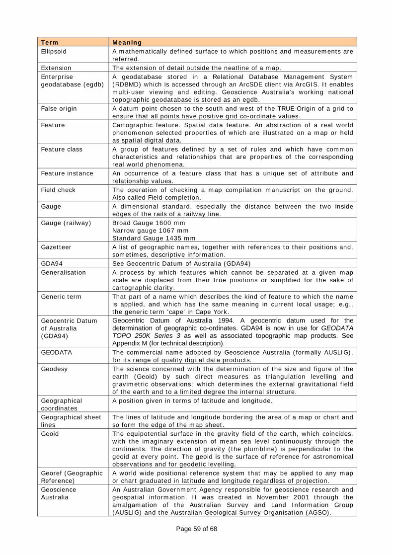
Page 59 of 68
Term Meaning Ellipsoid A mathematically defined surface to which positions and measurements are
referred. Extension The extension of detail outside the neatline of a map. Enterprise geodatabase (egdb)
A geodatabase stored in a Relational Database Management System (RDBMD) which is accessed through an ArcSDE client via ArcGIS. It enables multi-user viewing and editing. Geoscience Australia’s working national topographic geodatabase is stored as an egdb.
False origin A datum point chosen to the south and west of the TRUE Origin of a grid to ensure that all points have positive grid co-ordinate values.
Feature Cartographic feature. Spatial data feature. An abstraction of a real world phenomenon selected properties of which are illustrated on a map or held as spatial digital data.
Feature class A group of features defined by a set of rules and which have common characteristics and relationships that are properties of the corresponding real world phenomena.
Feature instance An occurrence of a feature class that has a unique set of attribute and relationship values.
Field check The operation of checking a map compilation manuscript on the ground. Also called Field completion.
Gauge A dimensional standard, especially the distance between the two inside edges of the rails of a railway line.
Gauge (railway) Broad Gauge 1600 mm Narrow gauge 1067 mm Standard Gauge 1435 mm
Gazetteer A list of geographic names, together with references to their positions and, sometimes, descriptive information.
GDA94 See Geocentric Datum of Australia (GDA94) Generalisation A process by which features which cannot be separated at a given map
scale are displaced from their true positions or simplified for the sake of cartographic clarity.
Generic term That part of a name which describes the kind of feature to which the name is applied, and which has the same meaning in current local usage; e.g., the generic term 'cape' in Cape York.
Geocentric Datum of Australia (GDA94)
Geocentric Datum of Australia 1994. A geocentric datum used for the determination of geographic co-ordinates. GDA94 is now in use for GEODATA TOPO 250K Series 3 as well as associated topographic map products. See Appendix M (for technical description).
GEODATA The commercial name adopted by Geoscience Australia (formally AUSLIG), for its range of quality digital data products.
Geodesy The science concerned with the determination of the size and figure of the earth (Geoid) by such direct measures as triangulation levelling and gravimetric observations; which determines the external gravitational field of the earth and to a limited degree the internal structure.
Geographical coordinates
A position given in terms of latitude and longitude.
Geographical sheet lines
The lines of latitude and longitude bordering the area of a map or chart and so form the edge of the map sheet.
Geoid The equipotential surface in the gravity field of the earth, which coincides, with the imaginary extension of mean sea level continuously through the continents. The direction of gravity (the plumbline) is perpendicular to the geoid at every point. The geoid is the surface of reference for astronomical observations and for geodetic levelling.
Georef (Geographic Reference)
A world wide positional reference system that may be applied to any map or chart graduated in latitude and longitude regardless of projection.
Geoscience Australia
An Australian Government Agency responsible for geoscience research and geospatial information. It was created in November 2001 through the amalgamation of the Australian Survey and Land Information Group (AUSLIG) and the Australian Geological Survey Organisation (AGSO).
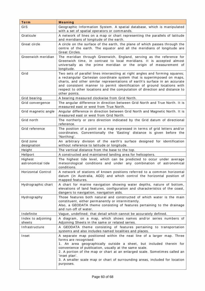
Page 60 of 68
Term Meaning GIS Geographic Information System. A spatial database, which is manipulated
with a set of spatial operators or commands. Graticule A network of lines on a map or chart representing the parallels of latitude
and meridians of longitude of the earth. Great circle A circle on the surface of the earth, the plane of which passes through the
centre of the earth. The equator and all the meridians of longitude are Great Circles.
Greenwich meridian The meridian through Greenwich, England, serving as the reference for Greenwich time, in contrast to local meridians. It is accepted almost universally as the prime meridian or the origin of measurement of longitude.
Grid Two sets of parallel lines intersecting at right angles and forming squares; a rectangular Cartesian coordinate system that is superimposed on maps, charts, and other similar representations of earth's surface in an accurate and consistent manner to permit identification of ground locations with respect to other locations and the computation of direction and distance to other points.
Grid bearing A bearing measured clockwise from Grid North. Grid convergence The angular difference in direction between Grid North and True North. It is
measured east or west from True North. Grid magnetic angle Angular difference in direction between Grid North and Magnetic North. It is
measured east or west from Grid North. Grid north The northerly or zero direction indicated by the Grid datum of directional
reference. Grid reference The position of a point on a map expressed in terms of grid letters and/or
coordinates. Conventionally the 'Easting' distance is given before the 'Northing'.
Grid zone designation
An arbitrary division of the earth's surface designed for identification without reference to latitude or longitude.
Height The vertical distance from the base to the top. Heliport A constructed and maintained landing area for helicopters. Highest astronomical tide
The highest tide level, which can be predicted to occur under average meteorological conditions and under any combination of astronomical conditions.
Horizontal Control A network of stations of known positions referred to a common horizontal datum (in Australia, AGD) and which control the horizontal position of mapped features.
Hydrographic chart A chart for marine navigation showing water depths, nature of bottom, elevations of land features, configuration and characteristics of the coast, dangers to navigation, navigation aids.
Hydrography Those features both natural and constructed of which water is the main constituent, either permanently or intermittently. Also, a GEODATA theme consisting of features pertaining to the drainage and run-off of water.
Indefinite Vague, undefined; that detail which cannot be accurately defined. Index to adjoining sheets
A diagram, on a map, which shows names and/or series numbers of Adjoining Sheets in the same or related series.
Infrastructure A GEODATA theme consisting of features pertaining to transportation systems and also includes named localities and places.
Inset A separate map positioned within the neat line of a larger map. Three forms are recognised: 1. An area geographically outside a sheet, but included therein for convenience of publication, usually at the same scale. 2. A portion of the map or chart at an enlarged scale. Sometimes called an 'inset plan'. 3. A smaller scale map or chart of surrounding areas, included for location purposes.
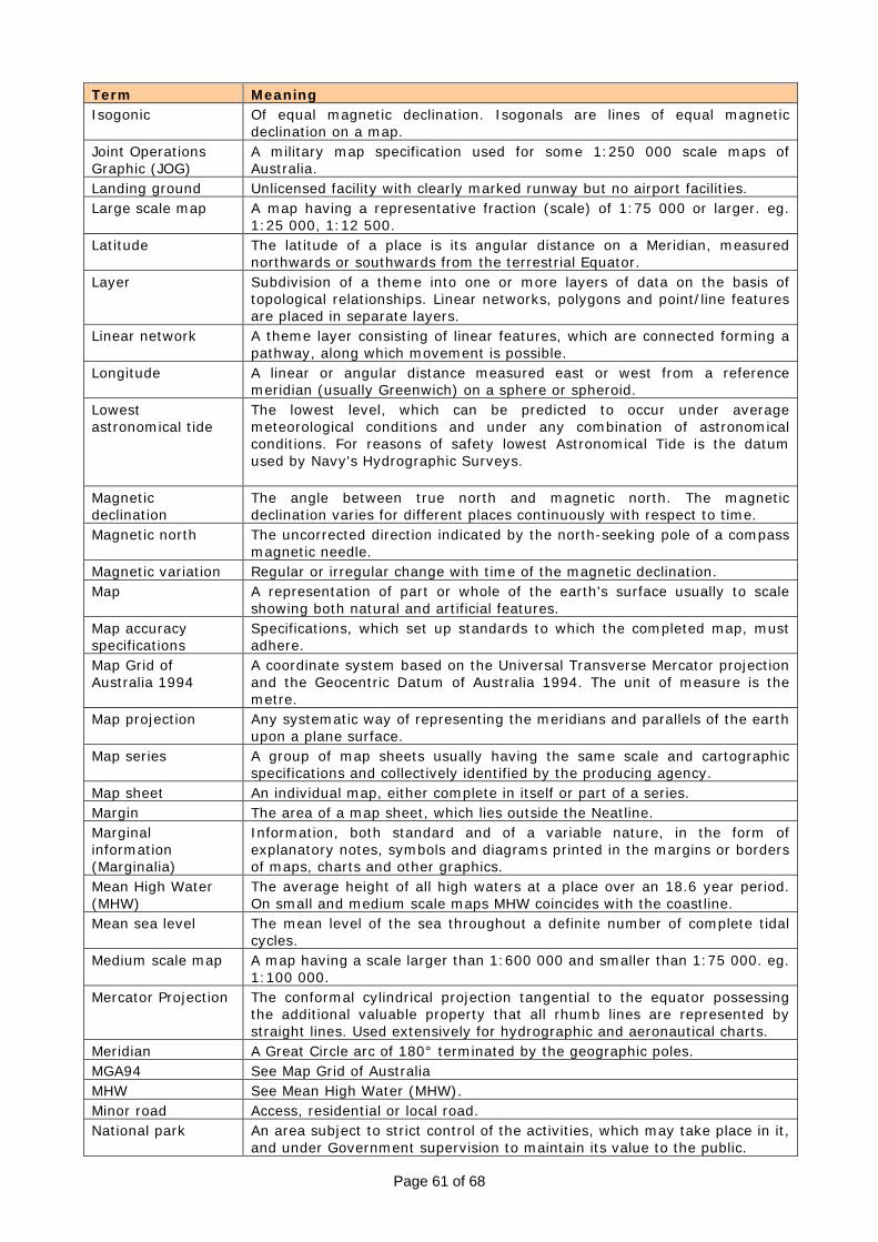
Page 61 of 68
Term Meaning Isogonic Of equal magnetic declination. Isogonals are lines of equal magnetic
declination on a map. Joint Operations Graphic (JOG)
A military map specification used for some 1:250 000 scale maps of Australia.
Landing ground Unlicensed facility with clearly marked runway but no airport facilities. Large scale map A map having a representative fraction (scale) of 1:75 000 or larger. eg.
1:25 000, 1:12 500. Latitude The latitude of a place is its angular distance on a Meridian, measured
northwards or southwards from the terrestrial Equator. Layer Subdivision of a theme into one or more layers of data on the basis of
topological relationships. Linear networks, polygons and point/line features are placed in separate layers.
Linear network A theme layer consisting of linear features, which are connected forming a pathway, along which movement is possible.
Longitude A linear or angular distance measured east or west from a reference meridian (usually Greenwich) on a sphere or spheroid.
Lowest astronomical tide
The lowest level, which can be predicted to occur under average meteorological conditions and under any combination of astronomical conditions. For reasons of safety lowest Astronomical Tide is the datum used by Navy's Hydrographic Surveys.
Magnetic declination
The angle between true north and magnetic north. The magnetic declination varies for different places continuously with respect to time.
Magnetic north The uncorrected direction indicated by the north-seeking pole of a compass magnetic needle.
Magnetic variation Regular or irregular change with time of the magnetic declination. Map A representation of part or whole of the earth's surface usually to scale
showing both natural and artificial features. Map accuracy specifications
Specifications, which set up standards to which the completed map, must adhere.
Map Grid of Australia 1994
A coordinate system based on the Universal Transverse Mercator projection and the Geocentric Datum of Australia 1994. The unit of measure is the metre.
Map projection Any systematic way of representing the meridians and parallels of the earth upon a plane surface.
Map series A group of map sheets usually having the same scale and cartographic specifications and collectively identified by the producing agency.
Map sheet An individual map, either complete in itself or part of a series. Margin The area of a map sheet, which lies outside the Neatline. Marginal information (Marginalia)
Information, both standard and of a variable nature, in the form of explanatory notes, symbols and diagrams printed in the margins or borders of maps, charts and other graphics.
Mean High Water (MHW)
The average height of all high waters at a place over an 18.6 year period. On small and medium scale maps MHW coincides with the coastline.
Mean sea level The mean level of the sea throughout a definite number of complete tidal cycles.
Medium scale map A map having a scale larger than 1:600 000 and smaller than 1:75 000. eg. 1:100 000.
Mercator Projection The conformal cylindrical projection tangential to the equator possessing the additional valuable property that all rhumb lines are represented by straight lines. Used extensively for hydrographic and aeronautical charts.
Meridian A Great Circle arc of 180° terminated by the geographic poles. MGA94 See Map Grid of Australia MHW See Mean High Water (MHW). Minor road Access, residential or local road. National park An area subject to strict control of the activities, which may take place in it,
and under Government supervision to maintain its value to the public.
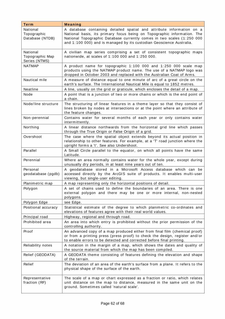
Page 62 of 68
Term Meaning National Topographic Database (NTDB)
A database containing detailed spatial and attribute information on a National basis, its primary focus being on Topographic information. The National Topographic Database currently comes in two scales (1:250 000 and 1:100 000) and is managed by its custodian Geoscience Australia.
National Topographic Map Series (NTMS)
A civilian map series comprising a set of consistent topographic maps nationwide, at scales of 1:100 000 and 1:250 000.
NATMAP A product name for topographic 1:100 000 and 1:250 000 scale map products using the NATMAP product name. The use of a NATMAP logo was dropped in October 2003 and replaced with the Australian Coat of Arms.
Nautical mile A measure of distance equal to one minute of arc of a great circle on the earth's surface. The International Nautical Mile is equal to 1852 metres.
Neatline A line, usually on the grid or graticule, which encloses the detail of a map. Node A point that is a junction of two or more chains or which is the end point of
a chain. Node/line structure The structuring of linear features in a theme layer so that they consist of
lines broken by nodes at intersections or at the point where an attribute of the feature changes.
Non-perennial Contains water for several months of each year or only contains water intermittently.
Northing A linear distance northwards from the horizontal grid line which passes through the True Origin or False Origin of a grid.
Overshoot The case where the spatial object extends beyond its actual position in relationship to other features. For example, at a 'T' road junction where the upright forms a 't'. See also Undershoot.
Parallel A Small Circle parallel to the equator, on which all points have the same Latitude.
Perennial Where an area normally contains water for the whole year, except during unusually dry periods, in at least nine years out of ten.
Personal geodatabase (pgdb)
A geodatabase stored in a Microsoft Access database which can be accessed directly by the ArcGIS suite of products. It enables multi-user viewing, but single-user editing.
Planimetric map A map representing only the horizontal positions of detail. Polygon A set of chains used to define the boundaries of an area. There is one
external polygon and there may be one or more internal, non-nested polygons.
Polygon Edge see Edge. Positional accuracy Statistical estimate of the degree to which planimetric co-ordinates and
elevations of features agree with their real world values. Principal road Highway, regional and through road. Prohibited area An area into which entry is prohibited without the prior permission of the
controlling authority. Proof An advanced copy of a map produced either from final film (chemical proof)
or from a printing press (press proof) to check the design, register and/or to enable errors to be detected and corrected before final printing.
Reliability notes A notation in the margin of a map, which shows the dates and quality of the source material from which the map has been compiled.
Relief (GEODATA) A GEODATA theme consisting of features defining the elevation and shape of the terrain.
Relief The deviation of an area of the earth's surface from a plane. It refers to the physical shape of the surface of the earth.
Representative fraction (RF)
The scale of a map or chart expressed as a fraction or ratio, which relates unit distance on the map to distance, measured in the same unit on the ground. Sometimes called 'natural scale'.
Page 63 of 68
Term Meaning Reproduction material
Material, generally in the form of positive or negative copies on film of each colour plate, from which a map may be reprinted without redrafting. Commonly called 'Repromat' or 'Rep mat'.
Repromat See Reproduction material Scale The relationship between the distance on a photograph, map or other
graphic to its corresponding distance on the ground or to another graphic. See also Representative Fraction.
Scale bar A graduated line by means of which distances on the map or chart may be measured in terms of ground distances.
SDTS The United States Spatial Data Transfer Standard. This standard is to be the basis of the new Australian Standard for the transfer of spatial digital data.
Secondary road Linking and distributor road. Segment A direct line between a pair of vertices or a vertice and a node. Series designation The letters and numbers used to identify land maps and provide a unique
designation for each map series by which it can be differentiated from all other series.
Sheet line system The system by which a Map Series is divided into individual Map Sheets. Sheet numbering system
The system by which individual map sheets within a series are numbered.
Sliver Long, thin triangle or polygon of very small area formed by overlaying of almost coincident lines. Often a result of twice digitising the same linear feature.
Small scale map A map having a scale smaller than 1:600 000. eg. 1:1 000 000. Source material Data of any type required for the production of maps and charts including,
but not limited to ground control, aerial and terrestrial photographs, satellite imagery, sketches, maps and charts; meteorological information; intelligence documents and written reports pertaining to natural and constructed features of the area to be mapped or charted.
Spatial object The spatial object holds the locational information of a feature instance. For GEODATA it is composed of either a point, node, line or polygon.
Specification A document, which sets out the standards to be adhered to in, the production of a particular dataset, map or map series. This generally contains information, which describes or represents data structure, the sheet layout, marginal information, symbols, lettering and colours to be adopted.
Standard parallel The parallel or parallels on a conical projection along which the principal scale is preserved.
State forest A tract of forest land gazetted as such by a government. SYMBAS SYMBOLISATION ALL SERIES, specifications for topographic maps
published by Royal Australian Survey Corps in 1988. Symbol A letter, character or other graphic device representing some feature,
quality or characteristic on a map. Terrain A tract of country considered with regard to its natural features and
configuration. Thematic map A map designed to demonstrate particular features or concepts. In
conventional use, this term excludes topographic maps. Thematic maps include rainfall maps, population distribution maps, and the like.
Theme The information contained in the map production material is divided into four themes, which contain logically related geographic information (Hydrography, Infrastructure Relief and Vegetation). Each theme is capable of being used as a data set in its own right.
Tile The area of a spatial database included in a data transfer. Tile Edge An artificial linear feature, which indicates the boundaries of the tile. The
tile edge closes off polygon features, which are situated in more than one tile.

Page 64 of 68
Term Meaning Topographic map A map whose principal purpose is to portray and identify the features of the
Earth's surface as faithfully as possible within the limitations imposed by scale.
Topography The detailed description, especially on a map, of a locality; including its relief and any relatively permanent objects, whether natural or of human origin, thereon. The configuration of a surface, including its relief, the position of its streams, lakes, roads, cities, and other features. The earth's natural and physical features collectively.
Track (railway) The number of sets of rails. Track (vehicular) Public or private roadway of minimum or no construction, not necessarily
maintained. A conformal cylindrical map projection, originally devised by Gauss, also known as the Gauss-Kruaer projection. As its name implies its construction is on the same principle as the Mercator projection, the only difference being that the great circle of tangency is now any nominated meridian. Meridians and parallels are curved lines, except for the central meridian or a specified zone (meridian of tangency), which remains a straight line. Projection zones are established about the central meridian and vary in width from two degrees to six degrees of longitude, with some overlap between zones. Properties: Scale: Scale is true along the central meridian, but enlarges away from the central meridian. Conformality: The projection is conformal; meridians and parallels intersect at right angles and all angles are correctly represented. Sheet fit: Map sheets at the same scale and within the same zone with the same central meridian fit perfectly along their sheet edges. General:
Transverse Mercator projection (TM)
The amount of scale distortion may become unacceptable at distances greater than about 1.5 degrees in longitude from the central meridian. In a modified form the projection is in general use for topographic mapping at scales of 1:250 000 and larger. See UNIVERSAL TRANSVERSE MERCATOR.
True bearing The horizontal angle between the meridian line and a line through the observed point, measured clockwise.
True north The direction from an observer's position to the geographic North Pole. UFI Unique Feature Identifier. Undershoot A line that falls short of another line that it should intersect. Universal Transverse Mercator (UTM)
A world wide systematic application of the Transverse Mercator Projection applying to the region between 80°S and 84°N latitude. The UTM is a modified TM projection whereby the natural scale of the central meridian is scaled by a factor of 0.9996 to enable a wider area to be mapped with acceptable distortion. Each Zone is six degrees of longitude in width with a half degree of overlap within the adjoining zone and having a true origin at the intersection of the central meridian of that zone and the equator.
Vegetation A GEODATA theme consisting of features describing the vegetation cover. Vertical control The measurements taken by surveying methods for the determination of
elevation with respect to a vertical datum. Vertice An intermediate point on a chain for which coordinates are held in the data. WGS 84 World Geodetic System 1984. A geocentric datum used for the
determination of geographic co-ordinates. It is for most practical purposes the same as GDA 94.
Work Package A group of Work Units bundled together for production by a producer. Work Unit One map sheet and its related dataset within a work package.

Page 65 of 68
Term Meaning World Aeronautical Chart (WAC)
A series of aeronautical charts at the scale of 1:1 000 000 that has been planned to cover the whole surface of the earth (including both land and sea areas) to a common specification laid down by the International Civil Aviation organisation.
World geodetic reference system 1972 (WGS 72)
Superseded by WGS 84. A reference spheroid having the following dimensions: semimajor axis 6 378 135.0 metres; and a flattening or ellipticity of 1/ 298.26.
Zone See UTM.
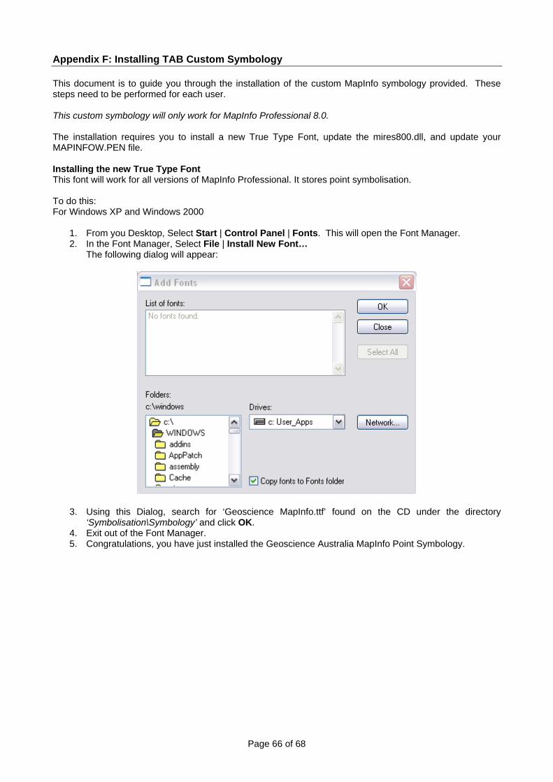
Page 66 of 68
Appendix F: Installing TAB Custom Symbology This document is to guide you through the installation of the custom MapInfo symbology provided. These steps need to be performed for each user. This custom symbology will only work for MapInfo Professional 8.0. The installation requires you to install a new True Type Font, update the mires800.dll, and update your MAPINFOW.PEN file. Installing the new True Type Font This font will work for all versions of MapInfo Professional. It stores point symbolisation. To do this: For Windows XP and Windows 2000
1. From you Desktop, Select Start | Control Panel | Fonts. This will open the Font Manager. 2. In the Font Manager, Select File | Install New Font…
The following dialog will appear:
3. Using this Dialog, search for ‘Geoscience MapInfo.ttf’ found on the CD under the directory ‘Symbolisation\Symbology’ and click OK.
4. Exit out of the Font Manager. 5. Congratulations, you have just installed the Geoscience Australia MapInfo Point Symbology.

Page 67 of 68
Updating the mires800.dll to utilise the Geoscience Australia’s MapInfo Fill Patterns MapInfo uses a special file called miresXXX.dll (where xxx denotes the version of MapInfo you are using, i.e. Version 7.8 is 780, version 7.9 is 790 and version 8 is 800) to store monochrome bitmap files that are use for you fill patterns or styles. NOTE: This will require renaming and copying files required for MapInfo Professional 8.0 to run correctly. Please follow the steps carefully. NOTE: The mires800.dll file will only work for MapInfo Professional 8.0. Hence, this section is only for users with MapInfo Professional 8.0 Installed. To update your MapInfo Fill Patterns, do this: For Windows XP and Windows 2000
1. Open Windows Explorer; open your MapInfo Professional 8.0 directory. The default location C:\Program Files\MapInfo\Professional
2. Locate the file mires800.dll. This file contains all the Bitmap files used by MapInfo to store your Fill patterns.
3. Right mouse click on this file and select Rename. 4. Rename the file to mires800_old.dll and press OK 5. Open another Windows Explorer window. Locate the updated mires800.dll file in the directory
‘Symbolisation\Symbology’ on your CD. Right Mouse Click and select Copy 6. Return to your MapInfo Professional Directory C:\Program Files\MapInfo\Professional, Right Mouse
Click and select Paste to add this file to your MapInfo Professional Directory. 7. Congratulations, you have successfully installed the Geoscience Australia MapInfo Area Symbology.
Installing the New Geoscience Australia Line Styles MapInfo use their own proprietary format to store line styles used by MapInfo Professional. This file is located in the profile directory for each user. NOTE: This file will need to be installed for each new user profile (logon). NOTE: This has only been tested on MapInfo Professional 8.0. To install this file: Before starting this process open windows Explorer & open the ‘tools folder option menu’ select the ‘view tab’ & select show ‘hidden files’ & folder under Hidden files folders. Then Apply to All Folders. For Windows 2000
1. Open Windows Explorer, navigate to C:\WINNT\Profiles\<your username>\Application Data\Mapinfo\Mapinfo\Professional\800\ Here you will see 5 files and 2 directories
2. Right Mouse click on the MAPINFOW.PEN file and rename this file to MAPINFOW_old.PEN 3. Open another Windows Explorer window and locate the MAPINFOW.PEN file in the directory
‘Symbolisation\Symbology’ on your CD. 4. Right Mouse click on this file and select Copy 5. Paste this file in your C:\WINNT\Profiles\<your username>\Application
Data\Mapinfo\Mapinfo\Professional\800\ directory. 6. Close Windows Explorer. 7. Congratulations, you have successfully installed the Geoscience Australia MapInfo Line Symbology.

Page 68 of 68
For Windows XP
1. Open Windows Explorer, navigate to C:\Documents and Settings\<your username>\Application Data\Mapinfo\Mapinfo\Professional\800\ Here you will see 5 files and 2 directories
2. Right Mouse click on the MAPINFOW.PEN file and rename this file to MAPINFOW_old.PEN 3. Open another Windows Explorer window and locate the MAPINFOW.PEN file in the directory
‘Symbolisation\Symbology’ on your CD. 4. Right Mouse click on this file and select Copy 5. Paste this file in your C:\WINNT\Profiles\<your username>\Application
Data\Mapinfo\Mapinfo\Professional\800\ directory. 6. Close Windows Explorer. 7. Congratulations, you have successfully installed the Geoscience Australia MapInfo Line Symbology.
Additional Files Some symbology requires multiple colours to be displayed within the one symbology style. To over come this limitation within MapInfo (where only one colour can be applied at any one time), MapInfo allow us to define custom bitmap files. A selection of these files has been provided to complete the Geoscience Australia MapInfo Symbology set. To install these files:
1. Open Windows Explorer. Go to the Application Data directory specified in the previous step. Take note of what operating system you are using
2. You will see the CustSymb directory. Open this directory 3. Open another Windows Explorer window and locate the Bitmaps directory on your CD containing the
250k scale Topographic data. 4. Copy the contents of this directory (i.e. copy the files, not the directory) and paste it to your
Applications Data directory specified in step 1. 5. Congratulations, you have successfully installed the Geoscience Australia MapInfo Additional
Symbology.