Embed Size (px)
Citation preview

214 Phase 2, Final Draft
________________________________________________________________________________ Casey & Lowe Corridor Options, Historic Heritage
Mt Victoria to Lithgow
Figure 6.134: SB19 - The Presbyterian Church (SHI No. 1960169), at Old Bowenfels (northeastern façade facing Mudgee St and Great Western Highway).
Figure 6.135: SB20 - The Presbyterian cemetery (SHI No. 1960046)) at Old Bowenfels, on the eastern side of the Great Western Highway.

215 Phase 2, Final Draft
________________________________________________________________________________ Casey & Lowe Corridor Options, Historic Heritage
Mt Victoria to Lithgow
Figure 6.136: SB21 – Old house, c. 1900 (SHI No. 1960068) close to the Presbyterian cemetery at Old Bowenfels and on the eastern side of the Great Western Highway.
Figure 6.137: SB22 - View west from Hassan’s Walls Lookout showing McKanes Falls Road (arrowed) sweeping downhill from the Great Western Highway (at right).

216 Phase 2, Final Draft
________________________________________________________________________________ Casey & Lowe Corridor Options, Historic Heritage
Mt Victoria to Lithgow
Old Bowenfels curtilage
Figure 6.138: Old Bowenfels east curtilage.

217 Phase 2, Final Draft
________________________________________________________________________________ Casey & Lowe Corridor Options, Historic Heritage
Mt Victoria to Lithgow
Figure 6.139: Old Bowenfels west curtilage

218 Phase 2, Final Draft
________________________________________________________________________________ Casey & Lowe Corridor Options, Historic Heritage
Mt Victoria to Lithgow
6.8 Ruined Cottage Remains of a ruined cottage survive at the corner of Browns Gap Road and Mid Hartley Road (Figs 6.140 to 6.142). The property includes a set of gate posts to the northwest along the fence line (Fig. 6.142). The site appears to be quite sandy and stone footings are exposed in section indicating some depth to the structural remains. The archaeological site is of course bigger than the standing remains and will include evidence of other structures and outbuildings, archaeological features, rubbish pits and artefacts. This site requires further research if it is to be impacted by the route within the red corridor. Current understanding is that this site is proposed to be listed on the new Lithgow Heritage LEP.
Figure 6.142: Gate posts at the entrance to the historic property and probably associated with the cottage.
Figure 6.140: Looking southeast towards the ruined cottage. Note the major plantings nearby - these are typical for the area.
Figure 6.141: Standing ruins of cottage.

219 Phase 2, Final Draft
________________________________________________________________________________ Casey & Lowe Corridor Options, Historic Heritage
Mt Victoria to Lithgow
Figure 6.143: Curtilage of the ruined cottage and associated archaeological remains, outlined in blue, at
the corner of Browns Gap Road and Mid Hartley Road.

220 Phase 2, Final Draft
________________________________________________________________________________ Casey & Lowe Corridor Options, Historic Heritage
Mt Victoria to Lithgow
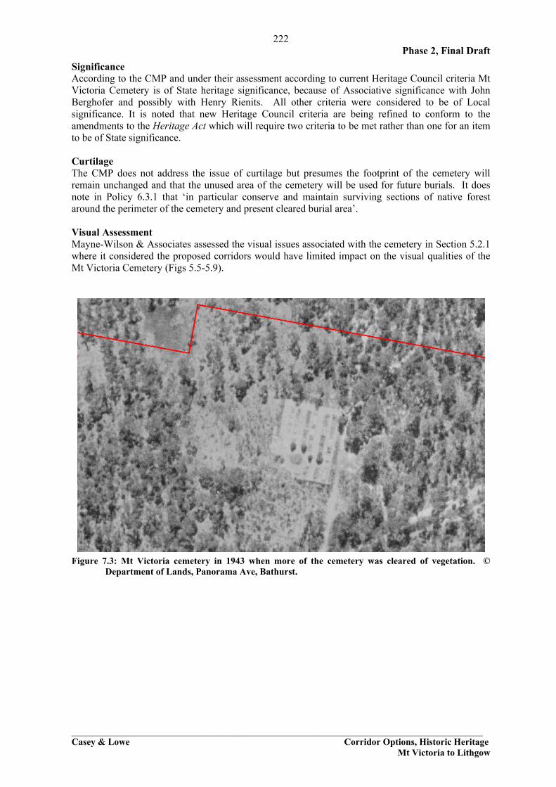
7.0 Historic Cemeteries This section includes only some of the cemeteries within or close to corridors as not all cemeteries need to be discussed, notably those at Old Bowenfels are discussed in Section 6.7 above. The focus in this section is on cemeteries where there was uncertainty about their curtilages or location due to mapping anomalies. 7.1 Mt Victoria Cemetery This cemetery has been the subject of a Conservation Management Plan, Blue Mountains Cemeteries, Conservation Management Plans, Vol 4, Megalong, Mount Victoria and Mount Irvine, by Hubert Architects with Siobhan Lavelle, R Ian. Jack and Colleen Morris, for the City of Blue Mountains. Mt Victoria Cemetery is a later nineteenth-century cemetery which was dedicated in 1881. The earliest burial is 1891 and the latest is 1991 but the cemetery was still open in 2002. The square area of the cemetery is slightly over 8 acres (approx. 3.25 hectares). The cemetery was laid out with a central driveway running north-south. Denominational boundaries were also laid out: Roman Catholic, Church of England, Wesleyan, Presbyterian, Jewish, General and unsectarian (Fig. 7.1). The CMP confirms the impression gained when visiting the cemetery, that only part of it was used (Figs 7.2, 7.3). Aside from the areas with headstones an additional area to the southwest has also been fenced but there are no obvious signs of burials. The CMP notes that there are approximately 60 unmarked graves but does not say where they are in relation to the headstones. Are they in the area to the west of the headstones? Presumably as in 1943 this area was cleared but this is not certain (Fig. 7.3). The denominations indicated on Figure 7.1 suggest that all the known burials are within the “General” section rather than in any specific denominations. The main view from the cemetery is towards Mt Victoria, to the northeast. There is no formal landscaping within the cemetery. Significant persons buried in the cemetery include Henry Rienits (1851-1928) and John William Berghofer (1840-1927).
Figure 7.1: Layout of Mt Victoria cemetery. North at the top, Hubert Architects et al 2002:22

221
Figure 7.2: Aerial photo of Mt Victoria Cemetery showing the eastern part of the cemetery where headstones were visible adjacent to the access road. The red box
indicates the fenced area. Original cemetery outline is indicated by the grey line. The corridors impinge into the southwest corner of the cemetery property.
222 Phase 2, Final Draft
________________________________________________________________________________ Casey & Lowe Corridor Options, Historic Heritage
Mt Victoria to Lithgow
Significance According to the CMP and under their assessment according to current Heritage Council criteria Mt Victoria Cemetery is of State heritage significance, because of Associative significance with John Berghofer and possibly with Henry Rienits. All other criteria were considered to be of Local significance. It is noted that new Heritage Council criteria are being refined to conform to the amendments to the Heritage Act which will require two criteria to be met rather than one for an item to be of State significance. Curtilage The CMP does not address the issue of curtilage but presumes the footprint of the cemetery will remain unchanged and that the unused area of the cemetery will be used for future burials. It does note in Policy 6.3.1 that ‘in particular conserve and maintain surviving sections of native forest around the perimeter of the cemetery and present cleared burial area’. Visual Assessment Mayne-Wilson & Associates assessed the visual issues associated with the cemetery in Section 5.2.1 where it considered the proposed corridors would have limited impact on the visual qualities of the Mt Victoria Cemetery (Figs 5.5-5.9).
Figure 7.3: Mt Victoria cemetery in 1943 when more of the cemetery was cleared of vegetation. © Department of Lands, Panorama Ave, Bathurst.

223 Phase 2, Final Draft
________________________________________________________________________________ Casey & Lowe Corridor Options, Historic Heritage
Mt Victoria to Lithgow
7.2 Hartley General Cemetery Background1 The area around Little Hartley and Hartley developed after Mitchell’s Great Western Highway opened in 1832. There was a concentration of services such as inns and stores on the flat below the River Lett crossing and it was natural that a cemetery should be established here to complement the earlier cemetery at Hartley Vale (outside the corridors). A Roman Catholic burial ground was surveyed and dedicated in 1844: the earliest surviving gravemarkers are both dated to 1847 (Muldoon, Hainer) and the cemetery has had continuous use for 150 years. Because of the high concentration of Irish Catholic families in Hartley and the Kanimbla Valley, the Catholic section of the cemetery is unusually predominant and for many years members of the Reformed churches were buried at Hartley Vale. The extensions to Hartley cemetery were dedicated in 1904 for the Reformed churches. The cemetery is set back from the highway and is contained within a fenced area which relates to the original property dedicated for the General Cemetery. Significance This cemetery is considered to be of State heritage significance.
Curtilage The curtilage identified for the cemetery is based on its historic boundaries which are fenced and some of which have plantings along, notably the eastern boundary. This curtilage is set back from the road in the eastern section and should be easily avoided by widening along the existing highway. The preference would be to do any road widening to the western side of the highway in this area.
1 Taken from the Lithgow Heritage Study Inventory Sheet
Figure 7.4: View along the northern boundary of Hartley Cemetery
Figure 7.5: Eastern end of the cemetery with the set back from the highway.

224 Phase 2, Final Draft
Figure 7.6: Hartley General Cemetery with its current property boundary outlined in red which is the identified curtilage.

225 Phase 2, Final Draft
________________________________________________________________________________ Casey & Lowe Corridor Options, Historic Heritage
Mt Victoria to Lithgow
7.3 Forty Bends Cemetery This cemetery is also called the Stockade Cemetery and Monte Vista Cemetery. It was not visited by the historic heritage consultant as they were not given permission to enter the area. Permission was given to Jillian Comber, Comber Consultants to visit a nearby Aboriginal burial ground and she has provided the following photographs. Information about the site is based on the National Trust inventory form for the cemetery and the information in the Lithgow Heritage Study inventory sheet. This cemetery is,
one of the two earliest cemeteries over the Blue Mountains and is closely associated with Hassans Walls stockade and the building of the Great Western Highway (Travis' grave). It also reflects the earliest inn-keeping (Keenan’s grave) and early settlement in the Bowenfels area...All graves pre-date civic registration and contain valuable information. The example of Connor’s work as a mason can be compared with other examples of his work in local cemeteries in Hartley Valley.2
The cemetery is close to Lockyers Road of 1829 and to Mitchells Great Western Highway of 1832. Nearby in the 1830s was the military and convict road gang establishment at Hassans Wall Stockade. The ‘old stockade’ is an earlier name for the cemetery. Settlement and inns developed along the road in the 1830s and the cemetery reflects a variety of early residents before 1860. The cemetery was superseded by the Old Catholic and Old Presbyterian cemeteries in Bowenfels in the 1850s.3 The graves are situated on a small knoll about 500 m southeast of the main house. When the cemetery was visited by the National Trust in 1991 the headstones were broken and had fallen over but have since been repaired or at least placed upright (Jillian Comber, pers. comm.) but headstones are becoming illegible. The cemetery contains remnants of seven headstones, one footstone and other monument fragments, all in sandstone. Headstones include:
a semi-circular topped stele with relief cross dedicated to William (Travis), late Corporal in Capt. McKane’s 80th Regiment ,who departed this life 12th June, 1837 aged 20 years.
a stele with relief spirals on the shoulders, to Michael Keenan died 27th December 1846 aged 47 years. Keenan was the licensee of the Travellers Inn at Hassans Walls (Bowenfels) from 1833.
a trefoil topped stele with cutaway shoulders, to Ann (MacDermott) died 5th December 1839(?) aged 35 years. This stone is signed by mason J. Connor.
a semi-circular topped stele to (Mary) Ann, daughter of Jas. and Sarah Baker, died (1st) Jan. 1837 aged (9) months.
a double semi-circular topped stele with relief cherubs to (Edward Taylor) who departed this life the 3rd October, 1834, aged (27) years.
fragments of a gothic topped stele with relief cross, and other fragments of one or more headstones with relief cross, quatrefoils and carved rope or chain border. The inscriptions on these fragments were illegible. Transcripts made a number of years ago indicate that these monuments were to Edward Brogan died 30/8/1843 aged 70 years and John Shanny died May, 1845, aged 42 years.
2 Taken from Forty Bends Cemetery, Lithgow Heritage Study inventory sheet, 1960042 3 Taken from Forty Bends Cemetery, Lithgow Heritage Study inventory sheet, 1960042

226 Phase 2, Final Draft
________________________________________________________________________________ Casey & Lowe Corridor Options, Historic Heritage
Mt Victoria to Lithgow
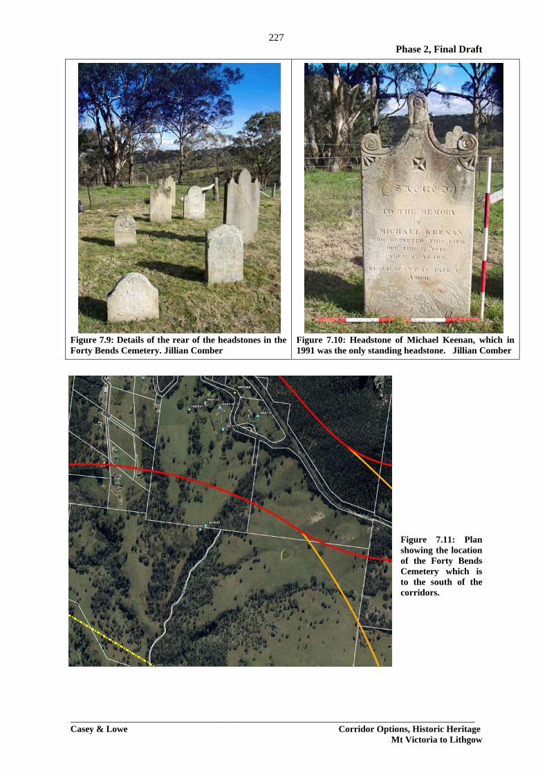
Transcribed list of the cemetery inscriptions. Significance This cemetery has been assessed as having State heritage significance Issues The current curtilage of the cemetery is defined by a fence presumably put up by the owners of the property but there is no certainty that it relates to the interments within the cemetery. There is no understanding if there are unmarked burials, possibly associated with convicts working on the stockade. As Section 6.2.2 on the Hassans Walls Stockade makes clear there were hundreds of convicts and soldiers stationed in this area in the 1830s. This cemetery has been identified as being considerably to the south of the corridors and there should be no impacts (Fig. 7.11). It is noted that the land which contains the cemetery has been associated with Monte Vista for many years and it is quite difficult to get to over private land. It is possible that if a road goes nearby to this cemetery it may make it prone to vandalism.
Figure 7.7: Forty Bends Cemetery with headstones and fencing. Jillian Comber
Figure 7.8: Forty Bends Cemetery with fencing showing the rear of the headstones. Jillian Comber
227 Phase 2, Final Draft
________________________________________________________________________________ Casey & Lowe Corridor Options, Historic Heritage
Mt Victoria to Lithgow
Figure 7.9: Details of the rear of the headstones in the Forty Bends Cemetery. Jillian Comber
Figure 7.10: Headstone of Michael Keenan, which in 1991 was the only standing headstone. Jillian Comber
Figure 7.11: Plan showing the location of the Forty Bends Cemetery which is to the south of the corridors.

Phase 2, Final Draft
_________________________________________________________________________________ Casey & Lowe Corridor Options, Historic Heritage
Mt Victoria to Lithgow
228
8.0 Old Lines of Road within the Corridors 8.1 Section of Road and Culvert on Mitchells Line, Historic Hartley Mitchells Line of Road turned to the west through Historic Hartley prior to crossing the River Lett. The line of road here is confused by twentieth-century dirt tracks, later lines of road. Further work needs to be done if the route is to go to the west of Historic Hartley. A surviving culvert was identified (Figs 8.1-8.2) which appears to be of quite early construction with its well cut sandstone blocks and remains of a timber decking and the line of the road to the east. It is similar to the culvert on Hartley Vale Road at Hartley Vale, formerly part of Bells Line of Road. There is an old timber bridge over the River Lett but it appears to be mostly of twentieth-century construction and is in poor condition. It is not listed on the RTA S170 register. This culvert and section of road are within the corridor but not within any of the nearby SHR areas (Fig. 8.3).
Figure 8.1: Surviving section of road near the culvert west of Historic Hartley, looking south. Note the poor condition of the timber decking. Figure 8.2: Culvert and associated ‘cobbling’ in the base of the creekline, west of Historic Hartley, looking south.

Phase 2, Final Draft
229
Figure 8.3: Location of culvert is indicated by the yellow star. The line of the road extended to the south and east and possibly to the north and east.

Phase 2, Final Draft
_________________________________________________________________________________ Casey & Lowe Corridor Options, Historic Heritage
Mt Victoria to Lithgow
230
8.2 Culverts and Rock Cutting on Mitchells Line of Road, Forty Bends The bypassed section of Mitchells road at Forty Bends retains remains of two early culverts and a rock cutting. The first culvert was fenced off and obscured (Fig. 8.4). It was a rubble stone culvert with later rendering. The second culvert was built of cut stone, now worn. This section of the road has also been partially bypassed by the current road alignment. This suggests that this is quite an old section of road. Stylistically both of these culverts are older than the culvert at Emoh (Section 8.3) which is probably late nineteenth century.
Figure 8.4: Culvert on Forty Bends Road. Figure 8.5: Second culvert on Forty Bends Road.
Figure 8.6: Rock cutting on Forty Bends Road.

Phase 2, Final Draft
_________________________________________________________________________________ Casey & Lowe Corridor Options, Historic Heritage
Mt Victoria to Lithgow
231
8.3 The Culvert at Emoh, Old Bowenfels There is a stone culvert adjacent to Emoh which is on the RTA S170 register (Fig. 8.6). It is part of the former line of Mitchells road, the Great Western Highway but is not an original culvert. It is thought to date to the later nineteenth century.
Figure 8.7: Stone culvert adjacent to Emoh on the former line of the highway, dating from the later nineteenth century.
8.4 Mitchells Line of Road Considerable sections of Mitchells line of road within the study area have been upgraded since the 1960s. Near the top of the mountain is one of the most intact elements, Victoria Pass with its early stone ‘bridge’. The 1999 EIS for Little Hartley only identified one section of Mitchell’s early road within that study area (Fig. 8.9). In 1999 it was noted that the corridor had been ‘subject to some relatively recent modifications, including some straightening of corners’, noting that there was a lot of upgrading in the 1960s.4 They inspected all culverts along this stretch of the road and found that they had been ‘upgraded’ to concrete pipes. It was also noted that it was possible that sections of earlier culverts and road works may survive within the reformed sections of roadway, particularly where it has been raised. The surviving section of roadway consists of road pavement and cutting, it was immediately east of the Nioka driveway entrance and between the access track and the highway (Fig. 8.8). The remains: ‘include remnants of an earlier twentieth century bitumenised macadam aggregate surface, above a Telford type sub-pavement of large 6” [inch] square stone pieces. There is also a small section of sandstone side cutting on the high (south) side of the remnant formation which includes one jumper-bar mark’.5
4 Lavelle 1999:12 5 Lavelle 1999:12

Phase 2, Final Draft
_________________________________________________________________________________ Casey & Lowe Corridor Options, Historic Heritage
Mt Victoria to Lithgow
232
Figure 8.8: Location of by-passed section of Mitchells road near Nioka. It is within the corridor. SKM
aerial.

Phase 2, Final Draft
_________________________________________________________________________________ Casey & Lowe Corridor Options, Historic Heritage
Mt Victoria to Lithgow
233
8.5 Coxs Pass Coxs Pass is the oldest line of road in the Blue Mountains. The road was built in 1815 to allow coaches, horses and cattle to cross the mountains. The most intact sections, associated with Mt York and coming down off the mountain and past near Collits Inn, are outside the corridors and not impacted by this proposal. Some sections of the former line of the road survive within the proposed corridors but generally no visible significant fabric was identified. Sections of Mid Hartley Road appear to be on the line of Coxs Pass and no early surviving construction was observed within this area. The red corridor crosses over part of Coxs Road where it is also part of Mid Hartley Road, the main access road between Hartley Vale and between Historic Hartley and Little Hartley. A section of it may survive on private land between Mid Hartley Road and Browns Gap Road. Further work needs to be undertaken in this area as well as the sections to the south of the highway. The general impression gained from the sections of road in the valley is that the ground was relatively flat and major construction works therefore were not required. At the most the odd culvert or bypassed section of road may survive.
Figure 8.9: Section of Mid Hartley Road which is also the line of Coxs Pass.
Phase 2, Final Draft
_________________________________________________________________________________ Casey & Lowe Corridor Options, Historic Heritage
Mt Victoria to Lithgow
234
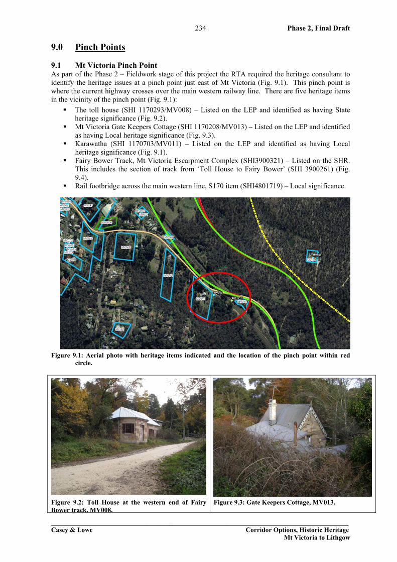
9.0 Pinch Points 9.1 Mt Victoria Pinch Point As part of the Phase 2 – Fieldwork stage of this project the RTA required the heritage consultant to identify the heritage issues at a pinch point just east of Mt Victoria (Fig. 9.1). This pinch point is where the current highway crosses over the main western railway line. There are five heritage items in the vicinity of the pinch point (Fig. 9.1):
The toll house (SHI 1170293/MV008) – Listed on the LEP and identified as having State heritage significance (Fig. 9.2).
Mt Victoria Gate Keepers Cottage (SHI 1170208/MV013) – Listed on the LEP and identified as having Local heritage significance (Fig. 9.3).
Karawatha (SHI 1170703/MV011) – Listed on the LEP and identified as having Local heritage significance (Fig. 9.1).
Fairy Bower Track, Mt Victoria Escarpment Complex (SHI3900321) – Listed on the SHR. This includes the section of track from ‘Toll House to Fairy Bower’ (SHI 3900261) (Fig. 9.4).
Rail footbridge across the main western line, S170 item (SHI4801719) – Local significance.
Figure 9.1: Aerial photo with heritage items indicated and the location of the pinch point within red circle.
Figure 9.2: Toll House at the western end of Fairy Bower track, MV008.
Figure 9.3: Gate Keepers Cottage, MV013.

Phase 2, Final Draft
_________________________________________________________________________________ Casey & Lowe Corridor Options, Historic Heritage
Mt Victoria to Lithgow
235
Figure 9.4: Sketch map of the Mt Victoria Escarpment Complex, and the location of the Fairy Bower
track from the Toll House to Fairy Bower. Smith et al 2006.

Phase 2, Final Draft
_________________________________________________________________________________ Casey & Lowe Corridor Options, Historic Heritage
Mt Victoria to Lithgow
236
9.2 Darling Causeway Pinch Point The RTA also requested a review of heritage issues associated with a pinch point on the Darling Causeway just north of Mt Victoria (Fig. 9.5). A site visit found a massive stone embankment extending for approximately 135 m (Fig. 9.6, 9.7). Stopping along the Darling Causeway is quite difficult because it is such a narrow section of road and much of it is along a ridge. As part of Phase 2 – Fieldwork project historian Ian Jack did research on the Darling Causeway so we could identify the likely date for the construction of this major embankment (Section 2.9). It is likely to date to c.1875 when the road between Mt Wilson and Mt Victoria was made after it was partially destroyed by the construction of the train line. This is a major piece of engineering works as the construction of the railway took up most of the ridge in this area and to fit a road here this large embankment need to be constructed. This is the only known section of stone embankment along the Darling Causeway but this is due more to the difficulty of access to this roadway to inspect for culverts and embankments than their necessary absence though it is noted that as the Causeway is mostly located on the top of a ridge there is limited opportunity for such construction. This embankment is currently not listed on the Blue Mountains LEP but it would be suitable for such listing and is considered to be at least of Local significance.
Figure 9.5: Location of the stone embankment on Darling Causeway, at the identified pinch point.

Phase 2, Final Draft
_________________________________________________________________________________ Casey & Lowe Corridor Options, Historic Heritage
Mt Victoria to Lithgow
237
Figure 9.6: Large stone embankment which extends for approximately 135m north of Mt Victoria.
Figure 9.7: Detail of stone facing of the embankment which consists of large well-cut stone blocks.

Phase 2, Final Draft
_________________________________________________________________________________ Casey & Lowe Corridor Options, Historic Heritage
Mt Victoria to Lithgow
238
10.0 Statutory Constraints 10.1 Commonwealth Legislation 10.1.1 Historic Heritage Environmental Protection and Biodiversity Conservation Act (EPBC)
The Environment Protection and Biodiversity Conservation Act 1999 (the EPBC Act) is the Australian Government’s central piece of environmental legislation. The EPBC Act provides a legal framework to protect and manage nationally and internationally important flora, fauna, ecological communities and heritage places — defined in the Act as matters of national environmental significance.6 The seven matters of national environmental significance to which the EPBC Act applies are:
• world heritage sites • national heritage places • wetlands of international importance (often called ‘Ramsar’ wetlands after the international
treaty under which such wetlands are listed) • nationally threatened species and ecological communities • migratory species • Commonwealth marine areas • nuclear actions.
In addition, the Act confers jurisdiction over actions that have a significant environmental impact on Commonwealth land, or that are carried out by a Commonwealth agency (even if that significant impact is not on one of the seven matters of ‘national environmental significance’). World Heritage The study area is adjacent to parts of the Greater Blue Mountains World Heritage Area (GBMWHA) which mostly runs along the eastern side of the Darling Causeway and north of the Highway east of Mt Victoria. Therefore they Commonwealth government are likely to require analysis of any potential issues that may affect the values of the World Heritage Area. The EPBC Act enhances the management and protection of Australia’s heritage places, including World Heritage properties. It provides for the listing of natural, historic or Indigenous places that are of outstanding national heritage value to the Australian nation as well as heritage places on Commonwealth lands and waters or under Australian Government control. A declared World Heritage property is an area that has been included in the World Heritage List or declared by the Minister to be a World Heritage property. Once a heritage place is listed under the EPBC Act, special requirements come into force to ensure that the values of the place will be protected and conserved for future generations. The EPBC Act provides for the preparation of management plans which set out the significant heritage aspects of the place and how the values of the site will be managed.7 The values which led to the listing of the National Park on the World Heritage List are all natural rather than cultural values. Therefore the focus of the EPBC Act is the management of these natural values. Under the EPBC Act an action that will have or is likely to have a significant impact on World Heritage values may only be taken if the action is approved by the Australian Government
6 Taken from the EPBC Act fact sheet: http://www.environment.gov.au/epbc/publications/pubs/epbc-act-fact-sheet.pdf. 7 EPBC Act http://www.environment.gov.au/epbc/protect/heritage.html.

Phase 2, Final Draft
_________________________________________________________________________________ Casey & Lowe Corridor Options, Historic Heritage
Mt Victoria to Lithgow
239
Environment Minister or is taken in accordance with a management plan accredited by the Australian Government Minister.
GBMWHA Strategic Plan The management of the GBMWHA has recently been outlined in a Strategic Plan (January 2009) which outlines the responsibilities of the State and Federal agencies. It is noted that the GBMWHA is managed on a day-to-day basis by the NSW Department of Environment and Climate Change. The GBMWHA was listed on the WHL in 2000 because it satisfies two of the criteria for natural values of outstanding universal significance:
- be outstanding examples representing significant on-going ecological and biological process in the evolution and development of terrestrial, fresh-water, coastal and marine ecosystems and communities of plants and animals; and
- contain the most important and significant natural habitats for in-situ conservation of biological diversity, including those containing threatened species of outstanding universal value from the point of view of science or conservation.8
While the listing on the World Heritage List the strategic plan recognises that there are other values in the WHA which are to be considered as part of the day to day management of the park by the National Parks and Wildlife Service. These other heritage values are ones ‘which complement and interact’ with the World Heritage values. These other values include: Geodiversity and biodiversity, Water Catchment, Indigenous, Historic, Recreation & Tourism, Wilderness and Scenic and Aesthetic. While the management strategies outlined in the Strategic Plan focus on the management of the World Heritage values it does include among its strategic objectives:
- manage the broad range of values, both World Heritage and non-World Heritage, ensuring that achieving the long-term conservation of the reserves’ World Heritage values over-riding principle.9
Cultural heritage, both Indigenous and historic, is seen as one of the 10 key management issues. The GBMWHA is to be managed to respect its cultural heritage values. National Heritage List A list of all cultural heritage items/sites within NSW which are on the National Heritage List are included in Appendix 1. There are no individual items/sites on this list within the study area. Although it is noted the whole of the GBMWHA is included on this list for its natural values – the values of which it was inscribed on the World Heritage List.10 The GBMWHA is currently being assessed for all of its values for potential National Heritage listing. Register of the National Estate The current standing of the Register of the National Estate is that it has no statutory standing and there is no requirement for a Commonwealth minister to consider heritage issues unless it is on Commonwealth owned land or on the National Heritage List or the World Heritage List.
Status of the Register of the National Estate - February 2007 The Australian Heritage Council can no longer add places to or remove places or a part of a place from the Register of the National Estate (Register). In 2006, the Environment Protection and Biodiversity Conservation Act 1999 (the EPBC Act), and the Australian Heritage Council 2003 were amended to, among other things, freeze the Register. Places may be protected under appropriate States, Territories and Local Governments heritage 8 Strategic Plan 2009:7 9 Strategic Plan 2009:24 10 Strategic Plan 2009:22

Phase 2, Final Draft
_________________________________________________________________________________ Casey & Lowe Corridor Options, Historic Heritage
Mt Victoria to Lithgow
240
legislation. Under an agreement between the Commonwealth and States and Territories it is intended that Registered places will be considered for inclusion in appropriate Commonwealth, State/Territory heritage lists. Registered places can be protected under the EPBC Act if they are also included in another Commonwealth statutory heritage list or are owned or leased by the Commonwealth. For example, registered places owned or leased by the Commonwealth are protected from any action likely to have a significant impact on the environment. There is no provision in the EPBC Act for Register of the National Estate places to be transferred to the National Heritage List or the Commonwealth Heritage List.
o Status: Indicative Definition: Data provided to or obtained by the Australian Heritage Council or the former Australian Heritage Commission has been entered into the database and the place is at some stage in the assessment process. A decision on whether the place should be entered in the Register has not been made.
o Status: Identified Definition: The former Australian Heritage Commission has assessed the values of this place and decided that it should be entered in the Register. The place had not reached the Interim List stage by 1 January 2004 when the Commission was abolished.
o Status: Interim list Definition: The place was in the Interim List at 1 January 2004 when the Australian Heritage Commission was abolished. The place had been publicly proposed for entry in the Register.
o Status: Registered Definition: The place is in the Register of the National Estate. Although some places may be legally registered because they are within a larger registered area they may not necessarily possess intrinsic significance. 10.2 State Legislation 10.2.1 Historic Heritage NSW Heritage Act 1977 (amended) Division 9: Section 139, 140-146 - Relics Provisions - Excavation Permit The main legislative constraint on archaeological remains is the relics provisions of the NSW Heritage Act 1977. According to Section 139:
A person must not disturb or excavate any land knowing or having reasonable cause to suspect that the disturbance or excavation will or is likely to result in a relic being discovered, exposed, moved, damaged or destroyed unless the disturbance or excavation is carried out in accordance with an excavation permit.
A person must not disturb or excavate any land on which the person has discovered or exposed a relic except in accordance with an excavation permit.
A ‘relic’ is an item of ‘environmental heritage’ defined by the NSW Heritage Act 1977 as:
those places, buildings, works, relics, moveable objects, and precincts of State or local heritage significance.

Phase 2, Final Draft
_________________________________________________________________________________ Casey & Lowe Corridor Options, Historic Heritage
Mt Victoria to Lithgow
241
A relic as further defined by the Act is: ..any deposit, object or material evidence - (a) which relates to the settlement of the area that comprises New South Wales, not being Aboriginal settlement; and (b) which is 50 or more years old. Any item identified as an historical archaeological site, item or relic cannot be impacted upon without an excavation permit approval from the NSW Heritage Council. An excavation permit forms an approval from the NSW Heritage Council for permission to ‘disturb’ a relic. As part of the lodgement process an Archaeological Assessment should be written to address the specific issues arising from a proposed impact. Under current policy items of State Heritage significance should be retained in situ. Therefore if relics within the Reserve are considered to be of State significance they should be retained in situ. The NSW Heritage Office has produced a Heritage Manual with guidelines for writing Archaeological Assessment, Heritage Impact Statements and Statements of Heritage Significance.
• Section 57 - Items on the NSW State Heritage Register A number of items within the study area were identified as being listed on the State Heritage Register (SHR) this means they are protected under the NSW Heritage Act, Section 57. When an application (S60) is made to the NSW Heritage Council to impact on an SHR item they require a series of specific issues to be addressed. Any proposed impact will require a Section 60 application which will go before the NSW Heritage Council for consideration. Sites and heritage items listed on the SHR are considered to be of State heritage significance and it is the intention of the Heritage Council to retain such sites and heritage items, which is the purpose of such a listing.
• NSW State Heritage Inventory The listing of an item on the State Heritage Inventory (SHI) does not offer it any statutory protection. Generally a listing indicates that the item is scheduled elsewhere, such as on a Council’s LEP or on the State Heritage Register or is a known relic.
• Section 170 Registers The study area contains a number of known items on S170 registers administered by State government departments: Department of Environment and Climate Change, Rail Corp and RTA. Under the NSW Heritage Act 1977 all government statutory authorities are required to maintain a S. 170 register. This is a list of sites which the statutory authority needs to maintain. According to Section 170:
(3) A government instrumentality shall establish and keep a register entitled the ‘Heritage and Conservation Register’.
(4) A government instrumentality shall enter in the register details of each item of the environmental heritage—
(a) which – i. is subject to an interim heritage order or listing on the State Heritage
Register; or ia. is listed in an environmental planning instrument under the Environmental Planning & Assessment Act 1979 as an item of environmental heritage, or
ii. could, in accordance with guidelines issued from time to time by the Heritage Council, be subject to an interim heritage order or listing on the State Heritage Register; and
(b) which— i. in the case of a statutory body, is owned or occupied by the statutory
body; or

Phase 2, Final Draft
_________________________________________________________________________________ Casey & Lowe Corridor Options, Historic Heritage
Mt Victoria to Lithgow
242
ii. in the case of a Department head, is vested in or owned or occupied by, or subject to the control of, the appropriate minister or the Department.
NSW National Parks and Wildlife Act The GBMWHA is managed under the NPW Act and the GBMWHA reserves are subject to the National Parks and Wildlife Act 1974 and the Wilderness Act 1987. According to the Strategic Plan for the management of the GBMWHA the following aspects of will be appropriately managed under this legislation: The following general purposes relate to the management of the national parks in NSW:
• the protection and preservation of the scenic, natural and cultural features; • the conservation of wildlife; • the maintenance of natural processes as far as possible; • the provision of appropriate recreational opportunities; and • the encouragement of scientific and educational inquiry into environmental features and processes, prehistoric and historic features, and park use patterns.
10.3 Local Council Statutory Controls All these have been reviewed for currency: 10.3.1 Blue Mountains City Council
• Local Environmental Plan 4 This plan has been superseded by the draft LEP 2000.
• Local Environmental Plan (1991) The heritage related clauses in this LEP are 25 (1) to (7). Council consent is required for any proposed impact on a known heritage item or any building, work or relic, tree or horticultural feature within a Heritage Conservation Area. Council can only grant consent to a development application for a heritage item and its setting and within a conservation area after reviewing and assessing the impact of the development on its heritage significance. This usually takes the form of a Heritage Impact Statement. Council will refer any such application to the NSW Heritage Branch, unless the works are considered to be minor. It should be noted that the Council consent required for any impacts on within a heritage conservation area specifically applies constraints to Mt Victoria.
• Local Environmental Plan (2002) This plan updates and amends the LEP 4 but does not amend LEP 1991. 10.3.2 Greater Lithgow City Council Local Environmental Plan (1994) The Lithgow City Council LEP is in the process of being updated but it is not yet available in draft form. Council has kindly provided this project with access to the inventory sheets and the GIS data for mapping. The current LEP 1994 and its schedule of sites have been incorporated into the list of sites (Table 3.2) but location details are unclear. Further stages of work on this project will need to review the draft of the new LEP when it becomes available. Under Part 4, Clause 40 of the LEP Council consent is required to demolish, alter, damage, despoil or destroy a heritage item. The Council will give the NSW Heritage Council notification and take their comments into consideration in their consent. Prior to granting of consent to impact on a heritage item the Council ‘must consider the impact of the development on the heritage significance of the item’. Under Clause 41 Council must also consider any impact in the vicinity of a heritage item as it may affect the significance and setting of the item.

Phase 2, Final Draft
_________________________________________________________________________________ Casey & Lowe Corridor Options, Historic Heritage
Mt Victoria to Lithgow
243
Clause 42 deals with Council’s role in giving ‘consent to development on known or potential archaeological’ sites or relics. This refers to those covered by Schedule 1. 10.3.3 Other Registers National Trust of Australia (NSW)
The National Trust register of sites has no statutory authority but is seen as a register of significant sites and will be taken into account by Statutory Authorities in their assessment of Statement of Heritage Impacts and other assessments.

Phase 2, Final Draft
_________________________________________________________________________________ Casey & Lowe Corridor Options, Historic Heritage
Mt Victoria to Lithgow
244
11.0 Heritage Significance 11.1 The Burra Charter and Significance The Australian International Council on Monuments and Sites (ICOMOS Australia) Charter for the Conservation of Places of Cultural Significance (the Burra Charter) was adopted in 1979 by ICOMOS Australia and revised in 1981 and 1988. The BURRA CHARTER established a set of principles and standards for heritage conservation which are referred to widely by heritage agencies and practitioners. Its standards are obligatory for conservation agencies receiving federal funding in Australia (Pearson & Sullivan 1995:44). The Charter defined cultural significance as ‘aesthetic, historic, scientific or social value for past, present or future generations’. A 1999 draft revision adds spiritual value to the list, and states that ‘cultural significance is embodied in the place itself, its fabric, setting, use, associations, meanings, records, related places and related objects’, noting that places may have a range of values for different individuals or groups. For the BURRA CHARTER the aim of conservation is to retain the cultural significance of a place (Article 2). The Guidelines to the Burra Charter - Cultural Significance (ICOMOS 1988) define the concept of cultural significance as including aesthetic, historic, scientific and social values. Historic value (2.3) encompasses the history of aesthetics, science and society, ‘and therefore to a large extent underlies all of the terms set out in this section’. Social value is defined in (2.6) as embracing ‘the qualities for which a place has become a focus of spiritual, political, national or other cultural sentiment to a majority or minority group’. 11.2 Significance and Historic Heritage The heritage significance of many of the heritage items and sites is relatively well defined through LEP and SHR listings. Other items, usually relics or archaeological sites, need to be further assessed to establish their significance through research, fieldwork and assessment. These have been given a preliminary level of Local significance. It is possible that some of the sites or relics may be reassessed as having State significance or no heritage significance. 11.2.1 Heritage Significance Criteria Basis of Assessment of Heritage Significance To identify the heritage significance of an archaeological site it is necessary to discuss and assess the significance of the study area. This process will allow for the analysis of the site’s manifold values. These criteria are part of the system of assessment which is centred on the Burra Charter of Australia ICOMOS. The Burra Charter principles are important to the assessment, conservation and management of sites and relics. The assessment of heritage significance is enshrined through legislation in the NSW Heritage Act 1977 and implemented through the NSW Heritage Manual and the Archaeological Assessment Guidelines.11 The various nature of heritage values and the degree of this value will be appraised according to the following criteria:12 Nature of Significance Criteria Criterion (a): Historic Significance - (evolution)
an item is important in the course, or pattern, of NSW’s cultural or natural history (or the cultural or natural history of the local area);
Criterion (b): Associative Significance – (association)
11 NSW Heritage Office 1996:25-27. 12 NSW Heritage Office 2001.
Phase 2, Final Draft
_________________________________________________________________________________ Casey & Lowe Corridor Options, Historic Heritage
Mt Victoria to Lithgow
245
an item has strong or special association with the life or works of a person, or group of persons, or importance in NSW’s cultural or natural history (or the cultural or natural history of the local area);
Criterion (c): Aesthetic Significance - (scenic qualities / creative accomplishments)
an item is important in demonstrating aesthetic characteristics and/or a high degree of creative or technical achievement in NSW (or the cultural or natural history of the local area);
Criterion (d): Social Significance - (contemporary community esteem)
an item has a strong or special association with a particular community or cultural group in NSW for social, cultural or spiritual reasons (or the cultural or natural history of the local area);
Criterion (e): Technical/Research Significance - (archaeological, educational, research
potential and scientific values) an item has potential to yield information that will contribute to an understanding of NSW’s cultural or natural history (or the cultural or natural history of the local area);
Criterion (f): Rarity an item possesses uncommon, rare or endangered aspects of NSW’s cultural or natural history (or the cultural or natural history of the local area);
Criterion (g): Representativeness
an item is important in demonstrating the principal characteristics of a class of NSW’s cultural or natural places of cultural or natural environments (or the cultural or natural history of the local area).
To be assessed as having heritage significance an item must:
• meet at least one of the one of the seven significance criteria • retain the integrity of its key attributes
Items may also be ranked according to their heritage significance as having:
• Local Significance • State Significance
Research Potential
Research potential is the most relevant criterion for assessing archaeological sites. However, assessing research potential for archaeological sites can be difficult as the nature or extent of features is sometimes unknown, therefore judgements must be formed on the basis of expected or potential attributes. One benefit of a detailed archaeological assessment is that the element of judgement can be made more rigorous by historical or other research.13
13 NSW Heritage Office 1996:26.

Phase 2, Final Draft
_________________________________________________________________________________ Casey & Lowe Corridor Options, Historic Heritage
Mt Victoria to Lithgow
246
Assessment of Research Potential Once the archaeological potential of a site has been determined, research themes and likely research questions identified, as addressed through archaeological investigation and analysis, the following inclusion guidelines should be applied: Does the site: (a) contribute knowledge which no other resource can? (b) contribute knowledge which no other site can? (c) is the knowledge relevant to general questions about human history or other substantive problems relating to Australian History, or does it contribute to other major research questions?14 If the answer to these questions is yes then the site will have archaeological research potential.
14 Bickford, A. & S. Sullivan 1984:23.

Phase 2, Final Draft
_________________________________________________________________________________ Casey & Lowe Corridor Options, Historic Heritage
Mt Victoria to Lithgow
247
12.0 References GHD 1999 Great Western Highway Upgrade, Little Hartley, EIS, Vol 2, Technical Papers, Hubert Architects with Siobhan Lavelle, R Ian. Jack and Colleen Morris 2002 Blue Mountains
Cemeteries, Conservation Management Plans, Vol 4, Megalong, Mount Victoria and Mount Irvine, unpublished report for the City of Blue Mountains. This is available on the internet.
Lavelle, Siobhan 1999 Historical archaeological and heritage assessment, Upgrading of the Great Western Highway, Little Hartley, NSW, for Musecape.
Smith, Jim, David Beaver and Chris Betteridge 2006 Tracks into History, Conservation Management Plan for the Walking tracks of State heritage significance in the Blue Mountains, prepared for Department of Environment and Conservation, parts 1 and 2.