Embed Size (px)
Citation preview

Eastside Transit Corridor Phase 2
Draft Environmental Impact Statement/
Environmental Impact Report
APPENDIX K
URBAN DESIGN
State Clearinghouse Number: 2010011062


EASTSIDE TRANSIT CORRIDOR PHASE 2 PROJECTFINAL URBAN DESIGN CONCEPT REPORT
January, 2011


3
Cover................................................................................................................................... 1
Table of Contents....................................................................................................... 3
Introduction................................................................................................................... 5
Station Visioning - Design Principles............................................................ 9
Station Visioning - Kit Of Parts....................................................................... 15
SR 60 LRT Alternative - Garfi eld Avenue................................................. 21
SR 60 LRT Alternative - Shops at Montebello...................................... 29
SR 60 LRT Alternative - Santa Anita Avenue......................................... 37
SR 60 LRT Alternative - Peck Road............................................................... 45
Washington Blvd. LRT Alternative - Garfi eld Avenue..................... 53
Washington Blvd. LRT Alternative - Whittier Boulevard............... 61
Washington Blvd. LRT Alternative - Greenwood Avenue............ 69
Washington Blvd. LRT Alternative - Rosemead Boulevard......... 77
Washington Blvd. LRT Alternative - Norwalk Boulevard.............. 85
Washington Blvd. LRT Alternative - Lambert Road.......................... 93
Urban Design Character Sketches............................................................ 101
Appendix UDWG City Meeting Notes.................................................... 111
TABLE OF CONTENTS
EASTSIDE PHASE 2 – URBAN DESIGN CONCEPT REPORT


To achieve this goal, each station was analyzed to understand the diff erent contextual conditions needed to fully integrate a transit alternative. Each station was analyzed to address the proposed alignment confi guration to its existing conditions surrounding the station location, as well as to integrate community image, provide for future corridor development, and create pedestrian-friendly streetscapes. In doing so, several objectives were taken into consideration including:
• Community integration, access and linkages
• Station alignment, layout, and confi guration (including Aerial and At-grade design)
• Parking demand and park and ride facilities
• Existing and future land use patterns and transit oriented development opportunities
• Multi-modal access including pedestrian, automobile, bus and bicycle access safety
The conceptual plans contained in this report, were designed to accommodate the needs of the program established above, and follow Metro guidelines for prioritization of accessibility as outlined below:
(1) Pedestrian
(2) Bicyclist
(3) Bus
In order to ensure the objectives and priorities listed above were taken into consideration on a station by station basis; a framework of “design principles” was used to lead discussions with staff and stakeholders. Secondly, a “kit of parts” was established to illustrate the various station design elements under evaluation in the development of the conceptual station plans. Lastly, the team developed scale model pieces, to demonstrate how the proposed station and adjacent uses would fi t within the individual community context. The process used to develop the station concept plans is described in subsequent sections.
In summary, the Urban Design Report provides a framework and conceptual design for stations along the Eastside Transit Corridor Phase 2 project. The conceptual station plans and renderings look to the future by incorporating existing plans from the various cities as well as plans for further community integration. The stations areas not only provide much needed transit infrastructure to the corridor but illustrate opportunities for further connectivity and linkages to residential and commercial activity, building upon city plans and potential for targeted development within the project area.
(4) Kiss and Ride (automobile)
(5) Park and Ride (automobile and motorcycle)
5
As part of the Eastside Transit Corridor Phase 2 Project, an urban design process for station area planning, city and stakeholder engagement, and development of conceptual station plans was conducted and summarized in the Urban Design Concept Report. The process involved in the development of the conceptual station plans included a design framework and principles, data collection, review of city plans and policies, participation from city representatives, and input from key stakeholders.
The proposed Eastside Transit Corridor Phase 2 Project would provide an extension of the Metro Gold Line from East Los Angeles to communities farther east. The project area is generally bounded by Pomona Boulevard and State Route 60 (SR 60) Freeway to the north, Peck Road and Painter Avenue to the east, Olympic and Washington Boulevards to the south, and Atlantic Boulevard to the west.
EXECUTIVE SUMMARY
Introduction
URBAN DESIGN REPORT CONCEPTSThe process used to develop the Urban Design Concept Report and conceptual station plans involved:
• Consulting key city staff to collect information and verify documentation of plans and reports including general plans, specifi c plans, redevelopment plans, and other relevant documents
• Soliciting feedback on major station elements and adjacent land planning opportunities and constraints
• Working with the outreach team to solicit feedback from key city staff and the public on station planning concepts
• Incorporating input from stakeholders on station planning opportunities and constraints as well as neighborhood character and identity
• Presenting station concept plans and urban design renderings developed through the process
• Identifying next steps for the urban design process to be addressed in subsequent phases of the project
PURPOSE
The main purpose of the Urban Design Concept Report is to develop conceptual station area plans and renderings, at an appropriate scale for conceptual design, to illustrate the station’s fi t into the neighborhood context and illustrate multi-modal connectivity. The report is designed to provide conceptual station plans developed in coordination with the Draft Environmental Impact Statement/Environmental Impact Report (DEIS/R) process.
The Urban Design Concept Report summarizes data collection, consultation and visioning for station areas within the project area for the current phase of work. The process builds on previous studies including the Station Concepts Report completed in December of 2009 as part of the Alternatives Analysis (AA) Addendum.
During the AA process, station area planning for four potential alignments analyzed land use, street and block connectivity, bus connectivity, Transit Oriented Development (TOD) potential and Park and Ride (PNR) opportunities. At the conclusion of the AA process, two build alternatives were identifi ed for further study as part of the Draft Environmental Impact Statement/Draft Environmental Impact Report (DEIS/R). These included the SR 60 Light Rail Transit Alternative and Washington Boulevard Light Rail Transit Alternative, currently under evaluation.
The Urban Design Concept Report provides analysis of stations along the SR 60 LRT and Washington Boulevard LRT alignments.
To solicit input from staff and stakeholders within the project area, an Urban Design Working Group (UDWG) was established. The UDWG process involved individual city consultation meetings and workshops with stakeholders to discuss potential station locations and develop a vision for the station areas. The UDWG process involved participation from the cities of Commerce, Montebello, Monterey Park, Pico Rivera, Rosemead, Santa Fe Springs, El Monte, South El Monte, and Whittier.
FINAL URBAN DESIGN CONCEPT REPORT

6
PROCESS
Vision
The urban design principles and kit of parts served as the foundation for a discussion on station area visioning, described in the Urban Design Concept Report. The process involved data collection on city plans, individual meetings with city staff and workshops held with key stakeholders. Detailed notes from city meetings are attached as a reference to the report. Input received from the stakeholder outreach is documented separately in the Metro Eastside Transit Corridor Phase 2 Urban Design Working Group Stakeholder Workshops Summary Report. This report summarizes the process of engagement and identifi es key fi ndings on a station by station basis.
Data Collection
As part of the urban design study, the design team gathered and analyzed information from participating cities within the Eastside Transit Corridor Phase 2 project area. The team identifi ed existing and proposed plans relating to issues of land use, transportation, and redevelopment. Principles from each of the city’s general plan documents were summarized and are included as part of the Urban Design Concept Report.
The Federal Transportation Administration (FTA) New Starts funding process encourages transportation agencies to work with local jurisdictions that govern land use decisions on proposed station area planning eff orts. In January 2010, Secretary of Transportation Ray La Hood announced that the Obama Administration proposed major changes to federal transportation polices to encourage projects that promote livability issues such as economic development opportunities and environmental benefi ts.
In coordination with these policies, the design team and Metro initiated the Urban Design Working Group as a vehicle to begin a series of dialogues with city staff and stakeholders within the project area about station planning elements, community characteristics, and themes for the development of the station concept plans. The ultimate goal was to better coordinate station area planning and improve livability factors for the neighborhoods and communities served by the proposed alternatives. The process was also designed to foster partnerships with local jurisdictions in the project area and Metro on station planning opportunities. Input received from the meetings was used to develop elements of the conceptual station plans included in this report.
The UDWG process involved 5 steps. Step One - Initial Meetings, Step Two - Individual City Consultation Meetings, Step Three - Stakeholder Workshops, Step Four - Project Status Updates, Step Five - Follow-up Meetings, with the cities.
STEP ONE – INITIAL MEETINGS 28 APRIL 2010Metro and members of the technical planning and urban design team organized two initial meetings with UDWG members along each of the alignment corridors (SR 60 and Washington Boulevard). The meetings involved city staff and decision makers from cities along the alignments. The objectives of the initial meetings were to introduce the project team, review the overall urban design program and schedule for the current phase of work, identify planning documents requested by the project team, review station concept plans developed during the AA addendum process and establish a common understanding of the project for individual follow up meetings.
STEP T WO – INDIVIDUAL CITY CONSULTATION MEETINGS 27 MAY 2010 – CITY OF SANTA FE SPRINGS1 JUNE 2010 – CITY OF MONTEREY PARK1 JUNE 2010 – CITY OF WHIT TIER2 JUNE 2010 – CITY OF MONTEBELLO3 JUNE 2010 – CITY OF EL MONTE AND SOUTH EL MONTE3 JUNE 2010 – CITY OF COMMERCE4 JUNE 2010 – CITY OF PICO RIVERA
A series of six meetings were held with cities near proposed stations along the alignments. Meetings were held with the cities of Santa Fe Springs, Commerce, Monterey Park, Montebello, Pico Rivera, South El Monte/ El Monte, and Whittier. City staff , technical managers, and key decision makers from city departments were invited to attend. The meetings provided a venue to discuss station area planning activities at the local level and solicit direct input on proposed station locations and coordination with city plans. The design team presented an overview of “Station Planning 101” to the cities and discussed opportunities and constraints within a ¼ mile of each station. The design team also reviewed city general plan principles, introduced the urban design principles, kit of parts concepts, and identifi ed critical items for consideration in the development of each station. Feedback received from this process is discussed for each station in the conceptual plans that follow.
STEP THREE – STAKEHOLDER WORKSHOPS 24 JUNE 2010 – CITY OF WHIT TIER AND SANTA FE SPRINGS12 JULY 2010 – CITY OF MONTEBELLO, MONTEREY PARK, ROSEMEAD AND COMMERCE13 JULY 2010 – CITY OF PICO RIVERA15 JULY 2010 – CITY OF EL MONTE, SOUTH EL MONTE AND INDUSTRY
Metro and the public outreach team facilitated a series of focus group meetings to discuss station locations along the two build alternatives. The main goal of focus group meetings was to provide information to city stakeholders on the Eastside Transit Corridor Phase 2 project, introduce station area planning concepts, solicit feedback from stakeholders on key station planning elements including, opportunities, constraints and input on major themes. The meetings utilized visual preference surveys and small group roundtables to discuss the proposed planning eff orts for each station. Four meetings were held with participants from cities within the project area, including the cities of; Whittier, Santa Fe Springs, Montebello, Monterey Park, Rosemead, Commerce, Pico Rivera, South El Monte, El Monte, and Industry.
STEP FOUR – PROJECT STATUS UPDATE MEETINGS
Metro and the public outreach team presented information on station planning and urban design process as part of the general project status update. The meetings provided the public with an opportunity to hear information on the urban design study of proposed stations, and identifi ed opportunities for the public to provide comment and receive future updates on the process.
STEP FIVE – FOLLOW UP MEETINGS WITH CITIES
A series of individual follow up meetings were conducted with the six cities originally consulted. The purpose was to review “what was heard” along with the conceptual station plans. The goal of the meeting was to present the results of the urban design study, solicit feedback from cities and identify next steps.
URBAN DESIGN REPORT CONCEPTS
Introduction
FINAL URBAN DESIGN CONCEPT REPORT

7
With established design principles, kit of parts, research from various plans and initial feedback from the Individual city and stakeholder meetings, the design team began to develop station concept plans. For each station a theme or idea was embraced based on what we learned to enhance the quality of the station character and neighborhood. The following summarizes key concepts for each station. These are described in more detail in subsequent sections.
SR 60 LIGHT RAIL TRANSIT ALTERNATIVE
GARFIELD AVENUE
An identity plaza is created to serve as a gateway between the cities’ of Montebello and Monterey Park at the intersection of Garfi eld Avenue and Via Campo. The plaza also anchors the existing neighborhood commercial strip and serves as an opportunity for public art and/or water features for community identity. Enhanced landscaping along Garfi eld Avenue will create a stronger link between the communities of Monterey Park and Montebello as an opportunity for a larger envisioned civic “greenway” extending north and south of the SR 60.
SHOPS AT MONTEBELLO
Created for The Shops at Montebello is a new signature transit plaza and roundabout. This anchors the station west of the mall along a proposed promenade for the “Shops”. To the east, the promenade is anchored by an entrance to the mall and food court with potential development opportunities along and in between. The Kaiser Permanente facility is provided with enhanced station connectivity to be part of a greater station concept plan.
SANTA ANITA AVENUE
While a concept site plan for the Santa Anita Avenue Station has not been fully envisioned per direction from Metro, there was strong input from the community and stakeholders for a mixed use destination Transit Oriented Development. The proposed site would anchor the southern end of the commercial corridor along Santa Anita Avenue and it’s civic core as well as serve as a front door to the Whittier Narrows Park. Additional ideas from the community, included stronger connectivity across the SR 60 for an enhanced pedestrian and bicycle connection from station to commercial corridor.
PECK ROAD
Adjacent to the San Gabriel River and close to the Whittier Narrows Park, the landscape character of the station borrows from the informal and lush materials of the river’s edge and basin. This creates a strong visual relationship from the station to the recreational network along the San Gabriel River. It is supported by secure walkways for pedestrians and bicyclists alike. The station is also straddles across Peck Road to create a unique “gateway” between the cities of South El Monte and Whittier.
WASHINGTON BOULEVARD LIGHT RAIL TRANSIT ALTERNATIVE
GARFIELD AVENUE
This alternative, the station layout creates a “greenway” concept building upon existing conditions and a landscape enhancement zone north of SR 60. This is integrated with development opportunities along Garfi eld Avenue centered about a transit plaza. This creates a rich opportunity for a unique environment using hard and softscape implementing plenty of art opportunities for community identity.
GREENWOOD AVENUE
Creating a gateway between Commerce and Montebello from the east to west and north to south, this station is uniquely placed to not only address livability but workability as well. Commerce could connect to this location with shuttle service to its industrial base while the station location serves its community. The site can accommodate potential gateway development opportunities and takes advantage of multiple bus lines. ROSEMEAD BOULEVARD
This location takes advantage of its direct connectivity with the Pico Rivera Town Center and Marketplace. Reinforcing an already established center of the community, this station is integrated with the 2 commercial centers and binds them together. Borrowing from the theme of “a place between two rivers” the canopy structures for the light rail station and bus stations may take a unique fl owing form reinforcing the identity of the community.
NORWALK BOULEVARD
Situated adjacent to the Santa Fe Springs Marketplace, this location takes advantage of its connectivity to the marketplace and surrounding neighborhoods. An identity plaza, situated at the intersection, serves to orient the visitor and integrate the city’s Heritage Art and Public Space Program. This too creates a signature gateway between Santa Fe Springs and Whittier.
LAMBERT ROAD
The station concept plan is fully envisioned along with the city of Whittier as a fully integrated potential Transit Oriented Development. The station was purposefully pulled into the center of the site maximizing the perimeter for ground fl oor retail and apartments above, thus making the development a signature station with an entry portal for the train. Complete with plazas, multiple linkages to and from the street provide for a strong destination for patrons of mass transit to enjoy.
WHIT TIER BOULEVARD
Creates a southern terminus to the “greenway” of Garfi eld Avenue and presents the opportunity for a signature gateway to the Whittier Boulevard commercial corridor. As part of the “greenway” concept, the station and guideway columns accommodate for planting materials to break down the scale of the structure and create a softer feel along Garfi eld Avenue. Highly connected with existing bus lines and surrounding neighborhoods, the station itself is uniquely integrated into its neighborhood context.
SUMMARY
Overall, the Urban Design Concept Report documents the extensive process used to develop the conceptual station plans and renderings for the Eastside Transit Corridor Phase 2 project. The report summarizes the processed used to gather data, solicit input and illustrate station area potential within the project area. In addition to the development of the report itself, the process was key to establishing coordination between Metro and the jurisdictions within the project area.
The following sections provide a detailed analysis of each station including station area concept, incorporation of urban design principles, discussion of key insights from the city staff and stakeholders, ¼ mile station area diagrams, concept diagrams, pedestrian and bicycle circulation diagrams, and vehicle circulation diagrams. In addition, renderings for four typical station conditions are provided to illustrate the potential character, fi t and design of stations along the proposed alignments.
EXECUTIVE SUMMARY
Introduction
URBAN DESIGN REPORT CONCEPTS
FINAL URBAN DESIGN CONCEPT REPORT

8

9
STATION VISIONINGDESIGN PRINCIPLES

10
Once the data collection and the individual city consultation meetings were completed, a series of fundamental design principles were established. The principles needed to be simple enough to understand and still be comprehensive. These principles created the formative framework for station planning and concept design. These principles are:
• Create community identity
• Integrate station to support existing land uses and future opportunities
• Create accessible “multi-modal” stations
• Create a safe and secure environment
• Integrate sustainable measures
• Amenitize the station
DESIGN PRINCIPLES
Station Visioning
CREATE COMMUNITY IDENTITY
This applies to a wide variety of concepts that may be implemented into a station plan. They may include but not be limited to places, character or objects.
To further explain, a place like a plaza may serve as the cornerstone of a neighborhood linking the station with development opportunities creating a place greater than the station. A community or neighborhood’s identity may be represented in the existing character of the landscape that already off ers a unique experience. The station provides an opportunity to expand that character and allow it to fl ourish. Finally, objects such as gateways, station canopies or public art present additional opportunities for community identity.
INTEGRATE STATION TO SUPPORT EXISTING LAND USES AND FUTURE OPPORTUNITIES
The fi rst step in this process was to collect and then research general plans, specifi c plans and redevelopment plans of the jurisdictions involved with the project. Secondly, we searched for ways to evolve or reinvent a city’s plan from their existing conditions. This allowed the station concept site plan to bridge the gap between stagnation and revitalization at a station location and to enhance what is already there.
CREATE ACCESSIBLE “MULTI-MODAL” STATIONS
First and foremost, transportation is all about moving people. Conveniently, effi ciently and safely; each station needs to cater to the individual and their transportation needs to allow a community, city and region to fl ourish. Therefore the station needs to provide that transfer point from pedestrian, bicycle, bus, LRT and private vehicle, off ering the proper facilities to make the station effi cient and enjoyable to a wide variety users.
CREATE A SAFE AND SECURE ENVIRONMENT
The station design needs to be executed in a manner that is inviting and experiential. People should feel comfortable in a place where they need to wait between modes of transportation. Either by way of light, adjacent people gathering spaces, quality of space and interest the station becomes more than a station but a place to be enjoyed.
INTEGRATE SUSTAINABLE MEASURES
Each station should look to ways of integrating measures of sustainability. The design of each station should achieve the most simple energy, water runoff , and recyclable measures, as well as economic and livability measures. While we may integrate solar or photovoltaic panels in the design of a station to reduce its energy consumption, we should also weigh the value of ease of use and promotion of transit oriented development to reduce the demand on private vehicles. We need to strive and promote a more sustainable way to move into the future.
AMENITIZE THE STATION
This addresses the station as a place about people. People need places to shop, eat, live and transact the simple needs of daily life. Each station should strive to provide, to one level or another, these needs. A place to celebrate their neighborhood with entertainment retail and/or community services adds value to that station and neighborhood equally, each supporting one another..
Additionally, the team reviewed the mission statements, goals and objectives of the cities involved with the Eastside Transit Corridor Phase 2 Project. We then created a series of graphics noting their objectives alongside the base principles to review and compare. In many cases the themes were consistent with the base principles and contained more detail for consideration. As we move into station design, the principles become a check list for review with each station. The stations should measure up and support the base and city principles which ultimately will yield a more vibrant and sustainable design, physically and economically.
Cities Reviewed:
• El Monte
• Montebello
• Monterey Park
• Pico Rivera
• Rosemead
• Santa Fe Springs
• South El Monte
• Whittier
FINAL URBAN DESIGN CONCEPT REPORT

11
City of El Monte City of Montebello
City of Monterey Park City of Pico Rivera
FINAL URBAN DESIGN CONCEPT REPORT

12
City of Rosemead City of Santa Fe Springs
City of South El Monte City of Whittier
FINAL URBAN DESIGN CONCEPT REPORT

13FINAL URBAN DESIGN CONCEPT REPORT


15
STATION VISIONINGKIT OF PARTS

16
KIT OF PARTS
Station Visioning
The “Kit of Parts” provides a list of elements to be considered for all station sites. Each part has been carefully selected as they relate to and expand upon the design principles. The Kit of Parts were presented at the city consultation and stakeholder meetings to illustrate a menu of design options used to create a successful place and streetscape. Not each station needs to incorporate all parts but the intent was to initiate a discussion based upon the menu. While Metro design guidelines may not provide some of the elements shown, the discussion was to structure a format for collaboration between agency, municipality and or private venture to partner and create a successful station location.
The station should be viewed as more than just a point of departure and arrival for people to commute. It’s a place where people may interact with ancillary uses needed for a thriving neighborhood locale. The station should be integrated with the existing fabric and streetscape to be an added value to the community. This is an opportunity to showcase unique characteristics about the surrounding neighborhood, through public art, station design or iconic gateway elements.
Consistent with these plans, the Urban Design Concept Report considers all the parts, stated below, for each station. Each Kit of Part is identifi ed with one or more design principles . Together they promote future development in a way that advocates transit use in a pedestrian friendly environment, for now and for years to come.
Identity + Amenitize
Identity + Safe and Secure + Amenitize
FINAL URBAN DESIGN CONCEPT REPORT

17
Identity
Identity + Sustainable + Amenitize
Identity + Safe and Secure + Accessible
Identity + Amenitize
FINAL URBAN DESIGN CONCEPT REPORT

18
Identity + Integrate
Identity + Accessible
Identity + Integrate + Safe and Secure + Accessible
Identity + Integrate + Accessible
FINAL URBAN DESIGN CONCEPT REPORT

19
Identity + Integrate + Safe and Secure + Sustainable
Identity + Integrate + Safe and Secure + Accessible
Identity + Integrate + Safe and Secure + Sustainable
Identity + Integrate + Safe and Secure + Accessible
FINAL URBAN DESIGN CONCEPT REPORT

21
SR 60 LRT ALTERNATIVEGARFIELD AVENUE
SUMMARY
An identity plaza is created to serve as a gateway between the cities’ of Montebello and
Monterey Park at the intersection of Garfi eld Avenue and Via Campo. The plaza also
anchors the existing neighborhood commercial strip and serves as an opportunity for
public art and/or water features for community identity. Enhanced landscaping along
Garfi eld Avenue will create a stronger link between the communities of Monterey Park and
Montebello as an opportunity for a larger envisioned civic “greenway” extending north and
south of the SR 60.
WHAT WE HEARD:
Montebello/Monterey Park City Comments,Individual City Meetings Highlights• Provide Kiss and Ride (KNR) locations
• Ensure Functional design of easy Bus/Train transfers
• Include a bridge crossing from parking lot to station platform due to walking duration
and traffi c concerns
Stakeholder Preference Survey and Station Map Group DiscussionsHighlights and Summary• Land Use: strongly liked mixed-use development with commercial and residential
patterns
• Station Integration: strong dislike for the at-grade, open space station design
• Streetscape & Safety: strongly liked streetscapes with ample pedestrian access
• Connectivity: strongly liked tree-lined pathways and access for pedestrians and
bicycles
• Parking: strongly disliked at-grade parking
• Create a potential for mixed use development and park-n-ride structure on southeast
corner of Garfi eld Avenue and Via Campo
• Provide pedestrian bridges for secure access to station
• Maintain the existing commercial strip along Garfi eld Avenue
• Create better access north of the SR 60 by improving the underpass, better lighting,
wider sidewalks, etc.
• Provide good pedestrian links to bus connectivity
• Enhance streetscape along Garfi eld Avenue with improved lighting and curved
walkways
• Provide safe access to station from the street and parking lots

22
Public Outreach Meeting with the city’s Stakeholders
Sample station concept through consultation with City Staff
Public Outreach Meeting with the city’s Stakeholders
Sample station concept through consultation with City Staff
STAKEHOLDER AND INDIVIDUAL CITY WORKSHOPS
23
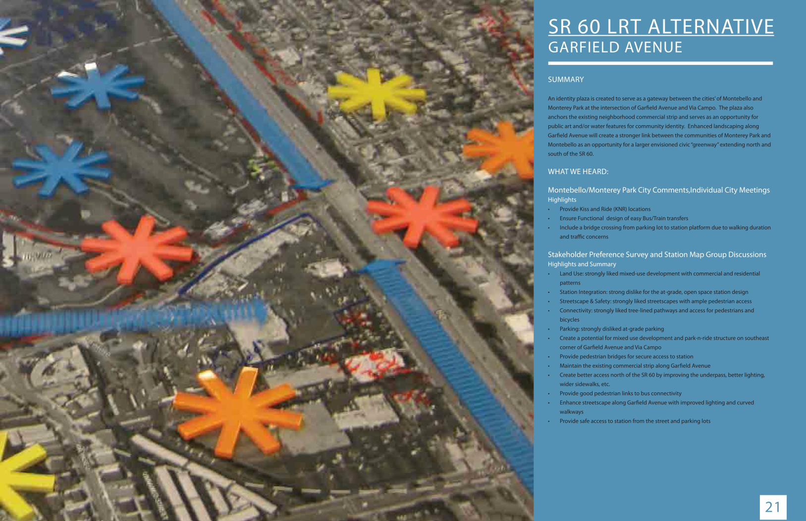
1/4 MILE - 5 TO 10 MIN. WALK
PROPOSED STATION LOCATION
EXISTING RESIDENTIAL
EXISTING COMMERCIAL
EXISTING OPEN SPACE
EXISTING INSTITUTIONAL
PROPOSED PARKWAY CONNECTIVITY
EXISTING RESIDENTIAL CONNECTIVITY
EXISTING COMMERCIAL CONNECTIVITY
PROPOSED ALIGNMENT
DIAGRAM LEGEND
500’ RADIUS FROM PROPOSED STATION
EXISTING LAND USE PATTERN EXERCISE
Neighborhood Land Use Diagram was developed in consultation with city staff and stakeholders for observation of existing land use patterns and station location connectivity. The core land uses considered for discussion were: Residential, Commercial, Open Space, Industrial and Institutional.
GARFIELD AVENUE
NEIGHBORHOOD LAND USE DIAGRAMSCALE: 1”=400’-0”
0’ 200’ 400’ 600’ 800’
Existing Land Use Pattern
RESIDENTIAL
OPEN SPACE
RESIDENTIAL
COMMERCIAL
MONTEBELLOPLAZAMIRACULOUS MEDAL
SCHOOL AND CHURCH
SR 60 FREEWAY
GA
RFIE
LD
AVEN
UE
VIA CAMPO
WILCO
X AVENU
E
MONTEBELLO MUNICIPALGOLF COURSE

RRRREEEESSSSIIIIDDDDEEEENNNNTTTTIIIIAAAALLLL RREESSIIDDEENNTTIIAALL
CCCOOMMMMMMMEEERRCCIIAALLOOPPEENN SSSPAACCCEEE
LEGENDSTATION LOCATION
COMMERCIAL
INDUSTRIAL
INSTITUTIONAL
LOW DENSITY RESIDENTIAL
HIGH DENSITY RESIDENTIAL
OPEN SPACE
_______________________________
_______________________________
_______________________________
_______________________________
_______________________________
_______________________________
SR-60 FREEWAY
VIA CAMPO
POMONA BLVD.
GA
RFIE
LD AV
E.
LIGHT RAIL
1500 FT RADIUS OR 5-10 MINUTE WALK
OUR LADY OFTHE MIRACULOUS
MEDAL
24
Create Community Identity• The station conceptual site plan introduces a gateway plaza and enhanced
intersection at Garfi eld Avenue and Via Campo.
• The plaza serves as a focal element to include potential station marquee, water
features and public art for community identity.
• Enhanced landscaping along Garfi eld Avenue as the initiative of a larger civic
“greenway” concept
Integrate Station to Integrate Existing Land Uses and Future Opportunities• The station design preserves existing community sensitive land uses anchored by
a new gateway plaza with potential Metro service offi ce.
• The park and ride facility is situated so as to maintain viable future TOD
opportunities.
• A new driveway with enhanced surface parking is provided for in the interior of
the site providing a better front door for the market.
• Station is integrated into the Cal Trans right of way along the SR 60.
Create Accessible “Multi-Modal” Stations• (1) Primary pedestrian fl ow comes from the station platform, park-n-ride facility,
bus stops and the existing neighborhood retail.
• (2) Bicycle access is primarily from the local road network with racks and storage
provided adjacent to the station entrance.
• (3) Bus stops are accessed adjacent to the intersection of Garfi eld Avenue and Via
Campo
• (4) Vehicle drop-off is provided along Via Campo adjacent to the station.
Create a Safe and Secure Environment• A pedestrian bridge is provided directly connecting the park-n-ride facility to the
station.
• Extending the plaza material across Via Campo and to the entrance of the station
creates an environment that puts the pedestrian fi rst.
• Special paving makes the driver more aware and can be a speed mitigation
measure. Along with enhanced crossings, textured pavers for speed control,
median refuges and a well lit environment all contribute to public safety.
Integrate Sustainable Measures• Maximize the station’s economic benefi ts through TOD integration.
• The station design to incorporate best practices of sustainable design.
Amenitize the Station• The station is amenitized through the proposed gateway plaza and station
connection.
• Enhancing the existing land uses through a new entry driveway and surface
parking in support of the station. View Looking East On Via Campo Towards Garfi eld Avenue
Station Section
GARFIELD AVENUE
Station Concepts
Existing Land Use DiagramThe land use diagram shows that the greatest number of station area residential inhabitants are located north of the SR 60 freeway. The Montebello golf course occupies 25% of the study area.
FINAL URBAN DESIGN CONCEPT REPORT

25“ For Discussion Purposes Only”
GARFIELD AVENUE
VIA CAMPO
EXISTING BUILDING
NEW4 STORY PARKING
STRUCTURE(344 STALLS REQUIRED) (425 STALLS PROVIDED)
ENHANCEDSURFACE PARKING
(166 SPACES)
PROPOSED STATION LOCATION
POTENTIALDEVELOPMENT
PLAZA
EXISTING BUILDING
EXISTINGGOLF COURSE
DROP OFF
ENHANCED INTERSECTION
VIA CAMPO
DROP OFF
PEDESTRIAN BRIDGE
INFO.CENTER
ENHANCED CROSSWALKS
MIRACULOUS MEDAL SCHOOL
AND CHURCH
ENHANCED ENTRY
ENHANCED STREETSCAPE
NE
W E
NTR
Y D
RIV
E
GARFIELD AVENUE STATION CONCEPT PLANSCALE: 1”=80’-0”
0’ 40’ 80’ 120’ 160’

26
TICKETING AND INFO
BIKE STORAGE/RACKS
MARQUEE STATION MARKER
HIGH CAPACITY BIKE STORAGE
PEDESTRIAN CIRCULATION
STAIRS/ESCALATOR
VERTICAL CIRCULATION
EXISTING CLASS III BIKE ROUTE
FUTURE CLASS III BIKE ROUTE
SUGGESTED FUTURE CLASS III BIKE ROUTE
PEPP DESTRIAN BBRIDGE
“ For Discussion Purposes Only”
GA
GA
GARFR IELDD AAAAAAAAVEVEVEVEVEVEVVENUEEE
VIVIVIVIVIA AAAA CACACACACAMPMPMPMPMPOOOOO
EXISTING BUILDING
NENEEEEWWW4 444 STOROROORO Y YYYY PAPAPAPARKRRRR ING GGGG
STRURURRUCTCTCCTC URUUUU E(3333(3333(33334444444444 STAAALLLLLLLL S SSSS REREREEEQUIRRRRREDDDDDDDDEDDD) )) ) (4(4(4(444444(44252525 S TAAALLLLLLS S S SS PRRPROVIDDDEDDDDDDDDED)))
ENE HAHAHAHANCNCNCCNCCCEDEDEDEDSUSUSUSUSUSSS RFRRFRR ACACACCCE EEEE PAPAPAPAPAPPPARKRKRKRKRKINING G G GG
(1(((( 666 SSSSSPAPAPAPAPAAACECECECECES)SSSS
PRPRRRRRRRRRRPROPOPPOSOSEDEDD S STATAATITIT ONON L LLOCOCATATAATTTAATTA IOIONN
POPOPOP TETETENTNTNTIAIAAAAAAAIALLLLLLLLLLLDEDEDEEEEEDEDEEEDEEDEEVEVVEVEVVV LOLOOPMPMPMEENEEEEEENENENENENEE TTTTTTT
PLPLPLPLLLLLLLLAZAZAZAZAZAZAZAZAZAZAZAZAAAAAAAAAAA
EXISTING BUILDING
EEXISSTITINGNGGOGOLFLF C COUOURSRSEE
DRDRDRROPOPOPOP OO OFFFFFFFF
ENEE HAHHAHH NCNN EDEDE INTETTTTT RSRRRRR ECEE TITTT ONONONONOO
VIA CAC MPPOOO
DRDRDRDRDRDROPOPOPOPOPO O OO OOOFFFFFFFFFFF
PEDESTRIAN BBRIDGEEEEPEPEPEPEDEDEDDEDESTSTSTS RIRIRIRIANANANANAA BBBBRIRIRIDGDGDGDGDGEEEEEPEPEPEPEDEDEDEDESTSTSTSTRIRIRIRIANANANANAA BBBBRIRIRIRIDGDGDGDGDGEEEEEE
INIININFOOOOOOFOFO...CCCCCECECECECECCCECCCCCECCCCC NTNTNTTEEEEEEEEREERER
ENENENENENENENENE HAHAHAHAHAHAHAHAHAHAHANNCN ED CRCRCRCRCRCRCRCRCCRCC OSO SWWALKS
MIMMIMIMIM RARARARACCCUUC LOLOUSSSUSSSS MEMMEMEMEDADADADAL LL SCSCHOHOOLLOL
ANNNNNANNNND D D D DDDDDD CCHCHCHCCHCHCHCHCHCHHURURUUUUU CHCH
ENENEENENNHAHAHAAAANCNCNCNCCCEDEDEDEDEDEDED ENENENENENNENENENNTRTRTRTRTRTRTRYYYYYYYY
ENNHAHANCNCCCCCCCEDEDEEEEESTTREREETETSCSCAPAPAPAPAPAPAPAPEEEEEEE
NE
NE
W
WE
NNTRT
YY D
RD
RIVIV
E
DIAGRAM LEGEND
PEDESTRIAN and BICYCLE CIRCULATION PLANSCALE: 1”=80’-0”
0’ 40’ 80’ 120’ 160’

27
VEHICULAR CIRCULATION
DIAGRAM LEGEND
BUS DROP OFF
DROP OFF
KISS AND RIDE ZONE
“ For Discussion Purposes Only”
GA
GA
GARFR IELDD AAAAAAAAVEVEVEVEVEVEVVENUEEE
VIVIVIVIVIA AAAA CACACACACAMPMPMPMPMPOOOOO
EXISTING BUILDING
NENEEEEWWW4 444 STOROROORO Y YYYY PAPAPAPARKRRRR ING GGGG
STRURURRUCTCTCCTC UURUUU E(333333(3(3334444444444 STAAALLLLLLLLS SSSS REREREEEQUIRRRRREDDDDDDDDEDDD) )) )(4(4(444(4(44444252525 S TAAALLLLLLSS SS PRRPROVIDDDEDEDDDDDDDD)))
ENE HAHAHAHANCNCNCCNCCCEDEDEDEDSUSUSUSUSUSSS RFRRFRR ACACACCCE EEEE PAPAPAPAPAPPPARKRKRKRKRKINING G GGG
(1(((( 66 SSSSSPAPAPAPAPAAACECECECECES)SSSS
PRPRRRRRRRRRRPROPOPPOSOSEDEDD S STATAATITIT ONON L LLOCOCATATAATTTAATTA IOIONN
POPOPOTETETENTNTNTIAIAAAAAAAIALLLLLLLLLLLDEDEDEEEEEDEDEEEDEEDEEVEVVEVEVVV LOLOOPMPMPMEENEEEEEENENENENENEE TTTTTTT
PLPLPLPLLLLLLLLAZAZAZAZAZAZAZAZAZAZAZAZAAAAAAAAAAA
EXISTING BUILDING
EEXISSTITINGNGGOGOLFLF C COUOURSRSEE
DRDRROPOP OOFFFFF
ENEE HAHHAHH NCNN EDEDE INTETTTTT RSRRRRR ECEE TITTT ONONONONOO
VIA CAC MPPOO
DRDRDRDRDRDROPOPOPOPOPO O OO OOOFFFFFFFFFFF
PEPEPEPEDEDEDDEDESTSTSTS RIRIRIRIIANANANANAA B BBBRIRIRIDGDGDGDGDGEEEEEPEPEPEPEDEDEDEDESTSTSTSTRIRIRIRIANANANANAA BBBBRIRIRIRIDGDGDGDGDGEEEEEE
INIININFOOOOOOOFOFO...CCCCECECECECECCCCECCCCCECCCCC NTNTNTTEEEEEEEEREERER
ENENENENENENENENE HAHAHAHAHAHAHAHAHAHAHANNCN ED CRCRCRCRCRCRCRCRCCRCC OSO SWWALKS
MMIMIMMIM RARARARACCCUUC LOLOUSSSSSUSSMEMMEMEMEDADADADALL L SCSCHOHOOLLOL
ANNNNNNANNND D D D D DDDDD CCHCHCHCCHCHCHCHCHCHHURURUUUUU CHCH
ENENEENENNNHAHAHAAAANCNCCNCNCCEDEDEDEEEDD ENENENENENNENENENNTRTRTRTRTRTRTRYYYYYYYY
ENNHAHANCNCCCCCCCEDEDEEEEE STTREREETETSCSCAPAPAPAPAPAPAPAPEEEEEEE
NE
NE
W
WE
NNTRT
YY D
RD
RIVIV
E
ROP OOF
VEHICULAR CIRCULATION PLANSCALE: 1”=80’-0”
0’ 40’ 80’ 120’ 160’


29
SR 60 LRT ALTERNATIVESHOPS AT MONTEBELLO
SUMMARYCreated for The Shops at Montebello is a new signature transit plaza and roundabout.
This anchors the station west of the mall along a proposed promenade for the “Shops”.
To the east, the promenade is anchored by an entrance to the mall and food court with
potential development opportunities along in between. The Kaiser Permanente facility is
provided with enhanced landscape and station connectivity to be part of a greater station
conceptual plan.
WHAT WE HEARD:
Montebello City Comments, Individual City Meetings Highlights• Enhanced pedestrian connections between station & mall
• Provide a joint use parking structure
• Desire for mixed use potential/destination
Stakeholder Preference Survey and Station Map Group DiscussionsHighlights and Summary• Land Use: liked mixed-use development with commercial and residential patterns
• Station Integration: dislike for the at-grade, open space station design
• Streetscape & Safety: liked streetscapes with ample pedestrian access
• Connectivity: liked tree-lined pathways and access for pedestrians and bicycles
• Parking: disliked at-grade parking
• Create the opportunity for new development and redevelopment of the mall. As we
look ahead there will be opportunities for new retail/commercial/ housing and jobs.
• Investigate if the station platform could be moved further east, closer to San Gabriel
Boulevard
• Relocate bus and transit access to the mall from Montebello center drive to the station
location for an integrated multi-modal point of access to the mall
• Streets to the mall and station should be enhanced and provide safe circulation for the
pedestrians
• To provide for shuttle buses and service from Rosemead Boulevard to the mall and
station
• Provide streetscape connectivity to the Kaiser Permanente Facility

30
Public Outreach Meeting with the city’s Stakeholders
Sample station concept through consultation with City Staff
Public Outreach Meeting with the city’s Stakeholders
Sample station concept through consultation with City Staff
STAKEHOLDER AND INDIVIDUAL CITY WORKSHOPS

31
1/4 MILE - 5 TO 10 MIN. WALK
SHUTTLE CIRCULATION
PROPOSED STATION LOCATION
EXISTING RESIDENTIAL
EXISTING COMMERCIAL
EXISTING INSTITUTIONAL
EXISTING RESIDENTIAL CONNECTIVITY
EXISTING COMMERCIAL CONNECTIVITY
PROPOSED ALIGNMENT
DIAGRAM LEGEND
500’ RADIUS FROM PROPOSED STATION
EXISTING LAND USE PATTERN EXERCISE
Neighborhood Land Use Diagram was developed in consultation with city staff and stakeholders for observation of existing land use patterns and station location connectivity. The core land uses considered for discussion were: Residential, Commercial, Open Space, Industrial and Institutional.
SHOPS AT MONTEBELLO
Existing Land Use Pattern
SCALE: 1”=400’-0”
0’ 200’ 400’ 600’ 800’NEIGHBORHOOD LAND USE DIAGRAM
RESIDENTIAL
OPEN SPACE
COMMERCIAL
COMMERCIAL
THE SHOPS
AT MONTEBELLO
DON BOSCO
TECHNICAL INSTITUTE
MONTEBELLO
HILLS
SR 60 FREEWAY
SAN GABRIEL
BOULEVARD
PARAMO
UNT BOULEVARD
KAISER
PERMANENTE
MONTEBELLO BOULEVARD

LEGENDSTATION LOCATION
COMMERCIAL
INDUSTRIAL
INSTITUTIONAL
LOW DENSITY RESIDENTIAL
HIGH DENSITY RESIDENTIAL
OPEN SPACE
_______________________________
_______________________________
_______________________________
_______________________________
_______________________________
_______________________________
RRRRREEEEESSSSSIIIIIDDDDDEEEEENNNNNNNTTTTTTTIIIIIAAAAALLLLL
CCCCCCOOOOMMMMMMMMMMMMEEEEERRRRRRCCCCCCCIIIIIAAAAALLL
CCCOOOMMMMMMEEERRRCIA
OOOOOPPPPEEEEENNNNN SSSSSPPPPPAAAAACCCEEE
TOWN CENTER DR.
N. MONTEBELLO BLVD.
SR-60 FREEWAY
LIGHT RAILMONTEBELLO TOWN CENTER
1500 FT RADIUS OR 5-10 MINUTE WALK
32
View Looking Down Montebello Town Center
Existing Land Use DiagramThe land use diagram shows that the greatest number of potential residential transit users is located north of the freeway with limited access except by automobile.
Station Section
SHOPS AT MONTEBELLO
Station Concepts
Create Community Identity• The station conceptual plan introduces a signature transit plaza and roundabout
confi guration to organize traffi c patterns.
• The roundabout integrates an identity plaza with supporting uses and reorganizes the
fl ow of people, bicyclist, bus and private vehicle.
• The station roundabout is then anchored by a proposed pedestrian promenade to an
existing mall entry on the east.
• The promenade then organizes future development and park-n-ride facilities along its
route.
Integrate Station to Integrate Existing Land Uses and Future Opportunities• The station design clearly and distinctly integrates itself with The Shops at Montebello
with a promenade link to the mall and enhanced access to the Kaiser Permanente
facility.
• The promenade provides a framework for future new development.
Create Accessible “Multi-Modal” Stations• (1) Primary pedestrian fl ow extends from the station, across the roundabout, and
to the promenade where it may access the park-n-ride facility and connect with the
shops.
• (2) The bicyclist connects via local road network with bicycle racks and storage located
adjacent to the station entry.
• (3) Local and regional bus connections are integrated into roundabout adjacent to the
station with overhead canopies.
• (4) Private vehicles may drop people off adjacent to the station within the roundabout
and a kiss-n-ride zone with clear visual line of sight southwest of the station. A park-n-
ride facility is situated off the promenade and accessed from town center drive with a
circulation tower visible to the station.
Create a Safe and Secure Environment• The roundabout will integrate specialty pavers to create a “transit plaza” where the
pedestrian is the priority. Using enhanced crossings, textured pavers for speed control,
median refuges, pedestrian signaled crossings and a well lit environment that all
contribute to public safety.
Integrate Sustainable Measures• The station provides a unique opportunity to enhance the economic vitality of the
shops and station by providing a direct connection between commuter and needs of a
community. Strong connectivity to a large job base.
• The station design to incorporate best practices of sustainable design.
Amenitize the Station• The station is amenitized through the proposed roundabout and transit plaza creating
a signature address for the promenade and future development.
• The future development is envisioned as a potential mixed use/destination
development as discussed with the city of Montebello.
FINAL URBAN DESIGN CONCEPT REPORT

33
POTENTIAL DEVELOPMENT
POTENTIAL DEVELOPMENT
NEW 2 STORY PARKING
STRUCTURE(417 STALLS REQUIRED(510 STALLS PROVIDED)
EXISTING MONTEBELLO TOWN CENTER SHOPPING CENTER
PROPOSED PLAZA
PROPOSED STATION LOCATION
TOWN CENTER DRIVE
MO
NTE
BELL
O T
OW
N C
ENTE
R
MONTEBELLO TOWN CENTER
EXISTING KAISER
PERMANENTE
SR 60 FREEWAY
EXISTING SURFACE PARKINGDROP OFF
NEW TRANSIT PLAZA AND
ROUNDABOUT
NEW ENTRYPLAZA
ENHANCED PARKING LOT
KAISER DROP OFF
PROPOSED PROMENADE
ENHANCED STREETSCAPE
“ For Discussion Purposes Only”
SCALE: 1”=80’-0”
0’ 40’ 80’ 120’ 160’SHOPS AT MONTEBELLO STATION CONCEPT PLAN

34
TICKETING AND INFO
BIKE STORAGE/RACKS
MARQUEE STATION MARKER
HIGH CAPACITY BIKE STORAGE
PEDESTRIAN CIRCULATION
STAIRS/ESCALATOR
VERTICAL CIRCULATION
SUGGESTED FUTURE CLASS III BIKE ROUTE
CONNECTIVITY TO CLASS III BIKE ROUTE ON NORTH MONTEBELLO BOULEVARD
CONNECTIVITY TO CLASS III BIKE ROUTE ON NORTH SAN GABRIEL BLVD..
“ For Discussion Purposes Only”
POPOPOTETENTNTNTIAIAIAL LLDEDEDEVEVEVELOLOLOPMPMPMENENENTT
POPOPOTTTETETEEEEEETEEENTTTTTTTTTTIIAAIAAIIAL LLDEDEEVEVEVELLLLLOLOLOLLLLLLLLL PMMMMMMMPMMMMMMMMENENE TTT
NENENENENEWWWWWWW 22222 STORYRYRYRYRY PPPPPP PARARARARARKINGGGGG
STRURURURURUCTCCCTCTCTCTURURURURU E(4(4(4(4(44171717117 STALLLLLLLLLLS S SS S S S REREREREQUIRRRRREDEDEDEDED(5(5(5555101010100 STALLLLLLSSSS SSS PRPRPRPRPROVIDDDDEDEDEDEDEDD)))
EXISTING MONTEBELLO TOWN CENTER SHOPPING CENTER
PRPRPPRPRPRPRPRPPPROPOPOPOPOPOPPOPO OSOSOSOSOSOSOSOSOSOSOSSSSOSEDEDEDEDEDEDEDEEEEDEED PLPLPPLPLPLPLLAZAZAZAZAZAZZAZZAAAAAAAA
PRPRRRPRPRRRRROPOOPOPOOPOPOO OSOS DED SSTATATTATATATATATATATTTTAT TTTITTTIONON L LLLOCOCCCOCOCOCOCCATATATATATATATATATATATTAATIIIOOIOIOIOIOIOIOI NNNNNNNNNNNNNNN
TOTOTOTOTOTTOTOT WNWNWNWNWNWNWNWN CCCCCCCCENENENENENNNNNNTETETETETETETETT R R R RRRRR DRDRDRDRDRDRDDD IVIVIVIVIVVIVVVEEEEEEEEEE
MO
MO
MO
MO
MMMN
TN
TN
TN
TN
TN
TNNNN
EBEBEEBEBEEBEEEEELELELELLELELE
LOLOLOLOOOO T T T TTT T
OW
OW
OW
OW
OW
OW
OW
OWW
OWW
N
N
NNNNNNNC
EC
EC
EC
EC
EC
EC
ENT
NT
NT
NT
NTT
NT
NT
NT
NT
NEREREREREREEREERE
MOMOMOMMOOMOONTN EBEBBEBEBEEBELELELELLLLOLOLO TTOWOWOWOWOOOWNNN N NNN CCEC NTNTNTTNTTNTEREERERERRR
SRSR 660 0 FRFREEEEWAWAYY
EXEXISISTITIINGNGNG SUSURFRFR ACACE E PAPAPARKRKR ININGGDDRDRDRDRDRDRDRDRDRDRDRDRDRRDDD OPOPOPOOOOPOPPOP OOOOOO OOOOO FFFFFFFFFFFFFFFFF
NENENENNENENENEENENEN W W W W WWWWW TRTRTRTRTRTRTRTRRANANANANANANANANNNANNSISISISISISISIS T T TT TTTTPLPLPLPLPLPLPLPLLAZAZAZAZAZAZAZZA AA A AAAA ANANAAANANANANAND D D D DDDDDDDDD
ROROROROROROROROUNUNUNUNUNUNUNUNDADADADADADDADAABOBOBOBOBOBOBOOUTUTUTUTTUTUTTUTTUTT
NENENNENNNNENENNENNN W W W W WWWWWW EENENENENENENEEEENEENEE TRTRTRTRTRTRTRTRTT YYYYYYYYYPLPLPLPLPLPLPLPP AZAZAZAZAZAZAZAZAAAAAAAA
ENENENNNNHAHAHH NCEDD PAPAPAP RRKRKKING LOLOTTT
KKAKAKKK ISEREERRREDRRRRDRRROPOPOOPOPOP OOOO O OFFFFFFFFFFF
PRPPPPPRP OPOPOPOOPOPOPOPPOOSOSOOSOSOSEDEDEEDEDEDED PRPRPRPRPRPRRROMOMOMOMMMENENENEEEEEEE ADADAA EEEEEEEE
ENENEEE HAHAAAANCEDDSTSTSTSTSTSTSTSTSTSTSTSTSTSTTREREETETSCAPPEE
DIAGRAM LEGEND
SCALE: 1”=80’-0”
0’ 40’ 80’ 120’ 160’PEDESTRIAN and BICYCLE CIRCULATION PLAN

35
DIAGRAM LEGEND
VEHICULAR CIRCULATION
DIAGRAM LEGEND
BUS DROP OFF
DROP OFF
“ For Discussion Purposes Only”
POPOPOTETENTNTNTIAIAIAL LLDEDEDEVEVEVELOLOLOPMPMPMENENENTTT
POPOPOTTTEEEEEEEETEEENTTTTTTTTTTIIAIAAIAAIIAIIAL LLDEDEEVEVEVELLLLLOLOLOLLLLLLLLL PMMMMMMMPMMMMMMMMENENENTTT
NENENENENEWWWWWWW 22222 STORYRYRYRYRY PP PPPPPARARARARARKINGGGGG
STRURURURURUCTCCCTCTCTCTURURURURU E(4(4(4(4(44171717117 STALLLLLLLLLLSSS S SSS REREREREQUIRRRRREDEDEDEDED(5(55(55510101000 STALLLLLLSSS SSS PRPRPRPRPROVIDDDDEDEDEDEDEDD)))
EXISTING MONTEBELLO TOWN CENTER SHOPPING CENTER
PRPRPPRPRPRPRPRPPPROPOPOPOPOPOPPOPO OSOSOSOSOSOSOSOSOSOSOSSSOSEDEDEDEDEDEDEDEEEEDEED PLPLPLPLPLPLPLLAZAZAZAZAZAZZAZZAAAAAAAA
PRPRRRPRPRRRRROPOOPOPOOPOPOOO OSOS DED SSTATATTATATATATATATATTATTATATTTITTTIONON L LLLLOCOCOCCOCOCOCOCCCO ATATATATATATATATATATATATTAATIIIOOIOIOIOIOIOIOI NNNNNNNNNNNNNNN
TOTOTOTOTTOTOTTOWNWNWNWNWNWNWNWN CCCCCCCCCENENENENENNNNNTETETETETETETETT R R R RRRRR DRDRDRDRDRDRDDD IVIVIVIVIVIVIVVVEEEEEEEEEE
MO
MO
MO
MO
MMMN
TN
TN
TN
TN
TN
TNNNN
EBEBEEBEBEBEBEEEEELELELELLELELE
LOLOLOLOOOO T T T TTT T
OW
OW
OW
OW
OW
OW
OW
OWW
OWW
NN
N
NNNNNNC
EC
EC
EC
EC
EC
EC
ENT
NT
NT
NT
NTT
NT
NT
NT
NT
NEREREREREEREEERE
MOMOMOMOOMOONTN EBEBEBEBBEEBELELELELLLLOLOLO TTOWOWOWOWOOWOWNN NNN NN CCCENTNTNTTNTTNTEREERERERER
EXISTING KAISER IONION
TEPERMANENT
SRSR 660 0 FRFREEEEWAWAYY
EXEXISISTITIINGNGNG SUSURFRFR ACACE E PAAPARKRKR ININGGDRDDRDRDRDRDRDRDRDRDRDRDRDRRD OPOPOPOOOOPOPPOP OOOOOO OOOOO FFFFFFFFFFFFFFFFFF
NENENENNENENENEENENEN W W WW WWWWW TRTRTRTRTRTRTRTRRANANANANANANANANNNANNSISISISISISISISIT T TT TTTTPLPLPLPLPLPLPLPLLAZAZAZAZAZAZAZAZA AA A AAAA ANANAAANANANANAND D DD DDDDDDD DD
ROROROROROROROROUNUNUNUNUNUNUNUNDADADADADADDADAABOBOBOBOBOBOBOOUTUTUTUTUTTTUTTTUTT
NENENENNNNENENNENNN W W W W WWWWWW ENEENENENENENEEEENEENEE TRTRTRTRTRTRTRTRTT YYYYYYYYYPLPLPLPLPLPLPLLPP AZAZAZAZAZAZAZAZAAAAAAAA
ENENENNNHAHAHH NCED PAPAPAP RRKRKKING LOLOTTT
KKAKAKKK ISEREERRRRE DRDRRRRROPOPOPOOPOO OO O OOFFFFFFFFFFF
PPRPPPPRP OPOPOPOOPOPOPOPOOSOSOOSOSOSO EDEDEDEDEEDEDD PRPRPRPRPRPRRROMOMOMOMMENENENEEEEEEE ADADAA EEEEEEEE
ENENEEEEE HAHAAAANCED STSTSTSTSTTSTSTSTTSTSTSTSTTREREETETSCAPPEE
KISS AND RIDE ZONE
SCALE: 1”=80’-0”
0’ 40’ 80’ 120’ 160’ VEHICULAR CIRCULATION PLAN


37
SR 60 LRT ALTERNATIVESANTA ANITA AVENUE
SUMMARYThe Santa Ana Station is located within a highly constrained site which, although
potentially allows for a station, requires substantial analysis and federal approvals from
the US Army Corps of Engineers for any potential adjacent developments. Although it is
potentially feasible and Metro is generally supportive of transit oriented developments,
a conceptual site plan will be further developed and enhanced only after continued
discussions with federal agencies.
WHAT WE HEARD:
South El Monte City Comments, Individual City MeetingsHighlights
• The city is very interested in seeing this station area developed as a mixed use/
entertainment district, 3 to 4 stories high
• The city is interested in developing the connectivity of the station with bus and shuttle
connectivity and the Emerald Regional Bikeway
• Establishing another pedestrian link over the SR 60 may be necessary
• The city would prefer retail along Santa Anita Avenue rather than clustered around a
station to maximize park user access
Stakeholder Preference Survey and Station Map Group DiscussionsHighlights and Summary
• Provide ample parking with small business development (eg. coff ee shops/small
businesses)
• Consider area to be developed as an entertainment district
• Station should be visual appealing, consider a mediterranean theme.
• Provide good access from Durfee Avenue and to the east
• Entrance to park and ride facility should be from the on/off ramp intersection
• Current station site is perfect place for growth and development
• Station site plan should be envisioned as a destination with markets and retail
• We need a new downtown image
• Create good pedestrian and bike pathways along Santa Anita Avenue to the station
• Create a plan similar to the Emerald Necklace plan linking access to parks and
recreation
• Need for strong bus and shuttle connectivity to support the city
• Need to create a strong link to Whittier Narrows and the station, 2.5 million annual
visitors
• Create more pathways and connectivity to the station from the neighborhoods
• Create a station with Spanish style architecture
• Station should integrate historical markers of the city
• Add Californian indigenous landscaping to beautify the streetscape around the
project.

Public Outreach Meeting with the city’s Stakeholders Public Outreach Meeting with the city’s Stakeholders
Sample station concept through consultation with City Staff Sample station concept through consultation with City Staff
38STAKEHOLDER AND INDIVIDUAL CITY WORKSHOPS

1/4 MILE - 5 TO 10 MIN WALK
39
SR 60/SANTA ANITA AVENUE
PROPOSED STATION LOCATION
EXISTING RESIDENTIAL
EXISTING COMMERCIAL
EXISTING OPEN SPACE
EXISTING INSTITUTIONAL
PROPOSED PARKWAY CONNECTIVITY
EXISTING RESIDENTIAL CONNECTIVITY
EXISTING COMMERCIAL CONNECTIVITY
PROPOSED ALIGNMENT
DIAGRAM LEGEND
500’ RADIUS FROM PROPOSED STATION
EXISTING LAND USE PATTERN EXERCISE
Neighborhood Land Use Diagram was developed in consultation with city staff and stakeholders for observation of existing land use patterns and station location connectivity. The core land uses considered for discussion were: Residential, Commercial, Open Space, Industrial and Institutional.
Existing Land Use Pattern
SCALE: 1”=400’-0”
0’ 200’ 400’ 600’ 800’NEIGHBORHOOD LAND USE DIAGRAM
RESIDENTIAL
OPEN SPACE
LEGG LAKE
SOUTH EL MONTE
HIGH SCHOOL
WHITTIER NARROWS
RECREATION
WHITTIER NARROWS
PARK
SOUTH EL MONTE CITY HALL
DEAN L SHIVELY SCHOOL
NEW TEMPLES SCHOOL
WHITTIER NARROWS
PARK
SR 60 FREEWAY
SANTA ANITA
AVENUE
DURFEE AVEN
UE
SR 60 FREEWAY