Embed Size (px)
DESCRIPTION
Virginia Freshwater Fishing and Watercraft Owner's Guide.
Citation preview

www.HuntFishVA.com
National Safe Boating Week: May 16–22, 2015
Free Fishing Days: June 5–7, 2015
2015 Virginia
Freshwater Fishing &Watercraft Owner’s Guide

Commonwealth of VirginiaTerry McAuliffe, Governor
Secretary of Natural ResourcesMolly J. Ward
Department of Game and Inland Fisheries
Bob Duncan, Executive Director
Members of the BoardBen Davenport, Chairman, ChathamCharles H. Cunningham, Vice-Chairman,FairfaxWatkins M. Abbitt, Jr., AppomattoxDavid Bernhardt, ArlingtonBill Bolling, MechanicsvilleLeon Boyd, VansantGarry L. Gray, Bowling GreenHugh Palmer, Highland SpringsClayton L. Spruill, Virginia BeachLeon O. Turner, FincastleMark A. Winkler, DDS, Fairfax Station
This booklet is for general information andcontains information regarding programs, policies, regulations, rules, and fees of the Virginia Department of Game and Inland Fisheries (VDGIF) current at the time of printing.Information and prices are subject to change.Specific laws are found in the Code of Virginiaor the Game Department Regulation Manual.For answers to specific questions about fish-ing and boating, contact the Department ofGame and Inland Fisheries office nearest you.
The Department of Game and Inland Fisheries prohibits discrimination on thebasis of gender, race, color, national origin,age, religion, or disability. Send all inquiries to Human Resources, Dept. of Game andInland Fisheries, P. O. Box 11104, Richmond,VA 23230 or Office for Human Resources, U.S. Fish and Wildlife Service, 4401 N. FairfaxDrive, Mail Stop 2000, Arlington, VA 22203.
The sale of advertising paid a large portion ofthe cost of this publication. The Department ofGame and Inland Fisheries neither endorses theproducts or services offered in the advertising,nor accepts any liability from the use of suchproducts or services.
3
TABLE OF CONTENTS
Freshwater Fishing What’s New For 2015. . . . . . . . . . . . . . . . . . . . . . . . . . . . . . . . . . . . . . . . . . . . . . . . 5Fishing License Information and Fees . . . . . . . . . . . . . . . . . . . . . . . . . . . . . . . . . . . . 5
Freshwater/Saltwater License Lines on Tidal Waters . . . . . . . . . . . . . . . . . . . . . . . 8Reciprocal Licenses. . . . . . . . . . . . . . . . . . . . . . . . . . . . . . . . . . . . . . . . . . . . . . . . 8
General Information . . . . . . . . . . . . . . . . . . . . . . . . . . . . . . . . . . . . . . . . . . . . . . . 10Department-owned Lakes, Ponds, Streams or Boat Access Sites . . . . . . . . . . . . . . . 8Fish Consumption Advisories . . . . . . . . . . . . . . . . . . . . . . . . . . . . . . . . . . . . . . . 13
Freshwater Fish Regulations. . . . . . . . . . . . . . . . . . . . . . . . . . . . . . . . . . . . . . . . . . 14Fish Bait Information. . . . . . . . . . . . . . . . . . . . . . . . . . . . . . . . . . . . . . . . . . . . . . 15Creel and Length Limit Tables . . . . . . . . . . . . . . . . . . . . . . . . . . . . . . . . . . . . . . . 16
Trout Fishing Guide . . . . . . . . . . . . . . . . . . . . . . . . . . . . . . . . . . . . . . . . . . . . . . . . 222015 Catchable Trout Stocking Plan. . . . . . . . . . . . . . . . . . . . . . . . . . . . . . . . . . . 24Special Regulation Trout Waters . . . . . . . . . . . . . . . . . . . . . . . . . . . . . . . . . . . . . 26
Nongame Fish, Reptile, Amphibian, and Aquatic Invertebrate Regulations. . . . . . . . 31
Let’s Go FishingFish Identification and Fishing Information . . . . . . . . . . . . . . . . . . . . . . . . . . . . . . . 33Public Lakes Guide . . . . . . . . . . . . . . . . . . . . . . . . . . . . . . . . . . . . . . . . . . . . . . . . . 41Major Fishing Rivers. . . . . . . . . . . . . . . . . . . . . . . . . . . . . . . . . . . . . . . . . . . . . . . . 50Virginia State Record Freshwater Fish . . . . . . . . . . . . . . . . . . . . . . . . . . . . . . . . . . . 52The Virginia Angler Recognition Program . . . . . . . . . . . . . . . . . . . . . . . . . . . . . . . . 54Freshwater Trophy Fish Award Application Form. . . . . . . . . . . . . . . . . . . . . . . . . . . 55
Virginia Watercraft Owner’s GuideWatercraft Registration, Titling, and Sales Tax Requirements . . . . . . . . . . . . . . . . . . 57Required Equipment . . . . . . . . . . . . . . . . . . . . . . . . . . . . . . . . . . . . . . . . . . . . . . . 59
Summary of Boating Safety Education Requirements. . . . . . . . . . . . . . . . . . . . . . 62Safe Operation
Virginia Boating Safety Education Requirement . . . . . . . . . . . . . . . . . . . . . . . . . . 64Enforcement . . . . . . . . . . . . . . . . . . . . . . . . . . . . . . . . . . . . . . . . . . . . . . . . . . . 64Personal Watercraft (PWC) Operation . . . . . . . . . . . . . . . . . . . . . . . . . . . . . . . . . 65Navigation Rules . . . . . . . . . . . . . . . . . . . . . . . . . . . . . . . . . . . . . . . . . . . . . . . . . 65Aids to Navigation. . . . . . . . . . . . . . . . . . . . . . . . . . . . . . . . . . . . . . . . . . . . . . . . 66
Other Safety ConcernsBoating Accident Reporting. . . . . . . . . . . . . . . . . . . . . . . . . . . . . . . . . . . . . . . . . 68Naval Protection Zone. . . . . . . . . . . . . . . . . . . . . . . . . . . . . . . . . . . . . . . . . . . . . 68Virginia Boating Accident Report Form. . . . . . . . . . . . . . . . . . . . . . . . . . . . . . . . . 69America’s Waterway Watch. . . . . . . . . . . . . . . . . . . . . . . . . . . . . . . . . . . . . . . . . 71Boat Theft Prevention . . . . . . . . . . . . . . . . . . . . . . . . . . . . . . . . . . . . . . . . . . . . . 71Carbon Monoxide. . . . . . . . . . . . . . . . . . . . . . . . . . . . . . . . . . . . . . . . . . . . . . . . 71Capsizing and Falls Overboard . . . . . . . . . . . . . . . . . . . . . . . . . . . . . . . . . . . . . . . 71
Enjoying the WaterTowed Sports Safety . . . . . . . . . . . . . . . . . . . . . . . . . . . . . . . . . . . . . . . . . . . . . . 71Environmental Laws . . . . . . . . . . . . . . . . . . . . . . . . . . . . . . . . . . . . . . . . . . . . . . 72
Safe Boating. . . . . . . . . . . . . . . . . . . . . . . . . . . . . . . . . . . . . . . . . . . . . . . . . . . . . . 72Lake Horsepower Limits . . . . . . . . . . . . . . . . . . . . . . . . . . . . . . . . . . . . . . . . . . . . . 73VDGIF Boat Ramps and Access Points . . . . . . . . . . . . . . . . . . . . . . . . . . . . . . . . . . . 73
Cover: top, fishing on the James River by Dwight Dyke; top left, middle, and right, entries from the 2014 Kids ’n Fishing Contest; bottom right, courtesy of the NationalSafe Boating Council; bottom left, fly fishing©Ralph Hensley.
View theseregs on yourSmartphone
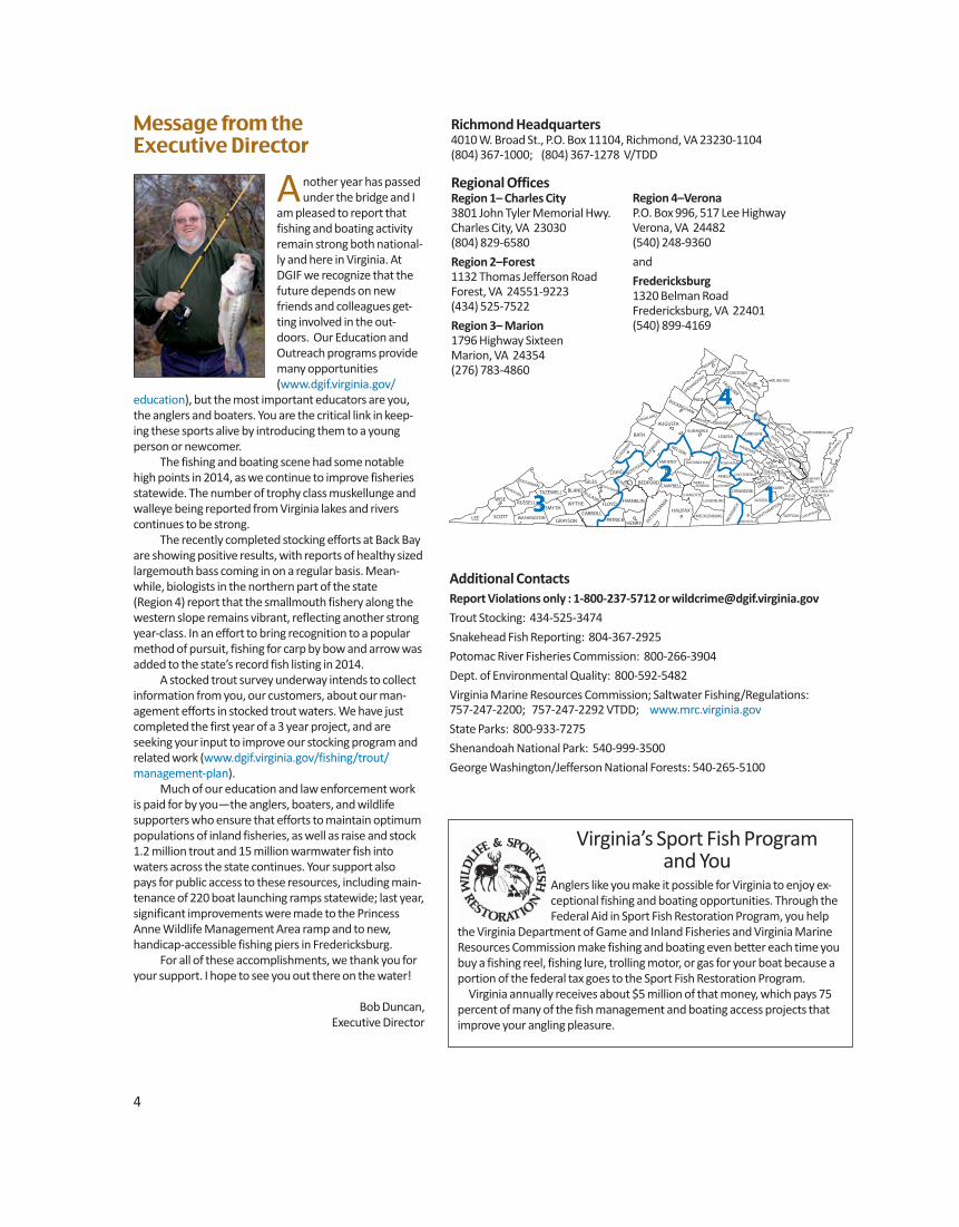
Message from the Executive Director
Another year has passedunder the bridge and I
am pleased to report thatfishing and boating activityremain strong both national-ly and here in Virginia. AtDGIF we recognize that thefuture depends on newfriends and colleagues get-ting involved in the out-doors. Our Education andOutreach programs providemany opportunities(www.dgif.virginia.gov/
education), but the most important educators are you,the anglers and boaters. You are the critical link in keep-ing these sports alive by introducing them to a young person or new comer.
The fishing and boating scene had some notablehigh points in 2014, as we continue to improve fisheriesstatewide. The number of trophy class muskellunge andwalleye being reported from Virginia lakes and rivers continues to be strong.
The recently completed stocking efforts at Back Bayare showing positive results, with reports of healthy sizedlargemouth bass coming in on a regular basis. Mean-while, biologists in the northern part of the state (Region 4) report that the smallmouth fishery along thewestern slope remains vibrant, reflecting another strongyear-class. In an effort to bring recognition to a popularmethod of pursuit, fishing for carp by bow and arrow wasadded to the state’s record fish listing in 2014.
A stocked trout survey underway intends to collectinformation from you, our customers, about our man-agement efforts in stocked trout waters. We have justcompleted the first year of a 3 year project, and are seeking your input to improve our stocking program andrelated work (www.dgif.virginia.gov/fishing/trout/management-plan).
Much of our education and law enforcement work is paid for by you—the anglers, boaters, and wildlife supporters who ensure that efforts to maintain optimumpopulations of inland fisheries, as well as raise and stock1.2 million trout and 15 million warmwater fish into waters across the state continues. Your support also pays for public access to these resources, including main-tenance of 220 boat launching ramps statewide; last year,significant improvements were made to the PrincessAnne Wildlife Management Area ramp and to new, handicap-accessible fishing piers in Fredericksburg.
For all of these accomplishments, we thank you foryour support. I hope to see you out there on the water!
Bob Duncan, Executive Director
LEE SCOTT
WISE
DICKENSON
BUCHANAN
RUSSELL
WASHINGTON
TAZEWELL
SMYTH
GRAYSON
WYTHE
BLAND
CARROLL PATRICK
FLOYD
PULASKI
GILES
HENRY
FRANKLIN
MONTGOMERY
CRAIG
ROANOKE
BEDFORD
PITTSYLV
ANIA
HALIFAX
CAMPBELL
BOTETOURT AMHERST
ALLEGHANY
BATH
ROCKBRIDGE
AUGUSTA
NELSON
HIGHLAND
ROCKINGHAM
SHENANDOAH
FREDERICK
CLARKE
WARREN
PAGE RAPPAHANNOCK
MADISON
CULPEPER
FAUQUIER
LOUDOUN
PRINCE WILLIAM
FAIRFAX
ARLINGTON
STAFFORD KING GEORGE
ORANGE SPOTSYLVANIA
CAROLINE LOUISA
ALBEMARLE
FLUVANNA
BUCKINGHAM
APPOMATTOX
CHARLOTTE
PRINCE EDWARD
LUNENBURG
NOTTOWAY
AMELIA CUM
BERL
AND
POWHATAN
GOOCHLAND
HANOVER
DINWIDDIE
CHESTERFIELD
MECKLENBURG
BRU
NSW
ICK
GREENSVILLE SOUTHAMPTON
SUSSEX
SURRY
ISLE OF WIGHT
SUFFOLK CHESAPEAKE
VIRGINIA
BEACH
NORFOLK PORTSMOUTH HAMPTON
NEWPORT NEWS
PRINCE
GEORGE
CHARLES CITY
JAM
ES
CITY YORK
HENRICO
NEW KENT
KING WILLIAM
KING AND QUEEN
GLOUCESTER
NO
RTH
AMPT
ON
ACCOMACK
MATH
EWS
MIDDLESEX
LANCASTER
NORTHUMBERLAND
WESTMORELAND RICHMOND
ESSEX
GREENE
4
32
1
4
Richmond Headquarters4010 W. Broad St., P.O. Box 11104, Richmond, VA 23230-1104(804) 367-1000; (804) 367-1278 V/TDD
Region 4–VeronaP.O. Box 996, 517 Lee HighwayVerona, VA 24482(540) 248-9360
and
Fredericksburg1320 Belman RoadFredericksburg, VA 22401(540) 899-4169
Regional OfficesRegion 1– Charles City3801 John Tyler Memorial Hwy.Charles City, VA 23030(804) 829-6580
Region 2–Forest1132 Thomas Jefferson RoadForest, VA 24551-9223(434) 525-7522
Region 3– Marion1796 Highway SixteenMarion, VA 24354(276) 783-4860
Additional ContactsReport Violations only : 1-800-237-5712 or [email protected]
Trout Stocking: 434-525-3474
Snakehead Fish Reporting: 804-367-2925
Potomac River Fisheries Commission: 800-266-3904
Dept. of Environmental Quality: 800-592-5482
Virginia Marine Resources Commission; Saltwater Fishing/Regulations: 757-247-2200; 757-247-2292 VTDD; www.mrc.virginia.gov
State Parks: 800-933-7275
Shenandoah National Park: 540-999-3500
George Washington/Jefferson National Forests: 540-265-5100
Virginia’s Sport Fish Program and You
Anglers like you make it possible for Virginia to enjoy ex-ceptional fishing and boating opportunities. Through theFederal Aid in Sport Fish Restoration Program, you help
the Virginia Department of Game and Inland Fisheries and Virginia MarineResources Commission make fishing and boating even better each time youbuy a fishing reel, fishing lure, trolling motor, or gas for your boat because aportion of the federal tax goes to the Sport Fish Restoration Program.
Virginia annually receives about $5 million of that money, which pays 75percent of many of the fish management and boating access projects that improve your angling pleasure.
5
WHAT’S NEW FOR 2015The following regulation changes are new for2015. More details can be found in sectionsthat follow this summary.
License Information and Fees• Children younger than 12 years old can
fish without a daily permit if under directsupervision of a permitted adult at allthree fee fishing areas.
General Information• Blue catfish and their hybrids cannot be
stocked in privately owned ponds andlakes.
• Seines, traps, and nets are prohibited inLick Creek and its tributaries (Smyth &Bland counties), Laurel Creek and its trib-utaries upstream of Highway 16 bridge(Tazewell & Bland counties), SusongBranch and Manpower Creek (Washing-ton & City of Bristol), and TimbertreeBranch (Scott County).
• Remove all trotlines, juglines, or setpoles from public waters when not inuse.
• Marking fish with tagging equipment forpersonal information or researchrequires agency permission.
Creel and Length Limits• On the Clinch River, no bass less than 20
inches, only one bass per day longer than20 inches.
• On the New River, no bass 14-22 inches,only one per day longer than 22 inchesfrom Fields Dam (Grayson County) toVA/WV state line and its tributaries.
• On Smith Mountain Lake and its tributar-ies, no striped bass 30-40 inches fromNov. 1 – May 31.
• Statewide, walleye and saugeye 5 perday in aggregate, no walleye or saugeyeless than 18 inches.
• No possession of American shad andhickory shad in Virginia waters of LakeGaston and Buggs Island (Kerr) Reservoirand tributaries to include Dan andStaunton rivers.
• No daily limit or size limit on snakehead.
Trout • New special regulation trout waters
(Catch-and-Release Only) include BigStony Creek (Wise & Scott counties),
Little Stony Creek (Scott County) and Little Tumbling Creek (Smith & Tazewell counties). See page 28
Nongame Fish/Reptile/Amphibian, andAquatic Invertebrates• Snapping turtles for private use shall only
be taken from June 1 to September 30.
FISHING LICENSE INFORMATION AND FEESResidency Qualifications1. Persons who have been a bonafide resident of the city, county, or state for six consecutive months immediately
preceding the date of application for license; 2. Persons who have been domiciliary resi-
dents of the state for at least two monthsupon approval of a completed affidavitto be furnished by the Game Depart-ment;
3. Legal voters in Virginia;4. Members of the armed forces if they reside in the Commonwealth and are on
active duty and are stationed at militaryinstallations within or on ships based inthe Commonwealth;
5. Students (including nonresident stu-dents boarding on campus) residing inVirginia who are enrolled in bonafide
Virginia schools; 6. Any unnaturalized person who owns real
estate in the county or city and who hasactually resided there not less than fiveyears next preceding the date of the ap-plication for the license in the county orcity where they qualify.
Every person who is required to have a license must carry such license and shallshow the license immediately upon demandof any officer whose duty it is to enforce thegame and inland fish laws, or upon the demand of any owner or lessee, or any employee or representative of such owneror lessee, upon whose land or water suchperson may be hunting, trapping or fishing. A license is not valid unless signed by thelicensee.
ExceptionsAll persons, except those listed below, mustpurchase the proper licenses before fishing.
• Resident or nonresident landowners,their spouses, their children and grand-children and the spouses of such
children and grandchildren, or the landowner’s parents, resident or non -
resident, do not need a license to hunt,trap, or fish within the boundaries oftheir own lands and inland waters.
• Residents under 16 years of age (also donot need a trout license).
• Resident, active-duty members of thearmed forces while on official leave—must have copy of leave papers in theirpossession.
• Tenants, on the land they rent and occu-py, are not required to have a license, butmust have the written permission of thelandowner.
• Guests fishing in individually owned private ponds.• Nonresident children under 12 (except in
designated stocked trout waters) whenaccompanied by a properly licensedadult. When fishing designated stockedtrout waters, a nonresident child under12 will need a nonresident freshwaterfishing license and a nonresident trout
license.• Legally blind persons.• Any Indian who “habitually” resides on
an Indian reservation or a member ofthe Virginia recognized tribes who
resides in the Commonwealth is not required to have a freshwater license;
Free Fishing
DaysJune 5–7, 2015
If fishing in designatedstocked trout waters, both a freshwater and trout license are required.
For more information:www.HuntFishVA.com
www.dgif.virginia.gov/plates/
A Reel Keeper

5
WHAT’S NEW FOR 2015The following regulation changes are new for2015. More details can be found in sectionsthat follow this summary.
License Information and Fees• Children younger than 12 years old can
fish without a daily permit if under directsupervision of a permitted adult at allthree fee fishing areas.
General Information• Blue catfish and their hybrids cannot be
stocked in privately owned ponds andlakes.
• Seines, traps, and nets are prohibited inLick Creek and its tributaries (Smyth &Bland counties), Laurel Creek and its trib-utaries upstream of Highway 16 bridge(Tazewell & Bland counties), SusongBranch and Manpower Creek (Washing-ton & City of Bristol), and TimbertreeBranch (Scott County).
• Remove all trotlines, juglines, or setpoles from public waters when not inuse.
• Marking fish with tagging equipment forpersonal information or researchrequires agency permission.
Creel and Length Limits• On the Clinch River, no bass less than 20
inches, only one bass per day longer than20 inches.
• On the New River, no bass 14-22 inches,only one per day longer than 22 inchesfrom Fields Dam (Grayson County) toVA/WV state line and its tributaries. Theregulation actually only includes 3 tribu-taries, all of which are downstream fromClaytor Dam (Little River from the LittleRiver Dam downstream (MontgomeryCounty), Walker Creek from the Norfolkand Southern Railroad Bridge down-stream (Giles County), and Wolf Creekfrom the Wolf Creek Dam downstream(Giles County).
• On Smith Mountain Lake and its tributar-ies, no striped bass 30-40 inches fromNov. 1 – May 31.
• Statewide, walleye and saugeye 5 perday in aggregate, no walleye or saugeyeless than 18 inches.
• No possession of American shad andhickory shad in Virginia waters of LakeGaston and Buggs Island (Kerr) Reservoirand tributaries to include Dan andStaunton rivers.
• No daily limit or size limit on snakehead.
Trout • New special regulation trout waters
(Catch-and-Release Only) include BigStony Creek (Wise & Scott counties),
Little Stony Creek (Scott County) and Little Tumbling Creek (Smith & Tazewell counties). See page 28
Nongame Fish/Reptile/Amphibian, andAquatic Invertebrates• Snapping turtles for private use shall only
be taken from June 1 to September 30.
FISHING LICENSE INFORMATION AND FEESResidency Qualifications1. Persons who have been a bonafide resident of the city, county, or state for six consecutive months immediately preceding the date of application for license; 2. Persons who have been domiciliary resi-
dents of the state for at least two monthsupon approval of a completed affidavitto be furnished by the Game Depart-ment;
3. Legal voters in Virginia;4. Members of the armed forces if they reside in the Commonwealth and are on
active duty and are stationed at militaryinstallations within or on ships based inthe Commonwealth;
5. Students (including nonresident stu-dents boarding on campus) residing inVirginia who are enrolled in bonafide
Virginia schools; 6. Any unnaturalized person who owns real
estate in the county or city and who hasactually resided there not less than fiveyears next preceding the date of the ap-plication for the license in the county orcity where they qualify.
Every person who is required to have a license must carry such license and shallshow the license immediately upon demandof any officer whose duty it is to enforce thegame and inland fish laws, or upon the demand of any owner or lessee, or any employee or representative of such owneror lessee, upon whose land or water suchperson may be hunting, trapping or fishing. A license is not valid unless signed by thelicensee.
ExceptionsAll persons, except those listed below, mustpurchase the proper licenses before fishing.
• Resident or nonresident landowners,their spouses, their children and grand-children and the spouses of such
children and grandchildren, or the landowner’s parents, resident or non -
resident, do not need a license to hunt,trap, or fish within the boundaries of
their own lands and inland waters.• Residents under 16 years of age (also do
not need a trout license).• Resident, active-duty members of the
armed forces while on official leave—must have copy of leave papers in theirpossession.
• Tenants, on the land they rent and occu-py, are not required to have a license, butmust have the written permission of thelandowner.
• Guests fishing in individually owned private ponds.• Nonresident children under 12 (except in
designated stocked trout waters) whenaccompanied by a properly licensedadult. When fishing designated stockedtrout waters, a nonresident child under12 will need a nonresident freshwaterfishing license and a nonresident trout
license.• Legally blind persons.• Any Indian who “habitually” resides on
an Indian reservation or a member ofthe Virginia recognized tribes who
resides in the Commonwealth is not required to have a freshwater license;
Free FishingDays
June 5–7, 2015
If fishing in designatedstocked trout waters, both a freshwater and trout license are required.
For more information:www.HuntFishVA.com
www.dgif.virginia.gov/plates/
A Reel Keeper

6
License Fees The issuance fee is included in the prices below.Fishing licenses are valid for one year from the date of purchase.
RESIDENT FEESSportsman’s License (16 years or older).............................$123.00Includes hunting license, bear-deer-turkey license (valid July 1–June 30), archery license, muzzleloader license, freshwater fishinglicense and trout license
County/City Resident Freshwater Fishing* .........................$16.00(For county or city of residence only)
Resident State Freshwater Fishing* ....................................$23.00
Resident Fishing License* (age 16 and older)1-year license ................................................................$23.002-year license ................................................................$44.003-year license ................................................................$65.004-year license ................................................................$86.00
Resident State Fresh/Saltwater Fishing* ............................$40.00
South Holston Reservoir Fishing License ............................$21.00(Allows fishing in both Tennessee and Virginia waters of South Holston Reservoir)
Resident 5-Day Freshwater Fishing ....................................$14.00(5 consecutive days) Not valid in designated stocked trout waters
Resident 5-Day Fresh/Saltwater Fishing .............................$24.00(5 consecutive days) Not valid in designated stocked trout waters
Resident Tidal Boat Sport Fishing (see page 8) ..................$126.00
Resident 65 and Over Annual Freshwater Fishing* ...............$9.00
Special Resident Annual Fishing License for Partially Disabled Veterans . . . . . . . . . . . . . . . . . . . . . . . . . . . . . . . $12.00Resident veterans rated and certified by the U.S. Department of Veterans Affairs as having at least 70 percent service-connected disability upon certification. All applicable licenses, stamps, or permits are required in addition to this license. See below for more details.
Resident Trout Fishing (October 1–June 15) ........................$23.00Required in addition to other resident licenses if fishing in stocked waters.
Resident Legacy Lifetime Freshwater Fishing License ........$125.00 Must be purchased before age 2. See page 7 for more details. Can be purchased in person at the Richmond office or via a mail-in application. Application available online or by calling 1-866-721-6911.
Resident Lifetime Freshwater Fish* (A valid trout fishing license is also required to fish in stocked trout waters.)See page 7 for more details.
Age up to age 44 ............................................................$260.00Age 45-50......................................................................$210.00Age 51-55......................................................................$160.00Age 56-60......................................................................$110.00Age 61-64........................................................................$60.00Age 65 and over...............................................................$20.00
Resident Lifetime Trout Fishing (A valid resident fishing licenseis also required.) See page 7 for more details.
Age up to age 44 ............................................................$260.00Age 45-50......................................................................$210.00Age 51-55......................................................................$160.00Age 56-60......................................................................$110.00Age 61-64........................................................................$60.00Age 65 and over...............................................................$20.00
Service-connected Totally and Permanently Disabled VeteranResident Lifetime License*.............................................no chargeTo freshwater fish and/or hunt. A valid trout fishing license is also required to fish in stocked trout waters. See page 7 for more details.
Totally and Permanently Disabled Resident Special Fishing Lifetime License ......................................................$15.00All applicable licenses, stamps, or permits are required in additionto this fishing license. See page 7 for more details.
* A valid trout license (annual or lifetime) is required in addition toother resident licenses only if you are fishing in designated stockedtrout waters (October 1–June 15).
It is unlawful to fish on waters of any public or private club, association, or preserve
without a proper license.
however, such Indian must have on his person an identification card or paper signed by the chief of his tribe, a valid tribal identification card, written confirmation through a central tribal registry, or certification from a tribal office. However, a saltwater fishing license is required.• Stockholders owning 50 percent or more of the stock of any domestic corporation owning land in Virginia, his or her spouse and children and minor grandchildren, resident or nonresident, to hunt, trap and fish within the boundaries of lands and inland waters owned by the domestic corporation.• Persons 65 years of age or older do not need a saltwater license
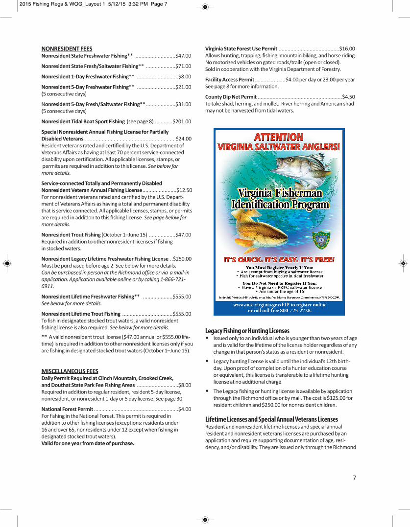
but must comply with the Virginia Fisherman Identification Program (FIP) requirements. See page 7.• Any person not fishing but aiding a disabled license holder.
Where to Get a LicenseOnline: www.HuntFishVA.com. Select the license(s), paywith your VISA or MasterCard, and print your license(s) afteryou pay.
In Person: Choose from hundreds of license agents across thestate. Sold by some clerks of the Circuit Court. For listing go towww.huntfishva.com/licenses. Not sold at Department Regional offices.
By Phone: 1-866-721-6911, during regular business hours.
2015 Fishing Regs & WOG_Layout 1 5/12/15 3:32 PM Page 6
7
Legacy Fishing or Hunting Licenses• Issued only to an individual who is younger than two years of age
and is valid for the lifetime of the license holder regardless of anychange in that person’s status as a resident or nonresident.
• Legacy hunting license is valid until the individual’s 12th birth-day. Upon proof of completion of a hunter education course
or equivalent, this license is transferable to a lifetime hunting license at no additional charge.
• The Legacy fishing or hunting license is available by applicationthrough the Richmond office or by mail. The cost is $125.00 for
resident children and $250.00 for nonresident children.
Lifetime Licenses and Special Annual Veterans LicensesResident and nonresident lifetime licenses and special annual resident and nonresident veterans licenses are purchased by an application and require supporting documentation of age, resi -dency, and/or disability. They are issued only through the Richmond
NONRESIDENT FEESNonresident State Freshwater Fishing** ...........................$47.00
Nonresident State Fresh/Saltwater Fishing** ....................$71.00
Nonresident 1-Day Freshwater Fishing** ............................$8.00
Nonresident 5-Day Freshwater Fishing** ..........................$21.00(5 consecutive days)
Nonresident 5-Day Fresh/Saltwater Fishing**....................$31.00(5 consecutive days)
Nonresident Tidal Boat Sport Fishing (see page 8) ............$201.00
Special Nonresident Annual Fishing License for Partially Disabled Veterans . . . . . . . . . . . . . . . . . . . . . . . . . . . . . . . $24.00Resident veterans rated and certified by the U.S. Department of Veterans Affairs as having at least 70 percent service-connected disability upon certification. All applicable licenses, stamps, orpermits are required in addition to this license. See below for more details.
Service-connected Totally and Permanently Disabled Nonresident Veteran Annual Fishing License.......................$12.50For nonresident veterans rated and certified by the U.S. Depart-ment of Veterans Affairs as having a total and permanent disabilitythat is service connected. All applicable licenses, stamps, or permitsare required in addition to this fishing license. See page below formore details.
Nonresident Trout Fishing (October 1–June 15) ..................$47.00Required in addition to other nonresident licenses if fishing in stocked waters.
Nonresident Legacy Lifetime Freshwater Fishing License ..$250.00 Must be purchased before age 2. See below for more details. Can be purchased in person at the Richmond office or via a mail-inapplication. Application available online or by calling 1-866-721-6911.
Nonresident Lifetime Freshwater Fishing** ....................$555.00See below for more details.
Nonresident Lifetime Trout Fishing ..................................$555.00To fish in designated stocked trout waters, a valid nonresident fishing license is also required. See below for more details.
** A valid nonresident trout license ($47.00 annual or $555.00 life-time) is required in addition to other nonresident licenses only if youare fishing in designated stocked trout waters (October 1–June 15).
MISCELLANEOUS FEESDaily Permit Required at Clinch Mountain, Crooked Creek, and Douthat State Park Fee Fishing Areas ............................$8.00Required in addition to regular resident, resident 5-day license, nonresident, or nonresident 1-day or 5 day license. See page 30.
National Forest Permit .........................................................$4.00For fishing in the National Forest. This permit is required inaddition to other fishing licenses (exceptions: residents under 16 and over 65, nonresidents under 12 except when fishing in designated stocked trout waters). Valid for one year from date of purchase.
Virginia State Forest Use Permit .........................................$16.00Allows hunting, trapping, fishing, mountain biking, and horse riding.No motorized vehicles on gated roads/trails (open or closed). Sold in cooperation with the Virginia Department of Forestry.
Facility Access Permit.....................$4.00 per day or 23.00 per yearSee page 8 for more information.
County Dip Net Permit .........................................................$4.50To take shad, herring, and mullet. River herring and American shadmay not be harvested from tidal waters.
2015 Fishing Regs & WOG_Layout 1 5/12/15 3:32 PM Page 7
8 2015 Virginia Freshwater Fishing & Boating Guide
Freshwater/Saltwater License Lines on Tidal WatersPersons fishing upstream of the designatedlines on the following waters must have avalid freshwater fishing license, while thosefishing below the lines must have a valid saltwater fishing license:
Elizabeth River: The Great Bridge Locks
James River: A line connecting Hog Pointon Hog Island (Surry County) and thedownstream point of the mouth of
College Creek (James City County)
Piankatank River/Dragon Run: The firstset of power lines immediately upriver ofAnderson Point
*Potomac River: Rt. 301 Bridge
Rappahannock River: Rt. 360 Bridge
York River System (including the Mattaponi and Pamunkey Rivers): Rt. 33 Bridges
Below these designated lines a fresh- water or saltwater license will be valid on any tidal portion of any tributary entering the above mainstem waters.
The following waters are entirely fresh-water and require a freshwater fishing license throughout: Meherrin River; Nottoway River; Blackwater River (Chowandrainage); Back Bay, Northwest River, andNorth Landing River and Intracoastal Water-way upstream to Great Bridge Locks; andDismal Swamp Canal below (or south) ofDeep Creek Locks.
*See reciprocal license section.
Reciprocal LicensesAll reciprocal license agreements listedbelow refer to both boat and bank anglers.
Buggs Island (Kerr) and Gaston: Virginia orNorth Carolina state fishing licenses and per-mits are honored on those waters lying eastof Union Street Dam on the Dan River in Vir-ginia and the mouth of Difficult Creek on theStaunton River of Kerr Reservoir to the Gas-ton Dam on the Roanoke River, including alltributary waters accessible by boat from themain bodies of the reservoirs, or from the Island Creek subimpoundment. (Note:North Carolina regulations apply on NorthCarolina portions of these waters. Virginiaregulations apply in Virginia waters.)
Blue Ridge Parkway: Virginia and North Carolina licenses are honored on all Parkwaywaters. (Note: Virginia regulations apply inParkway waters in Virginia except wherenoted herein or in federal regulations.)
New River: Virginia or North Carolina statefishing licenses and permits are honored onthe mainstream portion lying between theconfluence of the North and South Forks ofthe New River in North Carolina (AlleghanyCounty) downstream to the confluence ofthe New and Little rivers in Virginia (GraysonCounty).
Potomac River: Virginia has reciprocal license agreements for three sections of thePotomac River, one above the District of Columbia and two below the District of Columbia. License requirements are different for these sections.
Upper Potomac River [above Little Falls(upper border with the District of Colum-bia) to the West Virginia border/stateline]: Resident anglers with state fresh-water licenses in Virginia or Marylandmay fish the Potomac River and fromboth banks.
Fall LineThe Fall Line is defined as the
following landmarks: Appomattox—the remnants of HarvellDam approx. 0.5 mi upstream of Rt. 1
Chickahominy River–Walkers Dam James River–14th Street Bridge Mattaponi River–Rt. 360 Bridge Pamunkey River–Rt. 360 Bridge
Potomac River–Little FallsOccoquan River–I-95 Bridge
Rappahannock River–Rt. 1 Bridge
office. Retail license agents cannot issuethese licenses. Applications can be submit-ted in person at the Richmond office ormailed in. License applications can be found on the Department’s website atwww.HuntFishVA.com/licenses/lifetime orby calling 1-866-721-6911.
Tidal Boat LicenseThe tidal boat license is available to any boat owner, resident and nonresident. Thelicense is a special combined sport fishing license that gives the boat owner a license to fish in saltwater and freshwater withinVirginia.The license also covers all passen-gers on board the owner’s boat when fishingin Virginia tidal (to river Fall Lines) watersand saltwater only when the registered boatowner is present. There are no decals issuedunder this license and the VMRC FishermanIdentification Program rules apply for pas-sengers fishing in saltwater under this tidalboat license.
National Forest PermitAll persons required to have a license (exceptions: residents under 16 and over 65,nonresidents under 12 except when fishingin designated stocked trout waters) are required to have a National Forest Permitwhen fishing on National Forest lands excepton the North and South Fork of the Shenan-doah River, the James River, Skidmore Lakein Rockingham County, North Fork PoundReservoir, Lake Moomaw, the Jackson Riverbelow Gathright Dam, and in Wilson Creekbelow Douthat Lake in Alleghany and Bathcounties.
State Forest Use PermitRequired for those persons aged 16 or olderto practice the following activities on a stateforest: hunting, trapping, fishing, mountainbiking, and horse riding. No motorized vehi-cles on gated roads/trails (open or closed).The Forest Use Permit is not required forforest visitors who practice the following activities on a state forest: walking, hiking, or boating. Sold in cooperation with the Virginia Department of Forestry.
Facility Access PermitA Facility Access Permit is required whenusing any Department-owned Wildlife Man-agement Area or Fishing Lake. Such permitshall not be required for any person holdinga valid hunting, freshwater fishing, or trap-ping license or a current certificate of boatregistration issued by the Department orpersons 16 years of age or younger. The
Facility Access Permit requirement does notapply to Department-owned boat ramps orsegments of the Appalachian Trail on Depart-ment-owned land. The permit fee is $4 for adaily permit or $23 for an annual permit andmay be purchased online or at any licenseagent.
Replacement LicenseIf you purchased a license from a retail license agent, such as a sporting goods store,you can request a replacement at any retaillicense agent. If you purchased a license online, byphone, or from the Richmond office you willneed to request a replacement by calling toll-free at 1-866-721-6911 during regularbusiness hours.
www.HuntFishVA.com 9
Middle Potomac and its Tidal FreshwaterTributaries (between Woodrow WilsonBridge and Rt. 301): Valid Virginia fresh-water and saltwater (excluding county
icenses), Potomac River Fisheries Com-mission, and Maryland Bay sport licensesare all honored on the mainstem
Potomac and Maryland tributaries up to the demarcation lines (see below); all of these same licenses, except the Virginia saltwater licenses, are honored on the Virginia tributaries up to demarcation lines (see below):
Virginia tributaries up to the following demarcation lines: Accotink Creek: Rt. 1 Bridge Aquia Creek: First bridge above Aquia
Harbor Marina Chopawansic: Rt. 1 Bridge Choptank: Causeway Dougue Creek: Rt. 235, Mt. Vernon Memorial Parkway Four Mile Run: Rt. 1 Bridge Hunting Creek: Rt. 1 Bridge Little Hunting Creek: Rt. 1 Bridge Neabsco: Rt. 1 Bridge Occoquan River: Fall Line Pohick Creek: Rt. 611 (Colchester Road) Potomac Creek: Rt. 608 Bridge Powells Creek: Rt. 1 Bridge Quantico Creek: Rt. 1 Bridge Unnamed bays and tributaries accessible
by gas-powered boats
Maryland tributaries up to the following demarcation lines: Anacostia River: downstream of North-
east Branch Bridge at northbound lane ofAlternate Rt. 1
Bladensburg Road, and NorthwestBranch Bridge at southbound lane ofRhode Island Avenue
Piscataway Creek: Downstream of Rt. 224 Bridge (Livingston Rd.) Henson Run: Downstream of Oxon Hill
Road Bridge Nanjemoy Creek: Downstream of Rt. 6
(Trappe) Bridge Port Tobacco Creek: Downsteam of Rt. 6
Bridge Mattawoman Creek: Downstream of Rt. 225 Bridge Unnamed bays and tributaries accessible
by gas-powered boats
Lower Potomac River (between itsmouth and the Rt. 301 Bridge): Valid
Virginia saltwater (excluding County licenses), Maryland Bay sport, or Potomac River Fisheries Commission licenses are honored in the main stem. In Virginia tributaries below 301, Virginia fresh water and saltwater, and Potomac River Fisheries Commission licenses are honored.
Note: Maryland regulations apply for the Upper Potomac River and the Maryland Potomac River tributaries (call 1-800-688-3467 for current Maryland regulations). Note: Potomac River Fisheries Commis-sion regulations are enforced in the Potomacmainstem between the lower District of Columbia border and the mouth of the Potomac (call 1-804-224-7148 or 1-800-266-3904 for current PRFC regulations).
Waters between the Woodrow WilsonBridge and Little Falls are controlled by D.C.,and a D.C. fishing license is required.
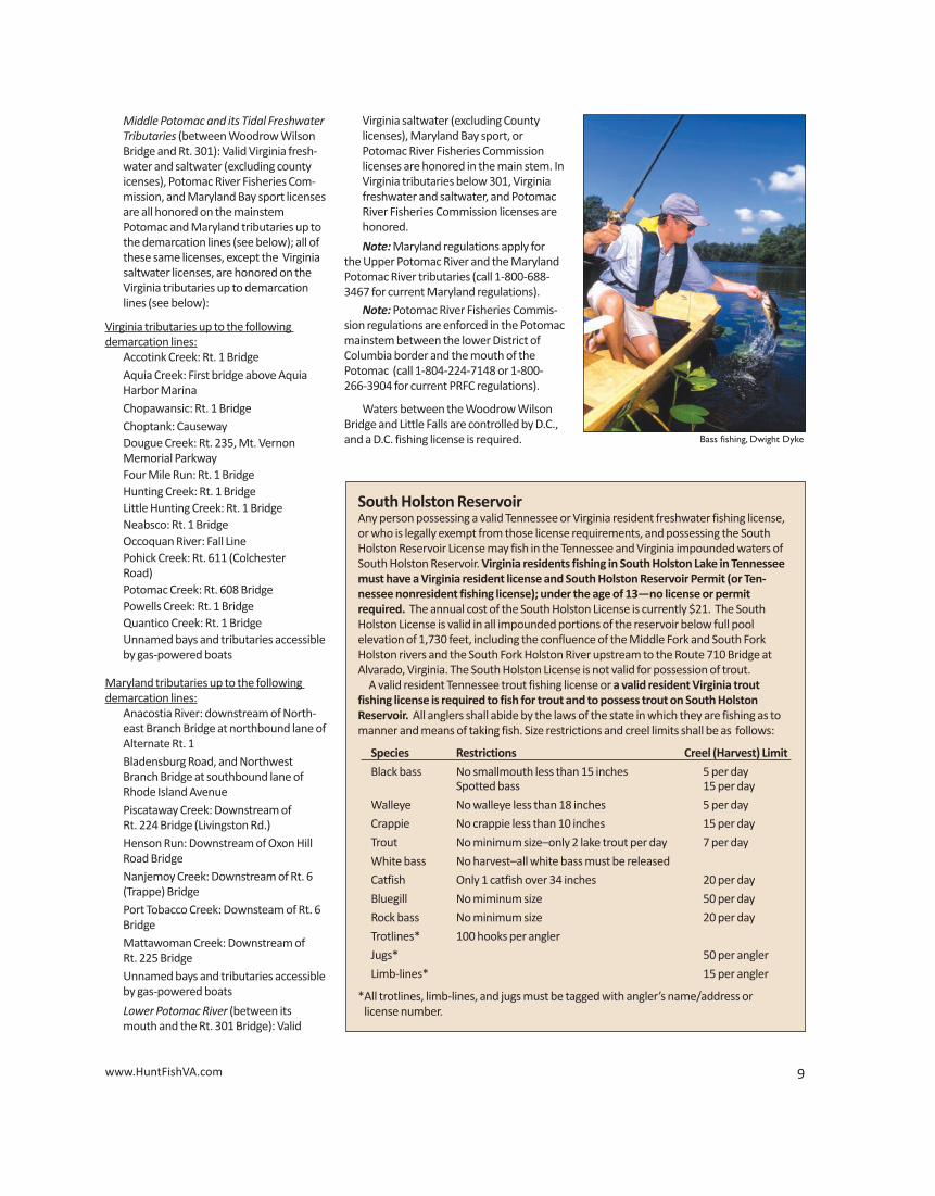
South Holston ReservoirAny person possessing a valid Tennessee or Virginia resident freshwater fishing license,or who is legally exempt from those license requirements, and possessing the South Holston Reservoir License may fish in the Tennessee and Virginia impounded waters ofSouth Holston Reservoir. Virginia residents fishing in South Holston Lake in Tennesseemust have a Virginia resident license and South Holston Reservoir Permit (or Ten-nessee nonresident fishing license); under the age of 13—no license or permit required. The annual cost of the South Holston License is currently $21. The South Holston License is valid in all impounded portions of the reservoir below full pool elevation of 1,730 feet, including the confluence of the Middle Fork and South Fork Holston rivers and the South Fork Holston River upstream to the Route 710 Bridge at Alvarado, Virginia. The South Holston License is not valid for possession of trout.
A valid resident Tennessee trout fishing license or a valid resident Virginia trout fishing license is required to fish for trout and to possess trout on South Holston Reservoir. All anglers shall abide by the laws of the state in which they are fishing as tomanner and means of taking fish. Size restrictions and creel limits shall be as follows:
Species Restrictions Creel (Harvest) Limit
Black bass No smallmouth less than 15 inches 5 per day Spotted bass 15 per day
Walleye No walleye less than 18 inches 5 per day
Crappie No crappie less than 10 inches 15 per day
Trout No minimum size–only 2 lake trout per day 7 per day
White bass No harvest–all white bass must be released
Catfish Only 1 catfish over 34 inches 20 per day
Bluegill No miminum size 50 per day
Rock bass No minimum size 20 per day
Trotlines* 100 hooks per angler
Jugs* 50 per angler
Limb-lines* 15 per angler
*All trotlines, limb-lines, and jugs must be tagged with angler’s name/address or license number.
Bass fishing, Dwight Dyke
8 2015 Virginia Freshwater Fishing & Boating Guide
Freshwater/Saltwater License Lines on Tidal WatersPersons fishing upstream of the designatedlines on the following waters must have avalid freshwater fishing license, while thosefishing below the lines must have a valid saltwater fishing license:
Elizabeth River: The Great Bridge Locks
James River: A line connecting Hog Pointon Hog Island (Surry County) and thedownstream point of the mouth of
College Creek (James City County)
Piankatank River/Dragon Run: The firstset of power lines immediately upriver ofAnderson Point
*Potomac River: Rt. 301 Bridge
Rappahannock River: Rt. 360 Bridge
York River System (including the Mattaponi and Pamunkey Rivers): Rt. 33 Bridges
Below these designated lines a fresh- water or saltwater license will be valid on any tidal portion of any tributary entering the above mainstem waters.
The following waters are entirely fresh-water and require a freshwater fishing license throughout: Meherrin River; Nottoway River; Blackwater River (Chowandrainage); Back Bay, Northwest River, andNorth Landing River and Intracoastal Water-way upstream to Great Bridge Locks; andDismal Swamp Canal below (or south) ofDeep Creek Locks.
*See reciprocal license section.
Reciprocal LicensesAll reciprocal license agreements listedbelow refer to both boat and bank anglers.
Buggs Island (Kerr) and Gaston: Virginia orNorth Carolina state fishing licenses and per-mits are honored on those waters lying eastof Union Street Dam on the Dan River in Vir-ginia and the mouth of Difficult Creek on theStaunton River of Kerr Reservoir to the Gas-ton Dam on the Roanoke River, including alltributary waters accessible by boat from themain bodies of the reservoirs, or from the Island Creek subimpoundment. (Note:North Carolina regulations apply on NorthCarolina portions of these waters. Virginiaregulations apply in Virginia waters.)
Blue Ridge Parkway: Virginia and North Carolina licenses are honored on all Parkwaywaters. (Note: Virginia regulations apply inParkway waters in Virginia except wherenoted herein or in federal regulations.)
New River: Virginia or North Carolina statefishing licenses and permits are honored onthe mainstream portion lying between theconfluence of the North and South Forks ofthe New River in North Carolina (AlleghanyCounty) downstream to the confluence ofthe New and Little rivers in Virginia (GraysonCounty).
Potomac River: Virginia has reciprocal license agreements for three sections of thePotomac River, one above the District of Columbia and two below the District of Columbia. License requirements are different for these sections.
Upper Potomac River [above Little Falls(upper border with the District of Colum-bia) to the West Virginia border/stateline]: Resident anglers with state fresh-water licenses in Virginia or Marylandmay fish the Potomac River and fromboth banks.
Fall LineThe Fall Line is defined as the
following landmarks: Appomattox—the remnants of HarvellDam approx. 0.5 mi upstream of Rt. 1
Chickahominy River–Walkers Dam James River–14th Street Bridge Mattaponi River–Rt. 360 Bridge Pamunkey River–Rt. 360 Bridge
Potomac River–Little FallsOccoquan River–I-95 Bridge
Rappahannock River–Rt. 1 Bridge
office. Retail license agents cannot issuethese licenses. Applications can be submit-ted in person at the Richmond office ormailed in. License applications can be found on the Department’s website atwww.HuntFishVA.com/licenses/lifetime orby calling 1-866-721-6911.
Tidal Boat LicenseThe tidal boat license is available to any boat owner, resident and nonresident. Thelicense is a special combined sport fishing license that gives the boat owner a license to fish in saltwater and freshwater withinVirginia.The license also covers all passen-gers on board the owner’s boat when fishingin Virginia tidal (to river Fall Lines) watersand saltwater only when the registered boatowner is present. There are no decals issuedunder this license and the VMRC FishermanIdentification Program rules apply for pas-sengers fishing in saltwater under this tidalboat license.
National Forest PermitAll persons required to have a license (exceptions: residents under 16 and over 65,nonresidents under 12 except when fishingin designated stocked trout waters) are required to have a National Forest Permitwhen fishing on National Forest lands excepton the North and South Fork of the Shenan-doah River, the James River, Skidmore Lakein Rockingham County, North Fork PoundReservoir, Lake Moomaw, the Jackson Riverbelow Gathright Dam, and in Wilson Creekbelow Douthat Lake in Alleghany and Bathcounties.
State Forest Use PermitRequired for those persons aged 16 or olderto practice the following activities on a stateforest: hunting, trapping, fishing, mountainbiking, and horse riding. No motorized vehi-cles on gated roads/trails (open or closed).The Forest Use Permit is not required forforest visitors who practice the following activities on a state forest: walking, hiking, or boating. Sold in cooperation with the Virginia Department of Forestry.
Facility Access PermitA Facility Access Permit is required whenusing any Department-owned Wildlife Man-agement Area or Fishing Lake. Such permitshall not be required for any person holdinga valid hunting, freshwater fishing, or trap-ping license or a current certificate of boatregistration issued by the Department orpersons 16 years of age or younger. The
Facility Access Permit requirement does notapply to Department-owned boat ramps orsegments of the Appalachian Trail on Depart-ment-owned land. The permit fee is $4 for adaily permit or $23 for an annual permit andmay be purchased online or at any licenseagent.
Replacement LicenseIf you purchased a license from a retail license agent, such as a sporting goods store,you can request a replacement at any retaillicense agent. If you purchased a license online, byphone, or from the Richmond office you willneed to request a replacement by calling toll-free at 1-866-721-6911 during regularbusiness hours.
www.HuntFishVA.com 9
Middle Potomac and its Tidal FreshwaterTributaries (between Woodrow WilsonBridge and Rt. 301): Valid Virginia fresh-water and saltwater (excluding county
icenses), Potomac River Fisheries Com-mission, and Maryland Bay sport licensesare all honored on the mainstem
Potomac and Maryland tributaries up to the demarcation lines (see below); all of these same licenses, except the Virginia saltwater licenses, are honored on the Virginia tributaries up to demarcation lines (see below):
Virginia tributaries up to the following demarcation lines: Accotink Creek: Rt. 1 Bridge Aquia Creek: First bridge above Aquia
Harbor Marina Chopawansic: Rt. 1 Bridge Choptank: Causeway Dougue Creek: Rt. 235, Mt. Vernon Memorial Parkway Four Mile Run: Rt. 1 Bridge Hunting Creek: Rt. 1 Bridge Little Hunting Creek: Rt. 1 Bridge Neabsco: Rt. 1 Bridge Occoquan River: Fall Line Pohick Creek: Rt. 611 (Colchester Road) Potomac Creek: Rt. 608 Bridge Powells Creek: Rt. 1 Bridge Quantico Creek: Rt. 1 Bridge Unnamed bays and tributaries accessible
by gas-powered boats
Maryland tributaries up to the following demarcation lines: Anacostia River: downstream of North-
east Branch Bridge at northbound lane ofAlternate Rt. 1
Bladensburg Road, and NorthwestBranch Bridge at southbound lane ofRhode Island Avenue
Piscataway Creek: Downstream of Rt. 224 Bridge (Livingston Rd.) Henson Run: Downstream of Oxon Hill
Road Bridge Nanjemoy Creek: Downstream of Rt. 6
(Trappe) Bridge Port Tobacco Creek: Downsteam of Rt. 6
Bridge Mattawoman Creek: Downstream of Rt. 225 Bridge Unnamed bays and tributaries accessible
by gas-powered boats
Lower Potomac River (between itsmouth and the Rt. 301 Bridge): Valid
Virginia saltwater (excluding County licenses), Maryland Bay sport, or Potomac River Fisheries Commission licenses are honored in the main stem. In Virginia tributaries below 301, Virginia fresh water and saltwater, and Potomac River Fisheries Commission licenses are honored.
Note: Maryland regulations apply for the Upper Potomac River and the Maryland Potomac River tributaries (call 1-800-688-3467 for current Maryland regulations). Note: Potomac River Fisheries Commis-sion regulations are enforced in the Potomacmainstem between the lower District of Columbia border and the mouth of the Potomac (call 1-804-224-7148 or 1-800-266-3904 for current PRFC regulations).
Waters between the Woodrow WilsonBridge and Little Falls are controlled by D.C.,and a D.C. fishing license is required.
South Holston ReservoirAny person possessing a valid Tennessee or Virginia resident freshwater fishing license,or who is legally exempt from those license requirements, and possessing the South Holston Reservoir License may fish in the Tennessee and Virginia impounded waters ofSouth Holston Reservoir. Virginia residents fishing in South Holston Lake in Tennesseemust have a Virginia resident license and South Holston Reservoir Permit (or Ten-nessee nonresident fishing license); under the age of 13—no license or permit required. The annual cost of the South Holston License is currently $21. The South Holston License is valid in all impounded portions of the reservoir below full pool elevation of 1,730 feet, including the confluence of the Middle Fork and South Fork Holston rivers and the South Fork Holston River upstream to the Route 710 Bridge at Alvarado, Virginia. The South Holston License is not valid for possession of trout.
A valid resident Tennessee trout fishing license or a valid resident Virginia trout fishing license is required to fish for trout and to possess trout on South Holston Reservoir. All anglers shall abide by the laws of the state in which they are fishing as tomanner and means of taking fish. Size restrictions and creel limits shall be as follows:
Species Restrictions Creel (Harvest) Limit
Black bass No smallmouth less than 15 inches 5 per day Spotted bass 15 per day
Walleye No walleye less than 18 inches 5 per day
Crappie No crappie less than 10 inches 15 per day
Trout No minimum size–only 2 lake trout per day 7 per day
White bass No harvest–all white bass must be released
Catfish Only 1 catfish over 34 inches 20 per day
Bluegill No miminum size 50 per day
Rock bass No minimum size 20 per day
Trotlines* 100 hooks per angler
Jugs* 50 per angler
Limb-lines* 15 per angler
*All trotlines, limb-lines, and jugs must be tagged with angler’s name/address or license number.
Bass fishing, Dwight Dyke
10 2015 Virginia Freshwater Fishing & Boating Guide
GENERAL INFORMATION• Fishing in inland waters must be by angling with a hook and line or rod and reel. (See exceptions for nongame fish.) • A hand landing net may be used to land
fish legally hooked in all waters. • Any person who fishes on another’s
property must have the landowner’s permission to do so except on designat-
ed stocked trout waters along whichsigns have been placed indicating thatthe waters are open to public fishing.
• No species of fish, freshwater mussel, ormollusk may be taken in inland waters tobe sold, except under special permitsprovided by law.
• It is unlawful to use lime, dynamite, orany other substances to destroy fish, orto cast or allow noxious matter to passinto watercourses that might destroy fishor fish spawn, or to deposit trash instreams or lakes or along their banks.
• It is illegal to use SCUBA (Self-containedUnderwater Breathing Apparatus) gearto take or attempt to take fish.
• It is unlawful to have more than the dailycreel limit of any fish in possession whileafield or on the waters. The daily creellimit includes live possession of fish.
• It shall be unlawful for any person, whilefishing, to remove the head or tail or
otherwise change the appearance of anygame fish (except bluegill sunfish andbream of the sunfish family) having adaily creel or size limit so as to obscure itsspecies or render it impracticable tomeasure its total original length or countthe number of such fish in possession. Inaddition, it shall be unlawful for any per-son to possess or transport such alteredgame fish while on the water. However,the prohibition against possession andtransportation in the previous sentenceshall not apply to the preparation of law-fully obtained fish for immediate use asfood or any lawful commercial use ofsuch fish.
• It is unlawful to take, kill, capture, or possess any threatened or endangered species.
Virginia Game FishIncludes the following: Trout, largemouthbass, smallmouth bass, spotted bass, rockbass, roanoke bass, bream, bluegill, crappie,walleye, sauger, white bass, chain pickerel,muskellunge, northern pike, and stripedbass.
Stocking FishIt is unlawful to stock any species of fish intoinland waters of the Commonwealth with-out first obtaining written approval from theDepartment (private ponds excepted).
Trout As BaitArtificially raised rainbow trout may be soldas bait for use in the James and New rivers,and in impoundments (ponds, lakes, reser-voirs), except impoundments listed as desig-nated stocked trout waters, Lake Moomaw,and Philpott Reservoir. Persons possessingpurchased rainbow trout for bait must havea valid invoice or bill of sale, specifying dateof purchase, the number of trout purchased,and name of an individual or business permitted to sell trout.
Special RegulationsLick Creek, Bear Creek, Hungry MotherCreek, Susong Branch, Mumpower Creek,and Timbertree BranchIt shall be unlawful to use fish as bait or touse seines, nets, or traps to take fish in LickCreek in Smyth and Bland counties, BearCreek in Smyth County, Laurel Creek and
ATTENTION ANGLERSTransfer and Unauthorized Release of Fish into
Virginia’s Rivers and Lakes is Illegal!
Unauthorized introduction (i.e., stocking) of fish, including game, bait and aquariumspecies, into new waters can harm the environment and destroy public fisheries. Examples of potentially harmful species include:
• Blue Catfish, which are overabundant in our tidal rivers, with ongoing efforts to reduce their abundance;• Flathead Catfish, which are native to the Midwest, prey on other fish species almost from the time they hatch;• Northern Snakeheads, which are exotics from Asia, with unknown impacts on
other species;• Minnows released from bait buckets, which can out-compete native species
and/or disrupt spawning of important species;• Rusty Crayfish, which can destroy aquatic vegetation used as nursery habitat by game fish.
All introduced species have the potential to cause significant and irreversible damage, and the effects are frequently unpredictable.
You can help by:• Not transporting species into other waters.• Destroy, or hold for future use, any unused live bait.• Report suspicious and illegal activity to 1-800-237-5712.
tributaries upstream of the Highway 16bridge in Tazewell and Bland counties, in Susong Branch and Mumpower Creek inWashington County and the City of Bristol,and Timbertree Branch in Scott County.
Dam RegulationsBuggs Island: Mechanical lure launchersmay not be used within 600 yards belowBuggs Island Dam.
Walkers Dam: Only rod and reel and handlines permitted within 500 yards below dam.It is illegal to snag fish at Walkers Dam.
Leesville Dam: It shall be unlawful to fish, attempt to fish, assist others in fishing, collect or attempt to collect bait while wad-ing, or operating, or anchoring any vessel in the waters of the Roanoke River fromLeesville Dam downstream 840 feet to a permanent overhead cable. However, fish-ing is permitted from behind safety railingsof the Department’s Leesville Dam fishingstructure.
Fishways: It shall be unlawful to fish or tocollect bait from March 1 through June 15within 300 feet of Boshers Dam Fishway onthe north bank of the James River.
www.HuntFishVA.com 11
Department-owned Lakes,Ponds, Streams, or Boat Access SitesA. Motors and boatsUnless otherwise posted, the use of boatspropelled by gasoline motors, sail, or mechanically operated paddle wheel is prohibited at Department-owned lakes,ponds, or streams. However, in Depart-ment-owned water bodies that prohibit theuse of gasoline motors, it is permissible touse a boat equipped with such a motor provided the motor is trimmed up (out ofthe water) and turned off at all times (in-cluding launch and retrieval).
B. Method of fishing Taking any fish at any Department-ownedlake, pond, or stream by any means otherthan by use of one or more attended poleswith hook and line attached is prohibited unless otherwise posted
C. Hours for fishing Fishing is permitted 24 hours a day unlessotherwise posted at Department-ownedlakes, ponds, streams, or boat access sites.
D. Seasons, hours and methods of fishing, size and creel limits, huntingThe open seasons for fishing, as well as fishing hours, methods of taking fish, andthe size, possession and creel limits, andhunting and trapping on Department-owned lakes, ponds, streams, or boat ac-cess sites shall conform to the regulationsof the board unless otherwise excepted byposted rules by the director or his designee.Such posted rules shall be displayed at each lake, pond, stream, or boat access site,in which case the posted rules shall be in effect. Failure to comply with posted rulesconcerning seasons, hours, methods of taking, bag limits, and size, possession, andcreel limits shall constitute a violation ofthis regulation.
E. Other uses Camping overnight or building fires (exceptin developed and designated areas), swim-ming, or wading in Department-ownedlakes, ponds, or streams (except by anglers,hunters, and trappers actively engaged infishing, hunting, or trapping), is prohibited.All other uses shall conform to the regula-tions of the board unless excepted by post-ed rules.
F. Fishing tournaments, etcIt shall be unlawful to organize, conduct,
supervise, or solicit entries for fishing tour-naments, rodeos, or other fishing events onlakes, ponds, or streams owned by the Department for which prizes are offered,awarded, or accepted based on size or num-bers of fish caught, either in money or othervaluable considerations. This will not prohib-it events approved by the Department whichare intended to promote youth fishing orprovide instruction, provided no prizes, asdefined above, are awarded and no partici-pation fees are charged.
Subscribe to Virginia Wildlife Magazineannual subscription – $12.95
Name____________________________________
Address __________________________________
City_________________ State ____ Zip ________Make checks payable to the: Treasurer of Virginia
Send orders to: Virginia Wildlife Magazine, Department of Game and Inland Fisheries, P.O. Box 11104, Richmond, VA 23230
orcall 1-800-710-9369 and mention code J15HF
Our boating page, “On The Water,” appears seasonally in the magazine and offers great tips on maintenance and boating safety.
please print
Find the latest news on fishing, boating, safety tips, Fishin’ Report, hunting regulations and seasons,
law enforcement, habitat management, special events, and much more!
Subscribe FREE • www.HuntFishVA.com
Sign Up Today!
12 2015 Virginia Freshwater Fishing & Boating Guide
Catch the Excitement!
Entr
ies
from
the
201
4 K
ids
n’ F
ishi
ng P
hoto
Con
test
Angling Education ProgramFishing is such an exciting sport, one that can be enjoyed byall. Yet there are so many who have never experienced thethrill of catching a fish! One of the great things about fishing isthat there are no restrictions to participants, regardless of age,gender, or ability. Anyone can enjoy fishing and the outdoors!
The DGIF Angling Education Program offers angling work-shops throughout the year covering a wide variety of speciesand techniques and are designed for beginners or experi-enced anglers. Visit the “Upcoming Events” page of the DGIFwebsite for more information and to register for a workshop:http://www3.dgif.virginia.gov/web/events/.
The Angling Education Program also offers the MaterialsRequest Program to provide educational fishing materials forevents. The Tackle Loaner Program supplies rods, reels, andtackle on loan for individuals and events. To obtain a MaterialsRequest form and locate a Tackle Loaner site near you, go tothe DGIF website and click on “Fishing” and then “Fishing Education.”
COMINGSOON
As we count down to the 100th Anniversary of the Virginia Department of Game and Inland Fisheries in2016, Virginia Wildlife magazine will launch a special“Best Of” edion online.
Stay tuned for more details, and be sure to checkour website at www.hun�ishva.com.
www.fishvirginiafirst.com
The Wildlife Foundation of Virginia is a non-profit organization,dedicated to the conservation, protection, and enhancement
of the wildlife and habitat resources throughout the Commonwealth of Virginia.
For more information on how you can help us ensure Virginianswill always have a place to hunt and fish, contact us:
Jenny West, Executive [email protected], 757-566-4000
www.vawildlife.org
We’re working hardto find you a place to fish and hunt!
Kids ’n Fishing Photo Contest
For more information and contest rules www.HuntFishVA.com
www.HuntFishVA.com 13
Fish Consumption AdvisoriesFishing provides many benefits, includingfood and recreational enjoyment. Many anglers keep, cook and eat their catches.Fish are routinely monitored for contami-nants by the Department of EnvironmentalQuality. Sometimes the fish in certain watersare found to contain potentially harmful levels of chemicals. When this happens, theDepartment of Health issues warnings forthe affected bodies of water. Because theHealth Department lowered their PCB advisory level and the list of advisories oftenchanges several times in a given year, DGIF is no longer publishing a current list in thisbooklet. For specific, up-to-date fish con-sumption advisories, please go to the HealthDepartment website, www.vdh.virginia.gov/epidemiology/DEE/PublicHealthToxicology/Advisories/Index.htm or call theHealth Department at 804-864-8182. Anglers should realize that they may stillfish these waters and enjoy excellent recre-
ational fishing. Below is a section on cleaningand cooking your fish, which will help reducecontamination levels in fish you eat.
Cleaning and Cooking Your FishPolychlorinated biphenyls (PCBs) and mostother organic contaminants usually build upin a fish’s fat deposits and just underneaththe skin. By removing the skin and fat beforecooking, you can reduce the levels of thesechemicals. Mercury collects in the fish’smuscle and cannot be reduced by cleaningand cooking methods. To reduce PCBs andother organics in your fish, consider cleaningand cooking your fish as described below:
• Remove all skin.• Trim off all the fat, especially the belly
flap, along the lateral line on each side ofthe fish, along the back, and under theskin.
• Bake or broil trimmed fish on a rack orgrill. Cooking does not destroy the
contaminants in fish, but heat from cook-ing melts some of the fat in the fish andallows some of the contaminated fat todrip away.
• Discard any drippings. Do not eat themor use them for cooking other foods orfor preparing sauces or gravies.
IMPORTANT: The meal advice included inthis information is based on fish that havebeen skinned, trimmed, and cooked properly.
Also remember that larger and older fishtend to collect more contaminants, and fattyfish (such as channel catfish and carp) tendto collect PCBs and other organic chemicals.Eating smaller, younger fish and avoidingfatty species can help limit your exposure.Your exposure depends not only on the contaminant levels in the fish, but also onthe amount of fish you eat.
Good Fishing Depends on Clean Water
Many of our rivers, lakes, and coastal areas are experiencingalgae blooms that cover our favorite fishing spots with greenslime and cause fish kills and “dead zones” where no aquatic lifecan survive. The cause is usually nitrogen and phosphorus pollu-tion that comes from farm and lawn fertilizers, septic systems,animal waste, and sewage treatment plants. Here’s what you cando to keep the water clean:• Take care not to over-fertilize and closely follow package instructions.• Pick up pet waste and properly manage waste from livestock.• Use green practices such as rain barrels, rain gardens, and
permeable pavements.• Maintain septic systems.• Encourage your community to invest in its wastewater infrastructure.
Supporting water quality protection supports great fishing!Learn more at: www.epa.gov/nutrientpollution/.
How’s My WaterwayEPA’s How’s My Waterway app and website helps users quicklyfind information on the condition of their local waters using asmart phone, tablet, or desktop computer. This tool provides results within seconds using EPA’s water quality assessment data.Check out the condition of your local waterbody today! Click onrelated links to learn about fish habitat partnerships and fish ad-visories. Visit: www.epa.gov/mywaterway.
Don’t Let Them Hitch a RideZebra mussels aresmall (<1¢¢) freshwaterbivalves with dark andlight bands on theirshells. They can attachto surfaces, in clusters,leading to tremendousrecreation, wildlife,and eco nomic dam-age. They can be accidentally transported to Virginia by boatersand anglers, and we are counting on you to help stop the spreadof zebra mussels by taking the following precautions:
✔ Visually inspect and scrub boat hulls, motors, anchors, andtrailers, removing any attached vegetation at site of origin,then hose equipment with hot (140°F) and/or high-pressurewater if possible.
✔ Bilges, live wells, and any other water-holding compartmentsshould be drained at the site of origin and flushed with disin-fectant or hot water.
✔ Boat and other equipment should remain completely dry forat least 24 hours before being used again.
✔ Take same precautions with waders, bait buckets, and otherequipment that can hold water or come into contact withwater.
If you believe you have seen or found a zebra mussel, please contact the Department immediately at (804) 367-6913 or Brian Watson at the Department’s Forest Office (434-525-7522).For more information on zebra mussels, please see our website.
Lee Walker
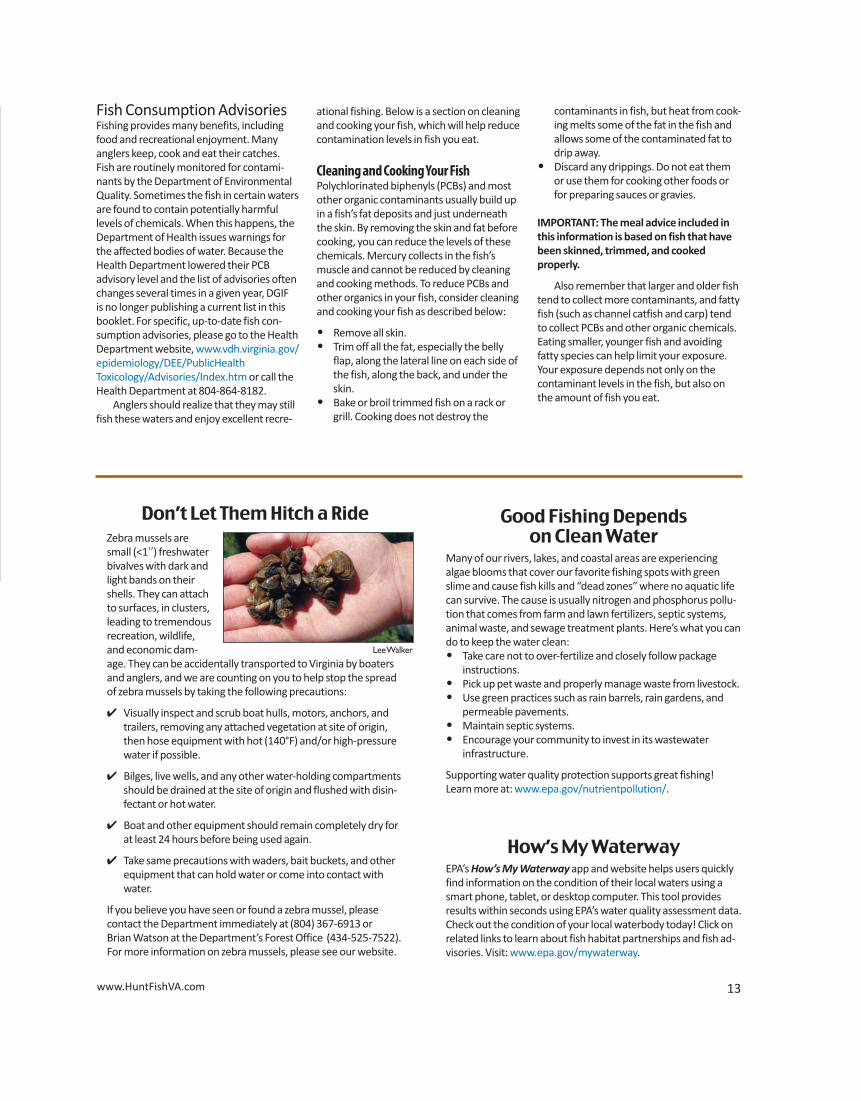
14 2015 Virginia Freshwater Fishing & Boating Guide
Freshwater Fish Regulations
SeasonsThere is a continuous, year-round season forall freshwater fish, with the following excep-tions:
• Special times and limited closures fortrout (Designated Stocked Trout Waterspage 23, Trout Heritage Waters page 23,Urban Program Waters page 23, BlueRidge Parkway page 23, and Fee Fishingtrout waters page 30); and
• Certain seasons for special methods totake nongame fish pages 31–32.
Regulations for anadromous (coastal)striped bass, alewife and blueback herringabove and below the fall line, in tidal rivers ofthe Chesapeake Bay; and anadromous(coastal) American shad and hickory shad,and all other saltwater fish below the fallline, in tidal rivers of the Chesapeake Bay, areset by the Virginia Marine Resources Com-mission. For more information call 757-247-2200 or go online at www.mrc.virginia.gov.
Catch-and-Release FishingIt is often necessary to release a fish becauseit is too small, illegal to keep, or you just don’twant to take it home to eat. In some cases,releasing fish unharmed is a conservationmeasure that will assist in helping to main-tain and build population abundance andsize. The Department of Game and InlandFisheries encourages anglers who practicecatch and release fishing to use a few simpleprecautions when doing so. Using the tipsbelow will help to assure that the fish you re-lease will survive to bite again another day.
• When catching a fish, play it quickly andkeep the fish in the water as much as pos-sible while handling. Avoid the use of anet in landing the fish and release itquickly to avoid exhaustion.
• Handle the fish gently and as little as pos-sible. Do not put your fingers in its eyes orgills. Avoid wiping the slime or scales offthe fish; this reduces their survival bymaking them more susceptible to dis-ease or infection.
• Remove hook promptly using needle -nose pliers or a “hook out” device. If thehook is too deep or hooked in the stom-ach or throat, cut the line and leave thehook in. The hook will dissolve withoutharming the fish.
Q: What do I do if I catch a tagged fish?
A: Anglers should call the regional office that corresponds to the area where thefish was caught and report their catch information or provide that informa-tion by mail. If a study is ongoing that provides a “reward” for tag returns, thetag will have to be returned to DGIF to receive the “reward.”
“Hunt Fish VA”Hunting & Fishing in Your Pocket
The Virginia Department of Game and Inland Fisheries’ app for iPhone®, iPod touch®, and the Android™
is perfect for:• getting the latest news from VDGIF;• looking up hunting regulations, seasons, and bag limits while
in the field;• viewing freshwater fishing regulations and state record fish;• identifying the fish you just caught;• getting sunrise and sunset times for your location;• recording your trophy harvests;• finding nearby boat ramps, wildlife management areas and lakes;• and more!
Best of all, it’s absolutely FREE!At the App Store and Android Market
• Carefully revive the fish if it appears ex-hausted by holding it upright and movingit gently forward so water runs over thegills. Release the fish when it begins tostruggle and is able to swim.
• Do not hold fish in a live well and later decide to release it. If you are going to release a fish, do so right away.
• With a little care and by following theguidelines set above, you can give
released fish a better chance of survival.
• See the “Qualifying a Trophy Fish byLength and Photo” option for Trophy FishAwards on page 54.
Recycle Your Fishing Line!Look for thesecontainers atboat rampsand marinas.
Lee
Wal
ker
www.HuntFishVA.com 15
Bait Type Possession Limit Note
1 Minnows, Chubs, Madtoms 50 In aggregate with other bait, see below
1Crayfish 50 In aggregate with other bait, see below
1Hellgrammites 50 In aggregate with other bait, see below
1 Salamanders (less than 6 inches) 50 In aggregate with other bait, see below
2 Shad (Gizzard, Threadfin, Herring) Unlimited Only permitted in certain waters, see below
3 Trout Unlimited Artificially raised trout only, see below
4 Virginia Game Fish See pages 16–21 Collected by angling with hook and line only
Fathead minnows, golden shiners, goldfish Unlimited
Legally purchased fish bait Unlimited Receipt needed specifying # and species
1 Minnows, chubs, madtoms, crayfish, hellgrammites, salamanders are limited to 50 total for all species combined (aggregate),not 50 of each species at the same time.
2 Gizzard and threadfin shad can be collected and used in any of Virginia's waters but there are geographical limitations for her-ring. There are no restrictions for herring in Virginia waters that are within the Roanoke, New, or Tennessee River drainages.However, it is unlawful to possess herring in all coastal rivers of the Chesapeake Bay, Meherrin River, Nottoway River, Blackwa-ter River (Chowan Drainage), North Landing and Northwest rivers and their tributaries, and Back Bay.
3 Only artificially raised trout may be used as bait. Must have an invoice or bill of sale specifying date of purchase, number oftrout purchased and business where trout were purchased. Trout may be used as bait in the James River, New River, and in impoundments except Lake Moomaw and Philpott Reservoir.
4 The only Game Fish that can be used as cut bait are bluegill, sunfish, and bream. It is unlawful to remove the head, tail, orchange the appearance of any other game fish since it would be impractical to measure original lengths or count the number of fish in possession.
Legal Methods for Capturing Nongame Bait:• Seine not exceeding 4 feet depth by 10 feet in length• Minnow traps with throat openings no larger than 1 inch in diameter• Cast net• Hand-held bow nets with diameter no larger than 20 inches and handle length not to exceed 8 feet• Umbrella-type net not to exceed 5 by 5 feet square• Dip nets may be used to take shad, herring, mullet, and suckers only but may not be used in waters where anadromous
(American) shad and herring cannot be possessed
Areas Restricted:• Designated stocked trout waters• Department (DGIF) owned lakes, unless otherwise posted• Lick Creek in Smyth and Bland counties, Bear Creek in Smyth County, Laurel Creek and tributaries upstream of the Highway
16 bridge in Tazewell and Bland counties, Hungry Mother Creek above Hungry Mother Lake in Smyth County, Susong Branchand Mumpower Creek in Washington County and the City of Bristol, and Timbertree Branch in Scott County.
• Unlawful to take salamanders in Grayson Highlands State Park and on national forest lands in the Jefferson National Forest inthose portions of Grayson, Smyth, and Washington counties bounded on the east by Rt. 16, on the north side by Rt. 603, andon the south and west by Rt. 58
Fish Bait Information
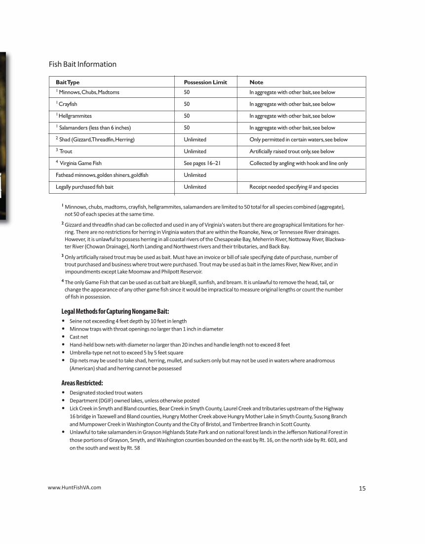
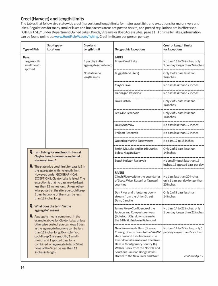
16
Q: I am fishing for smallmouth bass atClaytor Lake. How many and whatsize may I keep?
A: The statewide creel limit for bass is 5 inthe aggregate, with no length limit.However, under GEOGRAPHICALEXCEPTIONS, Claytor Lake is listed. Theexception is that no bass may be keptless than 12 inches long. Unless other-wise posted at the site, you could keep5 bass but none of them can be lessthan 12 inches long.
Q: What does the term “in the aggregate” mean?
A: Aggregate means combined. In theexample above for Claytor Lake, unlessotherwise posted, you can keep 5 bassin the aggregate but none can be lessthan 12 inches long. Example: Youcould keep 2 largemouth, 2 small-mouth and 1 spotted bass for a
combined or aggregate total of 5 but none of the 5 can be less than 12 inches in length.
Sub-type or Creel and Creel or Length LimitsType of Fish Locations Length Limit Geographic Exceptions for Exceptions
Bass: LAKESlargemouth 5 per day in the Briery Creek Lake No bass 16 to 24 inches, only smallmouth aggregate (combined) 1 per day longer than 24 inchesspotted
No statewide Buggs Island (Kerr) Only 2 of 5 bass less thanlength limits 14 inches
Claytor Lake No bass less than 12 inches
Flannagan Reservoir No bass less than 12 inches
Lake Gaston Only 2 of 5 bass less than14 inches
Leesville Reservoir Only 2 of 5 bass less than14 inches
Lake Moomaw No bass less than 12 inches
Philpott Reservoir No bass less than 12 inches
Quantico Marine Base waters No bass 12 to 15 inches
Smith Mt. Lake and its tributaries Only 2 of 5 bass less thanbelow Niagara Dam 14 inches
South Holston Reservoir No smallmouth less than 15 inches, 15 spotted bass per day
RIVERSClinch River–within the boundaries No bass less than 20 inches, of Scott, Wise, Russell or Tazewell only 1 bass per day longer than counties 20 inches
Dan River and tributaries down- Only 2 of 5 bass less thanstream from the Union Street 14 inchesDam, Danville
James River–Confluence of the No bass 14 to 22 inches, onlyJackson and Cowpasture rivers 1 per day longer than 22 inches(Botetourt Cty) downstream to the 14th St. Bridge in Richmond
New River–Fields Dam (Grayson No bass 14 to 22 inches, only 1County) downstream to the VA-WV per day longer than 22 inchesstate line and its tributaries Little River downstream from Little River Dam in Montgomery County, Big Walker Creek from the Norfolk and Southern Railroad Bridge down-stream to the New River and Wolf continued p. 17
Creel (Harvest) and Length LimitsThe tables that follow give statewide creel (harvest) and length limits for major sport fish, and exceptions for major rivers andlakes. Regulations for many smaller lakes and boat access areas are posted on site, and posted regulations are in effect (see“OTHER USES” under Department Owned Lakes, Ponds, Streams or Boat Access Sites, page 11). For smaller lakes, informationcan be found online at: www.HuntFishVA.com/fishing. Creel limits are per person per day.
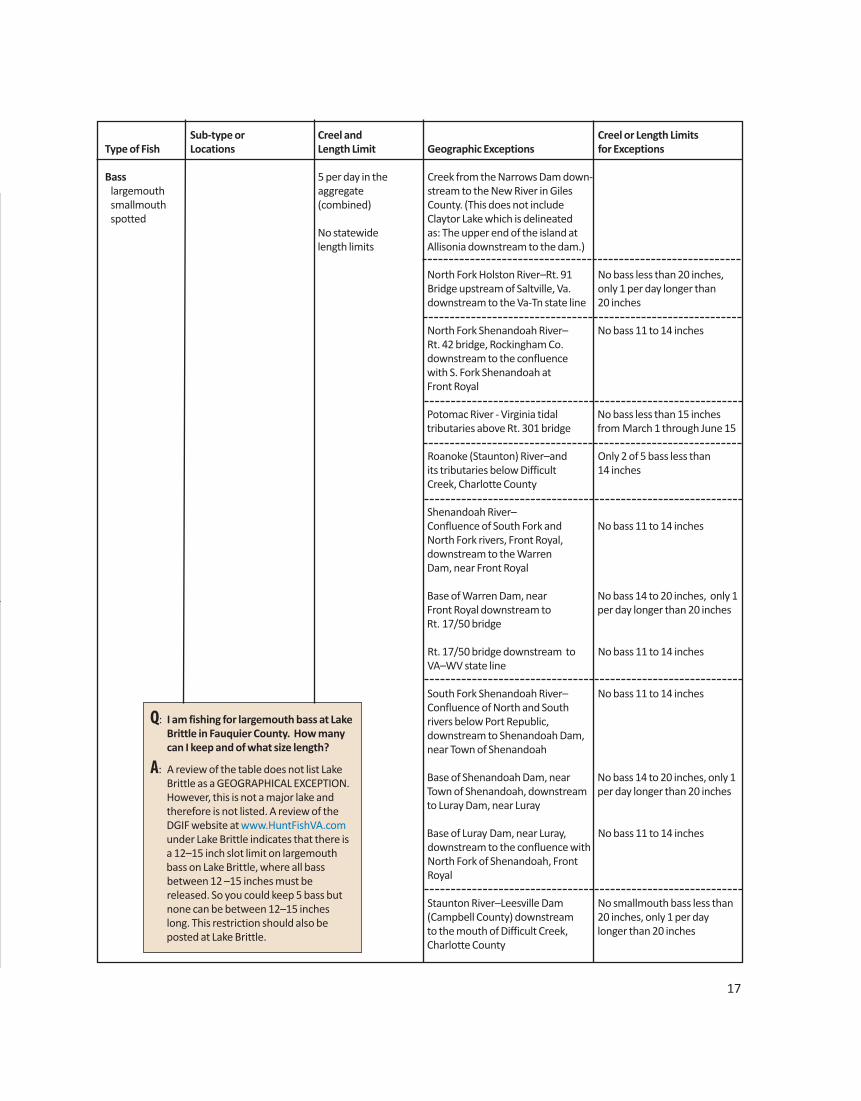
16
Q: I am fishing for smallmouth bass atClaytor Lake. How many and whatsize may I keep?
A: The statewide creel limit for bass is 5 inthe aggregate, with no length limit.However, under GEOGRAPHICALEXCEPTIONS, Claytor Lake is listed. Theexception is that no bass may be keptless than 12 inches long. Unless other-wise posted at the site, you could keep5 bass but none of them can be lessthan 12 inches long.
Q: What does the term “in the aggregate” mean?
A: Aggregate means combined. In theexample above for Claytor Lake, unlessotherwise posted, you can keep 5 bassin the aggregate but none can be lessthan 12 inches long. Example: Youcould keep 2 largemouth, 2 small-mouth and 1 spotted bass for a
combined or aggregate total of 5 but none of the 5 can be less than 12 inches in length.
Sub-type or Creel and Creel or Length LimitsType of Fish Locations Length Limit Geographic Exceptions for Exceptions
Bass: LAKESlargemouth 5 per day in the Briery Creek Lake No bass 16 to 24 inches, only smallmouth aggregate (combined) 1 per day longer than 24 inchesspotted
No statewide Buggs Island (Kerr) Only 2 of 5 bass less thanlength limits 14 inches
Claytor Lake No bass less than 12 inches
Flannagan Reservoir No bass less than 12 inches
Lake Gaston Only 2 of 5 bass less than14 inches
Leesville Reservoir Only 2 of 5 bass less than14 inches
Lake Moomaw No bass less than 12 inches
Philpott Reservoir No bass less than 12 inches
Quantico Marine Base waters No bass 12 to 15 inches
Smith Mt. Lake and its tributaries Only 2 of 5 bass less thanbelow Niagara Dam 14 inches
South Holston Reservoir No smallmouth less than 15 inches, 15 spotted bass per day
RIVERSClinch River–within the boundaries No bass less than 20 inches, of Scott, Wise, Russell or Tazewell only 1 bass per day longer than counties 20 inches
Dan River and tributaries down- Only 2 of 5 bass less thanstream from the Union Street 14 inchesDam, Danville
James River–Confluence of the No bass 14 to 22 inches, onlyJackson and Cowpasture rivers 1 per day longer than 22 inches(Botetourt Cty) downstream to the 14th St. Bridge in Richmond
New River–Fields Dam (Grayson No bass 14 to 22 inches, only 1County) downstream to the VA-WV per day longer than 22 inchesstate line and its tributaries Little River downstream from Little River Dam in Montgomery County, Big Walker Creek from the Norfolk and Western Railroad Bridge down-stream to the New River and Wolf continued p. 17
Creel (Harvest) and Length LimitsThe tables that follow give statewide creel (harvest) and length limits for major sport fish, and exceptions for major rivers andlakes. Regulations for many smaller lakes and boat access areas are posted on site, and posted regulations are in effect (see“OTHER USES” under Department Owned Lakes, Ponds, Streams or Boat Access Sites, page 11). For smaller lakes, informationcan be found online at: www.HuntFishVA.com/fishing. Creel limits are per person per day.
Q: I am fishing for largemouth bass at LakeBrittle in Fauquier County. How manycan I keep and of what size length?
A: A review of the table does not list LakeBrittle as a GEOGRAPHICAL EXCEPTION.However, this is not a major lake andtherefore is not listed. A review of theDGIF website at www.HuntFishVA.comunder Lake Brittle indicates that there isa 12–15 inch slot limit on largemouthbass on Lake Brittle, where all bassbetween 12 –15 inches must bereleased. So you could keep 5 bass butnone can be between 12–15 incheslong. This restriction should also beposted at Lake Brittle.
17
Sub-type or Creel and Creel or Length LimitsType of Fish Locations Length Limit Geographic Exceptions for Exceptions
Bass 5 per day in the Creek from the Narrows Dam down-largemouth aggregate stream to the New River in Giles smallmouth (combined) County. (This does not include spotted Claytor Lake which is delineated
No statewide as: The upper end of the island at length limits Allisonia downstream to the dam.)
North Fork Holston River–Rt. 91 No bass less than 20 inches,Bridge upstream of Saltville, Va. only 1 per day longer thandownstream to the Va-Tn state line 20 inches
North Fork Shenandoah River– No bass 11 to 14 inchesRt. 42 bridge, Rockingham Co.downstream to the confluencewith S. Fork Shenandoah at Front Royal
Potomac River - Virginia tidal No bass less than 15 inchestributaries above Rt. 301 bridge from March 1 through June 15
Roanoke (Staunton) River–and Only 2 of 5 bass less thanits tributaries below Difficult 14 inchesCreek, Charlotte County
Shenandoah River–Confluence of South Fork and No bass 11 to 14 inchesNorth Fork rivers, Front Royal,downstream to the WarrenDam, near Front Royal
Base of Warren Dam, near No bass 14 to 20 inches, only 1Front Royal downstream to per day longer than 20 inchesRt. 17/50 bridge
Rt. 17/50 bridge downstream to No bass 11 to 14 inchesVA–WV state line
South Fork Shenandoah River– No bass 11 to 14 inchesConfluence of North and South rivers below Port Republic, downstream to Shenandoah Dam,near Town of Shenandoah
Base of Shenandoah Dam, near No bass 14 to 20 inches, only 1Town of Shenandoah, downstream per day longer than 20 inchesto Luray Dam, near Luray
Base of Luray Dam, near Luray, No bass 11 to 14 inchesdownstream to the confluence with North Fork of Shenandoah, Front Royal
Staunton River–Leesville Dam No smallmouth bass less than (Campbell County) downstream 20 inches, only 1 per day to the mouth of Difficult Creek, longer than 20 inchesCharlotte County
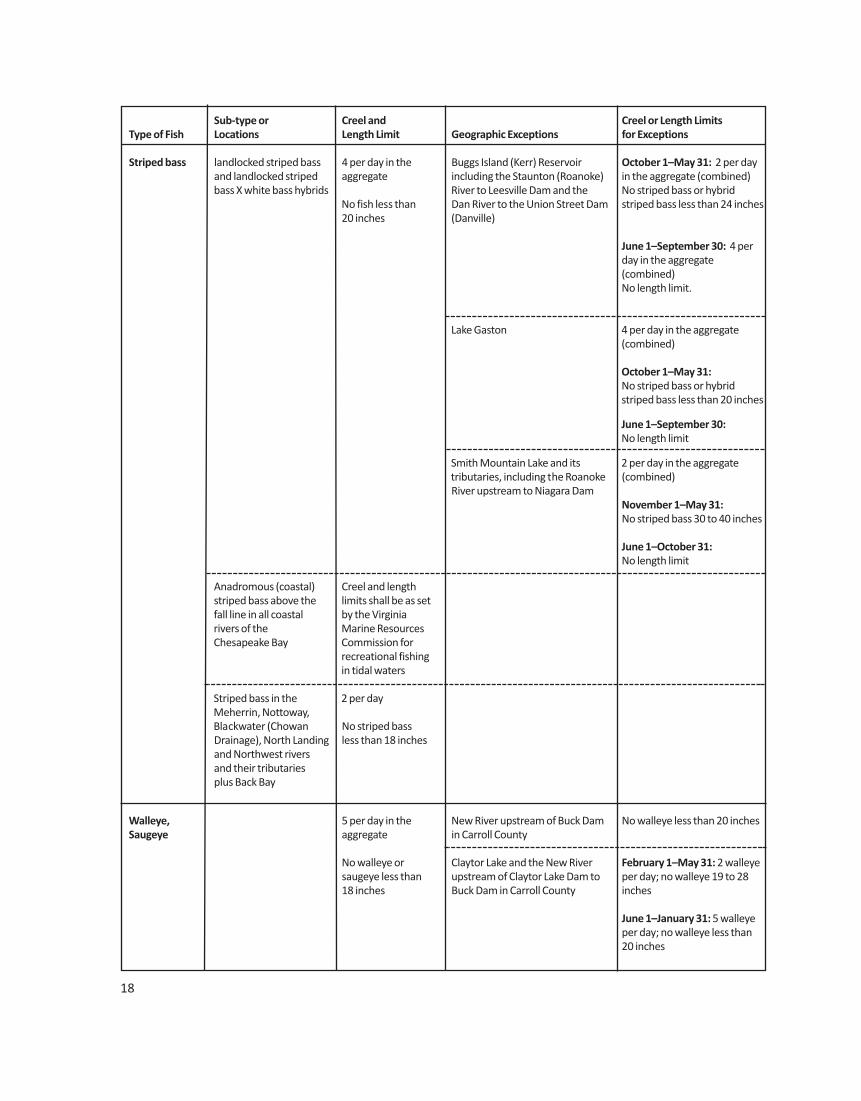
Sub-type or Creel and Creel or Length LimitsType of Fish Locations Length Limit Geographic Exceptions for Exceptions
Striped bass landlocked striped bass 4 per day in the Buggs Island (Kerr) Reservoir October 1–May 31: 2 per dayand landlocked striped aggregate including the Staunton (Roanoke) in the aggregate (combined)bass X white bass hybrids River to Leesville Dam and the No striped bass or hybrid
No fish less than Dan River to the Union Street Dam striped bass less than 24 inches20 inches (Danville)
June 1–September 30: 4 perday in the aggregate (combined)No length limit.
Lake Gaston 4 per day in the aggregate(combined)
October 1–May 31: No striped bass or hybrid striped bass less than 20 inches
June 1–September 30: No length limit
Smith Mountain Lake and its 2 per day in the aggregatetributaries, including the Roanoke (combined)River upstream to Niagara Dam
November 1–May 31:No striped bass 30 to 40 inches
June 1–October 31:No length limit
Anadromous (coastal) Creel and lengthstriped bass above the limits shall be as set fall line in all coastal by the Virginia rivers of the Marine ResourcesChesapeake Bay Commission for
recreational fishingin tidal waters
Striped bass in the 2 per dayMeherrin, Nottoway,Blackwater (Chowan No striped bassDrainage), North Landing less than 18 inchesand Northwest riversand their tributariesplus Back Bay
Walleye, 5 per day in the New River upstream of Buck Dam No walleye less than 20 inchesSaugeye aggregate in Carroll County
No walleye or Claytor Lake and the New River February 1–May 31: 2 walleyesaugeye less than upstream of Claytor Lake Dam to per day; no walleye 19 to 2818 inches Buck Dam in Carroll County inches
June 1–January 31: 5 walleyeper day; no walleye less than20 inches
18
Sub-type or Creel and Creel or Length LimitsType of Fish Locations Length Limit Geographic Exceptions for Exceptions
Sauger 2 per day
No statewide length limits
White bass 5 per day South Holston Reservoir No harvest or possession(catch and release only)
No statewide length limits
Chain pickerel 5 per day Gaston and Buggs Island No daily limit(Kerr) reservoirs
No statewide lengthlimits
Northern pike 2 per day
No pike less than20 inches
Muskellunge 2 per day New River–Fields Dam (Grayson 1 per dayCounty) downstream to the
No muskellunge VA-WV state line, including No muskellunge less thanless than 30 inches Claytor Lake 42 inches
Bluegill (bream) 50 per day in the Gaston and Buggs Island (Kerr) No daily limitand other sunfish aggregate reservoirs and that portion of excluding crappie (combined) the New River from the VA–NC rock bass state line downstream to the (redeye) and No statewide length confluence of the New and Little Roanoke bass limits rivers in Grayson County
Crappie 25 per day in the Gaston and Buggs Island (Kerr) No daily limit(black or white) aggregate reservoirs and that portion of
(combined) the New River from the VA–NC state line downstream to the
No statewide length confluence of the New and Little limits rivers in Grayson County
Flannagan and South Holston No crappie less than 10 inches;reservoirs South Holston Res.–15 per day
in the aggregate (combined)
Rock bass 25 per day Gaston and Buggs Island (Kerr) No daily limit(redeye) reservoirs and that portion of the
No statewide New River from the VA–NC statelength limits line downstream to the confluence
of the New and Little rivers inGrayson County
Nottoway and Meherrin rivers 5 per day in the aggregateand their tributaries (combined) with Roanoke bass
No rock bass less than 8 inches
South Holston Reservoir 20 per day
19
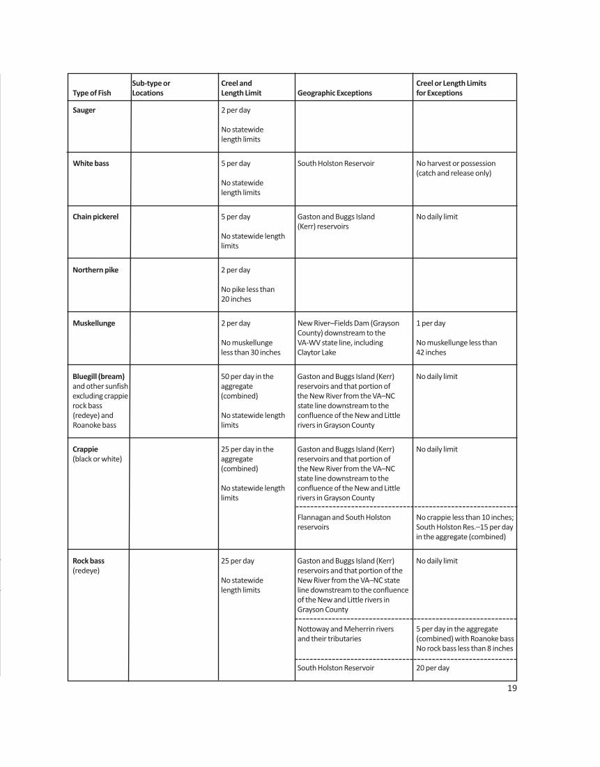
Sub-type or Creel and Creel or Length LimitsType of Fish Locations Length Limit Geographic Exceptions for Exceptions
Striped bass landlocked striped bass 4 per day in the Buggs Island (Kerr) Reservoir October 1–May 31: 2 per dayand landlocked striped aggregate including the Staunton (Roanoke) in the aggregate (combined)bass X white bass hybrids River to Leesville Dam and the No striped bass or hybrid
No fish less than Dan River to the Union Street Dam striped bass less than 24 inches20 inches (Danville)
June 1–September 30: 4 perday in the aggregate (combined)No length limit.
Lake Gaston 4 per day in the aggregate(combined)
October 1–May 31: No striped bass or hybrid striped bass less than 20 inches
June 1–September 30: No length limit
Smith Mountain Lake and its 2 per day in the aggregatetributaries, including the Roanoke (combined)River upstream to Niagara Dam
November 1–May 31:No striped bass 30 to 40 inches
June 1–October 31:No length limit
Anadromous (coastal) Creel and lengthstriped bass above the limits shall be as set fall line in all coastal by the Virginia rivers of the Marine ResourcesChesapeake Bay Commission for
recreational fishingin tidal waters
Striped bass in the 2 per dayMeherrin, Nottoway,Blackwater (Chowan No striped bassDrainage), North Landing less than 18 inchesand Northwest riversand their tributariesplus Back Bay
Walleye, 5 per day in the New River upstream of Buck Dam No walleye less than 20 inchesSaugeye aggregate in Carroll County
No walleye or Claytor Lake and the New River February 1–May 31: 2 walleyesaugeye less than upstream of Claytor Lake Dam to per day; no walleye 19 to 2818 inches Buck Dam in Carroll County inches
June 1–January 31: 5 walleyeper day; no walleye less than20 inches
18
Sub-type or Creel and Creel or Length LimitsType of Fish Locations Length Limit Geographic Exceptions for Exceptions
Sauger 2 per day
No statewide length limits
White bass 5 per day South Holston Reservoir No harvest or possession(catch and release only)
No statewide length limits
Chain pickerel 5 per day Gaston and Buggs Island No daily limit(Kerr) reservoirs
No statewide lengthlimits
Northern pike 2 per day
No pike less than20 inches
Muskellunge 2 per day New River–Fields Dam (Grayson 1 per dayCounty) downstream to the
No muskellunge VA-WV state line, including No muskellunge less thanless than 30 inches Claytor Lake 42 inches
Bluegill (bream) 50 per day in the Gaston and Buggs Island (Kerr) No daily limitand other sunfish aggregate reservoirs and that portion of excluding crappie (combined) the New River from the VA–NC rock bass state line downstream to the (redeye) and No statewide length confluence of the New and Little Roanoke bass limits rivers in Grayson County
Crappie 25 per day in the Gaston and Buggs Island (Kerr) No daily limit(black or white) aggregate reservoirs and that portion of
(combined) the New River from the VA–NC state line downstream to the
No statewide length confluence of the New and Little limits rivers in Grayson County
Flannagan and South Holston No crappie less than 10 inches;reservoirs South Holston Res.–15 per day
in the aggregate (combined)
Rock bass 25 per day Gaston and Buggs Island (Kerr) No daily limit(redeye) reservoirs and that portion of the
No statewide New River from the VA–NC statelength limits line downstream to the confluence
of the New and Little rivers inGrayson County
Nottoway and Meherrin rivers 5 per day in the aggregateand their tributaries (combined) with Roanoke bass
No rock bass less than 8 inches
South Holston Reservoir 20 per day
19
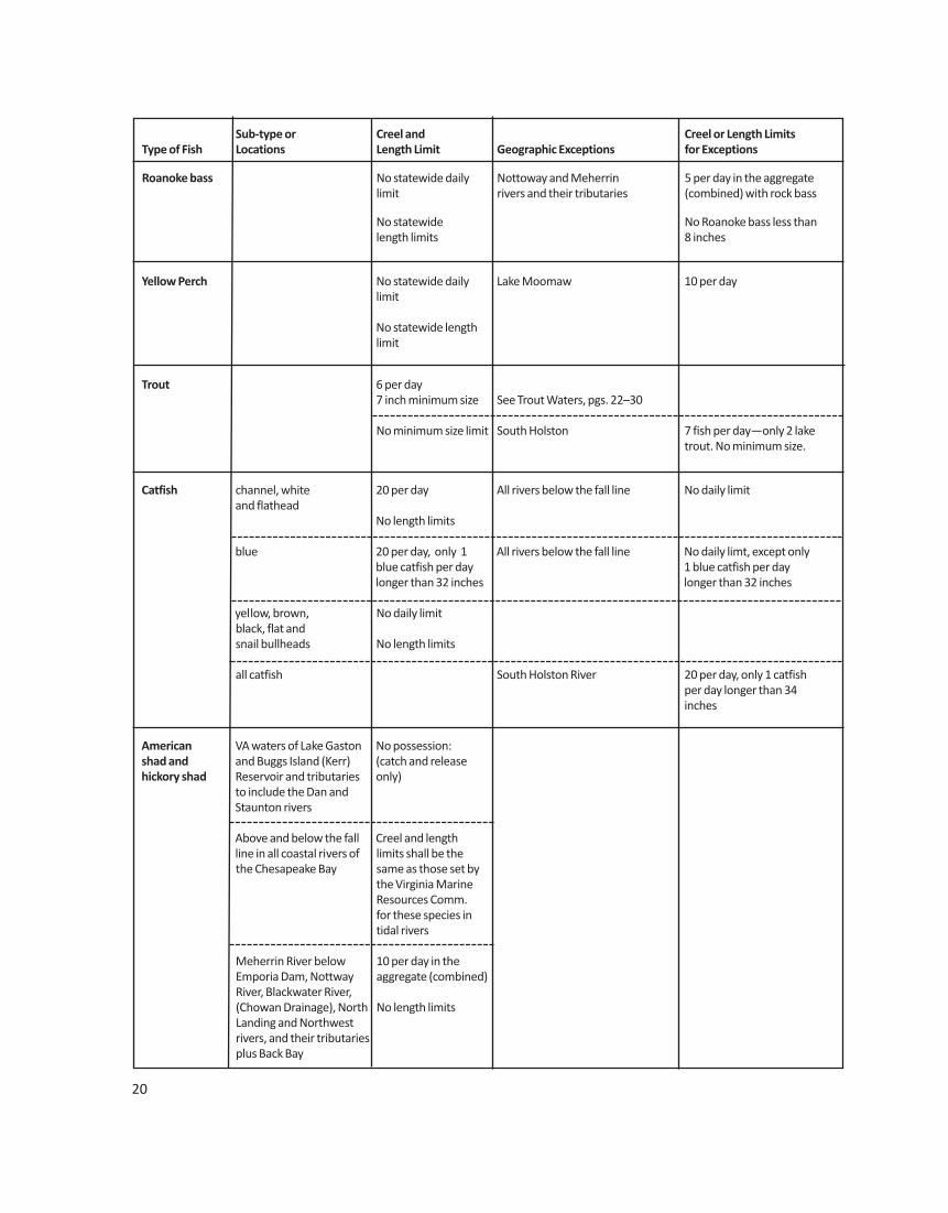
20
Sub-type or Creel and Creel or Length LimitsType of Fish Locations Length Limit Geographic Exceptions for Exceptions
Roanoke bass No statewide daily Nottoway and Meherrin 5 per day in the aggregatelimit rivers and their tributaries (combined) with rock bass
No statewide No Roanoke bass less than length limits 8 inches
Yellow Perch No statewide daily Lake Moomaw 10 per daylimit
No statewide lengthlimit
Trout 6 per day7 inch minimum size See Trout Waters, pgs. 22–30
No minimum size limit South Holston 7 fish per day—only 2 laketrout. No minimum size.
Catfish channel, white 20 per day All rivers below the fall line No daily limitand flathead
No length limits
blue 20 per day, only 1 All rivers below the fall line No daily limt, except onlyblue catfish per day 1 blue catfish per daylonger than 32 inches longer than 32 inches
yellow, brown, No daily limitblack, flat and snail bullheads No length limits
all catfish South Holston River 20 per day, only 1 catfish per day longer than 34inches
American VA waters of Lake Gaston No possession:shad and and Buggs Island (Kerr) (catch and releasehickory shad Reservoir and tributaries only)
to include the Dan and Staunton rivers
Above and below the fall Creel and lengthline in all coastal rivers of limits shall be the the Chesapeake Bay same as those set by
the Virginia Marine Resources Comm.for these species intidal rivers
Meherrin River below 10 per day in theEmporia Dam, Nottway aggregate (combined)River, Blackwater River, (Chowan Drainage), North No length limitsLanding and Northwest rivers, and their tributaries plus Back Bay
21
Sub-type or Creel and Creel or Length LimitsType of Fish Locations Length Limit Geographic Exceptions for Exceptions
Anadromous Above and below the fall Creel and length limits The Virginia Marine Resources Commission enacted (coastal) line in all coastal rivers shall be the same as a ban on the possession of river herring, effectivealewife and of the Chesapeake Bay those set by the January 1, 2012, due to the collapse of the stock,blueback and their tributaries Virginia Marine and to comply with an Atlantic States Marine Fisheriesherring Resources Comm. fishery management plan directive
for these species intidal rivers
Meherrin River, Nottoway No possessionRiver, Blackwater River(Chowan Drainage),North Landing andNorthwest rivers and theirtributaries, plus Back Bay
Other native 20 per day Statewide See pages 31–32 for or naturalized No length limits exceptionsnongame fish
Threatened and No possessionendangered species
Grass carp No possession (catchand release only)
Northern No statewide daily Anglers may possess a snakehead taken from Virginia waters if they Snakehead limit immediately kill the fish and notify the headquarters or a regional
office of the department; notification may be made by callingNo statewide length (804) 367-2925limit
Non-native See pages 31–32(exotic) fish
Red Drum Back Bay, Lake Tecumseh, 1 per day between North Landing River and 18 and 27 inchestheir tributaries
Spotted Sea Back Bay, Lake Tecumseh, 4 per day, no fish less Trout North Landing River and than 14 inches
their tributaries
Grey Trout Back Bay, Lake Tecumseh, 1 per day, no fish less North Landing River and than 12 inchestheir tributaries
Southern Back Bay, Lake Tecumseh, 6 per day, no fish less Flounder North Landing River and than 15 inches
their tributaries
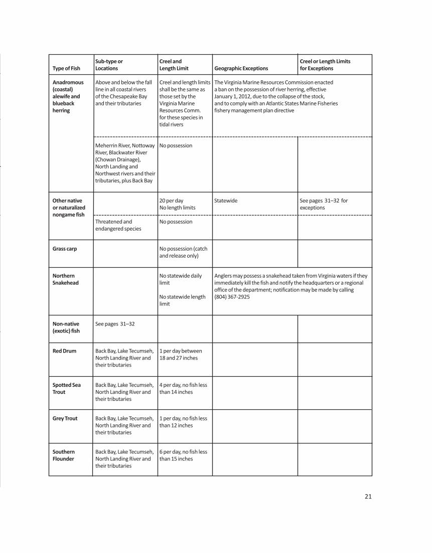
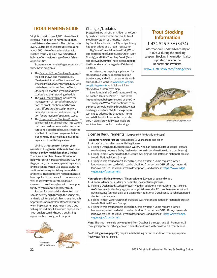
illustration©Michael Simon
22 2015 Virginia Freshwater Fishing & Boating Guide
TROUT FISHING GUIDE
Virginia contains over 2,900 miles of troutstreams, in addition to numerous ponds,small lakes and reservoirs. The total includesover 2,300 miles of wild trout streams andabout 600 miles of water inhabited withstocked trout. Virginia’s diversified trouthabitat offers a wide range of trout fishingopportunities. Trout management in Virginia consists ofthree basic programs:
• The Catchable Trout Stocking Program isthe best known and most popular.
“Designated Stocked Trout Waters” are stocked from October through May with catchable-sized trout. See the Trout Stocking Plan for the streams and lakes stocked and their stocking schedule. • The Wild Trout Program includes the
management of reproducing popula-tions of brook, rainbow, and browntrout. Efforts are directed primarily athabitat preservation and proper regula-tion for protection of spawning stocks.
• The Fingerling Trout Stocking Program in-volves stocking sublegal trout into watersthat have cold summer water tempera-tures and a good food source. This is thesmallest of the three programs, but in-cludes many of our high quality, specialregulation trout fishing waters.
Virginia’s trout season is open year-round and the general statewide limits are6 trout per day, no fish less than 7 inches.There are a number of exceptions foundbelow for certain areas and waters (i.e., her-itage, urban, special area, special regulation,and fee fishing waters), so please study thesections following for fishing times, dates,and limits. These different restrictions havebeen applied to certain wild trout waters, aswell as several types of stocked troutstreams, to provide anglers with the oppor-tunity to catch more and larger trout. Success for both wild and stocked troutshould be very high through the spring, fall,and mild winter periods. From June throughSeptember, normally low stream flows andwarming water temperatures make troutfishing more difficult. However, experiencedtrout anglers can find good trout fishing opportunities throughout the year.
Changes/UpdatesScottsville Lake in southern Albemarle Coun-ty has been added to the Catchable TroutStocking Program as a Priority A water.Ivy Creek Park Pond in the City of Lynchburghas been added as a Urban Trout water. Big Stony Creek (Mountain Fork)(Wiseand Scott counties), Little Stony Creek (ScottCounty), and Little Tumbling Creek (Smythand Tazewell Counties) have been added tothe list of streams managed as Catch and Release. An interactive mapping application forstocked trout waters, special regulationtrout waters, and wild trout waters is avail-able on DGIF’s website: www.dgif.virginia.gov/fishing/trout/ and click on link tostocked trout interactive map. Lake Tams in the City of Staunton will notbe stocked January-May 2015 due to the impoundment being renovated by the City. Thompson WMA Pond continues to ex-perience periodic leaking through its waterdischarge structure. While the Agency isworking to address the situation, Thomp-son WMA Pond will be stocked as a cate-gory A water, provided water levels aresufficient to accomplish the stockings.
Trout Stocking Information
1-434-525-FISH (3474)Information is updated each day at
4:00 P.M. during the stocking season. Stocking information is also
updated daily on the Department’s website.
www.HuntFishVA.com/fishing/stock
License Requirements (See page 6-7 for details and costs)
Residents fishing for trout: All residents 16 years of age and older.1. A state or county freshwater fishing license.2. Fishing a Designated Stocked Trout Water? Need an additional trout license. (Note a
resident may not use a 5-day freshwater license in combination with a trout license).3. Fishing in most waters within the George Washington and Jefferson National Forests? Need a National Forest Stamp4. Fishing in wild trout or most special regulation waters? Some require a signed
landowner permit card which can be obtained from certain DGIF offices, streamsidelandowners (see individual stream descriptions), and online at https://www3.dgif.
virginia.gov/troutpermits.
Nonresidents fishing for trout: All nonresidents 12 years of age and older.1. A nonresident annual, daily, or 5- day freshwater fishing license.2. Fishing a Designated Stocked Water? Need an additional nonresident trout license. Note: Nonresidents of any age, including children under 12, must have a nonresident fishing license (annual, daily or 5 day) and an additional trout license to fish designated stocked trout waters.3. Fishing in most waters within the George Washington and Jefferson National Forests?
Need a National Forest Stamp.4. Fishing in wild trout or most special regulation waters? Some require a signed
landowner permit card which can be obtained from certain DGIF offices, streamsidelandowners (see individual stream descriptions), and online at https://www3.dgif.
virginia.gov/troutpermits.
Note: The trout license is only required from October 1 through June 15. From June 16through September 30 anglers can fish in stocked trout waters without a trout license.
Fee Fishing Areas (page 30) require a daily fishing permit in addition to an appropriatefreshwater fishing license.
Brown trout, ©Spike Knuth
www.HuntFishVA.com 23
Designated Trout Waters(Catchable Trout Stocking Waters)“Designated Stocked Trout Waters” includethose waters that are stocked with catch-able-sized trout and are listed by the Direc-tor in the annual Trout Stocking Plan (seepages 20–21). These waters will only be considered designated stocked trout watersfrom October 1 through June 15 (trout license required). A trout license is not re-quired from June 16 through September 30.Trout angling hours on designated stockedtrout waters are from 5:00 am until onehour after sunset. See exceptions for TroutHeritage Waters (page 19), Urban ProgramWaters (page 19) and Fee Fishing Areas(page 25). Designated stocked trout watersare posted by the Department with appro-priate “stocked trout waters” signs. It is unlawful to fish in designatedstocked trout waters after the daily creellimit of trout has been obtained or duringthe closed hours for taking trout. Once atrout is taken into possession by placing inthe creel (basket, bucket, stringer, cooler,etc.) it becomes part of the daily creel limitand may not be released (culled). It is unlaw-ful to feed, bait, or snag trout in designatedstocked trout waters. It shall be unlawful forany person fishing in designated stockedtrout waters to use more than one rod, oneline, and one baited hook (a treble hook isconsidered one hook); however, any combi-nation of artificial lures is allowed. It shall beunlawful to use seines and nets in designat-ed stocked waters, except that a hand-land-ing net to land fish legally hooked may beused in all waters.
Urban Program WatersWaters in the Urban Fishing Program will beconsidered designated stocked trout watersfrom November 1 through April 30 only(trout license required). A trout license isnot required from May 1 through October31. In addition trout may be creeled fromthese waters year-round and the trout creellimit is 4 per day. Once a trout is taken intopossession by placing in the creel (basket,bucket, stringer, cooler, etc.) it becomes partof the daily creel limit and may not be re-leased (culled).
Artificial Lure DefinitionArtificial lure shall include manufactured orhandmade flies, spinners, plugs, spoons, andfacsimiles of live animals, but shall not beconstrued to include artificially-produced organic baits and fish eggs that are intended
to be ingested. Artificial lure with singlehook shall mean any single point lure (withno multiple point hooks). Where single-hook artificial lures are required, a multiplenumber of single-hook lures (such as drop-per flies) fished in a series is permitted.
Special Trout AreasBlue Ridge Parkway: Fishing is prohibitedfrom one-half hour after sunset until one-half hour before sunrise. No live or dead fishor fish eggs may be used as bait. Digging forworms is prohibited. Special creel limits andother regulations for Parkway waters maybe posted.
Shenandoah National Park: Only single-point hook artificial lures may be used—nobait. On those streams open to harvest, thecreel limit is 6 trout per day with a 9-inchminimum size for brook trout and a 7-inchminimum size for brown and rainbow trout.On all other streams open to fishing, catch
Trout Heritage Waters for 2015This program was added for those anglers who enjoyedand missed the old opening day. Selected waters arestocked for the first Saturday in April to create an announcedstocking event.
The following waters will be stocked for Heritage Day on April 4:
Beartree Lake Washington CountyBark Camp Lake Scott CountyClinch Mountain Fee Fishing Area* Washington CountyCripple Creek (Ravens Cliff) Wythe CountyCrooked Creek Fee Fishing Area* Carroll CountyDouthat Lake Fee Fishing Area* Bath CountyHawksbill Creek Page CountyJennings Creek Botetourt CountyLake Witten Tazewell CountyLiberty Lake Bedford CountyLincolnshire Lake Tazewell CountyMiddle Fork Holston River Smyth CountyPassage Creek Shenandoah CountyPedlar River (upper) Amherst CountyPigg River Franklin CountyQuantico MCB Prince William CountyRobinson River Madison CountyRose River Madison CountySouth Fork Powell River Wise CountyTinker Creek Roanoke County
* The fee fishing areas are closed to angling from March 30–April 3. Heritage Waters are closed on April 3. On April 4 fishing can begin at 9:00 A.M.
and release regulations apply. The release ofany brown trout back into any Park stream isprohibited and brown trout less than 7 inch-es must be disposed of within the Park butaway from Park streams, roads or trails. Thisis an effort to limit the impacts of browntrout on the native brook trout populations.Contact the Shenandoah National Park at540-999-3500 for the annual list of streamsopen to harvest.
Brook trout, ©Ralph Hensley
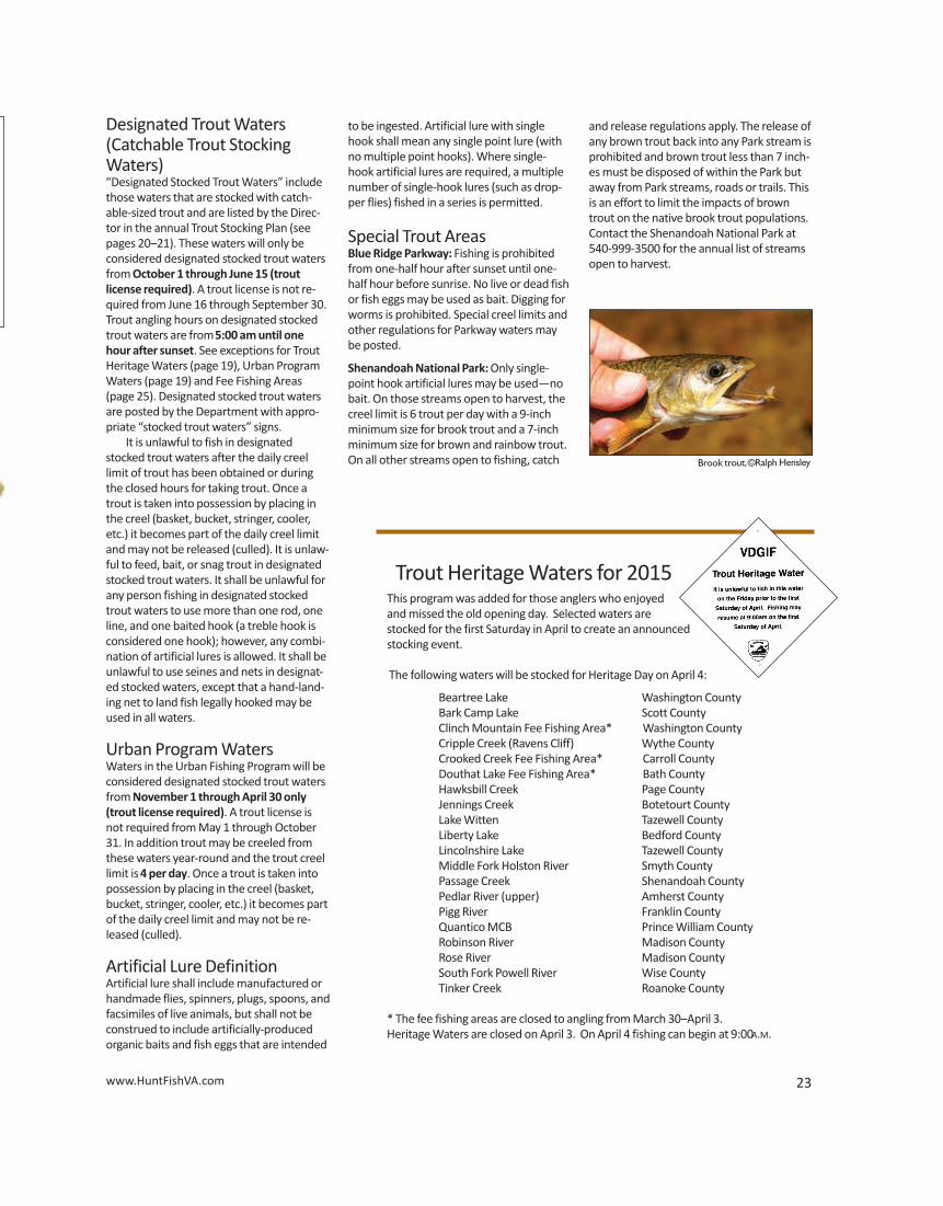
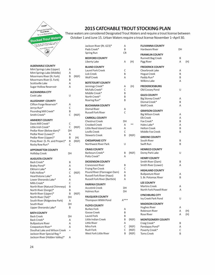
24
ALBEMARLE COUNTYMint Springs Lake (Upper) AMint Springs Lake (Middle) AMoormans River (N. Fork) B (NSF)Moormans River (S. Fork) B Scottsville Lake ASugar Hollow Reservoir A
ALEXANDRIA CITYCook Lake U
ALLEGHANY COUNTYClifton Forge Reservoir* AJerrys Run* CPounding Mill Creek* B Smith Creek* C (NSF)
AMHERST COUNTYDavis Mill Creek* CLittle Irish Creek* C (NSF)Pedlar River (Below dam)* DHPedlar River (Lower)* APedlar River (Upper)* B (H)Piney River (S. Fk. and Proper)* B (NSF)Rocky Row Run* C
APPOMATTOX COUNTYHolliday Creek DH
AUGUSTA COUNTYBack Creek* BBraley Pond* AElkhorn Lake* AFalls Hollow* C (NSF)Hearthstone Lake* ALower Sherando Lake* AMills Creek* CNorth River (Natural Chimneys) BNorth River (Gorge)* BNorth River (Upper)* B (NSF)North River (Tail)* DHSouth River (Ridgeview Park) ASouth River DHUpper Sherando Lake* B
BATH COUNTYBack Creek DHBack Creek* ABullpasture River ACowpasture River* ADouthat Lake and Wilson Creek +Jackson River Special Reg.* Jackson River (Hidden Valley)* A
Jackson River (Rt. 623)* APads Creek* BSpring Run CR
BEDFORD COUNTYLiberty Lake A (H)
BLAND COUNTYLaurel Fork Creek CLick Creek BWolf Creek A
BOTETOURT COUNTYJennings Creek* A (H)McFalls Creek* CMiddle Creek* BNorth Creek* BRoaring Run* B
BUCHANAN COUNTYDismal River ARussell Fork River C
CARROLL COUNTYChestnut Creek DHCrooked Creek A **Little Reed Island Creek ALovills Creek CStewarts Creek B (NSF)
CHESAPEAKE CITYNorthwest River Park U
CRAIG COUNTYBarbours Creek* B (NSF)Potts Creek* A
DICKENSON COUNTYCranesnest River BFrying Pan Creek CPound River (Flannagan Dam) ARussell Fork River (Haysi) BRussell Fork River (Bartlick) A
FAIRFAX COUNTYAccotink Creek DHHolmes Run DH
FAUQUIER COUNTYThompson WMA Pond A***
FLOYD COUNTYBurkes Fork AGoose Creek BLaurel Fork BLittle Indian Creek B (NSF)Little River AMira Fork C (NSF)Rush Fork C (NSF)West Fork Little River B (NSF)
FLUVANNA COUNTYHardware River DH
FRANKLIN COUNTYRunnett Bag Creek BPigg River A (H)
FREDERICK COUNTYClearbrook Lake AHogue Creek BPaddy Run* BWilkins Lake A
FREDERICKSBURGOld Cossey Pond U
GILES COUNTYBig Stoney Creek* ADismal Creek* BWolf Creek A
GRAYSON COUNTYBig Wilson Creek AElk Creek AFox Creek* BHales Lake* AHelton Creek BMiddle Fox Creek B
GREENE COUNTYSouth River BSwift Run B
HENRICO COUNTYDorey Park Lake U
HENRY COUNTYSmith River (Dam) BSmith River (Lower) A
HIGHLAND COUNTYBullpasture River AS. Br. Potomac River B
LEE COUNTYMartins Creek ANorth Fork Powell River A
LYNCHBURG CITYIvy Creek Park Pond U
MADISON COUNTYHughes River ARobinson River A (H)Rose River A (H)
MONTGOMERY COUNTYCraig Creek* BPandapas Pond* APoverty Creek* CToms Creek B
2015 CATCHABLE TROUT STOCKING PLANThese waters are considered Designated Trout Waters and require a trout license between
October 1 and June 15. Urban Waters require a trout license November 1–April 30.
25
NELSON COUNTYSouth Rockfish River C (NSF)Tye River A
NEWPORT NEWSLake Biggins U
PAGE COUNTYCub Run* BHawksbill Creek A (H)Upper Passage Creek* C
PATRICK COUNTYArarat River BClarks Creek BDan River (Above Talbott) B (NSF)Dan River (Below Powerhouse) APoorhouse Creek C (NSF)Rockcastle Creek B Round Meadow Creek C (NSF)South Mayo River (North Fork) CSouth Mayo River (South Fork) C
PRINCE WILLIAM COUNTYQuantico MCB B (H) (NSF)Locust Shade Park U
PULASKI COUNTYPeak Creek BPeak Creek DH
RICHMOND CITYShield Lake U
ROANOKE COUNTYGlade Creek ARoanoke River (City) ARoanoke River (Green Hill Park) DHRoanoke River (Salem) ARoanoke River (Salem) DHTinker Creek A (H)
ROCKBRIDGE COUNTYIrish Creek* BMaury River AMill Creek* ASouth River B
ROCKINGHAM COUNTYBriery Branch Lake* ADry River B (NSF)German River CHone Quarry Lake* AHone Quarry Run* CNorth Fork Shenandoah River BSilver Lake BSlate Lick Lake* BSlate Lick Run* BSouth River (Grottoes) A
RUSSELL COUNTYBig Cedar Creek A
SCOTT COUNTYBark Camp Lake* A (H)
Big Stony Creek BLittle Stony Creek* BStock Creek B
SHENANDOAH COUNTYMill Creek BPassage Creek* A (H)Peters Mill Creek* CStony Creek ATomahawk Pond* B
SMYTH COUNTYComers Creek* CCressy Creek* CDickey Creek* CHurricane Creek* CMiddle Fork Holston River
(Marion & Chilhowie) A (H)Middle Fork Holston River
(Upper) BSouth Fork Holston River
(Buller Dam)* ASouth Fork Holston River
(Lower) AStaley Creek A
STAUNTON CITYLake Tams B
TAZEWELL COUNTYLake Witten A (H)Laurel Creek* CLincolnshire Lake A (H)Little Tumbling Creek B
WARREN COUNTYHappy Creek BPassage Creek DH
WASHINGTON COUNTYBeartree Lake* A (H)Big Brumley Creek CBig Tumbling Creek A **Straight Branch* CTennessee Laurel AValley Creek CWhitetop Laurel (Lower)* AWhitetop Laurel (Upper)* A
WISE COUNTYClear Creek* CPound River/N.Fk. Pound River DHSouth Fork Powell River A (H)
WYTHE COUNTYCripple Creek (Rt. 94) ACripple Creek (Ravens) A (H)Gullion Fork Ponds* BRural Retreat Lake Pond AStoney Creek* CWest Fork Reed Creek* C
Category A stocked 8 times between October 1 and May 30.
Category B stocked 5 times between October 1 and May 15.
Category C stocked 3 times between October 1 and April 30.
* National Forest Waters.
+ Douthat stocked as Category A, Wilson as Category B put-and-take water after fee fishing season.
CR Catch and release
DH Delayed Harvest Water-Special Regulations apply, please refer to Delayed Harvest waters on page 24.
(NSF) These waters do not receive fall & early winter stockings.
** A section of these waters is reserved for a fee fishing area.
(H) These waters will receive a stocking for the “Heritage Day” program. Heritage Day is April 4. For details see page 23.
U Urban fishing waters, trout license required November 1 through April 30, stocked 5 times between November 1 and April 15.
Stocking information for put-and-take stocking can be obtained on our website or by calling 434-525-FISH (3474). Both are updated after 4:00 PM each day fish are stocked.
***The water discharge on Thompson WMA Pond has experienced periodic leaking over the past several years and the Department is taking steps to mitigate the problem.Thompson will be stocked as a Category A water, provided the pond water level is compatible with stocking needs.
trout illustration ©Spike Knuth
25
NELSON COUNTYSouth Rockfish River C (NSF)Tye River A
NEWPORT NEWSLake Biggins U
PAGE COUNTYCub Run* BHawksbill Creek A (H)Upper Passage Creek* C
PATRICK COUNTYArarat River BClarks Creek BDan River (Above Talbott) B (NSF)Dan River (Below Powerhouse) APoorhouse Creek C (NSF)Rockcastle Creek B Round Meadow Creek C (NSF)South Mayo River (North Fork) CSouth Mayo River (South Fork) C
PRINCE WILLIAM COUNTYQuantico MCB B (H) (NSF)Locust Shade Park U
PULASKI COUNTYPeak Creek BPeak Creek DH
RICHMOND CITYShield Lake U
ROANOKE COUNTYGlade Creek ARoanoke River (City) ARoanoke River (Green Hill Park) DHRoanoke River (Salem) ARoanoke River (Salem) DHTinker Creek A (H)
ROCKBRIDGE COUNTYIrish Creek* BMaury River AMill Creek* ASouth River B
ROCKINGHAM COUNTYBriery Branch Lake* ADry River B (NSF)German River CHone Quarry Lake* AHone Quarry Run* CNorth Fork Shenandoah River BSilver Lake BSlate Lick Lake* BSlate Lick Run* BSouth River (Grottoes) A
RUSSELL COUNTYBig Cedar Creek A
SCOTT COUNTYBark Camp Lake* A (H)
Big Stony Creek BLittle Stony Creek* BStock Creek B
SHENANDOAH COUNTYMill Creek BPassage Creek* A (H)Peters Mill Creek* CStony Creek ATomahawk Pond* B
SMYTH COUNTYComers Creek* CCressy Creek* CDickey Creek* CHurricane Creek* CMiddle Fork Holston River
(Marion & Chilhowie) A (H)Middle Fork Holston River
(Upper) BSouth Fork Holston River
(Buller Dam)* ASouth Fork Holston River
(Lower) AStaley Creek A
STAUNTON CITYLake Tams B
TAZEWELL COUNTYLake Witten A (H)Laurel Creek* CLincolnshire Lake A (H)Little Tumbling Creek B
WARREN COUNTYHappy Creek BPassage Creek DH
WASHINGTON COUNTYBeartree Lake* A (H)Big Brumley Creek CBig Tumbling Creek A **Straight Branch* CTennessee Laurel AValley Creek CWhitetop Laurel (Lower)* AWhitetop Laurel (Upper)* A
WISE COUNTYClear Creek* CMiddle Fork Powell River APound River/N.Fk. Pound River DHSouth Fork Powell River A (H)
WYTHE COUNTYCripple Creek (Rt. 94) ACripple Creek (Ravens) A (H)Gullion Fork Ponds* BRural Retreat Lake Pond AStoney Creek* CWest Fork Reed Creek* C
Category A stocked 8 times between October 1 and May 30.
Category B stocked 5 times between October 1 and May 15.
Category C stocked 3 times between October 1 and April 30.
* National Forest Waters.
+ Douthat stocked as Category A, Wilson as Category B put-and-take water after fee fishing season.
CR Catch and release
DH Delayed Harvest Water-Special Regulations apply, please refer to Delayed Harvest waters on page 24.
(NSF) These waters do not receive fall & early winter stockings.
** A section of these waters is reserved for a fee fishing area.
(H) These waters will receive a stocking for the “Heritage Day” program. Heritage Day is April 4. For details see page 23.
U Urban fishing waters, trout license required November 1 through April 30, stocked 5 times between November 1 and April 15.
Stocking information for put-and-take stocking can be obtained on our website or by calling 434-525-FISH (3474). Both are updated after 4:00 PM each day fish are stocked.
***The water discharge on Thompson WMA Pond has experienced periodic leaking over the past several years and the Department is taking steps to mitigate the problem.Thompson will be stocked as a Category A water, provided the pond water level is compatible with stocking needs.
trout illustration ©Spike Knuth
2015 Fishing Regs & WOG_Layout 1 4/21/15 10:14 AM Page 25
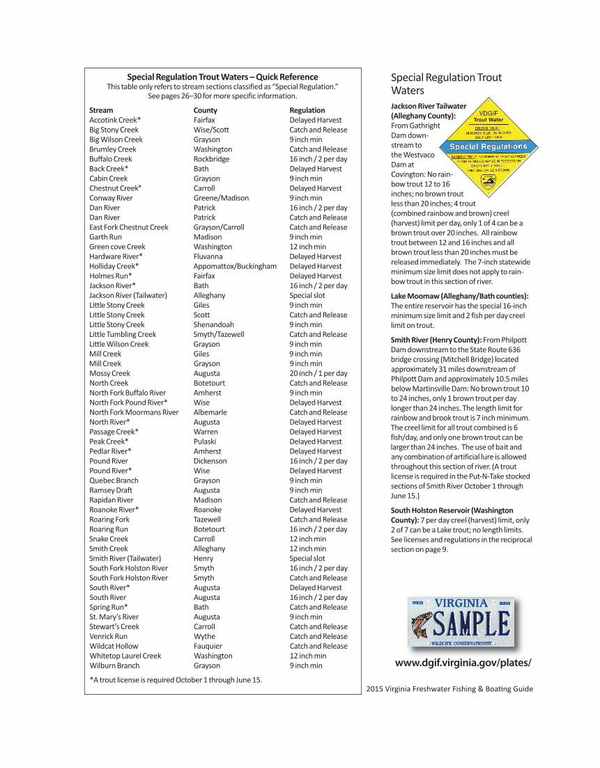
2015 Virginia Freshwater Fishing & Boating Guide
Special Regulation Trout WatersJackson River Tail water(Alleghany County):From GathrightDam down-stream tothe West vacoDam at Covington: No rain-bow trout 12 to 16inches; no brown troutless than 20 inches; 4 trout(combined rainbow and brown) creel (harvest) limit per day, only 1 of 4 can be abrown trout over 20 inches. All rainbowtrout between 12 and 16 inches and allbrown trout less than 20 inches must be released immediately. The 7-inch statewideminimum size limit does not apply to rain-bow trout in this section of river.
Lake Moomaw (Alleghany/Bath counties):The entire reservoir has the special 16-inchminimum size limit and 2 fish per day creellimit on trout.
Smith River (Henry County): From PhilpottDam downstream to the State Route 636bridge crossing (Mitchell Bridge) located approximately 31 miles downstream ofPhilpott Dam and approximately 10.5 milesbelow Martinsville Dam: No brown trout 10to 24 inches, only 1 brown trout per daylonger than 24 inches. The length limit forrainbow and brook trout is 7 inch minimum.The creel limit for all trout combined is 6fish/day, and only one brown trout can belarger than 24 inches. The use of bait andany combination of artificial lure is allowedthroughout this section of river. (A trout license is required in the Put-N-Take stockedsections of Smith River October 1 throughJune 15.)
South Holston Reservoir (WashingtonCounty): 7 per day creel (harvest) limit, only2 of 7 can be a Lake trout; no length limits.See licenses and regulations in the reciprocalsection on page 9.
Special Regulation Trout Waters – Quick ReferenceThis table only refers to stream sections classified as “Special Regulation.”
See pages 26–30 for more specific information.
Stream County RegulationAccotink Creek* Fairfax Delayed HarvestBig Stony Creek Wise/Scott Catch and ReleaseBig Wilson Creek Grayson 9 inch minBrumley Creek Washington Catch and ReleaseBuffalo Creek Rockbridge 16 inch / 2 per dayBack Creek* Bath Delayed HarvestCabin Creek Grayson 9 inch minChestnut Creek° Carroll Delayed HarvestConway River Greene/Madison 9 inch minDan River Patrick 16 inch / 2 per dayDan River Patrick Catch and ReleaseEast Fork Chestnut Creek Grayson/Carroll Catch and ReleaseGarth Run Madison 9 inch minGreen cove Creek Washington 12 inch minHardware River* Fluvanna Delayed HarvestHolliday Creek* Appomattox/Buckingham Delayed HarvestHolmes Run* Fairfax Delayed HarvestJackson River* Bath 16 inch / 2 per dayJackson River (Tailwater) Alleghany Special slotLittle Stony Creek Giles 9 inch minLittle Stony Creek Scott Catch and ReleaseLittle Stony Creek Shenandoah 9 inch minLittle Tumbling Creek Smyth/Tazewell Catch and ReleaseLittle Wilson Creek Grayson 9 inch minMill Creek Giles 9 inch minMill Creek Grayson 9 inch minMossy Creek Augusta 20 inch / 1 per dayNorth Creek Botetourt Catch and ReleaseNorth Fork Buffalo River Amherst 9 inch minNorth Fork Pound River* Wise Delayed HarvestNorth Fork Moormans River Albemarle Catch and ReleaseNorth River* Augusta Delayed HarvestPassage Creek* Warren Delayed HarvestPeak Creek* Pulaski Delayed HarvestPedlar River* Amherst Delayed HarvestPound River Dickenson 16 inch / 2 per dayPound River* Wise Delayed HarvestQuebec Branch Grayson 9 inch minRamsey Draft Augusta 9 inch minRapidan River Madison Catch and ReleaseRoanoke River* Roanoke Delayed HarvestRoaring Fork Tazewell Catch and ReleaseRoaring Run Botetourt 16 inch / 2 per daySnake Creek Carroll 12 inch minSmith Creek Alleghany 12 inch minSmith River (Tailwater) Henry Special slotSouth Fork Holston River Smyth 16 inch / 2 per daySouth Fork Holston River Smyth Catch and ReleaseSouth River* Augusta Delayed HarvestSouth River Augusta 16 inch / 2 per daySpring Run* Bath Catch and ReleaseSt. Mary’s River Augusta 9 inch minStewart’s Creek Carroll Catch and ReleaseVenrick Run Wythe Catch and ReleaseWildcat Hollow Fauquier Catch and ReleaseWhitetop Laurel Creek Washington 12 inch minWilburn Branch Grayson 9 inch min
*A trout license is required October 1 through June 15.
www.dgif.virginia.gov/plates/
27
9-inch MinimumBig and Little Wilson Creeksand their trib-utaries,QuebecBranch, WilburnBranch, and MillCreek (Grayson Coun-ty): That portion withinthe Grayson Highlands StatePark and the Jefferson National ForestMount Rogers National Recreation Area.With the special regulation on Cabin Creek(see below), all of the streams withinGrayson Highlands State Park are under oneregulation. Access can be gained throughGrayson Highlands State Park on Route 806and 817 off U.S. Route 58. Be prepared to dosome hiking to fish this area.
Cabin Creek (Grayson County): That portionof stream and its tributaries within theGrayson Highlands State Park and the Jeffer-son National Forest Mount Rogers NationalRecreation Area. See above for more infor-mation on the area.
Conway River/Devils Ditch (Greene andMadison counties): That portion of ConwayRiver and its major tributary, Devils Ditch,within the Rapidan Wildlife ManagementArea and the Shenandoah National Park.The stream lies north of Stanardsville andcan be reached by Route 615 from GravesMill.
Garth Run (Madison County): That portionof stream within the Rapidan Wildlife Man-agement Area. The stream can be reachedby Route 615 from Graves Mill. Most of thestream is accessible only by foot as thestreams enters a gorge.
Little Stony Creek (Giles County): That por-tion of stream within the Jefferson NationalForest. The stream is located near Pembrokeand can be reached by Route 623.
Little Stony Creek (Shenandoah County):That portion of stream within the George
Washington National Forest, includingWoodstock Reservoir. The stream is locatedwest of Woodstock and the Forest ServiceRoad 92 crosses the lower portion of thespecial regulation section. Much of theupper reaches can only be reached by foottrail.
Mill Creek (Giles County): That portion ofMill Creek and its tributaries upstream of thePoplar Street Bridge in the Town of Narrows(Mill Creek flows through the National Forest in Giles County and the Town of Narrows.) The stream can be accessed froma parking area on Northview Street, off ofState Route 100, south of Narrows.
North Fork Buffalo River (Amherst County):That portion of the stream and its tributarieswithin the George Washington National Forest. Access is available by a forest trail offForest Road 51 or from the end of StateRoute 635.
St. Mary’s River (Augusta County): All por-tions of stream and its tributaries above thegate near the George Washington NationalForest property line. The stream lies east ofRaphine off Route 608, a short distance fromI-81. Most of the area is accessible by foottrail only and backpacking is popular.
Ramsey’s Draft (Augusta County): That por-tion of the stream and its tributaries withinthe George Washington National Forest. Toreach this stream, drive 15 miles west ofChurchville on Route 250 and look for theMountain Home Picnic Area on the right; afoot trail parallels the stream from the picnicarea.
12-inch MinimumSnake Creek (Carroll County): All of BigSnake Creek below Hall Ford and all of LittleSnake Creek below the junction of Routes922 and 674. These streams are located justnorth of Fancy Gap. Parking and angler ac-cess is only permitted along Route 922 andat the Route 58 bridge (unless an individualis a landowner or guest).
Smith Creek (Alleghany County): That portion from the Clifton Forge Dam down-stream to a sign at the Forest Service bound-ary above the C & O Dam. Best streamaccess is by Route 606 from Clifton Forge tothe Clifton Forge Water Plant access road;anglers must park at the entrance and walk ahalf mile to the stream.
Whitetop Laurel/Green Cove Creeks(Washington County):Whitetop Laurel (2 sections)—that portionupstream from the first railroad trestleabove Taylor Valley to the mouth of GreenCove Creek at Creek Junction and that por-tion upstream from the mouth of StraightBranch to a sign at the Forest Service bound-ary just downstream of Taylor Valley; Green Cove Creek—that portion from Rt.859 downstream to its mouth. There re-mains a section of catchable stocked troutwater without special regulations throughthe village of Taylors Valley. The special regu-lation area is located east of Damascus (nearthe Tennessee line) and lies within theMount Rogers Recreation Area.
16-inch Minimum, 2 Fish Per Day*Buffalo Creek(RockbridgeCounty):That portionfrom the conflu-ence of Collier’s Creekupstream 2.9 miles to theconfluence of North andSouth Buffalo creeks. The stream flowsthrough private land and *a free writtenlandowner permit is required to fish thesewaters. A no cost permit, map, and addi -tional information for this stream can be obtained by visiting DGIF’s websitehttps://www3.dgif.virginia.gov/troutpermits/
*Dan River (Patrick County): That portionfrom Talbott Dam approximately 6 milesdownstream to a sign posted just upstreamfrom the confluence of the Dan River andTownes Reservoir. The upper reaches can bereached by taking Route 614 south fromMeadows of Dan, turn right on Route 601,and proceed to Talbott Dam. The lowerreach can only be accessed by boat at theupper end of Townes Reservoir. *A permitfrom the City of Danville is required and can be obtained at no charge from the CityUtilities Department or on site at the Pinnacles Powerhouse. Contact: City ofDanville, Director of Electric Division,
Regulations for the special 9-inch, 12-inch, 16-inch/2 fish, 20-inch/1fish, and catch & release trout stream sections that follow:a. Only single point hook artificial lures may be used unless otherwise noted. (See artifi-
cial lure definition page 23.)b. No bait may be in possession while fishing these waters unless otherwise noted. c. All trout less than the minimum size must be immediately returned to the water unharmed. No trout less than the minimum size may be in possession while fishing in these waters.
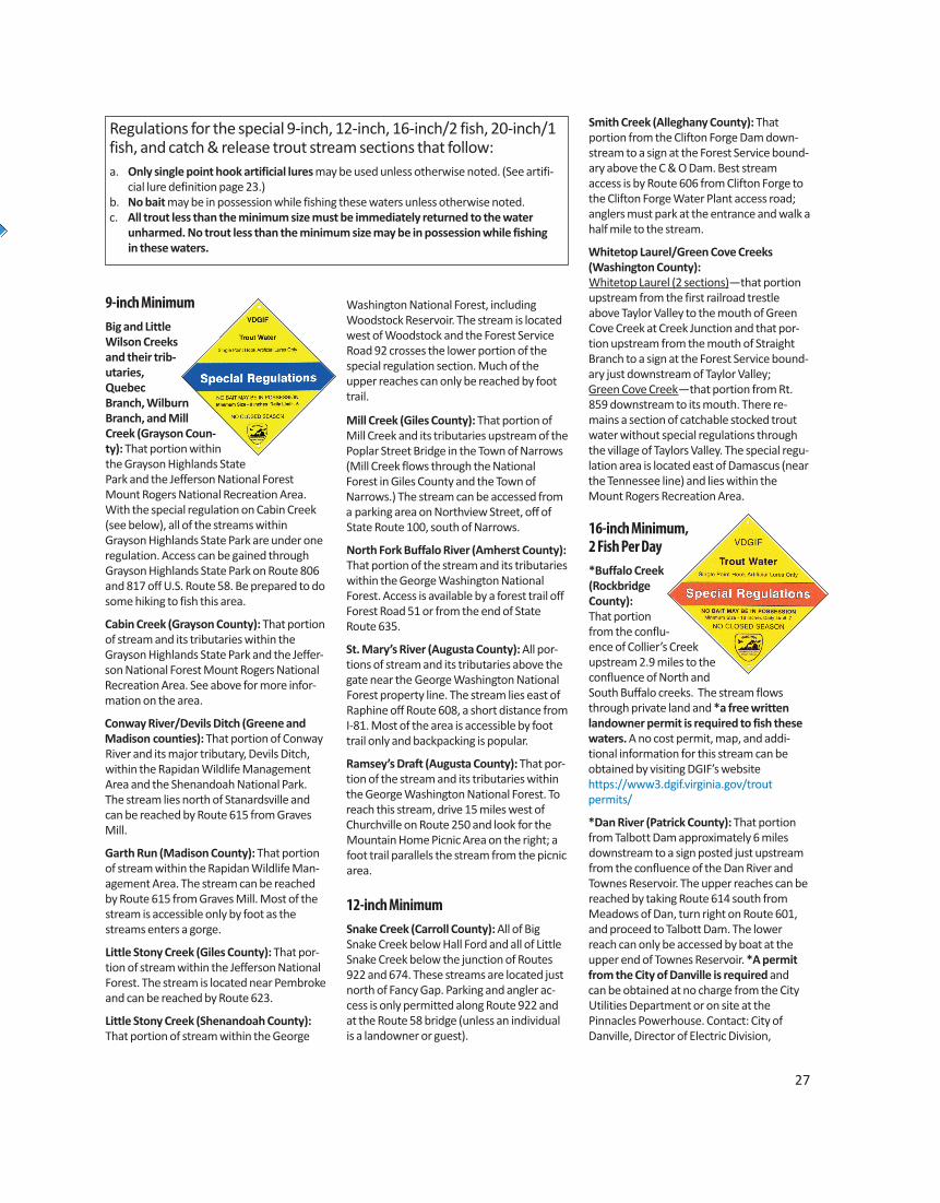
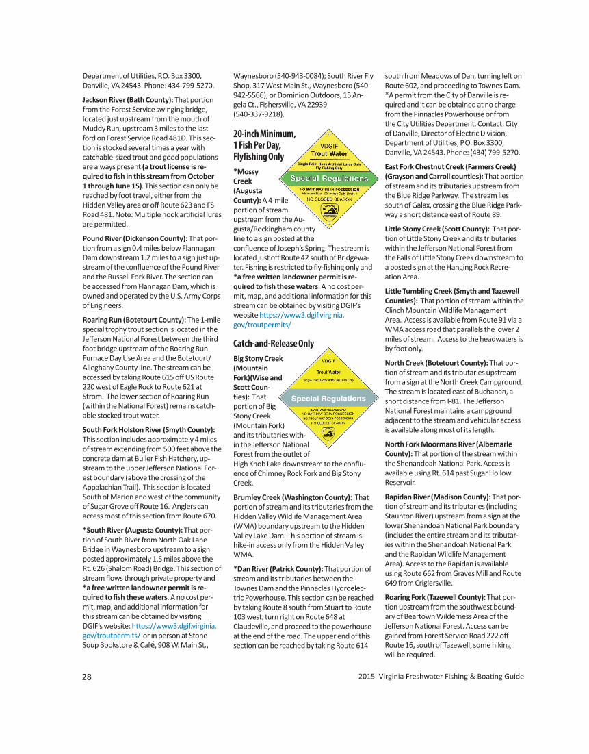
28 2015 Virginia Freshwater Fishing & Boating Guide
Department of Utilities, P.O. Box 3300,Danville, VA 24543. Phone: 434-799-5270.
Jackson River (Bath County): That portionfrom the Forest Service swinging bridge, located just upstream from the mouth ofMuddy Run, upstream 3 miles to the lastford on Forest Service Road 481D. This sec-tion is stocked several times a year withcatchable-sized trout and good populationsare always present (a trout license is re-quired to fish in this stream from October 1 through June 15). This section can only bereached by foot travel, either from the Hidden Valley area or off Route 623 and FSRoad 481. Note: Multiple hook artificial luresare permitted.
Pound River (Dickenson County): That por-tion from a sign 0.4 miles below FlannaganDam downstream 1.2 miles to a sign just up-stream of the confluence of the Pound Riverand the Russell Fork River. The section canbe accessed from Flannagan Dam, which isowned and operated by the U.S. Army Corpsof Engineers.
Roaring Run (Botetourt County): The 1-milespecial trophy trout section is located in theJefferson National Forest between the thirdfoot bridge upstream of the Roaring Run Furnace Day Use Area and the Botetourt/Alleghany County line. The stream can be accessed by taking Route 615 off US Route220 west of Eagle Rock to Route 621 atStrom. The lower section of Roaring Run(within the National Forest) remains catch-able stocked trout water.
South Fork Holston River (Smyth County):This section includes approximately 4 milesof stream extending from 500 feet above theconcrete dam at Buller Fish Hatchery, up-stream to the upper Jefferson National For-est boundary (above the crossing of theAppalachian Trail). This section is locatedSouth of Marion and west of the communityof Sugar Grove off Route 16. Anglers can access most of this section from Route 670.
*South River (Augusta County): That por-tion of South River from North Oak LaneBridge in Waynesboro upstream to a signposted approximately 1.5 miles above theRt. 626 (Shalom Road) Bridge. This section ofstream flows through private property and*a free written landowner permit is re-quired to fish these waters. A no cost per-mit, map, and additional information for this stream can be obtained by visitingDGIF’s website: https://www3.dgif.virginia.gov/troutpermits/ or in person at StoneSoup Bookstore & Café, 908 W. Main St.,
Waynesboro (540-943-0084); South River FlyShop, 317 West Main St., Waynesboro (540-942-5566); or Dominion Outdoors, 15 An-gela Ct., Fishersville, VA 22939(540-337-9218).
20-inch Minimum, 1 Fish Per Day,Flyfishing Only*MossyCreek (AugustaCounty): A 4-mileportion of streamupstream from the Au-gusta/Rockingham countyline to a sign posted at theconfluence of Joseph’s Spring. The stream islocated just off Route 42 south of Bridgewa-ter. Fishing is restricted to fly-fishing only and*a free written landowner permit is re-quired to fish these waters. A no cost per-mit, map, and additional information for thisstream can be obtained by visiting DGIF’swebsite https://www3.dgif.virginia.gov/troutpermits/
Catch-and-Release OnlyBig Stony Creek(MountainFork)(Wise andScott Coun-ties): Thatportion of BigStony Creek(Mountain Fork)and its tributaries with-in the Jefferson NationalForest from the outlet ofHigh Knob Lake downstream to the conflu-ence of Chimney Rock Fork and Big StonyCreek.
Brumley Creek (Washington County): Thatportion of stream and its tributaries from theHidden Valley Wildlife Management Area(WMA) boundary upstream to the HiddenValley Lake Dam. This portion of stream ishike-in access only from the Hidden ValleyWMA.
*Dan River (Patrick County): That portion ofstream and its tributaries between theTownes Dam and the Pinnacles Hydroelec-tric Powerhouse. This section can be reachedby taking Route 8 south from Stuart to Route103 west, turn right on Route 648 atClaudeville, and proceed to the powerhouseat the end of the road. The upper end of thissection can be reached by taking Route 614
south from Meadows of Dan, turning left onRoute 602, and proceeding to Townes Dam.*A permit from the City of Danville is re-quired and it can be obtained at no chargefrom the Pinnacles Powerhouse or from the City Utilities Department. Contact: Cityof Danville, Director of Electric Division, Department of Utilities, P.O. Box 3300,Danville, VA 24543. Phone: (434) 799-5270.
East Fork Chestnut Creek (Farmers Creek)(Grayson and Carroll counties): That portionof stream and its tributaries upstream fromthe Blue Ridge Parkway. The stream liessouth of Galax, crossing the Blue Ridge Park-way a short distance east of Route 89.
Little Stony Creek (Scott County): That por-tion of Little Stony Creek and its tributarieswithin the Jefferson National Forest fromthe Falls of Little Stony Creek downstream toa posted sign at the Hanging Rock Recre-ation Area.
Little Tumbling Creek (Smyth and TazewellCounties): That portion of stream within theClinch Mountain Wildlife ManagementArea. Access is available from Route 91 via aWMA access road that parallels the lower 2miles of stream. Access to the headwaters isby foot only.
North Creek (Botetourt County): That por-tion of stream and its tributaries upstreamfrom a sign at the North Creek Campground.The stream is located east of Buchanan, ashort distance from I-81. The Jefferson National Forest maintains a campground adjacent to the stream and vehicular accessis available along most of its length.
North Fork Moormans River (AlbemarleCounty): That portion of the stream withinthe Shenandoah National Park. Access isavailable using Rt. 614 past Sugar HollowReservoir.
Rapidan River (Madison County): That por-tion of stream and its tributaries (includingStaunton River) upstream from a sign at thelower Shenandoah National Park boundary(includes the entire stream and its tributar-ies within the Shenandoah National Parkand the Rapidan Wildlife ManagementArea). Access to the Rapidan is availableusing Route 662 from Graves Mill and Route649 from Criglersville.
Roaring Fork (Tazewell County): That por-tion upstream from the southwest bound-ary of Beartown Wilderness Area of theJefferson National Forest. Access can begained from Forest Service Road 222 offRoute 16, south of Tazewell, some hiking will be required.
www.HuntFishVA.com 29
South Fork Holston River (Smyth County):That portion of stream from the concretedam at Buller Fish Hatchery downstream tothe lower boundary of the Buller Fish Hatch-ery. Access can be gained through the BullerFish Hatchery property off Route 650, southof Marion.
Spring Run (Bath County): That portion ofthe stream from its confluence with theCowpasture River upstream to a cable andposted sign at the discharge from CourseySprings Hatchery. Parking is available at theangler access just below the hatchery. Atrout license is required October 1 throughJune 15.
Stewart’s Creek (Carroll County): Approxi-mately 4.5 miles of Stewart’s Creek and itstwo major tributaries, North Fork and SouthFork Stewart’s Creek, within the StewartsCreek Wildlife Management Area. Stewart’sCreek WMA is southeast of Galax on the eastside of the Blue Ridge Parkway. Take Exit 1off I-77. Follow the trailblazer signs to thearea.
Venrick Run (Wythe County): That portionof Venrick Run and its tributaries within BigSurvey Wildlife Management Area (WMA)and Town of Wytheville property. Thestream can be accessed from a parking loton Town property at the end of State Route684, off of State Route 21, south ofWytheville.
Wildcat Hollow (Fauquier County): Thatportion of stream within the G. R. ThompsonWildlife Management Area. Foot access isavailable from the lower Ted Lake Trail park-ing area located off of Rt. 688.
Delayed Harvest WatersFrom October 1through May 31fishing on thefollowing wa-ters is per-mitted underthe followingregulations only:
a. Only artificial lures may be used. b. No trout may be in possession (catch and
release only) while fishing these waters.c. No bait may be in possession while fish-
ing these waters.d. Trout license required October 1–June
15.
Note: During the period of June 1 through
September 30 restrictions a. through c.above will not apply and these waters arelike any other designated stocked troutwater (see page 23).
Accotink Creek (Fairfax County): That por-tion of stream from King Arthur Road down-stream 3.1 miles to Route 620 (BraddockRoad). Primary access is via the FCPA Wake-field Park facility off Braddock Road.
Back Creek (Bath County): That portion ofstream from the Rt. 600 Bridge just belowthe Virginia Power Back Creek Dam down-stream 1.5 miles to the Rt. 600 Bridge at thelower boundary of the Virginia Power Recre-ational Area. Take Route 39 west from WarmSprings to Mountain Grove, then right onRoute 600 for 6 miles.
Chestnut Creek (Carroll County): That por-tion of stream from the U.S. Rt. 58 Bridgedownstream 11.4 miles to the confluencewith the New River. The stream parallels theNew River Trail State Park, and parking isavailable at state road crossings and at thetrail head in Galax. In addition to the statepark, many private landowners have madethis program possible and anglers should besure to respect adjoining private property.
Hardware River (Fluvanna County): Thatportion of stream from the confluence withthe James River upstream 3 miles toMuleshoe Bend as posted. This section is located within the Hardware River WildlifeManagement Area (WMA), and is accessedby taking Route 6 east from Scottsville thenturning right onto Route 611 to the Kidd’sMill Road parking area. To access the easternportion of the WMA, continue east on Route6 and turn right onto Route 646. Detailedmaps and information on the HardwareRiver WMA can be obtained from any VDGIFoffice or at www.HuntFishVA.com.
Holliday Creek (Appomattox/Buckinghamcounties): That portion of stream from theRt. 640 crossing downstream 2.8 miles to asign at the headwaters of Holliday Lake. Thissection is located completely within the Appomattox/Buckingham State Forest thatcan be accessed by taking Route 24 northout of Appomattox to Route 626. Anglersshould turn onto Routes 640 or 614 to ac-cess a series of foot trails to the stream thathave been developed by the Virginia Depart-ment of Forestry (VDOF). A State Forest Use Permit is now required by the VDOF foranyone 16 years and older who fishes inone of Virginia’s 19 State Forests; the UsePermit is available at authorized retailerswho sell fishing licenses, or online.
Holmes Run (Fairfax County): That portionof stream from the Lake Barcroft Dam down-stream 1.2 miles to a sign posted at theAlexandria City line. A fairly good trail follows(and sometimes crosses) the stream fromthe parking lot off Columbia Pike (Route244).
North Fork of Pound and Pound rivers(Wise County): That portion of the streamsfrom the base of North Fork of Pound Damdownstream to the confluence with IndianCreek. Access is available at the North Forkof Pound Dam and at parking lots within thetown of Pound.
North River (Augusta County): That portionof stream from the base of Elkhorn Damdownstream 1.5 miles to a sign posted at thehead of Staunton City Reservoir. This is a remote section of stream that can only bereached by foot trail. Access is available byparking at Elkhorn Lake and following thetrail along the lake to the spillway.
Passage Creek (Warren County): That portion of stream from the Shenandoah/Warren County line downstream approxi-mately 1 mile through the Department’sFront Royal Fish Hatchery. This section is im-mediately downstream of the area that hashistorically been stocked under the put-and-take program. Parking is available on ForestService lands adjacent to Route 678 or onDepartment lands adjacent to Route 619.
Peak Creek (Pulaski County): That portion ofstream from the confluence of Tract Forkdownstream 2.7 miles to the Rt. 99 Bridge.Approximately 1 mile of this section is indowntown Pulaski.
Pedlar River (Amherst County): That portion of stream from the City of Lynchburg/George Washington NationalForest boundary line (below LynchburgReservoir) downstream 2.7 miles to theboundary line of the George WashingtonNational Forest (southeast of Buena Vista).The U.S. Forest Service and the Departmenthave cooperated in the development ofthree access sites to the river located alongFS 39 off Route 607.
Roanoke River (Roanoke County and City ofSalem): There are two delayed harvest sections located on the Roanoke River nearRoanoke. The first section is located withinGreen Hill Park in Roanoke County and wasestablished in 2001. The newest section is located within the City of Salem and was established in 2003. The Green Hill Park section is easily found off Route 11/460 westof Salem and stretches from the Route 760
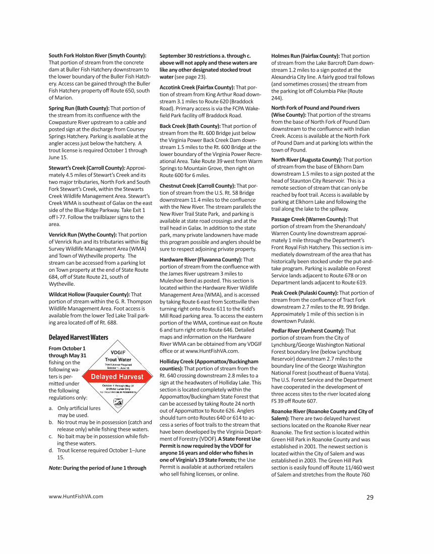
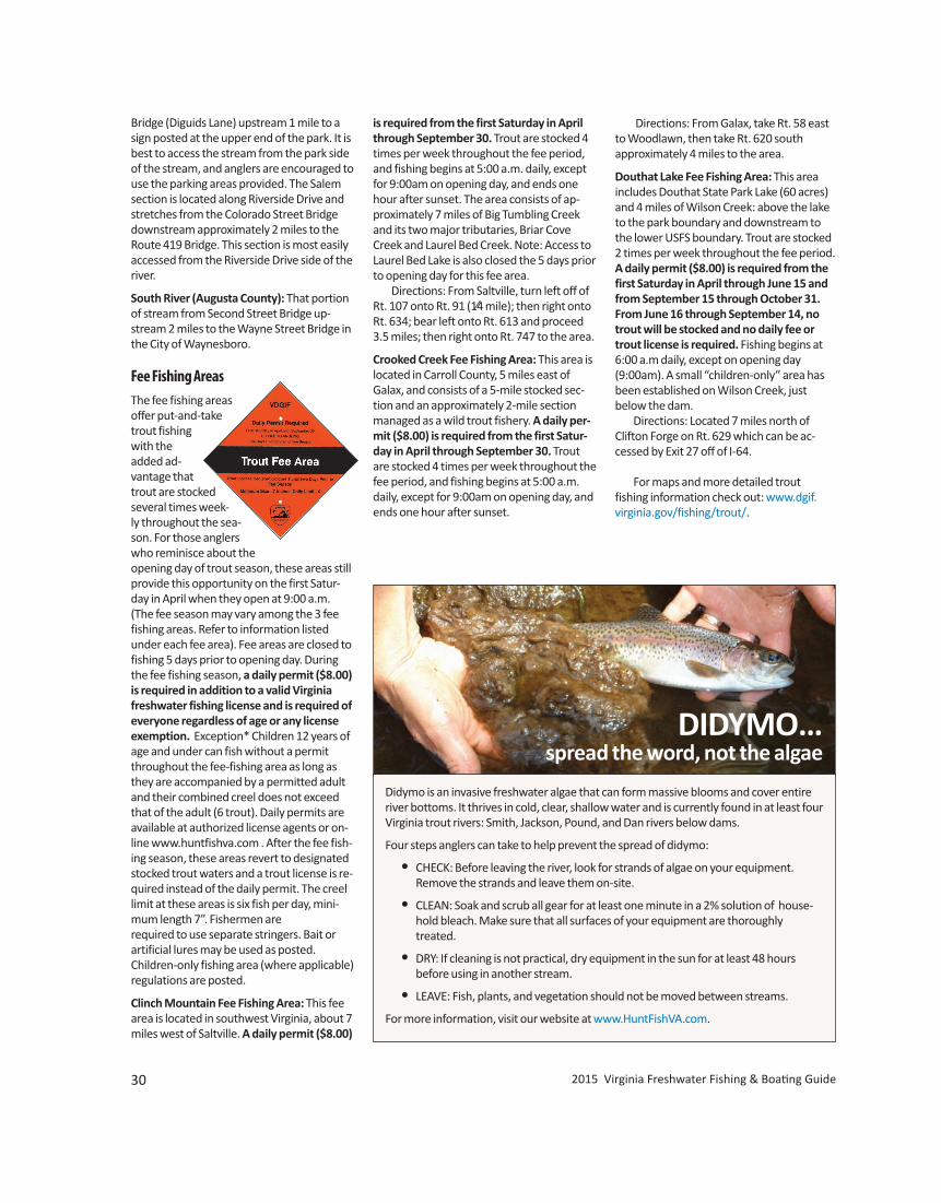
30 2015 Virginia Freshwater Fishing & Boating Guide
Bridge (Diguids Lane) upstream 1 mile to asign posted at the upper end of the park. It isbest to access the stream from the park sideof the stream, and anglers are encouraged touse the parking areas provided. The Salemsection is located along Riverside Drive andstretches from the Colorado Street Bridgedownstream approximately 2 miles to theRoute 419 Bridge. This section is most easilyaccessed from the Riverside Drive side of theriver.
South River (Augusta County): That portionof stream from Second Street Bridge up-stream 2 miles to the Wayne Street Bridge inthe City of Waynesboro.
Fee Fishing AreasThe fee fishing areasoffer put-and-taketrout fishingwith theadded ad-vantage thattrout are stockedseveral times week-ly throughout the sea-son. For those anglerswho reminisce about theopening day of trout season, these areas stillprovide this opportunity on the first Satur-day in April when they open at 9:00 a.m.(The fee season may vary among the 3 feefishing areas. Refer to information listedunder each fee area). Fee areas are closed tofishing 5 days prior to opening day. Duringthe fee fishing season, a daily permit ($8.00)is required in addition to a valid Virginiafreshwater fishing license and is required ofeveryone regardless of age or any licenseexemption. Exception* Children 12 years ofage and under can fish without a permitthroughout the fee-fishing area as long asthey are accompanied by a permitted adultand their combined creel does not exceedthat of the adult (6 trout). Daily permits areavailable at authorized license agents or on-line www.huntfishva.com . After the fee fish-ing season, these areas revert to designatedstocked trout waters and a trout license is re-quired instead of the daily permit. The creellimit at these areas is six fish per day, mini-mum length 7”. Fishermen are required to use separate stringers. Bait or artificial lures may be used as posted. Children-only fishing area (where applicable)regulations are posted.
Clinch Mountain Fee Fishing Area: This feearea is located in southwest Virginia, about 7miles west of Saltville. A daily permit ($8.00)
is required from the first Saturday in Aprilthrough September 30. Trout are stocked 4times per week throughout the fee period,and fishing begins at 5:00 a.m. daily, exceptfor 9:00am on opening day, and ends onehour after sunset. The area consists of ap-proximately 7 miles of Big Tumbling Creekand its two major tributaries, Briar CoveCreek and Laurel Bed Creek. Note: Access toLaurel Bed Lake is also closed the 5 days priorto opening day for this fee area. Directions: From Saltville, turn left off ofRt. 107 onto Rt. 91 (1⁄4 mile); then right ontoRt. 634; bear left onto Rt. 613 and proceed3.5 miles; then right onto Rt. 747 to the area.
Crooked Creek Fee Fishing Area: This area islocated in Carroll County, 5 miles east ofGalax, and consists of a 5-mile stocked sec-tion and an approximately 2-mile sectionmanaged as a wild trout fishery. A daily per-mit ($8.00) is required from the first Satur-day in April through September 30. Troutare stocked 4 times per week throughout thefee period, and fishing begins at 5:00 a.m.daily, except for 9:00am on opening day, andends one hour after sunset.
Directions: From Galax, take Rt. 58 eastto Woodlawn, then take Rt. 620 south approximately 4 miles to the area.
Douthat Lake Fee Fishing Area: This area includes Douthat State Park Lake (60 acres)and 4 miles of Wilson Creek: above the laketo the park boundary and downstream tothe lower USFS boundary. Trout are stocked2 times per week throughout the fee period.A daily permit ($8.00) is required from thefirst Saturday in April through June 15 andfrom September 15 through October 31.From June 16 through September 14, notrout will be stocked and no daily fee ortrout license is required. Fishing begins at6:00 a.m daily, except on opening day(9:00am). A small “children-only” area hasbeen established on Wilson Creek, justbelow the dam. Directions: Located 7 miles north ofClifton Forge on Rt. 629 which can be ac-cessed by Exit 27 off of I-64.
For maps and more detailed trout fishing information check out: www.dgif.virginia.gov/fishing/trout/. DIDYMO. . .
spread the word, not the algae
Didymo is an invasive freshwater algae that can form massive blooms and cover entireriver bottoms. It thrives in cold, clear, shallow water and is currently found in at least fourVirginia trout rivers: Smith, Jackson, Pound, and Dan rivers below dams.
Four steps anglers can take to help prevent the spread of didymo:
• CHECK: Before leaving the river, look for strands of algae on your equipment. Remove the strands and leave them on-site.
• CLEAN: Soak and scrub all gear for at least one minute in a 2% solution of house-hold bleach. Make sure that all surfaces of your equipment are thoroughlytreated.
• DRY: If cleaning is not practical, dry equipment in the sun for at least 48 hours before using in another stream.
• LEAVE: Fish, plants, and vegetation should not be moved between streams.
For more information, visit our website at www.HuntFishVA.com.
DIDYMO…spread the word, not the algae
www.HuntFishVA.com 31
opening not exceeding 36 inches. Taking turtles by hook and line require s a fishing license.
SCUBA: It is illegal to use SCUBA (Self-con-tained Underwater Breathing Apparatus)gear to take or attempt to take fish.
Trot Lines, juglines (noodles) or set poles(limb lines) may be used to take nongamefish and turtles provided they are not baitedwith live bait (worms are permissible), ex-cept on designated stocked trout waters, Department-owned lakes, and within 600feet of any dam. Live bait other than gamefish may be used on trot lines to take catfishin Carroll, Dickenson, Giles, Grayson, Mont-gomery, Pulaski and Wythe counties, and inthe Clinch River in Russell, Scott, and Wisecounties. (See page 9 for South HolstonReservoir.) Any person setting or possessing theabove equipment shall have it clearly markedby permanent means with his or her name,address, and telephone number, and is re-quired to check all lines and remove all fishand animals caught each day. Additional requirements for juglines(also called “noodles”): Defined as a singlehook, including one treble hook, and line attached to a float. Jugline/noodle sets onpublic waters shall be restricted to 20 per angler and must be attended (within sight)by anglers at all times. Also, in addition tobeing labeled with the angler’s name, ad-dress and telephone number, jugs/noodlesshall also be labeled with a reflective markerthat encircles the jugs/noodles to allow forvisibility at night.
Bow and Arrow (including crossbows) maybe used to take common carp, northernsnakehead, and gar (fishing license required)during day and night hours (24 hrs.), exceptfrom waters stocked with trout. Bowfin andcatfish may be taken in tidal waters (belowFall Line, see page 8). Spearguns and poisoned arrows are prohibited. Snakeheadmust be immediately killed and reported toDGIF.
Snagging, grabbing, snaring, gigging, andthe use of a striking iron are legal methodsto take nongame fish in certain waters in certain counties as follows (see table page 21for certain nongame fish limits):
1. In the waters of the following counties[except public impoundments, theRoanoke (Staunton) and Dan Rivers,and those waters stocked by the
NONGAME FISH, REPTILE, AMPHIBIAN,
AND AQUATIC INVERTEBRATE REGULATIONS
GeneralIt shall be unlawful to take, possess, import,cause to be imported, export, cause to beexported, buy, sell, offer for sale or liberatewithin the Commonwealth any wild animalunless otherwise specifically permitted bylaw or regulation. Albino reptiles and amphibians and domestic animals may beimported, possessed, and sold. A list of domestic animals and the Department’s official listing of “Native and NaturalizedFauna of Virginia” is available from the Richmond and regional offices, and atwww.HuntFishVA.com.
Native and Naturalized SpeciesPossession Limits (see exceptions for certain species below)
Personal Use & Not for Sale5–Amphibians and Reptiles20–Nongame Fish and Aquatic Invertebrates
Exceptions:1. No possession allowed Threatened and endangered species,
freshwater mussels, candy darter, east-ern hellbender, diamondback terrapin,and spotted turtle.
2. No possession limits – can be pos-sessed in unlimited numbers. Carp,bowfin, longnose gar, mullet, yellowbullhead, brown bullhead, black bull-head, snail bullhead, white sucker,northern hogsucker, gizzard shad,threadfin shad, white perch, yellowperch (10 fish limit in Lake Moomaw),alewife and blueback herring [see lim-its under Anadromous (coastal) in tableon page 21)], stoneroller (hornyhead),fathead minnow, golden shiner, gold-fish, and Asian clams.
3. See page 20 for catfish and page 21 foranadromous (coastal) shad and herringlimits.
4. Fish bait: minnows and chubs(Cyprinidae), salamanders (less than 6inches), crayfish, and hellgrammites—50 in aggregate (all species combined)unless said person has purchased fishbait and has a receipt specifying the
number of individuals purchased byspecies. Note:Madtoms, crayfish, andsalamanders cannot be bought or sold.
5. Bullfrogs–15 per day. Snapping turtles–5 per day, only from June 1 to September 30. Cannot be taken from the banks or waters of designated stocked trout waters.
6. Native amphibians and reptiles that arecaptured within the Commonwealthand possessed live for private use andnot for sale may be liberated under thefollowing conditions:
a. Period of captivity does not exceed30 days;
b. Animals must be liberated at the siteof capture;
c. Animals must have been housedseparately from other wild-caughtand domestic animals; and
d. Animals that demonstrate symp-toms of disease or illness or thathave sustained injury during theircaptivity may not be released.
Methods to Capture or TakeGeneral Methods:• Except as provided for under “Other
Methods” and except in any waterswhere the use of nets is prohibited, thespecies listed in the previous section(Possession Limits) may only be takenby hand, hook and line, with a seine notexceeding 4 feet in depth by 10 feet inlength, an umbrella-type net not ex-ceeding 5 by 5 feet square, small min-now traps with throat openings nolarger than 1 inch in diameter, cast nets,and handheld bow nets with diameternot to exceed 20 inches and handlelength not to exceed 8 feet.
• Gizzard shad and white perch may alsobe taken from below the fall line in alltidal rivers of the Chesapeake Bay usinga gill net in accordance with VirginiaMarine Resources Commission recre-ational fishing regulations.
• Bullfrogs may also be taken by giggingor bow and arrow and from private
waters by firearms no larger than .22 caliber rimfire. Taking bullfrogs with a gig, .22 caliber rimfire, or bow and arrow requires a hunting license.
• Snapping turtles may be taken for per-sonal use with hoop nets not exceed-ing 6 feet in length with a throat
www.HuntFishVA.com 31
opening not exceeding 36 inches. Taking turtles by hook and line require s a fishing license.
SCUBA: It is illegal to use SCUBA (Self-con-tained Underwater Breathing Apparatus)gear to take or attempt to take fish.
Trot Lines, juglines (noodles) or set poles(limb lines)may be used to take nongamefish and turtles provided they are not baitedwith live bait (worms are permissible), ex-cept on designated stocked trout waters, Department-owned lakes, and within 600feet of any dam. Live bait other than gamefish may be used on trot lines to take catfishin Carroll, Dickenson, Giles, Grayson, Mont-gomery, Pulaski and Wythe counties, and inthe Clinch River in Russell, Scott, and Wisecounties. (See page 9 for South HolstonReservoir.) Any person setting or possessing theabove equipment shall have it clearly markedby permanent means with his or her name,address, and telephone number, and is re-quired to check all lines and remove all fishand animals caught each day. Remove all trotlines, juglines, or setpoles from public waters when not in use. Additional requirements for juglines(also called “noodles”): Defined as a singlehook, including one treble hook, and line attached to a float. Jugline/noodle sets onpublic waters shall be restricted to 20 per angler and must be attended (within sight)by anglers at all times. Also, in addition tobeing labeled with the angler’s name, ad-dress and telephone number, jugs/noodlesshall also be labeled with a reflective markerthat encircles the jugs/noodles to allow forvisibility at night.
Bow and Arrow (including crossbows)maybe used to take common carp, northernsnakehead, and gar (fishing license required)during day and night hours (24 hrs.), exceptfrom waters stocked with trout. Bowfin andcatfish may be taken in tidal waters (belowFall Line, see page 8). Spearguns and poisoned arrows are prohibited. Snakeheadmust be immediately killed and reported toDGIF.
Snagging, grabbing, snaring, gigging, andthe use of a striking iron are legal methodsto take nongame fish in certain waters in certain counties as follows (see table page 21for certain nongame fish limits):
1. In the waters of the following counties[except public impoundments, the
NONGAME FISH, REPTILE, AMPHIBIAN,
AND AQUATIC INVERTEBRATE REGULATIONS
GeneralIt shall be unlawful to take, possess, import,cause to be imported, export, cause to beexported, buy, sell, offer for sale or liberatewithin the Commonwealth any wild animalunless otherwise specifically permitted bylaw or regulation. Albino reptiles and amphibians and domestic animals may beimported, possessed, and sold. A list of domestic animals and the Department’s official listing of “Native and NaturalizedFauna of Virginia” is available from the Richmond and regional offices, and atwww.HuntFishVA.com.
Native and Naturalized SpeciesPossession Limits (see exceptions for certain species below)
Personal Use & Not for Sale5–Amphibians and Reptiles20–Nongame Fish and Aquatic Invertebrates
Exceptions:1. No possession allowed Threatened and endangered species,
freshwater mussels, candy darter, east-ern hellbender, diamondback terrapin,and spotted turtle.
2. No possession limits – can be pos-sessed in unlimited numbers. Carp,bowfin, longnose gar, mullet, yellowbullhead, brown bullhead, black bull-head, snail bullhead, white sucker,northern hogsucker, gizzard shad,threadfin shad, white perch, yellowperch (10 fish limit in Lake Moomaw),alewife and blueback herring [see lim-its under Anadromous (coastal) in tableon page 21)], stoneroller (hornyhead),fathead minnow, golden shiner, gold-fish, and Asian clams.
3. See page 20 for catfish and page 21 foranadromous (coastal) shad and herringlimits.
4. Fish bait: minnows and chubs(Cyprinidae), salamanders (less than 6inches), crayfish, and hellgrammites—50 in aggregate (all species combined)unless said person has purchased fishbait and has a receipt specifying the
number of individuals purchased byspecies. Note:Madtoms, crayfish, andsalamanders cannot be bought or sold.
5. Bullfrogs–15 per day. Snapping turtles–5 per day, only from June 1 to September 30. Cannot be taken from the banks or waters of designated stocked trout waters.
6. Native amphibians and reptiles that arecaptured within the Commonwealthand possessed live for private use andnot for sale may be liberated under thefollowing conditions:
a. Period of captivity does not exceed30 days;
b. Animals must be liberated at the siteof capture;
c. Animals must have been housedseparately from other wild-caughtand domestic animals; and
d. Animals that demonstrate symp-toms of disease or illness or thathave sustained injury during theircaptivity may not be released.
Methods to Capture or TakeGeneral Methods:• Except as provided for under “Other
Methods” and except in any waterswhere the use of nets is prohibited, thespecies listed in the previous section(Possession Limits) may only be takenby hand, hook and line, with a seine notexceeding 4 feet in depth by 10 feet inlength, an umbrella-type net not ex-ceeding 5 by 5 feet square, small min-now traps with throat openings nolarger than 1 inch in diameter, cast nets,and handheld bow nets with diameternot to exceed 20 inches and handlelength not to exceed 8 feet.
• Gizzard shad and white perch may alsobe taken from below the fall line in alltidal rivers of the Chesapeake Bay usinga gill net in accordance with VirginiaMarine Resources Commission recre-ational fishing regulations.
• Bullfrogs may also be taken by giggingor bow and arrow and from private
waters by firearms no larger than .22 caliber rimfire. Taking bullfrogs with a gig, .22 caliber rimfire, or bow and arrow requires a hunting license.
• Snapping turtles may be taken for per-sonal use with hoop nets not exceed-ing 6 feet in length with a throat
32 2015 Virginia Freshwater Fishing & Boating Guide
Roanoke (Staunton) and Dan Rivers,and those waters stocked by the
Department]: Amelia, Appomattox, Brunswick, Campbell, Charlotte, Cumberland, Dinwiddie, Goochland (except James River), Greensville, Halifax, Louisa, Lunenburg, Mecklen- burg, Nottoway, Pittsylvania, and Prince Edward.
2. From April 1 through May 15 and Octo-ber 1 through November 30 during thedaytime in the following waters:Buchanan County, all waters exceptDismal River; Grayson County, NewRiver; Lee County, Powell River; RussellCounty, Clinch River; Scott County,Clinch River and its tributaries; TazewellCounty, Dry Run Creek; Wise County,Clinch River; and Washington County,Middle Fork and South Fork of the
Holston River. Creel limit: 20 suckers per day.
3. Snagging for carp and suckers duringApril in Wolf and Big Walkers Creek inGiles County.
4. Snagging for carp and suckers in Walk-ers Creek, Wolf Creek and the NorthFork of the Holston in Bland County.
5. Bow and arrow and gigging for carpyear-round in the Shenandoah River.
6. Shooting with a rifle for suckers andcarp from April 15 to May 31 duringdaylight hours in the shoals of theClinch River within the limits of ScottCounty, except that it shall be unlawfulto shoot fish on Sunday or within thelimits of any town, or from any bridge.Fishing license is required. Creel limit:20 per day.
Dip netsmay be used to take shad, herring,mullet and suckers except in designatedstocked trout waters, Department-owned orcontrolled lakes, in certain waters whereanadromous shad and herring cannot bepossessed (see pages 20–21 for shad andherring limits), and as restricted below. Theuser and all helpers (regardless of age) musthave dip net permits ($4.50) or valid fishinglicense. Permits are valid in the county’s inland waters for which issued. All other fishspecies taken are to be immediately returned to the water alive.
Herring: The Virginia Marine Resources Com-
mission enacted a ban on the posses-
sion of river herring in tidal waters, ef-fective January 1, 2012, due to the col-lapse of the stock and in order tocomply with an Atlantic States MarineFisheries Commission directive.
Suckers Taken with Dip Nets: Limit of 20 per day. Season: February 15– May 15. Dip nets shall not be more than 6 feet
square. Dip net permits are not re-quired for taking suckers in Brunswick,Greensville, and Sussex counties.
Nets and Seinesare prohibited while fishingin designated stocked trout waters and fortaking fish from Department-owned or con-trolled lakes, except as otherwise posted(see table page 21 for certain nongame fishlimits). Only those nets and seines listedunder general methods to capture or takenongame fish (above) can be used in thepublic waters of the Roanoke (Staunton) andDan rivers in Campbell, Charlotte, Halifaxand Pittsylvania counties, and in the City ofDanville. Seines, nets, and traps are also prohibited in Lick Creek in Smyth and Blandcounties, Bear Creek in Smyth County, LaurelCreek and tributaries upstream of Highway16 bridge in Tazewell and Bland counties,Hungry Mother Creek above Hungry MotherLake in Smyth County, Susong Branch andMumpower Creek in Washington Countyand the City of Bristol, and TimbertreeBranch in Scott County. However, these re-strictions do not prohibit the use of a hand-landing net to land fish legally hooked.Seasons and local restrictions governing theuse of nets and seines are complex. Personsdeciding to try this type of fishing shouldcontact the closest VDGIF regional office formore information.
Areas/Species RestrictedDesignated Stocked Trout Waters:Nongame fish may be harvested only byhook and line in designated stocked troutwaters.
Mollusks:Unlawful to take the spiny river-snail (Io fluvialis) in the Tennessee drainagein Virginia (Clinch, Powell and the North,South and Middle Forks of the Holston riversand tributaries). It shall be unlawful to takemussels from any inland waters in Virginia.
Salamanders:Unlawful to take salamandersin Grayson Highlands State Park and on National Forest lands in the Jefferson Na-
tional Forest in those portions of Grayson,Smyth and Washington counties boundedon the east by Rt. 16, on the north by Rt. 603, and on the south and west by Rt. 58.
Non-Native (Exotic Animals)
A special permit is required, and may be issued by the Department, if consistent withthe Department’s fish and wildlife manage-ment program, to import, possess, or sell thefollowing non-native (exotic) amphibians,fish, mollusks, aquatic invertebrates, andreptiles: giant or marine toad, tongueless orAfrican clawed frog, barred tiger salaman-der, gray tiger salamander, blotched tigersalamander, smallmouth buffalo, bigmouthbuffalo, black buffalo, piranhas, bigheadcarp, grass carp or white amur, red shiner, silver carp, black carp, rudd, tench, ruffe,snakeheads, air-breathing catfish, tilapia,swamp eel, tubenose goby, round goby,zebra mussel, New Zealand mudsnail, quagga mussel, rusty crayfish, Australiancrayfish, marbled crayfish, Chinese mittencrab, alligators, caimans, brown tree snake,crocodiles, and gavials. Anglers may legally possess snakeheadfish taken from Virginia waters provided theyimmediately kill the fish and notify DGIF at804-367-2925. All other non-native (exotic) amphib-ians, fish, aquatic invertebrates, and reptilesnot listed above may be possessed, purchased, and sold, provided that such animals shall be subject to all applicablelocal, state, and federal laws and regulations,including those that apply to threatened/endangered species, and further providedthat such animals shall not be liberated within the Commonwealth.
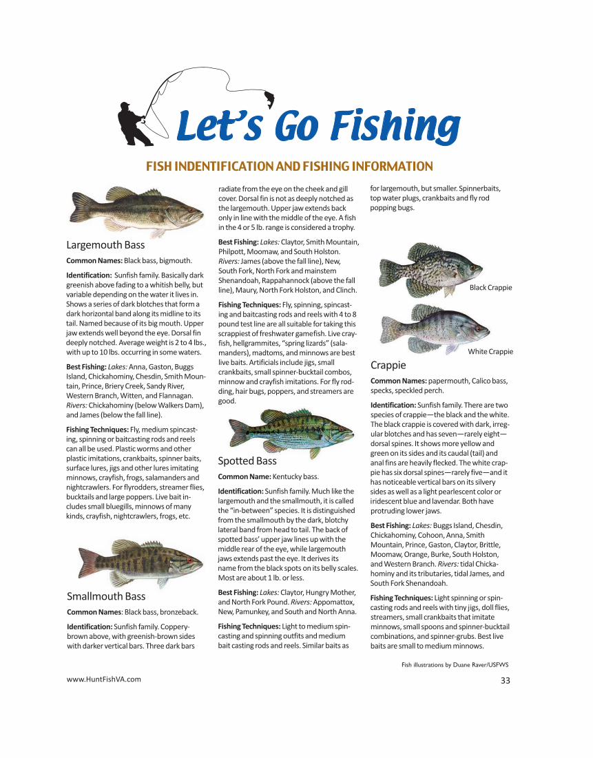
32 2015 Virginia Freshwater Fishing & Boating Guide
Department]: Amelia, Appomattox, Brunswick, Campbell, Charlotte, Cumberland, Dinwiddie, Goochland (except James River), Greensville, Halifax, Louisa, Lunenburg, Mecklen- burg, Nottoway, Pittsylvania, and Prince Edward.
2. From April 1 through May 15 and Octo-ber 1 through November 30 during thedaytime in the following waters:Buchanan County, all waters exceptDismal River; Grayson County, NewRiver; Lee County, Powell River; RussellCounty, Clinch River; Scott County,Clinch River and its tributaries; TazewellCounty, Dry Run Creek; Wise County,Clinch River; and Washington County,Middle Fork and South Fork of the
Holston River. Creel limit: 20 suckers per day.
3. Snagging for carp and suckers duringApril in Wolf and Big Walkers Creek inGiles County.
4. Snagging for carp and suckers in Walk-ers Creek, Wolf Creek and the NorthFork of the Holston in Bland County.
5. Bow and arrow and gigging for carpyear-round in the Shenandoah River.
6. Shooting with a rifle for suckers andcarp from April 15 to May 31 duringdaylight hours in the shoals of theClinch River within the limits of ScottCounty, except that it shall be unlawfulto shoot fish on Sunday or within thelimits of any town, or from any bridge.Fishing license is required. Creel limit:20 per day.
Dip nets may be used to take shad, herring,mullet and suckers except in designatedstocked trout waters, Department-owned orcontrolled lakes, in certain waters whereanadromous shad and herring cannot bepossessed (see pages 20–21 for shad andherring limits), and as restricted below. Theuser and all helpers (regardless of age) musthave dip net permits ($4.50) or valid fishinglicense. Permits are valid in the county’s inland waters for which issued. All other fishspecies taken are to be immediately returned to the water alive.
Herring: The Virginia Marine Resources Com-
mission enacted a ban on the posses-sion of river herring in tidal waters,effective January 1, 2012, due to the
collapse of the stock and in order tocomply with an Atlantic States MarineFisheries Commission directive.
Suckers Taken with Dip Nets: Limit of 20 per day. Season: February 15– May 15. Dip nets shall not be more than 6 feet
square. Dip net permits are not re-quired for taking suckers in Brunswick,Greensville, and Sussex counties.
Nets and Seines are prohibited while fishingin designated stocked trout waters and fortaking fish from Department-owned or con-trolled lakes, except as otherwise posted(see table page 21 for certain nongame fishlimits). Only those nets and seines listedunder general methods to capture or takenongame fish (above) can be used in thepublic waters of the Roanoke (Staunton) andDan rivers in Campbell, Charlotte, Halifaxand Pittsylvania counties, and in the City ofDanville. Seines, nets, and traps are also prohibited in Lick Creek in Smyth and Blandcounties, Bear Creek in Smyth County, LaurelCreek and tributaries upstream of Highway16 bridge in Tazewell and Bland counties,Hungry Mother Creek above Hungry MotherLake in Smyth County, Susong Branch andMumpower Creek in Washington Countyand the City of Bristol, and TimbertreeBranch in Scott County. However, these re-strictions do not prohibit the use of a hand-landing net to land fish legally hooked.Seasons and local restrictions governing theuse of nets and seines are complex. Personsdeciding to try this type of fishing shouldcontact the closest VDGIF regional office formore information.
Areas/Species RestrictedDesignated Stocked Trout Waters:Nongame fish may be harvested only byhook and line in designated stocked troutwaters.
Mollusks: Unlawful to take the spiny river-snail (Io fluvialis) in the Tennessee drainagein Virginia (Clinch, Powell and the North,South and Middle Forks of the Holston riversand tributaries). It shall be unlawful to takemussels from any inland waters in Virginia.
Salamanders: Unlawful to take salamandersin Grayson Highlands State Park and on National Forest lands in the Jefferson Na-tional Forest in those portions of Grayson,Smyth and Washington counties bounded
on the east by Rt. 16, on the north by Rt. 603, and on the south and west by Rt. 58.
Non-Native (Exotic Animals)
A special permit is required, and may be issued by the Department, if consistent withthe Department’s fish and wildlife manage-ment program, to import, possess, or sell thefollowing non-native (exotic) amphibians,fish, mollusks, aquatic invertebrates, andreptiles: giant or marine toad, tongueless orAfrican clawed frog, barred tiger salaman-der, gray tiger salamander, blotched tigersalamander, smallmouth buffalo, bigmouthbuffalo, black buffalo, piranhas, bigheadcarp, grass carp or white amur, red shiner, silver carp, black carp, rudd, tench, ruffe,snakeheads, air-breathing catfish, tilapia,swamp eel, tubenose goby, round goby,zebra mussel, New Zealand mudsnail, quagga mussel, rusty crayfish, Australiancrayfish, marbled crayfish, Chinese mittencrab, alligators, caimans, brown tree snake,crocodiles, and gavials. Anglers may legally possess snakeheadfish taken from Virginia waters provided theyimmediately kill the fish and notify DGIF at804-367-2925. All other non-native (exotic) amphib-ians, fish, aquatic invertebrates, and reptilesnot listed above may be possessed, purchased, and sold, provided that such animals shall be subject to all applicablelocal, state, and federal laws and regulations,including those that apply to threatened/endangered species, and further providedthat such animals shall not be liberated within the Commonwealth.
www.HuntFishVA.com 33
Let’s Go FishingFISH INDENTIFICATION AND FISHING INFORMATION
Black Crappie
White Crappie
Largemouth BassCommon Names: Black bass, bigmouth.
Identification: Sunfish family. Basically darkgreenish above fading to a whitish belly, butvariable depending on the water it lives in.Shows a series of dark blotches that form adark horizontal band along its midline to itstail. Named because of its big mouth. Upperjaw extends well beyond the eye. Dorsal findeeply notched. Average weight is 2 to 4 lbs.,with up to 10 lbs. occurring in some waters.
Best Fishing: Lakes: Anna, Gaston, Buggs Island, Chickahominy, Chesdin, Smith Moun-tain, Prince, Briery Creek, Sandy River, Western Branch, Witten, and Flannagan.Rivers: Chickahominy (below Walkers Dam),and James (below the fall line).
Fishing Techniques: Fly, medium spincast-ing, spinning or baitcasting rods and reelscan all be used. Plastic worms and otherplastic imitations, crankbaits, spinner baits,surface lures, jigs and other lures imitatingminnows, crayfish, frogs, salamanders andnightcrawlers. For flyrodders, streamer flies,bucktails and large poppers. Live bait in-cludes small bluegills, minnows of manykinds, crayfish, nightcrawlers, frogs, etc.
Smallmouth BassCommon Names: Black bass, bronzeback.
Identification: Sunfish family. Coppery-brown above, with greenish-brown sideswith darker vertical bars. Three dark bars
radiate from the eye on the cheek and gillcover. Dorsal fin is not as deeply notched asthe largemouth. Upper jaw extends backonly in line with the middle of the eye. A fishin the 4 or 5 lb. range is considered a trophy.
Best Fishing: Lakes: Claytor, Smith Mountain,Philpott, Moomaw, and South Holston.Rivers: James (above the fall line), New,South Fork, North Fork and mainstemShenandoah, Rappahannock (above the fallline), Maury, North Fork Holston, and Clinch.
Fishing Techniques: Fly, spinning, spincast-ing and baitcasting rods and reels with 4 to 8pound test line are all suitable for taking thisscrappiest of freshwater gamefish. Live cray-fish, hellgrammites, “spring lizards” (sala-manders), madtoms, and minnows are bestlive baits. Artificials include jigs, smallcrankbaits, small spinner-bucktail combos,minnow and crayfish imitations. For fly rod-ding, hair bugs, poppers, and streamers aregood.
Spotted BassCommon Name: Kentucky bass.
Identification: Sunfish family. Much like thelargemouth and the smallmouth, it is calledthe “in-between” species. It is distinguishedfrom the smallmouth by the dark, blotchylateral band from head to tail. The back ofspotted bass’ upper jaw lines up with themiddle rear of the eye, while largemouthjaws extends past the eye. It derives itsname from the black spots on its belly scales.Most are about 1 lb. or less.
Best Fishing: Lakes: Claytor, Hungry Mother,and North Fork Pound. Rivers: Appomattox,New, Pamunkey, and South and North Anna.
Fishing Techniques: Light to medium spin-casting and spinning outfits and mediumbait casting rods and reels. Similar baits as
CrappieCommon Names: papermouth, Calico bass,specks, speckled perch.
Identification: Sunfish family. There are twospecies of crappie—the black and the white.The black crappie is covered with dark, irreg-ular blotches and has seven—rarely eight—dorsal spines. It shows more yellow andgreen on its sides and its caudal (tail) andanal fins are heavily flecked. The white crap-pie has six dorsal spines—rarely five—and ithas noticeable vertical bars on its silverysides as well as a light pearlescent color oriridescent blue and lavendar. Both have protruding lower jaws.
Best Fishing: Lakes: Buggs Island, Chesdin,Chickahominy, Cohoon, Anna, Smith Mountain, Prince, Gaston, Claytor, Brittle,Moomaw, Orange, Burke, South Holston,and Western Branch. Rivers: tidal Chicka-hominy and its tributaries, tidal James, andSouth Fork Shenandoah.
Fishing Techniques: Light spinning or spin-casting rods and reels with tiny jigs, doll flies,streamers, small crankbaits that imitate minnows, small spoons and spinner-bucktailcombinations, and spinner-grubs. Best livebaits are small to medium minnows.
Fish illustrations by Duane Raver/USFWS
for largemouth, but smaller. Spinnerbaits,top water plugs, crankbaits and fly rod popping bugs.
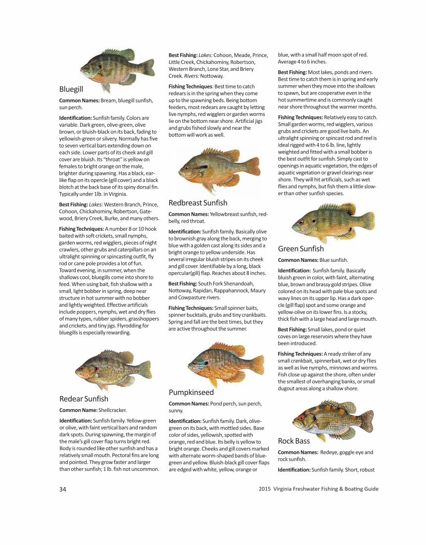
34 2015 Virginia Freshwater Fishing & Boating Guide
BluegillCommon Names: Bream, bluegill sunfish,sun perch.
Identification: Sunfish family. Colors arevariable. Dark green, olive-green, olivebrown, or bluish-black on its back, fading toyellowish-green or silvery. Normally has fiveto seven vertical bars extending down oneach side. Lower parts of its cheek and gillcover are bluish. Its “throat” is yellow on females to bright orange on the male,brighter during spawning. Has a black, ear-like flap on its opercle (gill cover) and a blackblotch at the back base of its spiny dorsal fin.Typically under 1lb. in Virginia.
Best Fishing: Lakes: Western Branch, Prince,Cohoon, Chickahominy, Robertson, Gate-wood, Briery Creek, Burke, and many others.
Fishing Techniques: A number 8 or 10 hookbaited with soft crickets, small nymphs, garden worms, red wigglers, pieces of nightcrawlers, other grubs and caterpillars on anultralight spinning or spincasting outfit, flyrod or cane pole provides a lot of fun. Toward evening, in summer, when the shallows cool, bluegills come into shore tofeed. When using bait, fish shallow with asmall, light bobber in spring, deep nearstructure in hot summer with no bobber and lightly weighted. Effective artificials include poppers, nymphs, wet and dry fliesof many types, rubber spiders, grasshoppersand crickets, and tiny jigs. Flyrodding forbluegills is especially rewarding.
Redear SunfishCommon Name: Shellcracker.
Identification: Sunfish family. Yellow-greenor olive, with faint vertical bars and randomdark spots. During spawning, the margin ofthe male’s gill cover flap turns bright red.Body is rounded like other sunfish and has arelatively small mouth. Pectoral fins are longand pointed. They grow faster and largerthan other sunfish; 1 lb. fish not uncommon.
Best Fishing: Lakes: Cohoon, Meade, Prince,Little Creek, Chickahominy, Robertson,Western Branch, Lone Star, and BrieryCreek. Rivers: Nottoway.
Fishing Techniques: Best time to catch redears is in the spring when they come up to the spawning beds. Being bottomfeeders, most redears are caught by lettinglive nymphs, red wigglers or garden wormslie on the bottom near shore. Artificial jigsand grubs fished slowly and near the bottom will work as well.
Redbreast SunfishCommon Names: Yellowbreast sunfish, red-belly, red throat.
Identification: Sunfish family. Basically oliveto brownish gray along the back, merging toblue with a golden cast along its sides and abright orange to yellow underside. Has several irregular bluish stripes on its cheekand gill cover. Identifiable by a long, blackopercular(gill) flap. Reaches about 8 inches.
Best Fishing: South Fork Shenandoah, Nottoway, Rapidan, Rappahannock, Mauryand Cowpasture rivers.
Fishing Techniques: Small spinner baits,spinner bucktails, grubs and tiny crankbaits.Spring and fall are the best times, but theyare active throughout the summer.
PumpkinseedCommon Names: Pond perch, sun perch,sunny.
Identification: Sunfish family. Dark, olive-green on its back, with mottled sides. Basecolor of sides, yellowish, spotted with orange, red and blue. Its belly is yellow tobright orange. Cheeks and gill covers markedwith alternate worm-shaped bands of blue-green and yellow. Bluish-black gill cover flapsare edged with white, yellow, orange or
Green SunfishCommon Names: Blue sunfish.
Identification: Sunfish family. Basicallybluish green in color, with faint, alternatingblue, brown and brassy gold stripes. Olivecolored on its head with pale blue spots andwavy lines on its upper lip. Has a dark oper-cle (gill flap) spot and some orange and yellow-olive on its lower fins. Is a stocky,thick fish with a large head and large mouth.
Best Fishing: Small lakes, pond or quietcoves on large reservoirs where they havebeen introduced.
Fishing Techniques: A ready striker of anysmall crankbait, spinnerbait, wet or dry fliesas well as live nymphs, minnows and worms.Fish close up against the shore, often underthe smallest of overhanging banks, or smalldugout areas along a shallow shore.
blue, with a small half moon spot of red. Average 4 to 6 inches.
Best Fishing: Most lakes, ponds and rivers.Best time to catch them is in spring and earlysummer when they move into the shallowsto spawn, but are cooperative even in thehot summertime and is commonly caughtnear shore throughout the warmer months.
Fishing Techniques: Relatively easy to catch.Small garden worms, red wigglers, variousgrubs and crickets are good live baits. An ultralight spinning or spincast rod and reel isideal rigged with 4 to 6 lb. line, lightlyweighted and fitted with a small bobber isthe best outfit for sunfish. Simply cast toopenings in aquatic vegetation, the edges ofaquatic vegetation or gravel clearings nearshore. They will hit artificials, such as wetflies and nymphs, but fish them a little slow-er than other sunfish species.
Rock BassCommon Names: Redeye, goggle eye androck sunfish.
Identification: Sunfish family. Short, robust
www.HuntFishVA.com 35
Fish illustrations by Duane Raver/USFWS
body and fairly large mouth. Lower jaw pro-trudes slightly. Back is olive-green with sidestarnished gold or brassy colored. Each scalehas a dark central spot. Large spots on itslower body forms a striped-like appearance.Has a discernable dark outline on its anal fin.Has wide vertical blotches on its sides and adark spot on its cheek. Average 6 to 8 inches,but will reach 12 to 14 inches and 1.5 to 2lbs. Cheeks with obvious scales.
Best Fishing: Lakes: Smith Mountain,Moomaw, and Laurel Bed. Rivers: Roanoke,New, Jackson, Maury, James, Bullpasture,Calfpasture, Buffalo, North Fork Shenan-doah and Clinch.
Fishing Techniques: Voracious feeders that readily strike spinners, jigs, smallcrankbaits and flies. Favored live baits include minnows, crayfish, nightcrawlers,mayfly nymphs and hellgrammites.
Roanoke BassCommon Names: Redeye, rock bass.
Identification: Sunfish family. Robust bodymuch like the rock bass but with dark, olive-green to olive-brown back, fading to grayishsides and white belly. Has smaller scale spotsthan the rock bass and lighter, small whitishor yellowish spots on its upper body. Has aslightly concave outline over the eyes.Cheeks scaleless or nearly so.
Best Fishing: Lakes: Leesville and SmithMountain. Most of the trophy “rock bass”registered by anglers are really Roanokebass. Rivers: Nottoway, Roanoke/Staunton, and Blackwater and Pigg of theRoanoke drainage.
Fishing Techniques: Spinning and spincast-ing with small to medium spinner baits,small spoons and crankbaits. Live baits include minnows, crayfish, and worms.
FlierCommon Names: Round sunfish, millpondflier.
Identification: Sunfish family. A deep-bodied, almost round fish, with many spineson both dorsal and anal fins. Color is a yellow-green or brassy-olive to brownish-gold, with a dark brown to black spot oneach scale, appearing as rows of spots. Adark vertical streak extends downward fromthe eye to the lower edge of its cheek. It haslarge, rounded fins, much like a crappie, witha head and mouth similar in shape to abluegill’s. Slow growing, they reach up to 10 inches in length.
Best Fishing: Lakes: Drummond, Airfield,Kilby, Cohoon, Meade, Lee Hall, and MottsRun. Rivers: Dismal Swamp Canal, Nottoway,and Blackwater.
Fishing Techniques: Most are probablycaught incidentally by fishermen fishing forcrappies in early spring. They will hit dry andwet flies, as well as small minnows andworms using typical small panfish rigs. Fisharound stumps, sunken brush, cypresstrunks and knees, and near or underbridges.
WarmouthCommon Names: Openmouth, warmouthbass, Indian fish.
Identification: Sunfish family. A large-mouthed, robust fish with mottled sides and wavy lines on its cheek. Basically darkbrownish above, with mottled and barredsides, and mottled or spotted fins. Can beolive-brown colored with greenish cast. Seldom gets larger than 8 or 9 inches.
Best Fishing: Numerous small lakes, pondssuch as lakes Orange, Lee Hall, and Airfield;and slow-moving, swampy rivers andstreams, such as Dragon Run and Nottoway.
Fishing Techniques: Caught incidental toother fishing activities. Will take a variety ofsmall artificials, as well as worms, small crayfish and minnows.
White BassCommon Names: Silver bass, linesides.
Identification: Temperate “true” bass family.Light greenish back, light yellowish-green tosilver sides to a silvery-white below, 6 to 8horizontal faint stripes; stripes below lateralline are broken; the first stripe below the lat-eral line is not complete to tail. Deep-bodiedwith distinctively arched back, considerablysmaller than its striped bass cousin. Singlespine on gill cover; variable patch of teeth ontongue. Commonly reaches 0.5 to 2 lbs.
Best Fishing: Lakes: Buggs Island, SmithMountain, Claytor, and Leesville. Rivers:New, and the Dan and Staunton (duringspawning).
Fishing Techniques: Spinning or spincastingoutfits with live minnows, or artificials imi-tating minnows, including jigs, spinner baits,streamers, spinner-bucktails, crankbaits andspoons. Caught during the spawning runs,also below dams in the tailraces, and byjump fishing schools in open water.
Striped BassCommon Names: Striper, rockfish.
Identification: True bass family. Stream-lined, elongated body; coloration shadesfrom dark olive above through silvery sidesto a white belly; 7 to 8 prominent unbrokenblack stripes originate behind the head andextend to the tail; more prominent than onthe white bass. Two spines on the gill cover;two patches of teeth on tongue. Ten to 15 lb.fish are common with 30 to 40 +lb. fish land-ed each season.
Best Fishing: Lakes: Smith Mountain, BuggsIsland, Anna, Claytor, Gaston, Leesville andWestern Branch. Rivers: Staunton/Roanoke,Dan, and all tidal rivers.
Fishing Techniques: Heavy baitcasting, spincasting or spinning outfits with a goodbackbone and 15 to 25 pound test line. Livebait includes large minnows or gizzard orthreadfin shad. Large feathered or plastic jigcombinations, spoons, crankbaits that imitate shad or other fish and bucktails.Trolling, drift fishing, jump fishing or deepjigging are usual fishing methods.
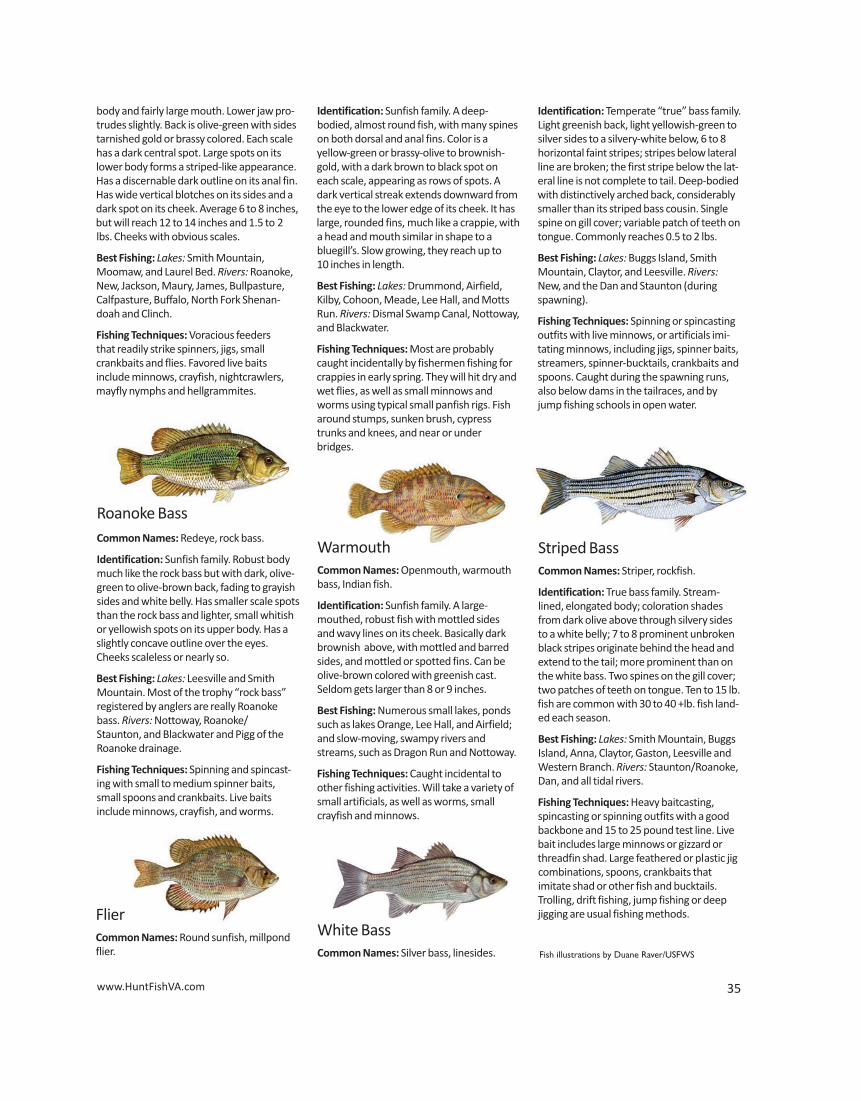
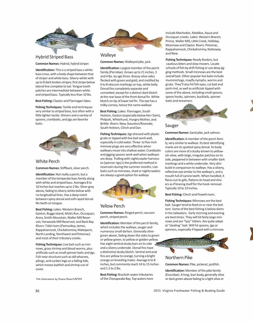
36 2015 Virginia Freshwater Fishing & Boating Guide
Hybrid Striped BassCommon Names: Hybrid, hybrid striper.
Identification: This is a striped bass x whitebass cross, with a body shape between thatof striper and white bass. Silvery-white withup to 8 dark broken stripes; first stripe belowlateral line complete to tail. Tongue toothpatches are intermediate between whiteand striped bass. Typically less than 10 lbs.
Best Fishing: Claytor and Flannagan lakes.
Fishing Techniques: Tackle and techniquesvery similar to striped bass, but often with alittle lighter tackle. Shiners and a variety ofspoons, crankbaits, and jigs are favoritebaits.
White Perch Common Names: Stiffback, silver perch.
Identification: Not really a perch, but amember of the temperate bass family alongwith white and striped bass. Averages 8 to10 inches but reaches up to 2 lbs. Silver grayabove, fading to silvery-white below with no longitudinal lines. Has a deep notch between spiny dorsal and soft-rayed dorsal.No teeth on tongue.
Best Fishing: Lakes: Western Branch, Gaston, Buggs Island, Motts Run, Occoquan,Anna, Smith Mountain, Waller Mill Reser-voir, Harwoods Mill Reservoir, and Back Bay.Rivers: Tidal rivers (Pamunkey, James, Rappahannock, Chickahominy, Mattaponi,North Landing, Northwest and Potomac)and most of their tributary creeks.
Fishing Techniques: Live bait such as min-nows, grass shrimp and blood worms, plusartificials such as small spinner baits and jigs.Fish near structure such as old wharves, pilings, and sunken logs on a falling tide,which moves baitfish and shrimp out ofcover.
WalleyeCommon Names: Walleyed pike, jack.
Identification: Largest member of the perchfamily (Percidae). Grows up to 21 inches, 3and 4 lbs. by age three. Brassy-olive sidesflecked with green and gold, and mottled by6 to 8 obscure markings on top, white belly.Dorsal fins completely separate and unmarked, except for a distinct dark blotch at the rear base of the front dorsal fin. Whiteblotch on tip of lower tail fin. The eye has amilky cornea, hence the name walleye.
Best Fishing: Lakes: Flannagan, South Holston, Gaston (especially below Kerr Dam),Philpott, Whitehurst, Hungry Mother, andBrittle. Rivers: New, Staunton/Roanoke,South Holston, Clinch and Dan.
Fishing Techniques: Jigs dressed with plasticgrubs or tipped with live bait work well, especially in cold water. Three- to five-inchminnow plugs are very effective whenwalleyes move into shallow water. Crankbaitsand jigging spoons work well when walleyesare deep. Trolling with nightcrawler harness-es (spinner rigs) is the preferred method inreservoirs during the summer months. Livebaits such as minnows, shad or nightcrawlersare always a good option for walleye.
Yellow PerchCommon Names: Ringed perch, raccoonperch, striped perch.
Identification: Member of the perch family,which includes the walleye, sauger and numerous small darters. Generally olive-green above, fading down the sides to greenor yellow-green, to yellow or golden yellow.Has eight vertical dusky bars on its sideand a silvery underside. Dorsal fins havea distinctive dusky blotch. Ventral and analfins are yellow to orange, turning a bright orange on breeding males. Average 6 to 8inches, but commonly reach 14 to 15 inchesand 1.5 to 2 lbs.
Best Fishing: Brackish-water tributaries of the Chesapeake Bay. Top waters here
SaugerCommon Names: Sand pike, jack salmon.
Identification: A member of the perch fami-ly, very similar to walleye. Its best identifyingmarks are its spotted spiny dorsal. Its bodycolors are more of a dusky-brown to yellow-ish-olive, with large, irregular patches on itsside, peppered in between with smaller darkmarkings and a white underside. Very slimbuild in comparison to walleye. Has a silvery,reflective eye similar to the walleye’s, and amouth full of canine teeth. When handled, itflares out its gills, flattens its head and shiv-ers as if bracing itself for the hook removal.Typically 10 to 19 inches.
Best Fishing: Clinch and Powell rivers.
Fishing Techniques: Minnows are the bestbait. Sauger tend to feed on or near the bot-tom. Some of the best fishing is below damsin the tailwaters. Early morning and eveningare best times. They will hit fairly large min-nows and are “lazy” hitters. Are quite adeptat “stealing” bait. Will hit spoons, jigs orspinners, especially if tipped with a minnow.
Northern PikeCommon Names: Pike, pickerel, jackfish.
Identification: Member of the pike family(Esocidae). A long, lean body, generally oliveor dark green above fading to a light olive or
include Machodoc, Maddox, Aquia and Occoquan creeks. Lakes: Western Branch,Prince, Waller Mill, Little Creek, Holliday,Moomaw and Claytor. Rivers: Potomac, Rappahannock, Chickahominy, Nottowayand New.
Fishing Techniques: Ready feeders, butcautious biters and slow movers. Locateschools of fish by drift fishing or use deep jig-ging methods. Small minnows are the bestoverall bait. Other popular live baits includemummichogs, mayfly nymphs, worms andgrubs. They’ll also hit fish eyes, cut bait andpork rind, as well as artificials tipped withsome of the above, including small spoons,spoon hooks, spinners, bucktails, spinnerbaits and streamers.
Fish illustrations by Duane Raver/USFWS
www.HuntFishVA.com 37
Chain PickerelCommon Names: Chainsides, jackpike, pike.
Identification: A member of the pike family,it is named for its chain-like markings on itssides. Also has a black vertical mark under itseye. Normally its fin is unmarked. Averages1.5 to 3 lbs. Fully scaled on both cheek andgill cover.
Best Fishing: Lakes: Chickahominy, Gaston,Western Branch, Diascund, Burnt Mills,Prince, Anna, Cohoon, Little Creek,Moomaw, Douthat and many other rivers,ponds and lakes. Rivers: Nottoway, Black -water, Chickahominy, and Dragon Run.
Fishing Techniques: Best time is from October through March. Most active whenwater temperatures are 55° to 70°F. Spin-ners, spoons, bucktails, jigs, pork rind baits,and a variety of crankbaits will take pickerel. Minnows are the best live bait. Fish theedges of weed beds, lily pad beds, sunkenbrush, or tree stumps.
MuskellungeCommon Names: Musky, muskie.
Identification: Largest member of the pikefamily. Normally olive to dark gray on itsback, with grayish to bluish to yellowishsides. Sides may have faint vertical bars,spots or blotches.
Rainbow TroutCommon Name: Rainbow.
Identification: The variety of rainbows hasresulted in a variety of colors, hues andmarkings. Normally the back is olive-greenwith a silvery cast on its sides fading to a silvery-white belly. A pinkish or light rosy redband extends from its cheek to near its tail.Normally, they are well spotted with blackspots, but vary from large spots to tinyspecks to no markings at all.
Best Fishing: Well established in streams ofthe southwestern region of the state and arefound in a myriad of mountain streams inwestern Virginia. Lakes: Moomaw. Riversand Streams: Smith River, Elk Creek, DanRiver, Potts Creek, Cripple Creek, RoanokeRiver, Little Reed Island Creek, Jackson River,Crooked Creek and Big Tumbling Creek, andmany others on both sides of the Blue Ridge.Some good wild streams are Whitetop Laurel, Fox Creek, and the South Fork Holston River.
Fishing Techniques: Hits dry flies, wet flies,streamers, nymphs, small spinners and spin-ner-bucktails, spoons, as well as worms, livenymphs, minnows and salmon eggs. Hatch-ery trout readily take kernel corn and col-ored marshmallows. Berkeley Power Baitsthat give off a scent and can be shaped onthe hook are used extensively by anglers.
gray-green to yellowish-green then to whiteon its belly. Its sides have light yellowishbean-shaped spots the length of its body.Strongly toothed jaws have teeth arrangedin rows, plus rows of teeth located on itstongue and palate; they angle inward so itsprey cannot get loose. Cheek is fully scaled,gill cover is only half scaled.
Best Fishing: Lakes: Occoquan, Motts Run,and Arrowhead (Page County).
Fishing Techniques: Still-fishing with largeminnows or other baitfish, or casting ortrolling with large spoons, spinner-bucktailsor crankbaits.
Feeding Habits: Muskies eat mainly otherfishes, especially soft-rayed species such assuckers, carp and shad, but also frogs, ducklings, muskrats and other mammals.
Best Fishing: Lakes: Rural Retreat, HungryMother, and Burke. Rivers: James, Clinch,Shenandoah and New.
Fishing Techniques: River fishermen usesmall boats with electric motors or smalloutboards to float larger pools and fishshoreline snags and submerged brush.Heavy bait casting rods and reels with 30+ lb.test line is used. Using large hooks, 4/0 orlarger, some anglers simply allow 8- or 12-inch suckers, shad or carp to swim free.Muskies are commonly caught in lakes by
trolling deep water with large crankbaits,spoons and spinner-bucktail combina-
tions. Early in the year, try trolling acrossshallow points.
Brown TroutCommon Names: English brown trout, German brown trout, European trout.
Identification: Colors vary widely. Naturalwild browns are olive-brown on the back,lighter on the sides, brilliant yellow-gold ontheir underside, with yellowish-green,unspotted fins. They have numerous blackor dark brown spots on their sides, alongwith a sprinkling of red spots encircled withlight blue rings. Hatchery-reared brownstend to be more silvery with dark brownishabove with light yellow undersides and spotsof a lighter shade.
Best Fishing: Lakes: Moomaw. Rivers andStreams: Little River, Mossy Creek, PottsCreek, Back Creek, Jackson River, Smith Riverand a wide array of others on either side ofthe Blue Ridge and in southwestern Virginia.
Fishing Techniques: Will rise to dry flies aswell as hitting wet flies, streamers andnymphs. Worms, live nymphs, minnows andsalmon eggs are good too. Brown trout tendto be bigger “meat eaters” in that they’lltake larger live baits more readily and will hitspinners, spinner bucktail combinations, aswell as small crankbaits and spoons. Livebaits and wet flies are normally fished down-stream while dry flies are fished upstream.
Brook Trout Common Names: Native, brookie, mountaintrout, speckled trout.
Identification: Most colorful of our trout.Back is a dark olive-green with light wavy orwormy markings. Sides are lighter, some-times with a bluish cast, yellowish spots andred spots with a light blue halo around them.Belly is white with bright orange fins. Finshave outer edges of white with a black lineseparating it from the orange. Ten to 16 inches and 1 to 2 lbs. is a good-sized brookie. Native brookies seldom grow beyond 12inches in Virginia streams.
Best Fishing: Over 400 streams or portionsof streams contain brook trout. Many of thestreams and ponds in the Shenandoah
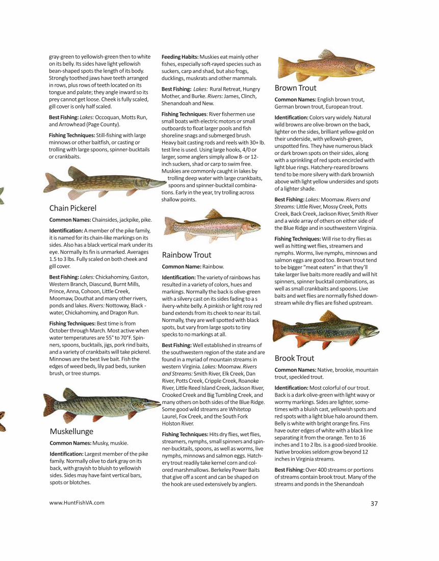

38 2015 Virginia Freshwater Fishing & Boating Guide
National Park and the George Washingtonand Jefferson National Forest have nativebrook trout. Lakes: Laurel Bed, Coles Creekand Mill Creek reservoirs, Lexington CityReservoir and Switzer Lake. Rivers andStreams: Crooked Creek, Little Stoney Creek,Rapidan River, Rose River, Hughes River, Jeremy's Run, Laurel Fork and Dry River.
Fishing Techniques: For the purist, dry flies,wet flies, streamers and nymphs are used.Nymphs early in the season, dry flies whenthe natural insects hatch. Live bait anglersuse garden worms and caddis, mayfly andstonefly nymphs also early in the year whenthese aquatic larvae are available naturally.In deep pools, small minnows may be effective year round.
Flathead CatfishCommon Names: Mud cat, shovelhead cat,yellow cat.
Identification: Broadly flattened head with alower jaw that projects beyond the upperjaw. Tail only slightly notched and adipose finis relatively large. Body is yellowish orcream-colored with black, dark brown orolive-brown mottling on back and sides, fading to dirty white or yellow. Younger fish have darker, bolder markingsand the upper tip of the tailshave white, triangular patches.
Best Fishing: Lakes: Occoquan,Claytor, Flannagan, Smith Moun-tain, and Buggs Island. Rivers: James,New, Staunton/Roanoke rivers and Occoquan Creek.
Fishing Techniques: Use live bait since theyaren’t easily attracted to catfish baits nor-mally used for other catfish, although chick-en entrails, nightcrawlers, and minnowswork well. Usually caught on the bottom ofdeep pools or in tailraces below dams.
Blue CatfishCommon Names: Forked-tailed cat, hump-back blue, chucklehead.
Channel Catfish Common Names: Spotted-catfish,speckledcatfish, silver catfish, fork-tailed catfish.
Identification: Deeply forked tail. Upper jawis longer than, and overlaps the lower. Whensmall, its smooth-skinned body is usuallyspotted; however, these spots disappear inolder fish (can be confused with blue catfish,
see identification of blue catfish). Has asmall dorsal fin with stiff spine standing
high on its back. Varies in color, althoughgenerally dark brownish to slate-gray ontop, fading to light brownish-gray on the
sides. Has 25 to 29 rays in its anal fin.
Best Fishing: Lakes: Buggs Island, Gaston,South Holston, Claytor, Anna, Chesdin, Flannagan, and most small public lakes. Rivers: Appomattox, Chickahominy, Dan,
White CatfishCommon Names: Forked-tailed cat.
Identification: Has a moderately forked tail,a stocky body with its upper jaw extendingslightly beyond lower. Color is basically blue-gray above, fading to gray on its sides with awhite underside. Occasionally mottled lightgray on its sides. Average 8 to 18 inches,rarely 20.
Best Fishing: Tidal rivers such as the Potomac, Rappahannock, James, and Yorkand numerous lakes in southeast and central Virginia.
Fishing Techniques: Many of the samemethods used for other catfish. Worms,minnows and scented baits fished on or near the bottom.
Identification: Heavy-bodied with a widehead and high spot forward of center nearthe head called the dorsal hump. Upper jawprojects well beyond the lower. Bluish-graybody above, fading to white on sides andbelly. No spots and a deeply forked tail. Bluecats are often confused with channel catfish.Small channel cats typically will have spotslacking in small blue cats. However, largechannel cats and medium-sized blue cats canbe more difficult to tell apart, often havingsimilar coloration and general body shape.The margin, or edge, of the anal fin can beused to identify these fish: blue catshave an anal fin with a very straightmargin; in channel cats the anal finhas a rounded margin. Biologistsand anglers can definitively distin-guish between the two species by
counting anal fin rays; 30-35 rays inthe blue cat’s anal fin versus the channelcat’s 25 to 29 rays.
Best Fishing: Lakes: Buggs Island. Rivers:James, Mattaponi, Pamunkey, Rappahan-nock, Staunton, Appomattox, and Potomactributaries in Virginia.
Fishing Techniques: March through May arethe best months, but they are caught yearround. Use heavy tackle with cut bait, liveherring, shad, or peeler crabs. Best at nightor low-light conditions.
Mattaponi, Pamunkey, New, Rappahannock,Shenandoah, Staunton, and North Landing.
Fishing Techniques: Rod and reel anglerscatch them on clam snouts, peeler crabs,large minnows, nightcrawlers, cut herring,chicken livers or entrails, shrimp, and a variety of stink or dough baits. They take avariety of artificials including crankbaits, jigsand spinners. Best at night or low-light conditions.
American ShadCommon Names: White shad, roe shad.
Identification: Largest of the river herringfamily, American shad average around 3 lbs.,with fish up to 5 lbs. common. Silver-sidedwith greenish-blue back; deep bodied fromthe side, narrow and symmetrical top to bottom head-on; row of dark spots on thesides, running back from the gill cover; theupper and lower jaws are equal length whenthe mouth is closed.
Best Fishing: Rivers: James (Richmond fall
www.HuntFishVA.com 39
Fish illustrations by Duane Raver/USFWS
Blueback Herring
Alewife
Hickory ShadCommon Names: Hickory, silver shad.
Identification: River herring family, averag-ing around 1 lb., with fish up to 2 lbs. common. Silver-sided with grayish-greenback and a prominent dark spot, followed bya row of lighter spots (especially when fresh)on the upper part of the side just behind thegill cover; body long but compressed, asymmetrical top to bottom and in cross section it is wedge-shaped; the lower jawprotrudes significantly beyond the upperjaw when the mouth is closed. Each scale onthe sides has a small dark spot.
Best Fishing: Rivers: Rappahannock (fall linearea in Fredericksburg), James (Richmondfall line area), Appomattox, Chickahominy(below Walker’s Dam), Mattaponi, Pamunkey, and Nottoway.
Fishing Techniques: Mid-March into Maywith spring spawning run, arriving earlierthan American shad. Light spin casting usingvery small, brightly colored shad darts,spoons, jigs, or minnow imitation lures. Flyfishing with darts, gold or white streamers,and other wet flies. Often taken near the sur-face, will “tail-walk” and sometimes jump.Check current regulations for restrictions.
line area), Mattaponi, Pamunkey, Meherrin,and Nottoway.
Fishing Techniques: Best time from mid-March to early May in fall line areas of tidalrivers as adults return to spawn. Light spin-casting rods and reels, with 1/32 to 1/8 oz.,brightly colored shad darts, spoons, jigs, orsmall minnow imitation lures. Fly fishingwith darts, gold or white soft-bodiedstreamers, and other wet flies. Increasedsuccess in deeper water; do not usuallyjump but give a good fight; need to be care-fully played to avoid tearing delicate mouth.Check current regulations for restrictions.
Blueback Herring & AlewifeCommon Names: River herring.
Identification: Blueback herring and alewifeare almost identical looking; the best way totell them apart is an internal difference,blueback have a black membrane that linesthe abdominal cavity and alewife have a lightcolored one with few, scattered spots. Blue-back are bluish along the back with a silveryhead; alewife is grayish-blue above, with abronze head. Maximum length is 12 to 15inches and less than 1 lb.
Fishing: Because stocks are depressed thereis no harvest permitted in the waters flowinginto North Carolina (Meherrin, Nottoway,
BowfinCommon Names: Grindle, grinnel.
Identification: Bowfin are living relics, withprimitive roots back 70 million years ago.Has a long, soft-rayed dorsal which arches ina bow over most of the length of its body.Tail is rounded, with distinct black spotrimmed with orange on males; black spot onfemales faint or absent and no orange rim.Its back and sides are brownish-green orolive-green, with mottled sides fading to yellowish or white. During spawning, its underside turns a bright yellow-green. Has acylindrical body and a wide flattened head,almost snake-like, with deep-set dark eyes.Snout is rounded with short nasal barbels.Mouth is large and has conical-shaped teeth.Note: While the bowfin shares similar coloration and body shape with the north-ern snakehead (recently introduced to thePotomac River), the anal fin of a bowfin ismuch shorter than that of the snakehead,and snakeheads will not have the spot foundon bowfin.
Best Fishing: Lakes: Chickahominy, LittleCreek and Diascund. Rivers: Chickahominy,Mattaponi, Pamunkey, Nottoway and Blackwater.
Fishing Techniques: They are strong, mus -cular fighters and strike at all manner of livebait and many artificials. Often fools an angler into thinking it’s whipped, and then suddenly explodes back to life. Minnows anda variety of jigs are best baits. Spinner baitsand bass jigs work well for summertimebowfin; in winter, vertical jigging spoons andblade baits can be effective. Use a good stiffrod with at least 15-lb test line. Steel leadersmay be necessary and don’t try to lip holdthese fish! Food value is generally considered poor.
Longnose GarCommon Names: Billy gar, billfish, garfish,garpike.
Identification: Living relic of prehistoricpast; family dates back 245 million years.Nothing in Virginia is even remotely similarto the gar. The long narrow beak-like jaw,laden with sharp teeth, is the unmistakablefeature. Very long, cylindrical fish withdorsal and anal fins set well back on thebody, and a large rounded tail fin; note thearmament of very large, hard, sharp, bonyscales. Brownish-olive on its back, fading toyellowish- or olive-green to white on itsbelly; 2 to 3 ft in length is not uncommon.
Best Fishing: Lakes: Western Branch, Prince,Chickahominy and Buggs Island. Rivers:Chickahominy, Pamunkey, James andRappahannock.
Fishing Techniques: Large minnows are beston medium to heavy casting and spinningtackle. They are adept at stripping bait fromhooks and difficult to hook in their bony jaw.Feed at night, especially moonlit nights.
Blackwater, North Landing and Northwestrivers and their tributaries plus Back Bay). The Virginia Marine Resources Com-mission enacted a ban on the possession ofriver herring, effective January 1, 2012, dueto the collapse of the stock over the past 40 years and in order to comply with an Atlantic States Marine Fisheries Commissionfishery management plan directive.
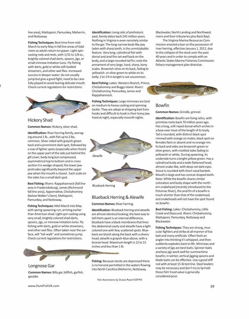
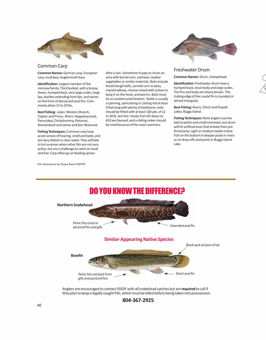
40
DO YOU KNOW THE DIFFERENCE?
Anglers are encouraged to contact VDGIF with all snakehead catches but are required to call ifthey plan to keep a legally caught fish, which must be killed before being taken into posssession.
804-367-2925
Pelvic fins close to pectoral fins and gills
Pelvic fins set back from gills and pectoral fins
Short anal fin
Black spot at base of tail
Extended anal fin
Northern Snakehead
Bowfin
Similar-Appearing Native Species
Common CarpCommon Names: German carp, Europeancarp, mud bass, buglemouth bass.
Identification: Largest member of the minnow family. Thick bodied, with a brassysheen, humped back, very large scales, largelips, barbles extending from lips, and spineson the front of dorsal and anal fins. Com-monly attain 15 to 20 lbs.
Best Fishing: Lakes: Western Branch, Claytor and Prince. Rivers: Rappahannock, Pamunkey, Chickahominy, Potomac,Shenandoah and James and Kerr Reservoir.
Fishing Techniques: Common carp haveacute senses of hearing, smell and taste, andare very skittish in clear water. They will bitein hot summer when other fish are not veryactive, but are a challenge to catch on hookand line. Carp often go on feeding sprees
after a rain. Sometimes it pays to chum anarea with kernel corn, oatmeal, cooked vegetables or similar materials. Baits includebread dough balls, canned corn or peas,marshmallows, cheese mixed with cotton tokeep it on the hook, and worms. Baits mustlie on unobstructed bottom. Tackle is usuallya spinning, spincasting or casting rod at least6 feet long with plenty of backbone; reelsshould be fitted with at least 100 yds. of 12to 30 lb. test line. Hooks from #2 down to#10 are favored, and a sliding sinker shouldbe used because of the carp’s wariness.
Fish illustrations by Duane Raver/USFWS
Freshwater DrumCommon Names: Drum, sheepshead.
Identification: Freshwater drum have ahumped back, stout body and large scales.The fins and body are silvery brown. Thetrailing edge of the caudal fin is rounded oralmost triangular.
Best Fishing: Rivers: Clinch and Powell.Lakes: Buggs Island.
Fishing Techniques: Most anglers use livebait (crayfish and small minnows), but drumwill hit artificial lures that imitate their pre-ferred prey. Light or medium tackle is best.Fish on the bottom in deeper pools in riversor on drop-offs and points in Buggs IslandLake.
41
LEE
SC
OTT
WIS
E
DIC
KEN
SON
BUC
HA
NA
N
RUSS
ELL
WA
SHIN
GTO
N
TAZ
EWEL
L
SMY
TH
GR
AYSO
N
WY
THE
BLA
ND
CA
RRO
LL
PATR
ICK
FLO
YD
PULA
SKI
GIL
ES
HEN
RY
FRA
NK
LIN
MO
NTG
OM
ERY
CRA
IG
ROANOKE
BED
FORD
PITTSYLVANIA
HA
LIFA
X
CA
MPB
ELL
BOTE
TOURT
A
MH
ERST
ALLEGHANY
BAT
H ROCKBRID
GE
AU
GU
STA
NEL
SON
HIG
HLA
ND
ROCK
ING
HA
M
SHEN
ANDOAH
FRED
ERIC
K CLA
RKE
WAR
REN
PAG
E RA
PPA
HA
NN
OC
K
MADIS
ON CU
LPEP
ER
FAUQUIE
R
LOU
DO
UN
PRINCE W
ILLIA
M
FAIR
FAX
ARL
ING
TON
STA
FFO
RD
KIN
G
GEO
RG
E
OR
AN
GE
SPO
TSYL
VAN
IA
CA
RO
LIN
E LO
UIS
A
ALB
EMA
RLE
FLU
VAN
NA
BU
CK
ING
HA
M
APP
OM
ATTO
X
CH
ARL
OTT
E
PRIN
CE
ED
WA
RD
LUN
ENB
UR
G
NO
TTO
WAY
AM
ELIA
CUMBERLAND
POW
HAT
AN
GO
OCH
LAN
D H
AN
OVE
R
DIN
WID
DIE
CH
ESTE
RFIE
LD
MEC
KLE
NB
UR
G
BRUNSWICK GRE
ENSV
ILLE
SOU
THAM
PTO
N
SUSS
EX
SURR
Y IS
LE O
F W
IGH
T
SUFF
OLK
C
HES
APE
AKE
VIRGINIA
BEACH
NO
RFO
LK
POR
TSM
OU
TH
HA
MPT
ON
NEW
POR
T N
EWS
PRIN
CE
GEO
RGE
CH
ARL
ES
CIT
Y
JAMES
CITY
YORK
HENRICO
NEW
KEN
T
KIN
G W
ILLI
AM
KING A
ND QUEEN
GLOUCESTER
NORTHAMPTON
ACCOMACK
MATHEWS
MID
DLESE
X
LANCAST
ER N
OR
THU
MB
ERLA
ND
WES
TMO
RELA
ND
RIC
HMO
ND
ESSE
X
GRE
ENE
4
32
1
Perm
it Bo
atPi
cnic
Gas
Boat
Han
di.
Conc
es.
LMB
Lake
s, S
ize
& Lo
catio
nRe
q.
Ram
pFa
cil.
Mot
orRe
ntal
Faci
l.Fa
cil.
BGSM
BCF
CRP
WB
TRM
YW
EH
SBSB
CPYP
WP
NP
Regi
on 1
–Ea
ster
n Vi
rgin
iaBe
aver
dam
Sw
amp
Rese
rvoi
r (63
5 ac
) Rt
. 17
to R
t. 61
6.Fe
e•
••
••
••
•Ch
andl
er’s
Mill
pond
(75
ac)
on R
t. 3
just
sout
h of
Wes
tmor
elan
d St
ate
Pk.
••
••
Chic
kaho
min
y Re
serv
oir (
1,23
0 ac
) I-6
4 ea
st to
Pro
vide
nce
Forg
e (R
t 60
E)Fe
e•
••
••
••
••
•off
Rt.
649.
Dia
scun
d Re
serv
oir (
1,11
0 ac
) I-6
4 ea
st to
Pro
vide
nce
Forg
e (R
t. 60
E)
••
••
••
off R
t. 60
3.
Gar
dy’s
Mill
Pon
d (7
5 ac
) Rt
. 202
wes
t of C
alla
o.•
••
••
Har
woo
d’s M
ill R
eser
voir
(265
ac)
Rt.
17 –
Rt. 1
73.
Fee
••
WD
WD
••
••
Har
rison
Lake
(82
ac)
Rt. 5
to R
t. 65
8. (H
arris
on La
ke N
ation
al F
ish
Hat
cher
y)•
•5
HP
••
••
Lake
Mau
ry (1
65 a
c) In
ters
ectio
n of
Rt.
60 a
nd R
t. 17
.•
••
••
••
••
Lee
Hal
l Res
ervo
ir (2
30 a
c) R
t. 14
3 N
ewpo
rt N
ews.
(757
) 886
-791
2Fe
e•
•W
DW
D•
••
••
Litt
le C
reek
Res
ervo
ir (9
47 a
c) R
t. 60
E to
Rt.
603
to R
t. 6
10 E
off
Fee
••
••
••
••
••
•La
kevi
ew D
rive.PU
BLI
C LA
KES
GU
IDE
For m
ore
info
rmat
ion:
ww
w.H
untF
ishV
A.co
m/f
ishi
ng/w
ater
bodi
es
BG –
Blue
gill
CF –
Catf
ish
CL –
Ram
p Cl
osed
–Ano
ther
to b
ebu
ilt in
ano
ther
loca
tion
CP –
Chai
n Pi
cker
el
CRP
–Cr
appi
eD
R –
Dirt
Ram
pFP
–Fis
hing
Pie
rH
SB –
Hyb
rid S
trip
ed B
ass
KB –
Kent
ucky
Spo
tted
Bas
s
KEY
LMB
–La
rgem
outh
Bas
sM
Y –
Mus
kellu
nge
NF
–N
atio
nal F
ores
tN
P–N
orth
ern
Pike
PK–P
arki
ng
PR –
Prim
itive
Ram
pRB
r –Re
dbre
ast S
unfis
hSB
–St
riped
Bas
sSF
–St
ate
Fore
st P
erm
itSL
–25
mph
Spe
ed Li
mit
SM B
–Sm
allm
outh
Bas
sSP
–St
ate
Park
Fee
SW –
Swim
min
gTR
–Tr
out
WB
–W
hite
Bas
s
WD
–W
eeke
nds O
nly
WE
–W
alle
yeW
P –
Whi
te P
erch
YP –
Yello
w P
erch
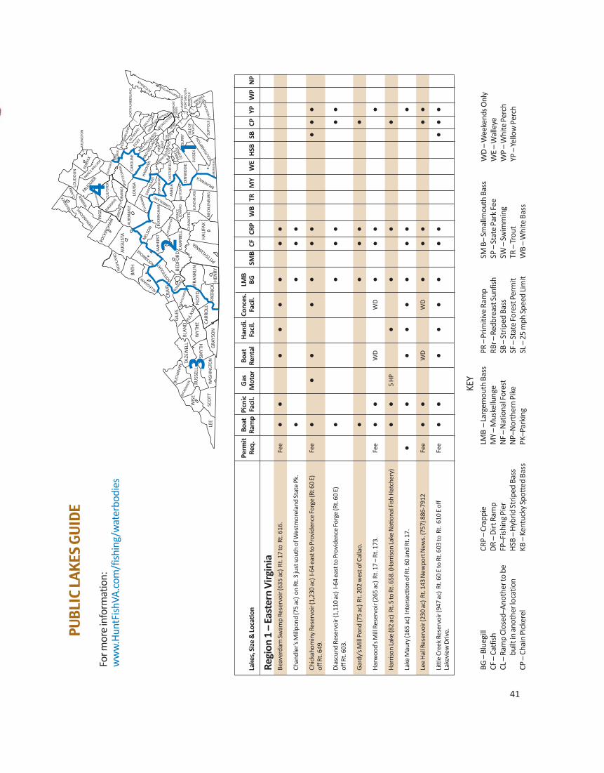
40
DO YOU KNOW THE DIFFERENCE?
Anglers are encouraged to contact VDGIF with all snakehead catches but are required to call ifthey plan to keep a legally caught fish, which must be killed before being taken into posssession.
804-367-2925
Pelvic fins close to pectoral fins and gills
Pelvic fins set back from gills and pectoral fins
Short anal fin
Black spot at base of tail
Extended anal fin
Northern Snakehead
Bowfin
Similar-Appearing Native Species
Common CarpCommon Names: German carp, Europeancarp, mud bass, buglemouth bass.
Identification: Largest member of the minnow family. Thick bodied, with a brassysheen, humped back, very large scales, largelips, barbles extending from lips, and spineson the front of dorsal and anal fins. Com-monly attain 15 to 20 lbs.
Best Fishing: Lakes: Western Branch, Claytor and Prince. Rivers: Rappahannock, Pamunkey, Chickahominy, Potomac,Shenandoah and James and Kerr Reservoir.
Fishing Techniques: Common carp haveacute senses of hearing, smell and taste, andare very skittish in clear water. They will bitein hot summer when other fish are not veryactive, but are a challenge to catch on hookand line. Carp often go on feeding sprees
after a rain. Sometimes it pays to chum anarea with kernel corn, oatmeal, cooked vegetables or similar materials. Baits includebread dough balls, canned corn or peas,marshmallows, cheese mixed with cotton tokeep it on the hook, and worms. Baits mustlie on unobstructed bottom. Tackle is usuallya spinning, spincasting or casting rod at least6 feet long with plenty of backbone; reelsshould be fitted with at least 100 yds. of 12to 30 lb. test line. Hooks from #2 down to#10 are favored, and a sliding sinker shouldbe used because of the carp’s wariness.
Fish illustrations by Duane Raver/USFWS
Freshwater DrumCommon Names: Drum, sheepshead.
Identification: Freshwater drum have ahumped back, stout body and large scales.The fins and body are silvery brown. Thetrailing edge of the caudal fin is rounded oralmost triangular.
Best Fishing: Rivers: Clinch and Powell.Lakes: Buggs Island.
Fishing Techniques: Most anglers use livebait (crayfish and small minnows), but drumwill hit artificial lures that imitate their pre-ferred prey. Light or medium tackle is best.Fish on the bottom in deeper pools in riversor on drop-offs and points in Buggs IslandLake.
41
LEE
SC
OTT
WIS
E
DIC
KEN
SON
BUC
HA
NA
N
RUSS
ELL
WA
SHIN
GTO
N
TAZ
EWEL
L
SMY
TH
GR
AYSO
N
WY
THE
BLA
ND
CA
RRO
LL
PATR
ICK
FLO
YD
PULA
SKI
GIL
ES
HEN
RY
FRA
NK
LIN
MO
NTG
OM
ERY
CRA
IG
ROANOKE
BED
FORD
PITTSYLVANIA
HA
LIFA
X
CA
MPB
ELL
BOTE
TOURT
A
MH
ERST
ALLEGHANY
BAT
H ROCKBRID
GE
AU
GU
STA
NEL
SON
HIG
HLA
ND
ROCK
ING
HA
M
SHEN
ANDOAH
FRED
ERIC
K CLA
RKE
WAR
REN
PAG
E RA
PPA
HA
NN
OC
K
MADIS
ON CU
LPEP
ER
FAUQUIE
R
LOU
DO
UN
PRINCE W
ILLIA
M
FAIR
FAX
ARL
ING
TON
STA
FFO
RD
KIN
G
GEO
RG
E
OR
AN
GE
SPO
TSYL
VAN
IA
CA
RO
LIN
E LO
UIS
A
ALB
EMA
RLE
FLU
VAN
NA
BU
CK
ING
HA
M
APP
OM
ATTO
X
CH
ARL
OTT
E
PRIN
CE
ED
WA
RD
LUN
ENB
UR
G
NO
TTO
WAY
AM
ELIA
CUMBERLAND
POW
HAT
AN
GO
OCH
LAN
D H
AN
OVE
R
DIN
WID
DIE
CH
ESTE
RFIE
LD
MEC
KLE
NB
UR
G
BRUNSWICK GRE
ENSV
ILLE
SOU
THAM
PTO
N
SUSS
EX
SURR
Y IS
LE O
F W
IGH
T
SUFF
OLK
C
HES
APE
AKE
VIRGINIA
BEACH
NO
RFO
LK
POR
TSM
OU
TH
HA
MPT
ON
NEW
POR
T N
EWS
PRIN
CE
GEO
RGE
CH
ARL
ES
CIT
Y
JAMES
CITY
YORK
HENRICO N
EW
K
ENT
KIN
G W
ILLI
AM
KING A
ND QUEEN
GLOUCESTER
NORTHAMPTON
ACCOMACK
MATHEWS
MID
DLESE
X
LANCAST
ER N
OR
THU
MB
ERLA
ND
WES
TMO
RELA
ND
RIC
HMO
ND
ESSE
X
GRE
ENE
4
32
1
Perm
it Bo
atPi
cnic
Gas
Boat
Han
di.
Conc
es.
LMB
Lake
s, S
ize
& Lo
catio
nRe
q.
Ram
pFa
cil.
Mot
orRe
ntal
Faci
l.Fa
cil.
BGSM
BCF
CRP
WB
TRM
YW
EH
SBSB
CPYP
WP
NP
Regi
on 1
–Ea
ster
n Vi
rgin
iaBe
aver
dam
Sw
amp
Rese
rvoi
r (63
5 ac
) Rt
. 17
to R
t. 61
6.Fe
e•
••
••
••
•Ch
andl
er’s
Mill
pond
(75
ac)
on R
t. 3
just
sout
h of
Wes
tmor
elan
d St
ate
Pk.
••
••
Chic
kaho
min
y Re
serv
oir (
1,23
0 ac
) I-6
4 ea
st to
Pro
vide
nce
Forg
e (R
t 60
E)Fe
e•
••
••
••
••
•off
Rt.
649.
Dia
scun
d Re
serv
oir (
1,11
0 ac
) I-6
4 ea
st to
Pro
vide
nce
Forg
e (R
t. 60
E)
••
••
••
off R
t. 60
3.
Gar
dy’s
Mill
Pon
d (7
5 ac
) Rt
. 202
wes
t of C
alla
o.•
••
••
Har
woo
d’s M
ill R
eser
voir
(265
ac)
Rt.
17 –
Rt. 1
73.
Fee
••
WD
WD
••
••
Har
rison
Lake
(82
ac)
Rt. 5
to R
t. 65
8. (H
arris
on La
ke N
ation
al F
ish
Hat
cher
y)•
•5
HP
••
••
Lake
Mau
ry (1
65 a
c) In
ters
ectio
n of
Rt.
60 a
nd R
t. 17
.•
••
••
••
••
Lee
Hal
l Res
ervo
ir (2
30 a
c) R
t. 14
3 N
ewpo
rt N
ews.
(757
) 886
-791
2Fe
e•
•W
DW
D•
••
••
Litt
le C
reek
Res
ervo
ir (9
47 a
c) R
t. 60
E to
Rt.
603
to R
t. 6
10 E
off
Fee
••
••
••
••
••
•La
kevi
ew D
rive.PU
BLI
C LA
KES
GU
IDE
For m
ore
info
rmat
ion:
ww
w.H
untF
ishV
A.co
m/f
ishi
ng/w
ater
bodi
es
BG –
Blue
gill
CF –
Catf
ish
CL –
Ram
p Cl
osed
–Ano
ther
to b
ebu
ilt in
ano
ther
loca
tion
CP –
Chai
n Pi
cker
el
CRP
–Cr
appi
eD
R –
Dirt
Ram
pFP
–Fis
hing
Pie
rH
SB –
Hyb
rid S
trip
ed B
ass
KB –
Kent
ucky
Spo
tted
Bas
s
KEY
LMB
–La
rgem
outh
Bas
sM
Y –
Mus
kellu
nge
NF
–N
atio
nal F
ores
tN
P–N
orth
ern
Pike
PK–P
arki
ng
PR –
Prim
itive
Ram
pRB
r –Re
dbre
ast S
unfis
hSB
–St
riped
Bas
sSF
–St
ate
Fore
st P
erm
itSL
–25
mph
Spe
ed Li
mit
SM B
–Sm
allm
outh
Bas
sSP
–St
ate
Park
Fee
SW –
Swim
min
gTR
–Tr
out
WB
–W
hite
Bas
s
WD
–W
eeke
nds O
nly
WE
–W
alle
yeW
P –
Whi
te P
erch
YP –
Yello
w P
erch
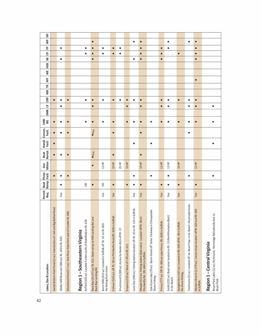
Perm
it Bo
atPi
cnic
Gas
Boat
Han
di.
Conc
es.
LMB
Lake
s, S
ize
& Lo
catio
nRe
q.
Ram
pFa
cil.
Mot
orRe
ntal
Faci
l.Fa
cil.
BGSM
BCF
CRP
WB
TRM
YW
EH
SBSB
CPYP
WP
NP
Sand
y Bo
ttom
Par
k Po
nd (1
2 ac
) In
ters
ectio
n of
I-64
and
Big
Bet
hel R
oad.
••
••
••
Wal
ler M
ill R
eser
voir
(360
ac)
Rt.
143
to R
t. 64
5.Fe
e•
••
••
••
••
Woo
dsto
ck P
ond
(7.5
ac)
Yor
k Ri
ver S
tate
Par
k ea
st o
f Cro
aker
Rt.
606.
••
••
•
Regi
on 1
–So
uthe
aste
rn V
irgin
iaAi
rfiel
d (1
05 a
c) L
ocat
ed 5
mile
s sou
th o
f Wak
efiel
d on
Rt.
628.
DR
••
••
Back
Bay
(25,
473
ac)
Rt. 6
15. S
tate
ram
ps a
t Mill
Land
ing
Rd. a
nd
••
•Priv
•Priv
••
••
••
•Ba
ck B
ay La
ndin
g Rd
.
Burn
t Mill
s (61
0 ac
) Lo
cate
d in
Suff
olk
off R
t. 10
on
Rt. 6
03.
Fee
DR
12 H
P•
••
•N
o fis
hing
from
shor
e.
Coho
on (5
10 a
c) o
ff R
t. 58
on
Pitc
hkett
le R
oad
(Rt.
604)
in S
uffol
k.
Fee
•10
HP
••
••
••
Dru
mm
ond
(3,0
00 a
c) A
cces
s by
feed
er d
itch
off R
t. 17
.25
HP
••
•Em
poria
(210
ac)
Wes
t of
I-95
on R
t. 61
1.•
10 H
P•
••
Lone
Sta
r (49
0 ac
) Fi
shin
g st
ation
loca
ted
off
Rt.
10 o
n Rt
. 125
in S
uffol
k.Fe
e•
••
••
••
Mea
de (5
12 a
c) F
ishi
ng st
ation
(bai
t sal
es).
Loca
ted
off
Rt. 5
8 on
Fe
e•
10 H
P•
••
••
••
••
Pitc
hkett
le R
d. (
Rt. 6
04 )
in S
uffol
k.
Oak
Gro
ve La
ke (7
0 ac
) B
yron
Str
eet o
ff V
olvo
Par
kway
in C
hesa
peak
e.
••
•Sh
ore
Fish
ing
Prin
ce (7
77 a
c) O
ff R
t. 46
0 on
Lake
Prin
ce (
Rt. 6
04) i
n Su
ffolk
.Fe
e•
12 H
P•
••
••
•Sm
ith (2
22 a
c) B
oat r
amp
loca
ted
on R
t. 13
(Nor
thha
mpt
on B
lvd.
) Fe
e•
•12
HP
••
••
•in
Va.
Bea
ch.
Spei
ghts
Run
(197
ac)
Loc
ated
on
Rt. 6
46 o
ff Rt
. 58
in S
uffol
k.Fe
e•
10 H
P•
••
No
shor
e fis
hing
.
Tras
hmor
e (5
2 ac
) Lo
cate
d off
Va.
Bea
ch E
xp. i
n Va
. Bea
ch. N
o pr
ivat
e bo
ats.
••
••
••
Wes
tern
Bra
nch
(1,5
79 a
c) 2
boa
t ram
ps lo
cate
d o
ff Rt
. 603
and
Rt.
605
Fee
•12
HP
••
••
••
••
in S
uffol
k.
Regi
on 1
–Ce
ntra
l Virg
inia
Brya
n Pa
rk La
kes (
12 a
c) R
ichm
ond,
Her
mita
ge R
d/La
kesi
de A
ve. t
o•
••
•Br
yan
Park
.
42 www.HuntFishVA.com 43
Perm
it Bo
atPi
cnic
Gas
Boat
Han
di.
Conc
es.
LMB
Lake
s, S
ize
& Lo
catio
nRe
q.
Ram
pFa
cil.
Mot
orRe
ntal
Faci
l.Fa
cil.
BGSM
BCF
CRP
WB
TRM
YW
EH
SBSB
CPYP
WP
NP
Ches
din
(3,1
00 a
c) I-
95 to
I-85
S to
Rt.
460
W to
Rt.
623
N to
Rt.
601
W
••
••
••
••
••
••
to R
t. 77
6 N
.
Hen
rico
Coun
ty P
ark
Lake
sCr
ump
Park
(2 a
c) S
tapl
es M
ill R
d. (3
3 W
) to
Cour
tney
Roa
d •
••
•D
eep
Run
Park
(2) (
2 ac
) I-6
4 to
S. G
aski
ns R
d. to
Rid
gefie
ld P
arkw
ay.
••
••
Dor
ey P
ark
(5 a
c) O
ff D
arby
tow
n Rd
.•
••
••
Thre
e La
kes P
ark
(3) (
4 ac
) off
Rt.
301
N to
Wilk
inso
n Rd
.•
••
••
Lake
view
(42
ac)
Rt. 1
to P
icke
tt S
t.•
••
••
Shie
lds (
7 ac
) in
Byr
d Pa
rk in
Ric
hmon
d.•
••
••
Swan
(13
ac)
in B
yrd
Park
in R
ichm
ond.
••
••
Swift
Cre
ek (1
56 a
c) P
ocah
onta
s Sta
te P
ark,
Rt.
10 t
o R
t. 65
5 (B
each
Rd.
)•
••
••
••
••
to R
t. 78
0.
Regi
on 2
–So
uths
ide
Virg
inia
Amel
ia (1
00 a
c) f
rom
Rt.
360
take
Rt.
604
N to
Rt.
616
to R
t. 65
2.•
••
••
Bann
ister
(400
ac)
Rt.
501
just
nor
th o
f Hal
ifax.
••
••
••
Bear
Cre
ek (4
2 ac
) Rt.
60 W
to R
t. 62
2 to
Rt.
629.
SP•
••
••
••
•Br
iery
Cre
ek (8
45 a
c) R
t. 15
, 7 m
iles s
outh
of F
arm
ville
.•
10 H
P m
ax•
••
•Br
unsw
ick
(150
ac)
on
Rt. 6
38 o
ff Rt
. 58
east
of E
dger
ton.
••
••
•Co
nner
(110
ac)
from
Rt.
360
take
Rt.
746
to R
t. 60
3 to
Rt.
619
to R
t. 62
3 E
••
••
•to
Rt.
624
S, 2
mile
s fro
m P
rovi
denc
e.
Cum
berla
nd S
tate
For
est L
akes
Arro
whe
ad (6
ac)
Rt.
60 W
, Rt.
622
to R
t. 62
9.•
••
Bonb
rook
(6 a
c) R
t. 60
W to
Rt.
622-
623-
626
to C
.S.F
.Fe
e•
••
Oak
Hill
(6 a
c) R
t. 60
W to
Rt.
622
to R
t. 62
9.•
••
Win
ston
(12
ac) R
t. 60
W to
Rt.
622
to R
t. 62
9.•
••
••
BG –
Blue
gill
CF –
Catf
ish
CL –
Ram
p Cl
osed
–Ano
ther
to b
ebu
ilt in
ano
ther
loca
tion
CP –
Chai
n Pi
cker
el
CRP
–Cr
appi
eD
R –
Dirt
Ram
pFP
–Fis
hing
Pie
rH
SB –
Hyb
rid S
trip
ed B
ass
KB –
Kent
ucky
Spo
tted
Bas
s
KEY
LMB
–La
rgem
outh
Bas
sM
Y –
Mus
kellu
nge
NF
–N
atio
nal F
ores
tN
P–N
orth
ern
Pike
PK–P
arki
ng
PR –
Prim
itive
Ram
pRB
r –Re
dbre
ast S
unfis
hSB
–St
riped
Bas
sSF
–St
ate
Fore
st P
erm
itSL
–25
mph
Spe
ed Li
mit
SM B
–Sm
allm
outh
Bas
sSP
–St
ate
Park
Fee
SW –
Swim
min
gTR
–Tr
out
WB
–W
hite
Bas
s
WD
–W
eeke
nds O
nly
WE
–W
alle
yeW
P –
Whi
te P
erch
YP –
Yello
w P
erch
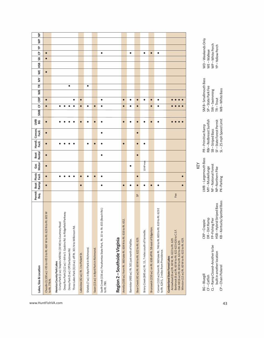
Perm
it Bo
atPi
cnic
Gas
Boat
Han
di.
Conc
es.
LMB
Lake
s, S
ize
& Lo
catio
nRe
q.
Ram
pFa
cil.
Mot
orRe
ntal
Faci
l.Fa
cil.
BGSM
BCF
CRP
WB
TRM
YW
EH
SBSB
CPYP
WP
NP
Sand
y Bo
ttom
Par
k Po
nd (1
2 ac
) In
ters
ectio
n of
I-64
and
Big
Bet
hel R
oad.
••
••
••
Wal
ler M
ill R
eser
voir
(360
ac)
Rt.
143
to R
t. 64
5.Fe
e•
••
••
••
••
Woo
dsto
ck P
ond
(7.5
ac)
Yor
k Ri
ver S
tate
Par
k ea
st o
f Cro
aker
Rt.
606.
••
••
•
Regi
on 1
–So
uthe
aste
rn V
irgin
iaAi
rfiel
d (1
05 a
c) L
ocat
ed 5
mile
s sou
th o
f Wak
efiel
d on
Rt.
628.
DR
••
••
Back
Bay
(25,
473
ac)
Rt. 6
15. S
tate
ram
ps a
t Mill
Land
ing
Rd. a
nd
••
•Priv
•Priv
••
••
••
•Ba
ck B
ay La
ndin
g Rd
.
Burn
t Mill
s (61
0 ac
) Lo
cate
d in
Suff
olk
off R
t. 10
on
Rt. 6
03.
Fee
DR
12 H
P•
••
•N
o fis
hing
from
shor
e.
Coho
on (5
10 a
c) o
ff R
t. 58
on
Pitc
hkett
le R
oad
(Rt.
604)
in S
uffol
k.
Fee
•10
HP
••
••
••
Dru
mm
ond
(3,0
00 a
c) A
cces
s by
feed
er d
itch
off R
t. 17
.25
HP
••
•Em
poria
(210
ac)
Wes
t of
I-95
on R
t. 61
1.•
10 H
P•
••
Lone
Sta
r (49
0 ac
) Fi
shin
g st
ation
loca
ted
off
Rt.
10 o
n Rt
. 125
in S
uffol
k.Fe
e•
••
••
••
Mea
de (5
12 a
c) F
ishi
ng st
ation
(bai
t sal
es).
Loca
ted
off
Rt. 5
8 on
Fe
e•
10 H
P•
••
••
••
••
Pitc
hkett
le R
d. (
Rt. 6
04 )
in S
uffol
k.
Oak
Gro
ve La
ke (7
0 ac
) B
yron
Str
eet o
ff V
olvo
Par
kway
in C
hesa
peak
e.
••
•Sh
ore
Fish
ing
Prin
ce (7
77 a
c) O
ff R
t. 46
0 on
Lake
Prin
ce (
Rt. 6
04) i
n Su
ffolk
.Fe
e•
12 H
P•
••
••
•Sm
ith (2
22 a
c) B
oat r
amp
loca
ted
on R
t. 13
(Nor
thha
mpt
on B
lvd.
) Fe
e•
•12
HP
••
••
•in
Va.
Bea
ch.
Spei
ghts
Run
(197
ac)
Loc
ated
on
Rt. 6
46 o
ff Rt
. 58
in S
uffol
k.Fe
e•
10 H
P•
••
No
shor
e fis
hing
.
Tras
hmor
e (5
2 ac
) Lo
cate
d off
Va.
Bea
ch E
xp. i
n Va
. Bea
ch. N
o pr
ivat
e bo
ats.
••
••
••
Wes
tern
Bra
nch
(1,5
79 a
c) 2
boa
t ram
ps lo
cate
d o
ff Rt
. 603
and
Rt.
605
Fee
•12
HP
••
••
••
••
in S
uffol
k.
Regi
on 1
–Ce
ntra
l Virg
inia
Brya
n Pa
rk La
kes (
12 a
c) R
ichm
ond,
Her
mita
ge R
d/La
kesi
de A
ve. t
o•
••
•Br
yan
Park
.
42 www.HuntFishVA.com 43
Perm
it Bo
atPi
cnic
Gas
Boat
Han
di.
Conc
es.
LMB
Lake
s, S
ize
& Lo
catio
nRe
q.
Ram
pFa
cil.
Mot
orRe
ntal
Faci
l.Fa
cil.
BGSM
BCF
CRP
WB
TRM
YW
EH
SBSB
CPYP
WP
NP
Ches
din
(3,1
00 a
c) I-
95 to
I-85
S to
Rt.
460
W to
Rt.
623
N to
Rt.
601
W
••
••
••
••
••
••
to R
t. 77
6 N
.
Hen
rico
Coun
ty P
ark
Lake
sCr
ump
Park
(2 a
c) S
tapl
es M
ill R
d. (3
3 W
) to
Cour
tney
Roa
d •
••
•D
eep
Run
Park
(2) (
2 ac
) I-6
4 to
S. G
aski
ns R
d. to
Rid
gefie
ld P
arkw
ay.
••
••
Dor
ey P
ark
(5 a
c) O
ff D
arby
tow
n Rd
.•
••
••
Thre
e La
kes P
ark
(3) (
4 ac
) off
Rt.
301
N to
Wilk
inso
n Rd
.•
••
••
Lake
view
(42
ac)
Rt. 1
to P
icke
tt S
t.•
••
••
Shie
lds (
7 ac
) in
Byr
d Pa
rk in
Ric
hmon
d.•
••
••
Swan
(13
ac)
in B
yrd
Park
in R
ichm
ond.
••
••
Swift
Cre
ek (1
56 a
c) P
ocah
onta
s Sta
te P
ark,
Rt.
10 t
o R
t. 65
5 (B
each
Rd.
)•
••
••
••
••
to R
t. 78
0.
Regi
on 2
–So
uths
ide
Virg
inia
Amel
ia (1
00 a
c) f
rom
Rt.
360
take
Rt.
604
N to
Rt.
616
to R
t. 65
2.•
••
••
Bann
ister
(400
ac)
Rt.
501
just
nor
th o
f Hal
ifax.
••
••
••
Bear
Cre
ek (4
2 ac
) Rt.
60 W
to R
t. 62
2 to
Rt.
629.
SP•
••
••
••
•Br
iery
Cre
ek (8
45 a
c) R
t. 15
, 7 m
iles s
outh
of F
arm
ville
.•
10 H
P m
ax•
••
•Br
unsw
ick
(150
ac)
on
Rt. 6
38 o
ff Rt
. 58
east
of E
dger
ton.
••
••
•Co
nner
(110
ac)
from
Rt.
360
take
Rt.
746
to R
t. 60
3 to
Rt.
619
to R
t. 62
3 E
••
••
•to
Rt.
624
S, 2
mile
s fro
m P
rovi
denc
e.
Cum
berla
nd S
tate
For
est L
akes
Arro
whe
ad (6
ac)
Rt.
60 W
, Rt.
622
to R
t. 62
9.•
••
Bonb
rook
(6 a
c) R
t. 60
W to
Rt.
622-
623-
626
to C
.S.F
.Fe
e•
••
Oak
Hill
(6 a
c) R
t. 60
W to
Rt.
622
to R
t. 62
9.•
••
Win
ston
(12
ac) R
t. 60
W to
Rt.
622
to R
t. 62
9.•
••
••
BG –
Blue
gill
CF –
Catf
ish
CL –
Ram
p Cl
osed
–Ano
ther
to b
ebu
ilt in
ano
ther
loca
tion
CP –
Chai
n Pi
cker
el
CRP
–Cr
appi
eD
R –
Dirt
Ram
pFP
–Fis
hing
Pie
rH
SB –
Hyb
rid S
trip
ed B
ass
KB –
Kent
ucky
Spo
tted
Bas
s
KEY
LMB
–La
rgem
outh
Bas
sM
Y –
Mus
kellu
nge
NF
–N
atio
nal F
ores
tN
P–N
orth
ern
Pike
PK–P
arki
ng
PR –
Prim
itive
Ram
pRB
r –Re
dbre
ast S
unfis
hSB
–St
riped
Bas
sSF
–St
ate
Fore
st P
erm
itSL
–25
mph
Spe
ed Li
mit
SM B
–Sm
allm
outh
Bas
sSP
–St
ate
Park
Fee
SW –
Swim
min
gTR
–Tr
out
WB
–W
hite
Bas
s
WD
–W
eeke
nds O
nly
WE
–W
alle
yeW
P –
Whi
te P
erch
YP –
Yello
w P
erch
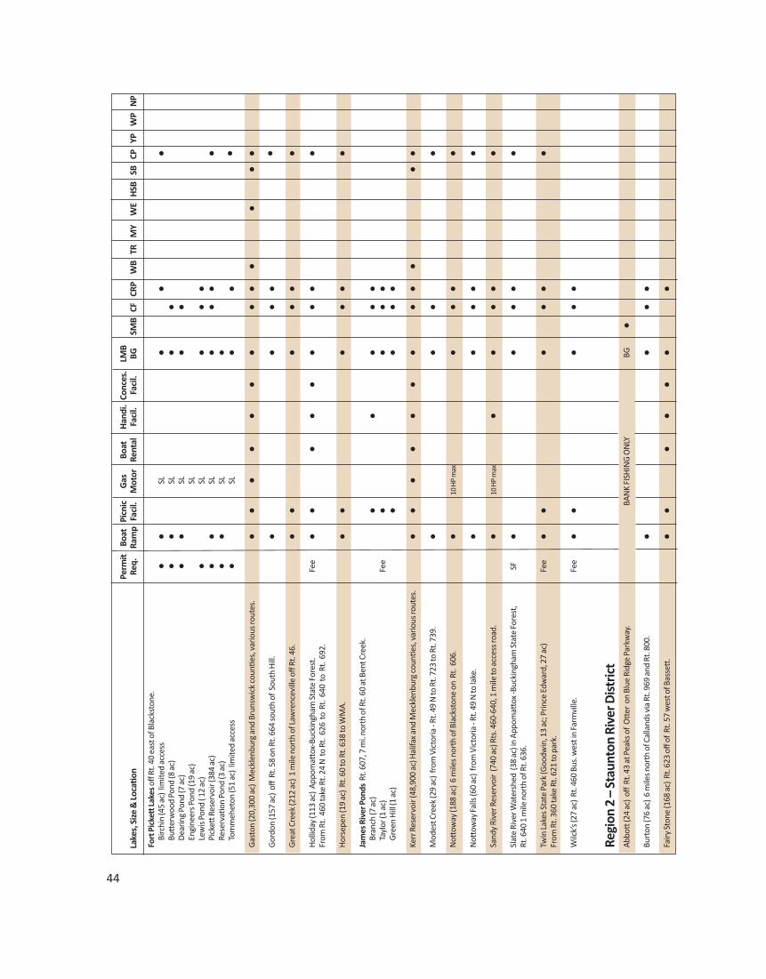
44
Perm
it Bo
atPi
cnic
Gas
Boat
Han
di.
Conc
es.
LMB
Lake
s, S
ize
& Lo
catio
nRe
q.
Ram
pFa
cil.
Mot
orRe
ntal
Faci
l.Fa
cil.
BGSM
BCF
CRP
WB
TRM
YW
EH
SBSB
CPYP
WP
NP
Fort
Pic
kett
Lake
soff
Rt. 4
0 ea
st o
f Bla
ckst
one.
Birc
hin
(45
ac)
limite
d ac
cess
••
SL•
••
Butt
erw
ood
Pond
(8 a
c)•
•SL
••
Dea
ring
Pond
(7 a
c)•
•SL
••
Engi
neer
s Pon
d (1
9 ac
)SL
Lew
is P
ond
( 12
ac)
•SL
••
•Pi
ckett
Res
ervo
ir (3
84 a
c)•
•SL
••
••
Rese
rvati
on P
ond
(3 a
c)•
•SL
•To
mm
ehet
on (5
1 ac
) lim
ited
acce
ss•
SL•
••
Gas
ton
(20,
300
ac)
Mec
klen
burg
and
Bru
nsw
ick
coun
ties,
var
ious
rout
es.
••
••
••
••
••
••
•G
ordo
n (1
57 a
c) o
ff R
t. 58
on
Rt. 6
64 so
uth
of S
outh
Hill
.•
••
••
Gre
at C
reek
(212
ac)
1 m
ile n
orth
of L
awre
ncev
ille
off R
t. 46
. •
••
••
•H
ollid
ay (1
13 a
c) A
ppom
attox
-Buc
king
ham
Sta
te F
ores
t. Fe
e•
••
••
••
••
From
Rt.
460
take
Rt.
24 N
to
Rt. 6
26 t
o R
t. 6
40 t
o R
t. 6
92.
Hor
sepe
n (1
9 ac
) Rt
. 60
to R
t. 63
8 to
WM
A.•
••
••
•Ja
mes
Riv
er P
onds
Rt. 6
07, 7
mi.
nort
h of
Rt.
60 a
t Ben
t Cre
ek.
Bran
ch (7
ac)
••
••
•Ta
ylor
(1 a
c)Fe
e•
••
•G
reen
Hill
(1 a
c)•
••
•Ke
rr R
eser
voir
(48,
900
ac) H
alifa
x and
Mec
klen
burg
coun
ties,
var
ious
rout
es.
••
••
••
••
••
••
Mod
est C
reek
(29
ac)
from
Vic
toria
- Rt
. 49
N to
Rt.
723
to R
t. 73
9.
••
••
Nott
oway
(188
ac)
6 m
iles n
orth
of B
lack
ston
e on
Rt.
606
.•
10 H
P m
ax•
••
•N
ottow
ay Fa
lls (6
0 ac
) fr
om V
icto
ria -
Rt. 4
9 N
to la
ke.
••
••
•Sa
ndy
Rive
r Res
ervo
ir (7
40 a
c) R
ts. 4
60-6
40, 1
mile
to a
cces
s roa
d.•
10 H
P m
ax•
••
••
Slat
e Ri
ver W
ater
shed
(38
ac)
in A
ppom
attox
-Buc
king
ham
Sta
te F
ores
t,SF
••
••
•Rt
. 640
1 m
ile n
orth
of R
t. 63
6.
Twin
Lake
s Sta
te P
ark
(Goo
dwin
, 13
ac; P
rince
Edw
ard,
27
ac)
Fee
••
••
••
From
Rt.
360
take
Rt.
621
to p
ark.
Wilc
k’s (
27 a
c) R
t. 46
0 Bu
s. w
est i
n Fa
rmvi
lle.
Fee
••
••
•
Regi
on 2
–St
aunt
on R
iver
Dis
tric
t Ab
bott
(24
ac)
off R
t. 43
at P
eaks
of
Ott
er o
n Bl
ue R
idge
Par
kway
.BA
NK
FISH
ING
ON
LYBG
•Bu
rton
(76
ac)
6 m
iles n
orth
of C
alla
nds v
ia R
t. 96
9 an
d Rt
. 800
. •
••
•Fa
iry S
tone
(168
ac)
Rt.
623
off o
f Rt
. 57
wes
t of B
asse
tt.
••
••
••
•
www.HuntFishVA.com 45
Perm
it Bo
atPi
cnic
Gas
Boat
Han
di.
Conc
es.
LMB
Lake
s, S
ize
& Lo
catio
nRe
q.
Ram
pFa
cil.
Mot
orRe
ntal
Faci
l.Fa
cil.
BGSM
BCF
CRP
WB
TRM
YW
EH
SBSB
CPYP
WP
NP
Lees
ville
Res
ervo
ir (3
,400
ac)
Cam
pbel
l, B
edfo
rd, a
nd P
ittsy
lvan
ia co
untie
s,
••
••
••
••
••
vario
us ro
utes
.
Mar
tinsv
ille
Rese
rvoi
r (17
5 ac
) Rt
. 220
Bus
. Sou
th, R
t. 17
4 N
orth
, left
on
Fee
••
••
••
Rt. 1
08.
Mill
Cre
ek (1
89 a
c) R
t. 60
to R
t. 77
8, r
ight
on
610
-619
.•
••
••
Nel
son
(40
ac)
Rt. 6
55 E
of A
rrin
gton
, left
on
812.
••
••
Ott
er La
ke (8
ac)
off
Blue
Rid
ge P
arkw
ay n
orth
of
Big
Isla
nd.
BAN
K FI
SHIN
G O
NLY
•Ph
ilpott
Res
ervo
ir (2
,800
ac)
Fra
nklin
, Hen
ry, a
nd P
atric
k co
untie
s,
••
••
••
••
vario
us ro
utes
.
Smith
Mou
ntai
n (2
0,00
0 ac
) Be
dfor
d, F
rank
lin, a
nd P
ittsy
lvan
ia co
untie
s,•
••
••
••
••
••
••
vario
us ro
utes
.
Ston
ehou
se (3
4 ac
) Rt
. 610
–62
5 –
830.
••
••
Thra
sher
(34
ac)
Rt. 6
0 –
610
–61
7.•
••
•W
hite
Oak
Mtn
. Pon
ds (4
) (1/
2 to
7 a
c) o
ff R
t. 70
7 o
ut o
f Spr
ing
Gar
den.
•
Regi
on 3
–So
uthw
est V
irgin
iaBa
rk C
amp
(48
ac)
Alt.
58 to
Taco
ma,
Rt.
706
to R
t. 6
99 to
Rt.
822
to
NF
••
••
••
U.S
.F.S
. Rt.
993
to la
ke.
Bear
tree
(14
ac)
I-81
to M
ario
n (E
xit 4
5) a
nd R
t. 16
S to
Trou
tdal
e,N
F•
••
wes
t on
Rt. 6
03 to
Rt.
58 W
to
lake
.
John
Fla
nnag
an (1
,143
ac)
Alt.
58
to R
t. 63
N to
Clin
cho
Rt.
63 t
o Rt
. 616
••
••
••,
KB
••
••
•to
Rt.
614
to la
ke.
Hal
es (4
ac)
I-81
to M
ario
n (E
xit 4
5) R
t. 16
S to
Sug
ar G
rove
and
Rt.
614
to
NF
•Rt
. 612
to R
t. 79
8 to
lake
.
Hid
den
Valle
y (6
1 ac
) Ab
ingd
on n
orth
wes
t on
Alt.
58
to R
t. 69
0 to
lake
. •
•, R
Br•
•H
ungr
y M
othe
r (10
8 ac
) H
ungr
y M
othe
r Sta
te P
ark.
I-81
to M
ario
n (E
xit 4
7)•
••
••
••
••
•to
Rt.
16 N
to st
ate
park
and
lake
.KB
, RBr
Keok
ee (9
2 ac
) Rt
. 23
to R
t. 68
W a
t App
alac
hia
to R
t. 6
06 t
o R
t. 62
3 N
F•
••
•to
U.S
.F.S
. roa
d to
lake
.
Laur
el (B
reak
s Int
erst
ate
Park
) Rt
. 460
at
Vans
ant
to R
t. 83
W t
o•
••
Rt. 8
0 N
to p
ark.
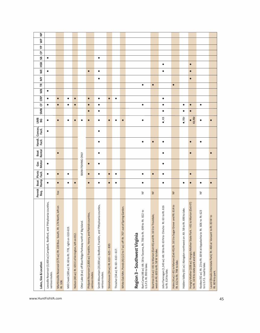
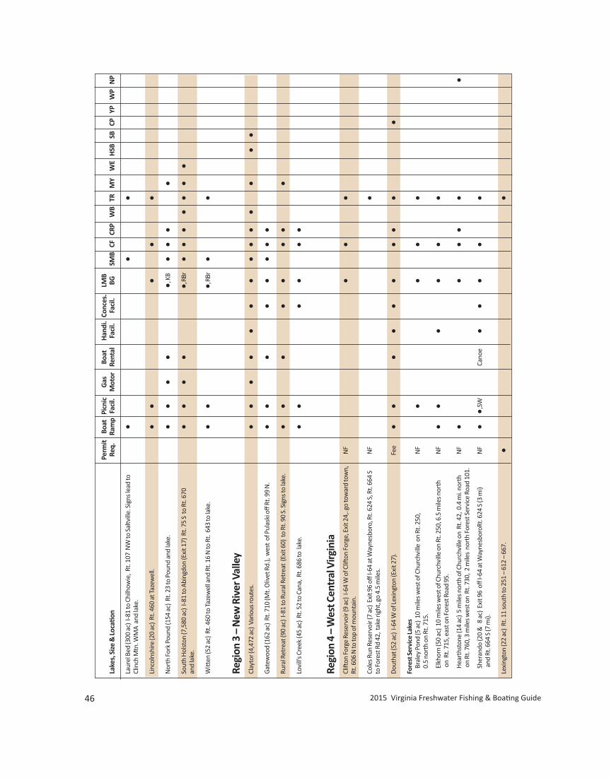
46 2015 Virginia Freshwater Fishing & Boating Guide
Perm
it Bo
atPi
cnic
Gas
Boat
Han
di.
Conc
es.
LMB
Lake
s, S
ize
& Lo
catio
nRe
q.
Ram
pFa
cil.
Mot
orRe
ntal
Faci
l.Fa
cil.
BGSM
BCF
CRP
WB
TRM
YW
EH
SBSB
CPYP
WP
NP
Laur
el B
ed (3
00 a
c) I-
81 to
Chi
lhow
ie, R
t. 10
7 N
W to
Sal
tvill
e. S
igns
lead
to
••
•Cl
inch
Mtn
. WM
A a
nd la
ke.
Linc
olns
hire
(20
ac)
Rt. 4
60 a
t Taz
ewel
l.•
••
••
Nor
th F
ork
Poun
d (1
54 a
c) R
t. 23
to P
ound
and
lake
.•
••
••,
KB
••
••
Sout
h H
olst
on (7
,580
ac)
I-81
to A
bing
don
(Exi
t 17)
Rt.
75 S
to
Rt. 6
70•
••
••,
RBr
••
••
••
•an
d la
ke.
Witt
en (5
2 ac
) Rt
. 460
to Ta
zew
ell a
nd R
t. 16
N to
Rt.
643
to la
ke.
••
•, RB
r•
•
Regi
on 3
–N
ew R
iver
Val
ley
Clay
tor (
4,47
2 ac
) Va
rious
rout
es.
••
••
••
••
••
••
••
Gat
ewoo
d (1
62 a
c) R
t. 71
0 (M
t. O
livet
Rd.
), w
est
of P
ulas
ki o
ff Rt
. 99
N.
••
••
••
••
Rura
l Ret
reat
(90
ac)
I-81
to R
ural
Ret
reat
(Ex
it 60
) to
Rt.
90 S
. Sig
ns to
lake
. •
••
••
••
•Lo
vill’
s Cre
ek (4
5 ac
) Rt
. 52
to C
ana,
Rt.
686
to la
ke.
••
••
••
Regi
on 4
–W
est C
entr
al V
irgin
iaCl
ifton
For
ge R
eser
voir
(9 a
c) I-
64 W
of C
lifton
For
ge, E
xit 2
4,. g
o to
war
d to
wn,
NF
••
•Rt
. 606
N to
top
of m
ount
ain.
Cole
s Run
Res
ervo
ir (7
ac)
Exi
t 96
off I-
64 a
t Way
nesb
oro,
Rt.
624
S, R
t. 66
4 S
NF
•to
For
est R
d 42
, tak
e rig
ht, g
o 4.
5 m
iles.
Dou
that
(52
ac)
I-64
W o
f Lex
ingt
on (E
xit 2
7).
Fee
••
••
••
••
••
Fore
st S
ervi
ce La
kes
Bral
ey P
ond
(5 a
c) 1
0 m
iles w
est o
f Chu
rchv
ille
on
Rt. 2
50,
NF
••
••
0.5
nort
h on
Rt.
715.
Elkh
orn
(50
ac)
10 m
iles w
est o
f Chu
rchv
ille
on R
t. 25
0, 6
.5 m
iles n
orth
N
F•
••
••
•on
Rt.
715,
eas
t on
Fore
st R
oad
95.
Hea
rths
tone
(14
ac)
5 m
iles n
orth
of C
hurc
hvill
e on
Rt.
42, 0
.4 m
i. no
rth
NF
••
••
••
on R
t. 76
0, 3
mile
s wes
t on
Rt.
730,
2 m
iles
nort
h Fo
rest
Ser
vice
Roa
d 10
1.
Sher
ando
(20
& 8
ac)
Exi
t 96
off
I-64
at W
ayne
sbor
oRt.
624
S (3
mi)
NF
••,
SWCa
noe
••
••
•an
d Rt
. 664
S (7
mi).
Lexi
ngto
n (2
2 ac
) Rt
. 11
sout
h to
251
–61
2 –
667.
••
www.HuntFishVA.com 47
Perm
it Bo
atPi
cnic
Gas
Boat
Han
di.
Conc
es.
LMB
Lake
s, S
ize
& Lo
catio
nRe
q.
Ram
pFa
cil.
Mot
orRe
ntal
Faci
l.Fa
cil.
BGSM
BCF
CRP
WB
TRM
YW
EH
SBSB
CPYP
WP
NP
Mill
s Cre
ek R
eser
voir
(17
ac)
Exit
96 o
ff I-6
4 at
Way
nesb
oro,
Rt.
624
S,
NF
•Rt
. 664
S to
For
est R
d. 4
2, ta
ke r
ight
, go
1.5
mile
s.
Moo
maw
(2,5
30 a
c) C
alla
ghan
Exi
t off
I-64,
2 m
iles e
ast o
n Rt
. 661
,PK
••
••
••
••
••
••
10 m
iles n
orth
on
Rt. 6
20.
Tam
s City
Par
k (3
ac)
City
of S
taun
ton.
••
•Vi
rgin
ia P
ower
Rec
. Pon
ds (4
0 &
32
ac)
Rt. 3
9 w
est o
f W
arm
Spr
ings
to
••
••
••
Hin
ers S
tore
, Rt.
600
N (6
mi).
Will
is R
ober
tson
(26
ac) R
t. 11
byp
ass t
o S.
Lex
ingt
on, R
t. 25
1 fo
llow
•
••
••
••
•si
gns t
o la
ke.
Regi
on 4
–N
orth
wes
t Virg
inia
Arro
whe
ad (3
4 ac
) so
uthe
ast o
f Lur
ay o
n Rt
. 669
.•
••
••
••
•Cl
earb
rook
(3 a
c) C
lear
broo
k Pa
rk (T
own
of C
lear
broo
k Rt
. 81
–11
–67
2).
••
•Fo
rest
Ser
vice
Lake
sBe
alle
r’s F
erry
Pon
d (7
ac)
Hw
y. 2
11 to
Lura
y. N
orth
on
Rt. 6
75,
NF
••
•ea
st o
n Rt
. 684
.
Brie
ry (9
ac)
Rt.
257
W o
f Day
ton
- Rt.
924.
NF
••
•D
ry R
un (1
0 ac
) Rt
. 33
W o
f Raw
ley
Sprin
gs.
NF
•H
one
Qua
rry
(6 a
c) R
t. 25
7 W
of D
ayto
n - R
t. 92
4.N
F•
••
•Sk
idm
ore
(118
ac )
Rt.
33 W
of H
arris
onbu
rg -
PS 2
27.
••
••
Slat
e Li
ck (1
0 ac
) Rt
. 33
- Rt.
612N
- Rt
. 230
- PS
127
9.N
F•
••
Tom
ahaw
k (2
ac)
Rt.
263
and
610
W o
f Mt.
Jack
son.
NF
••
••
Laur
a (4
4 ac
) Br
yce
Mtn
. Res
ort a
t Bay
se. R
t. 26
3, 1
2 m
iles,
wes
t of
•
••
••
•M
t. Ja
ckso
n.
Silv
er (1
0 ac
) Fr
om H
arris
onbu
rg ta
ke R
t. 42
sout
h to
Day
ton,
then
righ
t•
on R
t. 70
1.
Virg
inia
Dep
t. o
f Gam
e &
Inla
nd F
ishe
ries L
akes
Fred
eric
k (1
17 a
c) R
t. 52
2 an
d 34
0, 5
mile
s nor
th o
f Fro
nt R
oyal
. •
••
••
••
••
Shen
ando
ah (3
6 ac
) Rt
. 276
S o
f Rt.
33.
••
••
••
••
Wilk
ins (
3 ac
) Jim
Bar
nett
Par
k (W
inch
este
r).
••
••
••
Regi
on 4
–N
orth
ern
Virg
inia
Abel
(185
ac)
Rt.
17 N
- Rt
. 616
N -
Rt. 6
51 E
.•
••
•
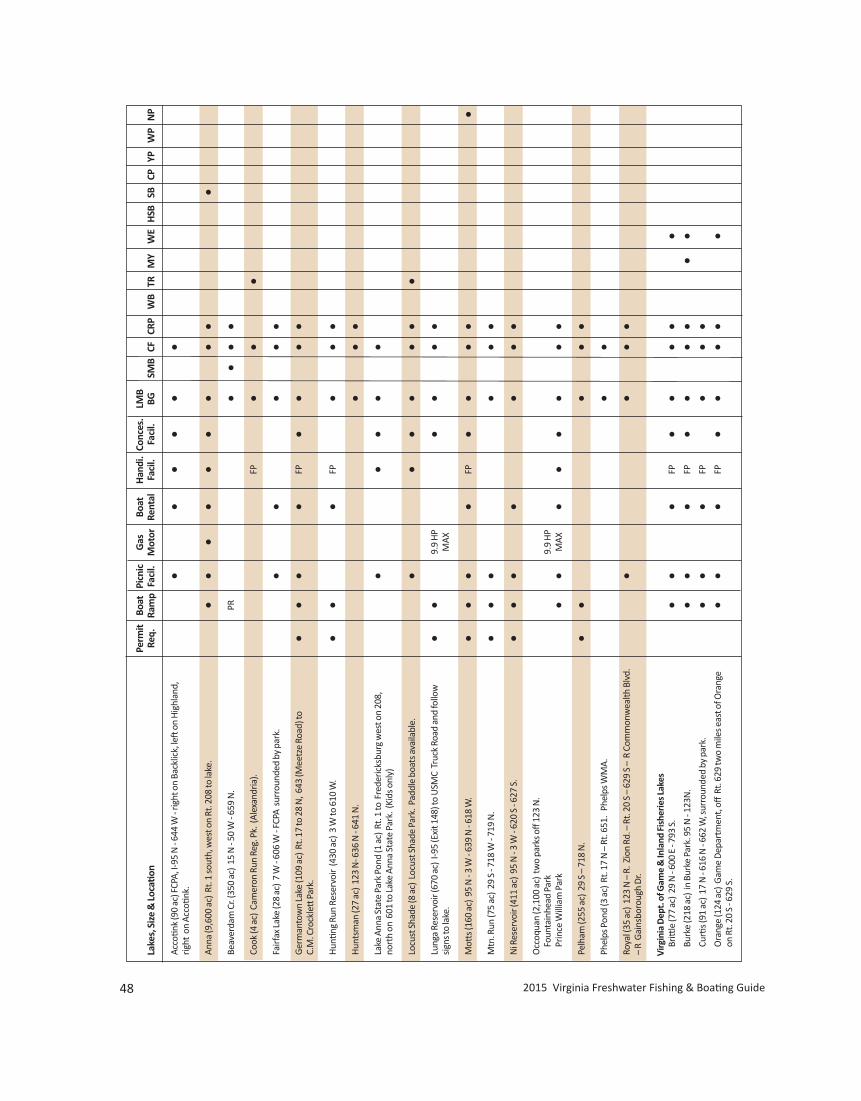
48 2015 Virginia Freshwater Fishing & Boating Guide
Perm
it Bo
atPi
cnic
Gas
Boat
Han
di.
Conc
es.
LMB
Lake
s, S
ize
& Lo
catio
nRe
q.
Ram
pFa
cil.
Mot
orRe
ntal
Faci
l.Fa
cil.
BGSM
BCF
CRP
WB
TRM
YW
EH
SBSB
CPYP
WP
NP
Acco
tink
(90
ac) F
CPA,
I-95
N -
644
W -
right
on
Back
lick,
left
on
Hig
hlan
d,•
••
••
•rig
ht o
n Ac
cotin
k.
Anna
(9,6
00 a
c) R
t. 1
sout
h, w
est o
n Rt
. 208
to la
ke.
••
••
••
••
••
Beav
erda
m C
r. (3
50 a
c) 1
5 N
- 50
W -
659
N.
PR•
••
•Co
ok (4
ac)
Cam
eron
Run
Reg
. Pk.
(Al
exan
dria
).FP
••
•Fa
irfax
Lake
(28
ac)
7 W
- 60
6 W
- FC
PA s
urro
unde
d by
par
k.
••
••
•G
erm
anto
wn
Lake
(109
ac)
Rt.
17 to
28
N, 6
43 (M
eetz
e Ro
ad) t
o•
••
•FP
••
••
C.M
. Cro
ckle
tt P
ark.
Hun
ting
Run
Rese
rvoi
r (4
30 a
c) 3
W to
610
W.
••
•FP
••
•H
unts
man
(27
ac)
123
N- 6
36 N
- 64
1 N
.•
••
Lake
Ann
a St
ate
Park
Pon
d (1
ac)
Rt.
1 to
Fre
deric
ksbu
rg w
est o
n 20
8,
••
••
•no
rth
on 6
01 to
Lake
Ann
a St
ate
Park
. (Ki
ds o
nly)
Locu
st S
hade
(8 a
c) L
ocus
t Sha
de P
ark.
Pad
dle
boat
s ava
ilabl
e.
••
••
••
•Lu
nga
Rese
rvoi
r (67
0 ac
) I-9
5 (E
xit 1
48) t
o U
SMC
Truc
k Ro
ad a
nd fo
llow
•
•9.
9 H
P•
••
•si
gns t
o la
ke.
MAX
Mott
s (16
0 ac
) 95
N -
3 W
- 63
9 N
- 61
8 W
.•
••
•FP
••
••
•M
tn. R
un (7
5 ac
) 29
S -
718
W -
719
N.
••
••
••
Ni R
eser
voir
(411
ac)
95
N -
3 W
- 62
0 S
- 627
S.
••
••
••
•O
ccoq
uan
(2,1
00 a
c) t
wo
park
s off
123
N.
Foun
tain
head
Par
k9.
9 H
PPr
ince
Will
iam
Par
k•
•M
AX•
••
••
•Pe
lham
(255
ac)
29
S –
718
N.
••
••
•Ph
elps
Pon
d (3
ac)
Rt.
17 N
– R
t. 65
1. P
help
s WM
A.•
•Ro
yal (
35 a
c) 1
23 N
– R
. Zio
n Rd
. – R
t. 20
S –
629
S –
R C
omm
onw
ealth
Blv
d.•
••
•–
R G
ains
boro
ugh
Dr.
Virg
inia
Dep
t. o
f Gam
e &
Inla
nd F
ishe
ries L
akes
Britt
le (7
7 ac
) 29
N -
600
E - 7
93 S
.•
••
FP•
••
••
Burk
e (2
18 a
c) in
Bur
ke P
ark.
95
N -
123N
.•
••
FP•
••
••
•Cu
rtis (
91 a
c) 1
7 N
- 61
6 N
- 66
2 W
, sur
roun
ded
by p
ark.
••
•FP
••
•O
rang
e (1
24 a
c) G
ame
Dep
artm
ent,
off R
t. 62
9 tw
o m
iles e
ast o
f Ora
nge
••
•FP
••
••
•on
Rt.
20 S
- 62
9 S.
www.HuntFishVA.com 49
Perm
it Bo
atPi
cnic
Gas
Boat
Han
di.
Conc
es.
LMB
Lake
s, S
ize
& Lo
catio
nRe
q.
Ram
pFa
cil.
Mot
orRe
ntal
Faci
l.Fa
cil.
BGSM
BCF
CRP
WB
TRM
YW
EH
SBSB
CPYP
WP
NP
Regi
on 4
–Ce
ntra
l Virg
inia
Alb
emar
le P
arks
Dep
t. La
kes
Beav
er C
reek
(104
ac)
Fol
low
680
from
Rt.
250
junc
tion
wes
t of
••
••
•Ch
arlo
ttes
ville
to la
ke.
Chris
Gre
ene
(62
ac)
Off
Rt. 6
06 o
ne m
ile fr
om a
irpor
t.Fe
e•
•,SW
Cano
e•
••
•M
int S
prin
gs (8
ac)
Rt.
684-
788
wes
t of C
roze
t.Fe
e•,
SW•
••
•To
tier C
reek
(66
ac)
Rt. 7
26 to
Rt.
845W
of S
cott
svill
e.•
••
••
•W
alnu
t Cre
ek (6
0 ac
) on
Rt.
631
sout
h of
Cha
rlott
esvi
lle.
Fee
••,
SWCa
noe
••
••
Gor
dons
ville
(81
ac)
I-64
W to
Rt.
15 B
osw
ell T
aver
n to
Rt.
603.
••
••
••
Nor
thea
st C
reek
(187
ac)
4 m
iles e
ast o
f Lou
isa
on R
t. 33
.•
••
••
•Ra
gged
Mou
ntai
n (5
0 ac
) Rt
. 702
off
Rt.
29.
••
•Ri
vann
a (4
50 a
c) R
t. 65
9 off
631
(Rio
Rd)
.•
••
•Su
gar H
ollo
w R
eser
voir
(47
ac)
On
Moo
rman
’s R
iver
6 m
i. w
est o
f Whi
te H
all
•on
Rt.
614.
No
boat
s allo
wed
.
Virg
inia
Dep
t. o
f Gam
e &
Inla
nd F
ishe
ries L
akes
Albe
mar
le (3
5 ac
) In
Whi
te H
all,
take
Rt.
614
E to
Rt.
675,
follo
w to
lake
.•
••
•Fl
uvan
na R
urita
n (5
0 ac
) O
n Rt
. 619
off
Rt.
58 a
t Cun
ning
ham
.•
••
•Po
wha
tan
Pond
s (3)
(20
ac) P
owha
tan
Coun
ty
PR•
••
Rt. 6
0 W
to
Rt. 6
27 to
Rt.
662.
Pow
hata
n La
kes (
2) (
71 a
c) P
owha
tan
Coun
ty
••
••
Rt. 6
0 W
to R
t. 68
4 (B
ell R
d) to
Rt.
625
(Pow
hata
n La
kes R
d.)
BG –
Blue
gill
CF –
Catf
ish
CL –
Ram
p Cl
osed
–Ano
ther
to b
ebu
ilt in
ano
ther
loca
tion
CP –
Chai
n Pi
cker
el
CRP
–Cr
appi
eD
R –
Dirt
Ram
pFP
–Fis
hing
Pie
rH
SB –
Hyb
rid S
trip
ed B
ass
KB –
Kent
ucky
Spo
tted
Bas
s
KEY
LMB
–La
rgem
outh
Bas
sM
Y –
Mus
kellu
nge
NF
–N
atio
nal F
ores
tN
P–N
orth
ern
Pike
PK–P
arki
ng
PR –
Prim
itive
Ram
pRB
r –Re
dbre
ast S
unfis
hSB
–St
riped
Bas
sSF
–St
ate
Fore
st P
erm
itSL
–25
mph
Spe
ed Li
mit
SM B
–Sm
allm
outh
Bas
sSP
–St
ate
Park
Fee
SW –
Swim
min
gTR
–Tr
out
WB
–W
hite
Bas
s
WD
–W
eeke
nds O
nly
WE
–W
alle
yeW
P –
Whi
te P
erch
YP –
Yello
w P
erch
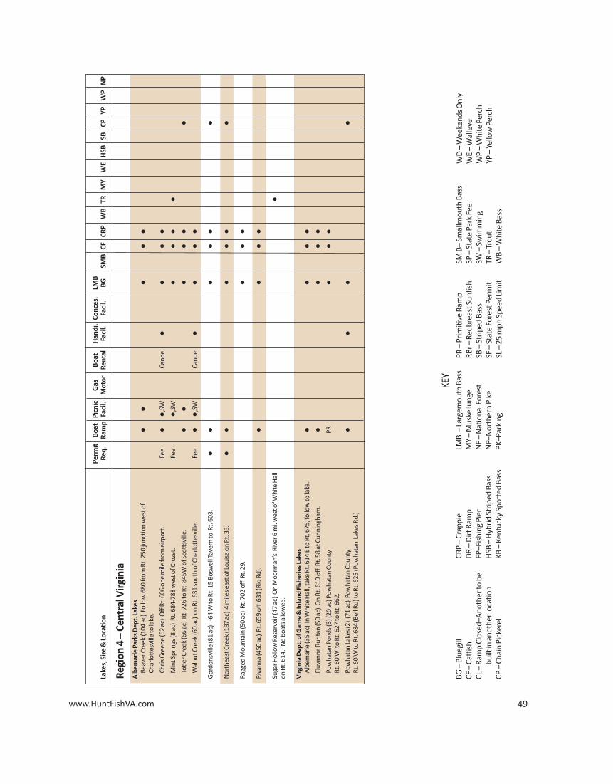
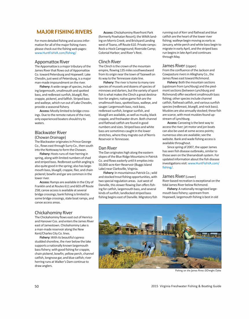
MAJOR FISHING RIVERS
For more detailed fishing and access infor-mation for all of the major fishing riversplease check out the fishing web pages:www.HuntFishVA.com/fishing/.
Appomattox RiverThe Appomattox is a major tributary of theJames River that flows out of AppomattoxCo. toward Petersburg and Hopewell. LakeChesdin, just west of Petersburg, is a majorman-made impoundment on the river. Fishery: A wide range of species, includ-ing largemouth, smallmouth and spottedbass, and redbreast sunfish, bluegill, flier,crappie, pickerel, and fallfish. Striped bassand walleye, which run out of Lake Chesdin,provide a seasonal fishery. Access: Mostly limited to bridge cross-ings. Due to the remote nature of the river,only experienced boaters should try its waters.
Blackwater River (Chowan Drainage)The Blackwater originates in Prince GeorgeCo., flows east through Surry Co., then southinto the Nottoway to form the Chowan. Fishery: Hosts runs of river herring inspring, along with limited numbers of shadand striped bass. Redbreast sunfish angling isalso quite good in the spring; also has large-mouth bass, bluegill, crappie, flier, and chainpickerel; bowfin and gar are common in thelower river. Access: Ramps are available in the City ofFranklin and at Routes 611 and 603 off Route258; canoe access is available at severalbridge crossings; bank fishing is limited tosome bridge crossings, state boat ramps, andcanoe access areas.
Chickahominy RiverThe Chickahominy flows east out of Henricoand Hanover Cos. and enters the James Rivereast of Jamestown. Chickahominy Lake is a man-made reservoir along the NewKent/Charles City Co. lines. Fishery: With its beautiful cypress studded shoreline, the river below the lakesupports a nationally known largemouthbass fishery; with good fishing for crappie,chain pickerel, bowfin, yellow perch, channelcatfish, longnose gar, and blue catfish; riverherring runs at Walker’s Dam continue todraw anglers.
Access: Chickahominy Riverfront Park(formerly Powhatan Resort); the WMA land-ing on Morris Creek; and Brickyard Landingwest of Toano, off Route 610. Private ramps:Rock-a-Hock Campground; Riverside Camp;Colonial Harbor; and River’s Rest.
Clinch RiverThe Clinch is the crown of the mountain empire, flowing 135 miles southwestwardfrom its origin near the town of Tazewell onits way to the Tennessee state line. Fishery: The river is home to many rarespecies of mussels and dozens of species ofminnows and darters, but the variety of sportfish is what makes the Clinch a great destina-tion for anglers; native game fish are thesmallmouth bass, spotted bass, walleye, andsauger. Largemouth bass, rock bass, redbreast sunfish, longear sunfish, andbluegill are available, as well as musky, blackcrappie, and freshwater drum. Both channeland flathead catfish are found in good numbers and sizes. Striped bass and whitebass are sometimes caught in the lowerstretches, where they migrate out of NorrisReservoir in Tennessee.
Dan RiverThe Dan originates high along the easternslopes of the Blue Ridge Mountains in PatrickCo. and flows easterly until it empties into50,000-acre Kerr Reservoir (Buggs IslandLake) near Clarksville, Virginia. Fishery: In mountainous Patrick Co.; wildand stocked trout fishing opportunities, withtwo special regulation areas. Just west ofDanville, this slower flowing Dan offers fish-ing for catfish, largemouth bass, and severalkinds of sunfish; landlocked striped bass fishing begins east of Danville. Migratory fish
running out of Kerr and flathead and bluecatfish are the heart of the lower river fishing; walleye begin moving as early as January, white perch and white bass begin tomigrate in early April, and the striped bassrun begins in late April and continuesthrough May.
James River (Upper)From the confluence of the Jackson andCowpasture rivers in Alleghany Co., theJames flows east toward Richmond. Fishery: Both the mountain sections (upstream from Lynchburg) and the pied-mont sections (between Lynchburg andRichmond) offer excellent smallmouth bassfishing; other species include channel catfish, flathead catfish, and various sunfishspecies (redbreast, bluegill, and rock bass).Muskies are also annually stocked; these fishare scarce, with most muskies found up-stream of Lynchburg. Access: Canoeing is the best way to access the river; jet motor and jon boats can also be used at some access points; numerous sites are available; see the website. Bank and wade fishing access isavailable throughout. Since spring of 2007, the upper Jameshas seen fish disease outbreaks, similar tothose seen on the Shenandoah system. Forupdated information about the fish diseaseinvestigations visit: www.HuntFishVA.com/fishing/.
James River(Lower)River-based recreation is exceptional on thetidal James River below Richmond. Fishery: A nationally recognized large-mouth bass fishery; upstream fromHopewell, largemouth fishing is best in old
50 2015 Virginia Freshwater Fishing & Boating Guide
Fishing on the James River, ©Dwight Dyke
www.HuntFishVA.com 51
river channels and abandoned gravel pits;downstream from Hopewell to Hog Island,bass fishing is most productive in larger tributary creeks and large expanses of vegetated tidal flats. The tidal James alsoprovides the best fishing for blue catfish inthe state, with hundreds of 30- to 60- poundfish caught each year; good crappie fishing inoxbows upstream of Hopewell; and whiteperch throughout the river. Returning adultAmerican shad from a stocking restorationprogram, along with a healthy run of hickoryshad, have created a very popular springfishery within the Fall Line from late Marchthrough early May. Anadromous stripedbass (“rockfish”) fishing has been excellentin the vicinity of the I-95 Bridge in Richmond.
Maury RiverCalfpasture and Little Calfpasture riverscome together to form the Maury River justbefore entering famous Goshen Pass; oncethrough the turbulent Pass the river dropsinto the valley toward Lexington and entersthe James River at Glasgow. Fishery: The Goshen Pass section has anexcellent stocked trout fishery; smallmouthbass are caught anywhere from the head -waters to the mouth of the river where it enters the James; the Maury is loaded withscrappy redbreast sunfish and has some rockbass; other fish include carp, catfish, andsuckers.
New RiverThe New is the oldest river in North Americaand second oldest in the world. It begins inNorth Carolina and flows northward for 160miles through Virginia before it turns intoBluestone Lake in West Virginia. Fishery: The New rivals the James andRappahannock rivers as one of the bestsport fisheries in Virginia: smallmouth bass, spotted bass, largemouth bass, rock bass,striped bass, white bass, hybrid striped bass,muskellunge, walleye, black crappie, chan-nel catfish, flathead catfish, yellow perch,redbreast sunfish, and bluegill. State recordsinclude musky (45 lbs. 8 oz.), smallmouth (8 lbs. 1 oz.), and walleye (15 lbs. 15 oz.). Thestate record spotted bass came out of Clay-tor Lake in 1993 at 3 lbs. 10 oz. Access: Plenty of excitement for white-water enthusiasts, with several major ClassII–III rapids. There is also an abundance offlatwater to please motor boaters and canoeists. Numerous sites are available; see the website.
North Fork Holston RiverFrom its origin in Bland Co., the North ForkHolston flows over 100 miles through Southwest Virginia before crossing the Tennessee state line near Yuma. Fishery: Outstanding smallmouth basspopulation, with good numbers of small-mouth 14 to 18 inches, about one-thirdmore than 14 inches, and more than 10%longer than 17 inches; rock bass and severalspecies of sunfish provide good fishing andchannel and flathead catfish are available.There is a mercury fish consumption pro -hibition in effect from Saltville downstreamto the Tennessee line.
North Fork Shenandoah RiverThe North Fork Shenandoah flows north 116miles from Rockingham Co. to Front Royalwhere it joins the South Fork Shenandoah toform the Shenandoah River. Fishery: Anglers can expect to catchsmallmouth bass throughout and the NorthFork is also home to some largemouth bassand redbreast sunfish, rock bass, bluegill,pumpkinseed sunfish, fallfish, muskie,American eel, white sucker, common carp,crappie, yellow bullhead and channel catfish. Access: The North Fork is a relativelysmall, shallow river; is an ideal river to floatby canoe; and can easily be waded. For updated information about theShenandoah River fish disease investiga-tions visit: www.HuntFishVA.com/fishing/.
North Landing and Northwest RiversThe North Landing and Northwest rivers in the Tidewater area may be close in proximity and eventually join in NorthCarolina, but there are plenty of differencesbetween the two. North Landing, the larger of the two,contains part of the Intracoastal Waterway,so you can follow the waterway north tothe Elizabeth River, and ultimately, theChesapeake Bay; heading south takes youinto Currituck Sound in North Carolina. Fishery: A wide variety of both fresh -water and brackish fish include largemouthbass, bluegill, pumpkinseed, yellow perch,white perch, and white catfish, with a resurgence of smaller striped bass (up to 10 pounds). Northwest River, draining eastward fromthe Great Dismal Swamp, is very dark incolor and acidic (commonly referred to as
blackwater). There are plenty of small tributaries to explore that keep you awayfrom bigger boats on the main river. Fishery: Abundant bluegill and pumpkin-seed, good numbers of largemouth bass, redear, black crappie, chain pickerel, and afew white perch and white catfish.
Nottoway RiverThe Nottoway begins in Prince Edward andLunenburg counties and flows 130 milessoutheasterly to its confluence with theBlackwater River at the North Carolina line,forming the Chowan River. Fishery: The fishery is divided at Rt. 630Bridge on the Greensville-Sussex Co. line:above has numerous redbreast sunfish,smallmouth bass, and Roanoke bass.; below,bluegill, largemouth bass, black crappie, andchannel catfish are more common; springsees blueback herring, American shad, hickory shad, striped bass, and white perch migrating upstream from North Carolina. Access: Above Route 630 bridge, canoeists find nice float trips in this shallow,clear and fast flowing section; below Rt. 630,the river slows, deepens, and darkens as numerous swamps in the Coastal Plain join it and this part of the river, particularly inSouthampton County, is large enough forbass boats during normal flows.
Rappahannock and Rapidan RiversThe Rappahannock flows from its origin atChester Gap in Fauquier Co. ~184 miles tothe Chesapeake Bay. The first 62 miles, fromthe headwaters to Mayfield Bridge (Freder-icksburg), are designated State Scenic River. Fishery: Above Fredericksburg and tidalinfluence: excellent smallmouth bass andredbreast sunfish angling. Below Fredericks-burg: herring and shad run each spring andthe tidal area also hosts white perch, large-mouth bass, striped bass, crappie, yellowperch, channel catfish, and blue catfish. Access: Upper Rappahannock and Rapidan access: public access points on theRapp (traveling downstream) are at Kelly’sFord (Route 672 off Route 651) in CulpeperCo. and Motts Landing (Route 618) in Spotsylvania Co.; about 25 miles separatethese canoe/jon boat slides and anovernight camp stop is nearly mandatory tofloat fish this reach; another access point islocated on the Rapidan at Elys Ford (Route610) in Spotsylvania Co. about 14 miles upstream of Motts Landing. Access may also
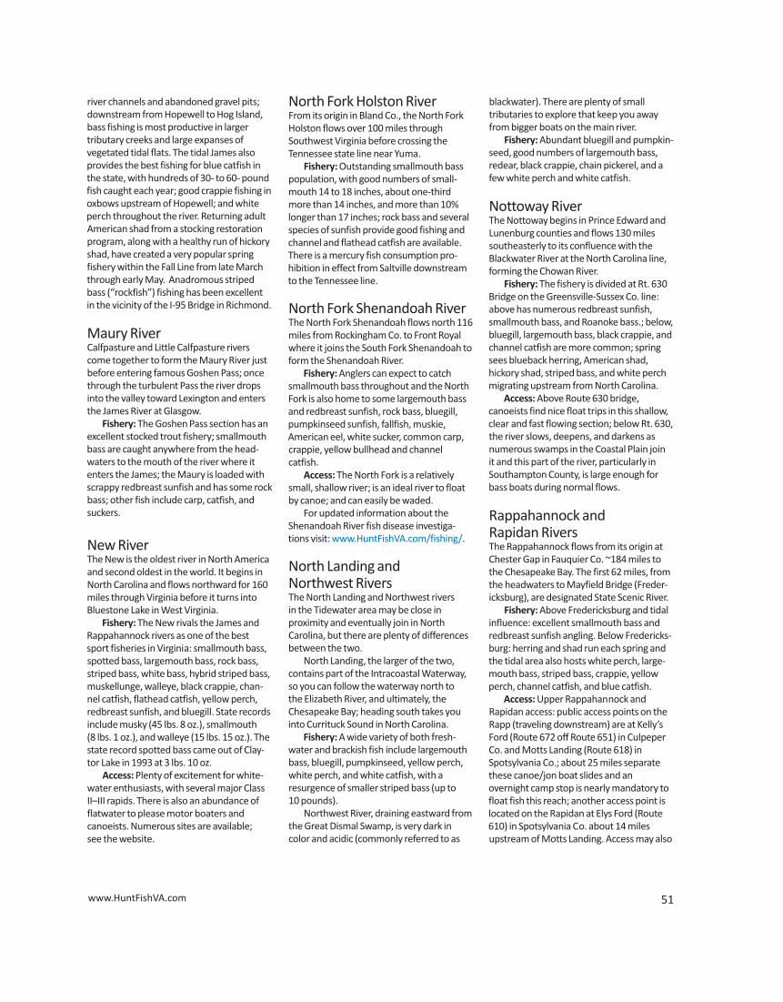
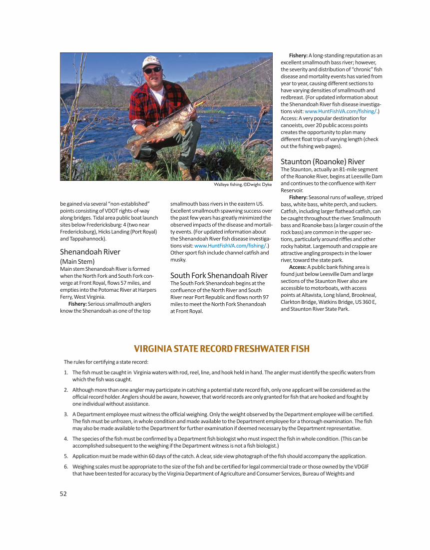
smallmouth bass rivers in the eastern US. Excellent smallmouth spawning success overthe past few years has greatly minimized theobserved impacts of the disease and mortali-ty events. (For updated information aboutthe Shenandoah River fish disease investiga-tions visit: www.HuntFishVA.com/fishing/.)Other sport fish include channel catfish andmusky.
South Fork Shenandoah RiverThe South Fork Shenandoah begins at theconfluence of the North River and SouthRiver near Port Republic and flows north 97miles to meet the North Fork Shenandoah at Front Royal.
52
be gained via several “non-established”points consisting of VDOT rights-of-wayalong bridges. Tidal area public boat launch sites below Fredericksburg: 4 (two nearFredericksburg), Hicks Landing (Port Royal)and Tappahannock).
Shenandoah River (Main Stem)Main stem Shenandoah River is formedwhen the North Fork and South Fork con-verge at Front Royal, flows 57 miles, andempties into the Potomac River at HarpersFerry, West Virginia. Fishery: Serious smallmouth anglersknow the Shenandoah as one of the top
The rules for certifying a state record:
1. The fish must be caught in Virginia waters with rod, reel, line, and hook held in hand. The angler must identify the specific waters fromwhich the fish was caught.
2. Although more than one angler may participate in catching a potential state record fish, only one applicant will be considered as the official record holder. Anglers should be aware, however, that world records are only granted for fish that are hooked and fought by one individual without assistance.
3. A Department employee must witness the official weighing. Only the weight observed by the Department employee will be certified.The fish must be unfrozen, in whole condition and made available to the Department employee for a thorough examination. The fishmay also be made available to the Department for further examination if deemed necessary by the Department representative.
4. The species of the fish must be confirmed by a Department fish biologist who must inspect the fish in whole condition. (This can be accomplished subsequent to the weighing if the Department witness is not a fish biologist.)
5. Application must be made within 60 days of the catch. A clear, side view photograph of the fish should accompany the application.
6. Weighing scales must be appropriate to the size of the fish and be certified for legal commercial trade or those owned by the VDGIF that have been tested for accuracy by the Virginia Department of Agriculture and Consumer Services, Bureau of Weights and
VIRGINIA STATE RECORD FRESHWATER FISH
Fishery: A long-standing reputation as anexcellent smallmouth bass river; however,the severity and distribution of “chronic” fishdisease and mortality events has varied fromyear to year, causing different sections tohave varying densities of smallmouth andredbreast. (For updated information aboutthe Shenandoah River fish disease investiga-tions visit: www.HuntFishVA.com/fishing/.)Access: A very popular destination forcanoeists, over 20 public access points creates the opportunity to plan many different float trips of varying length (checkout the fishing web pages).
Staunton (Roanoke) RiverThe Staunton, actually an 81-mile segmentof the Roanoke River, begins at Leesville Damand continues to the confluence with KerrReservoir. Fishery: Seasonal runs of walleye, stripedbass, white bass, white perch, and suckers.Catfish, including larger flathead catfish, canbe caught throughout the river. Smallmouthbass and Roanoke bass (a larger cousin of therock bass) are common in the upper sec-tions, particularly around riffles and otherrocky habitat. Largemouth and crappie areattractive angling prospects in the lowerriver, toward the state park. Access: A public bank fishing area isfound just below Leesville Dam and largesections of the Staunton River also are accessible to motorboats, with access points at Altavista, Long Island, Brookneal,Clarkton Bridge, Watkins Bridge, US 360 E,and Staunton River State Park.
Walleye fishing, ©Dwight Dyke
53
Measures. Fish under 25 pounds must be weighed on a scale capable of weighing to the ounce. Fish over 25 pounds should be weighed on scales having no greater graduations than one-half pound. When ever scales of 8-ounce graduations are used, the fish weight will always be rounded down to the nearest one-half pound.
7. Any potential state record fish found to contain artificial food in the stomach will not be recognized as a new record. Any fish fed artificial food to reach state record size is not eligible for state record status.
8. No fish caught within the boundaries of a public or private aquaculture facility or private fee fishing area will be recognized as astate record.
9. If there is reasonable doubt regarding any aspect of the application, it may be rejected.
10. One appeal of the Committee’s decision may be made within 60 days of notification. The appeal must be in writing to the Chairman, State Record Fish Committee.
Virginia State Record Freshwater Fish as of May 20, 2014
Species Weight Location Date Name Blue Catfish 143 lbs. Buggs Island Lake 6-18-2011 Richard Anderson Bowfin 17 lbs. 8 oz. Chickahominy Lake 11-14-1964 E. C. Cutright Bowfin** 16 lbs. 8 oz. Lake Cahoon 10-17-2004 John W. Plyler, Jr. Brook Trout 5 lbs. 10 oz. Big Stony Creek 10-22-1987 Greg Orndorff Brown Trout 18 lbs. 11 oz. Smith River 6-22-1979 William W. Nease Brown Trout** 14 lbs. 12 oz. South Fork, Holston 5-24-1990 Mike S. Perkins Carp (Bow & Arrow) 60 lbs. Private Pond 7-5-1970 Ben Topham Carp 49 lbs. 4 oz. Lake Prince 6-25-1986 Jeffrey Graham Chain Pickerel 7 lbs. 12 oz. Douthat Lake 1-26-1974 Glenn C. Williams Chain Pickerel** 7 lbs. 10 oz. Lake Shawnee 12-31-1996 R. L. White Channel Catfish 32 lbs. Lake Chesdin 4-28-1980 Hugh Wyatt Channel Catfish** 31 lbs. 8 oz. Rappahannock River 10-2-1992 Sue Stanley Coho Salmon 8 lbs. 12 oz. Philpott Reservoir 12-27-1971 Melvin Chilton Crappie 4 lbs. 14 oz. Lake Conner 4-8-1967 E. L. Blackstock Crappie** 4 lbs. 10 oz. Private Pond 4-24-1994 Justin Elliott Flathead Catfish 66 lbs. 4 oz. Occoquan Reservoir 5-6-1994 Mike Willems Freshwater Drum 26 lbs. 8 oz. Buggs Island Lake 7-10-2012 Nancy Cash Gar 25 lbs. 2 oz. Lake Prince 5-28-1987 Roger Beaver Hybrid Striped Bass 13 lbs. 9 oz. Flannagan Reservoir 6-19-2013 Joshua Neece Lake Trout 5 lbs. 6 oz. Philpott Reservoir 7-6-1966 Arthur A. Conner Largemouth Bass 16 lbs. 4 oz. Conner Lake 5-20-1985 Richard Tate Musky (includes Tiger) 45 lbs. 8 oz. New River 6-1-2007 Shannon Hill Northern Pike 31 lbs. 4 oz. Motts Run Reservoir 7-24-1994 George Wood Rainbow Trout 14 lbs. 7 oz. Greers Pond 6-28-1993 Michael Lowe Roanoke Bass 2 lbs. 9 oz. Western Branch Reservor 5-28-2005 Harry G. Swauger Rock Bass 2 lbs. 2 oz. Laurel Bed Lake 5-17-1986 Larry Ball Sauger 5 lbs. 8 oz. South Holston Lake 7-2-1972 R. Stallard Sauger** 3 lbs. Clinch River 4-24-2010 Ronald C. Davis Smallmouth Bass 8 lbs. 1 oz. New River 3-12-2003 Donald S. Eaton, Jr. Spotted Bass 6 lbs. 10 oz. Flannagan Reservoir 3-31-1976 Joe Jett Friend Spotted Bass** 4 lbs. 7 oz. Claytor Lake 3-10-2012 Rod Kegley Striped Bass 53 lbs. 7 oz. Leesville Reservoir 3-16-2000 James B. Davis Sunfish (all) 4 lbs. 12 oz. Private Pond 4-28-1986 Michael Mills Walleye 22 lbs. 8 oz. New River 8-20-1973 Roy G. Barrett Walleye** 15 lbs. 15 oz. New River 12-15-2000 Anthony P. Duncan White Bass 6 lbs. 13 oz. Lake Orange 7-31-1989 Ron Sprouse White Catfish 7 lbs. 6 oz. Western Branch Reservoir 3-24-1992 Thomas F. Elkins White Perch 3 lbs. 2 oz. Private Pond 6-13-2012 Beau McLaughlin Yellow Perch 3 lbs. Flannagan Reservoir 3-8-2010 George Mullins
** Denotes record fish was caught using new State Record Rules adopted in 1985 but did not exceed all-time record.
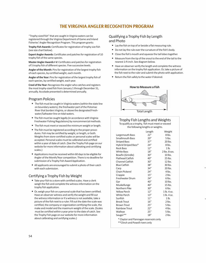
54
“Trophy-sized fish” that are caught in Virginia waters can be registered through the Virginia Department of Game and InlandFisheries’ Angler Recognition Program. This program grants:
Trophy Fish Awards: Certificates for registration of trophy size fish(see size chart below).
Expert Angler Awards: Certificates and patches for registration of 10trophy fish of the same species.
Master Angler Awards I-V: Certificates and patches for registrationof 5 trophy fish of different species. Five successive levels.
Angler of the Month: Pins for registration of the largest trophy fishof each species, by certified weight, each month.
Angler of the Year: Pins for registration of the largest trophy fish ofeach species, by certified weight, each year.
Creel of the Year: Recognizes the angler who catches and registersthe most trophy-sized fish from January 1 through December 31, annually. Accolade presented is determined annually.
Program Policies• The fish must be caught in Virginia waters (within the state line
on boundary waters), the freshwater part of the PotomacRiver that borders Virginia, or above the designated Fresh -water/Saltwater line on tidal waters.
• The fish must be caught legally (in accordance with VirginiaFreshwater Fishing Regulations) by noncommercial methods.
• The fish must meet or exceed the minimum weight or length.
• The fish must be registered according to the proper proce-dures. Fish may be certified by weight, or length, or both.Weights from store-certified scales or personal scales will beaccepted. Personal scales must be calibrated and certifiedwithin a year of date of catch. (See the Trophy Fish page on ourwebsite for more information about calibrating and certifyingscales.)
• Applications must be received within 60 days to be eligible forAngler of the Month/Year competition. There is no deadline forsubmission of a Trophy Fish Award Application.
• All applicants are encouraged to submit a photo of their catchwith each submission.
Certifying a Trophy Fish by Weight• Take your fish to a store with certified scales. Have a clerk
weigh the fish and complete the witness information on thetrophy fish application.
• Or, weigh your fish on a personal scale that has been certified.Have an observer witness and verify the weight and fill out
the witness information or if a witness is not available, take a picture of the fish next to a ruler. Fill out the date the scale was certified, the company or organization certifying the scale, the make and model and the maximum weight of the scale. (Scales must be certified within a year prior to the date of catch. See the Trophy Fish page on our website for more information about calibrating and certifying scales.)
Qualifying a Trophy Fish by Length and Photo
• Lay the fish on top of or beside a flat measuring rule.
• Do not lay the rule over the curvature of the fish’s body.
• Close the fish’s mouth and squeeze the tail lobes together.
• Measure from the tip of the snout to the end of the tail to thenearest 1⁄4-inch. See diagram below.
• Have an observer verify the length and complete the witness information on the trophy fish application. Or, take a picture of
the fish next to the ruler and submit the photo with application.
• Return the fish safely to the water if desired.
Trophy Fish Lengths and WeightsTo qualify as a trophy, fish must meet or exceed
the following lengths or weights.
Length Weight Largemouth Bass 22” 8 lbs. Smallmouth Bass 20” 5 lbs. Striped Bass 37” 20 lbs. Hybrid Striped Bass* 24” 8 lbs. Rock Bass 12” 1 lb. White Bass 18” 2 lbs. 8 ozs. Bowfin (Grindle) 30” 10 lbs. Flathead Catfish 40” 25 lbs. Channel Catfish 30” 12 lbs. Blue Catfish 38” 30 lbs. Carp 34” 20 lbs. Chain Pickerel 24” 4 lbs. Crappie 15” 2 lbs. Freshwater Drum 24” 6 lbs. Gar 40” 10 lbs. Muskellunge 40” 15 lbs. Northern Pike 30” 6 lbs. Yellow Perch 12” 1 lb. 4 oz. White Perch 13” 1 lb. 4 oz. Sunfish 11” 1 lb. Brook Trout 16” 2 lbs. Brown Trout 25” 5 lbs. Rainbow Trout 22” 4 lbs. Walleye 25” 5 lbs. Sauger** 18” 2 lbs.
* Claytor and Flannagan reservoirs only **Clinch and Powell rivers only
THE VIRGINIA ANGLER RECOGNITION PROGRAM
How to Measure a Fish
Total Length
Virginia Department of Game and Inland FisheriesFRESHWATER TROPHY FISH AWARD APPLICATION FORM
Mail-in Application: Certify the size of the fish. Fill out completely, one application form for each fish, $5.00 per fish. (No charge forfor youth 15 and under.) You may include more than one application form per envelope. Applications may be found in the Freshwater Fishing Regulations or online at www.dgif.virginia.gov/forms/EDUC/EDUC-006.pdf. Mail the application form(s) with payment and makecheck or money order payable to the Treasurer of Virginia. Send to: Cashier, VDGIF, P.O. Box 11104, Richmond, VA 23230.
PLEASE PRINT CLEARLY❒ Check box if applicant is 15 or under and receiving a trophy fish award for the 1st time for this species.
Birth Date: m/ d/ y/
Name ❒ Jr ❒ Sr ❒ II ❒ III ❒
Street Address Apt. #
City State Zip
Phone ( ) ❒ Female ❒ Male
• Species of Fish: • Date Caught: m/ d/ y/
• Weight of Fish: • Length of Fish (to nearest ¼-inch):
• Name of water where caught: • Name of County/City where caught:
• Type of water where caught: ❒ River ❒ Public Lake/Reservoir ❒ Stream ❒ Private Pond/Lake
Check the box below that applies and fill in information requested—see Program Policies for details
❒ Weight Certification: (Select One) ❒ Store Scale/Witness ❒ Certified/Calibrated ❒ Certified/Calibrated Personal Scale/Witness Personal Scale/Photo
Store/Name Phone ( )
Street Address
City State Zip
Witness Name
Witness Signature
Personal Scale: Date Certified/Calibrated Certified/Calibrated by
Scale Make/Model Scale Max Weight
❒ Length Certification:
Witness Name Phone ( )
Witness Signature
Street Address
City State Zip
❒ Length by Photo Certification: Take photo of fish next to ruler. Print your name, birth date, and fish species on back of the photo. Enclose with application. Photos become property of VDGIF and may be used in publications.
(Angler sign here) I, hereby affirm that the above information is true and that intaking this fish I complied with all state fishing regulations and rules of the Virginia Angler Recognition Program and that the witness/es actually witnessed the weighing and/or measuring of this fish. I understand that photos become the property of VDGIF and may be used inagency publications.
55
First Middle Last
Nov. 1, 2012
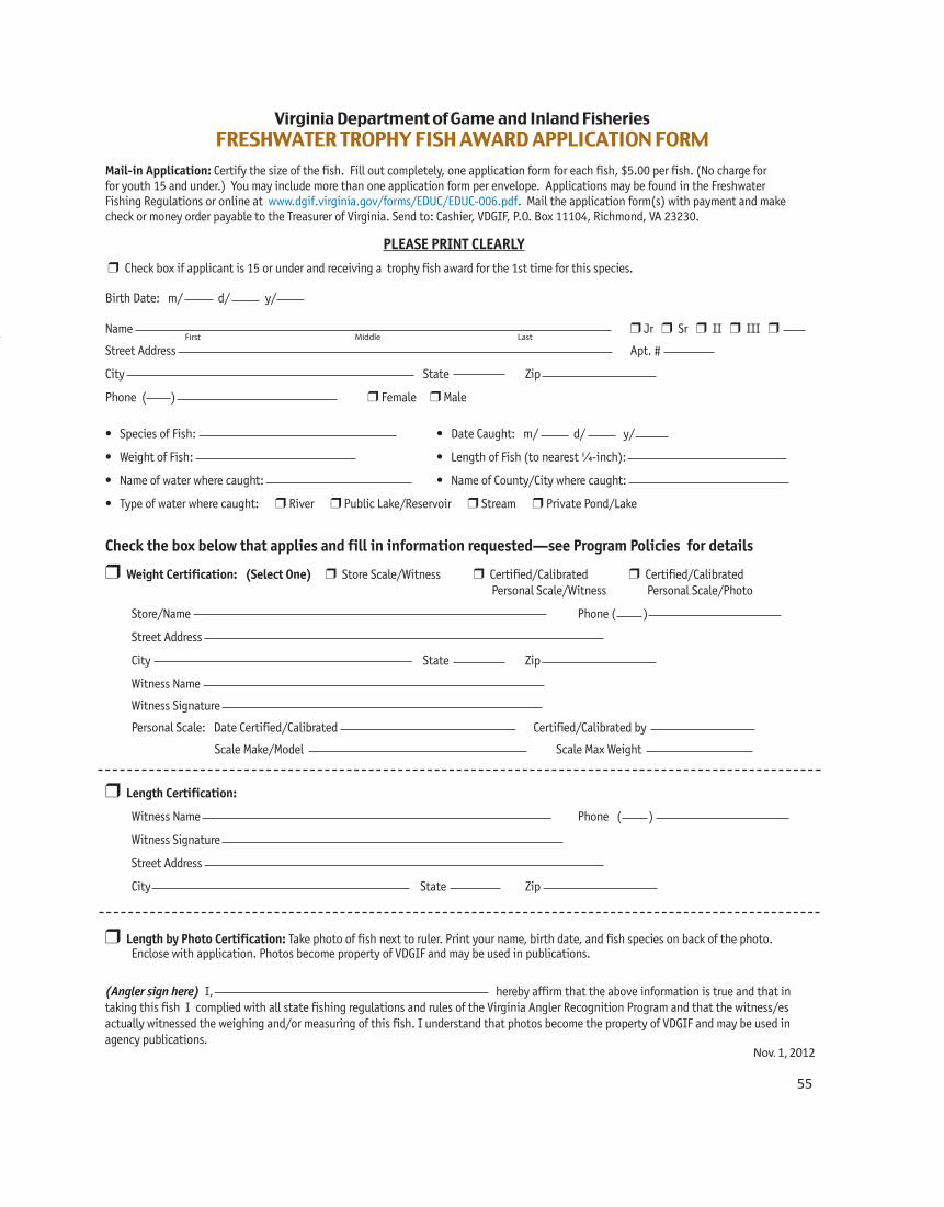

57
WATERCRAFT REGISTRATION,
TITLING, & SALES TAX REQUIREMENTS
The Virginia Department of Game and InlandFisheries (DGIF) administers all boat titlingand registration of recreational boats in Virginia. All motorboats used on the publicwaters of Virginia must be registered andtitled. If the motorboat is principally used onthe public waters of Virginia it must be registered and titled in Virginia as opposed to another state.
• A Certificate of Title (title) and a Certificate of Number (registration) are required for all watercraft propelled by machinery, including , but not limited to, gasoline, diesel, and electric motors. • A title alone is required for sail-powered
vessels in excess of 18 feet in length, ifthey do not have a motor.
• Boats used only on private waters do notrequire registration or titling.
• New watercraft must be registered orhave a temporary registration beforethey may be operated on the public
waters of Virginia. • Used watercraft with a current, valid registration may be operated for 30 days
on the previous owner’s registration if a copy of the dated bill of sale and the registration card are carried aboard the watercraft. • If there is no valid registration or the registration has expired, used watercraft must be registered or have a temporary registration before being operated on the public waters. • An owner bringing a watercraft into Virginia from another state may operate the vessel up to 90 consecutive days on the other state’s current, valid registra- tion before registering it in Virginia.
Watercraft registration is accomplishedthrough the mail or at the DGIF head quartersbuilding at 4010 West Broad Street in Rich-mond (8:30 A.M.–4:30 P.M., M–F except holidays). The full mailing address is on theapplication form. Applications submittedthrough the mail are usually processed andthe registration materials mailed within twoweeks of receipt in Richmond.
Titling and Registering Your WatercraftThe Application for Watercraft Certificate ofTitle and Certificate of Number (registration)form is available from DGIF offices, Department of Motor Vehicle servicecenters, and from the DGIF website,www.dgif.virginia.gov. This is a combinedapplication for both the registration and title. An application for title and registrationrequires a detailed description of the water-craft that includes the make, length, modelyear, type of vessel, hull material, type ofpropulsion, and the 12-character hull identi-fication number; the make, horsepower andserial number of the motor if in excess of 25horsepower; and the name and address ofthe lien holder, if any. Most of this information will be available
from the title provided by the previousowner or the Manufacturer’s Statement ofOrigin provided by the retail outlet where thewatercraft was purchased.
Additional information and forms on watercraft registration and titling may be obtained by calling the Boat Section of DGIF at 804-367-6135 or 866-721-6911. Forms can also be downloaded from our website at www.dgif.virginia.gov/forms.
VIRGINIA WATERCRAFT OWNERS GUIDE
S ince 1960 the Department hasbeen designated as the state boat-
ing agency, providing boat titling andregistration, boating access throughour many statewide public boat rampsand facilities, boating education, boat-ing law enforcement, and boat acci-dent investigation and reporting. There are endless opportunities forboaters in Virginia, from saltwater towhitewater and everything inbetween. Virginia offers an abundanceof beautiful public and private water-ways for the recreational boating community. Whether you are a seasoned mariner or just beginning,remember that boating does involvesome risks and the choices you make asa boat operator can either contributeto those risks or mitigate them. Be Responsible: Don’t drink andboat! Be Safe: Wear an approved lifejacket and take a boating safety course!Have Fun!
–Tom GuessBoating Law Administrator, VDGIF
Certain supporting documents must besubmitted with an application for title andregistration as follows:
New Watercraft:• The owner must provide the original
Manufacturer’s or Importer’s Certificate(Statement) of Origin with “First Assign-ment” completed and issued by dealer attime of purchase and a copy of the salesinvoice showing gross purchase price,watercraft sales tax paid, and a
description of the watercraft.• If watercraft was homemade by you, an affidavit must be provided stating this fact in lieu of a Manufacturer’s or Importer’s Certificate of Origin. The affidavit may be retrieved from the DGIF website or mailed to you upon request. Copies of receipts for building materials and pictures of the watercraft from all sides must also be submitted with the application and affidavit. Your watercraft may be subject to inspection by a law enforcement officer.
Used Watercraft:• If titled in Virginia—the original title with
assignment of title completed by titledowner/owners. If purchased from a deal-er the dealer reassignment portion of thetitle must be completed, and include acopy of the sales invoice showing grosspurchase price, watercraft sales tax paid,and a description of the watercraft.
• If titled by someone else in anotherstate—the original title with assignmentof title completed by titled owner/own-ers. If purchased from a dealer the dealerreassignment portion of the title must becompleted, and include a copy of thesales invoice showing gross purchaseprice, watercraft sales tax paid, and a
description of the watercraft.
www.GotMyTag.com
Automatically look up your points.
Reminds you of application dates.
Never miss the hunt of a lifetime.
Pictures shown aretags the app helped draw
in 2014 on public land!
Get the app today!Get the app today!
$1.99
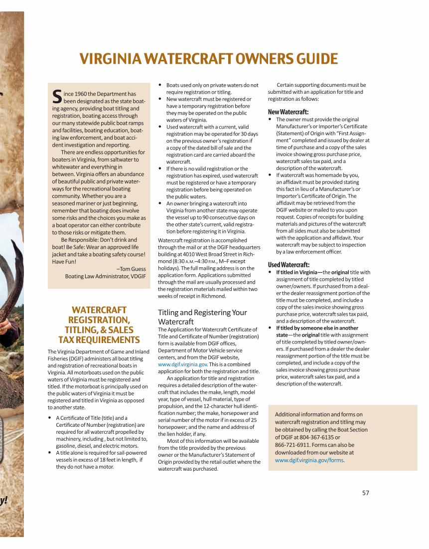
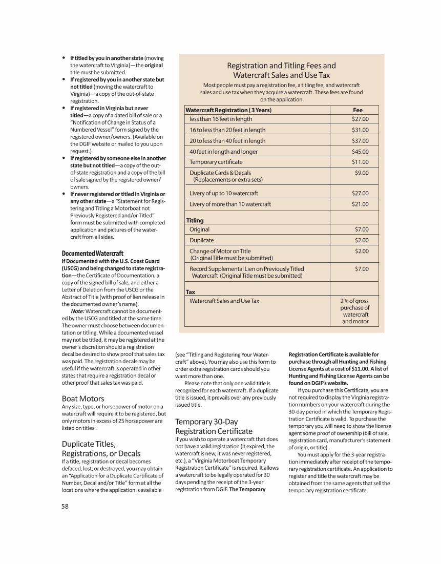
58
• If titled by you in another state (movingthe watercraft to Virginia)—the originaltitle must be submitted.
• If registered by you in another state butnot titled (moving the watercraft to
Virginia)—a copy of the out-of-state registration.• If registered in Virginia but never titled—a copy of a dated bill of sale or a
“Notification of Change in Status of aNumbered Vessel” form signed by theregistered owner/owners. (Available onthe DGIF website or mailed to you uponrequest.)
• If registered by someone else in anotherstate but not titled—a copy of the out-of-state registration and a copy of the billof sale signed by the registered owner/
owners.• If never registered or titled in Virginia or
any other state—a “Statement for Regis-tering and Titling a Motorboat not
Previously Registered and/or Titled” form must be submitted with completed application and pictures of the water- craft from all sides.
Documented WatercraftIf Documented with the U.S. Coast Guard(USCG) and being changed to state registra-tion—the Certificate of Documentation, acopy of the signed bill of sale, and either aLetter of Deletion from the USCG or theAbstract of Title (with proof of lien release inthe documented owner’s name). Note: Watercraft cannot be document-ed by the USCG and titled at the same time.The owner must choose between documen-tation or titling. While a documented vesselmay not be titled, it may be registered at theowner’s discretion should a registrationdecal be desired to show proof that sales taxwas paid. The registration decals may beuseful if the watercraft is operated in otherstates that require a registration decal orother proof that sales tax was paid.
Boat MotorsAny size, type, or horsepower of motor on awatercraft will require it to be registered, butonly motors in excess of 25 horsepower arelisted on titles.
Duplicate Titles, Registrations, or DecalsIf a title, registration or decal becomesdefaced, lost, or destroyed, you may obtainan “Application for a Duplicate Certificate ofNumber, Decal and/or Title” form at all thelocations where the application is available
(see “Titling and Registering Your Water-craft” above). You may also use this form toorder extra registration cards should youwant more than one. Please note that only one valid title isrecognized for each watercraft. If a duplicatetitle is issued, it prevails over any previouslyissued title.
Temporary 30-Day Registration CertificateIf you wish to operate a watercraft that doesnot have a valid registration (it expired, thewatercraft is new, it was never registered,etc.), a “Virginia Motorboat Temporary Registration Certificate” is required. It allowsa watercraft to be legally operated for 30days pending the receipt of the 3-year registration from DGIF. The Temporary
Watercraft Registration ( 3 Years) Fee less than 16 feet in length $27.00
16 to less than 20 feet in length $31.00
20 to less than 40 feet in length $37.00
40 feet in length and longer $45.00
Temporary certificate $11.00
Duplicate Cards & Decals $9.00 (Replacements or extra sets)
Livery of up to 10 watercraft $27.00
Livery of more than 10 watercraft $21.00
Titling Original $7.00
Duplicate $2.00
Change of Motor on Title $2.00(Original Title must be submitted)
Record Supplemental Lien on Previously Titled $7.00Watercraft (Original Title must be submitted)
Tax Watercraft Sales and Use Tax 2% of gross purchase of watercraft and motor
Registration and Titling Fees and Watercraft Sales and Use Tax
Most people must pay a registration fee, a titling fee, and watercraft sales and use tax when they acquire a watercraft. These fees are found
on the application.
Registration Certificate is available for purchase through all Hunting and FishingLicense Agents at a cost of $11.00. A list ofHunting and Fishing License Agents can befound on DGIF’s website. If you purchase this Certificate, you arenot required to display the Virginia registra-tion numbers on your watercraft during the30-day period in which the Temporary Regis-tration Certificate is valid. To purchase thetemporary you will need to show the licenseagent some proof of ownership (bill of sale,registration card, manufacturer’s statementof origin, or title). You must apply for the 3-year registra-tion immediately after receipt of the tempo-rary registration certificate. An application toregister and title the watercraft may beobtained from the same agents that sell thetemporary registration certificate.
Expiration and Renewal of RegistrationRegistrations are valid for three years.Renewal notices are mailed to the lastknown address of all watercraft ownersapproximately 45 days before expiration.The most common reason owners do notreceive a renewal notice is because theiraddress has changed within the three yearsand DGIF was not notified. If a renewalnotice was not received, the registrationmay be renewed by checking the “renewregistration” box at the top of the applica-tion to register and title a watercraft, thencompleting the application. A shorter “registration renewal application” is alsoavailable at the DGIF website.
Change in Status or Change ofMailing AddressIf a registered watercraft is sold, destroyed,abandoned, or stolen, or if there is a changein your mailing address, you are required bylaw to report this information within 15 daysin writing to the DGIF Boat Section. A “Notification of Change of Status of a Numbered Vessel” form is available at all the locations where the application is avail-able (see “Titling and Registering YourWatercraft” on page 57). The notificationcan be mailed to the address on the form oremailed to [email protected].
Registration Must be OnboardWhile OperatingYou must have the registration card or a“temporary” registration on the vesselbefore your watercraft may legally be operated on public waters. The 3-year registration card is the official document of registration for your watercraft and once it has been issued, must be carried aboardthe watercraft when in use. If you purchased a used watercraft with a valid, current registration, you mayoperate the vessel for 30 days from the dateof purchase provided you carry a dated bill of sale and the former owner’s valid registration card.
Validation DecalsDecals will be furnished with each 3-yearregistration issued by DGIF. Decals indicatethe month, year of expiration and the regis-tration number assigned to your water-craft, and must be displayed within 6 inchesof the registration number on each side ofthe watercraft for which they were issued.Only the current decal may be visible.Expired decals must be removed.
Trailers: Title, Registration, andLicense PlatesTitle, registration, and license plates forwatercraft trailers are purchased throughthe Department of Motor Vehicles. Checkwith DMV for rules and regulations regard-ing trailers.
The number issued to your watercraft appears on the registration and is to be dis-played on each side of the forward half of the vessel in block letters, at least 3” inheight, and contrasting in color with hull or background. They may be painted orattached to the watercraft, must read from left to right and must always be legible. A space or hyphen must separate both the “VA” symbol and the letter suffix fromthe numerals. On vessels so configured that a number on the hull or superstructure would notbe easily visible or the number would not remain securely attached (as on an inflatablevessel), the number may be painted on or the number and decal attached to a backingplate that is attached to the forward half of the vessel so that the number is visiblefrom each side of the vessel. If the watercraft already has Virginia registration numbers (used watercraft), inmost instances those same numbers will be reassigned to the new owner. The Virginiaregistration number assigned to a watercraft should never be removed from thewatercraft unless VDGIF assigns new numbers to the vessel.
Display of Registration Numbers
59
REQUIRED EQUIPMENTLife JacketsNearly all boating-related fatalities are theresult of drowning and most of these fatalities could have been prevented if a life jacket was worn.
• There must be one wearable (Type I, II,III, or V) USCG approved life jacket foreach person on the boat. The life jacketmust be the appropriate size for each
intended wearer D Each wearable life jacket needs to be
“readily accessible.” Readily accessiblemeans the life jackets are stowedwhere they can be easily reached, orare out in the open ready for wear.Readily accessible life jackets cannotbe in protective coverings or underlock and key.
D In addition, you should check each lifejacket for proper fit. This is especiallyimportant for children. Check the“Does Your Life Jacket Really Fit” onpage 60.
D A Type V life jacket needs to be wornaccording to the manufacturer labelto meet safety requirements.
D This requirement applies to all boatsincluding paddlecraft (canoes, kayaks,and stand-up paddleboards)
• In addition to the wearable life jacket,there must be at least one (1) USCG ap-proved Type IV throwable (ring buoy orseat cushion), on vessels of 16 feet orgreater. The regulation to carry a Type IVdoes not apply to (1) personal watercraft;(2) non-motorized canoes and kayaks of
Motorboat and PWC OperatorsBoating Safety Courses
Are Required
Personal Watercraft (PWC) “Jet Ski”
Required for all ages
Boats With Motors–10 hp or Greater
Age 45 or younger, July 1, 2014Age 50 or younger, July 1, 2015
All ages by July 1, 2016
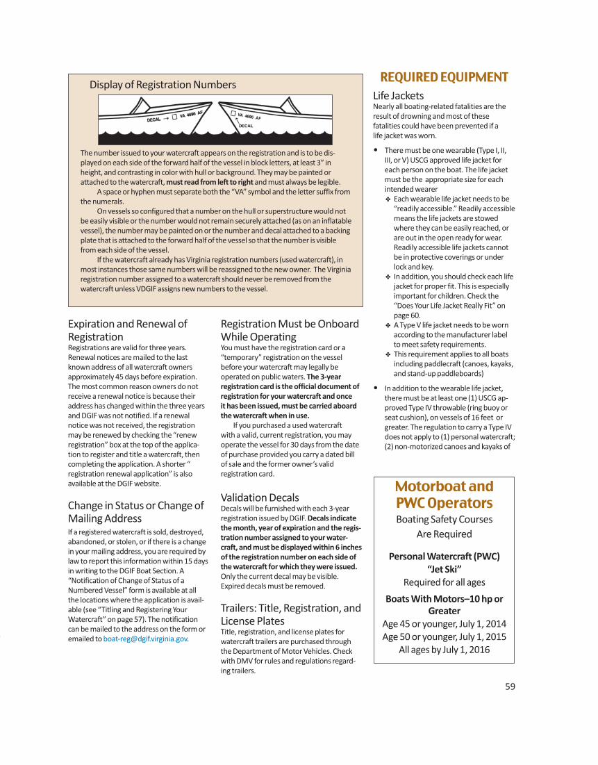
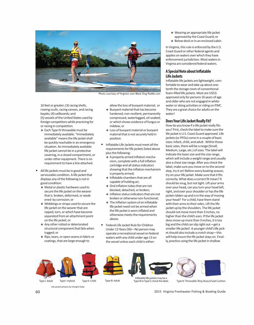
2015 Virginia Freshwater Fishing & Boating Guide
Inflatable life jackets may be a Type III or Type V, check the label. Type IV Throwable Ring Buoy & Seat Cushion
60
Type II–Child Type III–AdultType I–HybridType I–Adult
Life jacket photos by Dwight Dyke
Photo courtesy of Virginia’s own Black Dog Paddle.com
16 feet or greater; (3) racing shells, rowing sculls, racing canoes, and racing kayaks; (4) sailboards; and
(5) vessels of the United States used by foreign competitors while practicing for or racing in competition. D Each Type IV throwable must be
immediately available. “Immediatelyavailable” means the life jacket shallbe quickly reachable in an emergencysituation. An immediately availablelife jacket cannot be in a protectivecovering, in a closed compartment, orunder other equipment. There is norequirement to have a line attached.
• All life jackets must be in good and serviceable condition. A life jacket that displays any of the following is not in good condition: D Metal or plastic hardware used to
secure the life jacket on the wearerthat is broken, deformed, or weak-ened by corrosion; or
D Webbings or straps used to secure thelife jacket on the wearer that areripped, torn, or which have becomeseparated from an attachment pointon the life jacket; or
D Any other rotted or deteriorated structural component that fails when tugged; or D Rips, tears, or open seams in fabric or
coatings, that are large enough to
allow the loss of buoyant material; or D Buoyant material that has become
hardened, non-resilient, permanentlycompressed, waterlogged, oil-soaked,or which shows evidence of fungus ormildew; or
D Loss of buoyant material or buoyantmaterial that is not securely held inposition.
• Inflatable Life Jackets must meet all therequirements for life jackets listed aboveplus the following:
D A properly armed inflation mecha-nism, complete with a full inflation
cartridge and all status indicators showing that the inflation mechanism is properly armed; D Inflatable chambers that are all capable of holding air; D Oral inflation tubes that are not
blocked, detached, or broken; D Inflation status indicators that are not
broken or otherwise non-functional; D The inflation system of an inflatable
life jacket need not be armed whenthe life jacket is worn inflated and
otherwise meets the requirements above.
• Federal Life Jacket Rule for ChildrenUnder 13 Years Old—No person may
operate a recreational vessel on federal waters with any child under age 13 on the vessel unless each child is either:
D Wearing an appropriate life jacketapproved by the Coast Guard; or
D Below deck or in an enclosed cabin.
In Virginia, this rule is enforced by the U.S.Coast Guard or other federal agents andapplies on waters over which they haveenforcement jurisdiction. Most waters in Virginia are considered federal waters.
A Special Note about Inflatable Life JacketsInflatable life jackets are lightweight, com-fortable to wear and take up about one-tenth the storage room of conventionalfoam-filled life jackets. Most are USCGapproved only for persons 16 years of ageand older who are not engaged in white -water or skiing activities or riding on PWC.They are a great choice for adults on thewater!
Does Your Life Jacket Really Fit?How do you know if a life jacket really fitsyou? First, check the label to make sure thelife jacket is U.S. Coast Guard approved. Lifejackets (or PFDs) come in a couple of basicsizes: infant, child, and adult. Within thosebasic sizes, there will be a range (Small,Medium, Large, etc.) of sizes. The label willindicate the basic size and the size range,which will include a weight range and usuallyalso a chest size range. After you check thelabel, make sure you move on to the secondstep, try it on! Before every boating season,try on your life jacket. Make sure that it fitscorrectly. What does a correct fit mean? Itshould be snug, but not tight. Lift your armsover your head, can you turn your head left,right, and over your shoulder or has the lifejacket ridden up and is in the way of movingyour head? For a child, have them standwith their arms to their sides. Lift the lifejacket up by the shoulders. The life jacketshould not move more than 3 inches, nohigher than the child’s ears. If the life jacketdoes move up more than 3 inches, it is toobig and the child can slip right out—get asmaller life jacket! A younger child’s life jack-et should also include a crotch strap—thiswill help insure the life jacket stays on. Final-ly, practice using the life jacket in shallow
61
Minimum Number of B-I Hand-Portable Fire Extinguishers Required1
Length, feet No Fixed Fire Extinguishing Fixed Fire Extinguishing Systems in Engine Space System in Engine Space
Under 16 1 0 16 to less than 26 1 0 26 to less than 40 2 1 40 to 65 3 2
1One B-II hand-portable fire extinguisher may be substituted for two B-I hand- portable fire extinguishers.
water. Make sure it is snug enough to stayput and not ride up over the chin and earswhen in shallow water. Have children prac-tice in shallow water with their life jacket sothey don’t panic in case of emergency.
Fire ExtinguishersAll boats over 26 feet must have USCGapproved, adequately charges fire extin-guishers aboard (see the chart on this pagefor specific safety requirement). In addition,all motorboats under 26 feet that have oneor more of the following conditions mustalso carry fire extinguishers: a. Permanently installed fuel tanks. b. Closed compartment under thwarts and
seats wherein portable fuel tanks maybe stored.
c. Double bottoms not sealed to the hull orwhich are not completely filled withflotation material.
d. Closed living spaces. e. Closed stowage compartment in which
combustible or flammable materialsmay be stowed.
All fire extinguishers must be U.S. CoastGuard approved, must have an efficientchange, and must be in good and service-able condition.
Backfire Flame ArrestorInboard gasoline engines must have USCG,SEA, or UL approved flame arrestors on theircarburetors. The backfire flame arrestormust be securely attached to the carburetor.
VentilationNo person may operate a boat built after July 31, 1980, that has an inboard gasolineengine unless it is equipped with an opera-ble ventilation system that meets USCG standards. For boats built after April 25, 1940, andbefore August 1, 1980, (with engines usinggasoline as fuel and other fuels having aflashpoint of 110°F. or less) the following isrequired:
At least two ventilation ducts fittedwith cowls or their equivalent for thepurpose of properly and efficientlyventilating the bilges of every engineand fuel tank compartment. Thereshall be at least one exhaust ductinstalled so as to extend to the lowerportion of the bilge and at least oneintake duct installed so as to extend toa point at least midway to the bilge orat least below the level of the carbure-tor air intake.
For boats which are built after July 31,1978, but prior to August 1, 1980, there areno requirements for ventilation of the fueltank compartment if there is no electricalsource in the compartment and if the fueltank vents to the outside of the boat. The operator of the vessel is required tokeep the system in operating condition.
Sound Producing DevicesThe navigation rules require sound signals to be made under certain circumstances.Meeting, crossing, and overtaking situationsdescribed in Navigation Rules are examplesof when sound signals are required. Recre-ational vessels are also required to soundfog signals during periods of reduced visi - bility. Having some means of making an efficient sound signal capable of a 4-secondblast audible for 1 mile is required. A whistleor air horn is acceptable if your vessel is notequipped with a horn.
Muffling DeviceThe exhaust of an internal combustionengine on any motorboat shall be effectivelymuffled. The muffling device shall exhaust at or below the water line or it shall beequipped with mechanical baffles. The use of cutouts is prohibited.
Marine Sanitation Devices(MSD)Vessels with installed toilets and marine san-itation devices shall be in compliance withfederal regulations which set standards forsewage discharges from marine sanitationdevices. Vessels without installed toilets orwithout installed marine sanitation devicesshall not directly or indirectly dischargesewage into state waters. Sewage and otherwastes from self-contained, portable toiletsor other containment devices shall bepumped out at pump-out facilities or carriedashore for treatment in facilities approved
by the Virginia Department of Health. SmithMountain Lake is a “No Discharge Zone.”
Pump-Out StationsA complete list of pump-out stations is avail-able by contacting the Virginia Departmentof Health at 804-864-7473 or online atwww.vdh.state.va.us/EnvironmentalHealth/ONSITE/MARINA/pumpoutdata/index.htm .
Visual Distress SignalsAll recreational boats 16 feet or greater inlength shall be equipped with visual distresssignaling devices at all times when operatingon coastal waters. This regulation applies toall coastal waters and those rivers 2 miles ormore wide at the mouth and up to the firstpoint the river narrows to less than 2 miles. Boats less than 16 feet, manually pro-pelled boats (rowboats, canoes, kayaks,etc.), and open sailboats under 26 feet withno motor, are required to carry only nightvisual distress signals when operated oncoastal waters at night. Recreational boaters may carry addition-al visual distress signals over the minimumnumber of VDS required.
Note: It is illegal to display a visual distresssignal unless immediate assistance isneeded.
If using pyrotechnic signals, must have 3night signals plus 3 day signals or 3 day/nightcombination signals. If using non-pyrotech-nic signals, you must have 1 day signal and 1night signal.
Pyrotechnic visual distress signals must be: • USCG approved• in serviceable condition• readily accessible • not expired • Launchers produced before January 1,
1981, intended for use with approvedsignals are not required to be USCG
approved.
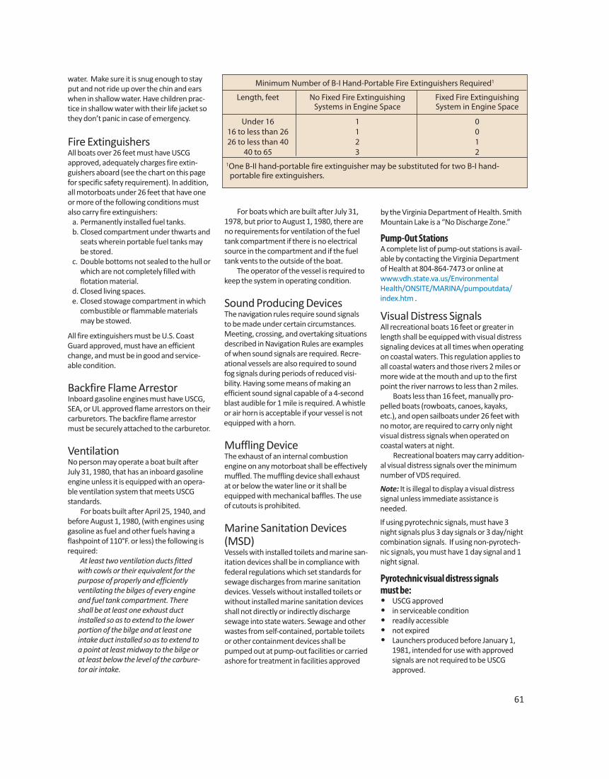
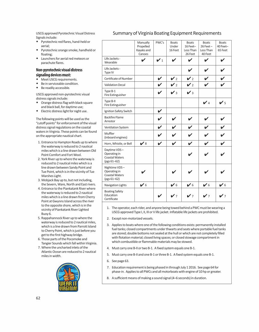
62
Summary of Virginia Boating Equipment Requirements
Manually PWC’s Boats Boats Boats BoatsPropelled Under 16 Feet– 26 Feet – 40 Feet–
Kayaks and 16 Feet Less Than Less Than 65 FeetCanoes 26 Feet 40 Feet
Life Jackets - ✔ ✔ 1 ✔ ✔ ✔ ✔Wearable
Life Jackets - ✔ ✔ ✔Type IV
Certificate of Number ✔ ✔ 2 ✔ 2 ✔ ✔
Validation Decal ✔ ✔ 2 ✔ 2 ✔ ✔
Type B-1 ✔ ✔ 3 ✔ 3Fire Extinguisher
Type B-II ✔ 4 ✔ 5Fire Extinguisher
Ignition Safety Switch ✔
Backfire Flame ✔ ✔ ✔ ✔ ✔Arrestor
Ventilation System ✔ ✔ ✔ ✔ ✔
Muffler ✔ ✔ ✔ ✔ ✔(inboard engines)
Horn, Whistle, or Bell ✔ 8 ✔ ✔ ✔ ✔ ✔
Daytime VDS – Operating in ✔ ✔ ✔Coastal Waters(pgs 61–62)
Nightime VDS – Operating in ✔ ✔ ✔ ✔ ✔Coastal Waters(pgs 61–62)
Navigation Lights ✔ 6 ✔ 6 ✔ 6 ✔ 6 ✔ 6
Boating SafetyEducation ✔ ✔ 7 ✔ 7 ✔ 7 ✔ 7Certificate
1. The operator, each rider, and anyone being towed behind a PWC must be wearing aUSCG approved Type I, II, III or V life jacket. Inflatable life jackets are prohibited.
2. Except non-motorized vessels.
3. Applies to boats where one of the following conditions exists: permanently installedfuel tanks; closed compartments under thwarts and seats where portable fuel tanksare stored; double bottoms not sealed at the hull or which are not completely filledwith flotation material; closed living spaces; or closed stowage compartment inwhich combustible or flammable materials may be stowed.
4. Must carry one B-II or two B-1. A fixed system equals one B-1.
5. Must carry one B-II and one B-1 or three B-1. A fixed system equals one B-1.
6. See page 63.
7. Education requirement is being phased in through July 1 2016. See page 64 forphase-in. Applies to all PWCs and all motorboats with engine of 10 hp or greater.
8. A sufficient means of making a sound signal (4–6 seconds) in duration.
USCG approved Pyrotechnic Visual DistressSignals include: • Pyrotechnic red flares, hand-held or aerial; • Pyrotechnic orange smoke, handheld or
floating;• Launchers for aerial red meteors or parachute flares.
Non-pyrotechnic visual distress signaling devices must:• Meet USCG requirements. • Be in serviceable condition.• Be readily accessible.
USCG approved non-pyrotechnic visual distress signals include:• Orange distress flag with black square
and black ball, for daytime use; • Electric distress light for night use.
The following points will be used as the “cutoff points” for enforcement of the visualdistress signal regulations on the coastalwaters in Virginia. These points can be foundon the appropriate nautical chart.
1. Entrance to Hampton Roads up to wherethe waterway is reduced to 2 nauticalmiles which is a line drawn between OldPoint Comfort and Fort Wool.
2. York River up to where the waterway isreduced to 2 nautical miles which is aline drawn between Sandy Point and
Tue Point, which is in the vicinity of Tue Marshes Light. 3. Mobjack Bay up to, but not including,
the Severn, Ware, North and East rivers. 4. Entrance to the Piankatank River where
the waterway is reduced to 2 nauticalmiles which is a line drawn from CherryPoint at Gwynns Island across the riverto the opposite shore, which is in thevicinity of Piankatank River Lighted
Buoy 6. 5. Rappahannock River up to where the
waterway is reduced to 2 nautical miles,which is a line drawn from Parrott Islandto Cherry Point, which is just before youget to the first highway bridge.
6. Those parts of the Pocomoke and Tangier Sounds which fall within Virginia. 7. Where the uncharted inlets of the
Atlantic Ocean are reduced to 2 nauticalmiles in width.
63
Navigation Lights – Power Driven Vessels
FIG. 3
FIG. 1 FIG. 2
FIG. 4
Navigation Lights – Sailing Vessels
FIG. 5
FIG. 7
FIG. 6
FIG. 8
Vessels Less Than 12 Meters (39.4 ft.) in Length• Vessels or sailboats using power: the lighting arrange-
ment in Figure 1, 2, 3, or 4 may be used.• Sailboats using sail alone: the lighting arrangement in
figure 5, 6, or 7 may be used.The white masthead light or all around white light mustbe at least 1 meter (3.3 ft.) higher than the colored side-lights.
Vessels 12 Meters but Less Than 20 Meters (65.5 ft.) in Length• Vessels or sailboats using power: the lighting arrange-
ment in Figure 1 or 2 may be used. The lightingarrangement in Figure 3 may be used if the vessel wasconstructed before December 24, 1980.
• Sailboats using sail alone: the lighting arrangement inFigure 5, 6, or 7 may be used.
The white masthead light or all around white light mustbe at least 1 meter (3.3 ft.) higher than the colored side-lights.
Unpowered VesselsA vessel under oars and sailboats less than 7 meters (23 feet) in length may display those lights prescribed fora sailing vessel, but it they do not, they shall have ready athand an electric torch or lighted lantern (Figure 8) shininga white light which shall be exhibited in sufficient time toprevent collision.
International Rules (Past the Line of Demarcation)Beyond three nautical miles of Viginia’s coastline, if yourpower-driven vessel is less than 23 feet (7 meters) inlength and its maximum speed does not exceed 7 knots, then it may display an all-round white light, andif possible, sidelights instead of the lights previously prescribed.
Navigation LightsRecreational boats, while underway, are required to display navigation lights between sunset and sunrise andduring periods of restricted visibility. No other lights shall be exhibited that could impairthe visibility of required running lights or impair the visibility of approaching vessels.
Lights Used When AnchoredAn anchor light is a 360 degree (all-round) white lightexhibited where it can best be seen and visible for 2 miles.
Special Lights for Enforcement VesselsEnforcement vessels of the VDGIF, the USCG, and otherlaw enforcement agencies may display a rotating or flash-ing blue light. When such a light is observed you shouldstop immediately and maneuver in such a way as to per-mit the boarding officer to come alongside or aboard. By federal law, blue lights may only be displayed byenforcement vessels of the federal, state or local govern-ments, and have the same effect on the water as the rotating or flashing blue lights on law enforcement carstraveling our highways.
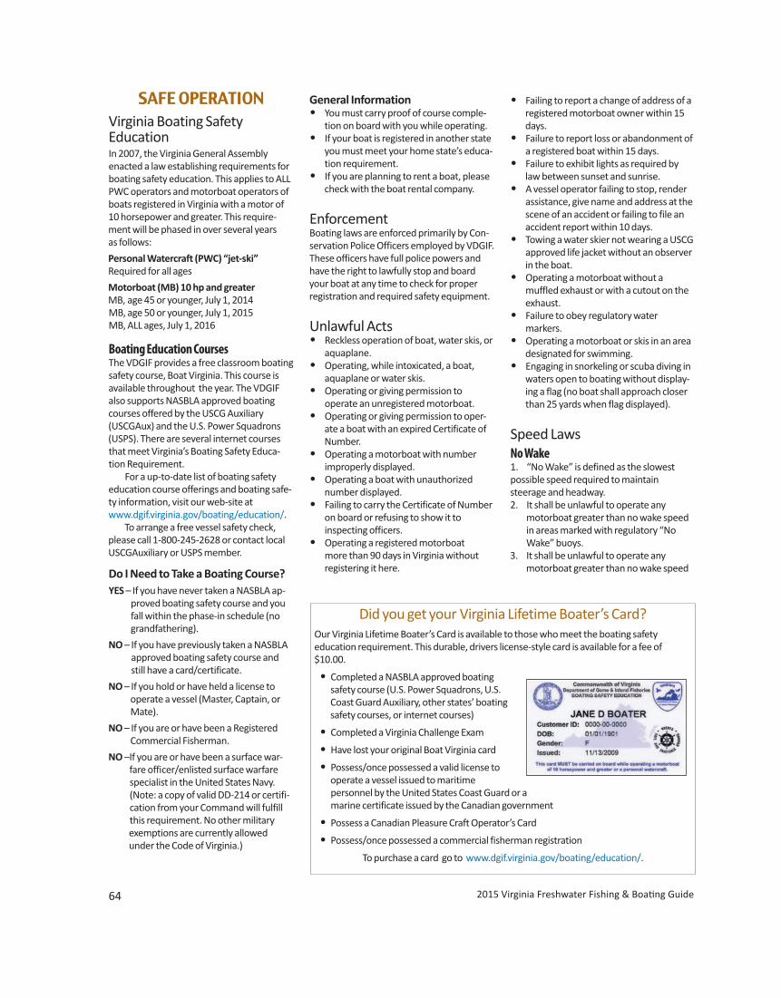
64
• Failing to report a change of address of aregistered motorboat owner within 15days.
• Failure to report loss or abandonment ofa registered boat within 15 days.
• Failure to exhibit lights as required bylaw between sunset and sunrise.
• A vessel operator failing to stop, renderassistance, give name and address at thescene of an accident or failing to file anaccident report within 10 days.
• Towing a water skier not wearing a USCGapproved life jacket without an observerin the boat.
• Operating a motorboat without a muffled exhaust or with a cutout on the exhaust. • Failure to obey regulatory water markers. • Operating a motorboat or skis in an area
designated for swimming. • Engaging in snorkeling or scuba diving in
waters open to boating without display-ing a flag (no boat shall approach closerthan 25 yards when flag displayed).
Speed LawsNo Wake1. “No Wake” is defined as the slowest possible speed required to maintain steerage and headway.2. It shall be unlawful to operate any
motorboat greater than no wake speedin areas marked with regulatory “NoWake” buoys.
3. It shall be unlawful to operate anymotorboat greater than no wake speed
SAFE OPERATIONVirginia Boating Safety Education In 2007, the Virginia General Assembly enacted a law establishing requirements for boating safety education. This applies to ALLPWC operators and motorboat operators ofboats registered in Virginia with a motor of 10 horsepower and greater. This require-ment will be phased in over several years as follows:
Personal Watercraft (PWC) “jet-ski”Required for all ages
Motorboat (MB) 10 hp and greaterMB, age 45 or younger, July 1, 2014MB, age 50 or younger, July 1, 2015MB, ALL ages, July 1, 2016
Boating Education CoursesThe VDGIF provides a free classroom boatingsafety course, Boat Virginia. This course isavailable throughout the year. The VDGIFalso supports NASBLA approved boatingcourses offered by the USCG Auxiliary(USCGAux) and the U.S. Power Squadrons(USPS). There are several internet coursesthat meet Virginia’s Boating Safety Educa-tion Requirement. For a up-to-date list of boating safetyeducation course offerings and boating safe-ty information, visit our web-site atwww.dgif.virginia.gov/boating/education/. To arrange a free vessel safety check,please call 1-800-245-2628 or contact localUSCGAuxiliary or USPS member.
Do I Need to Take a Boating Course?YES – If you have never taken a NASBLA ap-
proved boating safety course and youfall within the phase-in schedule (nogrand fathering).
NO – If you have previously taken a NASBLAapproved boating safety course andstill have a card/certificate.
NO – If you hold or have held a license to operate a vessel (Master, Captain, or Mate).
NO – If you are or have been a Registered Commercial Fisherman.
NO –If you are or have been a surface war-fare officer/enlisted surface warfarespecialist in the United States Navy.(Note: a copy of valid DD-214 or certifi-cation from your Command will fulfillthis requirement. No other military
exemptions are currently allowed under the Code of Virginia.)
General Information• You must carry proof of course comple-
tion on board with you while operating. • If your boat is registered in another state
you must meet your home state’s educa-tion requirement.
• If you are planning to rent a boat, pleasecheck with the boat rental company.
EnforcementBoating laws are enforced primarily by Con-servation Police Officers employed by VDGIF.These officers have full police powers andhave the right to lawfully stop and boardyour boat at any time to check for properregistration and required safety equipment.
Unlawful Acts• Reckless operation of boat, water skis, or
aquaplane. • Operating, while intoxicated, a boat,
aquaplane or water skis. • Operating or giving permission to operate an unregistered motorboat. • Operating or giving permission to oper-
ate a boat with an expired Certificate ofNumber.
• Operating a motorboat with number improperly displayed. • Operating a boat with unauthorized
number displayed. • Failing to carry the Certificate of Number
on board or refusing to show it to inspecting officers. • Operating a registered motorboat more than 90 days in Virginia without registering it here.
Did you get your Virginia Lifetime Boater’s Card?Our Virginia Lifetime Boater’s Card is available to those who meet the boating safetyeducation requirement. This durable, drivers license-style card is available for a fee of$10.00.
• Completed a NASBLA approved boatingsafety course (U.S. Power Squadrons, U.S.Coast Guard Auxiliary, other states’ boatingsafety courses, or internet courses)
• Completed a Virginia Challenge Exam
• Have lost your original Boat Virginia card
• Possess/once possessed a valid license tooperate a vessel issued to maritime
personnel by the United States Coast Guard or a marine certificate issued by the Canadian government
• Possess a Canadian Pleasure Craft Operator’s Card
• Possess/once possessed a commercial fisherman registration
To purchase a card go to www.dgif.virginia.gov/boating/education/.
2015 Virginia Freshwater Fishing & Boating Guide www.HuntFishVA.com 65
when within 50 feet or less of docks,piers, boathouses, boat ramps, and
people in the water. This definition does not prohibit the pulling of a skier with a rope of less than 50 feet, nor a person accompanying the motorboat (wake surfing) provided the motorboat is propelled by an inboard motor.
Slacken Speed Operators shall reduce speed to avoidendangering persons or property by theeffect of the motorboat’s wake whenapproaching or passing vessels under way,lying to, at anchor, or made fast to the shore;or, when approaching or passing piers,docks, or boathouses; or when approachingor passing persons in the water or usingwater skis or surfboards.
Safe SpeedA safe speed is a speed less than the maxi-mum at which the operator can take properand effective action to avoid collision andstop within a distance appropriate to theprevailing circumstances and conditions. In establishing a safe operating speed,the operator shall take into account: visibility, traffic density, ability to maneuverthe vessel (stopping distance and turningability), background light at night, proximityof navigational hazards, draft of the vessel,limitations of radar equipment, and the stateof wind, sea, and current.
Unsafe PracticesIt is unlawful to allow any person to ride orsit on the bow, gunwales, transom, or on thedecking over the bow of the vessel whileunder power unless such motorboat is provided with adequate guards or railing toprevent passengers from falls overboard.Passengers or other persons aboard a water-craft may occupy these areas of the vessel tomoor or anchor the watercraft, to cast off, orfor any other necessary purpose.
Personal Watercraft (PWC) OperationA personal watercraft is a motorboat lessthan 16 feet in length which uses an inboardmotor powering a jet pump as its primarymotive power and which is designed to beoperated by a person sitting, standing orkneeling on, rather than in the conventionalmanner of sitting or standing inside the vessel. PWCs must follow all rules and regula-tions for motorboats. There are additionalrules and regulations for PWC operators asfollows:
1. It shall be unlawful for any person tooperate a PWC, or the owner or any per-son having control to authorize or know-ingly permit a person to operate a PWC,unless the operator is at least 16 years ofage. Any person age 14 or 15 may operatea PWC if they have successfully complet-ed an approved boating education safetycourse, carry proof of successful comple-tion of such course, and show this proofupon request by a law enforcement
officer.
2. It is unlawful to operate a PWC unless theoperator, each rider and anyone beingtowed by a PWC is wearing a Type I, II, III,or V USCG approved life jacket. Inflatablelife jackets are prohibited.
3. If the PWC is equipped with a lanyard-type engine cut-off switch, the operatormust attach the lanyard to his person,clothing, or life jacket.
4. It is unlawful to operate a PWC after sunset or before sunrise.
5. It is unlawful to operate a PWC while carrying passengers in excess of the number for which the craft was designed by the manufacturer; including towed passengers.
6. A person shall be guilty of reckless opera-tion who operates any PWC recklessly soas to endanger the life, limb, or propertyof any person, which shall include, butnot be limited to: (1) weaving throughother vessels which are underway,stopped, moored or anchored whileexceeding a reasonable speed; (2) follow-ing another vessel or skier, crossing thepath of another vessel or skier, crossingthe path of another vessel more closelythan is reasonable and prudent; (3) cross-ing between the towing vessel and askier; or (4) steering toward an object orperson and turning sharply in close
proximity to such object or person in order to spray or attempt to spray an object or person with the wash or jet spray of the PWC.
7. PWC operators must maintain “no wake”operation when within 50 feet or less ofdocks, piers, boathouses, boat ramps,people in the water and vessels otherthan PWCs. PWCs may tow a skier with arope less than 50 feet. No wake is definedas “The slowest possible speed requiredto maintain steerage and headway.”
The above provisions do not apply toparticipants in regattas, races, marineparades, tournaments or exhibitionsapproved by the Board of the VDGIF orthe USCG.
Navigation RulesMost boating accidents are the result of a collision, either between two vessels, orbetween a vessel and a fixed or submergedobject. For this reason, boat operators are cautioned to follow the established Navigation Rules, especially maintaining aproper lookout and safe speed.
Remember the three basic rules of navigation:1. Practice Good Seamanship – it is the
responsibility of every vessel or PWCoperator to take all necessary action toavoid collisions. Such action should betaken in ample time to avoid a collisionand at a safe distance from other vessels.
2. Keep a Proper Lookout – every operatormust keep a proper lookout using bothsight and hearing at all times. Watch andlisten for other vessels, radio communi-cations, navigation hazards, and othersinvolved in water activities.
3. Maintain a Safe Speed – safe speed willvary depending upon conditions such
as wind, water conditions, navigation hazards, visibility, surrounding vessel traffic, and the maneuverability of your vessel.
The boat operator is responsible for knowingand following all of the applicable naviga-tional rules. Copies of the rules may beobtained from the Superintendent of Docu-ments, U.S. Government Printing Office,Washington, D.C. 20402, 202-512-1800. The stock number is 050-012-00192-8. On the Web at: www.uscgboating.org/regulations/navigation_rules.aspx.
(cont. pg. 67)
National Safe Boating Week
May 16–22, 2015
Cou
rtes
y of
the
Nat
iona
l Saf
e Bo
atin
g C
ounc
il
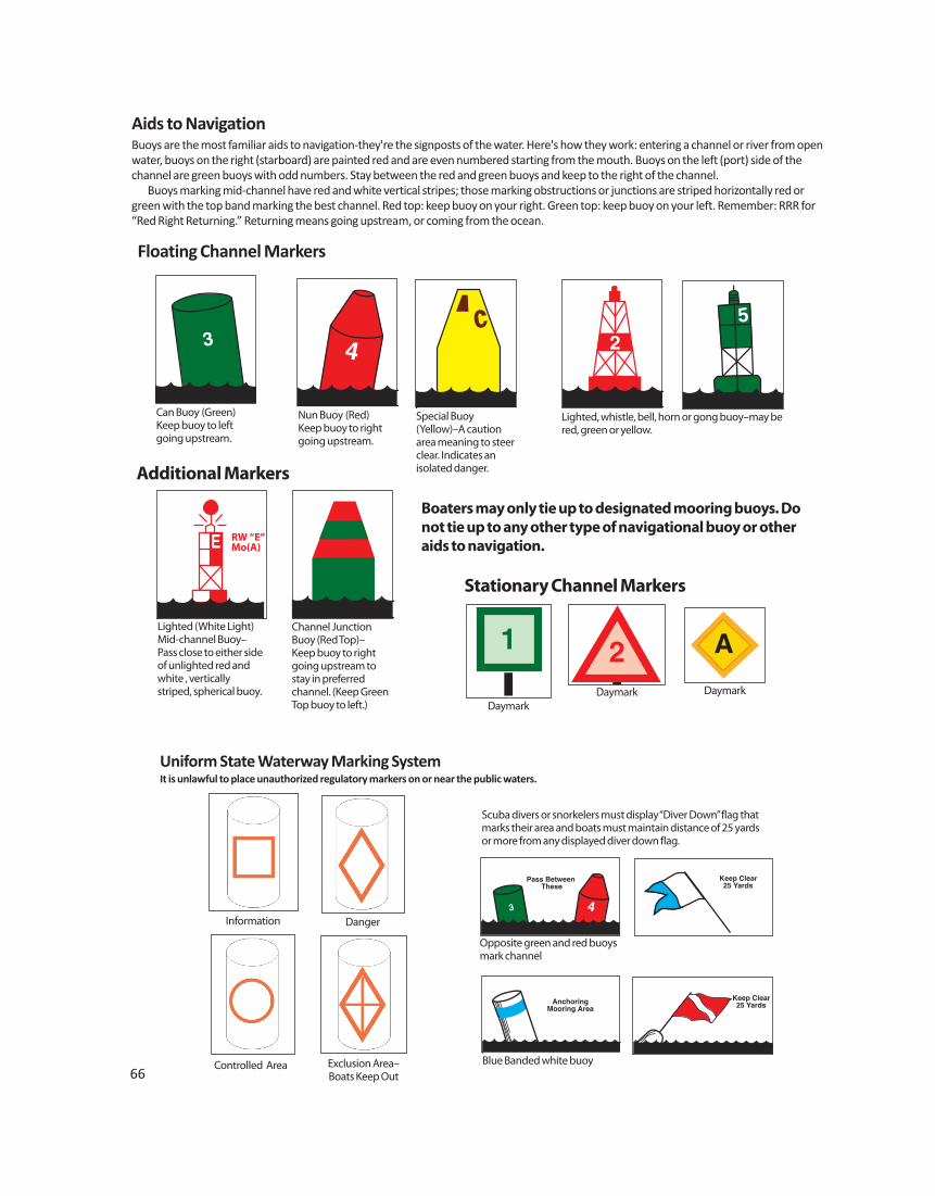
66Controlled Area
Information Danger
Exclusion Area–Boats Keep Out
Aids to NavigationBuoys are the most familiar aids to navigation-they're the signposts of the water. Here's how they work: entering a channel or river from openwater, buoys on the right (starboard) are painted red and are even numbered starting from the mouth. Buoys on the left (port) side of thechannel are green buoys with odd numbers. Stay between the red and green buoys and keep to the right of the channel. Buoys marking mid-channel have red and white vertical stripes; those marking obstructions or junctions are striped horizontally red orgreen with the top band marking the best channel. Red top: keep buoy on your right. Green top: keep buoy on your left. Remember: RRR for“Red Right Returning.” Returning means going upstream, or coming from the ocean.
Floating Channel Markers
3
Can Buoy (Green)Keep buoy to leftgoing upstream.
Nun Buoy (Red)Keep buoy to rightgoing upstream.
Special Buoy (Yellow)–A cautionarea meaning to steerclear. Indicates an isolated danger.
Lighted, whistle, bell, horn or gong buoy–may bered, green or yellow.
RW “E”Mo(A)
AnchoringMooring Area
Keep Clear25 Yards
Pass Between These
Keep Clear25 Yards
Scuba divers or snorkelers must display “Diver Down” flag thatmarks their area and boats must maintain distance of 25 yardsor more from any displayed diver down flag.
Uniform State Waterway Marking SystemIt is unlawful to place unauthorized regulatory markers on or near the public waters.
Lighted (White Light)Mid-channel Buoy–Pass close to either sideof unlighted red andwhite , verticallystriped, spherical buoy.
Channel JunctionBuoy (Red Top)–Keep buoy to rightgoing upstream tostay in preferredchannel. (Keep GreenTop buoy to left.)
Blue Banded white buoy
Opposite green and red buoysmark channel
DaymarkDaymark Daymark
Additional Markers
Stationary Channel Markers
Boaters may only tie up to designated mooring buoys. Donot tie up to any other type of navigational buoy or otheraids to navigation.
67
Right Side = Starboard Left Side = Port
Head-on (bow to bow) When two power-driven vessels are meetinghead-on or nearly head-on, each shall alterher course to starboard (right) so that eachshall pass on the port side of the other. Ahead-on situation exists when a vessel seesthe other ahead or nearly ahead and bynight she could see the masthead lights ofthe other in a line or nearly in a line or bothsidelights.
Giveway and Stand-on Vessels Give-way and Stand-on is the terminologyused to describe the appropriate action of each vessel in crossing and passing situations. The “give-way” vessel is the vessel thatmust take early and substantial action tokeep well clear of another vessel. The “stand-on” vessel shall maintaincourse and speed unless it becomes appar-ent that the vessel required to keep out ofthe way (the “give-way” vessel) is not takingthe appropriate action. If the stand-on vesselmust take action to avoid a collision, it mustavoid turning to port for a vessel on her portside. An action taken to avoid a collision needsto be positive, made in ample time and largeenough to be apparent to the other vessel. Ifnecessary to avoid a collision or allow moretime to assess the situation, a vessel mustslacken her speed or take all way off by stop-ping or reversing engines. In crossing situations, power boats mustgive-way to sailing vessels under sail regard-
less of the angle the power-driven vesselapproaches the sailing vessel.
Crossing When two power-driven vessels are cross-ing, the vessel which has the other on herstarboard side shall give way and keep out ofthe way and avoid crossing ahead (in front)of the other vessel. When taking action to stay out of the
way, make it early, substantial and well clearof the other boat. Avoid making a successionof small alterations of course or speed. If youare directed by the Rules to stay out of theway, then make your turn large and obviousso as to be readily apparent to another ves-sel both visually or by radar. This is especiallytrue at night, when the only visual indicationof your course change is the alteration ofyour boat’s lights.
Overtaking Any vessel overtaking any other shall give-way and keep out of the way of the vesselbeing overtaken. When a vessel is in any doubt as towhether it is overtaking another, it shallassume that this is the case and act accord-ingly. If you are being overtaken (passed), youare the stand-on vessel and should maintainyour course and speed. The vessel over -taking you should notify an intent to pass bymaking an appropriate sound signal. Oneshort blast of the horn or whistle means “Iintend to overtake you on your starboardside” and 2-short blasts means “I intend toovertake you on your port side”.
When two sailing vessels are approachingone another in a crossing situation, one of
them shall keep out of the way of the otheras follows:• When each has the wind on a different
side, the vessel which has the wind onthe port side shall keep out of the way ofthe other;
• When both have the wind on the sameside, the vessel which is to windwardshall keep out of the way of the vesselwhich is to leeward; and
• If a vessel with the wind on the port sidesees a vessel to windward and cannotdetermine with certainty whether theother vessel has the wind on the port oron the starboard side, she shall keep outof the way of the other.
Windward side is deemed to be the sideopposite to that on which the main-sail iscarried.
Responsibility Between VesselsExcept where otherwise required:
A power-driven vessel shall keep out ofthe way of: • A vessel not under command • A vessel restricted in her ability to maneuver, such as a tug boat or deep- draft freighter • A vessel engaged in commercial fishing • A sailing vessel
A sailing vessel shall keep out of the wayof: • A vessel not under command • A vessel restricted in her ability to maneuver, such as a tug boat or deep- draft freighter • A vessel engaged in commercial fishing
DANGER ZONE
50’ Rule*
50’ Rule
CROSSING SITUATION
Stand-On vesselholds courseand speed
GIVE-WAY vessel alters course
1 short blast**
1 short blast**
StarboardPort
OVERTAKING SITUATION
GIVE-WAYvessel
overtaking
STAND-ONvessel holds
courseand speed
Inland Rules
I want to go around you on yourport side - 2 short blasts**
Proceed2 short blasts**
Inland RulesI want to go aroundyour on your starboardside - 1 short blast*
50’ Rule*
50’ Rule*
Proceed1 short blast**
MEETING (HEAD-ON) SITUATIONS
1 short blast**
50’ Rule*
1 short blast**
2 short blasts**
50’ Rule*
2 short blasts**
1 short blast**
50’ Rule
1 short blast**
* A PWC must slow to no wake speed if within 50’ of a motorboat
SOUND SIGNALS
Short blast=a blast of about one second’s duration3 short blasts indicates a motorboat operating astern propulsion5 short blasts is the danger signal** Not sounded on international waters
Meeting Head to Head
PassingStarboard toStarboard
Passing Port to Port
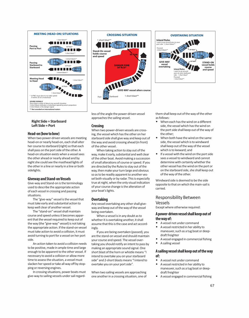
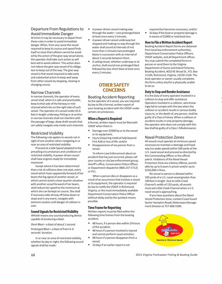
68
Departure From Regulations toAvoid Immediate Danger At times it may be necessary to depart fromthese rules in order to avoid immediate danger. When, from any cause the vesselrequired to keep its course and speed findsitself so close that collision cannot be avoid-ed by the action of the give-way vessel alone,the operator shall take such action as willbest aid to avoid collision. This action doesnot relieve the give-way vessel of its obliga-tion to keep out of the way. The give-wayvessel is that vessel required to take earlyand substantial action to keep well awayfrom other vessels by stopping, slowing orchanging course.
Narrow ChannelsIn narrow channels, the operator of everyvessel shall, when it is safe and practicable,keep to that side of the fairway or mid-channel which lies on the right side of suchvessel. The operator of a vessel under 65.6feet in length underway, fishing or at anchorin narrow channels shall not interfere withthe passage of large, deep-draft vessels thatcan safely navigate only inside such channels.
Restricted Visibility The following rule applies to vessels not insight of one another when navigating in ornear an area of restricted visibility: Proceed at a Safe Speed adapted to theprevailing circumstances and conditions ofrestricted visibility. A power-driven vesselshall have engines ready for immediatemaneuver. Except where it has been determinedthat a risk of collisions does not exist, everyvessel which hears apparently forward of herbeam the fog signal of another vessel, orwhich cannot avoid a close-quarter situationwith another vessel forward of her beam,shall reduce her speed to the minimum atwhich she can be kept on course. She shall if necessary take all way off (slow down orstop) and in any event, navigate withextreme caution until danger of collision isover.
Sound Signals for Restricted VisibilityWhistle means any sound producing devicecapable of producing a blast.
Short Blast = a blast of about 1 second.
Prolonged Blast = a blast of from 4–6 seconds’ duration.
In or near an area of restricted visibility,whether by day or night, the following soundsignals shall be made:
• A power-driven vessel making waythrough the water—one prolonged blastat least once every 2 minutes.
• A power-driven vessel underway butstopped and making no way through thewater shall sound at intervals of notmore than 2 minutes two prolongedblasts in succession with an interval ofabout 2 seconds between them.
• A sailing vessel, whether underway or atanchor, shall sound one-prolonged blastfollowed by two-short blast at least onceevery 2 minutes.
OTHER SAFETY CONCERNS
Boating Accident ReportingAs the operator of a vessel, you are requiredby law to file a formal, written report of your boating accident with the VDGIF undercertain circumstances.
When a Report is RequiredA formal, written report must be filed withVDGIF when there is:
• Damage over $2000 by or to the vesselor its equipment;
• Injury (requiring medical help beyondFirst Aid) or loss of life; and/or
• Disappearance of any person from a vessel.
To inform Law Enforcement about anaccident that has just occurred, please callyour county or city law enforcement group,sheriff’s office, Conservation Police Officer,or Department dispatcher (800-237-5712)or 911.
When a person dies or disappears as aresult of an occurrence that involves a vesselor its equipment, the operator is required by law to notify the VDGIF in Richmond, Virginia, or the most immediately availableDepartment Conservation Police Officerwithout delay and by the quickest meanspossible.
Time Frame for ReportingWritten reports must be filed within the following time frames from the boating accident:
• 48 hours, if a person dies within 24 hoursof the accident;
• 48 hours if a person involved is injuredand cannot perform usual activities;
• 48 hours if a person disappears from avessel;
• 10 days if an earlier report is not
2015 Virginia Freshwater Fishing & Boating Guide
Operate at Minimum Speed
KEEP OUT!
500Yards
100Yards
required but becomes necessary; and/or• 10 days if the boat or property damage is
in excess of $2000 or total boat loss.
How to File a Written Accident ReportBoating Accident Report forms are obtainedfrom local law enforcement authorities,Department Conservation Police Officers,VDGIF website, and all Department offices.You may submit the completed forms in person or send them to the Virginia Department of Game and Inland Fisheries,Boating Accident, 4010 W. Broad St., P.O. Box11104, Richmond, Virginia, 23230-1104. Theboat operator or owner usually completesthe form unless she/he is physically unableto do so.
Duty to Stop and Render AssistanceIt is the duty of every operator involved in acollision to stop and offer assistance. Operators involved in a collision, who know-ingly fail to comply with this law when thecollision or accident results in serious bodilyinjury to, or the death of, any person, shall beguilty of a Class 6 Felony. When a collision oraccident results in only property damage,the operator who does not comply with thislaw shall be guilty of a Class 1 Misdemeanor.
Naval Protection ZonesAll vessels must operate at minimum speednecessary to maintain a steerage and head-way (no wake speed) within 500 yards of theU.S. naval vessel and proceed as directed bythe Commanding Officer or the officialpatrol. Violations of the Naval Vessel Protection Zone are a felony offense, punish-able by up to 6 years in prison and/or up to$250,000 in fines. No vessel or person is allowed within100 yards of a U.S. naval vessel greater than100 feet in length. Due to Little Creek Channel’s width of 150 yards, all vesselsmust exit Little Creek Channel when a U.S.naval vessel is approaching. If you have questions about the NavelVessel Protection Zone, contact Coast GuardSector Hampton Roads Waterways Manage-ment Division at 757-668-5580.
69
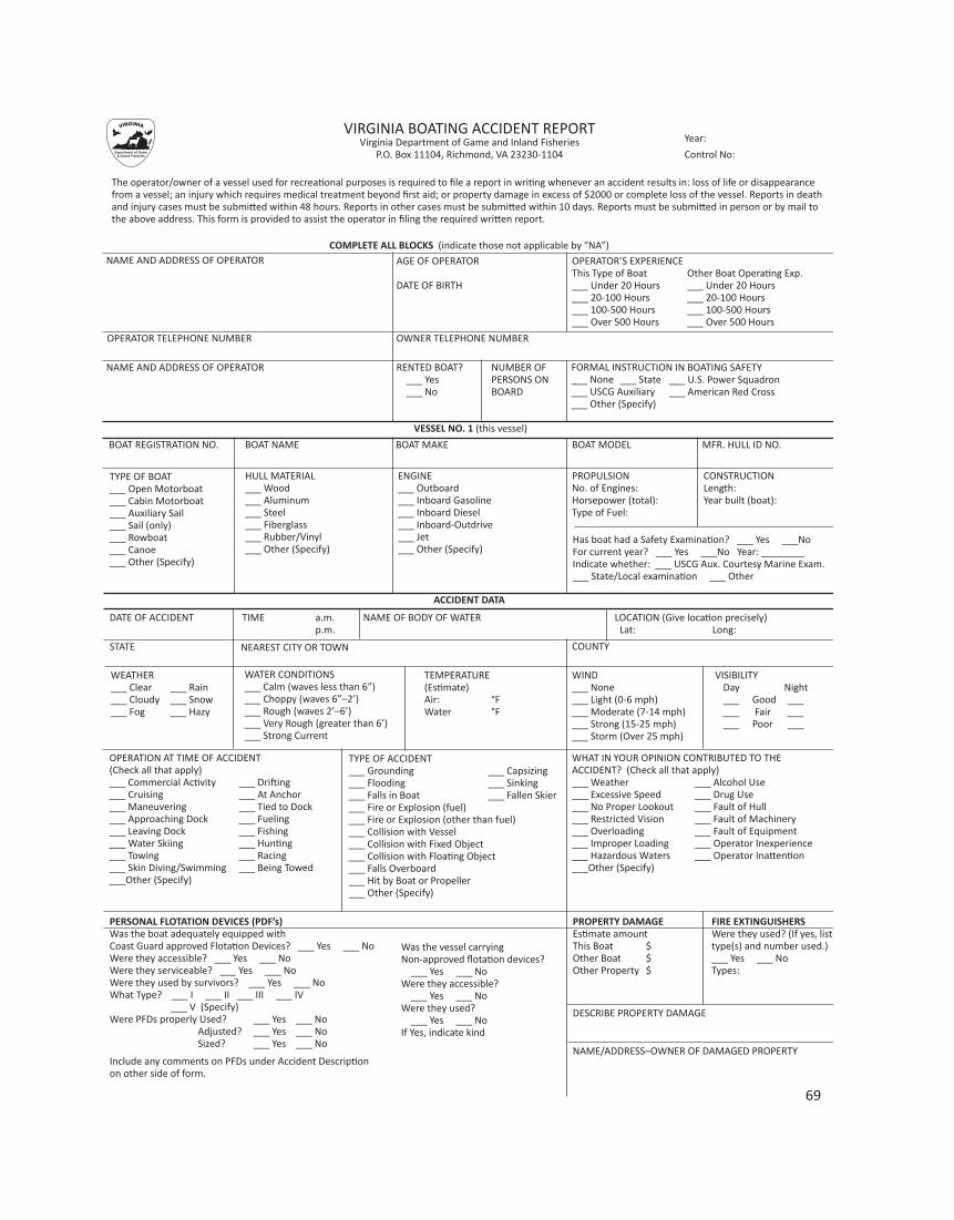
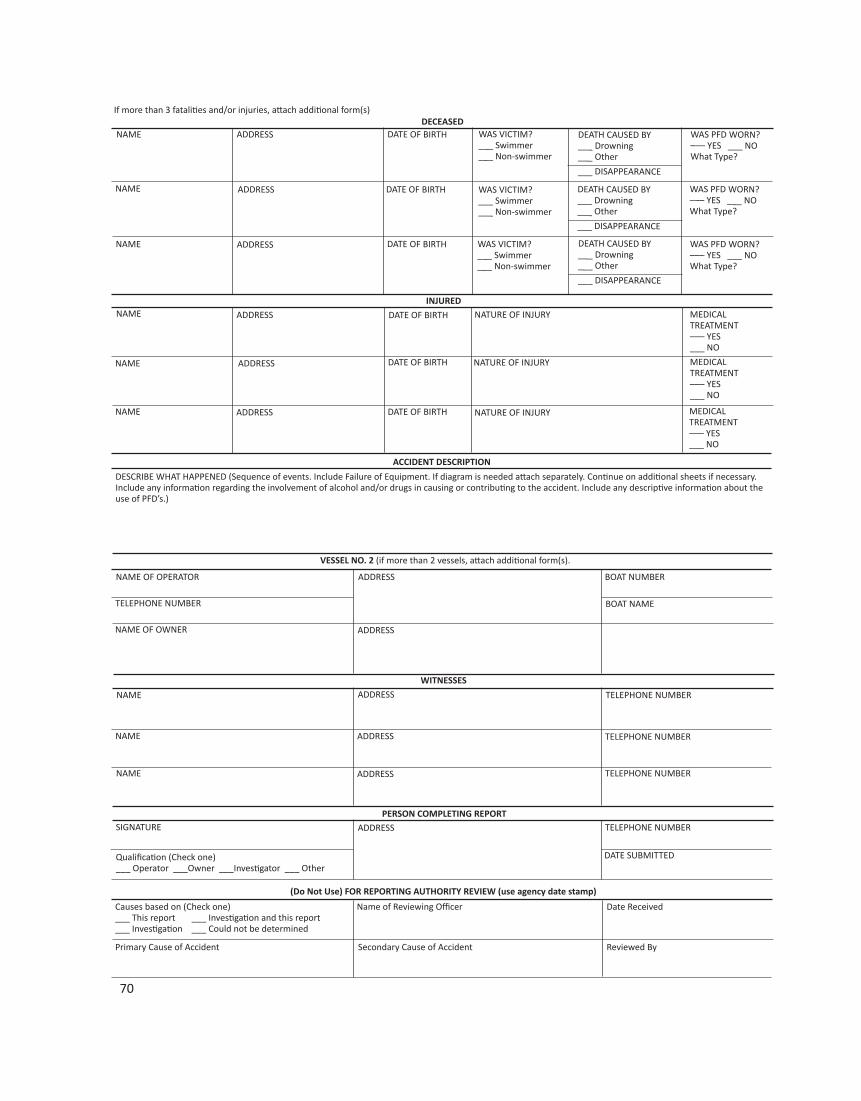
70
71
America’s Waterway WatchAmerica’s coasts, rivers, bridges, tunnels,ports, ships, military bases, and watersideindustries may be the terrorists’ next targets. If you see outwardly suspicious activity,or even behavior that makes you uneasy,please report it. Here are things to look for:
• Unattended vessels or vehicles in unusual locations. • Unusual night operations. • Recovering or tossing items into/onto the
waterway or shoreline. • Operating in or passing through an area
that does not typically have such activity. • Missing fencing or lighting near sensitive
locations. • Transfer of people or items between vessels, or between vessels and the shore outside of a port. • Anyone operating in an aggressive manner. • Small planes flying over critical locations. • Persons attempting to buy or rent fishing
or recreational vessels with cash forshort-term, undefined use.
• Other suspicious activity.
Call the National Response Center at 877-24WATCH or 911 to report suspicious activity.
Boat Theft PreventionWhen Buying a Boat• Be careful because it could be stolen.• Be certain that the boat’s description on the title matches the boat you are buying. Check year, make, length, and hull identification number.• Be sure the model and serial number on an outboard motor have not been removed, tampered with or altered.• Be suspicious of a fresh paint job on a late model vessel.• When buying a used vessel, try to deal
with a reputable marine dealer or a broker licensed by the state.• If the price seems too good to be true,
there is a good chance that the boat isstolen.
Equipment Identification• Mark all equipment when purchased. • If your boat was built before 1972, it may
not have a hull identification number.• It is a good idea to inscribe that registra-
tion number onto some unexposed location on the interior of your boat. • Document boat contents.• Store gear/electronics when not in use.
Trailerable BoatsStealing a boat is much easier if a thief canhitch up to your boat on a trailer and driveaway. These tips may help.
• If possible, store the boat and trailer in alocked garage.
• Store boats in the back or side yard out ofsight.
• Store the boat with the trailer tongue noteasily accessible.
• Park another vehicle or other large object in front of the trailer.• Remove one trailer wheel.• Purchase a good quality trailer hitch lock
and use it—even if stored inside.
Vessel SecurityThere are several things that can be done toreduce the risk of vessel theft.
• Lock Marine Hatch.• Lock the Forward Hatch.• Lock Windows.
Report It If your boat, trailer, or gear is missing, report it immediately to the followinggroups. Use your written and photographicmarine record to give specific and completeinformation.
• Local law enforcement agencies.• Your insurance company.• Department of Game and Inland Fisheries.• The dock or harbormaster.• Neighboring boaters.• Local newspapers.
Carbon MonoxideCarbon monoxide is an odorless, colorless,tasteless gas that can be toxic in small quan-tities. It is produced by engines, generators,grills, and other equipment commonly usedby boaters. Every year people who recreateon and around boats are overcome by theeffects of carbon monoxide. Recreational boaters need to be awareof carbon monoxide poisoning preventionpractices such as regular professional boatinspections; the installation and mainte-nance of carbon dioxide detectors in livingspaces; the hazards of “platform dragging;
exhaust leaks from CO sources, specific boatdesign features of concern (especially house-boats); and the danger of swimming near thestern of the watercraft while generators,engines or other carbon monoxide produc-ing equipment is in operation.
Capsizings and Falls OverboardCapsizings and falls overboard are the leading cause of fatal boating incidents. Tohelp lessen the chance of capsizing or fallingoverboard, follow these basic safety tips:
• Always wear your life jacket.• Stay low in the boat and maintain 3
points of contact. Keep 2 feet and 1 hand,or 2 hands and 1 foot in contact with theboat at all times. If seated, you have onepoint of contact on the seat, and stillneed to maintain 2 others—such as 1foot, 1 hand, 2 feet, etc.
• When loading supplies into a boat, haveone person get into the boat and thenhand that person the supplies.
• If retrieving an item from the water, maneuver the boat close to the object and use a boathook or paddle. If you do need to reach outside the hull of the boat, keep 3-points of contact.• Keep an even, balanced load.• Do not attach the anchor line to the stern
of the boat.• When pulling up the anchor, stay low in
the boat and well balanced.• If in rough waters, head the bow of the
boat anywhere from directly into theseas up to a 45 degree angle dependingon sea state and vessel construction.
• Follow the information stated on the “Capacity Plate.” Never exceed the allowable weight, horsepower rating, or maximum number of people.
ENJOYING THE WATERTowed Sports SafetyThe boating law contains several provisionsrelating to the towing of persons on waterskis, aquaplanes, and similar devices, and themanipulation of such devices by the person being towed.
1. All boats towing a water skier(s) or otherpersons on towed devices MUST haveONE of the following:
a. Persons being towed must be wearinga USCG approved life jacket or
b. There must be an observer on the boat(in addition to the operator) who is in aposition to observe the progress of theskier.
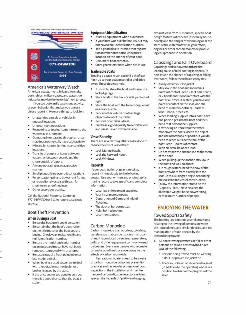
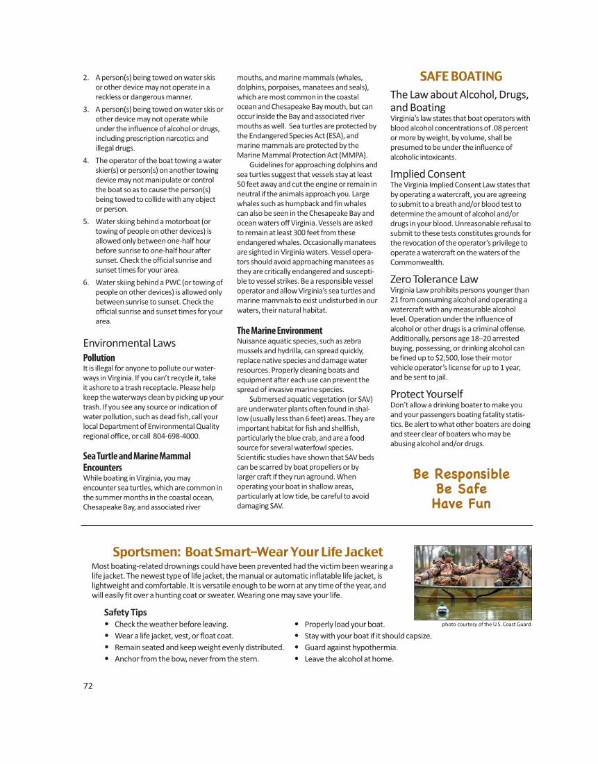
72
Sportsmen: Boat Smart–Wear Your Life JacketMost boating-related drownings could have been prevented had the victim been wearing alife jacket. The newest type of life jacket, the manual or automatic inflatable life jacket, is lightweight and comfortable. It is versatile enough to be worn at any time of the year, and will easily fit over a hunting coat or sweater. Wearing one may save your life.
Safety Tips• Check the weather before leaving.• Wear a life jacket, vest, or float coat.• Remain seated and keep weight evenly distributed.• Anchor from the bow, never from the stern.
• Properly load your boat.• Stay with your boat if it should capsize.• Guard against hypothermia.• Leave the alcohol at home.
photo courtesy of the U.S. Coast Guard
2. A person(s) being towed on water skis or other device may not operate in a reckless or dangerous manner.
3. A person(s) being towed on water skis orother device may not operate whileunder the influence of alcohol or drugs,including prescription narcotics and
illegal drugs.
4. The operator of the boat towing a waterskier(s) or person(s) on another towingdevice may not manipulate or controlthe boat so as to cause the person(s)being towed to collide with any object
or person.
5. Water skiing behind a motorboat (ortowing of people on other devices) isallowed only between one-half hourbefore sunrise to one-half hour aftersunset. Check the official sunrise andsunset times for your area.
6. Water skiing behind a PWC (or towing ofpeople on other devices) is allowed onlybetween sunrise to sunset. Check theofficial sunrise and sunset times for yourarea.
Environmental LawsPollutionIt is illegal for anyone to pollute our water-ways in Virginia. If you can’t recycle it, take it ashore to a trash receptacle. Please helpkeep the waterways clean by picking up yourtrash. If you see any source or indication ofwater pollution, such as dead fish, call yourlocal Department of Environmental Qualityregional office, or call 804-698-4000.
Sea Turtle and Marine Mammal EncountersWhile boating in Virginia, you mayencounter sea turtles, which are common inthe summer months in the coastal ocean,Chesapeake Bay, and associated river
mouths, and marine mammals (whales, dolphins, porpoises, manatees and seals),which are most common in the coastalocean and Chesapeake Bay mouth, but canoccur inside the Bay and associated rivermouths as well. Sea turtles are protected bythe Endangered Species Act (ESA), andmarine mammals are protected by theMarine Mammal Protection Act (MMPA). Guidelines for approaching dolphins andsea turtles suggest that vessels stay at least50 feet away and cut the engine or remain inneutral if the animals approach you. Largewhales such as humpback and fin whalescan also be seen in the Chesapeake Bay andocean waters off Virginia. Vessels are askedto remain at least 300 feet from theseendangered whales. Occasionally manateesare sighted in Virginia waters. Vessel opera-tors should avoid approaching manatees asthey are critically endangered and suscepti-ble to vessel strikes. Be a responsible vesseloperator and allow Virginia’s sea turtles andmarine mammals to exist undisturbed in ourwaters, their natural habitat.
The Marine EnvironmentNuisance aquatic species, such as zebramussels and hydrilla, can spread quickly,replace native species and damage waterresources. Properly cleaning boats andequipment after each use can prevent thespread of invasive marine species. Submersed aquatic vegetation (or SAV)are underwater plants often found in shal-low (usually less than 6 feet) areas. They areimportant habitat for fish and shellfish, particularly the blue crab, and are a foodsource for several waterfowl species. Scientific studies have shown that SAV bedscan be scarred by boat propellers or by larger craft if they run aground. When operating your boat in shallow areas, particularly at low tide, be careful to avoiddamaging SAV.
SAFE BOATINGThe Law about Alcohol, Drugs,and BoatingVirginia’s law states that boat operators withblood alcohol concentrations of .08 percentor more by weight, by volume, shall be presumed to be under the influence of alcoholic intoxicants.
Implied ConsentThe Virginia Implied Consent Law states thatby operating a watercraft, you are agreeingto submit to a breath and/or blood test todetermine the amount of alcohol and/ordrugs in your blood. Unreasonable refusal tosubmit to these tests constitutes grounds forthe revocation of the operator’s privilege tooperate a watercraft on the waters of theCommonwealth.
Zero Tolerance LawVirginia Law prohibits persons younger than21 from consuming alcohol and operating awatercraft with any measurable alcohollevel. Operation under the influence of alcohol or other drugs is a criminal offense.Additionally, persons age 18–20 arrestedbuying, possessing, or drinking alcohol canbe fined up to $2,500, lose their motor vehicle operator’s license for up to 1 year,and be sent to jail.
Protect YourselfDon’t allow a drinking boater to make youand your passengers boating fatality statis-tics. Be alert to what other boaters are doingand steer clear of boaters who may be abusing alcohol and/or drugs.
Be ResponsibleBe Safe Have Fun
www.HuntFishVA.com 73
VDGIF BOAT RAMPS AND ACCESS POINTSVDGIF-managed public boat access facilities are to be used for parking vehicles/trailers while boating and fishing, and are provided for this pur-pose only. Camping, Swimming, Sunbathing, Loitering, or any other use of the property, other than launching or retrieving boats and/or fishing is prohibited and considered trespassing. Public display of alcoholic beverages is prohibited. PWC staging on, or adjacent to, the boat ramp is prohibited. Littering, Dumping and Destruction of State Property Laws will be strictly enforced on these properties. Maps and driving directions may not work for all locations. Map information provided through Google is intended for planning purposes only.You may find that construction projects, traffic conditions, or other events may differ from the map results. Remember to check a boat landing’s status before visiting! www.dgif.virginia.gov/boating/access
Key: ( ) = miles R = Right L = Left Types of Access: R = Concrete RS = Shallow Water BS = Boat Slide SA = Shoreline Access GA=Gravel Access RH=Concrete, Hand Carry
Barrier TypeCounty/City Body Of Water Access Area Free? of # Location Access Accomack Messongo Creek Hammock N R 1 From Temperanceville. Rt 13 Turn W. Rt 695 (9.5), Turn S. Rt 788 (1 Mi.)
Accomack Pungoteague Creek Harborton Y R 2 From Pungoteague, West On Rt.180 (3) To Harborton. Access At End Of Rt. 180
Accomack Queen Sound Channel Queens Sound No R 1 On Rt 175 to Chincoteague from Wallop Station, * Very limited parking
Albemarle Beaver Creek Lake Beaver Creek Lake No R 1 From Charlottesville, Rt 250 West (.7); R on Rt 680 to Lake
Albemarle Albemarle Lake Lake Albemarle Yes R 1 From Charlottesville, Rt 601 West (4.7); L on 676 (1.1); R on Rt 614 (3.8); L on Rt 675(2.7)
Albemarle James River Scottsville Yes R 1 Town of Scottsville, Ferry Street
Alleghany Jackson River Clifton Forge Yes 1 From Br. 220 Town of Clifton Forge, south of river, turn west on Verge St.–Follow to site on right.
Alleghany Jackson River Island Ford II No SA 0 From Covington, E. on Rt. 1104 (2 mi. on right)
Alleghany Lake Moomaw Lake Moomaw Yes R 1 From Covington, Rt 60 West (4); R on Rt 600 (9.5) (Coles Point)
Alleghany Jackson River Low Moor No SA 0 From Low Moor exit (I64), N. 100 yds, E., on Rt. 1101, Follow Signs to Access
Amelia Amelia County Lake Amelia Lake (WMA) Yes R 1 From Rt 360, Rt 604 North (4.9);L on Rt 616 (1.4); R on Rt 652 (.9) to WMA
Amherst Mill Creek Reservoir Mill Creek Yes R 1 From Amherst, Northwest on Rt 645 (9.5)
Amherst James River Snowden No R 1 From Snowden, Rt 501/130 East cross over Rocky Roe Run (1)
Amherst Stonehouse Lake Stone House Creek No R 1 From Amherst west, Rt 60 West (6); R on 778 (2.4); L on Rt 610 (.3); R on Rt 625 (.3); L
Lake Limit Anna unlimited Back Bay unlimited Bannister unlimited Briery Creek 10 hp Buggs Island unlimited Burnt Mills 12 hp Chesdin unlimited Chickahominy unlimited Claytor unlimited Cohoon 10 hp Drummond 25 hp
Lake Limit Emporia 10 hp Ft. Pickett Lakes 35 hp Flannagan unlimited Gaston unlimited Harrison 5 hp Kilby 10 hp Leesville unlimited Lunga 10 hp Meade 10 HP Moomaw unlimited North Fork Pound unlimited
LAKE HORSEPOWER LIMITSNote: While some lakes have unlimited horsepower, they may have speed limits. Most lakes not listed are ‘Electric Motors Only,’but a few small city or county lakes have ‘No Boat’ regulations. Check local regulations.
Lake Limit Nottoway 10 hp Occoquan 10 hp Philpott unlimited Prince 12 hp Sandy River 10 hp Smith [Virginia Beach] 12 hp Smith Mountain unlimited Speight’s Run 10 hp South Holston unlimited Western Branch 12 hp
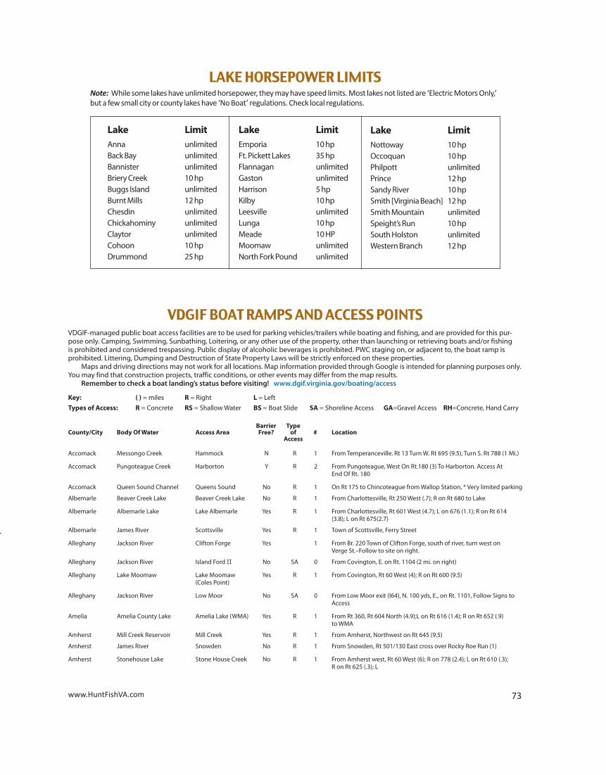
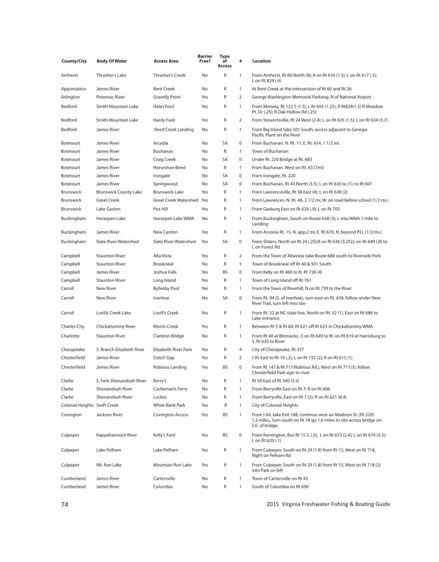
Amherst Thrasher’s Lake Thrasher’s Creek No R 1 From Amherst, Rt 60 North (8); R on Rt 610 (1.5); L on Rt 617 (.5); L on Rt 829 (.4)
Appomattox James River Bent Creek No R 1 At Bent Creek at the intersection of Rt 60 and Rt 26
Arlington Potomac River Gravelly Point Yes R 2 George Washington Memorial Parkway, N of National Airport
Bedford Smith Mountain Lake Hales Ford Yes R 1 From Moneta, Rt 122 S (1.5), L Rt 695 (1.25), R Rt828(1.5) R Meadow Pt. Dr (.25); R Oak Hollow Rd (.25)
Bedford Smith Mountain Lake Hardy Ford Yes R 2 From Stewertsville, Rt 24 West (2.4); L on Rt 635 (1.5); L on Rt 634 (3.7)
Bedford James River Reed Creek Landing No R 1 From Big Island take 501 South, access adjacent to Georgia Pacific Plant on the River
Botetourt James River Arcadia No SA 0 From Buchanan, N. Rt. 11, E. Rt. 614, 1 1/2 mi.
Botetourt James River Buchanan No R 1 Town of Buchanan
Botetourt James River Craig Creek No SA 0 Under Rt. 220 Bridge at Rt. 683
Botetourt James River Horseshoe Bend No R 1 From Buchanan. West on Rt. 43 (7mi)
Botetourt James River Irongate No SA 0 From Irongate, Rt. 220
Botetourt James River Springwood No SA 0 From Buchanan, Rt 43 North (3.5); L on Rt 630 to (1); to Rt 601
Brunswick Brunswick County Lake Brunswick Lake Yes R 1 From Lawrenceville, Rt 58 East (4); L on Rt 638 (2)
Brunswick Great Creek Great Creek Watershed Yes R 1 From Lawrencev. N. Rt. 46, 2 1/2 mi, W. on road before school (1/2 mi.) Brunswick Lake Gaston Pea Hill Yes R 1 From Gasburg East on Rt 626 (.9); L on Rt 705
Buckingham Horsepen Lake Horsepen Lake WMA No R 1 From Buckingham, South on Route 638 (3); L into WMA 1 mile to Landing
Buckingham James River New Canton Yes R 1 From Arvonia Rt. 15, N. app.2 mi, E. Rt 670, N. beyond P.O. (1/2/mi.)
Buckingham Slate River Watershed Slate River Watershed Yes SA 0 From Sliders, North on Rt 24 (.25);R on Rt 636 (3.25);L on Rt 640 (.8) to L on Forest Rd Campbell Staunton River Alta Vista Yes R 2 From the Town of Altavista take Route 688 south to Riverside Park
Campbell Staunton River Brookneal No R 1 Town of Brookneal off Rt 40 & 501 South
Campbell James River Joshua Falls Yes BS 0 From Kelly on Rt 460 to N. Rt 726 (4)
Campbell Staunton River Long Island Yes R 1 Town of Long Island off Rt 761
Carroll New River Byllesby Pool Yes R 1 From the Town of Riverhill, N on Rt 739 to the River
Carroll New River Ivanhoe No SA 0 From Rt. 94 (S. of Ivanhoe), turn east on Rt. 658, follow under New River Trail, turn left into site
Carroll Lovills Creek Lake Lovill’s Creek Yes R 1 From Rt. 52 at NC state line, North on Rt. 52 (1), East on Rt 686 to Lake entrance
Charles City Chickahominy River Morris Creek Yes R 1 Between Rt 5 & Rt 60; Rt 621 off Rt 623 in Chickahominy WMA
Charlotte Staunton River Clarkton Bridge No R 1 From Rt 40 at Womacks , S on Rt 649 to W. on Rt 619 at Harrisburg to S. Rt 620 to River
Chesapeake S. Branch Elizabeth River Elizabeth River Park Yes R 4 City of Chesapeake, Rt 337
Chesterfield James River Dutch Gap Yes R 2 I-95 East to Rt 10 (.2); L on Rt 732 (2); R on Rt 615 (1)
Chesterfield James River Robious Landing Yes BS 0 From Rt 147 & Rt 711(Robious Rd.), West on Rt 711(3), follow Chesterfield Park sign to river
Clarke S. Fork Shenandoah River Berry’s No R 1 Rt 50 East of Rt 340 (5.5)
Clarke Shenandoah River Castleman’s Ferry No R 1 From Berryville East on Rt 7; R on Rt 606
Clarke Shenandoah River Lockes No R 1 From Berryville, East on Rt 7 (3); R on Rt 621 (8.4)
Colonial Heights Swift Creek White Bank Park Yes R 1 City of Colonial Heights
Covington Jackson River Covington Access Yes BS 1 From I-64, take Exit 16B, continue west on Madison St. (Rt 220) 1.2 miles., turn south on Rt 18 go 1.6 miles to site across bridge on S.E. of bridge.
Culpeper Rappahannock River Kelly’s Ford Yes BS 0 From Remington, Bus Rt 15 S. (.5); L on Rt 673 (2.4); L on Rt 674 (3.3); L on Rt 620 (.1)
Culpeper Lake Pelham Lake Pelham Yes R 1 From Culpeper, South on Rt 29 (1.8) from Rt 15, West on Rt 718, Right on Pelham Rd
Culpeper Mt. Run Lake Mountain Run Lake Yes R 1 From Culpeper, South on Rt 29 (1.8) from Rt 15, West on Rt 718 (2) into Park on left
Cumberland James River Cartersville No R 1 Town of Cartersville on Rt 45
Cumberland James River Columbia No R 1 South of Columbia on Rt 690
74 2015 Virginia Freshwater Fishing & Boating Guide
Barrier TypeCounty/City Body Of Water Access Area Free? of # Location Access
www.HuntFishVA.com 75
Dinwiddie Lake Chesdin Lake Chesdin Yes R 2 From Petersburg, Rt 460 W(.4); R on Rt 226 (.2); R on Rt 600 (.9); L on Rt 601(3.5); R on Rt 776 (.6)
Emporia Meherrin Reservoir Emporia No R 1 From Rt 58 in Emporia; Rt 619 South 1 mile
Emporia Meherrin River Farmers Market Access Yes BS 1 On Main St., south of river, east of Main Street at Farmers Market
Emporia Meherrin River Meherrin Park Yes R 1 In Emporia, Off of Route 301, East on Hicksford Ave. into Meherrin Park Road, follow to end
Essex Hoskin’s Creek Hoskin’s Creek No R 1 Town of Tappahannock, Rt T-1002 (Dock Street)
Fairfax Burke Lake Lake Burke Yes R 1 From City of Fairfax, Rt 123 South
Fauquier Lake Brittle Lake Brittle Yes R 1 From New Baltimore Rt15 East (.3); R on Rt 600 (1.5); R on Rt 793 (1.2); R on Rt 825 (.3)
Fluvanna Rivanna River Crofton No R 1 From Zion Crossroads, Rt 15 South (4); R on Rt 616 (2.1); L on Rt 600 (1.5)
Fluvanna James River Hardware River No RS 0 From Scottsville, Rt 6 East (6); R on Rt 646 (3.8)
Fluvanna Rivanna River Palmyra No SA 0 From Town of Palmyra, Rt 53
Fluvanna Fluvanna Ruritan Lake Ruritan Lake Yes R 1 From Town of Palmyra, Rt 53 (3); L on Rt 660 (.1); R on Rt 619 (3)
Franklin Blackwater River Blackwater Landing Yes R 2 Located just beyond the south end of Main St
Franklin Pigg River Lynch Mem. Park Yes BS 1 From S. Main St. (Rocky Mount), west on Scuffing Hill Rd. go 0.2 mi.– turn south on Old Fort Rd.–400’ to site on left.
Franklin Smith Mountain Lake Penhook #9 Yes R 2 From Penhook, Rt 660 North (.8); R on Rt 966 (1.4)
Franklin Smith Mountain Lake Scruggs #8 Yes R 1 From Moneta southwest on Rt 122 (7); L on Rt 616 (5.7); R on Rt 601 (2)
Franklin Pigg River Waid Rec. Area Yes BS 1 From Rt 40 (west of Rocky Mount), turn northwest on Six Mile Post Rd. go 1.8 mi.–turn south on Waid Park Rd. 0.9 mi. to site on right.
Frederick Wheatlands Lake Lake Frederick Yes R 1 On Rt 340 South (1) of Double Toll Gate
Fredericksburg Rappahannock River City Docks Yes R 2 City of Fredericksburg on Sophia Street
Giles New River Glen Lyn No R 1 Town of Glen Lyn on Rt 460
Giles New River Narrows Yes RS 0 North of Narrows on Rt 649
Giles New River Rich Creek No R 1 East of Rich Creek (.5) on Rt 460
Giles New River Snidow Park Landing Yes R 1 In the Town of Pembroke take Snidow Road (Rt 623) south to bridge, L into Snidow Park
Gloucester Piankatank River Deep Point Yes R 1 From Glenns, Rt 198 East (7.5); L on Rt 606 (1.5)
Gloucester York River Gloucester Point Yes R 2 Town of Gloucester Point, Rt 1208
Gloucester Porpoptank River Tanyard No R 1 From Gloucester, Rt 14 North (4.3); L on Rt 613 (3.3); R on Rt 610 (.6); L on Rt 617 (.5)
Gloucester Ware River Warehouse Yes R 1 East of Gloucester on Rt 621 (2)
Goochland James River West View Yes R 1 From Goochland, Rt 6 West (3.5); L on Rt 600 (4.8); R on Rt 643 (1.2)
Grayson New River Baywood No RS 0 From Independence, Rt 58 East (6)
Grayson New River Bridle Creek No R 1 From Independence, Rt 58 West (1.8); L on Rt 711 (3.9)
Grayson New River Independence No GA 0 From Independence, Rt 21 South to Rt 221 (3.2); L on Rt 700 (.5)
Grayson New River Mouth of Wilson No GA 0 East of Mouth of Wilson; Intersection Rt 58 & 93
Grayson New River Oldtown No GA 0 Rt 58 West; R on Rt 640 (Old Town Rd) (1); R on Rt 634 (1.3); L on Rt 641 (1.7)
Grayson New River Riverside No GA 0 Intersection of Rt 94 & Rt 274, South of Fries
Greensville Nottoway River Jarratt Yes R 1 From Jarratt, Rt 630 East (2.2) to Nottoway River; site on left
Greensville Nottoway River Purdy No R 1 From Jarratt, Rt 610 West (.7); R on Rt 608 (4.4); R on Rt 651 (1.2)
Halifax Staunton River Clover No R 1 From Clover, Rt 360 East (3.5)
Halifax Hyco River Hyco No R 1 From South Boston, Rt 58 East (8)
Halifax Connor Lake Lake Connor Yes R 1 From Clover, Rt 746 N (4); L on Rt 603 (2.6); R on Rt 619 (2.19); R on Rt 623 (1.3); R on Rt 624 (1.5)
Halifax Staunton River Watkins Bridge No R 1 From Clover, Rt 746 North (8.5)
Hampton Back River Fox Hill Yes R 3 North (1) of Fox Hill at end of Dandy Point Road
Hanover South Anna River Ground Squirrel Bridge Yes RH 0 From Rt. 33 at Farrington, Northwest on Rt. 33 (2.25) to access at river on right
Hanover Pamunkey River Little Page Bridge Yes BS 0 From Hanover, North on Rt 301 (2)
Barrier TypeCounty/City Body Of Water Access Area Free? of # Location Access
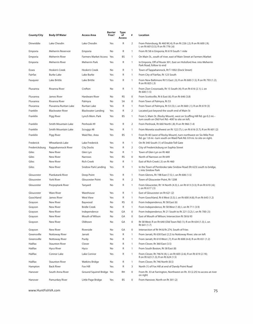
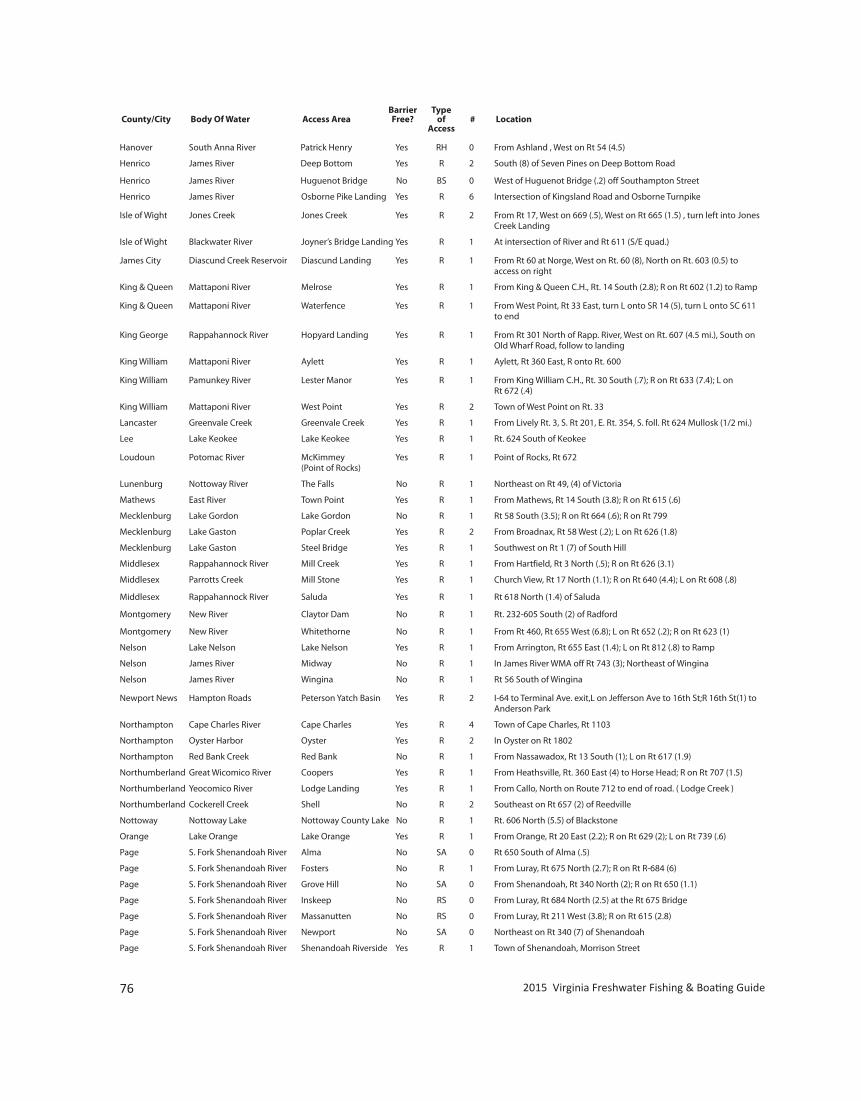
Hanover South Anna River Patrick Henry Yes RH 0 From Ashland , West on Rt 54 (4.5)
Henrico James River Deep Bottom Yes R 2 South (8) of Seven Pines on Deep Bottom Road Henrico James River Huguenot Bridge No BS 0 West of Huguenot Bridge (.2) off Southampton Street
Henrico James River Osborne Pike Landing Yes R 6 Intersection of Kingsland Road and Osborne Turnpike
Isle of Wight Jones Creek Jones Creek Yes R 2 From Rt 17, West on 669 (.5), West on Rt 665 (1.5) , turn left into Jones Creek Landing
Isle of Wight Blackwater River Joyner’s Bridge Landing Yes R 1 At intersection of River and Rt 611 (S/E quad.)
James City Diascund Creek Reservoir Diascund Landing Yes R 1 From Rt 60 at Norge, West on Rt. 60 (8), North on Rt. 603 (0.5) to access on right
King & Queen Mattaponi River Melrose Yes R 1 From King & Queen C.H., Rt. 14 South (2.8); R on Rt 602 (1.2) to Ramp
King & Queen Mattaponi River Waterfence Yes R 1 From West Point, Rt 33 East, turn L onto SR 14 (5), turn L onto SC 611 to end
King George Rappahannock River Hopyard Landing Yes R 1 From Rt 301 North of Rapp. River, West on Rt. 607 (4.5 mi.), South on Old Wharf Road, follow to landing
King William Mattaponi River Aylett Yes R 1 Aylett, Rt 360 East, R onto Rt. 600
King William Pamunkey River Lester Manor Yes R 1 From King William C.H., Rt. 30 South (.7); R on Rt 633 (7.4); L on Rt 672 (.4)
King William Mattaponi River West Point Yes R 2 Town of West Point on Rt. 33
Lancaster Greenvale Creek Greenvale Creek Yes R 1 From Lively Rt. 3, S. Rt 201, E. Rt. 354, S. foll. Rt 624 Mullosk (1/2 mi.)
Lee Lake Keokee Lake Keokee Yes R 1 Rt. 624 South of Keokee
Loudoun Potomac River McKimmey Yes R 1 Point of Rocks, Rt 672 (Point of Rocks)
Lunenburg Nottoway River The Falls No R 1 Northeast on Rt 49, (4) of Victoria
Mathews East River Town Point Yes R 1 From Mathews, Rt 14 South (3.8); R on Rt 615 (.6)
Mecklenburg Lake Gordon Lake Gordon No R 1 Rt 58 South (3.5); R on Rt 664 (.6); R on Rt 799
Mecklenburg Lake Gaston Poplar Creek Yes R 2 From Broadnax, Rt 58 West (.2); L on Rt 626 (1.8)
Mecklenburg Lake Gaston Steel Bridge Yes R 1 Southwest on Rt 1 (7) of South Hill
Middlesex Rappahannock River Mill Creek Yes R 1 From Hartfield, Rt 3 North (.5); R on Rt 626 (3.1)
Middlesex Parrotts Creek Mill Stone Yes R 1 Church View, Rt 17 North (1.1); R on Rt 640 (4.4); L on Rt 608 (.8)
Middlesex Rappahannock River Saluda Yes R 1 Rt 618 North (1.4) of Saluda Montgomery New River Claytor Dam No R 1 Rt. 232-605 South (2) of Radford Montgomery New River Whitethorne No R 1 From Rt 460, Rt 655 West (6.8); L on Rt 652 (.2); R on Rt 623 (1)
Nelson Lake Nelson Lake Nelson Yes R 1 From Arrington, Rt 655 East (1.4); L on Rt 812 (.8) to Ramp
Nelson James River Midway No R 1 In James River WMA off Rt 743 (3); Northeast of Wingina
Nelson James River Wingina No R 1 Rt 56 South of Wingina
Newport News Hampton Roads Peterson Yatch Basin Yes R 2 I-64 to Terminal Ave. exit,L on Jefferson Ave to 16th St;R 16th St(1) to Anderson Park
Northampton Cape Charles River Cape Charles Yes R 4 Town of Cape Charles, Rt 1103
Northampton Oyster Harbor Oyster Yes R 2 In Oyster on Rt 1802
Northampton Red Bank Creek Red Bank No R 1 From Nassawadox, Rt 13 South (1); L on Rt 617 (1.9)
Northumberland Great Wicomico River Coopers Yes R 1 From Heathsville, Rt. 360 East (4) to Horse Head; R on Rt 707 (1.5)
Northumberland Yeocomico River Lodge Landing Yes R 1 From Callo, North on Route 712 to end of road. ( Lodge Creek )
Northumberland Cockerell Creek Shell No R 2 Southeast on Rt 657 (2) of Reedville
Nottoway Nottoway Lake Nottoway County Lake No R 1 Rt. 606 North (5.5) of Blackstone
Orange Lake Orange Lake Orange Yes R 1 From Orange, Rt 20 East (2.2); R on Rt 629 (2); L on Rt 739 (.6)
Page S. Fork Shenandoah River Alma No SA 0 Rt 650 South of Alma (.5)
Page S. Fork Shenandoah River Fosters No R 1 From Luray, Rt 675 North (2.7); R on Rt R-684 (6)
Page S. Fork Shenandoah River Grove Hill No SA 0 From Shenandoah, Rt 340 North (2); R on Rt 650 (1.1)
Page S. Fork Shenandoah River Inskeep No RS 0 From Luray, Rt 684 North (2.5) at the Rt 675 Bridge
Page S. Fork Shenandoah River Massanutten No RS 0 From Luray, Rt 211 West (3.8); R on Rt 615 (2.8)
Page S. Fork Shenandoah River Newport No SA 0 Northeast on Rt 340 (7) of Shenandoah
Page S. Fork Shenandoah River Shenandoah Riverside Yes R 1 Town of Shenandoah, Morrison Street
76 2015 Virginia Freshwater Fishing & Boating Guide
Barrier TypeCounty/City Body Of Water Access Area Free? of # Location Access
www.HuntFishVA.com 77
Page S. Fork Shenandoah River White House No R 1 From Luray, Rt 211 East (2.8); R on Rt 646 (.1)
Pittsylvania Smith Mountain Lake Anthony Ford #4 Yes R 1 From Penhook, Rt 40 East (2); L on Rt 626 (6) Pittsylvania Lake Burton Lake Burton No R 1 From Callands, Rt 57 E(.3); L on Rt 969 (3); R on Rt 626 (1.3); R on Rt 649 (.6); R on Rt 800 (2.3)
Pittsylvania Leesville Reservoir Leesville Dam #7 No R 1 From Hurt, Bus Rt 29 South (1.5) to Rt 988 (1.3); R on Rt 642 (1.2); R on Rt 754 (2.9)
Pittsylvania Leesville Reservoir Myer’s Creek No R 1 From Gretna, Rt 40 W(2.5); R on Rt 790 (.2); L on Rt 765 (2.7); L on Rt 672 (1.2); R on Rt 768 (2.2)
Port Royal Rappahannock River Port Royal Landing Yes GA 0 At the end of King Street and the Rappahannock River (south side of river, 1 block east of Rt. 301
Portsmouth W. Branch Elizabeth River City Park Yes R 4 City of Portsmouth on City Park Drive
Powhatan James River Maidens No R 1 Rt 522 just south of Rt 6.
Powhatan Lower Powhatan Lake Powhatan Lakes No R 1 From Powhatan, Rt 60 West (3.2); R on Rt 684 (1.8); L on Rt 625 (1.6)
Powhatan James River Powhatan State Park No BS 0 From Rt 522 turn onto Rt 617, Park entrance is on the left.
Powhatan James River Watkins Landing Yes R 2 From Bon Air, Rt 147 West (3); R on Rt 711 (6.5); R on Rt 625 (1.2)
Prince Edward Briery Creek Lake Briery Creek Yes R 1 Rt 460 S Farmville, S. Rt. 15, (5 1/2m) enter WMA on W Rt 14, cont. 3/4 mi
Prince Edward Briery Creek Lake Briery Creek - Yes R 1 Rt 460 S Farmville, S. Rt. 15, (8 miles) to Rt 701, turn left onto 701 701 Landing to end
Prince Edward Sandy River Reservoir Sandy River Resevoir Yes R 2 Rt 460 E, Farmville, S. Rt on 640 (1m) enter on left
Pulaski Claytor Lake Allisonia Yes R 1 At Allisonia, Rt 693
Pulaski Claytor Lake Dublin Yes R 3 Southeast on Rt 660 (7) of Dublin
Pulaski Claytor Lake Harry DeHaven Park Yes R 2 From I-81, S on Little River Dam Rd (5.5), W on Poor House Rd. (2.5) to Park, follow signs to ramp
Richmond James River Ancarrow’s Landing Yes R 2 City of Richmond on Maury Street
Richmond Rappahannock River Carter’s Wharf No R 1 From Warsaw, Rt 3 West (2); Rt 624 North (10.8); L on Rt 622 (2)
Richmond Rappahannock River Simonson Landing No R 1 From Farnham, Rt 3 East to Rt 608 South to Rt 606 to ramp
Richmond Totuskey Creek Totuskey No R 1 From Warsaw, Southeast on Route 3 (3)
Rockbridge James River Glasgow Yes BS 1 From Rt. 130 Town of Glasgow, turn south on Rt 684, follow to parking lot shared with Locker Landing. Follow footpath under railroad tracks to James River.
Rockbridge Robertson Lake Lake Robertson No R 1 Rt 770 West (1) of Collierstown
Rockbridge Maury River Locker Landing No SA 0 Town of Glasgow on Rt 130 Rockbridge Maury River VMI Route 60 Bridge No SA 0 West of Bueno Vista off Route 60 (.5)
Rockingham S. Fork Shenandoah River Elkton No BS 0 From Elkton, North on Rt 33 Business (.2)
Rockingham South River Grottos Landing No BS 0 From Town of Grottoes, N on Rt 825, W on 20th St, follow to Park entrance, road to river
Rockingham S. Fork Shenandoah River Island Ford No SA 0 From Island Ford Rt. 340, W. Rt 649, Left Rt 642, ramp on right
Rockingham Lake Shenandoah Lake Shenandoah Yes R 1 From Harrisonburg, Southwest on Rt 659 (1.9); L on Rt 689 (.7); R on Rt 687 (.6)
Rockingham S. Fork Shenandoah River Port Republic No SA 0 From Grottoes, Rt 340 N.; W. Rt 659, R. bef. river, ramp on left
Russell Clinch River Blackford Bridge No GA 0 From Honaker on Rt 80 South (1.4); L on Rt 641 (.03)
Russell Clinch River Carterton No SA 0 From Castlewood in the community of Carterton, Rt 615 N (1.9); R on Rt 628 (3.3); R on Rt 614 (1)
Russell Laurel Bed Lake Laurel Bed Lake Yes R 1 From Saltville, Rt 634 North (.3); L on Rt 613 to Rt 747 in Clinch Mt. WMA
Russell Clinch River Nash’s Ford No SA 0 From Honaker, Rt 645 West (8.3); L on Rt 798 (.2)
Russell Clinch River Puckett’s Hole No SA 0 From Honaker, Rt 645 West (2.2); L on Rt 651 (1); R on Rt 652 (2.3)
Scott Bark Camp Lake Bark Camp Lake Yes R 1 From Dungannon, Rt 72 North (.5); L on Rt 653 (1.6); R on Rt 706 (3.9); R on Rt 822 (2.8)
Scott Clinch River Clinch Port No RS 1 From Clinchport take Rt 65 north (2.3); landing on the right
Scott Clinch River Dungannon No RS 1 From Dungannon, Rt 65 at Ruritan Park
Scott Clinch River State Line No SA 0 From Clinchport, SR 58 East (1.6); R on SR 625 (9)
Barrier TypeCounty/City Body Of Water Access Area Free? of # Location Access
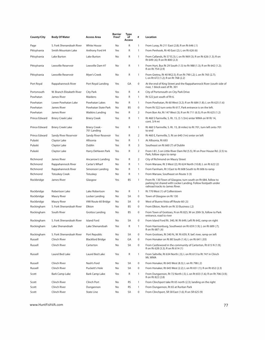
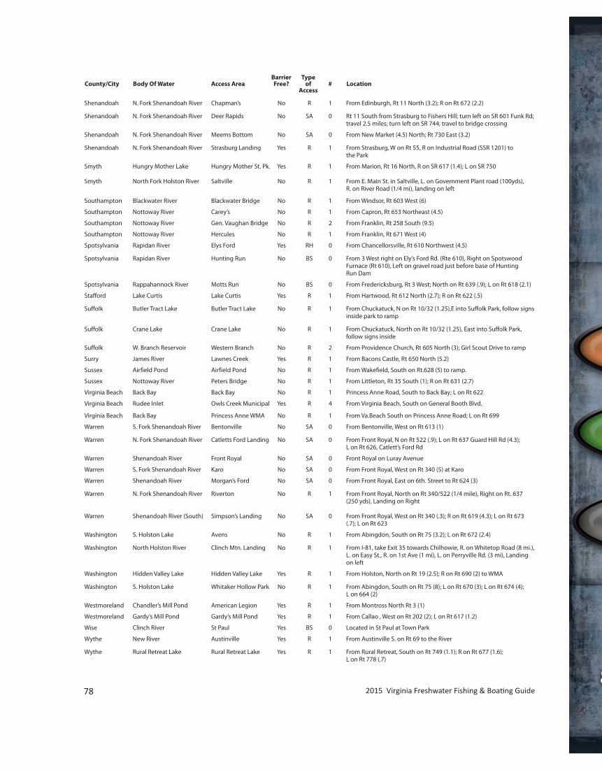
Shenandoah N. Fork Shenandoah River Chapman’s No R 1 From Edinburgh, Rt 11 North (3.2); R on Rt 672 (2.2)
Shenandoah N. Fork Shenandoah River Deer Rapids No SA 0 Rt 11 South from Strasburg to Fishers Hill; turn left on SR 601 Funk Rd; travel 2.5 miles; turn left on SR 744; travel to bridge crossing
Shenandoah N. Fork Shenandoah River Meems Bottom No SA 0 From New Market (4.5) North; Rt 730 East (3.2)
Shenandoah N. Fork Shenandoah River Strasburg Landing Yes R 1 From Strasburg, W on Rt 55, R on Industrial Road (SSR 1201) to the Park
Smyth Hungry Mother Lake Hungry Mother St. Pk. Yes R 1 From Marion, Rt 16 North, R on SR 617 (1.4); L on SR 750
Smyth North Fork Holston River Saltville No R 1 From E. Main St. in Saltville, L. on Government Plant road (100yds), R. on River Road (1/4 mi), landing on left Southampton Blackwater River Blackwater Bridge No R 1 From Windsor, Rt 603 West (6)
Southampton Nottoway River Carey’s No R 1 From Capron, Rt 653 Northeast (4.5)
Southampton Nottoway River Gen. Vaughan Bridge No R 2 From Franklin, Rt 258 South (9.5)
Southampton Nottoway River Hercules No R 1 From Franklin, Rt 671 West (4)
Spotsylvania Rapidan River Elys Ford Yes RH 0 From Chancellorsville, Rt 610 Northwest (4.5)
Spotsylvania Rapidan River Hunting Run No BS 0 From 3 West right on Ely’s Ford Rd. (Rte 610), Right on Spotswood Furnace (Rt 610), Left on gravel road just before base of Hunting Run Dam
Spotsylvania Rappahannock River Motts Run No BS 0 From Fredericksburg, Rt 3 West; North on Rt 639 (.9); L on Rt 618 (2.1)
Stafford Lake Curtis Lake Curtis Yes R 1 From Hartwood, Rt 612 North (2.7); R on Rt 622 (.5)
Suffolk Butler Tract Lake Butler Tract Lake No R 1 From Chuckatuck, N on Rt 10/32 (1.25),E into Suffolk Park, follow signs inside park to ramp
Suffolk Crane Lake Crane Lake No R 1 From Chuckatuck, North on Rt 10/32 (1.25), East into Suffolk Park, follow signs inside
Suffolk W. Branch Reservoir Western Branch No R 2 From Providence Church, Rt 605 North (3); Girl Scout Drive to ramp
Surry James River Lawnes Creek Yes R 1 From Bacons Castle, Rt 650 North (5.2)
Sussex Airfield Pond Airfield Pond No R 1 From Wakefield, South on Rt.628 (5) to ramp.
Sussex Nottoway River Peters Bridge No R 1 From Littleton, Rt 35 South (1); R on Rt 631 (2.7)
Virginia Beach Back Bay Back Bay No R 1 Princess Anne Road, South to Back Bay; L on Rt 622
Virginia Beach Rudee Inlet Owls Creek Municipal Yes R 4 From Virginia Beach, South on General Booth Blvd. Virginia Beach Back Bay Princess Anne WMA No R 1 From Va.Beach South on Princess Anne Road; L on Rt 699
Warren S. Fork Shenandoah River Bentonville No SA 0 From Bentonville, West on Rt 613 (1)
Warren N. Fork Shenandoah River Catletts Ford Landing No SA 0 From Front Royal, N on Rt 522 (.9); L on Rt 637 Guard Hill Rd (4.3); L on Rt 626, Catlett’s Ford Rd
Warren Shenandoah River Front Royal No SA 0 Front Royal on Luray Avenue
Warren S. Fork Shenandoah River Karo No SA 0 From Front Royal, West on Rt 340 (5) at Karo
Warren Shenandoah River Morgan’s Ford No SA 0 From Front Royal, East on 6th. Street to Rt 624 (3)
Warren N. Fork Shenandoah River Riverton No R 1 From Front Royal, North on Rt 340/522 (1/4 mile), Right on Rt. 637 (250 yds), Landing on Right
Warren Shenandoah River (South) Simpson’s Landing No SA 0 From Front Royal, West on Rt 340 (.3); R on Rt 619 (4.3); L on Rt 673 (.7); L on Rt 623
Washington S. Holston Lake Avens No R 1 From Abingdon, South on Rt 75 (3.2); L on Rt 672 (2.4)
Washington North Holston River Clinch Mtn. Landing No R 1 From I-81, take Exit 35 towards Chilhowie, R. on Whitetop Road (8 mi.), L. on Easy St., R. on 1st Ave (1 mi), L. on Perryville Rd. (3 mi), Landing on left
Washington Hidden Valley Lake Hidden Valley Lake Yes R 1 From Holston, North on Rt 19 (2.5); R on Rt 690 (2) to WMA
Washington S. Holston Lake Whitaker Hollow Park No R 1 From Abingdon, South on Rt 75 (8); L on Rt 670 (3); L on Rt 674 (4); L on 664 (2)
Westmoreland Chandler’s Mill Pond American Legion Yes R 1 From Montross North Rt 3 (1)
Westmoreland Gardy’s Mill Pond Gardy’s Mill Pond Yes R 1 From Callao , West on Rt 202 (2); L on Rt 617 (1.2)
Wise Clinch River St Paul Yes BS 0 Located in St Paul at Town Park
Wythe New River Austinville Yes R 1 From Austinville S. on Rt 69 to the River
Wythe Rural Retreat Lake Rural Retreat Lake Yes R 1 From Rural Retreat, South on Rt 749 (1.1); R on Rt 677 (1.6); L on Rt 778 (.7)
78 2015 Virginia Freshwater Fishing & Boating Guide
Barrier TypeCounty/City Body Of Water Access Area Free? of # Location Access
SAVE TODAY. THE GREAT OUTDOORS TOMORROW.SAVE TODAY. THE GREAT OUTDOORS TOMORROW.See how much you could save on more than just car insurance.
for your boageico.com | 1-877-434-2678 | local offi ce
Some discounts, coverages, payment plans and features are not available in all states or all GEICO companies. Boat and PWC coverages are written through Seaworthy Insurance Company, a Berkshire Hathaway affi liate, and through other non-affi liated insurance companies, and are secured through the GEICO Insurance
Agency. GEICO is a registered service mark of Government Employees Insurance Company, Washington, D.C. 20076; a Berkshire Hathaway Inc. subsidiary. GEICO Gecko Image © 1999-2015. © 2015 GEICO
geico.com | 1-877-434-2678 | local offi ce
Some discounts, coverages, payment plans and features are not available in all states or all GEICO companies. Boat and PWC coverages are written through Seaworthy Insurance Company, a Berkshire Hathaway affi liate, and through other non-affi liated insurance companies, and are secured through the GEICO Insurance