Embed Size (px)
Citation preview
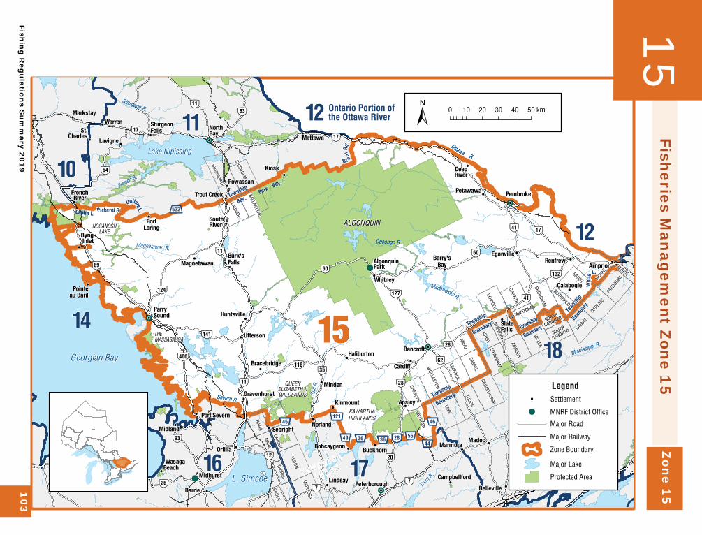
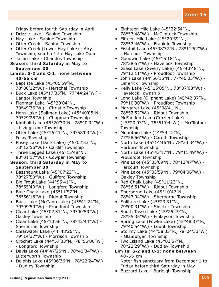
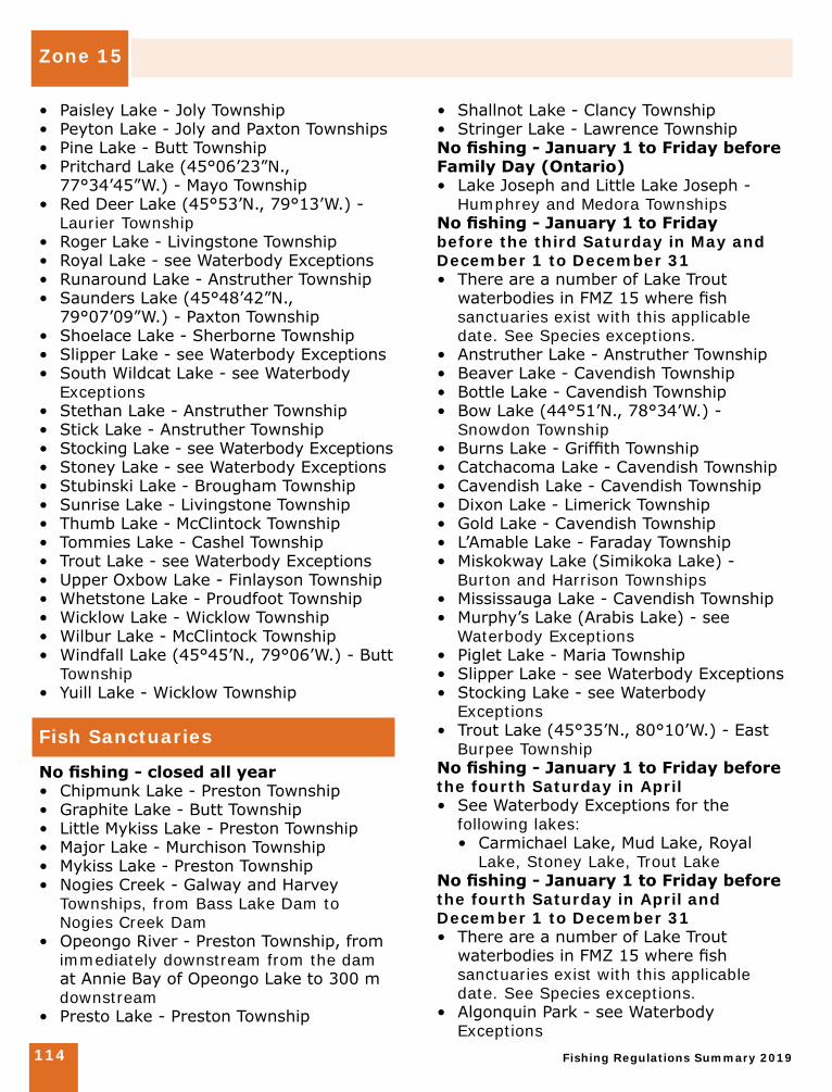
Zon
e 15
Fishin
g R
egu
lations S
um
mary 2
01
91
03
Fisheries M
anag
emen
t Zone 1
515
!(
!(
!(
!(
!(
!(
!(
!(
!!
!!
!!
!!
!!
!!
!!
!!
!!
!!
!!
!!
!!
!!
!
!!
!!
!!
!!
!!
!!
!!
!!
!!
!!
!!
!!
!!
!!
!!
!!
!!
!!
!!
!!
!!
!!
!!
!!
!!
!!
!!
!!
!!
!!
!!
!!
!!
!!
!!
!!
!!
!!
!!
!!
!!
Township
Bdy.
Cantin L.
Towns
hipBo
unda
ry
Township
Township
Township
Boundary
Boundary
Boundary
Dollars L.
Park Bdy.
OttawaR.
Whi
te
L.
B r ent
Rd.
Pickerel R.
Sturgeon R.
Severn R.
Opeongo R.
Mississippi R.
French R.
Trent
R.
Gull
R.
Magnetawan R.
Madawaska R.
Georgian Bay
L. Simcoe
Lake Nipissing
15
10
11 12
12
14
16 17
18THEMASSASAUGA
NOGANOSHLAKE
ALGONQUIN
PUZZLELAKE
QUEENELIZABETH IIWILDLANDS
KAWARTHAHIGHLANDS
Midhurst
AlgonquinPark
K A W A R T H A
L A K E S
Pointeau Baril
Bancroft
Bracebridge
Gravenhurst
Sebright
Burk'sFalls
SlateFalls
Cardiff
Markstay
Kinmount
Buckhorn
St.Charles
Barrie
Kaladar
Madoc
Lindsay
Bobcaygeon
Calabogie
DeepRiver
WasagaBeach
FrenchRiver
Orillia
Midland
Renfrew
Pembroke
Barry'sBay
Mattawa
Arnprior
Powassan
NorthBay
Petawawa
Warren
ByngInlet
Trout Creek
PortLoring
SouthRiver
Campbellford
Huntsville
Kiosk
Lavigne
Magnetawan
Port Severn
Eganville
SturgeonFalls
Peterborough
Marmora
Norland
ParrySound
Whitney
Minden
Utterson
Apsley
Belleville
Haliburton
SharbotLake
GRIFFITH
DENBIGH
CARDEN
ELDON
EFFINGHAM
LAURIER
MARIPOSA
MCNAB
CASHELGRIM
STHORPE
LAKELIM
ERICK
TUDOR
WOLLASTON
SOUTH
CANONTO
BROCKTHORAH
HIMSW
ORTH
METHUEN
CHANDOS
MARA
RAMA
NORTH
CANONTO
FITZROY
BROUGHAM
MILLER
PAKE
NHAM
LAVA
NTMATAWATCHAN
ASHBY ABINGER
BALLANTYNE
CHISHOLM
MAYO
LYNDOCH
BLITHFIELDBAGOT
DARLING
8993
8960
8941
8941
8960
8941
8912
8963
8928
8928
8928
897
8911
8911
8964
8917
8935
8917
8926
8917
8911
8962
897
897
8969
:;141
:;118
:;124
:;127
:;132
:;400
:;401
DE49 DE36 DE36
DE45
Township
Bdy.
Cantin L.
Towns
hipBo
unda
ry
Township
Township
Township
Boundary
Boundary
Boundary
Dollars L.
Park Bdy.
R.
Whi
te
L.
B r ent
Rd.
Pickerel R.
DE44DE56DE46
8928
@A522
FG121
Sturgeon R.
Severn R.
Opeongo R.
Mississippi R.
French R.
Trent
R.
Gull
R.
Magnetawan R.
Madawaska R.
Ottawa
Georgian Bay
L. Simcoe
Lake Nipissing
15
10
11 12
12
14
16 17
18
Ontario Portion of the Ottawa River
THEMASSASAUGA
NOGANOSHLAKE
ALGONQUIN
PUZZLELAKE
QUEENELIZABETH IIWILDLANDS
KAWARTHAHIGHLANDS
Midhurst
AlgonquinPark
Pointeau Baril
Bancroft
Bracebridge
Gravenhurst
Sebright
Burk'sFalls
SlateFalls
Cardiff
Markstay
Kinmount
Buckhorn
St.Charles
Barrie
Kaladar
Madoc
Lindsay
Bobcaygeon
Calabogie
DeepRiver
WasagaBeach
FrenchRiver
Orillia
Midland
Renfrew
Pembroke
Barry'sBay
Mattawa
Arnprior
Powassan
NorthBay
Petawawa
Warren
ByngInlet
Trout Creek
PortLoring
SouthRiver
Campbellford
Huntsville
Kiosk
Lavigne
Magnetawan
Port Severn
Eganville
SturgeonFalls
Peterborough
Marmora
Norland
ParrySound
Whitney
Minden
Utterson
Apsley
Belleville
Haliburton
SharbotLake
GRIFFITH
DENBIGH
CARDEN
ELDON
EFFINGHAM
LAURIER
MARIPOSA
MCNAB
CASHELGRIM
STHORPE
LAKELIM
ERICK
TUDOR
WOLLASTON
SOUTH
CANONTO
BROCKTHORAH
HIMSW
ORTH
METHUEN
CHANDOS
MARA
RAMA
NORTH
CANONTO
FITZROY
BROUGHAM
MILLER
PAKE
NHAM
LAVA
NTMATAWATCHAN
ASHBY ABINGER
BALLANTYNE
CHISHOLM
MAYO
LYNDOCH
BLITHFIELDBAGOT
DARLING
0 10 20 30 40 50 km±
Legend
!( MNRF District Office
Major Road
Major Railway
Zone Boundary
Major Lake
Protected Area
! Settlement
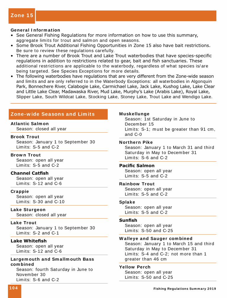
Zone 15
Fishing Regulations Summary 2019104
General Information• See General Fishing Regulations for more information on how to use this summary,
aggregate limits for trout and salmon and open seasons. • Some Brook Trout Additional Fishing Opportunities in Zone 15 also have bait restrictions.
Be sure to review these regulations carefully.• There are a number of Brook Trout and Lake Trout waterbodies that have species-specific
regulations in addition to restrictions related to gear, bait and fish sanctuaries. These additional restrictions are applicable to the waterbody, regardless of what species is/are being targeted. See Species Exceptions for more details.
• The following waterbodies have regulations that are very different from the Zone-wide season and limits and are only referred to in the Waterbody Exceptions: all waterbodies in Algonquin Park, Bonnechere River, Calabogie Lake, Carmichael Lake, Jack Lake, Kushog Lake, Lake Clear and Little Lake Clear, Madawaska River, Mud Lake, Murphy’s Lake (Arabis Lake), Royal Lake, Slipper Lake, South Wildcat Lake, Stocking Lake, Stoney Lake, Trout Lake and Wendigo Lake.
Zone-wide Seasons and Limits
Atlantic Salmon Season: closed all year
Brook Trout Season: January 1 to September 30 Limits: S-5 and C-2
Brown Trout Season: open all year Limits: S-5 and C-2
Channel Catfish Season: open all year Limits: S-12 and C-6
Crappie Season: open all year Limits: S-30 and C-10
Lake Sturgeon Season: closed all year
Lake Trout Season: January 1 to September 30 Limits: S-2 and C-1
Lake Whitefish Season: open all year Limits: S-12 and C-6
Largemouth and Smallmouth Bass combined Season: fourth Saturday in June to
November 30 Limits: S-6 and C-2
Muskellunge Season: 1st Saturday in June to
December 15 Limits: S-1; must be greater than 91 cm,
and C-0
Northern Pike Season: January 1 to March 31 and third
Saturday in May to December 31 Limits: S-6 and C-2
Pacific Salmon Season: open all year Limits: S-5 and C-2
Rainbow Trout Season: open all year Limits: S-5 and C-2
Splake Season: open all year Limits: S-5 and C-2
Sunfish Season: open all year Limits: S-50 and C-25
Walleye and Sauger combined Season: January 1 to March 15 and third
Saturday in May to December 31 Limits: S-4 and C-2; not more than 1
greater than 46 cm
Yellow Perch Season: open all year Limits: S-50 and C-25
Zone 15
Fishing Regulations Summary 2019 105
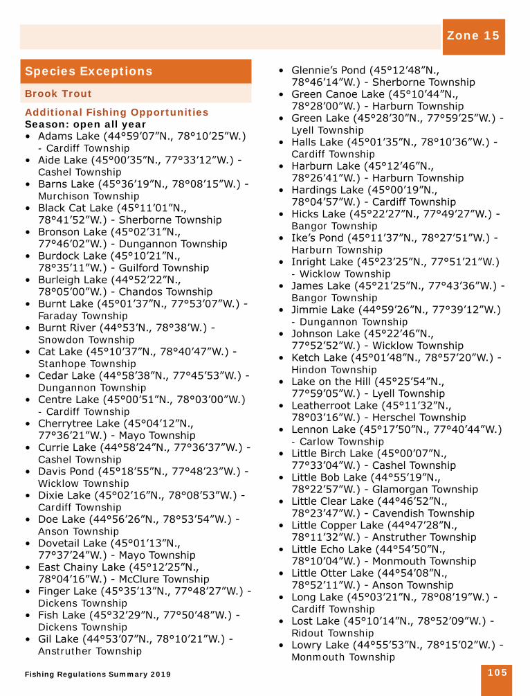
Species Exceptions
Brook Trout
Additional Fishing OpportunitiesSeason: open all year• Adams Lake (44°59’07”N., 78°10’25”W.)
- Cardiff Township• Aide Lake (45°00’35”N., 77°33’12”W.) -
Cashel Township • Barns Lake (45°36’19”N., 78°08’15”W.) -
Murchison Township • Black Cat Lake (45°11’01”N.,
78°41’52”W.) - Sherborne Township • Bronson Lake (45°02’31”N.,
77°46’02”W.) - Dungannon Township• Burdock Lake (45°10’21”N.,
78°35’11”W.) - Guilford Township • Burleigh Lake (44°52’22”N.,
78°05’00”W.) - Chandos Township • Burnt Lake (45°01’37”N., 77°53’07”W.) -
Faraday Township • Burnt River (44°53’N., 78°38’W.) -
Snowdon Township • Cat Lake (45°10’37”N., 78°40’47”W.) -
Stanhope Township• Cedar Lake (44°58’38”N., 77°45’53”W.) -
Dungannon Township • Centre Lake (45°00’51”N., 78°03’00”W.)
- Cardiff Township• Cherrytree Lake (45°04’12”N.,
77°36’21”W.) - Mayo Township • Currie Lake (44°58’24”N., 77°36’37”W.) -
Cashel Township • Davis Pond (45°18’55”N., 77°48’23”W.) -
Wicklow Township • Dixie Lake (45°02’16”N., 78°08’53”W.) -
Cardiff Township• Doe Lake (44°56’26”N., 78°53’54”W.) -
Anson Township• Dovetail Lake (45°01’13”N.,
77°37’24”W.) - Mayo Township • East Chainy Lake (45°12’25”N.,
78°04’16”W.) - McClure Township• Finger Lake (45°35’13”N., 77°48’27”W.) -
Dickens Township• Fish Lake (45°32’29”N., 77°50’48”W.) -
Dickens Township• Gil Lake (44°53’07”N., 78°10’21”W.) -
Anstruther Township
• Glennie’s Pond (45°12’48”N., 78°46’14”W.) - Sherborne Township
• Green Canoe Lake (45°10’44”N., 78°28’00”W.) - Harburn Township
• Green Lake (45°28’30”N., 77°59’25”W.) - Lyell Township
• Halls Lake (45°01’35”N., 78°10’36”W.) - Cardiff Township
• Harburn Lake (45°12’46”N., 78°26’41”W.) - Harburn Township
• Hardings Lake (45°00’19”N., 78°04’57”W.) - Cardiff Township
• Hicks Lake (45°22’27”N., 77°49’27”W.) - Bangor Township
• Ike’s Pond (45°11’37”N., 78°27’51”W.) - Harburn Township
• Inright Lake (45°23’25”N., 77°51’21”W.) - Wicklow Township
• James Lake (45°21’25”N., 77°43’36”W.) - Bangor Township
• Jimmie Lake (44°59’26”N., 77°39’12”W.) - Dungannon Township
• Johnson Lake (45°22’46”N., 77°52’52”W.) - Wicklow Township
• Ketch Lake (45°01’48”N., 78°57’20”W.) - Hindon Township
• Lake on the Hill (45°25’54”N., 77°59’05”W.) - Lyell Township
• Leatherroot Lake (45°11’32”N., 78°03’16”W.) - Herschel Township
• Lennon Lake (45°17’50”N., 77°40’44”W.) - Carlow Township
• Little Birch Lake (45°00’07”N., 77°33’04”W.) - Cashel Township
• Little Bob Lake (44°55’19”N., 78°22’57”W.) - Glamorgan Township
• Little Clear Lake (44°46’52”N., 78°23’47”W.) - Cavendish Township
• Little Copper Lake (44°47’28”N., 78°11’32”W.) - Anstruther Township
• Little Echo Lake (44°54’50”N., 78°10’04”W.) - Monmouth Township
• Little Otter Lake (44°54’08”N., 78°52’11”W.) - Anson Township
• Long Lake (45°03’21”N., 78°08’19”W.) - Cardiff Township
• Lost Lake (45°10’14”N., 78°52’09”W.) - Ridout Township
• Lowry Lake (44°55’53”N., 78°15’02”W.) - Monmouth Township

Zone 15
Fishing Regulations Summary 2019106
• Lunch Lake (45°33’17”N., 78°14’23”W.) - Airy Township
• Mawson Lake (44°56’26”N., 77°35’08”W.) - Cashel Township
• McCormick Lake (45°20’28”N., 77°46’46”W.) - Bangor Township
• McFee Lake (45°31’20”N., 78°06’44”W.) - Airy Township
• Mitchell Lake (45°04’10”N., 78°00’34”W.) - Herschel Township
• Moonbeam Lake (45°34’16”N., 78°08’17”W.) - Airy Township
• Nehemiah Lake (45°12’15”N., 78°48’18”W.) - Sherborne Township
• No Name Lake (45°10’51”N., 78°44’58”W.) - Sherborne Township
• North Chainy Lake (45°12’29”N., 78°04’33”W.) - McClure Township
• North Moonbeam Lake (Sawlog Lake) (45°35’05”N., 78°07’11”W.) - Murchison Township
• Otherside Lake (45°34’26”N., 78°04’31”W.) - Murchison Township
• Paradise Lake (45°37’23”N., 77°54’28”W.) - Dickens Township
• Partridge Lake (45°07’50”N., 78°47’18”W.) - Stanhope Township
• Pat Lake (45°18’19”N., 78°04’49”W.) - McClure Township
• Pell Lake (45°25’30”N., 77°57’06”W.) - Lyell Township
• Poplar Pond (45°21’29”N., 77°48’17”W.) - Bangor Township
• Potash Lake (45°22’45”N., 77°49’41”W.) - Bangor Township
• Pritchard Lake (45°06’23”N., 77°34’45”W) - Mayo Township
• Rabbit Lake (45°11’15”N., 78°44’14”W.) - Sherborne Township
• Rock Lake (45°03’48”N., 77°40’33”W.) - Dungannon Township
• Ronald Lake (45°12’33”N., 78°48’09”W.) - Sherborne Township
• Runaround Lake (44°52’27”N., 78°12’27”W.) - Anstruther Township
• Salt Lake (45°10’57”N., 77°33’56”W.) - Carlow Township
• Seesaw Lake (45°33’41”N., 78°11’35”W.) - Airy Township
• Shoelace Lake (45°12’38”N., 78°45’19”W.) - Sherborne Township
• Silver Buck Lake (45°09’45”N., 78°47’33”W.) - Sherborne Township
• Silver Doe Lake (45°09’59”N., 78°47’42”W.) - Sherborne Township
• Silversheen Lake (45°17’48”N., 78°05’05”W.) - McClure Township
• Sleeper Lake (Green Lake) (45°00’57”N., 77°28’32”W.) - Cashel Township
• Stethan Lake (44°50’37”N., 78°07’46”W.) - Anstruther Township
• Stick Lake (44°50’30”N., 78°11’16”W.) - Anstruther Township
• Sunbeam Lake (45°39’41”N., 78°41’21”W.) - McLaughlin Township
• Swordfingal Lake (45°02’27”N., 77°37’04”W.) - Mayo Township
• Tim Lake (45°07’41”N., 77°53’02”W.) - Herschel Township
• Tommy’s Lake (44°58’50”N., 77°36’44”W.) - Cashel Township
• Trout Lake (Alsever Lake) (45°31’00”N., 77°58’36”W.) - Murchison Township
• Tub Lake (45°30’52”N., 77°58’03”W.) - Murchison Township
• Tuya Lake (45°33’04”N., 78°08’37”W.) - Airy Township
• Twin Lake (45°00’34”N., 78°04’33”W.) - Cardiff Township
• West Headstone Lake (45°34’15”N., 78°13’47”W.) - Airy Township
• Wicklow Lake (45°21’25”N., 77°58’05”W.) - Wicklow Township
• Wish Lake (45°36’44”N., 78°05’07”W.) - Murchison Township
• Yuill Lake - Wicklow TownshipLimits: S-2 and C-2; must be greater
than 36 cm Note: only artificial lures may be used,
regardless of what species is/are being targeted
• Animoosh Lake - Dickson and Niven Townships
• Harry Lake - Lawrence Township • Rence Lake - Lawrence Township • Welcome Lake - Lawrence and
Nightingale Townships
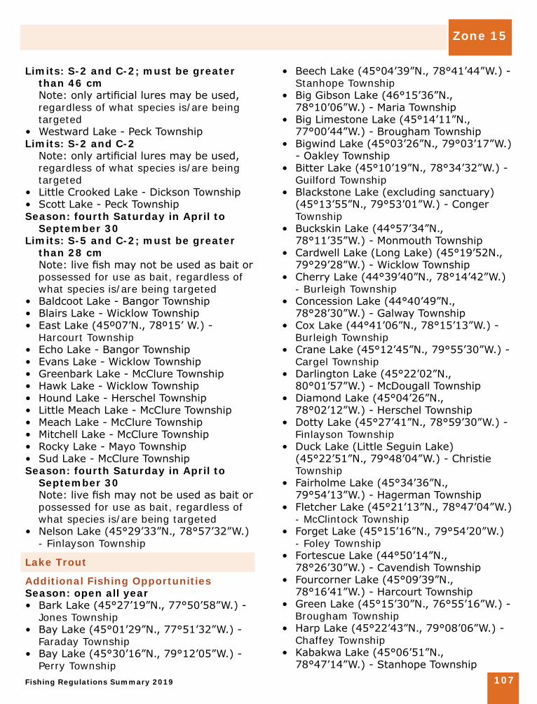
Fishing Regulations Summary 2019 107
Limits: S-2 and C-2; must be greater than 46 cm
Note: only artificial lures may be used, regardless of what species is/are being targeted
• Westward Lake - Peck Township Limits: S-2 and C-2 Note: only artificial lures may be used,
regardless of what species is/are being targeted
• Little Crooked Lake - Dickson Township • Scott Lake - Peck Township Season: fourth Saturday in April to
September 30 Limits: S-5 and C-2; must be greater
than 28 cm Note: live fish may not be used as bait or
possessed for use as bait, regardless of what species is/are being targeted
• Baldcoot Lake - Bangor Township • Blairs Lake - Wicklow Township • East Lake (45º07’N., 78º15’ W.) -
Harcourt Township • Echo Lake - Bangor Township • Evans Lake - Wicklow Township • Greenbark Lake - McClure Township • Hawk Lake - Wicklow Township • Hound Lake - Herschel Township • Little Meach Lake - McClure Township • Meach Lake - McClure Township • Mitchell Lake - McClure Township • Rocky Lake - Mayo Township • Sud Lake - McClure Township Season: fourth Saturday in April to
September 30 Note: live fish may not be used as bait or
possessed for use as bait, regardless of what species is/are being targeted
• Nelson Lake (45°29’33”N., 78°57’32”W.) - Finlayson Township
Lake Trout
Additional Fishing OpportunitiesSeason: open all year• Bark Lake (45°27’19”N., 77°50’58”W.) -
Jones Township• Bay Lake (45°01’29”N., 77°51’32”W.) -
Faraday Township• Bay Lake (45°30’16”N., 79°12’05”W.) -
Perry Township
• Beech Lake (45°04’39”N., 78°41’44”W.) - Stanhope Township
• Big Gibson Lake (46°15’36”N., 78°10’06”W.) - Maria Township
• Big Limestone Lake (45°14’11”N., 77°00’44”W.) - Brougham Township
• Bigwind Lake (45°03’26”N., 79°03’17”W.) - Oakley Township
• Bitter Lake (45°10’19”N., 78°34’32”W.) - Guilford Township
• Blackstone Lake (excluding sanctuary) (45°13’55”N., 79°53’01”W.) - Conger Township
• Buckskin Lake (44°57’34”N., 78°11’35”W.) - Monmouth Township
• Cardwell Lake (Long Lake) (45°19’52N., 79°29’28”W.) - Wicklow Township
• Cherry Lake (44°39’40”N., 78°14’42”W.) - Burleigh Township
• Concession Lake (44°40’49”N., 78°28’30”W.) - Galway Township
• Cox Lake (44°41’06”N., 78°15’13”W.) - Burleigh Township
• Crane Lake (45°12’45”N., 79°55’30”W.) - Cargel Township
• Darlington Lake (45°22’02”N., 80°01’57”W.) - McDougall Township
• Diamond Lake (45°04’26”N., 78°02’12”W.) - Herschel Township
• Dotty Lake (45°27’41”N., 78°59’30”W.) - Finlayson Township
• Duck Lake (Little Seguin Lake) (45°22’51”N., 79°48’04”W.) - Christie Township
• Fairholme Lake (45°34’36”N., 79°54’13”W.) - Hagerman Township
• Fletcher Lake (45°21’13”N., 78°47’04”W.) - McClintock Township
• Forget Lake (45°15’16”N., 79°54’20”W.) - Foley Township
• Fortescue Lake (44°50’14”N., 78°26’30”W.) - Cavendish Township
• Fourcorner Lake (45°09’39”N., 78°16’41”W.) - Harcourt Township
• Green Lake (45°15’30”N., 76°55’16”W.) - Brougham Township
• Harp Lake (45°22’43”N., 79°08’06”W.) - Chaffey Township
• Kabakwa Lake (45°06’51”N., 78°47’14”W.) - Stanhope Township
Zone 15
Zone 15
Fishing Regulations Summary 2019108
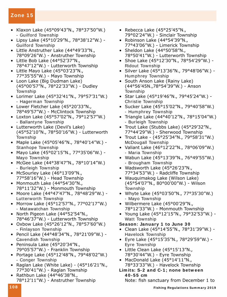
• Klaxon Lake (45°09’43”N., 78°37’50”W.) - Guilford Township
• Lipsy Lake (45°10’29”N., 78°38’12”W.) - Guilford Township
• Little Anstruther Lake (44°49’33”N., 78°09’26”W.) - Anstruther Township
• Little Bob Lake (44°52’37”N., 78°47’12”W.) - Lutterworth Township
• Little Mayo Lake (45°03’23”N., 77°35’55”W.) - Mayo Township
• Loon Lake (Big Dudman Lake) (45°00’57”N., 78°22’33”W.) - Dudley Township
• Lorimer Lake (45°32’41”N., 79°57’31”W.) - Hagerman Township
• Lower Fletcher Lake (45°20’33”N., 78°49’57”W.) - McClintock Township
• Loxton Lake (45°57’02”N., 79°12’57”W.) - Ballantyne Township
• Lutterworth Lake (Devil’s Lake) (45°52’10”N., 78°50’16”W.) - Lutterworth Township
• Maple Lake (45°05’46”N., 78°40’14”W.) - Stanhope Township
• Mayo Lake (45°02’15”N., 77°35’06”W.) - Mayo Township
• McGee Lake (44°38’47”N., 78°10’14”W.) - Burleigh Township
• McSourley Lake (46°13’09”N., 77°58’16”W.) - Head Township
• Monmouth Lake (44°54’30”N., 78°11’32”W.) - Monmouth Township
• Moore Lake (44°47’47”N., 78°48’29”W.) - Lutterworth Township
• Morrow Lake (45°12’57”N., 77°02’17”W.) - Matawatchan Township
• North Pigeon Lake (44°52’54”N., 78°46’37”W.) - Lutterworth Township
• Oxbow Lake (45°26’12”N., 78°57’60”W.) - Finlayson Township
• Pencil Lake (44°48’34”N., 78°21’09”W.) - Cavendish Township
• Peninsula Lake (45°20’34”N., 79°05’57”W.) - Franklin Township
• Portage Lake (45°12’48”N., 79°48’02”W.) - Conger Township
• Raglan Lake (White Lake) - (45°16’21”N., 77°30’41”W.) - Raglan Township
• Rathbun Lake (44°46’38”N., 78°12’11”W.) - Anstruther Township
• Rebecca Lake (45°25’45”N., 79°02’24”W.) - Sinclair Township
• Robinson Lake (44°54’39”N., 77°43’06”W.) - Limerick Township
• Sheldon Lake (44°50’58”N., 78°50’41”W.) - Lutterworth Township
• Shoe Lake (45°12’30”N., 78°54’29”W.) - Ridout Township
• Silver Lake (45°13’36”N., 79°48’06”W.) - Humphrey Township
• South Anson Lake (Rainy Lake) (44°56’45N.,78°54’39”W.) - Anson Township
• Star Lake (45°19’46”N., 79°45’24”W.) - Christie Township
• Sucker Lake (45°15’02”N., 79°40’58”W.) - Humphrey Township
• Triangle Lake (44°40’12”N., 78°15’04”W.) - Burleigh Township
• Trout Lake (Stubbs Lake) (45°29’32”N., 77°44’29”W.) - Sherwood Township
• Trout Lake - (45°25’34”N., 79°58’31”W.) McDougall Township
• Valiant Lake (46°12’22”N., 78°06’09”W.) - Maria Township
• Wabun Lake (45°13’39”N., 76°49’55”W.) - Brougham Township
• Wadsworth Lake (45°26’23”N., 77°34’53”W.) - Radcliffe Township
• Wauquimakog Lake (Wilson Lake) (45°54’07”N., 80°00’00”W.) - Wilson Township
• Whyte Lake (45°03’50”N., 77°35’30”W.) - Mayo Township
• Wilbermere Lake (45°00’29”N., 78°12’33”W.) - Monmouth Township
• Young Lake (45°12’15”N., 79°32’53”W.) - Watt Township
Season: January 1 to June 30 • Clean Lake (45°14’55”N., 78°31’39”W.) -
Havelock Township• Eyre Lake (45°15’35”N., 78°29’59”W.) -
Eyre Township• Little Clean Lake (45°15’13”N.,
78°30’44”W.) - Eyre Township • MacDonald Lake (45°14’11”N.,
78°33’33”W.) - Havelock TownshipLimits: S-2 and C-1; none between
40-55 cm Note: fish sanctuary from December 1 to
Zone 15
Fishing Regulations Summary 2019 109
Friday before fourth Saturday in April• Drizzle Lake - Sabine Township • Hay Lake - Sabine Township • Otter Creek - Sabine Township • Otter Creek (Lower Hay Lake) - Airy
Township, south of the Hay Lake Dam• Tallan Lake - Chandos Township Season: third Saturday in May to
September 30 Limits: S-2 and C-1; none between
40-55 cm • Baptiste Lake (45°06’59”N.,
78°00’12”W.) - Herschel Township• Buck Lake (45°17’35”N., 77°44’24”W.) -
Bangor Township• Flaxman Lake (45°20’04”N.,
79°49’36”W.) - Christie Township• Horn Lake (Sollman Lake) (45°40’05”N.,
79°29’28”W.) - Chapman Township• Kimball Lake (45°20’30”N., 78°40’34”W.)
- Livingstone Township• Otter Lake (45°16’41”N., 79°58’03”W.) -
Foley Township• Pusey Lake (Dark Lake) (45°02’53”N.,
78°12’56”W.) - Cardiff Township• Three Legged Lake (45°15’48”N.,
80°01’17”W.) - Cowper TownshipSeason: third Saturday in May to
September 30 • Basshaunt Lake (45°07’23”N.,
78°27’50”W.) - Guilford Township• Big Trout Lake (44°55’41”N.,
78°55’40”W.) - Longford Township• Blue Chalk Lake (45°11’57”N.,
78°56’18”W.) - Ridout Township• Buck Lake (McCann Lake) (45°41’24”N.,
79°09’59”W.) - Proudfoot Township• Clear Lake (45°02’31”N., 79°00’59”W.) -
Oakley Township• Clear Lake (45°10’56”N., 78°42’44”W.) -
Sherborne Township• Clearwater Lake (44°48’26”N.,
79°14’37”W.) - Morrison Township• Crochet Lake (44°57’33”N., 78°56’06”W.)
- Longford Township• Davis Lake (44°47’25”N., 78°42’34”W.) -
Lutterworth Township• Delphis Lake (45°06’36”N., 78°22’24”W.)
- Dudley Township
• Eighteen Mile Lake (45°22’54”N., 78°57’48”W.) - McClintock Township
• Fifteen Mile Lake (45°20’59”N., 78°57’46”W.) - Franklin Township
• Fishtail Lake (45°08’37”N., 78°11’52”W.) - Harcourt Township
• Goodwin Lake (45°15’18”N., 78°38’57”W.) - Havelock Township
• Grass Lake (Sweny Lake) (45°40’48”N., 79°12’11”W.) - Proudfoot Township
• John Lake (44°56’15”N., 77°46’05”W.) - Limerick Township
• Kelly Lake (45°15’05”N., 78°37’08”W.) - Havelock Township
• Long Lake (Oliphant Lake) (45°42’37”N., 79°10’30”W.) - Proudfoot Township
• Margaret Lake (45°08’41”N., 78°52’52”W.) - Ridout Township
• McFadden Lake (Crozier Lake) (45°20’03”N., 78°51’04”W.) - McClintock Township
• Mountain Lake (44°54’42”N., 77°58’56”W.) - Cardiff Township
• North Lake (45°14’46”N., 78°24’34”W.) - Harburn Township
• North Lake (45°43’17”N., 79°11’49”W.) - Proudfoot Township
• Pine Lake (45°05’09”N., 78°13’47”W.) - Harcourt Township
• Pine Lake (45°03’59”N., 79°04’06”W.) - Oakley Township
• Red Chalk Lake (45°11’23”N., 78°56’51”W.) - Ridout Township
• Sherborne Lake (45°10’47”N., 78°47’04”W.) - Sherborne Township
• Solitaire Lake (45°23’31”N., 79°00’31”W.) - Sinclair Township
• South Tasso Lake (45°25’49”N., 78°55’35”W.) - Finlayson Township
• Spring Lake (Fowke Lake) (45°48’37”N., 79°40’54”W.) - Lount Township
• Stormy Lake (44°58’33”N., 78°24’33”W.) - Glamorgan Township
• Two Island Lake (45°03’57”N., 78°22’29”W.) - Dudley Township
Limits: S-2 and C-1; none between 40-55 cm
Note: fish sanctuary from December 1 to Friday before third Saturday in May
• Buzzard Lake - Burleigh Township
Zone 15
Fishing Regulations Summary 2019110
• Chandos Lake - Chandos Township • Deer Lake - Cardiff Township • Eels Lake - Anstruther and Cardiff
Townships • Holland Lake - Dungannon Township • Hudson Lake - Cardiff Township • Jamieson Lake - Dungannon Township • Jeffrey Lake - Faraday Township • Lavallee Lake - Faraday Township • Stoplog Lake - Burleigh Township • Wahwashkesh Lake (Deer Lake) - Burton
and McKenzie Townships Limits: S-2 and C-1; none between
40-55 cm Note: only one line may be used when
angling through the ice, regardless of what species is/are being targeted
• Art Lake (Spruce Lake) - Dysart Township • Aylen Lake - Dickens Township • Bear Lake - Livingstone Township • Bella Lake - Sinclair Township • Bob Lake - Anson Township • Boshkung Lake - Stanhope Township • Camp Lake - Finlayson Township • Carson Lake - Jones and Sherwood
Townships • Cashel Lake - Cashel Township • Clear Lake - Humphrey Township • Clinto Lake - McClintock Township • Drag Lake - Dudley and Dysart Townships • Eagle Lake - Guilford Township • Esson Lake - Monmouth Township • Faraday Lake - Faraday Township • Galeairy Lake - Airy and Nightingale
Townships • Gliskning Lake - Airy Township • Grace Lake - Harcourt Township• Gull Lake - Lutterworth Township • Halls Lake - Stanhope Township • Havelock Lake - Havelock Township • Johnson Lake - Havelock Township • Kaminiskeg Lake - Sherwood and Bangor
Townships • Kawagama Lake - Sherborne, McClintock
and Livingstone Townships • Koshlong Lake - Glamorgan Township • Limerick Lake - Limerick Township • Limestone Lake - Mayo Township • Little Boshkung Lake - Minden Township • Livingstone Lake - Livingstone Township
• Lobster Lake - Airy Township • Lyell Lake (Cross Lake) - Lyell Township • Marsden Lake - Eyre, Guilford and
Havelock Townships • Mephisto Lake - Cashel Township • Moose Lake - Guilford and Harburn
Townships • Mountain Lake - Minden Township • Nunikani Lake - Sherborne Township • Oxtongue Lake - McClintlock Township • Papineau Lake - Wicklow and Bangor
Townships • Paudash Lake - Cardiff Township • Paugh Lake - Burns and Sherwood
Townships • Purdy Lake - Bangor Township • Raven Lake - Sherborne Township • Round Lake - Hagarty and Richards
Townships • Salmon Lake (44°49’N., 78°27’W.) -
Cavendish Township • Silent Lake - Cardiff Township • Skeleton Lake - Cardwell, Sisted,
Stephenson and Watts Townships • Soyers Lake - Minden Township • St. Nora Lake - Sherborne Township • Sucker Lake - Anstruther Township • Twelve Mile Lake - Minden Township • Victoria Lake - Clancy and Murchison
Townships• Waterloo Lake - Clara Township • Whitefish Lake - Humphrey Township Limits: S-2 and C-1; none between
40-55 cm • Bonita Lake (45°31’23”N., 78°43’21”W.)
- Peck Township • Canoe Lake (45°33’03”N., 78°43’04”W.) -
Peck Township• Rock Lake (45°30’12”N., 78°23’31”W.) -
Nightingale Township• Smoke Lake (45°30’57”N., 78°40’53”W.)
- Peck Township• Spider Lake (45°14’13”N., 80°03’11”W.) • Tea Lake (45°30’30”N., 78°44’04”W.) -
Peck Township• Two Rivers Lake (45°34’42”N.,
78°28’51”W.) - Canisbay Township• Whitefish Lake (45°32’43”N.,
78°25’19”W.) - Sproule Township
Zone 15
Fishing Regulations Summary 2019 111
Limits: S-2 and C-1; none between 33-40 cm
Note: only one line may be used when angling through the ice, regardless of what species is/are being targeted
• Lake St. Peter - McClure Township • Long Lake - Burleigh Township • Loucks Lake - Burleigh Township • McCauley Lake - Airy and Murchison
Townships • McKenzie Lake - Sabine and McClure
Townships • Wollaston Lake - Wollaston Township
Muskellunge
Limits: S-1; must be greater than 122 cm, and C-0
• Pickerel River - from the first set of rapids downstream of the lake at 45°59’45”N., 80°21’W. downstream to Georgian Bay and including those parts of the Pickerel River known as Cantin Lake, Trestle Gully Lake, Deep Bay, Muskrat Bay and David’s Bay
Walleye
Season: third Saturday in May to December 31
• Chateau Lake (46°05’35”N., 78°00’43”W.) - Maria Township
Limits: S-2 and C-1; must be greater than 50 cm
• Black Donald Lake (45°13’01”N., 76°56’23”W.) - Brougham Township
• Centennial Lake (45°09’15”N., 77°03’09”W.) - Matawatchan Township
• Golden Lake (45°34’26”N., 77°20’10”W.) - North Algona Township
• Lake Doré (45°37’12”N., 77°06’47”W.) - Wilberforce Township
• Meadow Lake (45°26’14”N., 77°08’31”W.) - Sebastopol Township
• Mud Lake (45°24’59”N., 77°09’52”W.) - Sebastopol Township
Waterbody Exceptions
Algonquin Park • Live fish may not be used as bait or
possessed for use as bait• Dip nets and baitfish traps may not be
used to harvest baitfish • Fish sanctuary - no fishing from January
1 to Friday before fourth Saturday in April and December 1 to December 31
Bonnechere River and the expansions - being Sicards, Square, Wilson and Kranz bays and Griffins Narrows lying between the south face of the Tramere Dam and the northerly edge of the bridge at King’s Highway 60 (North Algona, Hagarty and Richards Townships)
• Fish sanctuary - no fishing from March 1 to Friday before third Saturday in May
Bonnechere River - downstream of the Tramore Dam (Round Lake) (45º37’N., 77º28’W.) and upstream of the Golden Lake Dam (45º34’N., 77º14’W.)
• Walleye - S-2 and C-1; must be greater than 50 cm
Calabogie Lake (45°16’38”N., 76°44’34”W.) - Bagot Township
• Walleye - S-2 and C-1; must be greater than 50 cm
Calabogie Lake - Bagot and Blithfield Townships, west of line from Nettleton’s Bay to Barnet’s Point and inflowing streams
• Fish sanctuary - no fishing from March 1 to Friday before third Saturday in May
Carmichael Lake (45°48’N., 79°07’W.) - Paxton Township
• Live fish may not be used as bait or possessed for use as bait
• Fish sanctuary - no fishing from January 1 to Friday before fourth Saturday in April
Jack Lake - Burleigh and Methuen Townships, those waters lying north of the most northerly narrows of Rathbun Bay in Lot 27, Concession 8 (Methuen Township)
• Fish sanctuary - no fishing from March 1 to Friday before third Saturday in May

Zone 15
Fishing Regulations Summary 2019112
Jack Lake - Burleigh and Methuen Townships, those waters lying within Lots 22 to 25 in Concession 8, and within Lots 21 to 26 in Concessions 9 and 10 (Methuen Township)
• Fish sanctuary - no fishing from April 1 to Friday before third Saturday in May
Kushog Lake - Stanhope Township• Only one line may be used when angling
through ice• Lake Trout - S-2 and C-1; none between
40-55 cm Kushog Lake (Ox Narrows) - Stanhope
Township, 100 m on either side of the bridge on Highway 35
• Fish Sanctuary - no fishing from September 15 to November 30
Lake Clear (45°26’29”N., 77°11’44”W.) and Little Lake Clear (45°28’06”N., 77°12’52”W.) - Sebastopol Township
• Walleye - S-2 and C-1; must be greater than 50 cm
• Lake Trout - open from third Saturday in May to September 30
• Lake Trout - S-2 and C-1; none between 40-55 cm
Madawaska River - Bagot Township, Lots 17 and 18, Concessions 9 and 10
Madawaska River - from Mountain Chute Hydro Dam to Lots 17-19, Concession 1 (Brougham Township) and Lots 17-20, Concession 9 (North Canonto Township)
Madawaska River - from the bridge on Highway 62 at Combermere south to the bridge crossing at Madawaska River at Lot 24, Concession 18 (Raglan Township) on Highway 515
Madawaska River - Griffith and Matawatchan Townships
Madawaska River - McNabb Township, downstream from the Stewartville Hydro Dam, including Lots 9 to 13 in Concession 6
Madawaska River (Calabogie Lake) - Bagot and Blithfield Townships, west of line from Nettleton’s Bay to Barnet’s Point and inflowing streams
• Fish sanctuary - no fishing from March 1 to Friday before third Saturday in May
Upper Madawaska River - from the village of Whitney to the Hamlet of Madawaska
• Walleye - open from third Saturday in May to November 30
Madawaska River - upstream of Mountain Chute Dam (45°12’N., 76°54’W.) and downstream of Highland Falls (45°15’N., 77°11’W.), including Black Donald Lake (45°13’N., 76°56’W.) and Centennial Lake (45°09’N., 77°04’W.)
• Walleye - S-2 and C-1; must be greater than 50 cm
Mud Lake (45°49’N., 79°09’W.) - Paxton Township
• Live fish may not be used as bait or possessed for use as bait
• Fish sanctuary - no fishing from January 1 to Friday before fourth Saturday in April
Murphy’s Lake (Arabis Lake) - Burns Township
• Fish sanctuary - no fishing from January 1 to Friday before third Saturday in May and December 1 to December 31
• Brook Trout - S-5 and C-2; must be greater than 28 cm
Royal Lake (45°49’N., 79°08’W.) - Paxton Township
• Live fish may not be used as bait or possessed for use as bait
• Fish sanctuary - no fishing from January 1 to Friday before fourth Saturday in April
Slipper Lake - Havelock Township • Live fish may not be used as bait or
possessed for use as bait• Fish sanctuary - no fishing from January
1 to Friday before third Saturday in May and December 1 to December 31
• Brook Trout - S-5 and C-2; must be greater than 28 cm
South Wildcat Lake - Havelock Township • Live fish may not be used as bait or
possessed for use as bait• Lake Trout - open from third Saturday in
May to September 30
Zone 15
Fishing Regulations Summary 2019 113
Stocking Lake - Havelock Township • Live fish may not be used as bait or
possessed for use as bait• Fish sanctuary - no fishing from January
1 to Friday before third Saturday in May and December 1 to December 31
• Brook Trout - S-5 and C-2; must be greater than 28 cm
Stoney Lake (45°48’N., 79°08’W.) - Paxton Township
• Live fish may not be used as bait or possessed for use as bait
• Fish sanctuary - no fishing from January 1 to Friday before fourth Saturday in April
Trout Lake (45°48’N., 79°08’W.) - Paxton Township
• Live fish may not be used as bait or possessed for use as bait
• Fish sanctuary - no fishing from January 1 to Friday before fourth Saturday in April
Wendigo Lake - Clara Township • Only one line may be used when angling
through the ice• Brook Trout - S-5 and C-2; must be
greater than 28 cm • Lake Trout - S-2 and C-1; none between
40-55 cm
Bait Restrictions
Live fish may not be used as bait or possessed for use as bait• There are a number of Brook Trout
waterbodies in FMZ 15 where live fish may not be used as bait or possessed for use as bait, regardless of what species is/are being targeted.
• Acorn Lake - Richards Township • Adams Lake - Cardiff Township • Algonquin Park - see Waterbody
Exceptions • Blue Paint Lake - Livingstone Township • Bright Lake - McClintock Township • Buchanan Lake - McClintock Township • Buck Mountain Lake - Brudenell Township • Burleigh Lake - Chandos Township • Burnt Lake - Butt Township • Capsell Lake - Joly Township
• Carmichael Lake- see Waterbody Exceptions
• Cod Lake - McClintock Township • Crosstee Lake (Pine Lake) - Murchison
Township • Crystalline Lake - Livingstone Township • Curries Lake - Cashel Township • Dixie Lake - Cardiff Township • Doughnut Lake - Finlayson Township • East Jeannie Lakes - Livingstone
Township • Eastell Lake - Sinclair Township • Eiler Lake - McClintock Township • Finger Lake - Butt Township • Fisher Lake (45°22’58”N., 78°47’49”W.) -
McClintock Township • Halls Lake - Cardiff Township • Island Lake (45°46’2”N., 79°7’12”W) -
Paxton Township • Jimmies Lake - Dungannon Township • Johnson Lake - Wicklow Township • Kuwasda Lake - Ballantyne Township • Laurier Lake - Laurier Township • Little Beaver Lake - Ballantyne Township • Little Butt Lake (45°38’N., 79°02’W.) -
Butt Township • Little Nelson Lake - Finlayson Township • Little Troutspawn Lake (45° 22’ 58” N.,
78° 45’ 52” W.) - Livingstone Township • Little Whetstone Lake - Proudfoot
Township • Lonesome Lake - Murchison Township • Long Lake (45°50’N., 79°15’W.) - Joly
Township • Long Lake (45°51’N., 79°12’W.) - Joly
Township • Lost Lake - Ridout Township • Lowry Lake (Bluerock Lake) - Monmouth
Township • Martencamp Lake - Finlayson Township • McGuire Lake (45°44’N., 79°05’W.) - Butt
Township • Millichamp Lake - McClintock Township• Mud Lake - see Waterbody Exceptions • Nabdoe Lake - Butt Township • Niger Lake - McClintock Township • Nightfall Lake - McCraney Township • No-name Lake - Sherborne Township • North Moonbeam Lake (Sawlog Lake) -
Murchison Township
Zone 15
Fishing Regulations Summary 2019114
• Paisley Lake - Joly Township • Peyton Lake - Joly and Paxton Townships • Pine Lake - Butt Township • Pritchard Lake (45°06’23”N.,
77°34’45”W.) - Mayo Township • Red Deer Lake (45°53’N., 79°13’W.) -
Laurier Township • Roger Lake - Livingstone Township • Royal Lake - see Waterbody Exceptions• Runaround Lake - Anstruther Township • Saunders Lake (45°48’42”N.,
79°07’09”W.) - Paxton Township • Shoelace Lake - Sherborne Township• Slipper Lake - see Waterbody Exceptions• South Wildcat Lake - see Waterbody
Exceptions • Stethan Lake - Anstruther Township • Stick Lake - Anstruther Township • Stocking Lake - see Waterbody Exceptions • Stoney Lake - see Waterbody Exceptions• Stubinski Lake - Brougham Township • Sunrise Lake - Livingstone Township • Thumb Lake - McClintock Township • Tommies Lake - Cashel Township • Trout Lake - see Waterbody Exceptions • Upper Oxbow Lake - Finlayson Township • Whetstone Lake - Proudfoot Township • Wicklow Lake - Wicklow Township • Wilbur Lake - McClintock Township • Windfall Lake (45°45’N., 79°06’W.) - Butt
Township • Yuill Lake - Wicklow Township
Fish Sanctuaries
No fishing - closed all year• Chipmunk Lake - Preston Township • Graphite Lake - Butt Township • Little Mykiss Lake - Preston Township • Major Lake - Murchison Township • Mykiss Lake - Preston Township • Nogies Creek - Galway and Harvey
Townships, from Bass Lake Dam to Nogies Creek Dam
• Opeongo River - Preston Township, from immediately downstream from the dam at Annie Bay of Opeongo Lake to 300 m downstream
• Presto Lake - Preston Township
• Shallnot Lake - Clancy Township • Stringer Lake - Lawrence Township No fishing - January 1 to Friday before Family Day (Ontario)• Lake Joseph and Little Lake Joseph -
Humphrey and Medora Townships No fishing - January 1 to Friday before the third Saturday in May and December 1 to December 31• There are a number of Lake Trout
waterbodies in FMZ 15 where fish sanctuaries exist with this applicable date. See Species exceptions.
• Anstruther Lake - Anstruther Township • Beaver Lake - Cavendish Township • Bottle Lake - Cavendish Township • Bow Lake (44°51’N., 78°34’W.) -
Snowdon Township • Burns Lake - Griffith Township • Catchacoma Lake - Cavendish Township • Cavendish Lake - Cavendish Township • Dixon Lake - Limerick Township • Gold Lake - Cavendish Township • L’Amable Lake - Faraday Township • Miskokway Lake (Simikoka Lake) -
Burton and Harrison Townships • Mississauga Lake - Cavendish Township • Murphy’s Lake (Arabis Lake) - see
Waterbody Exceptions• Piglet Lake - Maria Township • Slipper Lake - see Waterbody Exceptions• Stocking Lake - see Waterbody
Exceptions • Trout Lake (45°35’N., 80°10’W.) - East
Burpee Township No fishing - January 1 to Friday before the fourth Saturday in April• See Waterbody Exceptions for the
following lakes: • Carmichael Lake, Mud Lake, Royal
Lake, Stoney Lake, Trout Lake No fishing - January 1 to Friday before the fourth Saturday in April and December 1 to December 31• There are a number of Lake Trout
waterbodies in FMZ 15 where fish sanctuaries exist with this applicable date. See Species exceptions.
• Algonquin Park - see Waterbody Exceptions
Zone 15
Fishing Regulations Summary 2019 115
No fishing - March 1 to Friday before the third Saturday in May• Bonnechere River - see Waterbody
Exceptions• Calabogie Lake - see Waterbody
Exceptions • Hansons Creek - McNab Township • Jack Lake - see Waterbody Exceptions for
details• Madawaska River - see Waterbody
Exceptions • York River - from Hamlet of Radcliffe/
Mayhews Landing downstream to a line between the points of land at the confluence with Negeek Lake on the Madawaska River (Lots 10 and 11, Concession 1 of Radcliffe Township)
No fishing - March 16 to Friday before the third Saturday in May• Chartier Lake, parts of Pickerel River and
Kimikong River - East Mills Township, Lots 13 to 20, Concession 1 and 2
• Drag River - Dysart Township and Village of Haliburton, between Bailey’s Dam and Head Lake
• Head Lake - Dysart Township, from the Drag River west to the western boundary of the Highway 121 bridge, including the waters under the bridge
No fishing - April 1 to Friday before the third Saturday in May• Black Creek - Wilberforce Township,
between the mouth of Black Creek at Lake Doré and the upstream side of the bridge on Black Creek Road
• Blackstone Lake and Creek - Conger Township, Lots 12, 13, 14 in Concession 12
• Burnt River - Dysart Township, between County Road Number 3 and Blue Hawk Lake
• Dobbs Lake and part of the Little Pickerel River - Lots 1, 2, Concession 4 in Pringle Township and Lots 1, 2, 3, Concession 5 (East Mills Township)
• Indian River - from Boundary Road in the City of Pembroke downstream to its confluence with the Muskrat River - Renfrew County
• Jack Lake - see Waterbody Exceptions • Muskrat River - Renfrew County, from
Highway 17 downstream through the City of Pembroke to its confluence with the Ottawa River
• North Magnetawan River - Armour, Proudfoot and Strong Townships, from the bridge between Lots 30 and 31 in Strong Township to Pickerel Lake
• Six Mile Creek (Bennett’s Creek) - Watt Township, Three Mile Lake to Muskoka Road 35
• Sucker Creek - Wilson Township No fishing - April 1 to May 31• Cashman Creek - from the first
bridge upstream from Sand Lake to the Proudfoot and Bethune Township boundary
• Joly Creek (Inlet Creek) - from Bernard Lake upstream to Strong and Joly Township boundary
No fishing - April 1 to June 15• Muskoka River - including the North
Muskoka River (Town of Bracebridge) from Bracebridge Falls downstream to the mouth of the Muskoka River at Lake Muskoka including the main channel to the green lighted buoy (E.E.1) and the secondary channel known as the Gap to the red lighted buoy (E.C.2); and the south Muskoka River (Village of Muskoka Falls) from the South Falls downstream to the confluence of the north and south branches of the Muskoka River
No fishing - May 1 to June 15• Magnetawan River - Chapman Township
and Village of Magnetawan No fishing - September 15 to November 30• Kushog Lake - see Waterbody ExceptionsNo fishing - October 1 to December 31• Boulter Lake - McClure Township