Embed Size (px)
Citation preview
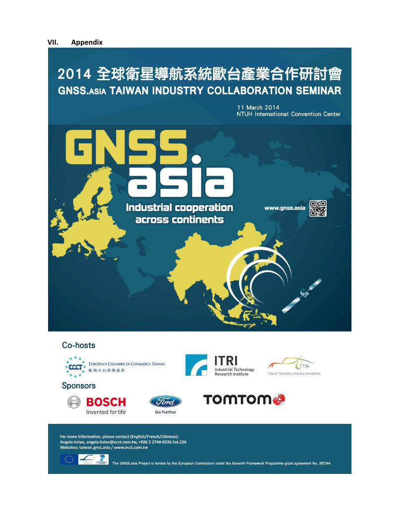
2014 GNSS.asia Taiwan Industry Collaboration Seminar Report
Deliverable D2.6.4
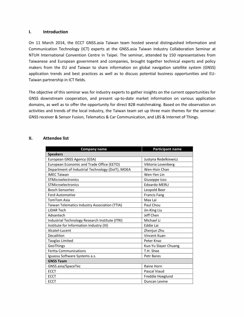
I. Introduction On 11 March 2014, the ECCT GNSS.asia Taiwan team hosted several distinguished Information and
Communication Technology (ICT) experts at the GNSS.asia Taiwan Industry Collaboration Seminar at
NTUH International Convention Centre in Taipei. The seminar, attended by 150 representatives from
Taiwanese and European government and companies, brought together technical experts and policy
makers from the EU and Taiwan to share information on global navigation satellite system (GNSS)
application trends and best practices as well as to discuss potential business opportunities and EU-
Taiwan partnership in ICT fields.
The objective of this seminar was for industry experts to gather insights on the current opportunities for
GNSS downstream cooperation, and present up-to-date market information on various application
domains, as well as to offer the opportunity for direct B2B matchmaking. Based on the observation on
activities and trends of the local industry, the Taiwan team set up three main themes for the seminar:
GNSS receiver & Sensor Fusion, Telematics & Car Communication, and LBS & Internet of Things.
II. Attendee list
Company name Participant name
Speakers
European GNSS Agency (GSA) Justyna Redelkiewicz
European Economic and Trade Office (EETO) Viktoria Lovenberg
Department of Industrial Technology (DoIT), MOEA Wen-Hsin Chan
IMEC Taiwan Wen-Yen Lin
STMicroelectronics Giuseppe Izzo
STMicroelectronics Edoardo MERLI
Bosch Sensortec Leopold Beer
Ford Automotive Francis Fang
TomTom Asia Max Lai
Taiwan Telematics Industry Association (TTIA) Paul Chou
LiDAR Tech Jin-King Liu
Advantech Jeff Chen
Industrial Technology Research Institute (ITRI) Michael Li
Institute for Information Industry (III) Eddie Lai
Alcatel-Lucent Zhenjun Zhu
Decathlon Vincent Kuan
Taoglas Limited Peter Knaz
GeoThings Kuo-Yu Slayer Chuang
Fertta Communications T.H. Shee
Iguassu Software Systems a.s. Petr Bares
GNSS Team
GNSS.asia/SpaceTec Raine Horn
ECCT Pascal Viaud
ECCT Freddie Hoeglund
ECCT Duncan Levine
ECCT Angela Hsiao
Private Companies
MediaTek Siefried Chang
KYEC Bernard Hsu
ASE Elisha Yang
Compal 鄭清松
UMC 李明彰 Philip Lee
System & Technology 藍明傳 Michael Lan
WAVEGIS Technology 李盈村 Richard
RoyalTek 唐自立
RoyalTek 林本驊
Locosys Technology Roger Liu
Locosys Technology Stella Chang
Locosys Technology Brenda Yuan
Locosys Technology Emma Chen
GlobalTop Technology 蔡政憲
GlobalTop Technology 俞行行
Haitec 黎瑋
Haitec 李怡珊
Haitec 陳智先
Haitec 蘇裕鈞
Wistron Jessica Huang
Wistron Lynn Chueh
Sunplus Technology 石光志
Sunplus Technology Tang Cheng Chen
Pegatron 童旭田
Pegatron 賴哲彥
Pegatron 黃中于
Pegatron Jeremy Lai
Pegatron 林冠宇
Jet Opto 蔡家祥
Ubiqconn 王健雄
Quanda Storage 卓裕山
Quanda Storage Robert Hu
E Lead 柯佳青
E Lead 吳憲昭
E Lead 歐姿青
Wonde Proud 陳志炫
ANSS BD Jack Chang
FIC Van Liu
Chunghwa Telecom Laboratories 林柏儔
Chunghwa Telecom Laboratories 陳志誠
Chunghwa Telecom Laboratories 王嘉綸
Chunghwa Telecom Taipei Division 黃正鑫
Taiwan Mobile David Su
Taiwan Mobile 蔡乙嘉
Far Eastern Group 喻芝蘭
Yofa Technology 李秋明
Wieson Technologies Jimmy Ho
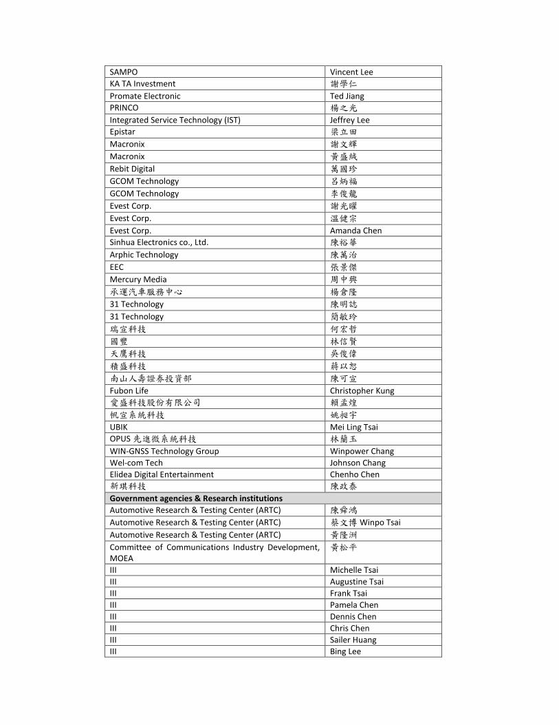
SAMPO Vincent Lee
KA TA Investment 謝學仁
Promate Electronic Ted Jiang
PRINCO 楊之光
Integrated Service Technology (IST) Jeffrey Lee
Epistar 梁立田
Macronix 謝文輝
Macronix 黃盛絨
Rebit Digital 萬國珍
GCOM Technology 呂炳福
GCOM Technology 李俊龍
Evest Corp. 謝光曜
Evest Corp. 溫健宗
Evest Corp. Amanda Chen
Sinhua Electronics co., Ltd. 陳裕華
Arphic Technology 陳萬治
EEC 張景傑
Mercury Media 周中興
承運汽車服務中心 楊倉隆
31 Technology 陳明誌
31 Technology 簡敏玲
瑞宣科技 何宏哲
國豐 林信賢
天鷹科技 吳俊偉
積盛科技 蔣以恕
南山人壽證券投資部 陳可宣
Fubon Life Christopher Kung
愛盛科技股份有限公司 賴孟煌
帆宣系統科技 姚昶宇
UBIK Mei Ling Tsai
OPUS 先進微系統科技 林蘭玉
WIN-GNSS Technology Group Winpower Chang
Wel-com Tech Johnson Chang
Elidea Digital Entertainment Chenho Chen
新琪科技 陳政泰
Government agencies & Research institutions
Automotive Research & Testing Center (ARTC) 陳舜鴻
Automotive Research & Testing Center (ARTC) 蔡文博 Winpo Tsai
Automotive Research & Testing Center (ARTC) 黃隆洲
Committee of Communications Industry Development, MOEA
黃松平
III Michelle Tsai
III Augustine Tsai
III Frank Tsai
III Pamela Chen
III Dennis Chen
III Chris Chen
III Sailer Huang
III Bing Lee
III Mavis Fan
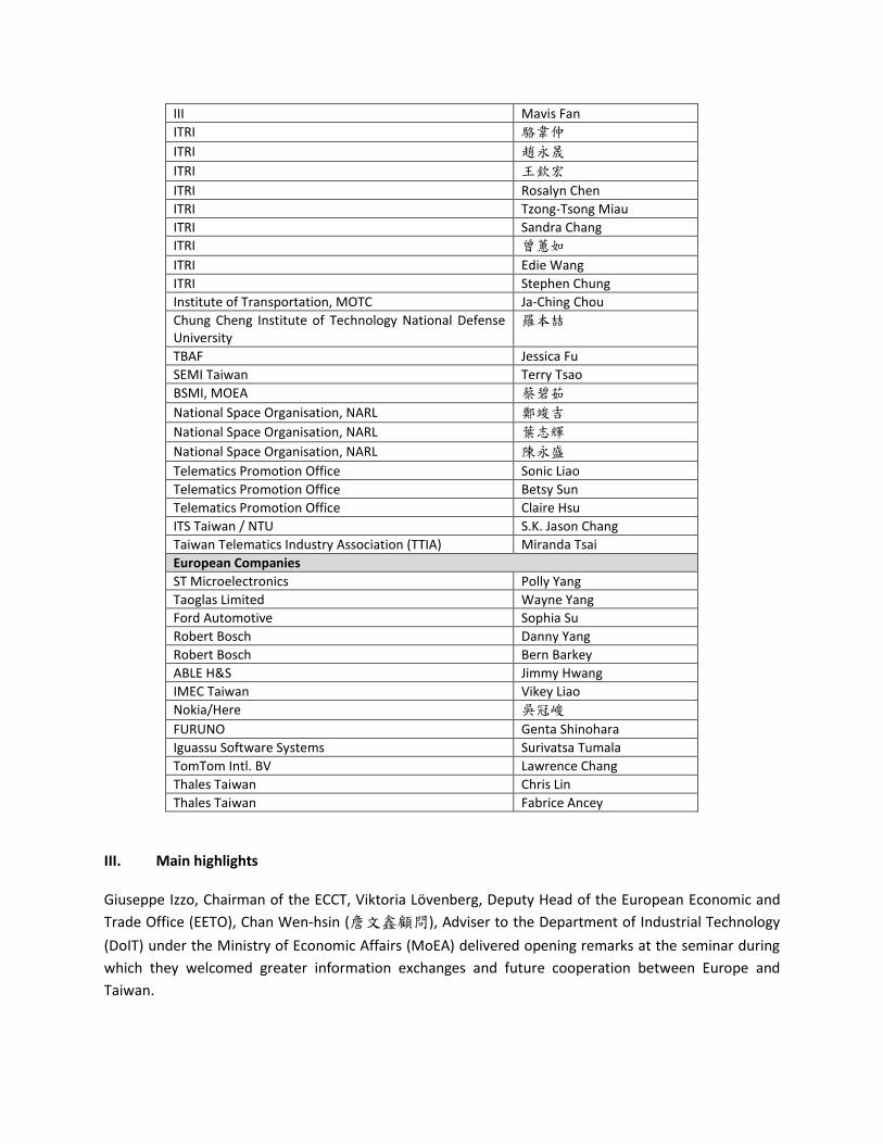
ITRI 駱韋仲
ITRI 趙永晟
ITRI 王欽宏
ITRI Rosalyn Chen
ITRI Tzong-Tsong Miau
ITRI Sandra Chang
ITRI 曾蕙如
ITRI Edie Wang
ITRI Stephen Chung
Institute of Transportation, MOTC Ja-Ching Chou
Chung Cheng Institute of Technology National Defense University
羅本喆
TBAF Jessica Fu
SEMI Taiwan Terry Tsao
BSMI, MOEA 蔡碧茹
National Space Organisation, NARL 鄭竣吉
National Space Organisation, NARL 葉志輝
National Space Organisation, NARL 陳永盛
Telematics Promotion Office Sonic Liao
Telematics Promotion Office Betsy Sun
Telematics Promotion Office Claire Hsu
ITS Taiwan / NTU S.K. Jason Chang
Taiwan Telematics Industry Association (TTIA) Miranda Tsai
European Companies
ST Microelectronics Polly Yang
Taoglas Limited Wayne Yang
Ford Automotive Sophia Su
Robert Bosch Danny Yang
Robert Bosch Bern Barkey
ABLE H&S Jimmy Hwang
IMEC Taiwan Vikey Liao
Nokia/Here 吳冠峻
FURUNO Genta Shinohara
Iguassu Software Systems Surivatsa Tumala
TomTom Intl. BV Lawrence Chang
Thales Taiwan Chris Lin
Thales Taiwan Fabrice Ancey
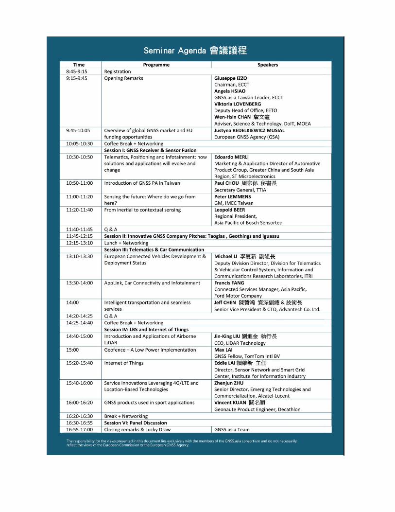
III. Main highlights
Giuseppe Izzo, Chairman of the ECCT, Viktoria Lövenberg, Deputy Head of the European Economic and
Trade Office (EETO), Chan Wen-hsin (詹文鑫顧問), Adviser to the Department of Industrial Technology
(DoIT) under the Ministry of Economic Affairs (MoEA) delivered opening remarks at the seminar during
which they welcomed greater information exchanges and future cooperation between Europe and
Taiwan.

In his welcoming remarks ECCT Chairman Giuseppe Izzo said that over the past two years the ECCT,
through the Taiwan chapter of the GNSS Asia project, has been actively involved in developing research
and industrial partnerships between EU and Asian organisations related to the European GNSS systems.
As more satellites are launched over the next two years and the availability and coverage of the signal
gradually improves, the project will move into an exciting new phase as early services become available.
There has already been huge growth in the location based services market and further growth will be
stimulated by the increased affordability of smartphones and other GNSS-enabled platforms. These
developments bring with them great business opportunities for both European and Taiwanese firms, he
concluded.
Viktoria Lövenberg described the GNSS project as ambitious. She said that satellite technology is a
powerful driver of the economy and will help create new jobs. Important steps have been taken through
GNSS.asia by linking stakeholders and there are interesting opportunities. She also highlighted the EU’s
Horizon 2020, the biggest EU research and innovation programme ever with nearly €80 billion of funding
available over seven years from 2014 to 2020, which will offer many opportunities for funding and
international collaboration and is crucial for the success of GNSS.
Chan Wen-hsin said that Taiwan is glad to be a part of the GNSS programme. Besides DoIT’s
involvement, Taiwan’s leading research institutes, the Industrial Technology Research Institute (ITRI) and
the Institute for Information Industry (III) have been involved and are actively pursuing Horizon 2020
projects together with European partners. Chan said that DoIT will continue to support funding for R&D
in satellite technology in Taiwan.
Angela Hsiao, GNSS.asia Taiwan Team Leader began the seminar presentations by introducing GNSS.asia
Taiwan. She noted that the objective of the seminar is to bring together the main stakeholders to spur
EU-Taiwan research and industrial partnerships on GNSS applications and receivers. GNSS.asia began at
the start of 2012, runs for 30 months and has the dual objectives of fostering business link-ups and
international cooperation.
After Ms Hsiao’s introduction, experts from the European GNSS Agency (GSA), Taiwanese industrial
research institutions, as well as major European and Taiwanese companies and innovative GNSS
companies gave presentations on the latest trends in the GNSS market, best practices and potential
business opportunities in the GNSS downstream sector between Europe and Taiwan. Three main
themes presented in the seminar were: GNSS receiver & sensor fusion, telematics & car communication,
and Location Based Services (LBS) & the Internet of Things (IoT).
Introductory session
Topic: Overview of the global GNSS market and EU funding opportunities
Speaker: Justyna Redelkiewicz, Market Development Project Officer, European Global Navigation
Satellite Systems Agency (GSA)
Mrs Redelkiewicz gave an update on the current status of the European Galileo programme and GNSS
programmes, an overview of the global GNSS market, as well as the funding opportunities in Horizon
2020. The European satellite navigation policy is presently implemented through the EGNOS and Galileo
programmes. The European Commission has delegated upstream matters (such as satellite roll-out) to
the European Space Agency while GSA is responsible for the downstream sector.
Mrs Redelkiewicz noted that with the launching of six to eight satellites by 2015, the Galileo Satellite
System will have its initial operational capability and start early services by 2015. Users will be able to
benefit from these services in combination with US GPS and other systems, such as the Russian
GLONASS. The Open Service will be Galileo’s freely accessible service for positioning, navigation and
timing. It will be fully interoperable with GPS and will be used for many mass-market applications,
including smartphones and in-car navigation. The Galileo Search and Rescue (SAR) service will be an
important tool for locating people in distress. It will provide a ‘forward link’ for the detection of distress
beacons, as well as a unique ‘return link’ feature that sends a detection acknowledgement message. In
this way, people in distress will know that help is on the way. SAR will be Europe’s contribution to a co-
operative effort on humanitarian search-and-rescue activities – known as COSPAS-SARSAT – which helps
save 1,300 lives every year.
The GNSS.asia team has held discussions with many players in Taiwan’s downstream sector including
chipset and application providers. Mrs Redelkiewicz acknowledged that Taiwan is especially interested
in LBS and road services, noting the rapid growth in built-in navigation systems in cars and how new
Intelligent Transport System (ITS) services are taking the use of GNSS far beyond in-vehicle navigation.
New policies and regulations in Europe will accelerate the business case for these trends. For example,
the European Parliament voted a compromise that by October 2015 all new cars and light vans in
Europe have to be equipped with Galileo and EGNOS enabled “eCall”, emergency devices that alert
rescue services to crashes. The in-vehicle eCall system uses emergency call technology to automatically
alert services to serious road accidents. It gives the location to help them arrive faster, save lives, reduce
injuries and cut congestion costs.
Mrs Redelkiewicz also noted the huge growth in LBS, which she described as a perfect fit with the
contemporary fast pace of life, especially in large cities because they respond to the growing needs for
mobility in urban environments and for getting to destinations quickly. They also facilitate faster social
networking. This combined with increased affordability of smartphones and other GNSS-enabled
platforms will drive the future growth of the LBS market expected to be 10% CAGR over the next
decade. Smartphones comprise 90% of LBS devices sold.
Mrs Redelkiewicz concluded her presentation by encouraging more EU-Taiwan cooperation in the
Horizon 2020 Galileo-related projects.
Session I: GNSS receivers and sensor fusion
Topic: Infotainment and telematics
Speaker: Edoardo Merli, Marketing & Application Director of Automotive Product Group, Greater
China and South Asia Region, ST Microelectronics
In this session Mr Merli described how with new technologies in telematics, positioning and
infotainment, solutions and applications will evolve and change. Cars are now connected and there is a
large range of automotive telematic applications ranging from emergency, navigation, diagnostic,
tracking, security and insurance. These are opening up new business models.
Telematics is one of the biggest growth areas in the automotive space but telematics is not limited to
automotive applications. Massive volumes are expected from consumer/industrial applications such as
tracking people, animals, containers, valuable goods, trains and ships. Companies involved in
automotive telematics naturally are very enthusiastic about the EU’s decision to make “eCall” safety
applications compulsory in new cars and vans in 2015. They are hoping governments in other markets
will adopt similar legislation.
STMicroelectronics has released its Teseo II single-chip satellite-tracking integrated circuit to the
European Space Agency (ESA) and the European Commission Joint Research Center (JRC) for testing for
eCall approval. The testing campaign is coordinated by the European GNSS Agency as part of its effort to
accelerate Galileo adoption. The Teseo II is a standalone satellite receiver able to use signals from
multiple satellite navigation systems, including GPS, the European Galileo system, Russian GLONASS, and
Japanese QZSS. This multi-constellation approach keeps many satellites in sight, delivering advantages
such as shorter time-to-first-fix and continuous tracking with enhanced accuracy, even under
challenging circumstances such as driving through urban canyons.
There are a lot of new players in the automotive space and some (such as Apple and Google) are
forming partnerships with automakers. In the past the automotive market was closed with fixed
relations between automakers and dealers but the new players are disrupting the traditional players
such as in the infotainment space.
ST is developing GNSS multi-constellation receivers for the automotive market, which provide better
accuracy, scalability and flexibility. While more satellites in the air will improve accuracy, getting
accurate positioning out of satellite range such as in canyons, tunnels and buildings requires the
integration of multi-sensors with satellites. When a satellite signal is not available, a variety of sensors
will be able to give an accurate position. Mr Merli explained how ST has developed a Dead Reckoning
(DR, the process of calculating one's current position by using a previously determined position)
software engine to provide users with accurate estimates of a vehicle‘s position and velocity by
combining information from satellites and sensors. A large number of Microelectromechanical systems
(MEMS) sensors will be needed in buildings, tunnels and other places not accessible by satellite signals
to enable accurate positioning for LBS and to give users the same smooth experience both indoors and
outdoors. In cars of the future the combination of sensors, cameras, GNSS and radar will be integrated
with infotainment systems into one seamless platform. But to realize this, you need the right kind of
products with the right functions at the right price.
Topic: GNSS Promotion Alliance (GNSSPA)
Speaker: Paul Chou, Secretary General, Taiwan Telematics Industry Association (TTIA)
In his presentation, Mr Chou introduced TTIA and announced the establishment of the Global Network
Satellite System Promotion Alliance (GNSSPA) working group. GNSSPA will promote automotive satellite
applications in Taiwan (for civilian business operations only) and cooperate with related associations
worldwide. TTIA is a government supported organization aimed at developing the telematics industry.
Its main functions are to make recommendations on policy to the government, establish international
platforms to act as bridges for global public, the private sector and academic institutes and to
coordinate among domestic associations.
The association has worked on promoting e-bus solutions and smart taxi dispatching systems among
other projects. It is now promoting automotive satellite applications for the purpose of enhancing
information for search and rescue, farming and fishing while cultivating the satellite industry in Taiwan
in line with international standards.
The members of GNSSPA will include academics in Taiwan and over 20 industrial representatives from
global satellite operators in Taiwan. GNSSPA plans to participate in the establishment of five major
industrial chains, in the integration of the various relevant work and operations, including R&D on
antennas, chip development, module integration and map data.
GNSSPA will serve all six of the global satellite systems and will consult experts in related associations
actively to establish Taiwan's satellite industry standards, test specifications, test fields and provide
certification services. Mr Chou said he is working with GNSSasia and companies to set up a working
group or task force and he welcomed others to join in new marketing initiative.
Topic: Sensing the future: Where do we go from here
Speaker: Lin Wen-Yen, Sales Director, IMEC Taiwan
In his presentation, Mr Lin presented expected future trends in GNSS receivers and sensor fusion.
30 years ago the TV series Night Rider gave us a vision of the future of the car as well as other devices.
Many of these are already a reality today such as smart watches. 92% of people are now using mobile
devices to get information and a further growth of 35% is predicted between 2012 and 2016. More and
more positioning-enabled solutions are being used and many are helping us to save time and money.
For example, the average driver spends 106 days of her life looking for parking. In Taiwan, that number
is likely to be even higher given the limited number of parking spaces, especially in the cities. A parking
finder app is the solution to eliminating all this wasted time. But for it to work it will need satellites and
sensors.
Thanks to semiconductor innovation, the size of antennas has been shrunk considerably over the years.
IMEC works on semiconductor technology such as antennas for high precision GNSS devices as well as
medical devices such as wireless cardiac monitoring patches, brainwave monitoring devices and sweat
analysis sensors.
The CEO of Cisco predicts that the total value from the internet of things will reach US$14.4 from 2013-
2023 given the rapid increase in applications from connected health, smart grids, smart buildings and
smart factories. These can be used for food quality control, sweat sensors (which can measure sweat,
stress levels and dehydration) while air quality sensors are useful in places like China given serious air
pollution.
Mr Lin concluded that more work needs to be done to realize the great potential. In particular smaller
devices will increase mobility and accuracy, ultra-low power will lead to greater autonomy,
reconfigurable technologies will enable new functionality and spectra, and new materials will be applied
for sensing the environment.
Topic: From inertial to contextual sensing
Speaker: Leopold Beer, Regional President, Asia Pacific, Bosch Sensortec
In his presentation Beer presented technologies from intertial to contextual sensing by focusing on
state-of-the-art MEMS solutions. Silicon is a much better material than steel for micro mechanical
structures. MEMS, miniature systems which usually combine tiny mechanical structures with electronic
circuits, are the main sensor clusters employed for indoor tracking and they are necessary for enabling
the next generation of wearable devices and the Internet of Things (IoT).
MEMS first became prominent with a gaming device in 2006. Since then growth has been exponential,
especially since the launch of smart phones. Given the rapid improvement in performance, shrinking size
and lower cost over the years, it is now possible to have 2-3 MEMS in each smart phone.
One of the major challenges today is how to reduce power consumption. To solve this you need smart
solution that turns off functions when they are not in use. Most of technologies for IoT are already there
but the services are not yet in place and the business models are not yet defined
Bosch is launching partnerships to drive this.
All levels of integration are available today which means that individual developers don’t need to know
how various systems work. To go from inertial to contextual sensing you need accuracy, size and power
efficiency but the biggest challenge is to integrate all systems and get them to work well together. In
addition, a standardization of interfaces is needed.

Session II: Innovative GNSS applications
In Session II, three innovative GNSS companies: Taoglas (Ireland), GeoThings (Taiwan), and Iguassu
(Czech Republic) presented their innovative products and solutions in GNSS applications.
Topic: Taoglas antenna solutions
Speaker: Peter Knaz, Senior Technical Sales Manager, Taoglas Taiwan
With headquarters in Ireland and facilities in the United States and Taiwan, Taoglas is engaged in the
business of antennas for the telecom, automotive and medical industries. Mr Knaz noted that it is
relatively easy to make GPS antennas but there are several physical challenges for covering all systems.
The market is heading towards smart antenna modules for embedded device applications. The
advantages of this is they are plug’n’play solutions, which reduce development and component costs
but the disadvantage is that customers have differing requirements regarding noise and space.
Topic: Geothings and Open GeoSMS
Speaker: Slayer Chuang (Kuo-yu)
Geothings is a spin off from ITRI. The company has developed an LBS location standard and APP, which
could be used for emergency and road side assistance services as well as in disaster-hit areas to
coordinate emergency response teams, volunteers or other relief efforts such as delivering emergency
supplies instantly. Geothings has developed an iHelp APP which allows users to quickly send pre-defined
geo-tagged SMS messages with their status and profile to the emergency call center in Taiwan. The
advantage of such an APP is that there is no need for a roaming package because it uses SMS. It can also
be used by people who cannot speak or hear. In addition, the beauty of such an APP is that it would not
require language skills for people travelling abroad.
Topic: Iguassu Software Systems
Speaker: Petr Bareš, Managing Director, Iguassu Software Systems
Iguassu Software Systems (ISS) is a Czech Republic-based company. It is a member of the Czech Space
Alliance, an industry association of 14 companies of which Mr Bareš has been the president since its
foundation in 2006. ISS has won more contracts from the European Space Agency than any other Czech
company. It participated in the writing of the Czech National Space Plan for the government. The
company is focused on EGNOS ground segment applications of space related subsystems, processing of
space-based data, real-time processing. The company is looking for partnerships related to its free
EGNOS educational tools for universities, which can be adapted for specific country or language needs,
as well as R&D cooperation.
Session III: Telematics & car communication
Topic: European connected vehicles development and deployment status
Speaker: Michael Li, Deputy Division Director, Industrial Technology Research Institute (ITRI)
In his presentation, Mr Li gave an update on the status of connected vehicles development and
deployment in Europe, and its development of cooperative Intelligence Transportation System (ITS).
Mr Li spoke about technology related to communication between vehicles (V2V) and infrastructure.
Vehicles are already connected to one another, the internet, the cloud and pedestrians but the
connection speed is still not fast enough. Vehicle safety applications require very low latency and
existing technology cannot satisfy this need. Dedicated short range communications (DSRC) technology
is suited to this.
Spectrum standards for DSRC are similar in the US and the EU. The US Department of Transportation
(DoT) announced a decision to move ahead with vehicle-to-vehicle communication technology for light
vehicles in February 2014. While the implementation will take several years, the DoT’s announcement
sends a signal to the market that will significantly enhance development of this technology and pave the
way for market penetration of V2V safety applications. Similarly, in Europe, the European Committee for
Standardization (CEN) and the European Telecommunications Standards Institute (ETSI) confirmed at
the sixth ETSI workshop on ITS in Berlin, that the first set of car-car standards are now available and
connected cars in Europe are on the way.
A number of associations are now working on development and rollout including the Amsterdam group,
a strategic alliance for key stakeholders with the common objective to facilitate joint deployment of
cooperative ITS in Europe. Several field testing projects of road infrastructure and management systems
are in the works. For example, the corridor stretching from the Netherlands, Germany and Austria,
which deploys roadside units dedicated to car-to-car communications, is set to start operating in 2015.
This is just one of many such deployment projects, all of which apply the same standards and system
specifications to ensure interoperability.
ITRI has been involved in supporting car makers and suppliers. It has been working with the USDoT since
2009 as well as the French SCORE@F project and participating in standard setting mechanisms and ETSI
interoperability tests. ITRI has also held a contest for innovative applications.
Mr Li concluded by saying that many governments globally have demonstrated their commitment
towards realizing connected vehicles in the near future. The first set of European ITS standards is
complete and ready for large-scale deployment and key stakeholders in Europe are planning to deploy
C-ITS in 2015. ITRI is developing DSRC solutions for connected vehicles while Taiwanese companies are
moving fast and offer many partnership opportunities.
Topic: AppLink, car connectivity and infotainment
Speaker: Francis Fang, Connected Services Manager, Asia Pacific, Ford Motor Company
Francis Fang presented Ford’s “AppLink”, car connectivity and infotainment. Ford expects the global
auto market to increase in size by another 30% from current levels to 109 million vehicles by 2020. In
Taiwan, the smart phone penetration is expected to reach 80% by 2018 and most new car buyers are
also smart phone users.
People want to stay connected while driving. They also want the experience to be personalized.
For safety reasons, voice operated functions need to work well. Ford’s Applink allows users to use
phones for entertainment, phone calls and other apps on their phone through voice-activated
commands. 1.5 million vehicles are already equipped with Applink, according to Mr Fang and it will soon
be available in Asia. This number is expected to rise to seven million by 2015.
Ford is working with application developers to integrate their efforts with its own vehicle developers.
Genivi is an open source platform maintained by Ford to integrate apps, smartphones and vehicles. Ford
believes this provides a win-win solution because it is license- free and gives customers the content they
want on a larger screen.
According to Bill Ford, cars are becoming mobile communication platforms and this is a great untapped
opportunity. Looking ahead, in-car systems will become more responsive and seamless given connection
to the cloud to personalise the experience. For example, the desired radio station can be automatically
switched on, the temperature can be adjusted precisely, the best traffic route will be chosen based on
conditions and a parking space will be found in advance.
Topic: Intelligent transportation by seamless and valuable services
Speaker: Jeff Chen, Chief Technology Officer, Advantech Corporation Limited
Two of the most influential factors in the 21st century are urbanization and high tech evolution.
We need solutions to deal with large populations in cities. Logistics and transportation is therefore a
major focus of Advantech in addition to healthcare and the home. IT is the backbone of living in a
megacity. We need good cars that are as safe as possible as well as railways and metros.
Advantech is involved in many public transport projects in Europe and Taiwan, providing computers and
modules such as fare collection modules, traffic management systems and toll systems. It also provides
components for Taipei’s U-bike and e-tag systems.
A valuable lesson that Advantech has learned through experience is that people will decide if your
system is good or bad. A user-friendly approach that seamlessly combines hardware and software that is
easy to use is therefore crucial. In addition, machines have to be able to withstand and operate
effectively in harsh environmental conditions. Companies also have to be open and flexible to changing
market needs. For example, a good e-bus system needs to combine automated fare collection with an
intelligent traffic management system and a fleet management system. To make an ebus system work
you need to satisfy passengers, manage the behavior of drivers and work with traffic authorities. Fleet
management involves managing driver behavior and optimising operational expenditures.
So-called “big data” will be increasingly useful in the future. For example, fire-fighting services will be
able to work much more effectively when fighting a fire in a building if they have instantly-accessible
information on the layout of the building and the number of people living there. Communication tools
linked to other emergency services such as a real-time GPS map showing the location of ambulances
would also improve the effectiveness of emergency response coordination. Besides emergency services,
smart IT systems are increasingly being deployed in the logistics industry to link multiple players in the
supply chain. For example, retailers will increasingly use smart systems to transport and track time-
sensitive items such as perishable food.
Session IV: LBS and the Internet of Things (IoTs)
Topic: Introduction and applications of airborne LiDAR
Speaker: Liu Jin-king, CEO, LiDAR Technology
In his presentation Mr Liu introduced his company’s innovative technology, airborne LiDAR. Light
Detection And Ranging (LiDAR), is a remote sensing technology that measures distance by illuminating a
target with a laser and analyzing the reflected light. Using this technology the company produces geo-
information (geomatics) products and applications such as topographical maps. These can be used to
analyse features such as surface water and ground subsidence (e.g. along Taiwan’s high speed rail line).
Another area is location-based services (LBS).
LiDAR is applied to various areas such as close range laser scanners and mobile systems in cars and
ships. Google uses LiDAR to get 3D images of landscape or buildings. LiDAR mapping is also used to
create digital models in film. For example, the environmental apocalypse movie “The Day After
Tomorrow” used the technology. For the film, a team scanned 13 blocks of New York City using LiDAR.
Three other teams then photographed each building from inside a building directly across the street.
They then mapped photos onto models and added water and people to create the realistic images of
chaos depicted in the movie.
Taking readings of 1-10 points per square metre combined with full waveform inversion, it is possible to
get very detailed topography even when a direct view of the surface is blocked by dense forest canopy.
Recent improvements in full waveform LiDAR can enhance signals if trees or other objects disrupt the
signal, improving the results for geological and other analysis. LiDAR can provide a wealth of information
on things like fault lines and volcanos.
In 2010 LiDAR Technology started a detailed mapping programme for disaster topography in Taiwan.
The company has found very important geological features such as active faults near Taipei (Mr Liu
reassured the audience that the definition of active could mean active within the last 20,000 years).
They also analysed the areas hit by typhoon Morakot in 2009, providing valuable analysis to help
estimate the potential for landslides and floods in the future.
Topic: Geofence – A low power implementation
Speaker: Max Lai, GNSS Fellow, TomTom International BV
The speaker focused on the new technology of Geofence. A Geofence is a virtual perimeter on a
geographic area. When a mobile device enters, exits, stays inside or outside the Geofence, the action is
known as a Geofence event and a notification or signal indicating the event is generated from the
application software. Geofencing applications are used in fleet management, Location Based Services
(LBS), mobile advertising, child location services, auto check-in at venues and agriculture.
The challenge facing Geofencing is to how limit its large power consumption needs. Shifting to silicon
and creating a smart system that automatically switches off power-hungry applications when not in use
helps to reduce power consumption. TomTom’s innovation is that it can support any shape and handle
challenging environments. Moreover, receivers need to operate at full power in critical zone areas but
TomTom’s solution tries to keep this area as small as possible. Lai’s presentation included a
demonstration on how the Geofence works when users are close to a Geofence border.
Topic: The Internet of Things
Speaker: Eddie Lai, Director, Sensor Network & Smart Grid Center (SNSI), Institute for Information
Industry (III)
The speaker gave an overview of the Internet of Things (IoT) and current developments at III. IoT refers
to uniquely identifiable objects and their virtual representations in an internet-like structure (objects
with an IP address/URI connected via a mostly wireless network) that have the ability to communicate
with one another and cloud or control centres.
The number of users and applications is growing. By 2020 there will be billions of users, millions of
applications and 212 billion Internet of Things (IoT) objects. Given the huge volume the potential for
applications and profits is enormous. Cisco CEO John Chambers estimates that IoT will generate US$14
trillion in profits between 2013 and 2023.
III has worked with the Ministry of Transportation and Communications (MoTC) and the Taipei City
Government to collect real-time traffic data via GPS and conduct advanced data computing and analysis.
In addition, it has worked with partners to develop BestLINK, an enhanced Wi-Fi transmission with an
extended range of up to 250km, In-Snergy, a cloud-based energy management system, AMI, an
advanced metering infrastructure and GNSS Fast Cold Start, which cuts down the length of time to
acquire a satellite signal to just three seconds. III is also working on geotagging for digital photos so you
can record where you took a photo.
Topic: Where mobile meets cloud
Speaker: Zhu Zhen-jun, Senior Director, Emerging Technologies and Commercialization, Alcatel-Lucent
The speaker focused on service innovations leveraging 4G/LTE and Location-Based-Services (LBS)
technologies. The company is helping its customers to establish new applications and business models,
not just faster internet. LTE will provide more precise location based services. Small cells in buildings will
provide better and more accurate coverage, especially indoors.
A lot of new services can be developed including navigation, entertainment in 4G as well as crowd
sourced traffic information. The network can provide more accurate positioning and improved big data
collection.
Retail, logistics and fleet management businesses will find LBS technology essential but we are just
scratching the surface in terms of new uses. For example, having access to elevator traffic data in office
buildings, could be useful for a number of consumer businesses catering to office workers. Faster
interaction with the cloud is important although not all information can be stored in the cloud. The right
balance needs to be found to optimize what is in the cloud and what is stored on the device.
Mr Zhu concluded that there are great LBS market opportunities. He cited statistics from Pyramid
Research predicting that global LBS market revenue will reach US$10.3 billion in 2015, up from just
US$2.8 billion in 2010. Stand-alone personal navigation devices (PNDs), Google and Nokia are shifting
the business model from payment to advertising-funded. Telecom carriers have unique advantages as
enablers of LBS service innovation.
Topic: GNSS products used in sports applications
Speaker: Vincent Kuan, Geonaute Product Engineer, Decathlon
The speaker’s presentation introduced his company’s GNSS products used in sports applications. The
company’s products include robust devices that register items such as distance travelled and heart rate.
Built-in sensors measure barometer and compass readings to help hikers, cyclists and runners. Devices
can be connected to mobile phones and can be programmed to buzz or vibrate to alert users about
important information as well as dangers, such as dangerously elevated pulse-rates.
Mygeonaute is a range of exercise-monitoring products combined with a cloud-based platform that
helps sportspeople monitor, compare and analyse their sports activities. It allows users to measure their
performance and share it with friends. The company is now also developing a coaching service. To make
devices and services even better, a number of challenges will need to be addressed including reducing
the still 30-plus second delay in connection times, reducing power consumption, shrinking devices
further (especially antennas and batteries), improving accuracy (GNSS will be more accurate than GPS)
and introducing wireless re-charging functionality.
Panel discussion
During the panel discussion that followed the presentations, TH Shee, Co-founder of Fertta
Communications led the discussion among the panelists and participants on industrial cooperation
between Europe and Taiwan in the GNSS downstream sector. Panelists concluded that GNSS technology
holds enormous potential for business and social development. However, given the enormously diverse
and complex nature of GNSS technology, it is important to develop a range of partnership in different
industries. The problems of accuracy, cost and power can only be resolved by through partnerships that
draw on experts from all the relevant fields. Panelists concluded that both Europe and Taiwan are key
players in the future of GNSS development.
Data policy that addresses both the technical challenges related to data storage as well as privacy
concerns is a major challenge that needs to be resolved to spur innovation.
Another conclusion reached is that the user experience is crucial. People want different things and user
interfaces must be adapted to make devices and applications user-friendly and fun. The central focus of
all service provides, therefore, should always be on how to solve the problems and meet the needs of
users.
On the question of the future of other satellite players such Beidou, panelists reiterated that the crucial
difference between them and GNSS is that GNSS is a civilian-controlled system and that Europe has a
strong commitment to providing an open system for global civilian benefits and not military use. The
seminar concluded with the finalization of several propositions on establishing links between Taiwanese
partners and European companies.
IV. Specific actions to follow up
The seminar has allowed the Taiwan team to capture well the capacity and interests of some key
companies to develop GNSS-related applications in the future. These companies also have the intention
to intensify the business with Taiwanese and European industry. The team will keep a close contact with
the targeted companies by providing more up-to-date information on Galileo, GNSS.asia activities (ie.
the 3rd EU-Asia Industry Collaboration Seminar and European Space Solutions Conference in Prague in
June; ITS Europe Congress in Helsinki in June), Horizon 2020 and technological news in the GNSS field.
DoIT of MOEA, III, ITRI, TPO and TTIA have shown their support to the GNSS.asia project and its
future activities. The DoIT is planning to combine the force of public and private sectors and propose
initiatives and promotion strategy to encourage the development of GNSS applications in Taiwan.
Taiwanese government has also set up incentives to encourage the local participation to European
Horizon 2020 projects. The team therefore needs to follow up the local government’s plan and strategy
for further cooperation opportunities.
European companies who were not able to attend the seminar this time will be informed by the
team and provided with information of potential local companies for more business opportunities.
Local companies who have shown their interest in GNSS.asia will be contacted or visited individually to
understand the companies’ products, solutions and their requirement for European business partners.
V. Outcome of side event
On 10 March, the day before Taiwan Seminar, the Taiwan team arranged two meetings with the
Taiwanese public stakeholders and the European Economic & Trade Office (EETO) to intensify the
conversation between the Taiwan public sector and European representatives. These meetings are a
follow-up action after the first meetings during the Taiwan Workshop on November 2012.
Meeting with DoIT, MOEA, ITRI, III, TPO and TTIA
The meeting was hosted by Advisor to DoIT, Mr. Wen Hsin Chan. Experts from the Institution for
Information Industry (III), Industrial Technology Research Institution (ITRI), Telematics Promotion Office
(TPO), and Taiwan Telematics Industrial Association (TTIA) gathered with the ECCT’s GNSS.asia team to
look for a better understanding of the Galileo programme and GNSS.asia project, as well as the state of
art of Horizon 2020 programme. This is the second time that key Taiwanese players in policy, research
and industry sides were able to discuss together with the GSA representative, GNSS.asia global
coordinator, and GNSS.asia Taiwan team on the future of EU-Taiwan industrial cooperation for the
Global Navigation Satellite System (GNSS).
The discussion has served to present the current status of Galileo Programme and GNSS.asia
project, market trends in GNSS, Horizon 2020 funding opportunities and the EU-Taiwan industry
cooperation. The attendees agreed that it is urgent to promote the EU-Taiwan cooperation, notably
within the scope of Horizon 2020. Mr. Wen Hsin Chan of DoIT, MOEA, Mr. Paul Chou of TTIA, as well as
representatives from III and ITRI expressed their interests to understand more about the Horizon 2020
funding opportunities and the ongoing GNSS development and applications in Europe with more
available elements provided from the GSA.
Meeting with EETO and ECCT CEO
The European representatives had opportunities to meet the Deputy Head of Office of EETO, Viktoria
Lövenberg, and ECCT CEO, Freddie Hoeglund to exchange ideas on the continuation of GNSS.asia project
and the EU-Taiwan cooperation in the future.
VI. Conclusion Comparing with the Taiwan Workshop in 2012, the team has witnessed a much greater participation
from the audience (70 participants in 2012, 150 in 2014); as well as a higher appreciation from the
Taiwan industry in various domains. The Taiwan industry and the GNSS market have matured in the
development of cross-sectors applications within the multi-GNSS environment. GNSS receivers, sensor
fusion, telematics and car communication continue to be the hot topics in the Taiwanese GNSS market.
There are more and more differentiated applications in Location Based Services (LBS), such as for the
outdoor activities, commercial services, and telecommunication. Under the big umbrella of Internet of
Things (IoT), Taiwan industry has started to take a closer look at the role of GNSS in the development of
IoT applications.
As Galileo is a strategic programme and Horizon 2020 supports its global uptake, there is a need to have
the European Commission involved and to bring key messages directly addressed to both the
government representatives and companies. Taiwanese government directs and supports the island’s
development of Science & Technology, and the business orientation with a top-down decision-making
structure. Therefore, the interaction between the EC and the local government regarding Galileo,
GNSS.asia and Horizon 2020 programmes in general would be crucial.
There is a need to stimulate the interaction between companies in Taiwan and in Europe as planned
precisely within the scope of the GNSS.asia project. After receiving positive feedback from the seminar,
the GNSS consortium and the local team have to plan more follow-up activities in 2014 to encourage the
industrial interaction. Taiwanese companies have shown their great interest in cooperating with
potential European partners.
VII. Appendix
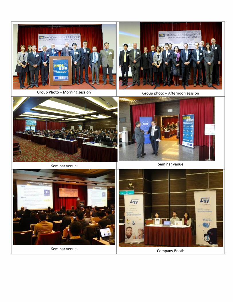
Group Photo – Morning session
Group photo – Afternoon session
Seminar venue
Seminar venue
Seminar venue
Company Booth
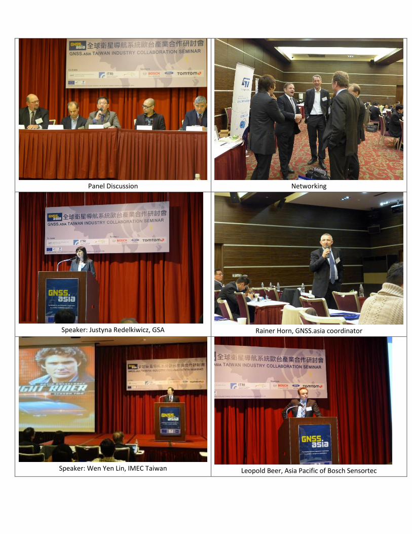
Panel Discussion
Networking
Speaker: Justyna Redelkiwicz, GSA
Rainer Horn, GNSS.asia coordinator
Speaker: Wen Yen Lin, IMEC Taiwan
Leopold Beer, Asia Pacific of Bosch Sensortec


![[SEMI Theater] Taiwan Market Update SEMICON Taiwan](https://img.pdfslide.us/doc/110x75/55588b1ad8b42a5d328b52fd/semi-theater-taiwan-market-update-semicon-taiwan.jpg)