Embed Size (px)
Citation preview

APPENDIX E
2011 Supplemental Biological Surveys of NASA-Administered Property at Santa Susana Field Laboratory

This page intentionally left blank.

2011 Supplemental Biological Surveys
of NASA-Administered Property at
Santa Susana Field Laboratory
National Aeronautics and Space Administration
Huntsville, Alabama
December 2011
Appendix E, NASA SSFL EIS for Proposed Demolition and Environmental Cleanup
E-1

This page intentionally left blank.
Appendix E, NASA SSFL EIS for Proposed Demolition and Environmental Cleanup
E-2

Acronyms and Abbreviations ............................................................................................................................. v
1 Introduction ...................................................................................................................................... 1-1 1.1 Purpose ............................................................................................................................................ 1-1 1.2 Background ...................................................................................................................................... 1-1 1.3 Location and Environmental Setting ............................................................................................... 1-1
1.3.1 General ............................................................................................................................... 1-1 1.3.2 Habitat Types ...................................................................................................................... 1-5 1.3.3 Soils ................................................................................................................................... 1-10 1.3.4 Climate Summary ............................................................................................................. 1-10
2 Methods ........................................................................................................................................... 2-1 2.1 Botanical Surveys ............................................................................................................................. 2-1
2.1.1 Pre-field Preparation .......................................................................................................... 2-1 2.1.2 Reference Populations ........................................................................................................ 2-5 2.1.3 Field Surveys ....................................................................................................................... 2-9 2.1.4 Sensitive Habitat Types ....................................................................................................... 2-9 2.1.5 Noxious and Invasive Weeds ............................................................................................ 2-10
2.2 Wildlife Surveys ............................................................................................................................. 2-10
3 Results .............................................................................................................................................. 3-1 3.1 Special-Status Plant Species ............................................................................................................ 3-1
3.1.1 Santa Susana tarweed (Deinandra minthornii) .................................................................. 3-1 3.1.2 Slender mariposa lily (Calochortus clavatus var. gracilis) .................................................. 3-1 3.1.3 Plummer’s mariposa lily (Calochortus plummerae) ........................................................... 3-1
3.2 Sensitive Habitats ........................................................................................................................... 3-1 3.3 Noxious and Invasive Weeds ........................................................................................................... 3-5 3.4 Special-Status Animal Species ......................................................................................................... 3-5 3.5 Wildlife Observations .................................................................................................................... 3-11
4 Conclusions and Recommendations ................................................................................................... 4-1 4.1 Conclusions ...................................................................................................................................... 4-1 4.2 Recommendations ........................................................................................................................... 4-1
5 References ........................................................................................................................................ 5-1
Appendixes A Special-Status Plants Identified in the Database Review Not Expected to Occur on the Site B Rare Plant Reference Site Photographs C List of Plant Species Observed D Representative Photographs of the Site, Special-status Plants, and Wildlife Species E Wildlife Species Observed in 2010 and 2011
Tables
1-1 Mapped Habitat Types and Current California Vegetation Classification System ............................................ 1-9 2-1 Special-Status Plant Species that Potentially Occur on the NASA-administered Property at SSFL ................... 2-2 3-1 Noxious and Invasive Weeds Identified on the NASA-administered Property at SSFL ..................................... 3-9
Appendix E, NASA SSFL EIS for Proposed Demolition and Environmental Cleanup
E-3

Figures
1-1 Regional Map .................................................................................................................................................. 1-3 1-2 Site Overview .................................................................................................................................................. 1-7 1-3 NRCS Soil Mapping Units .............................................................................................................................. 1-11 2-1 Special Status Plant Reference Locations ....................................................................................................... 2-7 3-1 Special-Status Plant Locations ........................................................................................................................ 3-3 3-2 Sensitive Natural Communities ...................................................................................................................... 3-7 3-3 Significant Wildlife Observations .................................................................................................................. 3-11
Appendix E, NASA SSFL EIS for Proposed Demolition and Environmental Cleanup
E-4

Acronyms and Abbreviations Boeing The Boeing Company Cal-IPC California Invasive Pest Plant Council CDFA California Department of Food and Agriculture CDFG California Department of Fish and Game CNDDB California Natural Diversity Data Base CNPS California Native Plant Societies EIS Environmental Impact Statement ENTS Laboratory Engineered Natural Treatment Systems ESA Endangered Species Act ºF Degree Fahrenheit ft Feet GIS Geographic information system GPS global positioning system LOX Liquid oxygen NAD North American Datum NASA National Aeronautics and Space Administration NRCS Natural Resources Conservation Service RCRA Resource Conservation and Recovery Act RFI RCRA Facility Investigation SAIC Science Applications International Corporation SSFL Santa Susana Field Laboratory SSURGO Soil Survey Geographic Database USFWS U.S. Fish and Wildlife Service WRCC Western Regional Climate Center
Appendix E, NASA SSFL EIS for Proposed Demolition and Environmental Cleanup
E-5

This page intentionally left blank.
Appendix E, NASA SSFL EIS for Proposed Demolition and Environmental Cleanup
E-6
SECTION 1
Introduction This report presents the findings of special-status plant species and wildlife surveys conducted in 2011 on the National Aeronautics and Space Administration (NASA)-administered property at Santa Susana Field Laboratory (SSFL) in southern California. SSFL was established shortly after World War II and has been used primarily as a site to develop and test nuclear reactors, rockets, and missiles. The 2,850-acre site is divided into four production and two buffer areas (Areas I, II, III, and IV, and the northern and southern buffer zones). A portion of SSFL is federally owned property that is administered by NASA. The remaining property at SSFL is owned by The Boeing Company (Boeing). The NASA-administered property at SSFL consists of 41.7 acres within Area I and all 409.5 acres of Area II. The Boeing Company owns the remainder of Area I, all of Areas III and IV, and the northern and southern buffer areas at the site.
1.1 Purpose This report presents the results of protocol-level botanical surveys and opportunistic wildlife surveys of the NASA-administered property at SSFL. These biological surveys were conducted to support NASA’s preparation of a Ecological Stewardship Plan for the property it administers at SSFL. The findings also will be used as the basis for the biological resources section of the Environmental Impact Statement (EIS) being prepared to assess the potential impacts of NASA’s proposal to demolish structures and to remediate soil and groundwater on the NASA-administered property at SSFL. This report has been prepared as a supplement to the Fall 2010 Habitat and Listed Species Surveys of NASA-Administered Property at Santa Susana Field Laboratory (NASA, 2011).
1.2 Background In April 2008 and May 2009, ecological surveys were conducted on portions of the NASA-administered property at SSFL as part of Resource Conservation and Recovery Act (RCRA) Facility Investigations (RFIs) (NASA, 2008; 2009a; 2009b). The fall 2010 habitat and listed species surveys (NASA, 2011) together with the 2011 botanical and wildlife surveys are intended to expand on the past ecological surveys through a survey of the entire NASA-administered property at SSFL, including some limited areas outside the RFI areas that had not been surveyed previously.
Several other ecological studies conducted at SSFL between 2005 and 2009 were reviewed for potential insight into the biological resources on the NASA-administered property:
• MWH Americas, Inc., and AMEC Earth & Environmental, Inc. (2005) • MWH Americas, Inc., and ERM (2007) • Ogden Environmental and Energy Services Co., Inc. (1998) • Padre Associates, Inc. (2008) • Science Applications International Corporation (SAIC) (2009)
1.3 Location and Environmental Setting Section 1.3 is summarized from a more detailed environmental setting description contained in the Fall 2010 Habitat and Listed Species Surveys of NASA-Administered Property at Santa Susana Field Laboratory (NASA, 2011). Additional information regarding physiography, geology, and habitat types also is included in that report.
1.3.1 General SSFL is approximately 29 miles northwest of downtown Los Angeles in the southeastern corner of Ventura County, California. SSFL is located mostly within an unincorporated part of Ventura County; its easternmost portion extends slightly into an unincorporated part of Los Angeles County (Figure 1-1). It encompasses 2,850 acres within a remote, mountainous area near the crest of the Simi Hills at the western border of the San Fernando Valley.
Appendix E, NASA SSFL EIS for Proposed Demolition and Environmental Cleanup
E-7

This page intentionally left blank.
Appendix E, NASA SSFL EIS for Proposed Demolition and Environmental Cleanup
E-8

Chatsworth Reservoir
West Hills
Chatsworth
San Fernando Valley
Santa Susana Knolls
Ventura County
SSFL Site Boundary
Los Angeles County
BoxCanyon
Black Canyon
Woolsey Canyon
Dayton Canyon
BOEING AREA INASAAREA II
UNDEVELOPED LAND(BOEING)
BOEINGAREA IV
BOEINGAREA III
NASAAREA I
UNDEVELOPED LAND(BOEING)
UNDEVELOPED LAND
(BOEING)
Former Ahmanson RanchDevelopment Project
Brandeis-BardinInstitute
Runkle Canyon
Sage Ranch
Bell Canyon
UV118
UV134
UV27
UV134UV118
UV118
tu101
Los Angeles
Simi Valley
Thousand Oaks
Agoura Hills
Moorpark
CalabasasWestlake Village
Hidden Hills
Oak Park
SSiimmii ,, AArrrrooyyoo
BBrr oo
wwnn ss
CCaa nn
yy oonn
WWaa
ss hh
Angeles River, LosAngeles River, Los
MMeeddeeaa CCrreeeekk
BB ee ll ll CCrreeeekk
LL iimm
ee kkii ll nn
CCaa nn
yy oonn
WWaa
ss hh
FFaallllss CCrreeeekk
SSaannttaa SSuussaannaa PPaassss WW
aasshh
CC oo nn ee jj oo ,, AArr rr oo
yyoo
CChhaattssww
oorrtthh CCrreeeekk
SSaannttaa RRooss aa,, AArrrrooyyoo
Bell CreekBell Creek
Figure 1-1Regional MapNASA Supplemental Biological Survey – 2011Santa Susana Field LaboratoryVentura County, California
18-Oct-2011Drawn By:A. Cooley
Map Document: O:\NASA\SSFL\maps\EIS_2011\BioSurvey_Spring2011\SSFL_Regional.mxd
Map Source: NASA and ESRI® Data & Maps 2006
0 1 20.5Miles
0 1.5 30.75Kilometers
Appendix E, NASA SSFL EIS for Proposed Demolition and Environmental Cleanup
E-9

This page intentionally left blank.
Appendix E, NASA SSFL EIS for Proposed Demolition and Environmental Cleanup
E-10
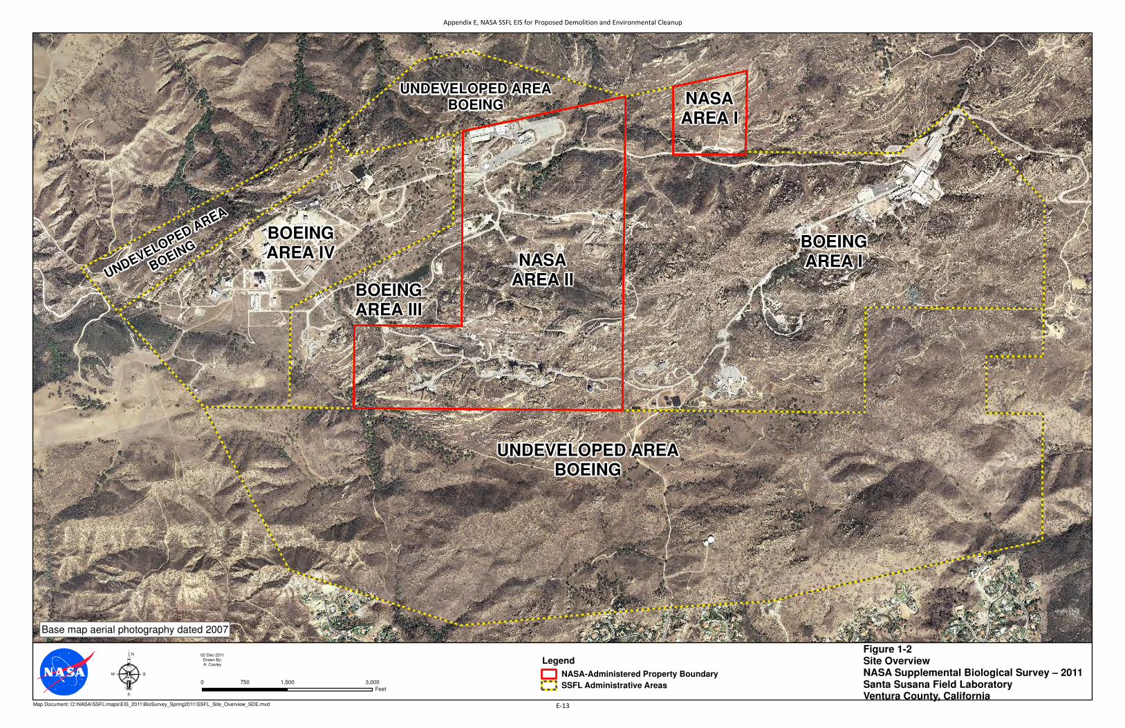
Area I LOX Plant and Area II are in the central and north-central parts of SSFL, respectively (Figure 1-2). The 451.2 acres of the NASA-administered property at SSFL represents approximately 16 percent of the total site area.
SSFL’s landscape is characterized by sandstone outcropping hills. Numerous industrial facilities, constructed drainage systems, and roadways have been developed within this hilly landscape. The site is within the central portion of the Southern California Coast ecological subregion in the Simi Valley–Santa Susana Mountains (261Be) ecological subsection. This subsection includes steep mountains; moderately steep to steep hills; and nearly level to gently sloping floodplains, terraces, and alluvial fans (Miles and Goudey, 1998).
1.3.2 Habitat Types Habitat surveys of the NASA-administered property conducted during fall 2010 identified eight natural terrestrial habitat types, two aquatic habitat types, and ruderal and developed areas (NASA, 2011). These habitat types are described briefly in the following text. Table 1-1 cross-references the mapped habitat types and the current California vegetation classification system (Sawyer et al., 2009).
Chaparral Chaparral is the most abundant and widespread natural community at the site. This habitat covers 172.6 acres (approximately 38 percent) of the NASA-administered property. Characteristic species include chamise (Adenostoma fasciculatum), hoaryleaf ceanothus (Ceanothus crassifolius), black sage (Salvia mellifera), laurel sumac (Malosma laurina), thickleaf yerba santa (Eriodictyon crassifolium), Mendocino bushmallow (Malacothamnus fasciculatus), and chaparral yucca (Yucca whipplei). The abundance of these species is variable within this habitat type depending on soils, aspect, past disturbance, and other environmental factors.
Venturan Coastal Sage Scrub Venturan coastal sage scrub covers 64.4 acres (approximately 15 percent) of the site. Characteristic species include coastal sagebrush (Artemisia californica), Eastern Mojave buckwheat (Eriogonum fasciculatum var. fasciculatum), black sage, chaparral yucca, thickleaf yerba santa, and common deerweed (Acmispon glaber).
Non-native Grassland Grassland habitat covers 19.2 acres (approximately 4 percent) of the site and often occurs in a mosaic with other habitat types. Most of the grasslands are characterized by slender oat (Avena barbata), intermixed with other introduced annual grasses such as ripgut brome (Bromus diandrus), soft brome (Bromus hordeaceus), and fescue (Vulpia spp). Native grasses including needlegrass (Nassella spp.), littleseed muhly (Muhlenbergia microsperma), and deergrass (Muhlenbergia rigens) are present in a few areas, but generally provide only minimal cover. Common herbaceous species include suncup (Camissonia spp.), winecup clarkia (Clarkia purpurea), longbeak stork’s bill (Erodium botrys), and winter vetch (Vicia villosa).
Coast Live Oak Woodland Coast live oak woodland is distributed widely across the site but only makes up 13.2 acres (approximately 3 percent) of the NASA-administered property. This habitat is characterized by mature coast live oak (Quercus agrifolia) trees. The understory generally consists of annual grasses such as ripgut brome and slender oat, with occasional native grasses including blue wildrye (Elymus glaucus) and California brome (Bromus carinatus). The understory shrub layer is poorly developed and, where present, generally consists of scattered Pacific poison oak (Toxicodendron diversilobum).
Appendix E, NASA SSFL EIS for Proposed Demolition and Environmental Cleanup
E-11

This page intentionally left blank.
Appendix E, NASA SSFL EIS for Proposed Demolition and Environmental Cleanup
E-12
AREA II
UNDEVELOPED AREABOEING
BOEINGAREA INASA
AREA II
BOEINGAREA IV
BOEINGAREA III
UNDEVELOPED AREABOEING NASA
AREA I
UNDEVELOPED AREA
BOEING
Figure 1-2Site OverviewNASA Supplemental Biological Survey – 2011Santa Susana Field LaboratoryVentura County, California
02-Dec-2011Drawn By:A. Cooley
Map Document: O:\NASA\SSFL\maps\EIS_2011\BioSurvey_Spring2011\SSFL_Site_Overview_SDE.mxd
0 1,500 3,000750
Feet
Legend
NASA-Administered Property Boundary
SSFL Administrative Areas
Base map aerial photography dated 2007
Appendix E, NASA SSFL EIS for Proposed Demolition and Environmental Cleanup
E-13

This page intentionally left blank.
Appendix E, NASA SSFL EIS for Proposed Demolition and Environmental Cleanup
E-14

TABLE 1-1 Mapped Habitat Types and Current California Vegetation Classification System NASA SSFL 2011 Supplemental Biological Surveys of NASA-Administered Property at Santa Susana Field Laboratory
Mapped Natural Habitat Types Current California Vegetation Classification System1
Chaparral Adenostoma fasciculatum – Salvia mellifera Shrubland Alliance Malosma laurina Shrubland Alliance Malacothamnus fasciculatus Shrubland Alliance Eriodictyon crassifolium Provisional Shrubland Alliance
Venturan Coastal Sage Scrub Artemisia californica –Eriogonum fasciculatum Shrubland Alliance
Non-Native Grassland Avena(barbata, fatua) Semi-Natural Herbaceous Stands
Coast Live Oak Woodland Quercus agrifolia Woodland Alliance
Coast Live Oak Riparian Forest Quercus agrifolia Woodland Alliance
Baccharis Scrub Baccharis pilularis Shrubland Alliance
Mule-fat Scrub Baccharis salicifolia Shrubland Alliance
Southern Willow Scrub Salix lasiolepis Shrubland Alliance
Note: SSFL = Santa Susana Field Laboratory 1 Sawyer et al.( 2009)
Coast Live Oak Riparian Forest Coast live oak riparian forest is found along the edges of the seasonal streams on the site. This habitat type covers 9.2 acres (approximately 2 percent) of the NASA-administered property. The composition of this community is generally similar to the coast live oak woodland habitat described previously, although the understory typically is more diverse in these areas and includes species such as Douglas’ sagewort (Artemisia douglasiana), creeping snowberry (Symphoricarpos mollis), and American black elderberry (Sambucus nigra).
Baccharis Scrub Baccharis scrub is limited, covering only 2.6 total acres (less than 1 percent) of the site. This community is characterized by generally pure stands of coyotebrush (Baccharis pilularis). In these areas, coyotebrush ranges from dense cover with a sparse herbaceous layer to more open stands with an understory composed of annual grasses and scattered forbs.
Mule-fat Scrub Mule-fat scrub is limited, covering 2.1 acres (less than 1 percent) of the site. This habitat type is characterized by localized, dense stands of mule-fat (Baccharis salicifolia).
Southern Willow Scrub Southern willow scrub habitat on the NASA-administered property is characterized by arroyo willow (Salix lasiolepis) intermixed with occasional red willow (Salix laevigata) and narrowleaf willow (Salix exigua). This habitat type is uncommon on the site, covering only 1 acre (less than 1 percent). Southern willow scrub occurs in localized patches around scattered ponds and detention basins and along portions of the seasonal drainages within the site.
Aquatic Habitats Aquatic habitats identified on the NASA-administered property include 0.4 acre of open water and 0.2 acre of freshwater marsh habitat associated with various ponds and detention basins. Freshwater marsh is limited to the outer edges of ponds and detention basins and is characterized by southern cattail (Typha domingensis).
Appendix E, NASA SSFL EIS for Proposed Demolition and Environmental Cleanup
E-15
Sandstone Rock Outcrops Approximately 91 acres (20 percent) of the NASA-administered property is composed of sandstone outcrops. In many areas, the outcrops are devoid of vegetation, while in other areas, the rocks are covered with a diverse assemblage of lichens. In some areas, scattered vascular plants are present. Common plants associated with theses rock outcrops include bushy spikemoss (Selaginella bigelovii), lanceleaf liveforever (Dudleya lanceolata), chalk dudleya (Dudleya pulverulenta), cliffbrake (Pellaea spp.), orange bush monkey flower (Mimulus aurantiacus), and Santa Susana tarweed (Deinandra minthornii).
Ruderal Ruderal habitat is common around developed areas and areas that have been subject to human disturbance. Ruderal habitats cover approximately 17 acres (4 percent) of the site. Common species observed in these areas include telegraphweed (Heterotheca grandiflora), black mustard (Brassica nigra), Maltese star-thistle (Centaurea melitensis), silver bird's-foot trefoil (Acmispon argophyllus), stork’s bill (Erodium spp.), and common deerweed.
Developed Developed areas include paved roads, parking areas, buildings, test structures, and other developments. Approximately 58 acres, or 13 percent, of the NASA-administered property have been developed.
1.3.3 Soils Three Natural Resources Conservation Service (NRCS) soil types occur within the NASA-administered property (NRCS, 2008). These soil types are described in the following text; Figure 1-3 shows their distribution on the property.
GrF–Gaviota rocky sandy loam, 15- to 50-percent slopes. This soil mapping unit occurs in the southern half of NASA Area I and in the northeastern corner of Area II. These soils are found on hills and mountains and have a very shallow or shallow to lithic (bedrock) contact. They are well to excessively well drained and are formed in material weathered from hard sandstone or meta-sandstone. These soils have very low to very high runoff and moderately rapid permeability.
ShE–Saugus sandy loam, 5- to 30-percent slopes. This soil mapping unit occurs in the northwestern and southwestern portions of Area II. This unit consists of deep, well-drained soils that formed from weakly consolidated sediments. They are found on dissected terraces and foothills. These soils have medium to rapid runoff and moderate permeability.
SnG–Sedimentary rock land. This soil mapping unit occurs in the northern half of NASA Area I and in the northwestern corner and southern half of Area II. This mapping unit consists mostly of exposed sedimentary rock with very thin, discontinuous areas of soil. There is little available information about this mapping unit; however, the potential for erosion is expected to be relatively low, based on the erosivity factors reported online and the relative lack of soil cover. It is expected that runoff is rapid and permeability is very low in these areas.
1.3.4 Climate Summary Climate data from the Western Regional Climate Center (2011) Canoga Park area, which is approximately 7 miles southeast of SSFL, is considered generally representative of the regional climate for the site. Average temperatures range from a low of 39 degrees Fahrenheit (°F) in December and January to a high of 95°F in July and August. Average annual rainfall is 16.8 inches, most of which falls between November and March.
Appendix E, NASA SSFL EIS for Proposed Demolition and Environmental Cleanup
E-16

SnG
SnG
ShE
GrF
ShE
SvF2
GrFGrF
ZmD2
ZmC
GxG
BdG
LeE2
SnG
GrF
GrF
CbF2
W
GrFCbF2
ZmD2
W
CrC
NASAAREA II
NASAAREA I
1800
1750
1900
1700
1650
1850
1600
1950
2000
1550
1500
2050
2100
2150
1450
1400
1350
1300
2200
1250
2250
2200
1900
2000
2050
2050
1850
1350
2000
1950
2000
1850
1500
1750
2000
1800
1600
2050
1750
1350
19001900
1950
1950
1900
2000
1900
2050
1750
2000
1750
2000
1800
1400
1900
185018
00
1850
2050
1750
2000
1800
1900
2000
2100
1900
2000
2100
1850
2050
2050
1450
1950
2050
2150
1750
1850
1950
1950
1900
1500
2150
1300
1850
2100
1850
1900
1900
1700
1800
2000
1850
1950
2150
1900
1850
1650
2200
145014
50
1950
1850
2050
1800
2000
1700
2000 1900
1800
1750
1850
1950
1500
1800
2050
1900
1850
1850
1950
1950
1900
2050
1800
1550
1900
1850
2000
Figure 1-3NRCS Soil Mapping UnitsNASA Supplemental Biological Survey - 2011Santa Susana Field LaboratoryVentura County, California
06-Dec-2011Drawn By:A. Cooley
Map Document: O:\NASA\SSFL\maps\EIS_2011\BioSurvey_Spring2011\BioSvy_Spring2011_NRCS.mxd
LegendContour
NASA-Administered Property Boundary
SSFL Administrative Area
NRCS Soil Mapping Units
BdG BadlandCbF2 Calleguas-Arnold complex, 30 to 50 percent slopes, erodedCrC Cortina stony sandy loam, 2 to 9 percent slopesGrF Gaviota rocky sandy loam, 15 to 50 percent slopesGxG Gullied landLeE2 Linne silty clay loam, 15 to 30 percent slopes, erodedShE Saugus sandy loam, 5 to 30 percent slopesSnG Sedimentary rock landSvF2 Soper gravelly loam, 30 to 50 percent slopes, erodedW WaterZmC Zamora loam, 2 to 9 percent slopesZmD2 Zamora loam, 9 to 15 percent slopes, eroded
Source: Soil mapping unit data is taken from the Natural ResourcesConservation Service (NRCS), publication date 01/03/2008.Soil Survey Geographic (SSURGO) database for Ventura County, California.Available via the Soil Data Mart webpage athttp://soildatamart.nrcs.usda.gov/Survey.aspx?State=CA
0 1,000500Feet
0 300150Meters
Appendix E, NASA SSFL EIS for Proposed Demolition and Environmental Cleanup
E-17

This page intentionally left blank.
Appendix E, NASA SSFL EIS for Proposed Demolition and Environmental Cleanup
E-18

SECTION 2
Methods
2.1 Botanical Surveys 2.1.1 Pre-field Preparation Preparation for the protocol-level special-status plant surveys included compiling a list of rare, threatened, or endangered plant species that have the potential to occur within the limits of the NASA-administered property at SSFL. For the purpose of this evaluation, a special-status plant is defined as any species that falls under one of the following classifications:
• Federally listed as threatened or endangered by the U.S. Fish and Wildlife Service (USFWS) under the Endangered Species Act (ESA)
• A candidate for federal listing under the ESA
• Listed threatened or endangered by the California Department of Fish and Game (CDFG) under the California Endangered Species Act
• Listed as rare under the California Native Plant Protection Act
• Considered rare, threatened, or endangered in California as determined by the California Native Plant Societies (CNPS) Rare Plant Inventory
The list of special-status plant species that potentially could occur on the NASA-administered property at SSFL was developed based on information from the California Natural Diversity Database (CNDDB) (CDFW, 2011b); CNPS (2011) Rare Plant Inventory; USFWS list of threatened, endangered, and candidate species for Ventura County (USFWS, 2011); and information from herbarium collections from the Jepson Online Interchange for California Floristics (University of California, 2011). The CNDDB and CNPS database searches included the following U.S. Geological Survey Quadrangles−Simi, Santa Susana, Oat Mountain, Thousand Oaks, Calabasas, Canoga Park, Point Dume, Malibu Beach, and Topanga.
The database searches and literature review identified 46 special-status plant species in the regional vicinity, 34 of which were considered to have the potential to occur on the NASA-administered property (Table 2-1). Appendix A contains a list of special-status plants identified in the data review that are considered unlikely to occur on the site.
Representative photographs of many of the special-status plant species were obtained from the Internet (CalPhotos, 2011) to facilitate field identification. Flowering periods provided by the CNPS Rare Plant Inventory (CNPS, 2011) were used to schedule field work to correspond with the appropriate blooming periods for the special-status plant species.
Ortho-rectified, 150-scale (1 inch = 150 feet [ft]) aerial photographs with overlain survey area boundaries were prepared as the base maps for the field surveys. These aerial photograph base maps were generated from the NASA geographic information system (GIS) database using the North American Datum (NAD) 1927 State Plane, California Zone V base datum coordinate system. Habitat mapping developed during the fall 2010 survey (NASA, 2011) also was overlain onto the base maps.
Appendix E, NASA SSFL EIS for Proposed Demolition and Environmental Cleanup
E-19

TABLE 2-1 Special-Status Plant Species that Potentially Occur on the NASA-administered Property at SSFL NASA SSFL 2011 Supplemental Biological Surveys of NASA-Administered Property at Santa Susana Field Laboratory
Scientific Name Common Name Status Blooming
Period Habitat and Notes
Asplenium vespertinum western spleenwort 4.2 Feb-June Rocky areas in chaparral, cismontane woodland, and coastal scrub. Herbarium collection from Lake Sherwood area, approximately 10 miles southwest of the site.
Astragalus brauntonii Braunton's milk-vetch FE 1B.1
Jan-Aug Chaparral, coastal scrub grassland, and closed-cone coniferous forest. Known to occur on Boeing-administered property at SSFL approximately 0.5 mile west of the site. Numerous reported occurrences in the regional vicinity.
Atriplex parishii Parish's brittlescale 1B.1 June-Oct Alkali meadows, vernal pools, chenopod scrub, and playas; usually found on drying alkali playas with fine soils. Limited suitable habitat on the site. The nearest reported occurrence is around Santa Monica, approximately 18 miles southeast of the site.
Baccharis malibuensis Malibu baccharis 1B.1 Aug Coastal scrub, chaparral, and oak woodland habitats. Several reported occurrences approximately 8 to 10 miles south of the site.
Calandrinia breweri Brewer's calandrinia 4.2 Mar-June Sandy or loamy soils in chaparral and coastal scrub. Several herbarium collections from Ventura County including the Santa Monica Mountains.
California macrophylla round-leaved filaree 1B.1 Mar-May Cismontane woodland and grassland; generally associated with clay soils. Three reported occurrences between 5 and 9 miles south of the site.
Calochortus catalinae Catalina mariposa lily 4.2 Feb-June Openings in chaparral, coastal scrub, and cismontane woodland and on grassy slopes. Numerous herbarium collections from Ventura County, including the Santa Monica Mountains.
Calochortus clavatus var. gracilis
slender mariposa lily 1B.2 Mar-June Chaparral and coastal scrub, often in grassy areas within other habitats. Known to occur on SSFL property. Several additional reported occurrences in the regional vicinity of the site.
Calochortus fimbriatus late-flowered mariposa lily
1B.2 June-Aug Chaparral and cismontane woodland; often on serpentine. Three reported occurrences approximately 8 miles north of the site, including one associated with open woodland on sandstone parent material.
Calochortus plummerae Plummer's mariposa lily 1B.2 May-July Coastal scrub, chaparral, grassland, cismontane woodland, and lower montane coniferous forests. Known to occur on SSFL property. Numerous reported occurrences in the regional vicinity of the site.
Centromadia parryi ssp. australis
southern tarweed 1B.1 May-Nov Edges of marshes, vernal pools, and vernally mesic grasslands. Limited suitable habitat present on the site. The only reported occurrence in the vicinity is a historical (1930) herbarium collection from Santa Monica (18 miles to the southeast).
Appendix E, NASA SSFL EIS for Proposed Demolition and Environmental Cleanup
E-20

TABLE 2-1 Special-Status Plant Species that Potentially Occur on the NASA-administered Property at SSFL NASA SSFL 2011 Supplemental Biological Surveys of NASA-Administered Property at Santa Susana Field Laboratory
Scientific Name Common Name Status Blooming
Period Habitat and Notes
Chorizanthe parryi var. fernandina
San Fernando Valley spineflower
FC/CE 1B.1
Apr-July Sandy soils in coastal scrub and rocky outcrops. Large population reported approximately 3.6 miles south of the site.
Chorizanthe parryi var. parryi
Parry's spineflower 1B.1 Apr-June Dry sandy soils in coastal scrub, chaparral, and grassland; often at interface with oak woodland habitat. Only document occurrence in the vicinity is a 1957 herbarium collection approximately 14 miles south of the site. This occurrence is possibly extirpated.
Deinandra minthornii Santa Susana tarweed CR 1B.2
July-Nov On sandstone outcrops in chaparral and coastal scrub. This species is widespread throughout much of the site. Numerous reported occurrences in the regional vicinity.
Delphinium parryi ssp. blochmaniae
dune larkspur 1B.2 Apr-May Coastal dunes and maritime chaparral in dry sandy soils. Only two reported occurrences in vicinity of the site, both are in the coastal hills to the southwest. Nearest reported occurrence is associated with oak woodland habitat approximately 10.5 miles to the southwest of the site.
Dodecahema leptoceras Slender-horned spineflower
FE/SE 1B.1
Apr-June Chaparral and coastal scrub. There are no CNDDB occurrences or herbarium records for this species in Ventura County. Nearest reported occurrence is a historical collection (1893) from Newhall, approximately 13 miles northeast of the site. There is also an occurrence (possibly extirpated) approximately 17 miles east northeast of the site.
Dudleya blochmaniae ssp. blochmaniae
Blochman's dudleya 1B.1 Apr-June Coastal scrub, grassland, and open rocky slopes; often in clay soil over serpentine or in rocky areas with little soil. Known to occur on SSFL (Boeing property). Other reported occurrence in the vicinity of Chatsworth Reservoir approximately 3 miles east of the site.
Dudleya cymosa ssp. agourensis
Agoura Hills dudleya FT 1B.2
May-June Rocky areas and volcanic breccias in chaparral and cismontane woodland habitats. Several known occurrences between 6 and 10 miles southwest of the site.
Dudleya cymosa ssp. marcescens
marcescent dudleya FT/CR 1B.2
Apr-July Chaparral, sheer rock surfaces, and rocky volcanic cliffs. Four reported occurrences between 8 and 9 miles south of the site.
Dudleya cymosa ssp. ovatifolia
Santa Monica dudleya FT 1B.2
Mar-June Chaparral and coastal scrub; often on north facing slopes in canyons associated with sedimentary conglomerates. Three known occurrences between 10 and 12 miles south of the site.
Dudleya multicaulis many-stemmed dudleya 1B.2 Apr-July Chaparral, coastal scrub and grassy slopes; often in heavy clay soils. Known to occur at SSFL (Boeing property). One reported CNDDB occurrence from a rocky outcrop approximately 3.5 miles east of the site.
Appendix E, NASA SSFL EIS for Proposed Demolition and Environmental Cleanup
E-21

TABLE 2-1 Special-Status Plant Species that Potentially Occur on the NASA-administered Property at SSFL NASA SSFL 2011 Supplemental Biological Surveys of NASA-Administered Property at Santa Susana Field Laboratory
Scientific Name Common Name Status Blooming
Period Habitat and Notes
Dudleya parva Conejo dudleya FT 1B.2
May-June Coastal scrub, grassland and rocky slopes; generally on clayey or volcanic soils. Two reported occurrences approximately 9 miles west of the site.
Dudleya verityi Verity's dudleya FT 1B.2
May-June Volcanic and rocky outcrops in chaparral, coastal scrub, and cismontane woodland. Three reported occurrences between 15 and 19 miles west of the site.
Eriogonum crocatum conejo buckwheat CR 1B.2
Apr-July Rocky areas in coastal scrub and grasslands. One reported occurrence approximately 10 miles southwest of the site.
Harpagonella palmeri Palmer's grapplinghook 4.2 Mar-May Chaparral, coastal scrub, and grassland; often on clay soils. One reported occurrence approximately 13 miles northeast of the site.
Horkelia cuneata ssp. puberula
mesa horkelia 1B.1 Feb-Sept Sandy or gravelly sites in chaparral, cismontane woodlands, and coastal scrub. Several herbarium collections from Ventura County. All CNDDB occurrences are more than 30 miles to the west northwest of the site.
Lasthenia glabrata ssp. coulteri
Coulter's goldfields 1B.1 Feb-June Coastal salt marshes, playas, grasslands, and vernal pools; usually associated with alkaline soils in playas, sinks, and grasslands. Limited suitable habitat on the site. Two reported occurrences in the vicinity of the site. One is a 1933 herbarium collection approximately 13 miles south, near the Malibu lagoon. The other is approximately 4.5 miles east of the site, but the habitat and taxonomy of this occurrence are questionable.
Navarretia fossalis spreading navarretia FT 1B.1
Apr-June Vernal pools, shallow freshwater marshes, playas, and chenopod scrub. Limited habitat present on the site. No reported occurrences in Ventura County. Nearest reported occurrences are between 19 and 20 miles northeast of the site.
Nolina cismontana chaparral nolina 1B.2 May-July Chaparral and coastal scrub; primarily on sandstone and shale substrates. Three reported occurrences within 3 to 6 miles west to southwest of the site.
Pentachaeta lyonii Lyon's pentachaeta FE/CE 1B.1
Mar-Aug Chaparral and grassland habitats. Numerous reported occurrences of this species in the regional vicinity of the site. Nearest CNDDB occurrence is approximately 6.5 miles west of the site.
Phacelia hubbyi Hubby's phacelia 4.2 Apr-June Gravelly and rocky areas in coastal scrub, chaparral, and grassland habitats. Several herbarium collections from Ventura County, including the Santa Susana Mountains.
Phacelia ramosissima var. austrolitoralis1
south coast branching phacelia
3.2 Mar-Aug Sandy or rocky sites in coastal scrub, chaparral, coastal dunes, and in coastal salt marshes. Herbarium records suggest that this variety is typically found in more coastal areas.
Appendix E, NASA SSFL EIS for Proposed Demolition and Environmental Cleanup
E-22

TABLE 2-1 Special-Status Plant Species that Potentially Occur on the NASA-administered Property at SSFL NASA SSFL 2011 Supplemental Biological Surveys of NASA-Administered Property at Santa Susana Field Laboratory
Scientific Name Common Name Status Blooming
Period Habitat and Notes
Pseudognaphalium leucocephalum
white rabbit-tobacco 2.2 July-Dec Sandy gravelly sites in coastal scrub, chaparral, riparian woodlands and cismontane woodland habitats. Known to occur on SSFL property.
Thelypteris puberula var. sonorensis
Sonoran maiden fern 2.2 Jan-Sept Along streams, seeps, and in mesic meadows. One reported occurrence in a seepage area along a stream approximately 15 miles southwest of the site.
Notes: CNDDB = California Natural Diversity Database SSFL = Santa Susana Field Laboratory 1 Phacelia ramosissima var. austrolitoralis–This variety is no longer recognized and is now considered a synonym for Phacelia ramosissima, according to the Jepson Online Interchange for California Floristics (University of California, 2011).
Status Codes: CE = State listed endangered species CR = State listed rare species FC = Candidate for federal listing as a threatened or endangered species FE = Federally listed endangered species FT = Federally listed threatened species 1B.1 = California Native Plant Society (CNPS) listed as rare, threatened, or endangered in California and elsewhere; considered seriously threatened in California. 1B.2 = CNPS listed as rare, threatened, or endangered in California and elsewhere; considered fairly threatened in California. 2.2 = CNPS listed as rare, threatened, or endangered in California and elsewhere; but more common elsewhere, considered fairly threatened in California. 3.2 – Plants about which more information is needed; a review list; considered fairly threatened in California. 4.2 – Plants of limited distribution; a watch list; considered fairly threatened in California. Sources: CNDDB RareFind Version 3.1.0 (CDFG, 2011b). Online CNPS Inventory of Rare and Endangered Plants (8th Edition) (CNPS, 2011) Threatened and Endangered Plants of Ventura County (USFWS, 2011) Berkeley Consortium of California Herbaria (University of California, 2011)
2.1.2 Reference Populations Reference sites for four special-status plants were visited prior to or during the field surveys. Reference populations provide information about the current phenology, assist with proper identification of target species, and confirm that both the timing and environmental conditions are suitable for conducting the botanical surveys. Given the large number of potentially occurring plants, it was impractical to observe reference populations for all the target species. Imprecise location information, uncertainty of population status, distance from the site, and restricted access to private property also precluded visits to some reference locations.
The following reference sites were visited on the dates indicated; Appendix B provides photographs of reference populations.
Braunton’s milk-vetch (Astragalus brauntonii): A large number of individuals on a previously burned, north-facing hillside were observed on April 18, June 6, and August 15, 2011. This population is within the southern portion of Boeing Area IV (coordinates 34o 13’ 34.58788’’ N; -118 o 43’ 00.34798’’ W), as shown in Figure 2-1. Plants were viewed in different development stages (budding, flowering, and fruiting) over the course of the three site visits.
Appendix E, NASA SSFL EIS for Proposed Demolition and Environmental Cleanup
E-23

This page intentionally left blank.
Appendix E, NASA SSFL EIS for Proposed Demolition and Environmental Cleanup
E-24

Chatsworth Reservoir
West Hills
Ventura County
SSFL Site Boundary
Los Angeles County
Canyon
Woolsey Canyon
Dayton Canyon
BOEING AREA INASAAREA II
UNDEVELOPED LAND(BOEING)
BOEINGAREA IV
BOEINGAREA III
NASAAREA I
UNDEVELOPED LAND
(BOEING)
UNDEVELOPED LAND
(BOEIN
G)
��23
��27
��23
Dudleya cymosa ssp. agourensis
Dudleya cymosa ssp. marcescens
Dudleya cymosa ssp. ovatifolia
Astragalus brauntonii
Los Angeles
Thousand Oaks
Simi Valley
Calabasas
Agoura Hills
Westlake Village
Hidden Hills
Oak Park
tu101
Figure 2-1Special StatusPlant Reference LocationsNASA Supplemental Biological Survey – 2011Santa Susana Field LaboratoryVentura County, California
02-Dec-2011Drawn By:A. Cooley
Map Document: O:\NASA\SSFL\maps\EIS_2011\BioSurvey_Spring2011\SSFL_SuppBioSvy_DudleyaReference2_SDE.mxd
Map Source: NASA and ESRI® Data & Maps 2006
0 1 20.5
Miles0 1.5 30.75
Kilometers
Appendix E, NASA SSFL EIS for Proposed Demolition and Environmental Cleanup
E-25

This page intentionally left blank.
Appendix E, NASA SSFL EIS for Proposed Demolition and Environmental Cleanup
E-26
Agoura Hills Dudleya (Dudleya cymosa ssp. agourensis): A large number of individuals were viewed on a north facing rock slope on Cornell Road south of Agoura Hills on June 7, 2011 (coordinates 34o 08’ 29.33165’’ N; -118 o 45’ 28.64898’’ W), as shown in Figure 2-1. The sandy-rocky slope was a road cut that exposed a former volcanic mud flow. Plants were viewed in flowering condition.
Marcescent Dudleya (Dudleya cymosa ssp. marcescens): Approximately 12 individuals were observed on an east-facing rock slope within Malibu Creek State Park approximately 2.9 miles south of State Highway 101 off Coastal Highway N1 (Malibu Canyon Road) on June 7, 2011 (coordinates 34o 05’ 29.36678’’ N; -118 o 43’ 19.91690’’ W), as shown in Figure 2-1. The rock slope is adjacent to a dirt roadway and hiking trail and partially covered with moss and lichens. Plants were viewed in flowering condition.
Santa Monica Mountains Dudleya (Dudleya cymosa spp. ovatifolia): Numerous individuals were observed on a northeast-facing rocky slope along a small creek 5.4 miles south of State Highway 101 off Coastal Highway N1 (Malibu Canyon Road) on June 7, 2011 (coordinates 34o 04’ 08.80759’’ N; -118 o 42’ 34.32287’’ W), as shown in Figure 2-1. The rock slope is a volcanic mud flow covered with mosses and lichens. Plants were viewed in flowering condition.
In addition to these rare plant reference locations, a site that had Palmer’s Dudleya (Dudleya palmeri) was viewed on June 7, 2011, to observe the diversity of characteristics of this genus.
2.1.3 Field Surveys The 2011 botanical field surveys were completed by Russell Huddleston, Steve Long, Gary Santolo, and Laurel Karren. The surveys were conducted in accordance with the USFWS botanical survey guidelines (1996), CDFG (2009), and CNPS (2001).
Field surveys were scheduled to capture the temporal variations in the occurrence of special-status plants. Surveys were conducted during the following periods: April 18 to 22, June 6 to 10, and August 15 to 20, 2011. Tarja Sagar, a botanist with the National Park Service’s Santa Monica Mountains National Recreation Area, provided local expertise on plant identification and assisted with the botanical surveys on June 7, 2011. Surveys of the NASA-administered property involved more than 488 person hours.
The survey area included the entire NASA-administered property at SSFL. The field surveys were conducted via systematic walking. Because of the steep rugged terrain and impenetrable dense vegetation in some areas, transects were not used for all areas of the site. In areas where terrain, slope, or dense vegetation constrained access, observations were made from adjacent, safely accessible locations. The surveys were floristic in nature and the plant species observed were identified to the taxonomic level necessary to assess their conservation status. Appendix C includes the list of observed plant species observed. Samples of plants that could not be identified readily in the field were collected for later identification using taxonomic keys. Taxonomic keys and the following local flora and field guides were used to identify plant species in the field and from collected samples: the Jepson Manual (Hickman, 1993); Flora of the Santa Ana River and Environs (Clarke, et al., 2006); Wildflowers of the Santa Monica Mountains (McAuley, 1996); and Flowering Plants: The Santa Monica Mountains, Coastal and Chaparral Regions of Southern California (Dale, 1986). Appendix D contains representative photographs of special-status plants, sensitive habitat, and selected wildlife species observed during the survey. Special-status plant occurrences were recorded in the field using a Trimble Geo-XT global positioning system (GPS) device.
2.1.4 Sensitive Habitat Types Sensitive habitats on the NASA-administered property at SSFL were evaluated based on the 2010 fall habitat mapping and descriptions (NASA, 2011).The status of the natural habitat types identified on the site was determined based on the current list of natural communities from the Vegetation Classification and Mapping Program (CDFG, 2011a). Habitat types assigned a rank of S1, S2, or S3 were considered high-priority conservation habitats. Habitat types ranked as S4 and S5 were not considered priority conservation types (CDFG, 2011a).
Appendix E, NASA SSFL EIS for Proposed Demolition and Environmental Cleanup
E-27

2.1.5 Noxious and Invasive Weeds The 2011 surveys did not include detailed assessments or mapping of noxious and invasive weeds on the site; however, noxious and invasive weed species and their general locations were recorded as part of the floristic surveys. A noxious weed is a plant that has been defined as a pest plant by law or regulation, and for the purpose of this report, included any species listed by the California Department of Food and Agriculture (CDFA) as a noxious weed (2011). Invasive weeds include species that present an economic or ecological threat, but that are not subject to legal regulations. Invasive species include any plant with a high or moderate threat level, as identified by the California Invasive Pest Plant Council (CAL-IPC) (2011).
2.2 Wildlife Surveys Opportunistic wildlife surveys were conducted concurrently with the special-status plant surveys. Direct observations, calls, and signs of wildlife (butterflies, amphibians, reptiles, birds, and mammals) were recorded during the field surveys. Searches under logs, rocks, and debris were conducted in limited cases where circumstances permitted. Binoculars were used to search for raptor nests on steep rocky cliffs, test stands, and other constructed structures. No protocol-level surveys were conducted, and wildlife observations were opportunistic rather than systematic, although the timing of the surveys presented the best opportunity for multiple seasonal observations. The locations of significant wildlife observations such as nest sites and special-status species sighted during the surveys were recorded by GPS (where accessible) or on aerial photographs (inaccessible locations). Potential habitat for aquatic species such vernal pool crustaceans and amphibians also was recorded during the surveys. Features such as potential seasonal wetlands and sandstone basins that have adequate size and structure to potentially hold enough water during the wet season to support aquatic biota were mapped with GPS. Appendix E contains a list of the wildlife species observed.
Appendix E, NASA SSFL EIS for Proposed Demolition and Environmental Cleanup
E-28

SECTION 3
Results This section presents the findings of the 2011 surveys. Pertinent findings of the fall 2010 survey also are presented for context.
3.1 Special-Status Plant Species No federal- or state-listed threatened or endangered plant species were observed on the NASA-administered property during the 2011 surveys. Santa Susana tarweed (Deinandra minthornii), which is listed as rare under the California Native Plant Protection Act, is widespread and abundant throughout much of the site. Two other plants included in the CNPS Rare Plant Inventory−slender mariposa lily (Calochortus clavatus var. gracilis) and Plummer’s mariposa lily (Calochortus plummerae )−also were observed on the site. Additional information about these occurrences is provided in this section. None of the special-status species of Dudleya was observed on the NASA-administered property area during the 2011 surveys.
3.1.1 Santa Susana tarweed (Deinandra minthornii) Santa Susana tarweed is a small leafy shrub in the sunflower family (Asteraceae). This species is listed as rare under the California Native Plant Protection Act as a CNPS 1B.2 (rare, threatened, or endangered in California and elsewhere and considered fairly endangered in California). Shrubs typically range from 1.5 to 3 ft tall and have numerous stiff stems ascending from the base. This plant produces a fragrant resin that makes the stems and leaves sticky. The yellow flower heads occur singly at the ends of the long stems. Blooming generally occurs from July through early November.
During the fall 2010 survey, more than 3,600 Santa Susana tarweeds were identified and mapped on the NASA-administered property (NASA, 2011). The majority of the plants were observed in Area II, where they were widespread throughout the area in association with sandstone outcrops. A total of 324 plants were mapped in Area I; most were found on a sandstone outcrop north of the Liquid Oxygen (LOX) Plant site. The areas containing Santa Susana tarweeds were visited during the 2011 surveys; no changes to the overall distribution were noted.
3.1.2 Slender mariposa lily (Calochortus clavatus var. gracilis) Slender mariposa lily is a perennial herb in the lily (Liliaceae) family. Stems are slender and typically between 7 and 12 inches tall with withering basal leaf. The yellow flowers are sparsely hairy with a reddish-brown line above small, shallow nectary. Several plants were observed in small sand pockets associated with dense patches of bushy spikemoss on a sandstone outcrop on the southern side of Skyline Road in Area II (Figure 3-1).
3.1.3 Plummer’s mariposa lily (Calochortus plummerae) Plummer’s mariposa lily is a perennial herb in the lily (Liliaceae) family. The stem generally ranges from 1 to 2 ft tall and is often branched. Basal leaves are generally 8 to 16 inches long, withering later in the season. Leaves along the stem range from 1.5 to 7 inches long and are inrolled toward the ends. The pink to purple flowers are finely toothed with a central ring of long, yellow to orange hairs above the nectary. Two plants were observed in a sandy opening in the chaparral habitat on the western side of the Bravo test stand in Area II (Figure 3-1).
3.2 Sensitive Habitats Two high-priority conservation natural habitats, as defined by the CDFG (2011a), were identified and mapped on the NASA-administered property during the fall 2010 survey−southern willow scrub and Venturan coastal sage scrub (NASA, 2011). These habitats have been assigned a state ranking of either S2 (community is considered imperiled
Appendix E, NASA SSFL EIS for Proposed Demolition and Environmental Cleanup
E-29

This page intentionally left blank.
Appendix E, NASA SSFL EIS for Proposed Demolition and Environmental Cleanup
E-30

!
!
NASAAREA II
NASAAREA I
Braunton’s milk-vetch reference population
Calochortus clavatus var. gracilis
Calochortus plummerae
Figure 3-1Special-Status Plant LocationsNASA Supplemental Biological Survey – 2011Santa Susana Field LaboratoryVentura County, California
23-Dec-2011Drawn By:A. Cooley
Map Document: O:\NASA\SSFL\maps\EIS_2011\BioSurvey_Spring2011\SSFL_SuppBioSvy_RarePlant_SDE.mxd
0 1,500 3,000750Feet
Legend
! August 2011 Biological Survey
Braunton's milk-vetchNASA-Administered Property BoundarySSFL Administrative Area Base map aerial photography dated 2007
0 500 1,000250Meters
Appendix E, NASA SSFL EIS for Proposed Demolition and Environmental Cleanup
E-31

This page intentionally left blank.
Appendix E, NASA SSFL EIS for Proposed Demolition and Environmental Cleanup
E-32

due to a restricted range, steep declines, or other factors that make it vulnerable to extirpation from the state), or S3 (the habitat is considered vulnerable with a moderate risk of extirpation due to a restricted range, recent declines, or other factors). Figure 3-2 shows the distribution of sensitive habitat types identified on the NASA-administered property at SSFL.
3.2.1.1 Southern Willow Scrub (S2) Southern willow scrub, which is relatively limited on the site (1.04 total acres), is associated with seasonal drainages, as well as with more permanent water sources. Small areas of this habitat type were identified in Area II along the drainages north of the Area II landfill and the Coca test stand site, and around the R-2 Ponds and the Coca detention pond. The largest area of southern willow scrub on the NASA-administered property occurs along the drainage on the southern side of the Alfa test stand site (Figure 3-2).
3.2.1.2 Venturan Coastal Sage Scrub (S3) Venturan coastal sage scrub is widespread throughout the site, covering a total of 64.44 acres. The largest areas of this habitat occur in the southwestern part of Area II. This habitat generally is intermixed with chaparral and rock outcrops (Figure 3-2).
3.3 Noxious and Invasive Weeds A total of 14 invasive plant species were identified on the NASA-administered property during the 2011 surveys. Five of the species identified are classified by the state as noxious weeds. Table 3-1 lists the noxious and invasive weeds that were identified and the general locations in which they were observed.
3.4 Special-status Animal Species Five CDFG Species of Special Concern occurrences have been documented by CNDDB (CDFS, 2011b) within the general vicinity of SSFL−western spadefoot toad (Spea hammondii), arroyo toad (Anaxyrus californicus), San Diego desert woodrat (Neotoma lepida intermedia), tricolored blackbird (Agelaius tricolor), and western mastiff bat (Eumops perotis californicus). The arroyo toad also is federally listed as endangered.
No evidence was found during the 2010 or 2011 surveys indicating the potential occurrence of any of these species, except for the San Diego desert woodrat. Evidence of potential occurrence of woodrat species (woodrat nests and scat) was found during the surveys; however, the species of woodrat on the site was not identified. No species-specific surveys have been conducted.
During the recent EIS public scoping period, USFWS commented that the following federally listed animal species have the potential to occur on the site:
• Quino checkerspot butterfly (Euphydryas editha ssp. quino)−Endangered • Riverside fairy shrimp (Streptocephalus woottoni)−Endangered • Vernal pool fairy shrimp (Branchinecta lynchi)−Threatened • California red-legged frog (Rana aurora ssp. draytonii)−Threatened • Least Bell’s vireo (Vireo bellii ssp. pusillus)−Endangered • Coastal California gnatcatcher (Poliptila californica ssp. californica)−Threatened
In addition to these species, the federally endangered longhorn fairy shrimp (Branchinecta longiantenna) was identified during the 2010 fall survey as having the potential to occur in seasonally inundated pools on rock outcrops on the NASA-administered property (NASA, 2011).
Appendix E, NASA SSFL EIS for Proposed Demolition and Environmental Cleanup
E-33

This page intentionally left blank.
Appendix E, NASA SSFL EIS for Proposed Demolition and Environmental Cleanup
E-34

SnG
NASAAREA II
NASAAREA I
Figure 3-2Sensitive Natural CommunitiesNASA Supplemental Biological Survey - 2011Santa Susana Field LaboratoryVentura County, California
06-Dec-2011Drawn By:A. Cooley
Map Document: O:\NASA\SSFL\maps\EIS_2011\BioSurvey_Spring2011\BioSvy_SensitiveCommunity.mxd
LegendDirt RoadPaved Road
Existing Building
Southern Willow Scrub
Venturan Coastal Sage Scrub
SSFL Administrative Area
NASA-Administered Property Boundary
0 1,000500Feet
0 300150Meters
Base map aerial photography dated 2007
Appendix E, NASA SSFL EIS for Proposed Demolition and Environmental Cleanup
E-35

This page intentionally left blank.
Appendix E, NASA SSFL EIS for Proposed Demolition and Environmental Cleanup
E-36

TABLE 3-1 Noxious and Invasive Weeds Identified On the NASA-administered Property at SSFL NASA SSFL 2011 Supplemental Biological Surveys of NASA-Administered Property at Santa Susana Field Laboratory
Scientific Name Common Name CDFA CAL-IPC Areas Observed
Ailanthus altissima tree of heaven C Moderate Area II−SPA, Delta and Coca
Brassica nigra black mustard -- Moderate Widespread in grassland habitats, chaparral openings, and disturbed areas throughout the site
Bromus diandrus ripgut brome -- Moderate Common in grasslands and in the understory of oak woodland habitat
Bromus madritensis ssp. rubens red brome -- High Widespread in grasslands and on sandstone outcrops
Carduus pycnocephalus Italian plumeless thistle
C Moderate Locally abundant in grasslands and in the understory of oak woodland habitat
Centaurea melitensis Maltese star-thistle C Moderate Widespread in grasslands, openings in chaparral, and in disturbed areas
Cirsium vulgare bull thistle C Moderate Area II−WTC, SPA, Coca, and R9 Pond
Cynodon dactylon Bermudagrass -- Moderate Area II−Coca
Foeniculum vulgare sweet fennel -- High Area II−R9 Pond
Gazania linearis treasureflower -- Moderate Observed in one location south of Skyline road
Mesembryanthemum crystallinum Common iceplant -- Moderate Alfa and Bravo−around developed areas including test stands and buildings.
Pennisetum setaceum crimson fountaingrass -- Moderate Common and widespread, often around developed areas.
Salsola tragus prickly Russian thistle C Limited Area II−Alfa
Vulpia myuros ssp. myuros rat-tail fescue -- Moderate Common in grassland habitats
Notes: CDFA = California Department of Food and Agriculture Cal-IPC = California Invasive Pest Plant Council SSFL = Santa Susana Field Laboratory
CDFA – List C Noxious weeds List C includes noxious weeds that are of known economic or environmental detriment and are usually widespread. They are subject to regulations designed to retard spread or to suppress at the discretion of the individual county agricultural commissioner. There is no state enforced action other than providing for pest cleanliness. CAL_IPC Ratings High−species that have severe ecological impacts on physical processes, plant and animal communities, and vegetation structure. Their reproductive biology and other attributes are conducive to moderate to high rates of dispersal and establishment. Most are widely distributed ecologically. Moderate−species that have substantial and apparent, but generally not severe ecological impacts on physical processes, plant and animal communities, and vegetation structure. Their reproductive biology and other attributes are conducive to moderate to high rates of dispersal, though establishment is generally dependent upon ecological disturbance. Ecological amplitude and distribution may range from limited to widespread. Limited−species that are invasive but their ecological impacts are minor on a statewide level or there was not enough information to justify a higher score. Their reproductive biology and other attributes result in low to moderate rates of invasiveness. Ecological amplitude and distribution are generally limited, but these species may be locally persistent and problematic. Sources: California Department of Food and Agriculture, 2011. State List of Noxious Weeds. California Invasive Pest Plant Council, 2011. Invasive Plant Inventory.
Appendix E, NASA SSFL EIS for Proposed Demolition and Environmental Cleanup
E-37
Species-specific surveys were not conducted during the 2010 or 2011 surveys for these federally listed wildlife species; however, the potential occurrence of these species on the site was evaluated during the opportunistic wildlife surveys that were conducted.
One least Bell’s vireo was sighted during the August 2011 survey in coyotebrush adjacent to coast live oak woodland habitat west of the Ash Pile in Area II (Figure 3-3). This sighting occurred outside the typical breeding period of this species (April 10 to July 31); therefore, one explanation for the presence of the bird sighted is that it might have been a transient moving through the area. Mule-fat, a favored plant of the least Bell’s vireo, exists on the site; however, the coverage of mule-fat scrub habitat is relatively limited (2.1 total acres) and fragmented. No least Bell’s vireos were observed or heard during surveys conducted during their breeding period.
The Quino checkerspot butterfly potentially was sighted on the NASA-administered property during the fall 2010 survey. One individual butterfly that might have been this species was sighted southwest of the Bravo test stand site in mosaic habitat consisting of rock outcrop, non-native grassland, and Venturan coastal sage scrub. The butterfly was observed in flight, and a positive identification was not possible; however, its color, markings, and flight pattern were observed to be similar to those of the Quino checkerspot butterfly. Potential suitable habitat for this species was observed onsite during the 2010 and 2011 surveys. Dotseed plantain (Plantago erecta), a potential host plant for this species, was found during surveys conducted in 2011. Other potential food (nectar) plants for the butterfly, including Coulter’s snapdragon (Antirrhinum coulterianum); California goldfields (Lasthenia gracilis); Cryptantha spp.; and pinebush (Ericameria pinifolia) were also observed during the 2011 surveys. A site assessment for Quino checkerspot butterfly completed by Forensic Entomology Services (2010) in Area IV concluded that the potential for occurrence was very low because the butterfly has not been sighted in Ventura County for more than 70 years and overall habitat at SSFL was considered marginal. A habitat survey for this species is planned within the NASA-administered properties for spring 2012.
One ring-tailed cat (Bassariscus astutus) was sighted on a rock outcrop near a riparian drainage northwest of the SPA site during the fall 2010 field surveys. The ring-tailed cat is a California “fully protected” species, which means it cannot be taken or possessed at any time.
The findings of the 2010 and 2011 surveys indicate that potential suitable habitat for the Riverside, vernal pool, and longhorn fairy shrimps exist on the NASA-administered property. Potential habitat includes small rock basins in sandstone outcrops and two seasonally ponded wetland areas. Opportunistic surveys for these species will be done in conjunction with planned wetland delineation fieldwork scheduled for January 2012.
No evidence of California red-legged frog occurrence was found during the 2010 or 2011 surveys. There is limited potential suitable habitat for this frog species on the NASA-administered property, primarily around the R-2 Ponds and the detention basin north of the Coca test stand site. A habitat assessment for California red-legged frog conducted by SAIC (2010) at several locations within SSFL (including the R2-A pond and Outfall 18 on the NASA property) determined that the presence of this species is unlikely. The coastal California gnatcatcher was not observed during the 2010 or 2011 surveys. Small, fragmented populations of gnatcatcher occur in Ventura County in habitat near where sage scrub-grassland interfaces; this species is less likely to be found in habitat where sage scrub grades into chaparral, such as was observed on the site. Dense sage scrub is occupied less frequently than more open sites.
Appendix E, NASA SSFL EIS for Proposed Demolition and Environmental Cleanup
E-38

!)!)[[
))
)
"¢
!
[)
NASAAREA II
NASAAREA I
Seasonal Pond
Seep01
small basin
small sandstone basin
two small sandstone basins
Figure 3-3Significant Wildlife ObservationsNASA Supplemental Biological Survey – 2011Santa Susana Field LaboratoryVentura County, California
06-Dec-2011Drawn By:A. Cooley
Map Document: O:\NASA\SSFL\maps\EIS_2011\BioSurvey_Spring2011\SSFL_SuppBioSvy_Wildlife.mxd
0 1,500 3,000750Feet
Legend
August 2011 Survey
"¢Bell's vireo
!Loggerhead Shrike
[) Two-striped garter snake
)Rock Basin
Fall 2010 Survey
[[ Active Red-tailed Hawk Nest
!)Rock Basin
April 2011 Survey
Coast Horned Lizard
Large nest in cliffApril 2011 Biological Survey AreaNASA-Administered Property BoundarySSFL Administrative Area
Base map aerial photography dated 2007
0 500 1,000250Meters
Appendix E, NASA SSFL EIS for Proposed Demolition and Environmental Cleanup
E-39

This page intentionally left blank.
Appendix E, NASA SSFL EIS for Proposed Demolition and Environmental Cleanup
E-40

The following Species of Special Concern were sighted during the 2010 and 2011 surveys−coast horned lizard (Phrynosoma coronatum [blainvillii population]), two-striped garter snake (Thamnophis hammondii), and loggerhead shrike (Lanius ludovicianus) (Figure 3-3):
• A coast horned lizard was sighted during the spring 2011 survey. Approximately 3 inches long, it was sighted on the LOX Plant site beneath a cliff. Two individuals of this species also were observed during the fall 2010 surveys near the Area II landfill and north of the LOX Plant site in Area I.
• A two-striped garter snake was observed under debris in the seasonal pond northwest of the LOX Plant site during the August 2011 survey.
• A loggerhead shrike was sighted foraging on a hill above the viewing stand at the Bravo test stand site during the August 2011 survey. One individual also was observed during the fall 2010 surveys on the eastern side of the SPA site in Area II.
3.5 Wildlife Observations Observations of wildlife on the NASA-administered property at SSFL were recorded during the 2010 and 2011 surveys. Appendix E lists the animal species identified on the site via sightings, calls, and other evidence of occurrence. A total of 11 butterfly species, 12 herpetile (reptiles and amphibians) species, 60 bird species, and at least 15 mammal species were identified during the surveys. Numerous common invertebrate species also were observed besides butterflies such as dragonflies and milkweed bugs.
A total of three inactive raptor stick nests were sighted during the fall 2010 survey. During the 2011 surveys, two of these nests were observed to be occupied by red-tailed hawks (Buteo jamaicensis) and successfully fledged young. A pair of ravens (Corvus corax) successfully fledged young from a nest on a test stand at the Alfa test stand site. An adult barn owl (Tyto alba) was observed in a test stand at the Coca test stand site; it is likely that owls use these structures for nesting. In addition, several California towhee nests were observed on the ground in the chaparral and coastal sage scrub areas.
Appendix E, NASA SSFL EIS for Proposed Demolition and Environmental Cleanup
E-41

This page intentionally left blank.
Appendix E, NASA SSFL EIS for Proposed Demolition and Environmental Cleanup
E-42

SECTION 4
Conclusions and Recommendations
4.1 Conclusions No federal- or state-listed threatened or endangered plant species were identified within the NASA-administered property at SSFL during the 2011 surveys. Santa Susana tarweed, which is listed as rare under the California Native Plant Protection Act, is widespread and abundant throughout much of the site. Two other plants included in the CNPS Rare Plant Inventory−slender mariposa lily and Plummer’s mariposa lily−also were observed on the site.
Two sensitive habitat types are present on the NASA-administered property. These included 1.04 acres of southern willow scrub habitat and 64.44 acres of Venturan coastal sage scrub habitat.
A total of 14 invasive plant species were identified during the 2011 surveys. Five of the identified species are classified by the state as noxious weeds.
Species-specific surveys for special-status animal species were not conducted during the 2011 surveys; however, opportunistic wildlife observations were recorded during both the 2010 and 2011 field surveys. A total of 10 butterfly species, 13 herpetile (reptiles and amphibians) species, 60 bird species, and at least 15 mammal species were identified during the surveys. The least Bell’s vireo was the only federally listed animal species sighted during the 2011 surveys. One individual was sighted during the August 2011 survey. This sighting occurred outside the typical breeding period of this species (April 10 to July 31); therefore, the bird sighted might have been a transient moving through the area.
One potential Quino checkerspot butterfly was observed during the fall 2010 surveys, but no similar looking individuals were observed during the 2011 field surveys.
One California state fully protected species, the ring-tailed cat, was observed during the fall 2010 surveys. This species was not seen during the 2011 field surveys.
Three Species of Special Concern were sighted during the 2011 surveys−coast horned lizard, two-striped garter snake, and loggerhead shrike. Two coast horned lizards and one loggerhead shrike were observed during the fall 2010 surveys.
4.2 Recommendations Pre-construction surveys by a qualified wildlife biologist are recommended before any proposed demolition, remediation, or other activities involving potential disturbance to wildlife or natural communities are initiated. This approach is especially important if the activities will occur during the breeding season for birds or wildlife. A breeding season schedule will be developed as part of the EIS and used in evaluating potential impacts to listed and protected species.
Because the rock basins and seasonal wetlands are found in areas that are unlikely to be affected by remediation or other onsite activities, protocol-level surveys for special-status invertebrates in these areas are not considered necessary. However, if it is later determined that the basins could be affected, it will be necessary to coordinate with resource agencies to evaluate what additional data might be needed or how mitigation of the impacts should occur.
A delineation of wetlands and waters of the United States and the State of California will be completed during the winter of 2011. These results will be documented in a separate wetland delineation report that will be submitted as in a separate report that will be submitted to the US Army Corps of Engineers for verification.
Appendix E, NASA SSFL EIS for Proposed Demolition and Environmental Cleanup
E-43

This page intentionally left blank.
Appendix E, NASA SSFL EIS for Proposed Demolition and Environmental Cleanup
E-44

SECTION 5
References California Department of Fish and Game. 2009. Guidelines for Assessing the Effects of Proposed Projects on Rare, Threatened, and Endangered Plants and Natural Communities. Available at: http://www.dfg.ca.gov/habcon/plant/.
California Department of Fish and Game. 2011a. Natural Communities List. Vegetation Mapping and Classification Program. Available at: http://www.dfg.ca.gov/biogeodata/vegcamp/natural_comm_list.asp. October.
California Department of Fish and Game. 2011b. California Natural Diversity Database (CNDDB). RareFind Version 3.1.0.Sacramento, California.
California Department of Food and Agriculture. 2011. Noxious Weed Pest Rating List. Available at: http://www.cdfa.ca.gov/phpps/ipc/weedinfo/winfo_list-pestrating.htm. October.
California Native Plant Society (CNPS). 2001. Botanical Survey Guidelines. Available at: http://www.cnps.org/cnps/rareplants/pdf/cnps_survey_guidelines.pdf.
California Native Plant Society (CNPS). 2011. California Native Plant Society’s Electronic Inventory of Rare and Endangered Plants of California. Available on line at: http://www.cnps.org/cnps/rareplants/inventory/index.php. March
California Invasive Pest Plant Council (Cal-IPC). 2011. California Invasive Plant Inventory. Berkeley, California. www.cal-ipc.org, October.
CalPhotos: Plants. 2011. University of California, Berkeley. Available on line at: http://calphotos.berkeley.edu//flora/. March.
Clarke, Oscar F., Danielle Svehla, Greg Balmer, and Arlee Montalvo. 2006. Flora of the Santa Ana River and Environs. Heyday Books.
Dale, Nancy. 1986. Flowering Plants: The Santa Monica Mountains, Coastal and Chaparral Regions of Southern California. March.
Forensic Entomology Services. 2010. Site Assessment for Quino Checkerspot Butterfly, Santa Susana Field Laboratory (SSFL) Area IV, Ventura County, California. Prepared for Science Applications International Corporation (SAIC). July 15.
Hickman, J.C. (ed.). 1993. The Jepson Manual. Higher Plants of California. University of California Press, Berkeley, California.
MWH Americas, Inc and AMEC Earth & Environmental, Inc. 2005. Addendum to the Biological Conditions Report Santa Susana Field Laboratory, Ventura County, California. Prepared for The Boeing Company, National Aeronautics and Space Administration, and U.S. Department of Energy.
MWH Americas, Inc and ERM. 2007. Group 4 – Southern Portion of Area II RCRA Facility Investigation Report Santa Susana Field Laboratory, Ventura County, California. Plant Health Study for Group 4 Report Area. Volume IV, Appendix E, Attachment E5, Ecological Surveys conducted in January 2006 and January 2007. Prepared for National Aeronautics and Space Administration. August.
McAuley, Milt. 1996. Wildflowers of the Santa Monica Mountains. Second Edition.
Appendix E, NASA SSFL EIS for Proposed Demolition and Environmental Cleanup
E-45

Miles, Scott and Charles Goudey (editors). 1998. Ecological Subregions of California. United States Department of Agriculture, Forest Service. Pacific Southwest Division. R5-EM-TP-005-Net. San Francisco.
National Aeronautics and Space Administration (NASA). 2008. Draft Group 2 RCRA Facility Investigation, Santa Susana Field Laboratory, Ventura County, California. Ecological Surveys conducted in April 2008. December.
National Aeronautics and Space Administration (NASA). 2009a. Draft Group 3 RCRA Facility Investigation, Santa Susana Field Laboratory, Ventura County, California. Ecological Surveys conducted in April 2008. May.
National Aeronautics and Space Administration (NASA). 2009b. Draft Group 9 RCRA Facility Investigation, Santa Susana Field Laboratory, Ventura County, California. Ecological Surveys conducted in May 2008. November.
National Aeronautics and Space Administration (NASA). 2011. Final Fall 2010 Habitat and Listed Species Surveys of NASA-Administered Property at Santa Susana Field Laboratory, Ventura County, California. Ecological Surveys conducted in September 28 through October 8, 2010. February.
Natural Resources Conservation Service (NRCS). 2008. Soil Survey Geographic (SSURGO) database for Ventura County, California. Available via the Soil Data Mart webpage at http://soildatamart.nrcs.usda.gov/Survey.aspx?State=CA. Publication date 01/03/2008.
Ogden Environmental and Energy Services Co., Inc. 1998. Biological Conditions Report Santa Susana Field Laboratory, Ventura County, California. Prepared for Boeing North American, Rocketdyne Propulsion and Power, National Aeronautics and Space Administration, and U.S. Department of Energy.
Padre Associates, Inc. 2008. Biological Resources Study for the Boeing Company Santa Susana Field Laboratory Engineered Natural Treatment Systems (ENTS) Project, Canoga Park, California. Prepared for The Boeing Company. December.
Sawyer, John O., Todd Keeler-Wolf and Julie M. Evans, 2009. A Manual of California Vegetation. California Native Plant Society. Sacramento, California.
Science Applications International Corporation (SAIC). 2009. Fall Biological Survey Report for Santa Susana Field Laboratory Area IV and Northern Undeveloped Areas, Denver, Colorado. Prepared for CDM and U.S. Department of Energy. November.
Science Applications International Corporation (SAIC). 2010. California Red-legged Frog Habitat Site Assessment at Santa Susana Field Laboratory Area IV and Vicinity. Prepared for U.S. Fish and Wildlife Service and U.S. Department of Energy. March 25.
University of California. 2011. The Jepson Online Interchange California Floristics. Available at: http://ucjeps.berkeley.edu/interchange.html. October.
U.S. Fish and Wildlife Service (USFWS). 1996. Guidelines for Conducting and Reporting Botanical Inventories for Federally Listed, Proposed and Candidate Plants. Available at: http://www.fws.gov/sacramento/ES/Survey-Protocols-Guidelines/es_survey.htm .
U.S. Fish and Wildlife Service (USFWS), 2011. Endangered Species Program List of Federal Threatened and Endangered Species for Ventura County, California. Available at: http://www.fws.gov/endangered/. March.
Western Regional Climate Center (WRCC). 2011. Climate Summary for Canoga Park, California (041484). Available at: http://www.wrcc.dri.edu/. October.
Appendix E, NASA SSFL EIS for Proposed Demolition and Environmental Cleanup
E-46

Appendix A Special-Status Plants Identified in the Database
Review Not Expected to Occur on the Site
Appendix E, NASA SSFL EIS for Proposed Demolition and Environmental Cleanup
E-47

This page intentionally left blank.
Appendix E, NASA SSFL EIS for Proposed Demolition and Environmental Cleanup
E-48

APPENDIX A
Special-status Plants Identified in the Database Review Not Expected to Occur on the Site
APPENDIX A Special-status Plants Identified in the Database Review Not Expected to Occur on the Site NASA SSFL 2011 Supplemental Biological Surveys of NASA-Administered Property at Santa Susana Field Laboratory
Scientific Name Common Name Status Blooming
Period Habitat and Notes
Arenaria paludicola marsh sandwort FE/CE 1B.1
May-Aug Sandy openings in marshes and swamps. Only known from two extant occurrences; no herbarium records or California Natural Diversity Data Base (NDDB) occurrences in Ventura County and the occurrence in Los Angeles County has been extirpated.
Astragalus pycnostachyus var. lanosissimus
Ventura marsh milk-vetch FE/CE 1B.1
June-Oct Coastal salt marshes, coastal scrub and coastal dunes. No suitable habitat in the study area.
Astragalus tener var. titi coastal dunes milk-vetch FE/CE 1B.1
Mar-May Coastal scrub, coastal prairie and coastal dunes; vernally mesic areas. No suitable habitat in the study area.
Atriplex coulteri Coulter's saltbush 1B.2 Mar-Oct Coastal bluff scrub, coastal dunes and coastal grasslands. No suitable habitat in the study area.
Berberis pinnata ssp. insularis
island barberry FE/CE 1B.2
Feb-May Endemic to the Channel Islands. Rocky areas in chaparral, coastal scrub, cismontane woodland, and closed cone coniferous forest.
Camissonia lewisii Lewis' evening-primrose 3 Mar-June Coastal dunes, coastal scrub, cismontane woodland, and grassland; generally on sandy or clay soils. No herbarium collections from Ventura County; Los Angeles County collections largely occur in coastal plains and basin areas.
Caulanthus californicus California jewelflower FE 1B.1
Feb-May Chenopod scrub, grassland and pinyon-juniper woodland. No CNDDB records of this species in Ventura or Los Angelis Counties. Several herbarium collections from 1935 from the Cuyama Valley near the northwestern part of the County, more than 50 miles from the study area.
Chloropyron maritimum ssp. maritimum
salt marsh bird's-beak FE/CE 1B.2
May-Oct Coastal salt marshes and dunes. No suitable habitat in the study area.
Dithyrea maritima beach spectaclepod CT 1B.1
Mar-May Coastal dunes and coastal scrub and other sandy habitat near the shore. No suitable habitat in the study area.
Appendix E, NASA SSFL EIS for Proposed Demolition and Environmental Cleanup
E-49

APPENDIX A Special-status Plants Identified in the Database Review Not Expected to Occur on the Site NASA SSFL 2011 Supplemental Biological Surveys of NASA-Administered Property at Santa Susana Field Laboratory
Scientific Name Common Name Status Blooming
Period Habitat and Notes
Malacothrix squalida island malacothrix FE 1B.1
Apr-July Endemic to the Channel Islands. Coastal bluff scrub, chaparral and cismontane woodland. Endemic to the Channel Islands.
Orcuttia californica California Orcutt grass FE/CE 1B.1
Apr-Aug Vernal pools and playas; typically in heavy clay soils. No suitable habitat in the study area.
Sidalcea neomexicana Salt Spring checkerbloom 2.2 Mar-June Alkali playas, brackish marshes, alkali springs also found in mesic alkaline areas in coastal scrub, chaparral, Mojave desert scrub and lower montane coniferous forests. No suitable habitat in study area.
Status Codes FE = Federally listed endangered species CE = State-listed endangered species CT = State-listed threatened species 1B.1 = California Native Plant Society (CNPS listed as rare, threatened, or endangered in California and elsewhere; considered seriously threatened in California 1B.2 = CNPS listed as rare, threatened, or endangered in California and elsewhere; considered fairly threatened in California 2.2 = CNPS listed as rare, threatened, or endangered in California and elsewhere; but more common elsewhere, considered fairly threatened in California 3 = Plants for which more information is needed; a review list Sources: CNDDB Rarefind Version 3.1.0 (CDFG, 2011). Online CNPS Inventory of Rare and Endangered Plants (8th Edition) (CNPS, 2011) List of Threatened and Endangered Plants of Ventura County (USFWS, 2011) Berkeley Consortium of California Herbaria (University of California, 2011)
Appendix E, NASA SSFL EIS for Proposed Demolition and Environmental Cleanup
E-50

Appendix B Rare Plant Reference Site Photographs
Appendix E, NASA SSFL EIS for Proposed Demolition and Environmental Cleanup
E-51

This page intentionally left blank.
Appendix E, NASA SSFL EIS for Proposed Demolition and Environmental Cleanup
E-52

APPENDIX B
Rare Plant Reference Site Photographs
A-1. Reference Site: Astragalus brauntonii. Vegetative; no flowers or buds April 17, 2011.
A-2. Reference Site: Astragalus brauntonii. Flowering June 8, 2011.
A-3. Reference Site: Dudleya cymosa spp. agourensis Flowers. June 7, 2011.
A-4. Reference Site: Dudleya cymosa spp. agourensis
Basal leaves. June 7, 2011.
Appendix E, NASA SSFL EIS for Proposed Demolition and Environmental Cleanup
E-53

A-5. Reference Site: Dudleya cymosa spp. marcescens Flowering. June 7, 2011. A-6. Reference Site: Dudleya cymosa spp. marcescens
Basal leaves. June 7, 2011.
A-7. Reference Site: Dudleya cymosa spp. ovatifolia
Flowering. June 7, 2011.
A-8. Reference Site: Dudleya cymosa spp. ovatifolia
Flowering. June 7, 2011.
Appendix E, NASA SSFL EIS for Proposed Demolition and Environmental Cleanup
E-54

Appendix C List of Plant Species Observed
Appendix E, NASA SSFL EIS for Proposed Demolition and Environmental Cleanup
E-55

This page intentionally left blank.
Appendix E, NASA SSFL EIS for Proposed Demolition and Environmental Cleanup
E-56

APPENDIX C
List of Plant Species Observed
APPENDIX C List of Plant Species Observed NASA SSFL2011 Supplemental Biological Surveys of NASA-Administered Property at Santa Susana Field Laboratory
Scientific Name1 Common Name2 Origin2 Habit2
BLECHNACEAE
Woodwardia fimbriata giant chainfern N Herb (P)
DENNSTAEDTIACEAE
Pteridium aquilinum Western brackenfern N Herb (P)
DRYOPTERIDACEAE
Dryopteris arguta coastal woodfern N Herb (P)
POLYPODIACEAE
Polypodium californicum California polypody N Herb (P)
PTERIDACEAE
Adiantum jordanii California maidenhair N Herb (P)
Aspidotis californica California lacefern N Herb (P)
Pellaea andromedifolia coffee cliffbrake N Herb (P)
Pellaea mucronata var. mucronata birdfoot cliffbrake N Herb (P)
Pentagramma triangularis ssp. triangularis goldenback fern N Herb (P)
SELAGINELLACEAE
Selaginella bigelovii bushy spikemoss N Herb (P)
PINACEAE
Pinus muricata3 Bishop pine N Tree
AIZOACEAE
Mesembryanthemum crystallinum4 common iceplant I Herb (A/P)
ADOXACEAE
Sambucus nigra ssp. caerulea (Sambucus mexicana)5
American black elderberry N Shrub/Tree
AMARANTHACEAE
Amaranthus albus tumbleweed I Herb (A)
Amaranthus blitoides mat amaranth I Herb (A)
ANACARDIACEAE
Malosma laurina laurel sumac N Shrub
Rhus ovata sugar sumac N Shrub
Appendix E, NASA SSFL EIS for Proposed Demolition and Environmental Cleanup
E-57
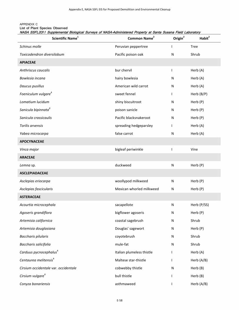
APPENDIX C List of Plant Species Observed NASA SSFL2011 Supplemental Biological Surveys of NASA-Administered Property at Santa Susana Field Laboratory
Scientific Name1 Common Name2 Origin2 Habit2
Schinus molle Peruvian peppertree I Tree
Toxicodendron diversilobum Pacific poison oak N Shrub
APIACEAE
Anthriscus caucalis bur chervil I Herb (A)
Bowlesia incana hairy bowlesia N Herb (A)
Daucus pusillus American wild carrot N Herb (A)
Foeniculum vulgare4 sweet fennel I Herb (B/P)
Lomatium lucidum shiny biscuitroot N Herb (P)
Sanicula bipinnata6 poison sanicle N Herb (P)
Sanicula crassicaulis Pacific blacksnakeroot N Herb (P)
Torilis arvensis spreading hedgeparsley I Herb (A)
Yabea microcarpa false carrot N Herb (A)
APOCYNACEAE
Vinca major bigleaf periwinkle I Vine
ARACEAE
Lemna sp. duckweed N Herb (P)
ASCLEPIADACEAE
Asclepias eriocarpa woollypod milkweed N Herb (P)
Asclepias fascicularis Mexican whorled milkweed N Herb (P)
ASTERACEAE
Acourtia microcephala sacapellote N Herb (P/SS)
Agoseris grandiflora bigflower agoseris N Herb (P)
Artemisia californica coastal sagebrush N Shrub
Artemisia douglasiana Douglas' sagewort N Herb (P)
Baccharis pilularis coyotebrush N Shrub
Baccharis salicifolia mule-fat N Shrub
Carduus pycnocephalus4 Italian plumeless thistle I Herb (A)
Centaurea melitensis4 Maltese star-thistle I Herb (A/B)
Cirsium occidentale var. occidentale cobwebby thistle N Herb (B)
Cirsium vulgare4 bull thistle I Herb (B)
Conyza bonariensis asthmaweed I Herb (A/B)
Appendix E, NASA SSFL EIS for Proposed Demolition and Environmental Cleanup
E-58

APPENDIX C List of Plant Species Observed NASA SSFL2011 Supplemental Biological Surveys of NASA-Administered Property at Santa Susana Field Laboratory
Scientific Name1 Common Name2 Origin2 Habit2
Conyza canadensis Canadian horeseweed N Herb (A/B)
Corethrogyne filaginifolia common sandaster N Herb (P/SS)
Deinandra fasciculata clustered tarweed N Herb (A)
Deinandra minthornii7 Santa Susanna tarweed N Shrub
Encelia californica California brittlebush N SS/Shrub
Ericameria pinifolia pinebush N Shrub
Erigeron foliosus leafy fleabane N Herb (P)
Eriophyllum confertiflorum golden-yarrow N SS/Shrub
Gazania linearis4 treasureflower I Herb (P)
Hazardia squarrosa var. grindelioides sawtooth goldenbush N SS/Shrub
Heterotheca grandiflora telegraphweed N Herb (A/P)
Hypochaeris glabra smooth cat's ear I Herb (A)
Lactuca serriola prickly lettuce I Herb (A/B)
Lactuca virosa bitter lettuce I Herb (A/B)
Lasthenia californica California goldfields N Herb (A/P)
Logfia filaginoides (syn. Filago californica) California cottonrose N Herb (A)
Logfia gallica (syn. Filago gallica) narrowleaf cottonrose I Herb (A)
Madia gracilis grassy tarweed N Herb (A)
Malacothrix saxatilis cliff desertdandelion N SS/Shrub
Micropus californicus q-tips N Herb (A)
Microseris douglasii Douglas' silverpuffs N Herb (A)
Pseudognaphalium biolettii (Gnaphalium bicolor)5 two-color rabbit-tobacco N Herb/SS (B)
Pseudognaphalium californicum ladies' tobacco N Herb/SS (B)
Pseudognaphalium canescens Wright's cudweed N Herb (A/P)
Pseudognaphalium luteoalbum Jersey cudweed I Herb (A)
Psilocarphus tenellus slender woollyheads N Herb (A)
Rafinesquia californica California plumeseed N Herb (A)
Senecio vulgaris old-man-in-the-Spring I Herb (A/B)
Silybum marianum blessed milkthistle I Herb (A/B)
Sonchus asper spiny sowthistle I Herb (A)
Sonchus oleraceus common sowthistle I Herb (A)
Appendix E, NASA SSFL EIS for Proposed Demolition and Environmental Cleanup
E-59
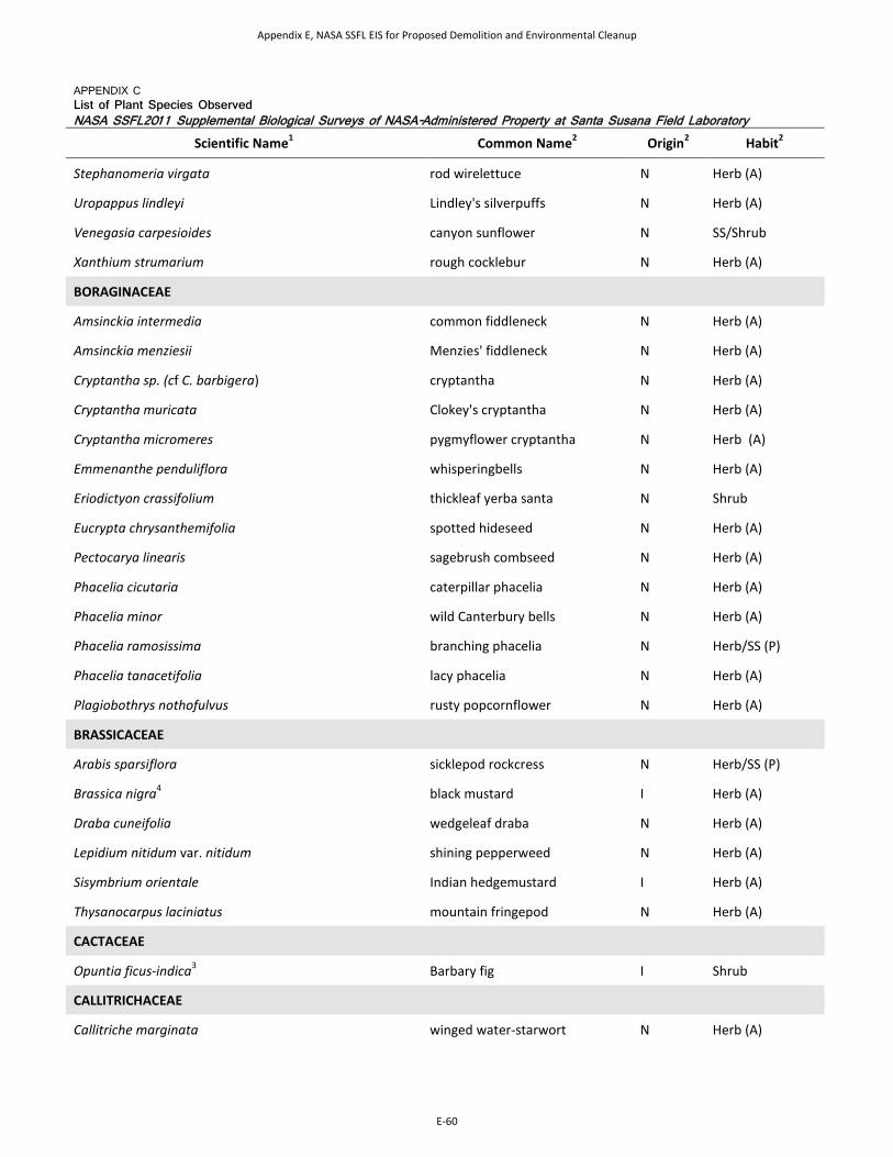
APPENDIX C List of Plant Species Observed NASA SSFL2011 Supplemental Biological Surveys of NASA-Administered Property at Santa Susana Field Laboratory
Scientific Name1 Common Name2 Origin2 Habit2
Stephanomeria virgata rod wirelettuce N Herb (A)
Uropappus lindleyi Lindley's silverpuffs N Herb (A)
Venegasia carpesioides canyon sunflower N SS/Shrub
Xanthium strumarium rough cocklebur N Herb (A)
BORAGINACEAE
Amsinckia intermedia common fiddleneck N Herb (A)
Amsinckia menziesii Menzies' fiddleneck N Herb (A)
Cryptantha sp. (cf C. barbigera) cryptantha N Herb (A)
Cryptantha muricata Clokey's cryptantha N Herb (A)
Cryptantha micromeres pygmyflower cryptantha N Herb (A)
Emmenanthe penduliflora whisperingbells N Herb (A)
Eriodictyon crassifolium thickleaf yerba santa N Shrub
Eucrypta chrysanthemifolia spotted hideseed N Herb (A)
Pectocarya linearis sagebrush combseed N Herb (A)
Phacelia cicutaria caterpillar phacelia N Herb (A)
Phacelia minor wild Canterbury bells N Herb (A)
Phacelia ramosissima branching phacelia N Herb/SS (P)
Phacelia tanacetifolia lacy phacelia N Herb (A)
Plagiobothrys nothofulvus rusty popcornflower N Herb (A)
BRASSICACEAE
Arabis sparsiflora sicklepod rockcress N Herb/SS (P)
Brassica nigra4 black mustard I Herb (A)
Draba cuneifolia wedgeleaf draba N Herb (A)
Lepidium nitidum var. nitidum shining pepperweed N Herb (A)
Sisymbrium orientale Indian hedgemustard I Herb (A)
Thysanocarpus laciniatus mountain fringepod N Herb (A)
CACTACEAE
Opuntia ficus-indica3 Barbary fig I Shrub
CALLITRICHACEAE
Callitriche marginata winged water-starwort N Herb (A)
Appendix E, NASA SSFL EIS for Proposed Demolition and Environmental Cleanup
E-60
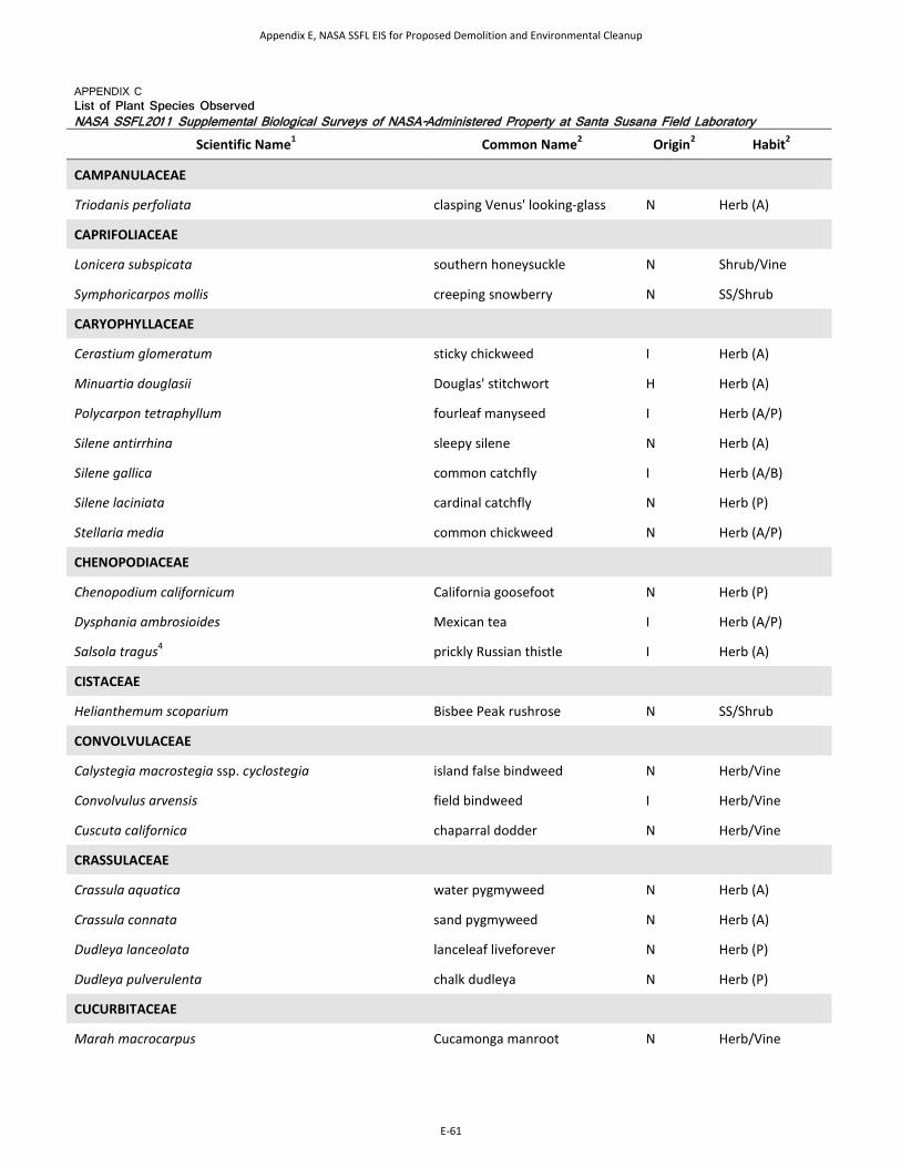
APPENDIX C List of Plant Species Observed NASA SSFL2011 Supplemental Biological Surveys of NASA-Administered Property at Santa Susana Field Laboratory
Scientific Name1 Common Name2 Origin2 Habit2
CAMPANULACEAE
Triodanis perfoliata clasping Venus' looking-glass N Herb (A)
CAPRIFOLIACEAE
Lonicera subspicata southern honeysuckle N Shrub/Vine
Symphoricarpos mollis creeping snowberry N SS/Shrub
CARYOPHYLLACEAE
Cerastium glomeratum sticky chickweed I Herb (A)
Minuartia douglasii Douglas' stitchwort H Herb (A)
Polycarpon tetraphyllum fourleaf manyseed I Herb (A/P)
Silene antirrhina sleepy silene N Herb (A)
Silene gallica common catchfly I Herb (A/B)
Silene laciniata cardinal catchfly N Herb (P)
Stellaria media common chickweed N Herb (A/P)
CHENOPODIACEAE
Chenopodium californicum California goosefoot N Herb (P)
Dysphania ambrosioides Mexican tea I Herb (A/P)
Salsola tragus4 prickly Russian thistle I Herb (A)
CISTACEAE
Helianthemum scoparium Bisbee Peak rushrose N SS/Shrub
CONVOLVULACEAE
Calystegia macrostegia ssp. cyclostegia island false bindweed N Herb/Vine
Convolvulus arvensis field bindweed I Herb/Vine
Cuscuta californica chaparral dodder N Herb/Vine
CRASSULACEAE
Crassula aquatica water pygmyweed N Herb (A)
Crassula connata sand pygmyweed N Herb (A)
Dudleya lanceolata lanceleaf liveforever N Herb (P)
Dudleya pulverulenta chalk dudleya N Herb (P)
CUCURBITACEAE
Marah macrocarpus Cucamonga manroot N Herb/Vine
Appendix E, NASA SSFL EIS for Proposed Demolition and Environmental Cleanup
E-61
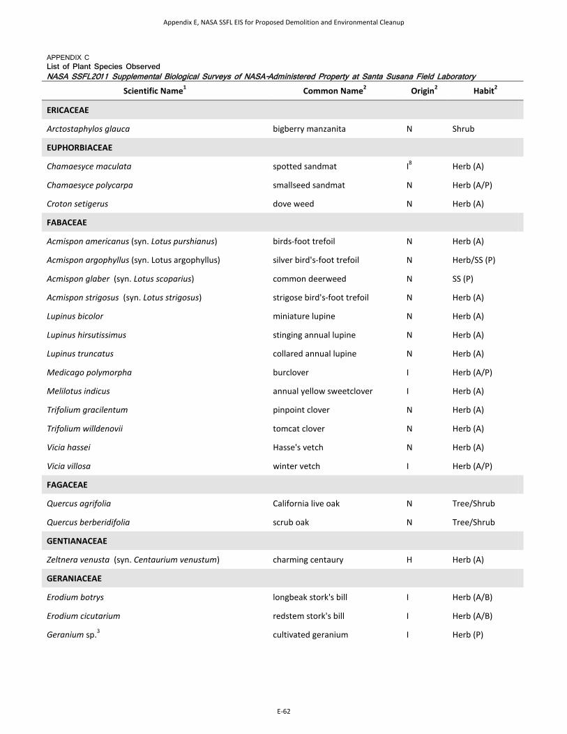
APPENDIX C List of Plant Species Observed NASA SSFL2011 Supplemental Biological Surveys of NASA-Administered Property at Santa Susana Field Laboratory
Scientific Name1 Common Name2 Origin2 Habit2
ERICACEAE
Arctostaphylos glauca bigberry manzanita N Shrub
EUPHORBIACEAE
Chamaesyce maculata spotted sandmat I8 Herb (A)
Chamaesyce polycarpa smallseed sandmat N Herb (A/P)
Croton setigerus dove weed N Herb (A)
FABACEAE
Acmispon americanus (syn. Lotus purshianus) birds-foot trefoil N Herb (A)
Acmispon argophyllus (syn. Lotus argophyllus) silver bird's-foot trefoil N Herb/SS (P)
Acmispon glaber (syn. Lotus scoparius) common deerweed N SS (P)
Acmispon strigosus (syn. Lotus strigosus) strigose bird's-foot trefoil N Herb (A)
Lupinus bicolor miniature lupine N Herb (A)
Lupinus hirsutissimus stinging annual lupine N Herb (A)
Lupinus truncatus collared annual lupine N Herb (A)
Medicago polymorpha burclover I Herb (A/P)
Melilotus indicus annual yellow sweetclover I Herb (A)
Trifolium gracilentum pinpoint clover N Herb (A)
Trifolium willdenovii tomcat clover N Herb (A)
Vicia hassei Hasse's vetch N Herb (A)
Vicia villosa winter vetch I Herb (A/P)
FAGACEAE
Quercus agrifolia California live oak N Tree/Shrub
Quercus berberidifolia scrub oak N Tree/Shrub
GENTIANACEAE
Zeltnera venusta (syn. Centaurium venustum) charming centaury H Herb (A)
GERANIACEAE
Erodium botrys longbeak stork's bill I Herb (A/B)
Erodium cicutarium redstem stork's bill I Herb (A/B)
Geranium sp.3 cultivated geranium I Herb (P)
Appendix E, NASA SSFL EIS for Proposed Demolition and Environmental Cleanup
E-62
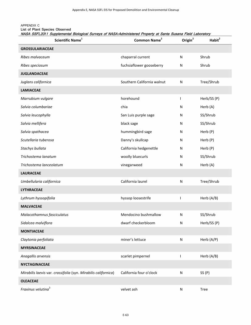
APPENDIX C List of Plant Species Observed NASA SSFL2011 Supplemental Biological Surveys of NASA-Administered Property at Santa Susana Field Laboratory
Scientific Name1 Common Name2 Origin2 Habit2
GROSSULARIACEAE
Ribes malvaceum chaparral current N Shrub
Ribes speciosum fuchsiaflower gooseberry N Shrub
JUGLANDACEAE
Juglans californica Southern California walnut N Tree/Shrub
LAMIACEAE
Marrubium vulgare horehound I Herb/SS (P)
Salvia columbariae chia N Herb (A)
Salvia leucophylla San Luis purple sage N SS/Shrub
Salvia mellifera black sage N SS/Shrub
Salvia spathacea hummingbird sage N Herb (P)
Scutellaria tuberosa Danny's skullcap N Herb (P)
Stachys bullata California hedgenettle N Herb (P)
Trichostema lanatum woolly bluecurls N SS/Shrub
Trichostema lanceolatum vinegarweed N Herb (A)
LAURACEAE
Umbellularia californica California laurel N Tree/Shrub
LYTHRACEAE
Lythrum hyssopifolia hyssop loosestrife I Herb (A/B)
MALVACEAE
Malacothamnus fasciculatus Mendocino bushmallow N SS/Shrub
Sidalcea malviflora dwarf checkerbloom N Herb/SS (P)
MONTIACEAE
Claytonia perfoliata miner’s lettuce N Herb (A/P)
MYRSINACEAE
Anagallis arvensis scarlet pimpernel I Herb (A/B)
NYCTAGINACEAE
Mirabilis laevis var. crassifolia (syn. Mirabilis californica) California four o'clock N SS (P)
OLEACEAE
Fraxinus velutina3 velvet ash N Tree
Appendix E, NASA SSFL EIS for Proposed Demolition and Environmental Cleanup
E-63

APPENDIX C List of Plant Species Observed NASA SSFL2011 Supplemental Biological Surveys of NASA-Administered Property at Santa Susana Field Laboratory
Scientific Name1 Common Name2 Origin2 Habit2
ONAGRACEAE
Camissonia bistorta southern suncup N Herb (A/P)
Camissonia californica California suncup N Herb (A/P)
Camissonia hirtella Santa Cruz Island suncup N Herb (A)
Camissonia micrantha miniature suncup N Herb (A)
Clarkia purpurea winecup clarkia N Herb (A)
Clarkia unguiculata elegant clarkia N Herb (A)
Epilobium sp. willowherb N Herb (A)
PAEONIACEAE
Paeonia californica California peony N Herb (P)
PAPAVERACEAE
Dendromecon rigida tree poppy N Shrub/Tree
Eschscholzia californica California poppy N Herb (A/P)
Platystemon californicus creamcups N Herb (A)
PHRYMACEAE
Mimulus aurantiacus orange bush monkeyflower N Shrub/SS
Mimulus brevipes widethroat yellow monkeyflower
N Herb (A)
Mimulus floribundus manyflowered monkeyflower N Herb (A)
Mimulus guttatus seep monkeyflower N Herb (A/P)
Mimulus pilosus false monkeyflower H Herb (A)
PLANTAGINACEAE
Antirrhinum coulterianum Coulter's snapdragon N Herb (A)
Antirrhinum kelloggii Kellogg snapdragon N Herb (A)
Antirrhinum multiflorum Sierra snapdragon N Herb/SS (A)
Collinsia parryi Parry's blue eyed Mary N Herb (A)
Keckiella cordifolia heartleaf Keckiella N Shrub/SS
Penstemon centranthifolius scarlet bugler N H/SS (P)
Penstemon spectabilis showy penstemon N H/SS (P)
Plantago erecta dotseed plantain N Herb (A)
Veronica peregrina neckweed N Herb (A)
Appendix E, NASA SSFL EIS for Proposed Demolition and Environmental Cleanup
E-64
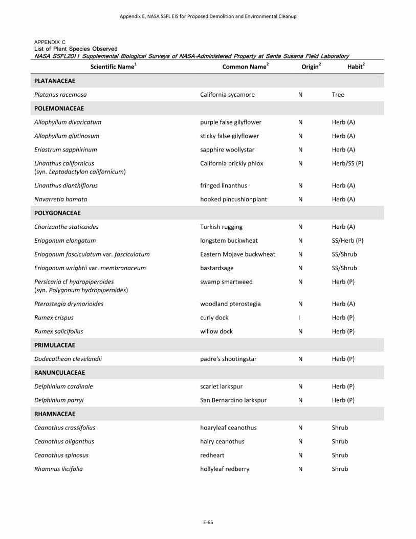
APPENDIX C List of Plant Species Observed NASA SSFL2011 Supplemental Biological Surveys of NASA-Administered Property at Santa Susana Field Laboratory
Scientific Name1 Common Name2 Origin2 Habit2
PLATANACEAE
Platanus racemosa California sycamore N Tree
POLEMONIACEAE
Allophyllum divaricatum purple false gilyflower N Herb (A)
Allophyllum glutinosum sticky false gilyflower N Herb (A)
Eriastrum sapphirinum sapphire woollystar N Herb (A)
Linanthus californicus (syn. Leptodactylon californicum)
California prickly phlox N Herb/SS (P)
Linanthus dianthiflorus fringed linanthus N Herb (A)
Navarretia hamata hooked pincushionplant N Herb (A)
POLYGONACEAE
Chorizanthe staticoides Turkish rugging N Herb (A)
Eriogonum elongatum longstem buckwheat N SS/Herb (P)
Eriogonum fasciculatum var. fasciculatum Eastern Mojave buckwheat N SS/Shrub
Eriogonum wrightii var. membranaceum bastardsage N SS/Shrub
Persicaria cf hydropiperoides (syn. Polygonum hydropiperoides)
swamp smartweed N Herb (P)
Pterostegia drymarioides woodland pterostegia N Herb (A)
Rumex crispus curly dock I Herb (P)
Rumex salicifolius willow dock N Herb (P)
PRIMULACEAE
Dodecatheon clevelandii padre's shootingstar N Herb (P)
RANUNCULACEAE
Delphinium cardinale scarlet larkspur N Herb (P)
Delphinium parryi San Bernardino larkspur N Herb (P)
RHAMNACEAE
Ceanothus crassifolius hoaryleaf ceanothus N Shrub
Ceanothus oliganthus hairy ceanothus N Shrub
Ceanothus spinosus redheart N Shrub
Rhamnus ilicifolia hollyleaf redberry N Shrub
Appendix E, NASA SSFL EIS for Proposed Demolition and Environmental Cleanup
E-65

APPENDIX C List of Plant Species Observed NASA SSFL2011 Supplemental Biological Surveys of NASA-Administered Property at Santa Susana Field Laboratory
Scientific Name1 Common Name2 Origin2 Habit2
ROSACEAE
Adenostoma fasciculatum chamise N Shrub
Cercocarpus betuloides birchleaf mountain mahogany N Shrub/Tree
Hertermeles arbutifolia toyon N Shrub
Drymocallis glandulosa (syn. Potentilla glandulosa) sticky cinquefoil N SS/Herb (P)
Prunus dulcis3 sweet almond I Tree
Prunus ilicifolia hollyleaf cherry N Tree/Shrub
Rosa californica California wildrose N Shrub
Rubus ursinus California blackberry N SS (P)
RUBIACEAE
Galium angustifolium narrowleaf bedstraw N Herb/SS (P)
Galium aparine stickywilly N Herb (A)
Galium cliftonsmithii Santa Barbara bedstraw N Shrub
Galium nuttallii climbing bedstraw N SS/Shrub
Galium parisiense wall bedstraw I Herb (A)
SALICACEAE
Populus fremontii Fremont cottonwood N Tree
Salix exigua narrowleaf willow N Shrub/Tree
Salix laevigata red willow N Tree
Salix lasiolepis arroyo willow N Tree/Shrub
SAXIFRAGACEAE
Lithophragma affine San Francisco woodland-star N Herb (P)
SCROPHULARIACEAE
Scrophularia californica California figwort N Herb (P)
SIMAROUBACEAE
Ailanthus altissima4 tree of heaven I Tree
SOLANACEAE
Datura wrightii sacred thorn-apple N Herb (A/P)
Nicotiana glauca tree tobacco I Shrub/Tree
Solanum douglasii greenspot nightshade N Herb (P)
Solanum xanti chaparral nightshade N Herb (P)
Appendix E, NASA SSFL EIS for Proposed Demolition and Environmental Cleanup
E-66
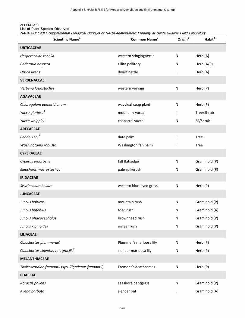
APPENDIX C List of Plant Species Observed NASA SSFL2011 Supplemental Biological Surveys of NASA-Administered Property at Santa Susana Field Laboratory
Scientific Name1 Common Name2 Origin2 Habit2
URTICACEAE
Hesperocnide tenella western stingingnettle N Herb (A)
Parietaria hespera rillita pellitory N Herb (A/P)
Urtica urens dwarf nettle I Herb (A)
VERBENACEAE
Verbena lasiostachys western vervain N Herb (P)
AGAVACEAE
Chlorogalum pomeridianum wavyleaf soap plant N Herb (P)
Yucca gloriosa3 moundlily yucca I Tree/Shrub
Yucca whipplei chaparral yucca N SS/Shrub
ARECACEAE
Phoenix sp.3 date palm I Tree
Washingtonia robusta Washington fan palm I Tree
CYPERACEAE
Cyperus eragrostis tall flatsedge N Graminoid (P)
Eleocharis macrostachya pale spikerush N Graminoid (P)
IRIDACEAE
Sisyrinchium bellum western blue-eyed grass N Herb (P)
JUNCACEAE
Juncus balticus mountain rush N Graminoid (P)
Juncus bufonius toad rush N Graminoid (A)
Juncus phaeocephalus brownhead rush N Graminoid (P)
Juncus xiphioides irisleaf rush N Graminoid (P)
LILIACEAE
Calochortus plummerae7 Plummer’s mariposa lily N Herb (P)
Calochortus clavatus var. gracilis7 slender mariposa lily N Herb (P)
MELANTHIACEAE
Toxicoscordion fremontii (syn. Zigadenus fremontii) Fremont's deathcamas N Herb (P)
POACEAE
Agrostis pallens seashore bentgrass N Graminoid (P)
Avena barbata slender oat I Graminoid (A)
Appendix E, NASA SSFL EIS for Proposed Demolition and Environmental Cleanup
E-67

APPENDIX C List of Plant Species Observed NASA SSFL2011 Supplemental Biological Surveys of NASA-Administered Property at Santa Susana Field Laboratory
Scientific Name1 Common Name2 Origin2 Habit2
Avena fatua wild oat I Graminoid (A)
Bromus carinatus California brome N Graminoid (A/P)
Bromus diandrus4 ripgut brome I Graminoid (A)
Bromus hordeaceus soft brome I Graminoid (A)
Bromus madritensis ssp. rubens4 red brome I Graminoid (A)
Bromus sterilis poverty brome I Graminoid (A)
Chloris virgata feather fingergrass I8 Graminoid (A)
Cynodon dactylon Bermudagrass I Graminoid (P)
Elymus glaucus blue wildrye N Graminoid (P)
Gastridium ventricosum nit grass I Graminoid (A)
Hordeum murinum ssp. leporinum hare barley I Graminoid (A)
Lamarckia aurea goldentop grass I Graminoid (A)
Leymus condensatus giant ryegrass N Graminoid (P)
Melica imperfecta smallflower melicgrass N Graminoid (P)
Muhlenbergia microsperma littleseed muhly N Graminoid (A)
Muhlenbergia rigens deergrass N Graminoid (P)
Nassella lepida foothill needlegrass N Graminoid (P)
Nassella pulchra purple needlegrass N Graminoid (P)
Pennisetum setaceum4 crimson fountaingrass I Graminoid (P)
Piptatherum miliaceum smilograss I Graminoid (P)
Poa annua annual bluegrass I Graminoid (A)
Poa pratensis Kentucky bluegrass I Graminoid (P)
Poa secunda Sandberg bluegrass N Graminoid (P)
Polypogon monspeliensis annual rabbitsfoot grass I Graminoid (A)
Schismus arabicus Arabian schismus I Graminoid (A)
Vulpia bromoides brome fescue I Graminoid (A)
Vulpia microstachys small fescue N Graminoid (A)
Vulpia myuros ssp. myuros4 rat-tail fescue I Graminoid (A)
Appendix E, NASA SSFL EIS for Proposed Demolition and Environmental Cleanup
E-68

APPENDIX C List of Plant Species Observed NASA SSFL2011 Supplemental Biological Surveys of NASA-Administered Property at Santa Susana Field Laboratory
Scientific Name1 Common Name2 Origin2 Habit2
THEMIDACEAE
Dichelostemma capitatum bluedicks N Herb (P)
TYPHACEAE
Typha domingensis southern cattail N Herb (P)
Notes: N = Native I = Introduced (non-native species that have become naturalized) (A) = Annual (B) = Biennial (P) = Perennial SS = Sub-Shrub 1Taxonomy follows the currently accepted nomenclature for plant species occurring in California as indicated on the Jepson On-Line Interchange for California Floristics (University of California, 2011). 2Species common name, origin and grow habitat from the U.S. Department of Agriculture’s Plants Database (2011). 3 Horticultural or landscape planting 4Noxious or invasive weed 5Taxonomic or nomenclatural synonym for taxon not occurring in California. 6 Species was observed just outside of the NASA-administered property by Tarja Sagar. 7Special-status plant species 8 Considered Native in the USDA Plants Databases, but is considered an introduced (naturalized) species in California, per the Jepson On-Line Interchange.
Appendix E, NASA SSFL EIS for Proposed Demolition and Environmental Cleanup
E-69

This page intentionally left blank.
Appendix E, NASA SSFL EIS for Proposed Demolition and Environmental Cleanup
E-70

Appendix D Representative Photographs of the Site, Special-
status Plants, and Wildlife Species
Appendix E, NASA SSFL EIS for Proposed Demolition and Environmental Cleanup
E-71

This page intentionally left blank.
Appendix E, NASA SSFL EIS for Proposed Demolition and Environmental Cleanup
E-72
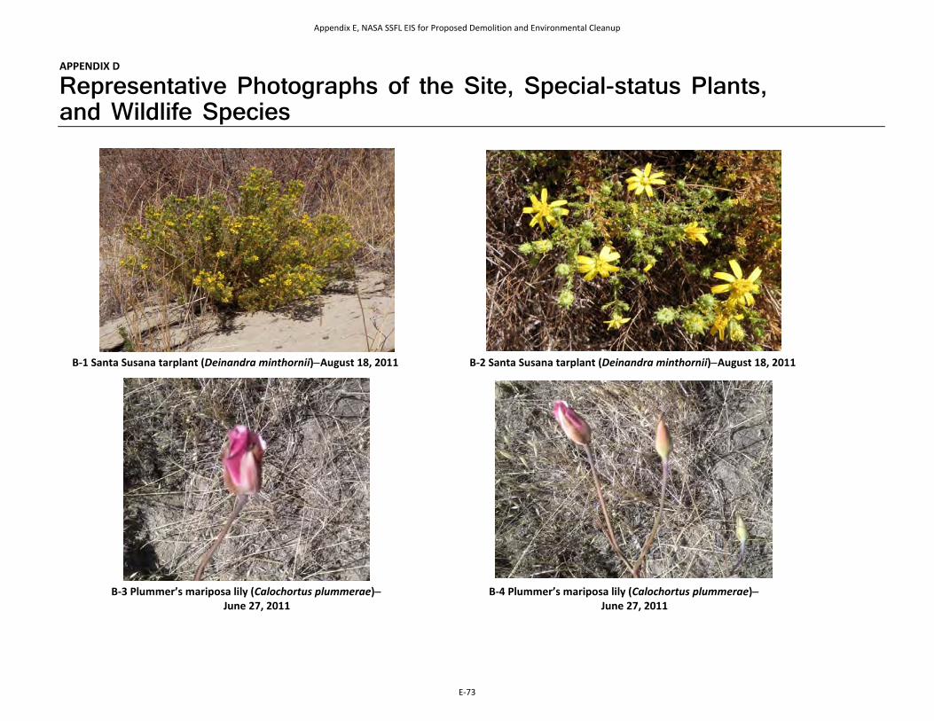
APPENDIX D
Representative Photographs of the Site, Special-status Plants, and Wildlife Species
B-1 Santa Susana tarplant (Deinandra minthornii)−August 18, 2011 B-2 Santa Susana tarplant (Deinandra minthornii)−August 18, 2011
B-3 Plummer’s mariposa lily (Calochortus plummerae)− June 27, 2011
B-4 Plummer’s mariposa lily (Calochortus plummerae)− June 27, 2011
Appendix E, NASA SSFL EIS for Proposed Demolition and Environmental Cleanup
E-73

B-5 View northeast of southern willow scrub in Alfa Area−April 2011 B-6 Woodrat (Neotoma sp.) nest−
April 2011
B-7 Coast horned lizard (Phrynosoma blainvillii), Area I−April 2011
B-8 Two striped garter snake (Thamnophis hammondii), Area 1−April 2011
Appendix E, NASA SSFL EIS for Proposed Demolition and Environmental Cleanup
E-74

B-9 Stick nest in sandstone cliff−April 2011 B-10 Red-tailed hawk (Buteo jamaicensis) nest− April 2011
B-10 Dead canyon bat (Parastrellus hesperus), Area II Alfa Site−August 2011
B-11 Western side-blotched lizard (Uta stansburiana elegans)− April 2011
Appendix E, NASA SSFL EIS for Proposed Demolition and Environmental Cleanup
E-75
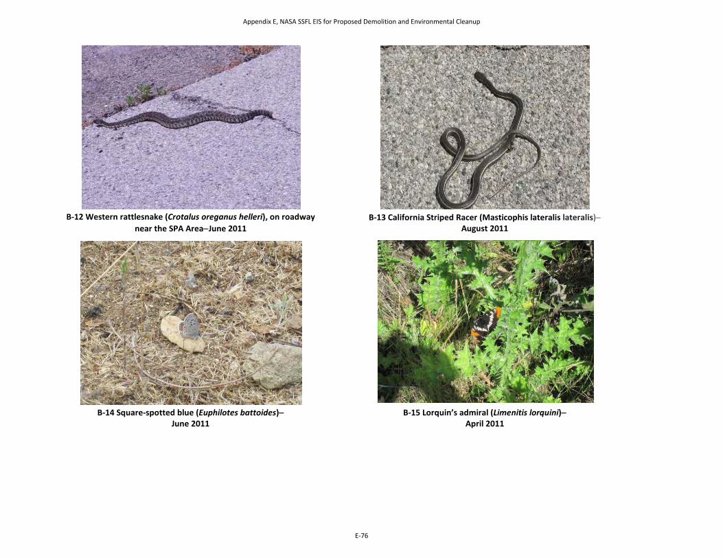
B-12 Western rattlesnake (Crotalus oreganus helleri), on roadway
near the SPA Area−June 2011 B-13 California Striped Racer (Masticophis lateralis lateralis)−
August 2011
B-14 Square-spotted blue (Euphilotes battoides)−
June 2011 B-15 Lorquin’s admiral (Limenitis lorquini)−
April 2011
Appendix E, NASA SSFL EIS for Proposed Demolition and Environmental Cleanup
E-76

Appendix E Wildlife Species Observed in 2010 and 2011
Appendix E, NASA SSFL EIS for Proposed Demolition and Environmental Cleanup
E-77

This page intentionally left blank.
Appendix E, NASA SSFL EIS for Proposed Demolition and Environmental Cleanup
E-78

APPENDIX E
Wildlife Species Observed in 2010 and 2011
APPENDIX E Wildlife Species Observed in 2010 and 2011 NASA SSFL 2011 Supplemental Biological Surveys of NASA-Administered Property at Santa Susana Field Laboratory
Common Name Scientific Name 2010 2011
Butterflies
Quino Checkerspot1,2 Euphydryas editha quino X
Anise Swallowtail Papilio zelacaon X
Western Tiger Swallowtail Papilio rutulus X
Checkered White Pontia protodice X
Cabbage White Pieres rapae X
Orange Sulphur Colius curytheme X
Square-spotted Blue Euphilotes battoides X
American Lady Vanessa virginiensis X
Lorquin's Admiral Limenitis lorquini X
Funereal Duskywing Erynnis funeralis X
Northern White-skipper Heliopetes ericetorum X
Herpetiles
Northern Pacific Treefrog Pseudacris regilla X
Western Toad Anaxyrus [Bufo] boreas X
Coast Horned Lizard3 Phrynosoma blainvillii X X
Western Fence Lizard Sceloporus occidentalis X X
California Whiptail Aspidoscelis tigris munda X X
Mountain Garter Snake Thamnophis elegans elegans X
Two-striped Garter Snake3 Thamnophis hammondii X
Ring-necked Snake Diadophis punctatus X X
California Striped Racer Coluber [=Masticophis ] lateralis lateralis
X
Gopher Snake Pituophis catenifer X
Western Rattlesnake Crotalus oreganus helleri X X
Birds
Mallard Anas platyrhynchos X X
California Quail Callipepla californica X X
Appendix E, NASA SSFL EIS for Proposed Demolition and Environmental Cleanup
E-79

APPENDIX E Wildlife Species Observed in 2010 and 2011 NASA SSFL 2011 Supplemental Biological Surveys of NASA-Administered Property at Santa Susana Field Laboratory
Common Name Scientific Name 2010 2011
Great Blue Heron Ardea herodias X X
Green Heron Butorides virescens X X
Turkey Vulture Cathartes aura X X
Cooper's Hawk Accipiter cooperii X X
Red-shouldered Hawk Buteo lineatus X X
Red-tailed Hawk Buteo jamaicensis X X
Ferruginous Hawk Buteo regalis X
American Kestrel Falco sparverius X X
Rock Pigeon Columba livia X X
Band-tailed Pigeon Patagioenas fasciata X X
Mourning Dove Zenaida macroura X X
Greater Roadrunner Geococcyx californianus X
Barn Owl Tyto alba X
Great Horned Owl Bubo virginianus X
White-throated Swift Aeronautes saxatalis X X
Black-chinned Hummingbird Archilochus alexandri X X
Anna's Hummingbird Calypte anna X X
Rufous/Allen's Hummingbird Selasphorus rufus/sasin X X
Belted Kingfisher Megaceryle alcyon X X
Acorn Woodpecker Melanerpes formicivorus X X
Nuttall's Woodpecker Picoides nuttallii X X
Northern Flicker Colaptes auratus X X
Black Phoebe Sayornis nigricans X X
Say's Phoebe Sayornis saya X X
Western Kingbird Tyrannus verticalis X
Loggerhead Shrike3 Lanius ludovicianus X X
Least Bell's Vireo 2 Vireo bellii pusillus X
Cassin's Vireo Vireo cassinii X X
Western Scrub-Jay Aphelocoma californica X X
American Crow Corvus brachyrhynchos X X
Common Raven Corvus corax X X
Appendix E, NASA SSFL EIS for Proposed Demolition and Environmental Cleanup
E-80
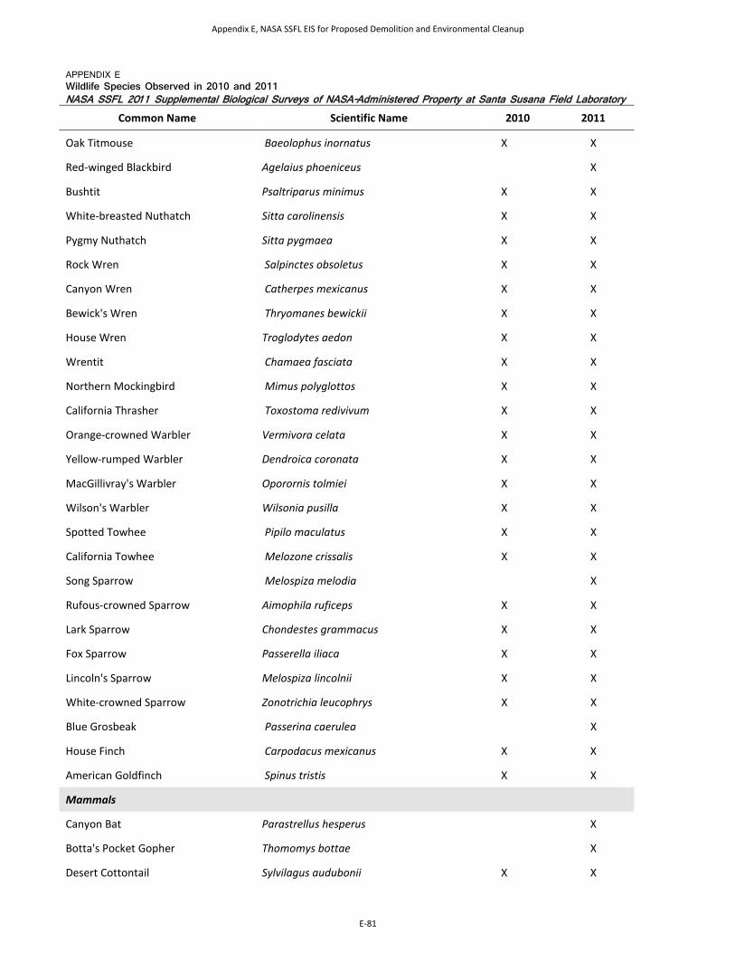
APPENDIX E Wildlife Species Observed in 2010 and 2011 NASA SSFL 2011 Supplemental Biological Surveys of NASA-Administered Property at Santa Susana Field Laboratory
Common Name Scientific Name 2010 2011
Oak Titmouse Baeolophus inornatus X X
Red-winged Blackbird Agelaius phoeniceus X
Bushtit Psaltriparus minimus X X
White-breasted Nuthatch Sitta carolinensis X X
Pygmy Nuthatch Sitta pygmaea X X
Rock Wren Salpinctes obsoletus X X
Canyon Wren Catherpes mexicanus X X
Bewick's Wren Thryomanes bewickii X X
House Wren Troglodytes aedon X X
Wrentit Chamaea fasciata X X
Northern Mockingbird Mimus polyglottos X X
California Thrasher Toxostoma redivivum X X
Orange-crowned Warbler Vermivora celata X X
Yellow-rumped Warbler Dendroica coronata X X
MacGillivray's Warbler Oporornis tolmiei X X
Wilson's Warbler Wilsonia pusilla X X
Spotted Towhee Pipilo maculatus X X
California Towhee Melozone crissalis X X
Song Sparrow Melospiza melodia X
Rufous-crowned Sparrow Aimophila ruficeps X X
Lark Sparrow Chondestes grammacus X X
Fox Sparrow Passerella iliaca X X
Lincoln's Sparrow Melospiza lincolnii X X
White-crowned Sparrow Zonotrichia leucophrys X X
Blue Grosbeak Passerina caerulea X
House Finch Carpodacus mexicanus X X
American Goldfinch Spinus tristis X X
Mammals
Canyon Bat Parastrellus hesperus X
Botta's Pocket Gopher Thomomys bottae X
Desert Cottontail Sylvilagus audubonii X X
Appendix E, NASA SSFL EIS for Proposed Demolition and Environmental Cleanup
E-81
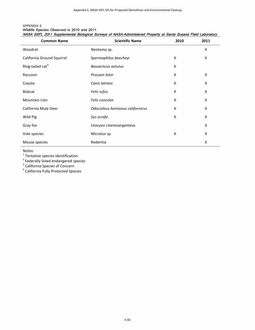
APPENDIX E Wildlife Species Observed in 2010 and 2011 NASA SSFL 2011 Supplemental Biological Surveys of NASA-Administered Property at Santa Susana Field Laboratory
Common Name Scientific Name 2010 2011
Woodrat Neotoma sp. X
California Ground Squirrel Spermophilus beecheyi X X
Ring-tailed cat4 Bassariscus astutus X
Raccoon Procyon lotor X X
Coyote Canis latrans X X
Bobcat Felis rufus X X
Mountain Lion Felis concolor X X
California Mule Deer Odocoileus hemionus californicus X X
Wild Pig Sus scrofa X X
Gray fox Urocyon cinereoargenteus X
Vole species Microtus sp. X X
Mouse species Rodentia X
Notes: 1 Tentative species identification 2 Federally listed endangered species 3 California Species of Concern 4 California Fully Protected Species
Appendix E, NASA SSFL EIS for Proposed Demolition and Environmental Cleanup
E-82

End of Appendix E
Appendix E, NASA SSFL EIS for Proposed Demolition and Environmental Cleanup
E-83

This page intentionally left blank.
Appendix E, NASA SSFL EIS for Proposed Demolition and Environmental Cleanup
E-84