Embed Size (px)
Citation preview


The Forks North Portage Partnership201-One Forks Market Road
Winnipeg, ManitobaR3C 4L9
Ph: 204-943-7752Fax: 204-943-7915www.theforks.com

Beneath our FeetThe
Over the last 6000 years, The Forks has been a site
of intense use by people of the First Nations and
more recently by Europeans and others from abroad.
Archaeological investigations over the past 15 years
have recovered artifacts that tell part of the story of
the way of life and various survival techniques of the
people of the past. These investigations have peeled
back the layers of soil to reveal our heritage.
This guide will highlight some of the major discoveries
from specific time periods including the tools that
were used for hunting, fishing, clothing manufacture,
tool manufacture, and day-to-day activities.
The teachings of the Elders also add important
insight to the knowledge of the past.
Figure 1
Peace Meeting
Hudson’s BayCompany MillComplex
6000 year old hearths
First Nations campsite
3000 year oldcampsite and trade centre
Immigration Period
Experimental Farm
Fur Trade Period Forts
A Fort Gibraltar IB Fort Gibraltar IIC Upper Fort Garry

Years Ago
From GLACIERS to
and
A 3000 Year Old
10,000 years ago, this area was under hundreds of metresof ice. Gradually, this ice retreated to the north leavingbehind the world’s largest freshwater lake, glacial LakeAgassiz. As the lake receded 8500 years ago, herds of animals moved into this areafollowed by hunters from the south and the west.
Figure 2
Archaeologists discovered a 3000 year old campsite andtrading centre on the north bank of the Assiniboine River,three metres (10 feet) below the surface. Early peoplestraded far and wide with others to obtain special items. A lithic (stone) cutting tool made of Alibates Chert, which is a type of rock found only in the Texas Panhandle, was recovered here. This knife was probably traded north along the Mississippi River and the Red River to reach The Forks.
The different styles ofrecovered projectilepoints (arrowheads)confirm that peoplefrom the north, the plains, and the west met at The Forks.
Two 6000 year old hearths(camp fires), containing catfishremains and flakes from makingstone tools, are the earliest evidence that people camped at The Forks. These hearthswere uncovered at a depth of 6 metres (20 feet).
The first peoples were bison hunters who used the atlatl, a throwing board which increased the distance and force of a thrown spear.
Figure 3
Figure 4
Plate 1
Plate 3
Plate 2
Figure 5

The majority of the recovered artifacts were animal bone(bison, whitetail deer, fox, rabbit, beaver, and squirrel) and fish bone (catfish, sucker, pike, drum, walleye, goldeye, and sturgeon). Fish were harvested using a toggling harpoon, a sophisticated fishing technique.
Daily activities also took place here. Knives, scrapers, projectile points and other tools were made by flakingsuitable types of stone such as chert, quartz, quartzite,rhyolite, and chalcedony. This process, using many different techniques, is called flintknapping.
Women, with the help of the children, gathered many different plants and berries for food. Local plants thatcould have been part of the diet include hazelnut, cattail, nettle, fireweed, and breadroot. Berries such as saskatoon, pincherry, chokecherry, raspberry, and strawberry, would have been collected for eating and the surplus would have been dried for winter food supplies. The women also worked animal hides for the manufacture of clothing, shelter, and containers.
Stone scrapers were used to cleanse the hide and bone awls were used to punch holes for sewing the hide with sinew.
Woodworking, using stone axes and wedges for rough work as wellas lithic knives and beaver teeth forfiner work, produced arrow shafts,harpoon shafts, teepee poles, and dozens of other items.
Fresh-water clams not only provided food. People used the shells as raw material for making decorative beads and pendants.
Figure 6
WOOD SHAFT BONE TUBE
SOCKET GROOVE
BONE HARPOON
RETRIEVAL LINE
Figure 7
Figure 8
Figure 9
Plate 4
Plate 5
Plate 6
Plate 7

and
Over the centuries, changes in climate resulted in differingvegetation and flooding that altered the landscape.One of the defining characteristics of The Forks are the many floods on the Red and Assiniboine Rivers.After people had camped here, the evidence of theircampsites would be covered by mud from a flood, preserving the artifacts beneath the new soil.
The Forks was continually visited by different groups of people. A soil profile shows numerous sequentiallayers where artifacts from various cultures were foundand the dates that people came to camp, hunt, fish,visit, trade, and meet other people.
These people are the direct ancestors of today’s FirstNations peoples. They had many varied ways of life,depending upon how they obtained their living from theland: prairie people hunted bison, fished, and farmed;people of the forests relied on moose, fish, and wild rice;and people from the Great Lakes area hunted deer andfished. Because of the Red and Assiniboine rivers, it was very easy for people to come together to trade their special products with others.
As well as being a highway, the two rivers provided a source of food. Differenttypes of fishing methods were used. Recovered artifactsinclude a bone harpoon and a copper harpoon.
Corn farming occurred at Lockport (30 km north) and may have also occurredat The Forks since a hoe,made from a bison shoulderblade, was discovered here.
Figure 12
Plate 9
Figure 11
Figure 10
Figure 13
Plate 8

The
Aboriginal Elder oral history tells of a Peace Meeting of several tribes, held at The Forks, over 500 years ago.Archaeological recoveries of campsites from this meeting are radiocarbon dated to A.D. 1285.
To support such a large gathering of people, intensive hunting and fishing occurred.
In addition, everyday activities took place in conjunctionwith the important trade and territory discussions. The siteof this meeting covered a large area and archaeologicalresearch has recovered artifacts indicating that hideworking,stoneworking, and ornament manufacture occurred aswell as daily food preparation.
One of the most important activities was the creation of pottery by the women of the different groups. Thesepots were used as storage containers or cooking pots.Archaeologists use the different styles of pottery, whichwere introduced 2000 years ago, to identify different cultures. The earliest technique of pottery making wascoiling, while later pots were made inside woven bags or net molds. The pottery found so far at The Forks has been made with the net method.
Figure 14
Figure 15
Figure 17
Figure 16
Plate 11
chalcedony knife and bone spatulas for food preparation
Plate 13
antler flaker for stoneworking and elk tooth for decoration
bone scrapers and awls for hideworking
Plate 12
Plate 10

Various bone and wood tools were used to decorate thesepots with distinct patterns. This was done by using acord-wrapped stick to produce impressions by incisingwith shaped bone tools or by pressing round, oval, or square objects into the clay. Different decorative styleshave been given names usually based on the area ortown where the sherds of that type of pottery were firstdiscovered. More than one group of First Nations peoplecould have manufactured the same style of pottery.
The distinctive types of recovered ceramics indicatepeople came from southern Manitoba (Winnipeg Riverand Blackduck); southwestern Manitoba and easternSaskatchewan (Plains Woodland); Manitoba and theDakotas (Sandy Lake and Red River); east centralManitoba (Bird Lake and Duck Bay); western Ontario(Rainy River); and southern Minnesota (Oneota).
Archaeologists seldom find complete ceramic pots.Based on the recovered ceramic fragments, artists havedrawn images that show what the complete pot mayhave looked like before it was broken during use.
Figure 18
Plate 14
Blackduck
Bird Lake
Oneota
Winnipeg River PlainsWoodland
Sandy Lake
Rainy River
Duck Bay
Blackduck
Bird Lake
Red River
Duck Bay
Figure 19
The
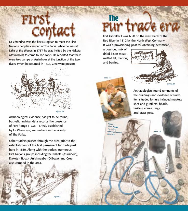
La Vérendrye was the first European to meet the FirstNations peoples camped at The Forks. While he was atLake of the Woods in 1737, he was invited by the Nakota(Assiniboin) to come to The Forks. He reported that therewere two camps of Assiniboin at the junction of the tworivers. When he returned in 1738, Cree were present.
Archaeological evidence has yet to be found, but valid archival data records the presence of Fort Rouge (1738 - 1749), established by La Vérendrye, somewhere in the vicinity of The Forks.
Other traders passed through the area prior to the establishment of the first permanent fur trade post here in 1810. Along with the traders, numerous First Nations groups including the Nakota (Assiniboin),Dakota (Sioux), Anishinaabe (Ojibwa), and Cree also camped in the area.
Fort Gibraltar I was built on the west bank of the Red River in 1810 by the North West Company. It was a provisioning post for obtaining pemmican, a pounded mix of dried bison meat, melted fat, marrow,and berries.
Archaeologists found remnants ofthe buildings and evidence of trade.Items traded for furs included muskets,shot and gunflints, beads, tinkling cones, rings, and brass pots.
Figure 23Chief Peguispainted by Peter Rindisbacher circa 1821
Figure 20
Figure 21
Plate 16
Plate 15
Figure 22

Fort Gibraltar I was dismantled and burned in 1815 during conflict between the North West Company and the Hudson’s Bay Company and their allies, the Selkirk Settlers.
In 1826, a huge flood inundated this area, leaving a layer of sand and silt over the ruins of the fort.Archaeologists found prints of moccasin-clad people,cattle, horses, and buggy wheels encapsulated justunderneath this layer. These may have been made by people fleeing from the flood with their livestockand possessions.
Fort Gibraltar II was built in 1817 by the North WestCompany on the north bank of the Assiniboine River at the junction of the two rivers.
In 1821, after amalgamation with the Hudson’s Bay Company, it became the western headquarters for the fur trade. It was then renamed Fort Garry.
During its existence, Fort Garry was a major provisioningcentre for the pemmican trade with large groups of Métisbison hunters pursuing the herds in the western prairiesand bringing back the meat in caravans of Red Rivercarts. The hunts expanded from 500 carts in 1820 to 1200 carts in 1840.
This fort was badly damaged by the huge flood of 1826. Some surviving buildings were used in conjunction with the Hudson’s Bay Company Experimental Farm, established in 1836. In 1852, another large flood destroyed the remaining buildings.
Figure 24
Figure 25
Plate 17
Figure 27
Figure 26

Because of the 1826 flood which almost destroyed the Hudson’s Bay Company facilities and the Red RiverColony, George Simpson (Governor of the HBC) decided to build a fort outside of the flood zone. He commissioned the construction of Lower Fort Garry,a considerable distance north on the Red River. It wasa good location, but the fur trade focus was at thejunction of the two rivers requiring the building ofanother fort at The Forks. In 1835, Upper Fort Garrywas built by the Hudson’s Bay Company.
In 1852, the fort was doubled in size to accommodate Britishtroops as well as carry on company business.
During the reconstruction of Main Street in 1998, archaeologists discovered the remains of one of the bastions and the east wall of Upper Fort Garry.
Figure 28
Plate 18
Figure 30
Plate 19
Figure 29

Upper Fort Garry was the political, administrative, business,and social centre for Rupertsland (western Canada). The fort had permanent residents—traders, clerks, and the governor of the territory. Some remnants of dishes that would have been used by the inhabitantswere recovered along with other artifacts such as cloth,buttons, beads, combs, and square nails.
The introduction of steam paddleboats on the RedRiver increased trade with the Americans to the south. To accommodate commercial freight, the Hudson’s Bay Company built a large warehouse at The Forks.
With the economy changing from fur trade to agriculture and with increased urbanization, the First Nations presence at The Forks diminished.However, over the next century, the City of Winnipegcontinued to benefit from the many contributions ofmembers of the different First Nations communities with increasing numbers choosing to reside in the city.
The Hudson’s Bay Company established a flour mill complex in 1872. Evidence of the basement and pilings from this mill were found during an archaeological project.
Demolition of Upper Fort Garry began in the1870s and by 1885 the only remaining portionwas the north gate which still stands at the corner of Broadway and Main Street.
Plate 20
Figure 31
Plate 21
Figure 32

The
PeriodMassive waves of immigrants began arriving by steamboat, from 1870 through the 1890s. Women and children could stay at the immigrationsheds built along the river while the men went out to homestead.
For a century this area was a hub of railroad activity. The construction of Union Station (on Main Street) and the High Line Main Track in 1911 made The Forks all but inaccessible to most people.
Since 1988, with the establishment of The Forks Renewal Corporation and The Forks National HistoricSite of Canada (Parks Canada), this site has once againbecome a meeting place for all with visiting, trading,music, and storytelling as it had been in the past.
In recognition of the rich history of this location, The Forks North Portage Partnership ensures that alldevelopment projects have an archaeologist present.This is to make sure that the resources are protectedand recovered in such a manner that the pages of history have new facts written upon them. There are still untold resources beneath our feet, each with their own story to tell.
In 1888, the Northern Pacific andManitoba Railroad established itsnorthern terminus at The Forks and settlers began arriving by train.
Figure 33
Figure 34
Figure 35

List of Figures and Plates
Figure 1 Map showing archaeological sites at The ForksSource: Compiled by Pam Goundry, Designed by Tom Powell Design Studio
Figure 2 Map showing glacier receding/movement of people into ManitobaSource: Pettipas, Leo, 1996:43, Aboriginal Migrations: A History of Movements in Southern Manitoba.Manitoba Museum of Man and Nature, Winnipeg.
Figure 3 Drawing of man throwing atlatl at bisonSource: Leigh Syms, Manitoba Museum of Man and Nature; Pettipas, Leo et. al.1983:37, Introducing Manitoba Prehistory. Manitoba Department of Cultural Affairs and Historical Resources. Papers in Manitoba Archaeology, Popular Series No. 4., Winnipeg.
Figure 4 Drawing of man with camp fireSource: Dickson, Gary A., 1977:20, Prehistoric Northern Manitoba. Historic Resources Branch,Department of Tourism, Recreation and Cultural Affairs and Manitoba Museum of Man and Nature, Winnipeg.
Figure 5 Drawing of First Nations trade meetingSource: McLeod, K. David, 1987:47, Land Below The Forks Archaeology, Prehistory and History of the Selkirk and District Planning Area.Manitoba Culture, Heritage and Recreation, Historic Resources Branch, Winnipeg.
Figure 6 Artists rendition of harpoon and shaftSource: Kroker, Sid and Pam Goundry, 1993:126, A 3000 Year Old Native Campsite and Trade Centre at The Forks.
Figure 7 Drawing of man fishing with harpoonSource: Pettipas, Leo et al., 1983:159, Introducing Manitoba Prehistory. Manitoba Department of Cultural Affairs and Historical Resources. Papers in Manitoba Archaeology, Popular Series No. 4., Winnipeg.
Figure 8 Two drawings of man flintknapping/close up of hand workSource: Pokotylo, David L., 1988:9, Blood from Stone. UBC Museum of Anthropology. Museum Note No. 11 (2nd Edition).
The guidance and help of Dr. E. Leigh Syms, Sid Kroker,
Jeff Palmer, and the members of The Forks Heritage
Advisory Committee are gratefully acknowledged.
Author: Pam Goundry
Artifact Photos: Ken Miner
Design: Tom Powell Design Studio
For those who wish to learn more of the fascinating history
of this site, further information can be obtained from
The Forks North Portage Partnership; The Forks National
Historic Site of Canada (Parks Canada); Historic Resources
Branch of Manitoba Culture, Heritage and Tourism;
The Manitoba Museum of Man and Nature; the Provincial
Archives of Manitoba; and Quaternary Consultants Ltd.
July 2002

Figure 19 Drawings of complete Aboriginal potsSource: Tisdale, M.A. and E. Leigh Syms, 2001;38, 40, Native Ceramics Course Workbook. Manitoba Museum of Man and Nature, Winnipeg; Quaternary Consultants Ltd.,1999:121, Impact Assessment and Archaeological Monitoring of The Forks Access Project: South of Water Avenue (DlLg-33:97A).
Figure 20 La Vérendrye explorationSource: McLeod, K. David, 1987:55, Land Below The Forks Archaeology, Prehistory and History of the Selkirkand District Planning Area. Manitoba Culture, Heritage and Recreation, Historic Resources Branch, Winnipeg.
Figure 21 Campsite with woman dressing hide, child in cradleboardSource: Historic Resources Branch (HRB), 1989:80, The Oldtimers First Peoples of the Land of the North Wind.Manitoba Culture, Heritage and Recreation. Historic Resources, Winnipeg.
Figure 22 Drawing of woman making pemmicanSource: Pettipas, Leo, 1996:152, Aboriginal Migrations: A History of Movements in Southern Manitoba.Manitoba Museum of Man and Nature, Winnipeg.
Figure 23 Rindisbacher painting of Chief Peguis circa 1821Source: Karklins, Karlis, 1992:29, Trade Ornament Usage Among the Native Peoples of Canada A Source Book. Studies in Archaeology Architecture and History, National Historic Sites, Parks Service, Environment Canada.
Figure 24 Drawing of 1826 Flood/Canoe/BuildingsSource: Bumsted, J.M., 1997:18, Floods of the CenturiesA History of Flood Disasters in the Red River Valley 1776-1997. Great Plains Publications, Winnipeg.
Figure 25 Rindisbacher drawing of Fort Gibraltar II/Fort GarrySource: Carter, Sarah, 1988:#5 (PAM N10608 Collection: Fort Gibraltar II) at The Forks North Portage Partnership.
Figure 26 Rindisbacher drawing of first Fort Garry (Fort Gibraltar II)Source: Carter, Sarah, 1988:#4 (Glenbow - Alberta Institute No1476A) at The Forks North Portage Partnership.
Figure 27 Photograph of people and Red River cartSource: Goodhand, Joyce, 1999: MMMN6 (Manitoba Museum of Man and Nature) at The Forks North Portage Partnership.
Figure 28 Finlay drawing of Upper Fort Garry - 1846 (before expansion)Source: Carter, Sarah, 1988:#12 (Glenbow-Alberta Institute 58.24.77) at The Forks North Portage Partnership.
Figure 9 Drawing of woman working hideSource: McLeod, K. David, 1987:38, Land Below The Forks Archaeology, Prehistory and History of the Selkirk and District Planning Area.Manitoba Culture, Heritage and Recreation, Historic Resources Branch, Winnipeg.
Figure 10 Soil profile of trenches with datesSource: Quaternary Consultants Ltd., 1999:9, Impact Assessment and Archaeological Monitoring of The Forks Access Project: South of Water Avenue (DlLg-33:97A).
Figure 11 Drawing of people with canoeSource: Pettipas, Leo, 1996:102, Aboriginal Migrations: A History of Movements in Southern Manitoba.Manitoba Museum of Man and Nature, Winnipeg.
Figure 12 Photocopy of bone harpoonSource: MacDonald, Jake, 1993:35, Land of the North Wind.In Manitoba 125 - A History. Volume 1: Rupertsland to Riel.Great Plains Publications, Winnipeg.
Figure 13 Drawing of woman hoeing CornSource: McLeod, K. David, 1987:45, Land Below The ForksArchaeology, Prehistory and History of the Selkirk and District Planning Area. Manitoba Culture, Heritage and Recreation, Historic Resources Branch, Winnipeg.
Figure 14 Drawing of First Nation campsiteSource: Historic Resources Branch (HRB), 1989:80, The Oldtimers First Peoples of the Land of the North Wind.Manitoba Culture, Heritage and Recreation. Historic Resources, Winnipeg.
Figure 15 Drawing of bow hunter and elkSource: McLeod, K. David, 1987:44, Land Below The ForksArchaeology, Prehistory and History of the Selkirk and District Planning Area. Manitoba Culture, Heritage and Recreation, Historic Resources Branch, Winnipeg.
Figure 16 Drawing of woman making coiled potterySource: Pettipas, Leo, 1996:88, Aboriginal Migrations: A History of Movements in Southern Manitoba.Manitoba Museum of Man and Nature, Winnipeg.
Figure 17 Drawing of woman making pottery in netSource: Pettipas, Leo, 1996:91, Aboriginal Migrations: A History of Movements in Southern Manitoba.Manitoba Museum of Man and Nature, Winnipeg.
Figure 18 Drawings of decorating potsSource: Behm, Jeffery A., 1997:24, Prehistoric Technology.The Wisconsin Archeologist 78(1/2):21-46.
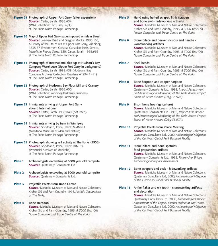
Plate 5 Hand using hafted scraper, lithic scrapers and bone awl - hideworking artifactsSource: Manitoba Museum of Man and Nature Collections;Kroker, Sid and Pam Goundry, 1993, A 3000 Year Old Native Campsite and Trade Centre at The Forks.
Plate 6 Stone biface and beaver incisors and handle - woodworking artifactsSource: Manitoba Museum of Man and Nature Collections;Kroker, Sid and Pam Goundry, 1993, A 3000 Year Old Native Campsite and Trade Centre at The Forks.
Plate 7 Shell beadsSource: Manitoba Museum of Man and Nature Collections;Kroker, Sid and Pam Goundry, 1993, A 3000 Year Old Native Campsite and Trade Centre at The Forks.
Plate 8 Bone harpoon and copper harpoonSource: Manitoba Museum of Man and Nature Collections;Quaternary Consultants Ltd., 1999, Impact Assessment and Archaeological Monitoring of The Forks Access Project:South of Water Avenue (DlLg-33:97A).
Plate 9 Bison bone hoe (agriculture)Source: Manitoba Museum of Man and Nature Collections;Quaternary Consultants Ltd., 1999, Impact Assessment and Archaeological Monitoring of The Forks Access Project:South of Water Avenue (DlLg-33:97A).
Plate 10 Projectile Points from Peace MeetingSource: Manitoba Museum of Man and Nature Collections;Quaternary Consultants Ltd., 2000, Archaeological Mitigationof the CanWest Global Park Baseball Facility.
Plate 11 Stone biface and bone spatulas - food preparation artifactsSource: Manitoba Museum of Man and Nature Collections;Quaternary Consultants Ltd., 1989, Provencher Bridge Archaeological Impact Assessment.
Plate 12 Bone scrapers and awls - hideworking artifactsSource: Manitoba Museum of Man and Nature Collections;Quaternary Consultants Ltd., 2000, Archaeological Mitigationof the CanWest Global Park Baseball Facility.
Plate 13 Antler flaker and elk tooth - stoneworking artifacts and decorationSource: Manitoba Museum of Man and Nature Collections;Quaternary Consultants Ltd., 2000, Archaeological ImpactAssessment of the Legacy Estates Project at The Forks;Quaternary Consultants Ltd., 2000, Archaeological Mitigationof the CanWest Global Park Baseball Facility.
Figure 29 Photograph of Upper Fort Garry (after expansion)Source: Carter, Sarah, 1988:#34 (PAM Collection: Fort Garry 37/1) at The Forks North Portage Partnership.
Figure 30 Map of Upper Fort Garry superimposed on Main StreetSource: Loewen, Brad and Gregory Monks, 1986:166, A History of the Structures at Upper Fort Garry, Winnipeg,1835-87. Environment Canada, Canadian Parks Service, Microfiche Report Series 330; Carter, Sarah, 1988:#63 at The Forks North Portage Partnership.
Figure 31 Photograph of International tied up at Hudson’s Bay Company Warehouse (Upper Fort Garry in background)Source: Carter, Sarah, 1988:#38 (Hudson’s Bay Company Archives Collection: Brigdens A1294 1 -11) at The Forks North Portage Partnership.
Figure 32 Photograph of Hudson’s Bay Flour Mill and GranarySource: Carter, Sarah, 1988:#50 (PAM Collection: Winnipeg-Buildings-Business) at The Forks North Portage Partnership.
Figure 33 Immigrants arriving at Upper Fort Garry aboard InternationalSource: Carter, Sarah, 1988:#40 (not listed) at The Forks North Portage Partnership.
Figure 34 Immigrants arriving by train in WinnipegSource: Goodhand, Joyce, 1999: MMMN 11 (Manitoba Museum of Man and Nature) at The Forks North Portage Partnership.
Figure 35 Photograph showing rail activity at The Forks (1956)Source: Goodhand, Joyce, 1999: PAM 53 (Provincial Archives of Manitoba) at The Forks North Portage Partnership.
Plate 1 Archaeologists excavating at 3000 year old campsiteSource: Quaternary Consultants Ltd.
Plate 2 Archaeologists excavating at 3000 year old campsiteSource: Quaternary Consultants Ltd.
Plate 3 Projectile Points from Trade CentreSource: Manitoba Museum of Man and Nature Collections;Kroker, Sid and Pam Goundry, 1994, Archaic Occupationsat The Forks.
Plate 4 Bone HarpoonSource: Manitoba Museum of Man and Nature Collections;Kroker, Sid and Pam Goundry, 1993, A 3000 Year Old Native Campsite and Trade Centre at The Forks.

Plate 14 Ceramic sherdsSource: Manitoba Museum of Man and Nature Collections;Quaternary Consultants Ltd., 1999, Impact Assessment and Archaeological Monitoring of The Forks Access Project:South of Water Avenue (DlLg-33:97A).
Plate 15 Archaeologists excavating at Fort Gibraltar ISource: Quaternary Consultants Ltd.
Plate 16 Trade goods - beads, tinkling cones, gunflints, shotSource: Manitoba Museum of Man and Nature Collections
Plate 17 Photograph of prints and buggy rutsSource: Quaternary Consultants Ltd.
Plate 18 Photograph of remains of Upper Fort Garry bastionSource: Quaternary Consultants Ltd.
Plate 19 Photograph of remains of Upper Fort Garry east wallSource: Quaternary Consultants Ltd.
Plate 20 Artifacts from Upper Fort Garry (pitcher, plate, cup)Source: Manitoba Museum of Man and Nature Collections;Quaternary Consultants Ltd., 1998, Archaeology of Main Street Roadworks: York Avenue to Tache Avenue 1996 - 1998.
Plate 21 Archaeologist excavating piling from Hudson’s Bay Company Flour MillSource: Quaternary Consultants Ltd.


![Grand Forks herald (Grand Forks, N.D.). 1917-12-01 [p ]. · Grand Forks herald (Grand Forks, N.D.). 1917-12-01 [p ]](https://img.pdfslide.us/doc/110x75/5e9b4cea4169af71771cee98/grand-forks-herald-grand-forks-nd-1917-12-01-p-grand-forks-herald-grand.jpg)