Embed Size (px)
Citation preview
PROP
OSED
RETA
IL B
UILD
ING
7,800
± SF
PROP
OSED
PON
D
Charles Usinas Mem
orial Hwy (SR-16)
Charles Usinas Mem
orial Hwy (SR-16)
16
LOAD
ING
ZONE
200’
200’
265.18’265.18’
Industry Center Rd
Industry Center Rd
Accelerating success.
Colliers International76 S. Laura Street, Suite 1500
Jacksonville, FL 32202P: +1 904 358 1206
colliers.com/jacksonville
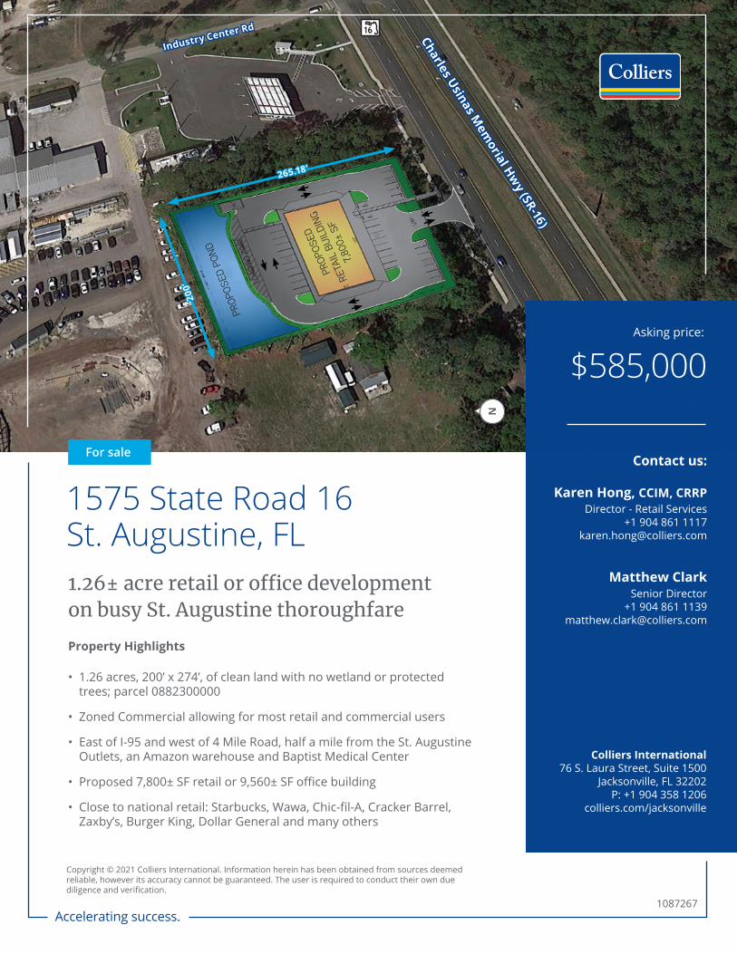
For sale
$585,000Asking price:
Contact us:
Karen Hong, CCIM, CRRPDirector - Retail Services
+1 904 861 [email protected]
Matthew ClarkSenior Director
+1 904 861 [email protected]
1.26± acre retail or office development on busy St. Augustine thoroughfare
1575 State Road 16St. Augustine, FL
Property Highlights
• 1.26 acres, 200’ x 274’, of clean land with no wetland or protected trees; parcel 0882300000
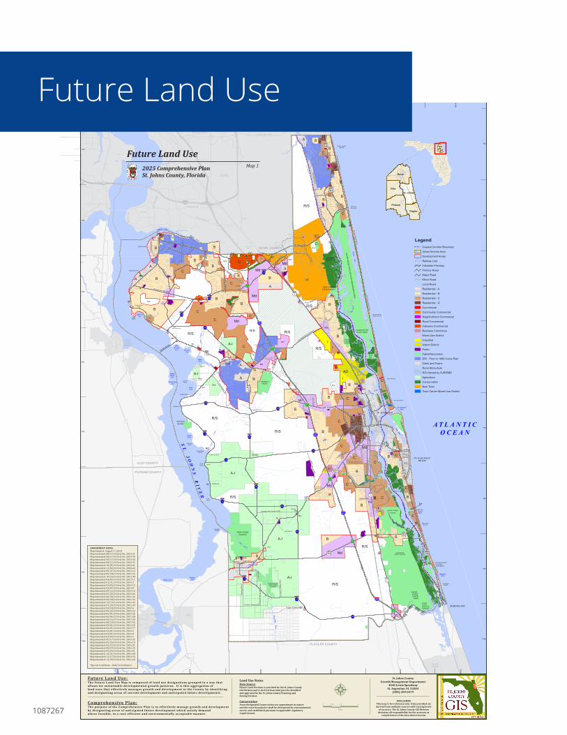
• Zoned Commercial allowing for most retail and commercial users
• East of I-95 and west of 4 Mile Road, half a mile from the St. Augustine Outlets, an Amazon warehouse and Baptist Medical Center
• Proposed 7,800± SF retail or 9,560± SF office building
• Close to national retail: Starbucks, Wawa, Chic-fil-A, Cracker Barrel, Zaxby’s, Burger King, Dollar General and many others
Copyright © 2021 Colliers International. Information herein has been obtained from sources deemed reliable, however its accuracy cannot be guaranteed. The user is required to conduct their own due diligence and verification.
1087267
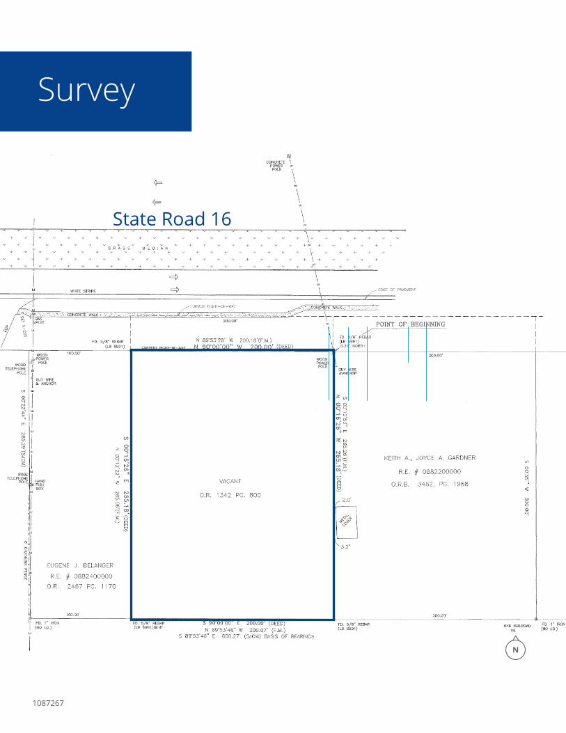
Survey
1087267
State Road 16State Road 16
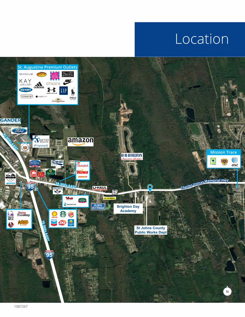
Location
1087267
16
38,500± AADT38,500± AADT Charles Usinas Memorial Hwy
Charles Usinas Memorial Hwy
St. Augustine Premium Outlets
St Johns County St Johns County Public Works DeptPublic Works Dept
Mission Trace
75,500± AA
DT
75,500± AA
DT
81,000± AADT
81,000± AADT
Brighton Day Brighton Day AcademyAcademy
(Proposed)
1087267
!!
!
!
!!
!!
!!
!!
!!
!!
!!
!!
!!
!!
!!
!!
!!
!!
!
!!
!!
!!
!
!
!
!!
!!
!
!!
!!
!!
!!
!!
!!
!
!!
!!
!
!
!
!
!
!
!!
!!
!
!
!
!
!!
!!
!!
!!
!
!
!
!
!
!!
!!
!!
!!
!!
!!
!!
!
!
!!
!!
!
!!
!!
!!
!!
!
!
!!
!!
!!
!
!
!!
!!
!
!
!
!
!!
!!
!!
!
!
!
!
!
!
!
!
!!
!
!
!!
!!
!!
!!
!
!
!
!
!
!
!
!
!
!!
!!
!
!
8Ç
8Å
8Ä
8Ã
8È
8Æ
!"̀$
!"̀$
!"̀$
!"̀$
Wd
Wd
We
We
)°
)±)±
)¹
)¹
)º
)º
)ª
-¥
-¦
-¦
-¦
-̈
-©
-³
-³
-³
Ei
Ei
Ej
Ej
Cp
?q
?q
?q
Et
Eu
Av
Av
Ax
Sf
%&a(
DUVAL COUNTY
CLAY COUNTY
PUTNAM COUNTY
FLAGLER COUNTY
Memorial Bridge
KayLarkinAirport
PALATKA EASTPALATKA
PALMCOAST
GREENCOVE
SPRINGS
MANDARIN
JACKSONVILLE
SOUTHSIDEJACKSONVILLE
BAYARD
JACKSONVILLEBEACH
J Turner Butler Blvd
San
Jose
Blvd
Greenland Rd
St. Augustine RdMan
darin
Rd
PONTE VEDRABEACH
MICKLERLANDING
PALM VALLEY
SAMPSON
FRUIT COVE
SWITZERLAND
REMINGTONPARK
ORANGEDALE
PALMO
COLEECOVE
BASS HAVEN
PICOLATA
BAKERSVILLE
WARDS CREEK
POPOPOINT
PACETTIPOINT
Shands Bridge WORLD GOLFVILLAGE
SOUTH PONTEVEDRA BEACH
USINA BEACH
VILANO BEACH
CRESCENTBEACH
DUPONTCENTER
SUMMERHAVEN
SPUDS
ARMSTRONG
ELKTON
VERMONTHEIGHTS
MOLASSESJUNCTION
FEDERALPOINT
RIVERDALE
TOCOI
LANE LANDING
RACYPOINT
TOCOIPOINT
MAGNOLIAPOINT
SOLANOPOINT
HASTINGS
MARINELAND
ST. AUGUSTINEBEACH
ST. AUGUSTINE
Solana Rd Ponte Vedra Blvd
NR
oscoeBlvd
PonteVedra
Blvd
Canal Blvd
SR
oscoeBlvd
Mickle r Rd
Nocatee Pkw y
Valle y
Ridg
e Blvd
Russell Sampson Rd
S tJoh ns
Pkw
y
Vete
rans
Pkw
y
Longleaf Pine Pkwy
Flora B ran chB
lvd
Durb in Creek Blvd
Race Track Rd
Frui
tCov
eR
d
RobertsRd
Greenbriar Rd
Leo
Mag
uire
Pkwy
International Golf Pkwy
SPonte
VedraBlvdLas Ca l in
asBlvd
SFr
ancis
Rd
Joe Ashton
Rd
Pace
tt iR
d
Coastal H
wyWoodlawn Rd
Lew
is Speedway
SanM
arco
A v
Masters
Dr
Four Mile Rd
NHolm
esBlvd
SH
olmes
Blvd
W King St King St Anastasia Blvd
Lightsey Rd
Kings Estate Rd
Old
Mou ltrie
Rd
WildwoodDr
ShoreD
r
Watson Rd
Del t o n a B lvd
ShoresB
lvd
Miz
ellR
d Pope Rd
16th St11th St
A St
A1A
Beac
hB
lvd
AllenN
ea se
Rd
St Ambrose Church Rd
Federal
Point Rd E St Johns Av
George MillerR
d
Has
tings
Blv
d
Cracker Swamp Rd
Cow
pen
Bran
chR
d
Flagler Estates Blvd Faver D yk es Rd
BARTRAMPARK
HallowesCove
LittleFlorence
Cove FlorenceCove
PalmoCove
ColeeCove
SulphurSpringCove
Puerto RicoCove
SolanoCove
MurphysCoveWarner Cove
Sixt eenmile
Creek
DeepCre ek
Toco
iCr
e ek
Sixmile
Creek
Trou
tCr
eek
Julington Creek
Durb inCreek
ST.
JO
HN
SR
I VE
R
Intracoas talW
aterway
Gu ana
Lake
Cap o
Cre
ek
S tokesCreek
Tolomato
R iver
GuanaR
iver
Casa Cola Creek
Rob inson
Creek
St. AugustineInletSan
SebastianRiver
SaltRun
Moultrie
Creek
M
osesCre ek
Matanzas
Ri v er
MatanzasInlet
Pe ll icer Creek
A T L A N T I CO C E A N
Old Dixie HwyR
ayR
d
Corona Rd
Landru mLn
Vare
llaAv
Northeast FloridaRegional Airportat St. Augustine
Davis Pond Blv d Crosswa ter PkwyPalm
Valley Rd
Preservation Tr
Pi ne Islan d Rd
EnsenadaD
r N LoopPkwy
SLo op Pkw
y
Pa l enc
iaV i
l la
geD r
KENSINGTON
Worl d Commerce Pkw
y
WGV Blvd
Roya
lPin
es
Pkw
y
Lega c y Tr
Inm
anR
d
Agricult u ral Center Dr
Dob
bsR
d
Rol ling
Hills Dr
Rei
dPa
ckin
gH
ouse
Rd
Dobbs RdCutoff
R 26E
R27E
R28E
R29E
R30E
R31E
R26E
R27E
R28E
R29E
R30E
R31E
T3S
T4S
T5S
T6S
T7S
T8S
T9S
T10S
T3S
T4S
T5S
T6S
T7S
T8S
T9S
T10S
B
C
R/S
R/S
R/S
R/S
DEEP CREEK
FORT MATANZAS NATIONAL MONUMENT
MOSES CREEK BUTLER BEACH PARK
ANASTASIASTATE
RECREATIO
NAR
EA
A-I
B
B
Md
A-I
FAVER DYKES STATE PARK
HASTINGS
BI
C
B
D
TreatyPark
C
Md
A-I
C
GU
ANAR
IVERSTATE
WILD
LIFEM
ANAGEM
ENTAR
EA
SJRWMD
SJRWMD
FAVERDYKESADDITIONSJRWMD
CB
Md
Md
C
STOKESLANDINGSJRWMD
GUANA RIVER STATE PARK
BB
B
B
A
C
C
D
C
B
CD
A-IYARBOROUGH DEEP CREEK SJRWMD
B
Md A
A AD
CC
CC
NC
RC
NC
NC
RC
NC
NC
CM
CM
RC
B
IC
MdA
P
P
P
P
P
PP
P
P
P
P
AD
CC
Md
P
P
P
A-I
P
P
Md
Md
P
P
P
A
I
MdP
RC
A
A CA AA
A
A
ACV
DEEP CREEKSTATE FOREST
WATSONISLAND
B
A
B
IC
CC
Md
CC
R/S
R/S
NEPark
R/S
R/S
R/S
P
NOCATEEPRESERVE
CC
RC
Md
B
B
P
B
C
CB
R/S
R/S
C
I
G.R.S.P.
A
C
C
P
IC
P
P
P
P
P
B
C
R/SMd
CC
R/S
RC
C
CC
CV
R/S B
Md
B
R/S
B
C
B
C
C
C
C
A-I
R/S
B
CV
CV
R/S
A
PIC
Md
I
A
NT
NT
A-I
R/S
A
B
B
R/S
RC
RC
TURNBULL CREEK
IC*
D*
B*
D*
I
B
BC*
B*
A-I
B
C
A
C
C
C
Md*
C
D
C
B
B
Md
Md
B
C*
P
C
CC
C
C
Md
IC
A
!"̀$
MATANZASSTATE FOREST
Cp
St. Johns
Duval
Clay
Putnam
Flagler
Legend! ! Coastal Corridor Boundary
Urban Service Area
Development Areas
Railway Line
Interstate Freeway
Primary Road
Major Road
Minor Road
Local Road
Residential - A
Residential - B
Residential - C
Residential - D
Commercial
Community Commercial
Neighborhood Commercial
Rural Commercial
Intensive Commercial
Business Commerce
Mixed Use District
Industrial
Airport District
Public
Parks/Recreation
DRI - Prior to 1990 Comp Plan
Cities and Towns
Rural Silviculture
R/S Owned by SJRWMD
Agriculture
Conservation
New Town
Town Center Mixed Use District
DISCLAIMERThis map is for reference only. Data provided arederived from multiple sources with varying levels
of accuracy. The St. Johns County GIS Divisiondisclaims all responsibility for the accuracy or
completeness of the data shown hereon.
Comprehensive Plan: The purpose of the Comprehensive Plan is to effectively manage growth and developmentby designating areas of anticipated future development which satisfy demandwhere feasible, in a cost-efficient and environmentally acceptable manner.
Future Land Use: The Future Land Use Map is composed of land use designations grouped in a way that allows for sustainable developmental growth patterns. It is this aggregation ofland uses that effectively manages growth and development in the County by identifyingand designating areas of current development and anticipated future developments. Å
Land Use NotesData SourceFuture Land Use data is provided by the St. Johns County GIS Division and is derived from land parcels identified and approved by the St. Johns County Planning and Zoning Division.
0 1.5 30.75
Miles
ConservationAreas designated Conservation are approximate in natureand the exact boundaries shall be determined by environmentalsurvey and established pursuant to applicable regulatoryrequirements.
St. Johns CountyGrowth Management Department
4040 Lewis SpeedwaySt. Augustine, FL 32084
(904) 209-0579
2025 Comprehensive PlanSt. Johns County, Florida
Future Land UseMap 1
AMENDMENT DATESMap Adopted: August 17, 2010Map Amended: 08/17/10 Ord. No. 2010-31Map Amended: 08/17/10 Ord. No. 2010-33Map Amended: 08/17/10 Ord. No. 2010-36Map Amended: 08/17/10 Ord. No. 2010-37Map Amended: 10/05/10 Ord. No. 2010-41Map Amended: 11/02/10 Ord. No. 2010-46Map Amended: 06/21/12 Ord. No. 2012-13Map Amended: 09/18/12 Ord. No. 2012-25Map Amended: 10/16/12 Ord. No. 2012-30Map Amended: 04/02/13 Ord. No. 2013-11Map Amended: 01/21/14 Ord. No. 2014-3Map Amended: 04/04/14 Ord. No. 2014-12Map Amended: 04/07/14 Ord. No. 2014-8Map Amended: 05/12/14 Ord. No. 2014-16Map Amended: 06/23/14 Ord. No. 2014-24Map Amended: 06/30/14 Ord. No. 2014-26Map Amended: 08/28/14 Ord. No. 2014-32Map Amended: 12/19/14 Ord. No. 2014-45Map Amended: 01/29/15 Ord. No. 2014-59Map Amended: 03/18/15 Ord. No. 2015-4Map Amended: 05/22/15 Ord. No. 2015-22Map Amended: 06/01/15 Ord. No. 2015-25Map Amended: 06/06/15 Ord. No. 2015-28Map Amended: 06/16/15 Ord. No. 2015-38Map Amended: 08/18/15 Ord. No. 2015-54Map Amended: 09/01/15 Ord. No. 2015-55Map Amended: 02/01/16 Ord. No. 2015-77Map Amended: 04/01/16 Ord. No. 2016-2Map Amended: 04/01/16 Ord. No. 2016-8Map Amended: 04/04/16 Ord. No. 2016-5Map Amended: 05/17/16 Ord. No. 2016-25Map Amended: 05/20/16 Ord. No. 2016-19Map Amended: 06/23/16 Ord. No. 2016-31Map Amended: 08/29/16 Ord. No. 2016-35Map Amended: 09/26/16 Ord. No. 2016-41Map Amended: 10/21/16 Ord. No. 2016-48Map Amended: 11/17/16 Ord. No. 2016-52Map Amended: 12/29/16 Ord. No. 2016-60
*Special Conditions - Refer to Ordinance.
Future Land Use
!"̀$
!"̀$
!"̀$
Wd
Wd
We
We
)°
)±)±
)¹
)¹
)º
)º
)ª
-¥
-¦
-¦
-¦
-©
-³
-³
-³
Ei
Ei
Ej
Ej
Cp
Cp
?q
?q
?q
Et
Eu
Av
Ax
Av
DUVAL COUNTY
CLAY COUNTY
PUTNAM COUNTY
FLAGLER COUNTY
NAS Jacksonville
Buckman Bridge
Memorial Bridge
KayLarkinAirport
PALATKA EASTPALATKA
PALMCOAST
GREENCOVE
SPRINGS
MANDARIN
SAN JOSE
SOUTHSIDEJACKSONVILLE
BAYARD
JACKSONVILLEBEACH
J Turner Butler Blvd
Sout
hsid
e Bl
vd
Baymeadows Rd
San
Jose
Blvd
Sunbeam Rd
Greenland Rd
Man
darin
Rd
PONTE VEDRABEACH
MICKLERLANDING
PALM VALLEY
SAMPSON
FRUIT COVE
SWITZERLAND
REMINGTONPARK
ORANGEDALE
PALMO
COLEECOVE
BASS HAVEN
PICOLATA
BAKERSVILLE
WARDS CREEK
POPOPOINT
PACETTIPOINT
Shands Bridge WORLD GOLFVILLAGE
SOUTH PONTEVEDRA BEACH
USINA BEACH
VILANO BEACH
BUTLERBEACH
CRESCENTBEACH
DUPONTCENTER
SUMMERHAVEN
SPUDS
ARMSTRONG
ELKTON
VERMONTHEIGHTS
MOLASSESJUNCTION
FEDERALPOINT
RIVERDALE
TOCOI
LANE LANDING
RACYPOINT
TOCOIPOINT
MAGNOLIAPOINT
SOLANOPOINT
HASTINGS
MARINELAND
ST. AUGUSTINEBEACH
ST. AUGUSTINE
Solana Rd Ponte Vedra Blvd
NR
oscoeBlvd
PonteVedra
Blvd
Canal Blvd
SR
oscoeBlvd
Mickle r Rd
Nocatee Pkwy
Valley
Ridg
e Blvd
Russell Sampson Rd
S tJoh ns
Pkw
y
Vete
rans
Pkw
y
Longleaf Pine Pkwy
Flora B ran chB
lvd
Race Track Rd
Frui
tCov
eR
d
RobertsRd
Greenbriar Rd
Leo
Mag
uire
Pkwy
International Golf Pkwy
SPonte
VedraBlvdLas Ca l in
asBlvd
Joe Ashton
Rd
Pac
ett i
Rd
Coastal H
wyWoodlawn Rd
Lew
is Speedway
SanM
arco
A v
Masters
Dr
Four Mile Rd
NHolm
esB lvd
SH
olmes
Blvd
W King St King St Anastasia Blvd
Lightsey Rd
Kings Estate Rd
Old
Mou ltrie
Rd
WildwoodDr
ShoreD
r
Watson Rd
Del t o n a B lvd
ShoresBl vd
Miz
ellR
d Pope Rd
16th St11th St
A St
A1A
Beac
hB
lvd
AllenN
ease
Rd
St Ambrose Church Rd
Federal
Point Rd E St Johns Av
George MillerR
d
Has
tings
Blvd
Cracker Swamp Rd
Cow
pen
Bran
chR
d
Flagler Estates Blvd Faver Dyk esRd
HallowesCove
LittleFlorence
Cove FlorenceCove
PalmoCove
ColeeCove
SulphurSpringCove
Puerto RicoCove
SolanoCove
MurphysCoveWarner Cove
Sixte enmile
Creek
DeepCre ek
Toco
iC
re
ek
Sixmile
Creek
Trou
tC
r eek
Julington Creek
Durb inCreek
ST.
JO
HN
SR
I VE
R
Intracoast alW
aterway
Gu ana
Lake
Cap o
Cre
ek
S tokesCreek
To lomato
R iver
GuanaRiver
Casa Cola Creek
Rob i nson
Creek
St. AugustineInletSan
Sebas tianRiver
SaltRun
Moultrie
Creek
M
osesCreek
Matanzas
Riv er
MatanzasInlet
Pe ll icerCreek
A T L A N T I CO C E A N
Old Dixie HwyR
ayR
d
Corona Rd
Landru mLn
Vare
llaAv
Crosswa ter PkwyPalm
Valley Rd
Preservation Tr
Pi ne Islan d Rd
EnsenadaD
r N LoopPkwy
Worl d C ommerce Pkw
y
WGV Blvd
Roy
alPi
nesP
kw
y
Lega c y Tr
Agricu
lt u ral Center Dr
Dob
bsR
d
Roll ing
Hills Dr
Rei
dPa
ckin
gH
ouse
Rd
Dobbs RdCutoff
Northeast FloridaRegional Airportat St. Augustine
Old St. Augustine Rd
JACKSONVILLE
Roos
evel
t Blv
d
BARTRAMSPRINGS DUVAL COUNTY
CLAY COUNTY
PUTNAM COUNTY
FLAGLER COUNTY
NAS Jacksonville
Buckman Bridge
Memorial Bridge
KayLarkinAirport
PALATKA EASTPALATKA
PALMCOAST
GREENCOVE
SPRINGS
MANDARIN
SAN JOSE
SOUTHSIDEJACKSONVILLE
BAYARD
JACKSONVILLEBEACH
J Turner Butler Blvd
Sout
hsid
eBl
vd
Baymeadows Rd
San
Jose
Blvd
Sunbeam Rd
Greenland Rd
Man
darin
Rd
PONTE VEDRABEACH
MICKLERLANDING
PALM VALLEY
SAMPSON
FRUIT COVE
SWITZERLAND
REMINGTONPARK
ORANGEDALE
PALMO
COLEECOVE
BASS HAVEN
PICOLATA
BAKERSVILLE
WARDS CREEK
POPOPOINT
PACETTIPOINT
Shands Bridge WORLD GOLFVILLAGE
SOUTH PONTEVEDRA BEACH
USINA BEACH
VILANO BEACH
BUTLERBEACH
CRESCENTBEACH
DUPONTCENTER
SUMMERHAVEN
SPUDS
ARMSTRONG
ELKTON
VERMONTHEIGHTS
MOLASSESJUNCTION
FEDERALPOINT
RIVERDALE
TOCOI
LANE LANDING
RACYPOINT
TOCOIPOINT
MAGNOLIAPOINT
SOLANOPOINT
HASTINGS
MARINELAND
ST. AUGUSTINEBEACH
ST. AUGUSTINE
Solana Rd PonteVedra
Blvd
NR
oscoeBlvd
PonteVedra
Blvd
Canal Blvd
SR
oscoeBlvd
Mickle r Rd
Nocatee Pkwy
Valley
Ridg
e Blvd
Russell Sampson Rd
S tJoh ns
Pkw
y
Vete
rans
Pkw
y
Longleaf Pine Pkwy
Flora B ran chB
lvd
Durb in Creek Blvd
Race Track Rd
Frui
tCov
eR
d
RobertsRd
Greenbriar Rd
Leo
Mag
uire
Pkwy
International Golf Pkwy
SPonte
VedraBl vdLas Ca l in
asBlvd
SFr
anci
sR
d
Joe Ashton
Rd
Pac
ett i
Rd
Coastal H
wyWoodlawn Rd
Lew
is Speedway
SanM
arco
A v
Maste rs
Dr
Four Mile Rd
NHolm
esB lvd
SH
olmes
Blvd
W King St King St Anastasia Blvd
Lightsey Rd
Kings Estate Rd
Old
Mou ltrie
Rd
WildwoodDr
ShoreD
r
Watson Rd
Del t o n a B lvd
ShoresBl vd
Miz
ellR
d Pope Rd
16th St11th St
A St
A1A
Beac
hB
lvd
Alle nN
ease
Rd
St Ambrose Church Rd
Federal
Point Rd E St Johns Av
George MillerR
d
Has
tings
Blvd
Cracker Swamp Rd
Cow
pen
Bran
chR
d
Flagler Estates Blvd Faver Dyk esRd
HallowesCove
LittleFlorence
Cove FlorenceCove
PalmoCove
ColeeCove
SulphurSpringCove
Puerto RicoCove
SolanoCove
MurphysCoveWarner Cove
Sixte enmile
Creek
DeepCre ek
Toco
iC
reek
Sixmile
Creek
Trou
tC
r eek
Julington Creek
Durb inCreek
ST.
JO
HN
SR
I VE
R
Intracoast alW
aterway
Gu ana
Lake
Cap o
Cre
ek
S tokesCreek
To lomato
R iver
GuanaRiver
Casa Cola Creek
Rob i nson
Creek
St. AugustineInletSan
Sebas tianRiver
SaltRun
Moultrie
Creek
M
osesCreek
Matanzas
Riv er
MatanzasInlet
Pe ll icerCreek
FAVER-DYKESSTATE PARK
FORT MATANZASNATIONAL
MONUMENT
ANA
STASIASTATE
PAR
K
GU
AN
AR
IVE
RW
ILDLIF
EM
AN
AG
EM
EN
TA
RE
A
GUANA RIVER- GTMNERR
A T L A N T I CO C E A N
Old Dixie HwyR
ayR
d
Corona Rd
Landru mLn
Vare
llaAv
Davis Pond Blv d Crosswa ter PkwyPalm
Valley Rd
Preservation Tr
Pi ne Islan d Rd
EnsenadaD
r N LoopPkwy
SLo op Pkw
y
Pa l enc
iaV
il la
geDr
W
orl d C ommerce Pkwy
WGV Blvd
Roy
alPi
nesP
kw
y
Lega c y Tr
Inm
anR
d
Agricu
lt u ral Center Dr
Dob
bsR
d
Roll ing
Hills Dr
Rei
dPa
ckin
gH
ouse
Rd
MATANZAS STATE FOREST
MOSES CREEKCONSERVATION
AREA
DEEP CREEKCONSERVATION AREA
NOCATEEPRESERVE
DAVISPARK
VETERANSPARK
TREATYPARK
Dobbs RdCutoff
DEEP CREEKCONSERVATION AREA
Northeast FloridaRegional Airportat St. Augustine
TWELVE MILE SWAMP CONSERVATION AREA
TWELVE MILE SWAMP CONSERVATION AREA
Old St. Augustine Rd
JACKSONVILLE
Roos
evel
t Blv
d
BARTRAMSPRINGS
Julington CreekPlantation
CordovaPalms
Nocatee
Silverleaf
RiverTown
TwinCreeks
Saint Johns
CaballosDel Mar
AberdeenDurbin
Crossing
AshfordMills
BartramPark
Marshall Creek(Palencia)
World CommerceCenter
St. AugustineCentre
LegendDevelopment of Regional Impact
Development of Regional Impact
Zoning
Residential Uses
Commercial or Office Professional
Industrial or Airport Development
Planned Developments or Mixed Use
Airport Overlay District
Park and Open Space
Intertidal Marsh
Municipalities
Proposed Transportation Corridors **
Proposed Transportation Corridors
Currently Under Construction or Construction is Imminent
This map is for reference use only. Data provided are derived from multiple sources with varying levels of accuracy. The St. Johns County GIS Division disclaims all responsibility for the accuracy or completeness of the data shown hereon.
0 1.5 3 4.5
Miles
" DISCLAIMER:St. Johns CountyDevelopment Map Prepared: 12/23/2015
Development
1087267
j
j
j
j
j
j
jj
j
jj
j
j
j
j
j
jj
j
j
j
j
j
j
j
j
j
j
j
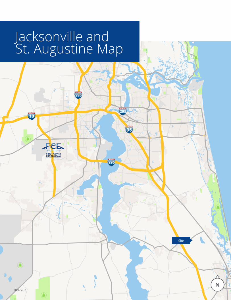
Site
Jacksonville andSt. Augustine Map
1087267
Executive SummaryPrepared by Esri
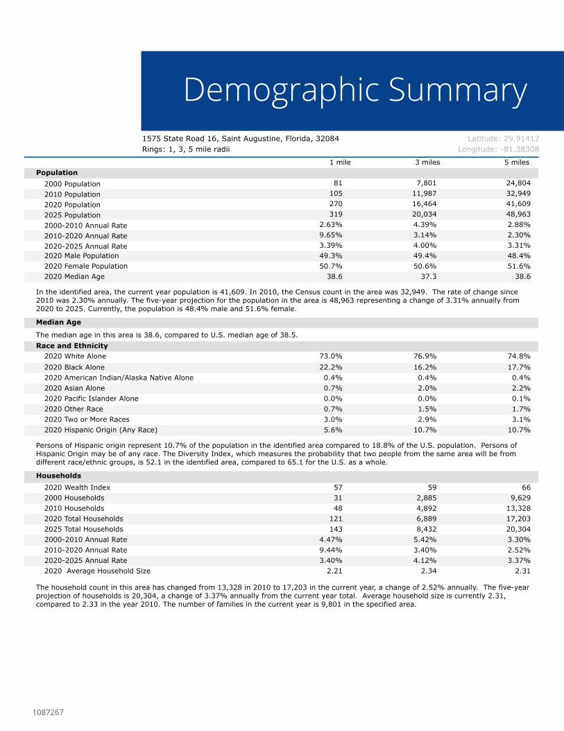
Latitude: 29.914121575 State Road 16, Saint Augustine, FL1575 State Road 16, Saint Augustine, Florida, 32084 Rings: 1, 3, 5 mile radii Longitude: -81.38308
1 mile 3 miles 5 milesPopulation
2000 Population 81 7,801 24,8042010 Population 105 11,987 32,9492020 Population 270 16,464 41,6092025 Population 319 20,034 48,9632000-2010 Annual Rate 2.63% 4.39% 2.88%2010-2020 Annual Rate 9.65% 3.14% 2.30%2020-2025 Annual Rate 3.39% 4.00% 3.31%2020 Male Population 49.3% 49.4% 48.4%2020 Female Population 50.7% 50.6% 51.6%2020 Median Age 38.6 37.3 38.6
In the identified area, the current year population is 41,609. In 2010, the Census count in the area was 32,949. The rate of change since 2010 was 2.30% annually. The five-year projection for the population in the area is 48,963 representing a change of 3.31% annually from 2020 to 2025. Currently, the population is 48.4% male and 51.6% female.
Median Age
The median age in this area is 38.6, compared to U.S. median age of 38.5.Race and Ethnicity
2020 White Alone 73.0% 76.9% 74.8%2020 Black Alone 22.2% 16.2% 17.7%2020 American Indian/Alaska Native Alone 0.4% 0.4% 0.4%2020 Asian Alone 0.7% 2.0% 2.2%2020 Pacific Islander Alone 0.0% 0.0% 0.1%2020 Other Race 0.7% 1.5% 1.7%2020 Two or More Races 3.0% 2.9% 3.1%2020 Hispanic Origin (Any Race) 5.6% 10.7% 10.7%
Persons of Hispanic origin represent 10.7% of the population in the identified area compared to 18.8% of the U.S. population. Persons of Hispanic Origin may be of any race. The Diversity Index, which measures the probability that two people from the same area will be from different race/ethnic groups, is 52.1 in the identified area, compared to 65.1 for the U.S. as a whole.
Households2020 Wealth Index 57 59 662000 Households 31 2,885 9,6292010 Households 48 4,892 13,3282020 Total Households 121 6,889 17,2032025 Total Households 143 8,432 20,3042000-2010 Annual Rate 4.47% 5.42% 3.30%2010-2020 Annual Rate 9.44% 3.40% 2.52%2020-2025 Annual Rate 3.40% 4.12% 3.37%2020 Average Household Size 2.21 2.34 2.31
The household count in this area has changed from 13,328 in 2010 to 17,203 in the current year, a change of 2.52% annually. The five-year projection of households is 20,304, a change of 3.37% annually from the current year total. Average household size is currently 2.31, compared to 2.33 in the year 2010. The number of families in the current year is 9,801 in the specified area.
Data Note: Income is expressed in current dollars. Housing Affordability Index and Percent of Income for Mortgage calculations are only available for areas with 50 or more owner-occupied housing units. Source: U.S. Census Bureau, Census 2010 Summary File 1. Esri forecasts for 2020 and 2025. Esri converted Census 2000 data into 2010 geography.
March 11, 2021
©2021 Esri Page 1 of 2
Demographic Summary
1087267
Executive SummaryPrepared by Esri
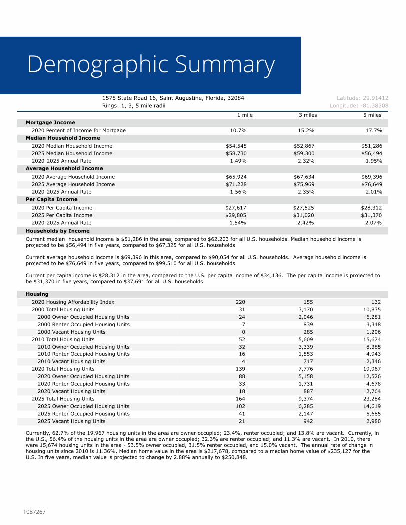
Latitude: 29.914121575 State Road 16, Saint Augustine, FL1575 State Road 16, Saint Augustine, Florida, 32084 Rings: 1, 3, 5 mile radii Longitude: -81.38308
1 mile 3 miles 5 milesMortgage Income
2020 Percent of Income for Mortgage 10.7% 15.2% 17.7%Median Household Income
2020 Median Household Income $54,545 $52,867 $51,2862025 Median Household Income $58,730 $59,300 $56,4942020-2025 Annual Rate 1.49% 2.32% 1.95%
Average Household Income
2020 Average Household Income $65,924 $67,634 $69,3962025 Average Household Income $71,228 $75,969 $76,6492020-2025 Annual Rate 1.56% 2.35% 2.01%
Per Capita Income2020 Per Capita Income $27,617 $27,525 $28,3122025 Per Capita Income $29,805 $31,020 $31,3702020-2025 Annual Rate 1.54% 2.42% 2.07%
Households by IncomeCurrent median household income is $51,286 in the area, compared to $62,203 for all U.S. households. Median household income is projected to be $56,494 in five years, compared to $67,325 for all U.S. households
Current average household income is $69,396 in this area, compared to $90,054 for all U.S. households. Average household income is projected to be $76,649 in five years, compared to $99,510 for all U.S. households
Current per capita income is $28,312 in the area, compared to the U.S. per capita income of $34,136. The per capita income is projected to be $31,370 in five years, compared to $37,691 for all U.S. households
Housing2020 Housing Affordability Index 220 155 1322000 Total Housing Units 31 3,170 10,835
2000 Owner Occupied Housing Units 24 2,046 6,2812000 Renter Occupied Housing Units 7 839 3,3482000 Vacant Housing Units 0 285 1,206
2010 Total Housing Units 52 5,609 15,6742010 Owner Occupied Housing Units 32 3,339 8,3852010 Renter Occupied Housing Units 16 1,553 4,9432010 Vacant Housing Units 4 717 2,346
2020 Total Housing Units 139 7,776 19,9672020 Owner Occupied Housing Units 88 5,158 12,5262020 Renter Occupied Housing Units 33 1,731 4,6782020 Vacant Housing Units 18 887 2,764
2025 Total Housing Units 164 9,374 23,2842025 Owner Occupied Housing Units 102 6,285 14,6192025 Renter Occupied Housing Units 41 2,147 5,6852025 Vacant Housing Units 21 942 2,980
Currently, 62.7% of the 19,967 housing units in the area are owner occupied; 23.4%, renter occupied; and 13.8% are vacant. Currently, in the U.S., 56.4% of the housing units in the area are owner occupied; 32.3% are renter occupied; and 11.3% are vacant. In 2010, there were 15,674 housing units in the area - 53.5% owner occupied, 31.5% renter occupied, and 15.0% vacant. The annual rate of change in housing units since 2010 is 11.36%. Median home value in the area is $217,678, compared to a median home value of $235,127 for the U.S. In five years, median value is projected to change by 2.88% annually to $250,848.
Data Note: Income is expressed in current dollars. Housing Affordability Index and Percent of Income for Mortgage calculations are only available for areas with 50 or more owner-occupied housing units. Source: U.S. Census Bureau, Census 2010 Summary File 1. Esri forecasts for 2020 and 2025. Esri converted Census 2000 data into 2010 geography.
March 11, 2021
©2021 Esri Page 2 of 2
Demographic Summary
1087267


![PDF[1575 KB]](https://img.pdfslide.us/doc/110x75/586cd5e21a28ab427c8b9677/pdf1575-kb.jpg)