Embed Size (px)
Citation preview
IEA Hydropower Implementing Agreement Annex VIII -
Hydropower Good Practices: Environmental Mitigation Measures and Benefits
Case Study 14-01: Development of Regional Industries – Gosho Dam, Japan
Key Issues: 14-Development of Regional Industries 1-Biological Diversity 11-Benefits due to Power Generation
Climatic Zone: Cf: Temperate humid climate
Subjects: - Environmental improvement of areas - Tourist development around the dam
Effects: - Activation of local community through tourism development
Project name: Gosho Dam
Country: Iwate Prefecture, Japan (Asia)
Implementing Party & Period: - Project: The Ministry of Land, Infrastructure and Transport From 1973 -
- Good Practice: The Ministry of Land, Infrastructure and Transport
Keywords: Concept of peripheral environmental improvement, Recreational Space, Promotion of regional development
Abstract: As a sightseeing and recreational center, Lake Gosho and the surrounding area attract a large number of tourists, mainly due to the recent improvement of the Lake Gosho Regional Park and its favorable location near a newly-opened high-speed traffic network. This is the culmination of efforts put forth by the government, the prefecture, the city, the town and local inhabitants working together from the time the dam was constructed.
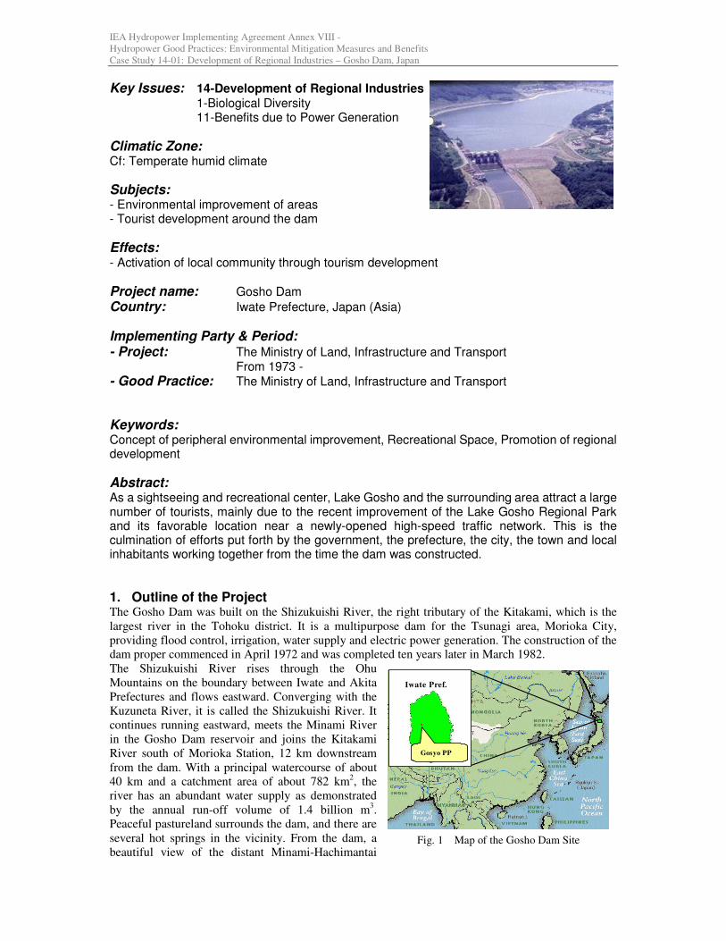
1. Outline of the Project The Gosho Dam was built on the Shizukuishi River, the right tributary of the Kitakami, which is the
largest river in the Tohoku district. It is a multipurpose dam for the Tsunagi area, Morioka City,
providing flood control, irrigation, water supply and electric power generation. The construction of the
dam proper commenced in April 1972 and was completed ten years later in March 1982.
The Shizukuishi River rises through the Ohu
Mountains on the boundary between Iwate and Akita
Prefectures and flows eastward. Converging with the
Kuzuneta River, it is called the Shizukuishi River. It
continues running eastward, meets the Minami River
in the Gosho Dam reservoir and joins the Kitakami
River south of Morioka Station, 12 km downstream
from the dam. With a principal watercourse of about
40 km and a catchment area of about 782 km2, the
river has an abundant water supply as demonstrated
by the annual run-off volume of 1.4 billion m3.
Peaceful pastureland surrounds the dam, and there are
several hot springs in the vicinity. From the dam, a
beautiful view of the distant Minami-Hachimantai Fig. 1 Map of the Gosho Dam Site
Iwate Pref.
Gosyo PP
2
range including Mt. Iwate, or Iwate Fuji, can be
enjoyed.
Such factors as the favorable location,
completion of the dam construction, opening of
a high-speed traffic network, regional
improvement and development all serve to bring
the areas around Lake Gosho into the limelight
as a center of tourism and recreational activities.
The Gosho Dam is a composite type dam; a
concrete gravity type on the right bank side and
an impervious core rock-fill type on the left bank
side. Particulars and location of the Gosho Dam
are shown in Table 1 and Fig. 1, respectively.
2. Features of the Project Area Lake Gosho is situated in a hilly volcanic zone
surrounded by Mt. Iwate to the north, Mt.
Komagatake to the northwest and the Tohne
Mountains to the south, the hills and mountains
sloping down to the flat basin floor. The
Shizukuishi and other rivers form terraces and a
valley plain. Lake Gosho is an artificial lake
created on the plain by damming up the rivers.
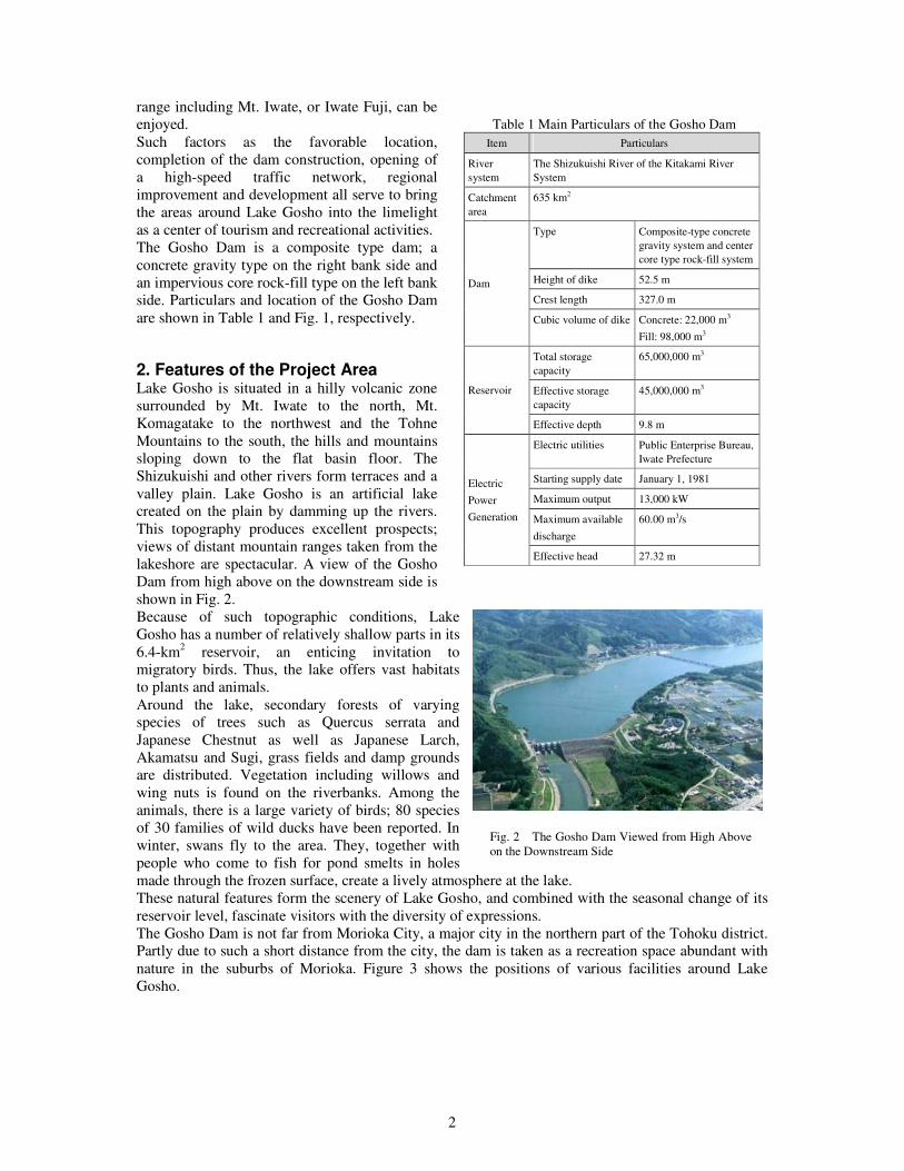
This topography produces excellent prospects;
views of distant mountain ranges taken from the
lakeshore are spectacular. A view of the Gosho
Dam from high above on the downstream side is
shown in Fig. 2.
Because of such topographic conditions, Lake
Gosho has a number of relatively shallow parts in its
6.4-km2 reservoir, an enticing invitation to
migratory birds. Thus, the lake offers vast habitats
to plants and animals.
Around the lake, secondary forests of varying
species of trees such as Quercus serrata and
Japanese Chestnut as well as Japanese Larch,
Akamatsu and Sugi, grass fields and damp grounds
are distributed. Vegetation including willows and
wing nuts is found on the riverbanks. Among the
animals, there is a large variety of birds; 80 species
of 30 families of wild ducks have been reported. In
winter, swans fly to the area. They, together with
people who come to fish for pond smelts in holes
made through the frozen surface, create a lively atmosphere at the lake.
These natural features form the scenery of Lake Gosho, and combined with the seasonal change of its
reservoir level, fascinate visitors with the diversity of expressions.
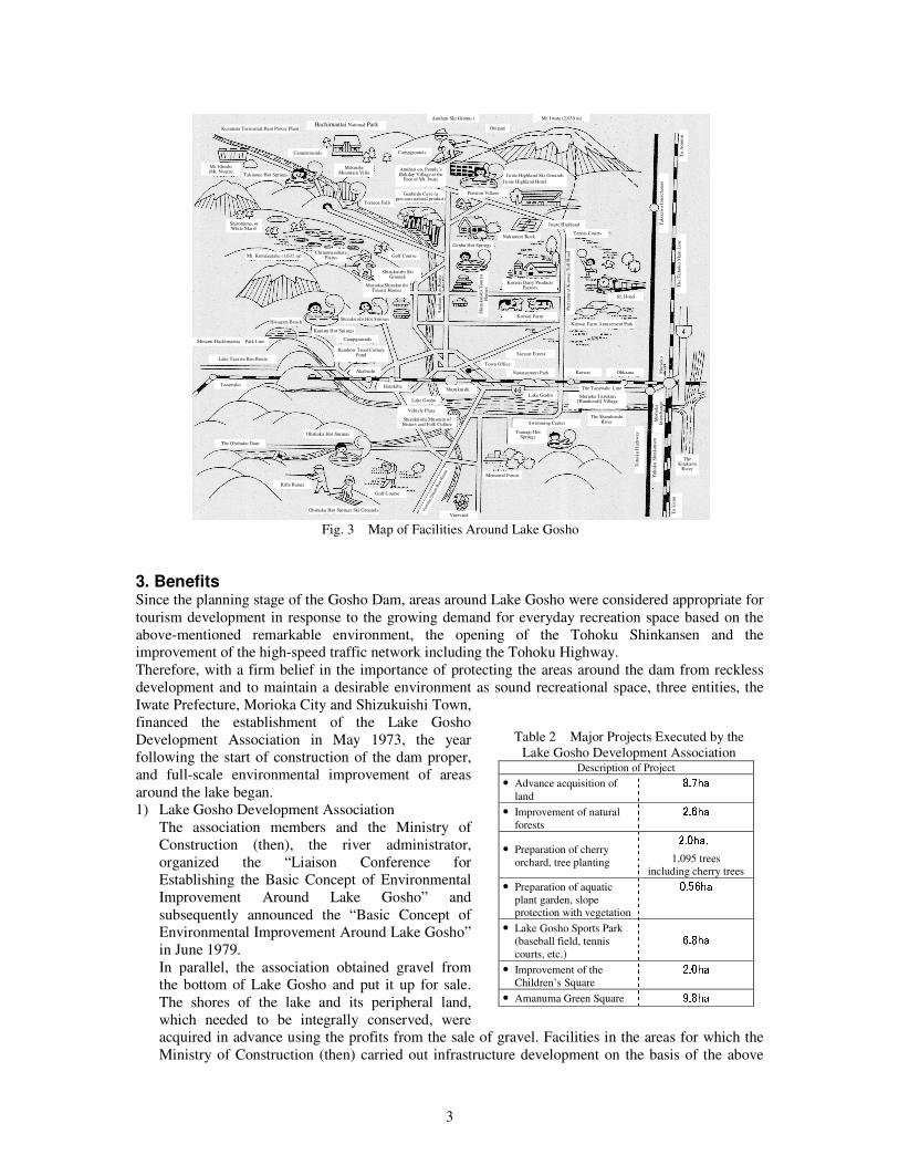
The Gosho Dam is not far from Morioka City, a major city in the northern part of the Tohoku district.
Partly due to such a short distance from the city, the dam is taken as a recreation space abundant with
nature in the suburbs of Morioka. Figure 3 shows the positions of various facilities around Lake
Gosho.
Table 1 Main Particulars of the Gosho Dam
Item Particulars
River
system
The Shizukuishi River of the Kitakami River
System
Catchment
area
635 km2
Type Composite-type concrete
gravity system and center
core type rock-fill system
Height of dike 52.5 m
Crest length 327.0 m
Dam
Cubic volume of dike Concrete: 22,000 m3
Fill: 98,000 m3
Total storage
capacity
65,000,000 m3
Effective storage
capacity
45,000,000 m3 Reservoir
Effective depth 9.8 m
Electric utilities Public Enterprise Bureau,
Iwate Prefecture
Starting supply date January 1, 1981
Maximum output 13,000 kW
Maximum available
discharge
60.00 m3/s
Electric
Power
Generation
Effective head 27.32 m
Fig. 2 The Gosho Dam Viewed from High Above on the Downstream Side
3
3. Benefits Since the planning stage of the Gosho Dam, areas around Lake Gosho were considered appropriate for
tourism development in response to the growing demand for everyday recreation space based on the
above-mentioned remarkable environment, the opening of the Tohoku Shinkansen and the
improvement of the high-speed traffic network including the Tohoku Highway.
Therefore, with a firm belief in the importance of protecting the areas around the dam from reckless
development and to maintain a desirable environment as sound recreational space, three entities, the
Iwate Prefecture, Morioka City and Shizukuishi Town,
financed the establishment of the Lake Gosho
Development Association in May 1973, the year
following the start of construction of the dam proper,
and full-scale environmental improvement of areas
around the lake began.
1) Lake Gosho Development Association
The association members and the Ministry of
Construction (then), the river administrator,
organized the “Liaison Conference for
Establishing the Basic Concept of Environmental
Improvement Around Lake Gosho” and
subsequently announced the “Basic Concept of
Environmental Improvement Around Lake Gosho”
in June 1979.
In parallel, the association obtained gravel from
the bottom of Lake Gosho and put it up for sale.
The shores of the lake and its peripheral land,
which needed to be integrally conserved, were
acquired in advance using the profits from the sale of gravel. Facilities in the areas for which the
Ministry of Construction (then) carried out infrastructure development on the basis of the above
Kuzuneta Terrestrial Heat Power Plant Hachimantai National Park
Amihari Ski Grounds Onigajo
Mt. Iwate (2,039 m)
Campgrounds Mt. Eboshi (Mt. Nyuto)
Takinoue Hot Springs
Campgrounds
Mitsuishi Mountain Villa Amihari-so, People’s
Holiday Village at the Foot of Mt. Iwate Iwate Highland Ski Grounds
Iwate Highland Hotel
Torigoe Falls Genbudo Cave (a
precious natural product) Pension Village
Shironuma, or White Marsh
Chinumagahara Plains Golf Course
Shizukuishi Ski Grounds
Genbu Hot Springs Nukumori Rock
Iwate Highland Tennis Courts
Pre
fect
ura
l K
oiw
ai
Toll
Road
To A
om
ori
Tak
izaw
a In
terc
hange
Th
e T
oho
ku
Main
Lin
e
SL Hotel
Koiwai Farm Amusement Park
Mo
riok
a
Mt. Komagatake (1,632 m)
Morioka/Shizukuishi Tourist Homes
Am
ihari
Bu
s R
oute
Sh
izu
ku
ishi
Tou
rist
H
om
es Koiwai Dairy Products
Factory
Koiwai Farm Hiyagata Beach
Kunimi Hot Springs Shizukuishi Hot Springs
Campgrounds Rainbow Trout Culture
Pond Saezuri Forest Lake Tazawa Bus Route
Town Office Nanatsumori Park
Tazawako Akabuchi
Harukiba Shizukuishi
Koiwai Ohkama
The Tazawako Line
The Shizukuishi River
Lake Gosho Morioka Tezukuri [Handicraft] Village
Mo
riok
a
Inte
rch
ange
Toh
ok
u S
hin
kan
sen
To
Ueno
To
ho
ku
Hig
hw
ay
The Kitakami
River
Yum
oto
Ons
en
Bus
Route
Lake Gosho Vehicle Plaza
Shizukuishi Museum of History and Folk Culture Swimming Center
Tsunagi Hot Springs
Memorial Forest
Vineyard
Golf Course
Ohshuku Hot Springs Ski Grounds
Rifle Range
Ohshuku Hot Springs The Ohshuku Dam
Minami-Hachimantai Park Line
Fig. 3 Map of Facilities Around Lake Gosho
Table 2 Major Projects Executed by the
Lake Gosho Development Association Description of Project
• Advance acquisition of
land 8.7ha • Improvement of natural
forests 2.6ha • Preparation of cherry
orchard, tree planting 2.0ha, 1,095 trees
including cherry trees • Preparation of aquatic
plant garden, slope
protection with vegetation 0.56ha • Lake Gosho Sports Park
(baseball field, tennis
courts, etc.) 6.8ha • Improvement of the
Children’s Square 2.0ha • Amanuma Green Square 9.8ha
4
concept and the land acquired in advance are now being improved.
The major projects executed by the association are shown in Table 2.
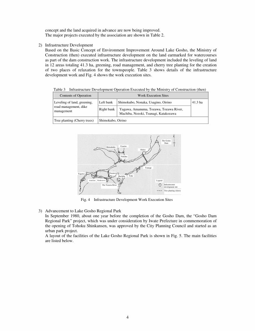
2) Infrastructure Development
Based on the Basic Concept of Environment Improvement Around Lake Gosho, the Ministry of
Construction (then) executed infrastructure development on the land earmarked for watercourses
as part of the dam construction work. The infrastructure development included the leveling of land
in 12 areas totaling 41.3 ha, greening, road management, and cherry tree planting for the creation
of two places of relaxation for the townspeople. Table 3 shows details of the infrastructure
development work and Fig. 4 shows the work execution sites.
Table 3 Infrastructure Development Operation Executed by the Ministry of Construction (then)
Contents of Operation Work Execution Sites
Left bank Shimokubo, Nonaka, Usagino, Oirino Leveling of land, greening,
road management, dike
management Right bank Yagawa, Amanuma, Tozawa, Tozawa River,
Machiba, Nozoki, Tsunagi, Katakozawa
41.3 ha
Tree planting (Cherry trees) Shimokubo, Oirino
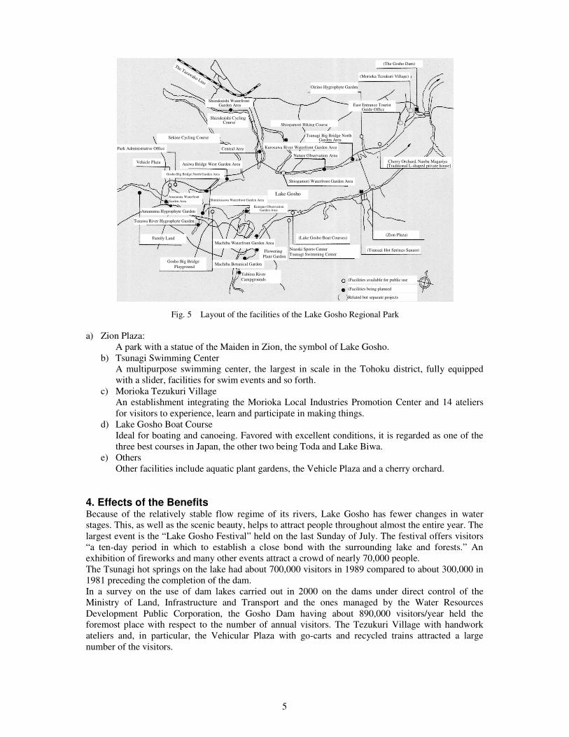
3) Advancement to Lake Gosho Regional Park
In September 1980, about one year before the completion of the Gosho Dam, the “Gosho Dam
Regional Park” project, which was under consideration by Iwate Prefecture in commemoration of
the opening of Tohoku Shinkansen, was approved by the City Planning Council and started as an
urban park project.
A layout of the facilities of the Lake Gosho Regional Park is shown in Fig. 5. The main facilities
are listed below.
Shimokubo Usagino
Nonaka
Yagawa
Oirino
The Gosho
Dam
Tsunagi
Yoke Machiba
Tozawa
The Tozawa River
Katakozawa Amanuma Legend
Infrastructure
development site
Tree planting (cherry trees)
Fig. 4 Infrastructure Development Work Execution Sites
5
a) Zion Plaza:
A park with a statue of the Maiden in Zion, the symbol of Lake Gosho.
b) Tsunagi Swimming Center
A multipurpose swimming center, the largest in scale in the Tohoku district, fully equipped
with a slider, facilities for swim events and so forth.
c) Morioka Tezukuri Village
An establishment integrating the Morioka Local Industries Promotion Center and 14 ateliers
for visitors to experience, learn and participate in making things.
d) Lake Gosho Boat Course
Ideal for boating and canoeing. Favored with excellent conditions, it is regarded as one of the
three best courses in Japan, the other two being Toda and Lake Biwa.
e) Others
Other facilities include aquatic plant gardens, the Vehicle Plaza and a cherry orchard.
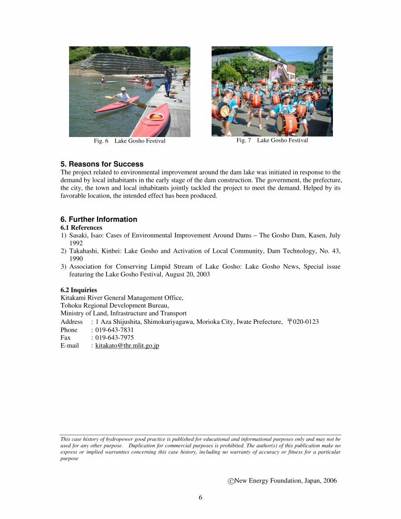
4. Effects of the Benefits Because of the relatively stable flow regime of its rivers, Lake Gosho has fewer changes in water
stages. This, as well as the scenic beauty, helps to attract people throughout almost the entire year. The
largest event is the “Lake Gosho Festival” held on the last Sunday of July. The festival offers visitors
“a ten-day period in which to establish a close bond with the surrounding lake and forests.” An
exhibition of fireworks and many other events attract a crowd of nearly 70,000 people.
The Tsunagi hot springs on the lake had about 700,000 visitors in 1989 compared to about 300,000 in
1981 preceding the completion of the dam.
In a survey on the use of dam lakes carried out in 2000 on the dams under direct control of the
Ministry of Land, Infrastructure and Transport and the ones managed by the Water Resources
Development Public Corporation, the Gosho Dam having about 890,000 visitors/year held the
foremost place with respect to the number of annual visitors. The Tezukuri Village with handwork
ateliers and, in particular, the Vehicular Plaza with go-carts and recycled trains attracted a large
number of the visitors.
Shizukuishi Waterfront Garden Area
The Tazawako Line
Shizukuishi Cycling Course
Oirino Hygrophyte Garden
(The Gosho Dam)
(Morioka Tezukuri Village)
East Entrance Tourist Guide Office
Park Administrative Office
Sekine Cycling Course
Central Area Kurosawa River Waterfront Garden Area
Nature Observation Area
Shiogamori Hiking Course
Tsunagi Big Bridge North Garden Area
Cherry Orchard, Nanbu Magariya [Traditional L-shaped private house]
Vehicle Plaza
Gosho Big Bridge North Garden Area
Aniwa Bridge West Garden Area
Shiogamori Waterfront Garden Area
Lake Gosho Amanuma Waterfront
Garden Area
Amanuma Hygrophyte Garden
Tozawa River Hygrophyte Garden
Shimizusawa Waterfront Garden Area
Kumano Observation Garden Area
Family Land Machiba Waterfront Garden Area
Flowering
Plant Garden
(Lake Gosho Boat Courses)
Nozoki Sports Center
Tsunagi Swimming Center
(Zion Plaza)
(Tsunagi Hot Springs Square)
Gosho Big Bridge
Playground Machiba Botanical Garden
Yabitsu River
Campgrounds (Facilities available for public use
(Facilities being planned
Related but separate projects
Fig. 5 Layout of the facilities of the Lake Gosho Regional Park
6
5. Reasons for Success The project related to environmental improvement around the dam lake was initiated in response to the
demand by local inhabitants in the early stage of the dam construction. The government, the prefecture,
the city, the town and local inhabitants jointly tackled the project to meet the demand. Helped by its
favorable location, the intended effect has been produced.
6. Further Information
6.1 References
1) Sasaki, Isao: Cases of Environmental Improvement Around Dams – The Gosho Dam, Kasen, July
1992
2) Takahashi, Kinbei: Lake Gosho and Activation of Local Community, Dam Technology, No. 43,
1990
3) Association for Conserving Limpid Stream of Lake Gosho: Lake Gosho News, Special issue
featuring the Lake Gosho Festival, August 20, 2003
6.2 Inquiries
Kitakami River General Management Office,
Tohoku Regional Development Bureau,
Ministry of Land, Infrastructure and Transport
Address : 1 Aza Shijushita, Shimokuriyagawa, Morioka City, Iwate Prefecture, 〒020-0123
Phone : 019-643-7831
Fax : 019-643-7975
E-mail : [email protected]
This case history of hydropower good practice is published for educational and informational purposes only and may not be
used for any other purpose. Duplication for commercial purposes is prohibited. The author(s) of this publication make no
express or implied warranties concerning this case history, including no warranty of accuracy or fitness for a particular
purpose
Fig. 6 Lake Gosho Festival
Fig. 7 Lake Gosho Festival
New Energy Foundation, Japan, 2006 C