Embed Size (px)
Citation preview
11/18/2012
1
Climate Change Adaptation
Dr. Fulco LudwigEarth System Science Group
Wageningen University
2 October 2012
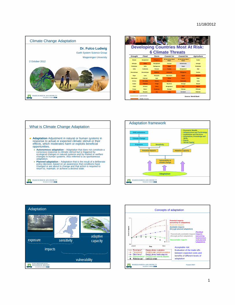
Developing Countries Most At Risk:6 Climate Threats
Drought Flood Storm Coastal 1m Coastal 5m Agriculture
Malawi Bangladesh Philippines All low-lying Island States
All low-lying Island States Sudan
Ethiopia China Bangladesh Vietnam Netherlands Senegal
Zimbabwe India Madagascar Egypt Japan Zimbabwe
India Cambodia Vietnam Tunisia Bangladesh Mali
Mozambique Mozambique Moldova Indonesia Philippines Zambia
Niger Laos Mongolia Mauritania Egypt Morocco
Mauritania Pakistan Haiti China Brazil Niger
Eritrea Sri Lanka Samoa Mexico Venezuela India
Sudan Thailand Tonga Myanmar Senegal Malawi
Chad Vietnam China Bangladesh Fiji Algeria
Kenya Benin Honduras Senegal Vietnam Ethiopia
Iran Rwanda Fiji Libya Denmark Pakistan
Middle Income
Low Income Source: World Bank
What is Climate Change Adaptation
Adaptation Adjustment in natural or human systems in response to actual or expected climatic stimuli or their effects, which moderates harm or exploits beneficial opportunities. Autonomous adaptation – Adaptation that does not constitute a
conscious response to climatic stimuli but is triggered byconscious response to climatic stimuli but is triggered by ecological changes in natural systems and by market or welfare changes in human systems. Also referred to as spontaneous adaptation.
Planned adaptation – Adaptation that is the result of a deliberate policy decision, based on an awareness that conditions have changed or are about to change and that action is required to return to, maintain, or achieve a desired state.
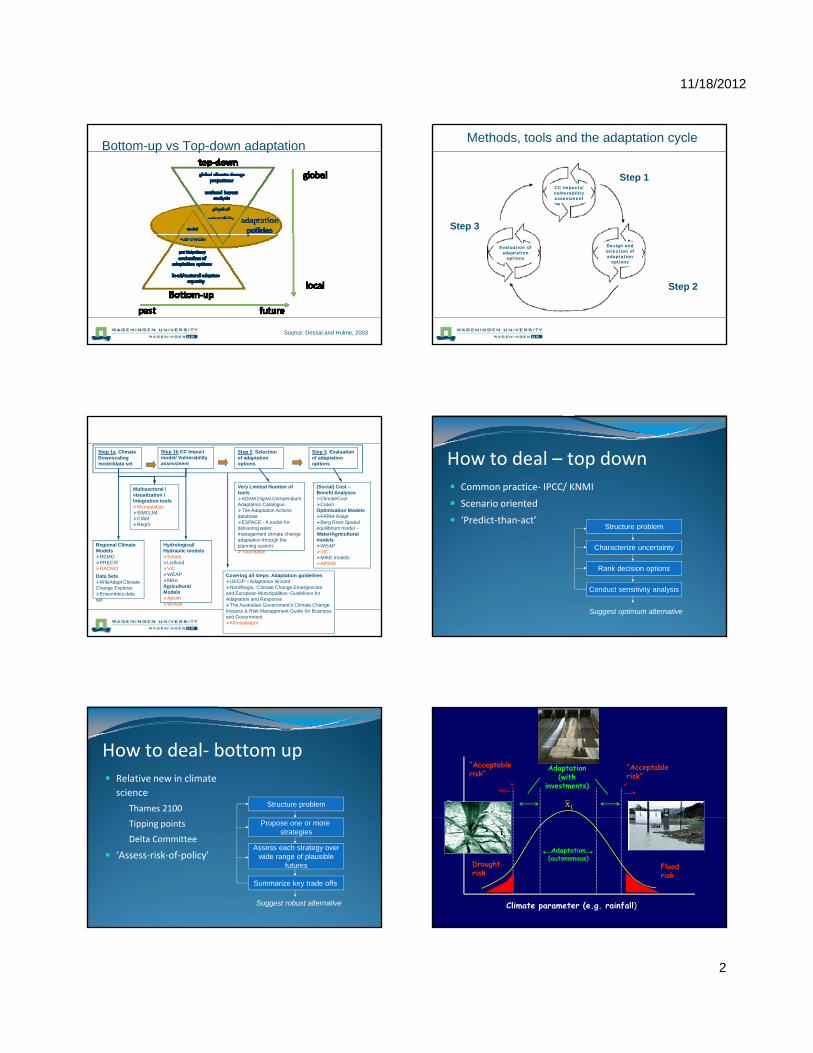
Adaptation framework
Adaptive CapacityPotential Impacts
Exposure
Climate Change
GHG emissions
Sensitivity
• Economic Wealth• Infrastructure and Technology• Institutions and Services• Information, Knowledge and
Skills• Equity• Social Capital
Adaptation
Vulnerability to climate change
adaptive
Adaptation
exposure sensitivityadaptive capacity
impacts
vulnerability
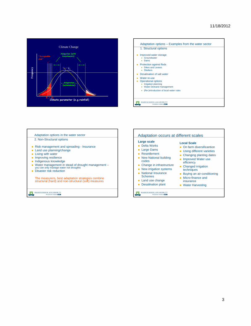
Concepts of adaptation
Theoretically avoidable impacts (through perfect adaptation)
Potential impacts (assuming no adaptation)Expected impacts (assumed autonomous adaptation)Avoidable impacts (through planned adaptation)
Residual impacts (assuming
Füssel 2007
( g )
Unavoidable impacts
( gautonomous and planned adaptation)
Acceptable risk: Evaluation of the trade-offs between expected costs and benefits of different levels of adaptation
11/18/2012
2
Bottom-up vs Top-down adaptation
Source: Dessai and Hulme, 2003
Methods, tools and the adaptation cycle
CC impacts/ vulnerability assessment
Step 1
Step 3
Evaluation of adaptation
options
Design and selection of adaptation
options
Step 2
Step 1a. Climate Downscaling model/data set
Step 1b CC Impact model/ Vulnerability assessment
Step 2. Selection of adaptation options
Step 3. Evaluation of adaptation options
Multisectoral / visualization / Integration toolsKlimaatatlasSIMCLIMCIAMRegIS
Very Limited Number of tools ADAM Digital Compendium Adaptation Catalogue The Adaptation Actions databaseESPACE - A toolkit for d li i
(Social) Cost –Benefit AnalysesClimateCostCalvinOptimization ModelsFARM-AdaptBerg River Spatial
ilib i d l
Regional Climate ModelsREMOPRECISRACMOData SetsWikiAdapt Climate Change ExplorerEnsembles data set
Hydrological/Hydraulic modelsSobekLisfloodVICWEAPMikeAgricultural ModelsApsimWofost
gdelivering water management climate change adaptation through the planning system’Touchtable
equilibrium model –Water/Agricultural modelsWEAPVICMIKE modelsAPSIM
Covering all steps: Adaptation guidelinesUKCIP – Adaptation WizardNordRegio, ‘Climate Change Emergencies and European Municipalities: Guidelines for Adaptation and ResponseThe Australian Government’s Climate Change Impacts & Risk Management Guide for Business and Government Klimaatwijzer
How to deal – top down Common practice‐ IPCC/ KNMI
Scenario oriented
‘Predict‐than‐act’Structure problemStructure problem
Characterize uncertainty
Rank decision options
Conduct sensitivity analysis
Suggest optimum alternative
How to deal‐ bottom up Relative new in climate
science
Thames 2100 Structure problem
Tipping points
Delta Committee
‘Assess‐risk‐of‐policy’
Propose one or more strategies
Assess each strategy overwide range of plausible
futures
Summarize key trade offs
Suggest robust alternative
Adaptation (with
investments)
x1
uenc
y
“Acceptable risk”
“Acceptable risk”
Adaptation (autonomous)
Climate parameter (e.g. rainfall)
Freq
u
Extremen Extremen
Drought risk
Flood risk
11/18/2012
3
Adapation (with investments)
x1
uenc
y x2
Climate Change
“Acceptable risk”
Adaptation (autonomous)
Climate parameter (e.g.rainfall)
Freq
u
P1P2
Adaptation options – Examples from the water sector1. Structural options
Improved water storage Groundwater Dams
Protection against flods Dikes and Levees Shelters
Desalination of salt water Water re-use Operational options
Irrigation planning Water Demand management (Re-)introduction of local water rules
Adaptation options in the water sector2. Non-Structural options
Risk management and spreading - Insurance Land use planning/change Living with water Improving resilience Indigenous knowledge Water management in stead of drought management –
you can only manage water not droughts Disaster risk reduction
The measurers. best adaptation strategies combine structural (hard) and non-structural (soft) measures
Adaptation occurs at different scalesLarge scale Delta Works Large Dams Resettlement New National building
codes
Local Scale On farm diversificantion Using different varieties Changing planting dates Improved Water use
efficiency Change in infrastructure New irrigation systems National Insurance
Schemes Land use change Desalination plant
efficiency Changed irrigation
techniques Buying an air-conditioning Micro-finance and
insurance Water Harvesting
11/18/2012
1
Coastal erosion and what to do about it
25 October 2012Workshop Challenges and Approaches in River Delta Planning
Marcel Marchand
The problem…
Coastal erosion is a worldwide phenomenon social equity
Problem analysis
• Coastal erosion is a natural phenomenon. It becomes a problem if coastal functions are at risk:• Beach quality• Flood risk• Land loss
• Understand the process:• Understand the process: • is it structural or event-driven (storms)? • Is the coast in equilibrium or not?• What are the root causes? • Sediment belance• Effect of sea level rise
11/18/2012
2
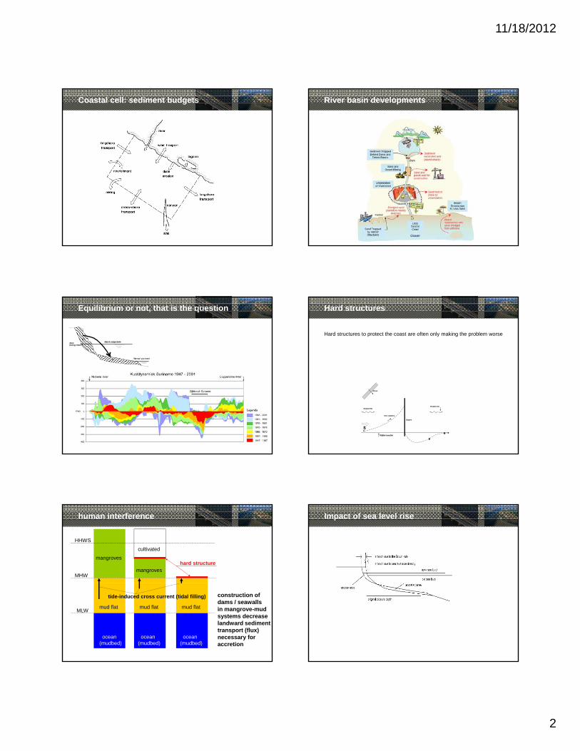
Coastal cell: sediment budgets River basin developments
Equilibrium or not, that is the question Hard structures
Hard structures to protect the coast are often only making the problem worse
human interference
HHWS
MHW
cultivated
mangroves
mangroveshard structure
MLWmud flat mud flatmud flat
ocean(mudbed)
ocean(mudbed)
ocean(mudbed)
tide-induced cross current (tidal filling) construction of dams / seawallsin mangrove-mudsystems decreaselandward sedimenttransport (flux)necessary foraccretion
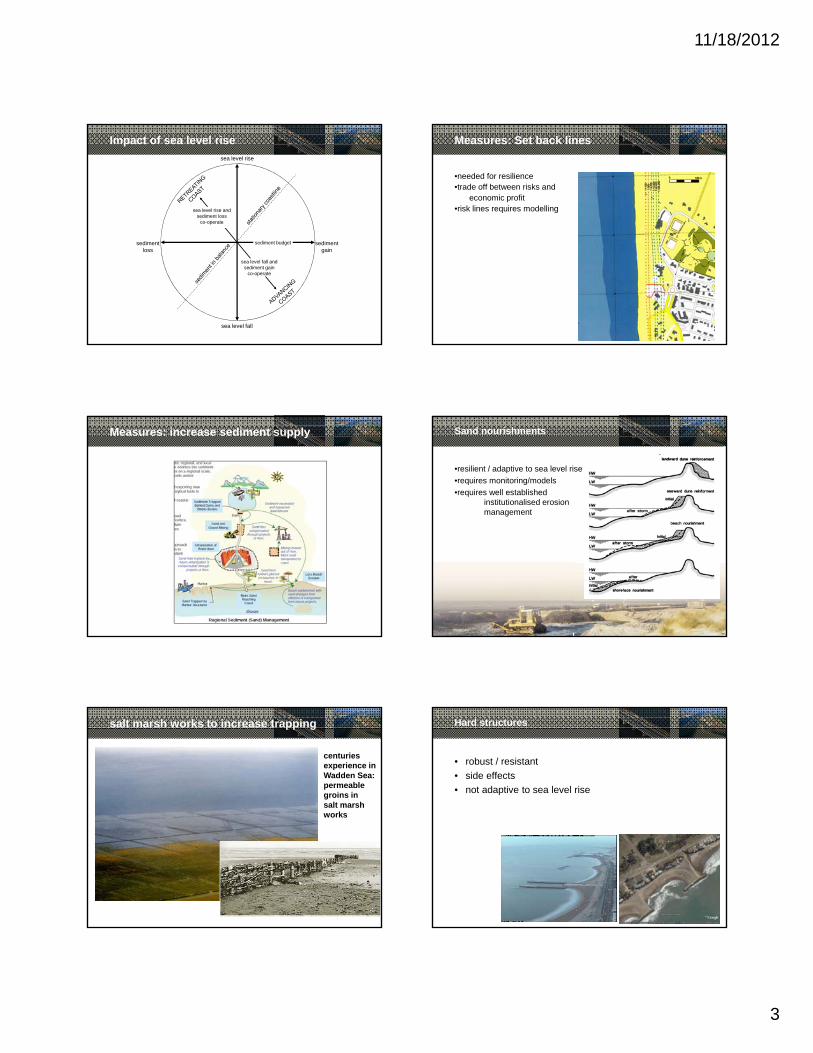
Impact of sea level rise
11/18/2012
3
sea level rise
sea level rise and sediment loss
co-operate
Impact of sea level rise
sea level fall
sea level fall and sediment gain
co-operate
sediment gain
sediment loss
sediment budget
Measures: Set back lines
•needed for resilience•trade off between risks and
economic profit•risk lines requires modelling
Measures: increase sediment supply Sand nourishments
•resilient / adaptive to sea level rise•requires monitoring/models•requires well established
institutionalised erosion management
salt marsh works to increase trapping
centuriesexperience inWadden Sea:permeable groins insalt marshworks
Hard structures
• robust / resistant• side effects• not adaptive to sea level rise
11/18/2012
4
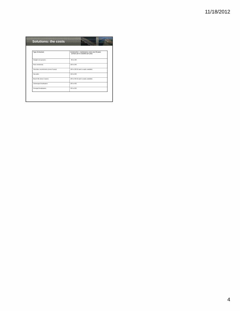
Solutions: the costs
Type of structure Construction + maintenance costs over 50 years(in Euro per m coastline per year)
Straight rock groynes 50 to 150
Rock revetments 100 to 200
Shoreface nourishments (every 5 years) 100 to 200 (if sand is easily available)Shoreface nourishments (every 5 years) 100 to 200 (if sand is easily available)
Sea walls 150 to 300
Beach fills (every 3 years) 200 to 300 (if sand is easily available)
Submerged breakwaters 200 to 400
Emerged breakwaters 250 to 500
1
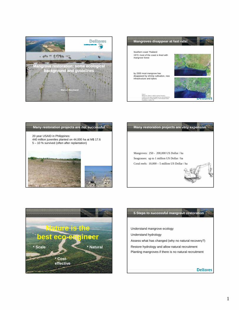
Mangrove restoration: some ecological Mangrove restoration: some ecological background and guidelinesbackground and guidelines
Marcel Marchand
Mangroves disappear at fast rate!
Southern coast Thailand:1973: most of the coast is lined with mangrove forest
by 2000 most mangrove has disappeard by shrimp cultivation, new infrastructure and dykes
Source:Mangroves: Nature’s defence against Tsunamis—A report on the impact of mangrove loss and shrimp farmdevelopment on coastal defences. Environmental JusticeFoundation, London, UK.
Many restoration projects are not successful
20 year USAID in Philippines: 440 million juveniles planted on 44,000 ha at M$ 17.65 – 10 % survived (often after replantation)
Many restoration projects are very expensive
Mangroves: 250 - 200,000 US Dollar / ha
Seagrasses: up to 1 million US Dollar / ha
Coral reefs: 10,000 – 5 million US Dollar / ha
Nature is the best eco-engineer
* Scale
* Cost-effective
* Natural
5 Steps to successful mangrove restoration
Understand mangrove ecology
Understand hydrology
Assess what has changed (why no natural recovery?)Assess what has changed (why no natural recovery?)
Restore hydrology and allow natural recruitmentPlanting mangroves if there is no natural recruitment
2
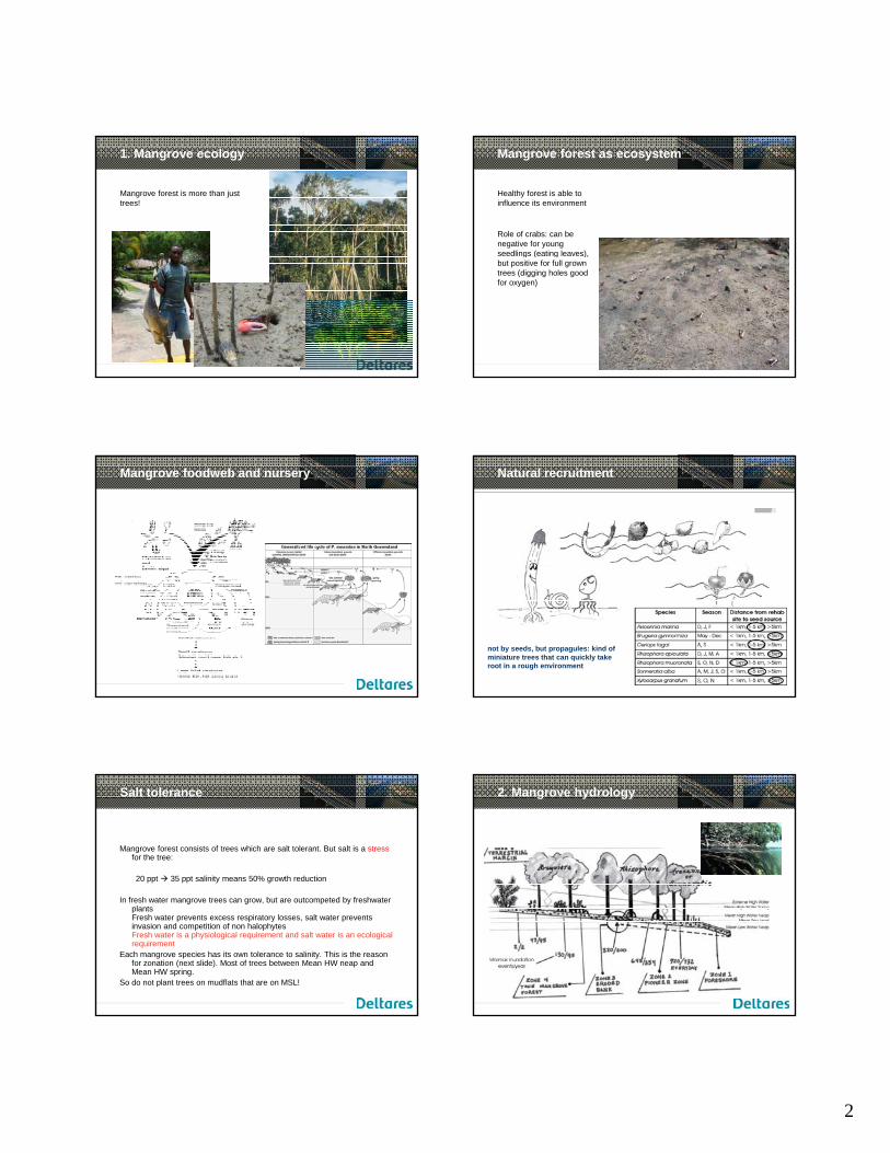
1. Mangrove ecology
Mangrove forest is more than just trees!
Mangrove forest as ecosystem
Healthy forest is able to influence its environment
Role of crabs: can be negative for young seedlings (eating leaves), g ( g ),but positive for full grown trees (digging holes good for oxygen)
Mangrove foodweb and nursery Natural recruitment
not by seeds, but propagules: kind of miniature trees that can quickly take root in a rough environment
Salt tolerance
Mangrove forest consists of trees which are salt tolerant. But salt is a stressfor the tree:
20 ppt 35 ppt salinity means 50% growth reduction
In fresh water mangrove trees can grow, but are outcompeted by freshwater plantsFresh water prevents excess respiratory losses, salt water prevents invasion and competition of non halophytesFresh water is a physiological requirement and salt water is an ecological requirement
Each mangrove species has its own tolerance to salinity. This is the reason for zonation (next slide). Most of trees between Mean HW neap and Mean HW spring.
So do not plant trees on mudflats that are on MSL!
2. Mangrove hydrology
3
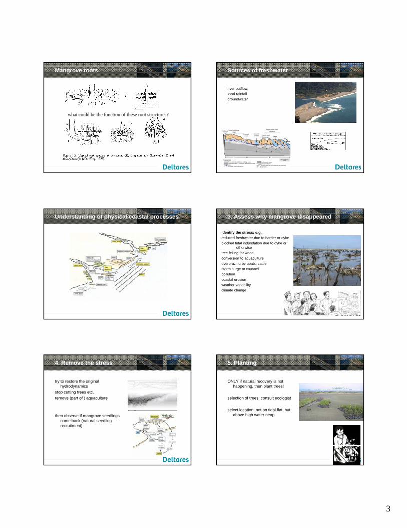
Mangrove roots
what could be the function of these root structures?
Sources of freshwater
river outflow: local rainfallgroundwater
Understanding of physical coastal processes 3. Assess why mangrove disappeared
identify the stress; e.g.reduced freshwater due to barrier or dykeblocked tidal indundation due to dyke or
otherwise tree felling for woodconversion to aquacultureovergrazing by goats cattleovergrazing by goats, cattlestorm surge or tsunamipollutioncoastal erosionweather variabilityclimate change
4. Remove the stress
try to restore the original hydrodynamics
stop cutting trees etc.remove (part of ) aquaculture
then observe if mangrove seedlings come back (natural seedling recruitment)
5. Planting
ONLY if natural recovery is not happening, then plant trees!
selection of trees: consult ecologist
select location: not on tidal flat butselect location: not on tidal flat, but above high water neap
4
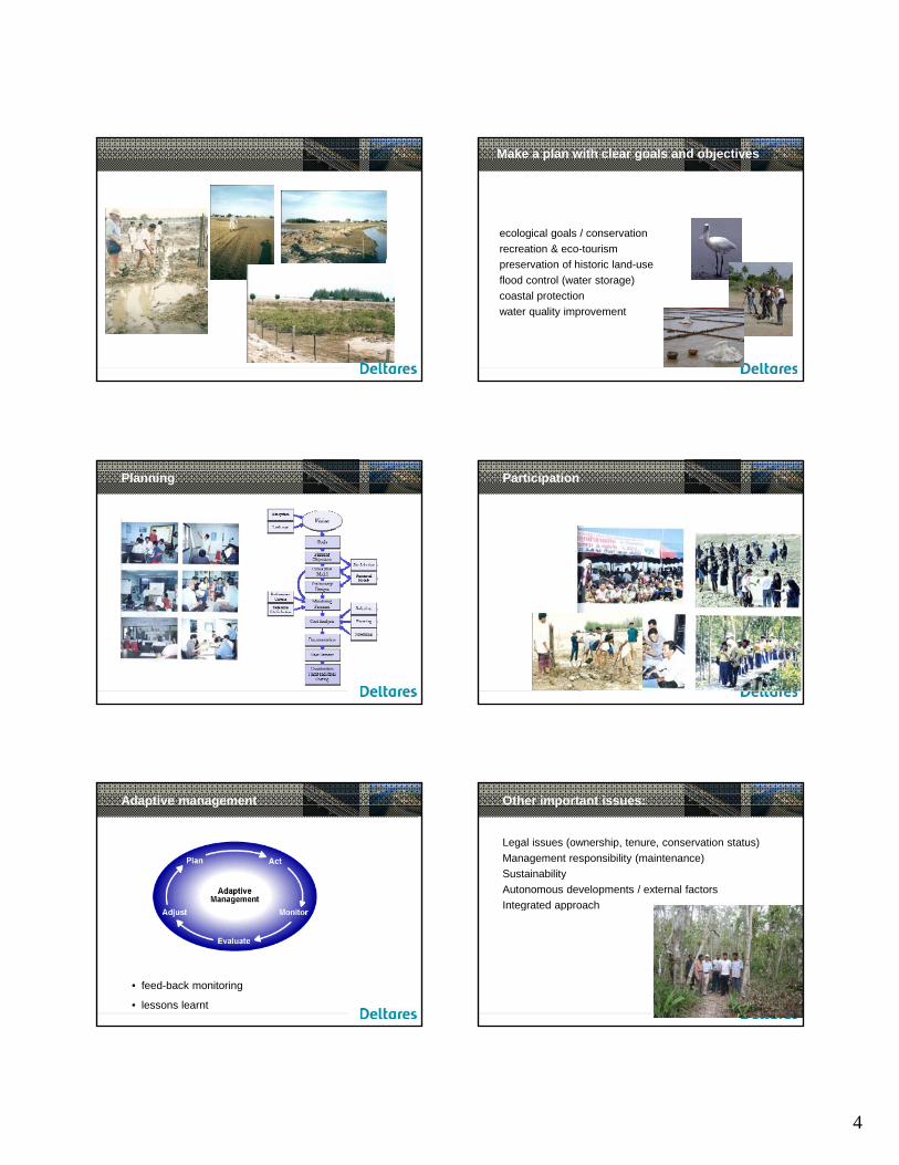
Make a plan with clear goals and objectives
ecological goals / conservationrecreation & eco-tourismpreservation of historic land-useflood control (water storage)coastal protectionwater quality improvement
Planning Participation
Adaptive management
• feed-back monitoring
• lessons learnt
Other important issues:
Legal issues (ownership, tenure, conservation status)Management responsibility (maintenance)SustainabilityAutonomous developments / external factorsIntegrated approachIntegrated approach
5
discussion?
11/18/2012
1
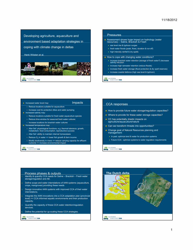
Developing agriculture, aquaculture and
environment based adaptation strategies in
coping with climate change in deltas
Henk Wösten et al.
Pressures
Assessment shows huge impact on hydrology (water resources) – Saline, Brackish & Fresh
see level rise & typhoon surges
fresh water floods (peak, flows, duration & run-off)
high intensity rainfall & dry spells
How to cope with changing water conditions?
increase brackish water retention (storage of fresh water?) decrease salinity intrusion
increase high rainwater retention (reduce floods)
increase fresh water storage (flood protection & dry spell reserves)
increase coastal defence (high sea level & typhoon)
Increased water level may: Impacts Reduce locations suitable for aquaculture
Increase cost for protection dikes and water pumping Increased salinity may:
Reduce locations suitable for fresh water aquaculture species
Reduce time window for seasonal fresh water cultures
Increase locations for brackish water culturesIncreased temperature may: Increased temperature may:
Alter fish’ physiological functions, e.g. thermal tolerance, growth, metabolism, food consumption, reproductive success
Alter fish’ ability to maintain internal homeostasis
Reduce O2 in water => lower fish growth & farm income
Modify biodiversity in rivers => reduce carrying capacity for effluent nutrients => increase environmental impact
CCA responses
How to provide future water storage/regulation capacities?
Where to provide for these water storage capacities?
CC has potentially drastic impacts on agriculture/aquaculture/nature
Can we transform threats into opportunities?
Change goal of Natural Resources planning and management:
In past: optimize land & water for production systems
Future CCA : optimize systems to water regulation requirements
Process phases & outputs1. Identify & quantify CCA needs for Saline – Brackish – Fresh water
storage/regulation and AE.
2. Define scope and water interrelations of AAN systems (aquaculture, crops, mangroves) providing these needs
3. Design innovative AAN systems with improved CCA of their water interrelations.
4. Integrate the AAN innovations into a CCA adaptation plan (provincial level) => CCA informed aquatic environments and their production capacity.
5. Quantify the capacity of these CCA water retention/regulation services.
6. Define the potential for up-scaling these CCA strategies.
The Dutch delta
Different services – different needs
o Food supply → freshwater
o Nature conservation / biodiversity → natural systems
o Safety → dams/dikes
11/18/2012
2
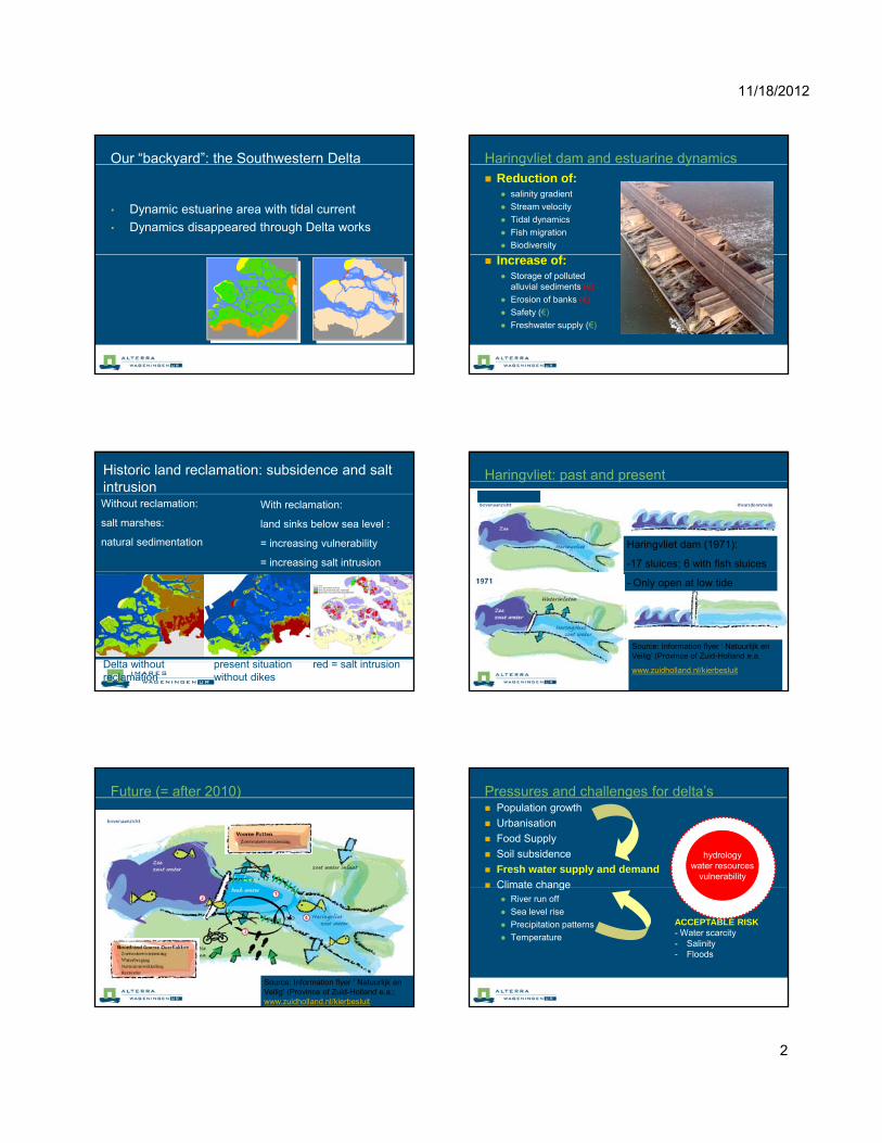
Our “backyard”: the Southwestern Delta
• Dynamic estuarine area with tidal current
• Dynamics disappeared through Delta works
Haringvliet dam and estuarine dynamics Reduction of:
salinity gradient
Stream velocity
Tidal dynamics
Fish migration
Biodiversity
Increase of: Storage of polluted
alluvial sediments (€)
Erosion of banks (€)
Safety (€)
Freshwater supply (€)
Historic land reclamation: subsidence and salt intrusionWithout reclamation:
salt marshes:
natural sedimentation
With reclamation:
land sinks below sea level :
= increasing vulnerability
= increasing salt intrusion
Delta without present situation red = salt intrusionreclamation without dikes
Haringvliet: past and present
Thanks for your attentionHaringvliet dam (1971):
-17 sluices; 6 with fish sluices
Historically
- Only open at low tide
Source: Information flyer ‘ Natuurlijk en Veilig’ (Province of Zuid-Holland e.a.
www.zuidholland.nl/kierbesluit
Future (= after 2010)
Source: Information flyer ‘ Natuurlijk en Veilig’ (Province of Zuid-Holland e.a.; www.zuidholland.nl/kierbesluit
Pressures and challenges for delta’s Population growth
Urbanisation
Food Supply
Soil subsidence
Fresh water supply and demand Climate change
hydrologywater resources
vulnerabilityClimate change River run off
Sea level rise
Precipitation patterns
Temperature
ACCEPTABLE RISK- Water scarcity- Salinity- Floods
11/18/2012
3
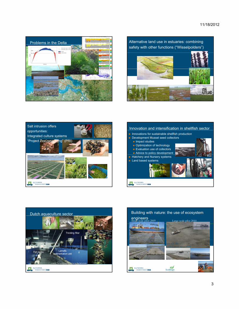
Problems in the Delta Alternative land use in estuaries: combining
safety with other functions (“Wisselpolders”)
Salt intrusion offers
opportunities:
Integrated culture systems
“Project Zeeuwse Tong” (PRI)
Innovation and intensification in shellfish sector Innovations for sustainable shellfish production Development Mussel seed collectors
Impact studies Optimization of technology Evaluation use of collectors Advice to policy developmentp y p
Hatchery and Nursery systems Land based systems
Dutch aquaculture sector
Trickling filter
Courtesy Fleuren & Nooijen BV, Someren, The Netherlands
Lamella sedimentation unit
Fish tanks
Building with nature: the use of ecosystem
engineersSmall scale pilot 2009 Large scale pilot 2010
Each reef: 400 m3, ± 230 tons of oyster shells
200 x 10 m12 x 4 m
11/18/2012
4
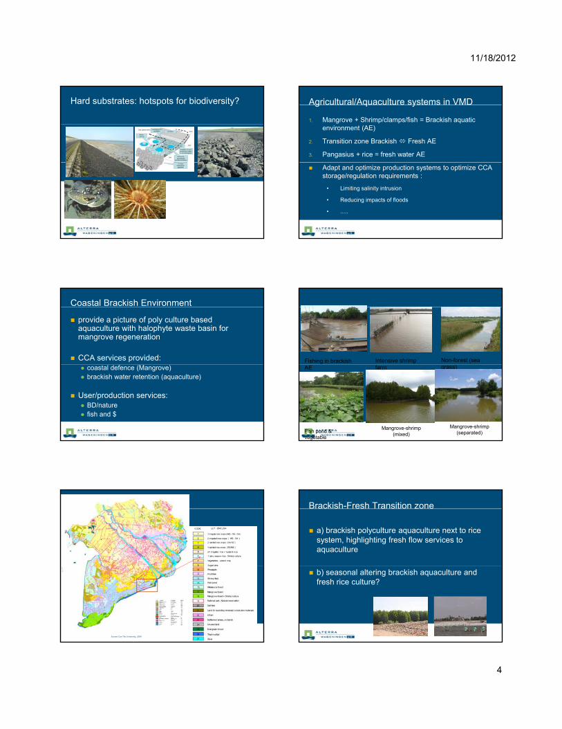
Hard substrates: hotspots for biodiversity? Agricultural/Aquaculture systems in VMD
1. Mangrove + Shrimp/clamps/fish = Brackish aquatic environment (AE)
2. Transition zone Brackish Fresh AE
3. Pangasius + rice = fresh water AE
Adapt and optimize production systems to optimize CCA storage/regulation requirements :
• Limiting salinity intrusion
• Reducing impacts of floods
• .....
Coastal Brackish Environment
provide a picture of poly culture based aquaculture with halophyte waste basin for mangrove regeneration
CCA services provided: coastal defence (Mangrove) brackish water retention (aquaculture)
User/production services: BD/nature fish and $
Intensive shrimp Non-forest (sea Fishing in brackish farm
Mangrove-shrimp (separated)
Mangrove-shrimp (mixed)
Fish pond & vegetable
grass) AE
Source: Can Tho University, 2009
Brackish-Fresh Transition zone
a) brackish polyculture aquaculture next to rice system, highlighting fresh flow services to aquaculture
b) seasonal altering brackish aquaculture and fresh rice culture?
11/18/2012
5
Fresh water zone - rice picture of paddy field, with now standing water
(AWDI) (innovation of farmer and irrigation practices)
CCA service: rainwater retention: potential it 10 t i fi ld f 1 Mil Hcapacity: 10 cm storage in field, for 1 Mil. Ha =
1,000,000,000 m3 (1 Mha rice is around 30% of Mekong Delta?)
Room for the Mekong Floods picture of flood plain, centre river, two sides
controlled flood plains, outer protected rice systems, flood plains with fresh fish & recession agriculture
CCA services: seasonal flood retention/protection & dry season reserve& dry season reserve
user functions: fish & rice Full-dyke <> semi-dyke
Eel culture during flood season
Process Look at, and work with present water use(r)s in
CCA relevant aquatic environments
What changes/innovations are needed in todays water use systems to optimize: the CCA water storage/regulation functions?
d ti it /BD f th t ? secure productivity/BD of the system?
Thank you
1
Managing the ‘urban’ in deltas: What, Where, How
Assela PathiranaUNESCO-IHE
Contents
• The proportion • Where is ‘urban’ population?
Th h ll• The challenge• Hope, lessons and possible
solutions• Take-home message
City of Mumbai: Two facets, a glittering skylines and world’s largest slums
What is the correct size of the ‘Urban Issue’
Climate Change, Poverty, Hunger, g , y, g ,War, Nuclear proliferation, …
If Global Climate is Complex…
• Local scale – higher uncertainty.
• Development do not pfollow plans.
• Lot of ‘noise’ around trends.
Urbanization
• + Transpiration• + Infiltration• * Overland/drainage flow
2
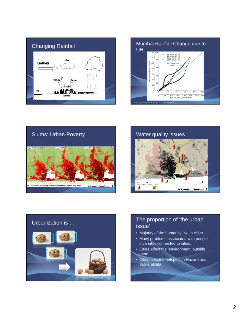
Changing Rainfall Mumbai Rainfall Change due to UHI
Source: Pathirana, et al, 2012 (in review)
Slums: Urban Poverty Water quality issues
Urbanization is …
[ ][ ]
[ ]
The proportion of ‘the urban issue’• Majority of the humanity live in cities. • Many problems associated with people –
invariably connected to cities. Citi ff t th ‘ i t’ t id• Cities affect the ‘environment’ outside them.
• Cities become hotspots in Hazard and Vulnerability.
3
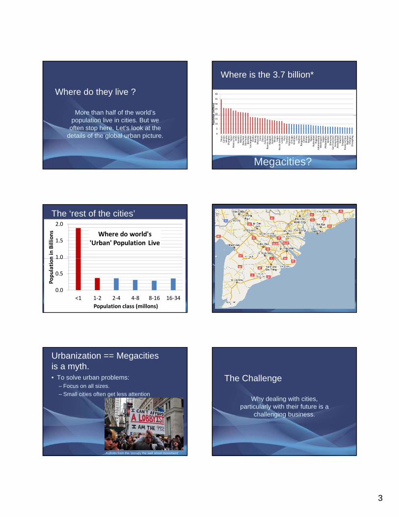
Where do they live ?
More than half of the world’s population live in cities. But we
often stop here. Let’s look at the details of the global urban picture.
Where is the 3.7 billion*
20
25
30
35
40
on (millions)
0
5
10
15
Tokyo
Canton
Jakarta
Shanghai
Seoul
Mexico City
Delhi
Karachi
Manila
New
York
São Paulo
Bombay
Los Angeles
Osaka
Beijing
Moscow
Cairo
Dacca
Calcutta
Buenos Aires
Bangkok
Istanbul
Tehran
Lagos
Rio de Janeiro
London
Paris
Tientsin
Shenzhen
Chicago
Kinshasa
Lima
Madras
Bangalore
Lahore
Wuhan
Bogotá
Taipei
Hyderabad
Nagoya
Johannesburg
Washington
Saigon
Philadelphia
Boston
Shenyang
San Francisco
Hong Kong
Ahmedabad
Madrid
Singapore
Kuala Lumpur
Baghdad
Chengtu
Chungking
Populatio
Megacities?
The ‘rest of the cities’
1.0
1.5
2.0
n in
Billions Where do world's
'Urban' Population Live
0.0
0.5
1.0
<1 1‐2 2‐4 4‐8 8‐16 16‐34
Population
Population class (millons)
Urbanization == Megacities is a myth. • To solve urban problems:
– Focus on all sizes. – Small cities often get less attention
A photo from the ‘occupy the wall street movement’
The Challenge
Why dealing with cities, y g ,particularly with their future is a
challenging business.
4
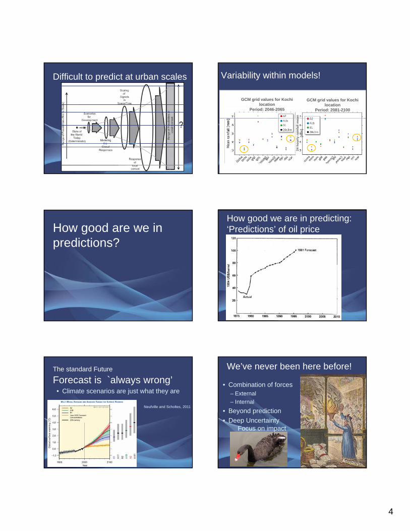
Difficult to predict at urban scales Variability within models!
GCM grid values for Kochi location
Period: 2081-2100
GCM grid values for Kochi location
Period: 2046-2065
an
24 h
ourly
rai
nfal
l mea
[mm
]
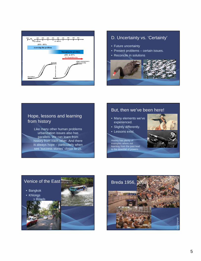
How good are we in predictions?
How good we are in predicting:‘Predictions’ of oil price
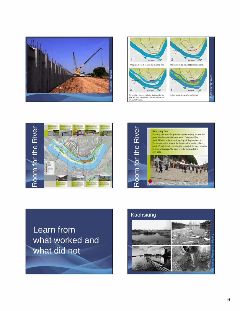
The standard Future
Forecast is `always wrong’• Climate scenarios are just what they are
Neufville and Scholtes, 2011
We’ve never been here before!
• Combination of forces– External – Internal
• Beyond predictionBeyond prediction• Deep Uncertainty
Focus on impact
5
D. Uncertainty vs. ‘Certainty’
• Future uncertainty• Present problems – certain issues.• Reconcile in solutions
Hope, lessons and learning from history
Like many other human problems y purbanization issues also has parallels. We can learn from
history from each other. And there is always hope – particularly when see ‘success stories’ closer to us.
But, then we’ve been here!
• Many elements we’ve experienced.
• Slightly differently. L i t• Lessons exist.
History has plenty of examples where not learning from the past lead to the downfall of powers.
Venice of the East
• Bangkok• Khlongs
> Roads
Breda 1956, 2003C
orD
ijkgr
aaf
6
The
Nat
ion,
Tha
iland
Roo
m F
or th
e riv
er
the
Riv
erR
oom
for th
e R
iver
Roo
m fo
r
Learn from what worked andwhat worked and what did not
KaohsiungH
isto
ryKa
ohsi
ung
Mus
eum
of H
7
theo
dora
.com
Kaohsiung City – Case to share
Green Corridor
Total Detention Capacity1.6 M m3And increasing …
(圖片來源Photo by: Topos, vol.55, 2006)(圖片來源 Photo by: 陸曉筠) (圖片來源Photo by: ASLA)
(圖片來源Photo by: Topos, vol.55, 2006)
(圖片來源Photo by: 陸曉筠)
(圖片來源Photo by: Topos, vol.60, 2007)
(圖片來源Photo by: ASLA)
(圖片來源Photo by: Topos, vol.55, 2006)
(圖片來源Photo by: ASLA)
Benefits • Reduced flood risk• Ecological • Livability – top 100• Financial returns!
Hen
ry T
rotte
r
Learning from History• Netherlands yesterday > Kaohsiung today• Kaoshiung > Bangkok• Bagkok > HCMC •• …
Envi
ronm
enta
l Deg
rada
tion
Economic Development
Turning Point
Kuznet’s Curve
k Ex
posu
re
Conflicting phase
Floo
d R
is
8
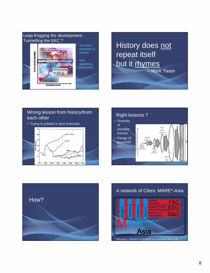
Leap-frogging the development : Tunnelling the EKC ?
• Not many examples in history!!
• VeryVery appealing possibility!!
History does notrepeat itselfb i hbut it rhymes
-- Mark Twain
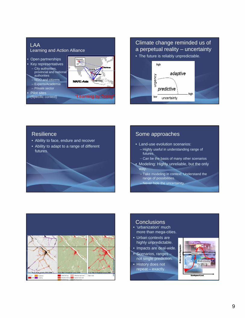
Wrong lesson from history/from each other• Trying to predict in spot forecasts.
Right lessons ?• Diversity
of possible futures.
• Range of possibilities.
How? A network of Cities: MARE*-Asia
* Managing adapting responses to a changing flood risk
9
LAALearning and Action Alliance
• Open partnerships• Key representatives
– City authorities, i i l d i lprovincial and national
authorities– NGO and citizens– Experts/Academia– Private sector
• Pilot sites (Specific context) “Learning by Doing”
Climate change reminded us of a perpetual reality – uncertainty• The future is reliably unpredictable.
Resilience• Ability to face, endure and recover • Ability to adapt to a range of different
futures.
Some approaches
• Land-use evolution scenarios: – Highly useful in understanding range of
futures. – Can be the basis of many other scenariosCan be the basis of many other scenarios
• Modeling: Highly unreliable, but the only way. – Take modeling in context: Understand the
range of possibilities. – Never hide the uncertainity.
Afte
r Will
iam
Vee
erbe
ek
Conclusions• ‘urbanization’ much
more than mega-cities.• Urban contexts are
highly unpredictable. I t d l id• Impacts are deal-wide.
• Scenarios, ranges –not single prediction.
• History does not repeat – exactly.
11/18/2012
1
River deltas are valuable: provide food to the world
underpin economies
sustain biodiversity
home to many peopleRiver deltas are vulnerable: pollution
urbanization
flooding and drought
land subsidence and erosion
overall loss of environmental quality
And pressures are increasing:economic growth
population growth
climate change
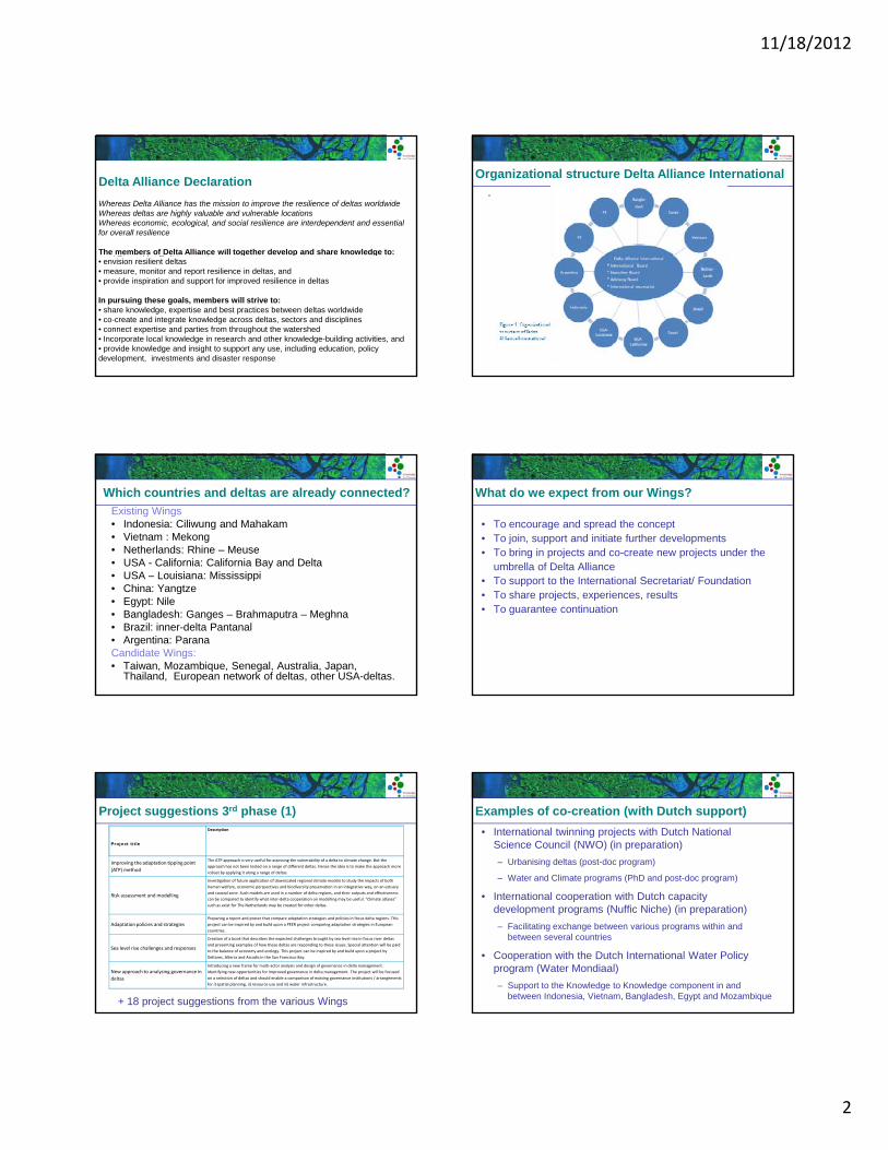
Deltas most vulnerable to Climate ChangeIPCC 4th Assessment – Climate Change 2007 Synthesis Report
Deltas are facing many similar challenges
pressure on space
flood vulnerability
freshwater shortage
ageing or inadequate infrastructure coastal erosion
loss of environmental quality and biodiversity
Yangtze River Delta (China) **** ** *** * * ****Mekong River Delta (Vietnam) ** **** **** ** * ***Ganges-Brahmaputra Delta (Bangladesh) **** **** ** ** **** ****Ciliwung River Delta (Indonesia) **** **** ** ** * ****Mahakam River Delta (Indonesia) ** *** *** ** *** ***
issues
deltas
( )
Nile River Delta (Egypt) **** * **** **** ** **Rhine River Delta (Netherlands) *** ** ** *** ** *Mississippi River Delta (USA) * **** * **** **** ****California Delta and Bay (USA) ** **** **** *** * ***Pantanal Inland Delta (Brazil)
**********
relatively minor problem, now and in the near future
currently already a big problem, future trend uncertain
currently a minor problem, but is likely to increase in the near future
currently already a big problem, likely to increase in the near future
What is Delta Alliance?
• International network between deltas• Knowledge driven • Multi-sector, interdisciplinary• Framework and support for successful international
cooperationI t ti l D lt Alli F d ti• International Delta Alliance Foundation
Mission: improve the resilience of deltas worldwide
Through:• Generating jointly more integrated and effective knowledge• Sharing knowledge• Reduce unnecessary overlap• Identifying knowledge gaps.
Delta Alliance Resilience Strategy
Delta Alliance mission:Improving the resilience of deltas worldwide, in partnership with other
organizations, through:
1. defining resilience for deltas;
A framework for activities within Delta Alliance
2. measuring and monitoring resilience;
3. reporting resilience and advocating for improved resilience;
4. providing inspiration for improved resilience; and
5. providing assistance for improved resilience.
11/18/2012
2
Signed during Delta Alliance Launch in Rotterdam
Si d b D lt
Delta Alliance DeclarationWhereas Delta Alliance has the mission to improve the resilience of deltas worldwideWhereas deltas are highly valuable and vulnerable locationsWhereas economic, ecological, and social resilience are interdependent and essential for overall resilience
The members of Delta Alliance will together develop and share knowledge to:Signed by Delta Alliance members
Projects and activities within Delta Alliance must embody the Declaration
g g• envision resilient deltas • measure, monitor and report resilience in deltas, and• provide inspiration and support for improved resilience in deltas
In pursuing these goals, members will strive to: • share knowledge, expertise and best practices between deltas worldwide • co-create and integrate knowledge across deltas, sectors and disciplines • connect expertise and parties from throughout the watershed • Incorporate local knowledge in research and other knowledge-building activities, and• provide knowledge and insight to support any use, including education, policy development, investments and disaster response
Organizational structure Delta Alliance International.
Which countries and deltas are already connected?Existing Wings• Indonesia: Ciliwung and Mahakam• Vietnam : Mekong• Netherlands: Rhine – Meuse• USA - California: California Bay and Delta• USA Louisiana: Mississippi• USA – Louisiana: Mississippi• China: Yangtze• Egypt: Nile• Bangladesh: Ganges – Brahmaputra – Meghna• Brazil: inner-delta Pantanal• Argentina: ParanaCandidate Wings:• Taiwan, Mozambique, Senegal, Australia, Japan,
Thailand, European network of deltas, other USA-deltas.
What do we expect from our Wings?
• To encourage and spread the concept• To join, support and initiate further developments• To bring in projects and co-create new projects under the
umbrella of Delta Alliance• To support to the International Secretariat/ Foundation • To share projects, experiences, results• To guarantee continuation
Project suggestions 3rd phase (1)
Project title
Description
Improving the adaptation tipping point
(ATP) method
The ATP approach is very useful for assessing the vulnerability of a delta to climate change. But the
approach has not been tested on a range of different deltas. Hence the idea is to make the approach more
robust by applying it along a range of deltas.
Investigation of future application of downscaled regional climate models to study the impacts of both
human welfare, economic perspectives and biodiversity preservation in an integrative way, on an estuary
and coastal zone Such models are used in a number of delta regions and their outputs and effectivenessRisk assessment and modellingand coastal zone. Such models are used in a number of delta regions, and their outputs and effectiveness
can be compared to identify what inter‐delta cooperation on modelling may be useful. “Climate atlases”
such as exist for The Netherlands may be created for other deltas.
Adaptation policies and strategiesPreparing a report and poster that compare adaptation strategies and policies in focus delta regions. This
project can be inspired by and build upon a PEER project comparing adaptation strategies in European
countries.
Sea level rise challenges and responses
Creation of a book that describes the expected challenges brought by sea level rise in focus river deltas
and presenting examples of how these deltas are responding to these issues. Special attention will be paid
to the balance of economy and ecology. This project can be inspired by and build upon a project by
Deltares, Alterra and Arcadis in the San Francisco Bay.
New approach to analysing governance in
deltas
Introducing a new frame for multi‐actor analysis and design of governance in delta management.
Identifying new opportunities for improved governance in delta management. The project will be focused
on a selection of deltas and should enable a comparison of existing governance institutions / arrangements
for i) spatial planning, ii) resource use and iii) water infrastructure.
+ 18 project suggestions from the various Wings
Examples of co-creation (with Dutch support)• International twinning projects with Dutch National
Science Council (NWO) (in preparation)– Urbanising deltas (post-doc program)
– Water and Climate programs (PhD and post-doc program)
I t ti l ti ith D t h it• International cooperation with Dutch capacity development programs (Nuffic Niche) (in preparation)– Facilitating exchange between various programs within and
between several countries
• Cooperation with the Dutch International Water Policy program (Water Mondiaal)– Support to the Knowledge to Knowledge component in and
between Indonesia, Vietnam, Bangladesh, Egypt and Mozambique
11/18/2012
3
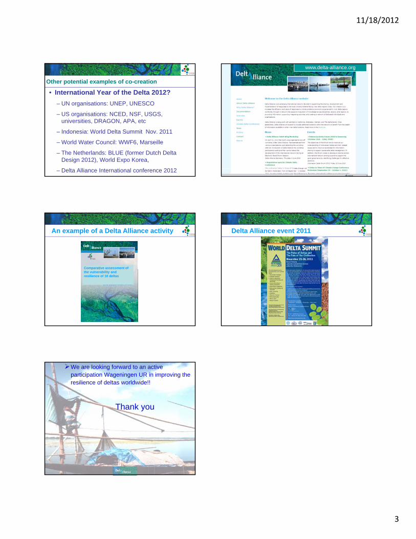
Other potential examples of co-creation
• International Year of the Delta 2012?– UN organisations: UNEP, UNESCO
– US organisations: NCED, NSF, USGS, universities DRAGON APA etcuniversities, DRAGON, APA, etc
– Indonesia: World Delta Summit Nov. 2011
– World Water Council: WWF6, Marseille
– The Netherlands: BLUE (former Dutch Delta Design 2012), World Expo Korea,
– Delta Alliance International conference 2012
www.delta-alliance.org
Comparative assessment of
An example of a Delta Alliance activity
pthe vulnerability andresilience of 10 deltas
Delta Alliance event 2011
We are looking forward to an active participation Wageningen UR in improving the resilience of deltas worldwide!!
Thank you
14
Annex 5. Outcomes working sessions 'Delta planning approaches' (Day 2; Tuesday 23 October) Presentation scenarios construction: Bangladesh and Myanmar Presentation scenarios construction: Indonesia Presentation scenarios construction: Vietnam Mekong delta ‘Synergizing and conclusions’ (Day 5; Friday 25 October) Presentation upstream delta Presentation urban delta Presentation coastal delta
11/18/2012
1
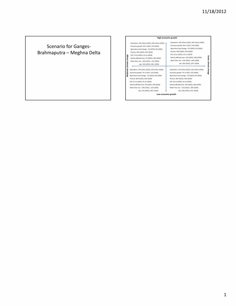
Scenario for Ganges‐Brahmaputra – Meghna Delta
High economic growth
clim
ate chan
ge Faster climate
Population: 250 million (2025), 300 million (2050)
Economic growth: 9% in 2025, 15% (2050)
Agriculture land change: ‐1% (2025), 0% (2050)
Poverty: 30% (2025), 25% (2050)
SLR: 14 cm (2025), 25 cm (2050)
Salinity affected area: 5% (2025), 10% (2050)
Water flow: dry: ‐10% (2025), ‐15% (2050)
wet: 15% (2025), 18% (2050)
Population: 250 million (2025), 300 million (2050)
Economic growth: 9% in 2025, 15% (2050)
Agriculture land change: ‐1% (2025), 0% (2050)
Poverty: 30% (2025), 25% (2050)
SLR: 18 cm (2025), 32 cm (2050)
Salinity affected area: 12% (2025), 18% (2050)
Water flow: dry: ‐15% (2025), ‐20% (2050)
wet: 20% (2025), 25% (2050)
Low economic growth
Moderate ch
ange
Population: 270 million (2025), 320 million (2050)
Economic growth: 7% in 2025, 15% (2050)
Agriculture land change: ‐1% (2025), 0% (2050)
Poverty: 40% (2025), 30% (2050)
SLR: 14 cm (2025), 25 cm (2050)
Salinity affected area: 5% (2025), 10% (2050)
Water flow: dry: ‐10% (2025), ‐15% (2050)
wet: 15% (2025), 18% (2050)
Population: 270 million (2025), 320 million (2050)
Economic growth: 7% in 2025, 15% (2050)
Agriculture land change: ‐1% (2025), 0% (2050)
Poverty: 40% (2025), 30% (2050)
SLR: 18 cm (2025), 32 cm (2050)
Salinity affected area: 12% (2025), 18% (2050)
Water flow: dry: ‐15% (2025), ‐20% (2050)
wet: 20% (2025), 25% (2050)
11/18/2012
1
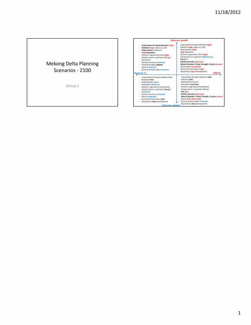
Mekong Delta PlanningScenarios ‐ 2100
Group 1
‐ Urbanization & Industrialization (high)‐ Pollution (high: water, air, soil)‐ Deforestation (high)‐ High Population .‐ Decline in agricultural land (High).‐ Infrastructure in upstream (Medium gr.)‐ SLR (2m)‐ Salinity intrusion (dramatic)‐ Natural disasters: Flood, Drought, Erosion (severe)‐ Storm (more frequently)‐ Scarcity of fresh water (high)‐ Aquaculture (high development)
‐ Urbanization & Industrialization (high)‐ Pollution (high: water, air, soil)‐ Deforestation (medium)‐ High Population.‐ Decline in agricultural land (High).‐ Infrastructure in upstream (Fast gr.)‐ SLR (0.5m)‐ Salinity intrusion (moderate)‐ Flood & Drought (slightly)‐ Storm (moderate)‐ Scarcity of fresh water (medium)
Socio‐eco. growth
d CC Hi h CCq ( g p )
‐ Urbanization & Industrialization (low)‐ Pollution (low)‐ Deforestation (none)‐ Population (very low).‐ Decline in agricultural land (None).‐ Infrastructure in upstream (None)‐ SLR (2m)‐ Salinity intrusion (dramatic)‐ Natural disasters: Flood, Drought, Erosion (severe)‐ Storm (more frequently)‐ Scarcity of fresh water (medium)‐ Aquaculture (low development)
‐ Urbanization & Industrialization (low)‐ Pollution (low)‐ Deforestation (none)‐ Population (Medium).‐ Decline in agricultural land (None).‐ Infrastructure in upstream (Low gr.)‐ SLR (0.5m)‐ Salinity intrusion (moderate)‐ Storm (moderate)‐ Scarcity of fresh water (low)‐ Aquaculture (low development)
Socio‐eco. squeeze
Moderate CC High CC
11/18/2012
1
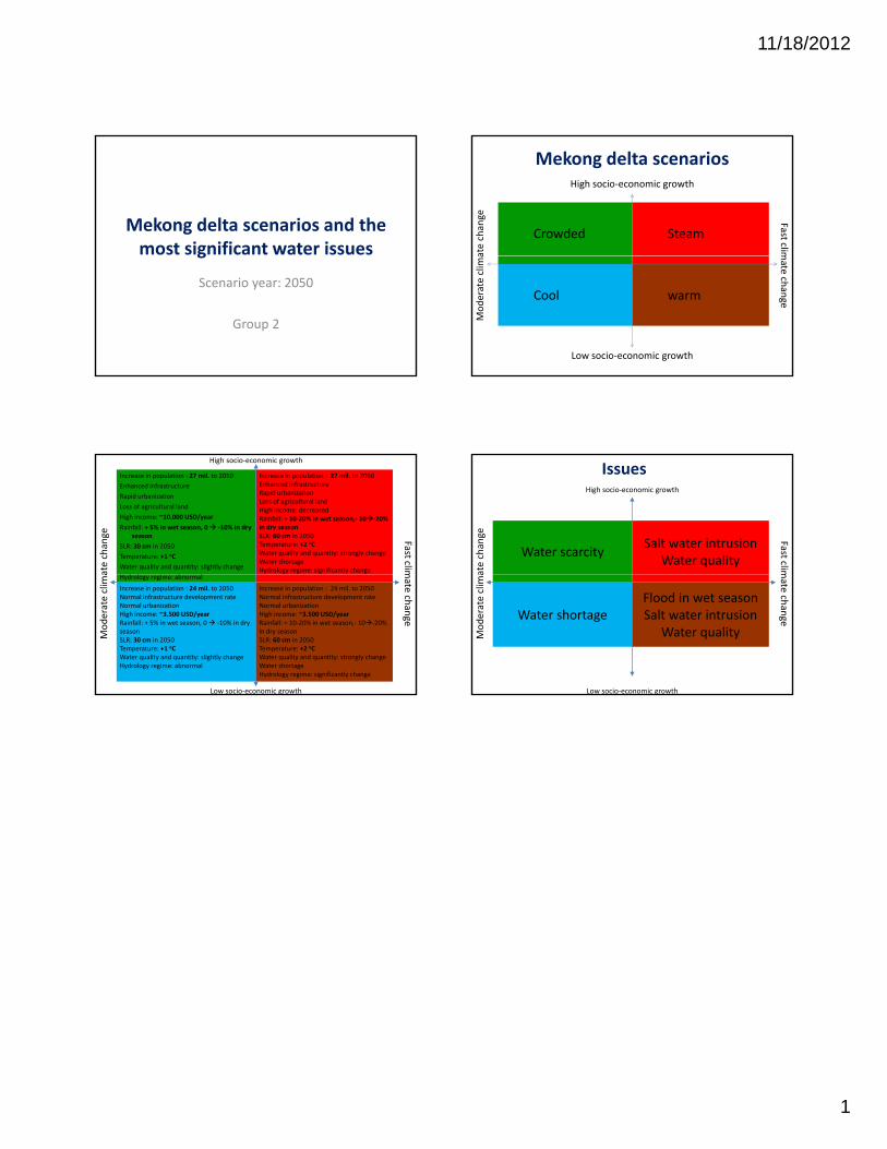
Mekong delta scenarios and the most significant water issues
Scenario year: 2050
Group 2
g
Mekong delta scenarios
Crowded Steam
High socio‐economic growth
ate chan
ge Fast clim
Cool warm
Low socio‐economic growth
Moderate clim
a
mate ch
ange
Increase in population : 27 mil. to 2050
Enhanced infrastructure
Rapid urbanization
Loss of agricultural land
High income: ~10.000 USD/year
Rainfall: + 5% in wet season, 0 ‐10% in dry season
SLR: 30 cm in 2050
Temperature: +1 oC
Water quality and quantity: slightly change
Increase in population : 27 mil. to 2050Enhanced infrastructureRapid urbanizationLoss of agricultural landHigh income: decreasedRainfall: + 10‐20% in wet season,‐ 10‐20% in dry seasonSLR: 60 cm in 2050Temperature: +2 oCWater quality and quantity: strongly changeWater shortageHydrology regime: significantly change
High socio‐economic growth
ate chan
ge Fast clim
Hydrology regime: abnormal
Increase in population : 24 mil. to 2050Normal infrastructure development rate Normal urbanizationHigh income: ~3.500 USD/yearRainfall: + 5% in wet season, 0 ‐10% in dry seasonSLR: 30 cm in 2050Temperature: +1 oCWater quality and quantity: slightly changeHydrology regime: abnormal
Increase in population : 24 mil. to 2050Normal infrastructure development rate Normal urbanizationHigh income: ~3.500 USD/yearRainfall: + 10‐20% in wet season,‐ 10‐20% in dry seasonSLR: 60 cm in 2050Temperature: +2 oCWater quality and quantity: strongly changeWater shortageHydrology regime: significantly change
Low socio‐economic growth
Moderate clim
a
mate ch
ange
Water scarcitySalt water intrusion
Water quality
High socio‐economic growthate chan
ge Fast clim
Issues
Water shortageFlood in wet seasonSalt water intrusion
Water quality
Low socio‐economic growth
Moderate clim
a
mate ch
ange
11/18/2012
1
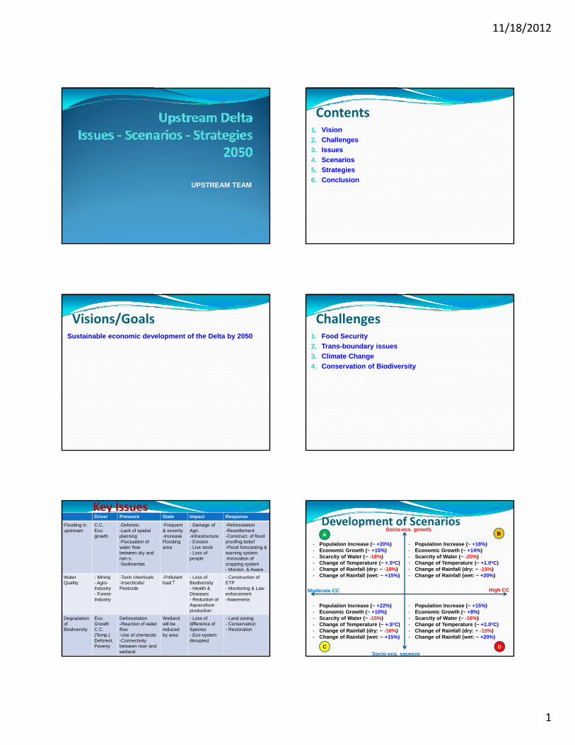
UPSTREAM TEAM
Contents1. Vision2. Challenges3. Issues4. Scenarios5. Strategies6. Conclusion
Visions/GoalsSustainable economic development of the Delta by 2050
Challenges1. Food Security2. Trans-boundary issues3. Climate Change4. Conservation of Biodiversity
Key IssuesDriver Pressure State Impact Response
Flooding in upstream
C.C.Eco. growth
-Deforest.-Lack of spatial planning-Fluctuation of water flow between dry and rain s.-Sedimentat.
-Frequent& severity-IncreaseFlooding area
- Damage of Agri.-Infrastructure- Erosion- Live stock- Loss of people
-Reforestation-Resettlement-Construct. of flood proofing belief-Flood forecasting & warning system-Innovation of cropping system- Monitor. & Aware.
Water - Mining -Toxin chemicals -Pollutant - Loss of - Construction ofWater Quality
Mining- Agro-Industry- Forest-Industry
Toxin chemicals-Insecticide/ Pesticide
Pollutantload
Loss of Biodiversity- Health & Diseases- Reduction of Aquaculture production
Construction of ETP- Monitoring & Law enforcement-Awareness
Degradation of Biodiversity
Eco. GrowthC.C. (Temp.)Deforest.Poverty
Deforestation-Reaction of water flow-Use of chemicals-Connectivity between river and wetland
Wetlandwill be reduced by area
- Loss of difference of Species- Eco-system disrupted
- Land zoning- Conservation- Restoration
Socio-eco. growthDevelopment of Scenarios
- Population Increase (~ +20%)- Economic Growth (~ +15%)- Scarcity of Water (~ -18%)- Change of Temperature (~ +.5oC)- Change of Rainfall (dry: ~ -10%)- Change of Rainfall (wet: ~ +15%)
- Population Increase (~ +18%)- Economic Growth (~ +14%)- Scarcity of Water (~ -20%)- Change of Temperature (~ +1.0oC)- Change of Rainfall (dry: ~ -15%)- Change of Rainfall (wet: ~ +20%)
A B
Socio-eco. squeeze
Moderate CC High CC
- Population Increase (~ +22%)- Economic Growth (~ +10%)- Scarcity of Water (~ -15%)- Change of Temperature (~ +.5oC)- Change of Rainfall (dry: ~ -10%)- Change of Rainfall (wet: ~ +15%)
- Population Increase (~ +15%)- Economic Growth (~ +8%)- Scarcity of Water (~ -16%)- Change of Temperature (~ +1.0oC)- Change of Rainfall (dry: ~ -15%)- Change of Rainfall (wet: ~ +20%)
C D
11/18/2012
2
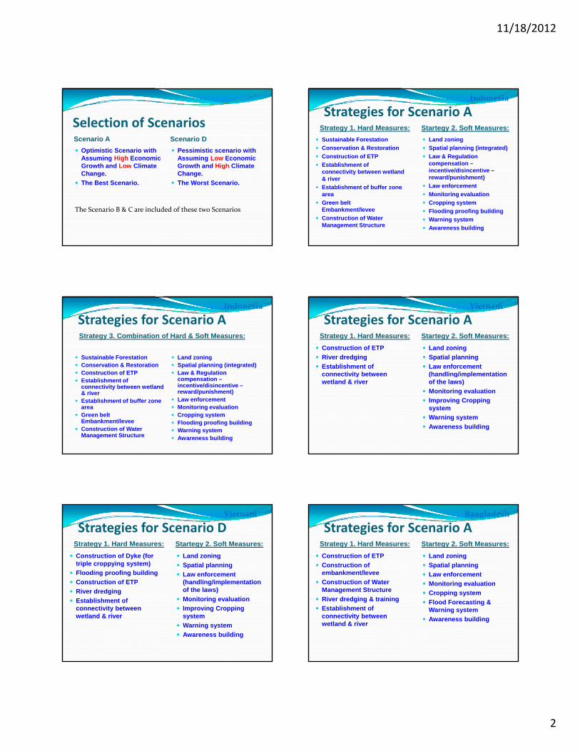
Selection of ScenariosScenario A Scenario D Optimistic Scenario with
Assuming High Economic Growth and Low Climate
Pessimistic scenario with Assuming Low Economic Growth and High ClimateGrowth and Low Climate
Change. The Best Scenario.
Growth and High Climate Change.
The Worst Scenario.
The Scenario B & C are included of these two Scenarios
Strategies for Scenario AStrategy 1. Hard Measures: Startegy 2. Soft Measures:
Sustainable Forestation Conservation & Restoration Construction of ETP Establishment of
Land zoning Spatial planning (integrated) Law & Regulation
compensation –
Indonesia
connectivity between wetland & river
Establishment of buffer zone area
Green belt Embankment/levee
Construction of Water Management Structure
incentive/disincentive –reward/punishment)
Law enforcement Monitoring evaluation Cropping system Flooding proofing building Warning system Awareness building
Strategies for Scenario AStrategy 3. Combination of Hard & Soft Measures:
Indonesia
Sustainable Forestation Conservation & Restoration Construction of ETP
Land zoning Spatial planning (integrated) Law & Regulation
Establishment of connectivity between wetland & river
Establishment of buffer zone area
Green belt Embankment/levee
Construction of Water Management Structure
gcompensation –incentive/disincentive –reward/punishment)
Law enforcement Monitoring evaluation Cropping system Flooding proofing building Warning system Awareness building
Strategies for Scenario AStrategy 1. Hard Measures: Startegy 2. Soft Measures:
Construction of ETP River dredging Establishment of
connectivity between
Land zoning Spatial planning Law enforcement
(handling/implementation
Vietnam
connectivity between wetland & river
(handling/implementation of the laws)
Monitoring evaluation Improving Cropping
system Warning system Awareness building
Strategies for Scenario DStrategy 1. Hard Measures: Startegy 2. Soft Measures:
Construction of Dyke (for triple croppying system)
Flooding proofing building Construction of ETP
Land zoning Spatial planning Law enforcement
(handling/implementation
Vietnam
Construction of ETP River dredging Establishment of
connectivity between wetland & river
(handling/implementation of the laws)
Monitoring evaluation Improving Cropping
system Warning system Awareness building
Strategies for Scenario AStrategy 1. Hard Measures: Startegy 2. Soft Measures:
Construction of ETP Construction of
embankment/levee Construction of Water
Land zoning Spatial planning Law enforcement Monitoring evaluation
Bangladesh
Construction of Water Management Structure
River dredging & training Establishment of
connectivity between wetland & river
Monitoring evaluation Cropping system Flood Forecasting &
Warning system Awareness building
11/18/2012
3
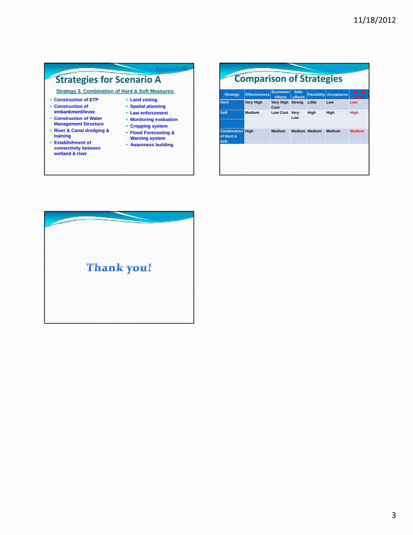
Strategies for Scenario AStrategy 3. Combination of Hard & Soft Measures:
Construction of ETP Construction of
embankment/levee Construction of Water
Land zoning Spatial planning Law enforcement Monitoring evaluation
Bangladesh
Construction of Water Management Structure
River & Canal dredging & training
Establishment of connectivity between wetland & river
Monitoring evaluation Cropping system Flood Forecasting &
Warning system Awareness building
Comparison of Strategies
Strategy EffectivenessEconomic
effectsSide-
effects Flexibility AcceptanceOverall score
Hard Very High Very High Cost
Strong Little Low Low
Soft Medium Low Cost Very Low
High High High
Combination of Hard & Soft
High Medium Medium Medium Medium Medium
11/18/2012
1
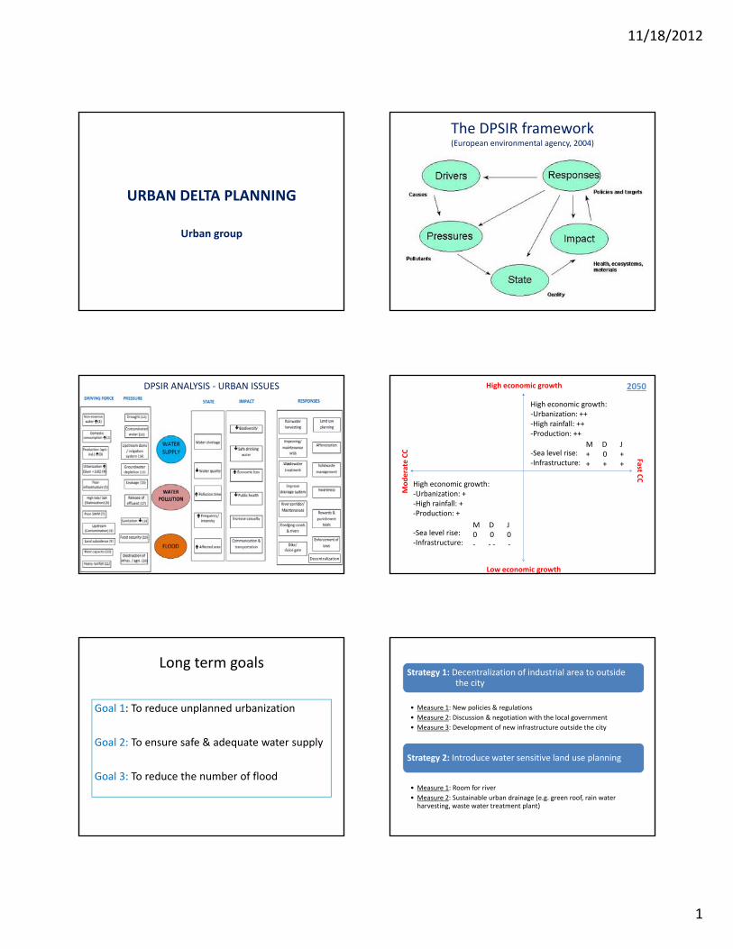
URBAN DELTA PLANNING
Urban group
The DPSIR framework(European environmental agency, 2004)
DPSIR ANALYSIS ‐ URBAN ISSUES
Decentralization
High economic growth:‐Urbanization: ++‐High rainfall: ++‐Production: ++
‐Sea level rise: ‐Infrastructure:
M D J+ 0 ++ + +
High economic growth
Fast
erate CC
2050
High economic growth:‐Urbanization: +‐High rainfall: +‐Production: +
‐Sea level rise: ‐Infrastructure:
M D J0 0 0‐ ‐ ‐ ‐
Low economic growth
CC
Mode
Long term goals
Goal 1: To reduce unplanned urbanization
Goal 2: To ensure safe & adequate water supply
Goal 3: To reduce the number of flood
Strategy 1: Decentralization of industrial area to outside the city
• Measure 1: New policies & regulations
• Measure 2: Discussion & negotiation with the local government
• Measure 3: Development of new infrastructure outside the city
Strategy 2: Introduce water sensitive land use planning
• Measure 1: Room for river
• Measure 2: Sustainable urban drainage (e.g. green roof, rain water harvesting, waste water treatment plant)
11/18/2012
2
Evaluation
Criteria Strategy 1: Decentralization of industrial area to outside the city
Strategy 2: Introduce water sensitive land use planning
Effectiveness ++ ++
Economic effect +/‐ – (short term) / + (long / ( ) / ( gterm)
Side effect • Vulnerability ↓ +• Food security –• Political control –
• Livability ++• Urban heat control +• Human health +• Urban agri. +
Flexibility ++ –
Acceptance +/‐ +/‐
11/18/2012
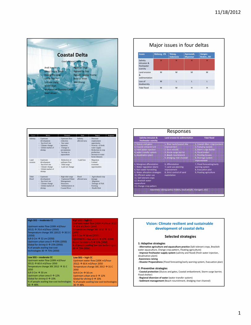
1
Coastal Delta
Andi Irawan
Dang Quang Thinh
Ngan Le Thuy
Nguyen Le Duy
Coach: Marcel Marchand
g g
Hoang Phi Long
Le Thi Thu Ha
Ly Quoc Dang
M A R Shah
Muhammad Thursina Cahya
Nasif Ahsan
g y y
Nguyen Quang Truong
Reaz U. Khan
Win Hlaing
Major issues in four deltas
Issues Mekong, VN Telang, Indonesia
Ayeravadi, Myanmar
Ganges‐Brahm., BD
Salinity intrusion &freshwater scarcity
H H H H
Land erosion M M M MLand erosion & sedimentation
M M M M
Loss of biodiversity
M L L L
Tidal flood M M H H
Issues Driver Pressure State Impact Response
Salinity - Upstream development
- Sea level rise- Climate change- Global market of
shrimp
- Upstream flow reduction
- Sea water intrusion
- Change in precipitation
- Increase in aquaculture
Salinity affected area
- Decrease employment opportunity
- Scarcity of fresh water supply
- Reduction in crop production
- Increase in water borne diseases
Land erosion
- Upstream development
- Reduction of sediment flow
- Land loss - Migration- Limitederosion development
- Sea level rise- Climate change- Global market of
shrimp
sediment flow- Tidal surge- Land use change
- Limited economic opportunities
Tidal flood
- Upstream development
- Sea level rise- Climate change- Global market of
shrimp
- High tidal surge- Unplanned Water
Management Structures
- Sedimentation in Coastal River
Flood affected area
- Agricultural crop damage
- Migration- Damage of Fish
Farming- Health Risk
ResponsesSalinity intrusion & freshwater scarcity
Land erosion & sedimentation Tidal flood
1, Sluices and gates2, Coastal embankment3, fresh water injection4, water transfer system5, desalination plant
1, River bank/coastal dike improvement2, Dam retrofit3, Storm surge barrier4, Beach nourishment5, dredging river channel
1, Coastal dikes +improvement2, Pumping system3, Storm surge barrier4, Flood shelter5, Floating houses6, Drainage system improvement
6, Mangrove afforestation7, Water regulation (dam)8, Rain water harvesting9, Water allocation strategies10, Efficient water use11, Salt tolerant crops12, Brackish water aquaculture13, Change crop pattern
6, Afforestation7, Land use planning improvement8, Strict control of sand exploitation
7, Flood forecasting/earlywarning system8, Evacuation plan9, Floating agriculture
Awareness raising (policy makers, local people, managers, etc)
High SEG – moderate CC
Upstream water flow (100K m3/hour 2012) 70.K m3/hour (2050)Temperature change 30C (2012) 30.5 C (2050)SLR 0 Cm 32 cm (2050)Upstream urban area 0 03% (2050)Global for shrimp 0 15% (2050)% of people availing low‐cost technologies 30 75% (2050)
High SEG – high CCUpstream water flow (100K m3/hour 2012) 60.K m3/hour (2050)Temperature change 30C 2012 31 C (2050)SLR 0 Cm 50 cm (2050)
Upstream urban area 0 03% (2050)
Global for shrimp 0 15% (2050)% of people availing low‐cost technologies 30 75% (2050)
Low SEG – high CCUpstream water flow (100K m3/hour 2012) 60.K m3/hour 2050Temperature change 30C 2012 31 C 2050SLR 0 Cm 50 cmUpstream urban area 0 12%Global for shrimp 0 10%% of people availing low‐cost technologies 30 48%
Low SEG – moderate CCUpstream water flow (100K m3/hour 2012) 60.K m3/hour 2050Temperature change 30C 2012 31 C 2050SLR 0 Cm 50 cmUpstream urban area 0 12%Global for shrimp 0 10%% of people availing low‐cost technologies 30 48%
Selected strategies
1: Adaptive strategies‐ Alternative agriculture and aquaculture practice (Salt tolerant crops, Brackish water aquaculture, Change crop pattern, Floating agriculture)Improve freshwater supply system (salinity and flood) (fresh water injection
Vision: Climate resilient and sustainable development of coastal delta
‐ Improve freshwater supply system (salinity and flood) (fresh water injection, desalination plant)‐Awareness raising ‐ Disaster Preparedness (Flood forecasting/early warning system, Evacuation plan)
2: Preventive strategies‐ Coastal protection (Sluices and gates, Coastal embankment, Storm surge barrier, Flood shelter)‐ Regional diversion of water (water transfer system)‐ Sediment management (Beach nourishment, dredging river channel)
11/18/2012
2
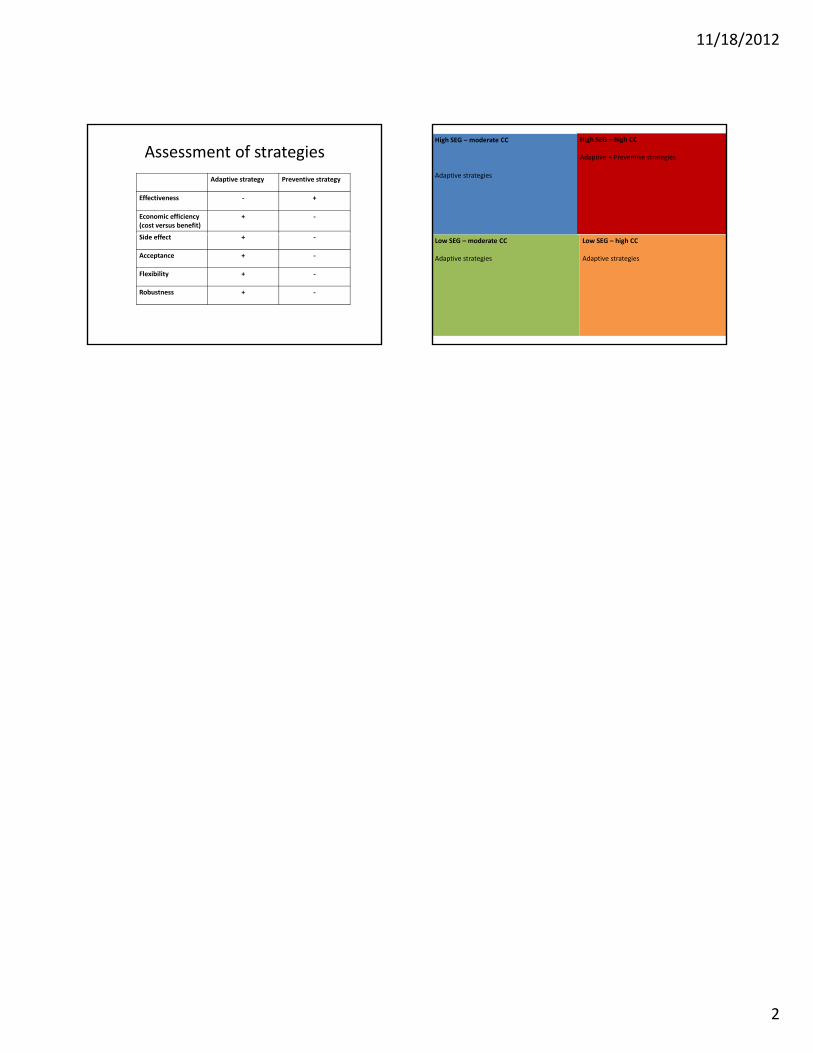
Assessment of strategies
Adaptive strategy Preventive strategy
Effectiveness ‐ +
Economic efficiency (cost versus benefit)
+ ‐
id ffSide effect + ‐
Acceptance + ‐
Flexibility + ‐
Robustness + ‐
High SEG – moderate CC
Adaptive strategies
High SEG – high CC
Adaptive + Preventive strategies
Low SEG – high CC
Adaptive strategies
Low SEG – moderate CC
Adaptive strategies
15
Annex 6. Daily recapitulation Recap Day 1 by Mohammad Aminur Rahman Shah Recap Day 2 by Long Hoang Phi Recap Day 5 by Le Thuy Ngan
11/18/2012
1
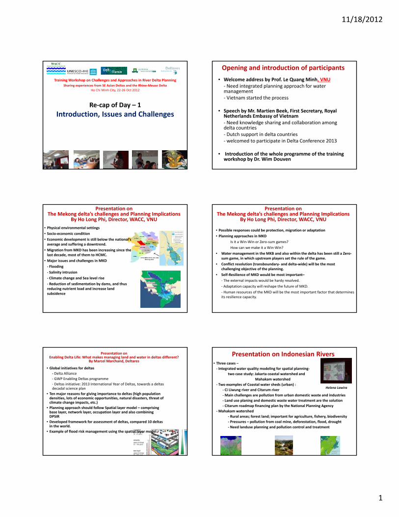
Re‐cap of Day – 1
Introduction Issues and Challenges
Training Workshop on Challenges and Approaches in River Delta Planning
Sharing experiences from SE Asian Deltas and the Rhine‐Meuse Delta
Ho Chi Minh City, 22‐26 Oct 2012
Introduction, Issues and Challenges
Opening and introduction of participants
• Welcome address by Prof. Le Quang Minh, VNU‐ Need integrated planning approach for water management‐ Vietnam started the process
• Speech by Mr. Martien Beek, First Secretary, Royal Netherlands Embassy of VietnamNetherlands Embassy of Vietnam‐ Need knowledge sharing and collaboration among delta countries‐ Dutch support in delta countries‐ welcomed to participate in Delta Conference 2013
• Introduction of the whole programme of the training workshop by Dr. Wim Douven
Presentation on The Mekong delta’s challenges and Planning Implications
By Ho Long Phi, Director, WACC, VNU
• Physical environmental settings
• Socio‐economic condition
• Economic development is still below the national’s average and suffering a downtrend.
• Migration from MKD has been increasing since the last decade, most of them to HCMC.
• Major issues and challenges in MKD
‐ Flooding
‐ Salinity intrusion
‐ Climate change and Sea level rise
‐ Reduction of sedimentation by dams, and thus reducing nutrient load and increase land subsidence
Presentation on The Mekong delta’s challenges and Planning Implications
By Ho Long Phi, Director, WACC, VNU
• Possible responses could be protection, migration or adaptation
• Planning approaches in MKD
Is it a Win‐Win or Zero‐sum games?
How can we make it a Win‐Win?
• Water management in the MKB and also within the delta has been still a Zero‐sum game in which upstream players set the rule of the gamesum game, in which upstream players set the rule of the game.
• Conflict resolution (transboundary‐ and delta‐wide) will be the most challenging objective of the planning.
• Self‐Resilience of MKD would be most important–
‐ The external impacts would be hardy resolved.
‐ Adaptation capacity will reshape the future of MKD.
‐ Human resources of the MKD will be the most important factor that determinesits resilience capacity.
Presentation on Enabling Delta Life: What makes managing land and water in deltas different?
By Marcel Marchand, Deltares
• Global initiatives for deltas‐ Delta Alliance
‐ GWP Enabling Deltas programme
‐ Deltas initiative: 2013 International Year of Deltas, towards a deltasdecadal science plan
• Ten major reasons for giving importance to deltas (high population densities, lots of economic opportunities, natural disasters, threat of li t h i t t )climate change impacts, etc.)
• Planning approach should follow Spatial layer model – comprising base layer, network layer, occupation layer and also combining DPSIR
• Developed framework for assessment of deltas, compared 10 deltas in the world.
• Example of flood risk management using the spatial layer model
Presentation on Indonesian Rivers• Three cases –‐ Integrated water quality modeling for spatial planning‐
two case study: Jakarta coastal watershed and
Mahakam watershed
‐ Two examples of Coastal water sheds (urban) :
‐ Ci Liwung river and Citarum river
‐Main challenges are pollution from urban domestic waste and industries
‐ Land use planing and domestic waste water treatment are the solution
Helena Lawira
Land use planing and domestic waste water treatment are the solution
‐ Citarum roadmap financing plan by the National Planning Agency
‐Mahakam watershed
‐ Rural areas; forest land; important for agriculture, fishery, biodiversity
‐ Pressures – pollution from coal mine, deforestation, flood, drought
‐ Need landuse planning and pollution control and treatment

11/18/2012
2
Presentation on Indonesian Rivers• Case of Unesco World Heritage ‐ Cultural Landscape of Bali Province: the SubakSystem as a Manifestation of the Tri Hita Karana Philosophy
‐ Community participation in
sustainable water use and management
water quality monitoring
afforestation
Other issues in Indonesia
‐water quantity is not a big issue yet
‐water use conflicts among provinces
Presentation on Bangladesh Delta Plan 2100
M. Fida A. Khan
• Dynamic and active delta
• Natural disasters‐‐ Flood, river erosion, cyclone, tidal surge, drought, salinity intrusion
• Major issues
‐ Integrated Land Use
‐ Urban Water Management
‐ River Management
‐ Disaster Preparedness and Management
‐ Innovative Water Infrastructure and Management
‐ Climate Change Impact and Adaptation
‐ Governance and Strengthening of Institutions and Stakeholders at all Levels
• Future challenges‐ Ensure food security
‐ Improve safety & living conditions
‐ Becoming middle income country by 2021
‐ Climate related disasters
• Current planning approach – short term plan
• Delta Plan 2100
Presentation on Bangladesh Delta Plan 2100
• Delta Plan 2100‐ Long term vision/ strategic plan/ dynamic planning approach
‐ overarching umbrella plan guiding sectoral development in integrated manner
‐ to be implemented through short, medium and long term projects
‐ to be prepared by 2014.
Presentation on Ayeyarwady Delta
• Potentials in Ayeyarwady Delta Area
- Agricultural products- Prawn farming and other fish farming- Navigation and Port facilities- Mangrove resources- Tourism
• ChallengesWin Hlaing
- Natural hazards like Cyclones- Mangrove forest protection
• Involvement of local government in water management is poor
• Integrated mangrove rehabilitation and management through community participation projects in the area should enhance
• More research on CC impacts in Ayeyarwady delta is needed
Presentation on Rhine – Meuse Delta
• Rhine‐Meuse delta plain area , urbanized, flood protected by dykes and coastal defences
• Drivers of change‐ Demographic trends, Economic developments,
Technological developments, Climate change
•Key issues
Marcel Marchand
Key issues
Vulnerability to flooding, Freshwater shortage,
Biodiversity
•Main measures already taken
‐ Flood protection infrastructure
‐ Sand nourishment
‐ Room for the river
Presentation on Rhine – Meuse Delta
• Current planning focus
‐ Committee on Sustainable Coastal Development
‐ 5 key decisions are to be made by 2015 for the delta on
‐ safety standards and program
‐ spatial adaptation
‐ Freshwater strategy
‐Meuse – Rhine Estuary
L k Ij l‐ Lake Ijssel
• Main strengths and weaknesses in planning
Strenghts:
‐ Knowledge basis ‐ Active civil society
‐Waterschappen (waterboards) ‐ Delta Law
Weaknesses
‐Water management and spatial planning not well integrated yet
‐ Long procedures create uncertainty among local people
‐ (Too?) many administrative layers
11/18/2012
3
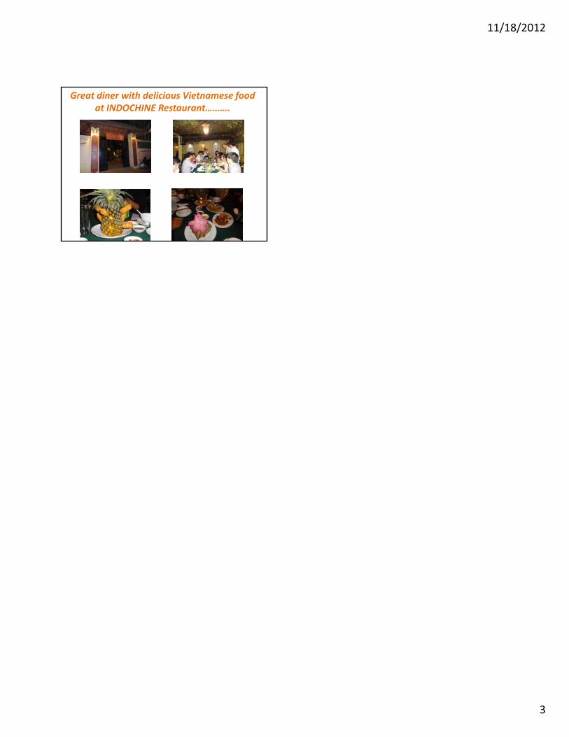
Great diner with delicious Vietnamese food at INDOCHINE Restaurant……….
11/18/2012
1
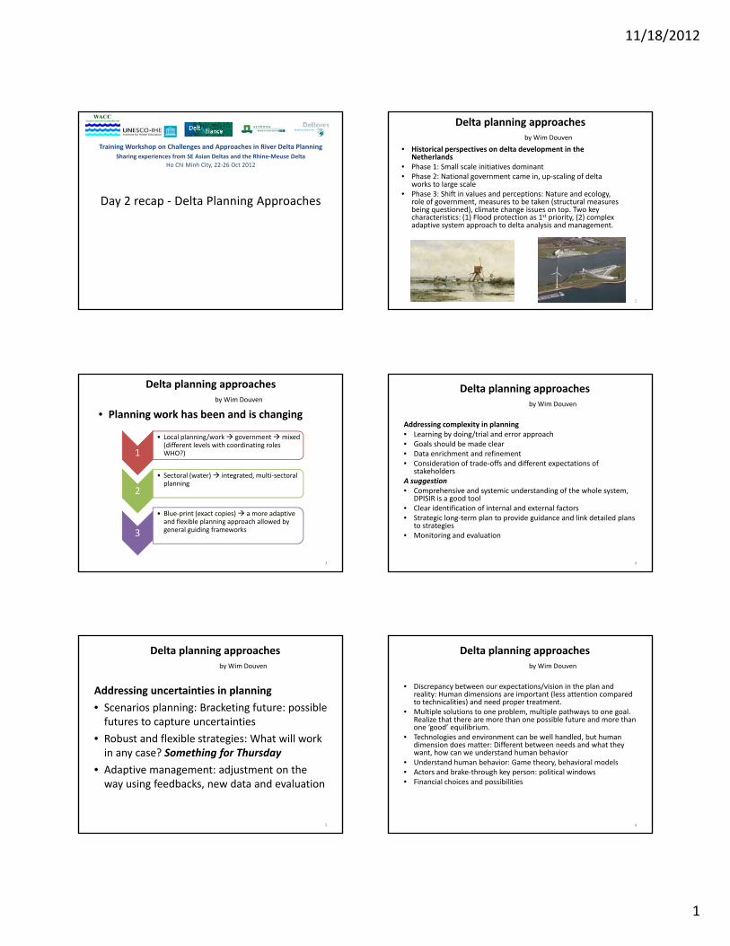
Day 2 recap ‐ Delta Planning Approaches
Training Workshop on Challenges and Approaches in River Delta Planning
Sharing experiences from SE Asian Deltas and the Rhine‐Meuse Delta
Ho Chi Minh City, 22‐26 Oct 2012
Delta planning approaches by Wim Douven
• Historical perspectives on delta development in the Netherlands
• Phase 1: Small scale initiatives dominant • Phase 2: National government came in, up‐scaling of delta
works to large scale• Phase 3: Shift in values and perceptions: Nature and ecology,
role of government, measures to be taken (structural measures being questioned) climate change issues on top Two keybeing questioned), climate change issues on top. Two key characteristics: (1) Flood protection as 1st priority, (2) complex adaptive system approach to delta analysis and management.
2
• Planning work has been and is changing
Delta planning approaches by Wim Douven
1
• Local planning/work government mixed (different levels with coordinating roles WHO?)
l ( ) d l l
3
2
• Sectoral (water) integrated, multi‐sectoralplanning
3
• Blue‐print (exact copies) a more adaptive and flexible planning approach allowed by general guiding frameworks
Addressing complexity in planning• Learning by doing/trial and error approach• Goals should be made clear• Data enrichment and refinement• Consideration of trade‐offs and different expectations of
stakeholders
Delta planning approaches by Wim Douven
stakeholdersA suggestion• Comprehensive and systemic understanding of the whole system,
DPISIR is a good tool• Clear identification of internal and external factors• Strategic long‐term plan to provide guidance and link detailed plans
to strategies• Monitoring and evaluation
4
Addressing uncertainties in planning
• Scenarios planning: Bracketing future: possible futures to capture uncertainties
b d fl ibl i h ill k
Delta planning approaches by Wim Douven
• Robust and flexible strategies: What will work in any case? Something for Thursday
• Adaptive management: adjustment on the way using feedbacks, new data and evaluation
5
• Discrepancy between our expectations/vision in the plan and reality: Human dimensions are important (less attention compared to technicalities) and need proper treatment.
• Multiple solutions to one problem, multiple pathways to one goal. Realize that there are more than one possible future and more than one ‘good’ equilibrium.T h l i d i b ll h dl d b h
Delta planning approaches by Wim Douven
• Technologies and environment can be well handled, but human dimension does matter: Different between needs and what they want, how can we understand human behavior
• Understand human behavior: Game theory, behavioral models• Actors and brake‐through key person: political windows• Financial choices and possibilities
6
11/18/2012
2
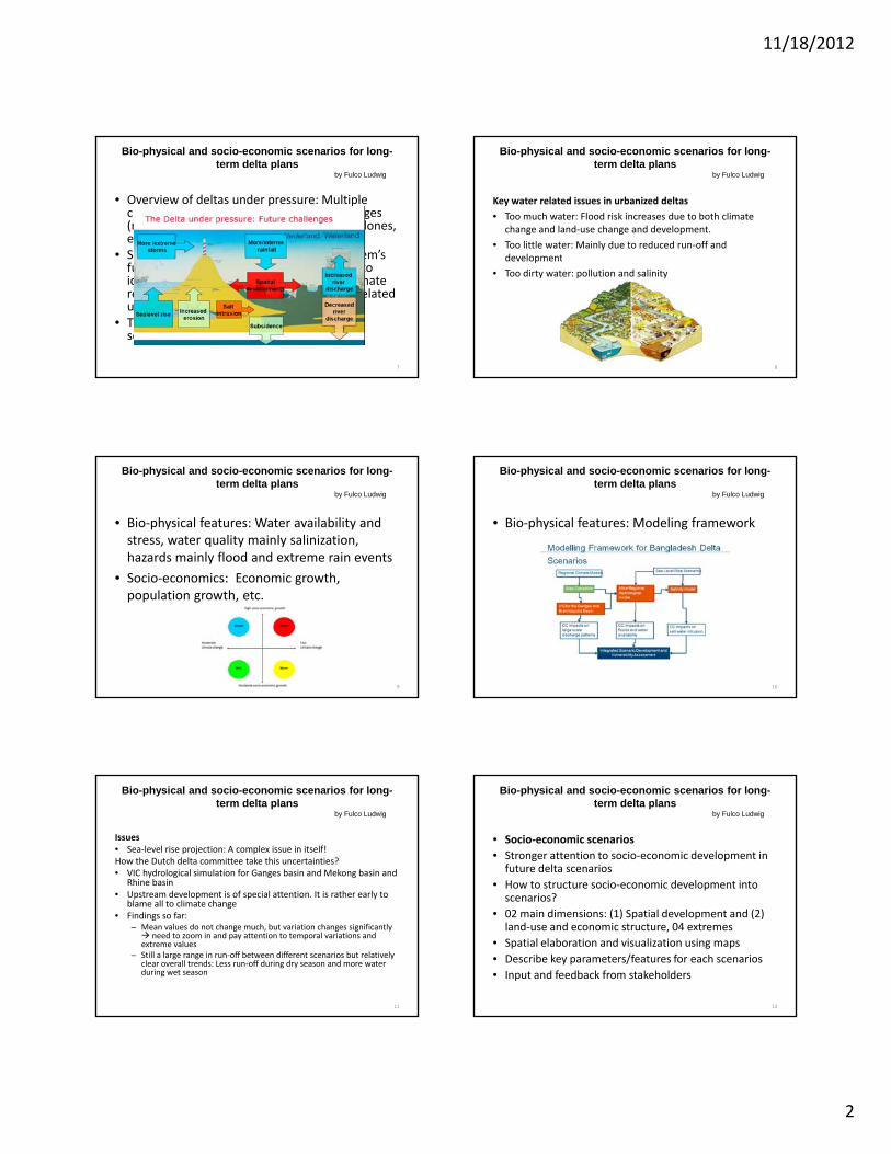
Bio-physical and socio-economic scenarios for long-term delta plans
by Fulco Ludwig
• Overview of deltas under pressure: Multiple challenges: sea‐level rise, hydrological changes (mean and extreme values), storms and cyclones, etc
• Scenario approach as a tool to capture system’sScenario approach as a tool to capture system s futures, not prediction nor projections but to identify and analyze uncertainties: Both climate related and socio‐economic development related uncertainties.
• There is no probabilities linked to different scenarios
7
Bio-physical and socio-economic scenarios for long-term delta plans
by Fulco Ludwig
Key water related issues in urbanized deltas
• Too much water: Flood risk increases due to both climate change and land‐use change and development.
• Too little water: Mainly due to reduced run‐off and developmentdevelopment
• Too dirty water: pollution and salinity
8
• Bio‐physical features: Water availability and stress, water quality mainly salinization, hazards mainly flood and extreme rain events
• Socio economics: Economic growth
Bio-physical and socio-economic scenarios for long-term delta plans
by Fulco Ludwig
• Socio‐economics: Economic growth, population growth, etc.
9
• Bio‐physical features: Modeling framework
Bio-physical and socio-economic scenarios for long-term delta plans
by Fulco Ludwig
10
Issues• Sea‐level rise projection: A complex issue in itself!How the Dutch delta committee take this uncertainties? • VIC hydrological simulation for Ganges basin and Mekong basin and
Rhine basin• Upstream development is of special attention It is rather early to
Bio-physical and socio-economic scenarios for long-term delta plans
by Fulco Ludwig
Upstream development is of special attention. It is rather early to blame all to climate change
• Findings so far: – Mean values do not change much, but variation changes significantly need to zoom in and pay attention to temporal variations and extreme values
– Still a large range in run‐off between different scenarios but relatively clear overall trends: Less run‐off during dry season and more water during wet season
11
• Socio‐economic scenarios
• Stronger attention to socio‐economic development in future delta scenarios
• How to structure socio‐economic development into scenarios?
Bio-physical and socio-economic scenarios for long-term delta plans
by Fulco Ludwig
scenarios?
• 02 main dimensions: (1) Spatial development and (2) land‐use and economic structure, 04 extremes
• Spatial elaboration and visualization using maps
• Describe key parameters/features for each scenarios
• Input and feedback from stakeholders
12
11/18/2012
3
Economic diversification / Land Use
Spatially Spatially evolving
Dual node industrializationCorridor industrialization
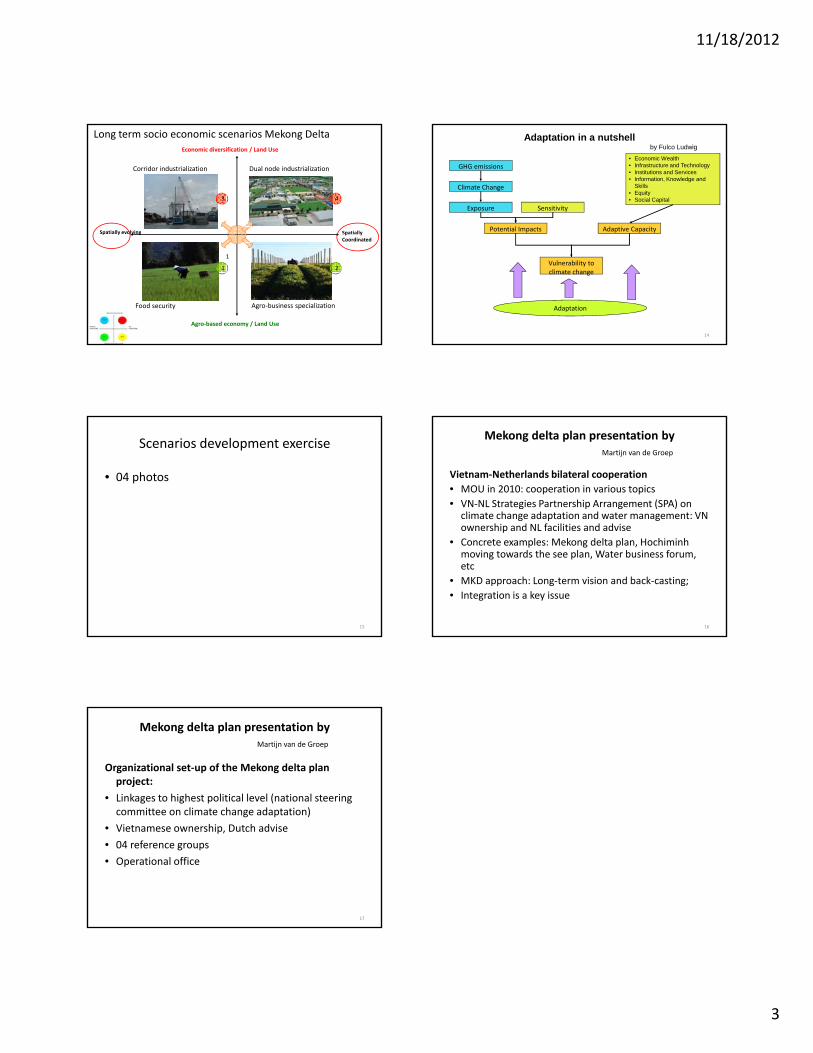
Long term socio economic scenarios Mekong Delta
3 4
p yCoordinated
p y g
Agro‐business specializationFood security
Agro‐based economy / Land Use
1
21
Adaptive CapacityPotential Impacts
Exposure
Climate Change
GHG emissions
Sensitivity
• Economic Wealth• Infrastructure and Technology• Institutions and Services• Information, Knowledge and
Skills• Equity• Social Capital
Adaptation in a nutshellby Fulco Ludwig
14
Adaptation
Vulnerability to climate change
Scenarios development exercise
• 04 photos
15
Mekong delta plan presentation by Martijn van de Groep
Vietnam‐Netherlands bilateral cooperation
• MOU in 2010: cooperation in various topics
• VN‐NL Strategies Partnership Arrangement (SPA) on climate change adaptation and water management: VN ownership and NL facilities and adviseownership and NL facilities and advise
• Concrete examples: Mekong delta plan, Hochiminhmoving towards the see plan, Water business forum, etc
• MKD approach: Long‐term vision and back‐casting;
• Integration is a key issue
16
Organizational set‐up of the Mekong delta plan project:
• Linkages to highest political level (national steering committee on climate change adaptation)
Mekong delta plan presentation by Martijn van de Groep
• Vietnamese ownership, Dutch advise
• 04 reference groups
• Operational office
17
11/19/2012
1
Challenges and Approaches in River Delta Planning22‐26 October 2012, HochiminhCity, Vietnam
Day 5: Synergizing and Conclusions
Ngan Le
http://www.muskokawaterweb.ca/waterfront‐living/healthy‐shorelines/83‐water‐101/watersheds
Delta Themes
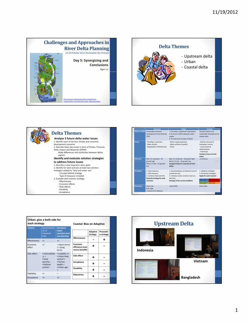
‐ Upstream delta‐ Urban‐ Coastal delta
Delta ThemesAnalyse 3 future delta water issues1. Identify each of the four climate and economic development scenarios2. Describe these key issues in term of Drivers, Pressure, State, Impact and Response (DPSIR)
Make differences and similarities between deltas explicit.
Identify and evaluate solution strategies dd f ito address future issues
1. Describe a clear long term aims, goals2. Identify for each scenario at least two solution strategies related to “land and water use”.
‐ Concept behind strategy‐ Type of measures included
3. Evaluate each solution strategy‐ Effectiveness‐ Economic effects‐ Slide‐effects‐ Flexibility‐ Acceptance
Upstream Urban CoastalVision to 2050 Sustainable economic
development of the Delta by 2050
1: To reduce unplanned urbanization2: To ensure safe & adequate water supply 3: To reduce the number of flood
Climate resilient and sustainable development of coastal delta
Issues ‐ Flooding in upstream‐Water Quality‐ Degradation of Biodiversity
‐Water supply (quantity)‐Water pollution (quality)‐ Flood
‐ Salinity intrusion & freshwater scarcity‐ Land erosion & sedimentation‐ Tidal flood Compare issues of each deltas
Scenarios Best: CC moderate – SE th hi h
Best: CC moderate – SE growth highW t CC f t SE th l
4 scenariosgrowth highWorst: CC fast – SE growth low
Worst: CC fast – SE growth lowCompare factors in scenario of each deltas
Strategies 1. Hard measures2. Soft measures3. Combine Hard and Soft Separate strategy for each countries
1. Decentralization of industrial area to outside the city2. Introduce water sensitive land use planning Strategy of the current problems
1. Adaptive strategies2. Preventive strategiesApply for each scenario
Evaluation Hard: LowSoft: HighCombine H+S: Medium
(next slide) (next slide)
Adaptivestrategy
Preventive strategy
Effectiveness ‐ +Economic efficiency (cost versus benefit)
+ ‐
Criteria Decentralization of industrial area
Introduce water sensitive land use planning
Effectiveness ++ ++
Economic effect
+/‐ – (short term) / + (long term)
Urban: give a both side for each strategy Coastal: Bias on Adaptive
versus benefit)
Side effect + ‐Acceptance + ‐Flexibility + ‐Robustness + ‐
term)
Side effect • Vulnerability ↓ +• Food security –• Politicalcontrol –
• Livability ++• Urban heat control +• Human health +• Urban agri. +
Flexibility ++ –
Acceptance +/‐ +/‐
Upstream Delta
IndonesiaIndonesia
Bangladesh
Vietnam
11/19/2012
2
Upstream Delta
• Good: Provided concrete strategies for each delta, each scenario
• Other Issues: Erosion, Landslide, Impacts of dam reservoirs, Water management for agriculture
• The urban and costal deltas need to concern or have responsibilities to the upstream delta.
• Should use carefully the concrete number/ percentage in the scenarios
Urban: The DPSIR framework(European environmental agency, 2004)
Urban• Good: Considered the relationship between the responses and the drivers, pressures, etc.
• Other Issues: Increasing frequencies of other hazards, labours’ accommodation
• Strategies solve the current problems. Still need strategies for g p gthe future.
• Need to create the linkages between Drivers and Issues, Scenarios and strategies
Coastal DeltaIssues Mekong, VN Telang,
IndonesiaAyeravadi, Myanmar
Ganges‐Brahm., BD
Salinity intrusion &freshwater scarcity
H H H H
Land erosion & sedimentation
M M M M
Loss of biodiversity
M L L L
Tidal flood M M H H
Coastal Delta• Good: Considered level of issues for each delta and decided which are the three main issues in general
• Other Issues: other causes of flood (not only tide), wetland system and rain behaviours, urbanization in coastal delta
• Bias on adaptive strategies. Need to combine 2 strategies for p g geach scenario and consider the side‐effects of each strategy in each scenario
• Need to be more concrete/ detailed in the strategies and assessment
Thank you!
16
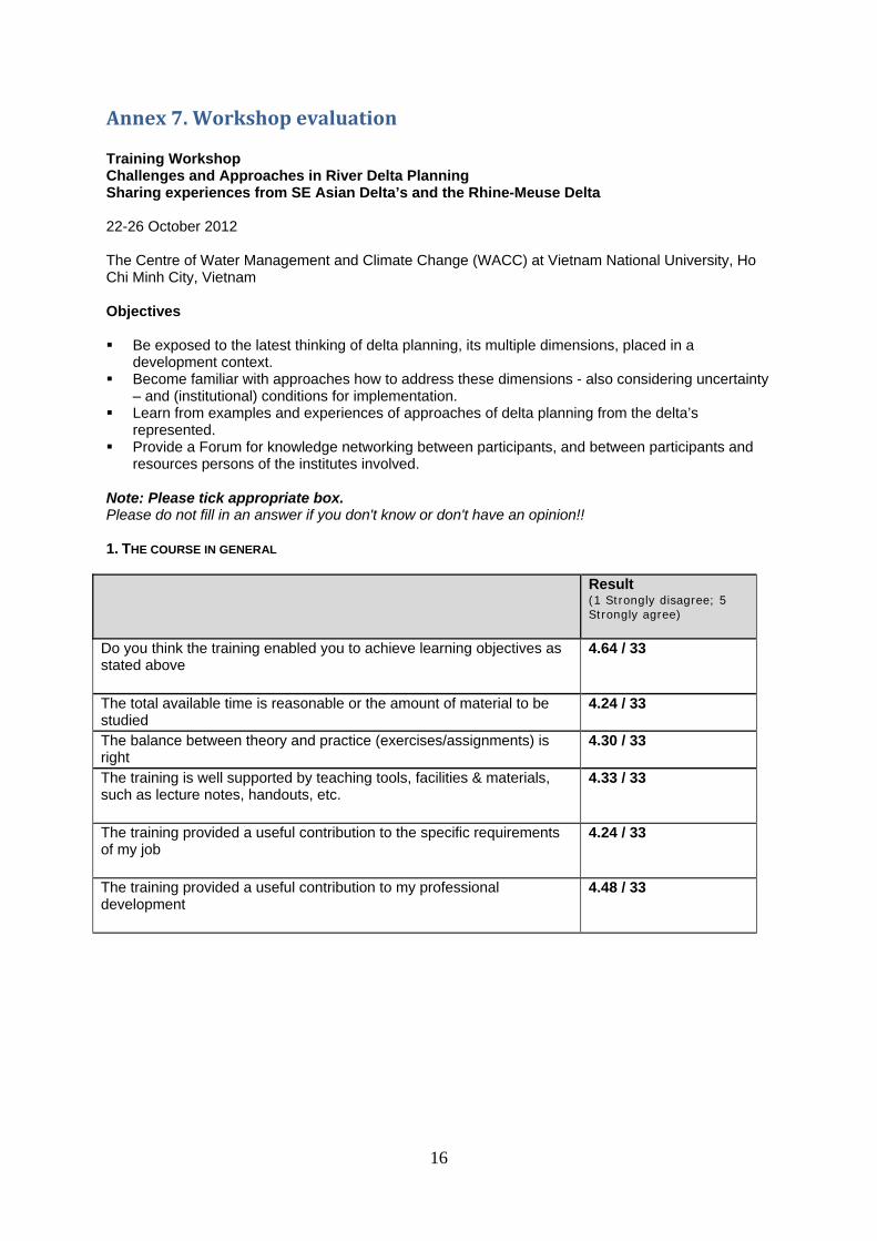
Annex 7. Workshop evaluation Training Workshop Challenges and Approaches in River Delta Planning Sharing experiences from SE Asian Delta’s and the Rhine-Meuse Delta 22-26 October 2012 The Centre of Water Management and Climate Change (WACC) at Vietnam National University, Ho Chi Minh City, Vietnam Objectives Be exposed to the latest thinking of delta planning, its multiple dimensions, placed in a
development context. Become familiar with approaches how to address these dimensions - also considering uncertainty
– and (institutional) conditions for implementation. Learn from examples and experiences of approaches of delta planning from the delta’s
represented. Provide a Forum for knowledge networking between participants, and between participants and
resources persons of the institutes involved. Note: Please tick appropriate box. Please do not fill in an answer if you don't know or don't have an opinion!! 1. THE COURSE IN GENERAL
Result
(1 Strongly disagree; 5 Strongly agree)
Do you think the training enabled you to achieve learning objectives as stated above
4.64 / 33
The total available time is reasonable or the amount of material to be studied
4.24 / 33
The balance between theory and practice (exercises/assignments) is right
4.30 / 33
The training is well supported by teaching tools, facilities & materials, such as lecture notes, handouts, etc.
4.33 / 33
The training provided a useful contribution to the specific requirements of my job
4.24 / 33
The training provided a useful contribution to my professional development
4.48 / 33
17
Working relations Result (1 difficult; 5 stimulating)
The working relations with the trainers has been:
4.64 / 33
The working relations between participants has been:
4.27 / 33
Comments on the course: 2: I would like to see more practical example on else studies. Also I would like to see the field trip designed changed to better capture some practical learning, maybe a dam site etc. 3: Good 4: It will be better giving more time scale 5: It would have been better if some modules are incorporated on practical work (like how to produce a map or relevant software package) within the schedule of the workshop. 6: The course has provided a good overview for the approach to be taken in developing a delta planning with insight mostly from the technical perspectives. 8: It is a nice course in which people from different countries/delta's share and learn each others about planning approach 10: Very much relevant issues were discussed. Got the opportunity to be exposed to new ideas. 14: The workshop is very well organized. Content of the workshop is reasonable. Lecturers are excellent. 15: Very relevant to the objectives and friendly atmosphere. 17: Overall the course is good and nicely organized. The field trip could be more informative showing examples a livelihood adaptation in Delta - agriculture, chatting in community; some socio-economic aspects should be added. 18: My most useful courses so far! This training course is very well designed and well implemented. Excellent presentation and lively discussion with right amount of time for practice. Host institute is very helpful and great facilitation. 19: The course was pretty good and I learned a lot, not only from the presentations and discussions but also from the conversations with experts from different research aspects/different countries. 20: Very good, very fruitful. We all share the experience of the several Delta among. The participant in the effective way. 21: It is a very nice course. The participants are very active. A lot of discussion has carries out. 22: Very well organized and relevant. 23: This course is also helpful for my current job. Hence I strongly support and hope will happen in the near future. 24: It should be organized frequently. 25: It is very helpful for me to add new knowledge that I lack of but I need. Thank you very much. 26: Provide additional section: round-table negotiation between groups of upstream delta, urban delta and coastal delta. 27: Try to deliver handouts before presentation so it's much useful to track the trainers. 29: For the time being the course was too much important and interesting. It will enable all the participants to think about own delta problem in an integrated way. After the training I think I can contribute a lot in my delta planning. 30: The course is very much helpful, informative, contain latest thinking for the river delta planning and it is very much appropriate for my country as well as for my professional development. 31: The topic is a bit broad. It is not easy to digest all material provided. 32: The course is very good, especially for participants which are working on related fields. But the total available time should be considered in order to give more detail lectures. 33: the course provides various practical tools that enhance my experiences of different delta situations. It is very helpful for my critical thinking to apply in my local situation in CK, especially since I am working in REDD+/ climate change issues. That has direct relation with upstream delta.
18
Comments on the lecturers: 3: Informative 4: Lecturers is excellent from profession 5: On the very first day, there should be a general lecture since the participants are from different backgrounds. Hence this general lecture may be useful for getting insight of delta planning. 6: Lecturers has been very resourceful, but need more to be well informed about each country's condition, socio. economic situation etc. 7: Open-minded 8: The substances of the lecturers are enough to provide useful information to the participants however in some sessions need more time to be explained. 10: The lecturers were well prepared. They designed the course nicely & executed nicely. They motivated us highly to perform the given tasks. They shared relevant information. 11: All lecturers are very sportive, good presentations. 14: All lecturers are knowledgeable and experienced well prepared presentations and tasks. 15: Friendly 17: The lecturers were good and nicely presented different case studies/examples. 18: Excellent experts who provided state-of-the-art knowledge and insightful experience for the participants. all lecturers are very helpful and inspiring. 19: Participants need to keep in touch after the workshop. 20: The lecturers are very good. 21: Very good lecturers. More knowledge has been introduced to the participants. 22: Very well prepared & organized. Good expertise. 25: They are great and enthusiastic. 26: Cooperative, enthusiastic 29: The resource personnel/facilitators were excellent in terms of having vast knowledge and experience in the practical field. I learned lot of practical examples from them and it will enhance my experience and help to develop my professional carrier as well. 30: Nice, excellent and informative. 32: All of the lecturers gave clear presentation. 33: the lecturers are very knowledgeable, supportive and friendly. 2. ADDITIONAL QUESTIONS
A. What did you like the most about this training?
1: -The approaches of delta planning: DPSIR, scenario -Various experiences from our neighboring countries & experts from Netherland 2: -The friendly attitude of the trainers -The intensive interaction -The friendly learning environment. 3: Sharing of information 4: I like very much about group works 5: The thematic proposal on different scenario 6: The relevancy of the topic of discussion with the real condition 7: Get a lot of vital knowledge. Have a general viewpoint about problems of each delta 8: Interactive discussion, sharing, and new networking/ friends in delta planning. 9: Having a lot of knowledge by sharing the information from different delta's. 10: Group works 11: Working atmosphere, the interaction between lecturers and participants, and field trip. 12: - Approaches and frame work from the planning - Participants background. 13: Good organization (theory + practice + field trip) 14: - Approaches to delta planning
- Q & A - Visit tour
15: Opportunity to exchange knowledge & experiences. 16: I like most the atmosphere of the training workshop. It was really cooperative and a sharing environment.
19
17: Group work for sharing knowledge from different types of deltas. 18: The course is very well designed for specific topic of planning in emerging deltas. 19: Very active and productive discussions after each presentation. 20: The interactive among the participants. The interactive between the lectures and the participant. 21: The training method 22: Enabling participants to develop different scenarios of delta development issues from which participants can make plans and strategies. 23: - Addressing the challenge in Delta planning, especially in different deltas.
- Approaching the methods to solve the serious problems. 24: The cooperation between participants is good. 25: The people from several countries and disciplines share their knowledge, opinions and enjoy together. Also the field trip to Mekong Delta was great. 26: Characteristics and issues of delta planning. 27: - Practical information, good approach for delta planning, good organization, re-cap. 28: Knowledge's related to Delta planning and analysis generally on strategies and measures. 29: The approaches of this training were interesting to me. Because at first all of the facilitators five us sound knowledge about the theory and they tried to combine theory with examples. 30: Decorative and nicely presented which is easy to catch? 31: Working together 32: I like strongly about study comparative share on experience coming from other countries. 33: The lecturers and participants are coming from various expertise's and situations that enhance my knowledge and understanding of different scenarios & future possible development. This mix of participants is very helpful to develop network & common understanding among different countries.
B. What did you like the least about this training? 1: Travelling about 1 and 1/2 hours 2: The field visit. It was very nice but learning points were limited. However the guide did give us some good information. 3: Nothing 5: The sequence of lecturers was sometimes not in proper order. 6: Lack of guidance in the discussion/ group work among the participant in order to have meaningful/fruitful discussion 9: The field trip 12: Field study, participants location 13: Time is quite hard 15: Almost nothing 16: I actually like to listen more about human interaction in problems arising among deltas and how the people involved in planning, addressing the issues and solve them. Adaptive capacities of the most vulnerable group & people. I hope to meet it again in other workshop. 18: It would be perfect to have more information on the DIPSIR model. 19: Location of the VNU is too far from the city's centre. It took a long time (1 hr) for transportation. 20: The hotel accommodation 23: The transportation. It takes time to go to the workshop place. 24: It's better if the working time of workshop could be shorter. It should finish at 4 pm instead of 5 pm. 25: The location is quite far from my living area, but after all it is ok. 26: Moving 25km everyday 29: The integration of different approaches as well as different methods to analyze delta problems. 30: The duration and length of this training should be increased. 32: The least I like that the questions came from participants which not related to the topic.
20
C. What did you find most difficult? 3: Language barrier 4: Difficult for me is a little bit on professional 5: The English pronunciation of the Vietnamese and Indonesian participant. 6: Climate change scenario 7: There is a difficulty because of different ideas. It is not easy to work in international group (May be training time is short). 8: There are several terms to be understood, but fortunately it can be handled during the workshop. 10: Too long sessions 11: How to apply new approaches to the real planning tasks for the particular area. 12: New approaches and frameworks. Language pronunciation. 14: A comprehensive planning for complicated delta. 16: Since I don't have much knowledge in water resource planning, so I found difficulty in understanding some specific concepts and professional knowledge. 18: I did not find any topic/issue that is too difficult. 19: Combine issues of different deltas and figure out solutions for general problems. 22: To be able to link different issues to solving problems of deltas. 25: My background is computer science, so there were some points I could not follow, especially the specific terminology in environmental science. 26: Myself have few experience about delta. Therefore it's hard to contribute to work group. 27: How to organize the steering committee and operational team to finish the delta plan successfully. 29:Sometimes I found that integration of different options for policy making is a tough job. 30: To catch the things from Vietnam and Indonesian participants. 31: How to implement some new concepts (e.g. adaptive management, uncertainty analysis). 32: The most difficult is to formulate the solution to overcome the problem.
D. Was there anything you found missing in this training which you believe should have been included?
2: A documentary film maybe. 3: More example 5: Some quantitative measurement tool 6: Economic & social perspectives in identifying the issues in developing a delta plan. 7: The way for working in group. There are a lot of individual ideas. 12: -Social factors. We should put some presentation which focus on social issues. -Participants from Mekong Delta ( experts, officers, NGO's) 14: A sample of good planning for a delta in developing country. 15: Experiences sharing in reality planning work. 16: It was included in B (what did you like the least about this training?) 17: The course should include one lecture basics of planning process, strategy and policy development. 18: Given the time availability, I think nothing should be added. 20: The case of Delta Mekong hasn't really present in the training. 23: I think that this teaching workshop focus on the theory. The technical tools to solve the problems in planning deltas should be involved. 25: The use of information system or computing system in supporting the planning process. 26: Enough for certain time. 30: If possible to include some modeling like flood modeling, atmospheric modeling. 31: Providing some tools (packages)for senior development, mapping, data collection. 32: The result of the course which has formulated as a principal response is very important. 33: There is no specific overview on upstream delta. The lecturers were about urban & coastal area. In Vietnam and Bangladesh: upstream issue is related strongly with transboundary among countries. In Indonesia is about deforestation & loss bioversity. These are important to address.
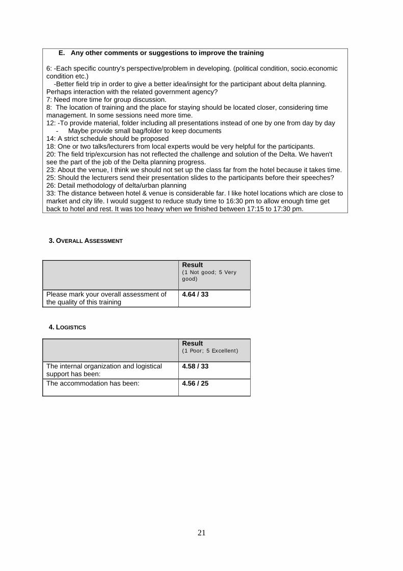
21
E. Any other comments or suggestions to improve the training 6: -Each specific country's perspective/problem in developing. (political condition, socio.economic condition etc.) -Better field trip in order to give a better idea/insight for the participant about delta planning. Perhaps interaction with the related government agency? 7: Need more time for group discussion. 8: The location of training and the place for staying should be located closer, considering time management. In some sessions need more time. 12: -To provide material, folder including all presentations instead of one by one from day by day
- Maybe provide small bag/folder to keep documents 14: A strict schedule should be proposed 18: One or two talks/lecturers from local experts would be very helpful for the participants. 20: The field trip/excursion has not reflected the challenge and solution of the Delta. We haven't see the part of the job of the Delta planning progress. 23: About the venue, I think we should not set up the class far from the hotel because it takes time. 25: Should the lecturers send their presentation slides to the participants before their speeches? 26: Detail methodology of delta/urban planning 33: The distance between hotel & venue is considerable far. I like hotel locations which are close to market and city life. I would suggest to reduce study time to 16:30 pm to allow enough time get back to hotel and rest. It was too heavy when we finished between 17:15 to 17:30 pm.
3. OVERALL ASSESSMENT
Result
(1 Not good; 5 Very good)
Please mark your overall assessment of the quality of this training
4.64 / 33
4. LOGISTICS
Result (1 Poor; 5 Excellent)
The internal organization and logistical support has been:
4.58 / 33
The accommodation has been: 4.56 / 25
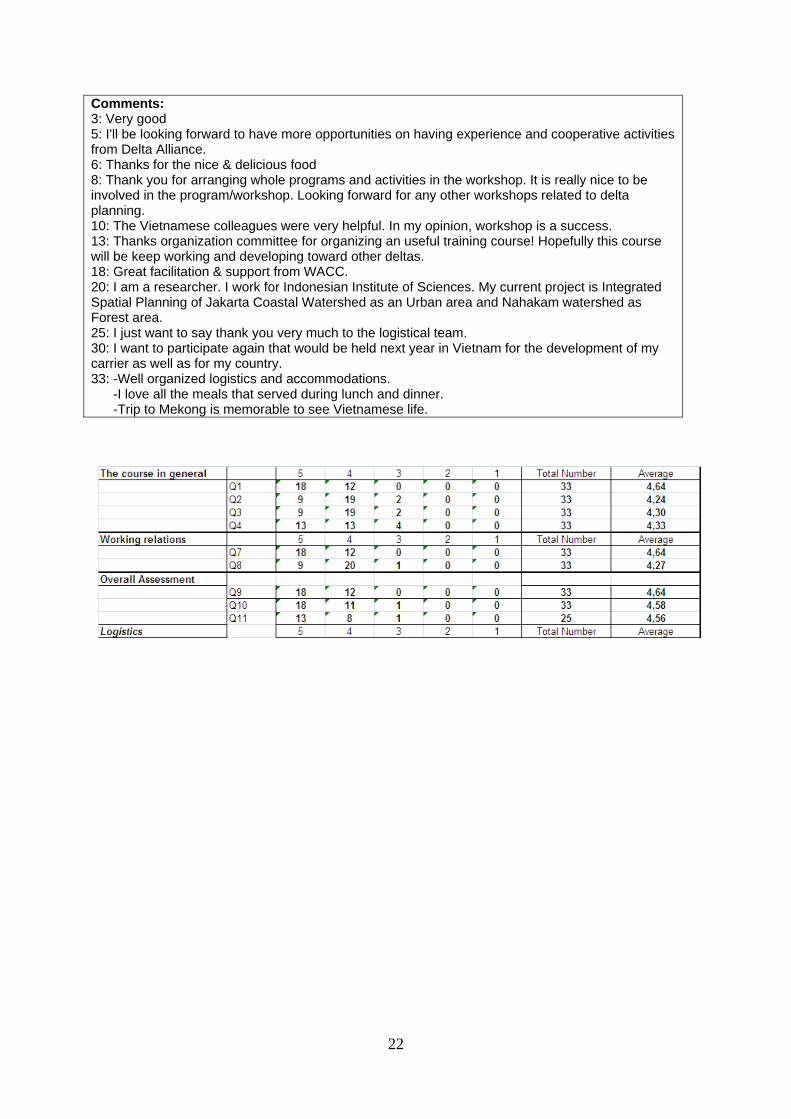
22
Comments: 3: Very good 5: I'll be looking forward to have more opportunities on having experience and cooperative activities from Delta Alliance. 6: Thanks for the nice & delicious food 8: Thank you for arranging whole programs and activities in the workshop. It is really nice to be involved in the program/workshop. Looking forward for any other workshops related to delta planning. 10: The Vietnamese colleagues were very helpful. In my opinion, workshop is a success. 13: Thanks organization committee for organizing an useful training course! Hopefully this course will be keep working and developing toward other deltas. 18: Great facilitation & support from WACC. 20: I am a researcher. I work for Indonesian Institute of Sciences. My current project is Integrated Spatial Planning of Jakarta Coastal Watershed as an Urban area and Nahakam watershed as Forest area. 25: I just want to say thank you very much to the logistical team. 30: I want to participate again that would be held next year in Vietnam for the development of my carrier as well as for my country. 33: -Well organized logistics and accommodations. -I love all the meals that served during lunch and dinner. -Trip to Mekong is memorable to see Vietnamese life.