Embed Size (px)
Citation preview
CHAPTER 10 - WILDLIFE RESOURCES AND WATER SAFETY
This Chapter 10 of Title 15A of the North Carolina Administrative Code (15A NCAC 10); WILDLIFE RESOURCES AND WATER SAFETY; has been transferred and recodified from Chapter 10 of Title 15 of the North Carolina Administrative Code (15 NCAC 10), effective November 1, 1989. The recodification was pursuant to G.S. 143B-279.1.
SUBCHAPTER 10A - WILDLIFE RESOURCES COMMISSION
SECTION .0100 - GENERAL
15A NCAC 10A .0101 RESPONSIBILITIES15A NCAC 10A .0102 FUNCTIONS15A NCAC 10A .0103 FISCAL POLICY15A NCAC 10A .0104 REIMBURSEMENT OF WILDLIFE FUND15A NCAC 10A .0105 STEWARDSHIP OF REVENUES15A NCAC 10A .0106 MOTTO
History Note: Authority G.S. 75A-3; 113-306; 113-307.1; 143-239; 143-243; 143-250; 143-254.1; 143A-118; 143B-281;Eff. February 1, 1976;Repealed Eff. February 1, 1982.
SECTION .0200 - ORGANIZATION AND PROCEDURE
15A NCAC 10A .0201 ACTION BY COMMISSION
History Note: Authority G.S. 143-243;Eff. February 1, 1976;Repealed Eff. July 1, 1988.
15A NCAC 10A .0202 OFFICERS OF COMMISSION15A NCAC 10A .0203 MEETINGS OF COMMISSION
History Note: Authority G.S. 143-243;Eff. February 1, 1976;Amended Eff. April 15, 1979;Repealed Eff. February 1, 1982.
15A NCAC 10A .0204 COMMITTEES
History Note: Authority G.S. 75A-3(b); 143-243;Eff. February 1, 1976;Amended Eff. April 15, 1979;Repealed Eff. July 1, 1988.
15A NCAC 10A .0205 SEAL OF COMMISSION15A NCAC 10A .0206 EXECUTIVE DIRECTOR15A NCAC 10A .0207 ASSISTANT FOR ADMINISTRATION15A NCAC 10A .0208 ASSISTANT FOR FIELD OPERATIONS
History Note: Authority G.S. 143-243; 143-246;Eff. February 1, 1976;Repealed Eff. February 1, 1982.
15A NCAC 10A .0209 ENFORCEMENT JURISDICTION OF SPECIAL OFFICERS
History Note: Authority G.S. 113-134; 113-138; 113-305;Eff. May 1, 1982;Repealed Eff. July 1, 1988.
SECTION .0300 - ANNUAL REGULATIONS PROCEDURE
15A NCAC 10A .0301 NECESSITY FOR ANNUAL REGULATIONS15A NCAC 10A .0302 POLICY CONSIDERATIONS
History Note: Authority G.S. 113-131; 113-132; 113-273; 113-291.2; 113-291.7; 113-301.1; 113-307; 143-239; 150B-12;Eff. February 1, 1976;Repealed Eff. July 1, 1988.
15A NCAC 10A .0303 PROCEDURE FOR ADOPTION
History Note: Authority G.S. 143-243; 143B-18; 150B-12;Eff. February 1, 1976;Repealed Eff. February 1, 1982.
SECTION .0400 - PETITIONS FOR RULE
15A NCAC 10A .0401 FORM AND CONTENTS OF PETITION(a) A petition for rule must be a written petition requesting rulemaking, addressed to the Executive Director, Wildlife Resources Commission, Archdale Building, 512 North Salisbury Street, Raleigh, North Carolina 27604-1188, and must contain:
(1) name and address of the petitioner;(2) name and address of the person, group or organization, if any, on behalf of which the petition is
made, together with the representative capacity of the petitioner;(3) identification of the rule sought to be adopted, amended or repealed;(4) suggested language for any rule sought to be adopted or amended and a statement of its desired
effect; and(5) signature of the petitioner.
(b) In addition to the foregoing, the petition may contain expression of any reasons in support or arguments in favor of the regulatory action proposed. Any tables, charts, maps, publications, photographs or other supporting materials which the petitioner deems pertinent to the proposal may be included by way of exhibits or attachments.
History Note: Authority G.S. 150B-20;Eff. February 1, 1976;Amended Eff. July 1, 1993; April 15, 1979.
15A NCAC 10A .0402 ACTION ON PETITION(a) The Executive Director shall cause the petition requesting rulemaking to be marked or stamped with the date of its receipt by him, which date shall constitute the date of its submission. The Executive Director shall then refer the petition requesting rulemaking to the Wildlife Resources Commission for its consideration.(b) Within 120 days following submission of the petition requesting rulemaking, the Wildlife Resources Commission shall:
(1) deny the petition in writing, stating the reason or reasons for such denial; or(2) initiate rulemaking proceedings in accordance with G.S. 150B-20.
(c) The Wildlife Resources Commission shall notify the person who submitted the petition of the action taken by the Commission. Any denial of a petition requesting rulemaking shall be sent to the petitioner at the address therein indicated by registered mail, "return receipt requested."
History Note: Authority G.S. 150B-20;Eff. February 1, 1976;
Amended Eff. July 1, 1993.
SECTION .0500 - DECLARATORY RULINGS
15A NCAC 10A .0501 WHEN ISSUEDIn accordance with the procedures set forth in Rule .0503 of this Section, and except as provided in Rule .0502 of this Section, a declaratory ruling is authorized to be issued by the Wildlife Resources Commission when there is submitted to the Executive Director a written request signed and verified under oath by or on behalf of a person or group of persons of common interest who will be substantially affected in their persons, property, public office or employment by such ruling; and which request shows on its face:
(1) that there is an actual controversy as to the applicability of a specific rule or regulation of the Commission, or of a specific statute administered or enforced by the Commission, to an existing factual situation;
(2) that every relevant fact and circumstance necessary to the ruling is definitively stated and is conceded by all parties to be a true and existing fact or circumstance for all purposes;
(3) that all parties who will be directly or indirectly affected by the ruling, other than the Commission and its agents and employees, have joined in the request therefor and in the verification of the facts therein set forth; and
(4) that the ruling will be final and determinative of the controversy and binding on all parties affected thereby, subject only to reversal or modification by a court on direct judicial review as provided by law.
History Note: Authority G.S. 150B-4;Eff. February 1, 1976.
15A NCAC 10A .0502 WHEN NOT ISSUEDA declaratory ruling will not be issued upon any request which is not in writing or upon the written request of a person who will not be substantially affected, either directly or indirectly, in his person, property, public office or employment by the ruling requested; or when it is or becomes apparent from any source:
(1) that no actual controversy exists, either as among the respective parties or as between the parties and the Commission, as to the applicability of a specific rule or regulation of the Commission, or of a specific statute administrated or enforced by the Commission, to an existing factual situation;
(2) that the question to be ruled upon is academic, hypothetical, moot, speculative, or lacking in specificity;
(3) that any relevant fact or circumstance necessary to the ruling is controverted, unverified, indefinite as to time or place, or omitted from the request for ruling;
(4) that the proposed ruling will substantially affect a person, other than an agent or employee of the Commission, who is not a party to the request therefor;
(5) that a case or proceeding involving the substance of the requested ruling is pending before a court or another agency;
(6) that the requested ruling would not be final and binding on the parties to be affected thereby, subject only to direct judicial review as provided by law;
(7) that the request for ruling challenges the validity of a statute administered or enforced by the Commission;
(8) that the requested ruling would require an interpretation of a statute not administered or enforced by the Commission or of a rule, regulation, order, or ordinance of some other governmental agency;
(9) that the Commission is without power or authority to issue the requested ruling for any reason; or(10) that the request is not made in good faith.
History Note: Authority G.S. 150B-4;Eff. February 1, 1976.
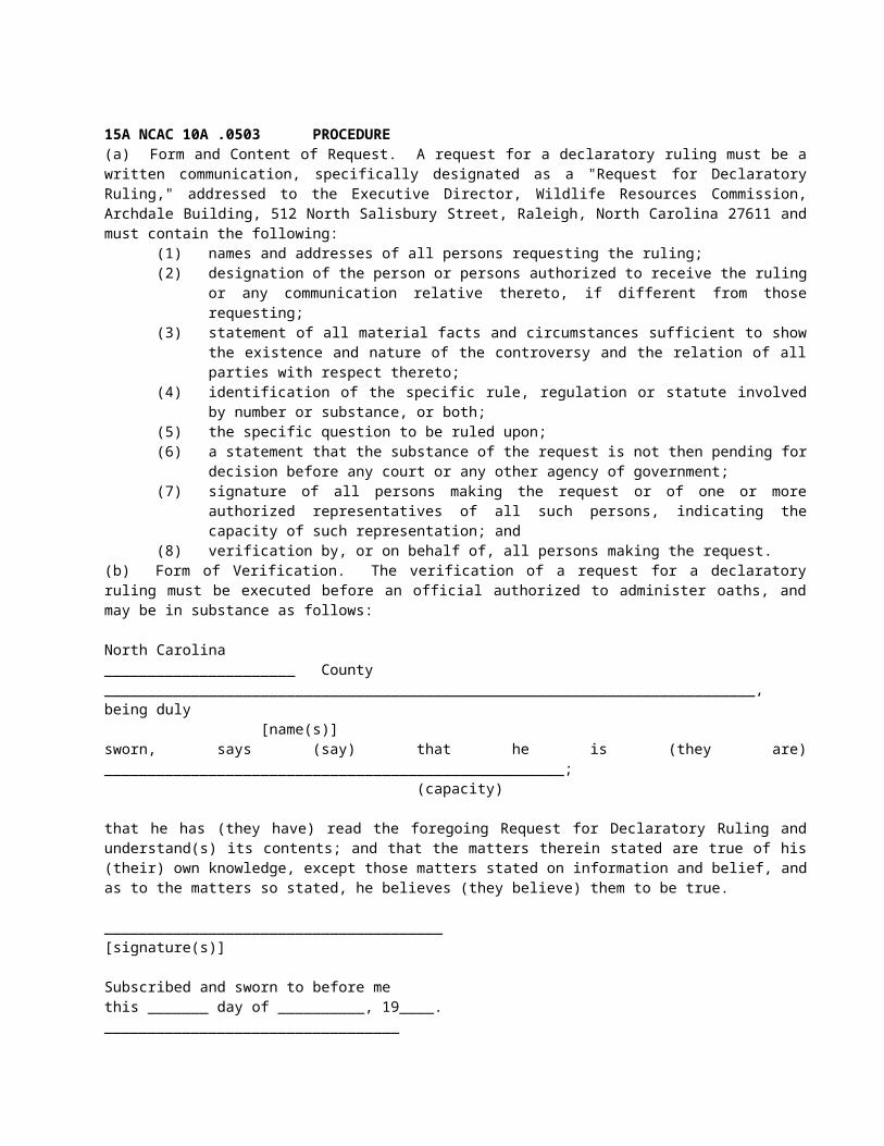
15A NCAC 10A .0503 PROCEDURE(a) Form and Content of Request. A request for a declaratory ruling must be a written communication, specifically designated as a "Request for Declaratory Ruling," addressed to the Executive Director, Wildlife Resources
Commission, Archdale Building, 512 North Salisbury Street, Raleigh, North Carolina 27611 and must contain the following:
(1) names and addresses of all persons requesting the ruling;(2) designation of the person or persons authorized to receive the ruling or any communication relative
thereto, if different from those requesting;(3) statement of all material facts and circumstances sufficient to show the existence and nature of the
controversy and the relation of all parties with respect thereto;(4) identification of the specific rule, regulation or statute involved by number or substance, or both;(5) the specific question to be ruled upon;(6) a statement that the substance of the request is not then pending for decision before any court or any
other agency of government;(7) signature of all persons making the request or of one or more authorized representatives of all such
persons, indicating the capacity of such representation; and(8) verification by, or on behalf of, all persons making the request.
(b) Form of Verification. The verification of a request for a declaratory ruling must be executed before an official authorized to administer oaths, and may be in substance as follows:
North Carolina______________________ County___________________________________________________________________________, being duly
[name(s)]sworn, says (say) that he is (they are) _____________________________________________________;
(capacity)
that he has (they have) read the foregoing Request for Declaratory Ruling and understand(s) its contents; and that the matters therein stated are true of his (their) own knowledge, except those matters stated on information and belief, and as to the matters so stated, he believes (they believe) them to be true.
_______________________________________[signature(s)]
Subscribed and sworn to before methis _______ day of __________, 19____.__________________________________
(signature of official) Title of Official
(L.S.)
(c) Action on Request. The Executive Director shall cause the request for a declaratory ruling to be marked or stamped with the date of receipt and, within 60 days thereafter:
(1) deny the ruling in writing, stating the reason or reasons for such denial;(2) place the request on the agenda for the next ensuing meeting of the Wildlife Resources Commission;(3) issue a ruling in accordance with existing policy of the Commission, in which case the ruling shall be
deemed that of the Commission; or(4) take such other action as he may deem appropriate.
(d) Form and Content of Ruling. A declaratory ruling is a written communication, specifically designated as a "declaratory ruling" (with a number, the substance, or sub-title as may be desirable for identification and future reference), addressed to the persons requesting the ruling or to the person or persons authorized in the request to receive the ruling or communications relative thereto, and containing the following:
(1) reference to the request for declaratory ruling;(2) reference to authority for the ruling (the statute and these regulations, or the specific action of the
Commission);(3) names and addresses of the persons affected by the ruling, unless it is general in effect and is so
indicated;(4) recital of the material facts on which the ruling is based, or reference to the facts as stated in the
request;
(5) the ruling;(6) date of issue; and(7) signature of Executive Director.
(e) Notice of Ruling or Denial of Ruling. Any declaratory ruling issued by the Wildlife Resources Commission or the Executive Director and any communication denying such a ruling shall be sent by registered mail, "return receipt requested," to the persons requesting the ruling, or to such person or persons as are designated in the request to receive the ruling or communications relative thereto.
History Note: Authority G.S. 150B-11; 150B-17;Eff. February 1, 1976;Amended Eff. April 15, 1979.
SECTION .0600 - LAW ENFORCEMENT PERSONNEL: DISABILITY AND RETIREMENT
15A NCAC 10A .0601 POLICY15A NCAC 10A .0602 DEFINITIONS15A NCAC 10A .0603 TENURE15A NCAC 10A .0604 RETIREMENT AGE15A NCAC 10A .0605 MEDICAL EVALUATION OFFICER15A NCAC 10A .0606 DUTIES OF MEDICAL EVALUATION OFFICER15A NCAC 10A .0607 MEDICAL EXAMINATIONS15A NCAC 10A .0608 FITNESS REQUIREMENTS15A NCAC 10A .0609 FITNESS CLASSIFICATIONS15A NCAC 10A .0610 PHYSICAL AND EMOTIONAL DISABILITY15A NCAC 10A .0611 APPEALS15A NCAC 10A .0612 CONFIDENTIALITY OF MEDICAL INFORMATION
History Note: Authority G.S. 8-53; 113-128(9); 126-16; 126-24; 126-34; 126-35; 126-36; 126-36.1; 126-39; 126-53; 143-243; 143-246; 143B-281;Eff. December 21, 1978;Amended Eff. June 17, 1979;Repealed Eff. June 21, 1981.
SECTION .0700 - SECONDARY EMPLOYMENT
15A NCAC 10A .0701 POLICY15A NCAC 10A .0702 DEFINITIONS15A NCAC 10A .0703 EMPLOYEE RESPONSIBILITY15A NCAC 10A .0704 AGENCY RESPONSIBILITY15A NCAC 10A .0705 APPEAL15A NCAC 10A .0706 PENALTIES
History Note: Authority G.S. 126-24; 126-35; 143-243; 143-246; 143B-281; Eff. February 7, 1979;Repealed Eff. June 21, 1981.
SECTION .0800 - WORK PLANNING AND PERFORMANCE REVIEW
15A NCAC 10A .0801 POLICY15A NCAC 10A .0802 WORK PLANNING15A NCAC 10A .0803 PERFORMANCE REVIEW
History Note: Authority G.S. 113-91(2); 126-7; 126-22; 126-24; 143-243; 143-246; 143B-281;Eff. March 9, 1979;Amended Eff. January 6, 1980;
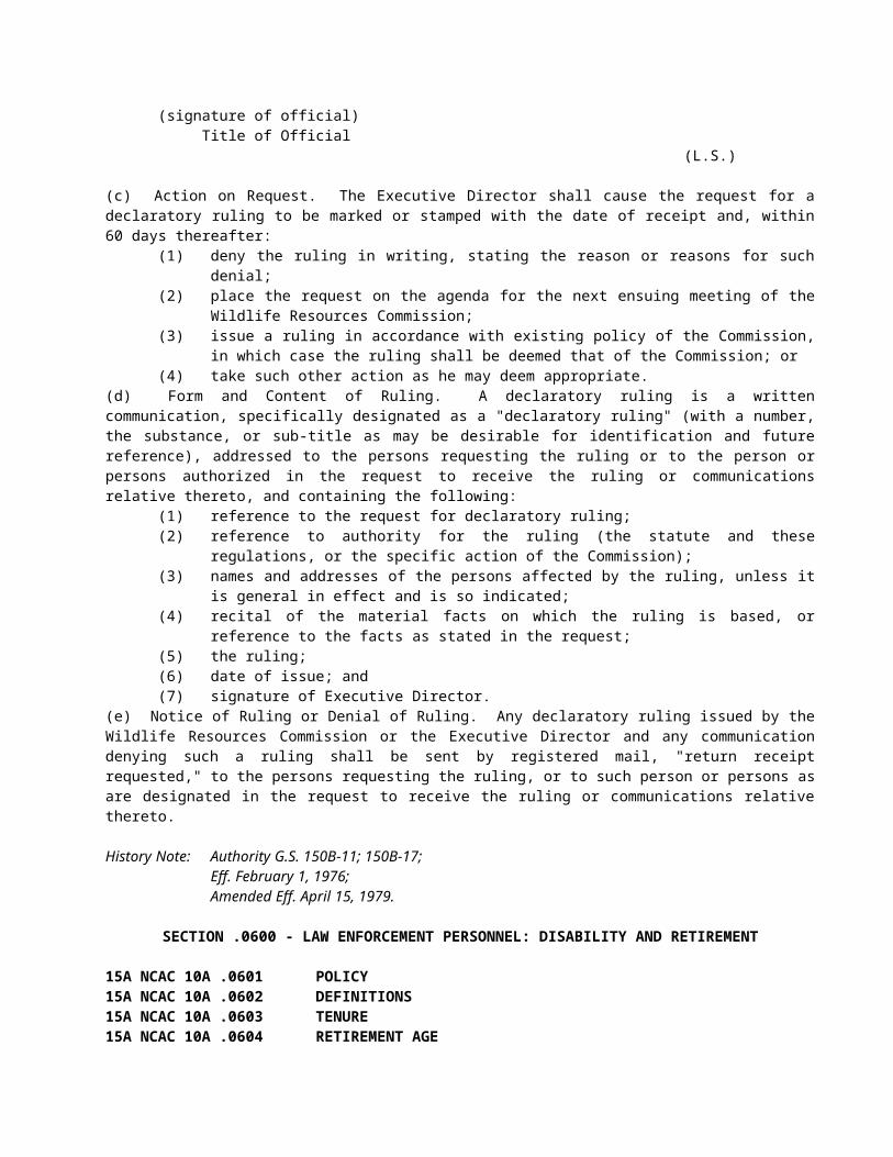
Repealed Eff. June 21, 1981.
SECTION .0900 - EMPLOYMENT AND PROMOTIONS
15A NCAC 10A .0901 POLICY15A NCAC 10A .0902 PROBATIONARY APPOINTMENT15A NCAC 10A .0903 WILDLIFE ENFORCEMENT OFFICERS15A NCAC 10A .0904 PERFORMANCE EVALUATION15A NCAC 10A .0905 DISMISSAL DURING PROBATIONARY PERIOD15A NCAC 10A .0906 PERSONNEL ACTION AT CONCLUSION OF PROBATION15A NCAC 10A .0907 EMPLOYEE PROMOTIONS
History Note: Authority G.S. 17A-7; 113-91(2); 126-4; 126-5; 126-24; 126-35; 143-243; 143-246; 143A-281; 1 NCAC 8C .0404; 1 NCAC 8D .0202;Eff. June 17, 1979;Repealed Eff. June 21, 1981.
SECTION .1000 - WARNING TICKETS
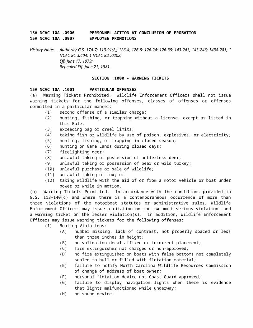
15A NCAC 10A .1001 PARTICULAR OFFENSES(a) Warning Tickets Prohibited. Wildlife Enforcement Officers shall not issue warning tickets for the following offenses, classes of offenses or offenses committed in a particular manner:
(1) second offense of a similar charge;(2) hunting, fishing, or trapping without a license, except as listed in this Rule;(3) exceeding bag or creel limits;(4) taking fish or wildlife by use of poison, explosives, or electricity;(5) hunting, fishing, or trapping in closed season;(6) hunting on Game Lands during closed days;(7) firelighting deer;(8) unlawful taking or possession of antlerless deer;(9) unlawful taking or possession of bear or wild turkey;(10) unlawful purchase or sale of wildlife;(11) unlawful taking of fox; or(12) taking wildlife with the aid of or from a motor vehicle or boat under power or while in motion.
(b) Warning Tickets Permitted. In accordance with the conditions provided in G.S. 113-140(c) and where there is a contemporaneous occurrence of more than three violations of the motorboat statutes or administrative rules, Wildlife Enforcement Officers may issue a citation on the two most serious violations and a warning ticket on the lesser violation(s). In addition, Wildlife Enforcement Officers may issue warning tickets for the following offenses:
(1) Boating Violations:(A) number missing, lack of contrast, not properly spaced or less than three inches in height;(B) no validation decal affixed or incorrect placement;(C) fire extinguisher not charged or non-approved;(D) no fire extinguisher on boats with false bottoms not completely sealed to hull or filled with
flotation material;(E) failure to notify North Carolina Wildlife Resources Commission of change of address of
boat owner;(F) personal flotation device not Coast Guard approved;(G) failure to display navigation lights when there is evidence that lights malfunctioned while
underway;(H) no sound device;(I) muffler not adequate;(J) loaded firearm on access area;(K) parking on access area in other than designated parking area, provided traffic to ramp not
impeded;(L) motorboat registration expired 10 days or less;
(M) no Type IV throwable personal flotation device on board, but other personal flotation device requirements met;
(N) violation of no-wake speed zone when mitigating circumstances present;(O) running lights on motorboat are obstructed, not visible or improperly configured;(P) personal flotation device is not readily accessible on board motorboat;(Q) failure to wear a kill-switch lanyard on personal watercraft;(R) exceeding capacity of personal watercraft while towing a skier;(S) allowing youth under the age of 12 to operate a personal watercraft while accompanied by
an adult; (T) wearing an inflatable personal flotation device while operating a personal watercraft; or(U) No light available on board a manually propelled vessel.
(2) License Violations:(A persons under 16 hunting, trapping, or trout fishing without meeting statutory requirements;(B) senior citizens hunting or fishing without valid license(s) (Senior citizens are those persons
65 years old or older);(C) when it appears evident that the wrong license was purchased or issued by mistake;(D) failure to carry required license or identification on person, if positive identification can be
established;(E) non-resident hunting, fishing, or trapping with resident license, if domicile is established,
but not 60 days; (F) hunting, fishing, or trapping on Game Lands or fishing in Designated Trout Waters that are
not properly posted or have been posted for no more than 30 days; (G) persons who are 18 years or older or who do not reside with their parents, when such
persons are taking wildlife upon their parent's land without a license as required by G.S. 113-270.2, 113-270.3(b) except for subdivision (5), 113-270.5, 113-271, or 113-272;
(H) failure to comply with a statutorily enacted license requirement that has been in effect for less than a year; or
(I) license expiration of 10 days or less.(3) Game Lands Violations:
(A) camping on Game Lands in other than designated area; or(B) possession of weapons readily available for use while on game land thoroughfare, during
closed season.(4) Trapping Violations:
(A) improper chain length at dry land sets;(B) trap tag not legible;(C) trap tag missing, but with a group of properly tagged traps;(D) trap tag missing, but evidence that animal destroyed;(E) improper jawsize;(F) failure to comply with "offset" jaw requirement for traps with jaw spread of more than 5 ½
inches;(G) failure to attend traps daily, during severe weather (ice, high water, heavy snow); or(H) no written permission, but on right-of-way of public road.
(5) Miscellaneous Violations:(A) allowing dogs, not under the control of the owner to chase deer during closed season;(B) attempting to take deer with dogs, or allowing dogs to chase deer in restricted areas;(C) using dogs to track wounded deer during primitive weapon season;(D) failure to report big game kill to nearest cooperator agent, when game is tagged and subject
is enroute to another agent;(E) training dogs or permitting them to run unleashed on Game Lands west of I-95 during the
period of April 1 through August 15;(F) violation of newly adopted rules, when not readily available to the public;(G) violation of local laws, when information not available to the public;(H) all permits (except for fox depredation permit);(I) closed season, if misprinted in digest or suddenly changed;(J) minor record violation (taxidermist); (K) failure to put name and address on marker (trotline); or
(L) failure to put name and address on nets.(c) Special Consideration. Special consideration may be given in local areas where the offender is hunting or fishing out of his normal locality and is unfamiliar with the local law. Consideration may also be given for violations on newly opened or established Game Lands and on reclassified or newly Designated Mountain Trout Waters. Special consideration may be given to offenders under 18 years of age.
History Note: Authority G.S. 113-140;Eff. April 1, 1991;Amended Eff. May 1, 2007; May 1, 2004; November 2, 1992; November 1, 1991.
SECTION .1100 - WAIVER
15A NCAC 10A .1101 WAIVER(a) The executive director or his designee shall waive rule provisions listed in Paragraph (b) of this Rule and subsequent Paragraphs under specified conditions and according to the following standards:
(1) The applicant has complied with the laws of North Carolina and with rules promulgated by the Wildlife Resources Commission;
(2) The Commission is able to safeguard the wildlife resources in North Carolina while granting the waiver; and
(3) The applicant is able to meet the conditions of the waiver.(b) The executive director or his designee shall waive the rule banning intrastate transfer of cervids and shall issue a transportation permit to an applicant for such a waiver provided that:
(1) The executive director or his designee determines that the applicant is eligible for a waiver according to standards listed in Paragraph (a) of this Rule;
(2) The eligible applicant shall first notify the Commission of the following:(A) the tag number(s) assigned to the cervid;(B) the facility of origination;(C) the facility of destination;(D) the date(s) upon which the transfer is to take place; and (E) the means by which the cervid is to be transported; and
(3) The executive director or his designee confirms receipt of the information requested in Subparagraph (b)(2) of this Rule.
Transportation of cervids between facilities that are licensed to the same individual shall be permitted upon the condition that the licensed applicant log the information required by Subparagraph (b)(2) of this Rule rather than submit a separate application for each transportation. (c) The executive director or his designee shall waive the rule banning importation of cervids and shall issue a transportation permit to an applicant for such a waiver provided that:
(1) The executive director or his designee determines that the applicant is eligible for a waiver according to standards listed in Paragraph (a) of this Rule;
(2) The herd of origin for all cervids to be imported has met the following conditions:(A) The herd has been held in a facility that has been secured by a fence that has not been
breached or jumped by a cervid for at least five years, and into which no cervid has been introduced for at least five years;
(B) All members of the herd that have died in the past five years have been tested for Chronic Wasting Disease [CWD]; and all CWD test results have been negative; and
(C) Facility records demonstrating compliance with the conditions in this Subparagraph have been submitted with the import application.
(3) The eligible applicant shall first notify the Commission of the following:(A) the tag number(s) or other identification assigned to the cervid;(B) the facility of origination;(C) the facility of destination;(D) the date(s) upon which the transfer is to take place; and (E) the means by which the cervid is to be transported; and
(4) The executive director or his designee confirms receipt of the information requested in Subparagraph (c)(3) of this Rule.
(d) The executive director or his designee shall waive the rule against cervid facility expansion and to amend a license to permit expansion to an applicant for such a waiver provided that:
(1) The executive director or his designee confirms the applicant's eligibility for a waiver according to standards listed in Paragraph (a) of this Rule;
(2) The eligible applicant shall first notify Commission of the following:(A) the location of the facility for which expansion is desired;(B) the number of cervids held at that facility;(C) the number of births or purchases of cervids expected within a year of the application; and(D) the proposed capacity for which expansion is desired; and
(3) The executive director or his designee confirms receipt of the information requested in Paragraphs (c) and (d) of this Rule.
History Note: Authority G.S. 113-134; 113-274; 150B-19(6);Temporary Adoption Eff. May 21, 2003;Temporary Adoption Expired March 12, 2004;Eff. November 1, 2004;Amended Eff. August 1, 2006.
SECTION .1200 - EMERGENCY POWERS
15A NCAC 10A .1201 EMERGENCY POWERS(a) Upon a finding by the Wildlife Resources Commission that a wildlife disease threatens irreparable injury to wildlife or to the public, the Executive Director shall develop an emergency response plan in consultation with the Governor's office and the State Veterinarian. The plan may prescribe one or more of the following actions:
(1) shorten or lengthen harvest seasons;(2) prohibit transport of wildlife resources or parts thereof;(3) prohibit possession of wildlife resources;(4) confiscate wildlife resources;(5) revoke licenses or permits;(6) expand or restrict daily bag limits, daily creel limits, and possession limits;(7) establish mandatory wildlife check stations;(8) restrict public access to game lands;(9) require prepayment of outside testing costs by persons who desire disease testing of their harvested
wildlife resource when such testing is not essential to the objectives of the plan;(10) prohibit supplemental feeding or baiting of wildlife;(11) prohibit any other activities that aid in the transmission or movement of the disease as determined by
the best available science regarding the disease threat;(12) implement any other activities necessary to reduce infection opportunities; and(13) implement any other requirements necessary to assist in the detection and isolation of the disease.
(b) The Commission shall inform the public of the actions in the response plan through press releases, postings on the Wildlife Commission web site, letters sent to representatives of sportsmen's groups or other constituents likely to be directly affected, and by employee outreach.
History Note: Authority G.S. 113-134; 113-306(f);Eff. March 1, 2011.
SECTION .1300 – WILDLIFE POACHER REWARD FUND
15A NCAC 10A .1301 FUNDING SOURCESThe Wildlife Resources Commission shall direct at least 10 percent of compensatory restitution associated with replacement costs and investigative costs as defined in G.S. 15A-1343(b1)(5) and specified in Rules 15A NCAC 10B .0117 and 15A NCAC 10C .0215 to the Wildlife Poacher Reward Fund.
History Note: Authority G.S. 15A-1343; 113-134; 113-294;Eff. May 1, 2014.
15A NCAC 10A .1302 OFFENSES AND REWARD AMOUNTS(a) Rewards shall be paid only for information resulting in the arrest and conviction of persons who have committed Class 1 or Class 2 misdemeanors specified in G.S. 113-294 and G.S. 113-337, and Class 1 misdemeanors involving wildlife resources specified in G.S. 113-264(b).(b) The reward amount shall be equivalent to the amount of the fine, replacement costs, or restitution assessed by the court, whichever is greatest, not to exceed one thousand dollars ($1,000). If no fine, replacement cost, or restitution is assessed, including in cases that result in a prayer for judgment, the reward shall be one hundred dollars ($100.00).
History Note: Authority G.S. 113-134; 113-264; 113-294; 113-294.1; 113-337;Eff. May 1, 2014.
15A NCAC 10A .1303 ELIGIBILITY(a) Rewards shall be paid only to individuals who provide information resulting in the arrest and conviction of persons who have committed the offenses specified in Rule .1302(a) of this Section. If more than one individual provides information resulting in the arrest of a person for the same offense, the Commission shall pay reward money in equal amounts to each individual not to exceed the amount specified in Rule .1302(b) of this Section.(b) Rewards shall be paid after the final disposition of a case resulting in a conviction or a prayer for judgment. For purposes of this Rule, a conviction shall be as defined in G.S. 113-171(a).(c) The following individuals are not eligible to receive reward money:
(1) any current Wildlife Resources Commission employee or members of his or her immediate family;(2) any current Wildlife Resources Commissioner;(3) any sworn law enforcement officer;(4) the perpetrator of the crime for which the information has been given and any accomplice or
accessory to that crime; and(5) any individual who refuses to provide the Commission with his or her name and contact information.
History Note: Authority G.S. 113-134; 113-171; 113-294.1;Eff. May 1, 2014.
SECTION .1400 – INTERSTATE WILDLIFE VIOLATOR COMPACT (WVC)
15A NCAC 10A .1401 GENERAL PROVISIONS(a) Purpose. The purpose of this section is to establish the rules necessary to implement G.S. 113 Article 22B, the Interstate Wildlife Violator Compact (hereinafter referred to as WVC).(b) Applicability. The rules in this Section shall apply to any person possessing a license, privilege or right to hunt, fish, trap, possess, or transport wildlife in the State of North Carolina. Violations under this Section apply to only hunting, fishing and trapping. The rules shall not apply to any offenses committed in North Carolina or any other WVC state prior to August 1, 2017.(c) Definitions. The definitions in G.S. 113-300.6 Article II shall apply throughout this Subchapter and to all forms prescribed pursuant to this Subchapter, unless otherwise indicated.
History Note: Authority G.S. 113-134; 113-300.7;Eff. August 1, 2017.
15A NCAC 10A .1402 WILDLIFE VIOLATOR COMPACT MANUALThe Wildlife Violator Compact Operations Manual, which is incorporated by reference, including subsequent amendments and editions, may be found free of charge, at http://www.ncwildlife.org, and G.S. 113-300.6 hereby establish the administrative and procedural guidelines for participation in the WVC.
History Note: Authority G.S. 113-134; 113-300.7;Eff. August 1, 2017.
15A NCAC 10A .1403 WILDLIFE VIOLATOR COMPACT CONDITIONS FOR NON-RESIDENTS(a) Non-residents of North Carolina who are residents of a WVC member state at the time of a misdemeanor hunting, fishing, or trapping violation occurring in North Carolina, may be released on personal recognizance when the
violation consists of a written citation requiring a violator to resolve the violation directly with the court, either in person, by mail, or through an attorney.(b) All identified offenses set forth in G.S. 113 are subject to the provisions of the WVC.(c) Upon failure to comply with the terms of a citation for violation of North Carolina hunting, fishing, or trapping laws, the Wildlife Resources Commission shall send notice of failure to comply, by certified mail, return receipt requested, to the violator's last known address, and report the failure to comply to the home state to start suspension procedures in accordance with the Wildlife Violator Compact Manual.(d) License privileges shall only be restored when the citation is resolved through the North Carolina Court System.(e) Upon resolving the citation, the non-resident shall notify the Wildlife Resources Commission so that hunting, fishing or trapping privileges can be restored.
History Note: Authority G.S. 113-134; 113-300.7;Eff. August 1, 2017.
15A NCAC 10A .1404 WILDLIFE VIOLATOR COMPACT CONDITIONS FOR RESIDENTS(a) North Carolina residents committing hunting, fishing, or trapping violations in another WVC member state, who upon release on personal recognizance from the issuing state, failed to resolve the violation, shall have their hunting, fishing, or trapping privileges suspended in North Carolina.(b) If the Wildlife Resources Commission receives notice of an unresolved violation, a Notice of Suspension shall be prepared and sent to the violator:
(1) the notice shall have a delayed effective date of at least 14 business days, to allow the violator to contact the court in the issuing state and resolve the case;
(2) the notice shall be delivered personally or by letter sent by certified mail, return receipt requested, to the last known address of the licensee or permit holder;
(3) the notice of suspension shall inform the violator of the facts supporting the suspension and procedures to be followed in resolving the matter with the court in the issuing state; and
(4) the notice shall provide the procedure for appealing the suspension.(c) Any suspensions received by the Wildlife Resources Commission shall remain in effect until such time as the North Carolina resident resolves the violation in the issuing state.(d) When a North Carolina resident resolves a violation with the court in the issuing state, it is the responsibility of the resident to present documents to the Wildlife Resources Commission that acknowledge compliance. Upon receipt of documentation set forth in Paragraph (e) of this Rule, an acknowledgement of compliance shall be issued directly to that person by the Wildlife Resources Commission.(e) The following shall be sufficient evidence of compliance in response to a notice of suspension for non-compliance:
(1) copy of the court judgment; or(2) a copy of a Notice of Compliance from the issuing state.
(f) The Wildlife Resources Commission shall reinstate the license if the acknowledgement of compliance is presented after the effective date of the suspension.(g) Residents receiving a Notice of Suspension from the Wildlife Resources Commission under the WVC provisions for failure to resolve a citation issued in another WVC member state may file a petition with the Office of Administrative Hearings, within 60 days from the date of delivery by certified mail to the residents last known address, pursuant to G.S. 150B-23.(h) The issuing state shall be notified if the suspension order is overturned by the Office of Administrative Hearings.
History Note: Authority G.S. 113-134; 113-300.7;Eff. August 1, 2017.
15A NCAC 10A .1405 RECIPROCAL RECOGNITION OF SUSPENSIONS(a) When the Wildlife Resources Commission receives notice of suspension of a North Carolina resident's hunting, fishing, or trapping privileges or licenses by a WVC member state that are the result of a conviction or an accumulation of convictions of wildlife violations in one or more states that participate in the WVC, the agency shall determine whether the violation, or accumulation of violations, leading to the suspension could have led to the suspension of rights, privileges, or licenses under G.S. 113. If it is determined that the resident's privileges or licenses would have been suspended under G.S. 113, the resident's licenses, rights, and privileges to hunt, fish, or trap in North
Carolina shall be suspended pursuant to Article 22B of G.S. 113 for the same period as imposed by the WVC member state where the violation occurred.(b) North Carolina shall communicate suspension information to other member states, using the WVC database. Information may include the following:
(1) name;(2) date of birth;(3) last known address;(4) violation(s) and convictions upon which the suspension is based;(5) scope of the suspension (i.e., fishing, hunting, trapping, all privileges or rights); and(6) effective dates of the suspension and term of the suspension.
(c) In the event documentation of a violation and subsequent license suspension is needed by a member state for license suspension hearings or other purposes, the Wildlife Resources Commission may provide certified copies of the citation or other charging instrument, any arrest or investigation reports, suspension orders, and the disposition of the matter.
History Note: Authority G.S. 113-134; 113-300.7;Eff. August 1, 2017.
15A NCAC 10A .1406 APPEALSA final agency decision made by the Wildlife Resources Commission to suspend any North Carolina hunting, fishing or trapping license pursuant to the WVC shall be appealable to the Office of Administrative Hearings pursuant to G.S. 150B-23. Notice of the right to appeal shall be included in the correspondence notifying the licensee of the final agency decision.
History Note: Authority G.S. 113-134; 113-300.7;Eff. August 1, 2017.
SUBCHAPTER 10B - HUNTING AND TRAPPING
SECTION .0100 - GENERAL REGULATIONS
15A NCAC 10B .0101 IMPORTATION OF WILD ANIMALS AND BIRDS(a) Before any live wild bird or wild animal is imported into North Carolina for any purpose, a permit shall be obtained from the Executive Director of the North Carolina Wildlife Resources Commission authorizing the importation, using application forms provided by the Commission.(b) Deer, elk, or other species in the family Cervidae may only be imported into the state of North Carolina from a herd in which Chronic Wasting Disease (CWD) has not been detected for at least five years and has been managed using standards equivalent to, or more stringent than, the criteria specified in 15A NCAC 10H .0301 and 15A NCAC 10H .0302. The individual U.S. or Mexican state or territory, Canadian province or other country of origin must have CWD monitoring requirements that are at least as stringent as those described in this Rule, 15A NCAC 10H .0301 and 15A NCAC 10H .0302. The originating individual U.S. or Mexican state's or territory's, Canadian province's or other country's CWD monitoring program must be jointly reviewed by Wildlife Resources Commission and Department of Agriculture and Consumer Services personnel before approval of any importation of cervids into North Carolina. There shall be no importation from individual U.S. or Mexican states or territories, Canadian provinces or other countries in which CWD has been detected, either in a wild herd or a captive herd.(c) Cervids imported into North Carolina shall be individually identified by tags provided by the Wildlife Resources Commission that shall be affixed by the licensee to each cervid as set forth in 15A NCAC 10H .0301.(d) Waterfowl imported into North Carolina must be received from facilities or individuals who are certified under the National Poultry Improvement Plan (NPIP) as pullorum-typhoid and avian influenza negative. If the source birds are not part of NPIP, they must be tested pullorum-typhoid and avian influenza negative by NPIP standards within 30 days prior to entry into North Carolina. Health certificates for imported waterfowl shall be available for inspection by authorized Commission personnel upon request.
History Note: Authority G.S. 106.549.97; 113-134; 113-272.6; 113-274; 113-291.3;Eff. February 1, 1976;
Temporary Amendment Eff. October 8, 2002; May 17, 2002;Amended Eff. August 1, 2010; May 1, 2010; June 1, 2005; August 1, 2004.
15A NCAC 10B .0102 IMPORTATION OF GRAY FOXESThe importation of gray foxes into Anson, Avery, Burke, Cabarrus, Caldwell, Catawba, Cleveland, Davidson, Gaston, Lincoln, McDowell, Mecklenburg, Mitchell, Montgomery, Moore, Richmond, Rowan, Rutherford, Stanly, Union and Yancey Counties is prohibited.
History Note: Authority G.S. 113-134; 113-274; 113-291.3; 113-291.4;Eff. February 1, 1976.
15A NCAC 10B .0103 RESPONSIBILITY OF GUIDES
History Note: Authority G.S. 113-134; 113-270.4;Eff. February 1, 1976;Repealed Eff. February 1, 1982.
15A NCAC 10B .0104 HUNTING AND TRAPPING IN VICINITY OF FLOOD OR FIRE
History Note: Authority G.S. 113-134; 113-291.2;Eff. February 1, 1976;Repealed Eff. March 1, 1992.
15A NCAC 10B .0105 MIGRATORY GAME BIRDS(a) Cooperative State Rules:
(1) The taking of sea ducks (scoter, eider and old squaw) during any federally-announced season for only these species shall be limited to the waters of the Atlantic Ocean, and to those coastal waters south of US 64 that are separated by a distance of at least 800 yards of open water from any shore, island or marsh.
(2) Tundra swans may be taken during the open season by permit only subject to annual limitations imposed by the U.S. Fish and Wildlife Service. Based upon the annual limitations imposed by the U.S. Fish and Wildlife Service, the Wildlife Resources Commission shall issue nontransferable swan permits to applicants who will be selected at random by computer. Only one swan may be taken under each permit which shall be cancelled at the time of the kill by cutting out the month and day of the kill. Accompanying the permit is a tag which must be affixed to the swan at the time and place of the kill. The tag must be affixed in accordance with instructions provided with the permit. In addition, a preaddressed post-paid card is supplied to each permittee on which to report the number of days hunted and the details of the kill if made. It is unlawful to hunt swans without having the permit and the tag in possession or to possess a swan without the cancelled permit in possession and the tag affixed in accordance with instructions provided with the permit to the swan. It is unlawful to possess a swan permit or tag while hunting that was assigned to another person or to alter the permit or tag in any way other than cutting out the proper month and day of kill.
(b) Notwithstanding the provisions of G.S. 113-291.1(a) and (b), the following restrictions apply to the taking of migratory game birds:
(1) No migratory game bird may be taken: (A) With a rifle; (B) With a shotgun of any description capable of holding more than three shells, unless it is
plugged with a one-piece filler, incapable of removal without disassembling the gun, so as to limit its total capacity to not more than three shells.
(2) No migratory game bird may be taken: (A) From or by the use of a sinkbox or any other type of low floating device affording the hunter
a means of concealment beneath the surface of the water; (B) With the aid of bait, or on, over, or within 300 yards of any place where any grain, salt or
other feed is exposed so as to constitute an attraction to migratory game birds or has been so exposed during any of the 10 consecutive days preceding the taking, except that this Part shall not apply to standing crops, flooded croplands, grain crops shocked on the field where
grown, or grains found scattered solely as the result of normal agricultural planting or harvesting;
(C) With the aid of live decoys, or on, over or within 300 yards of any place where tame or captive migratory game birds are present, unless such birds are and have been for a period of 10 consecutive days prior to such taking confined within an enclosure which eliminates the audibility of their calls and totally conceals them from the sight of wild migratory game birds.
(3) Crippled waterfowl may be taken from a motorboat under power in those areas described, delineated, and designated as special sea duck hunting areas in Subparagraph (a)(1) of this Rule.
(4) Waterfowl hunting and harassment and other unauthorized activities is prohibited on posted waterfowl management areas established by the Wildlife Resources Commission for Canada Geese and ducks restoration. Information on impoundments can be found at ncwildlife.org.
(5) In that area of Roanoke Sound adjacent to and immediately Northeast of Roanoke Island as marked by buoys designating the waterfowl rest area, it is unlawful to harass or take any waterfowl.
(6) The area east of US 17 is designated as an experimental September teal season zone as referenced by the Federal frameworks calling for state rules designating experimental areas.
(c) Reporting Requirements: For tundra swan and Canada goose seasons where a permit is required to hunt by Memorandum of Agreement with the U.S. Fish & Wildlife Service, hunter questionnaires supplied on preaddressed, postage-paid cards shall be returned to the Commission and postmarked no later than April 1 following the end of the applicable season. Failure to return the questionnaire and animal parts, if required, by this date shall make the individual ineligible to receive a permit for the following applicable season. In lieu of returning a hard copy, individuals may fill out a questionnaire on-line through the Wildlife Commission web site at ncwildlife.org when this option is available by April 1 following the end of the applicable season.
History Note: Authority G.S. 113-134; 113-274; 113-291.1; 113-291.2; 50 C.F.R. 20.21; 50 C.F.R. 20.105;Eff. February 1, 1976;Amended Eff. July 1, 1995; April 1, 1992; February 1, 1990; September 1, 1989;Temporary Amendment Eff. September 10, 1998;Amended Eff. August 1, 2015; May 1, 2007; June 1, 2005; May 1, 2004; July 1, 2000.
15A NCAC 10B .0106 WILDLIFE TAKEN FOR DEPREDATIONS(a) Depredation permits allow the taking of undesirable or excess wildlife resources as described in Subparagraphs (1) and (2) of this Paragraph. Only employees of the Wildlife Resources Commission and Wildlife Damage Control Agents may issue depredation permits. Each permit shall be written on a form supplied by the Commission. No permit is needed for the owner or lessee of a property to take wildlife while committing depredations on the property; however the manner of taking, disposition of dead wildlife, and reporting requirements as described in this Rule still apply. No permit shall be issued to take any endangered or threatened species of wildlife listed under 15A NCAC 10I, except alligators, by reason of depredations to property. Only the Executive Director may issue depredation permits for Special Concern species listed in 15A NCAC 10I .0105 and for alligators. An individual may take an endangered or threatened species in immediate defense of his own life or of the lives of others without a permit. Any endangered or threatened species that may constitute a demonstrable but non-immediate threat to human safety shall be reported to a federal or state wildlife enforcement officer, who, upon verification of the report, may take or remove the specimen as provided by 15A NCAC 10I .0102. Depredation permits for other species shall be issued under the following conditions:
(1) for taking wildlife that is or has been damaging or destroying property provided there is evidence of property damage. No permit may be issued for the taking of any migratory birds and other federally-protected animals unless a corresponding valid U.S. Fish and Wildlife Service depredation permit, if required, has been issued. A permit issued pursuant to this Rule shall name the species allowed to be taken and may contain limitations as to age, sex, or any other condition, such as type of depredation, location of animal or damage, and local laws, within the species so named. The permit shall be issued to a landholder or an authorized representative of a unit of local government for depredations on public property; and the permit shall be used only by individuals named on the permit.
(2) for taking of wildlife resources in circumstances of overabundance or when the wildlife resources present a danger to human safety. Cities as defined in G.S. 160A-1(2) seeking such a depredation
permit shall apply to the Executive Director using a form supplied by the Commission requesting the following information:(A) the name and location of the city;(B) the acreage of the affected property;(C) a map of the affected property;(D) the signature of an authorized city representative;(E) the nature of the overabundance or the threat to public safety; and (F) a description of previous actions taken by the city to ameliorate the problem.
(b) Wildlife Damage Control Agents: Upon completion of a training course designed for the purpose of reviewing and updating information on wildlife laws and safe, humane wildlife handling techniques, and demonstration of a knowledge of wildlife laws and safe, humane wildlife handling techniques, an individual with no record of wildlife law violations may apply to the Wildlife Resources Commission (Commission) to become a Wildlife Damage Control Agent (WDCA). Those persons who demonstrate knowledge of wildlife laws and safe, humane wildlife handling techniques by a passing score of 85 percent or better on a written examination provided by a representative of the Wildlife Resources Commission, in cooperation with the training course provider, shall be approved. Those persons failing to obtain a passing score shall be given one chance for re-testing without re-taking the course. Those persons approved as agents by the Commission may then issue depredation permits for depredation as defined in Subparagraph (a)(1) of this Rule to landholders and be listed as a second party to provide the control service. WDCAs may not issue depredation permits for coyotes in the counties of Beaufort, Dare, Hyde, Tyrrell, Washington; big game animals; bats; or species listed as endangered, threatened, or special concern under 15A NCAC 10I .0103, .0104, and .0105 of this Chapter. WDCAs shall report to the Wildlife Resources Commission the number and disposition of animals taken, by county, annually. Records shall be available for inspection by a Wildlife Enforcement officer at any time during normal business hours. These business hours are the posted business hours of the Commission at ncwildlife.org. WDCA status shall be revoked at any time by the Executive Director when there is evidence of violations of wildlife laws, failure to report, or inhumane treatment of animals by the WDCA. A WDCA may not charge for the permit, but may charge for his or her investigations and control services. In order to maintain a knowledge of current laws, rules, and techniques, each WDCA shall renew his or her agent status every three years by showing proof of having attended at least one training course provided for the purpose of reviewing and updating information on wildlife laws and safe, humane wildlife handling techniques within the previous 12 months or agency approved continuing education credits.(c) Each depredation permit shall have an expiration date or time after which the depredation permit is no longer valid. The depredation permit authorizes possession of any wildlife resources taken under the permit and shall be retained as long as the wildlife resource is in the permittee's possession. All individuals taking wildlife resources under the authority of a depredation permit shall comply with the conditions written on the permit and the requirements specified in this Rule.(d) Manner of Taking:
(1) Taking Without a Permit. Wildlife taken without a permit while committing depredations to property may, during the open season on the species, be taken by the landholder by any lawful method. During the closed season, such depredating wildlife may be taken without a permit only by the use of firearms or archery equipment as defined in 15A NCAC 10B .0116.
(2) Taking With a Permit. Wildlife taken under a depredation permit may be taken only by the method or methods authorized by the permit. When trapping is authorized, in order to limit the taking to the intended purpose, the permit may specify a reasonable distance from the property sought to be protected, according to the particular circumstances, within which the traps shall be set. The Executive Director or agent may also state in a permit authorizing trapping whether or not bait may be used and the type of bait, if any, that is authorized based upon factors such as type of depredation, locations of animal or damage, and local laws. In addition to any trapping restrictions that may be contained in the permit, the method of trapping shall be in accordance with the requirements and restrictions imposed by G.S. 113-291.6 and other local laws passed by the General Assembly. No depredation permit shall authorize the use of poisons or pesticides in taking wildlife except in accordance with the provisions of the North Carolina Pesticide Law of 1971, G.S. 143, Article 52, the Structural Pest Control Act of 1955, G.S. 106, Article 4C, and G.S. 113, Article 22A. No depredation permit shall authorize the taking of wildlife by any method by any landholder upon the lands of another except when the individual is listed as a second party on a depredation permit.
(3) Intentional Wounding. It is unlawful for any landholder, with or without a depredation permit, intentionally to wound a wild animal in a manner so as not to cause its immediate death as suddenly and humanely as the circumstances permit.
(e) Disposition of Wildlife Taken:(1) Generally. Except as provided by Subparagraphs (e)(2) through (5) of this Paragraph, any wildlife
killed without a permit while committing depredations shall be buried or otherwise disposed of in a safe and sanitary manner on the property. Wildlife killed under a depredation permit may be transported to an alternate disposal site if desired. Anyone in possession of carcasses of animals being transported under a depredation permit shall have the depredation permit in his or her possession. Except as provided by Subparagraphs (e)(2) through (5) of this Rule, all wildlife killed under a depredation permit shall be buried or otherwise disposed of as stated on the permit.
(2) Deer and feral swine. The edible portions of feral swine and deer may be retained by the landholder for consumption but shall not be transported from the property where the depredations took place without a valid depredation permit. The landholder may give a second party the edible portions of the feral swine and deer taken under the depredation permit. The receiver of the edible portions shall hold a copy of the depredation permit. The nonedible portions of any deer carcass, including head, hide, feet, and antlers, shall be disposed of as specified in Subparagraph (1) of this Paragraph or turned over to a wildlife enforcement officer for disposition.
(3) Fox. Any fox killed under a depredation permit may be disposed of as described in Subparagraph (1) of this Paragraph or, upon compliance with the fur tagging requirements of 15A NCAC 10B .0400, the carcass or pelt thereof may be sold to a licensed fur dealer.
(4) Furbearing Animals. The carcass or pelt of any furbearing animal killed during the open season for taking such furbearing animal for control of depredations to property, whether with or without a permit, may be sold to a licensed fur dealer provided that the person offering such carcass or pelt for sale has a valid hunting or trapping license; provided further that bobcats and otters may only be sold upon compliance with any required fur tagging requirement set forth in 15A NCAC 10B .0400.
(5) Animals Taken Alive. Wild animals in the order Carnivora, armadillos, groundhogs, nutria, and beaver shall be humanely euthanized either at the site of capture or at a facility designed to humanely handle the euthanasia or released on the property where captured. Feral swine shall be euthanized while still in the trap in accordance with G.S. 113-291.12. For all other animals taken alive, the animal shall be euthanized or released on property with permission of the landowner. When the relocation site is public property, written permission shall be obtained from an appropriate local, state, or federal official before any animal may be released. Animals transported or held for euthanasia shall be euthanized within 12 hours of capture. Anyone in possession of live animals being transported for relocation or euthanasia under a depredation permit shall have the depredation permit in his or her possession.
(f) Reporting Requirements. Any landholder who kills an alligator; a coyote in the counties of Beaufort, Dare, Hyde, Tyrrell, or Washington; deer; Canada goose; bear; elk; or wild turkey under a valid depredation permit shall report such kill on the form provided with the permit and mail the form upon the expiration date to the Wildlife Resources Commission. Any landowner who kills a coyote in the counties of Beaufort, Dare, Hyde, Tyrrell, and Washington shall report such kill as directed on the form provided with the depredation permit. The killing and method of disposition of every alligator; coyote in the counties of Beaufort, Dare, Hyde, Tyrrell, and Washington; bear; or elk taken without a permit shall be reported to the Wildlife Resources Commission within 24 hours following the time of such killing.
History Note: Authority G.S. 113-134; 113-273; 113-274; 113-291.4; 113-291.6; 113-300.1; 113-300.2; 113-307; 113-331; 113-333; 113-334(a); 113-337;Eff. February 1, 1976;Amended Eff. August 1, 2013; January 1, 2012; August 1 2010; July 1, 2010; May 1, 2008; August 1, 2002; July 1, 1997; July 1, 1995; January 1, 1995; January 1, 1992; August 1, 1990;Temporary Amendment Eff. August 1, 2014 and shall remain in effect until amendments expire as specified in G.S. 150B-21.1(d) or the United States District Court for the Eastern District of North Carolina's court order number 2:13-CV-60-BOs signed on May 13, 2014 is rescinded, whichever date is earlier. The court order is available at www.ncwildlife.org;Temporary Amendment Eff. February 27, 2015;Amended Eff. December 1, 2016; July 1, 2016; May 1, 2016.
15A NCAC 10B .0107 BLACK BEAR
It is unlawful to take or possess a female bear with a cub or cubs at its side, or to take or possess a cub bear. For the purpose of this Rule, a cub bear is defined as any bear weighing less than 75 pounds.
History Note: Authority G.S. 113-134; 113-291.2; 113-291.7;Eff. February 1, 1976;Amended Eff. August 1, 2016; June 1, 2005; July 1, 1985.
15A NCAC 10B .0108 CHASING DEER BY DOGS IN CLOSED SEASON
History Note: Authority G.S. 113-134; 113-291.5;Eff. February 1, 1976;Repealed Eff. February 1, 1982.
15A NCAC 10B .0109 CHASING DEER BY DOGS IN CERTAIN COUNTIESIt is unlawful to allow dogs to run or chase deer or to attempt to take deer with dogs at any time in Alamance County south of I-85; Orange County south of I-85; Chatham County; Lee County; Wake County south of NC 98; and in and west of Rockingham, Guilford, Randolph and Montgomery Counties and that part of Anson County west of NC 742.Note: See 15A NCAC 10D .0103 which prohibits any hunting with dogs on game lands during the season for hunting deer with guns in and west of these counties.
History Note: Authority G.S. 113-134; 113-291.5;Eff. February 1, 1976;Amended Eff. July 1, 1999; July 1, 1991; August 1, 1980; August 1, 1978; August 1, 1977.
15A NCAC 10B .0110 ATTENDANCE OF TRAPS Every trap shall be visited daily and any animal caught therein removed, except for completely submerged conibear type traps which shall be visited once every 72 hours and any animal caught therein removed.
History Note: Authority G.S. 113-134; 113-291.6;Eff. February 1, 1976;Amended Eff. August 1, 2002; July 1, 1988.
15A NCAC 10B .0111 RESTRICTIONS ON RACCOON AND OPOSSUM HUNTING(a) Axes or saws may not be carried when raccoon or opossum hunting.(b) Except in Richmond County, raccoon may not be shot during daylight hours west of US 1.
History Note: Authority G.S. 113-134; 113-291.1;Eff. February 1, 1976;Amended Eff. August 1, 1981; August 1, 1979; August 1, 1978; August 1, 1977.
15A NCAC 10B .0112 BEAVER
History Note: Authority G.S. 113-134; 113-291.1;Eff. February 1, 1976;Repealed Eff. July 1, 1988.
15A NCAC 10B .0113 BIG GAME KILL REPORTS(a) Upon killing a bear, deer, or wild turkey and before moving the animal from the site of kill, the successful hunter shall validate the Big Game Harvest Report Card furnished with the big game hunting license by cutting or punching out the validation box that correctly identifies the big game animal harvested. In lieu of the Big Game Harvest Report Card, antlerless deer may be recorded as outlined on the Bonus Antlerless Deer Harvest Report Card acquired from the Wildlife Resources Commission or a Wildlife Service Agent. Deer harvested under the Deer Management Assistance Program (DMAP) program, not validated with either a Big Game Harvest Report Card or Bonus Antlerless Deer Harvest Report Card, shall be validated by affixing a Commission-issued DMAP tag to the deer as required by G.S. 113-291.2(e).
(b) Before any harvested bear, deer, or wild turkey is skinned, dressed, or dismembered for consumption and within 24 hours of the kill, the animal shall be registered through the Electronic Big Game Reporting System. The hunter may field dress the animal at the site of kill or before registering it by bleeding and removing the digestive, respiratory, and circulatory organs. However, the hunter may not further process the carcass in a manner that obscures its species identity, age, or sex before registering the animal. When the kill occurs in a remote area that prevents the animal from being transported as an entire carcass, the animal may be skinned and quartered before being registered. When a hunter harvests a big game animal in a remote area and plans to remain in the remote area for longer than a day, the 24-hour time limit to register the kill is extended until the hunter leaves the area. Upon leaving the remote area, the hunter shall register the kill within 24 hours.(c) When a hunter registers a kill, the Electronic Big Game Reporting System shall issue an authorization number to the big game hunter. The hunter shall record the authorization number obtained through the Electronic Big Game Reporting System in the space provided immediately adjacent to the validation box that has been cut or punched out on the Big Game Harvest Report Card or the Bonus Antlerless Deer Harvest Report Card. Any hunter validating a deer harvest with a Commission-issued DMAP tag shall record and maintain the issued authorization number to serve as proof of registration. The authorization number shall thereafter constitute authorization for the continued possession of the carcass. Possession of a harvested bear, deer, or wild turkey without the validated Big Game Harvest Report Card or Bonus Antlerless Deer Harvest Report Card where applicable, including the authorization number obtained through the Electronic Big Game Reporting System, is unlawful.(d) Persons who kill a big game animal and leave it unattended shall identify the carcass with their name, their hunting license number, and the date of kill. Once an unattended animal is registered, the animal need only be identified with the authorization number received by registering the kill. It is unlawful for a person to possess a Big Game Harvest Report Card or Bonus Antlerless Deer Harvest Report Card on which the species validation box has been cut or punched out, but on which the authorization number received by registering the kill has not been recorded, or to possess a used or affixed Commission-issued DMAP tag without a valid authorization number, unless the animal is in the person's possession or is identified as described in this Paragraph and not more than 24 hours have passed since the harvest.(e) Persons who are by law exempt from the big game hunting license by G.S. 113-276 shall obtain a Big Game Harvest Report Card or Bonus Antlerless Deer Harvest Report Card for License Exempt Hunters from a Wildlife Service Agent, or possess a valid Commission-issued DMAP tag. Upon harvesting a bear, deer, or wild turkey, the exempt person shall validate and register the kill as provided by this Rule.(f) Persons who use special tags issued pursuant to G.S. 113-291.2(e) to validate the harvest of a deer shall follow the tagging and reporting requirements set forth by statute and shall not take any action under this Rule.
History Note: Authority G.S. 113-134; 113-270.3; 113-276.1; 113-291;Eff. February 1, 1976;Amended Eff. July 1, 1998; July 1, 1997; July 1, 1995; July 1, 1994; July 1, 1993; July 1, 1989;Temporary Amendment Eff. July 1, 1999;Amended Eff. August 1, 2017; August 1, 2012; August 1, 2010; June 1, 2009; May 1, 2007; May 1, 2004; July 1, 2000.
15A NCAC 10B .0114 DOG TRAINING AND FIELD TRIALS(a) For purposes of 15A NCAC 10B and 10D, the following definitions apply:
(1) "Commission-sanctioned field trial" means a field trial that, pursuant to a written request from the sponsoring organization, has been authorized in writing and scheduled for occurrence by an authorized representative of the Wildlife Resources Commission.
(2) "Active participant" means a person participating in a field trial who handles dogs or uses a firearm.(b) Each person using wildlife to train or run dogs shall possess a North Carolina hunting license. (c) A person serving as judge of a commission-sanctioned field trial is exempted from any license requirements. Judges of non-sanctioned field trials using wildlife shall possess a North Carolina hunting license.(d) Except as exempted in Paragraph (e) of this Rule, the following applies to active participants in field trials:
(1) North Carolina residents participating in any field trial that uses wildlife shall have a N.C. hunting license;
(2) non-residents participating in a commission- sanctioned field trial that uses wildlife shall possess a N.C. hunting license or a hunting license from his or her state of residence; and
(3) non-residents participating in other types of field trials that use wildlife shall possess a N.C. hunting license
(e) Persons without a license may participate in commission-sanctioned field trials for beagles conducted without firearms on private field trial areas that are fenced in accordance with G.S. 113-276(k).(f) Except as allowed by rules pertaining to authorized field trials, it is unlawful to carry axes, saws or climbing irons while training or running dogs during closed season on game animals.(g) On a commission-sanctioned field trial for retrievers or bird dogs, shotguns containing live ammunition or firearms using only blank ammunition may be used only when the application for and the authorization of the field trial so provide. No wild waterfowl, quail or pheasant shall be used in field trials when shotguns with live ammunition are permitted. All waterfowl, quail and pheasants so used shall be obtained from a licensed game bird propagator. Each specimen of waterfowl so obtained shall be marked by one of the methods provided by 50 C.F.R. 21.13. Each pheasant or quail so obtained shall be banded by the propagator prior to delivery with a leg band that is imprinted with the number of his or her propagation license. The purchaser of the birds shall obtain a copy of the receipt from the propagator showing the date and the number and species of birds purchased. The copy of the receipt shall be available for inspection by any authorized agent of the Wildlife Resources Commission during the time and at the place where the trial is being held.(h) Applications for authorization of a field trial shall be submitted in writing to a Wildlife Enforcement Officer at least 30 days prior to the scheduled event.(i) Pursuant to G.S. 113-291.1(d), hunters may train dogs using shotguns with shot of number 4 size or smaller during the closed season using domestically raised waterfowl and domestically raised game birds. Only nontoxic shot shall be used when training dogs using domestically raised waterfowl. All domestically raised waterfowl shall be individually tagged on one leg with a seamless band stamped with the number of the propagation license for the facility from which the domestically raised waterfowl originated. All other domestically raised game birds shall be individually tagged on one leg with a band indicating the propagation license number for the facility from which the birds originated.
History Note: Authority G.S. 113-134; 113-273; 113-276; 113-291.1; 113-291.5; 50 C.F.R. 21.13;Eff. February 1, 1976;Amended Eff. May 1, 2015; January 1, 2013; January 1, 2012; May 1, 2006; July 1, 1995; July 1, 1994; July 1, 1991; May 1, 1990.
15A NCAC 10B .0115 SHINING LIGHTS IN DEER AREAS(a) It having been found upon sufficient evidence that certain areas frequented by deer are subject to substantial unlawful night deer hunting, or that residents in such areas have been greatly inconvenienced by persons shining lights on deer, or both, the shining of lights on deer in such areas is limited by Paragraphs (b) and (c) of this Rule, subject to the exceptions contained in Paragraph (d) of this Rule.(b) No person shall, between the hours of 11:00 p.m. and one-half hour before sunrise, intentionally shine a light upon a deer or intentionally sweep a light in search of deer in the indicated portions of the following counties:
(1) Beaufort -- entire county;(2) Bladen -- entire county;(3) Brunswick -- entire county;(4) Camden -- entire county;(5) Chowan -- entire county;(6) Currituck -- entire county;(7) Duplin -- entire county;(8) Franklin -- entire county;(9) Gates -- entire county;(10) Greene -- entire county;(11) Hertford -- entire county;(12) Hyde -- entire county;(13) Jones -- entire county;(14) Lenoir -- entire county;(15) Martin -- entire county;(16) Nash -- entire county;(17) Pamlico -- entire county;(18) Pasquotank -- entire county;(19) Pender -- entire county;(20) Perquimans -- entire county;
(21) Pitt -- entire county;(22) Sampson -- entire county;(23) Tyrrell -- entire county;(24) Vance -- entire county;(25) Wake -- entire county;(26) Warren -- entire county;(27) Washington -- entire county;(28) Wayne -- entire county.
(c) No person shall, between the hours of one-half hour after sunset and one-half hour before sunrise, intentionally shine a light upon a deer or intentionally sweep a light in search of deer in the indicated portions of the following counties:
(1) Alamance -- entire county;(2) Alexander -- entire county;(3) Alleghany -- entire county;(4) Anson -- entire county;(5) Ashe -- entire county;(6) Avery -- that portion south and east of Highway 221;(7) Buncombe County -- entire county;(8) Burke -- entire county;(9) Cabarrus -- entire county;(10) Caswell -- entire county;(11) Catawba -- entire county;(12) Chatham -- entire county;(13) Cherokee -- entire county(14) Clay -- entire county;(15) Cleveland -- entire county;(16) Cumberland -- entire county;(17) Davidson -- entire county;(18) Davie -- entire county;(19) Durham -- entire county;(20) Edgecombe -- entire county;(21) Forsyth County -- entire county;(22) Gaston -- entire county;(23) Granville -- entire county;(24) Guilford -- entire county;(25) Halifax -- entire county;(26) Harnett -- entire county;(27) Henderson -- entire county;(28) Hoke -- entire county;(29) Iredell -- entire county;(30) Johnston -- entire county;(31) Lee -- entire county;(32) Lincoln -- entire county;(33) Macon -- entire county;(34) McDowell -- entire county;(35) Mecklenburg -- entire county;(36) Mitchell -- entire county;(37) Montgomery -- entire county;(38) Northampton -- entire county;(39) Orange County -- entire county;(40) Person -- entire county;(41) Polk -- entire county;(42) Randolph -- entire county;(43) Robeson County -- entire county;(44) Rockingham -- entire county;(45) Rowan -- entire county;
(46) Rutherford -- entire county;(47) Stanly -- entire county;(48) Stokes -- entire county;(49) Surry -- entire county;(50) Swain -- entire county;(51) Transylvania -- entire county;(52) Union -- entire county;(53) Watauga -- entire county;(54) Yancey -- entire county.
(d) Paragraphs (b) and (c) of this Rule shall not be construed to prevent:(1) the lawful hunting of raccoon or opossum during open season with artificial lights designed or
commonly used in taking raccoon and opossum at night;(2) the necessary shining of lights by landholders on their own lands;(3) the shining of lights necessary to normal travel by motor vehicles on roads or highways; or(4) the use of lights by campers and others who are legitimately in such areas for other reasons and who
are not attempting to attract or to immobilize deer by the use of lights.
History Note: Authority G.S. 113-134; 113-291.1; S.L. 1981, c. 410; S.L. 1981 (Second Session 1982), c. 1180;Eff. November 11, 1979;Amended Eff. July 18, 2002; April 1, 1997; July 1, 1996; November 1, 1995; March 1, 1995; July 1, 1994.
15A NCAC 10B .0116 PERMITTED ARCHERY EQUIPMENT(a) Only longbows and recurved bows having a minimum pull of 40 pounds, compound bows having a minimum pull of 35 pounds, and crossbows shall be used for taking game.(b) Only arrows with a fixed minimum broadhead width of seven-eighths of an inch or a mechanically opening broadhead with a width of at least seven-eighths of an inch in the open position shall be used for taking bear, deer, or wild turkey. Blunt-type arrow heads may be used in taking small animals and birds including rabbits, squirrels, quail, grouse, and pheasants. Poisonous, drugged, barbed, or explosive arrowheads shall not be used for taking any game.(c) Crossbows shall have a minimum pull rated at least 100 pounds. Heads on bolts used with crossbows shall conform to those described for arrows in Paragraph (b) of this Rule.
History Note: Authority G.S. 113-134; 113-291.1(a);Eff. September 1, 1980;Amended Eff. August 1, 2014; August 1, 2012; July 10, 2010; May 1, 2007; August 1, 2002; July 1, 2000; July 1, 1998; July 1, 1996; August 1, 1990.
15A NCAC 10B .0117 REPLACEMENT COSTS OF WILDLIFE RESOURCES (a) Replacement Costs Distinguished. As it applies to wildlife resources, the term "replacement costs" must be distinguished from the "value" of the wildlife concerned. Except in cases where wild animals and wild birds may lawfully be sold on the open market, as with the carcasses or pelts of furbearing animals, the monetary value of the specimens cannot be determined easily. The degree of special interest or concern in a particular species by the public, including not only hunters and trappers, but conservationists and those to whom the value of wildlife resources is primarily aesthetic, cannot be measured in dollar amounts. The average cost per animal or bird legally taken by hunters, including travel and lodging, weapons and ammunition, excise taxes on equipment, licenses, and hunting club fees, may fairly be estimated. This too, however, is a reflection of the value of existing wildlife resources rather than a measure of the cost of its replacement. Thus, the relative values of wildlife species shall be considered only as they may bear on the necessity or desirability of actual replacement.(b) Factors to Be Considered. The factors which shall be considered in determining the replacement costs of resident species of wildlife resources that have been taken, injured, removed, harmfully altered, damaged, or destroyed include the following:
(1) whether the species is classified as endangered or threatened;(2) the relative frequency of occurrence of the species in the state;(3) the extent of existing habitat suitable for the species within the state;(4) the dependency of the species on unique habitat requirements;(5) the cost of acquiring, by purchase or long-term lease, lands and waters for habitat development;
(6) the cost of improving and maintaining suitable habitat for the species on lands and waters owned or acquired;
(7) the cost of live-trapping the species in areas of adequate populations and transplanting them to areas of suitable habitat with low populations;
(8) the availability of the species and the cost of acquisition for restocking purposes;(9) the cost of rearing in captivity those species which, when released, have a probability of survival in
the wild;(10) the ratio between the natural life expectancy of the species and the period of its probable survival
when, having been reared in captivity, it is released to the wild;(11) the change in the value of money as reflected by the consumer price index. Inflation costs are based
on the consumer price index from the last update shown in Paragraph (c) of this Rule.(c) Costs of Replacement. Based on the factors listed in Paragraph (b) of this Rule, including a June, 2001 update of the original figures using consumer price index from the June, 1980 base, the following wild animals and wild birds are listed with the estimated replacement cost of each individual specimen:
Species Replacement Cost
Any endangered species $4,960.00Any threatened species 4313.00Any other species with no open season 54.00Beaver 104.00Black Bear 2232.00Crow 4.00Deer 602.00Dove 13.00Duck 41.00ElkFox
2500.00 88.00
Goose 125.00Grouse 37.00Mink 75.00Muskrat 19.00Nutria 15.00Opossum 6.00Otter 647.00Pheasant 37.00Quail 30.00Rabbit 13.00Raccoon 58.00Rail 37.00Skunk 19.00Snipe 26.00Squirrel, fox 54.00Squirrel, gray and red 17.00Tundra swan 1078.00Weasel 11.00Wild boar 755.00Wildcat 647.00Wild turkey 1617.00Woodcock 26.00
(d) Costs of Investigations(1) Factors to Be Considered. Upon any investigation required as provided by G.S. 143-215.3(a)(7) or
by court order for the purpose of determining the cost of replacement of wildlife resources which have been killed, taken, injured, removed, harmfully altered, damaged, or destroyed, the factors to be considered in determining the cost of the investigation are as follows:
(A) the time expended by the employee or employees making the investigation, including travel time between the place of usual employment and the site of the investigation, and the time required in formulating and rendering the report;
(B) the cost of service to the state of each employee concerned, including annual salary, hospitalization insurance, and the state's contribution to social security taxes and to the applicable retirement system;
(C) subsistence of the investigating personnel, including meals, reasonable gratuities, and lodging away from home, when required;
(D) the cost of all necessary transportation;(E) the use or rental of boats and motors, when required;(F) the cost of cleaning or repairing any uniform or clothing that may be damaged, soiled or
contaminated by reason of completing the investigation;(G) the cost of necessary telephonic communications;(H) any other expense directly related to and necessitated by the investigation.
(2) Computation of Costs. In assessing the cost of time expended in completing the investigation, the time expended by each person required to take part in the investigation shall be recorded in hours, the value of which shall be computed according to the ratio between the annual costs of service of the employee and his total annual working hours (2087 hours reduced by holidays, annual leave entitlement, and earned sick leave). Other costs shall be assessed as follows:(A) subsistence: the actual cost of meals, reasonable gratuities, and lodging away from home,
not to exceed the then current maximum per diem for state employees;(B) transportation: total mileage by motor vehicle multiplied by:
(i) the then current rate per mile for travel by state-owned vehicle; or(ii) the then current rate per mile for travel by privately owned vehicle, as applicable;
(C) boat and motor: five dollars ($5.00) per hour;(D) uniform and clothing cleaning and repair: actual cost;(E) telephonic communications: actual cost;(F) other expenses: actual cost.
History Note: Authority G.S. 113-134; 113-267;Eff. October 1, 1980;Amended Eff. August 1, 2002; December 1, 1993; October 1, 1989.
15A NCAC 10B .0118 SALE OF WILDLIFE(a) The carcasses or pelts of bobcats, opossums, and raccoon that have been lawfully taken by any hunting method, upon compliance with applicable fur tagging requirements set forth in 15A NCAC 10B .0402, may be sold to licensed fur dealers. The sale of carcasses or pelts of bobcats, opossums, and raccoon killed accidentally or taken by hunting for control of depredations shall be permitted under the conditions set forth in 15A NCAC 10B.0106(e)(4) and 15A NCAC 10B .0127.(b) Except as otherwise provided in Paragraphs (a), (d), (e), and (f) of this Rule, the sale of game birds and game animals or parts thereof is prohibited, except that processed products other than those made from edible portions may be sold provided that no label or advertisement identifies the product as a game bird, game animal, or part thereof; that the game bird or game animal was lawfully acquired; and the product is not readily identifiable as a game bird or game animal, or part thereof.(c) The sale of edible portions or products of game birds and game animals is prohibited, except as may be otherwise provided by statute.(d) The pelt or feathers of deer, elk, fox, pheasant, quail, rabbit, or squirrel (fox and gray) may be bought or sold for the purpose of making fishing flies provided that the source of these animals may be documented as being legally obtained from out of state sources or from lawfully operated commercial breeding facilities. The buying and selling of migratory game birds shall be in accordance with 50 C.F.R. 20.91 which is hereby incorporated by reference, including subsequent amendments and editions (https://www.gpo.gov/fdsys/granule/CFR-2000-title50-vol1/CFR-2000-title50-vol1-sec20-91).(e) The Executive Director or his designee may issue Trophy Wildlife Sale permits as authorized in G.S. 113-274 for the sale of lawfully taken and possessed individual dead wildlife specimens or their parts that are mounted, stuffed, or otherwise permanently preserved that may be sold under G.S. 113-291.3. A copy of the permit shall be retained with the specimen.
(f) Raw hides from any lawfully-taken or possessed white-tailed deer may be sold.
History Note: Authority G.S. 113-134; 113-273; 113-274; 113-276.2; 113-291.3; 113-337; 50 C.F.R. 20.91;Eff. November 9, 1980;Amended Eff. May 1, 2014; August 1, 2002; April 1, 1991; February 1, 1990;Temporary Amendment Eff. February 27, 2015;Temporary Amendment Expired Eff. December 11, 2015;Amended Eff. May 1, 2016.
15A NCAC 10B .0119 WILDLIFE COLLECTORS(a) Collection Licenses. The Executive Director may license qualified individuals to take or collect any species of wildlife resources except that endangered, threatened, and special concern species may not be taken or collected except under a special permit issued by the Executive Director for research purposes, unless there is an open season for the species. If an open season exists for the species, then the appropriate hunting, fishing, or trapping license serves as the authorization for take. This Rule shall not prohibit an individual from killing an endangered, threatened, or special concern species in defense of his own life or the lives of others without a permit. Individuals who annually collect fewer than five reptiles or fewer than 25 amphibians that are not on the endangered, threatened, or special concern lists shall be exempted from this license requirement, except snapping turtles (Chelydra serpentina) less than 11 inches (curved carapace length) shall not be collected at all. The license shall be issued upon payment of a fee in accordance with G.S. 113-272.4, except that licenses shall be issued to representatives of educational or scientific institutions or of governmental agencies without charge. The license shall be used in lieu of any other hunting or trapping license required by law and shall authorize possession and transportation of the wildlife incidental to the authorized taking, except that it shall not authorize the taking, possession, or transportation of any species of wildlife in violation of the Endangered Species Act, the Migratory Bird Treaty Act, The Bald and Golden Eagle Protection Act or any other federal act to prohibit or restrict the possession and transportation of wildlife resources.(b) Limits on collection. Individuals shall collect no more than 10 turtles from the family Chelydridae (snapping turtles) per day and no more than 100 per calendar and these turtles shall have a curved carapace length greater than 11 inches. Individuals shall collect no more than 10 turtles from the family Kinosternidae (mud and musk turtles) per day and no more than 100 per calendar year.(c) Qualifications of Licensees. In addition to representatives of educational and scientific institutions and governmental agencies, the collection license may be issued to any individual for any purpose when it is not deemed inimical to the efficient conservation of the species to be collected or to some other wildlife species that may be dependent thereon.(d) Methods of Taking. The manner of taking wildlife resources under a collection license may be specified by the Executive Director pursuant to G.S. 113-272.4(d) and need not be restricted to the usual methods of hunting or trapping.(e) Term of License. The Executive Director may, pursuant to G.S. 113-272.4(c), impose time limits and other restrictions on the duration of any collection license, but unless so restricted the license shall be valid from January 1 through December 31 of the applicable year.(f) Report of Collecting Activity. Each individual licensed under this Rule shall submit a report to the Wildlife Resources Commission within 15 days following the date of expiration of the license. The report shall show the numbers of each species taken under the license and the use or disposition thereof. The Executive Director may require additional information for statistical purposes such as the dates and places of the taking and the sex, size, weight, condition, and approximate age of each specimen taken. (g) Other Requirements and Restrictions. The Executive Director may, pursuant to G.S. 113-272.4(d), impose such other requirements and restrictions on persons licensed under this Rule as he may deem to be necessary to the efficient administration of the wildlife conservation statutes and rules.
History Note: Authority G.S. 113-134; 113-272.4;Eff. January 1, 1981;Amended Eff. August 1, 2017; January 1, 2013; May 1, 2009; May 1, 2008; April 1, 2001; February 1, 1994; November 1, 1990; September 1, 1989.
15A NCAC 10B .0120 TAKING DEER AND BEAR WITH HANDGUNSHandguns of any type may be used to take deer and bear. Ammunition of any type may be used to take deer and bear, unless otherwise prohibited by state or federal law.
History Note: Authority G.S. 113-134; 113-291.1;Eff. October 1, 1983;Amended Eff. August 1, 2014; June 1, 2005.
15A NCAC 10B .0121 WILD BIRDS DEFINEDThe English sparrow (Passer domesticus), Eurasian collared dove (Streptopelia decaocto), pigeon (Columba livia), mute swan (Cygnus olor), and starling (Sturnus vulgaris) are specifically excluded from the definition of "wild birds" contained in G.S. 113-129(15a).
History Note: Authority G.S. 113-129; 113-134;Eff. December 1, 1987;Amended Eff. August 1, 2010; May 1, 2006; October 1, 2004.
15A NCAC 10B .0122 PROHIBITED HUNTING ON STATE FISH HATCHERIESIt is unlawful to possess a loaded firearm within a posted restricted zone on any state owned fish hatchery or to discharge a firearm into or across such a restricted zone.
History Note: Authority G.S. 113-134; 113-264;Eff. September 1, 1989.
15A NCAC 10B .0123 POSSESSION OF CERTAIN SPECIES OF WILDLIFE RESOURCES (EFFECTIVE UNTIL JULY 31, 2018)It is unlawful for any individual to import, transport, export, purchase, possess, or sell any species of Tongueless or African Clawed Frog (Xenopus spp.) or to stock or release them in the public or private waters or lands of North Carolina, except as authorized under permit issued by the Executive Director pursuant to G.S. 113-274(c)(4) and subject to limitations as specified in this Rule:
(1) Importation, possession, sales, transportation, and exportation will be allowed under permit by retail and wholesale establishments whose primary function is providing scientific supplies for research; provided that they must be possessed in indoor facilities; and that all transportation of specimens provides adequate safeguards against accidental escape; and that sale or transfer is permitted only as listed in Item (2) of this Rule. Written applications for permits shall include plans for holding, transportation, advertisement, and sale in such detail as to allow a determination of the safeguards provided against accidental escape and sales to unauthorized individuals.
(2) Purchase, importation, and possession of this species within North Carolina will be allowed under permit only by state and federal governmental agencies, corporate research entities, and research institutions; provided that sales are permitted to lawful out-of-state consumers; and, provided that they must be possessed in indoor facilities and that all transportation of specimens provides adequate safeguards against accidental escape; and that the agency’s or institution’s Animal Use and Care Committee has approved the research protocol for this species; and, further provided that no specimens may be stocked or released in the public or private waters or lands of North Carolina and may not be transferred to any private individual.
History Note: Authority G.S. 113-134; 113-274; 113-292;Eff. February 1, 1994;Amended Eff. April 1, 1997.
15A NCAC 10B .0123 LIMITATIONS ON CERTAIN EXOTIC SPECIES (EFFECTIVE AUGUST 1, 2018)(a) Except as provided in this Rule, it shall be unlawful to import, transport, export, purchase, possess, sell, transfer, or release into public or private waters or lands of the State, any live specimen(s) of Tongueless or African Clawed Frog (Xenopus spp.), Brown Anole (Anolis sagrei), Cuban Treefrog (Osteopilus septentrionalis), any Asian Newts (genera Cynops, Pachytriton, Paramesotriton, Laotriton, Tylototriton), or Red-eared Slider (Trachemys scripta elegans). (b) The North Carolina Wildlife Resources Commission may by permit authorize importation, transportation, exportation, purchase, possession, sale, or transfer of any species in this Rule by the following entities, subject to the specified limitations:
(1) Retail and Wholesale Establishments. Importation, possession, sale, transfer, transportation, and exportation of these species within North Carolina, by retail and wholesale establishments whose primary business is providing scientific supplies for research, shall be allowed by permit, provided the following conditions are met:(A) the application for a permit shall be in writing and include plans for holding, transportation,
advertisement, and sale to allow a determination of the safeguards employed to prevent accidental escape and sales to unauthorized individuals;
(B) in-state sale or transfer is allowed only to agencies, entities, and institutions listed in Subparagraph (2) of this Paragraph;
(C) exportation shall comply with all applicable rules and regulations of the importing state;(D) all specimens shall be possessed in indoor facilities; and(E) transportation of specimens shall employ safeguards that prevent accidental escape.
(2) Government Agencies and Research Institutions. Purchase, importation, possession, transfer, transportation, and exportation of these species within North Carolina shall be allowed by permitted state and federal governmental agencies, corporate research entities, and research institutions, provided the following conditions are met:(A) the application for a permit shall be in writing and include plans for holding, transportation,
final disposition, and safeguards to prevent accidental escape;(B) exportation shall comply with all applicable rules and regulations of the importing state; (C) all specimens shall be possessed in indoor facilities;(D) transportation of specimens shall employ safeguards that prevent accidental escape; and(E) the agency's, entity's, or institution's Animal Use and Care Committee has approved the
research protocol for these species.(c) Notwithstanding Paragraph (a) of this Rule, it shall be lawful for private individuals in possession of a live specimen(s) of Red-eared Slider(s)(Trachemys scripta elegans) prior to August 1, 2018, to retain, transport, transfer, or export the animal(s) in their possession.(d) Notwithstanding Paragraph (a) of this Rule, facilities open to the public for education may apply for a permit to collect, receive, and possess Red-eared Slider(s).
History Note: Authority G.S. 113-134; 113-274; 113-292;Eff. February 1, 1994;Amended Eff. August 1, 2018; April 1, 1997.
15A NCAC 10B .0124 IMPORTATION OF ANIMAL PARTS (a) No cervid carcass or carcass part from any state or province where Chronic Wasting Disease occurs as identified by the Chronic Wasting Disease Alliance on the Internet at http://www.cwd-info.org/index.php/fuseaction/about.map shall be imported, transported, or possessed in North Carolina except as provided herein:
(1) meat that is cut and wrapped;(2) quarters or other portions of meat with no part of the spinal column or head attached;(3) meat that has been boned out;(4) caped hides;(5) cleaned skull plates;(6) antlers;(7) cleaned teeth;(8) finished taxidermy products.
(b) Pursuant to G.S. 113-291.2, any cervid carcass, carcass part, or container of processed and packaged cervid meat imported as in (a) above from a state or province where Chronic Wasting Disease is known to occur as identified by the Chronic Wasting Disease Alliance on the Internet at http://www.cwd-info.org/index.php/fuseaction/about.map shall be tagged identifying:
(1) Hunter's name and address;(2) State or province of origin of any cervid carcass, carcass part, or container of processed and
packaged cervid meat;(3) Date the cervid was killed and the hunter's hunting license number from the state or province of
origin of any cervid carcass, carcass part, or container of processed and packaged cervid meat; and(4) Destination of the cervid carcass, carcass part or container of processed and packaged cervid meat
within North Carolina.
History Note: Authority G.S. 113-291.2;Eff. May 1, 2006.
15A NCAC 10B .0125 RELEASE OF MUTE SWANSIt is unlawful for any individual to release any mute swan (Cygnus olor) into the public waters of North Carolina. Any individual who releases a mute swan to privately controlled waters must ensure that the animal has been pinioned. Individuals who currently possess or confine mute swans on their property must pinion all mute swans on their property by January 1, 2009. For the purposes of this Rule privately controlled waters is defined as: a body of water lying wholly upon a single tract of privately owned land or a body of water lying entirely within private property, even if that property is comprised of multiple tracts owned by one or multiple individuals. In addition, privately controlled waters are waters to which the public does not have access without permission of one or more of the private landowners surrounding the water(s).
History Note: Authority G.S. 113-292(d);Eff. July 1, 2008.
15A NCAC 10B .0126 STATE HUNTING LICENSE EXEMPTIONS(a) Any governmental or non-profit entity conducting an organized hunting event may obtain from the Executive Director or his designee, subject to the requirements in Paragraph (b) of this Rule, an exemption which allows all participants in the event to hunt without first obtaining hunting licenses, but the participants must:
(1) comply with the hunter safety requirements of G.S. 113-270.1A or be accompanied by a properly licensed adult who maintains a proximity to the license exempt individual which enables the adult to monitor the activities of, and communicate with, the individual at all times;
(2) report all big game harvested as proscribed in Rule .0113 of this Section; (3) obtain a certificate of participation in federal Harvest Information Program, if hunting migratory
game birds; and(4) obtain a federal Migratory Bird Hunting and Conservation Stamp, if the participant is 16 years of age
or older and hunting waterfowl.(b) The governmental or non-profit entity requesting a state hunting license exemption shall apply using a form provided by the Commission and submit that form to the Chief of the Division of Wildlife Management not less than 21 days prior to the organized hunting event. A statement of purpose for the event must be attached to the completed form. The Executive Director or his designee shall deny any request with a statement of purpose that is:
(1) inconsistent with the mission of the Wildlife Resources Commission as stated in Paragraph (d) of this Rule; or
(2) for a purpose other than to promote hunting to youth, disabled people, novice hunters or lapsed hunters.
(c) The person in charge of the event must be on-site at all times and have a copy of the exemption available for inspection on request by Commission personnel. The exemption is limited to the immediate location of the event and shall remain in effect for the time period specified on the exemption.(d) The mission of the N.C. Wildlife Resources Commission is to conserve North Carolina's wildlife resources and their habitats and provide programs and opportunities that allow hunters, anglers, boaters and other outdoor enthusiasts to enjoy wildlife-associated recreation.
History Note: Authority G.S. 113-134; 113-270.2; 113-276; 113-276.1;Eff. August 1, 2010.
15A NCAC 10B .0127 POSSESSION OF WILDLIFE KILLED ACCIDENTALLY OR FOUND DEADFor wildlife killed accidentally or found dead of natural causes the following apply:
(1) When a deer is accidentally killed on a road or highway by reason of collision with a motor vehicle, the law enforcement officer who investigates the accident shall, upon request, authorize possession and transport of the carcass of the deer for personal and lawful use, including delivery of the carcass to a second person for his private use or the use by a charitable organization. Commission employees may authorize possession of any deer or turkey found dead of natural causes or as the result of a vehicle collision.
(2) Black bears shall not be possessed. Species listed as endangered, threatened, or of special concern under 15A NCAC 10I .0103, .0104, and .0105 may be possessed with written permission. Raptors and nongame migratory birds may be possessed under federal permits.
(3) For all other wildlife resources possession shall be legal. The sale of any wildlife resources or wildlife parts found dead is prohibited, except licensed trappers and hunters may sell the carcasses or pelt of any beaver, coyote, groundhog, mink, muskrat, nutria, opossum, otter, raccoon, skunk, weasel or bobcat to a licensed fur dealer if the dead furbearing animal was found during the open season for that species. Licensed trappers and hunters may also sell the carcasses or pelt of any fox to a licensed fur dealer if the dead fox was found during an open fox season and the county in which the fox was found allows for the sale of fox carcasses and pelts. All tagging requirements set forth in 15A NCAC 10B .0400 apply.
History Note: Authority G.S. 113-134; 113-274; 113-291.3; 113-291.4; 113-331; 113-333; 113-337;Eff. January 1, 2013.
SECTION .0200 - HUNTING
15A NCAC 10B .0201 PROHIBITED TAKING AND MANNER OF TAKE(a) It is unlawful for any person to take, or have in possession, any wild animal or wild bird listed in this Section except during the open seasons and in accordance with the limits herein prescribed, or as prescribed by 15A NCAC 10B .0300 pertaining to trapping or 15A NCAC 10D applicable to game lands managed by the Wildlife Resources Commission, unless otherwise permitted by law. Lawful seasons and bag limits for each species apply beginning with the first day of the listed season and continue through the last day of the listed season, with all dates being included. When any hunting season ends on a January 1 that falls on a Sunday, that season shall be extended to Monday, January 2.(b) On Sundays, hunting on private lands shall be allowed under the following conditions:
(1) archery equipment as described in 15A NCAC 10B .0116, falconry, and dogs where and when allowed the other days of the week are lawful methods of take, except as prohibited in G.S. 103-2:
(2) firearms are lawful methods of take when used as described in G.S. 103-2; and(3) migratory game birds may not be taken.
(c) On Sundays, hunting on public lands is allowed with the following restrictions:(1) only falconry and dogs used in conjunction with falconry are lawful methods of take; and(2) migratory game birds may not be taken.
These restrictions do not apply to military installations under the exclusive jurisdiction of the federal government.(d) Those animals not classified as game animals in G.S. 113-129(7c), and for which a season is set under this Section, may be taken during the hours and methods authorized for taking game animals.(e) Where local laws govern hunting, or are in conflict with this Subchapter, the local law shall prevail.
History Note: Authority G.S. 103-2; 113-291.1(a); 113-134; 113-291.2; 113-291.3;Eff. February 1, 1976;Amended Eff. May 1, 2016; August 1, 2012; July 10, 2010; July 1, 1996; July 1, 1987.
15A NCAC 10B .0202 BEAR (EFFECTIVE UNTIL JULY 31, 2018)(a) Open Seasons for hunting bear shall be from the:
(1) Monday on or nearest October 15 to the Saturday before Thanksgiving and the third Monday after Thanksgiving to January 1 in and west of Surry, Wilkes, Caldwell, Burke, and Cleveland counties.
(2) Second Monday in November to January 1 in Bladen, Brunswick, Carteret, Columbus, Cumberland, Duplin, New Hanover, Onslow, Pamlico, Pender, and Sampson counties.
(3) First Monday in December to the third Saturday thereafter in Robeson County. (4) Second Monday in November to the following Saturday and the third Monday after Thanksgiving to
the fifth Saturday after Thanksgiving in Beaufort, Camden, Chowan, Craven, Dare, Edgecombe, Greene, Halifax, Hyde, Jones, Lenoir, Martin, Nash, Northampton, Pasquotank, Pitt, Tyrrell, Washington, Wayne, and Wilson counties.
(5) Saturday preceding the second Monday in November to the following Saturday and the third Monday after Thanksgiving to the fifth Saturday after Thanksgiving in Bertie, Currituck, Gates, Hertford, and Perquimans counties.
(6) Concurrent with the open season for all lawful weapons for hunting deer as specified in 15A NCAC 10B .0203(a)(1) in Alamance, Alexander, Anson, Cabarrus, Caswell, Catawba, Chatham, Davie, Davidson, Durham, Franklin, Forsyth, Gaston, Granville, Guilford, Harnett, Hoke, Iredell, Johnston, Lee, Lincoln, Mecklenburg, Montgomery, Moore, Orange, Person, Randolph, Richmond, Rockingham, Rowan, Scotland, Stanly, Stokes, Union, Vance, Wake, Warren, and Yadkin counties.
(b) Restrictions(1) For purposes of this Paragraph, "bait" means any natural, unprocessed food product that is a grain,
fruit, nut, vegetable, or other material harvested from a plant crop that is not modified from its raw components.
(2) Bears shall not be taken with the use or aid of:(A) any processed food product as defined in G.S. 113-294(r), any animal, animal part or
product, salt, salt lick, honey, sugar, sugar-based material, syrups, candy, pastry, gum, candy block, oils, spices, peanut butter, or grease;
(B) any extracts of substances identified in Part (A) of this Subparagraph;(C) any substances modified by substances identified in Part (A) of this Subparagraph, including
any extracts of those substances; or(D) any bear bait attractant, including sprays, aerosols, scent balls, and scent powders.
(3) Bears may be taken with the aid of bait from the Monday on or nearest October 15 to the Saturday before Thanksgiving in the counties in Subparagraph (a)(1) of this Rule.
(4) Bears may be taken with the aid of bait during the entire open season in the counties identified in Subparagraphs (a)(2) through (a)(6) of this Rule.
(5) Bears shall not be taken while in the act of consuming bait.(6) Hunters shall not take bears using dogs in the following counties: Alamance south of Interstate 85,
Anson west of N.C. Hwy 742, Cabarrus, Chatham, Davie, Davidson, Franklin, Forsyth, Gaston, Guilford, Lee, Lincoln, Mecklenburg, Montgomery, Orange south of Interstate 85, Randolph, Rockingham, Rowan, Stanly, Union, and Wake south of N.C. Hwy 98. In all other counties and parts of counties, hunters may take bears using dogs and may release dogs in the vicinity of bait.
(c) No Open Season. There is no open season in those parts of counties included in the following posted bear sanctuaries:
Avery, Burke, and Caldwell counties--Daniel Boone bear sanctuary except by permit onlyBeaufort, Bertie, and Washington counties--Bachelor Bay bear sanctuaryBladen County--Suggs Mill Pond bear sanctuaryBrunswick and Columbus counties--Green Swamp bear sanctuaryBuncombe, Haywood, Henderson, and Transylvania counties--Pisgah bear sanctuaryCarteret, Craven, and Jones counties--Croatan bear sanctuaryClay County--Fires Creek bear sanctuaryColumbus County--Columbus County bear sanctuaryCurrituck County--North River bear sanctuaryDare County--Bombing Range bear sanctuary except by permit onlyHaywood County--Harmon Den bear sanctuaryHaywood County--Sherwood bear sanctuaryHyde County--Gull Rock bear sanctuaryHyde County--Pungo River bear sanctuaryJackson County--Panthertown-Bonas Defeat bear sanctuaryMacon County--Standing Indian bear sanctuaryMacon County--Wayah bear sanctuaryMadison County--Rich Mountain bear sanctuaryMcDowell and Yancey counties--Mt. Mitchell bear sanctuary except by permit onlyMitchell and Yancey counties--Flat Top bear sanctuaryWilkes County--Thurmond Chatham bear sanctuary
(d) The daily bag limit is one, the possession limit is one, and the season limit is one.(e) Kill Reports. The carcass of each bear shall be reported as provided by 15A NCAC 10B .0113.
History Note: Authority G.S. 113-134; 113-291.1; 113-291.2; 113-291.7; 113-305;Eff. February 1, 1976;Amended Eff. July 1, 1998; September 1, 1995; July 1, 1995; July 1, 1994; April 14, 1992;
Temporary Amendment Eff. July 1, 1999;Amended Eff. July 1, 2000;Temporary Amendment Eff. July 1, 2002;Amendment Eff. August 1, 2002;Temporary Amendment Eff. September 1, 2003;Temporary Amendment Expired Eff. December 27, 2003;Amended Eff. August 1, 2015; August 1, 2014; August 1, 2012; August 1, 2010; May 1, 2009; May 1, 2008; May 1, 2007; May 1, 2006; June 1, 2005;Temporary Amendment Eff. May 31, 2016;Amended Eff. August 1, 2017; August 1, 2016.
15A NCAC 10B .0202 BEAR (EFFECTIVE AUGUST 1, 2018)(a) Open Seasons for hunting bear shall be from the:
(1) Monday on or nearest October 15 through the Saturday before Thanksgiving and the third Monday after Thanksgiving through January 1 in and west of Surry, Wilkes, Caldwell, Burke, and Cleveland counties;
(2) Second Monday in November through January 1 in Bladen, Brunswick, Carteret, Columbus, Cumberland, Duplin, New Hanover, Onslow, Pamlico, Pender, Robeson, and Sampson counties;
(3) Second Saturday in November through the second Sunday thereafter and the third Saturday after Thanksgiving through the fifth Sunday after Thanksgiving in Beaufort, Bertie, Craven, Hertford, Jones, Martin, and Washington counties;
(4) Second Saturday in November through the first Sunday after Thanksgiving and the third Saturday after Thanksgiving through the fifth Sunday after Thanksgiving in Dare, Hyde, and Tyrrell counties;
(5) Second Saturday in November through the second Sunday thereafter and the third Saturday after Thanksgiving through the fifth Sunday after Thanksgiving in Currituck, Gates, and Perquimans counties;
(6) Second Sunday in November through the following Sunday and the third Saturday after Thanksgiving through the fifth Sunday after Thanksgiving in Camden, Chowan, and Pasquotank counties;
(7) Third Saturday in November though the fifth Sunday thereafter in Edgecombe, Greene, Halifax, Lenoir, Nash, Northampton, Pitt, Wayne, and Wilson counties; and
(8) Concurrent with the open season for all lawful weapons for hunting deer as specified in 15A NCAC 10B .0203(a)(1) in Alamance, Alexander, Anson, Cabarrus, Caswell, Catawba, Chatham, Davie, Davidson, Durham, Franklin, Forsyth, Gaston, Granville, Guilford, Harnett, Hoke, Iredell, Johnston, Lee, Lincoln, Mecklenburg, Montgomery, Moore, Orange, Person, Randolph, Richmond, Rockingham, Rowan, Scotland, Stanly, Stokes, Union, Vance, Wake, Warren, and Yadkin counties.
(b) Restrictions(1) For purposes of this Paragraph, "bait" means any natural, unprocessed food product that is a grain,
fruit, nut, vegetable, or other material harvested from a plant crop that is not modified from its raw components.
(2) Bears shall not be taken with the use or aid of:(A) any processed food product as defined in G.S. 113-294(r), any animal, animal part or
product, salt, salt lick, honey, sugar, sugar-based material, syrups, candy, pastry, gum, candy block, oils, spices, peanut butter, or grease;
(B) any extracts of substances identified in Part (A) of this Subparagraph;(C) any substances modified by substances identified in Part (A) of this Subparagraph, including
any extracts of those substances; or(D) any bear bait attractant, including sprays, aerosols, scent balls, and scent powders.
(3) Bears may be taken with the aid of bait from the Monday on or nearest October 15 to the Saturday before Thanksgiving in the counties in Subparagraph (a)(1) of this Rule.
(4) Bears may be taken with the aid of bait during the entire open season in the counties identified in Subparagraphs (a)(2) through (a)(6) of this Rule.
(5) Bears shall not be taken while in the act of consuming bait.(6) Hunters shall not take bears using dogs in the following counties: Alamance south of Interstate 85,
Anson west of N.C. Hwy 742, Cabarrus, Chatham, Davie, Davidson, Franklin, Forsyth, Gaston, Guilford, Lee, Lincoln, Mecklenburg, Montgomery, Orange south of Interstate 85, Randolph,
Rockingham, Rowan, Stanly, Union, and Wake south of N.C. Hwy 98. In all other counties and parts of counties, hunters may take bears using dogs and may release dogs in the vicinity of bait.
(c) No Open Season. There is no open season in those parts of counties included in the following posted bear sanctuaries:
Avery, Burke, and Caldwell counties--Daniel Boone bear sanctuary except by permit onlyBeaufort, Bertie, and Washington counties--Bachelor Bay bear sanctuaryBladen County--Suggs Mill Pond bear sanctuaryBrunswick County--Green Swamp bear sanctuaryBuncombe, Haywood, Henderson, and Transylvania counties--Pisgah bear sanctuaryCarteret, Craven, and Jones counties--Croatan bear sanctuaryClay County--Fires Creek bear sanctuaryColumbus County--Columbus County bear sanctuaryCurrituck County--North River bear sanctuaryDare County--Bombing Range bear sanctuary except by permit onlyHaywood County--Harmon Den bear sanctuaryHaywood County--Sherwood bear sanctuaryHyde County--Gull Rock bear sanctuaryHyde County--Pungo River bear sanctuaryJackson County--Panthertown-Bonas Defeat bear sanctuaryMacon County--Standing Indian bear sanctuaryMacon County--Wayah bear sanctuaryMadison County--Rich Mountain bear sanctuaryMcDowell and Yancey counties--Mt. Mitchell bear sanctuary except by permit onlyMitchell and Yancey counties--Flat Top bear sanctuaryWilkes County--Thurmond Chatham bear sanctuary
(d) The daily bag limit for bear is one, the possession limit is one, and the season limit is one.
History Note: Authority G.S. 113-134; 113-291.1; 113-291.2; 113-291.7; 113-305;Eff. February 1, 1976;Amended Eff. July 1, 1998; September 1, 1995; July 1, 1995; July 1, 1994; April 14, 1992;Temporary Amendment Eff. July 1, 1999;Amended Eff. July 1, 2000;Temporary Amendment Eff. July 1, 2002;Amendment Eff. August 1, 2002;Temporary Amendment Eff. September 1, 2003;Temporary Amendment Expired Eff. December 27, 2003;Amended Eff. August 1, 2015; August 1, 2014; August 1, 2012; August 1, 2010; May 1, 2009; May 1, 2008; May 1, 2007; May 1, 2006; June 1, 2005;Temporary Amendment Eff. May 31, 2016;Amended Eff. August 1, 2018; August 1, 2017; August 1, 2016.
15A NCAC 10B .0203 DEER (WHITE-TAILED) (EFFECTIVE UNTIL JULY 31, 2018)(a) Open Seasons (All Lawful Weapons) for hunting deer:
(1) Deer With Visible Antlers. Deer with antlers or spikes protruding through the skin, as distinguished from knobs or buttons covered by skin or velvet, may be taken during the following seasons:(A) Saturday on or nearest October 15 through January 1 in all of Beaufort, Bertie, Bladen,
Brunswick, Camden, Carteret, Chowan, Columbus*, Cumberland, Craven, Currituck, Dare, Duplin, Edgecombe, Franklin, Gates, Greene, Halifax, Harnett, Hertford, Hoke, Hyde, Johnston, Jones, Lenoir, Martin, Moore, Nash, New Hanover, Northampton, Onslow, Pamlico, Pasquotank, Pender, Perquimans, Pitt, Richmond**, Robeson, Sampson, Scotland**, Tyrrell, Vance, Wake, Warren, Washington, Wayne, and Wilson counties. *Unlawful to hunt or kill deer in Lake Waccamaw or within 50 yards of its shoreline. **Refer to 15A NCAC 10D .0103(h) for seasons on Nicholson Creek, Rockfish Creek, and Sandhills Game Lands.
(B) Saturday before Thanksgiving through January 1 in all of Alexander, Alleghany, Ashe, Catawba, Davie, Forsyth, Gaston, Iredell, Lincoln, Stokes, Surry, Watauga, Wilkes*, and Yadkin counties.*Refer to 15A NCAC 10D .0103(h) for seasons on Buffalo Cove Game Land.
(C) Monday of Thanksgiving week through the third Saturday after Thanksgiving Day in all of Avery, Buncombe, Burke, Caldwell, Cherokee, Clay, Graham, Haywood, Henderson, Jackson, Macon, Madison, McDowell, Mitchell, Swain, Transylvania, and Yancey counties.
(D) Two Saturdays before Thanksgiving through January 1 in all of Alamance, Anson, Cabarrus, Caswell, Chatham, Davidson, Durham, Granville, Guilford, Lee, Mecklenburg, Montgomery, Orange, Person, Randolph, Rockingham, Rowan, Stanly, and Union counties.
(E) Saturday on or nearest September 10 through January 1 in those parts of Camden, Gates, and Pasquotank counties known as the Dismal Swamp National Wildlife Refuge; in those parts of Hyde, Tyrrell, and Washington counties known as the Pocosin Lakes National Wildlife Refuge; in that part of Hyde county known as Lake Mattamuskeet National Wildlife Refuge; in those parts of Dare and Hyde counties known as Alligator River National Wildlife Refuge; in those parts of Anson and Richmond counties known as the Pee Dee National Wildlife Refuge; and in that part of Currituck County known as the Mackay Island National Wildlife Refuge.
(F) Monday of Thanksgiving week through January 1 in all of Cleveland, Polk, and Rutherford counties, except for South Mountain Game Land.
(2) Deer of Either Sex. Except on Game Lands, deer of either sex may be taken during the open seasons and in the counties and portions of counties listed in Parts (A), (B), (C), (D), (E), (F), and (G) of this Subparagraph: (Refer to 15A NCAC 10D .0103 for either-sex deer seasons on Game Lands). Deer of either sex may be taken during the open season identified in Part (H) of this Subparagraph.(A) The open either-sex deer hunting dates established by the U.S. Fish and Wildlife Service
during the period from the Saturday on or nearest September 10 through January 1 in those parts of Camden, Gates, and Pasquotank counties known as the Dismal Swamp National Wildlife Refuge; in those parts of Hyde, Tyrrell, and Washington counties known as the Pocosin Lakes National Wildlife Refuge; in those parts of Anson and Richmond counties known as the Pee Dee National Wildlife Refuge; and in those parts of Currituck County known as the Currituck National Wildlife Refuge and the Mackay Island National Wildlife Refuge.
(B) The open either-sex deer hunting dates established by the appropriate military commands at each of the military installations listed in this Paragraph, during the period from Saturday on or nearest October 15 through January 1 in that part of Brunswick County known as the Sunny Point Military Ocean Terminal, in that part of Craven County known and marked as Cherry Point Marine Base, in that part of Onslow County known and marked as the Camp Lejeune Marine Base, on Fort Bragg Military Reservation, and on Camp Mackall Military Reservation.
(C) Youth either-sex deer hunts. First Saturday in October for youth either-sex deer hunting by permit only on a portion of Belews Creek Steam Station in Stokes County designated by agents of the Commission; the third Saturday in October for youth either-sex deer hunting by permit only on Mountain Island State Forest in Lincoln and Gaston counties; and the second Saturday in November for youth either-sex deer hunting by permit only on apportion of Warrior Creek located on W. Kerr Scott Reservoir, Wilkes County designated by agents of the Commission. A youth is defined as a person under 18 years of age.
(D) The last open day of the Deer with Visible Antlers season described in Subparagraph (a)(1) of this Rule in all of Buncombe*, Haywood, Henderson, Madison, and Transylvania counties. *Except for that part east of NC 191, south of the French Broad and Swannanoa Rivers, west of US 25, and north of NC 280**Refer to 15A NCAC 10D .0103 for either-sex deer seasons on game lands that differ from the days identified in this Subparagraph
(E) The last six open days of the Deer With Visible Antlers season described in Subparagraph (a)(1) of this Rule in all of Avery, Burke, Caldwell, McDowell, Mitchell, and Yancey counties.
(F) The first six open days and the last seven open days of the Deer with Visible Antlers season described in Subparagraph (a)(1) of this Rule in all of Cleveland, Polk, and Rutherford counties.
(G) All the open days of the Deer With Visible Antlers season described in Subparagraph (a)(1) of this Rule in and east of Ashe, Watauga, Wilkes, Alexander, Catawba, Lincoln, and Gaston counties and in the following parts of counties: Buncombe: That part east of NC 191, south of the French Broad and Swannanoa Rivers, west of US 25, and north of NC 280; and Henderson; That part east of NC 191 and north and west of NC 280.
(H) The fourth Saturday in September, subject to the following restriction: only persons under the age of 18 years may hunt.
(b) Open Seasons (Bow and Arrow) for hunting deer:(1) Authorization. Subject to the restrictions set out in Subparagraph (2) of this Paragraph and the bag
limits set out in Paragraph (e) of this Rule, deer may be taken with bow and arrow during the following seasons:(A) Saturday on or nearest September 10 to the third Friday thereafter in the counties and parts
of counties having the open season for Deer With Visible Antlers specified by Part (A) of Subparagraph (a)(1) of this Rule, except on Nicholson Creek, Rockfish Creek, and Sandhills Game Lands.
(B) Saturday on or nearest September 10 to the third Friday before Thanksgiving in the counties and parts of counties having the open seasons for Deer with Visible Antlers specified by Part (B) of Subparagraph (a)(1) of this Rule except for that portion of Buffalo Cove Game Land in Wilkes County.
(C) Saturday on or nearest September 10 to the Sunday prior to the opening of the blackpowder firearms and bow and arrow season identified in Part (c)(1)(C) of this Rule; and the Sunday immediately following the closing of blackpowder firearms and bow and arrow season identified in Part (c)(1)(C) of this Rule to the Sunday before Thanksgiving in the counties and parts of counties having the open seasons for Deer With Visible Antlers specified by Part (C) of Subparagraph (a)(1) of this Rule and in Cleveland, Polk, and Rutherford counties.
(D) Saturday on or nearest September 10 to the fourth Friday before Thanksgiving in the counties and parts of counties having the open season for Deer With Visible Antlers specified by Part (D) of Subparagraph (a)(1) of this Rule, and on Nicholson Creek, Rockfish Creek, and Sandhills Game Lands.
(E) Sunday immediately following the closing of the open season for Deer With Visible Antlers specified by Part (a)(1)(C) of this Rule through January 1 in the counties and parts of counties having the open season for Deer With Visible Antlers specified by Part (a)(1)(C) of this Rule.
(2) Restrictions(A) Dogs may not be used for hunting deer during the bow and arrow season, except a single
dog on a leash may be used to retrieve a wounded deer in accordance with G.S. 113-291.1(k).
(B) Only archery equipment of the types authorized in 15A NCAC 10B .0116 for taking deer may be used during the bow and arrow deer hunting season.
(C) Deer of either sex may be taken during bow and arrow seasons specified by Parts (b)(1)(A), (B), (C), and (D) of this Rule.
(D) Only deer with antlers or spikes protruding through the skin, as distinguished from knobs or buttons covered by skin or velvet, shall be taken during the bow and arrow season specified by Part (b)(1)(E) of this Rule.
(c) Open Seasons (Blackpowder Firearms and Bow and Arrow) for hunting deer:(1) Authorization. Subject to the restrictions set out in Subparagraph (2) of this Paragraph, deer may be
taken only with blackpowder firearms and bow and arrow during the following seasons:(A) The Saturday on or nearest October 1 to the Friday of the second week thereafter in the
counties and parts of counties having the open seasons for Deer With Visible Antlers specified by Part (A) of Subparagraph (a)(1) of this Rule, except on Nicholson Creek, Rockfish Creek, and Sandhills Game Lands.
(B) The third Saturday preceding Thanksgiving until the Friday of the second week thereafter in the counties* and parts of counties having the open seasons for Deer With Visible Antlers specified by Part (B) of Subparagraph (a)(1) of this Rule.*Refer to 15A NCAC 10D .0103(h) for seasons on Buffalo Cove game land.
(C) Monday on or nearest October 1 to the Saturday of the second week thereafter in Cleveland, Polk, and Rutherford counties and in the counties and parts of counties having the open seasons for Deer With Visible Antlers specified by Part (F) of Subparagraph (a)(1) of this Rule.
(D) The fourth Saturday preceding Thanksgiving until the Friday of the second week thereafter in the counties and parts of counties having the open season for Deer With Visible Antlers specified by Part (D) of Subparagraph (a)(1) of this Rule, and on Nicholson Creek, Rockfish Creek, and Sandhills Game Lands.
(2) Restrictions(A) Deer of either sex may be taken during blackpowder firearms and bow and arrow season in
and east of the following counties: Polk, Rutherford, McDowell, Burke, Caldwell, Watauga, and Ashe. Deer of either sex may be taken on the last day of this season only in all other counties.
(B) Dogs shall not be used for hunting deer during the blackpowder firearms and bow and arrow seasons, except a single dog on a leash may be used to retrieve a wounded deer in accordance with G.S. 113-291.1(k).
(3) As used in this Paragraph, blackpowder firearms means "Any firearm - including any firearm with a matchlock, flintlock, percussion cap, or similar type of ignition system - manufactured in or before 1898; any replica of this type of firearm if such replica is not designed or redesigned for using rimfire or conventional centerfire fixed ammunition; and any muzzle-loading rifle, muzzle-loading shotgun, or muzzle-loading handgun that is designed to use blackpowder, blackpowder substitute, or any other propellant loaded through the muzzle and that cannot use fixed ammunition."
(d) Open Season (Urban Season) for hunting deer:(1) Authorization. Subject to the restrictions set out in Subparagraph (3) of this Paragraph and the bag
limits set out in Paragraph (e) of this Rule, deer of either sex may be taken with bow and arrow in participating cities in the State, as defined in G.S. 160A-1(2), from the second Saturday following January 1 to the fifth Saturday thereafter. Deer shall not be taken on any game land or part thereof that occurs within a city boundary.
(2) Participation. Cities that intend to participate in the urban season shall send a letter to that effect no later than April 1 of the year prior to the start of the urban season to the Executive Director or his designee at 1722 Mail Service Center, Raleigh, N.C. 27699-1722. Cities shall also submit a map of the city's boundaries within which the urban season shall apply.
(3) Restrictions:(A) Dogs shall not be used for hunting deer during the urban season, except a single dog on a
leash may be used to retrieve a wounded deer in accordance with G.S. 113-291.1(k).(B) Only archery equipment of the types authorized in 15A NCAC 10B .0116 for taking deer
shall be used during the urban season.(e) Bag limits. In and east of Vance, Franklin, Wake, Harnett, Moore, and Richmond counties, the possession limit is six deer, up to four of which may be deer with visible antlers. In all other counties of the state the possession limit is six deer, up to two of which may be deer with visible antlers. The season limit in all counties of the State, is six deer. In addition to the bag limits described above, a hunter may obtain multiple bonus antlerless deer harvest report cards from the Wildlife Resources Commission or any Wildlife Service Agent to allow the harvest of two additional antlerless deer per card on lands others than lands enrolled in the Commission's game land program during any open deer season in all counties and parts of counties of the State identified in Part (G) of Subparagraph (a)(2) of this Rule. Antlerless deer harvested and reported on the bonus antlerless harvest report card shall not count as part of the possession and season limit. Hunters may also use the bonus antlerless harvest report cards for deer harvested during the season described in Paragraph (d) of this Rule within the boundaries of participating municipalities, except on State-owned game lands. Antlerless deer include males with knobs or buttons covered by skin or velvet as distinguished from spikes protruding through the skin. The bag limits described above do not apply to deer harvested in areas covered in the Deer Management Assistance Program (DMAP) as described in G.S. 113-291.2(e) for those individuals using Commission-issued DMAP tags and reporting harvest as described on the DMAP license. Season bag limits shall be set by the number of DMAP tags issued and in the hunters' possession. All deer harvested under this
program, regardless of the date of harvest, shall be tagged with these DMAP tags and reported as instructed on the DMAP license. The hunter does not have to validate the Big Game Harvest Report Card provided with the hunting license for deer tagged with the DMAP tags. Any deer harvested on lands enrolled in the DMAP and not tagged with DMAP tags may only be harvested during the regularly established deer seasons subject to all the restrictions of those seasons, including bag limits, and reported using the big game harvest report card or the bonus antlerless harvest report card.
History Note: Authority G.S. 113-134; 113-270.3; 113-276.1; 113-291.1; 113-291.2;Eff. February 1, 1976;Amended Eff. July 1, 1998; July 1, 1997; July 1, 1996, July 1, 1995; December 1, 1994; July 1, 1994; July 1, 1993;Temporary Amendment Eff. July 1, 1999;Amended Eff. July 1, 2000;Temporary Amendment Eff. July 1, 2002; July 1, 2001;Amended Eff. August 1, 2002 (Approved by RRC on 06/21/01 and 04/18/02);Temporary Amendment Eff. June 1, 2003;Amended Eff. June 1, 2004 (this amendment replaces the amendment approved by RRC on July 17, 2003);Amended Eff. August 1, 2017; August 1, 2016; August 1, 2015; August 1, 2014; August 1, 2013; August 1, 2012; August 1, 2011; July 10, 2010; June 1, 2008; May 1, 2007; May 1, 2006; June 1, 2005.
15A NCAC 10B .0203 DEER (WHITE-TAILED) (EFFECTIVE AUGUST 1, 2018)(a) Open Seasons (All Lawful Weapons) for hunting deer:
(1) Deer With Visible Antlers. Deer with antlers or spikes protruding through the skin, as distinguished from knobs or buttons covered by skin or velvet, may be taken on all game lands except Buffalo Cove, Nicholson Creek, Rockfish Creek, Sandhills, and South Mountains Game Lands (Refer to 15A NCAC 10D .0103 for Deer With Visible Antlers seasons on these Game Lands), during the following seasons:(A) Saturday on or nearest October 15 through January 1 in all of Beaufort, Bladen, Brunswick,
Carteret, Columbus*, Cumberland, Craven, Dare, Duplin, Harnett, Hoke, Hyde, Jones, Lenoir, Moore, New Hanover, Onslow, Pamlico, Pender, Richmond, Robeson, Sampson, Scotland, Tyrrell, and Washington counties.*Unlawful to hunt or kill deer in Lake Waccamaw or within 50 yards of its shoreline.
(B) Saturday on or nearest October 15 through January 1 in all of Bertie, Camden, Chowan, Currituck, Edgecombe, Franklin, Gates, Greene, Halifax, Hertford, Johnston, Martin, Nash, Northampton, Pasquotank, Perquimans, Pitt, Vance, Wake, Warren, Wayne, and Wilson counties.
(C) Saturday before Thanksgiving Day through January 1 in all of Alexander, Alleghany, Ashe, Catawba, Cleveland, Davie, Forsyth, Gaston, Iredell, Lincoln, Polk, Rutherford, Stokes, Surry, Watauga, Wilkes, and Yadkin counties.
(D) Monday of Thanksgiving week through the third Saturday after Thanksgiving Day in all of Avery, Buncombe, Burke, Caldwell, Cherokee, Clay, Graham, Haywood, Henderson, Jackson, Macon, Madison, McDowell, Mitchell, Swain, Transylvania, and Yancey counties.
(E) Two Saturdays before Thanksgiving Day through January 1 in all of Alamance, Anson, Cabarrus, Caswell, Chatham, Davidson, Durham, Granville, Guilford, Lee, Mecklenburg, Montgomery, Orange, Person, Randolph, Rockingham, Rowan, Stanly, and Union counties.
(F) Saturday on or nearest September 10 through January 1 in those parts of Camden, Gates, and Pasquotank counties known as the Dismal Swamp National Wildlife Refuge; in those parts of Hyde, Tyrrell, and Washington counties known as the Pocosin Lakes National Wildlife Refuge; in that part of Hyde county known as Lake Mattamuskeet National Wildlife Refuge; in those parts of Dare and Hyde counties known as Alligator River National Wildlife Refuge; in those parts of Anson and Richmond counties known as the Pee Dee National Wildlife Refuge; and in that part of Currituck County known as the Mackay Island National Wildlife Refuge.
(2) Deer of Either Sex. Except on Game Lands, deer of either sex may be taken during the open seasons and in the counties and portions of counties listed in Parts (A), (B), (C), (D), (E), (F), and (G) of this Subparagraph (Refer to 15A NCAC 10D .0103 for either-sex deer seasons on Game Lands). Deer of either sex may be taken during the open season identified in Part (H) of this Subparagraph.(A) The open either-sex deer hunting dates established by the U.S. Fish and Wildlife Service
during the period from the Saturday on or nearest September 10 through January 1 in those parts of Camden, Gates, and Pasquotank counties known as the Dismal Swamp National Wildlife Refuge; in those parts of Hyde, Tyrrell, and Washington counties known as the Pocosin Lakes National Wildlife Refuge; in those parts of Anson and Richmond counties known as the Pee Dee National Wildlife Refuge; and in those parts of Currituck County known as the Currituck National Wildlife Refuge and the Mackay Island National Wildlife Refuge.
(B) The open either-sex deer hunting dates established by the appropriate military commands at each of the military installations listed in this Paragraph, during the period from Saturday on or nearest October 15 through January 1 in that part of Brunswick County known as the Sunny Point Military Ocean Terminal, in that part of Craven County known and marked as Cherry Point Marine Base, in that part of Onslow County known and marked as the Camp Lejeune Marine Base, on Fort Bragg Military Reservation, and on Camp Mackall Military Reservation.
(C) Youth either-sex deer hunts. First Saturday in October for youth either-sex deer hunting by permit only on a portion of Belews Creek Steam Station in Stokes County designated by agents of the Commission; the third Saturday in October for youth either-sex deer hunting by permit only on Mountain Island State Forest in Lincoln and Gaston counties; and the second Saturday in November for youth either-sex deer hunting by permit only on apportion of Warrior Creek located on W. Kerr Scott Reservoir, Wilkes County designated by agents of the Commission. A youth is defined as a person under 18 years of age.
(D) The first open Saturday of the Deer with Visible Antlers season described in Subparagraph (a)(1) of this Rule in all of Buncombe*, Haywood, Henderson, Madison, and Transylvania counties.*Except for that part east of NC 191, south of the French Broad and Swannanoa Rivers, west of US 25, and north of NC 280
(E) The first open day of the Deer With Visible Antlers season described in Subparagraph (a)(1) of this Rule through the first Saturday thereafter in all of Avery, Burke, Caldwell, McDowell, Mitchell, and Yancey counties.
(F) The first open day of the Deer with Visible Antlers season described in Subparagraph (a)(1) of this Rule through the second Friday thereafter in all of Cleveland, Polk, and Rutherford counties.
(G) All the open days of the Deer With Visible Antlers season described in Subparagraph (a)(1) of this Rule in and east of Ashe, Watauga, Wilkes, Alexander, Catawba, Lincoln, and Gaston counties and in the following parts of counties: Buncombe: That part east of NC 191, south of the French Broad and Swannanoa Rivers, west of US 25, and north of NC 280; and Henderson; That part east of NC 191 and north and west of NC 280.
(H) The fourth Saturday in September in all counties, subject to the following restriction: only persons under the age of 18 years may hunt.
(b) Open Seasons (Archery) for hunting deer:(1) Authorization. Subject to the restrictions set out in Subparagraph (2) of this Paragraph and the bag
limits set out in Paragraph (e) of this Rule, deer may be taken with archery equipment during the following seasons: (A) Saturday on or nearest September 10 through the day immediately preceding the first open
day of the Blackpowder Firearms and Archery Seasons described in Subparagraph (c)(1) of this Rule; and the Sunday immediately following the closing of blackpowder firearms and archery season identified in Part (c)(1)(B) of this Rule to the Sunday before Thanksgiving in the counties and parts of counties having the open seasons for Deer With Visible Antlers specified by Part (a)(1)(D) of this Rule except on Buffalo Cove, Nicholson Creek, Rockfish Creek, Sandhills, and South Mountains Game Lands (Refer to 15A NCAC 10D .0103 for Archery seasons on these Game Lands).
(B) Sunday immediately following the closing of the open season for Deer With Visible Antlers through January 1 in the counties and parts of counties having the open season for Deer With Visible Antlers specified by Part (a)(1)(D) of this Rule.
(2) Restrictions(A) In the areas of the State where the Commission is authorized to regulate the use of dogs as
provided in G.S. 113-291.5, dogs may not be used for hunting deer during the archery season, except a single dog on a leash may be used to retrieve a dead or wounded deer in accordance with G.S. 113-291.1(k).
(B) Only archery equipment of the types authorized in 15A NCAC 10B .0116 for taking deer may be used during the archery deer hunting season.
(C) Deer of either sex may be taken during archery seasons specified by Part (b)(1)(A) of this Rule.Only deer with antlers or spikes protruding through the skin, as distinguished from knobs or buttons covered by skin or velvet, shall be taken during the archery season specified by Part (b)(1)(B) of this Rule.
(c) Open Seasons (Blackpowder Firearms and Archery) for hunting deer:(1) Authorization. Subject to the restrictions set out in Subparagraph (2) of this Paragraph, deer may be
taken only with blackpowder firearms and archery equipment during the following seasons:(A) Two Saturdays preceding the first day of the Deer with Visible Antlers seasons described in
Parts (a)(1)(A), (B), (C), (E), and (F) of this Rule through the second Friday thereafter except on Buffalo Cove, Nicholson Creek, Rockfish Creek, Sandhills, and South Mountains Game Lands (Refer to 15A NCAC 10D .0103 for Blackpowder Firearms and Archery seasons on these Game Lands):
(B) Monday on or nearest October 1 through the second Saturday thereafter in the counties and parts of counties having the open seasons for Deer With Visible Antlers specified by Part (a)(1)(D) of this Rule.
(2) Restrictions(A) Deer of either sex may be taken during blackpowder firearms and archery season in and east
of the following counties: Polk, Rutherford, McDowell, Burke, Caldwell, Watauga, and Ashe. Deer of either sex may be taken on the first Saturday day of this season only in all other counties.
(B) In the areas of the State where the Commission is authorized to regulate the use of dogs as provided in G.S. 113-291.5, dogs shall not be used for hunting deer during the blackpowder firearms and archery seasons, except a single dog on a leash may be used to retrieve a dead or wounded deer in accordance with G.S. 113-291.1(k).
(3) As used in this Rule, blackpowder firearms means "Any firearm - including any firearm with a matchlock, flintlock, percussion cap, or similar type of ignition system - manufactured in or before 1898, that cannot use fixed ammunition; any replica of this type of firearm if such replica is not designed or redesigned for using rimfire or conventional centerfire fixed ammunition; and any muzzle-loading rifle, muzzle-loading shotgun, or muzzle-loading or cylinder-loading handgun that is designed to use blackpowder, blackpowder substitute, or any other propellant loaded through the muzzle or cylinder and that cannot use fixed ammunition."
(d) Open Season (Urban Season) for hunting deer:(1) Authorization. Subject to the restrictions set out in Subparagraph (3) of this Paragraph and the bag
limits set out in Paragraph (e) of this Rule, deer of either sex may be taken with bow and arrow in participating cities in the State, as defined in G.S. 160A-1(2), from the second Saturday following January 1 through the sixth Sunday thereafter. Deer shall not be taken on any game land or part thereof that occurs within a city boundary.
(2) Participation. Cities that intend to participate in the urban season shall send a letter to that effect no later than April 1 of the year prior to the start of the urban season to the Executive Director or his designee at 1722 Mail Service Center, Raleigh, N.C. 27699-1700. Cities shall also submit a map of the city's boundaries within which the urban season shall apply.
(3) Restrictions:(A) In the areas of the State where the Commission is authorized to regulate the use of dogs as
provided in G.S. 113-291.5, dogs shall not be used for hunting deer during the urban season,
except a single dog on a leash may be used to retrieve a dead or wounded deer in accordance with G.S. 113-291.1(k).
(B) Only archery equipment of the types authorized in 15A NCAC 10B .0116 for taking deer shall be used during the urban season.
(e) Bag limits. The possession and season limit is six deer, two of which may be deer with visible antlers and four of which may be antlerless deer. Antlerless deer include males with knobs or buttons covered by skin or velvet as distinguished from spikes protruding through the skin. In addition to the bag limits described above, a hunter may obtain multiple bonus antlerless deer harvest report cards from the Wildlife Resources Commission or any Wildlife Service Agent to allow the harvest of two additional antlerless deer per card for deer harvested during the season described in Paragraph (d) of this Rule within the boundaries of participating municipalities, except on State-owned game lands. Antlerless deer harvested and reported on the bonus antlerless harvest report card shall not count as part of the possession and season limit. The bag limits described above do not apply to deer harvested in areas covered in the Deer Management Assistance Program (DMAP) as described in G.S. 113-291.2(e) for those individuals using Commission-issued DMAP tags and reporting harvest as described on the DMAP license. Season bag limits shall be set by the number of DMAP tags issued and in the hunters' possession. All deer harvested under this program, regardless of the date of harvest, shall be tagged with these DMAP tags and reported as instructed on the DMAP license. The hunter does not have to validate the Big Game Harvest Report Card provided with the hunting license for deer tagged with the DMAP tags. Any deer harvested on lands enrolled in the DMAP and not tagged with DMAP tags may only be harvested during the regularly established deer seasons subject to all the restrictions of those seasons, including bag limits, and reported using the big game harvest report card or the bonus antlerless harvest report card.
History Note: Authority G.S. 113-134; 113-270.3; 113-276.1; 113-291.1; 113-291.2; 113-291.5;Eff. February 1, 1976;Amended Eff. July 1, 1998; July 1, 1997; July 1, 1996, July 1, 1995; December 1, 1994; July 1, 1994; July 1, 1993;Temporary Amendment Eff. July 1, 1999;Amended Eff. July 1, 2000;Temporary Amendment Eff. July 1, 2002; July 1, 2001;Amended Eff. August 1, 2002 (Approved by RRC on 06/21/01 and 04/18/02);Temporary Amendment Eff. June 1, 2003;Amended Eff. June 1, 2004 (this amendment replaces the amendment approved by RRC on July 17, 2003);Amended Eff. August 1, 2018; August 1, 2017; August 1, 2016; August 1, 2015; August 1, 2014; August 1, 2013; August 1, 2012; August 1, 2011; July 10, 2010; June 1, 2008; May 1, 2007; May 1, 2006; June 1, 2005.
15A NCAC 10B .0204 WILD BOAR (BOTH SEXES)
History Note: Authority G.S. 113-134; 113-270.3; 113-276.1; 113-291.2;Eff. February 1, 1976;Amended Eff. May 1, 2009; May 1, 2007; July 1, 1999; July 1, 1995; July 1, 1993; July 1, 1987; July 1, 1986;Repealed Eff. February 1, 2012.
15A NCAC 10B .0205 RACCOON AND OPOSSUM(a) Open Season: The open season for taking raccoon and opossum shall be from sunrise Monday on or nearest October 15 through the last day of February. (b) Bag Limits:
(1) The daily bag limit for raccoon is three and there are no season and no possession limits. (2) There is no restriction on bag limits for opossum.
Note: See 15A NCAC 10B .0111 prohibiting axes, saws and shooting in certain western counties.
History Note: Authority G.S. 113-134; 113-291.2;Eff. February 1, 1976;Amended Eff. July 1, 1995; July 1, 1987; July 1, 1986; July 1, 1985;Temporary Amendment Eff. July 1, 1999;
Amended Eff. May 1, 2008; May 1, 2007; July 1, 2000.
15A NCAC 10B .0206 SQUIRRELS(a) Open Seasons:
(1) Gray and red squirrels may be taken by hunting on the Monday on or closest to October 15 to the last day of February.
(2) Fox squirrels may be taken by hunting on the Monday on or nearest October 15 to December 31 in the counties of Alleghany, Anson, Ashe, Bladen, Brunswick, Cumberland, Duplin, Edgecombe, Greene, Harnett, Hoke, Johnston, Jones, Lenoir, Moore, New Hanover, Onslow, Pender, Pitt, Richmond, Sampson, Scotland, Stokes, Surry, Watauga, Wayne and Wilkes.
(b) Bag Limits:(1) The daily bag limit for gray and red squirrels is eight and there are no season and no possession
limits.(2) In those counties listed in Subparagraph (a)(2) of this Rule, the daily bag limit for fox squirrels is
one; the possession limit is two, and the season limit is 10.
History Note Authority G.S. 113-134; 113-291.2;Eff. February 1, 1976;Amended Eff. August 1, 2013; August 1, 2010; May 1, 2009; May 1, 2008; May 1, 2006; July 1, 1995; July 1, 1987; July 1, 1986; July 1, 1985.
15A NCAC 10B .0207 RABBITS (EFFECTIVE UNTIL JULY 31, 2018)(a) Open Season: The open season for taking rabbits is the first Saturday preceding Thanksgiving through the last day of February.(b) Bag Limits: The daily bag limit is five and there are no season and no possession limits.(c) Box-traps: During the hunting season specified in Paragraph (a) of this Rule and subject to the bag limits set forth in Paragraph (b) of this Rule, rabbits may be taken with box-traps. A valid hunting license shall serve as a transportation permit for live rabbits taken pursuant to this Rule.
History Note: Authority G.S. 113-134; 113-274; 113-291.1; 113-291.2;Eff. February 1, 1976;Amended Eff. July 1, 1987; July 1, 1986; July 1, 1985; July 1, 1984;Temporary Amendment Eff. August 1, 1998;Amended Eff. May 1, 2008; April 1, 1999.
15A NCAC 10B .0207 RABBITS (EFFECTIVE AUGUST 1, 2018)(a) Open Season: The open season for taking rabbits shall be the Saturday before Thanksgiving Day through the last day of February.(b) Bag Limits: The daily bag limit for rabbits is five and there are no season and no possession limits.(c) Box-traps: During the hunting season specified in Paragraph (a) of this Rule and subject to the bag limits set forth in Paragraph (b) of this Rule, rabbits may be taken with box-traps. A valid hunting license shall serve as a transportation permit for live rabbits taken pursuant to this Rule.
History Note: Authority G.S. 113-134; 113-274; 113-291.1; 113-291.2;Eff. February 1, 1976;Amended Eff. July 1, 1987; July 1, 1986; July 1, 1985; July 1, 1984;Temporary Amendment Eff. August 1, 1998;Amended Eff. August 1, 2018; May 1, 2008; April 1, 1999.
15A NCAC 10B .0208 QUAIL (a) The open season for quail shall be the Saturday before Thanksgiving to the last day of February.(b) The daily bag Limit shall be six per day and the possession limit shall be 12. There shall be no season limit.
History Note: Authority G.S. 113-134; 113-291.2;Eff. February 1, 1976;Amended Eff. July 1, 1996; July 1, 1987; July 1, 1986; July 1, 1985; July 1, 1984;
Temporary Amendment Eff. July 1, 2001;Amended Eff. July 18, 2002.
15A NCAC 10B .0209 WILD TURKEY(a) Open Seasons:
(1) Spring Wild Turkey Season is from the second Saturday in April through the Saturday of the fourth week thereafter on only bearded or male turkeys in all counties statewide.
(2) Spring Youth Only Wild Turkey Season is from the first Saturday in April until the Friday thereafter on only bearded or male wild turkeys. The bag limit during the Spring Youth Only Wild Turkey season is one bird. For purposes of this Subparagraph, a youth hunter is younger than 18 years of age.
(b) Bag Limits. The daily bag limit is one bird and the annual bag limit shall be two birds. Possession limit is two birds.(c) Dogs. The use of dogs for hunting wild turkeys is prohibited.(d) Kill Reports. The kill shall be validated at the site of kill and the kill reported as provided by 15A NCAC 10B .0113.
History Note: Authority G.S. 113-134; 113-270.3; 113-276.1; 113-291.2; 113-291.5;Eff. February 1, 1976;Amended Eff. July 1, 1998; July 1, 1997; July 1, 1996; July 1, 1995; July 1, 1994; July 1, 1993; July 1, 1992;Temporary Amendment Eff. July 1, 1999;Amended Eff. July 1, 2000;Temporary Amendment Eff. July 1, 2001;Temporary Amendment Eff. July 1, 2002;Amended Eff. August 1, 2002 (approved by RRC on 06/21/01 and 04/18/02);Temporary Amendment Eff. June 1, 2003;Amended Eff. June 1, 2004 (this amendment replaces the amendment approved by RRC on July 17, 2003);Amended Eff. February 1, 2018; August 1, 2017; January 1, 2013; May 1, 2009; May 1, 2007; November 1, 2005.
15A NCAC 10B .0210 RUFFED GROUSE (NATIVE PHEASANT)(a) Open Season: Monday on or nearest October 15 to last day of February.(b) Bag Limits: Daily, three; possession, six; season, 30.
History Note: Authority G.S. 113-134; 113-291.2;Eff. February 1, 1976;Amended Eff. July 1, 1987; July 1, 1986; July 1, 1985; July 1, 1984.
15A NCAC 10B .0211 PHEASANT (NONNATIVE VARIETIES) (EFFECTIVE UNTIL JULY 31, 2018)(a) Open Season: Saturday next preceding Thanksgiving to February 1 on male pheasant only.(b) Bag Limits: Daily, three; possession, six; season, 30.
History Note: Authority G.S. 113-134; 113-291.2;Eff. February 1, 1976;Amended Eff. July 1, 1987; July 1, 1986; July 1, 1985; July 1, 1984.
15A NCAC 10B .0211 PHEASANT (NONNATIVE VARIETIES) (EFFECTIVE AUGUST 1, 2018)(a) Open Season: The open season for taking Pheasant (nonnative varieties) shall be the Saturday before Thanksgiving Day to February 1 on male pheasant only.(b) Bag Limits: The daily bag limit for pheasants (nonnative varieties) is three; the possession limit is six; and the season limit is 30.
History Note: Authority G.S. 113-134; 113-291.2;Eff. February 1, 1976;Amended Eff. August 1, 2018; July 1, 1987; July 1, 1986; July 1, 1985; July 1, 1984.
15A NCAC 10B .0212 FOXES (GRAY AND RED) (EFFECTIVE UNTIL JULY 31, 2018)(a) Seasons.
(1) There shall be no closed season on taking foxes with dogs;(2) Foxes may be taken with weapons or traps the first to fourth Saturday in January in the following
counties:
Caswell HendersonClay MaconGraham Tyrrell
(3) Foxes may be taken the Saturday next preceding Thanksgiving through January 1 by bow and arrow in all areas of the State east of Interstate Highway 77 and in Mitchell County.
(b) Bag Limit.(1) Except in areas of open season for taking foxes with weapons or traps, foxes may not be intentionally
killed by any method;(2) In areas of open season in all areas east of Interstate Highway 77 as set by the Legislature and in
Subparagraph (a)(2) and (a)(3) of this Rule, the following bag limit applies: Daily, two; season, 10.Note: Where local laws governing the taking of foxes conflict with these Regulations, the local laws shall prevail.
History Note: Authority G.S. 113-134; 113-291.2; 113-291.4;Eff. February 1, 1976;Amended Eff. July 1, 1987; December 1, 1985;Temporary Amendment Eff. November 1, 1989;Amended Eff. July 1, 1994; May 1, 1990;Temporary Amendment Eff. July 1, 1999;Amended Eff. May 1, 2009; July 1, 2000.
15A NCAC 10B .0212 FOXES (GRAY AND RED) (EFFECTIVE AUGUST 1, 2018)(a) Fox Season:
(1) There shall be no closed season on taking foxes with dogs, except on Bladen Lakes State Forest Game Land from March 15 through July 15;
(2) Foxes may be taken with weapons or traps the first to fourth Saturday in January in the following counties:
Caswell HendersonClay MaconGraham Tyrrell
(3) Foxes may be taken the Saturday before Thanksgiving Day through January 1 using archery equipment in all areas of the State east of Interstate Highway 77 and in Mitchell County.
(b) Bag Limit for Foxes:(1) Except in areas of open season for taking foxes with weapons or traps, foxes shall not be
intentionally killed by any method;(2) For areas of open season detailed in Subparagraph (a)(2) and (a)(3) of this Rule, the following bag
limit applies: the daily limit is two; and the season limit is 10.(c) Where local laws governing the taking of foxes conflict with this Rule, local laws shall prevail.
History Note: Authority G.S. 113-134; 113-291.2; 113-291.4; 113-291.4A;Eff. February 1, 1976;Amended Eff. July 1, 1987; December 1, 1985;Temporary Amendment Eff. November 1, 1989;Amended Eff. July 1, 1994; May 1, 1990;Temporary Amendment Eff. July 1, 1999;Amended Eff. August 1, 2018; May 1, 2009; July 1, 2000.
15A NCAC 10B .0213 GROUNDHOG(a) No closed season.(b) Bag Limits: No restriction.
History Note: Authority G.S. 113-134; 113-291.2;Eff. February 1, 1976.
15A NCAC 10B .0214 WILDCAT (BOBCAT)(a) The open season for bobcat shall be the Monday on or nearest October 15 through the last day in February.(b) There shall be no restriction on bag limits.
History Note: Authority G.S. 113-134; 113-291.2;Eff. February 1, 1976;Amended Eff. July 1, 1996; July 1, 1995; July 1, 1987; July 1, 1986; July 1, 1985.
15A NCAC 10B .0215 CROWS(a) Open seasons for hunting crows are as follows: Wednesday, Friday, and Saturday of each week from the first Wednesday in June to the last day of February and on the following holidays: July 4, Labor Day, Thanksgiving, Christmas, New Years, and Martin Luther King, Jr., except when those days occur on a Sunday.Note: Federal law protects crows and limits state seasons to a maximum of 124 days per year.(b) There are no bag limit restrictions on crows.(c) Manner of Take. Hunters may use electronic calls.
History Note: Authority G.S. 113-134; 113-291.1; 113-291.2; 50 C.F.R. 20.133;Eff. February 1, 1976;Amended Eff. May 1, 2009; May 1, 2006; June 1, 2005; July 1, 1991; July 1, 1987; July 1, 1984; July 1, 1983;Temporary Amendment Eff. October 1, 2011;Amended Eff. August 1, 2017; January 1, 2012.
15A NCAC 10B .0216 FALCONRY (a) Seasons. Except as provided in Paragraphs (d) and (e) of this Rule, the open seasons for the practice of falconry as permitted by the rules contained in 15A NCAC 10H .0800 coincides with the regular open seasons contained in this Section for squirrels, rabbits, quail, ruffed grouse and pheasant, and with the open seasons set forth in the Code of Federal Regulations for migratory game birds in this state.(b) Bag Limits. The daily bag, possession and season limits set forth in this Section for squirrels, rabbits, quail, ruffed grouse and pheasant and the daily bag, field possession, and total possession limits set forth in the Code of Federal Regulations for migratory game birds apply to falconry except as provided in Paragraph (e) of this Rule.(c) Out of Season Kills. When any raptor being used in falconry kills any species of wildlife for which there is no open season or a species of game on which the season is then closed, the falconer or person using the raptor shall not take the dead wildlife into his possession but shall leave the same where it lies, provided that the raptor may be allowed to feed on the dead wildlife before leaving the site of the kill. If the species so killed is a resident species of game on which there is a season limit, the kill shall be included as part of the season limit of the person using the raptor for falconry.(d) Hunting After Limit Taken. After a falconer has acquired the daily bag, possession or season limit of any lawful species, regardless of the manner of taking, the falconer shall not release any raptor.(e) Extended Seasons. An extended falconry season on rabbits is the Monday on or nearest October 15 until the last day of February. Bag limits for those portions of the season outside the regular seasons are three rabbits daily, and a possession limit of six.
History Note: Authority G.S. 113-134; 113-270.3(b)(4); 50 C.F.R. 21.28; 50 C.F.R. 21.29;Eff. September 1, 1979;Amended Eff. August 1, 2012; May 1, 2008; July 1, 1998.
15A NCAC 10B .0217 PISTOL SEASONS
The seasons for taking rabbits, squirrels, opossums, raccoons, furbearing animals, groundhogs, and crows by the use of pistols as authorized by G.S. 113-291.1(g) shall be the same as the hunting and trapping seasons established by the applicable rules of this Section and of Section .0300 of this Subchapter for the particular species.
History Note: Authority G.S. 113-134; 113-291.1(g); 50 C.F.R. 20.133;Eff. August 1, 1980.
15A NCAC 10B .0218 LOCAL TURKEY SEASON CLOSED
History Note: Temporary Adoption Eff. April 2, 1982;Authority G.S. 113-134; 113-291.2; 150B-13;Repealed Eff. September 1, 1982.
15A NCAC 10B .0219 COYOTE(a) This Rule applies to hunting coyotes. In all counties of the State, except those counties specified in Paragraph (b), the following apply:
(1) There is no closed season for taking coyotes. (2) Coyotes may be taken on private lands anytime during the day or night. (3) Coyotes may be taken on public lands without a permit from the hours of one-half hour before
sunrise until one-half hour after sunset, and from one-half hour after sunset to one-half hour before sunrise by permit only.
(b) In the counties of Beaufort, Dare, Hyde, Tyrell, and Washington, the following apply:(1) Coyote hunting on public lands is prohibited, except that coyotes may be taken on State-owned game
lands by the holder of a permit for a specific special hunt opportunity for coyotes authorized by G.S 113-264(d). Any special hunt for coyotes pursuant to G.S. 113-264(d) shall only allow hunting from the hours of one-half hour before sunrise until one-half hour after sunset. Contests or competition coyote hunts on public lands are prohibited. If, within a calendar year, two or more red wolves are shot by one or more hunters with a valid special hunt permit for coyotes on State game lands within the five counties identified in this Paragraph, all special hunts for coyotes on State game lands within those five counties shall be suspended for one calendar year.
(2) There is no closed season for taking coyotes on private lands. Coyotes may be taken on private lands from hours of one-half hour before sunrise until one-half hour after sunset only.
(3) Coyotes may be taken on private lands by permit only, and any take shall be reported within 24 hours to the Commission.
(4) Coyote hunting permits are in addition to hunting licenses. Individuals exempted form license requirements under the provisions specified in G.S. 113-276 shall acquire the coyote hunting permits to hunt coyotes in the counties specified in this Paragraph. Coyote hunting permits are valid for one calendar year and are subject to annual renewal. These permits are non-transferable. Permit holders shall submit their harvest reports in order to be eligible for permit renewal.
(c) There are no bag limit restrictions on coyotes.(d) Manner of Take. Hunters may use electronic calls and artificial lights.
History Note: Authority G.S. 113-134; 113-264; 113-291.1; 113-291.2;Eff. July 1, 1993;Temporary Amendment Eff. October 1, 2011;Amended Eff. January 1, 2012;Temporary Amendment Eff. August 1, 2014 and shall remain in effect until amendments expire as specified in G.S. 150B-21.1(d) or the United States District Court for the Eastern District of North Carolina's court order number 2:13-CV-60-BOs signed on May 13, 2014 is rescinded, whichever date is earlier. The court order is available at www.ncwildlife.org;Amended Eff. July 26, 2013;Temporary Amendment Eff. February 27, 2015;Amended Eff. July 1, 2016.
15A NCAC 10B .0220 NUTRIA(a) There shall be no closed season.
(b) There shall be no bag limit restrictions.
History Note: Authority G.S. 113-134; 113-291.2; 113-291.1(a);Eff. July 1, 1996.
15A NCAC 10B .0221 STRIPED SKUNK(a) There shall be no closed season.(b) There shall be no bag limit restrictions.
History Note: Authority G.S. 113-134; 113-291; 113-291.2;Eff. May 1, 2006.
15A NCAC 10B .0222 ARMADILLO(a) Open season. There is no closed season for taking armadillo by hunting.(b) Bag limits. There are no bag limit restrictions.
History Note: Authority G.S. 113-134; 113-291; 113-291.2;Eff. August 1, 2010.
15A NCAC 10B .0223 FERAL SWINE(a) This Rule applies to hunting feral swine. There is no closed season for taking feral swine. Feral swine may be taken on private lands anytime during the day or night. Feral swine may be taken on public lands without a permit from the hours of one-half hour before sunrise until one-half hour after sunset, and from one-half hour after sunset to one-half hour before sunrise by permit only.(b) There are no bag limit restrictions on feral swine.(c) Hunters may use artificial lights and electronic calls.
History Note: Authority G.S. 113-129; 113-134; 113-264; 113-291; 113-291.1; 113-291.2;Temporary Adoption Eff. October 1, 2011;Eff. February 1, 2012;Temporary Amendment Eff. August 1, 2012;Amended Eff. August 1, 2015; March 21, 2013.
15A NCAC 10B .0224 AMERICAN ALLIGATOR(a) The season for taking American alligators shall be September 1 to October 1.(b) Take shall be by permit only.(c) The bag limit shall be one per permit and the season limit is one.(d) American alligators shall be restrained before being killed. American alligators shall only be restrained using a hand-held restraining line or catch pole; a snatch hook attached to a hand-held restraining line or rod and reel; a harpoon or gig attached to a hand-held restraining line; a baited wooden peg less than two inches in length attached to a hand-held restraining line; or archery equipment with an arrow-attached restraining line.(e) American alligators restrained by any method specified in Paragraph (d) of this Rule shall be killed immediately upon capture.(f) Alligators may be taken day or night and with the use of artificial lights.(g) The use of baited hooks is prohibited.
History Note: Authority G.S. 113-134; 113-291.1; 113-291.2;Eff. August 1, 2018.
15A NCAC 10B .0225 ELK(a) The season for taking elk by hunting shall be October 1 to November 1. (b) Hunting elk shall be by permit only.(c) The bag limit shall be one per permit.(d) Elk may be taken by any legal weapon as defined in G.S. 113-291.1.
History Note: Authority G.S. 113-134; 113-291; 113-291.1; 113-291.2;
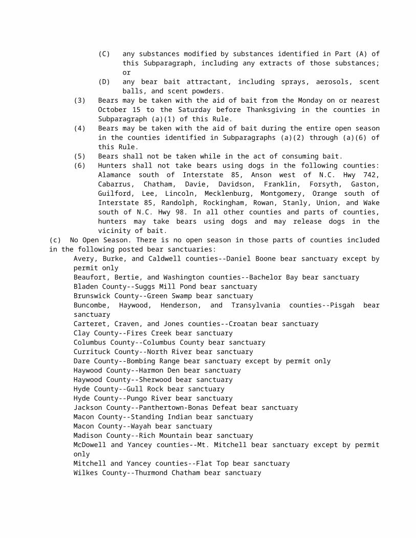
Eff. August 1, 2016.
SECTION .0300 - TRAPPING
15A NCAC 10B .0301 DEFINITIONS As used in this Section, the following definitions apply:
(1) "Breakaway device" means any device incorporated into a snare or snare component that allows the loop to break open, and an animal to escape completely free of the snare, when a specified amount of force is applied.
(2) "Collarum™-type trap" means any power-activated snare that is activated when the trigger is pulled and that is designed to capture and restrain the animal by a cable around the neck.
(3) "Leghold" and "foothold" mean any trap designed to hold an animal by the foot.(4) "Loop stop" means a device that is attached to the snare cable to prevent the loop from closing
beyond a specified point.(5) "Power-activated" means a snare on which the loop closure (speed or direction) is initiated or
augmented by some type of powering device (e.g., a spring).(6) "Relaxing lock" means a snare lock that allows the snare loop to release constriction pressure on the
captured animal when the cable is not taut. (7) "Snare" means any restraining device made from a cable and a locking mechanism.(8) "Steel-jaw" means any leghold or foothold trap in which the jaw(s) are made of metal.
History Note: Authority G.S. 113-134; 113-291.1; 113-291.2; 113-291.6;Eff. January 1, 2011.
15A NCAC 10B .0302 PROHIBITED TAKINGIt is unlawful for any person to trap, take, or have in possession any beaver, mink, muskrat, nutria, opossum, otter, raccoon, skunk, weasel or wildcat (bobcat), except during the open seasons and in accordance with the limits set forth in Rules .0302 and .0303 of this Section or during the open seasons and within the limits prescribed for the particular species under 15A NCAC 10B .0200. Note: See 15A NCAC 10B .0110 as to requirements of tagging and attending traps.
History Note: Authority G.S. 113-134; 113-291.1; 113-291.2;Eff. February 1, 1976;Amended Eff. August 1, 1977;Recodified from Rule 10B .0301 Eff. January 1, 2011.
15A NCAC 10B .0303 OPEN SEASONS(a) General. Following are the seasons for taking by trapping fur-bearing animals as defined in G.S. 113-129(7a), coyotes, armadillos, and groundhogs, all dates being inclusive:
(1) November 1 through the last day of February except for that part of the state described in Subparagraph (2) of this Paragraph.
(2) December 1 through the last day of February in and east of Hertford, Bertie, Martin, Pitt, Greene, Lenoir, Duplin, Pender and New Hanover counties.
(3) Trapping coyotes is allowed during times and with methods described by local laws in counties where local laws have established fox trapping seasons even when those seasons fall outside the regular trapping seasons described above.
(4) Nutria may be trapped east of I-77 at any time.(b) Feral Swine. There is no closed season for trapping feral swine subject to the following restrictions:
(1) In addition to a hunting or trapping license, a permit issued by the Wildlife Resources Commission is required to trap feral swine. Individuals exempted from license requirements under the provisions specified in G.S. 113-276 may trap feral swine without a hunting or trapping license, but must acquire the permit.
(2) Feral swine may be live-trapped using only corral or box traps. Corral and box traps must be constructed in a manner such that a non-target animal can be easily released or can escape without harm. The permit number must be displayed on all traps.
(3) Feral swine must be euthanized while in the trap and may not be removed alive from any trap.
Note: See 15A NCAC 10D .0102(f) for other trapping restrictions on game lands.
History Note: Authority G.S. 113-134; 113-291.1; 113-291.2;Eff. February 1, 1976;Amended Eff. July 1, 1996; July 1, 1984; July 1, 1983; August 1, 1982; August 1, 1981;Temporary Amendment Eff. July 1, 1999;Amended Eff. July 1, 2000;Temporary Amendment Eff. June 1, 2003;Amended Eff. August 1, 2010; May 1, 2009; November 1, 2008; May 1, 2008; May 1, 2007; May 1, 2006; June 1, 2005; August 1, 2004;Recodified from Rule 10B .0302 Eff. January 1, 2011;Temporary Amendment Eff. December 29, 2011;Amended Eff. November 1, 2012.
15A NCAC 10B .0304 BAG LIMITSThere are no restrictions on bag limits of furbearers, coyotes, groundhogs, and feral swine.Note: Where local laws govern trapping, or are in conflict with these regulations, the local law shall prevail.
History Note: Authority G.S. 113-134; 113-291.2;Eff. August 1, 1977;Amended Eff. May 1, 2009; May 1, 2008; June 1, 2005; July 1, 1996; July 1, 1984;Recodified from Rule 10B .0303 Eff. January 1, 2011;Temporary Amendment Eff. December 29, 2011;Amended Eff. November 1, 2012.
15A NCAC 10B .0305 TRAPS (a) A steel-jaw or leghold trap set on dry land with a solid anchor shall not have a chain longer than eight inches unless the chain is fitted with a shock-absorbing device with at least 40 pounds and no more than 75 pounds of pressure to stretch or compress the device. (b) A Collarum™-type trap shall:
(1) Have a cable that is 3/16th inch in diameter, a loop stop with a minimum loop diameter of three inches, a relaxing lock, and a breakaway device that has been tested to break or disassemble at no more than 285 pounds of pull.
(2) Have a set capture loop no less than 10 inches and no greater than 12 inches in diameter. (3) Be equipped with at least one swivel device between the loop and the anchor.(4) Be staked in a manner that does not allow the animal or the restraint device to reach any part of a
fence or reach rooted, woody vegetation greater than ½ inch in diameter.(5) Not be set using a drag or used with a kill pole.
History Note: Authority G.S. 113-134; 113-291.6;Eff. May 1, 2007;Recodified from Rule 10B .0304 Eff. January 1, 2011;Amended Eff. January 1, 2011.
SECTION .0400 - TAGGING FURS
15A NCAC 10B .0401 DEFINITIONSAs used in this Section, the following definitions shall apply:
(1) "Affix", when used in reference to attachment of a fur tag to the carcass or pelt of an animal, means permanent attachment of the tag through some portion of the carcass or pelt in such a manner as not to be removable without damage to the tag;
(2) "Carcass" means the dead body of an animal from which the pelt thereof has not been removed;(3) "Fur dealer" means any person who is licensed under the provisions of Paragraph (f) of Section
113-273 of the General Statutes of North Carolina;
(4) "Pelt" means the fur, hide, or skin of an animal which has been removed from the carcass thereof, but does not include a finished product which has been manufactured from such fur, hide or skin or is in the active process of such manufacture;
(5) "Person" means any individual, firm, corporation or association which is authorized by law to act as an entity.
History Note: Authority G.S. 113-129; 113-134; 113-273; 113-291.4;Eff. November 14, 1978;Amended Eff. January 1, 1992; August 1, 1981; October 1, 1980.
15A NCAC 10B .0402 TAGGING FURS (a) Except as provided in Rule .0404 and .0405 of this Section, it is unlawful to transport or to buy, sell, barter, trade, or otherwise transfer possession or ownership of the carcass or pelt of any bobcat, otter or fox without having affixed to such carcass or pelt an individual tag provided by the North Carolina Wildlife Resources Commission. Each such tag shall bear a serial number. When the U.S. Fish and Wildlife Service repeals its tagging requirements for otter and bobcat this paragraph shall apply only to tagging foxes.(b) It is unlawful for any person to import into this State the carcass or pelt of any otter or bobcat which has not been previously affixed with a tag required and supplied by the state in which the animal was taken. When the U.S. Fish and Wildlife Service repeals its tagging requirements for otter and bobcat this Paragraph shall no longer apply.
History Note: Authority G.S. 113-134; 113-273; 113-276.1; 50 C.F.R. 23; 87 Stat. 884;Eff. November 14, 1978;Amended Eff. August 1, 2010; August 1, 2004; January 1, 1992; October 11, 1980; October 1, 1980.
15A NCAC 10B .0403 APPLICATION FOR TAGS(a) Fur tags shall be distributed in response to applications made on forms supplied by the Commission. (b) The fees to be charged for each fur tag are as follows:
Species Fee Bobcat 2.20Otter 2.20
(c) Foxes shall be tagged in accordance with G.S. 113-291.4(g). The carcasses or pelts of foxes lawfully taken and lawfully tagged in an area of open fox season, and those taken under a depredation permit, and those taken under a local law that permits foxes to be sold may be sold; provided that this Paragraph shall not authorize the sale of carcasses or pelts of foxes taken under a depredation permit in any county in which the sale of foxes or parts thereof is prohibited by local law.
History Note: Authority G.S. 113-134; 113-270.1; 113-273; 113-276.1; 113-291.4;Eff. November 14, 1978;Amended Eff. April 1, 2003; January 1, 1992; August 1, 1988; July 1, 1988; July 1, 1984.
15A NCAC 10B .0404 TRAPPERS AND HUNTERS(a) Every fox taken in an area of open season as provided by G.S. 113-291.4 shall be tagged at the scene of taking.(b) Every person taking any bobcat or otter in this State, or any foxes under a depredation permit, general statute, rule, or local law that permits taking, shall obtain and affix the appropriate tag to each carcass or pelt before selling or transferring the same to any person or transporting the same for any purpose, except that:
(1) A person may transport the same from the place of taking to his North Carolina residence and from his North Carolina residence to a fur tag agent or taxidermist's place of business.
(2) A person may transport the same from the place of taking to the nearest place in this State where the appropriate tag may be obtained.
(3) The carcass, pelt or mounted specimen is exempt from tagging requirements while in the taxidermist's place of business or after the mount is completed.
(4) A licensed trapper may take live foxes during any legal trapping season, except foxes taken under G.S. 113-291.4, without tagging them and sell them to a licensed controlled hunting preserve for fox in accordance with G.S. 113-273(g).
No carcass or pelt of any bobcat, otter or fox taken within this State may be removed from the state without an appropriate fur tag having been affixed thereto, except a licensed taxidermist may ship the same to a tannery for processing. Any carcass or pelt remaining in a person's possession after the end of the season, except those in a licensed taxidermist's place of business or his or her taxidermy preservation facility, shall be properly tagged by him or her within 30 days following the close of such season, provided that no tags shall be shipped from the Commission to a person 23 consecutive days from the close of the season. When the U.S. Fish and Wildlife Service repeals its tagging requirements for otter and bobcat this Paragraph shall apply only to tagging foxes.(c) In any case where the taking of foxes with weapons or traps and the sale thereof is authorized by local legislation, except live foxes taken by licensed trappers who live-trap foxes for sale during any open season, the hunter or trapper taking any such fox shall, in the absence of a specific provision to the contrary, obtain and affix the carcass or pelt with an appropriate tag before selling or transferring the same to any other person, or transporting the same for any purpose than as authorized by Paragraph (a) of this Rule.
History Note: Authority G.S. 113-134; 113-276.1; 113-291.4; S.L. 1985, chs. 108, 179, 180, 664 and 722;Eff. November 14, 1978;Amended Eff. August 1, 2015; August 1, 2010; July 10, 2010; May 1, 2008; July 1, 1994; January 1, 1992; December 1, 1985; October 1, 1980.
15A NCAC 10B .0405 FUR DEALERS(a) It is unlawful for any fur dealer licensed or otherwise authorized to deal in furs in this State, or any person or agent acting in his behalf, to buy or accept delivery from any person the carcass or pelt of any fox taken within the State which has not been previously affixed with a tag provided by the North Carolina Wildlife Resources Commission as required by this Section.(b) It is unlawful for any fur dealer to import into this State the carcass or pelt of any otter or bobcat which has not been previously affixed with a tag required and supplied by the state in which the animal was taken. It is unlawful for any fur dealer, or agent of a fur dealer, to import into this State or to accept delivery of a carcass or pelt of any fox from a source located in any other state which does not by law or regulation require tagging of such carcasses or pelts, or a carcass or pelt of any fox which has not been tagged in accordance with the tagging requirements of the state from which it is imported, unless documentation of the date and hour of the arrival of such carcass or pelt at such fur dealer's place of business is available for inspection and such carcass or pelt is affixed with a fur tag provided by the North Carolina Wildlife Resources Commission within seven days after the date and hour of such arrival. No such carcass or pelt shall be resold or removed from such fur dealer's place of business without having been tagged as required by this Section. When the U.S. Fish and Wildlife Service repeals its tagging requirements for otter and bobcat this Paragraph shall apply only to tagging foxes.(c) Any fur dealer or agent of a fur dealer authorized to do business in this State may import and accept delivery in this State of the carcass or pelt of any bobcat, otter or fox which has been affixed with a tag when and as required by the laws or regulations of the state from which such carcass or pelt is imported. When the U.S. Fish and Wildlife Service repeals its tagging requirements for otter and bobcat this Paragraph shall apply only to tagging foxes.(d) Except as provided by Paragraph (b) of this Rule, it is unlawful for any fur dealer licensed to do business in this State to have in possession the carcass or pelt of any bobcat, otter or fox which has not been affixed with a fur tag provided by the North Carolina Wildlife Resources Commission or a tag required by the laws or regulations of the state from which the same was imported. When the U.S. Fish and Wildlife Service repeals its tagging requirements for otter and bobcat this Paragraph shall apply only to tagging foxes.(e) Each fur dealer licensed to do business in this State shall maintain records of all acquisitions of carcasses and pelts of beaver, bobcat, mink, muskrat, nutria, opossum, otter, raccoon, skunk, weasel, and foxes. Such records shall consist of receipts, copies of receipts, or other written evidence of the transactions showing the sources and numbers of acquisition. Each fur dealer shall provide the Wildlife Resources Commission with monthly reports, made on forms supplied by the Commission, summarizing all acquisitions of carcasses and pelts of such animals, except those which have been acquired from and reported by other fur dealers licensed by the State. The reports shall include all such acquisitions made during each month beginning with October and ending with March of the following year; shall distinguish between acquisitions made within the State and those made from without the State; and, if acquired from within the State, shall indicate the counties in which the animals were taken. The report covering each month shall be mailed or delivered to the Commission on or before the 15th day of the next succeeding month. The records required by this Paragraph and the inventory of carcasses and pelts on hand shall be made available for inspection by any officer or representative of the Wildlife Resources Commission upon request at all reasonable times. In the case of nonresident fur dealers licensed to do business in this State, the records and reports required by this Paragraph apply
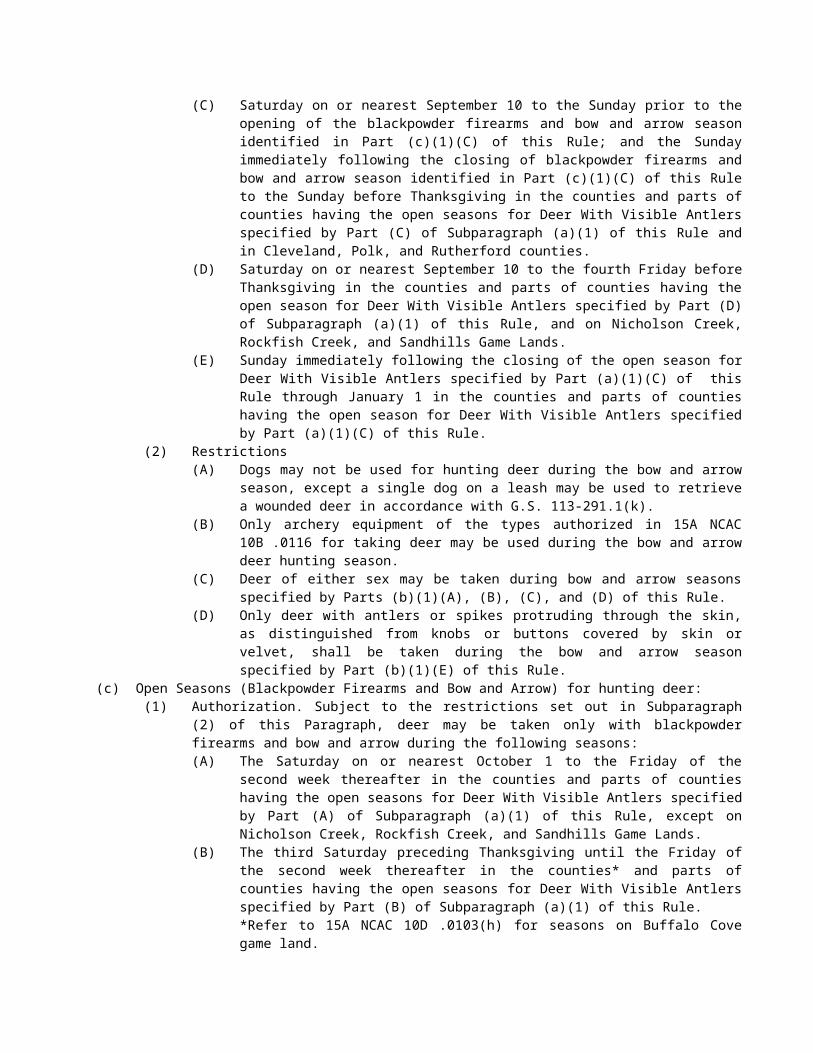
only to carcasses or pelts of animals acquired from within this State, and no reports are required from nonresident fur dealers who acquire pelts only from other fur dealers licensed in the State.(f) The tagging requirements of Paragraph (a) of Rule .0402 of this Section and of Paragraphs (b) and (d) of this Rule do not apply to the pelts or furs of foxes that are imported into this State by a fur dealer operating under a valid North Carolina Fur-Dealer Station License at a fixed place of business or to such pelts or furs delivered to the place of business of such fur dealer by a seller from another state provided that the following conditions are satisfied:
(1) the nonresident seller is a licensed fur dealer in the state from which the pelts or furs originated;(2) the resident dealer has available for inspection a dated, signed bill of sale indicating the precise
number of green pelts and dry pelts of fox purchased in each lot of imported fur; the name, address, and fur dealer license number of the seller; and the date of arrival of the lot of pelts at the licensed place of business;
(3) imported green pelts of fox are kept separate from the green pelts of native fox during processing and are readily identifiable as to imported lot number and bill of sale;
(4) imported dry pelts of fox are not batched with native dry pelts of fox unless such pelts are marked in a manner that readily identifies them as to imported lot number and bill of sale;
(5) such imported, untagged pelts of fox are imported, processed, and stored only for sale and export to buyers in other states; and
(6) such imported, untagged pelts of fox are not held on the premises for longer than 21 days from the date of arrival without having been tagged as required by Rule .0402(a) of this Section.
History Note: Authority G.S. 113-129; 113-134; 113-273; 113-291.3; 113-291.4; 50 C.F.R. 23; 87 Stat. 884;Eff. November 14, 1978;Amended Eff. August 1, 2010; January 1, 1992; December 1, 1981; August 1, 1981; February 2, 1981.
15A NCAC 10B .0406 MISUSE OF TAGS(a) It is unlawful for any person to affix any fur tag to the carcass or pelt of any species of animal other than that for which its use is authorized and it is unlawful to buy or sell any bobcat, otter, or fox carcass or pelt which has an unauthorized tag so affixed. When the U.S. Fish and Wildlife Service repeals its tagging requirements for otter and bobcat this Paragraph shall apply only to tagging foxes.(b) It is unlawful for any person to sell or transfer any unused fox tag to any other person. It is unlawful for any person to sell any unused fur tag for a price greater than the fee listed for such tag in Paragraph (c) of Rule .0403 of this Section.(c) It is unlawful for any person to reuse a fur tag or to remove the same from the pelt to which affixed prior to delivery to a manufacturer or fur processor.(d) It is unlawful to counterfeit or modify any fur tag.
History Note: Authority G.S. 113-134; 113-135; 113-135.1; 113-273; 113-276.1; 113-291.4;Eff. November 14, 1978;Amended Eff. August 1, 2017; August 1, 2010; January 1, 1992; December 1, 1981; October 1, 1980.
15A NCAC 10B .0407 REVOCATION AND NONRENEWAL OF LICENSES
History Note: Authority G.S. 113-134; 113-276.2; 113-276.3; 113-277;Eff. October 1, 1980;Repealed Eff. July 1, 1988.
15A NCAC 10B .0408 FOX DEALER PERMIT
History Note: Authority G.S. 113-134; 113-274; 113-291.3; 113-291.4;Eff. November 1, 1982;Repealed Eff. July 1, 1988.
15A NCAC 10B .0409 SALE OF LIVE FOXES AND COYOTES TO CONTROLLED FOX HUNTING PRESERVES
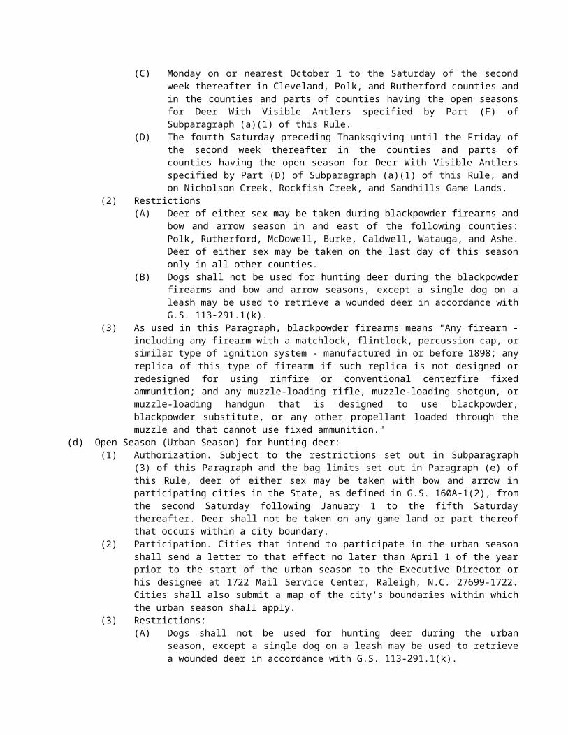
Licensed trappers may, subject to the restrictions on taking foxes in G.S.113- 291.4, live-trap foxes and coyotes during any open trapping season for foxes and coyotes, and sell them to licensed controlled fox hunting preserves in accordance with the following conditions:
(1) Licensed trappers are exempt from caging, captivity permit or captivity license requirements set forth in 15A NCAC 10H .0300 for any live-trapped foxes or coyotes trapped for the purpose of sale to controlled hunting preserves. This exemption shall apply during the trapping season and for a period of 10 days after the trapping season.
(2) Licensed trappers are exempt from tagging requirements set forth in this Section so long as the foxes are kept alive.
History Note: Authority G.S. 113-134; 113-273(g);113-291.4;Eff. January 1, 1992;Amended Eff. July 10, 2010; June 1, 2004.
SUBCHAPTER 10C - INLAND FISHING REGULATIONS
SECTION .0100 - JURISDICTION OF AGENCIES: CLASSIFICATION OF WATERS
15A NCAC 10C .0101 SCOPE AND PURPOSEThe following rules pertain to the classification of the waters of North Carolina as coastal fishing waters, inland fishing waters and joint fishing waters. These rules are adopted jointly by the Marine Fisheries Commission and the Wildlife Resources Commission. In addition to the classification of the waters of the state these joint rules set forth guidelines to determine which fishing activities in joint waters are regulated by the Marine Fisheries Commission and which are regulated by the Wildlife Resources Commission. Finally, the joint rules set forth special fishing regulations applicable in joint waters that can be enforced by officers of the division of marine fisheries and the Wildlife Resources Commission. These regulations do not affect the jurisdiction of the Marine Fisheries Commission and the Wildlife Resources Commission in any matters other than those specifically set out.
History Note: Authority G.S. 113-134; 113-132; 113-136;Eff. February 1, 1976;Amended Eff. January 1, 1977.
15A NCAC 10C .0102 INLAND FISHING WATERSInland fishing waters are all inland waters except private ponds; and all waters connecting with or tributary to coastal sounds or the ocean extending inland from the dividing line between coastal fishing waters and inland fishing waters agreed upon by the Marine Fisheries Commission and the Wildlife Resources Commission. All waters which are tributary to inland fishing waters and which are not otherwise designated by agreement between the Marine Fisheries Commission and the Wildlife Resources Commission are inland fishing waters. The regulation and licensing of fishing in inland fishing waters is under the jurisdiction of the Wildlife Resources Commission. Regulations and laws administered by the Wildlife Resources Commission regarding fishing in inland fishing waters are enforced by wildlife enforcement officers. Note: A private pond is a body of water arising within and lying wholly upon the lands of a single owner or a single group of joint owners or tenants in common, and from which fish cannot escape, and into which fish of legal size cannot enter from public waters at any time. This does not include any impoundment located on land owned by a public body or governmental entity.
History Note: Authority G.S. 113-134; 113-129; 113-132;Eff. February 1, 1976;Amended Eff. January 1, 1977.
15A NCAC 10C .0103 COASTAL FISHING WATERSCoastal fishing waters are the Atlantic Ocean, the various coastal sounds, and estuarine waters up to the dividing line between coastal fishing waters and inland fishing waters agreed upon by the Marine Fisheries Commission and the Wildlife Resources Commission. All waters which are tributary to coastal fishing waters and which are not otherwise
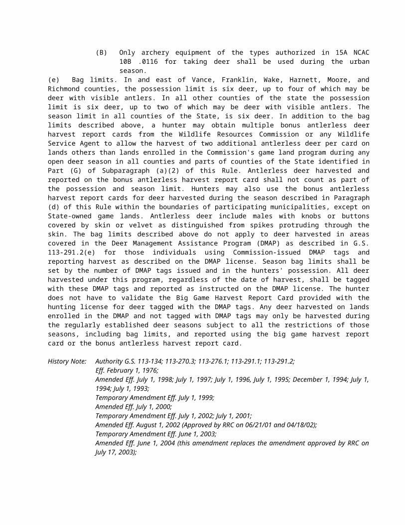
designated by agreement between the Marine Fisheries Commission and the Wildlife Resources Commission are coastal fishing waters. The regulations and licensing of fishing in coastal fishing waters is under the jurisdiction of the Marine Fisheries Commission; except that inland game fish (exclusive of spotted sea trout, red drum, flounder, white perch, yellow perch, weakfish, and striped bass) are subject to regulations by the Wildlife Resources Commission in coastal fishing waters. Regulations and laws administered by the Marine Fisheries Commission regarding fishing in coastal waters are enforced by marine fisheries inspectors. Regulations regarding inland game fish in coastal waters are enforced by wildlife protectors unless otherwise agreed to by the Wildlife Resources Commission.
History Note: Authority G.S. 113-129; 113-132; 113-134; 113-292;Eff. February 1, 1976;Amended Eff. July 1, 1991; January 1, 1977.
15A NCAC 10C .0104 JOINT FISHING WATERSJoint fishing waters are those coastal fishing waters, hereinafter set out, denominated by agreement of the Marine Fisheries Commission and the Wildlife Resources Commission pursuant to G.S. 113-132(e) as joint fishing waters. All waters which are tributary to joint fishing waters and which are not otherwise designated by agreement between the Marine Fisheries Commission and the Wildlife Resources Commission are classified as joint fishing waters. The regulation and licensing of fishing in joint waters shall be as stated in 15A NCAC 10C .0106.
History Note: Authority G.S. 113-132; 113-134; 113-292;Eff. February 1, 1976;Amended Eff. January 1, 1977.
15A NCAC 10C .0105 POSTING DIVIDING LINESThe dividing lines of all major bodies of water and watercourses which are divided by the agreement of the Marine Fisheries Commission and the Wildlife Resources Commission so that portions of the same are constituted inland fishing waters, coastal fishing waters, or joint fishing waters shall be marked with signs insofar as may be practicable. Unmarked and undesignated tributaries shall have the same classification as the designated waters to which they connect or into which they flow. No unauthorized removal or relocation of any such marker shall have the effect of changing the classification of any body of water or portion thereof, nor shall any such unauthorized removal or relocation or the absence of any marker affect the applicability of any regulations pertaining to any such body of water or portion thereof.
History Note: Authority G.S. 113-132; 113-134;Eff. January 1, 1977.
15A NCAC 10C .0106 APPLICABILITY OF REGULATIONS: JOINT WATERS(a) All coastal fishing laws and regulations administered by the Department of Environment, Health, and Natural Resources and the Marine Fisheries Commission apply to joint waters except as otherwise provided, and shall be enforced by fisheries enforcement officers.(b) The following inland fishing laws and regulations administered by the Wildlife Resources Commission apply to joint waters and shall be enforced by wildlife enforcement officers:
(1) all laws and regulations pertaining to inland game fishes,(2) all laws and regulations pertaining to inland fishing license requirements for hook and line fishing,(3) all laws and regulations pertaining to hook and line fishing except as hereinafter provided.
History Note: Authority G.S. 113-132; 113-134; 113-271; 113-275; 113-292;Eff. January 1, 1977;Amended Eff. April 1, 1990; April 15, 1979.
15A NCAC 10C .0107 SPECIAL REGULATIONS: JOINT WATERSIn order to effectively manage all fisheries resources in joint waters and in order to confer enforcement powers on both fisheries enforcement officers and wildlife enforcement officers with respect to certain rules, the Marine Fisheries Commission and the Wildlife Resources Commission deem it necessary to adopt special rules for joint waters. Such rules supersede any inconsistent rules of the Marine Fisheries Commission or the Wildlife Resources Commission that would otherwise be applicable in joint waters under the provisions of 15A NCAC 10C .0106:
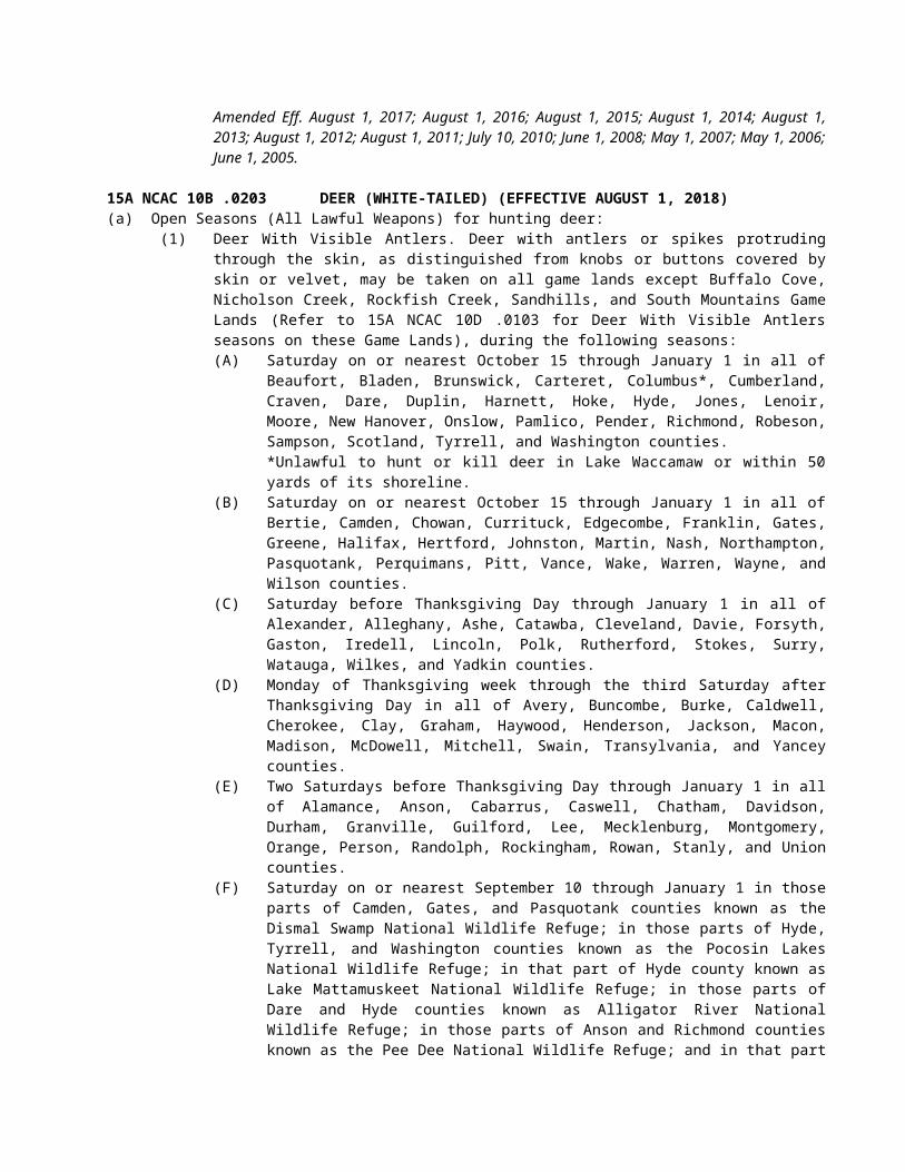
(1) Striped Bass(a) It is unlawful to possess any striped bass or striped bass hybrid that is less than 18 inches
long (total length).(b) It is unlawful to possess striped bass or striped bass hybrids between the lengths of 22 and
27 inches (total length) in joint fishing waters of the Central Southern Management Area as designated in 15A NCAC 03R .0201.
(c) It is unlawful to possess striped bass or striped bass hybrids May through September in the joint fishing waters of the Central Southern Management Area and the Albemarle Sound Management Area.
(d) It is unlawful to possess striped bass or striped bass hybrids taken from the joint fishing waters of the Cape Fear River.
(e) It is unlawful to possess more than one daily creel limit of striped bass or striped bass hybrids, in the aggregate, per person per day, regardless of the number of management areas fished.
(f) Possession of fish shall be assessed for the creel and size limits of the management area in which the individual is found to be fishing, regardless of the size or creel limits for other management areas visited by that individual in a given day.
(g) It is unlawful to engage in net fishing for striped bass or their hybrids in joint waters except as authorized by rules of the Marine Fisheries Commission.
(2) Lake Mattamuskeet(a) It is unlawful to set or attempt to set any gill net in Lake Mattamuskeet canals designated as
joint waters.(b) It is unlawful to use or attempt to use any trawl net or seines in Lake Mattamuskeet canals
designated as joint waters.(3) Cape Fear River. It is unlawful to use or attempt to use any net, net stakes or electrical fishing
device within 800 feet of the dam at Lock No. 1 on the Cape Fear River.(4) Shad: It is unlawful to possess more than 10 American shad or hickory shad, in the aggregate, per
person per day taken by hook-and-line.
History Note: Authority G.S. 113-132; 113-134; 113-138; 113-292;Eff. January 1, 1977;Amended Eff. July 1, 2008; May 1, 2005; August 1, 2000; July 1, 1993; November 1, 1991; January 1, 1991; August 1, 1985.
15A NCAC 10C .0108 SPECIFIC CLASSIFICATION OF WATERSThe several sounds and estuarine and tributary waters all or portions of which are specifically classified as inland, joint, or coastal fishing waters by agreement of the Marine Fisheries Commission and the Wildlife Resources Commission are listed in the regulations of the Marine Fisheries Commission under 15A NCAC 3Q .0200 and such list and classification is incorporated herein by reference, shall include any later amendments, and is made a part of this Section to the same extent as if the same were fully set forth herein.
History Note: Authority G.S. 113-129; 113-132; 113-134; 150B-14;Eff. January 1, 1977;Amended Eff. July 1, 1993; January 1, 1981; January 1, 1978.
15A NCAC 10C .0109 PROTECTION OF SEA TURTLESPursuant to a cooperative agreement entered into on the fifth day of February, 1979, by the Department of Environment, Health, and Natural Resources, the Marine Fisheries Commission, and the Wildlife Resources Commission, the Wildlife Resources Commission will exercise regulatory jurisdiction over any species of sea turtles, and their eggs and nests, consistent with designation of such species as endangered or threatened by the U.S. Fish and Wildlife Service. As provided by said agreement, the law enforcement officers of both the Marine Fisheries Commission and the Wildlife Resources Commission have jurisdiction to enforce any state laws and regulations, including those contained in 15A NCAC 10I, relating to endangered or threatened species of sea turtles and their eggs and nests.
History Note: Authority G.S. 113-132; 113-134; 113-138; 113-181; 113-182; 113-224; 113-305;
Eff. April 29, 1979;Amended Eff. April 1, 1990.
15A NCAC 10C .0110 MANAGEMENT RESPONSIBILITY FOR ESTUARINE STRIPED BASS IN JOINT WATERS(a) The management areas for estuarine striped bass fisheries in coastal North Carolina are designated in 15A NCAC 03R .0201.(b) In order to effectively manage the recreational hook and line harvest in joint waters of the Albemarle Sound-Roanoke River stock of striped bass, the Marine Fisheries Commission and the Wildlife Resources Commission deem it necessary to establish two management areas: the Albemarle Sound Management Area and the Roanoke River Management Area as designated in 15A NCAC 03R .0201. The Wildlife Resources Commission shall have principal management responsibility for the stock when it is in the joint and inland fishing waters of the Roanoke River Management Area. The Marine Fisheries Commission shall have principal management responsibility for the stock in the coastal, joint and inland waters of the Albemarle Sound Management Area. The annual quota for recreational harvest of the Albemarle Sound-Roanoke River striped bass stock shall be divided equally between the two management areas. Each Commission shall implement management actions for recreational harvest within their respective management areas that shall be consistent with the North Carolina Estuarine Striped Bass Fishery Management Plan.
History Note: Authority G.S. 113-132; 113-134; 113-138; 113-292;Eff. January 1, 1991;Amended Eff. June 1, 2005.
15A NCAC 10C .0111 IMPLEMENTATION OF ESTUARINE STRIPED BASS MANAGEMENT PLANS: RECREATIONAL FISHINGThe Marine Fisheries and Wildlife Resources Commissions shall implement their respective striped bass management plans for recreational fishing pursuant to their respective rulemaking powers. To preserve jurisdictional authority of each Commission, the following means are established through which management measures can be implemented by a single instrument in the following management areas:
(1) In the Roanoke River Management Area, the exclusive authority to open and close seasons and areas and establish size and creel limits, whether inland or joint fishing waters, shall be vested in the Wildlife Resources Commission. An instrument closing any management area in joint waters shall operate as a jointly issued instrument opening or closing seasons or areas to harvest in the Roanoke River Management Area.
(2) In the Albemarle Sound Management Area, the exclusive authority to open and close seasons and areas and establish size and creel limits, whether coastal or joint fishing waters shall be vested in the Marine Fisheries Commission. The season shall close by Marine Fisheries Commission proclamation if the quota is about to be exceeded. In the Albemarle Sound Management Area administered by the Marine Fisheries Commission, a proclamation affecting the harvest in joint and coastal waters, excluding the Roanoke River Management Area shall automatically be implemented and effective as a Wildlife Resources Commission action in the inland waters and tributaries to the waters affected.
History Note: Authority G.S. 113-132; 113-134; 113-138; 113-292;Eff. January 1, 1991;Amended Eff. June 1, 2005.
SECTION .0200 - GENERAL REGULATIONS
15A NCAC 10C .0201 IDENTIFICATIONIt is unlawful to fish without having on one's person a means of identification indicating the current residence of such person.
History Note: Authority G.S. 113-134; 113-276.1;Eff. February 1, 1976.
15A NCAC 10C .0202 FISHING LICENSE REQUIREMENTS
History Note: Authority G.S. 113-132; 113-134;Eff. February 1, 1976;Repealed Eff. July 1, 1988.
15A NCAC 10C .0203 RECIPROCAL LICENSE AGREEMENTS(a) Virginia. In accordance with a reciprocal license agreement between the States of Virginia and North Carolina, all valid licenses and permits authorizing sport fishing and legally obtained from the Virginia Department of Game and Inland Fisheries or the North Carolina Wildlife Resources Commission, or the duly authorized agents of either, shall be reciprocally honored for fishing by means of rod and reel, hook and line, casting, or trotline in the Dan River east of the Union Street Dam at Danville, and east of the mouth of Difficult Creek on the Staunton River arm of Kerr Reservoir to the Gaston Dam on the Roanoke River, including all tributary waters lying in either Virginia or North Carolina that are accessible by boat from the main bodies of the Kerr and Gaston Reservoirs, or from the Island Creek subimpoundment. Senior citizen and juvenile license exemptions authorized by either state shall be honored by both states. In addition, all valid fishing licenses and permits legally obtained from the Virginia Department of Game and Inland Fisheries or the North Carolina Wildlife Resources Commission, or the duly authorized agents of either, shall be reciprocally honored for fishing with rod and reel, hook and line, or by casting in that portion of the New River between the confluence of the North and South forks of the New River in North Carolina (Alleghany County) and the confluence of the New and Little Rivers in Virginia (Grayson County).(b) Georgia. In accordance with a reciprocal license agreement between the States of North Carolina and Georgia, all valid statewide fishing licenses, permits, and license exemptions required by and legally obtained from the North Carolina Wildlife Resources Commission or the Georgia Department of Natural Resources, or duly authorized agents of either, shall be reciprocally honored for the purposes of fishing with hook and line in all of Chatuge Reservoir including all tributary waters lying in either Georgia or North Carolina that are accessible by boat from the main body of Chatuge Reservoir. All persons fishing in the waters of Chatuge Reservoir beyond the bounds of the state from which they hold a valid fishing license, shall be authorized to fish with said license only from boats not anchored to the shore or to a pier or boat dock connecting to the shore.(c) Tennessee. In accordance with a reciprocal license agreement between the States of North Carolina and Tennessee, all valid statewide fishing licenses obtained from the North Carolina Wildlife Resources Commission or the Tennessee Wildlife Resources Agency, or the duly authorized agents of either, shall be reciprocally honored for the purposes of fishing with hook and line or fishing in designated mountain trout waters, in that portion of Slick Rock Creek that coincides with the state line between North Carolina and Tennessee and in all of Calderwood Reservoir.
History Note: Authority G.S. 113-134; 113-275; 113-304;Eff. February 1, 1976;Amended Eff. August 1, 2017; August 1, 2014; July 1, 1998; July 1, 1995; July 1, 1991.
15A NCAC 10C .0204 DRAINING IMPOUNDED PUBLIC WATERS
History Note: Authority G.S. 113-134; 113-274;Eff. February 1, 1976;Repealed Eff. July 1, 1988.
15A NCAC 10C .0205 PUBLIC MOUNTAIN TROUT WATERS (EFFECTIVE UNTIL JULY 31, 2018)(a) For purposes of this Rule, the following definitions apply:
(1) "Natural bait" means any living or dead organism (plant or animal), or parts thereof, or prepared substances designed to attract fish by the sense of taste or smell.
(2) "Artificial lure" means a fishing lure that neither contains nor has been treated by any substance that attracts fish by the sense of taste or smell.
(3) "Youth anglers" are individuals under 18 years of age.(b) For purposes of this Rule, 15A NCAC 10C .0316, and 15A NCAC 10D .0104, the following classifications apply:
(1) "Public Mountain Trout Waters" are all waters included in this Rule and so designated in 15A NCAC 10D .0104.
(2) "Catch and Release/Artificial Flies Only Trout Waters" are Public Mountain Trout Waters where only artificial flies having one single hook may be used. No trout may be possessed or harvested while fishing these streams. Waters designated as such include tributaries unless otherwise noted.
(3) "Catch and Release/Artificial Lures Only Trout Waters" are Public Mountain Trout Waters where only artificial lures having one single hook may be used. No trout may be possessed or harvested while fishing these streams. Waters designated as such include tributaries unless otherwise noted.
(4) "Delayed Harvest Trout Waters" are Public Mountain Trout Waters where between October 1 and one-half hour after sunset on the Friday before the first Saturday of the following June it is unlawful to possess natural bait, use more than one single hook on an artificial lure, or harvest or possess trout while fishing. From 6:00 a.m. on the first Saturday in June until noon that same day only youth anglers may fish and these waters have no bait or lure restrictions. From noon on the first Saturday in June until October 1 anglers of all ages may fish and these waters have no bait or lure restrictions. Waters designated as such do not include tributaries unless otherwise noted.
(5) "Hatchery Supported Trout Waters" are Public Mountain Trout Waters that have no bait or lure restrictions. Waters designated as such do not include tributaries unless otherwise noted.
(6) "Special Regulation Trout Waters" are Public Mountain Trout Waters where watercourse-specific regulations apply. Waters designated as such do not include tributaries unless otherwise noted.
(7) "Wild Trout Waters" are Public Mountain Trout Waters which are identified as such in this Rule or 15A NCAC 10D .0104. Only artificial lures having only one single hook may be used. No person shall possess natural bait while fishing these waters. Waters designated as such do not include tributaries unless otherwise noted.
(8) "Wild Trout Waters/Natural Bait" are Public Mountain Trout Waters where all artificial lures and natural baits, except live fish, may be used provided they are fished using only one single hook. Waters designated as such include tributaries unless otherwise noted.
(9) "Undesignated Waters" are all other waters in the State. These waters have no bait or lure restrictions. Trout may not be possessed while fishing these waters from March 1 until 7:00 a.m. on the first Saturday in April.
(c) Seasons, creel and size limits. Seasons, creel and size limits for trout in all waters are listed in Rule .0316 of this Subchapter.(d) Classifications. This Paragraph designates waters in each county that have a specific classification. Waters on game lands are so designated in 15A NCAC 10D .0104, unless otherwise indicated in this Paragraph. All other waters are classified as Undesignated Waters.
(1) Alleghany(A) Delayed Harvest Trout Waters are as follows:
Little River (S.R. 1133 bridge to 275 yards downstream of the intersection of S.R. 1128 and S.R. 1129 [marked by a sign on each bank])
(B) Hatchery Supported Trout Waters are as follows:Big Pine CreekBledsoe CreekBrush Creek (N.C. 21 bridge to confluence with Little River, except where posted against trespassing)Cranberry Creek(Big) Glade CreekLittle River (275 yards downstream from the intersection of S.R. 1128 and S.R. 1129 [marked by a sign on each bank] to McCann Dam)Meadow ForkPine Swamp CreekPiney ForkPrathers Creek
(C) Wild Trout Waters are as follows:All waters located on Stone Mountain State Park
(2) Ashe County(A) Catch and Release/Artificial Lures Only Trout Waters are as follows:
Big Horse Creek (Virginia state line to Mud Creek at S.R. 1363, excluding tributaries)(B) Delayed Harvest Trout Waters are as follows:
Big Horse Creek (S.R. 1324 bridge to North Fork New River)
Helton Creek (Virginia state line to New River)South Fork New River (upstream end of Todd Island to the SR 1351 bridge)Trout Lake
(C) Hatchery Supported Trout Waters are as follows:Beaver Creek (N.C. 221 to South Fork New River)Big Horse Creek (Mud Creek at S.R. 1363 to S.R. 1324 bridge)Big Laurel Creek (S.R. 1315 bridge to confluence with North Fork New River)Buffalo Creek (S.R. 1133 bridge to N.C. 194-88 bridge)Cranberry Creek (Alleghany Co. line to South Fork New River)Nathans CreekNorth Fork New River (Watauga Co. line to Sharp Dam)Old Fields Creek (N.C. 221 to South Fork New River)Peak Creek (headwaters to Trout Lake, except Blue Ridge Parkway waters)Roan CreekThree Top Creek
(3) Avery County(A) Catch and Release/Artificial Flies Only Trout Waters are as follows:
Elk River (portion on Lees-McRae College property, excluding the millpond)Lost Cove Creek (game land portion, excluding Gragg Prong and Rockhouse Creek)
(B) Catch and Release/Artificial Lures Only Trout Waters are as follows:Wilson Creek (game land portion)
(C) Hatchery Supported Trout Waters are as follows:Boyde Coffey LakeElk River (S.R. 1305 crossing immediately upstream of Big Falls to the Tennessee state line)Linville River (Land Harbor line [below dam] to the Blue Ridge Parkway boundary line, except where posted against trespassing)Milltimber CreekNorth Toe River — upper (Watauga St. to Roby Shoemaker Wetlands and Family Recreational Park, except where posted against trespassing)North Toe River — lower (S.R. 1164 to Mitchell Co. line, except where posted against trespassing)Squirrel CreekWildcat Lake
(D) Wild Trout Waters are as follows:Birchfield CreekCow Camp CreekCranberry Creek (headwaters to U.S. 19E/N.C. 194 bridge)Gragg ProngHorse CreekKentucky CreekNorth Harper CreekPlumtree CreekRoaring CreekRockhouse CreekShawneehaw Creek (portion adjacent to Banner Elk Greenway)South Harper CreekWebb Prong
(4) Buncombe County(A) Catch and Release/Artificial Lures Only Trout Waters are as follows:
Carter Creek (game land portion)(B) Hatchery Supported Trout Waters are as follows:
Bent Creek (headwaters to N.C. Arboretum boundary line)Cane Creek (headwaters to S.R. 3138 bridge)Corner Rock Creek (Little Andy Creek to confluence with Walker Branch)Dillingham Creek (Corner Rock Creek to Ivy Creek)
Ivy Creek (Ivy River) (Dillingham Creek to U.S. 19-23 bridge)Lake PowhatanReems Creek (Sugar Camp Fork to U.S. 19-23 bridge, except where posted against trespassing)Rich Branch (downstream from the confluence with Rocky Branch)Stony CreekSwannanoa (S.R. 2702 bridge near Ridgecrest to Wood Avenue bridge [intersection of N.C. 81 and U.S. 74A in Asheville], except where posted against trespassing)
(5) Burke County(A) Catch and Release/Artificial Lures Only Trout Waters are as follows:
Henry Fork (portion on South Mountains State Park)(B) Delayed Harvest Trout Waters are as follows:
Jacob Fork (Shinny Creek to lower South Mountains State Park boundary)(C) Hatchery Supported Trout Waters are as follows:
Carroll Creek (game land portion above S.R. 1405)Henry Fork (lower South Mountain State Park line downstream to S.R. 1919 at Ivy Creek)Linville River portion within Linville Gorge Wilderness area and portion below Lake James powerhouse from upstream bridge on S.R. 1223 to Muddy Creek)
(D) Special Regulation Trout Waters are as follows:Catawba River (Muddy Creek to City of Morganton water intake dam)
(E) Wild Trout Waters are as follows:All waters located on South Mountains State Park, except those waters identified in parts A and B of this Subparagraph
(6) Caldwell County(A) Delayed Harvest Trout Waters are as follows:
Wilson Creek (game land portion below Lost Cove Creek to Philips Branch)(B) Hatchery Supported Trout Waters are as follows:
Boone Fork PondBuffalo Creek (mouth of Joes Creek to McCloud Branch)Joes Creek (first falls upstream of S.R. 1574 to confluence with Buffalo Creek)Wilson Creek (Phillips Branch to Brown Mountain Beach Dam, except where posted against trespassing)Yadkin River (Happy Valley Ruritan Community Park to S.R. 1515)
(C) Wild Trout Waters are as follows:Buffalo Creek (Watauga Co. line to Long Ridge Branch including game land tributaries)Joes Creek (Watauga Co. line to first falls upstream of the end of S.R. 1574)Rockhouse Creek
(7) Cherokee County(A) Hatchery Supported Trout Waters are as follows:
Davis Creek (confluence of Bald and Dockery creeks to Hanging Dog Creek)Hyatt Creek (Big Dam Branch to Valley River)Junaluska Creek (Ashturn Creek to Valley River)Shuler Creek (Joe Brown Hwy [S.R. 1325] bridge to Tennessee state line)Valley River (S.R. 1359 to U.S. 19 Business bridge in Murphy)
(B) Wild Trout Waters/Natural Bait are as follows:Bald Creek (game land portion)Dockery Creek (game land portion)North Shoal Creek (game land portion)
(8) Clay County(A) Delayed Harvest Trout Waters are as follows:
Fires Creek (USFS Rd. 340A to the foot bridge in the USFS Fires Creek Picnic Area)(B) Hatchery Supported Trout Waters are as follows:
Buck Creek (game land portion downstream of U.S. 64 bridge)Fires Creek (foot bridge in the USFS Fires Creek Picnic Area to S.R. 1300)Tusquitee Creek (Compass Creek to lower S.R. 1300 bridge)
(9) Graham County
(A) Delayed Harvest Trout Waters are as follows:(Big) Snowbird Creek (USFS footbridge at the old railroad junction to USFS Rd. 2579)
(B) Hatchery Supported Trout Waters are as follows:Calderwood Reservoir (Cheoah Dam to Tennessee state line)Cheoah ReservoirPanther Creek (confluence of Stand Creek and Rock Creek to Lake Fontana)Santeetlah Creek (Johns Branch to Lake Santeetlah)(Big) Snowbird Creek (USFS Road 2579 to S.R. 1127 bridge)Stecoah Creek (upper game land boundary to Lake Fontana)Tulula Creek (S.R. 1201 to lower bridge on S.R. 1275)West Buffalo CreekYellow Creek (Lake Santeetlah hydropower pipeline to Cheoah River)
(C) Wild Trout Waters are as follows:Little Buffalo CreekSouth Fork Squally CreekSqually Creek
(D) Wild Trout Waters/Natural Bait are as follows:Deep CreekFranks CreekLong Creek (game land portion)
(10) Haywood County(A) Delayed Harvest Trout Waters are as follows:
West Fork Pigeon River (Queen Creek to the first game land boundary upstream of Lake Logan)
(B) Hatchery Supported Trout Waters are as follows:Cold Springs Creek (Fall Branch to Pigeon River)Jonathan Creek (upstream S.R. 1302 bridge to Pigeon River, except where posted against trespassing)Pigeon River (Stamey Cove Branch to upstream U.S. 19-23 bridge)Richland Creek (Russ Avenue [U.S. 276] bridge to U.S. 19 bridge)West Fork Pigeon River (Tom Creek to Queen Creek, including portions on game lands, except Middle Prong)
(C) Wild Trout Waters/Natural Bait are as follows:Hemphill CreekHurricane Creek
(11) Henderson County(A) Delayed Harvest Trout Waters are as follows:
North Fork Mills River (game land portion below the Hendersonville watershed dam)(B) Hatchery Supported Trout Waters are as follows:
(Rocky) Broad River (end of S.R. 1611 to Rutherford County line)Cane Creek (railroad bridge upstream of S.R. 1551 bridge to U.S. 25 bridge)Clear Creek (Laurel Fork to S.R. 1582)Green River (Lake Summit powerhouse to game land boundary)(Big) Hungry River
(12) Jackson County(A) Catch and Release/Artificial Lures Only Trout Waters are as follows:
Flat CreekTuckasegee River (upstream from the Clark property)
(B) Delayed Harvest Trout Waters are as follows:Tuckasegee River (downstream N.C. 107 bridge to the falls located 275 yards upstream of the U.S. 23-441 bridge [marked by a sign on each bank])
(C) Hatchery Supported Trout Waters are as follows:Balsam LakeBear Creek LakeCedar Cliff LakeCullowhee Creek (Tilley Creek to Tuckasegee River)
Dark Ridge Creek (Jones Creek to Scott Creek)Greens Creek (Greens Creek Baptist Church on S.R. 1370 to Savannah Creek)Savannah Creek (Shell Branch to Cagle Branch)Scott Creek (Dark Ridge Creek to Tuckasegee River, except where posted against trespassing)Tanasee Creek LakeTuckasegee River — upper (John Brown Branch to the downstream N.C. 107 bridge)Tuckasegee River — lower (falls located 275 yards upstream of U.S. 23-441 bridge [marked by a sign on each bank] to S.R. 1534 bridge at Wilmot)Wolf Creek Lake
(D) Wild Trout Waters are as follows:Gage CreekNorth Fork Scott CreekTanasee CreekWhitewater River (downstream from Silver Run Creek to South Carolina state line)Wolf Creek (except Balsam Lake and Wolf Creek Lake)
(E) Wild Trout Waters/Natural Bait are as follows:Buff CreekChattooga River (S.R. 1100 bridge to the South Carolina state line)Lower Fowler Creek (game land portion)Scotsman Creek (game land portion)
(13) Macon County(A) Delayed Harvest Trout Waters are as follows:
Nantahala River (Whiteoak Creek to Nantahala hydropower discharge canal)(B) Hatchery Supported Trout Waters are as follows:
Burningtown Creek (Left Prong to Little Tennessee River)Cartoogechaye Creek (downstream U.S. 64 bridge to Little Tennessee River)Cliffside LakeCullasaja River (Sequoyah Dam to U.S. 64 bridge near junction of S.R. 1672)Nantahala River — upper (Dicks Creek to Whiteoak Creek)Nantahala River — lower (Nantahala hydropower discharge canal to Swain Co. line)Queens Creek Lake
(C) Wild Trout Waters/Natural Bait are as follows:Chattooga River (S.R. 1100 bridge to South Carolina state line)Jarrett Creek (game land portion)Kimsey CreekOverflow Creek (game land portion)Park CreekTellico Creek (game land portion)Turtle Pond Creek (game land portion)
(14) Madison County(A) Delayed Harvest Trout Waters are as follows:
Big Laurel Creek (N.C. 208 bridge to the U.S. 25-70 bridge)Shelton Laurel Creek (N.C. 208 bridge at Belva to the confluence with Big Laurel Creek)Spring Creek (N.C. 209 bridge at Hot Springs city limits to iron bridge at end of Andrews Ave.)
(B) Hatchery Supported Trout Waters are as follows:Big Laurel Creek (Mars Hill watershed boundary to the S.R. 1318 [Big Laurel Rd.] bridge downstream of Bearpen Branch)Big Pine Creek (S.R. 1151 bridge to French Broad River)Little Ivy Creek (confluence of Middle Fork and Paint Fork at Beech Glen to confluence with Ivy Creek at Forks of Ivy)Max Patch PondMeadow Fork Creek (S.R. 1165 to Spring Creek)Puncheon Fork (Hampton Creek to Big Laurel Creek)Roaring Fork (Fall Branch to Meadow Fork)
Shelton Laurel Creek (confluence of Big Creek and Mill Creek to N.C. 208 bridge at Belva)Shut-in CreekSpillcorn CreekSpring Creek (junction of N.C. 209 and N.C. 63 to USFS Rd. 223)West Fork Shut-in Creek (lower game land boundary to confluence with East Fork Shut-in Creek)
(C) Wild Trout Waters/Natural Bait are as follows:Big Creek (headwaters to the lower game land boundary)
(15) McDowell County(A) Catch and Release/Artificial Lures Only Trout Waters are as follows:
Newberry Creek (game land portion)(B) Delayed Harvest Trout Waters are as follows:
Catawba River (portion adjacent to Marion Greenway)Curtis Creek (game land portion downstream of the USFS boundary at Deep Branch)Mill Creek (U.S. 70 bridge to I-40 bridge)
(C) Hatchery Supported Trout Waters are as follows:Armstrong Creek (Cato Holler line downstream to upper Greenlee line)Catawba River (Catawba Falls Campground to Old Fort Recreation Park)Little Buck Creek (game land portion)Mill Creek (upper railroad bridge to U.S. 70 bridge, except where posted against trespassing)North Fork Catawba River (headwaters to North Cove School at S.R. 1569 bridge)
(16) Mitchell County(A) Delayed Harvest Trout Waters are as follows:
Cane Creek (N.C. 226 bridge to S.R. 1189 bridge)North Toe River (U.S. 19E bridge to N.C. 226 bridge)
(B) Hatchery Supported Trout Waters are as follows:Big Rock Creek (headwaters to N.C. 226 bridge at S.R. 1307 intersection)Cane Creek (S.R. 1219 to N.C. 226 bridge)East Fork Grassy CreekGrassy Creek (East Fork Grassy Creek to mouth)Little Rock Creek (Green Creek bridge to Big Rock Creek, except where posted against trespassing)North Toe River (Avery Co. line to S.R. 1121 bridge)
(C) Wild Trout Waters are as follows:Green Creek (headwaters to Green Creek bridge, except where posted against trespassing)Little Rock Creek (above Green Creek bridge, including all tributaries, except where posted against trespassing)Wiles Creek (game land boundary to mouth)
(17) Polk County(A) Delayed Harvest Trout Waters are as follows:
Green River (Fishtop Falls Access Area to the confluence with Cove Creek)(B) Hatchery Supported Trout Waters are as follows:
Green River (Mouth of Cove Creek to the natural gas pipeline crossing)North Pacolet River (Joels Creek to N.C. 108 bridge)
(18) Rutherford County(A) Hatchery Supported Trout Waters are as follows:
(Rocky) Broad River (Henderson Co. line to U.S. 64/74 bridge, except where posted against trespassing)
(19) Stokes County(A) Hatchery Supported Trout Waters are as follows:
Dan River (Virginia state line downstream to a point 200 yards below the end of S.R. 1421)(20) Surry County
(A) Delayed Harvest Trout Waters are as follows:Ararat River (portion adjacent to the Ararat River Greenway)
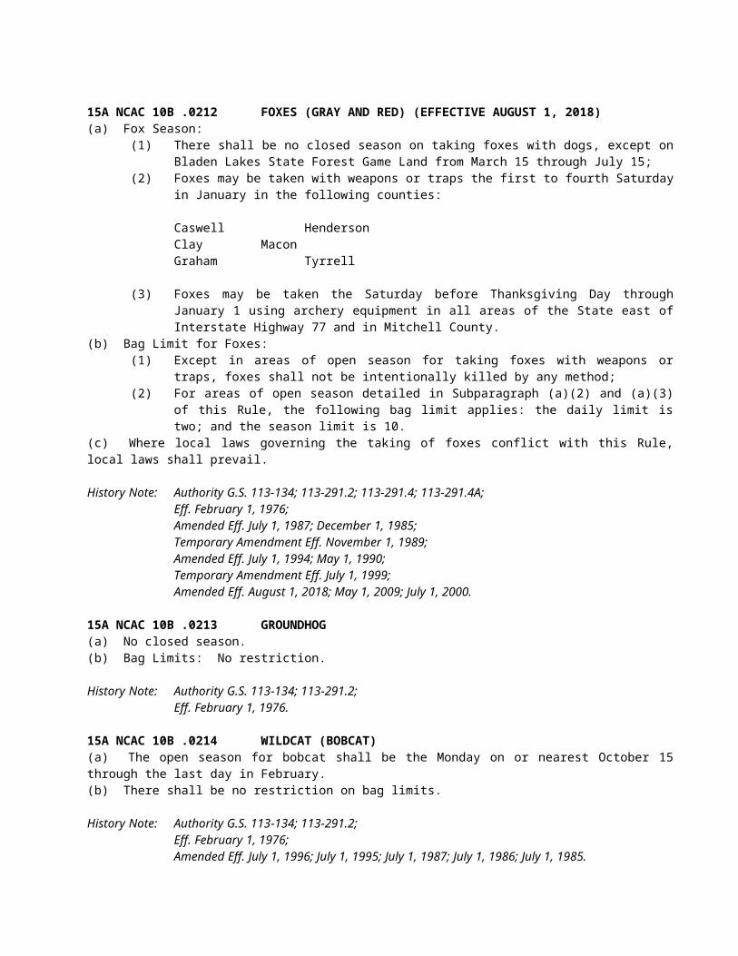
Mitchell River (.6 mile upstream of the end of S.R. 1333 to the S.R. 1330 bridge below Kapps Mill Dam)
(B) Hatchery Supported Trout Waters are as follows:Ararat River (S.R. 1727 bridge downstream to the N.C. 103 bridge)Big Elkin Creek (dam 440 yards upstream of N.C. 268 bridge to a point 265 yards downstream of N.C. 268 [marked by a sign on each bank])Fisher River (Cooper Creek) (Virginia state line to I-77 bridge)Little Fisher River (Virginia state line to N.C. 89 bridge)Lovills Creek (U.S. 52 Business bridge to Ararat River)Pauls Creek (Virginia state line to .3 miles below S.R. 1625 bridge)
(21) Swain County(A) Delayed Harvest Waters Trout Waters are as follows:
Tuckasegee River (U.S. 19 bridge to Slope Street bridge)(B) Hatchery Supported Trout Waters are as follows:
Alarka Creek (game land boundary to Fontana Reservoir)Calderwood Reservoir (Cheoah Dam to Tennessee state line)Cheoah ReservoirConnelly Creek (Camp Branch to Tuckasegee River)Deep Creek (Great Smoky Mountains National Park Boundary line to Tuckasegee River)Nantahala River (Macon Co. line to existing Fontana Lake water level)
(22) Transylvania County(A) Catch and Release/Artificial Flies Only Trout Waters are as follows:
Davidson River (headwaters to Avery Creek, excluding Avery Creek, Looking Glass Creek and Grogan Creek)
(B) Delayed Harvest Waters Trout Waters are as follows:East Fork French Broad River (Glady Fork to French Broad River)Little River (confluence of Lake Dense to 100 yards downstream of Hooker Falls)
(C) Hatchery Supported Trout Waters are as follows:Davidson River (Avery Creek to lower USFS boundary)French Broad River (confluence of North Fork French Broad River and West Fork) French Broad River to the Island Ford Rd. [S.R. 1110] Access AreaMiddle Fork French Broad River (upstream U.S. 178 bridge to French Broad River)West Fork French Broad River (Camp Cove Branch to confluence with North Fork French Broad River)
(D) Wild Trout Waters are as follows:All waters located on Gorges State ParkWhitewater River (downstream from Silver Run Creek to South Carolina state line)
(E) Wild Trout Waters/Natural Bait are as follows:North Fork French Broad River (game land portion downstream of S.R. 1326)Thompson River (S.R. 1152 to South Carolina state line, except where posted against trespassing)
(23) Watauga County(A) Catch and Release/Artificial Lures Only Trout Waters are as follows:
Laurel Creek (confluence of North and South Fork Laurel creeks to Elk Creek, excluding tributaries) Pond Creek (headwaters to Locust Ridge Rd. bridge, excluding the pond adjacent to Coffee Lake)
(B) Delayed Harvest Trout Waters are as follows:Lake CoffeyWatauga River (adjacent to intersection of S.R. 1557 and S.R. 1558 to N.C. 105 bridge and S.R. 1114 bridge to N.C. 194 bridge at Valle Crucis)
(C) Hatchery Supported Trout Waters are as follows:Beaverdam Creek (confluence of Beaverdam Creek and Little Beaverdam Creek to an unnamed tributary adjacent to the intersection of S.R. 1201 and S.R. 1203)Beech CreekBuckeye Creek (Buckeye Creek Reservoir dam to Grassy Gap Creek)
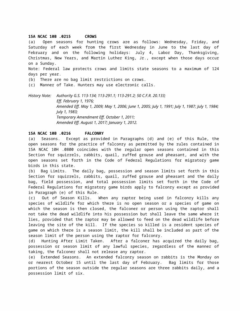
Buckeye Creek ReservoirCove Creek (S.R. 1233 bridge at Zionville to S.R. 1214 bridge at Sherwood) Dutch Creek (second bridge on S.R. 1134 to mouth)Elk Creek (S.R. 1510 bridge at Triplett to Wilkes Co. line, except where posted against trespassing)Laurel Creek (S.R. 1123 bridge at S.R. 1157 intersection to Watauga River)Meat Camp Creek (S.R. 1340 bridge at S.R. 1384 intersection to N.C. 194)Middle Fork New River (adjacent to intersection of S.R. 1539 and U.S. 321 to South Fork New River)Norris Fork CreekSouth Fork New River (canoe launch 70 yards upstream of U.S. 421 bridge to lower boundary of Brookshire Park)Stony Fork (S.R. 1500 bridge at S.R. 1505 intersection to Wilkes Co.line)
(D) Wild Trout Waters are as follows:Dutch Creek (headwaters to second bridge on S.R. 1134)Howard CreekMaine Branch (headwaters to North Fork New River)North Fork New River (from confluence with Maine and Mine branches to Ashe Co. line)Watauga River (Avery Co. line to S.R. 1580 bridge)Winkler Creek (lower bridge on S.R. 1549 to confluence with South Fork New River)
(24) Wilkes County(A) Delayed Harvest Trout Waters are as follows:
East Prong Roaring River (Bullhead Creek downstream to Stone Mountain State Park lower boundary)Elk Creek — upper (Watauga Co. line to lower boundary of the Blue Ridge Mountain Club)Elk Creek — lower (portion on Leatherwood Mountains development)Reddies River (Town of North Wilkesboro water intake dam to confluence with the Yadkin River)Stone Mountain Creek (from falls at Alleghany Co. line to confluence with East Prong Roaring River and Bullhead Creek)
(B) Hatchery Supported Trout Waters are as follows:Basin Creek (S.R. 1730 bridge to confluence with Lovelace Creek)Bell Branch PondCub Creek (.5 mile upstream of S.R. 2460 bridge to S.R. 1001 bridge)Darnell Creek (North Prong Reddies River) (downstream ford on S.R. 1569 to confluence with North Fork Reddies River)East Prong Roaring River (Stone Mountain State Park lower boundary to S.R. 1002 bridge)Fall Creek (S.R. 1300 bridge to confluence with South Prong Lewis Fork, except where posted against trespassing)Middle Fork Reddies River (Clear Prong) (headwaters to bridge on S.R. 1580)Middle Prong Roaring River (headwaters to bridge on S.R. 1736)North Fork Reddies River (Vannoy Creek) (headwaters to Union School bridge on S.R. 1559)Pike CreekPike Creek PondSouth Fork Reddies River (S.R. 1355 bridge to confluence with Middle Fork Reddies River)South Prong Lewis Fork (Fall Creek to S.R. 1155 bridge)
(C) Wild Trout Waters are as follows:All waters located on Stone Mountain State Park, except East Prong Roaring River from Bullhead Creek downstream to the Stone Mountain State Park lower boundary where Delayed Harvest Trout Waters regulations apply, and Stone Mountain Creek from falls at Alleghany County line to confluence with East Prong Roaring River and Bullhead Creek in Stone Mountain State Park where Delayed Harvest Trout Waters regulations apply
(25) Yancey County(A) Catch and Release/Artificial Flies Only Trout Waters are as follows:
South Toe River (headwaters to Upper Creek)
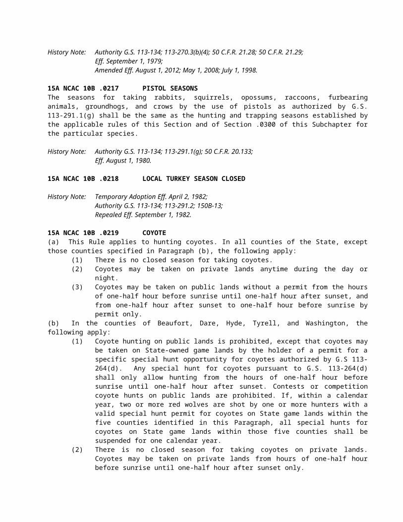
Upper Creek(B) Delayed Harvest Trout Waters are as follows:
Cane River (Blackberry Ridge Rd. to downstream boundary of Cane River County Park)(C) Hatchery Supported Trout Waters are as follows:
Bald Mountain Creek (except where posted against trespassing)Cane River (Bee Branch [S.R. 1110] to Bowlens Creek)Price Creek (junction of S.R. 1120 and S.R. 1121 to Indian Creek)South Toe River (Clear Creek to lower boundary line of Yancey Co. Recreation Park, except where posted against trespassing)
(D) Wild Trout Waters are as follows:Cattail Creek (bridge at Mountain Farm Community Rd. to N.C. 197 bridge)Lickskillet CreekMiddle Creek (game land boundary to mouth)
History Note: Authority G.S. 113-272; 113-292;Eff. February 1, 1976;Amended Eff. July 1, 1998; July 1, 1997; July 1, 1996; July 1, 1995; July 1, 1994; July 1, 1993; October 1, 1992;Temporary Amendment Eff. July 1, 1999;Amended Eff. July 1, 2000;Temporary Amendment Eff. July 1, 2001;Temporary Amendment Eff. July 1, 2002;Amended Eff. August 1, 2002 (approved by RRC on 6/21/01 and 04/18/02);Temporary Amendment Eff. June 1, 2003;Amended Eff. June 1, 2004 (this amendment replaces the amendment approved by RRC on July 17, 2003);Amended Eff. August 1, 2017; August 1, 2016; August 1, 2015; August 1, 2014; August 1, 2013; August 1, 2012; August 1, 2011; August 1, 2010; May 1, 2009; May 1, 2008; May 1, 2007; May 1, 2006; June 1, 2005.
15A NCAC 10C .0205 PUBLIC MOUNTAIN TROUT WATERS (EFFECTIVE AUGUST 1, 2018)(a) For purposes of this Rule, the following definitions apply:
(1) "Natural bait" means any living or dead organism (plant or animal), or parts thereof, or prepared substances designed to attract fish by the sense of taste or smell.
(2) "Artificial lure" means a fishing lure that neither contains nor has been treated by any substance that attracts fish by the sense of taste or smell.
(3) "Youth anglers" are individuals under 18 years of age.(b) For purposes of this Rule, 15A NCAC 10C .0316, and 15A NCAC 10D .0104, the following classifications apply:
(1) "Public Mountain Trout Waters" are all waters included in this Rule and so designated in 15A NCAC 10D .0104.
(2) "Catch and Release/Artificial Flies Only Trout Waters" are Public Mountain Trout Waters where only artificial flies having one single hook may be used. No trout may be possessed or harvested while fishing these streams. Waters designated as such include tributaries unless otherwise noted.
(3) "Catch and Release/Artificial Lures Only Trout Waters" are Public Mountain Trout Waters where only artificial lures having one single hook may be used. No trout may be possessed or harvested while fishing these streams. Waters designated as such include tributaries unless otherwise noted.
(4) "Delayed Harvest Trout Waters" are Public Mountain Trout Waters where between October 1 and one-half hour after sunset on the Friday before the first Saturday of the following June it is unlawful to possess natural bait, use more than one single hook on an artificial lure, or harvest or possess trout while fishing. From 6:00 a.m. on the first Saturday in June until noon that same day only youth anglers may fish and these waters have no bait or lure restrictions. From noon on the first Saturday in June until October 1 anglers of all ages may fish and these waters have no bait or lure restrictions. Waters designated as such do not include tributaries unless otherwise noted.
(5) "Hatchery Supported Trout Waters" are Public Mountain Trout Waters that have no bait or lure restrictions. Waters designated as such do not include tributaries unless otherwise noted.
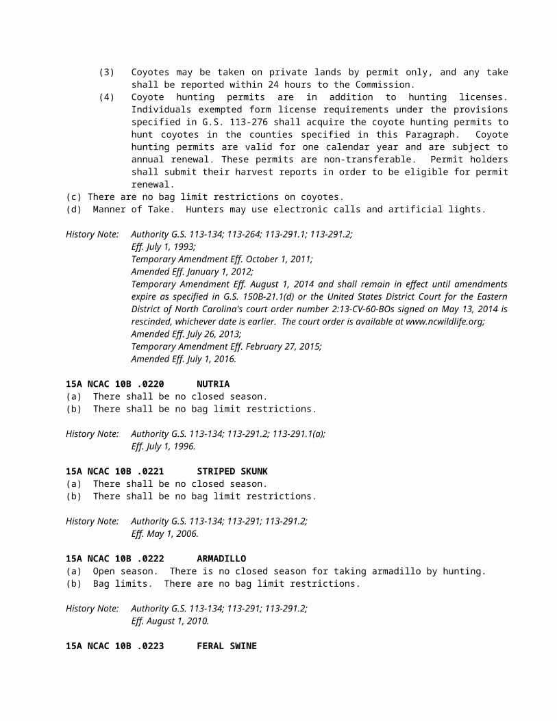
(6) "Special Regulation Trout Waters" are Public Mountain Trout Waters where watercourse-specific regulations apply. Waters designated as such do not include tributaries unless otherwise noted.
(7) "Wild Trout Waters" are Public Mountain Trout Waters which are identified as such in this Rule or 15A NCAC 10D .0104. Only artificial lures having only one single hook may be used. No person shall possess natural bait while fishing these waters. Waters designated as such do not include tributaries unless otherwise noted.
(8) "Wild Trout Waters/Natural Bait" are Public Mountain Trout Waters where all artificial lures and natural baits, except live fish, may be used provided they are fished using only one single hook. Waters designated as such include tributaries unless otherwise noted.
(9) "Undesignated Waters" are all other waters in the State. These waters have no bait or lure restrictions. Trout may not be possessed while fishing these waters from March 1 until 7:00 a.m. on the first Saturday in April.
(c) Seasons, creel and size limits. Seasons, creel and size limits for trout in all waters are listed in Rule .0316 of this Subchapter.(d) Classifications. This Paragraph designates waters in each county that have a specific classification. Waters on game lands are so designated in 15A NCAC 10D .0104, unless otherwise indicated in this Paragraph. All other waters are classified as Undesignated Waters.
(1) Alleghany(A) Delayed Harvest Trout Waters are as follows:
Little River (S.R. 1133 bridge to 275 yards downstream of the intersection of S.R. 1128 and S.R. 1129 [marked by a sign on each bank])
(B) Hatchery Supported Trout Waters are as follows:Big Pine CreekBledsoe CreekBrush Creek (N.C. 21 bridge to confluence with Little River, except where posted against trespassing)Cranberry Creek(Big) Glade CreekLittle River (275 yards downstream from the intersection of S.R. 1128 and S.R. 1129 [marked by a sign on each bank] to McCann Dam)Meadow ForkPine Swamp CreekPiney ForkPrathers Creek
(C) Wild Trout Waters are as follows:All waters located on Stone Mountain State Park
(2) Ashe County(A) Catch and Release/Artificial Lures Only Trout Waters are as follows:
Big Horse Creek (Virginia state line to Mud Creek at S.R. 1363, excluding tributaries)(B) Delayed Harvest Trout Waters are as follows:
Big Horse Creek (S.R. 1324 bridge to North Fork New River)Helton Creek (Virginia state line to New River)South Fork New River (upstream end of Todd Island to the SR 1351 bridge)Trout Lake
(C) Hatchery Supported Trout Waters are as follows:Beaver Creek (N.C. 221 to confluence of Beaver Creek and South Beaver Creek)Big Horse Creek (Mud Creek at S.R. 1363 to S.R. 1324 bridge)Big Laurel Creek (S.R. 1315 bridge to confluence with North Fork New River)Buffalo Creek (S.R. 1133 bridge to N.C. 194-88 bridge)Cranberry Creek (Alleghany Co. line to South Fork New River)Nathans CreekNorth Fork New River (Watauga Co. line to Sharp Dam)Old Fields Creek (N.C. 221 to South Fork New River)Peak Creek (headwaters to Trout Lake, except Blue Ridge Parkway waters)Roan CreekThree Top Creek
(3) Avery County(A) Catch and Release/Artificial Flies Only Trout Waters are as follows:
Elk River (portion on Lees-McRae College property, excluding the millpond)Lost Cove Creek (game land portion, excluding Gragg Prong and Rockhouse Creek)
(B) Catch and Release/Artificial Lures Only Trout Waters are as follows:Wilson Creek (game land portion)
(C) Hatchery Supported Trout Waters are as follows:Boyde Coffey LakeElk River (S.R. 1305 crossing immediately upstream of Big Falls to the Tennessee state line)Linville River (Land Harbor line [below dam] to the Blue Ridge Parkway boundary line, except where posted against trespassing)Milltimber CreekNorth Toe River — upper (Watauga St. to Roby Shoemaker Wetlands and Family Recreational Park, except where posted against trespassing)North Toe River — lower (S.R. 1164 to Mitchell Co. line, except where posted against trespassing)Squirrel CreekWildcat Lake
(D) Wild Trout Waters are as follows:Birchfield CreekCow Camp CreekCranberry Creek (headwaters to U.S. 19E/N.C. 194 bridge)Gragg ProngHorse CreekKentucky CreekNorth Harper CreekPlumtree CreekRoaring CreekRockhouse CreekShawneehaw Creek (portion adjacent to Banner Elk Greenway)South Harper CreekWebb Prong
(4) Buncombe County(A) Catch and Release/Artificial Lures Only Trout Waters are as follows:
Carter Creek (game land portion)(B) Hatchery Supported Trout Waters are as follows:
Bent Creek (headwaters to N.C. Arboretum boundary line)Cane Creek (headwaters to S.R. 3138 bridge)Corner Rock Creek (Little Andy Creek to confluence with Walker Branch)Dillingham Creek (Corner Rock Creek to Ivy Creek)Ivy Creek (Ivy River) (Dillingham Creek to U.S. 19-23 bridge)Lake PowhatanReems Creek (Sugar Camp Fork to U.S. 19-23 bridge, except where posted against trespassing)Rich Branch (downstream from the confluence with Rocky Branch)Stony CreekSwannanoa (S.R. 2702 bridge near Ridgecrest to Wood Avenue bridge [intersection of N.C. 81 and U.S. 74A in Asheville], except where posted against trespassing)
(5) Burke County(A) Catch and Release/Artificial Lures Only Trout Waters are as follows:
Henry Fork (portion on South Mountains State Park)(B) Delayed Harvest Trout Waters are as follows:
Jacob Fork (Shinny Creek to lower South Mountains State Park boundary)(C) Hatchery Supported Trout Waters are as follows:
Carroll Creek (game land portion above S.R. 1405)
Henry Fork (lower South Mountain State Park line downstream to S.R. 1919 at Ivy Creek)Linville River portion within Linville Gorge Wilderness area and portion below Lake James powerhouse from upstream bridge on S.R. 1223 to Muddy Creek)
(D) Special Regulation Trout Waters are as follows:Catawba River (Muddy Creek to City of Morganton water intake dam)
(E) Wild Trout Waters are as follows:All waters located on South Mountains State Park, except those waters identified in parts A and B of this Subparagraph
(6) Caldwell County(A) Delayed Harvest Trout Waters are as follows:
Wilson Creek (game land portion below Lost Cove Creek to Philips Branch)(B) Hatchery Supported Trout Waters are as follows:
Boone Fork PondBuffalo Creek (mouth of Joes Creek to McCloud Branch)Joes Creek (first falls upstream of S.R. 1574 to confluence with Buffalo Creek)Wilson Creek (Phillips Branch to Brown Mountain Beach Dam, except where posted against trespassing)Yadkin River (Happy Valley Ruritan Community Park to S.R. 1515)
(C) Wild Trout Waters are as follows:Buffalo Creek (Watauga Co. line to Long Ridge Branch including game land tributaries)Joes Creek (Watauga Co. line to first falls upstream of the end of S.R. 1574)Rockhouse Creek
(7) Cherokee County(A) Hatchery Supported Trout Waters are as follows:
Davis Creek (confluence of Bald and Dockery creeks to Hanging Dog Creek)Hyatt Creek (Big Dam Branch to Valley River)Junaluska Creek (Ashturn Creek to Valley River)Shuler Creek (Joe Brown Hwy [S.R. 1325] bridge to Tennessee state line)Valley River (S.R. 1359 to U.S. 19 Business bridge in Murphy)
(B) Wild Trout Waters/Natural Bait are as follows:Bald Creek (game land portion)Dockery Creek (game land portion)North Shoal Creek (game land portion)
(8) Clay County(A) Delayed Harvest Trout Waters are as follows:
Fires Creek (USFS Rd. 340A to the foot bridge in the USFS Fires Creek Picnic Area)(B) Hatchery Supported Trout Waters are as follows:
Buck Creek (game land portion downstream of U.S. 64 bridge)Fires Creek (foot bridge in the USFS Fires Creek Picnic Area to S.R. 1300)Tusquitee Creek (Compass Creek to lower S.R. 1300 bridge)
(9) Graham County(A) Delayed Harvest Trout Waters are as follows:
(Big) Snowbird Creek (USFS footbridge at the old railroad junction to USFS Rd. 2579)(B) Hatchery Supported Trout Waters are as follows:
Calderwood Reservoir (Cheoah Dam to Tennessee state line)Cheoah ReservoirPanther Creek (confluence of Stand Creek and Rock Creek to Lake Fontana)Santeetlah Creek (Johns Branch to Lake Santeetlah)(Big) Snowbird Creek (USFS Road 2579 to S.R. 1127 bridge)Stecoah Creek (upper game land boundary to Lake Fontana)Tulula Creek (S.R. 1201 to lower bridge on S.R. 1275)West Buffalo CreekYellow Creek (Lake Santeetlah hydropower pipeline to Cheoah River)
(C) Wild Trout Waters are as follows:Little Buffalo CreekSouth Fork Squally Creek
Squally Creek(D) Wild Trout Waters/Natural Bait are as follows:
Deep CreekFranks CreekLong Creek (game land portion)
(10) Haywood County(A) Delayed Harvest Trout Waters are as follows:
West Fork Pigeon River (Queen Creek to the first game land boundary upstream of Lake Logan)
(B) Hatchery Supported Trout Waters are as follows:Cold Springs Creek (Fall Branch to Pigeon River)Jonathan Creek (upstream S.R. 1302 bridge to Pigeon River, except where posted against trespassing)Pigeon River (Stamey Cove Branch to upstream U.S. 19-23 bridge)Richland Creek (Russ Avenue [U.S. 276] bridge to U.S. 19 bridge)West Fork Pigeon River (Tom Creek to Queen Creek, including portions on game lands, except Middle Prong)
(C) Wild Trout Waters/Natural Bait are as follows:Hemphill CreekHurricane Creek
(11) Henderson County(A) Delayed Harvest Trout Waters are as follows:
North Fork Mills River (game land portion below the Hendersonville watershed dam)(B) Hatchery Supported Trout Waters are as follows:
(Rocky) Broad River (end of S.R. 1611 to Rutherford County line)Cane Creek (railroad bridge upstream of S.R. 1551 bridge to U.S. 25 bridge)Clear Creek (Laurel Fork to S.R. 1582)Green River (Lake Summit powerhouse to game land boundary)(Big) Hungry River
(12) Jackson County(A) Catch and Release/Artificial Lures Only Trout Waters are as follows:
Flat CreekTuckasegee River (upstream from the Clark property)
(B) Delayed Harvest Trout Waters are as follows:Tuckasegee River (downstream N.C. 107 bridge to the falls located 275 yards upstream of the U.S. 23-441 bridge [marked by a sign on each bank])
(C) Hatchery Supported Trout Waters are as follows:Balsam LakeBear Creek LakeCedar Cliff LakeCullowhee Creek (Tilley Creek to Tuckasegee River)Dark Ridge Creek (Jones Creek to Scott Creek)Greens Creek (Greens Creek Baptist Church on S.R. 1370 to Savannah Creek)Savannah Creek (Shell Branch to Cagle Branch)Scott Creek (Dark Ridge Creek to Tuckasegee River, except where posted against trespassing)Tanasee Creek LakeTuckasegee River — upper (John Brown Branch to the downstream N.C. 107 bridge)Tuckasegee River — lower (falls located 275 yards upstream of U.S. 23-441 bridge [marked by a sign on each bank] to S.R. 1534 bridge at Wilmot)Wolf Creek Lake
(D) Wild Trout Waters are as follows:Gage CreekNorth Fork Scott CreekTanasee CreekWhitewater River (downstream from Silver Run Creek to South Carolina state line)
Wolf Creek (except Balsam Lake and Wolf Creek Lake)(E) Wild Trout Waters/Natural Bait are as follows:
Buff CreekChattooga River (S.R. 1100 bridge to the South Carolina state line)Lower Fowler Creek (game land portion)Scotsman Creek (game land portion)
(13) Macon County(A) Delayed Harvest Trout Waters are as follows:
Nantahala River (Whiteoak Creek to Nantahala hydropower discharge canal)(B) Hatchery Supported Trout Waters are as follows:
Burningtown Creek (Left Prong to Little Tennessee River)Cartoogechaye Creek (downstream U.S. 64 bridge to Little Tennessee River)Cliffside LakeCullasaja River (Sequoyah Dam to U.S. 64 bridge near junction of S.R. 1672)Nantahala River — upper (Dicks Creek to Whiteoak Creek)Nantahala River — lower (Nantahala hydropower discharge canal to Swain Co. line)Queens Creek Lake
(C) Wild Trout Waters/Natural Bait are as follows:Chattooga River (S.R. 1100 bridge to South Carolina state line)Jarrett Creek (game land portion)Kimsey CreekOverflow Creek (game land portion)Park CreekTellico Creek (game land portion)Turtle Pond Creek (game land portion)
(14) Madison County(A) Delayed Harvest Trout Waters are as follows:
Big Laurel Creek (N.C. 208 bridge to the U.S. 25-70 bridge)Shelton Laurel Creek (N.C. 208 bridge at Belva to the confluence with Big Laurel Creek)Spring Creek (N.C. 209 bridge at Hot Springs city limits to iron bridge at end of Andrews Ave.)
(B) Hatchery Supported Trout Waters are as follows:Big Laurel Creek (Mars Hill watershed boundary to the S.R. 1318 [Big Laurel Rd.] bridge downstream of Bearpen Branch)Big Pine Creek (S.R. 1151 bridge to French Broad River)Little Ivy Creek (confluence of Middle Fork and Paint Fork at Beech Glen to confluence with Ivy Creek at Forks of Ivy)Max Patch PondMeadow Fork Creek (S.R. 1165 to Spring Creek)Puncheon Fork (Hampton Creek to Big Laurel Creek)Roaring Fork (Fall Branch to Meadow Fork)Shelton Laurel Creek (confluence of Big Creek and Mill Creek to N.C. 208 bridge at Belva)Shut-in CreekSpillcorn CreekSpring Creek (junction of N.C. 209 and N.C. 63 to USFS Rd. 223)West Fork Shut-in Creek (lower game land boundary to confluence with East Fork Shut-in Creek)
(C) Wild Trout Waters/Natural Bait are as follows:Big Creek (headwaters to the lower game land boundary)
(15) McDowell County(A) Catch and Release/Artificial Lures Only Trout Waters are as follows:
Newberry Creek (game land portion)(B) Delayed Harvest Trout Waters are as follows:
Catawba River (portion adjacent to Marion Greenway)Curtis Creek (game land portion downstream of the USFS boundary at Deep Branch)Mill Creek (U.S. 70 bridge to I-40 bridge)
(C) Hatchery Supported Trout Waters are as follows:Armstrong Creek (Cato Holler line downstream to upper Greenlee line)Catawba River (Catawba Falls Campground to Old Fort Recreation Park)Little Buck Creek (game land portion)Mill Creek (upper railroad bridge to U.S. 70 bridge, except where posted against trespassing)North Fork Catawba River (headwaters to North Cove School at S.R. 1569 bridge)
(16) Mitchell County(A) Delayed Harvest Trout Waters are as follows:
Cane Creek (N.C. 226 bridge to S.R. 1189 bridge)North Toe River (U.S. 19E bridge to N.C. 226 bridge)
(B) Hatchery Supported Trout Waters are as follows:Big Rock Creek (headwaters to N.C. 226 bridge at S.R. 1307 intersection)Cane Creek (S.R. 1219 to N.C. 226 bridge)East Fork Grassy CreekGrassy Creek (East Fork Grassy Creek to mouth)Little Rock Creek (Green Creek bridge to Big Rock Creek, except where posted against trespassing)North Toe River (Avery Co. line to S.R. 1121 bridge)
(C) Wild Trout Waters are as follows:Green Creek (headwaters to Green Creek bridge, except where posted against trespassing)Little Rock Creek (above Green Creek bridge, including all tributaries, except where posted against trespassing)Wiles Creek (game land boundary to mouth)
(17) Polk County(A) Delayed Harvest Trout Waters are as follows:
Green River (Fishtop Falls Access Area to the confluence with Cove Creek)(B) Hatchery Supported Trout Waters are as follows:
Green River (Mouth of Cove Creek to the natural gas pipeline crossing)North Pacolet River (Joels Creek to N.C. 108 bridge)
(18) Rutherford County(A) Hatchery Supported Trout Waters are as follows:
(Rocky) Broad River (Henderson Co. line to U.S. 64/74 bridge, except where posted against trespassing)
(19) Stokes County(A) Hatchery Supported Trout Waters are as follows:
Dan River (Virginia state line downstream to a point 200 yards below the end of S.R. 1421)(20) Surry County
(A) Delayed Harvest Trout Waters are as follows:Ararat River (portion adjacent to the Ararat River Greenway)Mitchell River (.6 mile upstream of the end of S.R. 1333 to the S.R. 1330 bridge below Kapps Mill Dam)
(B) Hatchery Supported Trout Waters are as follows:Ararat River (S.R. 1727 bridge downstream to the N.C. 103 bridge)Big Elkin Creek (dam 440 yards upstream of N.C. 268 bridge to a point 265 yards downstream of N.C. 268 [marked by a sign on each bank])Fisher River (Cooper Creek) (Virginia state line to I-77 bridge)Little Fisher River (Virginia state line to N.C. 89 bridge)Lovills Creek (U.S. 52 Business bridge to Ararat River)Pauls Creek (Virginia state line to .3 miles below S.R. 1625 bridge)
(21) Swain County(A) Delayed Harvest Waters Trout Waters are as follows:
Tuckasegee River (U.S. 19 bridge to Slope Street bridge)(B) Hatchery Supported Trout Waters are as follows:
Alarka Creek (game land boundary to Fontana Reservoir)Calderwood Reservoir (Cheoah Dam to Tennessee state line)
Cheoah ReservoirConnelly Creek (Camp Branch to Tuckasegee River)Deep Creek (Great Smoky Mountains National Park Boundary line to Tuckasegee River)Nantahala River (Macon Co. line to existing Fontana Lake water level)
(22) Transylvania County(A) Catch and Release/Artificial Flies Only Trout Waters are as follows:
Davidson River (headwaters to Avery Creek, excluding Avery Creek, Looking Glass Creek and Grogan Creek)
(B) Delayed Harvest Waters Trout Waters are as follows:East Fork French Broad River (East Fork Baptist Church to French Broad River)Little River (confluence of Lake Dense to 100 yards downstream of Hooker Falls)
(C) Hatchery Supported Trout Waters are as follows:Davidson River (Avery Creek to lower USFS boundary)French Broad River (confluence of North Fork French Broad River and West Fork) French Broad River to the Island Ford Rd. [S.R. 1110] Access AreaMiddle Fork French Broad River (upstream U.S. 178 bridge to French Broad River)West Fork French Broad River (Camp Cove Branch to confluence with North Fork French Broad River)
(D) Wild Trout Waters are as follows:All waters located on Gorges State ParkWhitewater River (downstream from Silver Run Creek to South Carolina state line)
(E) Wild Trout Waters/Natural Bait are as follows:North Fork French Broad River (game land portion downstream of S.R. 1326)Thompson River (S.R. 1152 to South Carolina state line, except where posted against trespassing)
(23) Watauga County(A) Catch and Release/Artificial Lures Only Trout Waters are as follows:
Laurel Creek (confluence of North and South Fork Laurel creeks to Elk Creek, excluding tributaries) Pond Creek (headwaters to Locust Ridge Rd. bridge, excluding the pond adjacent to Coffee Lake)
(B) Delayed Harvest Trout Waters are as follows:Lake CoffeyWatauga River (adjacent to intersection of S.R. 1557 and S.R. 1558 to N.C. 105 bridge and S.R. 1114 bridge to N.C. 194 bridge at Valle Crucis)
(C) Hatchery Supported Trout Waters are as follows:Beaverdam Creek (confluence of Beaverdam Creek and Little Beaverdam Creek to an unnamed tributary adjacent to the intersection of S.R. 1201 and S.R. 1203)Beech CreekBuckeye Creek (Buckeye Creek Reservoir dam to Grassy Gap Creek)Buckeye Creek ReservoirCove Creek (S.R. 1233 bridge at Zionville to S.R. 1214 bridge at Sherwood) Dutch Creek (second bridge on S.R. 1134 to mouth)Elk Creek (S.R. 1510 bridge at Triplett to Wilkes Co. line, except where posted against trespassing)Laurel Creek (S.R. 1123 bridge at S.R. 1157 intersection to Watauga River)Meat Camp Creek (S.R. 1340 bridge at S.R. 1384 intersection to N.C. 194)Middle Fork New River (adjacent to intersection of S.R. 1539 and U.S. 321 to South Fork New River)Norris Fork CreekSouth Fork New River (canoe launch 70 yards upstream of U.S. 421 bridge to lower boundary of Brookshire Park)Stony Fork (S.R. 1500 bridge at S.R. 1505 intersection to Wilkes Co.line)
(D) Wild Trout Waters are as follows:Dutch Creek (headwaters to second bridge on S.R. 1134)Howard Creek
Maine Branch (headwaters to North Fork New River)North Fork New River (from confluence with Maine and Mine branches to Ashe Co. line)Watauga River (Avery Co. line to S.R. 1580 bridge)Winkler Creek (lower bridge on S.R. 1549 to confluence with South Fork New River)
(24) Wilkes County(A) Delayed Harvest Trout Waters are as follows:
East Prong Roaring River (Bullhead Creek downstream to Stone Mountain State Park lower boundary)Elk Creek — upper (Watauga Co. line to lower boundary of the Blue Ridge Mountain Club)Elk Creek — lower (portion on Leatherwood Mountains development)Reddies River (Town of North Wilkesboro water intake dam to confluence with the Yadkin River)Stone Mountain Creek (from falls at Alleghany Co. line to confluence with East Prong Roaring River and Bullhead Creek)
(B) Hatchery Supported Trout Waters are as follows:Basin Creek (S.R. 1730 bridge to confluence with Lovelace Creek)Bell Branch PondCub Creek (.5 mile upstream of S.R. 2460 bridge to S.R. 1001 bridge)Darnell Creek (North Prong Reddies River) (downstream ford on S.R. 1569 to confluence with North Fork Reddies River)East Prong Roaring River (Stone Mountain State Park lower boundary to S.R. 1002 bridge)Fall Creek (S.R. 1300 bridge to confluence with South Prong Lewis Fork, except where posted against trespassing)Middle Fork Reddies River (Clear Prong) (headwaters to bridge on S.R. 1580)Middle Prong Roaring River (headwaters to bridge on S.R. 1736)North Fork Reddies River (Vannoy Creek) (headwaters to Union School bridge on S.R. 1559)Pike CreekPike Creek PondSouth Fork Reddies River (S.R. 1355 bridge to confluence with Middle Fork Reddies River)South Prong Lewis Fork (Fall Creek to S.R. 1155 bridge)
(C) Wild Trout Waters are as follows:All waters located on Stone Mountain State Park, except East Prong Roaring River from Bullhead Creek downstream to the Stone Mountain State Park lower boundary where Delayed Harvest Trout Waters regulations apply, and Stone Mountain Creek from falls at Alleghany County line to confluence with East Prong Roaring River and Bullhead Creek in Stone Mountain State Park where Delayed Harvest Trout Waters regulations apply
(25) Yancey County(A) Catch and Release/Artificial Flies Only Trout Waters are as follows:
South Toe River (headwaters to Upper Creek)Upper Creek
(B) Delayed Harvest Trout Waters are as follows:Cane River (Blackberry Ridge Rd. to downstream boundary of Cane River County Park)
(C) Hatchery Supported Trout Waters are as follows:Bald Mountain Creek (except where posted against trespassing)Cane River (Bee Branch [S.R. 1110] to Bowlens Creek)Price Creek (junction of S.R. 1120 and S.R. 1121 to Indian Creek)South Toe River (Clear Creek to lower boundary line of Yancey Co. Recreation Park, except where posted against trespassing)
(D) Wild Trout Waters are as follows:Cattail Creek (bridge at Mountain Farm Community Rd. to N.C. 197 bridge)Lickskillet CreekMiddle Creek (game land boundary to mouth)
History Note: Authority G.S. 113-272; 113-292;Eff. February 1, 1976;
Amended Eff. July 1, 1998; July 1, 1997; July 1, 1996; July 1, 1995; July 1, 1994; July 1, 1993; October 1, 1992;Temporary Amendment Eff. July 1, 1999;Amended Eff. July 1, 2000;Temporary Amendment Eff. July 1, 2001;Temporary Amendment Eff. July 1, 2002;Amended Eff. August 1, 2002 (approved by RRC on 6/21/01 and 04/18/02);Temporary Amendment Eff. June 1, 2003;Amended Eff. June 1, 2004 (this amendment replaces the amendment approved by RRC on July 17, 2003);Amended Eff. August 1, 2018; August 1, 2017; August 1, 2016; August 1, 2015; August 1, 2014; August 1, 2013; August 1, 2012; August 1, 2011; August 1, 2010; May 1, 2009; May 1, 2008; May 1, 2007; May 1, 2006; June 1, 2005.
15A NCAC 10C .0206 TROTLINES, JUG HOOKS AND SET HOOKS (a) For purposes of this Rule, the following definitions apply:
(1) "set hook" means a fishing device consisting of a single line having no more than three hooks that is attached at one end only to a stationary object.
(2) "jug hook" means a fishing device consisting of a single line having no more than three hooks that is attached to a float.
(3) "trotline" means a fishing device consisting of a horizontal common line having multiple hooks attached.
(b) Except as otherwise prohibited in this Rule, trotlines, jug hooks, and set hooks may be set in the inland waters of North Carolina, provided no live bait is used. Trotlines, jug hooks, and set hooks may not be set in any of the impounded waters on the Sandhills Game Land. Trotlines, jug hooks, and set hooks may not be set in any designated public mountain trout waters except impounded waters of power reservoirs and municipally-owned water supply reservoirs open to the public for fishing. In Lake Waccamaw, trotlines, jug hooks, or set hooks may be set only from October 1 through April 30.(c) Each trotline, set hook, and jug hook shall bear legible and indelible identification of the user's name and address or the user's Wildlife Resources Commission customer number. Each trotline shall be conspicuously marked at each end and each set hook conspicuously marked at one end with a flag, float, or other prominent object so that its location is readily discernible by boat operators and swimmers. Trotlines shall be set parallel to the nearest shore in all inland fishing waters unless otherwise prohibited. The number of jug hooks that may be fished is limited to 70 per boat. All trotlines, set hooks, and jug hooks shall be fished at least once daily and all fish removed at that time. Trotlines, set hooks, and jug hooks without bait or not labled as described in this Paragraph may be removed from the water by wildlife enforcement officers. It is unlawful to use metal cans or glass jugs as floats.
History Note: Authority G.S. 113-134; 113-272; 113-292;Eff. February 1, 1976;Amended Eff. July 1, 1993; May 1, 1992; July 1, 1989; January 1, 1982;Temporary Amendment Eff. July 1, 2002;Amended Eff. August 1, 2015; August 1, 2014; August 1, 2013; May 1, 2008; June 1, 2005; August 1, 2002.
15A NCAC 10C .0207 GRABBLING FOR FISH
History Note: Authority G.S. 113-134; 113-292;Eff. February 1, 1976;Repealed Eff. July 1, 1988.
15A NCAC 10C .0208 SPAWNING AREASThe following waters are designated as spawning areas in which fishing is prohibited or restricted as indicated:
(1) No person shall fish by any method from February 15 to April 15, both inclusive, in Linville River from the NC 126 bridge downstream to the mouth of the Linville River.
(2) No person shall fish by any method within the bypass channel constructed by the U.S. Army Corps of Engineers around Lock and Dam No. 1 on the Cape Fear River at any time.
History Note: Authority G.S. 113-134; 113-292;Eff. February 1, 1976;Amended Eff. May 1, 2009; August 1, 2004; July 1, 1993; July 1, 1989; July 1, 1985; July 1, 1984.
15A NCAC 10C .0209 TRANSPORTATION OF LIVE FISH(a) Fish Transport: It shall be unlawful for any person, firm, or corporation to transport live freshwater nongame fishes, or live game fishes in excess of the possession limit, or fish eggs without having in possession a permit obtained from the North Carolina Wildlife Resources Commission.(b) Fish Stocking: It shall be unlawful for any person, firm, or corporation to stock any life stage of any species of fish in the inland fishing waters of this State without having first procured a stocking permit from the North Carolina Wildlife Resources Commission.(c) Permits for stocking fish shall be issued as follows:
(1) Application for a stocking permit shall be made on a form provided by the Commission. The applicant shall specify the purpose for the stocking, species to be stocked, the source of the stock, the number of individual specimens to be released, and the location where release is desired.
(2) Before issuing a stocking permit, the Executive Director shall review the application and determine, based on principles of wildlife management and biological science, that the proposed stocking will not:(A) threaten the introduction of epizootic disease or (B) create a danger to or an imbalance in the environment inimical to the conservation of
wildlife resources. (3) Based on the determination made in Subparagraph (2):
(A) If the Executive Director determines that either or both conditions cannot be met under any circumstances, the application shall be denied.
(B) If the Executive Director determines that both conditions may be met only by the introduction of fewer than the number requested, a permit only for the number that may be safely released shall be issued.
(C) If the Executive Director determines that the number requested may be safely released, he shall issue the permit.
(4) Any stocking permit issued by the Commission may impose the following conditions or restrictions:(A) Location where the permitted number of fish may be stocked.(B) Certification that fish are free of certifiable diseases by the vendor or a laboratory qualified
to make such determination.(C) Documentation of the date, time and location of the release. (D) Access by the Commission to the property where fish introductions occur to assess impacts
of the introduction.(E) All conditions required shall be included in writing on the permit.
(5) Based on the criteria in Subparagraph (2), no permit shall be issued to stock any of the following species in the areas indicated:
SPECIES LOCATIONSalmonids except brown, brook, and rainbow trout StatewideFlathead catfish Statewide
(d) For purposes of this Rule, stocking is the introduction or attempted introduction of one or more individuals of a particular species of live fish into public waters for any purpose other than:
(1) As bait affixed to a hook and line, or (2) A release incidental to "catch and release" fishing in an area within the same body of water where
the fish was caught, or within an adjacent body of water not separated from that body by any natural or manmade obstruction to the passage of that species.
(e) The release of more than the daily creel limit, or if there is no established creel limit for the species, more than five individuals of the species, shall constitute prima facie evidence of an intentional release.
History Note: Authority G.S. 113-134; 113-135; 113-274; 113-292;Eff. February 1, 1976;Amended Eff. June 1, 2005.
15A NCAC 10C .0210 FISHES TAKEN ILLEGALLY: MANAGEMENT PURPOSES
History Note: Authority G.S. 113-134; 113-137;Eff. February 1, 1976;Repealed Eff. July 1, 1988.
15A NCAC 10C .0211 POSSESSION OF CERTAIN FISHES(a) It is unlawful to transport, purchase, possess, sell or stock in the public or private waters of North Carolina any live individuals of:
(1) piranha,(2) "walking catfish" (Clarias batrachus),(3) snakehead fish (from the Family Channidae, formerly Ophiocephalidae),(4) black carp (Mylopharyngodon piceus),(5) bighead carp (Hypophthalmichthys nobilis),(6) silver carp (Hypophthalmichthys molitrix),(7) rudd (Scardinius erythropthalomus),(8) round goby (Neogobius melanostomus),(9) tubenose goby (Proterorhinus marmoratus),(10) ruffe (Gymnocephalus cernuus),(11) Japanese mysterysnail (Cipangopaludina japonica),(12) Chinese mysterysnail (Cipangopaludina chinensis malleata),(13) red-rim melania (Melanoides tuberculatus),(14) virile crayfish (Orconectes (Gremicambarus) virilis),(15) rusty crayfish (Orconectes (Procericambarus) rusticus),(16) Australian red claw crayfish or "red claw" (Cherax quadricarinatus, or other species of "giant"
crayfish species in the genus Cherax),(17) white amur or "grass carp" (Ctenopharyngodon idella),(18) swamp or "rice" eel (Monopterus albus),(19) red shiner (Cyprinella lutrensis),(20) zebra mussel (Dreissena polymorpha) or (21) quagga mussel (Dreissena rostriformis bugensis) or any mussel in the family Dreissenidae.
(b) A person may buy, possess or stock triploid grass carp only for the purpose of controlling aquatic vegetation under a permit issued by the Executive Director when the director determines that conditions of such possession or stocking provide minimal probability of escape and threat to sensitive aquatic habitat and that the carp is certified to be sterile by genetic testing at a federal, state, or university laboratory.
History Note: Authority G.S. 113-134; 113-274(c)(1c); 113-292;Eff. February 1, 1976;Amended Eff. September 1, 1984;Temporary Amendment Eff. July 1, 2001;Amended Eff. July 18, 2002;Temporary Amendment Eff. September 1, 2002;Amended Eff. August 1, 2013; August 1, 2011; June 1, 2009, June 1, 2005; August 1, 2004.
15A NCAC 10C .0212 FISH HATCHERIESIt is unlawful to fish by any method or at any time in the waters of Bones Creek from the Lake Rim Dam to the US 401 Bypass (Raeford Road) or upon any property used in conjunction with any state fish hatchery, except McKinney Lake Reservoir at McKinney Lake State Fish Hatchery, or except as part of fishing events authorized by the North Carolina Wildlife Resources Commission. On Lake Rim it is unlawful to use power-driven boats, except those powered by electric motors, to swim or bathe at any time, or to use, or have in possession, any minnows or other species of fish except golden shiners (shad roaches) for use as bait.
History Note: Authority G.S. 113-134; 113-264; 113-292;Eff. February 1, 1976;Amended Eff. July 1, 1998; May 1, 1992;
Amended Eff. June 1, 2004 (this amendment replaces the amendment approved by RRC on July 17, 2003).
15A NCAC 10C .0213 SNAGGING FISHIt is unlawful to take fish from any inland fishing waters by snagging. As used in this Rule, "snagging" means pulling or jerking a device equipped with one or more hooks through the water for the purpose of impaling fish thereon.
History Note: Authority G.S. 113-134; 113-292;Eff. January 1, 1977;Amended Eff. July 1, 1989; January 1, 1981; January 1, 1979; January 1, 1978.
15A NCAC 10C .0214 FISH COLLECTORS(a) Collection Licenses. The Executive Director is authorized to license qualified individuals to take or collect any species of fish from the inland fishing waters of the State, or game fish from the joint or coastal waters, other than an endangered or threatened species. Such license shall be issued upon payment of a fee of five dollars ($5.00), except that licenses may be issued to representatives of educational or scientific institutions or of governmental agencies without charge. Such license may be used in lieu of any other fishing license required by law and shall authorize possession and transporation of the fish incidental to the authorized taking.(b) Qualifications of Licensees. In addition to representatives of educational or scientific institutions and governmental agencies, the collection license may be issued to any individual for any worthwhile purpose that is not deemed inimical to the conservation of the species to be collected or to some other fish or wildlife resources that may be dependent thereon.(c) Methods of Taking. The manner of taking fish under a collection license may be specified by the Executive Director and need not be restricted to the usual methods of lawful fishing.(d) Term of License. The Executive Director may, in his discretion, impose time limits, but unless so restricted the license shall be valid from January 1 through December 31 of the applicable year.(e) Report of Collecting Activity. Each individual licensed under this Rule shall submit a written report to the Executive Director within 15 days following the date of expiration of the license. The report shall be on a form supplied by the Wildlife Resources Commission and shall show the numbers of each species taken under the license and the use or disposition thereof. The Executive Director may require additional information for statistical purposes such as the dates and places of the taking and the sex, size, weight, condition, and approximate age of each specimen taken. Such additional information may be required on the form of report or by a separate writing accompanying the form.(f) Other Requirements and Restrictions. The Executive Director may, in his discretion, impose such other requirements and restrictions on persons licensed under this Rule as he may deem to be necessary to the efficient administration of the wildlife conservation laws and regulations.
History Note: Authority G.S. 113-134; 113-272.4;Eff. January 1, 1981.
15A NCAC 10C .0215 REPLACEMENT COSTS OF WILDLIFE RESOURCES - FISH(a) Replacement Costs Distinguished. As it applies to fishes the term "replacement costs" must be distinguished from the "value" of the fish concerned. Except in cases where fish may lawfully be sold on the open market, as with commercially reared species, the monetary value of the specimens cannot be determined easily. The degree of special interest or concern in a particular species by the public, including not only anglers, but conservationists and those to whom the value of fishes is primarily aesthetic, cannot be measured in dollar amounts. The average cost per fish legally taken by anglers including travel and lodging, fishing equipment and bait, excise taxes on equipment, licenses and other fees, may fairly be estimated. This too, however, is a reflection of the value of existing fishery resources rather than a measure of the cost of their replacement. Thus, the relative value of fish species should be considered only as they may bear on the necessity or desirability of actual replacement.(b) Factors to be Considered. The factors which should be considered in determining the replacement costs of resident species of fishes that have been taken, injured, removed, harmfully altered, damaged, or destroyed include the following:
(1) whether the species is classified as endangered or threatened;(2) the relative frequency of occurrence of the species in the state;(3) the extent of existing habitat suitable for the species within the state;
(4) the dependency of the species on unique habitat requirements;(5) the cost of improving and maintaining suitable habitat for the species;(6) the cost of capturing the species in areas of adequate populations and transplanting them to areas of
suitable habitat with low populations;(7) the cost of propagating and rearing the species in a hatchery and the cost of transporting them to
areas of suitable habitat with low populations;(8) the availability of the species and the cost of acquisition for restocking purposes;(9) the cost of those species which, when released, have a probability of survival in the wild;(10) the ratio between the natural life expectancy of the species and the period of its probable survival
when, having been reared in a hatchery, it is released to the wild;(11) the change in the value of money as reflected by the consumer price index.
(c) Costs of Replacement. Based on the factors listed in Paragraph (b) of this Rule, including the June, 1980, consumer price index of 247.6 percent of the 1967 base, the following fishes are listed with the estimated replacement cost:
Species Weight Replacement CostStriped bass and up to 5 lbs. $25/fishBodie bass 5 lbs. to 10 lbs. $20/lb.
10 lbs. to 20 lbs. $25/lb.Over 20 lbs. $30/lb.
White bass up to 2 lbs. $10/fishOver 2 lbs. $10/lb.
Largemouth bass Up to 2 lbs. $10/fish2 lbs. to 7 lbs. $10/lb.Over 7 lbs. $20/lb.
Smallmouth bass and Up to 2 lbs. $10/fishother black bass 2 lbs. to 4 lbs. $10/lb.
Over 4 lbs. $20/lb.
Walleye Up to 2 lbs. $10/fish2 lbs. to 5 lbs. $10/lb.Over 5 lbs. $20/lb.
Muskellunge Up to 1 lb. $30/fishOver 1 lb. $30/lb.
Sunfish All Sizes $5/fish
Crappie All Sizes $10/fish
Catfish (Channel, Blue Up to 1 lb. $5/fishand Flathead) 1 lb. to 20 lbs. $5/lb.
Over 20 lbs. $10/lb.
Trout (Wild) Up to 7 in. $10/fish7 in. to 13 in. $15/fishOver 13 in. $30/lb.
Trout (Hatchery) 7 in. to 13 in. $5/fishOver 13 in. $10/lb.
All Other Game Fish All Sizes $5/fish
All Other Non-Game Fish All Sizes $2.50/fish(d) Cost of Investigations. The factors to be considered and the computation of costs are as specified in 15A NCAC 10B .0117.
History Note: Authority G.S. 113-134; 113-267;Eff. December 1, 1993.
15A NCAC 10C .0216 STATE INLAND FISHING LICENSE EXEMPTIONS(a) Any governmental or non-profit entity conducting an organized fishing event for educational or therapeutic purposes may obtain from the Commission an exemption from the requirements of the fishing license for participants in the event. (b) The state inland fishing license exemption shall only be issued when all the information required by these Rules contained on a form provided by the Commission is submitted by the applicant to the Chief of the Division of Inland Fisheries not less than 21 days prior to the organized fishing event, subject to the following conditions:
(1) The person in charge of the event must be on-site at all times and have a copy of the exemption available for inspection on request by Commission personnel; and
(2) The exemption shall be limited to the immediate location of the event and shall remain in effect only for the duration of the event.
(c) The Commission may require that an applicant receiving a state fishing license exemption report both the number of male participants and the number of female participants less than 16 years of age and the names of participants 16 years of age and older who do not have a fishing license.
History Note: Authority G.S. 113-134; 113-272.2; 113-276; 113-292;Eff. May 1, 2007;Amended Eff. June 1, 2009.
15A NCAC 10C .0217 PUBLIC ACCESS FOR ANGLERS ONLY(a) A landowner who has accepted from the Wildlife Resources Commission a sign indicating Public Access for Fishing Only and posted such sign on his property agrees to allow any licensed angler, and accompanying youths, to cross his or her property in order to access public waters for the purpose of fishing.(b) By accepting and posting the Public Access for Fishing Only sign, the landowner has designated the Wildlife Resources Commission as an agent as described in G.S. 14-159.6. As an agent, the Commission confers access to any member of the public with a valid fishing license and accompanying youths. Anglers who access property under the terms of this Rule are prohibited from engaging in any of the following activities while on the private property unless otherwise posted:
(1) building fires; (2) littering; (3) swimming; (4) launching or retrieving boats; (5) camping;(6) causing property damage; (7) entering before 7 am; and (8) remaining on the property after 9 pm.
History Note: Authority G.S. 14-159.6; 113-134; 113-305;Eff. August 1, 2014.
SECTION .0300 - GAME FISH
15A NCAC 10C .0301 INLAND GAME FISHES DESIGNATEDThe following fishes are classified and designated as inland game fishes:
(1) mountain trout, all species including but not limited to rainbow, brown and brook trout;(2) muskellunge, chain (jack) and redfin pickerel;(3) yellow perch, when found in inland waters, walleye and sauger;(4) black bass, including largemouth, smallmouth, spotted and redeye bass;(5) black and white crappie;
(6) sunfish, including bluegill (bream), redbreast (robin), redear (shellcracker), pumpkinseed, warmouth, rock bass, (redeye), flier, Roanoke bass, and all other species of the sunfish family (Centrarchidae) not specifically listed in this Rule;
(7) spotted sea trout (speckled trout), when found in inland fishing waters;(8) flounder, when found in inland fishing waters;(9) red drum (channel bass, red fish, puppy drum), when found in inland fishing waters;(10) striped bass, white bass, white perch and Morone hybrids (striped bass-white bass), when found in
inland fishing waters;(11) American and hickory shad, when found in inland fishing waters;(12) kokanee salmon.
History Note: Authority G.S. 113-134; 113-129;Eff. February 1, 1976;Amended Eff. June 1, 2005; June 1, 2004; July 1, 1996; July 1, 1990; July 1, 1983; January 1, 1981; January 1, 1980.
15A NCAC 10C .0302 MANNER OF TAKING INLAND GAME FISHES(a) Except as provided in this Rule, it is unlawful for any person to take inland game fishes from any of the waters of North Carolina by any method other than with hook and line. Landing nets may be used to land fishes caught on hook and line. Game fishes taken incidental to commercial fishing operations in joint fishing waters or coastal fishing waters shall be immediately returned to the water unharmed. Game fishes taken incidental to the use of special devices for taking nongame fishes from inland fishing waters as authorized in Rule .0402 of this Subchapter or as authorized by 15A NCAC 10C .0407 by anglers licensed under G.S. 113-272.2(c) shall be immediately returned to the water unharmed, except that a daily creel limit of American and hickory shad may be taken with dip nets and bow nets from March 1 through April 30 in those waters where such gear may be lawfully used, and white perch may be taken when captured in a cast net being used to collect nongame fishes in all impounded waters west of Interstate 95 and in the Tar River Reservoir (Nash County).(b) In the inland waters of the Roanoke River upstream of U.S. 258 bridge, only a single barbless hook or a lure with a single barbless hook may be used from 1 April to 30 June. Barbless as used in this Rule, requires that the hook does not have a barb or the barb is bent down.
History Note: Authority G.S. 113-134; 113-273; 113-292; 113-302;Eff. February 1, 1976;Amended Eff. July 1, 1996; October 1, 1994; July 1, 1993; May 1, 1992; January 1, 1982;Temporary Amendment Eff. November 1, 1998;Amended Eff. August 1, 2014; August 1, 2002; April 1, 1999.
15A NCAC 10C .0303 PURCHASE AND SALE OF INLAND GAME FISHES
History Note: Authority G.S. 113-134; 113-273; 113-292; 113-302;Eff. February 1, 1976;Amended Eff. January 1, 1982; January 1, 1981; January 1, 1979; January 1, 1977;Repealed Eff. July 1, 1988.
15A NCAC 10C .0304 TAKING AND POSSESSION OF INLAND GAME FISHES(a) It is unlawful to take in one day more than the daily creel limit of those species of inland game fish having a specified creel limit; to possess more fish than the daily creel limit in effect on those waters being fished; to possess any fish outside of the size limit in effect on those waters being fished; to possess more fish than the daily creel limit while boating or afield; or to possess at any place more than three days creel limit. It is unlawful to destroy unnecessarily any inland game fish taken from public fishing waters.(b) No person while fishing shall remove the head or tail or otherwise change the appearance of any game fish having a minimum size limit so as to render it impracticable to measure its total original length. No person while fishing shall change the appearance of any game fish having a daily creel limit so as to obscure its identification or render it impracticable to count the number of fish in possession.
History Note: Authority G.S. 113-134; 113-135; 113-135.1; 113-292;
Eff. February 1, 1976;Amended Eff. July 1, 1998; July 1, 1991; July 1, 1988; January 1, 1981.
15A NCAC 10C .0305 BLACK BASS (EFFECTIVE UNTIL JULY 31, 2018)(a) The daily creel limit for Largemouth, Smallmouth, and Spotted Bass — collectively known as Black Bass - is five fish, except in waters identified in Paragraphs (b), (c), and (d) of this Rule. There is no minimum size limit for these fish, but only two of them may be less than 14 inches except in waters identified in Paragraphs (b), (c), (d), (e), (f), (g), (h), (i), (j), (k), (l), and (m) of this Rule. There is no closed season, except for waters identified in Paragraph (l) of this Rule.(b) In Lake Cammack in Alamance County, and Lake Holt in Granville County the daily creel limit for Largemouth Bass is 10 fish and no more than two fish greater than 14 inches may be possessed.(c) In Lake Santeetlah in Graham County, there is no daily creel limit for Black Bass less than 14 inches. The daily creel limit for Black Bass greater than 14 inches is five fish.(d) In Lake Chatuge in Clay County, the daily creel limit for Black Bass is 10 fish, the minimum size limit for Largemouth Bass is 12 inches, and there is no minimum size limit for Smallmouth Bass and Spotted Bass.(e) The minimum size limit for Black Bass is 14 inches in the following:
(1) Lake Raleigh in Wake County;(2) Pungo Lake in Washington and Hyde counties;(3) New Lake in Hyde County; and(4) Currituck, Roanoke, Croatan, Albemarle sounds, and all their tributaries including Roanoke River
downstream of Roanoke Rapids Dam, Chowan River, Yeopim River, Pasquotank River, Perquimans River, North River, Northwest River, Scuppernong River, and Alligator River (including the Alligator/Pungo Canal east of the NC Hwy 264/45 bridge).
(f) In Cane Creek Lake in Union County, and Buckhorn Reservoir in Wilson and Nash counties, the minimum size limit for Largemouth Bass is 16 inches.(g) In Lake Phelps in Tyrrell and Washington counties, the minimum size limit is 14 inches, and no fish between 16 and 20 inches may be possessed.(h) In Shearon Harris Reservoir and Lake Hampton in Yadkin County, there is no minimum size limit for Black Bass, but only two Black Bass less than 14 inches and no Black Bass between 16 and 20 inches may be possessed.(i) In Randleman Reservoir, there is no minimum size limit for Largemouth Bass, but only two Largemouth Bass less than 14 inches and only one Largemouth Bass greater than 20 inches may be possessed.(j) In Lake Thom-A-Lex in Davidson County, the minimum size limit for Black Bass is 18 inches.(k) In the Alleghany County portion of New River downstream of Fields Dam (Grayson County, Virginia) there is no minimum size limit for Black Bass, but no fish between 14 and 22 inches in length may be possessed and only one Black Bass greater than 22 inches may be possessed.(l) In Sutton Lake, the minimum size limit for Black Bass is 14 inches and no Black Bass may be possessed from December 1 through March 31.(m) In Lake Mattamuskeet and associated canals in Hyde County, the minimum size limit for Largemouth Bass is 16 inches and only one Largemouth Bass greater than 20 inches may be possessed.(n) For purposes of this Rule, creel limits apply to Largemouth, Smallmouth, and Spotted Bass in aggregate unless otherwise specified.
History Note: Authority G.S. 113-134; 113-292; 113-304; 113-305;Eff. February 1, 1976;Temporary Amendment Eff. May 10, 1990, for a period of 180 days to expire on November 1, 1990;Temporary Amendment Eff. May 22, 1990, for a period of 168 days to expire on November 1, 1990;Temporary Amendment Eff. May 1, 1991, for a period of 180 days to expire on November 1, 1991;Amended Eff. July 1, 1994; July 1, 1993; October 1, 1992;Temporary Amendment Eff. December 1, 1994 for a period of 180 days or until the permanent rule becomes effective, whichever is sooner;Amended Eff. July 1, 1998; July 1, 1997; July 1, 1996; July 1, 1995;Temporary Amendment Eff. November 1, 1998;Amended Eff. April 1, 1999;Temporary Amendment Eff. July 1, 1999;Amended Eff. July 1, 2000;Temporary Amendment Eff. July 1, 2001;
Temporary Amendment Eff. March 8, 2002 [This rule replaces the rule proposed for permanent amendment effective July 1, 2002 and approved by RRC in May 2001];Amended Eff. August 1, 2002 (approved by RRC in April 2002);Temporary Amendment Eff. June 1, 2003;Amended Eff. June 1, 2004 (this amendment replaces the amendment approved by RRC on July 17, 2003);Amended Eff. August 1, 2017; August 1, 2016; November 1, 2013; August 1, 2012; March 1, 2012; August 1, 2011; August 1, 2010; May 1, 2009; July 1, 2008; May 1, 2008; May 1, 2007; May 1, 2006; June 1, 2005.
15A NCAC 10C .0305 BLACK BASS (EFFECTIVE AUGUST 1, 2018)(a) The daily creel limit for Largemouth, Smallmouth, and Spotted Bass — collectively known as Black Bass - is five fish, except in waters identified in Paragraphs (b), (c), (d), and (n) of this Rule. There is no minimum size limit for these fish, but only two of them may be less than 14 inches except in waters identified in Paragraphs (b), (c), (d), (e), (f), (g), (h), (i), (j), (k), (l), (m), and (n) of this Rule. There is no closed season, except for waters identified in Paragraphs (l) and (n) of this Rule.(b) In Lake Cammack in Alamance County, and Lake Holt in Granville County the daily creel limit for Largemouth Bass is 10 fish and no more than two fish greater than 14 inches may be possessed.(c) In Lake Santeetlah in Graham County, there is no daily creel limit for Black Bass less than 14 inches. The daily creel limit for Black Bass greater than 14 inches is five fish.(d) In Lake Chatuge in Clay County, the daily creel limit for Black Bass is 10 fish, the minimum size limit for Largemouth Bass is 12 inches, and there is no minimum size limit for Smallmouth Bass and Spotted Bass.(e) The minimum size limit for Black Bass is 14 inches in the following:
(1) Lake Raleigh in Wake County;(2) Pungo Lake in Washington and Hyde counties;(3) New Lake in Hyde County; and(4) Currituck, Roanoke, Croatan, Albemarle sounds, and all their tributaries including Roanoke River
downstream of Roanoke Rapids Dam, Chowan River, Yeopim River, Pasquotank River, Perquimans River, North River, Northwest River, Scuppernong River, and Alligator River (including the Alligator/Pungo Canal east of the NC Hwy 264/45 bridge).
(f) In Cane Creek Lake in Union County, and Buckhorn Reservoir in Wilson and Nash counties, the minimum size limit for Largemouth Bass is 16 inches.(g) In Lake Phelps in Tyrrell and Washington counties, the minimum size limit is 14 inches, and no fish between 16 and 20 inches may be possessed.(h) In Shearon Harris Reservoir and Lake Hampton in Yadkin County, there is no minimum size limit for Black Bass, but only two Black Bass less than 14 inches and no Black Bass between 16 and 20 inches may be possessed.(i) In Randleman Reservoir, there is no minimum size limit for Largemouth Bass, but only two Largemouth Bass less than 14 inches and only one Largemouth Bass greater than 20 inches may be possessed.(j) In Lake Thom-A-Lex in Davidson County, the minimum size limit for Black Bass is 18 inches.(k) In the Alleghany County portion of New River downstream of Fields Dam (Grayson County, Virginia) there is no minimum size limit for Black Bass, but no fish between 14 and 22 inches in length may be possessed and only one Black Bass greater than 22 inches may be possessed.(l) In Sutton Lake, the minimum size limit for Black Bass is 14 inches and no Black Bass may be possessed from December 1 through March 31.(m) In Lake Mattamuskeet and associated canals in Hyde County, the minimum size limit for Largemouth Bass is 16 inches and only one Largemouth Bass greater than 20 inches may be possessed.(n) In Jean Guite Creek and associated canals within the Town of Southern Shores, Dare County, no Black Bass may be possessed.(o) For purposes of this Rule, creel limits apply to Largemouth, Smallmouth, and Spotted Bass in aggregate unless otherwise specified.
History Note: Authority G.S. 113-134; 113-292; 113-304; 113-305;Eff. February 1, 1976;Temporary Amendment Eff. May 10, 1990, for a period of 180 days to expire on November 1, 1990;Temporary Amendment Eff. May 22, 1990, for a period of 168 days to expire on November 1, 1990;Temporary Amendment Eff. May 1, 1991, for a period of 180 days to expire on November 1, 1991;
Amended Eff. July 1, 1994; July 1, 1993; October 1, 1992;Temporary Amendment Eff. December 1, 1994 for a period of 180 days or until the permanent rule becomes effective, whichever is sooner;Amended Eff. July 1, 1998; July 1, 1997; July 1, 1996; July 1, 1995;Temporary Amendment Eff. November 1, 1998;Amended Eff. April 1, 1999;Temporary Amendment Eff. July 1, 1999;Amended Eff. July 1, 2000;Temporary Amendment Eff. July 1, 2001;Temporary Amendment Eff. March 8, 2002 [This rule replaces the rule proposed for permanent amendment effective July 1, 2002 and approved by RRC in May 2001];Amended Eff. August 1, 2002 (approved by RRC in April 2002);Temporary Amendment Eff. June 1, 2003;Amended Eff. June 1, 2004 (this amendment replaces the amendment approved by RRC on July 17, 2003);Amended Eff. August 1, 2018; August 1, 2017; August 1, 2016; November 1, 2013; August 1, 2012; March 1, 2012; August 1, 2011; August 1, 2010; May 1, 2009; July 1, 2008; May 1, 2008; May 1, 2007; May 1, 2006; June 1, 2005.
15A NCAC 10C .0306 CRAPPIE(a) There is no daily creel limit for Crappie, except for waters identified in Paragraphs (b), (c), (d), and (e) of this Rule. There is no minimum size limit for these fish, except for waters identified in Paragraphs (d) and (e). There is no closed season.(b) In Buckhorn Reservoir in Wilson and Nash counties, the daily creel limit is 20 fish.(c) In Lake Chatuge in Clay County, the daily creel limit is 30 fish.(d) In the following waters, the daily creel limit is 20 fish and the minimum size limit is 10 inches:
(1) B. Everett Jordan Reservoir;(2) Roanoke River and its tributaries downstream of Roanoke Rapids dam;(3) Cashie River and its tributaries;(4) Middle River and its tributaries; (5) Eastmost River and its tributaries; and (6) Lake Mattamuskeet and associated canals in Hyde County.
(e) In the following waters, the daily creel limit is 20 fish and the minimum size limit is eight inches:(1) Pee Dee River from Blewett Falls Dam to the South Carolina state line;(2) Badin Lake;(3) Falls Lake (Stanly and Montgomery counties);(4) Lake Tillery;(5) Blewett Falls Lake;(6) Lake Norman;(7) Lake Hyco;(8) Lake Ramseur;(9) Cane Creek Lake;(10) Lake Hampton (Yadkin County);(11) Tar River downstream of Tar River Reservoir Dam;(12) Neuse River downstream of Falls Lake Dam;(13) Haw River downstream of Jordan Lake Dam;(14) Deep River downstream of Lockville Dam;(15) Cape Fear River;(16) Waccamaw River downstream of Lake Waccamaw Dam;(17) Lumber River including Drowning Creek;(18) all other public fishing waters east of Interstate 95, except Tar River Reservoir in Nash County,
Sutton Lake in New Hanover County, and waters listed in Paragraph (d) of this Rule; and(19) all public waters west of Interstate 77, except Lake Chatuge.
For waters in Subparagraphs (11) through (19), the restrictions apply to all tributaries.
History Note: Authority G.S. 113-134; 113-292;
Eff. November 1, 2013;Amended Eff. August 1, 2017; August 1, 2016; August 1, 2015.
15A NCAC 10C .0307 FLOUNDER, SEA TROUT, AND RED DRUMIn inland fishing waters, Sea Trout (Spotted or Speckled), Flounder, and Red Drum (also known as Channel Bass, Red Fish or Puppy Drum) recreational seasons, size limits and creel limits are the same as those established in the Rules of the Marine Fisheries Commission or proclamations issued by the Fisheries Director in adjacent joint or coastal fishing waters.
History Note: Authority G.S. 113-134; 113-292; 113-304; 113-305;Eff. November 1, 2013
15A NCAC 10C .0308 KOKANEE SALMONThe daily creel limit for Kokanee Salmon is seven fish. There is no minimum size limit for these fish. There is no closed season for Kokanee Salmon.
History Note: Authority G.S. 113-134; 113-292; Eff. November 1, 2013.
15A NCAC 10C .0309 MUSKELLUNGEThe daily creel limit for Muskellunge is one fish. The minimum size limit for this fish is 42 inches. There is no closed season for Muskellunge.
History Note: Authority G.S. 113-134; 113-292; Eff. November 1, 2013.
15A NCAC 10C .0310 PICKERELThere is no daily creel limit and no minimum size limit for Pickerel (Chain and Redfin). There is no closed season for Pickerel.
History Note: Authority G.S. 113-134; 113-292; Eff. November 1, 2013.
15A NCAC 10C .0311 ROANOKE AND ROCK BASS(a) There is no daily creel limit and no minimum size limit for Roanoke and Rock Bass, except for waters identified in Paragraph (b) of this Rule. There is no closed season for Roanoke and Rock Bass.(b) In all public fishing waters east of Interstate 77, the daily creel limit for Roanoke and Rock Bass is two fish in the aggregate and the minimum size for these fish is eight inches.
History Note: Authority G.S. 113-134; 113-292; Eff. November 1, 2013.
15A NCAC 10C .0312 SAUGERThe daily creel limit for Sauger is eight fish. The minimum size limit for these fish is 15 inches. There is no closed season for Sauger.
History Note: Authority G.S. 113-134; 113-292; Eff. November 1, 2013.
15A NCAC 10C .0313 SHAD (AMERICAN AND HICKORY)(a) The daily creel limit for American and Hickory Shad in the aggregate is 10 fish, except for waters identified in Paragraphs (b), (c) and (d) of this Rule. There is no minimum size limit for these fish. There is no closed season, except for waters identified in Paragraph (e) of this Rule.(b) In the inland waters of Roanoke River, Neuse River, and their tributaries, the daily creel limit for American and Hickory Shad is 10 in the aggregate, only one of which may be an American Shad.
(c) In the inland waters of the Cape Fear River and its tributaries, the daily creel limit for American and Hickory Shad is 10 in the aggregate, only five of which may be American Shad. (d) In Roanoke Rapids Reservoir, Lake Gaston and John H. Kerr Reservoir, no American Shad may be possessed.(e) The season for taking American and Hickory Shad with bow nets is March 1 through April 30.
History Note: Authority G.S. 113-134; 113-292; 113-304; 113-305;Eff. November 1, 2013.
15A NCAC 10C .0314 STRIPED BASS(a) The daily creel limit for Striped Bass and its hybrids is four fish in the aggregate, except in waters identified in Paragraphs (b), (e), (f), (g), (h), (i), and (j) of this Rule. The minimum size limit for these fish is 20 inches, except in waters identified in Paragraphs (b), (c), (d), (e), (f), (g), (h), (i), and (j) of this Rule. There is no closed season, except for waters identified in Paragraphs (g), (h), (i), (j), and (k) of this Rule.(b) In the Dan River upstream from its confluence with Bannister River to the dam at Union Street in Danville, VA and in John H. Kerr Reservoir, the daily creel limit on Striped Bass and its hybrids is two in the aggregate and the minimum size limit is 24 inches from October 1 through May 31. From June 1 through September 30, the daily creel limit on Striped Bass and its hybrids is four in the aggregate with no minimum size limit.(c) In Lake Gaston and Roanoke Rapids Reservoir, the minimum size limit for Striped Bass and its hybrids is 20 inches from October 1 through May 31. There is no minimum size limit for these fish from June 1 through September 30.(d) In Lake Norman, Arrowhead Lake (Anson Co.), High Rock Pond (Caswell Co.), Moss Lake, Mountain Island Reservoir, Oak Hollow Lake, Lake Thom-A-Lex, Lake Townsend, and Salem Lake the minimum size limit for Striped Bass and its hybrids is 16 inches.(e) In Lake Chatuge in Clay County, the daily creel limit is 15 in the aggregate. There is no minimum size limit, but only two may be greater than 22 inches.(f) In Lake Mattamuskeet, and in the Pee Dee River and its tributaries downstream from the Blewett Falls Dam to the South Carolina state line, the daily creel limit for Striped Bass and its hybrids is three fish in the aggregate, and the minimum size limit is 18 inches.(g) In the inland fishing waters of Neuse, Pungo, and Tar Pamlico rivers and their tributaries extending upstream to the first impoundment of the main course on the river or its tributaries, and in all other inland fishing waters east of Interstate 95 not specified in Paragraphs (f), (h), (i), and (j) of this Rule, the daily creel limit for Striped Bass and its hybrids is two fish in the aggregate. The minimum size limit is 18 inches but no Striped Bass or hybrids between the lengths of 22 inches and 27 inches shall be possessed. In these waters, the season for taking and possessing Striped Bass is closed from May 1 through September 30.(h) In the inland fishing waters of the Cape Fear River and its tributaries downstream of Buckhorn Dam, the season for taking and possessing Striped Bass is closed year-round.(i) In the inland and joint fishing waters [as identified in 15A NCAC 10C .0107(1)(e)] of the Roanoke River Striped Bass Management Area, which includes the Roanoke, Cashie, Middle, and Eastmost rivers and their tributaries, the open season for taking and possessing Striped Bass and its hybrids is March 1 through April 30 from the joint-coastal fishing waters boundary at Albemarle Sound upstream to Roanoke Rapids Lake dam. During the open season, the daily creel limit for Striped Bass and its hybrids is two fish in the aggregate, and the minimum size limit is 18 inches. No fish between 22 inches and 27 inches in length shall be possessed in the daily creel limit. Only one fish larger than 27 inches may be possessed in the daily creel limit.(j) In designated inland fishing waters of Roanoke Sound, Croatan Sound, Albemarle Sound, Chowan River, Currituck Sound, Alligator River, Scuppernong River, and their tributaries (excluding the Roanoke River and Cashie River and their tributaries), Striped Bass fishing season, size limits and creel limits are the same as those established by rules or proclamations of the Marine Fisheries Commission in adjacent joint or coastal fishing waters.(k) In accordance with G.S. 113-292, the Executive Director may, by proclamation, suspend, or extend the hook-and-line season for Striped Bass in the inland and joint waters of coastal rivers and their tributaries. It is unlawful to violate the provisions of any proclamation issued under this authority.
History Note: Authority G.S. 113-134; 113-292; 113-304; 113-305;Eff. November 1, 2013;Amended Eff. August 1, 2016; August 1, 2015; August 1, 2014.
15A NCAC 10C .0315 SUNFISH(a) For purposes of this Rule, Sunfish include bluegill, redbreast, redear, pumpkinseed, warmouth, flier and all other species of the sunfish family (Centrarchidae) not specified in 15A NCAC 10C .0305, 15A NCAC 10C .0306 and 15A NCAC 10C .0311.(b) There is no daily creel limit for Sunfish, except for waters identified in Paragraph (c) of this Rule. There is no minimum size limit for these fish. There is no closed season.(c) In the following waters and all their tributaries, the daily creel limit for Sunfish is 30 in the aggregate, no more than 12 of which may be Redbreast Sunfish:
(1) Roanoke River downstream of Roanoke Rapids Dam; (2) Tar River downstream of Tar River Reservoir Dam; (3) Neuse River downstream of Falls Lake Dam;(4) Haw River downstream of Jordan Lake Dam; (5) Deep River downstream of Lockville Dam; (6) Cape Fear River; (7) Waccamaw River downstream of Lake Waccamaw Dam; (8) Lumber River including Drowning Creek; and(9) all other public fishing waters east of Interstate 95, except Tar River Reservoir in Nash County.
History Note: Authority G.S. 113-134; 113-292; Eff. November 1, 2013.
15A NCAC 10C .0316 TROUT (EFFECTIVE UNTIL JULY 31, 2018)(a) The daily creel limit for trout in Hatchery-Supported Trout Waters is seven fish. There is no minimum size limit for these fish. The open season is from 7 a.m. on the first Saturday in April until March 1, except for waters designated in Paragraphs (d) and (g) of this Rule.(b) The daily creel limit for trout in Wild Trout Waters and Wild Trout/Natural Bait Trout Waters is four fish. The minimum size limit for these fish is seven inches. There is no closed season.(c) No trout may be harvested from Catch and Release/Artificial Lures Only Trout Waters or Catch and Release/Artificial Flies Only Trout Waters. Trout may not be possessed while fishing these waters.(d) The daily creel limit for trout in Delayed Harvest Trout Waters is seven fish. There is no minimum size limit for these fish. The Youth-only Delayed Harvest Trout Water Season is from 6 a.m. on the first Saturday in June until 12 p.m. that same day. During this season only individuals under the age of 18 may fish. From 12 p.m. on the first Saturday in June until September 30, the Delayed Harvest Trout Waters Season is open for all anglers. From October 1 to one-half hour after sunset on the Friday before the first Saturday in June, trout may not be harvested or possessed while fishing these waters. Delayed Harvest Trout Waters are closed to all fishing from one-half hour after sunset on the Friday before the first Saturday in June to 6 a.m. on the first Saturday in June.(e) The daily creel limits, size limits, and seasons for trout in Special Regulation Trout Waters are as follows: in the Catawba River (Burke County) from Muddy Creek to the City of Morganton water intake dam the daily creel limit is seven fish. There is no minimum size limit for these fish, but only one may be greater than 14 inches. There is no closed season.(f) The daily creel limit for trout in undesignated trout waters is seven fish. There is no minimum size limit for these fish.(g) There is no closed season on taking trout from Linville River within Linville Gorge Wilderness Area and the impounded waters of power reservoirs and municipally-owned water supply reservoirs open to the public for fishing.(h) In designated Public Mountain Trout Waters the season for taking all species of fish is the same as the trout fishing season.(i) All trout water designations and manners of take are set forth in 15A NCAC 10C .0205.
History Note: Authority G.S. 113-134; 113-292;Eff. November 1, 2013;Amended Eff. August 1, 2017; August 1, 2015.
15A NCAC 10C .0316 TROUT (EFFECTIVE AUGUST 1, 2018)(a) The daily creel limit for trout in Hatchery-Supported Trout Waters is seven fish. There is no minimum size limit for these fish. The open season is from 7 a.m. on the first Saturday in April until March 1, except for waters designated in Paragraphs (d) and (g) of this Rule.
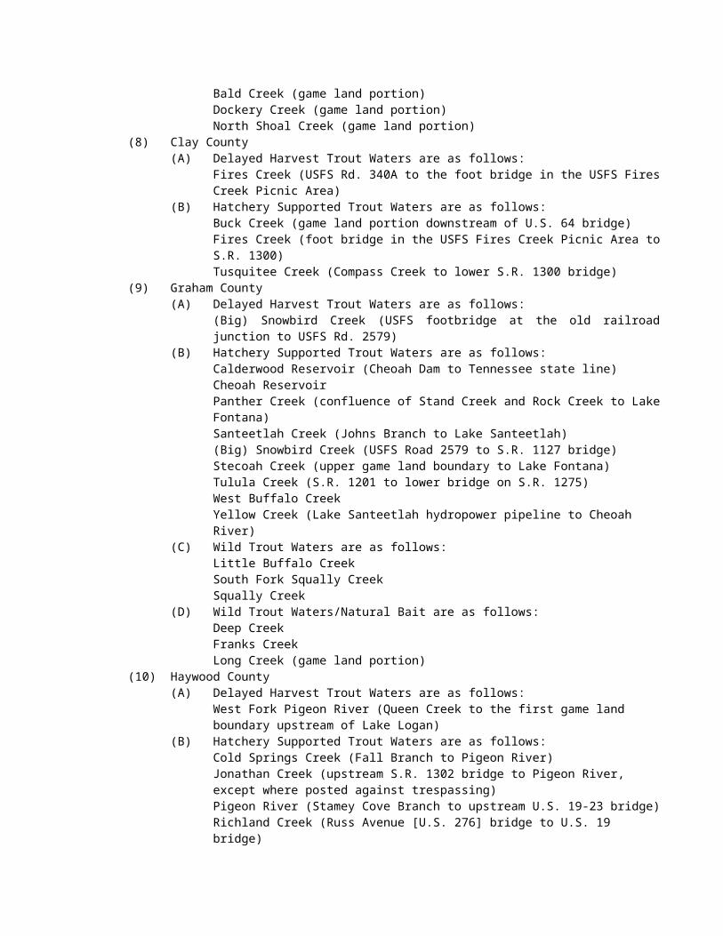
(b) The daily creel limit for trout in Wild Trout Waters and Wild Trout/Natural Bait Trout Waters is four fish. The minimum size limit for these fish is seven inches. There is no closed season.(c) No trout may be harvested from Catch and Release/Artificial Lures Only Trout Waters or Catch and Release/Artificial Flies Only Trout Waters. Trout may not be possessed while fishing these waters.(d) The daily creel limit for trout in Delayed Harvest Trout Waters is seven fish. There is no minimum size limit for these fish. The Youth-only Delayed Harvest Trout Water Season is from 6 a.m. on the first Saturday in June until 12 p.m. that same day. During this season only individuals under the age of 18 may fish. From 12 p.m. on the first Saturday in June until September 30, the Delayed Harvest Trout Waters Season is open for all anglers. From October 1 to one-half hour after sunset on the Friday before the first Saturday in June, trout may not be harvested or possessed while fishing these waters. Delayed Harvest Trout Waters are closed to all fishing from one-half hour after sunset on the Friday before the first Saturday in June to 6 a.m. on the first Saturday in June.(e) The daily creel limits, size limits, and seasons for trout in Special Regulation Trout Waters are as follows: in the Catawba River (Burke County) from Muddy Creek to the City of Morganton water intake dam the daily creel limit is two fish. The minimum size limit is 14 inches. There is no closed season.(f) The daily creel limit for trout in undesignated trout waters is seven fish. There is no minimum size limit for these fish.(g) There is no closed season on taking trout from Linville River within Linville Gorge Wilderness Area and the impounded waters of power reservoirs and municipally-owned water supply reservoirs open to the public for fishing.(h) In designated Public Mountain Trout Waters the season for taking all species of fish is the same as the trout fishing season.(i) All trout water designations and manners of take are set forth in 15A NCAC 10C .0205.
History Note: Authority G.S. 113-134; 113-292;Eff. November 1, 2013;Amended Eff. August 1, 2018; August 1, 2017; August 1, 2015.
15A NCAC 10C .0317 WALLEYE(a) The daily creel limit for Walleye is eight fish except for waters identified in Paragraphs (b) and (d) of this Rule. There is no minimum size limit for these fish except for waters identified in Paragraphs (c) and (d) of this Rule. There is no closed season.(b) In Linville River upstream upstream from the NC 126 bridge, the daily creel limit for Walleye is four fish.(c) In Lake James and its tributaries, except the Linville River upstream from the N.C. 126 bridge, the minimum size limit for walleye is 15 inches. (d) In John H. Kerr Reservoir, Lake Gaston, and Roanoke Rapids Lake, the daily creel limit is five fish and the minimum size limit for Walleye is 18 inches.
History Note: Authority G.S. 113-134; 113-292; Eff. November 1, 2013.
15A NCAC 10C .0318 WHITE BASSThe daily creel limit for White Bass is 10 fish. There is a 14 inch minimum size limit for these fish. There is no closed season for White Bass.
History Note: Authority G.S. 113-134; 113-292;Eff. November 1, 2013.Amend Eff. August 1, 2017.
15A NCAC 10C .0319 WHITE PERCH(a) There is no daily creel limit and no minimum limit size for White Perch. There is no closed season for White Perch.(b) In and west of Haywood, Buncombe, and Rutherford counties, it is unlawful to transport, possess, or release live White Perch.
History Note: Authority G.S. 113-134; 113-292; 113-304; 113-305;Eff. November 1, 2013;Amended Eff. August 1, 2016.
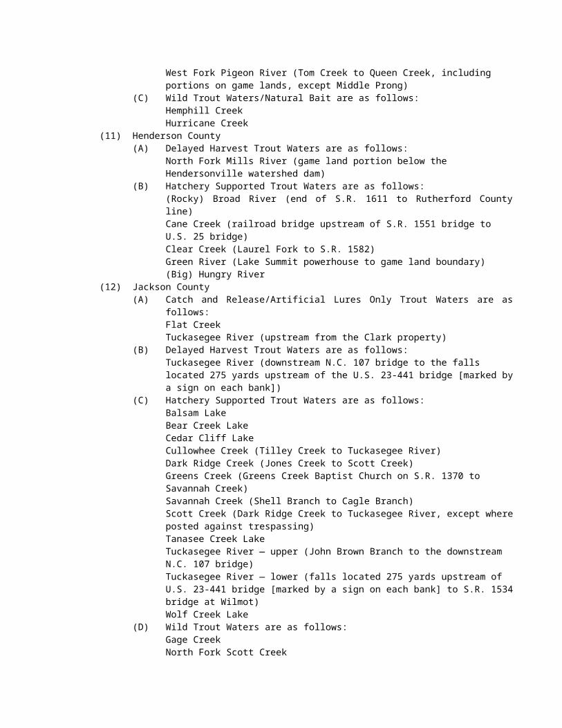
15A NCAC 10C .0320 YELLOW PERCHThere is no daily creel limit and no minimum size limit for Yellow Perch. There is no closed season for Yellow Perch.
History Note: Authority G.S. 113-134; 113-292; 113-304; 113-305;Eff. November 1, 2013.
SECTION .0400 – JURISDICTION OF AGENCIES: CLASSIFICATION OF WATERS
15A NCAC 10C .0401 MANNER OF TAKING NONGAME FISHES: PURCHASE AND SALE (EFFECTIVE UNTIL JULY 31, 2018)(a) Except as permitted by the rules in this Section, it is unlawful to take nongame fishes from the inland fishing waters of North Carolina in any manner other than with hook and line, or grabbling. Nongame fishes may be taken by hook and line or grabbling at any time without restriction as to size limits or creel limits, with the following exceptions:
(1) Blue crabs shall have a minimum carapace width of five inches (point to point) and it is unlawful to possess more than 50 crabs per person per day or to exceed 100 crabs per vessel per day.
(2) While boating on or fishing in the following inland fishing waters, no person shall take river herring (alewife and blueback) that are greater than six inches in length, or possess such herring regardless of origin in:(A) Roanoke River downstream of Roanoke Rapids Dam;(B) Tar River downstream of Rocky Mount Mill Dam;(C) Neuse River downstream of Milburnie Dam;(D) Cape Fear River downstream of Buckhorn Dam;(E) Pee Dee River downstream of Blewett Falls Dam;(F) Lumber River including Drowning Creek;(G) all the tributaries to the rivers listed above; and(H) all other inland fishing waters east of I-95.
(3) Grass carp shall not be taken or possessed on Lake James, Lookout Shoals Lake, Lake Norman, Mountain Island Reservoir, Lake Wylie, and John H. Kerr Reservoir, except that one fish per day may be taken with archery equipment.
(4) No trotlines or set-hooks shall be used in the impounded waters located on the Sandhills Game Land or in designated public mountain trout waters.
(5) In Lake Waccamaw, trotlines or set-hooks may be used only from October 1 through April 30.(6) In inland fishing waters, gray trout (weakfish) recreational seasons, size limits, and creel limits are
the same as those established by Marine Fisheries Commission rule or proclamations issued by the Fisheries Director in adjacent joint or coastal fishing waters.
(b) The season for taking nongame fishes by other hook and line methods in designated public mountain trout waters is the same as the trout fishing season. Trout seasons are designated in 15A NCAC 10C .0316.(c) Nongame fishes taken by hook and line, grabbling, or by licensed special devices may be sold, with the following exceptions:
(1) alewife and blueback herring, excluding those less than six inches in length collected from Kerr Reservoir (Granville, Vance, and Warren counties);
(2) blue crab; and(3) bowfin.
(d) Freshwater mussels, including the Asiatic clam (Corbicula fluminea), may be taken only from impounded waters, except mussels shall not be taken in Lake Waccamaw in Columbus County, and in University Lake in Orange County. The daily possession limit for freshwater mussels is 200 in the aggregate, except there is no daily possession limit for the Asiatic clam (Corbicula fluminea).(e) In waters that are stocked and managed for catfish and located on game lands, on Commission-owned property, or on the property of a cooperator, including waters within the Community Fishing Program, it is unlawful to take channel, white, or blue catfish by means other than hook and line; the daily creel limit is six catfish in aggregate. Waters where this creel limit applies shall be posted on-site with signs indicating the creel limit. (f) The daily creel limit for blue catfish greater than 32 inches is one fish in the following reservoirs:
(1) Lake Norman;(2) Mountain Island Lake;
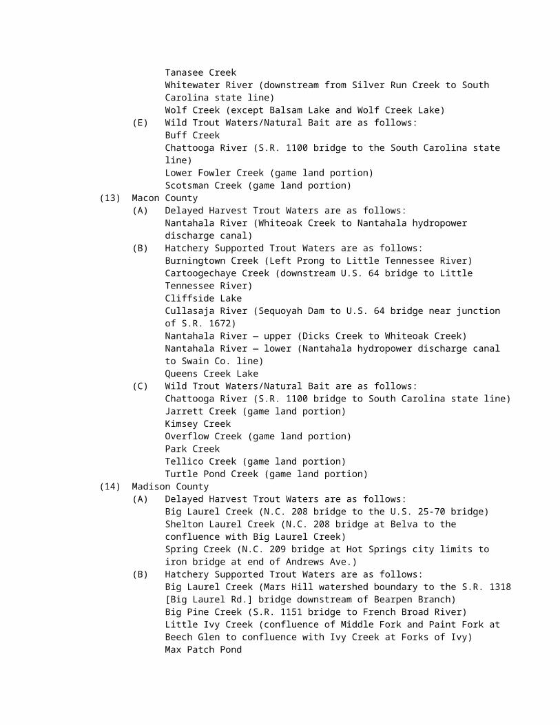
(3) Lake Wylie;(4) Badin Lake; and(5) Lake Tillery.
(g) The daily creel limit for American eels taken from or possessed, regardless or origin, while boating on or fishing in inland fishing waters is 25, and the minimum size limit is 9 inches.
History Note: Authority G.S. 113-134; 113-272; 113-292;Eff. February 1, 1976;Amended Eff. July 1, 1994; July 1, 1993; May 1, 1992;Temporary Amendment Eff. December 1, 1994;Amended Eff. July 1, 1998; July 1, 1996; July 1, 1995;Temporary Amendment Eff. July 1, 1999;Amended Eff. July 1, 2000;Temporary Amendment Eff. July 1, 2002; July 1, 2001;Amended Eff. August 1, 2002 (approved by RRC on 06/21/01 and 04/18/02);Temporary Amendment Eff. June 1, 2003;Amended Eff. May 1, 2004 (this amendment replaces the amendment approved by RRC on July 17, 2003);Amended Eff. August 1, 2016; August 1, 2015; August 1, 2014; August 1, 2013; August 1, 2012; August 1, 2011; August 1, 2010; May 1, 2009; May 1, 2008; May 1, 2007; May 1, 2006; June 1, 2005.
15A NCAC 10C .0401 MANNER OF TAKING NONGAME FISHES: PURCHASE AND SALE (EFFECTIVE AUGUST 1, 2018)(a) Except as permitted by the rules in this Section, it is unlawful to take nongame fishes from the inland fishing waters of North Carolina in any manner other than with hook and line or grabbling. Nongame fishes may be taken by hook and line or grabbling at any time without restriction as to size limits or creel limits, with the following exceptions:
(1) Blue crabs shall have a minimum carapace width of five inches (point to point) and it is unlawful to possess more than 50 crabs per person per day or to exceed 100 crabs per vessel per day.
(2) While boating on or fishing in the following inland fishing waters, no person shall take river herring (alewife and blueback) that are greater than six inches in length, or possess such herring regardless of origin in:(A) Roanoke River downstream of Roanoke Rapids Dam;(B) Tar River downstream of Rocky Mount Mill Dam;(C) Neuse River downstream of Milburnie Dam;(D) Cape Fear River downstream of Buckhorn Dam;(E) Pee Dee River downstream of Blewett Falls Dam;(F) Lumber River including Drowning Creek;(G) all the tributaries to the rivers listed above; and(H) all other inland fishing waters east of I-95.
(3) Grass carp shall not be taken or possessed on Lake James, Lookout Shoals Lake, Lake Norman, Mountain Island Reservoir, Lake Wylie, and John H. Kerr Reservoir, except that one fish per day may be taken with archery equipment.
(4) No trotlines or set-hooks shall be used in the impounded waters located on the Sandhills Game Land or in designated public mountain trout waters.
(5) In Lake Waccamaw, trotlines or set-hooks may be used only from October 1 through April 30.(6) In inland fishing waters, gray trout (weakfish) recreational seasons, size limits, and creel limits are
the same as those established by Marine Fisheries Commission rule or proclamations issued by the Fisheries Director in adjacent joint or coastal fishing waters.
(b) The season for taking nongame fishes by other hook and line methods in designated public mountain trout waters is the same as the trout fishing season. Trout seasons are designated in 15A NCAC 10C .0316.(c) Nongame fishes taken by hook and line, grabbling, or by licensed special devices may be sold, with the following exceptions:
(1) alewife and blueback herring, excluding those less than six inches in length collected from Kerr Reservoir (Granville, Vance, and Warren counties);
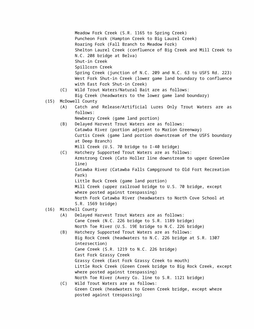
(2) blue crab; and(3) bowfin.
(d) Freshwater mussels, including the Asiatic clam (Corbicula fluminea), may be taken only from impounded waters, except mussels shall not be taken in Lake Waccamaw in Columbus County, and in University Lake in Orange County. The daily possession limit for freshwater mussels is 200 in the aggregate, except there is no daily possession limit for the Asiatic clam (Corbicula fluminea).(e) In waters that are stocked and managed for catfish and located on game lands, on Commission-owned property, or on the property of a cooperator, including waters within the Community Fishing Program, it is unlawful to take channel, white, or blue catfish by means other than hook and line; the daily creel limit is six catfish in aggregate. Waters where this creel limit applies shall be posted on-site with signs indicating the creel limit.(f) The daily creel limit for blue catfish greater than 32 inches is one fish in the following reservoirs:
(1) Lake Norman;(2) Mountain Island Lake;(3) Lake Wylie;(4) Badin Lake; (5) Lake Tillery;(6) John H. Kerr Reservoir (North Carolina portion);(7) Lake Gaston (North Carolina portion); and(8) Roanoke Rapids Reservoir.
(g) The daily creel limit for American eels taken from or possessed, regardless or origin, while boating on or fishing in inland fishing waters is 25, and the minimum size limit is 9 inches.(h) No person while fishing shall remove the head or tail or otherwise change the appearance of any nongame fish having a size limit so as to render it impracticable to measure its total original length. No person while fishing shall change the appearance of any nongame fish having a daily creel limit so as to obscure its identification or render it impracticable to count the number of fish in possession.
History Note: Authority G.S. 113-134; 113-272; 113-292;Eff. February 1, 1976;Amended Eff. July 1, 1994; July 1, 1993; May 1, 1992;Temporary Amendment Eff. December 1, 1994;Amended Eff. July 1, 1998; July 1, 1996; July 1, 1995;Temporary Amendment Eff. July 1, 1999;Amended Eff. July 1, 2000;Temporary Amendment Eff. July 1, 2002; July 1, 2001;Amended Eff. August 1, 2002 (approved by RRC on 06/21/01 and 04/18/02);Temporary Amendment Eff. June 1, 2003;Amended Eff. May 1, 2004 (this amendment replaces the amendment approved by RRC on July 17, 2003);Amended Eff. August 1, 2018; August 1, 2016; August 1, 2015; August 1, 2014; August 1, 2013; August 1, 2012; August 1, 2011; August 1, 2010; May 1, 2009; May 1, 2008; May 1, 2007; May 1, 2006; June 1, 2005
15A NCAC 10C .0402 TAKING NONGAME FISHES FOR BAIT OR PERSONAL CONSUMPTION (EFFECTIVE UNTIL JULY 31, 2018)
(a) It is unlawful to take nongame fish for bait or personal consumption in the inland waters of North Carolina using equipment other than:
(1) a net of dip net design not greater than six feet across;(2) a seine of not greater than 12 feet in length (except in Lake Waccamaw in Columbus County where
there is no length limitation) and with a bar mesh measure of not more than one-fourth inch;(3) a cast net;(4) a bow net for the seasons and waters in which the use of bow nets is authorized in 15A NCAC
10C .0407;(5) a dip net when used in conjunction with a licensed hand-crank electrofisher; (6) a gig (except in Public Mountain Trout Waters);(7) up to three traps for the seasons and waters in which the use of traps is authorized in 15A NCAC 10C
.0407;
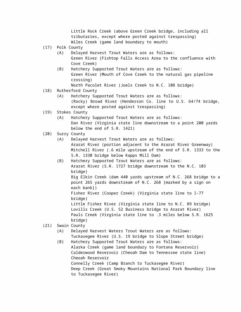
(8) up to two eel pots;(9) a spear gun for the seasons and waters in which the use of a spear gun is authorized in 15A NCAC
10C .0407;(10) minnow traps not exceeding 12 inches in diameter and 24 inches in length, with funnel openings not
exceeding one inch in diameter, and that are under the immediate control and attendance of the individual operating them;
(11) a hand-held line with a single bait attached;(12) a single, multiple-bait line for taking crabs not to exceed 100 feet in length, marked on each end with
a solid float no less than five inches in diameter, bearing legible and indelible identification of the user's name and address, and under the immediate control and attendance of the person using the device, with a limit of one line per person and no more than one line per vessel; or
(13) a collapsible crab trap with the largest open dimension not greater than 18 inches and that by design is collapsed at all times when in the water, except when it is being retrieved or lowered to the bottom, with a limit of one trap per person.
(b) The use of equipment under this Rule only requires a valid license that provides basic inland fishing privileges.(c) It is unlawful to sell nongame fishes or aquatic animals taken under this Rule.(d) Game fishes taken while netting for bait shall be returned unharmed to the water, except white perch may be taken when captured in a cast net being used to collect nongame fishes for bait or personal consumption in all impounded waters west of I-95 and in the Tar River Reservoir (Nash County).(e) No person shall take or possess during one day more than 200 nongame fish in aggregate for bait or personal consumption subject to the following restrictions:
(1) No more than 25 eels, none of which may be less than 9 inches in length, shall be taken from or possessed, regardless of origin, while boating on or fishing in inland fishing waters;
(2) While boating on or fishing in the following inland fishing waters, no river herring (alewife and blueback) that are greater than six inches in total length shall be taken, and no such river herring shall be possessed regardless of origin:(A) Roanoke River downstream of Roanoke Rapids Dam;(B) Tar River downstream of Rocky Mount Mill Dam;(C) Neuse River downstream of Milburnie Dam;(D) Cape Fear River downstream of Buckhorn Dam;(E) Pee Dee River downstream of Blewett Falls Dam;(F) Lumber River including Drowning Creek;(G) the tributaries to the rivers listed above; and(H) all other inland fishing waters east of Interstate 95.
(3) No more than 50 crabs per person per day or 100 per vessel per day with a minimum carapace width of five inches (point to point) shall be taken.
(f) Any fishes taken for bait purposes are included within the daily possession limit for that species.(g) It is unlawful to take nongame fish for bait or any other fish bait from designated public mountain trout waters and from the bodies of water specified for the following counties:
(1) Chatham County:Deep RiverRocky RiverBear Creek
(2) Lee County:Deep River
(3) Moore County:Deep River
(4) Randolph County:Deep River below the Coleridge DamFork Creek
(h) In the waters of the Little Tennessee River, including all the tributaries and impoundments thereof, and on adjacent shorelines, docks, access ramps, and bridge crossings, it is unlawful to transport, possess, or release live river herring (alewife and blueblack).
History Note: Authority G.S. 113-134; 113-135; 113-135.1; 113-272; 113-272.3; 113-292;Eff. February 1, 1976;
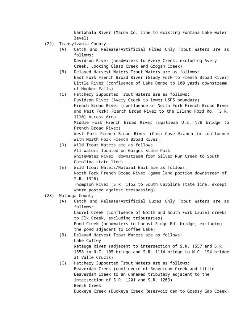
Amended Eff. July 1, 2000; July 1, 1998; July 1, 1993; July 1, 1992; May 1, 1992; July 1, 1989;Temporary Amendment Eff. July 1, 2001;Amended Eff. July 18, 2002;Temporary Amendment Eff. June 1, 2003;Amended Eff. June 1, 2004 (this amendment replaces the amendment approved by RRC on July 17, 2003);Amended Eff. August 1, 2017; August 1, 2016; August 1, 2015; August 1, 2014; August 1, 2013; August 1, 2010; May 1, 2008; May 1, 2007; May 1, 2006.
15A NCAC 10C .0402 TAKING NONGAME FISHES FOR BAIT OR PERSONAL CONSUMPTION (EFFECTIVE AUGUST 1, 2018)(a) It is unlawful to take nongame fish for bait or personal consumption in the inland waters of North Carolina using equipment other than:
(1) a net of dip net design not greater than six feet across;(2) a seine of not greater than 12 feet in length (except in Lake Waccamaw in Columbus County where
there is no length limitation) and with a bar mesh measure of not more than one-fourth inch;(3) a cast net;(4) a bow net for the seasons and waters in which the use of bow nets is authorized in 15A NCAC
10C .0407;(5) a dip net when used in conjunction with a licensed hand-crank electrofisher;(6) a gig (except in Public Mountain Trout Waters);(7) up to three traps for the seasons and waters in which the use of traps is authorized in 15A NCAC 10C
.0407;(8) up to two eel pots;(9) a spear gun for the seasons and waters in which the use of a spear gun is authorized in 15A NCAC
10C .0407;(10) minnow traps not exceeding 12 inches in diameter and 24 inches in length, with funnel openings not
exceeding one inch in diameter, from which all fish and animals are removed daily, and that are labeled with the user's Wildlife Resources Commission customer number or name and address;
(11) a hand-held line with a single bait attached;(12) a single, multiple-bait line for taking crabs not to exceed 100 feet in length, marked on each end with
a solid float no less than five inches in diameter, bearing legible and indelible identification of the user's name and address, and under the immediate control and attendance of the person using the device, with a limit of one line per person and no more than one line per vessel; or
(13) a collapsible crab trap with the largest open dimension not greater than 18 inches and that by design is collapsed at all times when in the water, except when it is being retrieved or lowered to the bottom, with a limit of one trap per person.
(b) The use of equipment under this Rule requires a valid license that provides basic inland fishing privileges.(c) It is unlawful to sell nongame fishes or aquatic animals taken under this Rule.(d) Game fishes taken while netting for bait shall be returned unharmed to the water, except white perch may be taken when captured in a cast net being used to collect nongame fishes for bait or personal consumption in all impounded waters west of I-95 and in the Tar River Reservoir (Nash County).(e) No person shall take or possess during one day more than 200 nongame fish in aggregate for bait or personal consumption subject to the following restrictions:
(1) No more than 25 eels, none of which may be less than 9 inches in length, shall be taken from or possessed, regardless of origin, while boating on or fishing in inland fishing waters;
(2) While boating on or fishing in the following inland fishing waters, no river herring (alewife and blueback) that are greater than six inches in total length shall be taken, and no such river herring shall be possessed regardless of origin:(A) Roanoke River downstream of Roanoke Rapids Dam;(B) Tar River downstream of Rocky Mount Mill Dam;(C) Neuse River downstream of Milburnie Dam;(D) Cape Fear River downstream of Buckhorn Dam;(E) Pee Dee River downstream of Blewett Falls Dam;(F) Lumber River including Drowning Creek;(G) the tributaries to the rivers listed above; and
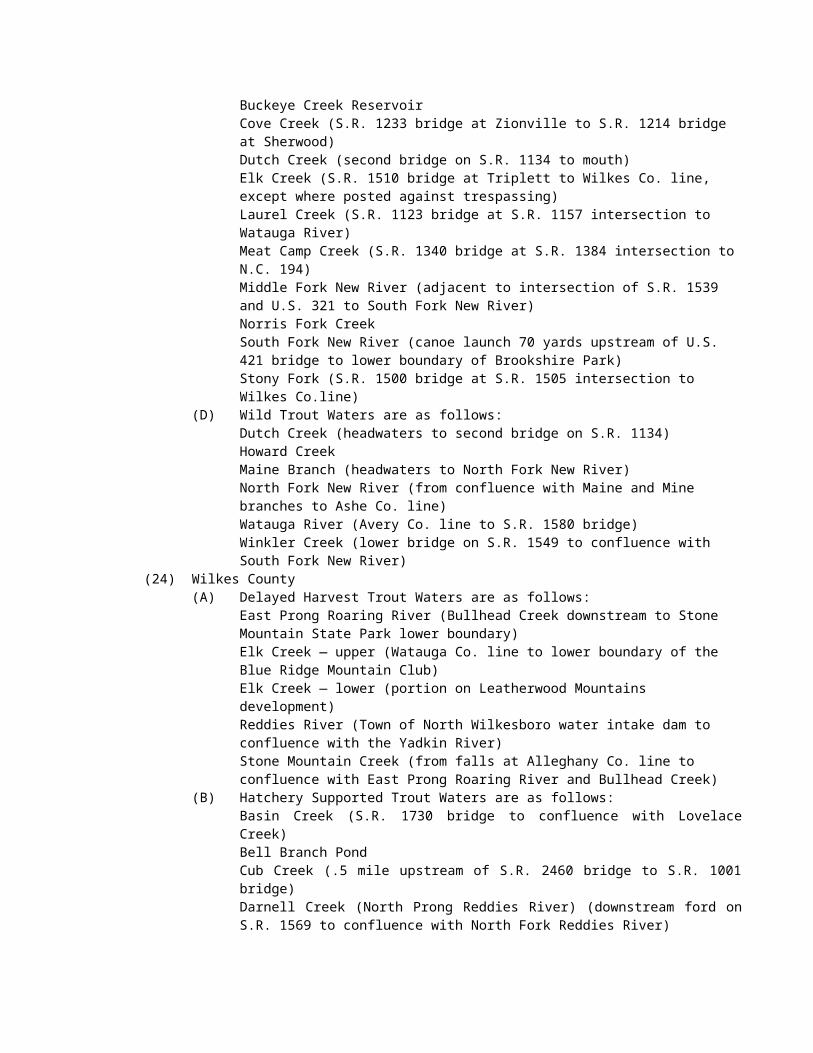
(H) all other inland fishing waters east of Interstate 95.(3) No more than 50 crabs per person per day or 100 per vessel per day with a minimum carapace width
of five inches (point to point) shall be taken.(f) Any fishes taken for bait purposes are included within the daily possession limit for that species.(g) It is unlawful to take nongame fish for bait or any other fish bait from the following waters:
(1) Public Mountain Trout Waters (except in impounded waters of power reservoirs and municipally-owned water supply reservoirs);
(2) Bear Creek in Chatham County;(3) Deep River in Chatham, Lee, and Moore counties and downstream of Coleridge Dam in Randolph
County;(4) Fork Creek in Randolph County; and(5) Rocky River in Chatham County.
(h) In the waters of the Little Tennessee River, including all the tributaries and impoundments thereof, and on adjacent shorelines, docks, access ramps, and bridge crossings, it is unlawful to transport, possess, or release live river herring (alewife and blueblack).(i) No person while fishing shall remove the head or tail or otherwise change the appearance of any nongame fish having a size limit so as to render it impracticable to measure its total original length. No person while fishing shall change the appearance of any nongame fish having a daily creel limit so as to obscure its identification or render it impracticable to count the number of fish in possession.
History Note: Authority G.S. 113-134; 113-135; 113-135.1; 113-272; 113-272.3; 113-292;Eff. February 1, 1976;Amended Eff. July 1, 2000; July 1, 1998; July 1, 1993; July 1, 1992; May 1, 1992; July 1, 1989;Temporary Amendment Eff. July 1, 2001;Amended Eff. July 18, 2002;Temporary Amendment Eff. June 1, 2003;Amended Eff. June 1, 2004 (this amendment replaces the amendment approved by RRC on July 17, 2003);Amended Eff. August 1, 2018; August 1, 2017; August 1, 2016; August 1, 2015; August 1, 2014; August 1, 2013; August 1, 2010; May 1, 2008; May 1, 2007; May 1, 2006.
15A NCAC 10C .0403 TAKING NONGAME FISHES BY SPECIAL DEVICES
History Note: Authority G.S. 113-134; 113-272.3; 113-276; 113-292;Eff. February 1, 1976;Amended Eff. January 1, 1982; January 1, 1977;Repealed Eff. July 1, 1988.
15A NCAC 10C .0404 SPECIAL DEVICES(a) Archery equipment. The use of archery equipment, as defined in 15A NCAC 10B .0116, as a licensed special device is authorized for taking nongame fishes at any time from all inland fishing waters other than impounded waters located on the Sandhills Game Land and designated public mountain trout waters. Unless prohibited by Marine Fisheries Commission's rules in 15A NCAC 03, bow and arrow may be used in joint fishing waters.(b) Nets. Where authorized, manually operated nets, including seines and bow, cast, dip, gill, drift, and fyke nets may be used under the special device license. No fixed gill net or other stationary net which may be authorized as a special device may be more than 100 yards in length, nor shall any such net be placed within 50 yards of any other fixed net. Fixed nets must be set so that they run parallel to the nearest shoreline. No fixed or drift gill nets shall be used unless such net is marked for the protection of boat operators. A net shall be deemed so marked when there is attached to it at each end two separate yellow buoys that shall be of solid foam or other solid buoyant material no less than five inches in its smallest dimensions. The owner shall be identified on a buoy on each end either by using engraved buoys or by attaching engraved metal or plastic tags to the buoys. Such identification shall include one of the following:
(1) owner's N.C. motor boat registration number; (2) owner's U.S. vessel documentation name; or (3) owner's last name, first and middle initials.
It is unlawful to attach gill nets to any wire, rope, or similar device extended across any navigable watercourse.
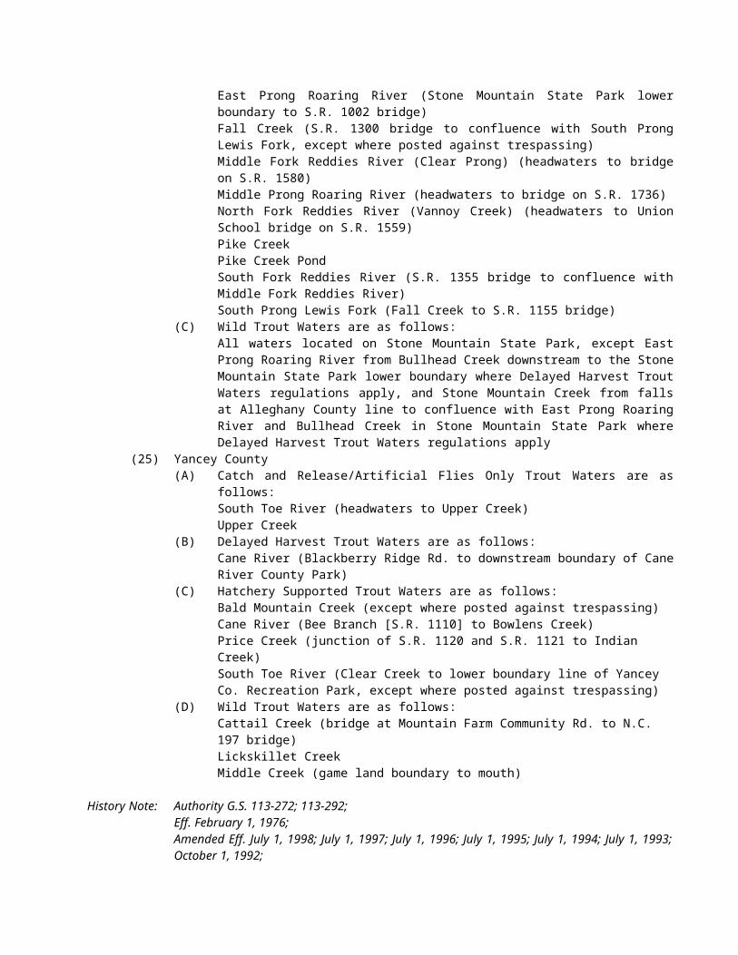
(c) Traps. Baskets and traps, excluding collapsible crab traps, may be used under the special device license. Such devices when set and left unattended shall be affixed with a card or tag furnished by the license holder and upon which his name and address shall be legibly and indelibly inscribed. No fish trap may exceed 60 inches in length or 30 inches in depth or width. No lead nets, wing nets, or other device designed to guide or herd fish may be attached to the trap or used or set within 25 feet of the trap.(d) Spears. Manually operated gigs or under-water spear or harpoon guns may be used under the special device license in the inland waters having a season for their use specified in Rule .0407 of this Section.(e) Crab pots. It is unlawful to use crab pots in inland fishing waters, except by persons owning property adjacent to the inland fishing waters of coastal rivers and their tributaries who are permitted to set two crab pots to be attached to their property and not subject to special device license requirements.(f) Eel pots. It is unlawful to use pots with mesh sizes smaller than one-half inch by one-half inch. Each pot must be marked by attaching a floating buoy that shall be of solid foam or other solid buoyant material and no less than five inches in diameter and no less than five inches in length. Buoys may be of any color except yellow. The owner shall be identified on the attached buoy by using engraved buoys or by engraved metal or plastic tags attached to the buoy. Such identification shall include one of the following:
(1) owner's N.C. motorboat registration number;(2) owner's U.S. vessel documentation name; or(3) owner's last name, first and middle initials.
(g) Hand-crank electrofisher. For the purposes of this Rule, a hand-crank electrofisher is any manually-operated device which is capable of generating a low voltage electrical current not exceeding 300 volts for the taking of catfish. Hand-crank electrofishers may be used only where authorized by local law and only in those waters specified in 15A NCAC 10C .0407.
History Note: Authority G.S. 113-134; 113-272.2; 113-276; 113-292;Eff. February 1, 1976;Amended Eff. July 1, 1999; July 1, 1996; December 1, 1995; July 1, 1995; July 1, 1994; July 1, 1993;Temporary Amendment Effective July 1, 2001;Amended Eff. August 1, 2014; August 1, 2012; May 1, 2008; May 1, 2007; August 1, 2004; July 18, 2002.
15A NCAC 10C .0405 POSSESSION OF LICENSESExcept as indicated in this Rule, every individual participating in the taking of fish through the use of any special device must have the special device fishing license issued to him, personally, in his possession or readily available for inspection. A bow net or a dip net may be used by an individual other than the licensee with the licensee's permission, but such user must have the license in his possession or readily available for inspection. When using drag seines authorized for taking nongame fishes at beaches on inland fishing waters where there are migratory saltwater fishes (herring or mullet), only the principal owner and operator is required to be licensed.
History Note: Authority G.S. 113-134; 113-275; 113-276; 113-276.1; 113-292;Eff. February 1, 1976;Temporary Amendment Eff. November 1, 1998;Amended Eff. April 1, 1999.
15A NCAC 10C .0406 TRAWLS AND DREDGESIt is unlawful to use a trawl or clam dredge in any inland fishing waters.
History Note: Authority G.S. 113-134; 113-276; 113-292;Eff. February 1, 1976;Amended Eff. July 1, 1988; January 1, 1982; January 1, 1981.
15A NCAC 10C .0407 PERMITTED SPECIAL DEVICES AND OPEN SEASONSExcept in designated public mountain trout waters, and in impounded waters located on the Sandhills Game Land, there is a year-round open season for the licensed taking of nongame fishes by bow and arrow. The use of special fishing devices, including crab pots in impoundments located entirely on game lands is prohibited. Seasons and waters in which the use of other special devices is authorized are indicated by counties below:
(1) Alamance:(a) July 1 to August 31 with seines in Alamance Creek below NC 49 bridge and Haw River;(b) July 1 to June 30 with gigs in all public waters;
(2) Alexander: July 1 to June 30 with traps and gigs in all public waters; and with spear guns in Lake Hickory and Lookout Shoals Reservoir;
(3) Alleghany: July 1 to June 30 with gigs in New River, except designated public mountain trout waters;
(4) Anson:(a) July 1 to June 30 with traps and gigs in all public waters;(b) March 1 to April 30 with bow nets in Pee Dee River below Blewett Falls Dam;(c) July 1 to August 31 with seines in all running public waters, except Pee Dee River from
Blewett Falls downstream to the Seaboard Coast Line Railroad trestle;(5) Ashe: July 1 to June 30 with gigs in New River (both forks), except designated public mountain
trout waters;(6) Beaufort:
(a) July 1 to June 30 with traps in the Pungo River, and in the Tar and Pamlico Rivers above Norfolk and Southern Railroad bridge; and with gigs in all inland public waters;
(b) March 1 to April 30 with bow nets in all inland public waters;(7) Bertie:
(a) July 1 to June 30 with traps in the Broad Creek (tributary of Roanoke);(b) March 1 to April 30 with bow nets in all inland public waters, excluding public lakes,
ponds, and other impounded waters;(8) Bladen:
(a) March 1 to April 30 with bow nets in Black River; (b) July 1 to March 1 with hand-crank electrofishers (local law) in Cape Fear River between
Lock and Dam 1 and 3 and in Black River, except that hand-crank electrofishing is prohibited within 400 yards of Lock and Dam 1, 2, and 3 on Cape Fear River;
(9) Brunswick: March 1 to April 30 with bow nets in Alligator Creek, Hoods Creek, Indian Creek, Orton Creek below Orton Pond, Rices Creek, Sturgeon Creek and Town Creek;
(10) Buncombe: July 1 to June 30 with gigs in all public waters, except designated public mountain trout waters;
(11) Burke:(a) July 1 to August 31 with seines in all running public waters, except Johns River and
designated public mountain trout waters;(b) July 1 to June 30 with traps, gigs, and spear guns in all public waters, except designated
public mountain trout waters and Lake James;(12) Cabarrus:
(a) July 1 to August 31 with seines in all running public waters,(b) July 1 to June 30 with traps and gigs in all public waters;
(13) Caldwell: July 1 to June 30 with traps, gigs, and spear guns in all public waters, except designated public mountain trout waters;
(14) Camden:(a) July 1 to June 30 with traps in all inland public waters;(b) March 1 to April 30 with bow nets in all inland public waters, excluding public lakes,
ponds, and other impounded waters;(15) Carteret: March 1 to April 30 with bow nets in all inland public waters except South River and the
tributaries of the White Oak River;(16) Caswell:
(a) July 1 to June 30 with gigs in all public waters;(b) July 1 to August 31 with seines in all running public waters, except Moons Creek;(c) July 1 to June 30 with traps in Hyco Reservoir;
(17) Catawba:(a) July 1 to August 31 with seines in all running public waters, except Catawba River below
Lookout Dam;(b) July 1 to June 30 with traps, spear guns, and gigs in all public waters;
(18) Chatham:
(a) December 1 to April 15 with dip and gill nets in the Cape Fear River, Deep River, Haw River and Rocky River (local law);
(b) July 1 to August 31 with seines in the Cape Fear River, and Haw River;(c) July 1 to June 30 with traps in Deep River; and with gigs in all public waters;
(19) Cherokee: July 1 to June 30 with gigs in all public waters, except designated public mountain trout waters;
(20) Chowan:(a) March 1 to April 30 with bow nets in all inland public waters, excluding public lakes,
ponds, and other impounded waters;(b) July 1 to June 30 with traps in all inland public waters, excluding public lakes, ponds, and
other impounded waters;(21) Clay: July 1 to June 30 with gigs in all public waters, except designated public mountain trout
waters;(22) Cleveland:
(a) July 1 to August 31 with seines in all running public waters;(b) July 1 to June 30 with gigs, traps and spear guns in all public waters;
(23) Columbus:(a) December 1 to March 1 with gigs in all inland public waters, except Lake Waccamaw and
its tributaries;(b) March 1 to April 30 with bow nets in Livingston Creek;(c) July 1 to March 1 with hand-crank electrofishers (local law) in Waccamaw and Lumber
rivers;(24) Craven:
(a) July 1 to June 30 with traps in the main run of the Trent and Neuse Rivers;(b) March 1 to April 30 with bow nets in all inland public waters, except Pitch Kettle, Grindle,
Slocum (downstream of the US 70 bridge), Spring and Hancock Creeks and their tributaries; and with seines in the Neuse River;
(25) Currituck:(a) July 1 to June 30 with traps in Tulls Creek and Northwest River;(b) March 1 to April 30 with bow nets in all inland public waters, excluding public lakes,
ponds, and other impounded waters;(26) Dare:
(a) July 1 to June 30 with traps in Mashoes Creek, Milltail Creek, East Lake and South Lake;(b) March 1 to April 30 with bow nets in all inland public waters, excluding public lakes,
ponds, and other impounded waters;(27) Davidson:
(a) July 1 to August 31 with seines in all running public waters;(b) July 1 to June 30 with gigs in all public waters, and with traps in all public waters except
Leonard's Creek, Abbott's Creek below Lake Thom-A-Lex dam, and the Abbott's Creek arm of High Rock Lake upstream from the NC 8 bridge;
(28) Davie:(a) July 1 to June 30 with traps and gigs in all public waters;(b) July 1 to August 31 for taking only carp and suckers with seines in Dutchmans Creek from
US 601 to Yadkin River and in Hunting Creek from SR 1338 to South Yadkin River;(29) Duplin:
(a) December 1 to June 5 with seines in the main run of the Northeast Cape Fear River downstream from a point one mile above Serecta Bridge;
(b) March 1 to April 30 with bow nets in the main run of the Northeast Cape Fear River downstream from a point one mile above Serecta Bridge;
(30) Durham:(a) July 1 to August 31 with seines in Neuse River;(b) July 1 to June 30 with gigs in all public waters;
(31) Edgecombe: March 1 to April 30 with bow nets in all public waters;(32) Forsyth: July 1 to June 30 with traps and gigs in all public waters, except traps may not be used in
Belews Creek Reservoir;(33) Franklin:
(a) July 1 to August 31 with seines in Tar River;(b) July 1 to June 30 with gigs in all public waters, except Parrish, Laurel Mill, Jackson,
Clifton, Moore's and Perry's Ponds, and in the Franklinton City ponds;(34) Gaston:
(a) July 1 to August 31 with seines in all running public waters;(b) July 1 to June 30 with gigs, traps and spear guns in all public waters;
(35) Gates: March 1 to April 30 with bow nets in all inland public waters, excluding public lakes, ponds, and other impounded waters;
(36) Graham: July 1 to June 30 with gigs in all public waters, except designated public mountain trout waters;
(37) Granville:(a) July 1 to June 30 with gigs in all public waters, except Kerr Reservoir;(b) July 1 to August 31 with seines in the Tar River below US 158 bridge;(c) July 1 to June 30 with dip and cast nets in Kerr Reservoir;
(38) Greene: March 1 to April 30 with bow nets and reels in Contentnea Creek;(39) Guilford:
(a) July 1 to August 31 with seines in Haw River, Deep River below Jamestown Dam, and Reedy Fork Creek below US 29 bridge;
(b) July 1 to June 30 with gigs in all public waters;(40) Halifax: March 1 to April 30 with bow nets in Beech Swamp, Clarks Canal, Conoconnara Swamp,
Fishing Creek below the Fishing Creek Mill Dam, Kehukee Swamp, Looking Glass Gut, Quankey Creek, and White's Mill Pond Run;
(41) Harnett:(a) January 1 to May 31 with gigs in Cape Fear River and tributaries;(b) March 1 to April 30 with bow nets in Cape Fear River;
(42) Haywood: July 1 to June 30 with gigs in all public waters, except Lake Junaluska and designated public mountain trout waters;
(43) Henderson: July 1 to June 30 with gigs in all public waters, except designated public mountain trout waters;
(44) Hertford:(a) July 1 to June 30 with traps in Wiccacon Creek;(b) March 1 to April 30 with bow nets in all inland public waters, excluding public lakes,
ponds, and other impounded waters;(45) Hyde:
(a) July 1 to June 30 with traps in all inland waters;(b) March 1 to April 30 with bow nets in all inland public waters, excluding public lakes,
ponds, and other impounded waters;(46) Iredell: July 1 to June 30 with traps and gigs in all public waters; and with spear guns in Lookout
Shoals Reservoir and Lake Norman;(47) Jackson: July 1 to June 30 with gigs in all public waters, except designated public mountain trout
waters;(48) Johnston: March 1 to April 30 with bow nets in Black Creek, Little River, Middle Creek, Mill Creek,
Neuse River and Swift Creek; (49) Jones:
(a) July 1 to June 30 with traps in the Trent River below US 17 bridge and White Oak River below US 17 bridge;
(b) March 1 to April 30 with bow nets in all inland public waters, except the tributaries to the White Oak River;
(50) Lee:(a) December 1 to April 15 with dip and gill nets (local law) in Cape Fear River and Deep
River; (b) July 1 to August 31 with seines in Cape Fear River;(c) July 1 to June 30 with traps in Deep River, and with gigs in all public waters;
(51) Lenoir:(a) July 1 to June 30 with traps in Neuse River below US 70 bridge at Kinston;
(b) March 1 to April 30with bow nets in Neuse River and Contentnea Creek upstream from NC 118 bridge at Grifton; and with seines in Neuse River;
(52) Lincoln:(a) July 1 to August 31 with seines in all running public waters;(b) July 1 to June 30 with traps, gigs and spear guns in all public waters;
(53) McDowell:(a) July 1 to August 31 with seines in all running public waters, except designated public
mountain trout waters;(b) July 1 to June 30 with traps, gigs, and spear guns in all public waters, except designated
public mountain trout waters and Lake James;(54) Macon: July 1 to June 30 with gigs in all public waters, except designated public mountain trout
waters;(55) Madison: July 1 to June 30 with gigs in all public waters, except designated public mountain trout
waters;(56) Martin: March 1 to April 30 with bow nets in all inland public waters, excluding public lakes,
ponds, and other impounded waters;(57) Mecklenburg:
(a) July 1 to August 31 with seines in all running public waters;(b) July 1 to June 30 with traps, gigs and spear guns in all public waters except Freedom Park
Pond and Hornet's Nest Ponds;(58) Montgomery:
(a) July 1 to August 31 with seines in all running public waters, except that part of the Pee Dee River between the Lake Tillery dam at Hydro and the mouth of Rocky River;
(b) July 1 to June 30 with traps and gigs in all public waters;(59) Moore:
(a) July 1 to August 31 with seines in all running public waters except in Deep River;(b) July 1 to June 30 with gigs in all public waters, except lakes located on the Sandhills Game
Land; and with traps in Deep River and its tributaries;(60) Nash:
(a) July 1 to June 30 with gigs in all public waters, except Tar River;(b) March 1 to April 30 with bow nets in the Tar River below Harris' Landing and Fishing
Creek below the Fishing Creek Mill Dam;(61) New Hanover: March 1 to April 30with bow nets in all inland public waters, except Sutton (Catfish)
Lake;(62) Northampton:
(a) July 1 to June 30 with gigs in all public waters, except Gaston and Roanoke Rapids Reservoirs and the Roanoke River above the US 301 bridge;
(b) March 1 to April 30with bow nets in Occoneechee Creek, Old River Landing Gut and Vaughans Creek below Watsons Mill;
(63) Onslow:(a) July 1 to June 30 with traps in White Oak River below US 17 bridge;(b) August 1 to March 31 with eel pots in the main run of New River between US 17 bridge and
the mouth of Hawkins Creek;(c) March 1 to April 30 with bow nets in the main run of New River and in the main run of the
White Oak River;(d) March 1 to April 30 with bow nets in Grant's Creek;
(64) Orange:(a) July 1 to August 31 with seines in Haw River,(b) July 1 to June 30 with gigs in all public waters;
(65) Pamlico: March 1 to April 30 with bow nets in all inland public waters, except Dawson Creek;(66) Pasquotank:
(a) July 1 to June 30 with traps in all inland waters;(b) March 1 to April 30 with bow nets in all inland public waters, excluding public lakes,
ponds, and other impounded waters;(67) Pender:
(a) December 1 to June 5 with seines in the main run of Northeast Cape Fear River;
(b) March 1 to April 30 with bow nets in the Northeast Cape Fear River, Long Creek, Moore's Creek approximately one mile upstream to New Moon Fishing Camp, and Black River;
(c) July 1 to March 1 with hand-crank electrofishers (local law) in Black River;(68) Perquimans:
(a) July 1 to June 30 with traps in all inland waters;(b) March 1 to April 30 with bow nets in all inland public waters, excluding public lakes,
ponds, and other impounded waters;(69) Person:
(a) July 1 to August 31 with seines in Hyco Creek and Mayo Creek;(b) July 1 to June 30 with gigs in all public waters.
(70) Pitt:(a) July 1 to June 30 with traps in Neuse River and in Tar River below the mouth of Hardee
Creek east of Greenville;(b) March 1 to April 30 with bow nets in all inland public waters, except Grindle Creek, and
Contentnea Creek between NC 118 bridge at Grifton and the Neuse River;(c) December 1 to June 5 with seines in Tar River;
(71) Polk: July 1 to June 30 with gigs in all public waters, except designated public mountain trout waters;
(72) Randolph:(a) July 1 to August 31 with seines in Deep River above the Coleridge Dam and Uwharrie
River;(b) July 1 to June 30 with gigs in all public waters;
(73) Richmond:(a) July 1 to August 31 with seines in all running public waters, except Pee Dee River from
Blewett Falls downstream to the Seaboard Coast Line Railroad trestle;(b) July 1 to June 30 with traps and gigs in all public waters, except lakes located on the
Sandhills Game Land;(c) March 1 to April 30 with bow nets in Pee Dee River below Blewett Falls Dam;
(74) Robeson: December 1 to March 1 with gigs in all inland public waters.(75) Rockingham:
(a) July 1 to August 31 with seines in Dan River and Haw River;(b) July 1 to June 30 with traps in Dan River; and with gigs in all public waters;
(76) Rowan:(a) July 1 to August 31 with seines in all running public waters,(b) July 1 to June 30 with traps and gigs in all public waters;
(77) Rutherford:(a) July 1 to August 31 with seines in all running public waters, except designated public
mountain trout waters;(b) July 1 to June 30 with traps, gigs, and spear guns in all public waters, except designated
public mountain trout waters;(78) Sampson:
(a) March 1 to April 30 with bow nets in Big Coharie Creek, Black River and Six Runs Creek;(b) July 1 to March 1 with hand-crank electrofishers (local law) in Black River downstream of
NC 1105 bridge;(79) Stanly:
(a) July 1 to August 31 with seines in all running public waters, except that part of the Pee Dee River between the Lake Tillery dam at Hydro and the mouth of Rocky River;
(b) July 1 to June 30 with traps and gigs in all public waters;(80) Stokes: July 1 to June 30 with traps and gigs in all public waters, except designated public mountain
trout waters, and traps may not be used in Belews Creek Reservoir;(81) Surry: July 1 to June 30 with gigs in all public waters, except designated public mountain trout
waters; and with traps in the main stem of Yadkin River;(82) Swain: July 1 to June 30 with gigs in all public waters, except designated public mountain trout
waters;(83) Transylvania: July 1 to June 30 with gigs in all public waters, except designated public mountain
trout waters;
(84) Tyrrell:(a) July 1 to June 30 with traps in Scuppernong River and Alligator Creek;(b) March 1 to April 30 with bow nets in all inland public waters, excluding Lake Phelps, the
drainage canals that connect Lake Phelps and Scuppernong River, public lakes, ponds and other impounded waters;
(85) Union:(a) July 1 to August 31 with seines in all running public waters,(b) July 1 to June 30 with traps and gigs in all public waters;
(86) Vance:(a) July 1 to August 31 with seines in the Tar River;(b) July 1 to June 30 with gigs in all public waters, except Rolands, Faulkners, Southerlands,
and Weldon Ponds, City Lake, and Kerr Reservoir;(c) July 1 to June 30 with dip and cast nets in Kerr Reservoir;
(87) Wake:(a) July 1 to June 30 with gigs in all public waters, except Sunset, Benson, Wheeler, Raleigh,
and Johnson Lakes;(b) March 1 to April 30 with bow nets in the Neuse River below Milburnie Dam, and Swift
Creek below Lake Benson Dam;(88) Warren:
(a) July 1 to August 31 with seines in Fishing Creek, Shocco Creek, and Walker Creek; excluding Duck and Hammes Mill Ponds;
(b) July 1 to June 30 with gigs in all public waters, except Duck and Hammes Mill Ponds, Kerr Reservoir, and Gaston Reservoir;
(c) July 1 to June 30 with dip and cast nets in Kerr Reservoir;(89) Washington: March 1 to April 30 with bow nets in all inland public waters, excluding Lake Phelps,
the drainage canals that connect Lake Phelps and Scuppernong River, public lakes, ponds and other impoundments.
(90) Wayne: March 1 to April 30 with bow nets in Little River, Mill Creek and Neuse River. (91) Wilkes: July 1 to June 30 with traps in Yadkin River below W. Kerr Scott Reservoir; and with gigs
and spear guns in all public waters, except designated public mountain trout waters;(92) Wilson:
(a) July 1 to June 30 with gigs in Contentnea Creek (except Buckhorn Reservoir), including unnamed tributaries between Flowers Mill and SR 1163 (Deans) bridge;
(b) March 1 to April 30 with bow nets in Contentnea Creek below US 301 bridge and in Toisnot Swamp downstream from the Lake Toisnot Dam;
(93) Yadkin: July 1 to June 30 with gigs in all public waters, and with traps in the main stem of Yadkin River.
History Note: Authority G.S. 113-134; 113-276; 113-292;Eff. February 1, 1976;Temporary Amendment Eff. December 29, 1988;Temporary Amendment Eff. December 1, 1993;Amended Eff. July 1, 2000; July 1, 1998; July 1, 1996; December 1, 1995; July 1, 1995; July 1, 1994; June 1, 1994;Temporary Amendment Eff. July 1, 2002; July 1, 2001;Amended Eff. August 1, 2002 (approved by RRC on 06/21/01 and 04/18/02);Temporary Amendment Eff. June 1, 2003;Amended Eff. August 1, 2015; May 1, 2007; June 1, 2005; August 1, 2004.
15A NCAC 10C .0408 TRAPPING NONGAME FISH IN HIGH ROCK LAKE
History Note: Emergency Rule Eff. June 23, 1981;Authority G.S. 113-134; 113-292; 150B-13;Made Permanent with Change Eff. September 30, 1981;Repealed Eff. January 1, 1982.
SECTION .0500 – PRIMARY NURSERY AREAS
15A NCAC 10C .0501 SCOPE AND PURPOSETo establish and protect those fragile inland waters which support embryonic, larval or juvenile populations of marine or estuarine fish or crustacean species. These Rules will set forth permanent nursery areas in inland fishing waters. Nursery areas are necessary for the early growth and development of virtually all of North Carolina's important marine or estuarine fish or crustacean species. Nursery areas need to be maintained, as much as possible, in their natural state, and the fish and crustacean populations within them must be permitted to develop in a normal manner with as little interference from man as possible.
History Note: Authority G.S. 113-132; 113-134;Eff. September 1, 1990;Amended Eff. July 1, 2000.
15A NCAC 10C .0502 PRIMARY NURSERY AREAS DEFINEDPrimary nursery areas are defined as those areas inhabited by the embryonic, larval or juvenile life stages of marine or estuarine fish or crustacean species due to favorable physical, chemical or biological factors.
History Note: Authority G.S. 113-132; 113-134;Eff. August 1, 1990;Amended Eff. July 1, 2000.
15A NCAC 10C .0503 DESCRIPTIVE BOUNDARIESThe following waters have been designated as primary nursery areas:
(1) North River:(a) Broad Creek - Camden County - Entire stream;(b) Deep Creek - Currituck County - Entire stream;(c) Lutz Creek - Currituck County - Entire stream.
(2) Alligator River:(a) East Lake - Dare County - Inland waters portion;(b) Little Alligator River - Tyrrell County - Entire stream.
(3) Currituck Sound:(a) Martin Point Creek - Dare County - Entire stream (Jean Guite Creek);(b) Tull Creek and Bay - Currituck County - Tull Bay to mouth of Northwest River; Tull Creek
from mouth upstream to SR 1222 bridge.(4) Pamlico River:
(a) Duck Creek - Beaufort County - Entire stream;(b) Bath Creek - Beaufort County - Entire stream;(c) Mixons Creek - Beaufort County - Entire stream;(d) Porter Creek - Beaufort County - Entire stream;(e) Tooleys Creek - Beaufort County - Entire stream;(f) Jacobs Creek - Beaufort County - Entire stream;(g) Jacks Creek - Beaufort County - Entire stream;(h) Bond Creek - Beaufort County - Entire stream;(i) Muddy Creek - Beaufort County - Entire stream;(j) Strawhorn Creek - Beaufort County - Entire stream;(k) South Prong Wright Creek - Beaufort County - Entire stream;(l) Jordan Creek - Beaufort County - Entire stream.
(5) Neuse River:(a) Slocum Creek - Craven County - Entire stream;(b) Hancock Creek - Craven County - Entire stream.
(6) New River:(a) French Creek - Onslow County - Entire stream;(b) New River - Onslow County - US Highway 17 bridge to NC 24/US 258 bridge.
(7) Roanoke River: Halifax and Northampton counties - US 258 bridge to Roanoke Rapids dam.
(8) Tar-Pamlico River: Nash, Edgecombe, Pitt and Beaufort counties - N&S railroad at Washington upstream to Rocky Mount Mills Dam.
(9) Neuse River: Wake, Johnston, Wayne, Lenoir, Pitt and Craven counties - Pitchkettle Creek upstream to Milburnie Dam.
(10) Cape Fear River: Chatham, Lee, Harnett, Cumberland and Bladen counties - Lock and Dam No. 1 upstream to Buckhorn Dam.
(11) Albemarle Sound: Peter Mashoes Creek – Dare County – Entire Stream.(12) Croatan Sound: Spencer Creek – Dare County – Entire Stream.(13) White Oak River: Onslow and Jones counties – Grants Creek upstream to Gibson Bridge Road (SR
1118).(14) Northeast Cape Fear River: Pender County – NC 210 bridge upstream to NC 53 bridge.
History Note: Authority G.S. 113-132; 113-134;Eff. August 1, 1990;Amended Eff. May 1, 2008; November 1, 2007; August 1, 2004; July 1, 2000; July 1, 1993.
SECTION .0600 - ANADROMOUS FISH SPAWNING AREAS
15A NCAC 10C .0601 SCOPE AND PURPOSETo establish and protect those inland waters which function as spawning areas for anadromous fishes. These Rules will set forth anadromous fish spawning areas in inland fishing waters. Anadromous fish spawning areas are necessary for the spawning and early development of North Carolina's important anadromous fishes. Anadromous fish spawning areas provide the physical, biological, and chemical attributes necessary for anadromous fishes to spawn successfully.
History Note: Authority G.S. 113-132; 113-134;Eff. May 1, 2008.
15A NCAC 10C .0602 ANADROMOUS FISH SPAWNING AREAS DEFINEDAnadromous fish spawning areas are those areas where evidence of spawning of anadromous fishes has been documented by direct observation of spawning, capture of running ripe females, or capture of eggs or early larvae.
History Note: Authority G.S. 113-132; 113-134;Eff. May 1, 2008.
15A NCAC 10C .0603 DESCRIPTIVE BOUNDARIESThe following waters have been designated as anadromous spawning areas:
(1) Currituck Sound Area:(a) Northwest River including designated tributaries - main stem waters west of a line
beginning on the north shore at a point 36° 30.8374' N – 76° 04.8770' W; running southerly to the south shore to a point 36° 30.7061' N – 76° 04.8916' W; and south of a line beginning on the west shore at a point 36° 33.0259' N – 76° 09.1609' W; running easterly to the east shore to a point 36° 33.0292' N – 76° 08.9488' W; including the following tributary from the confluence with Northwest River in the direction indicated to the specified boundary: Moyock Run (Shingle Landing Creek) - upstream (southwest) to a line beginning on the west shore at a point 36° 31.5252' N – 76° 10.7385' W; running easterly along US 168 (Caratoke Highway) to the east shore to a point 36° 31.5140' N – 76° 10.7239 W.
(b) Tull Creek - southwest of a line beginning on the north shore at a point 36° 30.0991' N – 76° 04.8587' W; running southeasterly to the south shore to a point 36° 29.9599' N – 76° 04.7126' W; including the following tributaries from their confluence with Tull Creek to the specified boundary:(i) Roland Creek - upstream (northwest) to a line beginning on the north shore at a
point 36° 29.8274' N – 76° 08.1294' W; running southerly to the south shore to a point 36° 29.8120' N – 76° 08.1308' W; and east of a line beginning on the northwest shore of Guinea Mill Run Canal at a point 36° 28.9227' N – 76° 07.9126' W; running southerly along US 168 bridge (Caratoke Highway) to the southeast shore at a point 36° 28.9045' N – 76° 07.8956' W.
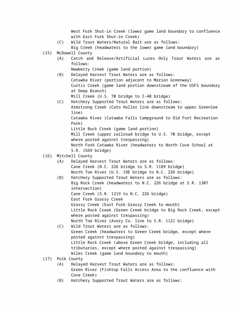
(ii) New Bridge Creek - upstream (south) to a line beginning on the northwest shore at a point 36° 28.0046' N – 76° 06.3312' W; running southeasterly along US 168 bridge (Caratoke Highway) to the southeast shore to a point 36° 27.9970' N – 76° 06.3243' W.
(iii) Cowells Creek - upstream (south) to a line beginning on the west shore at a point 36° 27.1571' N – 76° 04.5391' W; running easterly along US 168 bridge (Caratoke Highway) to the east shore to a point 36° 27.1542' N – 76° 04.5128' W.
(iv) Buckskin Creek - upstream (southeast) to a line beginning on the west shore at a point 36° 27.1925' N – 76° 04.1671' W; running easterly along US 168 bridge (Caratoke Highway) to the east shore to a point 36° 27.1989' N – 76° 04.1400' W.
(c) West Landing - north of a line beginning on the west shore at a point 36° 30.9867' N – 76° 02.5868' W; running easterly to the east shore to a point 36° 31.0045' N – 76° 02.3780' W; and west of a line beginning on the north shore at a point 36° 31.5828' N – 76° 02.2977' W; running southerly to the south shore to a point 36° 31.5618' N – 76° 02.2870' W.
(2) Albemarle Sound Area:(a) Big Flatty Creek - west of a line beginning on the north shore at a point 36° 09.3267' N –
76° 08.2562' W; running southerly to the south shore to a point 36° 08.9730' N – 76° 08.3175' W; including the following tributaries from the confluence with Big Flatty Creek in the direction indicated to the specified boundary:(i) Chapel Creek - upstream (northwest) to a line beginning on the north shore at a
point 36° 09.6689' N – 76° 09.9595' W; running southerly along SSR 1103 (Esclip Road) to the south shore to a point 36° 09.6522' N – 76° 09.9612' W.
(ii) Mill Dam Creek - upstream (southwest) to a line beginning on the north shore at a point 36° 09.0094' N – 76° 10.1667' W; running southerly along SSR 1103 (Esclip Road) to the south shore to a point 36° 08.9931' N – 76° 10.1611'W.
(b) Salmon Creek - southwest of a line beginning on the north shore at a point 36° 00.4648' N – 76° 42.3513' W; running southeasterly to the south shore to a point 36° 00.3373' N – 76° 42.1499' W; and south of a line beginning on the west shore at a point 36° 02.4783' N – 76° 45.8164' W; running easterly to the east shore to a point 36° 02.4807' N – 76° 45.7906' W.
(c) Mackeys (Kendrick) Creek - southeast of a line beginning on the north shore at a point 35° 56.3806' N – 76° 36.4356' W; running southwesterly to the south shore to a point 35° 56.3122' N – 76° 36.4613' W; and northwest of a line beginning on the southwest shore at a point 35° 52.5564' N – 76° 37.0968' W; running northeasterly along SSR 1122 bridge (Buncombe Avenue) to the northeast shore to a point 35° 52.5470' N – 76° 37.1113' W; including the following tributary from its confluence with Mackeys Creek in the direction indicated to the specified boundary: Main Canal - upstream (southeast) to a line beginning on the southwest shore at a point 35° 52.8229' N – 76° 36.6916' W; running northeasterly along SSR 1122 (Buncombe Avenue) to the northeast shore to a point 35° 52.8390' N – 76° 36.6708' W.
(d) Deep Creek (Washington County) - west of a line beginning on the north shore at a point 35° 56.1291' N – 76° 23.1179' W; running southerly to the south shore to a point 35° 56.0744' N – 76° 23.1230' W; and east of a line beginning on the north shore at a point 35° 55.4610' N – 76° 25.3996' W; running southerly along SSR 1302 bridge (Pea Ridge Road) to the south shore to a point 35° 55.4323' N – 76° 25.3974' W; and east of line beginning on the north shore at a point 35° 55.7173' N – 76° 25.3848' W; running southerly along SSR 1302 bridge (Pea Ridge Road) to the south shore to a point 35° 55.6863' N – 76° 25.3957' W.
(e) Banton (Bunton or Maybell) Creek - south of a line beginning on the west shore at a point 35° 56.0552' N – 76° 22.0664' W; running northeasterly to the east shore to a point 35° 56.1151' N – 76° 21.8760' W; and northeast of a line beginning on the west shore at a point 35° 55.6117' N – 76° 22.2463' W; running easterly to the east shore to a point 35° 55.6128' N – 76° 22.2126' W.
(f) Tom Mann Creek - south of a line beginning on the west shore at a point 35° 58.5296' N – 75° 52.8982' W; running easterly to the east shore to a point 35° 58.5175' N – 75° 53.6851' W.
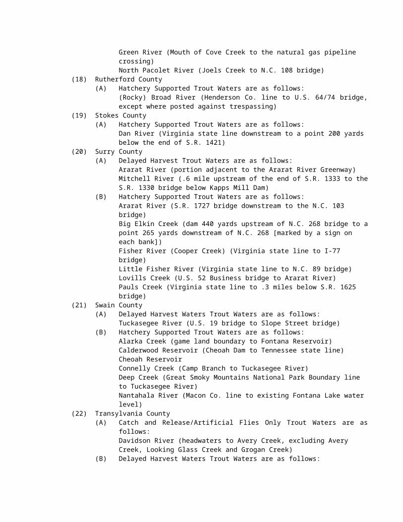
(g) Peter Mashoes Creek - west of a line beginning on the north shore at a point 35° 57.2344' N – 75° 48.3087' W; running southerly to the south shore to a point 35° 56.7805' N – 75° 48.3563' W.
(3) North River, including Indiantown Creek and other designated tributaries - main stem waters west of a line beginning on the north shore at a point 36° 18.7703' N – 75° 58.7384' W; running southerly to the south shore to a point 36° 18.4130' N – 75° 58.7228' W; and south of a line beginning on the west shore at a point 36° 21.7982' N – 76° 07.0726' W; running easterly along US 158 bridge to the east shore to a point 36° 21.8030' N – 76° 07.0612' W; including the following tributary from the confluence with North River in the direction indicated to the specified boundary: Crooked Creek - upstream (west) to a line beginning on the north shore at a point 36° 18.7171' N – 76° 01.4361' W; running southerly to the south shore to a point 36° 18.7002' N – 76° 01.4296' W.
(4) North River Area: Bump Landing Creek - east of a line beginning on the north shore at a point 36° 19.3757' N – 75° 57.9057' W; running southerly to the south shore to a point 36° 19.2496' N – 75° 57.9107' W; and west of a line beginning on the north shore at a point 36° 19.4049' N – 75° 57.4963' W; running southeasterly to the south shore to a point 36° 19.3830' N – 75° 57.5098' W.(a) Narrow Ridges Creek - east of a line beginning on the north shore at a point 36° 18.3249' N
– 75° 57.8910' W; running southerly to the south shore to a point 36° 18.1388' N – 75° 57.9029' W; and west of a line beginning on the north shore at a point 36° 18.1566' N – 75° 57.4879' W; running southeasterly to the south shore to a point 36° 18.1221' N – 75° 57.5095' W.
(b) Great Creek - west of a line beginning on the north shore at a point 36° 18.1045' N – 75° 58.4289' W; running southerly to the south shore to a point 36° 17.9882' N – 75° 58.4458' W; and northeast of a line beginning on the north shore at a point 36° 17.1310' N – 76° 00.3414'W; running southeasterly to the south shore to a point 36° 17.1163' N – 76° 00.3310' W. On the north shore of Great Creek within the fourth tributary: south of a line beginning on the west shore at a point 36° 18.1729' N – 75° 58.9137' W; running southeasterly to the south shore to a point 36° 18.1640' N – 75° 58.9022' W.
(c) Deep Creek - east of a line beginning on the north shore at a point 36° 17.1576' N – 75° 56.7594' W; running southerly to the south shore to a point 36° 16.9846' N – 75° 56.6802' W; and south of a line beginning on the west shore at a point 36° 17.9515' N – 75° 56.5174' W; running easterly to the east shore to a point 36° 17.9523' N – 75° 56.5042' W.
(d) Public Creek - west of a line beginning on the north shore at a point 36° 17.2462' N – 75° 58.2774' W; running southerly to the south shore to a point 36° 17.2121' N – 75° 58.2788' W; and northeast of a line beginning on the north shore at a point 36° 17.1661' N – 75° 58.6059' W; running southeasterly to the south shore to a point 36° 17.1574' N – 75° 58.6003' W.
(5) Pasquotank River including designated tributaries - main stem waters north of a line beginning on the west shore at a point 36° 18.0769' N – 76° 13.0979' W; running easterly along the south side of the US 158 bridge to the east shore to a point 36° 18.0594' N – 76° 12.9620' W and south of a line at South Mills beginning on the west shore at a point 36° 26.7432' N – 76° 19.6666' W; running easterly along US 17 business (Main Street) to the east shore to a point 36° 26.7642' N – 76° 19.5932' W; and southeast of a line beginning on the northeast shore at a point 36° 26.1777' N – 76° 22.1079' W; running southwesterly to the southwest shore to a point 36° 26.1693' N – 76° 22.1257' W; including the following tributaries from their confluence with the Pasquotank River in the direction indicated to the specified boundary:(a) Joyce Creek - upstream (northeast) to a line beginning on the north shore at a point 36°
26.8329' N – 76° 17.6174' W; running southwesterly along SSR 1224 bridge (Old Swamp Road) to the south shore to a point 36° 26.8103' N – 76° 17.6193' W.
(b) Sawyers Creek - upstream (northeast) to a line beginning on the northeast shore at a point 36° 21.7237' N – 76° 10.2841' W; running southwesterly along SSR 1203 bridge (Scotland Road) to the southwestern shore to a point 36° 21.7115' N – 76° 10.3041' W.
(c) Knobbs Creek - upstream (northwest) to a line beginning on the northwest shore at a point 36° 18.5172' N – 76° 14.5920' W; running southeasterly along SSR 1309 bridge (Main Street Extended) to the southeast shore to a point 36° 18.4973' N – 76° 14.5729' W.
(6) Pasquotank River Area:
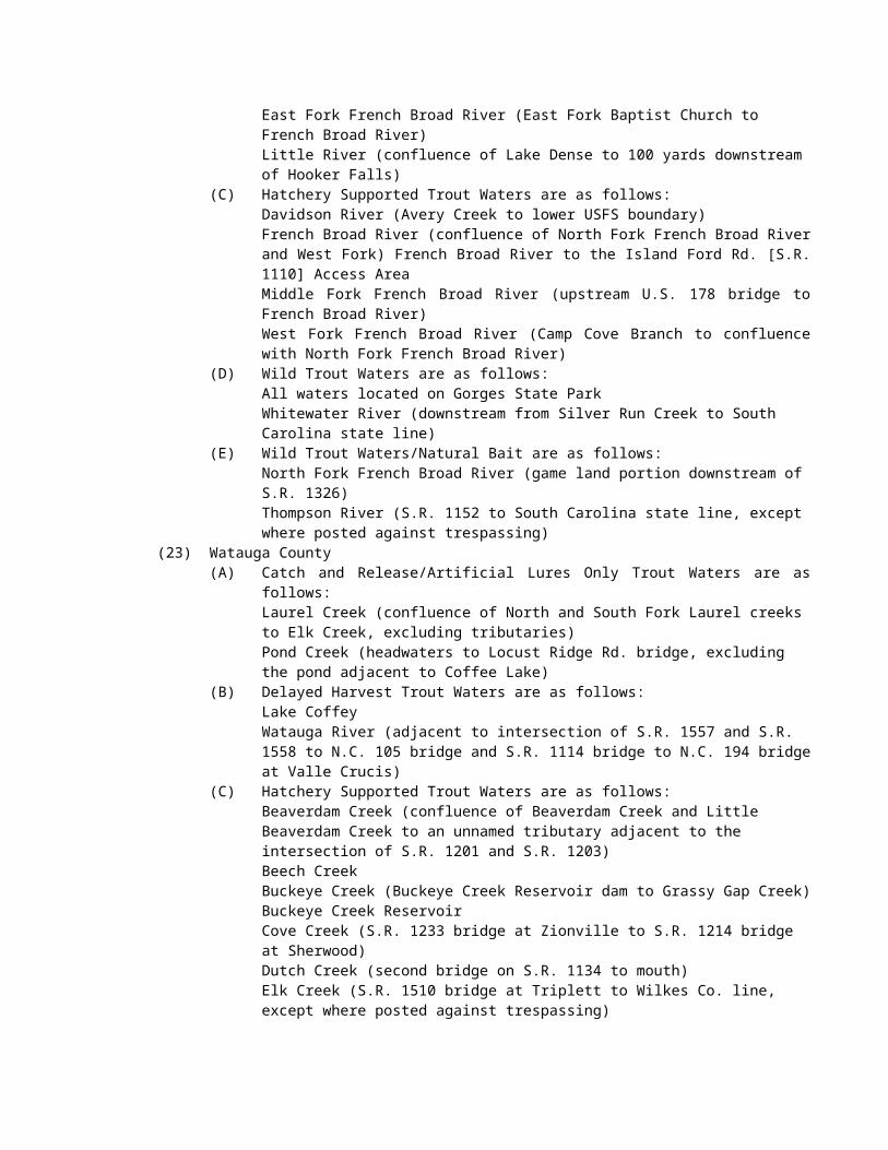
(a) Charles Creek - south of a line beginning on the west shore at a point 36° 17.8090' N – 76° 13.0732' W; running easterly to the east shore to a point 36° 17.8024' N – 76° 13.0407' W; and northeast of a line beginning on the northwest shore at a point 36° 17.4713' N – 76° 13.2227' W; running southeasterly along NC 34 (Road Street) to the southeast shore to a point 36° 17.4565' N – 76° 13.2140' W.
(b) Areneuse Creek and Mill Dam Creek - north of a line beginning on the west shore at a point 36° 17.3133' N – 76° 08.1655' W; running southeasterly along NC 343 bridge to the east shore to a point 36° 17.1328' N – 76° 07.6269' W; and southwest of a line beginning on the west shore of Mill Dam Creek at a point 36° 18.5994' N – 76° 07.8672' W; running southeasterly to the east shore to a point 36° 18.5991' N – 76° 07.8379' W; and southwest of a line beginning on the northwest shore of Areneuse Creek at a point 36° 18.0342' N – 76° 06.9433' W, running southeasterly along NC 343 bridge to the southeast shore to a point 36° 18.0196' N – 76° 06.9245' W.
(c) Portohonk Creek - northeast of a line beginning on the west shore at a point 36° 15.0519' N – 76° 05.2793' W; running southeasterly to the east shore to a point 36° 15.0391' N – 76° 05.2532' W; and south of a line beginning on the west shore at a point 36° 16.2809' N – 76° 04.8223' W; running easterly along NC 343 bridge to the east shore to a point 36° 16.2794' N – 76° 04.8051' W.
(d) New Begun Creek - west of a line beginning on the north shore at a point 36° 13.3298' N – 76° 08.2878' W; running southerly to the south shore to a point 36° 13.0286' N – 76° 08.1820' W; and southeast of a line beginning on the northeast shore at a point 36° 12.5577' N – 76° 10.3998' W; running southwesterly along NC 34 bridge (Weeksville Road) to the southwest shore to a point 36° 12.5467' N – 76° 10.4186' W; and northeast of a line beginning on the northeast shore at a point 36° 12.3280' N – 76° 10.4934' W; running northwesterly to the northwest shore to a point 36° 12.3067' N – 76° 10.5438' W.
(7) Little River including designated tributaries - main stem wasters northwest of a line beginning on the west shore at a point 36° 12.2950' N – 76° 17.1405' W; running southeasterly to the east shore to a point 36° 12.5237' N – 76° 16.9418' W; and south of a line beginning on the west shore at a point 36° 16.9826' N – 76° 23.1763' W; running easterly along SSR 1223 (Five Bridges Road, Perquimans County) and SSR 1303 (Cherry Glade Road, Pasquotank County) bridge to the east shore to a point 36° 16.9840' N – 76° 23.1570' W; including the following tributary from the confluence with Little River in the direction indicated to the specified boundary: Halls Creek - upstream (northeast) to a line beginning on the northwest shore at a point 36°13.2067' N – 76° 16.5769' W; running southeasterly along SSR 1140 (Halls Creek Road) to the southeast shore to a point 36° 13.1944' N – 76° 16.5523' W.
(8) Little River Area:(a) Deep Creek - southwest of a line beginning on the north shore at a point 36° 11.0945' N –
76° 16.6717' W; running southeasterly to the south shore to a point 36° 10.7510' N – 76° 16.2258' W; and south of a line beginning on the west shore at a point 36° 10.2553' N – 76° 18.7639' W; running easterly to the east shore to a point 36° 10.2633' N – 76° 18.7267' W.
(b) Symonds Creek - northeast of a line beginning on the north shore at a point 36° 10.2898' N – 76° 14.1801' W; running southeasterly to the south shore to a point 36° 10.2042' N – 76° 14.0368' W; and south of a line beginning on the west shore at a point 36° 11.4843' N – 76° 13.7218' W; running easterly along SSR 1100 bridge (Nixonton Road) to the east shore to a point 36° 11.4839' N – 76° 13.7028' W.
(9) Perquimans River including designated tributaries - main stem waters southwest of a line beginning on the west shore at a point 36° 11.6569' N – 76° 28.0055' W; running southeasterly along the US 17 business bridge (Church Street) to the east shore to a point 36° 11.6123' N – 76° 27.9382' W; and west of a line beginning on the north shore at a point 36° 18.8942' N – 76° 31.1905' W; running southeasterly to the south shore to a point 36° 18.8723' N – 76° 31.1734' W; and south of a line beginning on the west shore at a point 36° 18.9514' N – 76° 32.6510' W; running easterly along SSR 1202 bridge (Perry Bridge Road) to the east shore to a point 36° 18.9361' N – 76° 32.6584' W; including the following tributary from the confluence with the Perquimans River in the direction indicated to the specified boundary: Goodwin Creek - upstream (west) to a line beginning on the northwest shore at a point 36° 11.2807' N – 76° 33.6243' W; running southerly along SSR 1110 bridge (Center Hill Highway) to the southeast shore to a point 36° 11.2585' N – 76° 33.5755' W; and
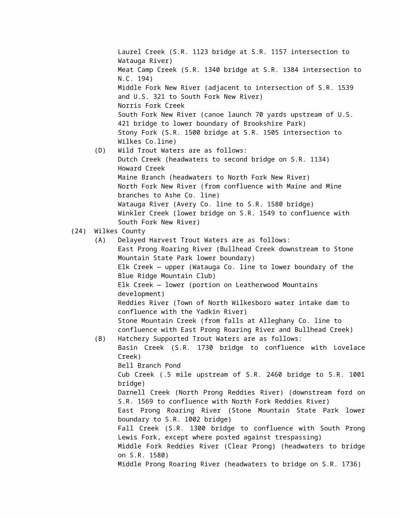
north to a line beginning on the west shore at a point 36° 11.0494' N – 76° 32.3409' W; running easterly along SSR 1110 bridge (Center Hill Highway) to the east shore to a point 36° 11.0383' N – 76° 32.2780' W.
(10) Perquimans River Area:(a) Mill Creek - north of a line beginning on the west shore at a point 36° 11.9757' N – 76°
27.5752' W; running easterly to the east shore to a point 36° 11.9766' N – 76° 27.2511' W; and southwest of a line beginning on the northwest shore at a point 36° 13.2910' N – 76° 26.6778' W; running southeasterly along SSR 1214 bridge (Lake Road) to the southeast shore to a point 36° 13.2762' N – 76° 26.6580' W.
(b) Walter's Creek - southwest of a line beginning on the north shore at a point 36° 11.1305' N – 76° 27.9185' W; running southeasterly to the south shore to a point 36° 11.0224' N – 76° 27.6626' W; and northeast of a line beginning on the northeast shore at a point 36° 10.0498' N – 76° 28.4208' W; running southwesterly along US 17 to the southwest shore to a point 36° 10.0408' N – 76° 28.4354' W.
(c) Suttons Creek - north of a line beginning on the west shore at a point 36° 10.0394' N – 76° 23.7945' W; running southeasterly to the east shore to a point 36° 09.9325' N – 76° 23.5263' W; and south of a line beginning on the west shore at a point 36° 11.5101' N – 76° 23.6253' W; running easterly along SSR 1300 bridge (New Hope Road) to the east shore to a point 36° 11.5081' N – 76° 23.6060' W.
(d) Jackson (Cove) Creek - northeast of a line beginning on the north shore at a point 36° 08.4642' N – 76° 20.3324' W; running southeasterly to the east shore to a point 36° 08.4159' N – 76° 20.2890' W; and southwest of a line beginning on the northwest shore at a point 36° 08.6083' N – 76° 20.1512' W; running southeasterly to the southeast shore to a point 36° 08.6007' N – 76° 20.1312' W.
(e) Muddy Creek - northwest of a line beginning on the north shore at a point 36° 07.0381' N – 76° 17.1350' W; running southeasterly to the east shore to a point 36° 07.0218' N – 76° 17.1226' W; and south of a line beginning on the west shore at a point 36° 07.5922' N – 76° 16.8153' W; running easterly to the east shore to a point 36° 07.5933' N – 76° 16.7757' W.
(11) Yeopim River including designated tributaries - main stem waters west of a line beginning on the north shore at a point 36° 05.4526' N – 76° 27.7651' W; running southerly to the south shore to Norcum Point 36° 05.1029' N – 76° 27.7120' W; and southeast of a line beginning on the north shore at a point 36° 05.1202' N – 76° 29.5050' W; running southwesterly to a point 36° 05.0644' N – 76° 29.5586' W; and running easterly to the east shore to a point 36° 05.0571' N – 76° 29.4657' W; including the following tributaries from the confluence with Yeopim River in the direction indicated to the specified boundary:(a) Yeopim Creek - upstream (north) to a line beginning on the west shore at a point 36°
07.4416' N – 76° 26.4833' W; running easterly along SSR 1347 (Holiday Island Road) to the east shore to a point 36° 07.4409' N – 76° 26.4667' W.
(b) Bethel Creek - upstream (north) to a line beginning on the southwest shore at a point 36° 07.1208' N – 76° 29.3581' W; running northeasterly to the northeast shore to a point 36° 07.1724' N – 76° 29.2818' W.
(c) Burnt Mill Creek - upstream (northwest) to a line beginning on the northeast shore at a point 36° 05.7727' N – 76° 32.6234' W; running southwesterly along US 17 to the southwest shore to a point 36° 05.7663' N – 76° 32.6374' W.
(d) Middleton Creek - upstream (southeast) to a line beginning on the northwest shore at a point 36° 04.2913' N – 76° 30.2613' W; running southeasterly along SSR 1100 bridge (Drummond Point Road) to the southeast shore to a point 36° 04.2813' N – 76° 30.2460' W; and northeast of a line beginning on the northwest shore at a point 36° 04.0714' N – 76° 29.5779' W; running southeasterly along SSR 1100 (Drummond Point Road) to the southeast shore to a point 36° 04.0639' N – 76° 29.5583' W.
(12) Edenton Bay Area:(a) Pembroke Creek (Pollock Swamp) - northwest of a line beginning on the west shore at a
point 36° 03.2819' N – 76° 37.0138' W; running northeasterly to the east shore to a point 36° 03.4185' N – 76° 36.6783' W; and west of a line beginning on the north shore at a point 36° 08.1216' N – 76° 37.7846' W; running southerly along SSR 1316 bridge (Greenhall Road) to the south shore to a point 36° 08.1035' N – 76° 37.7818' W.
(b) Queen Anne Creek - east of a line beginning on the north shore at a point 36° 03.3757' N – 76° 36.3629' W; running southerly to the south shore to a point 36° 03.3551' N – 76° 36.3574' W; and southwest of a line beginning on the northwest shore at a point 36° 03.5719' N – 76° 35.0968' W; running southeasterly along NC 32 bridge (Yeopim Road) to the southeast shore to a point 36° 03.5659' N – 76° 35.0796' W.
(13) Chowan River Area:(a) Buckhorn Creek (Hertford County) - north of a line beginning on the west shore at a point
36° 31.9519' N – 76° 55.2580' W; running easterly to the east shore to a point 36° 31.9628' N – 76° 55.2429' W; and east of a line beginning on the north shore at a point 36° 31.9443' N – 76° 55.8902' W; running southerly to the south shore to a point 36° 31.9099' N – 76° 55.8904' W.
(b) Somerton Creek - north of a line beginning on the west shore at a point 36° 31.7177' N – 76° 54.8327' W; running easterly to the east shore to a point 36° 31.7143' N – 76° 54.7810' W; and south of the NC/VA state line.
(c) Meherrin River Area:(i) Vaughan's Creek (Kirby's Creek) - west of a line beginning on the north shore at a
point 36° 28.3541' N – 77° 05.6259' W; running southerly to the south shore to a point 36° 28.3307' N – 77° 05.6369' W; and east of a line beginning on the north shore at a point 36° 28.7019' N – 77° 08.7566' W; running southerly along SSR 1362 bridge (Watson Mill Road) to the south shore to a point 36° 28.6834' N – 77° 08.7593' W; and northeast of a line beginning on the northwest shore at a point 36° 28.0921' N – 77° 08.5719' W; running southeasterly along SSR 1362 bridge (Watson Mill Road) to the southeast shore to a point 36° 28.0787' N – 77° 08.5557' W. Turkey Creek - from the confluence with Vaughan's Creek upstream; and northeast of a line beginning on the northwest shore at a point 36° 27.8047' N – 77° 07.7316' W; running southeasterly along SSR 1363 (Turkey Branch Road, Northampton County) and SSR 1300 bridge (Wise Store Road, Hertford County) to the southeast shore to a point 36° 27.7957' N – 77° 07.7170' W.
(ii) Potecasi Creek - southwest of a line beginning on the west shore at a point 36° 26.1234' N – 76° 57.5262' W; running southeasterly to the east shore to a point 36° 26.1005' N – 76° 57.4960' W; and east of a line beginning on the north shore at a point 36° 22.1250' N – 77° 05.3109' W; running southerly along SSR 1160 bridge (Spring Avenue) to the south shore to a point 36° 22.1035' N – 77° 05.3220' W.(A) Old Tree Swamp - from the confluence with Potecasi Creek upstream to a
line beginning on the west shore at a point 36° 22.5909' N – 77° 04.0382' W; running easterly along SSR 1167 bridge (Beaver Dam Road) to the east shore to a point 36° 22.5895' N – 77° 04.0192' W.
(B) Cutawhiskie Creek - from the confluence with Potecasi Creek upstream to a line beginning on the northwest shore at a point 36° 21.2751' N – 77° 04.3761' W; running southeasterly along SSR 1137 bridge (Liverman Mill Road) to the southeast shore to a point 36° 21.2583' N - 77° 04.3461' W.
(d) Mud Creek - north of a line beginning on the west shore at a point 36° 23.5134' N – 76° 53.9131' W; running easterly to the east shore to a point 36° 23.5132' N – 76° 53.8815' W; and east of a line beginning on the north shore at a point 36° 23.6287' N – 76° 53.8782' W; running southerly to the south shore to a point 36° 23.5943' N – 76° 53.8784' W.
(e) Catherine Creek (Hertford County) - south of a line beginning on the west shore at a point 36° 22.9579' N – 76° 53.1994' W; running southeasterly to the east shore to a point 36° 22.9456' N – 76° 53.1742' W; and north of a line beginning on the west shore at a point 36° 22.7142' N – 76° 53.1872' W; running easterly to the east shore to a point 36° 22.7209' N – 76° 53.1631' W.
(f) Buckhorn Creek (Run Off Swamp) (Gates County) - north of a line beginning on the west shore at a point 36° 22.9682' N – 76° 51.9172' W; running easterly to the east shore to a point 36° 22.9614' N – 76° 51.8870' W; and east of a line beginning on the north shore at a point 36° 23.3321' N – 76° 52.0233' W; running southerly to the south shore to a point 36° 23.3101' N – 76° 52.0244' W.
(g) Spikes Creek - northwest of a line beginning on the west shore at a point 36° 22.6515' N – 76° 50.8882' W; running northeasterly to the east shore to a point 36° 22.6684' N – 76° 50.8493' W; and east of a line beginning on the north shore at a point 36° 22.9574' N – 76°51.4953' W; running southerly to the south shore to a point 36° 22.9419' N – 76° 51.4959' W.
(h) Barnes Creek - north of a line beginning on the west shore at a point 36° 21.8820' N – 76° 48.6419' W; running easterly to the east shore to a point 36° 21.8978' N – 76° 48.5902' W; and east of a line beginning on the north shore at a point 36° 22.8208' N – 76° 50.0931' W; running southerly to the south shore to a point 36° 22.7839' N – 76° 50.0941' W.
(i) Shingle (Island) Creek - north of a line beginning on the north shore of the western most entrance into Chowan River at a point 36° 21.8449' N – 76° 48.0940' W; running southeasterly to the south shore to a point 36° 21.7831' N – 76° 48.0427' W. At the eastern most entrance to the creek: north of a line beginning of the west shore at a point 36° 21.8469' N – 76° 47.2668' W; running northeasterly to the east shore to a point 36° 21.9062' N – 76° 47.1862' W.
(j) Sarem Creek - east of a line beginning on the north shore at a point 36° 21.7259' N – 76° 46.4085' W; running southerly to the south shore to a point 36° 21.6748' N – 76° 46.4392' W; and southeast of a line beginning on the southwest shore at a point 36° 25.0514' N – 76° 49.4791' W; running northeasterly along SSR 1118 bridge (Taylors Road) to the northeast shore to a point 36° 25.0710' N – 76° 49.4657' W; including the following tributary from the confluence with Sarem Creek in the direction indicated to the specified boundary: Cole Creek - upstream (northeast) to a line beginning on the west shore at a point 36° 24.5075' N – 76° 47.0641' W; running easterly along NC 37 bridge to the east shore to a point 36° 24.5048' N – 76° 47.0397' W.
(k) Hodges Creek - west of a line beginning on the north shore at a point 36° 21.2459' N – 76° 46.3421' W; running southerly to the south shore to a point 36° 21.1823' N – 76° 46.3243' W; and east of a line beginning on the north shore at a point 36° 21.1597' N – 76° 46.6073' W; running southerly to the south shore to a point 36° 21.1309' N – 76° 46.6084' W.
(l) Wiccacon River including designated tributaries - west of a line beginning on the north shore at a point 36° 20.5439' N – 76° 45.4550' W; running southeasterly to the south shore to a point 36° 20.4684' N – 76° 45.3392' W; and east of a line beginning on the northeast shore at a point 36° 19.0196' N – 76° 53.5596' W; running southwesterly to the southwest shore to a point 36° 18.9936' N – 76° 53.5751' W; including the following tributaries from their confluence with Wiccacon River in the direction indicated to the specified boundary:(i) Ahoskie Creek - upstream (south) to a line beginning on the west shore at a point
36° 16.4860' N – 76° 54.1172' W; running easterly along NC 561 to the east shore to a point 36° 16.4796' N – 76° 54.0933' W.
(ii) Chinkapin Creek - upstream (southwest) to a line beginning on the northwest shore at a point 36° 15.1763' N – 76° 50.9758' W; running southeasterly along SSR 1432 bridge (Big Mill Road) to the southeast shore to a point 36° 15.1671' N – 76° 50.9567' W.
(m) Beef Creek - north of a line beginning on the west shore at a point 36° 20.3235' N – 76° 44.6401' W; running easterly to the east shore to a point 36° 20.3070' N – 76° 44.5797' W; and east of a line beginning on the north shore at a point 36° 20.9720' N – 76° 44.7930' W; running southerly to the south shore to a point 36° 21.0058' N – 76° 44.7931' W.
(n) Goose Creek - west of a line beginning on the north shore at a point 36° 19.5838' N – 76° 44.5971' W; running southerly to the south shore to a point 36° 19.5375' N – 76° 44.5925' W; and northeast of a line beginning on the west shore at a point 36° 19.9806' N – 76° 45.2656' W; running easterly to the east shore to a point 36° 19.9799' N – 76° 45.2356' W.
(o) Swain Mill (Taylor Pond) Creek - west of a line beginning on the north shore at a point 36° 18.5808' N – 76° 43.4729' W; running southerly to the south shore to a point 36° 18.5616' N – 76° 43.4706' W; and northeast of a line beginning on the northwest shore at a point 36° 18.5029' N – 76° 43.5882' W; running southeasterly along SSR 1441 bridge (Swain Mill Road) to the southeast shore to a point 36° 18.4906' N – 76° 43.5694' W.
(p) Bennetts Creek - north of a line beginning on the west shore at a point 36° 18.3499' N – 76° 42.0286' W; running northeasterly to the east shore to a point 36° 18.4057' N – 76° 41.6986'
W; and southwest of a line beginning on the northwest shore at a point 36° 25.9349' N – 76° 41.9859' W; running southeasterly along the Merchants Mill Pond Dam to the southeast shore to a point 36° 25.9154' N – 76° 41.9530' W.
(q) Catherine Creek including designated tributaries -main stem waters northeast of a line beginning on the west shore at a point 36° 18.1011' N – 76° 41.1286' W; running southeasterly to the east shore to a point 36° 17.9413' N – 76° 40.8627' W; including the following tributaries from the confluence with Catherine Creek in the direction indicated to the specified boundary:(i) Trotman Creek - upstream (northwest) to a line beginning on the north shore at a
point 36° 20.8213' N – 76° 38.1714' W; running southerly along NC 32 bridge to the south shore to a point 36° 20.7989' N – 76° 38.1646' W.
(ii) Warwick Creek - upstream (northeast) to a line beginning on the north shore at a point 36° 19.8212' N – 76° 38.0409' W; running southerly along NC 32 bridge to the south shore to a point 36° 19.7833' N – 76° 38.0235' W.
(r) Stumpy Creek - east of a line beginning on the north shore at a point 36° 16.6440' N – 76° 40.4251' W; running southerly to the south shore to a point 36° 16.6255' N – 76° 40.4196' W; and west of a line beginning on the north shore at a point 36° 16.7331' N – 76° 39.9154' W; running southerly along SSR 1232 bridge (Cannon Ferry Road) to the south shore to a point 36° 16.7220' N – 76° 39.9220' W.
(s) Dillard (Indian) Creek - east of a line beginning on the north shore at a point 36° 14.2234' N – 76° 41.5901' W; running southerly to the south shore to a point 36° 14.2023' N – 76° 41.5855' W; and west of a line beginning on the north shore at a point 36° 13.7727' N – 76° 40.3878' W; running southerly along SSR 1226 (Dillards Mill Road) to the south shore to a point 36° 13.7592' N – 76° 40.3875' W.
(t) Keel (Currituck) Creek - north of a line beginning on the west shore at a point 36° 14.1245' N – 76° 44.1961' W; running easterly to the east shore to a point 36° 14.0899' N – 76° 43.8533' W; and south of a line beginning on the west shore at a point 36° 15.2755' N – 76° 43.5077' W; running easterly to the east shore to a point 36° 15.2746' N – 76° 43.4750' W.
(u) Rocky Hock Creek - east of a line beginning on the west shore at a point 36° 06.5662' N – 76° 41.3108' W; running southeasterly to the east shore to a point 36° 06.6406' N – 76° 41.4512' W; and southwest of a line beginning on the northwest shore at a point 36° 08.3485' N – 76° 39.9790' W; running southeasterly along the face of Bennett Mill Pond Dam to the southeast shore to a point 36° 08.3353' N – 76° 39.9603' W.
(14) Cashie River including designated tributaries - main stem waters west of a line beginning on the north shore at a point 35° 54.7865' N – 76° 49.0521' W; running southerly to the south shore to a point 35° 54.6691' N – 76° 49.0553' W; and east of a line beginning on the north shore at a point 36° 05.7521' N – 77° 04.0494' W; running southerly along SSR 1260 bridge (Republican Road) to the south shore to a point 36° 05.7171' N – 77° 04.0344' W; including the following tributaries from their confluence with Cashie River in the direction indicated to the specified boundary:(a) Connarista Swamp - upstream (north) to a line beginning on the west shore at a point 36°
06.4489' N – 77° 02.4658' W; running easterly along SSR 1221 bridge (Charles Taylor Road) to the east shore to a point 36° 06.4501' N – 77° 02.4236' W.
(b) Whiteoak Swamp - upstream (northeast) to a line beginning on the northwest shore at a point 36° 04.6654' N – 76° 58.5841' W; running southeasterly along US 13 to the southeast shore to a point 36° 04.6480' N – 76° 58.5676' W.
(c) Chiska Creek - upstream (west) to a line beginning on the north shore at a point 36° 02.5659' N – 77° 02.3636' W; running southerly along SSR 1112 bridge (Roquist Pocosin Road) to the south shore to a point 36° 02.5463' N – 77° 02.3730' W.
(d) Hoggard Mill Creek - upstream (north) to a line beginning on the northwest shore at a point 36° 01.5828' N – 76° 56.9799' W; running southeasterly along the Hoggard Mill Pond Dam to the southeast shore to a point 36° 01.5479' N – 76° 56.9556' W.
(e) Roquist Creek - upstream (west) to a line beginning on the northeast shore at a point 36° 00.6453' N – 77° 02.8441' W; running southwesterly along SSR 1112 bridge (Roquist Pocosin Road) to the southwest shore to a point 36° 00.6119' N – 77° 02.8719' W.
(f) Wading Place Creek - upstream (east) to a line beginning on the west shore at a point 35° 58.1755' N – 76° 53.0010' W; running easterly along NC 308 bridge (Cooper Hill Road) to the east shore to a point 35° 58.1631' N – 76° 52.9542' W.
(15) Cashie River Area:(a) Broad Creek - south of a line beginning on the west shore at a point 35° 55.0568' N – 76°
45.2632' W; running easterly to the east shore to a point 35° 55.0543' N – 76° 45.1309' W.(b) Grennel Creek - east of a line beginning on the north shore at a point 35°55.3147' N – 76°
44.5010' W; running southerly to the south shore to a point 35° 55.2262' N – 76° 44.5495' W.
(c) Cashoke Creek - west of a line beginning on the north shore at a point 35° 56.2934' N – 76° 44.1769' W; running southwesterly to the south shore to a point 35° 56.2623' N – 76° 44.1993' W; and east of a line beginning on the north shore at a point 35° 56.3383' N – 76° 44.5958' W; running southerly along NC 45 bridge to the south shore to a point 35° 56.2839' N – 76° 44.5836' W.
(16) Roanoke River including designated tributaries - main stem waters northwest of a line beginning on the west shore at a point 36° 12.5264' N – 77° 23.0223' W; running northeasterly along the south side of the US 258 bridge to the east shore to a point 36° 12.5674' N – 77° 22.9724' W; to the base of the Roanoke Rapids Dam; including the following tributary from the confluence with Roanoke River in the direction indicated to the specified boundary: Bridgers Creek - upstream (northeast) to a line beginning on the west shore at a point 36° 15.0786' N – 77° 22.3766' W; running easterly to the east shore to a point 36° 15.0846' N – 77° 22.3083' W.
(17) Roanoke River Area:(a) Kehukee Swamp - west of a line beginning on the north shore at a point 36° 05.1942' N –
77° 18.9596' W; running southwesterly to the south shore to a point 36° 05.1670' N – 77° 18.9761' W; and south of a line beginning on the northeast shore at a point 36° 05.7019' N – 77° 19.3686' W; running southwesterly to the southwest shore to a point 36° 05.6909' N – 77° 19.3902' W.
(b) Wire Gut - north of a line beginning on the west shore at a point 36° 00.9580' N – 77° 13.0755' W; running easterly to the east shore to a point 36° 00.9542' N – 77° 13.0320' W; and east of a line beginning on the north shore at a point 36° 01.4294' N – 77° 13.6239' W; running southerly to the south shore to a point 36° 01.3873' N – 77° 13.6270' W.
(c) Apple Tree Creek - east of a line beginning on the north shore at a point 36° 00.4174' N – 77° 12.3252' W; running southeasterly to the south shore to a point 36° 00.3987' N – 77° 12.3088' W; and south of a line beginning on the west shore at a point 36° 02.3508' N – 77° 13.6900' W; running easterly to the east shore to a point 36° 02.3497' N – 77° 13.6055' W; and east of a line beginning on the north shore at a point 36° 01.9425' N – 77° 12.4225' W; running southerly to the south shore to a point 36° 01.9066' N – 77° 12.4222' W.
(d) Indian Creek - east of a line beginning on the north shore at a point 35° 59.0794' N – 77° 11.4926' W; running southerly to the south shore to a point 35° 59.0597' N – 77° 11.4967' W; and southwest of a line beginning on the northwest shore at a point 36° 03.5103' N – 77° 10.6537' W; running southeasterly along SSR 1108 bridge (Indian Woods Road) to the southeast shore to a point 36° 03.4917' N – 77° 10.6402' W; and west of a line beginning on the north shore at a point 36° 02.3940' N – 77° 09.3722' W; running southerly along SSR 1108 bridge (Indian Woods Road) to the south shore to a point 36° 02.3787' N – 77° 09.3711' W.
(e) Prices Gut - west of a line beginning on the north shore at a point 35° 57.3701' N – 77° 11.9815' W; running southerly to the south shore to a point 35° 57.3552' N – 77° 11.9796' W; and east of a line beginning on the north shore at a point 35° 57.4077' N – 77° 12.0401' W; running southerly to the south shore to a point 35° 57.3763' N – 77° 12.0135' W.
(f) Rainbow Gut - south of a line beginning on the west shore at a point 35° 55.9334' N – 77° 11.3246' W; running easterly to the east shore to a point 35° 55.9275' N – 77° 11.3136' W.
(g) Coniott Creek including designated tributaries - main stem waters west of a line beginning on the north shore at a point 35° 56.6562' N – 77° 04.2860' W; running southwesterly to the south shore to a point 35° 56.6397' N – 77° 04.3066' W; and southeast of a line beginning on the northeast shore at a point 35° 59.4139' N – 77° 08.2158' W; running southwesterly along SSR 1122 bridge (Broad Neck Road) to the southwest shore to a point 35° 59.3976' N
– 77° 08.2491' W; including the following tributary from the confluence with Coniott Creek in the direction indicated to the specified boundary: Frog Level Swamp - upstream to a line beginning on the north shore at a point 35° 58.0087' N – 77° 06.3447' W; running southerly to the south shore to a point 35° 57.9223' N – 77° 06.3483' W.
(h) Conoho Creek - north of a line beginning on the west shore at a point 35° 52.5439' N – 77° 02.6673' W; running easterly to the east shore to a point 35° 52.5407' N – 77° 02.6280' W; and southeast of a line beginning on the northeast shore at a point 35° 58.3271' N – 77° 17.6825' W; running southwesterly along NC 11 bridge to the southwest shore to a point 35° 58.3096' N – 77° 17.7006' W.
(i) Sweetwater Creek including designated tributaries - main stem east of a line beginning on the west shore at a point 35° 51.6464' N – 77° 00.5090' W; running southeasterly to the east shore to a point 35° 51.6252' N – 77° 00.4879' W; and northwest of a line beginning on the northeast shore at a point 35° 48.6186' N – 77° 02.0173' W; running southwesterly along SSR 1501 bridge (Big Mill Road) to the southwest shore to a point 35° 48.5968' N – 77° 02.0311' W; including the following tributary from the confluence with Sweetwater Creek in the direction indicated to the specified boundary: Peter Swamp - upstream (southeast) to a line beginning on the west shore at a point 35° 49.0798' N – 77° 00.2510' W; running easterly to the east shore to a point 35° 49.0705' N – 77° 00.2118' W.
(j) Unnamed Tributary (upstream of Old Mill Creek) - northwest of a line beginning on the northeast shore at a point 35° 53.9775' N – 76° 56.6431' W; running southwesterly to the southwest shore to a point 35° 53.9913' N – 76° 56.6238' W; and southeast of a line beginning on the northeast shore at a point 35° 54.1143' N – 76° 56.8761' W; running southwesterly along SSR 1542 bridge (Bertie County) to the southwest shore to a point 35° 54.0927' N – 76° 56.8956' W.
(k) Old Mill Creek - north of a line beginning on the west shore at a point 35° 53.9483' N – 76° 55.3921' W; running southeasterly to the east shore to a point 35° 53.9378' N – 76° 55.3710' W; and south of a line beginning on the west shore at a point 35° 54.3010' N – 76° 55.0492' W; running easterly along SSR 1518 bridge (Bertie County) to the east shore to a point 35° 54.3085' N – 76° 55.0164' W.
(l) Gardner Creek - south of a line beginning on the west shore at a point 35°50.1599' N – 76° 56.0211' W; running easterly to the east shore to a point 35° 50.1633' N – 76° 55.9899' W; and north of a line beginning on the west shore at a point 35° 48.4791' N – 76° 55.9768' W; running easterly to the east shore to a point 35° 48.4834' N – 76° 55.9378' W.
(m) Cut Cypress Creek - northeast of a line beginning on the north shore at a point 35° 51.9465' N – 76° 53.5762' W; running southeasterly to the south shore to a point 35° 51.9229' N – 76° 53.5556' W.
(n) Roses Creek - southeast of a line beginning on the north shore at a point 35° 50.1683' N – 76° 50.9664' W; running southwesterly to the south shore to a point 35° 50.1363' N – 76° 56.9907' W; and north of a line beginning on the west shore at a point 35° 49.5501' N – 76° 50.7358' W; running easterly to the east shore to a point 35° 49.5649' N – 76° 50.6674' W.
(o) Broad Creek - west of a line beginning on the north shore at a point 35° 52.5191' N – 76° 50.4235' W; running southerly to the south shore to a point 35° 52.4262' N – 76° 50.3791' W.
(p) Welch Creek - south of a line beginning on the west shore at a point 35° 51.8458' N – 76° 45.8381' W; running easterly along the shoreline and across the mouths of the three creek entrances to the east shore to a point 35° 51.8840' N – 76° 45.6207' W; and north of a line beginning on the west shore at a point 35° 49.7473' N – 76° 47.1058' W; running easterly to the east shore to a point 35° 49.7506' N – 76° 47.0778' W.
(q) Conaby Creek - south of a line beginning on the west shore at a point 35° 55.3779' N – 76° 42.4401' W; and running easterly to the east shore to a point 35° 55.3752' N – 76° 42.3408' W; north of a line beginning on the southwest shore at a point 35° 51.6443' N – 76° 44.5188' W; running northeasterly to the northeast shore to a point 35° 51.6538' N – 76° 44.4926' W.
(18) Scuppernong River including designated tributaries - main stem waters south of a line beginning on the west shore at a point 35° 54.0158' N – 76° 15.4605' W; running easterly to the east shore to a point 35° 54.0406' N – 76° 15.3007' W; and east of a line beginning on the north shore at a point 35° 51.6231' N – 76° 26.1210' W; running southerly to the south shore to a point 35° 51.5952' N – 76°
26.1178' W; including the following tributaries from their confluence with Scuppernong River in the direction indicated to the specified boundary: (a) First Creek (Rider's Creek) - upstream (south) to a line beginning on the north shore at a
point 35° 53.5116' N – 76° 14.0222' W; running southerly along NC 94 bridge to the south shore to a point 35° 53.4948' N – 76° 14.0125' W.
(b) Second Creek - upstream (south) to a line beginning on the north shore at a point 35° 53.0541' N – 76° 15.1132' W; running southerly along SSR 1105 (Bodwell Road) to the south shore to a point 35° 53.0286' N – 76° 15.1211' W.
(c) Lake Phelps - all waters of Lake Phelps and the following main canals connecting to Scuppernong River:(i) Moccasin Canal;(ii) Western (Enoch) Canal;(iii) Mountain Canal;(iv) Thirty-foot Canal;(v) Somerset (Old) Canal;(vi) Batava (Minerva, Magnolia, Bonarva) Canal; and(vii) Bee Tree Canal.
(19) Alligator River Area:(a) Little Alligator River - west of a line beginning on the north shore at a point 35° 56.7640' N
– 76° 01.0299' W; running southerly to the south shore to a point 35° 55.9362' N – 76° 01.2492' W; and north of a line beginning on the west shore at a point 35° 56.4784' N – 76° 07.5433' W; running easterly to the east shore to a point 35° 56.4771' N – 76° 07.5076' W.
(b) East Lake - east of a line beginning on the north shore at a point 35° 56.1676' N – 75° 55.2603' W; running southerly to the south shore to a point 35° 55.4727' N – 75° 55.5043' W; and south of a line beginning on the west shore at a point 35° 58.6402' N – 75° 52.1855' W; running easterly to the east shore to a point 35° 58.5887' N – 75° 51.7080' W.
(c) Second Creek - west of a line beginning on the north shore at a point 35° 51.7616' N – 76° 03.5105' W; running southerly to the south shore to a point 35° 51.1317' N – 76° 03.8003' W.
(d) Milltail Creek - east of a line beginning on the north shore at a point 35° 50.5192' N – 75° 58.6134' W; running southerly to the south shore to a point 35° 50.4956' N – 75° 58.6158' W; and northwest of a line beginning on the northeast shore at a point 35° 47.7377' N – 75° 53.1295' W; running southwesterly to the southwest shore to a point 35° 47.7180' N – 75° 53.1295' W.
(e) Whipping Creek and Lake - east of a line beginning on the north shore at a point 35° 41.3930' N – 76° 00.2481' W; running southerly to the south shore to a point 35° 41.3717' N – 76° 00.2554' W; and west of a line beginning on the north shore at a point 35° 42.1737' N – 75° 57.6728' W; running southerly to the south shore to a point 35° 42.1570' N – 75° 57.6732' W.
(f) Swan Creek and Lake - east of a line beginning on the north shore at a point 35° 40.2674' N – 76° 00.7360' W; running southerly to the south shore to a point 35° 40.2420' N – 76° 00.7548' W.
(20) Alligator River including designated tributary - main stem waters west of a line beginning on the north shore at Cherry Ridge Landing at a point 35° 42.2172' N – 76° 08.4686' W; running southerly to the south shore to a point 35° 42.1327' N – 76° 08.5002' W; and east of a line beginning on the north shore at a point 35° 36.0502' N – 76° 13.9734' W; running southerly along NC 94 to the south shore to a point 35° 36.0300' N – 76° 13.9779' W; including the following tributary from the confluence with Alligator River in the direction indicated to the specified boundary: Northwest Fork - upstream (north) to a line beginning on the north shore at a point 35° 43.6826' N – 76° 11.9538' W; running southerly to the south shore to a point 35° 43.6495' N – 76° 11.9692' W.
(21) Croatan Sound Area:(a) Spencer Creek - west of a line beginning on the north shore at a point 35° 51.4205' N – 75°
45.0645' W; running southerly to the south shore to a point 35° 51.3876' N – 75° 45.0640' W; and west of a line beginning on the north shore 35° 51.5597' N – 75° 45.0141' W; running southerly to the south shore to a point 35° 51.4624' N – 75° 45.0498' W; and west of a line beginning on the north shore at a point 35° 51.6783' N – 75° 44.9125' W; running
southerly to the south shore to a point 35° 51.5693' N – 75° 45.0109' W; and east of a line beginning on the north shore at a point 35° 52.5133' N – 75° 46.3070' W; running southerly to the south shore to a point 35° 52.4635' N – 75° 46.3110' W.
(b) Callaghan Creek - west of a line beginning on the north shore at a point 35° 51.1312' N – 75° 45.1327' W; running southwesterly to the south shore to a point 35° 51.0953' N – 75° 45.1629' W; and east of a line beginning on the north shore at a point 35° 50.0643' N – 75° 46.6041' W; running southerly to the south shore to a point 35° 50.0306' N – 75° 46.6034' W.
(22) Pamlico River Area:(a) Chocowinity Creek - south of a line beginning on the west shore at a point 35 30.4778' N –
77 04.4049' W; running southerly to the east shore at a point 35 30.4692' N – 77 04.3862' W; and north of a line beginning on the west shore at a point 35° 28.3423' N – 77° 05.0615' W; running easterly to the east shore at a point 35° 28.3413' N – 77° 05.0334' W.
(b) Blounts Creek - south of a line beginning on the west shore at a point 35 23.9524' N – 76 58.0357' W; running easterly to the east shore at a point 35 23.9565' N – 76 57.9576' W; and north of a line beginning on the west shore at a point 35° 22.3210' N – 76° 57.7210' W; running easterly along NC 33 to the east shore at a point 35° 22.3080' N – 76° 57.6706' W; on Nancy Run, north of a line beginning on the west shore at a point 35° 22.7132' N – 76° 59.0317' W; running easterly along NC 33 to the east shore at a point 35° 22.7064' N – 76° 59.0191' W; on Herring Run, north and west of a line beginning on the north shore at a point 35° 22.5435' N – 76° 56.9969' W; running southerly along SSR 1100 (Core Point Road) to the south shore at a point 35° 22.5168' N – 76° 57.0063' W.
(c) Durham Creek - south of a line beginning on the west shore at a point 35 21.5669' N – 76 51.9166' W; running easterly along the SSR 1955 bridge (Durham Creek Lane) to the east shore at a point 35 21.5721' N – 76 51.8621' W and north of a line beginning on the west shore at a point 35° 19.1959' N – 76° 52.3278' W; running southeasterly along NC 33 to the east shore at a point 35° 19.1802' N – 76° 52.2947' W.
(d) Little Goose Creek - north and east of a line beginning on the north shore at a point 35 28.7258' N – 76 55.8667' W; running southeasterly to the south shore at a point 35 28.5986' N – 76 55.7922' W and west of a line beginning on the north shore at a point 35° 29.0329' N – 76° 54.2344' W; running southeasterly along SSR 1334 (Camp Leach Road) to the south shore at a point 35° 29.0283' N – 76° 54.2228' W; and the unnamed northwest branch, south of a line beginning on the north shore at a point 35° 29.4589' N – 76° 55.0263' W; running southwesterly to the south shore at a point 35° 29.4492' N – 76° 55.0322' W.
(e) Broad Creek - north of a line beginning on the west shore at a point 35 30.0451' N – 76 57.6152' W; running easterly to the east shore at a point 35 30.0459' N – 76 57.5318' W and south of a line beginning on the west shore at a point 35° 32.1646' N – 76° 58.5193' W; running easterly along US 264 to the east shore at a point 35° 32.1588' N – 76° 58.5048' W.
(f) Runyon Creek - north of a line beginning on the west shore at a point 35 32.1615' N – 77 02.3606' W; running easterly along the NC 32 bridge (Park Drive) to the east shore at a point 35 32.1340' N – 77 02.3438' W and south of a line beginning on the north shore at a point 35° 33.0407' N – 77° 01.1497' W; running southeasterly to the south shore at a point 35° 33.0260' N – 77° 01.1449' W.
(23) Tar River including designated tributaries - main stem waters west of a line beginning on the north shore at a point 35 33.1993' N – 77 05.3977' W; running southerly to the south shore at a point 35 32.9978' N – 77 05.1529' W and east of a line beginning on the north shore at a point 35° 57.6505' N – 77° 48.2537' W; running southeasterly along the Rocky Mount Mill Pond Dam to the south shore at a point 35° 57.5997' N – 77° 48.1412' W; including the following tributaries from their confluence with Tar River in the direction indicated to the specified boundary:(a) Swift Creek - upstream (northwest) to a line beginning on the north shore at a point 36°
00.5829' N – 77° 39.9482' W; running southerly to the south shore at a point 36° 00.5413' N – 77° 39.9616' W.
(b) Fishing Creek - upstream (northwest) to a line beginning on the north shore at a point 36° 08.0430' N – 77° 43.2829' W; running southerly to the south shore at a point 36° 08.0173' N – 77° 43.2921' W; on Deep Creek, upstream (northeast) to a line beginning on the north
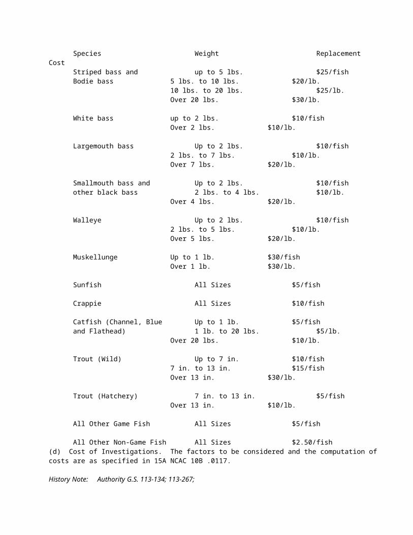
shore at a point 35° 57.8688' N – 77° 27.2298' W; running southeasterly to the south shore at a point 35° 57.8403' N – 77° 27.1890' W.
(c) Town Creek - upstream (west) to a line beginning on the north shore at a point 35° 48.4135' N – 77° 36.7687' W; running southwesterly to the south shore at a point 35° 48.3728' N – 77° 36.7686' W.
(d) Otter Creek - upstream (west) to a line beginning on the west shore at a point 35° 43.2448' N – 77° 31.9013' W; running easterly to the east shore at a point 35° 43.2385' N – 77° 31.8735' W.
(e) Tyson Creek - upstream (southwest) to a line beginning on the west shore at a point 35° 40.4470' N – 77° 30.7015' W; running easterly to the east shore at a point 35° 40.4107' N – 77° 30.6075' W.
(f) Conetoe Creek - upstream (north and east) to a line beginning on the north shore at a point 35° 44.5315' N – 77° 29.1676' W; running southerly to the south shore at a point 35° 44.5071' N – 77° 29.1894' W.
(g) Hardee Creek - upstream (southwest) to a line beginning on the west shore at a point 35° 35.6842' N – 77° 19.3857' W; running easterly to the east shore at a point 35° 35.6781' N – 77° 19.3680' W.
(h) Chicod Creek - upstream (west) to a line beginning on the west shore at a point 35° 34.6186' N – 77° 14.0233' W; running southerly to the east shore at a point 35° 34.5985' N – 77° 14.0169' W.
(i) Old Grindle Creek - upstream (north) to a line beginning on the north shore at a point 35° 35.3098' N – 77° 09.9461' W; running southerly along SSR 1565 (Grimesland Bridge Road) to the south shore at a point 35° 35.2891' N – 77° 09.9511' W.
(j) Bear Creek - upstream (southwest) to a line beginning on the west shore at a point 35° 32.4699' N – 77° 07.4185' W; running easterly to the east shore at a point 35° 32.4697' N – 77° 07.3758' W.
(24) Tranters Creek including designated tributaries - main stem waters north and west of a line beginning on the west shore at a point 35 33.1993' N – 77 05.3978' W; running easterly to the east shore at a point 35 33.2408' N – 77 05.0872' W and south of a line beginning on the west shore at a point 35° 45.7848' N – 77° 15.2294' W; running easterly to the east shore at a point 35° 45.7905' N – 77° 15.1931' W; including the following tributaries from their confluence with Tranters Creek in the direction indicated to the specified boundary:(a) Aggie Run - upstream (east) to a line beginning on the north shore at a point 35° 38.3433' N
– 77° 05.5003' W; running southeasterly to the south shore at a point 35° 38.2633' N – 77° 05.4097' W.
(b) Cherry Run - upstream (northeast) to a line beginning on the north shore at a point 35° 35.1560' N – 77° 04.0436' W; running southerly along US 17 to the south shore at a point 35° 35.1404' N – 77° 04.0437' W.
(25) Lake Mattamuskeet - all waters and all inland manmade tributaries of Lake Mattamuskeet. (26) Bay River Area: Trent Creek - south of a line beginning on the west shore at a point 35 06.2738' N
– 76 43.1071' W; running easterly along the NC 55 bridge (Pamlico County) to the east shore to a point 35 06.2603' N – 76 43.0741' W; and north of a line beginning on the southwest shore at a point 35 04.3545' N – 76 42.8282' W; running northeasterly to the northeast shore to a point 35 04.3686' N – 76 42.8117' W.
(27) Neuse River including designated tributaries - main stem waters south of a line beginning on the east shore at a point 35 47.9955' N – 78 32.2902' W; running westerly along Milburnie Dam (Bridges Lake Dam) to the west shore to a point 35 48.0280' N – 78 32.3989' W; and northwest of a line near Pitch Kettle Creek beginning on the north shore at a point 35 16.9793' N – 77 15.5529' W; running south to the south shore to a point 35 16.9237' N – 77 15.5461' W; including the following tributaries from their confluence with Neuse River in the direction indicated to the specified boundary: (a) Middle Creek - upstream (west) to a line beginning on the southwest shore at a point 35
30.4489' N – 78 24.1072' W; running northeasterly along the NC 210 bridge (Johnston County) to the northeast shore to a point 35 30.4767' N – 78 24.0676' W.
(b) Mill Creek - upstream (west) to a line beginning on the north shore at a point 35 20.7619' N – 78 20.0813' W; running southerly along the SSR 1185 bridge (Joyner Bridge Road) to the south shore to a point 35 20.7262' N – 78 20.0938' W.
(c) Little River - upstream (northwest) to a line beginning on the southwest shore at a point 35 40.0035' N – 78 15.5262' W; running northeasterly along the NC 42 bridge (Johnston County) to the northeast shore to a point 35 40.0142' N – 78 15.5060' W.
(d) Walnut Creek - upstream (north) to a line beginning on the west shore at a point 35 15.5439' N – 77 52.5703' W; running easterly to the east shore to a point 35 15.5407' N – 77 52.5574' W.
(e) Bear Creek - upstream (north) to a line beginning on the northeast shore at a point 35 21.1265' N – 77 49.1500' W; running southwesterly to the southwest shore to a point 35 21.1125' N – 77 49.1605' W.
(f) Falling Creek - upstream (northwest) to a line beginning on the west shore at a point 35 15.6635' N – 77 41.5862' W; running easterly along the US 70 bridge (Banks School Road) to the east shore to a point 35 15.6687' N – 77 41.5540' W.
(g) Contentnea Creek - upstream (northwest) to a line beginning on the west shore at a point 35 34.1707' N – 77 47.5396' W; running easterly to the east shore to a point 35 34.1704' N – 77 47.4966' W.
(h) Halfmoon Creek - upstream (southwest) to a line beginning on the north shore at a point 35 19.1578' N – 77 20.2050' W; running southerly to the south shore to a point 35 19.1335' N – 77 20.2036' W.
(i) Village Creek - upstream (southwest) to a line beginning on the northeast shore at a point 35 18.4795' N – 77 18.1037' W; running southwesterly to the southwest shore to a point 35 18.4603' N – 77 18.1121' W.
(j) Kitten Creek - upstream (northwest) to include all waters. (k) Core Creek - upstream (west) to a line beginning on the north shore at a point 35 10.7941'
N – 77 18.9102' W; running southerly to the south shore to a point 35 10.7715' N – 77 18.9012' W.
(l) Pitchkettle Creek - upstream (northwest) to include all waters.(28) Neuse River Area:
(a) Turkey Quarter and Greens creeks - southeast of a line beginning on the west shore of Turkey Quarter Creek at a point 35 15.6738' N – 77 14.6823' W; running southeasterly to the southeast shore of Turkey Quarter Creek to a point 35 15.6534' N – 77 14.6470' W; and northwest of a line beginning on the north shore of Greens Creek at a point 35 14.1883' N – 77 11.8862' W; running southwesterly to the southwest shore of Greens Creek to a point 35 14.1389' N – 77 11.7535' W.
(b) Taylor Creek - northwest of a line beginning on the north shore at a point 35 14.3719' N – 77 10.8050' W; running southwesterly to the south shore to a point 35 14.3300' N – 77 10.8352' W.
(c) Pine Tree Creek - west of a line beginning on the north shore at a point 35° 12.6663' N – 77° 07.4285' W; running southwesterly to the south shore to a point 35° 12.7033' N – 77° 07.3594' W and north of a line beginning on the west shore at a point 35° 12.8553' N – 77° 07.8300' W; running easterly to the east shore to a point 35° 12.8372' N – 77° 07.7934' W and north of a line beginning on the west shore at a point 35° 13.2012' N – 77° 08.7753' W; running southeasterly to the east shore to a point 35° 13.1714' N – 77° 08.7071' W.
(d) Swift and Little Swift creeks - north of a line beginning on the west shore at a point 35 11.5972' N – 77 06.0562' W; running easterly to the east shore to a point 35 11.5816' N – 77 05.9861' W for both creeks and south of a line beginning on the northeast shore at a point 35 17.8175' N – 77 08.9421' W; running southwesterly along the SSR 1440 bridge (Streets Ferry Road) to the southwest shore to a point 35 17.8027' N – 77 08.9529' W for Swift Creek; and southwest of two lines, one beginning on the northwest shore of Fisher Swamp at a point 35 14.6533' N – 77 03.9072' W; running southeasterly to the southeast shore to a point 35 14.6322' N – 77 03.8983' W; and the other beginning on the northwest shore of Little Swift Creek at a point 35 14.1315' N – 77 03.6823' W; running southeasterly along the SR 1627 bridge (Craven County) to the southeast shore to a point 35 14.1179' N – 77 03.6676' W for Little Swift Creek.
(e) Bachelor Creek - west of a line beginning on the north shore at a point 35°09.0099' N – 77° 04.5858' W; running southerly to the south shore to a point 35° 08.9085' N – 77° 04.7172' W and east of a line at Rollover Creek beginning on the north shore at a point 35 07.9194' N – 77 11.9438' W; running southerly to the south shore to a point 35 07.8931' N – 77 11.9445' W.
(f) Trent River Area:(i) Brice Creek - south of a line beginning on the west shore at a point 35° 02.1261' N
– 77° 02.1243' W; running easterly to the east shore to a point 35° 02.1268' N – 77° 02.1015' W and north of a line beginning on the west shore at a point 34 59.7828' N - 77 00.0710' W; running easterly along the SSR 1101 bridge (County Line Road) to the east shore to a point 34 59.7789' N - 77 00.0534' W.
(ii) Mill Creek - south of a line beginning on the west shore at a point 35 00.4595' N – 77 12.8427' W; running easterly to the east shore to a point 35 00.4593' N – 77 12.8160' W; and north of a line beginning on the west shore at a point 34 59.8881' N – 77 12.8536' W; running easterly to the east shore to a point 34 59.8878' N – 77 12.8368' W.
(iii) Mill Run - southwest of a line beginning on the northwest shore at a point 35 00.3766' N – 77 16.8680' W;running southeasterly along the NC 58 bridge (Jones County) to the southeast shore to a point 35 00.3654' N – 77 16.8487' W; and northeast of a line beginning on the northwest shore at a point 35 00.0929' N – 77 17.3282' W; running southeasterly to the southeast shore to a point 35 00.0740' N – 77 17.3024' W.
(g) Trent River including all the waters of Jumping Creek - main stem waters southwest of a line beginning on the west shore at a point 35° 01.9478' N – 77° 15.6377' W; running easterly along the SSR 1121 bridge (Oak Grove Road) to the east shore to a point 35° 01.9506' N – 77° 15.6095' W; and northeast of a line beginning on the northeast shore at a point 35 04.0759' N – 77 35.3891' W; running southwesterly along the SSR 1153 bridge (Vine Swamp Road) to the southwest shore to a point 35 04.0624' N – 77 35.4063' W; including all the waters of Jumping Creek.
(h) Upper Broad Creek - northwest of a line beginning on the north shore at a point 35 06.8922' N – 76 56.3911' W, running southerly to the south shore to a point 35 06.8623' N – 76 56.3916' W and southeast of a line beginning on the west shore at a point 35 08.3197' N – 76 58.7314' W; running easterly along the NC 55 bridge at the Craven and Pamlico county line to the east shore to a point 35 08.3209' N – 76 58.6753' W.
(i) Beard Creek - northwest of a line beginning on the north shore at a point 35 02.6853' N – 76 52.3346' W; running southerly to the south shore to a point 35 02.6663' N – 76 52.3351' W and southeast of line beginning on the southwest shore at a point 35 03.7198' N – 76 52.6024' W; running northeasterly along the SSR 1115 bridge (Pamlico County) to the northeast shore to a point 35 03.7258' N – 76 52.5942' W.
(j) Dawson Creek - northwest of a line beginning on the southwest shore at a point 35 01.8352' N – 76 47.4672' W; running northeasterly to the northeast shore to a point 35 01.8475' N – 76 47.4283' W; and southeast of a line beginning on the southwest shore of Fork Run at a point 35 02.1112' N – 76 48.3083' W; running northeasterly along the SSR 1005 bridge (Pamlico County) to the northeast shore of Fork Run to a point 35 02.1206' N – 76 48.2922' W.
(k) Slocum Creek:(i) Southwest Prong - southwest of a line beginning on the northwest shore at a point
34 53.1520' N – 76 55.8540' W; running southeasterly along the SSR 1746 bridge (Greenfield Heights Boulevard) to the southeast shore to a point 34 53.1369' N – 76 55.8460' W; and northeast of a line beginning on the west shore at a point 34 51.5981' N – 76 57.1687' W; running easterly to the east shore to a point 34 51.5935' N – 76 57.1229' W.
(ii) East Prong - south of a line beginning on the west shore at a point 34 52.9687' N – 76 54.5195' W; running easterly along the NC 101 bridge (Fontana Boulevard) to the east shore to a point 34 52.9680' N – 76 54.5020' W.
(l) Hancock Creek - south of a line beginning on the west shore at a point 34 52.1403' N – 76 50.8518' W; running easterly along the NC 101 bridge (Craven County) to the east shore to a point 34 52.1412' N – 76 50.8382' W.
(29) White Oak River - main stem waters north and west of a line beginning on the west shore at a point 34° 48.1466' N – 77° 11.4711' W; running easterly to a point on the west shore 34° 48.1620' N – 77° 11.4244' W; and south and east of a line beginning on the west shore at a point 34.° 53.5120' N – 77° 51.4013' W; running easterly to a point on the east shore 34° 53.5009' N – 77° 14.0194' W; including the following tributaries from their confluence with White Oak River in the direction indicated to the specified boundary:(a) Holston Creek - east to a line beginning on the north shore at a point 34°49.6284' N – 77°
09.3783' W; running southerly to shore at a point 34° 49.6177' N – 77° 09.3670' W.(b) Grant's Creek - west to a line beginning on the north shore at a point 34°47.9302' N – 77°
12.8060' W; running southerly along SSR 1434 bridge (Belgrade-Swansboro Road) to a point on the south shore 34° 47.9185' N – 77° 12.7954' W.
(30) New River - main stem waters north of a line beginning on the west shore at a point 34° 45.1654' N – 77° 26.1222' W; running easterly along the US Highway 17 bridge to a point on the east shore 34° 45.2007' N – 77° 25.9790' W; and south of a line beginning at a point on the west shore 34° 50.5818' N – 77° 30.1735' W running easterly along the SSR 1316 bridge (Rhodestown Road) to a point on the east shore 34° 50.5951' N – 77° 30.1534' W.
(31) Northeast and Little Northeast Creeks - north and east of a line beginning on the west shore at a point 34° 44.0778' N – 77° 21.2640' W; running southeasterly along the railroad bridge to a point on the east shore 34° 44.0446' N – 77° 21.2126' W; and west of a line beginning on the north shore 34° 44.9055' N – 77° 19.7541' W; running southerly along SSR 1406 bridge (Piney Green Road) to a point on the south shore 34° 44.8881' N – 77° 19.7649' W.
(32) Northeast Cape Fear River - main stem waters north of a line beginning at a point on the west shore 34° 26.5658' N – 77° 50.0871' W; running northeasterly along the NC 210 bridge to a point on the east shore 34° 26.6065' N – 77° 49.9955' W and south of a line beginning on the west shore 34° 38.7667' N – 77° 52.3417' W running easterly along SSR 1318 bridge (Croomsbridge Road) to a point on the east shore 34° 38.7744' N – 77° 52.3093' W; including the following tributaries from their confluence with the Northeast Cape Fear River in the direction indicated to the specified boundary:(a) Burgaw Creek - west to a line beginning on the north shore at a point 34° 32.4670' N – 77°
51.1705' W; running southerly along SSR 1411 bridge (Stag Park Road) to a point on the south shore 34° 32.4567' N – 77° 51.1711' W.
(b) Pike Creek - west to a line beginning on the north shore at a point 34° 28.7928' N – 77° 52.5148' W; running southerly along SSR 1411 bridge (Ashton Lake Road) to a point on the south shore 34° 28.7882' N – 77° 52.5261' W.
(c) Merrick Creek - north and east to a line beginning on the north shore at a point 34° 26.8264' N – 77° 48.1948' W; running southerly along NC 210 bridge to a point on the south shore 34° 26.8028' N – 77° 48.1797' W.
(d) Island Creek - south and east to a line beginning on the west shore at a point 34° 22.0359' N – 77° 48.9107' W; running easterly along SSR 1002 bridge (Holly Shelter Road) to a point on the east shore 34° 22.0213' N – 77° 48.8854' W.
(e) Prince George Creek - south and east to a line beginning on the north shore at a point 34° 20.6773' N – 77° 54.2113' W; running southerly along NC 133 bridge to a point on the south shore 34° 20.6659' N – 77° 54.2170' W.
(f) Turkey Creek - north and east to a line beginning on the north shore at a point 34° 23.8546' N – 77° 54.7872' W; running southerly along NC 133 bridge to a point on the south shore 34° 23.8429' N – 77° 54.7772' W.
(g) Long Creek - north and west to a line beginning on the west shore at a point 34° 26.3494' N – 78° 01.5716' W; running easterly along NC 210 bridge to a point on the east shore 34° 26.3500' N – 78° 01.5396' W.
(33) Black River - north and west of a line beginning on the west shore at a point 34° 22.0783' N – 78° 04.4123' W; running easterly to a point on the east shore 34° 21.9950' N – 78 ° 04.2864' W and south and east of a line beginning at a point on the north shore 34° 42.5285' N – 78° 15.8178' W; running southerly to a point on the south shore 34° 42.5008' N – 78° 15.7972' W. South River - south and
east of a line beginning at a point on the west shore 34° 38.4120' N – 78° 18.7075' W; running easterly along SSR 1007 bridge (Ennis Bridge Road) to a point on the east shore 34° 38.4080' N – 78° 18.6727' W.
(34) Cape Fear River - main stem waters north and west of a line at Lock and Dam #1 beginning on the west shore at a point 34° 24.2628' N – 78° 17.6390' W; running easterly to a point on the east shore 34° 24.2958' N – 78° 17.5634' W and south and east of a line beginning at a point on the west shore 35° 24.8404' N – 78° 49.4267' W; running easterly to a point on the east shore 35° 24.8833' N – 78° 49.3288' W; including the following tributaries from their confluence with the Cape Fear River in the direction indicated to the specified boundary:(a) Brown's Creek - south and west to a line beginning on the north shore at a point 34°
36.8641' N – 78° 35.0917' W; running southerly along NC 87 bridge to a point on the south shore 34° 36.8477' N – 78° 35.0731' W.
(b) Hammond Creek - south and west to a line beginning on the north shore at a point 34° 34.032' N – 78° 30.3542' W; running southerly along NC 87 bridge to a point on the south shore 34° 34.0142' N – 78° 30.3397' W.
(c) Steep Run - south and west to a line beginning on the north shore at a point 34° 25.5019' N – 78° 20.9934' W; running southerly along NC 87 bridge to a point on the south shore 34° 25.4742' N – 78° 20.9549' W.
(d) Wayman's Creek - south and west to a line beginning on the north shore at a point 34° 22.4396' N – 78° 16.3904' W; running southerly along NC 87 bridge to a point on the south shore 34° 22.4287' N – 78° 16.3723' W.
(e) Livingston Creek - south to a line beginning on the north shore at a point 34° 19.5405' N – 78° 12.9889' W; running southerly along NC 87 bridge to a point on the south shore 34° 19.5128' N – 78° 12.9727' W.
(f) Hood Creek - south and west to a line beginning on the north shore at a point 34° 18.6658' N – 78° 07.1988' W; running southerly along NC 87 bridge to a point on the south shore 34° 18.6612' N – 78° 07.1741' W.
(g) Indian Creek - west to a line beginning on the north shore at a point 34° 17.7383' N – 78° 02.6706' W; running southerly along SSR 1453 bridge (Brunswick County) to a point on the south shore 34° 17.7210' N – 78° 02.6697' W.
(h) Sturgeon Creek - west to a line beginning on the north shore at a point 34° 14.6391' N – 78° 01.8154' W; running southerly to a point on the south shore 34° 14.5918' N – 78° 01.7941' W.
(i) Mill Creek - north and west of Sturgeon Creek to a line beginning on the north shore at a point 34° 15.2342' N – 78° 01.6370' W; running southerly to a point on the south shore 34° 15.2024' N – 78° 01.6525' W.
(j) Alligator Creek - north of the Brunswick River to the origin of the Creek excluding the dredged portions of the Creek.
(k) Jackeys Creek - west of the Brunswick River to a line beginning on the north shore at a point 34° 11.9672' N – 77° 58.8303' W; running southerly along the NC 133 bridge to a point on the south shore 34° 11.9544' N – 77° 58.8307' W.
(l) Mallory Creek - west of the Brunswick River to a line beginning on the north shore at a point 34° 10.0530' N – 77° 58.5927' W; running southerly along the NC Highway 133 bridge to a point on the south shore 34° 10.0351' N – 77° 58.5942' W.
(m) Town Creek - west to a line beginning on the north shore at a point 34° 09.4084' N – 78° 05.5059' W; running southerly along US 17 bridge to a point on the south shore 34° 09.3731' N – 78° 05.5147' W.
(n) Lilliput Creek - west to a line beginning on the north shore at a point 34° 04.5292' N – 77° 57.3187' W; running southerly along NC 133 bridge to a point on the south shore 34° 04.5137' N – 77° 57.3108' W.
History Note: Authority G.S. 113-132; 113-134;Eff. May 1, 2008.
SUBCHAPTER 10D - GAME LANDS REGULATIONS
SECTION .0100 - GAME LANDS REGULATIONS
15A NCAC 10D .0101 DESIGNATION OF GAME LANDS
History Note: Authority G.S. 113-134; 113-264; 113-291.2; 113-305; 113-306;Eff. February 1, 1976;Repealed Eff. July 1, 1988.
15A NCAC 10D .0102 GENERAL REGULATIONS REGARDING USE(a) For purposes of this Subchapter, the following definitions apply:
(1) "Permanent Hunting Blind" means any structure that is used for hunter concealment, constructed from manmade or natural materials, and that is not disassembled and removed at the end of each day's hunt.
(2) "Target shooting" means the discharge of a firearm for purposes other than hunting, trapping, or self-defense.
(3) "Youth" means individuals under 18 years of age.(b) Trespass. Entry on game lands for purposes other than hunting, trapping, or fishing shall be as authorized by the landowner. The Wildlife Resources Commission has identified the following areas on game lands that have additional restrictions on entry or usage:
(1) Archery Zone. On portions of game lands posted as "Archery Zones" hunting is limited to bow and arrow hunting and falconry only. On these areas, deer of either sex may be taken on all open days of any applicable deer season.
(2) Safety Zone. On portions of game lands posted as "Safety Zones" hunting is prohibited. No person shall hunt or discharge a firearm or bow and arrow within, into, or across a posted safety zone on any game land. Falconry is exempt from this provision.
(3) Restricted Firearms Zone. On portions of game lands posted as "Restricted Firearms Zones" the use of centerfire rifles is prohibited.
(4) Restricted Zone. Portions of game lands posted as "Restricted Zones" are closed to all use by the general public, and entry upon such an area for any purpose is prohibited without first having obtained written approval of such entry or use from an authorized agent of the Wildlife Resources Commission. Entry shall be authorized only when such entry will not compromise the primary purpose for establishing the Restricted Zone and the person or persons requesting entry are able to demonstrate a valid need or such person is a contractor or agent of the Commission conducting official business. "Valid need" includes issues of access to private property, scientific investigations, surveys, or other access to conduct activities in the public interest.
(5) Temporary Restricted Zone. Portions of game lands posted as "Temporary Restricted Zones" are closed to all use by the general public, and entry upon such an area for any purpose is prohibited without first having obtained written approval of such entry or use from an authorized agent of the Wildlife Resources Commission. An area of a game land shall be declared a Temporary Restricted Zone when there is a danger to the health or welfare of the public due to topographical features or activities occurring on the area.
(6) Scouting-only Zone. On portions of the game lands posted as "Scouting-only Zones" the discharge of firearms or bow and arrow is prohibited.
(7) Restricted Deer Hunting Zone. On portions of game lands posted as "Restricted Deer Hunting Zones" the use of dogs for taking deer is prohibited, except as allowed by permit as provided in G.S. 113-264(d).
(8) Day Use Only Zone. On portions of game lands posted as "Day Use Only Zones" the use by the general public shall be prohibited from sunset to sunrise.
The Commission shall conduct a public input meeting in the area where the game land is located before establishing the following zones: archery, restricted firearms, restricted zone, restricted deer hunting, or day use only. After the input meeting, the public comments shall be presented at an official Commission meeting for final determination.(c) Littering. No person shall deposit any litter, trash, garbage, or other refuse at any place on any game land except in receptacles provided for disposal of such refuse at designated camping and target-shooting areas. No garbage dumps or
sanitary landfills shall be established on any game land by any person, firm, corporation, county, or municipality, except as permitted by the landowner.(d) Use of weapons. No person shall discharge:
(1) any weapon within 150 yards of any game land building or designated game land camping area, except where posted otherwise;
(2) any weapon within 150 yards of any residence located on or adjacent to game lands, except on Butner-Falls of Neuse and Jordan game lands; and
(3) any firearm within 150 yards of any residence located on or adjacent to Butner-Falls of Neuse and Jordan Game Lands.
No person shall hunt with or have in possession any shotgun shell containing lead or toxic shot while hunting on any posted waterfowl impoundment on any game land, except shotgun shells containing lead buckshot may be used while deer hunting. Every individual carrying a concealed handgun shall adhere to the requirements set forth in G.S. 14-415.11, even if the state issuing the concealed handgun permit is not North Carolina. On Butner-Falls of Neuse, Jordan, Kerr Scott, and Vance game lands, no person shall possess loaded firearms, ammunition, bows and arrows, crossbows, or other weapons except as provided in the Code of Federal Regulations, Title 36, Chapter III, Part 327.13, which is incorporated by reference, including subsequent amendments and editions, free of charge, at: http://www.ecfr.gov/cgi-bin/text-idx?SID=75b0c14fb2c26906cf64a267eb69b052&mc=true&node=se36.3.327_113&rgn=div8. On Buckhorn, Chatham, Harris, Hyco, Lee, Mayo, and Sutton Lake game lands; Pee Dee River Game Land north of U.S. 74; and that portion of R. Wayne Bailey- Caswell Game Land that is located north of U.S. 158 and east of N.C. 119, no person shall possess a firearm during closed hunting seasons or closed hunting days for game birds or game animals, except under the following conditions:
(1) the firearm is a .22 caliber pistol with a barrel not greater than seven and one-half inches in length and shooting only short, long, or long rifle ammunition carried as a side arm;
(2) the firearm is cased or not immediately available for use;(3) the firearm is used by persons participating in field trials on field trial areas; or(4) the firearm is possessed in designated camping areas for defense of persons and property.
(e) Game Lands License: Hunting and Trapping(1) Requirement. Except as provided in Subparagraph (4) of this Paragraph, any person entering upon
any game land for the purpose of hunting, trapping, running dogs, or training dogs using wildlife shall have in his or her possession a game lands license in addition to the appropriate hunting or trapping license, or a license that conveys the game land use privilege.
(2) For commission-sanctioned field trials, active participants (as defined in 15A NCAC 10B .0114) in a field trial using wildlife shall possess a game lands license in addition to the appropriate North Carolina hunting license, or a license that conveys the game land use privilege, except non-residents may substitute hunting licenses from their state(s) of residence.
(3) For any other field trial using wildlife occurring on game lands, judges and active participants shall possess a game lands license in addition to the appropriate North Carolina hunting license, or a license that conveys the game land use privilege.
(4) Exceptions:(A) a person under 16 years of age may hunt on game lands on the license of his parent or legal
guardian;(B) on the game lands described in Rule .0103(e)(1) of this Section, the game lands license is
required only for hunting doves; all other activities are subject to the control of the landowners.
(f) Field Trials and Training Dogs. Any individual or organization sponsoring a field trial on the Sandhills Field Trial area or the Laurinburg Fox Trial facility, shall file with the Commission an application to use the area and facility accompanied by the facility use fee computed at the rate of two hundred dollars ($200.00) for each scheduled day of the trial. The total facility use fee shall cover the period from 12:00 noon of the day preceding the first scheduled day of the trial to 10:00 a.m. of the day following the last scheduled day of the trial. The facility use fee shall be paid for all intermediate days on which for any reason trials are not run but the building or facilities are used or occupied. A fee of seventy-five dollars ($75.00) per day shall be charged to sporting, educational, or scouting groups for scheduled events utilizing the club house only. No person or group of persons or any other entity shall enter or use in any manner any of the physical facilities located on the Sandhills Field Trial area or the Laurinburg Fox Trial facility without first having obtained written approval of such entry or use from an authorized agent of the Wildlife Resources Commission, and no such entry or use of any such facility shall exceed the scope of or continue beyond the approved use. The
Sandhills Field Trial facilities shall be used only for field trials scheduled with the approval of the Wildlife Resources Commission. No more than 16 days of field trials may be scheduled for occurrence on the Sandhills facilities during any calendar month, and no more than four days may be scheduled during any calendar week; provided, that a field trial requiring more than four days may be scheduled during one week upon reduction of the maximum number of days allowable during some other week so that the monthly maximum of 16 days is not exceeded. Before October 1 of each year, the North Carolina Field Trial Association or other organization desiring use of the Sandhills facilities between October 22 and November 18 and between December 3 and March 31 shall submit its proposed schedule of such use to the Wildlife Resources Commission for its consideration and approval. The use of the Sandhills Field Trial facilities at any time by individuals for training dogs is prohibited; elsewhere on the Sandhills Game Lands dogs may be trained only on Mondays, Wednesdays, and Saturdays from October 1 through April 1. Dogs may not be trained or permitted to run unleashed from April 1 through August 15 on any game land located west of I-95, except when participating in field trials sanctioned by the Wildlife Resources Commission. Dogs may not be trained or permitted to run unleashed from March 15 through June 15 on any game land located east of I-95, except when participating in field trials sanctioned by the Wildlife Resources Commission. Additionally, on game lands located west of I-95 where special hunts are scheduled for sportsmen participating in the Disabled Sportsman Program, dogs may not be trained or allowed to run unleashed during legal big game hunting hours on the dates of the special hunts. A field trial shall be authorized when such field trial does not conflict with other planned activities on the Game Land or field trial facilities, and the applying organization can demonstrate their experience and expertise in conducting genuine field trial activities. Entry to physical facilities, other than by field trial organizations under permit, shall be granted when they do not conflict with other planned activities previously approved by the Commission and they do not conflict with the mission of the agency.(g) Trapping. Subject to the restrictions contained in 15A NCAC 10B .0110, .0302, and .0303, trapping of furbearing animals is permitted on game lands during the applicable open seasons, except that trapping is prohibited:
(1) on the field trial course of the Sandhills Game Land;(2) in posted "safety zones" located on any game land;(3) by the use of bait on the National Forest Lands bounded by the Blue Ridge Parkway on the south, US
276 on the north and east, and NC 215 on the west;(4) on the John's River Waterfowl Refuge in Burke County; and(5) on the DuPont State Forest Game Lands.
On those areas of state-owned land known collectively as the Roanoke River Wetlands, controlled trapping is allowed under a permit system.(h) Vehicular Traffic. No person shall drive a motorized vehicle on any game land except on those roads constructed, maintained, and opened for vehicular travel and those trails posted for vehicular travel, unless such person:
(1) is driving in the vehicle gallery of a scheduled bird dog field trial held on the Sandhills Game Land; or
(2) is a disabled sportsman as defined in Paragraph (k) of this Rule or holds a Disabled Access Program Permit as described in Paragraph (m) of this Rule and is abiding by the rules described in Paragraph (m).
(i) Camping. (1) No person shall camp on any game land except on an area designated by the landowner for camping.(2) On game lands owned by the State of North Carolina, where the North Carolina Wildlife Resources
Commission is the primary custodian, the maximum period of consecutive overnight camping at any designated camping area is 14 days within any 30-day period from May 1 through August 31. After 14 consecutive days of camping, all personal belongings shall be removed from the game land.
(j) Swimming. Swimming is prohibited in the lakes located on the Sandhills Game Land.(k) Disabled Sportsman Program. In order to qualify for permit hunts for disabled sportsmen offered by the Commission and use of designated blinds during those hunts, an individual shall possess a Disabled Veteran Sportsman license, a Totally Disabled Sportsman license, or a disabled sportsman hunt certification issued by the Commission. In order to qualify for the certification, the applicant shall provide medical certification of one or more of the following disabilities:
(1) missing 50 percent or more of one or more limbs, whether by amputation or natural causes;(2) paralysis of one or more limbs;(3) dysfunction of one or more limbs rendering the person unable to perform the task of grasping and
lifting with the hands and arms or unable to walk without mechanical assistance, other than a cane;(4) disease, injury, or defect confining the person to a wheelchair, walker, or crutches; or(5) deafness.
On game lands where the privileges described in Paragraph (m) of this Rule apply, participants in the program may operate electric wheel chairs, all terrain vehicles, or other passenger vehicles:
(1) on ungated or open-gated roads normally closed to vehicular traffic; and(2) on any Commission-maintained road open for vehicular travel and those trails posted for vehicular
travel.Each program participant may be accompanied by one companion provided such companion has in his possession the companion card issued by the Commission. Hunters who qualify under the Disabled Sportsman Program and their companions may access special hunting blinds for people with disabilities during regularly scheduled, non-permit hunting days on a first come basis, except for those blinds located on the Restricted Area of Caswell Game Land.(l) Release of Animals and Fish. It is unlawful to release pen-raised animals or birds, wild animals or birds, domesticated animals, except hunting dogs and raptors where otherwise permitted for hunting or training purposes, or feral animals, or hatchery-raised fish on game lands without prior written authorization. It is unlawful to move wild fish from one stream to another on game lands without prior written authorization. Written authorization shall be given when release of such animals is determined by a Wildlife Resources Commission biologist not to be harmful to native wildlife in the area and such releases are in the public interest or advance the programs and goals of the Wildlife Resources Commission.(m) Non-Highway Licensed Vehicles. It is unlawful to operate motorized land vehicles not licensed for highway use on Game Lands except for designated areas on National Forests. Disabled persons as defined in Paragraph (k) of this Rule and people who have obtained a Disabled Access Program permit are exempt from the previous sentence but shall comply with the terms of their permit. Furthermore, disabled persons, as defined under the federal Americans with Disabilities Act (42 U.S.C. 126) may use wheelchairs or other mobility devices designed for indoor pedestrian use on any area where foot travel is allowed.(n) Disabled Access Program. Permits issued under this program shall be based upon medical evidence submitted by the person verifying that a handicap exists that limits physical mobility to the extent that normal utilization of the game lands is not possible without vehicular assistance. Persons meeting this requirement may operate electric wheel chairs, all terrain vehicles, and other passenger vehicles on any Commission-maintained road open for vehicular travel and those trails posted for vehicular travel and ungated or open-gated roads otherwise closed to vehicular traffic on game lands owned by the Wildlife Resources Commission and on game lands whose owners have agreed to such use. Those game lands, or parts thereof, where this Paragraph applies are designated in the game land rules and map book. This Paragraph does not permit vehicular access on fields, openings, roads, paths, or trails planted for wildlife food or cover. One companion, who is identified by a companion card issued to each qualified disabled person, may accompany a disabled person to provide assistance, provided the companion is at all times in visual or verbal contact with the disabled person. The companion may participate in all lawful activities while assisting a disabled person, provided license requirements are met. Any vehicle used by a qualified disabled person for access to game lands under this provision shall display the vehicular access permit issued by the Wildlife Resources Commission in the passenger area of the vehicle where it can easily be seen by Commission staff outside the vehicle. It is unlawful for anyone other than disabled persons as defined in Paragraph (k) of this Rule and those holding a Disabled Access Permit to hunt, during waterfowl season, within 100 yards of a waterfowl blind designated by the Wildlife Resources Commission as a Disabled Sportsman's hunting blind.(o) Public nudity. Public nudity, including nude sunbathing, is prohibited on any Game Land, including land or water. For the purposes of this Section, "public nudity" means a person's intentional failure to cover with a fully opaque covering the person's genitals, pubic area, anal area, or female breasts below a point from the top of the areola while in a public place.(p) Shooting Ranges. On public shooting ranges managed by the Commission, no person shall use designated shooting ranges for any purpose other than for firearm or bow and arrow marksmanship, development of shooting skills, or for other safe uses of firearms and archery equipment. All other uses, including camping, building fires, operating concessions or other activities not directly involved with recreational or competitive shooting are prohibited, except for activities that have been approved by the Commission and for which a permit has been issued may be conducted, provided that the permit authorizing such activity is available for inspection by wildlife enforcement officers at the time the activity is taking place. No person, when using any shooting range, shall deposit any debris or refuse on the grounds of the range. This includes any items used as targets, except that clay targets broken on the range, by the shooter, may be left on the grounds where they fall. No person shall shoot any items made of glass on the grounds of the range. No person may leave any vehicle or other obstruction in such a location or position that it will prevent, impede, or inconvenience the use by other persons of any shooting range. No person shall leave parked any vehicle or other object at any place on the shooting range other than such a place or zone as is designated as an authorized parking zone and posted or marked as such. No person shall handle any firearms or bow and arrow on a shooting range
in a careless or reckless manner. No person shall intentionally shoot into any target holder, post, or other permanent fixture or structure while using a shooting range. No person shall shoot a firearm in a manner that would cause any rifled or smoothbore projectiles to travel off of the range, except that shotgun shot, size No. 4 or smaller may be allowed to travel from the range if it presents no risk of harm or injury to any person(s). Persons using a shooting range shall obey posted range safety rules and those persons who violate range safety rules or create a public safety hazard shall leave the shooting range if directed to by law enforcement officers or to leave by Commission employees. No person shall handle any firearms on a shooting range while under the influence of an impairing substance. The consumption of alcohol or alcoholic beverages on a shooting range is prohibited. Open days and hours of operation shall be designated on signs and at least one such sign shall be posted at the entrance to each shooting range. No person, when using any shooting range, shall do any act that is prohibited or neglect to do any act that is required by signs or markings placed on such area under authority of this Rule for the purpose of regulating the use of the area.(q) Limited-access Roads. During the months of June, July, and August, roads posted as "Limited-access Roads" are open to motorized vehicles from 5:00 a.m. to 10:00 p.m. only. These roads shall be posted with the opening and closing times.
History Note: Authority G.S. 113-129; 113-134; 113-264; 113-270.3; 113-291.2; 113-291.5; 113-305; 113-306; 143-318.10;Eff. February 1, 1976;Amended Eff. July 1, 1993; April 1, 1992;Temporary Amendment Eff. October 11, 1993;Amended Eff. July 1, 1998; July 1, 1996; July 1, 1995; July 1, 1994;Temporary Amendment Eff. July 1, 1999;Amended Eff. July 1, 2000;Temporary Amendment Eff. August 31, 2001;Amended Eff. August 1, 2002;Amended Eff. June 1, 2004; (this amendment replaces the amendment approved by RRC on July 17, 2003);Amended Eff. January 1, 2013; January 1, 2012; June 1, 2011; August 1, 2010; May 1, 2009; May 1, 2008; May 1, 2007; May 1, 2006; November 1, 2005;Temporary Amendment Eff. July 1, 2014;Amended Eff. August 1, 2017; August 1, 2016; May 1, 2015; August 1, 2014.
15A NCAC 10D .0103 HUNTING ON GAME LANDS (EFFECTIVE UNTIL JULY 31, 2018)(a) Safety Requirements. No person while hunting on any designated game land shall be under the influence of alcohol or any narcotic drug, or fail to comply with restrictions enacted by the National Park Service regarding the use of the Blue Ridge Parkway where it adjoins game lands listed in this Rule.(b) Traffic Requirements. No person shall park a vehicle on game lands in such a manner as to block traffic or gates, or otherwise prevent vehicles from using any roadway.(c) Tree Stands. It is unlawful to erect or to occupy, for the purpose of hunting, any tree stand or platform attached by nails, screws, bolts, or wire to a tree on any game land designated herein. This prohibition does not apply to lag-screw steps or portable stands that are removed after use with no metal remaining in or attached to the tree.(d) Time and Manner of Taking. Hunting is allowed on game lands only during the open season for game animals and game birds, unless hunting is allowed by permit. Individual game lands or parts thereof may be closed to hunting or limited to specific dates by this Chapter. Persons shall hunt only with weapons lawful for the open game animal or game bird seasons. On managed waterfowl impoundments, persons shall:
(1) not enter the posted impoundment areas earlier than 4:00 a.m. on the permitted hunting dates;(2) not hunt after 1:00 p.m. on such hunting dates;(3) not set decoys out prior to 4:00 a.m.;(4) remove decoys by 3:00 p.m. each day; and(5) not operate any vessel or vehicle powered by an internal combustion engine.
On designated youth waterfowl days occurring after the end of the regular waterfowl seasons only, youths may hunt on managed waterfowl impoundments from ½ hour before sunrise to sunset. Restrictions (1), (3), and (5) in this Paragraph shall apply. On waterfowl impoundments that have a posted "Scouting-only Zone," trapping during the trapping season and waterfowl hunting on designated waterfowl hunting days are the only activities allowed on the portion of the impoundment outside of the posted "Scouting-only Zone." No person shall attempt to obscure the sex or age of any bird or animal taken by severing the head or any other part thereof, or possess any bird or animal that has
been so mutilated. No person shall place, or cause to be placed on any game land, salt, grain, fruit, or other foods without prior written authorization of the Commission or its agent. A decision to grant or deny authorization shall be made based on the best management practices for the wildlife species in question. No person shall take or attempt to take any game birds or game animals attracted to such foods.(e) Definitions:
(1) For purposes of this Section, "Dove Only Area" refers to a Game Land on which doves may be taken and dove hunting is limited to Mondays, Wednesdays, Saturdays, Thanksgiving Day, Christmas Day, and New Year's Days within the federally-announced season.
(2) For purposes of this Section, "Three Days per Week Area" refers to a Game Land on which any game may be taken during the open seasons and hunting is limited to Mondays, Wednesdays, Saturdays, Thanksgiving Day, Christmas Day, and New Year's Days, except for game lands in this Rule that specifically allow hunting on Tuesdays, Thursday, and Fridays. Falconry may also be practiced on Sundays. These "open days" also apply to either-sex deer hunting seasons listed under each game land. Raccoon and opossum hunting may continue until 7:00 a.m. on Tuesdays, until 7:00 a.m. on Thursdays, and until midnight on Saturdays.
(3) For purposes of this Section, "Six Days per Week Area" refers to a Game Land on which any game may be taken during the open seasons.
(f) Hunting with Dogs on Game Lands. Deer shall not be taken with the use of dogs on game lands in counties or parts of counties where taking deer with dogs is prohibited as described in 15A NCAC 10B .0109.(g) Bear Sanctuaries. On Three Days per Week Areas and Six Days per Week Areas, bears shall not be taken on lands designated and posted as bear sanctuaries except when authorized by permit only elsewhere in this Chapter. Feral Swine shall not be taken with the use of dogs on bear sanctuaries. Dogs shall not be trained or allowed to run unleashed between March 1 and the Monday on or nearest October 15 on bear sanctuaries in and west of the counties and parts of counties described in 15A NCAC 10B .0109.(h) The listed seasons and restrictions apply in the following game lands:
(1) Alcoa Game Land in Davidson, Davie, Montgomery, Rowan, and Stanly counties(A) Six Days per Week Area(B) Deer of either sex may be taken the first six open days and the last six open days of the
applicable Deer With Visible Antlers Season in that portion in Montgomery county, and deer of either sex may be taken all the open days of the applicable Deer With Visible Antlers Season in those portions in Davidson, Davie, Rowan, and Stanly counties.
(C) On the Lick Creek Tract, deer and bear hunting is archery only.(2) Alligator River Game Land in Tyrrell County
(A) Six Day per Week Area(B) Deer of either sex may be taken all the open days of the applicable Deer With Visible
Antlers Season.(C) Bear may only be taken the first three hunting days during the November Bear Season and
the first three hunting days during the second week of the December Bear Season.(3) Angola Bay Game Land in Duplin and Pender counties
(A) Six Days per Week Area(B) Deer of either sex may be taken all the open days of the applicable Deer With Visible
Antlers Season.(C) Target shooting is prohibited.
(4) Bachelor Bay Game Land in Bertie, Martin, and Washington counties(A) Six Days per Week Area(B) Deer of either sex may be taken all the open days of the applicable Deer With Visible
Antlers Season.(5) Bertie County Game Land in Bertie County
(A) Six Days per Week Area(B) Deer of either sex may be taken all the open days of the applicable Deer With Visible
Antlers Season.(6) Bladen Lakes State Forest Game Land in Bladen County
(A) Three Days per Week Area(B) Deer of either sex may be taken all the open days of the applicable Deer With Visible
Antlers Season.(C) Except for blackpowder firearms, rifles larger than .22 caliber rimfire shall not be used.
(D) On the Singletary Lake Tract, the use of dogs for hunting deer and bear is prohibited.(E) Wild turkey hunting on the Singletary Lake Tract is by permit only.(F) Camping is restricted to September 1 through the last day of February and March 31through
May 14 in areas both designated and posted as camping areas.(G) The use of dogs for pursuing or taking foxes is prohibited March 15 through July 15.
(7) Brinkleyville Game Land in Halifax County(A) Six Days per Week Area(B) Deer of either sex may be taken the first six open days and the last six open days of the
applicable Deer With Visible Antlers Season.(C) Horseback riding is prohibited.
(8) Brunswick County Game Land in Brunswick County(A) Hunting is by permit only.(B) The use of dogs for hunting deer is prohibited.
(9) Buckhorn Game Land in Orange County(A) Hunting is by permit only.(B) Horseback riding is prohibited.
(10) Buckridge Game Land in Tyrrell County.(A) Three Days per Week Area(B) Deer of either sex may be taken all the open days of the applicable Deer With Visible
Antlers Season.(C) Bear may only be taken the first three hunting days during the November Bear Season and
the first three hunting days of the second week of the December Bear Season. If any of these days falls on a Tuesday, Friday or Saturday, bear hunting is allowed on those days.
(D) Target shooting is prohibited.(11) Buffalo Cove Game Land in Caldwell and Wilkes Counties
(A) Six Days per Week Area(B) The Deer With Visible Antlers season for deer consists of the open hunting days from the
Monday before Thanksgiving through the third Saturday after Thanksgiving. Deer may be taken with bow and arrow on open days beginning the Saturday on or nearest September 10 to the third Saturday thereafter, and Monday on or nearest October 15 to the Saturday before Thanksgiving and during the Deer With Visible Antlers Season. Deer may be taken with blackpowder firearms on open days beginning the Monday on or nearest October 1 through the Saturday of the second week thereafter, and during the Deer With Visible Antlers season.
(C) Deer of either sex may be taken the last open day of the applicable Deer With Visible Antlers Season.
(D) Horseback riding is prohibited except on designated trails May 16 through August 31 and all horseback riding is prohibited from September 1 through May 15.
(12) Bullard and Branch Hunting Preserve Game Lands in Robeson County(A) Three Days per Week Area(B) Deer of either sex may be taken all the open days of the applicable Deer With Visible
Antlers Season.(13) Butner - Falls of Neuse Game Land in Durham, Granville, and Wake counties
(A) Six Days per Week Area(B) Deer of either sex may be taken the first six open days and the last six open days of the
applicable Deer With Visible Antlers Season.(C) Waterfowl shall be taken only on:
(i) the opening and closing days of the applicable waterfowl seasons;(ii) Thanksgiving, Christmas, New Year's, and Martin Luther King, Jr. Days; and(iii) Tuesdays, Thursdays, and Saturdays of the applicable waterfowl seasons.On the posted waterfowl impoundments a special permit is required for all waterfowl hunting after November 1.
(D) Horseback riding is prohibited.(E) Target shooting is prohibited.(F) Wild turkey hunting is by permit only, except on those areas posted as an archery zone.
(G) The use of dogs for hunting deer is prohibited on that portion west of NC 50 and south of Falls Lake.
(H) The use of bicycles is restricted to designated areas, except that this restriction does not apply to hunters engaged in the act of hunting during the open days of the applicable seasons for game birds and game animals. On designated bicycle riding areas, the use of bicycles is allowed from May 15 through August 31, and on Sundays only from September 1 through May 14.
(I) Camping and the presence of campers and tents in designated Hunter Camping Areas are limited to September 1 through the last day of February and March 31 through May 14.
(J) Camping is allowed at any time in the designated Mountains-to-Sea Trail Camping Area and shall not exceed a maximum stay of two consecutive nights. Campfires are prohibited in this camping area.
(14) Buxton Woods Game Land in Dare County:(A) Six Days per Week Area(B) Deer of either sex may be taken all the open days of the applicable Deer With Visible
Antlers Season.(C) Target shooting is prohibited.
(15) Cape Fear River Wetlands Game Land in Pender County(A) Six Days per Week Area(B) Deer of either sex may be taken all the open days of the applicable Deer With Visible
Antlers Season.(C) Turkey Hunting is by permit only on that portion known as the Roan Island Tract.(D) The use of dogs for hunting deer is prohibited on the portion of the game land that is west of
the Black River, north of Roan Island, east of Lyon Swamp Canal to Canetuck Road, and south of NC 210 to the Black River.
(E) Target shooting is prohibited.(16) Carteret County Game Land in Carteret County
(A) Six Days per Week Area(B) Deer of either sex may be taken the first six open days and the last six open days of the
applicable Deer With Visible Antlers Season.(C) The use of dogs for hunting deer is prohibited.
(17) R. Wayne Bailey-Caswell Game Land in Caswell County(A) Three Days per Week Area(B) Deer of either sex may be taken the last six open days of the applicable Deer With Visible
Antlers Season.(C) Horseback riding is allowed only during June, July, and August, and on Sundays during the
remainder of the year except during open turkey and deer seasons. Horseback riding is allowed only on roads opened to vehicular traffic and on those gated roads and trails that are posted for equestrian use. People age 16 or older horseback riding on this game land shall possess a Game Lands license.
(D) The area encompassed by the following roads is permit-only for all quail and woodcock hunting, and all bird dog training: From Yanceyville south on NC 62 to the intersection of SR 1746, west on SR 1746 to the intersection of SR 1156, south on SR 1156 to the intersection of SR 1783, east on SR 1783 to the intersection of NC 62, north on NC 62 to the intersection of SR 1736, east on SR 1736 to the intersection of SR 1730, east on SR 1730 to NC 86, north on NC 86 to NC 62.
(E) On the posted waterfowl impoundment, waterfowl hunting is by permit only after November 1.
(F) Camping and the presence of campers and tents in designated Hunter Camping Areas are limited to September 1 through the last day of February and March 31 through May 14.
(G) Target shooting is prohibited, except at the R. Wayne Bailey-Caswell Shooting Range.(18) Chatham Game Land in Chatham County
(A) Six Days per Week Area(B) Deer of either sex may be taken the first six open days and the last six open days of the
applicable Deer With Visible Antlers Season.(C) Wild turkey hunting is by permit only.
(D) Horseback riding is allowed only during June, July, and August; and on Sundays during the remainder of the year except during open turkey and deer seasons.
(E) Target shooting is prohibited.(19) Chowan Game Land in Chowan County
(A) Six Days per Week Area(B) Deer of either sex may be taken all the days of the applicable Deer With Visible Antlers
Season.(20) Chowan Swamp Game Land in Bertie, Gates, and Hertford counties.
(A) Six Days per Week Area(B) Deer of either sex may be taken all the open days of the applicable Deer With Visible
Antlers Season.(C) Bear hunting is restricted to the first three hunting days during the November bear season
and the first three hunting days during the second week of the December bear season except that portion of Chowan Swamp Game Land in Gates County that is east of Highway 158/13, south of Highway 158, west of Highway 32, and north of Catherine Creek and the Chowan River where the bear season is the same as the season dates for the Gates County bear season.
(D) Camping is restricted to September 1 through the last day of February and March 31 through May 14 in areas both designated and posted as camping areas.
(E) Horseback riding is prohibited except during May 16 through August 31 and on Sundays only September 1 through May 15 on those roads that are open to vehicular traffic and on those gated roads and trails posted for equestrian use.
(21) Cold Mountain Game Land in Haywood County(A) Six Days per Week Area(B) Horseback riding is prohibited except on designated trails May 16 through August 31 and all
horseback riding is prohibited from September 1 through May 15.(C) Deer of either sex may be taken the last open day of the applicable Deer With Visible
Antlers Season.(22) Columbus County Game Land in Columbus County.
(A) Three Days per Week Area(B) Deer of either sex may be taken all the open days of the applicable Deer With Visible
Antlers Season.(23) Croatan Game Land in Carteret, Craven, and Jones counties
(A) Six Days per Week Area(B) Deer of either sex may be taken all the open days of the applicable Deer With Visible
Antlers Season.(C) Waterfowl shall be taken only on the following days:
(i) the opening and closing days of the applicable waterfowl seasons;(ii) Thanksgiving, Christmas, New Year's, and Martin Luther King, Jr. Days; and(iii) Tuesdays and Saturdays of the applicable waterfowl seasons.
(D) Beginning on the first open waterfowl day in October through the end of the waterfowl season, waterfowl hunting from designated Disabled Sportsmen blinds on the Catfish Lake Waterfowl Impoundment is by permit only.
(E) Dove hunting is by permit only for the first two open days of dove season on posted areas. During the rest of dove season, no permit is required to hunt doves.
(24) Currituck Banks Game Land in Currituck County(A) Six Days per Week Area(B) Permanent waterfowl blinds in Currituck Sound on these game lands shall be hunted by
permit only from November 1 through the end of the waterfowl season.(C) Licensed hunting guides may accompany the permitted individual or party provided the
guides do not use a firearm.(D) The boundary of the game land shall extend 5 yards from the edge of the marsh or shoreline.(E) Dogs are allowed only for waterfowl hunting by permitted waterfowl hunters on the day of
their hunt.(F) No screws, nails, or other objects penetrating the bark shall be used to attach a tree stand or
blind to a tree.
(G) Deer of either sex may be taken all the days of the applicable Deer With Visible Antlers season.
(25) Dare Game Land in Dare County(A) Six Days per Week Area(B) Deer of either sex may be taken the last six open days of the applicable Deer With Visible
Antlers Season.(C) No hunting is allowed on posted parts of bombing range.(D) The use and training of dogs is prohibited from March 1 through June 30.
(26) Dover Bay Game Land in Craven County(A) Six Days per Week Area(B) Deer of either sex may be taken all the days of the applicable Deer With Visible Antlers
season.(27) DuPont State Forest Game Lands in Henderson and Transylvania counties
(A) Hunting is by permit only.(B) The training and use of dogs for hunting is prohibited except by special hunt permit holders
during scheduled permit hunts.(28) Elk Knob Game Land in Watauga County
(A) Six Days per Week Area(B) Deer of either sex may be taken the last six open days of the applicable Deer With Visible
Antlers Season.(29) Embro Game Land in Halifax and Warren counties
(A) Six Days per Week Area(B) Deer of either sex may be taken the first six open days and the last six open days of the
applicable Deer With Visible Antlers Season.(C) Horseback riding is prohibited.
(30) Goose Creek Game Land in Beaufort and Pamlico counties(A) Six Days per Week Area(B) Deer of either sex may be taken all the open days of the applicable Deer With Visible
Antlers Season.(C) Except as provided in Part (D) of this Subparagraph, waterfowl in posted waterfowl
impoundments shall be taken only on the following days:(i) the opening and closing days of the applicable waterfowl seasons;(ii) Thanksgiving, Christmas, New Year's, and Martin Luther King, Jr. Days; and(iii) Tuesdays and Saturdays of the applicable waterfowl seasons.
(D) Beginning on the first open waterfowl season day in October and through the end of the waterfowl season, waterfowl hunting is by permit only on the following waterfowl impoundments: Pamlico Point, Campbell Creek, Hunting Creek, Spring Creek, Smith Creek, and Hobucken.
(E) On Pamlico Point and Campbell Creek Waterfowl Impoundments all activities, except waterfowl hunting on designated waterfowl hunting days and trapping during the trapping season, are restricted to the posted Scouting-only Zone during the period November 1 through March 15.
(F) Camping is restricted to September 1 through the last day of February and March 31 through May 14 in areas both designated and posted as camping areas.
(G) Hunting and vehicular access on the Parker Farm Tract is restricted from September 1 through January 1 and April 1 through May 15 to individuals that possess a valid hunting opportunity permit.
(31) Green River Game Land in Henderson, and Polk counties(A) Six Days per Week Area(B) Deer of either sex may be taken the last open day of the applicable Deer With Visible
Antlers Season.(C) Horseback riding is prohibited.
(32) Green Swamp Game Land in Brunswick County(A) Six Days per Week Area(B) Deer of either sex may be taken all the open days of the applicable Deer With Visible
Antlers Season.
(33) Gull Rock Game Land in Hyde County(A) Six Days per Week Area(B) Deer of either sex may be taken all the open days of the applicable Deer With Visible
Antlers Season.(C) Waterfowl on posted waterfowl impoundments shall be taken only on the following days:
(i) the opening and closing days of the applicable waterfowl seasons; and(ii) Thanksgiving, Christmas, New Year's, and Martin Luther King, Jr. Days; and(iii) Tuesdays and Saturdays of the applicable waterfowl season.
(D) Camping is restricted to September 1 through the last day of February and March 31 through May 14 in areas designated and posted as camping areas.
(E) Bear may only be taken the first three hunting days during the November Bear Season and the first three hunting days during the second week of the December Bear Season, except for that portion designated as bear sanctuary.
(34) Harris Game Land in Chatham, Harnett, and Wake counties(A) Six Days per Week Area(B) Deer of either sex may be taken the first six open days and the last six open days of the
applicable Deer With Visible Antlers Season.(C) Waterfowl shall be taken only on the following days:
(i) Tuesdays, Fridays, and Saturdays of the applicable waterfowl seasons;(ii) Thanksgiving, Christmas, and New Year's Days; and(iii) the opening and closing days of the applicable waterfowl seasons.
(D) The use or construction of permanent hunting blinds shall be prohibited.(E) Wild turkey hunting is by permit only, except on those areas posted as an archery zone.(F) Target shooting is prohibited.(G) Horseback riding is prohibited.
(35) Hill Farm Game Land in Stokes County- hunting and trapping is by permit only.(36) Holly Shelter Game Land in Pender County
(A) Six Days per Week Area(B) Deer of either sex may be taken all the open days of the applicable Deer With Visible
Antlers Season.(C) Waterfowl may be taken only on the following days:
(i) the opening and closing days of the applicable waterfowl seasons;(ii) Thanksgiving, Christmas, New Year's, and Martin Luther King, Jr. Days; and(iii) Tuesdays and Saturdays of the applicable waterfowl seasons.
(D) Camping is restricted to September 1 through the last day of February and March 31 through May 14 in areas designated and posted as camping areas.
(E) On that portion north of the Bear Garden Road, west of Shaw Road to Baby Branch, east of the Northeast Cape Fear River, south of NC 53 and west of NC 50, deer hunting and bear hunting are permit only.
(F) The use of dogs for hunting deer and bear is prohibited:(i) all open days on that portion of the game land that is south of Baby Branch
extending west to Stag Park Road, west of Shaw Road, north of Meeks Road extending west to Stag Park Road and east of Stag Park Road; and
(ii) on Tuesdays, Thursdays, and Fridays, with the exception of Thanksgiving, Christmas, and New Year's days, and except for the area north of Bear Garden Road, west of Shaw Road to Baby Branch, east of the Northeast Cape Fear River, south of NC 53 and west of NC 50, where the use of dogs for deer and bear hunting is by permit only.
(G) Hunting and vehicular access on the Pender 4 Tract is restricted from September 1 to the last day of February and April 1 to May 15 to individuals that possess valid hunting opportunity permits, unless otherwise authorized by the Wildlife Resources Commission.
(H) Hunters who possess a Disabled Access Permit may operate an All Terrain Vehicle on and within 100 yards of trails designated for Disabled Sportsman Access.
(I) Target shooting is prohibited, except on the Holly Shelter Shooting Range.(J) Geocaching is restricted to closed days for taking bear, deer, turkey, and waterfowl.
(37) Hyco Game land in Person County
(A) Six Days per Week Area(B) Deer of either sex may be taken the first six open days and the last six open days of the
applicable Deer With Visible Antlers Season.(C) Target shooting is prohibited.
(38) J. Morgan Futch Game Land in Tyrrell County - Permit Only Area.(39) Johns River Game Land in Burke County
(A) Hunting is by permit only.(B) During permitted deer hunts, deer of either sex may be taken by permit holders.(C) Entry on posted waterfowl impoundments is prohibited October 1 through March 31, except
by lawful waterfowl hunting permit holders and only on those days written on the permits.(D) The use or construction of permanent hunting blinds is prohibited.
(40) Jordan Game Land in Chatham, Durham, Orange, and Wake counties(A) Six Days per Week Area(B) Deer of either sex may be taken all the open days of the applicable Deer With Visible
Antlers Season.(C) Waterfowl may be taken only on:
(i) Mondays, Wednesdays, and Saturdays of the applicable waterfowl seasons;(ii) Thanksgiving, Christmas, and New Year's Days; and(iii) the opening and closing days of the applicable waterfowl seasons.
(D) Horseback riding is prohibited except on those areas posted as American Tobacco Trail and other areas posted for equestrian use. Unless otherwise posted, horseback riding is permitted on posted portions of the American Tobacco Trail anytime the trail is open for use. On all other trails posted for equestrian use, horseback riding is allowed only during June, July, and August, and on Sundays the remainder of the year except during open turkey and deer seasons. People age 16 or older who ride horseback on trails occurring entirely within the game land boundaries shall possess a Game Lands license.
(E) Target shooting is prohibited.(F) Wild turkey hunting is by permit only, except on those areas posted as an Archery Zone.(G) The use of bicycles is restricted to designated areas, except that this restriction does not
apply to hunters engaged in the act of hunting during the open days of the applicable seasons for game birds and game animals.
(41) Juniper Creek Game Land in Brunswick and Columbus counties(A) Six Days per Week Area(B) Deer of either sex may be taken all the open days of the Deer With Visible Antlers Season.(C) Camping is restricted to September 1 through the last day of February and March 31 through
May 14 in areas both designated and posted as camping areas.(42) Kerr Scott Game Land in Wilkes County
(A) Six Days per Week Area(B) Use of centerfire rifles is prohibited.(C) Use of blackpowder firearms, shotguns, or rifles for hunting deer during the applicable Deer
With Visible Antlers Season is prohibited.(D) Tree stands shall not be left overnight; and no screws, nails, or other objects penetrating the
bark shall be used to attach a tree stand or blind to a tree.(E) Deer of either sex may be taken on all open days of the applicable Deer With Visible
Antlers season.(F) Hunting on posted waterfowl impoundments is by permit only.(G) The use of firearms for hunting wild turkey is prohibited.
(43) Lantern Acres Game Land in Tyrrell and Washington counties(A) Six Days per Week Area(B) Deer of either sex may be taken all the open days of the applicable Deer With Visible
Antlers Season.(C) Wild turkey hunting is by permit only.(D) The use of dogs for hunting deer on the Godley Tract is prohibited.(E) Waterfowl hunting on posted waterfowl impoundments is by permit only.
(44) Lee Game Land in Lee County(A) Six Days per Week Area
(B) Deer of either sex may be taken the first six open days and the last six open days of the applicable Deer With Visible Antlers Season.
(C) Target shooting is prohibited.(45) Light Ground Pocosin Game Land in Pamlico County
(A) Six Days per Week Area(B) Deer of either sex may be taken all the open days of the applicable Deer with Visible
Antlers Season.(46) Linwood Game Land in Davidson County
(A) Six Days per Week Area(B) Deer of either sex may be taken on all of the open days of the applicable Deer With Visible
Antlers Season.(47) Lower Fishing Creek Game Land in Edgecombe and Halifax counties
(A) Six Days per Week Area(B) Deer of either sex may be taken the first six open days and the last six open days of the
applicable Deer With Visible Antlers Season.(C) Horseback riding is prohibited.(D) The use of dogs for hunting deer is prohibited.
(48) Mayo Game Land in Person County(A) Six Days per Week Area(B) Deer of either sex may be taken the first six open days and the last six open days of the
applicable Deer With Visible Antlers Season.(C) Waterfowl shall be taken only on:
(i) Tuesdays, Thursdays, and Saturdays applicable waterfowl seasons;(ii) Christmas and New Year's Days; and(iii) the opening and closing days of the applicable waterfowl seasons.
(D) Target shooting is prohibited.(49) Mitchell River Game Land in Surry County
(A) Three Days per Week Area(B) Deer of either sex may be taken the last six days of the applicable Deer with Visible Antlers
Season.(C) Horseback riding is prohibited except on designated trails May 16 through August 31, and
all horseback riding is prohibited from September 1 through May 15.(50) Nantahala Game Land in Cherokee, Clay, Graham, Jackson, Macon, Swain, and Transylvania
counties(A) Six Days per Week Area(B) Deer of either sex may be taken the last open day of the applicable Deer With Visible
Antlers Season in that portion located in Transylvania County.(51) Needmore Game Land in Macon and Swain counties.
(A) Six Days per Week Area(B) Horseback riding is prohibited except on designated trails May 16 through August 31, and
all horseback riding is prohibited from September 1 through May 15.(C) On posted dove fields, dove hunting on the opening day of dove season is by permit only.
(52) Neuse River Game Land in Craven County(A) Six Days per Week Area(B) Deer of either sex may be taken all the open days of the applicable Deer With Visible
Antlers Season.(53) New Lake Game Land in Hyde and Tyrrell counties
(A) Six Days per Week Area(B) Deer of either sex may be taken all the open days of the applicable Deer With Visible
Antlers Season.(54) Nicholson Creek Game Land in Hoke County
(A) Three Days per Week Area(B) Deer of either sex may be taken with bow and arrow on open hunting days from the
Saturday on or nearest September 10 to the fourth Friday before Thanksgiving.
(C) Deer of either sex may be taken with blackpowder firearms on open hunting days beginning the fourth Saturday before Thanksgiving through the Wednesday of the second week thereafter.
(D) The Deer With Visible Antlers season consists of the open hunting days from the second Saturday before Thanksgiving through the third Saturday after Thanksgiving.
(E) Deer of either sex may be taken the last open day of the applicable Deer With Visible Antlers Season.
(F) The use of dogs for hunting deer is prohibited.(G) Wild turkey hunting is by permit only.(H) On Lake Upchurch, the following activities are prohibited:
(i) Operating any vessel or vehicle powered by an internal combustion engine; and(ii) Swimming.
(I) Target shooting is prohibited.(55) North River Game Land in Camden and Currituck counties
(A) Six Days per Week Area(B) Deer of either sex may be taken all the open days of the applicable Deer With Visible
Antlers Season.(C) The boundary of the Game Land shall extend five yards from the edge of the marsh or
shoreline.(D) Hunting on the posted waterfowl impoundment is by permit only.
(56) Northwest River Marsh Game Land in Currituck County(A) Six Days per Week Area(B) Deer of either sex may be taken all the open days of the applicable Deer With Visible
Antlers Season.(C) The boundary of the Game Land shall extend five yards from the edge of the marsh or
shoreline.(57) Pee Dee River Game Land in Anson, Montgomery, Richmond, and Stanly counties
(A) Six Days per Week Area(B) Deer of either sex may be taken the first six open days and the last six open days of the
applicable Deer With Visible Antlers Season.(C) Use of centerfire rifles is prohibited in that portion in Anson and Richmond counties North
of US-74.(D) Target shooting is prohibited.(E) Horseback riding is allowed only on roads opened to vehicular traffic and only during the
following times:(i) during June, July, and August; and(ii) on Sundays during the other months or parts of months when deer and turkey
seasons are closed.(58) Perkins Game Land in Davie County
(A) Three Days per Week Area(B) Deer of either sex may be taken the last open day of the applicable Deer With Visible
Antlers Season.(C) Horseback riding is prohibited from November 1 through January 1.
(59) Pisgah Game Land in Avery, Buncombe, Burke, Caldwell, Haywood, Henderson, Madison, McDowell, Mitchell, Transylvania, Watauga, and Yancey counties(A) Six Days per Week Area(B) Deer of either sex may be taken the last open day of the applicable Deer With Visible
Antlers Season.(C) Horseback riding is prohibited on the Black Bear (McDowell County), Linville River
(Burke County), and Little Tablerock Tracts (Avery, McDowell, and Mitchell counties).(60) Pond Mountain Game Land in Ashe County
(A) Six Days per Week Area(B) Deer of either sex may be taken the last six open days of the applicable Deer with Visible
Antlers Season.
(C) Horseback riding is prohibited except on designated trails from May 16 through August 31 and Sundays from September 1 through October 31. All horseback riding is prohibited from November 1 through May 15.
(61) Pungo River Game Land in Hyde County(A) Six Days per Week Area(B) Deer of either sex may be taken all the open days of the applicable Deer With Visible
Antlers Season.(62) Rendezvous Mountain State Forest Game Land in Wilkes County
(A) Three Days per Week Area(B) Deer of either sex may be taken the last six open days of the applicable Deer With Visible
Antlers Season.(C) Bear hunting is prohibited.
(63) Rhodes Pond Game Land in Cumberland and Harnett counties(A) Hunting is by permit only.(B) Swimming is prohibited on the area.
(64) Roanoke River Wetlands in Bertie, Halifax, Martin, and Northampton counties(A) Hunting is by Permit only.(B) Vehicles are prohibited on roads or trails except those operated on Commission business or
by permit holders.(C) Camping is restricted to September 1 through the last day of February and March 31 through
May 14 in areas both designated and posted as camping areas, provided, however, that camping is allowed at any time within 100 yards of the Roanoke River on the state-owned portion of the game land.
(65) Roanoke Island Marshes Game Land in Dare County-Hunting is by permit only.(66) Robeson Game Land in Robeson County
(A) Three Days per Week Area(B) Deer of either sex may be taken all the open days of the applicable Deer With Visible
Antlers Season.(67) Rockfish Creek Game Land in Hoke County
(A) Three Days per Week Area(B) Deer of either sex may be taken with bow and arrow on open hunting days from the
Saturday on or nearest September 10 to the fourth Friday before Thanksgiving.(C) Deer of either sex may be taken with blackpowder firearms on open hunting days beginning
the fourth Saturday before Thanksgiving through the Wednesday of the second week thereafter.
(D) The Deer With Visible Antlers season consists of the open hunting days from the second Saturday before Thanksgiving through the third Saturday after Thanksgiving.
(E) Deer of either sex may be taken the last open day of the applicable Deer With Visible Antlers Season.
(F) The use of dogs for hunting deer is prohibited.(G) Wild turkey hunting is by permit only.(H) Taking fox squirrels is prohibited.(I) Target shooting is prohibited.
(68) Rocky Run Game Land in Onslow County - Hunting is by permit only.(69) Sampson Game Land in Sampson County
(A) Three Days per Week Area(B) Deer of either sex may be taken all the open days of the applicable Deer With Visible
Antlers Season.(C) Target shooting is prohibited.
(70) Sandhills Game Land in Hoke, Moore, Richmond, and Scotland counties(A) Three Days per Week Area(B) Hunting is prohibited on the J. Robert Gordon Field Trial Grounds from October 22 through
March 31 except as follows:(i) deer may be taken with archery equipment on all the open days of the bow-and-
arrow season through the fourth Friday before Thanksgiving; with blackpowder firearms and archery equipment all the open days of the blackpowder firearms
season through the second Saturday before Thanksgiving; and with all legal weapons from the second Monday before Thanksgiving through the Saturday following Thanksgiving;
(ii) dove may be taken all open days from the opening day of the dove season through the third Saturday thereafter;
(iii) squirrel (gray and fox) may be taken all the open days from second Monday before Thanksgiving, through the Saturday following Thanksgiving;
(iv) rabbit may be taken all open days from the second Saturday preceding Thanksgiving through the Saturday following Thanksgiving;
(v) waterfowl may be taken on open days during any waterfowl season;(vi) wild animals and wild birds may be taken as part of a Disabled Sportsmen Program
Permit Hunt; and(vii) raccoon and opossum may be taken on open days from sunrise Monday on or
nearest October 15 through the last day of February.(C) The Deer With Visible Antlers season is the open hunting days from the second Saturday
before Thanksgiving through the third Saturday after Thanksgiving, except on the J. Robert Gordon Field Trial Grounds.
(D) The bow-and-arrow season is all open days from the Saturday on or nearest to Sept. 10 to the fourth Friday before Thanksgiving and, except on the J. Robert Gordon Field Trial Grounds, the third Monday after Thanksgiving through January 1. Deer may be taken with archery equipment on all open hunting days during the bow and arrow season, the Deer with Visible antlers season, and the blackpowder firearms season as stated in this Subparagraph.
(E) Blackpowder firearms season is all the open days from the fourth Saturday preceding Thanksgiving through the Wednesday of the second week thereafter and, except on the J. Robert Gordon Field Trial Grounds, the third Monday after Thanksgiving through January 1. Deer may be taken with blackpowder firearms on all open hunting days during the blackpowder firearms season and the Deer With Visible Antlers season.
(F) Either-sex deer hunting during the Deer With Visible Antlers Season is by permit only.(G) In addition to the regular hunting days, waterfowl may be taken on the opening and closing
days of the applicable waterfowl seasons.(H) Wild turkey hunting is by permit only.(I) The following areas are permit-only for all quail and woodcock hunting, and dog training on
birds:(i) In Richmond County: that part east of US 1;(ii) In Scotland County: that part west of SR 1328 and north of Gardner Farm Lane and
that part east of SR 1328 and north of Scotland Lake Lane.(J) Horseback riding on field trial grounds from October 22 through March 31 is prohibited
unless riding in authorized field trials.(K) Camping and the presence of campers and tents in designated Hunter Camping Areas are
limited to September 1 through the last day of February and March 31 through May 14.(L) Target shooting is prohibited, except at the John F. Lentz Hunter Education Complex.
(71) Sandy Creek Game Land in Nash and Franklin Counties(A) Six Days per Week Area(B) Deer of either sex may be taken the first six open days and the last six open days of the
applicable Deer With Visible Antlers Season.(C) Horseback riding is prohibited.(D) The use of dogs for hunting deer is prohibited.
(72) Sandy Mush Game Land in Buncombe and Madison counties.(A) Three Days per Week Area(B) Deer of either sex may be taken the last open day of the applicable Deer with Visible
Antlers season.(C) Horseback riding is prohibited except on designated trails May 16 through August 31 and all
horseback riding is prohibited from September 1 through May 15.(D) Dogs shall only be trained on Mondays, Wednesdays, and Saturdays and only as allowed in
15A NCAC 10D .0102(f).
(E) Dove hunting is by permit only from the opening day through the second Saturday of dove season.
(73) Second Creek Game Land in Rowan County- hunting is by permit only.(74) Shocco Creek Game Land in Franklin, Halifax, Nash, and Warren counties
(A) Six Days per Week Area(B) Deer of either sex may be taken the first six open days and the last six open days of the
applicable Deer With Visible Antlers Season.(C) Horseback riding is prohibited.
(75) South Mountains Game Land in Burke, Cleveland, McDowell, and Rutherford counties(A) Six Days per Week Area(B) The Deer With Visible Antlers season consists of the open hunting days from the Monday
before Thanksgiving through the third Saturday after Thanksgiving. Deer may be taken with bow and arrow on open days beginning the Saturday on or nearest September 10 to the third Saturday thereafter, and Monday on or nearest October 15 to the Saturday before Thanksgiving and during the Deer With Visible Antlers season. Deer may be taken with blackpowder firearms on open days beginning the Monday on or nearest October 1 through the Saturday of the second week thereafter, and during the Deer With Visible Antlers season.
(C) Deer of either sex may be taken the last open day of the applicable Deer With Visible Antlers Season.
(D) Horseback riding is prohibited except on designated trails May 16 through August 31 and all horseback riding is prohibited from September 1 through May 15.
(E) That part of South Mountains Game Land in Cleveland, McDowell, and Rutherford counties is closed to all grouse hunting, quail hunting, woodcock hunting, and all bird dog training.
(76) Stones Creek Game Land in Onslow County(A) Six-Day per Week Area(B) Deer of either sex may be taken all the open days of the applicable Deer With Visible
Antlers Season.(C) The use of dogs for hunting deer is prohibited on Mondays, Wednesdays, and Fridays.(D) Swimming in all lakes is prohibited.(E) Waterfowl on posted waterfowl impoundments may be taken only on the following days:
(i) the opening and closing days of the applicable waterfowl seasons;(ii) Thanksgiving, Christmas, New Year's, and Martin Luther King, Jr. Days; and(iii) Tuesdays and Saturdays of the applicable waterfowl seasons.
(F) Target shooting is prohibited.(G) Geocaching is restricted to closed days for taking bear, deer, turkey, and waterfowl.
(77) Suggs Mill Pond Game Land in Bladen and Cumberland counties(A) Hunting and trapping is by permit only.(B) Camping is restricted to September 1 through the last day of February and March 31 through
May 14 in areas both designated and posted as camping areas.(C) Entry is prohibited on scheduled hunt or trapping days except for:
(i) hunters or trappers holding special hunt or trapping permits; and(ii) persons using Campground Road to access Suggs Mill Pond Lake at the dam.
(D) During the period of November 1 through January 31, except on Sundays, the use of vessels on Suggs Mill Pond Lake and Little Singletary Lake is limited to waterfowl hunting only by waterfowl hunters possessing a valid and current Hunting Opportunity Permit issued by the Wildlife Resources Commission pursuant to G.S. 113-264(d).
(E) During the period of November 1 through March 15, the use of vessels on managed waterfowl impoundments is limited to waterfowl hunting only by waterfowl hunters possessing a valid and current Hunting Opportunity Permit issued by the Wildlife Resources Commission pursuant to G.S. 113-264(d).
(78) Sutton Lake Game Land in New Hanover and Brunswick counties(A) Six Days per Week Area(B) Deer of either sex may be taken the last six open days of the applicable Deer With Visible
Antlers Season.(C) Target shooting is prohibited.
(79) Tar River Game Land in Edgecombe County – hunting is by permit only.(80) Texas Plantation Game Land in Tyrrell County - hunting is by permit only.(81) Three Top Mountain Game Land in Ashe County
(A) Six Days per Week Area(B) Deer of either sex may be taken the last six open days of the applicable Deer With Visible
Antlers Season.(C) Horseback riding is prohibited.
(82) Thurmond Chatham Game Land in Alleghany and Wilkes counties(A) Six Days per Week Area(B) Deer of either sex may be taken the first six open days and the last six open days of the
applicable Deer With Visible Antlers Season.(C) Horseback riding is prohibited except on designated trails May 16 through August 31, and
all horseback riding is prohibited from September 1 through May 15. People age 16 or older horseback riding on this game land shall possess a Game Lands license.
(D) The maximum period of consecutive overnight camping at any designated campground is 14 days within any 30 day period from May 1 through August 31. After 14 consecutive days of camping all personal belongings must be removed from the game land.
(83) Tillery game Land in Halifax County(A) Six Days per Week Area(B) Deer of either sex may be taken the first six open days and the last six open days of the
applicable Deer With Visible Antlers Season.(C) Horseback riding is prohibited.(D) The use of dogs for hunting deer is prohibited.(E) Wild turkey hunting is by permit only.
(84) Toxaway Game Land in Jackson and Transylvania counties(A) Six Days per Week Area(B) Deer of either sex may be taken the last open day of the applicable Deer With Visible
Antlers Season.(C) Horseback riding is prohibited except on designated trails May 16 through August 31 and all
horseback riding is prohibited from September 1 through May 15.(85) Uwharrie Game Land in Davidson, Montgomery, and Randolph counties
(A) Six Days per Week Area(B) Deer of either sex may be taken the first six open days and the last open six days of the
applicable Deer With Visible Antlers Season.(C) On the posted waterfowl impoundment, waterfowl may be taken only on the following days:
(i) the opening and closing days of the applicable waterfowl seasons;(ii) Thanksgiving, Christmas, New Year's, and Martin Luther King, Jr. Days; and(iii) Mondays, Wednesdays and Saturdays of the applicable waterfowl seasons.
(D) Target shooting is prohibited, except at the Flintlock Valley Shooting Range.(86) Vance Game Land in Vance County
(A) Six Days per Week Area(B) Deer of either sex may be taken all the open days of the applicable Deer With Visible
Antlers Season.(C) The use of dogs, centerfire rifles, and handguns for hunting deer is prohibited on the
Nutbush Peninsula tract.(87) Van Swamp Game Land in Beaufort and Washington counties
(A) Six Days per Week Area(B) Deer of either sex may be taken all the open days of the applicable Deer With Visible
Antlers Season.(C) Bear may only be taken the first three hunting days during the November Bear Season and
the first three hunting days during the second week of the December Bear Season.(88) Voice of America Game Land in Beaufort County- hunting and trapping is by permit only.(89) White Oak River Game Land in Onslow County
(A) Three Days per Week Area(B) Deer of either sex may be taken all the open days of the applicable Deer With Visible
Antlers Season.
(C) Except as provided in Part (D) of this Subparagraph, waterfowl in posted waterfowl impoundments shall be taken only on the following days:(i) the opening and closing days of the applicable waterfowl seasons;(ii) Thanksgiving, Christmas, New Year's, and Martin Luther King, Jr. Days; and(iii) Tuesdays and Saturdays of the applicable waterfowl seasons.
(D) Beginning on the first open waterfowl season day in October and through the end of the waterfowl season, a permit is required for hunting posted waterfowl impoundments.
(E) The Huggins Tract and Morton Tracts have the following restrictions:(i) access on Hargett Avenue and Sloan Farm Road requires a valid Hunting
Opportunity Permit issued by the Wildlife Resources Commission pursuant to G.S. 113-264(d);
(ii) hunting is by permit only; and(iii) the use of dogs for hunting deer is prohibited.
(F) Wild turkey hunting is by permit only.(90) Whitehall Plantation Game Land in Bladen County
(A) Hunting and trapping is by permit only.(B) Camping is restricted to September 1 through the last day of February and March 31 through
May 14 in areas both designated and posted as camping areas.(91) William H. Silver Game Land in Haywood County
(A) Six Days per Week Area(B) Deer of either sex may be taken the last open day of the applicable Deer With Visible
Antlers Season.(i) On permitted type hunts, deer of either sex may be taken on the hunt dates indicated on the permit. Completed applications shall be received by the Commission not later than the first day of September next preceding the dates of hunt. Permits shall be issued by random computer selection, shall be mailed to the permittees prior to the hunt, and are nontransferable. A hunter making a kill shall validate the kill and report the kill to a wildlife cooperator agent or by phone.(j) The following game lands and refuges are closed to all hunting except to those individuals who have obtained a valid and current permit from the Wildlife Resources Commission:
(1) Bertie, Halifax and Martin counties—Roanoke River Wetlands;(2) Bertie County—Roanoke River National Wildlife Refuge;(3) Bladen County—Suggs Mill Pond Game Lands;(4) Burke County—John's River Waterfowl Refuge;(5) Dare County—Dare Game Lands (Those parts of bombing range posted against hunting);(6) Dare County—Roanoke Sound Marshes Game Lands; and(7) Henderson and Transylvania counties—DuPont State Forest Game Lands.
(k) Access to Hunting Creek Swamp Waterfowl Refuge in Davie County requires written permission from the Commission. Written permission may be granted only when entry onto the Waterfowl Refuge will not compromise the primary purpose for establishing the Waterfowl Refuge and the person requesting entry can demonstrate a valid need or the person is a contractor or agent of the Commission conducting official business. "Valid need" includes issues of access to private property, scientific investigations, surveys, or other access to conduct activities in the public interest.(l) Feral swine may be taken by licensed hunters during the open season for any game animal using any legal manner of take allowed during those seasons. Dogs may not be used to hunt feral swine except on game lands that allow the use of dogs for hunting deer or bear, and during the applicable deer or bear season.(m) Youth Waterfowl Day. On the day declared by the Commission to be Youth Waterfowl Day, youths may hunt on any game land and on any impoundment without a special hunt permit, including permit-only areas, except where prohibited in Paragraph (h) of this Rule.(n) Permit Hunt Opportunities for Disabled Sportsmen. The Commission may designate special hunts for participants of the disabled sportsman program by permit. The Commission may schedule these permit hunts during the closed season. Hunt dates and species to be taken shall be identified on each permit. If the hunt has a limited weapon choice, the allowed weapons shall be stated on each permit.(o) As used in this Rule, horseback riding includes all equine species.(p) When waterfowl hunting is specifically permitted in this Rule on Christmas and New Years' Day and those days fall on Sundays, the open waterfowl hunting day shall be the following day.
History Note: Authority G.S. 113-134; 113-264; 113-291.2; 113-291.5; 113-296; 113-305;
Eff. February 1, 1976;Temporary Amendment Eff. October 3, 1991;Amended Eff. July 1, 1998; July 1, 1997; July 1, 1996; September 1, 1995; July 1, 1995; September 1, 1994; July 1, 1994;Temporary Amendment Eff. October 1, 1999; July 1, 1999;Amended Eff. July 1, 2000;Temporary Amendment Eff. July 1, 2002; July 1, 2001;Amended Eff. August 1, 2002 (approved by RRC on 06/21/01 and 04/18/02);Temporary Amendment Eff. June 1, 2003;Amended Eff. June 1, 2004 (this replaces the amendment approved by RRC on July 17, 2003);Amended Eff. August 1, 2017; August 1, 2016; May 1, 2015; August 1, 2014; January 1, 2013; August 1, 2012; August 1, 2011; August 1, 2010; May 1, 2009; May 1, 2008; May 1, 2007; October 1, 2006; August 1, 2006; May 1, 2006; February 1, 2006; June 1, 2005; October 1, 2004.
15A NCAC 10D .0103 HUNTING ON GAME LANDS (EFFECTIVE AUGUST 1, 2018)(a) Safety Requirements. No person while hunting on any designated game land shall be under the influence of alcohol or any narcotic drug, or fail to comply with restrictions enacted by the National Park Service regarding the use of the Blue Ridge Parkway where it adjoins game lands listed in this Rule.(b) Traffic Requirements. No person shall park a vehicle on game lands in such a manner as to block traffic or gates, or otherwise prevent vehicles from using any roadway.(c) Tree Stands. It is unlawful to erect or to occupy, for the purpose of hunting, any tree stand or platform attached by nails, screws, bolts, or wire to a tree on any game land designated herein. This prohibition does not apply to lag-screw steps or portable stands that are removed after use with no metal remaining in or attached to the tree.(d) Time and Manner of Taking. Hunting is allowed on game lands only during the open season for game animals and game birds, unless hunting is allowed by permit. Individual game lands or parts thereof may be closed to hunting or limited to specific dates by this Chapter. Persons shall hunt only with weapons lawful for the open game animal or game bird seasons. On managed waterfowl impoundments, persons shall:
(1) not enter the posted impoundment areas earlier than 4:00 a.m. on the permitted hunting dates;(2) not hunt after 1:00 p.m. on such hunting dates;(3) not set decoys out prior to 4:00 a.m.;(4) remove decoys by 3:00 p.m. each day; and(5) not operate any vessel or vehicle powered by an internal combustion engine.
On designated youth waterfowl days occurring after the end of the regular waterfowl seasons only, youths may hunt on managed waterfowl impoundments from ½ hour before sunrise to sunset. Restrictions (1), (3), and (5) in this Paragraph shall apply. On waterfowl impoundments that have a posted "Scouting-only Zone," trapping during the trapping season and waterfowl hunting on designated waterfowl hunting days are the only activities allowed on the portion of the impoundment outside of the posted "Scouting-only Zone." No person shall attempt to obscure the sex or age of any bird or animal taken by severing the head or any other part thereof, or possess any bird or animal that has been so mutilated. No person shall place, or cause to be placed on any game land, salt, grain, fruit, or other foods without prior written authorization of the Commission or its agent. A decision to grant or deny authorization shall be made based on the best management practices for the wildlife species in question. No person shall take or attempt to take any game birds or game animals attracted to such foods.(e) Definitions:
(1) For purposes of this Section, "Dove Only Area" refers to a Game Land on which doves may be taken and dove hunting is limited to Mondays, Wednesdays, Saturdays, Thanksgiving Day, Christmas Day, and New Year's Days within the federally-announced season.
(2) For purposes of this Section, "Three Days per Week Area" refers to a Game Land on which any game may be taken during the open seasons and hunting is limited to Mondays, Wednesdays, Saturdays, Thanksgiving Day, Christmas Day, and New Year's Days, except for game lands in this Rule that specifically allow hunting on Tuesdays, Thursday, and Fridays. Falconry may also be practiced on Sundays. These "open days" also apply to either-sex deer hunting seasons listed under each game land. Raccoon and opossum hunting may continue until 7:00 a.m. on Tuesdays, until 7:00 a.m. on Thursdays, and until midnight on Saturdays.
(3) For purposes of this Section, "Six Days per Week Area" refers to a Game Land on which any game may be taken during the open seasons.
(f) Hunting with Dogs on Game Lands. Deer shall not be taken with the use of dogs on game lands in counties or parts of counties where taking deer with dogs is prohibited as described in 15A NCAC 10B .0109.(g) Bear Sanctuaries. On Three Days per Week Areas and Six Days per Week Areas, bears shall not be taken on lands designated and posted as bear sanctuaries except when authorized by permit only pursuant to this Chapter. Feral Swine shall not be taken with the use of dogs on bear sanctuaries. Dogs shall not be trained or allowed to run unleashed between March 1 and the Monday on or nearest October 15 on bear sanctuaries in and west of the counties and parts of counties described in 15A NCAC 10B .0109.(h) The listed seasons and restrictions apply in the following game lands:
(1) Alcoa Game Land in Davidson, Davie, Montgomery, Rowan, and Stanly counties(A) Six Days per Week Area(B) Deer of either sex may be taken the first open day of the applicable Deer With Visible
Antlers Season through the second Friday thereafter in that portion in Montgomery county, and deer of either sex may be taken all the open days of the applicable Deer With Visible Antlers Season in those portions in Davidson, Davie, Rowan, and Stanly counties.
(C) On the Lick Creek Tract, deer and bear hunting is archery only.(2) Alligator River Game Land in Tyrrell County
(A) Six Day per Week Area(B) Deer of either sex may be taken all the open days of the applicable Deer With Visible
Antlers Season.(C) Bear may only be taken the first three hunting days during the November Bear Season and
the first three hunting days during the second week of the December Bear Season.(3) Angola Bay Game Land in Duplin and Pender counties
(A) Six Days per Week Area(B) Deer of either sex may be taken all the open days of the applicable Deer With Visible
Antlers Season.(C) Target shooting is prohibited.
(4) Bachelor Bay Game Land in Bertie, Martin, and Washington counties(A) Six Days per Week Area(B) Deer of either sex may be taken all the open days of the applicable Deer With Visible
Antlers Season.(5) Bertie County Game Land in Bertie County
(A) Six Days per Week Area(B) Deer of either sex may be taken all the open days of the applicable Deer With Visible
Antlers Season.(6) Bladen Lakes State Forest Game Land in Bladen County
(A) Three Days per Week Area(B) Deer of either sex may be taken all the open days of the applicable Deer With Visible
Antlers Season.(C) Except for blackpowder firearms, rifles larger than .22 caliber rimfire shall not be used.(D) On the Singletary Lake Tract, the use of dogs for hunting deer and bear is prohibited.(E) Wild turkey hunting on the Singletary Lake Tract is by permit only.(F) Camping is restricted to September 1 through the last day of February and March 31through
May 14 in areas both designated and posted as camping areas.(G) The use of dogs for pursuing or taking foxes is prohibited March 15 through July 15.
(7) Brinkleyville Game Land in Halifax County(A) Six Days per Week Area(B) Deer of either sex may be taken the first open day of the applicable Deer With Visible
Antlers Season through the second Friday thereafter.(C) Horseback riding is prohibited.
(8) Brunswick County Game Land in Brunswick County(A) Hunting is by permit only.(B) The use of dogs for hunting deer is prohibited.
(9) Buckhorn Game Land in Orange County(A) Hunting is by permit only.(B) Horseback riding is prohibited.
(10) Buckridge Game Land in Tyrrell County.
(A) Three Days per Week Area(B) Deer of either sex may be taken all the open days of the applicable Deer With Visible
Antlers Season.(C) Bear may only be taken the first three hunting days during the November Bear Season and
the first three hunting days of the second week of the December Bear Season. If any of these days falls on a Tuesday, Friday or Saturday, bear hunting is allowed on those days.
(D) Target shooting is prohibited.(11) Buffalo Cove Game Land in Caldwell and Wilkes Counties
(A) Six Days per Week Area(B) The Deer With Visible Antlers season for deer consists of the open hunting days from the
Monday before Thanksgiving Day through the third Saturday after Thanksgiving. Deer may be taken with archery equipment on open days beginning the Saturday on or nearest September 10 to the third Saturday thereafter, and Monday on or nearest October 15 to the Saturday before Thanksgiving and during the Deer With Visible Antlers Season. Deer may be taken with blackpowder firearms on open days beginning the Monday on or nearest October 1 through the Saturday of the second week thereafter, and during the Deer With Visible Antlers season.
(C) Deer of either sex may be taken the first open Saturday day of the applicable Deer With Visible Antlers Season.
(D) Horseback riding is prohibited except on designated trails May 16 through August 31 and all horseback riding is prohibited from September 1 through May 15.
(12) Bullard and Branch Hunting Preserve Game Lands in Robeson County(A) Three Days per Week Area(B) Deer of either sex may be taken all the open days of the applicable Deer With Visible
Antlers Season.(13) Butner - Falls of Neuse Game Land in Durham, Granville, and Wake counties
(A) Six Days per Week Area(B) Deer of either sex may be taken the first open day of the applicable Deer With Visible
Antlers Season through the second Friday thereafter.(C) Waterfowl shall be taken only on:
(i) the opening and closing days of the applicable waterfowl seasons;(ii) Thanksgiving, Christmas, New Year's, and Martin Luther King, Jr. Days; and(iii) Tuesdays, Thursdays, and Saturdays of the applicable waterfowl seasons.On the posted waterfowl impoundments a special permit is required for all waterfowl hunting after November 1.
(D) Horseback riding is prohibited.(E) Target shooting is prohibited.(F) Wild turkey hunting is by permit only, except on those areas posted as an archery zone.(G) The use of dogs for hunting deer is prohibited on that portion west of NC 50 and south of
Falls Lake.(H) The use of bicycles is restricted to designated areas, except that this restriction does not
apply to hunters engaged in the act of hunting during the open days of the applicable seasons for game birds and game animals. On designated bicycle riding areas, the use of bicycles is allowed from May 15 through August 31, and on Sundays only from September 1 through May 14.
(I) Camping and the presence of campers and tents in designated Hunter Camping Areas are limited to September 1 through the last day of February and March 31 through May 14.
(J) Camping is allowed at any time in the designated Mountains-to-Sea Trail Camping Area and shall not exceed a maximum stay of two consecutive nights. Campfires are prohibited in this camping area.
(14) Buxton Woods Game Land in Dare County:(A) Six Days per Week Area(B) Deer of either sex may be taken all the open days of the applicable Deer With Visible
Antlers Season.(C) Target shooting is prohibited.
(15) Cape Fear River Wetlands Game Land in Pender County
(A) Six Days per Week Area(B) Deer of either sex may be taken all the open days of the applicable Deer With Visible
Antlers Season.(C) Turkey Hunting is by permit only on that portion known as the Roan Island Tract.(D) The use of dogs for hunting deer is prohibited on the portion of the game land that is west of
the Black River, north of Roan Island, east of Lyon Swamp Canal to Canetuck Road, and south of NC 210 to the Black River.
(E) Target shooting is prohibited.(16) Carteret County Game Land in Carteret County
(A) Six Days per Week Area(B) Deer of either sex may be taken the first open day of the applicable Deer With Visible
Antlers Season through the second Friday thereafter.(C) The use of dogs for hunting deer is prohibited.
(17) R. Wayne Bailey-Caswell Game Land in Caswell County(A) Three Days per Week Area(B) Deer of either sex may be taken the first open day of the applicable Deer With Visible
Antlers Season through the second Wednesday thereafter.(C) Horseback riding is allowed only during June, July, and August, and on Sundays during the
remainder of the year except during open turkey and deer seasons. Horseback riding is allowed only on roads opened to vehicular traffic and on those gated roads and trails that are posted for equestrian use. People age 16 or older horseback riding on this game land shall possess a Game Lands license.
(D) The area encompassed by the following roads is permit-only for all quail and woodcock hunting, and all bird dog training: From Yanceyville south on NC 62 to the intersection of SR 1746, west on SR 1746 to the intersection of SR 1156, south on SR 1156 to the intersection of SR 1783, east on SR 1783 to the intersection of NC 62, north on NC 62 to the intersection of SR 1736, east on SR 1736 to the intersection of SR 1730, east on SR 1730 to NC 86, north on NC 86 to NC 62.
(E) On the posted waterfowl impoundment, waterfowl hunting is by permit only after November 1.
(F) Camping and the presence of campers and tents in designated Hunter Camping Areas are limited to September 1 through the last day of February and March 31 through May 14.
(G) Target shooting is prohibited, except at the R. Wayne Bailey-Caswell Shooting Range.(18) Chatham Game Land in Chatham County
(A) Six Days per Week Area(B) Deer of either sex may be taken the first open day of the applicable Deer With Visible
Antlers Season through the second Friday thereafter.(C) Wild turkey hunting is by permit only.(D) Horseback riding is allowed only during June, July, and August; and on Sundays during the
remainder of the year except during open turkey and deer seasons.(E) Target shooting is prohibited.
(19) Chowan Game Land in Chowan County(A) Six Days per Week Area(B) Deer of either sex may be taken all the days of the applicable Deer With Visible Antlers
Season.(20) Chowan Swamp Game Land in Bertie, Gates, and Hertford counties.
(A) Six Days per Week Area(B) Deer of either sex may be taken all the open days of the applicable Deer With Visible
Antlers Season.(C) Bear hunting is restricted to the first three hunting days during the November bear season
and the first three hunting days during the second week of the December bear season except that portion of Chowan Swamp Game Land in Gates County that is east of Highway 158/13, south of Highway 158, west of Highway 32, and north of Catherine Creek and the Chowan River where the bear season is the same as the season dates for the Gates County bear season.
(D) Camping is restricted to September 1 through the last day of February and March 31 through May 14 in areas both designated and posted as camping areas.
(E) Horseback riding is prohibited except during May 16 through August 31 and on Sundays only September 1 through May 15 on those roads that are open to vehicular traffic and on those gated roads and trails posted for equestrian use.
(F) Target shooting is prohibited in the area west of Sand Banks Road, east of the Chowan River and north of US 13/158 to the NC-VA state line.
(21) Cold Mountain Game Land in Haywood County(A) Six Days per Week Area(B) Horseback riding is prohibited except on designated trails May 16 through August 31 and all
horseback riding is prohibited from September 1 through May 15.(C) Deer of either sex may be taken the first open day of the applicable Deer With Visible
Antlers Season.(22) Columbus County Game Land in Columbus County.
(A) Three Days per Week Area(B) Deer of either sex may be taken all the open days of the applicable Deer With Visible
Antlers Season.(23) Croatan Game Land in Carteret, Craven, and Jones counties
(A) Six Days per Week Area(B) Deer of either sex may be taken all the open days of the applicable Deer With Visible
Antlers Season.(C) Waterfowl shall be taken only on the following days:
(i) the opening and closing days of the applicable waterfowl seasons;(ii) Thanksgiving, Christmas, New Year's, and Martin Luther King, Jr. Days; and(iii) Tuesdays and Saturdays of the applicable waterfowl seasons.
(D) Beginning on the first open waterfowl day in October through the end of the waterfowl season, waterfowl hunting from designated Disabled Sportsmen blinds on the Catfish Lake Waterfowl Impoundment is by permit only.
(E) Dove hunting is by permit only for the first two open days of dove season on posted areas. During the rest of dove season, no permit is required to hunt doves.
(24) Currituck Banks Game Land in Currituck County(A) Six Days per Week Area(B) Permanent waterfowl blinds in Currituck Sound on these game lands shall be hunted by
permit only from November 1 through the end of the waterfowl season.(C) Licensed hunting guides may accompany the permitted individual or party provided the
guides do not use a firearm.(D) The boundary of the game land shall extend 5 yards from the edge of the marsh or shoreline.(E) Dogs are allowed only for waterfowl hunting by permitted waterfowl hunters on the day of
their hunt.(F) No screws, nails, or other objects penetrating the bark shall be used to attach a tree stand or
blind to a tree.(G) Deer of either sex may be taken all the days of the applicable Deer With Visible Antlers
season.(25) Dan River Game Land in Rockingham County
(A) Hunting and trapping is by permit only.(B) Horseback riding is prohibited except on those areas posted for equestrian use. People age
16 or older horseback riding on this game land must possess a Game Lands license.(C) Target shooting is prohibited.
(26) Dare Game Land in Dare County(A) Six Days per Week Area(B) Deer of either sex may be taken the first open day of the applicable Deer With Visible
Antlers Season through the first Friday thereafter.(C) No hunting is allowed on posted parts of bombing range.(D) The use and training of dogs is prohibited from March 1 through June 30.
(27) Dover Bay Game Land in Craven County(A) Six Days per Week Area
(B) Deer of either sex may be taken all the days of the applicable Deer With Visible Antlers season.
(28) DuPont State Forest Game Lands in Henderson and Transylvania counties(A) Hunting is by permit only.(B) The training and use of dogs for hunting is prohibited except by special hunt permit holders
during scheduled permit hunts.(29) Elk Knob Game Land in Watauga County
(A) Six Days per Week Area(B) Deer of either sex may be taken the first open day of the applicable Deer With Visible
Antlers Season through the first Friday thereafter.(30) Embro Game Land in Halifax and Warren counties
(A) Six Days per Week Area(B) Deer of either sex may be taken the first open day of the applicable Deer With Visible
Antlers Season through the second Friday thereafter.(C) Horseback riding is prohibited.
(31) Goose Creek Game Land in Beaufort and Pamlico counties(A) Six Days per Week Area(B) Deer of either sex may be taken all the open days of the applicable Deer With Visible
Antlers Season.(C) Except as provided in Part (D) of this Subparagraph, waterfowl in posted waterfowl
impoundments shall be taken only on the following days:(i) the opening and closing days of the applicable waterfowl seasons;(ii) Thanksgiving, Christmas, New Year's, and Martin Luther King, Jr. Days; and(iii) Tuesdays and Saturdays of the applicable waterfowl seasons.
(D) Beginning on the first open waterfowl season day in October and through the end of the waterfowl season, waterfowl hunting is by permit only on the following waterfowl impoundments: Pamlico Point, Campbell Creek, Hunting Creek, Spring Creek, Smith Creek, and Hobucken.
(E) On Pamlico Point and Campbell Creek Waterfowl Impoundments all activities, except waterfowl hunting on designated waterfowl hunting days and trapping during the trapping season, are restricted to the posted Scouting-only Zone during the period November 1 through March 15.
(F) Camping is restricted to September 1 through the last day of February and March 31 through May 14 in areas both designated and posted as camping areas.
(G) Hunting and vehicular access on the Parker Farm Tract is restricted from September 1 through January 1 and April 1 through May 15 to individuals that possess a valid hunting opportunity permit.
(32) Green River Game Land in Henderson, and Polk counties(A) Six Days per Week Area(B) Deer of either sex may be taken the first open Saturday of the applicable Deer With Visible
Antlers Season.(C) Horseback riding is prohibited.
(33) Green Swamp Game Land in Brunswick County(A) Six Days per Week Area(B) Deer of either sex may be taken all the open days of the applicable Deer With Visible
Antlers Season.(C) On that portion north of Big Macedonia Road, east of Makatoka Road, south of Little
Macedonia Road, and west of Green Swamp Road, hunting for bear, deer, and turkey is by permit only.
(D) Pursuing or chasing deer or bear with dogs for the purposes of training or hunting is prohibited on that portion of the game land that is north of Big Macedonia Road, east of Makatoka Road, south of Little Macedonia Road, and west of Green Swamp Road.
(34) Gull Rock Game Land in Hyde County(A) Six Days per Week Area(B) Deer of either sex may be taken all the open days of the applicable Deer With Visible
Antlers Season.
(C) Waterfowl on posted waterfowl impoundments shall be taken only on the following days:(i) the opening and closing days of the applicable waterfowl seasons; and(ii) Thanksgiving, Christmas, New Year's, and Martin Luther King, Jr. Days; and(iii) Tuesdays and Saturdays of the applicable waterfowl season.
(D) Camping is restricted to September 1 through the last day of February and March 31 through May 14 in areas designated and posted as camping areas.
(E) Bear may only be taken the first three hunting days during the November Bear Season and the first three hunting days during the second week of the December Bear Season, except for that portion designated as bear sanctuary.
(35) Harris Game Land in Chatham, Harnett, and Wake counties(A) Six Days per Week Area(B) Deer of either sex may be taken the first open day of the applicable Deer With Visible
Antlers Season through the second Friday thereafter.(C) Waterfowl shall be taken only on the following days:
(i) Tuesdays, Fridays, and Saturdays of the applicable waterfowl seasons;(ii) Thanksgiving, Christmas, and New Year's Days; and(iii) the opening and closing days of the applicable waterfowl seasons.
(D) The use or construction of permanent hunting blinds shall be prohibited.(E) Wild turkey hunting is by permit only, except on those areas posted as an archery zone.(F) Target shooting is prohibited.(G) Horseback riding is prohibited.
(36) Headwaters State Forest Game Land in Transylvania County(A) Six Days per Week Area(B) Deer of either sex may be taken the first open day of the applicable Deer With Visible
Antlers Season(37) Hill Farm Game Land in Stokes County- hunting and trapping is by permit only.(38) Holly Shelter Game Land in Pender County
(A) Six Days per Week Area(B) Deer of either sex may be taken all the open days of the applicable Deer With Visible
Antlers Season.(C) Waterfowl may be taken only on the following days:
(i) the opening and closing days of the applicable waterfowl seasons;(ii) Thanksgiving, Christmas, New Year's, and Martin Luther King, Jr. Days; and(iii) Tuesdays and Saturdays of the applicable waterfowl seasons.
(D) Camping is restricted to September 1 through the last day of February and March 31 through May 14 in areas designated and posted as camping areas.
(E) On that portion north of the Bear Garden Road, west of Shaw Road to Baby Branch, east of the Northeast Cape Fear River, south of NC 53 and west of NC 50, deer hunting and bear hunting are permit only.
(F) The use of dogs for hunting deer and bear is prohibited:(i) all open days on that portion of the game land that is south of Baby Branch
extending west to Stag Park Road, west of Shaw Road, north of Meeks Road extending west to Stag Park Road and east of Stag Park Road; and
(ii) on Tuesdays, Thursdays, and Fridays, with the exception of Thanksgiving, Christmas, and New Year's days, and except for the area north of Bear Garden Road, west of Shaw Road to Baby Branch, east of the Northeast Cape Fear River, south of NC 53 and west of NC 50, where the use of dogs for deer and bear hunting is by permit only.
(G) Hunting and vehicular access on the Pender 4 Tract is restricted from September 1 to the last day of February and April 1 to May 15 to individuals that possess valid hunting opportunity permits, unless otherwise authorized by the Wildlife Resources Commission.
(H) Hunters who possess a Disabled Access Permit may operate an All Terrain Vehicle on and within 100 yards of trails designated for Disabled Sportsman Access.
(I) Target shooting is prohibited, except on the Holly Shelter Shooting Range.(J) Geocaching is restricted to closed days for taking bear, deer, turkey, and waterfowl.
(39) Hyco Game land in Person County
(A) Six Days per Week Area(B) Deer of either sex may be taken the first open day of the applicable Deer With Visible
Antlers Season through the second Friday thereafter.(C) Target shooting is prohibited.
(40) J. Morgan Futch Game Land in Tyrrell County - Permit Only Area.(41) Johns River Game Land in Burke County
(A) Hunting is by permit only.(B) During permitted deer hunts, deer of either sex may be taken by permit holders.(C) Entry on posted waterfowl impoundments is prohibited October 1 through March 31, except
by lawful waterfowl hunting permit holders and only on those days written on the permits.(D) The use or construction of permanent hunting blinds is prohibited.
(42) Jordan Game Land in Chatham, Durham, Orange, and Wake counties(A) Six Days per Week Area(B) Deer of either sex may be taken all the open days of the applicable Deer With Visible
Antlers Season.(C) Waterfowl may be taken only on:
(i) Mondays, Wednesdays, and Saturdays of the applicable waterfowl seasons;(ii) Thanksgiving, Christmas, and New Year's Days; and(iii) the opening and closing days of the applicable waterfowl seasons.
(D) Horseback riding is prohibited except on those areas posted as American Tobacco Trail and other areas posted for equestrian use. Unless otherwise posted, horseback riding is permitted on posted portions of the American Tobacco Trail anytime the trail is open for use. On all other trails posted for equestrian use, horseback riding is allowed only during June, July, and August, and on Sundays the remainder of the year except during open turkey and deer seasons. People age 16 or older who ride horseback on trails occurring entirely within the game land boundaries shall possess a Game Lands license.
(E) Target shooting is prohibited.(F) Wild turkey hunting is by permit only, except on those areas posted as an Archery Zone.(G) The use of bicycles is restricted to designated areas, except that this restriction does not
apply to hunters engaged in the act of hunting during the open days of the applicable seasons for game birds and game animals.
(43) Juniper Creek Game Land in Brunswick and Columbus counties(A) Six Days per Week Area(B) Deer of either sex may be taken all the open days of the Deer With Visible Antlers Season.(C) Camping is restricted to September 1 through the last day of February and March 31 through
May 14 in areas both designated and posted as camping areas.(44) Kerr Scott Game Land in Wilkes County
(A) Six Days per Week Area(B) Use of centerfire rifles is prohibited.(C) Use of blackpowder firearms, shotguns, or rifles for hunting deer during the applicable Deer
With Visible Antlers Season is prohibited.(D) Tree stands shall not be left overnight; and no screws, nails, or other objects penetrating the
bark shall be used to attach a tree stand or blind to a tree.(E) Deer of either sex may be taken on all open days of the applicable Deer With Visible
Antlers season.(F) Hunting on posted waterfowl impoundments is by permit only.(G) The use of firearms for hunting wild turkey is prohibited.
(45) Lantern Acres Game Land in Tyrrell and Washington counties(A) Six Days per Week Area(B) Deer of either sex may be taken all the open days of the applicable Deer With Visible
Antlers Season.(C) Wild turkey hunting is by permit only.(D) The use of dogs for hunting deer on the Godley Tract is prohibited.(E) Waterfowl hunting on posted waterfowl impoundments is by permit only.
(46) Lee Game Land in Lee County(A) Six Days per Week Area
(B) Deer of either sex may be taken the first open day of the applicable Deer With Visible Antlers Season through the second Friday thereafter.
(C) Target shooting is prohibited.(47) Light Ground Pocosin Game Land in Pamlico County
(A) Six Days per Week Area(B) Deer of either sex may be taken all the open days of the applicable Deer with Visible
Antlers Season.(48) Linwood Game Land in Davidson County
(A) Six Days per Week Area(B) Deer of either sex may be taken on all of the open days of the applicable Deer With Visible
Antlers Season.(49) Lower Fishing Creek Game Land in Edgecombe and Halifax counties
(A) Six Days per Week Area(B) Deer of either sex may be taken the first open day of the applicable Deer With Visible
Antlers Season through the second Friday thereafter.(C) Horseback riding is prohibited.(D) The use of dogs for hunting deer is prohibited.
(50) Mayo Game Land in Person County(A) Six Days per Week Area(B) Deer of either sex may be taken the first open day of the applicable Deer With Visible
Antlers Season through the second Friday thereafter.(C) Waterfowl shall be taken only on:
(i) Tuesdays, Thursdays, and Saturdays applicable waterfowl seasons;(ii) Christmas and New Year's Days; and(iii) the opening and closing days of the applicable waterfowl seasons.
(D) Target shooting is prohibited.(51) Mitchell River Game Land in Surry County
(A) Three Days per Week Area(B) Deer of either sex may be taken the first open day of the applicable Deer With Visible
Antlers Season through the second Wednesday thereafter.(C) Horseback riding is prohibited except on designated trails May 16 through August 31, and
all horseback riding is prohibited from September 1 through May 15.(52) Nantahala Game Land in Cherokee, Clay, Graham, Jackson, Macon, Swain, and Transylvania
counties(A) Six Days per Week Area(B) Deer of either sex may be taken the first open Saturday of the applicable Deer With Visible
Antlers Season in that portion located in Transylvania County.(53) Needmore Game Land in Macon and Swain counties.
(A) Six Days per Week Area(B) Horseback riding is prohibited except on designated trails May 16 through August 31, and
all horseback riding is prohibited from September 1 through May 15.(C) On posted dove fields, dove hunting on the opening day of dove season is by permit only.
(54) Neuse River Game Land in Craven County(A) Six Days per Week Area(B) Deer of either sex may be taken all the open days of the applicable Deer With Visible
Antlers Season.(55) New Lake Game Land in Hyde and Tyrrell counties
(A) Six Days per Week Area(B) Deer of either sex may be taken all the open days of the applicable Deer With Visible
Antlers Season.(56) Nicholson Creek Game Land in Hoke County
(A) Three Days per Week Area(B) Deer of either sex may be taken with archery equipment on open hunting days from the
Saturday on or nearest September 10 through the Friday before Thanksgiving Day.(C) Deer of either sex may be taken with blackpowder firearms on open hunting days beginning
the Saturday before Thanksgiving Day through the Wednesday thereafter.
(D) The Deer With Visible Antlers season consists of the open hunting days from the second Saturday before Thanksgiving through the third Saturday after Thanksgiving Day.
(E) Deer of either sex may be taken the first open day of the applicable Deer With Visible Antlers Season.
(F) The use of dogs for hunting deer is prohibited.(G) Wild turkey hunting is by permit only.(H) On Lake Upchurch, the following activities are prohibited:
(i) Operating any vessel or vehicle powered by an internal combustion engine; and(ii) Swimming.
(I) Target shooting is prohibited.(57) North River Game Land in Camden and Currituck counties
(A) Six Days per Week Area(B) Deer of either sex may be taken all the open days of the applicable Deer With Visible
Antlers Season.(C) The boundary of the Game Land shall extend five yards from the edge of the marsh or
shoreline.(D) Hunting on the posted waterfowl impoundment is by permit only.
(58) Northwest River Marsh Game Land in Currituck County(A) Six Days per Week Area(B) Deer of either sex may be taken all the open days of the applicable Deer With Visible
Antlers Season.(C) The boundary of the Game Land shall extend five yards from the edge of the marsh or
shoreline.(59) Pee Dee River Game Land in Anson, Montgomery, Richmond, and Stanly counties
(A) Six Days per Week Area(B) Deer of either sex may be taken the first open day of the applicable Deer With Visible
Antlers Season through the second Friday thereafter.(C) Use of centerfire rifles is prohibited in that portion in Anson and Richmond counties North
of US-74.(D) Target shooting is prohibited.(E) Horseback riding is allowed only on roads opened to vehicular traffic and only during the
following times:(i) during June, July, and August; and(ii) on Sundays during the other months or parts of months when deer and turkey
seasons are closed.(60) Perkins Game Land in Davie County
(A) Three Days per Week Area(B) Deer of either sex may be taken the first open Saturday of the applicable Deer With Visible
Antlers Season.(C) Horseback riding is prohibited from November 1 through January 1.
(61) Pisgah Game Land in Avery, Buncombe, Burke, Caldwell, Haywood, Henderson, Madison, McDowell, Mitchell, Transylvania, Watauga, and Yancey counties(A) Six Days per Week Area(B) Deer of either sex may be taken the first open Saturday of the applicable Deer With Visible
Antlers Season.(C) Horseback riding is prohibited on the Black Bear (McDowell County), Linville River
(Burke County), and Little Tablerock Tracts (Avery, McDowell, and Mitchell counties).(62) Pond Mountain Game Land in Ashe County
(A) Six Days per Week Area(B) Deer of either sex may be taken the first open day of the applicable Deer With Visible
Antlers Season through the first Friday thereafter.(C) Horseback riding is prohibited except on designated trails from May 16 through August 31
and Sundays from September 1 through October 31. All horseback riding is prohibited from November 1 through May 15.
(63) Pungo River Game Land in Hyde County(A) Six Days per Week Area
(B) Deer of either sex may be taken all the open days of the applicable Deer With Visible Antlers Season.
(64) Rendezvous Mountain State Forest Game Land in Wilkes County(A) Three Days per Week Area(B) Deer of either sex may be taken the first open day of the applicable Deer With Visible
Antlers Season through the second Wednesday thereafter.(C) Bear hunting is prohibited.
(65) Rhodes Pond Game Land in Cumberland and Harnett counties(A) Hunting is by permit only.(B) Swimming is prohibited on the area.
(66) Roanoke River Wetlands in Bertie, Halifax, Martin, and Northampton counties(A) Hunting is by Permit only.(B) Vehicles are prohibited on roads or trails except those operated on Commission business or
by permit holders.(C) Camping is restricted to September 1 through the last day of February and March 31 through
May 14 in areas both designated and posted as camping areas, provided, however, that camping is allowed at any time within 100 yards of the Roanoke River on the state-owned portion of the game land.
(67) Roanoke Island Marshes Game Land in Dare County-Hunting is by permit only.(68) Robeson Game Land in Robeson County
(A) Three Days per Week Area(B) Deer of either sex may be taken all the open days of the applicable Deer With Visible
Antlers Season.(69) Rockfish Creek Game Land in Hoke County
(A) Three Days per Week Area(B) Deer of either sex may be taken with archery equipment on open hunting days from the
Saturday on or nearest September 10 to the fourth Friday before Thanksgiving Day.(C) Deer of either sex may be taken with blackpowder firearms on open hunting days beginning
the fourth Saturday before Thanksgiving Day through the Wednesday of the second week thereafter.
(D) The Deer With Visible Antlers season consists of the open hunting days from the second Saturday before Thanksgiving Day through the third Saturday after Thanksgiving Day.
(E) Deer of either sex may be taken the first open day of the applicable Deer With Visible Antlers Season.
(F) The use of dogs for hunting deer is prohibited.(G) Wild turkey hunting is by permit only.(H) Taking fox squirrels is prohibited.(I) Target shooting is prohibited.
(70) Rocky Run Game Land in Onslow County - Hunting is by permit only.(71) Sampson Game Land in Sampson County
(A) Three Days per Week Area(B) Deer of either sex may be taken all the open days of the applicable Deer With Visible
Antlers Season.(C) Target shooting is prohibited.
(72) Sandhills Game Land in Hoke, Moore, Richmond, and Scotland counties(A) Three Days per Week Area(B) Hunting is prohibited on the J. Robert Gordon Field Trial Grounds from October 22 through
March 31 except as follows:(i) deer of either-sex may be taken with archery equipment on all the open days of the
archery season through the fourth Friday before Thanksgiving Day; with blackpowder firearms and archery equipment all the open days of the blackpowder firearms season through the third Wednesday before Thanksgiving Day; and only deer with visible antlers may be taken with all legal weapons from the second Saturday before Thanksgiving Day through the Saturday following Thanksgiving Day;
(ii) dove may be taken all open days from the opening day of the dove season through the third Saturday thereafter;
(iii) squirrel (gray and fox) may be taken all the open days from second Monday before Thanksgiving Day through the Saturday following Thanksgiving Day;
(iv) rabbit may be taken all open days from the second Saturday preceding Thanksgiving Day through the Saturday following Thanksgiving Day;
(v) waterfowl may be taken on open days during any waterfowl season;(vi) wild animals and wild birds may be taken as part of a Disabled Sportsmen Program
Permit Hunt; and(vii) raccoon and opossum may be taken on open days from sunrise Monday on or
nearest October 15 through the last day of February.(C) The Deer With Visible Antlers season is the open hunting days from the second Saturday
before Thanksgiving Day through the third Saturday after Thanksgiving Day except on the J. Robert Gordon Field Trial Grounds.
(D) The archery season is all open days from the Saturday on or nearest to Sept. 10 to the fourth Friday before Thanksgiving Day and, except on the J. Robert Gordon Field Trial Grounds, the third Monday after Thanksgiving Day through January 1. Deer may be taken with archery equipment on all open hunting days during the archery season, the Deer with Visible antlers season, and the blackpowder firearms season as stated in this Subparagraph.
(E) Blackpowder firearms season is all the open days from the fourth Saturday preceding Thanksgiving Day through the Wednesday of the second week thereafter and, except on the J. Robert Gordon Field Trial Grounds, the third Monday after Thanksgiving Day through January 1. Deer may be taken with blackpowder firearms on all open hunting days during the blackpowder firearms season and the Deer With Visible Antlers season.
(F) Either-sex deer hunting during the Deer With Visible Antlers Season is by permit only.(G) In addition to the regular hunting days, waterfowl may be taken on the opening and closing
days of the applicable waterfowl seasons.(H) Wild turkey hunting is by permit only.(I) Horseback riding on field trial grounds from October 22 through March 31 is prohibited
unless participating in authorized field trials.(J) Camping and the presence of campers and tents in designated Hunter Camping Areas are
limited to September 1 through the last day of February and March 31 through May 14.(K) Target shooting is prohibited, except at the John F. Lentz Hunter Education Complex.
(73) Sandy Creek Game Land in Nash and Franklin Counties(A) Six Days per Week Area(B) Deer of either sex may be taken the first open day of the applicable Deer With Visible
Antlers Season through the second Friday thereafter.(C) Horseback riding is prohibited.(D) The use of dogs for hunting deer is prohibited.
(74) Sandy Mush Game Land in Buncombe and Madison counties.(A) Three Days per Week Area(B) Deer of either sex may be taken the first open Saturday of the applicable Deer with Visible
Antlers season.(C) Horseback riding is prohibited except on designated trails May 16 through August 31 and all
horseback riding is prohibited from September 1 through May 15.(D) Dogs shall only be trained on Mondays, Wednesdays, and Saturdays and only as allowed in
15A NCAC 10D .0102(f).(E) Dove hunting is by permit only from the opening day through the second Saturday of dove
season.(75) Second Creek Game Land in Rowan County- hunting is by permit only.(76) Shocco Creek Game Land in Franklin, Halifax, Nash, and Warren counties
(A) Six Days per Week Area(B) Deer of either sex may be taken the first open day of the applicable Deer With Visible
Antlers Season through the second Friday thereafter.(C) Horseback riding is prohibited.
(D) Camping is restricted to September 1 through the last day of February and March 31 through May 14 in areas both designated and posted as camping areas.
(77) South Mountains Game Land in Burke, Cleveland, McDowell, and Rutherford counties(A) Six Days per Week Area(B) The Deer With Visible Antlers season consists of the open hunting days from the Monday
before Thanksgiving Day through the third Saturday after Thanksgiving. Deer may be taken with archery equipment on open days beginning the Saturday on or nearest September 10 to the third Saturday thereafter, and Monday on or nearest October 15 to the Saturday before Thanksgiving Day and during the Deer With Visible Antlers season. Deer may be taken with blackpowder firearms on open days beginning the Monday on or nearest October 1 through the Saturday of the second week thereafter, and during the Deer With Visible Antlers season.
(C) Deer of either sex may be taken the first open Saturday day of the applicable Deer With Visible Antlers Season.
(D) Horseback riding is prohibited except on designated trails May 16 through August 31 and all horseback riding is prohibited from September 1 through May 15.
(78) Stones Creek Game Land in Onslow County(A) Six-Day per Week Area(B) Deer of either sex may be taken all the open days of the applicable Deer With Visible
Antlers Season.(C) The use of dogs for hunting deer is prohibited on Mondays, Wednesdays, and Fridays.(D) Swimming in all lakes is prohibited.(E) Waterfowl on posted waterfowl impoundments may be taken only on the following days:
(i) the opening and closing days of the applicable waterfowl seasons;(ii) Thanksgiving, Christmas, New Year's, and Martin Luther King, Jr. Days; and(iii) Tuesdays and Saturdays of the applicable waterfowl seasons.
(F) Target shooting is prohibited.(G) Geocaching is restricted to closed days for taking bear, deer, turkey, and waterfowl.
(79) Suggs Mill Pond Game Land in Bladen and Cumberland counties(A) Hunting and trapping is by permit only.(B) Camping is restricted to September 1 through the last day of February and March 31 through
May 14 in areas both designated and posted as camping areas.(C) Entry is prohibited on scheduled hunt or trapping days except for:
(i) hunters or trappers holding special hunt or trapping permits; and(ii) persons using Campground Road to access Suggs Mill Pond Lake at the dam.
(D) During the period of November 1 through January 31, except on Sundays, the use of vessels on Suggs Mill Pond Lake and Little Singletary Lake is limited to waterfowl hunting only by waterfowl hunters possessing a valid and current Hunting Opportunity Permit issued by the Wildlife Resources Commission pursuant to G.S. 113-264(d).
(E) During the period of November 1 through March 15, the use of vessels on managed waterfowl impoundments is limited to waterfowl hunting only by waterfowl hunters possessing a valid and current Hunting Opportunity Permit issued by the Wildlife Resources Commission pursuant to G.S. 113-264(d).
(80) Sutton Lake Game Land in New Hanover and Brunswick counties(A) Six Days per Week Area(B) Deer of either sex may be taken the first open day of the applicable Deer With Visible
Antlers Season through the first Friday thereafter.(C) Target shooting is prohibited.
(81) Tar River Game Land in Edgecombe County – hunting is by permit only.(82) Texas Plantation Game Land in Tyrrell County - hunting is by permit only.(83) Three Top Mountain Game Land in Ashe County
(A) Six Days per Week Area(B) Deer of either sex may be taken the first open day of the applicable Deer With Visible
Antlers Season through the first Friday thereafter.(C) Horseback riding is prohibited.
(84) Thurmond Chatham Game Land in Alleghany and Wilkes counties
(A) Six Days per Week Area(B) Deer of either sex may be taken the first open day of the applicable Deer With Visible
Antlers Season through the second Friday thereafter.(C) Horseback riding is prohibited except on designated trails May 16 through August 31, and
all horseback riding is prohibited from September 1 through May 15. People age 16 or older horseback riding on this game land shall possess a Game Lands license.
(D) The maximum period of consecutive overnight camping at any designated campground is 14 days within any 30 day period from May 1 through August 31. After 14 consecutive days of camping all personal belongings must be removed from the game land.
(85) Tillery game Land in Halifax County(A) Six Days per Week Area(B) Deer of either sex may be taken the first open day of the applicable Deer With Visible
Antlers Season through the second Friday thereafter.(C) Horseback riding is prohibited.(D) The use of dogs for hunting deer is prohibited.(E) Wild turkey hunting is by permit only.
(86) Toxaway Game Land in Jackson and Transylvania counties(A) Six Days per Week Area(B) Deer of either sex may be taken the first open Saturday of the applicable Deer With Visible
Antlers Season.(C) Horseback riding is prohibited except on designated trails May 16 through August 31 and all
horseback riding is prohibited from September 1 through May 15.(87) Uwharrie Game Land in Davidson, Montgomery, and Randolph counties
(A) Six Days per Week Area(B) Deer of either sex may be taken the first open day of the applicable Deer With Visible
Antlers Season through the second Friday thereafter.(C) On the posted waterfowl impoundment, waterfowl may be taken only on the following days:
(i) the opening and closing days of the applicable waterfowl seasons;(ii) Thanksgiving, Christmas, New Year's, and Martin Luther King, Jr. Days; and(iii) Mondays, Wednesdays and Saturdays of the applicable waterfowl seasons.
(D) Target shooting is prohibited, except at the Flintlock Valley Shooting Range.(88) Vance Game Land in Vance County
(A) Six Days per Week Area(B) Deer of either sex may be taken all the open days of the applicable Deer With Visible
Antlers Season.(C) The use of dogs, centerfire rifles, and handguns for hunting deer is prohibited on the
Nutbush Peninsula tract.(89) Van Swamp Game Land in Beaufort and Washington counties
(A) Six Days per Week Area(B) Deer of either sex may be taken all the open days of the applicable Deer With Visible
Antlers Season.(C) Bear may only be taken the first three hunting days during the November Bear Season and
the first three hunting days during the second week of the December Bear Season.(90) Voice of America Game Land in Beaufort County- hunting and trapping is by permit only.(91) White Oak River Game Land in Onslow County
(A) Three Days per Week Area(B) Deer of either sex may be taken all the open days of the applicable Deer With Visible
Antlers Season.(C) Except as provided in Part (D) of this Subparagraph, waterfowl in posted waterfowl
impoundments shall be taken only on the following days:(i) the opening and closing days of the applicable waterfowl seasons;(ii) Thanksgiving, Christmas, New Year's, and Martin Luther King, Jr. Days; and(iii) Tuesdays and Saturdays of the applicable waterfowl seasons.
(D) Beginning on the first open waterfowl season day in October and through the end of the waterfowl season, a permit is required for hunting posted waterfowl impoundments.
(E) The Huggins Tract and Morton Tracts have the following restrictions:
(i) access on Hargett Avenue and Sloan Farm Road requires a valid Hunting Opportunity Permit issued by the Wildlife Resources Commission pursuant to G.S. 113-264(d);
(ii) hunting is by permit only; and(iii) the use of dogs for hunting deer is prohibited.
(F) Wild turkey hunting is by permit only.(92) Whitehall Plantation Game Land in Bladen County
(A) Hunting and trapping is by permit only.(B) Camping is restricted to September 1 through the last day of February and March 31 through
May 14 in areas both designated and posted as camping areas.(93) William H. Silver Game Land in Haywood County
(A) Six Days per Week Area(B) Deer of either sex may be taken the first open Saturday of the applicable Deer With Visible
Antlers Season.(i) On permitted type hunts, deer of either sex may be taken on the hunt dates indicated on the permit. Completed applications shall be received by the Commission not later than the first day of September next preceding the dates of hunt. Permits shall be issued by random computer selection, shall be mailed to the permittees prior to the hunt, and are nontransferable. A hunter making a kill shall validate the kill and report the kill to a wildlife cooperator agent or by phone.(j) The following game lands and refuges are closed to all hunting except to those individuals who have obtained a valid and current permit from the Wildlife Resources Commission:
(1) Bertie, Halifax and Martin counties—Roanoke River Wetlands;(2) Bertie County—Roanoke River National Wildlife Refuge;(3) Bladen County—Suggs Mill Pond Game Lands;(4) Burke County—John's River Waterfowl Refuge;(5) Dare County—Dare Game Lands (Those parts of bombing range posted against hunting);(6) Dare County—Roanoke Sound Marshes Game Lands; and(7) Henderson and Transylvania counties—DuPont State Forest Game Lands.
(k) Access to Hunting Creek Swamp Waterfowl Refuge in Davie County requires written permission from the Commission. Written permission may be granted only when entry onto the Waterfowl Refuge will not compromise the primary purpose for establishing the Waterfowl Refuge and the person requesting entry can demonstrate a valid need or the person is a contractor or agent of the Commission conducting official business. "Valid need" includes issues of access to private property, scientific investigations, surveys, or other access to conduct activities in the public interest.(l) Feral swine may be taken by licensed hunters during the open season for any game animal or game bird using any legal manner of take allowed during those seasons. Dogs may not be used to hunt feral swine except on game lands that allow the use of dogs for hunting deer or bear, and during the applicable deer or bear season.(m) Youth Waterfowl Day. On the day declared by the Commission to be Youth Waterfowl Day, youths may hunt on any game land and on any impoundment without a special hunt permit, including permit-only areas, except where prohibited in Paragraph (h) of this Rule.(n) Permit Hunt Opportunities for Disabled Sportsmen. The Commission may designate special hunts for participants of the disabled sportsman program by permit. The Commission may schedule these permit hunts during the closed season. Hunt dates and species to be taken shall be identified on each permit. If the hunt has a limited weapon choice, the allowed weapons shall be stated on each permit.(o) As used in this Rule, horseback riding includes all equine species.(p) When waterfowl hunting is specifically permitted in this Rule on Christmas and New Years' Day and those days fall on Sundays, the open waterfowl hunting day shall be the following day.
History Note: Authority G.S. 113-134; 113-264; 113-291.2; 113-291.5; 113-296; 113-305;Eff. February 1, 1976;Temporary Amendment Eff. October 3, 1991;Amended Eff. July 1, 1998; July 1, 1997; July 1, 1996; September 1, 1995; July 1, 1995; September 1, 1994; July 1, 1994;Temporary Amendment Eff. October 1, 1999; July 1, 1999;Amended Eff. July 1, 2000;Temporary Amendment Eff. July 1, 2002; July 1, 2001;Amended Eff. August 1, 2002 (approved by RRC on 06/21/01 and 04/18/02);
Temporary Amendment Eff. June 1, 2003;Amended Eff. June 1, 2004 (this replaces the amendment approved by RRC on July 17, 2003);Amended Eff. August 1, 2018; August 1, 2017; August 1, 2016; May 1, 2015; August 1, 2014; January 1, 2013; August 1, 2012; August 1, 2011; August 1, 2010; May 1, 2009; May 1, 2008; May 1, 2007; October 1, 2006; August 1, 2006; May 1, 2006; February 1, 2006; June 1, 2005; October 1, 2004.
15A NCAC 10D .0104 FISHING ON GAME LANDS (EFFECTIVE UNTIL JULY 31, 2018)(a) Generally. Except as otherwise indicated herein, fishing on game lands that are open to fishing shall be in accordance with the North Carolina rules. All game lands are open to public fishing except restocked ponds when posted against fishing, Hunting Creek Swamp Waterfowl Refuge, Grogan Creek in Transylvania County, and in the case of private ponds where fishing may be prohibited by the owners thereof. No trotline or set-hook or any net, trap, gig, bow and arrow, or other special fishing device of a type mentioned in 15A NCAC 10C .0404(b),(c),(d), and (f) may be used in any impounded waters located entirely on game lands. Bow and arrow may be used to take nongame fishes in impounded waters located entirely on game lands with the exception of those waters mentioned in 15A NCAC 10C .0404(a). Blue crabs taken by hook and line (other than set-hooks) in designated waterfowl impoundments located on game lands shall have a minimum carapace width of five inches (point to point) and the daily possession limit is 50 per person and 100 per vessel.(b) Designated Public Mountain Trout Waters
(1) Fishing Hours. It is unlawful to fish in designated public mountain trout waters on any game land and in all waters on the Dupont State Forest Game Land from one-half hour after sunset to one-half hour before sunrise, except in Hatchery Supported Trout waters as stated in 15A NCAC 10C .0305(a), Delayed Harvest waters as stated in 15A NCAC 10C .0205(a)(5), game lands sections of the Nantahala River located downstream from the Swain County line, and in the sections of Green River in Polk County located on Green River Game Lands from Cove Creek downstream to the natural gas pipeline crossing.
(2) Location. All waters located on the game lands listed in this Subparagraph are designated public mountain trout waters except Cherokee Lake, Grogan Creek, Big Laurel Creek downstream from the US 25-70 bridge to the French Broad River, Pigeon River downstream of Waterville Reservoir to the Tennessee state line, Nolichucky River, Mill Ridge Pond, Cheoah River downstream of Santeetlah Reservoir, Little River from 100 yards downstream of Hooker Falls downstream to the Dupont State Forest boundary, Lake Imaging, Lake Dense, Lake Alfred, Lake Julia, Fawn Lake, North Fork Catawba River downstream of the mouth of Armstrong Creek, Green River downstream of the natural gas pipeline crossing, and Spring Creek below US Forest Service road 223.Dupont State Forest Game Lands in Henderson and Transylvania counties.Three Top Mountain Game Land in Ashe County.Nantahala National Forest Game Lands in Cherokee, Clay, Graham, Jackson, Macon, Swain, and Transylvania counties.Pisgah National Forest Game Lands in Avery, Buncombe, Burke, Caldwell, Haywood, Henderson, Madison, McDowell, Mitchell, Transylvania, and Yancey counties.Thurmond Chatham Game Land in Wilkes County.Toxaway Game Land in Transylvania County.South Mountains Game Land in Cleveland and Rutherford counties.Cold Mountain Game Land in Haywood County.Green River Game Land in Henderson and Polk counties.Pond Mountain Game Land in Ashe County.Rendezvous Mountain State Forest Game Land in Wilkes County.
(3) All designated public mountain trout waters located on the game lands listed in Subparagraph (b)(1) of this Rule are Wild Trout Waters unless classified otherwise. [See 15A NCAC 10C .0205(d)]
(c) Ponds. In all game lands ponds, it is unlawful to take channel, white, or blue catfish (forked tail catfish) by means other than hook and line and the daily creel limit for forked tail catfish is six fish in aggregate.
History Note: Authority G.S. 113-134; 113-264; 113-272; 113-292; 113-305;Eff. February 1, 1976;Amended Eff. July 1, 2000; July 1, 1998; July 1, 1996; July 1, 1995; July 1, 1994; July 1, 1993; July 1, 1992;
Temporary Amendment Eff. July 1, 2002; July 1, 2001;Amended Eff. August 1, 2002 (approved by RRC on 06/21/01 and 04/18/02);Temporary Amendment Eff. June 1, 2003;Amended Eff. August 1, 2017; August 1, 2015; August 1, 2014; August 1, 2010; May 1, 2009; August 1, 2004.
15A NCAC 10D .0104 FISHING ON GAME LANDS (EFFECTIVE AUGUST 1, 2018)(a) Generally. Except as otherwise indicated herein, fishing on game lands that are open to fishing shall be in accordance with the North Carolina rules. All game lands are open to public fishing except restocked ponds when posted against fishing, Hunting Creek Swamp Waterfowl Refuge, Grogan Creek in Transylvania County, and in the case of private ponds where fishing may be prohibited by the owners thereof. No trotline or set-hook or any net, trap, gig, archery equipment, or other special fishing device of a type mentioned in 15A NCAC 10C .0404(b),(c),(d), and (f) may be used in any impounded waters located entirely on game lands. Archery equipment may be used to take nongame fishes in impounded waters located entirely on game lands with the exception of those waters mentioned in 15A NCAC 10C .0404(a). Blue crabs taken by hook and line (other than set-hooks) in designated waterfowl impoundments located on game lands shall have a minimum carapace width of five inches (point to point) and the daily possession limit is 50 per person and 100 per vessel.(b) Designated Public Mountain Trout Waters
(1) Location. All waters located on the game lands listed in this Subparagraph are designated public mountain trout waters except as noted: (A) Cold Mountain Game Land in Haywood County;(B) DuPont State Forest Game Lands in Henderson and Transylvania counties, except Little
River from 100 yards downstream of Hooker Falls downstream to the DuPont State Forest boundary, Lake Imaging, Lake Dense, Lake Alfred, Lake Julia, and Fawn Lake;
(C) Green River Game Land in Henderson and Polk counties, except Green River downstream of the natural gas pipeline crossing;
(D) Headwaters Game Land in Transylvania County;(E) Nantahala National Forest Game Lands in Cherokee, Clay, Graham, Jackson, Macon,
Swain, and Transylvania counties, except Cheoah River downstream of Santeetlah Reservoir and Cherokee Lake;
(F) Pisgah National Forest Game Lands in Avery, Buncombe, Burke, Caldwell, Haywood, Henderson, Madison, McDowell, Mitchell, Transylvania, Watauga, and Yancey counties, except Grogan Creek, North Fork Catawba River downstream of the mouth of Armstrong Creek, Big Laurel Creek downstream from the US 25-70 bridge to the French Broad River, Mill Ridge Pond, Nolichucky River, Pigeon River downstream of Waterville Reservoir to the Tennessee state line, and Spring Creek below US Forest Service road 223;
(G) Pond Mountain Game Land in Ashe County;(H) Rendezvous Mountain State Forest Game Land in Wilkes County;(I) South Mountains Game Land in Cleveland and Rutherford counties;(J) Three Top Mountain Game Land in Ashe County;(K) Thurmond Chatham Game Land in Wilkes County;(L) Toxaway Game Land in Transylvania County; and(M) William H. Silvers Game Land in Haywood County.
(2) All designated public mountain trout waters located on the game lands listed in Subparagraph (b)(1) of this Rule are Wild Trout Waters unless classified otherwise. [See 15A NCAC 10C .0205(d)]
(c) Ponds. In all game lands ponds, it is unlawful to take channel, white, or blue catfish (forked tail catfish) by means other than hook and line and the daily creel limit for forked tail catfish is six fish in aggregate.
History Note: Authority G.S. 113-134; 113-264; 113-272; 113-292; 113-305;Eff. February 1, 1976;Amended Eff. July 1, 2000; July 1, 1998; July 1, 1996; July 1, 1995; July 1, 1994; July 1, 1993; July 1, 1992;Temporary Amendment Eff. July 1, 2002; July 1, 2001;Amended Eff. August 1, 2002 (approved by RRC on 06/21/01 and 04/18/02);Temporary Amendment Eff. June 1, 2003;
Amended Eff. August 1, 2018; August 1, 2017; August 1, 2015; August 1, 2014; August 1, 2010; May 1, 2009; August 1, 2004.
15A NCAC 10D .0105 POSSESSION AND REMOVAL OF ANIMALS, PLANTS AND MATERIALS(a) For purposes of this Rule, the following definitions apply:
(1) "Other materials" includes: all metals, minerals, rocks, soil, organic debris, buildings, fences, historic artifacts and water.
(2) "Commission lands" includes all state-owned game lands, hatcheries, depots, refuges, boating access areas and public fishing access areas, or parts thereof, allocated to the Wildlife Resources Commission.
(3) "Written permission" includes permits, sales agreements, agricultural agreements, and letters written by authorized Commission personnel. Written permissions shall specify the type of activity allowed, the Commission land(s) where the activity may occur and the persons authorized.
(b) On Commission lands:(1) No wildlife resources, fungi, invertebrates, eggs, nests, animal parts, plants, plant materials, or other
materials may be possessed on or removed from Commission lands except:(A) as allowed in this Rule; or(B) if written permission has been granted by the Wildlife Resources Commission.This restriction applies to both dead and living wildlife resources, fungi, invertebrates, eggs, animal parts, plants and plant materials.
(2) All game, fur-bearing animals, fisheries resources, and nongame animals or birds for which the Commission has established an open season, legally taken under a valid hunting, trapping, fishing or falconry license may be possessed on and removed from Commission lands.
(3) Berries, fruit, nuts, mushrooms, ramps and other plants or plant products suitable for human consumption may be possessed on and removed from Commission lands without written permission for personal consumption only, except any fungi, plant or part thereof on a state or federal protected list may not be possessed on or removed from Commission lands without written permission. All other fungi, plants and plant products which are not suitable for human consumption may not be possessed on or removed from Commission lands except with written permission. Crops or products thereof planted for the benefit of wildlife may not be removed without written permission.
(4) Insects, worms or other invertebrates collected as fish bait may be possessed on and removed from Commission lands without written permission for personal use only, except any species on a state or federal protected list may not be collected and may not be removed from Commission lands. Sale of these resources is prohibited.
(5) Minimal amounts of animal parts, plant parts not removed from live plants, and other materials collected by hand and removed from Commission lands without written permission, except in violation of rules, general statutes or federal law. Collection of animal parts, plant parts not removed from live plants, and other materials for commercial use or sale is prohibited. For purposes of this Subparagraph, "minimal amounts," are quantities that fit within a cubic foot of space, except for firewood to be used at designated game land campgrounds. Minimal amounts of firewood are quantities sufficient to build and maintain a fire for the duration of the game land user's stay at the campground.
(6) Litter and road kill animals may be removed without written permission, except in violation of 15A NCAC 10B .0106.
(7) A collection license as described in 15A NCAC 10B .0119 does not qualify as written permission to collect or remove any wildlife resources from Commission lands. Written permission must be specific to the Commission land.
(c) On all other lands enrolled in the game land program;(1) All game, fur-bearing animals, fisheries resources, and nongame animals or birds for which the
Commission has established an open season, legally taken under a valid hunting, trapping, fishing or falconry license may be possessed on and removed from game lands.
(2) Possession and removal of all other wildlife resources, fungi, invertebrates, eggs, nests, animals parts, plants, plant materials, or other materials is subject to the rules of the Commission and is at the discretion of the landowner, except where the landowner has ceded authority to the Commission. When the landowner has ceded authority to the Commission, the permissions and restrictions in Paragraph (b) of this Rule apply.
(d) Any individual who has written permission, or a hunting, trapping, fishing or falconry license required in order to possess or remove wildlife resources, fungi, invertebrates, eggs, nests, animals parts, plants, plant materials, or other materials from Commission lands and all other lands enrolled in the game land program must have that written permission or license on his person. This requirement extends to any individual operating in conjunction with another's written permission.
History Note: Authority G.S. 113-134; 113-264; 113-291; 113-291.2; 113-305; 113-333;Eff. August 1, 2012.
SUBCHAPTER 10E - FISHING AND BOATING ACCESS AREAS
15A NCAC 10E .0101 DEFINITIONFor the purpose of this Subchapter the term "public fishing and boating access area" means any area of land which adjoins or abuts on the public waters of the state; which is owned, leased, cooperatively managed, or controlled by the North Carolina Wildlife Resources Commission; which is developed and maintained for the purpose of providing ingress to and egress from public waters and public fishing opportunities; and which is posted with a sign or signs designating the same as a public fishing or boating access area. Public fishing areas include Community Fishing Program waters and other cooperatively managed public waters developed for public fishing.
History Note: Authority G.S. 113-134; 113-264; 113-305;Eff. February 1, 1976;Amended Eff. August 1, 2010.
15A NCAC 10E .0102 REGULATIONS POSTEDThe Executive Director of the Commission shall cause to be prepared signs or notices containing the rules in this Subchapter or the essential substance thereof and shall cause at least one of such signs to be posted at some conspicuous place on each public fishing and boating access area in the State.
History Note: Authority G.S. 113-134; 113-264;Eff. February 1, 1976;Amended Eff. August 1, 2010; April 15, 1979.
15A NCAC 10E .0103 SIGNS AND MARKERSThe Executive Director shall cause to be installed signs or markings designating parking and nonparking zones and such other signs or marking to regulate the use of each access area as in his opinion will best serve the purposes for which the area is intended.
History Note: Authority G.S. 113-134; 113-264;Eff. February 1, 1976.
15A NCAC 10E .0104 USE OF AREAS REGULATED (a) No person shall leave any vehicle, boat trailer or other obstruction on any public fishing or boating access area in such a location, position or condition that it will prevent or impede the use by other persons of any ramp or other facility constructed for the purpose of launching or landing boats or fishing. No person shall leave parked any vehicle, boat, boat trailer or other object at any place on any public fishing or boating access area other than on such place or zone as is designated as an authorized parking zone and posted or marked as such.(b) No person shall possess a loaded firearm on any public fishing or boating access area, except that a handgun may be carried by an individual with a valid concealed handgun permit. The individual carrying a handgun must adhere to the requirements set forth in North Carolina G.S. 14-415.11, even if the state issuing the concealed handgun permit is not North Carolina. The permission to carry a handgun does not apply to access areas on the following game lands:
(1) Bladen Lakes State Forest(2) Buckhorn(3) Butner-Falls of Neuse(4) Chatham
(5) DuPont State Forest(6) Harris(7) Hyco(8) Jordan(9) Kerr Scott(10) Lee(11) Mayo(12) Pee Dee River north of U.S 74(13) Sutton Lake(14) Vance(15) the portion of R. Wayne Bailey-Caswell that is located north of U.S. 158 and east of N.C. 119
No person shall operate a vehicle on any public fishing or boating access area in a manner so as to endanger life or property.(c) No person, when using any public fishing or boating access area, shall deposit any debris or refuse anywhere on the grounds of the area. No person, when using any public fishing or boating access area, shall do any act which is prohibited or neglect to do any act which is required by signs or markings placed on such area under authority of this Rule for the purpose of regulating the use of the area. At any time when all designated parking zones on any public fishing or boating access area are full, any person may enter and use such facilities, provided such person makes other arrangements for parking and violates none of the provisions of this Rule or the signs or markings made or posted pursuant hereto.(d) No person shall operate a motorboat in the public waters of North Carolina within 50 yards of a Commission-owned or managed boat launching ramp at greater than "no wake" speed. For the purpose of this Rule, "no wake" speed means idling speed or a slow speed creating no appreciable wake.(e) Except where facilities are provided, it is unlawful to use any boating access area for purposes other than the launching of boats and parking vehicles and boat trailers. All other uses—including swimming, skiing, camping, building fires, operating concessions or other activities not directly involved with launching of boats—are prohibited, except that those activities including fish weigh-ins and for which a permit has been issued may be conducted, provided that the permit authorizing such activity is available for inspection by wildlife enforcement officers at the time the activity is taking place.(f) Except where facilities are provided and approved uses are posted, it is unlawful to use any public fishing area for purposes other than fishing. All prohibited uses and activities shall be posted including possession of loaded firearms (except as allowed in Paragraph (b) of this Rule), swimming, launching or mooring jet skis or boats, skiing, building fires, operating concessions, or other activities not directly associated with fishing.(g) It is unlawful to feed or release animals or birds, domesticated animals and feral animals on public fishing or boating access areas without prior written authorization of the Wildlife Resources Commission. Written authorization will only be granted to persons acting on behalf of the Commission, to persons conducting scientific investigations or surveys, and for release of rehabilitated wildlife. Written authorization will not be granted for any feeding or release that is inimical to the conservation of native wildlife resources. For the purpose of enforcing this Paragraph, "domesticated animals" does not include pets under the control of the owner and raptors or hunting dogs where otherwise permitted for hunting or training purposes.
History Note: Authority G.S. 75A-14; 113-134; 113-264;Eff. February 1, 1976;Amended Eff. August 1, 2012; August 1, 2010; May 1, 2009; July 1, 1995; February 1, 1994; September 1, 1992; July 1, 1991.
15A NCAC 10E .0105 DESIGNATED FISHING AND BOATING ACCESS AREAS
History Note: Authority G.S. 113-134; 113-264; 113-305; 113-306;Eff. February 1, 1976;Amended Eff. April 15, 1979; January 1, 1978; January 1, 1977;Repealed Eff. February 1, 1982.
SUBCHAPTER 10F - MOTORBOATS AND WATER SAFETY
SECTION .0100 - MOTORBOAT REGISTRATION
15A NCAC 10F .0101 MOTORBOAT IDENTIFICATION
History Note: Authority G.S. 75A-3;Eff. February 1, 1976;Repealed Eff. July 1, 1988.
15A NCAC 10F .0102 APPLICATION FOR CERTIFICATE OF VESSEL NUMBER(a) General. Every owner applying for a certificate of number or certificate of title of a vessel required to be numbered pursuant to G.S. 75A-4 and 75A-7 or required to be titled pursuant to G.S. 75A-34 and 75A-35 shall apply to the North Carolina Wildlife Resources Commission or to one of its Wildlife Service Agents for a certificate of number or certificate of title using an application provided by the Wildlife Resources Commission. The application shall contain the following information:
(1) name of owner(s);(2) address, telephone number, date of birth, and North Carolina driver license number of owner(s);(3) present or previous certificate of number (if any);(4) desired period of certificate of number (one or three years);(5) primary use of vessel (pleasure, livery, demonstration, commercial passenger, commercial fishing,
other commercial, other);(6) model of vessel (if known);(7) manufacturer (if known);(8) year of manufacture or model year (if known);(9) manufacturer's hull identification number (if any);(10) overall length of vessel in feet and inches;(11) type of vessel (open, cabin, houseboat, personal watercraft, pontoon, other);(12) hull material (wood, metal, fiberglass, inflatable, plastic, other);(13) type of propulsion (inboard; outboard; inboard-outdrive; jet drive; sail; auxiliary sail/inboard;
auxiliary sail/outboard, other);(14) type of fuel (gasoline, diesel, electric, other);(15) proof of ownership document;(16) signature of owner(s);(17) make of motor (if over 25 horsepower), serial number, purchase price of motor;(18) lien holder name, address, and telephone number;(19) effective lien date;(20) county where vessel is taxed; and(21) status of United States Coast Guard documentation.
(b) Application for certificate of number and certificate of title. The owner(s) shall complete and submit an application for a certificate of number, along with the proof of ownership document and applicable fees to the Wildlife Resources Commission or one of its authorized agents for processing within 15 days of the date of sale. A new certificate of number shall be issued for new or never before registered vessels. For a period of 60 days following the date of sale, the new owner may use a copy of the proof of ownership document, provided it contains the date of sale, as a temporary certificate of number pending receipt of the original certificate. If the vessel is 14 feet or longer or is a personal watercraft, then a Certificate of Title for Vessel shall be issued, including recordation of any liens listed on the application.(c) Livery Vessel Owners. A "livery vessel" is one that is rented or leased to an individual for a specific time period by the owners(s). The certificate of numbering and certificate of titling requirements of G.S. 75A-4, 75A-7, 75A-34, and 75A-35 apply to livery vessels. Upon receipt of a completed application, a copy of the lease or rental agreement form and fee, the Wildlife Resources Commission shall issue to the applicant a certificate of number and, if applicable according to the standards in Paragraph (b) of this Rule, a certificate of title.(d) Dealers and Manufacturers of Vessels. A "manufacturer" as the term is used in this Rule is defined as a person, firm, or corporation engaged in the business of manufacturing vessels either upon prior commission or for the purpose of selling them after manufacture. A "dealer" as the term is used in this Rule is defined as a person, firm, or corporation engaged in the business of offering vessels for sale at retail or wholesale from an established location(s).

The certificate of numbering requirements of G.S. 75A-4 and 75A-7 apply to vessels belonging to dealers and manufacturers. Upon receipt of a completed application and fee, the Wildlife Resources Commission shall issue to the applicant a certificate of number that may be used in connection with the operation of any vessel in the possession of the dealer or manufacturer when the vessel is being demonstrated. Dealer and manufacturer certificate of numbers shall not be transferred. A new certificate of number shall be issued upon transfer. Demonstration vessels shall not be titled so long as the vessel is owned by the dealer or manufacturer. Vessels owned or possessed by dealers or manufacturers for personal use or for any use other than for demonstration and testing purposes shall be individually registered in the name of the dealer or manufacturer in accordance with Paragraph (a) of this Rule. Additional dealer's or manufacturer's certificates of number may be obtained by making application in the same manner as prescribed for the initial certificate with payment of an additional fee for each additional certificate. Dealers and manufacturers may register individual vessels in accordance with Rule .0104(a) of this Section.(e) Government Agency Vessels. The certificate of numbering requirements of G.S. 75A-4 and 75A-7 apply to vessels belonging to state or local government agencies. Upon receipt of a completed application from a state or local government agency, the Wildlife Resources Commission shall issue to the applicant a permanent certificate of number. There is no fee for a permanent state or local government agency certificate of number and the certificate is valid until the vessel is transferred to another government agency, an individual, business, or dealer. Government agency registered vessels shall not be titled.(f) Commercial Fishing Vessel. The certificate of numbering and certificate of titling requirements of G.S. 75A-4, 75A-7, 75A-34, and 75A-35 apply to commercial fishing vessels. The standard application for a certificate of number shall be used for commercial fishing vessels with the term "commercial fishing" marked in the section designated for "primary use." Upon receipt of a completed application, proof of ownership document, and fee, as provided for in G.S. 75A-3 and 75A-5,the Wildlife Resources Commission shall issue to the applicant a certificate of number and, if applicable according to the standards in Paragraph (b) of this Rule, a certificate of title.(g) Commercial Passenger Vessel. The certificate of numbering requirements of G.S. 75A-4, 75A-7, 75A-34, and 75A-35 apply to commercial passenger vessels. Upon receipt of a completed application, proof of ownership document, and fee, the Wildlife Resources Commission shall issue to the applicant a certificate of number and, if applicable according to the standards in Paragraph (b) of this Rule, a certificate of title.
History Note: Authority G.S. 75A-3; 75A-5; 75A-7; 75A-19; 75A-34; 75A-35; 33 C.F.R. 174.17;Eff. February 1, 1976;Amended Eff. August 31, 1980;Legislative Objection Lodged Eff. December 16, 1980;Amended Eff. July 1, 1988 at ARRC request to cure referenced Legislative Objection;Amended Eff. August 1, 2014; May 1, 2007; July 1, 1998; April 1, 1997; November 1, 1993; August 1, 1988; July 1, 1988.
15A NCAC 10F .0103 TRANSFER OF OWNERSHIP(a) Transfer of previously registered and titled vessels.
(1) Transfer of previously registered and titled vessels from one individual owner(s) to another.(A) When the ownership of a titled vessel is transferred, the owner(s) listed on the face of the
Certificate of Title for Vessel shall complete the Assignment of Title section on the reverse side of the Certificate of Title and surrender the title to the new owner(s). All outstanding liens shall be satisfied before the Certificate of Title is surrendered to the new owners(s). If the ownership of a titled vessel is transferred by court order, will, settlement agreement, separation agreement, judgment or other document and the original title is not available, the previous owner(s) or estate representative shall provide the new owner(s) with documents establishing ownership.
(B) The new owner(s) shall submit an application for a certificate of number and certificate of title, along with the properly assigned Certificate of Title and applicable fees to the Wildlife Resources Commission or one of its authorized agents for processing within 15 days of the date of sale. The new owner(s) shall indicate on the application whether or not any liens exist on the vessel. If applicable, a new Certificate of Title for Vessel shall be issued, including recordation of any new liens listed on the application. The original certificate of number shall be retained when a vessel, previously registered in North Carolina, is transferred to a new owner. A new certificate of number shall be issued to vessels previously registered in another state or to vessels never before registered.
(C) For 60 days following the transfer of ownership of a previously titled vessel, the new owner may use a copy of the properly assigned Certificate of Title as a temporary certificate of number pending receipt of his own certificate provided the certificate is validated in accordance with Part (b)(1)(A) of this Rule.
(2) Transfer of previously registered and titled vessels through a dealer.(A) When the ownership of a titled vessel is transferred to a dealer, the owner(s) listed on the
face of the Certificate of Title for Vessel shall complete the Assignment of Title section on the reverse side of the Certificate of Title and surrender the title to the dealer. All outstanding liens shall be satisfied before the certificate of title is surrendered to the dealer.
(B) When the vessel is subsequently sold, the dealer shall, on the day of the sale, provide the new owner(s) the original Certificate of Title completed by the previous owner(s) and a Dealer Bill of sale. The Dealer's Bill of Sale shall include the dealer's name, the name of the new owner(s), the date of sale, certificate of number, manufacturer's hull identification number, model, year, and length of the vessel. The Dealer's Bill of Sale shall be signed by both the dealer and the new owner(s).
(C) The new owner(s) shall complete and submit the standard application for a certificate of number and Certificate of Title, along with the properly assigned certificate of title, Dealer Bill of Sale, and applicable fees to the Wildlife Resources Commission or one of its authorized agents for processing within 15 days of the date of sale. If applicable, a new Certificate of Title for Vessel shall be issued, including recordation of any new liens listed on the application. The original certificate of number shall be retained when a vessel, previously registered in North Carolina, is transferred to a new owner(s). A new certificate of number shall be issued to vessels previously registered in another state or vessels never before registered.
(D) For a period of 60 days following the transfer of ownership of a previously registered vessel, the new owner may use a copy of the Dealer's Bill of Sale as a temporary certificate of number pending receipt of his own certificate provided the certificate is validated in accordance with Part (b)(1)(A) of this Rule.
(b) Transfer of previously registered, non-titled vessels.(1) Transfer of a previously registered, non-titled vessel from one individual owner to another.
(A) If the ownership of a previously registered vessel is transferred, by sale or gift, the previous owner(s) shall complete a notarized bill of sale. The bill of sale shall be given to the new owner and shall include the previous owner's name, the new owner's name, the date of sale or gift, certificate of number, manufacturer's hull identification number, model, year, and length of the vessel. The previous owner's signature shall be notarized. If the ownership of a previously registered vessel is transferred by a court order, will, settlement agreement, separation agreement, judgment or other document, the previous owner(s) or representative of the estate shall provide the new owner(s) with documents establishing ownership.
(B) The new owner shall complete and submit an application for a certificate of number and Certificate of Title, along with the proof of ownership document and applicable fees, to the Wildlife Resources Commission or one of its authorized agents for processing within 15 days of the date of sale or gift. If applicable, a new Certificate of Title for Vessel shall be issued, including recordation of any new liens listed on the application. The original certificate of number shall be retained when a vessel previously registered in North Carolina is transferred to a new owner. A new certificate of number shall be issued to vessels previously registered in another State or to vessels never before registered.
(C) For 60 days following the transfer of ownership of a previously registered vessel, the new owner may use a copy of the proof of ownership document, provided it contains the date of sale, as a temporary certificate of number pending receipt of his own certificate provided the certificate is validated in accordance with Part (b)(1)(A) of this Rule.
(2) Transfer of a previously registered, non-titled vessel through a dealer.(A) The owner(s) selling or transferring a previously registered vessel to a dealer shall complete
a notarized bill of sale naming the dealer as the new owner. The bill of sale shall be given to the dealer and shall include the previous owner's name, date of sale, certificate of number, manufacturer's hull identification number, model, year, and length of the vessel. The signature of the previous owner(s) shall be notarized.
(B) When the vessel is subsequently sold, the dealer shall, on the day of the sale, provide the new owner(s) a dealer bill of sale. The dealer's bill of sale shall include the dealer's name, the new owner(s) name, the date of sale, certificate of number, manufacturer's hull identification number, model year, and length of the vessel. The dealer's bill of sale shall be signed by both the dealer and the new owner(s).
(C) The new owner(s) shall complete and submit the standard application for a certificate of number and Certificate of Title, along with the proof of ownership document and applicable fees to the Wildlife Resources Commission or one of its authorized agents for processing within 15 days of the date of sale. If applicable, a new Certificate of Title for Vessel shall be issued, including recordation of any new liens listed on the application. The original certificate of number shall be retained when a vessel, previously registered in North Carolina, is transferred to a new owner(s). A new certificate of number shall be issued to vessels previously registered in another state or vessels never before registered.
(D) For a period of 60 days following the transfer of ownership of a previously registered vessel, the new owner may use a copy of the dealer's bill of sale as a temporary certificate of number pending receipt of his own certificate provided the certificate is validated in accordance with Part (b)(1)(A) of this Rule.
(3) Transfer of a vessel individually-registered to a dealer or manufacturer. Vessels that have been individually numbered by dealers or manufacturers shall upon transfer of ownership be governed by the provisions of Subparagraph (b)(1) of this Rule.
History Note: Authority G.S. 75A-3; 75A-5; 75A-19; 75A-37; 33 C.F.R. 174.21;Eff. February 1, 1976;Amended Eff. August 1, 2014; May 1, 2007; July 1, 1998; April 1, 1997; February 1, 1995; November 1, 1993; July 1, 1988; April 19, 1981;Pursuant to G.S. 150B-21.3A, rule is necessary without substantive public interest Eff. December 6, 2016.
15A NCAC 10F .0104 CERTIFICATE OF NUMBER(a) General. Upon receipt of a completed application, proof of ownership document, and applicable fee(s), the Wildlife Resources Commission shall issue to the applicant a certificate of number which shall authorize the operation of the vessel. The certificate of number shall be carried while operating the vessel and shall be presented for inspection to any law enforcement officer upon request. The certificate of number shall include the following information:
(1) name of owner(s), dealer or manufacturer;(2) address, including zip code, of the primary owner(s), dealer or manufacturers; (3) title indicator;(4) certificate of number awarded to vessel;(5) expiration date of the certificate of number;(6) use of vessel (pleasure, livery, demonstration, commercial passenger, commercial fishing, other
commercial; other);(7) model of vessel (if known);(8) manufacturer (if known);(9) year of manufacture or model year (if known);(10) manufacturer's hull identification number (if any);(11) overall length of vessel;(12) type of vessel (open, cabin, houseboat, personal watercraft, pontoon, other);(13) hull material (wood, metal, fiberglass, plastic, inflatable, other);(14) type of propulsion (inboard, outboard, inboard-outdrive, sail, auxiliary sail/inboard, auxiliary
sail/outboard, jet drive);(15) type of fuel (gasoline, diesel, electric, other);(16) notice to owner that he shall report within 30 days changes of address or ownership, and destruction
or abandonment of vessel;(17) signature of owner;(18) notice to the owner that the operator shall:
(A) always carry this certificate on vessel when in use;
(B) report any accident involving injury or death to persons, or property damage more than two thousand dollars ($2,000.00);
(C) stop and render assistance if involved in boating accident.(b) Livery Vessel Owners. The certificate of number awarded to a livery vessel shall be marked "livery vessel" and shall include the same information in Paragraph (a) of this Rule. (c) Dealers and Manufacturers. The certificate of number awarded to dealers and manufacturers shall be marked "dealer" or "manufacturer" in lieu of the description of the vessel, motor and type of fuel. Any dealer or manufacturer demonstrating or testing a vessel may utilize a set of dealer's numbers and the corresponding dealer's certificate of number to operate any vessel held for sale, but only for demonstration or testing purposes. Vessels owned or possessed by dealers or manufacturers for personal use or for any use whatsoever other than for demonstration and testing purposes must be individually registered in the name of the dealer in accordance with Paragraph (a) of this Rule. (d) Government agency. The certificate of number awarded to State or local government agencies shall be marked "permanent" and shall include the same information in Paragraph (a) of this Rule; however, there will be no title indicator or expiration date listed for permanent certificate of numbers.(e) Commercial Fishing. The certificate of number awarded to a commercial fishing vessel shall be marked "commercial fishing" and shall include the same information in Paragraph (a) of this Rule.(f) Commercial Passenger. The certificate of number awarded to a commercial passenger vessel shall be marked "commercial passenger" and shall include the same information in Paragraph (a) of this Rule.(g) Vessel Registration Agents. In order to make certificates of number readily available throughout the State, vessel dealers, manufacturers, and other related businesses which operate from locations within North Carolina may be appointed as wildlife service agents of the Wildlife Resources Commission and authorized to issue temporary certificates of number for new registrations, transfers of ownership, renewal and duplicate transactions. All official certificates of numbers shall be processed and mailed from the Wildlife Resources Commission headquarters. Rules governing the appointment and operations of wildlife service agents are contained in 15A NCAC 10G .0400 Wildlife Service Agents.
History Note: Legislative Objection Lodged Eff. December 16, 1980;Authority G.S. 75A-3; 75A-5; 75A-7; 75A-19; 33 C.F.R. 174.19;Eff. February 1, 1976;Amended Eff. May 1, 2007; July 1, 1998; April 1, 1997; July 1, 1988; August 31, 1980; January 1, 1980;Pursuant to G.S. 150B-21.3A, rule is necessary without substantive public interest Eff. December 6, 2016.
15A NCAC 10F .0105 NUMBERING PATTERN(a) General. The certificate of number assigned shall consist of the symbol "NC" identifying the state, followed by not more than four Arabic numerals and two capital letters, in sequence, separated by a hyphen or equivalent space, in accordance with the serials, numerically and alphabetically. As examples: NC-1-A or NC-1234-AA.(b) Individual. Since the letters "I," "O," and "Q" may be mistaken for Arabic numerals, they shall not be used in the letter sequences. Letters, or letters and numbers forming words or combinations shall not be used.(c) Government Agency. The single letter "P" shall be reserved for use following the numerals of vessels numbered by governmental entities. (d) Dealer/Manufacturer. The single letter "X" shall be reserved for use following the numerals of vessels numbered for demonstration purposes by dealers and manufacturers.
History Note: Authority G.S. 75A-3; 75A-5; 75A-7; 33 C.F.R. 174.23;Eff. February 1, 1976;Amended Eff. May 1, 2007; July 1, 1998; April 1, 1997; September 1, 1996; August 31, 1980;Pursuant to G.S. 150B-21.3A, rule is necessary without substantive public interest Eff. December 6, 2016.
15A NCAC 10F .0106 DISPLAY OF VESSEL NUMBERS(a) The vessel numbers shall be painted on or attached to each side of the forward half of the vessel for which the number was issued in a position that is visible and legible for identification. The numbers shall read from left to right and shall be in block characters not less than three inches in height. The numbers shall be of a solid color that
contrasts with the color of the background and maintained to be visible and legible; i.e., dark numbers on a light background, or light numbers on a dark background.(b) No other number, except the year date of the validation decal described in Rule .0107 of this Section, shall be carried on the bow of such vessel.(c) Manufacturers or dealers may have the number awarded to them printed upon or attached to a removable sign or signs to be temporarily but firmly mounted upon or attached to the vessel being demonstrated, so long as the display meets the requirements of the Rules in this Section. Where a currently or previously-numbered vessel is being demonstrated with a set of dealer's numbers, the permanent numbers painted on or attached to the bow shall be covered.(d) A vessel registered to a governmental entity and bearing the letter "P" shall continue to display the assigned numbers for so long as the vessel belongs to a governmental entity. Upon transfer of ownership to a private individual(s) or business, the new owner shall apply to the Wildlife Resources Commission for a new certificate of number and shall be assigned a new certificate of number.(e) A United States Coast Guard documented vessel registered in North Carolina shall not display the state vessel numbers.
History Note: Authority G.S. 75A-3; 75A-5; 75A-19;Eff. February 1, 1976;Amended Eff. August 1, 2014; May 1, 2007; April 1, 1997;Pursuant to G.S. 150B-21.3A, rule is necessary without substantive public interest Eff. December 6, 2016.
15A NCAC 10F .0107 VALIDATION DECALIn addition to the certificate of number, the Wildlife Resources Commission shall supply to the owner of each vessel that is numbered, two validation decals indicating the year of expiration. The owner shall affix one validation decal in a position that is visible and legible on the starboard bow and one validation decal on the port side bow of the vessel following and within six inches of the vessel number. The owner of a United States Coast Guard documented vessel shall affix one validation decal in a position that is visible and legible on the forward half of the starboard bow and one validation decal on the forward half of the port side bow. Any validation decals issued for a vessel numbered on application by a governmental entity shall contain no expiration date, but shall bear the letter "P" and shall not be subject to renewal so long as the vessel remains the property of a governmental entity. When any such vessel is transferred to private ownership, the decals shall be removed or obliterated by the transferring agency.
History Note: Authority G.S. 75A-3; 75A-5; 75A-7; 33 C.F.R. 174.15;Eff. February 1, 1976;Amended Eff. January 1, 2015; May 1, 2007; April 1, 1997; August 31, 1980; January 1, 1980;Pursuant to G.S. 150B-21.3A, rule is necessary without substantive public interest Eff. December 6, 2016.
15A NCAC 10F .0108 RECIPROCITY
History Note: Authority G.S. 75A-3; 75A-5;Eff. February 1, 1976;Repealed Eff. July 1, 1988.
15A NCAC 10F .0109 TEMPORARY CERTIFICATE OF NUMBER(a) Whenever a wildlife service agent processes the final transaction to issue, renew, or transfer a certificate of number or to issue a duplicate certificate of number the new owner shall be issued a temporary certificate of number. For a period not exceeding 60 days following the date of the transaction, the vessel may be operated on the temporary certificate of number pending receipt of the regular certificate.(b) In order to be valid, the temporary certificate of number shall contain the following:
(1) name of issuing wildlife service agent;(2) name and address of owner(s), dealer or manufacturer;(3) title indicator;(4) certificate of number;
(5) use of vessel (pleasure, livery, demonstration, commercial passenger, commercial fishing, other commercial, other;
(6) model of vessel;(7) manufacturer;(8) year of manufacture or model year;(9) manufacturer's hull identification number;(10) length of vessel;(11) type of vessel (open, cabin, houseboat, personal watercraft, pontoon, other);(12) hull material (wood, metal, fiberglass, plastic, inflatable, other);(13) type of propulsion; (inboard, outboard, inboard-outdrive; sail, auxiliary sail/inboard, auxiliary
sail/outboard, jet drive);(14) type of fuel (gasoline, diesel, electric, other);(15) date temporary certificate of number is issued;(16) date temporary certificate of number expires;(17) transaction status;(18) signature of owner(s).
History Note: Authority G.S. 75A-3; 75A-5; 33 C.F.R. 174.21;Eff. April 1, 1997;Amended Eff. May 1, 2007; July 1, 1998;Pursuant to G.S. 150B-21.3A, rule is necessary without substantive public interest Eff. December 6, 2016.
15A NCAC 10F .0110 ABANDONED VESSELS(a) General. An abandoned vessel is defined as a vessel that has been relinquished, left or given up by the lawful owner(s) without the intention to later resume any right or interest in such vessel. It does not include any vessel left by an owner(s) or agent of the owner(s) with any person or business for the purpose of storage, maintenance or repair which is not subsequently claimed.(b) Abandonment: A person finding an abandoned vessel can become the registered and titled owner of the vessel, provided the previous owner(s) cannot be located and that they have not reported the vessel missing or stolen. The applicant shall comply with the following procedures to seek ownership of such vessel:
(1) The Finder shall send a Certified Letter, return receipt requested, to the last registered owner(s). The Finder shall demonstrate to Wildlife Resources Commission that this letter was not deliverable or that the last registered owner(s) failed to acknowledge or respond.
(2) The Finder shall provide to the Wildlife Resources Commission a written police report stating that the abandoned vessel has not been reported missing or stolen in the area where it is listed as being moored.
(3) The Finder shall complete and submit an application for a certificate of number and certificate of title, along with a notarized statement summarizing when and where the vessel was found, the evidenced attempts to locate the owner(s), any available evidence that the vessel is abandoned, statements from any other persons knowledgeable about the history of the vessel and applicable fees to the Wildlife Resources Commission.
(c) The Wildlife Resources Commission shall consider the evidence and documentation presented. If Wildlife Resources Commission determines that the vessel has been abandoned, it shall issue a certificate of number and certificate of title to the applicant. History Note: Authority G.S. 113-134; 75A-5(i2);
Eff. May 1, 2007;Pursuant to G.S. 150B-21.3A, rule is necessary without substantive public interest Eff. December 6, 2016.
SECTION .0200 - SAFETY EQUIPMENT AND ACCIDENT REPORTS
15A NCAC 10F .0201 SAFETY EQUIPMENT(a) Federal Regulations Adopted. As its regulations governing required equipment of vessels as defined in G.S. 75A-2(5), pursuant to G.S. 75A-6, the Wildlife Resources Commission incorporates by reference, including subsequent
amendments and editions, the following federal regulations, to be applicable to vessels operated on all waters of this state as defined by G.S. 75A-2(6): Code of Federal Regulations, Title 46, Part 25, and Title 33, Part 175, as supplemented by the Federal Register. To the extent that the vessel equipment requirements of G.S. 75A-6 conflict with these federal regulations, they are hereby modified to conform to the federal regulations as authorized by G.S. 75A-6(m) and 113-307.Without limitation to the adoption of the Federal regulations named herein, Paragraphs (b) through (g) apply to vessels operating in State waters.(b) Personal flotation devices (hereinafter referred to as PFDs) are required as follows except as provided in Subparagraph (6) of this Paragraph:
(1) No person may operate a vessel unless at least one Type I, II or III PFD is on board and readily accessible for each person.
(2) No person shall operate a vessel 16 feet or more in length unless one type IV PFD is on board and immediately available for use, in addition to the total number of PFDs required in Subparagraph (1) of this Paragraph.
(3) No person shall operate a vessel while such vessel is underway with any child under 13 years old aboard unless each such child is:(A) wearing an appropriate PFD approved by the Coast Guard; or(B) below decks; or(C) in an enclosed cabin.This Subparagraph does not apply to a vessel that is registered as a commercial vessel.
(4) A Type V PFD may be carried in lieu of any PFD required under Subparagraph (1) of this Paragraph provided:(A) the approval label for the Type V PFD indicates that the device is approved for the activity
for which the vessel is used; or(B) the Type V PFD is used in accordance with the requirements on the approval label and with
the requirements in its owner’s manual.(5) No person shall operate a vessel unless each required PFD is:
(A) in serviceable condition;(B) of appropriate size and fit for the intended wearer;(C) USCG approved; and(D) legibly marked with its approval number, as specified in CFR Title 46 Part 25 and CFR
Title 33 Part 175.(6) Exemptions:
(A) Canoes and kayaks 16 feet in length and over are exempted from the requirements for carriage of the additional Type IV PFD as specified in Subparagraph (b)(2) of this Rule.
(B) Sailboards, surfboards, tubes, swimming rafts, inflatable toys and similar devices routinely used as water toys or swimming aids are exempted from the requirements for carriage of any type PFD required under this Paragraph.
(C) Manually propelled vessels such as racing shells, rowing sculls, racing canoes and racing kayaks that are recognized by national and international racing associations for use in competitive racing, that are not designed to carry any equipment not solely for competitive racing, and in which all occupants with the with exception of a coxswain, if one is provided, row, scull, or paddle, are exempted from the requirements for carriage of any type PFD required under this Paragraph.
(c) Fire Extinguishers are required as follows:(1) All motorboats shall carry at least the minimum number of USCG approved hand portable fire
extinguishers specified in this Rule if any one of the following conditions exist:(A) closed compartments under thwarts and seats wherein portable fuel tanks may be stored;(B) double bottoms not sealed to the hull or which are not completely filled with flotation
material;(C) closed living spaces;(D) closed stowage compartments in which combustible or flammable materials are stowed;(E) permanently installed fuel tanks; or(F) motorboats of Class 2 or longer.
(2) Motorboats of Class A and 1 (less than 26 feet): One Type B-I(3) Motorboats of Class 2 Two Type B-I extinguishers
(4) Motorboats of Class 3 Three Type B-I extinguishers(5) One Type B-II hand held fire extinguisher may be substituted for two B-I hand portable fire
extinguishers. A fixed fire extinguishing system installed in the engine compartment is equal to one Type B-I hand portable fire extinguisher.
Exemption to fire extinguisher requirements: Open Vessels. Vessels less than 26 feet in length, propelled by outboard motors and not carrying passengers for hire, need not carry such portable fire extinguishers if the construction of such motorboats will not permit the entrapment of explosive or flammable gases or vapors.(d) Every engine, except outboard motors, using gasoline as fuel and installed in a vessel must be equipped with an acceptable means of backfire flame control. An acceptable means of backfire flame control must meet the requirements of CFR Title 46 Part 25 and CFR Title 33 Part 175.(e) Every vessel, except those open vessels defined in Paragraph (c) of this Rule, using as fuel any liquid of a volatile nature, shall be provided with such means of properly and efficiently ventilating the bilges of the engine and fuel tank compartments so as to remove any explosive or flammable gases. Proper and efficient ventilation meets the requirements of CFR Title 46 Part 25 and CFR Title 33 Part 175.(f) Sound Devices
(1) Vessels of less than 12 meters (39.4 feet) in length shall be equipped with some means of making an efficient sound signal; and
(2) Vessels equal to or greater than 12 meters (39.4 feet) in length shall be provided with a whistle and a bell which complies with 33 USC 2033.
(g) Lights. The lights prescribed by this Paragraph shall be exhibited from sunset to sunrise and in fog, mist, falling snow, heavy rainstorms, sandstorms, or any other similar circumstances of restricted visibility. During such times no other lights shall be exhibited, except such lights as cannot be mistaken for the lights specified in these Rules or do not impair their visibility or distinctive character, or interfere with keeping a proper lookout. They may be exhibited in all other circumstances when deemed necessary:
(1) Vessels equal to or greater than 12 meters (39.4 feet) but less than 20 meters (65.6 feet) in length shall exhibit:(A) A masthead light forward visible for three miles;(B) Sidelights, green to starboard and red to port visible for two miles; and(C) A stern light visible for two miles;
(2) Vessels less than 12 meters (39.4 feet) in length shall exhibit:(A) An all-round white light visible for two miles; and(B) Sidelights, green to starboard and red to port visible for 1 mile;
(3) Sailing vessels underway that are seven meters (23 feet) in length or greater shall exhibit:(A) A stern light visible for two miles; and(B) Sidelights, green to starboard and red to port visible for two miles;
(4) In a sailing vessel less than 20 meters in length the lights prescribed in Subparagraph (3) of this Paragraph may be combined in one lantern carried at or near the top of the mast where it can be best seen;
(5) A sailing vessel of less than seven meters (23 feet) in length shall, if practicable, exhibit the lights prescribed in Subparagraph (3) or (4) of this Paragraph; if not the vessel shall have ready at hand an electric torch or lighted lantern showing a white light which shall be exhibited in sufficient time to prevent a collision;
(6) A vessel under oars may exhibit the lights prescribed in this Rule for sailing vessels; but if not, it shall have ready at hand an electric torch or lighted lantern showing a white light which shall be exhibited in sufficient time to prevent a collision; and
(7) Vessels of 10 Horsepower or Less. On waters of this State not subject to the jurisdiction of the United States, vessels propelled by machinery of 10 horsepower or less, in lieu of the foregoing requirements, may carry from one-half hour after sunset to one-half hour before sunrise a white light in the stern or have on board a hand flashlight in good working condition which shall be ready at hand and shall be temporarily displayed in sufficient time to prevent collision. On waters of this State that are subject to the jurisdiction of the United States, this exception, though permissible under state law, is not sanctioned by any federal law or regulation.
History Note: Authority G.S. 75A-3; 75A-6; 113-307;Eff. February 1, 1976;
Amended Eff. November 1, 2013; April 1, 2009; March 1, 2008; April 1, 1999; August 1, 1988; May 1, 1976;Pursuant to G.S. 150B-21.3A, rule is necessary without substantive public interest Eff. December 6, 2016.
15A NCAC 10F .0202 ACCIDENT REPORTS(a) "Boating Accident" Defined. For the purpose of this Regulation a "boating accident" means a collision, accident, casualty or occurrence involving a vessel or its equipment and resulting in damage by or to the vessel, its equipment, or other property; in injury or loss of life to any person; or in the disappearance of any person from a vessel under circumstances which indicate the possibility of death or injury. A "boating accident" includes, but is not limited to, capsizing, collision, foundering, flooding, fire, explosion and the disappearance of a vessel other than by theft.(b) Federal Regulations Adopted. As its regulations governing the reporting of boating accidents and notification of death or disappearance of persons from vessels operating on the waters of this State, the Wildlife Resources Commission incorporates by reference Subpart C of Part 173 of Title 33 of the Code of Federal Regulations, and includes subsequent amendments which will be published in the Federal Register.(c) Use of Report. The accident reports required under Paragraph (b) of this Rule shall be used in developing statistical data as to the causes and frequency of boating accidents, and in transmittal of information as required by G.S. 75A-12. No such report shall be admissible as evidence.
History Note: Authority G.S. 75A-3; 75A-11; 113-307; 33 C.F.R. 174.101 et seq.;Eff. February 1, 1976;Amended Eff. November 1, 1999; August 1, 1988; May 1, 1976;Pursuant to G.S. 150B-21.3A, rule is necessary without substantive public interest Eff. December 6, 2016.
SECTION .0300 - LOCAL WATER SAFETY REGULATIONS
15A NCAC 10F .0301 GENERAL PROVISIONS(a) Applicability. Except as limited by the subject matter, all of the provisions of this Rule apply to all public waters located within the territorial limits of the counties and municipalities in which special regulations are set forth for specific waters or regulated areas by the succeeding rules.(b) Definitions. Unless the context requires otherwise, the definitions used in G.S.75A apply within these regulations. In addition, the following definitions apply in these regulations:
(1) Commission. North Carolina Wildlife Resources Commission;(2) Executive Director. Executive Director of the Commission;(3) No-Wake Speed. Idle speed or a slow speed creating no appreciable wake;(4) Uniform System. Uniform Waterway Marking System and the supplementary standards for such
system promulgated by the Commission.(c) Marking of Regulated Areas. The Executive Director may designate agencies for placement and maintenance of markers for regulated areas established by rules promulgated pursuant to this Section. The agency designated by the Executive Director may delegate the actual placement and maintenance of such markers to some other agency, corporation, group or individual, so long as the designating agency exercises supervisory authority over such agency, corporation, group or individual. Prior to marking a restricted zone established pursuant to G.S. 75A-15, the designated agency for placement and maintenance of the markers must obtain written approval from the Executive Director by making a written request for permission to mark the area specifically described therein. Enforcement of the restrictions set forth in Rule .0302 et seq. of this Section is dependent upon placement and maintenance of adequate marking of the regulated areas by suitable agencies, as designated in those rules, in accordance with the requirements of the Uniform Waterway Marking System, which are hereby incorporated by reference, and automatically include any later amendments of the incorporated matter as authorized by G.S. 150B-21.6 and the supplementary standards for such system promulgated by the Commission in Paragraph (g) of this Rule. Unless a specific variance is granted, placement and maintenance of the markers must be and remain in accordance with the uniform system. The Executive Director or his representative is instructed to supervise and approve placement and maintenance of individual markers to insure full implementation of the objectives of the uniform system.(d) Implementation of Uniform Waterway Marking System. Except where done by virtue of the supervening federal authority, it is unlawful for anyone to place, maintain, or to allow to remain in place, any regulatory markers or navigational aids of the sort included in the uniform system in any waters without authorization of the Commission.
The Executive Director is authorized to approve placement of the navigational aids, informational markers, and regulatory markers warning of dangers and not requiring enforcement sanctions, in accordance with both public interest in recreational use and water safety and in accordance with the policies embodied in the uniform system.(e) Removal of Unauthorized Markers. Markers or navigational aids which do not conform to the specifications of the uniform system or which are placed without lawful authority or permission, where the person responsible for the actual placement cannot be feasibly determined, may be removed by agents of the Commission. Nonconforming markers as to which the person responsible for placement and maintenance is known, may nevertheless be removed by agents of the Commission if such markers are likely to mislead the public or cause a dangerous situation. Where agents of the Commission discover authorized markers which have been improperly placed or are defective through lack of maintenance, such agents may serve written notice upon the person responsible for such improper placement or for the maintenance of the marker concerned. If, within 10 days no action has been taken in accordance with the notice given, such default constitutes a violation of these regulations.(f) Miscellaneous Restrictions. Except for mooring buoys or markers as to which it is specifically permitted, it is unlawful to tie a vessel to any waterway marker. It is unlawful for any unauthorized person to move, remove, damage, obstruct, paint over, or in any way tamper with any marker lawfully placed in the waters of North Carolina in conformity with these regulations or the uniform system generally.(g) Supplementary Standards. The standards listed in this Paragraph are supplementary to the Uniform Waterway Marking System and shall be applicable in the succeeding rules of this Section to the areas of water thereby regulated:
(1) The perimeter of swimming areas in the water must be marked with float lines which, in conjunction with the shoreline, form a completely enclosed area. The total enclosed area may not exceed 5,000 square feet. Such area may not extend out into the water sufficiently as to restrict travel unduly on any regular navigational channel or otherwise to obstruct passage of vessels in reasonably using the waters.
(2) Float lines must have attached floats along their length at intervals of not less than one every 10 feet.(3) Floats must be buoyant enough to float at the surface of the water while attached to the float line, but
no float may exceed a size of 18 inches as measured across its largest dimension.(4) Floats may be solid or hollow and preferably should be of plastic or other light and resilient material
not likely to cause injury should one strike a swimmer in the water.(5) Floats must be either solid white or solid international orange in color. Float lines may consist of all
white floats or of alternating white and orange floats.(6) Buoys or floating signs indicating the "boats-keep-out" symbol of the uniform system and in
conformity with its standards must be attached to the float lines at such points as necessary to give warning to the vessels approaching the swimming area from various directions.
(7) Float lines and warning markers must be anchored securely to prevent them from shifting position to any appreciable extent under normal conditions.
(8) All markers warning of a no-wake speed zone around certain facilities must be buoys or floating signs placed in the water at a distance of not greater than 50 yards from the protected facility. The markers must be sufficient in number and size as to give adequate warning of the restriction to the vessels approaching from various directions.
(9) The boundaries of mooring areas may be defined by the placement of the speed zone warning markers themselves or by such warning markers plus additional boundary floats or markers that may be approved by the Executive Director or his representative.
History Note: Authority G.S. 75A-3; 75A-15;Eff. February 1, 1976;Amended Eff. November 1, 1993; March 25, 1978;Temporary Amendment Eff. July 1, 1998;Amended Eff. April 1, 1999.
15A NCAC 10F .0302 ATLANTIC BEACH(a) Regulated Areas. This Rule applies to the following waters in Atlantic Beach:
(1) the waters of the canals within the subdivisions of Atlantic Beach Isles and Sound View Isles within the town limits of Atlantic Beach;
(2) the waters of Bogue Sound from the east side of Channel Bay Mobile Home Park running westerly to the west side of North Shore Mobile Home Park extending 55 yards from the shore;
(3) the waters of Bogue Sound extending 50 yards on each side of the entrance to Hoop Pole Creek Bay and 50 yards on each side of the four boat ramps in Hoop Pole Creek Bay;
(4) the waters of Bogue Sound beginning at day markers #3PA (green) and #4PA (red) at the entrance to the 8 ½ Marina Channel running to day markers #7PA (green) and #8PA (red) extending the length of the canal to and 50 yards on each side of the boat ramp at 8 ½ Marina Village.
(b) Speed Limit. No person shall operate any motorboat or vessel at greater than no-wake speed within any of the regulated areas identified in Paragraph (a) of this Rule.(c) Placement and Maintenance of Markers. The Town of Atlantic Beach is designated as a suitable agency for placement and maintenance of the markers implementing this Rule, subject to the approval of the United States Coast Guard and the United States Army Corps of Engineers.
History Note: Authority G.S. 75A-3; 75A-15;Eff. February 1, 1976;Amended Eff. July 1, 1998.
15A NCAC 10F .0303 BEAUFORT COUNTY(a) Regulated Areas. This Rule applies to the following waters in Beaufort County:
(1) that portion of Broad Creek south of a line from a point on the east shore at 35.49472 N, 76.95693 W to a point on the west shore at 35.49476 N, 76.96028 W and north of a line from a point on the east shore at 35.48485 N, 76.95178 W to a point on the west shore at 35.48495 N, 76.95619 W;
(2) that portion of Blounts Creek south of a line 100 yards north of the Blounts Creek Boating Access Area, from a point on the east shore at 35.40846 N, 76.96091 W to a point on the west shore at 35.40834 N, 76.96355 W, and north of a line 100 yards south of Cotton Patch Landing, from a point on the east shore at 35.40211 N, 76.96573 W to a point on the west shore at 35.40231 N, 76.96702 W;
(3) the waters of Battalina Creek, within the territorial limits of the Town of Belhaven;(4) the navigable portion of Nevil Creek extending upstream from its mouth at the Pamlico River;(5) that portion of Blounts Creek north of a line 35 yards south-southeast of the Mouth of the Creek
Bridge from a point on the east shore at 35.43333 N, 76.96985 W to a point on the west shore at 35.43267 N, 76.97196 W and south of a line 350 yards north-northeast of the Mouth of the Creek Bridge from a point on the east shore at 35.43553 N, 76.96962 W to a point on the west shore at 35.43645 N, 76.96998 W;
(6) that portion of Tranters Creek east of a line from a point on the north shore at 35.56961 N, 77.09159 W to a point on the south shore at 35.56888 N, 77.09118 W and north of a line from a point on the east shore at 35.56714 N, 77.08941 W to a point on the west shore at 35.56689 N, 77.09029 W; and
(7) the waters of Little Creek beginning at a line near its mouth from a point on the east shore at 35.41917 N , 76.97102 W to a point on the west shore at 35.41900 N, 76.96940 W.
(b) Speed Limit. It is unlawful to operate a vessel at greater than no-wake speed in the regulated areas described in Paragraph (a) of this Rule.(c) Placement of Markers. The Board of Commissioners of Beaufort County and the City Council of the City of Washington are the designated agencies for placement of the markers implementing this Rule, subject to the approval of the United States Coast Guard and the United States Army Corps of Engineers.
History Note: Authority G.S. 75A-3; 75A-15Eff. February 1, 1976;Amended Eff. September 1, 2013; September 1, 2010; June 1, 1998; April 1, 1997; June 1, 1989; March 1, 1987; April 1, 1986; March 4, 1979;Pursuant to G.S. 150B-21.3A, rule is necessary without substantive public interest Eff. December 6, 2016;Amended Eff. November 1, 2017.
15A NCAC 10F .0304 BLADEN COUNTY(a) Regulated Area. The portion of White Lake between the shoreline and the offshore marker poles which were installed in the lake by the State Parks Division of the Department of Environment, Health, and Natural Resources is designated as the restricted area.
(b) Swimming. Swimming, except skin diving, shall not be permitted outside of the restricted area.(c) Skiing. No skiing is permitted in the restricted area, except to leave from within or return into that area. All vessels pulling skiers shall leave from within the restricted area on a course perpendicular to the nearest shoreline. Upon returning, all vessels pulling skiers shall reduce to no-wake speed when the skiers have entered the restricted area.(d) Speed Limit. Within the restricted area all vessels, except those engaged in skiing as regulated by Paragraph (c) of this Rule, shall be operated at a no-wake speed. Operation of any vessel on a course parallel to the shoreline is prohibited in the restricted area.(e) Placement and Maintenance of Markers. The Board of Commissioners of Bladen County, the Town of White Lake, and the State Parks Division are designated as suitable agencies for placement and maintenance of adequate marking to implement the regulations listed above.
History Note: Authority G.S. 75A-3; 75A-15;Eff. February 1, 1976;Amended Eff. April 1, 1990; August 1, 1988; June 17, 1979;Pursuant to G.S. 150B-21.3A, rule is necessary without substantive public interest Eff. December 6, 2016.
15A NCAC 10F .0305 BRUNSWICK COUNTY(a) Regulated Areas. This Rule shall apply to the waters and portions of waters described as follows:
(1) Lockwoods Folly River in the Town of Varnamtown, from a point at 33.94966 N, 78.22587 W 500 yards northwest of the boat ramp located at the end of SR 1123 otherwise known as Fisherman Road, to a point at 33.94498 N, 78.22206 W, 180 yards southeast of the boat ramp, and including the portion of the river otherwise known as Mill Creek where it meets Lockwoods Folly River directly across from the boat ramp, to a point 100 feet northeast at 33.94687 N, 78.22235 W;
(2) Calabash River in the Town of Calabash, from a point in the water at the end of Marina Drive at 33.88638 N, 78.56254 W to a point 650 yards southwest at the southern end of the deep-sea fishing docks at 33.88344 N, 78.56751 W;
(3) the Small Boat Harbor, shore to shore beginning at its intersection with the Intracoastal Waterway at a point at 33.91685 N, 78.02865 W;
(4) Shallotte River east of SR 1233, otherwise known as Village Point Road SW south of the Town of Shallotte, shore to shore from its intersection with the Intracoastal Waterway at a point at 33.91477 N, 78.37103 W to point 500 feet north at 33.91613 N, 78.37126 W;
(5) Montgomery Slough otherwise known as Davis Creek, within 100 yards of the hotel and marina at the northern end of 57th Place West in the Town of Oak Island;
(6) the waters in the natural and concrete canals located on the south side of the Intracoastal Waterway, east of N.C. Highway 904 in the Town of Ocean Isle Beach;
(7) Town Creek east of SR 1609, otherwise known as Clearview Lane in Town Creek Township, shore to shore from a point at 34.16788 N, 78.07139 W, north and east around a bend in the creek to a point at 34.16910 N, 78.07030 W;
(8) Montgomery Slough, otherwise known as Davis Creek, shore to shore from its entrance at the Intracoastal Waterway west of SW Yacht Drive at a point at 33.92145 N, 78.19408 W, to the canal end at NE 40th Street in the Town of Oak Island; and
(9) Intracoastal Waterway in the Town of Sunset Beach, shore to shore from a point 150 yards east of the Sunset Boulevard South bridge at 33.88173 N, 78.50995 W, to a point 50 yards west of the bridge at 33.88111 N, 78.51194 W.
(b) Speed Limit. No person shall operate a vessel at greater than no-wake speed within any of the regulated areas described in Paragraph (a) of this Rule.(c) Placement of Markers. The following agencies shall be the designated agencies for the placement of markers implementing this Rule, subject to the approval of the United States Coast Guard and the United States Army Corps of Engineers:
(1) the Board of Aldermen of Varnamtown for areas indicated in Subparagraph (a)(1) of this Rule;(2) the Board of Commissioners of Brunswick County for areas indicated in Subparagraphs (a)(2)
through (8) of this Rule; and(3) the North Carolina Wildlife Resources Commission for the area indicated in Subparagraph (a)(9) of
this Rule.
History Note: Authority G.S. 75A-3; 75A-15;Eff. February 1, 1976;Amended Eff. April 1, 1997; July 1, 1994; July 1, 1993; January 1, 1989; January 1, 1987;Temporary Amendment Eff. March 1, 1998;Amended Eff. April 1, 2009; April 1, 1999;Pursuant to G.S. 150B-21.3A, rule is necessary without substantive public interest Eff. December 6, 2016;Amended Eff. July 1, 2018.
15A NCAC 10F .0306 CAROLINA BEACH(a) Regulated Area. This Rule applies to those waters known as Carolina Beach Yacht Basin bounded on the north by a line perpendicular to Florida Avenue and intersecting marker number "2" in the channel of the yacht basin, and on the south by the terminus of the yacht basin at the Carolina Beach Municipal Marina.(b) Speed Limit. It is unlawful to operate any motorboat or vessel at a speed greater than no -wake speed in the regulated area described in Paragraph (a) of this Rule.(c) Placement and Maintenance of Markers. The Carolina Beach Town Council is designated a suitable agency for placement and maintenance of the markers implementing this Rule, subject to the approval of the United States Coast Guard and the United States Army Corps of Engineers.
History Note: Authority G.S. 75A-3; 75A-15;Eff. February 1, 1976;Amended Eff. March 1, 1983;Pursuant to G.S. 150B-21.3A, rule is necessary without substantive public interest Eff. December 6, 2016.
15A NCAC 10F .0307 CATAWBA: IREDELL: LINCOLN AND MECKLENBURG COUNTIES(a) Regulated Area. This Rule applies to Lake Norman which is located in the counties of Catawba, Iredell, Lincoln and Mecklenburg.(b) Speed Limit Near Shore Facilities. No person shall operate a vessel at greater than no-wake speed within 50 yards of any marked boat launching area, bridge, dock, pier, marina, boat storage structure, or boat service area on the waters of Lake Norman.(c) Speed Limit Near Parks: No person shall operate a vessel greater than no-wake speed within 50 yards of the following parks as designated by markers:
(1) Jetton Park;(2) Brown's Cove Park.
(d) Specific Speed Zones: No person shall operate a vessel at greater than no-wake speed in the following designated waters:
(1) the entire area of Bluff Point Cove;(2) that cove immediately north of the inlet of Hager Creek.
(e) Restricted Swimming Areas. No person operating or responsible for the operation of a vessel shall permit it to enter any marked swimming area on the waters of Lake Norman.(f) Placement and Maintenance of Markers. Each of the boards of commissioners of the above-named counties is designated a suitable agency for placement and maintenance of navigational aids and regulatory markers of a general nature on the waters of Lake Norman within the boundaries of each respective county. Provided the said counties exercise their supervisory responsibility, they may delegate the actual process of placement or maintenance of such markers to some other agency, corporation, group, or individual.With regard to marking the restricted zones described above, markers may be placed and maintained by the individuals using the protected areas and facilities in accordance with the Uniform Waterway Marking System and supplementary standards as set forth in Rule .0301(g)(1) to (8) of this Section.(g) Markers Reflecting County Regulation. Where any marker conforming or required to conform to the uniform system is placed in or near Lake Norman advising the public of the provisions of any local act or of county ordinances made under the authority of any local act and:
(1) Such provisions are not within the enforcement jurisdiction of the Commission; and(2) The Commission has not passed regulations of an identical or closely similar nature to that of the
provisions in question, such marker to be deemed in conformity with the uniform system must bear
on it the legend "County Regulation" at such a place or at such places as needed to indicate which provisions are not enforceable by the Commission as a matter of state law.
(h) Miscellaneous Restrictions. In addition to the acts prohibited by Paragraph (f) of Rule .0301 of this Section, it is unlawful to commit any such act with respect to any marker placed or erected under the authority of Chapter 1205 of the 1965 Session Laws of the State of North Carolina by any one of the above named counties or by them jointly.
History Note: Authority G.S. 75A-3; 75A-15; S.L. 1965, c. 1205;Eff. February 1, 1976;Amended Eff. July 1, 1998; October 1, 1992; May 1, 1989; March 25, 1978;Pursuant to G.S. 150B-21.3A, rule is necessary without substantive public interest Eff. December 6, 2016.
15A NCAC 10F .0308 CLAY COUNTY(a) Regulated Areas. It is unlawful to operate any motorboat or vessel at greater than no-wake speed in the following areas on Chatuge Lake:
(1) within 50 yards of the boat ramp at Ho Hum Campground;(2) the waters of Shooting Creek, from a line shore to shore 50 yards west of the High Bridge on NC
Highway 175, to a line at the southeast end of Shooting Creek shore to shore, from a point at 35.01960 N, 83.72752 W; to a point at 35.01979 N, 83.72638 W;
(3) within 50 yards of the Gibson Cove access area;(4) within 50 yards of the Chatuge Cove Marina;(5) that portion of the cove shore to shore, west of Cottage Court off of NC Highway 175, northeast of a
line from a point on the east shore at 35.02576 N, 83.73784 W; to a point on the northwest shore at 35.02609 N, 83.73945 W;
(6) within 50 yards of the Chatuge Dam Spillway access area; and(7) the waters of McCracken Cove.
(b) Restricted Swimming Areas. No person operating or responsible for the operation of a vessel shall permit it to enter any marked public swimming area established with the approval of the Executive Director, or his representative, on the regulated area.(c) Placement and Maintenance of Markers. The Board of Commissioners of Clay County is designated a suitable agency for placement of the markers implementing this Rule, subject to the approval of the Tennessee Valley Authority and the United States Army Corps of Engineers.
History Note: Authority G.S. 75A-3; 75A-15;Eff. February 1, 1976;Amended Eff. June 1, 2005; July 1, 1998; February 1, 1990; July 1, 1986; March 25, 1978;Pursuant to G.S. 150B-21.3A, rule is necessary without substantive public interest Eff. December 6, 2016;Amended Eff. June 1, 2017.
15A NCAC 10F .0309 COLUMBUS COUNTY(a) Regulated Areas
(1) Restricted Area. The portion of Lake Waccamaw between the shoreline and the offshore marker poles which were installed in the lake by the State Parks Division of the Department of Environment, Health, and Natural Resources is designated as a restricted area.
(2) Swimming Areas. Areas at public beaches on Lake Waccamaw in which swimming is the principal use of the water, and which are so marked in accordance with the Uniform Waterway Marking System, are designated as public swimming areas.
(b) Skiing. Except to leave or return to the shore, or a dock or pier, no skiing is permitted within the restricted area. In leaving or returning to the shore, or a dock or pier, all vessels pulling skiers must be operated on a course perpendicular to the shoreline. Upon dropping skiers, boat speed shall be reduced to a no-wake speed.(c) Speed Limit. Within the restricted area all vessels, except those engaged in skiing as regulated by Paragraph (b) of this Rule, shall be operated at a no-wake speed. Operation of any vessel on a course parallel to the shoreline is prohibited in the restricted area.(d) Boating Prohibited. No person shall operate any vessel within a marked public swimming area.
(e) Placement and Maintenance of Markers. The Board of Commissioners of Columbus County, the Town of Lake Waccamaw, and state parks division are designated as suitable agencies for placement and maintenance of adequate marking to implement the regulations listed above.
History Note: Authority G.S. 75A-3; 75A-15;Eff. February 1, 1976;Amended Eff. April 1, 1990;Pursuant to G.S. 150B-21.3A, rule is necessary without substantive public interest Eff. December 6, 2016.
15A NCAC 10F .0310 DARE COUNTY(a) Regulated Areas. This Rule applies to the following waters and portions of waters:
(1) Manteo. Doughs Creek adjacent to Shallowbag Bay and all canals situated within the territorial limits of the Town of Manteo.
(2) Hatteras.(A) The waters of Hatteras Harbor and Muddy Creek bounded on the north and south by the
high-water mark, on the west by a straight line between channel markers number 20 and 17, and on the east by the mouth of Muddy Creek at Sandy Bay.
(B) The waters of Hatteras Inlet North Dock ferry basin and the Hatteras Landing channel, including the vicinity of Coast Guard Beacon Number One in the approach channel as delineated by appropriate markers.
(3) Mann's Harbor. The waters of Ferry Dock Road Canal.(4) Nags Head:
(A) Those waters contained within the canals of Old Nags Head Cove Development;(B) The Roanoke Sound inlets at Pond Island on either side of Marina Drive extending north
from US 64-264.(5) Wanchese:
(A) The waters of Wanchese Harbor;(B) The Canal from its beginning where it connects with the Roanoke Sound south of the dead
end road SR 1141 extending northwest roughly parallel to SR 1141 and SR 1142, then westward roughly parallel to NC 345, and finally curving to the southwest roughly parallel to the C.B. Daniels Road to its end.
(6) Stumpy Point Canal. That portion of Stumpy Point Canal beginning at the Wildlife Resources Commission boating access area and extending inland for a distance of 3,600 feet.
(7) Stumpy Point Basin. That portion of the Stumpy Point Basin, at the head of the Stumpy Point Bay, which is next to Highway 264 in the dock area and designated by the appropriate markers.
(8) Town of Southern Shores. The waters contained in the canals and lagoons within the territorial limits of the Town of Southern Shores.
(9) Colington Harbour. The waters contained in the canals of Colington Harbour.(10) Kitty Hawk. Those waters contained in the canals of Kitty Hawk Landing Subdivision.(11) Washington Baum Bridge. Those waters of the Roanoke Sound from marker 24B north of the bridge
to marker 24A south of the bridge, and 50 yards east of the navigation span west to the shore as designated by the appropriate markers.
(12) Colington Island. The waters contained in an area beginning at the bath house and recreation center on the western shore of Colington Island, running 600 feet in a northerly direction and extending 300 feet into Albemarle Sound as marked.
(13) The waters of Baum Bay Harbor.(14) The waters of High Bridge Creek.(15) Mill Creek - The waters of Pamlico Sound at Mill Creek near Avon as delineated by appropriate
markers.(16) Ginguite Creek - The waters of Ginguite Creek from Highway 158 north to Lot 15 in Martins Point
Subdivision.(17) Marina Canal B The waters of Marina Canal starting at the mouth of the canal from the Pamlico
Sound to the boat basin adjoining Palmetto Shores Subdivision.(b) Speed Limit. No person shall operate any motorboat or vessel at greater than no-wake speed within any of the regulated areas described in Paragraph (a) of this Rule.
(c) Restricted Swimming Area. No person operating or responsible for the operation of any vessel, surfboard, water skis, or jet skis shall permit the same to enter any marked swimming area described in Subparagraph (12) of Paragraph (a) of this Rule.(d) Placement and Maintenance of Markers. Subject to the approval of the United States Coast Guard and the United States Army Corps of Engineers, the following agencies are designated suitable agencies for placement and maintenance of markers implementing this Rule as to the regulated areas listed in the several Subparagraphs of Paragraph (a) of this Rule:
(1) the Board of Commissioners of the Town of Manteo as to the areas indicated in Subparagraph (1);(2) the Board of Commissioners of Dare County as to the areas indicated in Subparagraphs (2) through
(7), (9), (11), (13), (15), (16) and (17).(3) the Board of Commissioners of the Town of Southern Shores as to the areas indicated in
Subparagraph (8);(4) the Board of Commissioners of the Town of Kitty Hawk as to the areas indicated in Subparagraph
(10) and (14).
History Note: Authority G.S. 75A-3; 75A-15;Eff. February 1, 1976;Amended Eff. April 1, 1997; December 1, 1994; May 1, 1994; March 1, 1993; May 1, 1988;Temporary Amendment Eff. February 1, 1999; July 1, 1998;Amended Eff. July 1, 2000; April 1, 1999;Pursuant to G.S. 150B-21.3A, rule is necessary without substantive public interest Eff. December 6, 2016.
15A NCAC 10F .0311 GRANVILLE, VANCE AND WARREN COUNTIES (a) Regulated Areas. This Rule applies to the following waters of John H. Kerr Reservoir in Granville, Vance and Warren Counties:
(1) Kimball Point, Warren County -Within 50 yards of the shoreline in the northernmost cove of the Kimball Point Recreation Area located at the western end of SR 1204.
(2) Camp Kerr Lake, Vance County - Within the waters of the cove where the Camp Kerr Lake boat ramp is located.
(3) Lower Mill Creek, Vance County -Beginning at a point on the eastern side of Lower Mill Creek where it intersects the North Carolina - Virginia state line, running across the creek with said state line and then running in a southerly direction on both the east and west sides of the creek to the head waters and including all waters of the creek south of the state line.
(4) Flat Creek at NC Highway 39 Bridge, Vance County - Within 50 yards on either side of the NC Highway 39 Bridge.
(5) Satterwhite Point State Recreation Area, Vance County.(b) Speed Limit Near Ramps. No person shall operate a vessel at greater than no-wake speed within 50 yards of any concrete boat launching ramp located on the reservoir.(c) Speed Limit in Mooring Areas. No person shall operate a vessel at greater than no-wake speed while within a designated mooring area established by or with the approval of the US Army Corps of Engineers on the waters of the reservoir.(d) Speed Limit. No person shall operate a vessel at greater than no-wake speed within any regulated area of the reservoir described in Paragraph (a) of this Rule.(e) Restricted Swimming Areas. No person operating or responsible for the operation of a vessel shall permit it to enter a designated swimming area established by or with the approval of the US Army Corps of Engineers on the waters of the reservoir.(f) Placement and Maintenance of Markers. Each of the Boards of Commissioners of the above-named counties is designated a suitable agency for placement and maintenance of markers implementing this Rule for regulated areas within their territorial jurisdiction in accordance with the Uniform System, subject to the approval of the US Army Corps of Engineers.
History Note: Authority G.S. 75A-3; 75A-15;Eff. February 1, 1976;Amended Eff. December 1, 1994; March 25, 1978;Temporary Amendment Eff. June 1, 1998; January 1, 1998;
Amended Eff. May 1, 2013; May 1, 2005; April 1, 1999; July 1, 1998;Pursuant to G.S. 150B-21.3A, rule is necessary without substantive public interest Eff. December 6, 2016.
15A NCAC 10F .0312 HENDERSON COUNTY(a) Regulated Area. The regulated area is that portion of Lake Summit which lies west and south of a straight line between Williams-Shepherd Point and Zimmerman Point.(b) Speed Restriction. It is unlawful to operate a vessel at a speed greater than no -wake speed in the regulated area described in the preceding Paragraph; provided, that at least five regulatory markers warning of the speed zone are spaced substantially along the line between the two points described; provided, further, that this speed zone is effective only from June 1 through September 10 of each year, and the regulatory markers required are to be removed during the period in which the speed zone is not in effect.(c) Placement, Maintenance and Removal of Markers. The Board of Commissioners of Henderson County is designated a suitable agency for placement, maintenance and removal of the markers implementing this Rule.
History Note: Authority G.S. 75A-3; 75A-15;Eff. February 1, 1976;Pursuant to G.S. 150B-21.3A, rule is necessary without substantive public interest Eff. December 6, 2016.
15A NCAC 10F .0313 HYDE COUNTY(a) Regulated Areas. This Rule applies to the following waters in Hyde County:
(1) Swan Quarter Canal near the Town of Swan Quarter beginning at its entrance at point at 35.40215 N, 76.34033 W in Swanquarter Bay and extending the entire length of the canal;
(2) Carawan Canal near the Town of Swan Quarter beginning at its entrance at a point at 35.39758 N, 76.33312 W in Swanquarter Bay and extending the entire length of the canal;
(3) The waters within 50 yards of all public boat launching areas providing access to Pamlico Sound;(4) That portion of Far Creek in the Town of Engelhard shore to shore, beginning at a point at 35.51061
N, 75.98699 W and ending at the Roper Lane bridge at 35.50869 N, 76.00229 W;(5) Fodrey Canal. That portion of Fodrey Canal shore to shore, beginning in Swanquarter Bay at a point
at 35.40345 N, 76.34175 W and extending inland 300 yards ending at a point at 35.40469 N, 76.33944 W;
(6) Silver Lake in Ocracoke, harbor-wide;(7) The entire waters of the Hydeland Canal beginning at the Hydeland Canal Access Area (35.42131 N,
76.20915 W) and ending at the end of SR 1122 (35.40873 N, 76.21185 W);(8) The waters of Gray Ditch beginning near the SR 1110 bridge at the intersection of Great Ditch Road
and Nebraska Road, at 35.45926 N, 76.07527 W and ending at 35.45027 N, 76.06862 W; and(9) A portion of Main Canal off of Mattamuskeet Lake in the vicinity of Mattamuskeet Lodge,
beginning in East Main Canal at 35.45226 N, 76.17359 W, and extending to a point in West Main Canal at 35.45174 N, 76.18132 W, and that portion of Central Canal beginning at its intersection with Main Canal and extending northward to 35.45687 N, 76.1751 W.
(b) Speed Limit. No person shall operate a motorboat or vessel at greater than no-wake speed on the regulated areas described in Paragraph (a) of this Rule. (c) Placement and Maintenance of Markers. The Board of Commissioners of Hyde County is designated a suitable agency for placement and maintenance of the markers implementing this Rule, subject to the approval of the United States Coast Guard and the United States Army Corps of Engineers.
History Note: Authority G.S. 75A-3; 75A-15;Eff. February 1, 1976;Amended Eff. February 1, 2014; January 1, 2012; December 1, 2010; October 1, 1995; March 1, 1993; January 1, 1989; March 29, 1981;Pursuant to G.S. 150B-21.3A, rule is necessary without substantive public interest Eff. December 6, 2016.
15A NCAC 10F .0314 NEW HANOVER COUNTY(a) Regulated Areas. This Rule applies to the following waters in New Hanover County:
(1) that area bounded on the north by the US 74-76 Bridge crossing the Intracoastal Waterway, on the south by a line shore to shore intersecting Intracoastal Waterway marker number 127, on the west by the shore of Wrightsville Sound, and on the east by a line perpendicular to US Highway 74-76 and intersecting marker number 25 in Motts Channel;
(2) that area of Motts Channel between marker number 25 at the Intracoastal Waterway on the west and marker number 16 at the entrance from Banks Channel on the east;
(3) that area bounded on the west by the US 76 Bridge crossing Bradley Creek, on the north and south by the banks of Bradley Creek, on the east by a line from a point on the southwest shore at 34.21293 N, 77.83171 W, to a point on the northeast shore at 34.21437 N, 77.83061 W;
(4) Lee's Cut from its western intersection with the Intracoastal Waterway at 34.21979 N, 77.80965 W, to its eastern intersection with Banks Channel at 34.21906 N, 77.79645 W;
(5) the unnamed channel lying between the shore west of Bahama Drive in the Town of Wrightsville Beach and an unnamed island located approximately 500 feet northeast of the US 74 bridge over Banks Channel; and
(6) those waters of the Northeast Cape Fear River between the US Hwy. 117 bridge and the railroad trestle 60 yards east of the Castle Hayne Boating Access Area.
(b) Speed Limit. No person shall operate a vessel at greater than no-wake speed within any of the regulated areas described in Paragraph (a) of this Rule.(c) Placement of Markers. The Board of Commissioners of New Hanover County is designated a suitable agency for placement of the markers implementing this Rule, subject to the approval of the United States Coast Guard and the United States Army Corps of Engineers.
History Note: Authority G.S. 75A-3; 75A-15.Eff. February 1, 1976;Amended Eff. July 1, 1993; May 1, 1989; June 1, 1987; May 1, 1987;Pursuant to G.S. 150B-21.3A, rule is necessary without substantive public interest Eff. December 6, 2016;Amended Eff. April 1, 2017.
15A NCAC 10F .0315 POLK COUNTY(a) Regulated Area. The inlet of Lake Adger lying north of a line running from the end of the point on which Red Barn Landing is located South 69 degrees West (true) approximately 1,800 feet to the beach on the north side of said lake is designated as a "slow-no-wake" area.(b) Speed Limit. No person shall operate a motorboat at greater than no -wake speed within the "slow-no-wake" area described in Paragraph (a) of this Rule.(c) Placement and Maintenance of Markers. The Board of Commissioners of Polk County is designated a suitable agency for placement and maintenance of markers implementing this Rule.
History Note: Authority G.S. 75A-3; 75A-15;Eff. February 1, 1976;Pursuant to G.S. 150B-21.3A, rule is necessary without substantive public interest Eff. December 6, 2016.
15A NCAC 10F .0316 FORSYTH: ROCKINGHAM AND STOKES COUNTIES(a) Regulated Area. This Rule applies to Belews Lake in Forsyth, Rockingham and Stokes Counties.(b) Speed Limit. No person shall operate a vessel at greater than no-wake speed within 50 yards of any public boat launching ramp on the waters of Belews Lake in any of the counties listed in (a) of this Rule, or within 50 yards of any bridge crossing any portion of Belews Lake in Forsyth County, when such area has been marked as provided in (c) of this Rule.(c) Placement and Maintenance of Markers. With regard to marking the restricted zones described in this Rule, markers may be placed and maintained by the boards of commissioners of Forsyth County, Rockingham County and Stokes County, or their designees, within their respective counties, in accordance with the uniform system and the following additional requirements. All markers warning of a no-wake speed zone must be buoys or floating signs placed in the water at a distance of not greater than 50 yards from the protected facility. The markers must be sufficient in number and size as to give adequate warning of the restriction to the vessels approaching from various directions.
History Note: Authority G.S. 75A-3; 75A-15;Eff. February 1, 1976;Amended Eff. May 1, 1976;Pursuant to G.S. 150B-21.3A, rule is necessary without substantive public interest Eff. December 6, 2016.
15A NCAC 10F .0317 STANLY COUNTY(a) Regulated Areas. This Rule applies to the following waters and portions of waters described as follows:
(1) Narrows Reservoir (Badin Lake);(2) Lake Tillery;
(A) Turner Beach Cove as delineated by appropriate markers.(B) Mountain Creek Cove as delineated by appropriate markers
(b) Speed Limit Near Ramps. No person shall operate a vessel at greater than no -wake speed within 50 yards of any public boat launching ramp while on the waters of a regulated area described in Paragraph (a) of this Rule.(c) Restricted Swimming Areas. No person operating or responsible for the operation of a vessel shall permit it to enter any marked public swimming area established with the approval of the Executive Director, or his representative, on the waters of a regulated area described in Paragraph (a) of this Rule.(d) Speed Limit. No person shall operate a vessel at greater than no-wake speed within any of the regulated area described in Paragraph (a) of this Rule:(e) Placement and Maintenance of Markers. The Board of Commissioners of Stanly County is hereby designated a suitable agency for placement and maintenance of the markers implementing this Rule in accordance with the Uniform System.
History Note: Authority G.S. 75A-3; 75A-15;Eff. February 1, 1976;Amended Eff. July 1, 1995; March 25, 1978; November 1, 1977;Temporary Amendment Eff. June 1, 1998;Amended Eff. July 1, 2000; April 1, 1999; July 1, 1998;Pursuant to G.S. 150B-21.3A, rule is necessary without substantive public interest Eff. December 6, 2016.
15A NCAC 10F .0318 WARREN COUNTY (a) Regulated Area. This Rule applies only to that portion of Lake Gaston which lies within the boundaries of Warren County.(b) Speed Limit Near Ramps. No person shall operate a vessel at greater than no-wake speed within 50 yards of any public boat launching ramp while on the waters of Gaston Lake in Warren County.(c) Speed Limit in Mooring Areas. No person shall operate a vessel at greater than no-wake speed while within a lawfully marked mooring area on the waters of Gaston Lake in Warren County.(d) Restricted Swimming Areas. No person operating or responsible for the operation of a vessel shall permit it to enter any lawfully marked public swimming area on the waters of Gaston Lake in Warren County.(e) No person shall operate a vessel at greater than no-wake speed:
(1) within those waters of the Camp Willow Run Canoe/Sail Cove, beginning at a point shore to shore from 36.49355 N, 77.91795 W, to 36.49530 N, 77.91552 W.
(2) within the waters of the cove on Hubquarter Creek, shore to shore beginning at a line from 36.50030 N, 78.004744 W to 36.49951 N, 78.00549 W.
(f) Placement and Maintenance of Markers. The Board of Commissioners of Warren County is designated a suitable agency for placement and maintenance of the markers implementing this Rule, subject to the approval of the United States Coast Guard and the United States Army Corps of Engineers. With regard to marking Gaston Lake, all of the supplementary standards listed in Rule .0301(g) of this Section shall apply.
History Note: Authority G.S. 75A-3; 75A-15;Eff. February 1, 1976;Amended Eff. October 1, 1992; March 25, 1978;Temporary Amendment Eff. June 17, 2002;
Amended Eff. May 1, 2004 (this amendment replaces the amendment approved by RRC on February 20, 2003;Amended Eff. May 1, 2013;Pursuant to G.S. 150B-21.3A, rule is necessary without substantive public interest Eff. December 6, 2016.
15A NCAC 10F .0319 WASHINGTON COUNTY(a) Regulated Areas. This Rule applies to the following waters and portions of waters:
(1) that portion of Mackey's Creek which lies between a point 150 yards upstream from the center of SR 1321, where said road dead ends on the eastern shore of the creek, to a point 150 yards downstream from the center of SR 1321.
(2) that portion of Conaby Creek beginning at the N.C. 45 Bridge and continuing eastward 1000 feet.(b) Speed Limit. No person shall operate any motorboat or vessel at greater than no-wake speed in the regulated area described in Paragraph (a) of this Rule.(c) Placement and Maintenance of Markers. The Board of Commissioners of Washington County is designated a suitable agency for placement and maintenance of the markers implementing this Rule, subject to the approval of the United States Coast Guard and the United States Army Corps of Engineers.
History Note: Authority G.S. 75A-3; 75A-15;Eff. February 1, 1976;Amended Eff. February 1, 1995;Pursuant to G.S. 150B-21.3A, rule is necessary without substantive public interest Eff. December 6, 2016.
15A NCAC 10F .0320 ONSLOW COUNTY(a) Regulated Areas. This Rule applies to the following waters and portions of waters:
(1) Old Settler's Beach: those waters of Onslow County contained within the canals located in the Old Settler's Beach subdivision extended from the Pender County line northwardly or northeasterly to the canal adjacent to or near the property of Topsail Island Developers, Inc., and more specifically those canals extending along the cul-de-sac lots from the Pender County line northwardly or northeasterly to the most northwardly of said canals above referred to, said canals extended from First Street to the canal lying northwardly or northeasterly of Ninth Street, to include those waters of the approach canal at Old Settler's Beach from marker number 53 in the Intracoastal Waterway south to Broadway Street;
(2) New River: those waters of New River, near Jacksonville, between a point 100 yards upstream, and 300 yards downstream, of the Seaboard Coast Line Railroad trestle; and those waters of the New River between the Old Bridge Street and US 17 (Riverview Street) bridges and upstream from the US 17 bridge along the south shore to a point 50 yards beyond the Jacksonville Marina;
(3) Wheeler's Point: those waters in the creek from Wheeler's Point northerly to SR 1558 near the town of Sneads Ferry;
(4) Swansboro Harbor: those waters of White Oak River and Swansboro Bay between the Atlantic Intracoastal Waterway and the NC Highway 24 bridge, Swansboro.
(b) Speed Limit. No person shall operate any motorboat or vessel at greater than no-wake speed within the regulated areas described in Paragraph (a) of this Rule.(c) Placement and Maintenance of Markers. The Board of Commissioners of Onslow County is designated a suitable agency for placement and maintenance of the markers implementing this Rule, subject to the approval of the United States Coast Guard and the United States Army Corps of Engineers.
History Note: Authority G.S. 75A-3; 75A-15;Eff. May 1, 1976;Amended Eff. July 1, 1993; June 1, 1989; October 1, 1984; May 1, 1982.
15A NCAC 10F .0321 PENDER COUNTY(a) Regulated Areas. This Rule applies to the following waters in Pender County:
(1) the canal adjoining Old Point Development;(2) the First Finger Canal in New Topsail Beach;
(3) in the Town of Topsail Beach, those waters on the eastern side of Banks Channel within 100 yards of the shoreline beginning 155 yards west of Bush's Marina, and extending northeast ending 75 yards from the shoreline perpendicular to Haywood Avenue;
(4) those waters of the Northeast Cape Fear River between the U.S. Highway 117 bridge and the railroad trestle 60 yards east of the Castle Hayne Boating Access Area; and
(5) in the Town of Surf City, the waters of the channel in Topsail Sound known as Deep Creek, from its mouth at a point at 34.43199 N, 77.54795 W to its end west of Goldsboro Avenue.
(b) Speed Limit. No person shall operate any motorboat or vessel at greater than no-wake speed within the regulated areas described in Paragraph (a) of this Rule.(c) Placement of Markers. The Board of Commissioners of Pender County with respect to the regulated areas designated in Subparagraphs (1), (2) and (4) of Paragraph (a) of this Rule, the Board of Commissioners of the Town of Topsail Beach, with respect to the regulated area designated in Subparagraph (3) of Paragraph (a) of this Rule, and the Board of Commissioners of the Town of Surf City, with respect to the regulated area designated in Subparagraph (5) of Paragraph (a) of this Rule are designated as suitable agencies for placement of the markers implementing this Rule, subject to the approval of the United States Coast Guard and the United States Army Corps of Engineers.
History Note: Authority G.S. 75A-3; 75A-15;Eff. May 1, 1976;Amended Eff. July 1, 1993; December 1, 1991; May 1, 1989; October 1, 1985;Temporary Amendment Eff. April 1, 1999;Amended Eff. June 1, 2017; July 1, 2000.
15A NCAC 10F .0322 UNION COUNTY(a) Regulated Area. This Rule applies to Cane Creek Lake which lies within the territorial limits of Union County.(b) Speed Limit Near Ramps. No person shall operate a vessel at greater than no -wake speed within 50 yards of any public boat launching ramp or within 50 yards of the boat ramp at the Family Camping Area located on the regulated area described in Paragraph (a) of this Rule.(c) Speed Limit in Congested Area. No person shall operate a vessel at greater than no-wake speed within 75 yards of the narrow neck that connects the upper and lower portions of Cane Creek Lake.(d) Restricted Swimming Areas. No person operating or responsible for the operation of a vessel shall permit it to enter any marked public swimming area established with the approval of the Executive Director, or his representative, on the regulated area described in Paragraph (a) of this Rule.(e) Placement and Maintenance of Markers. The Board of Commissioners of Union County is designated a suitable agency for placement and maintenance of the markers implementing this Rule. With regard to marking Cane Creek Lake, supplementary standards as set forth in Rule .0301(g)(1) to (8) of this Section shall apply.
History Note: Authority G.S. 75A-3; 75A-15;Eff. May 1, 1976;Amended Eff. March 1, 1987; March 25, 1978;Pursuant to G.S. 150B-21.3A, rule is necessary without substantive public interest Eff. December 6, 2016.
15A NCAC 10F .0323 BURKE COUNTY(a) Regulated Areas. This Rule applies only to the following waters or portions of waters in Burke County:
(1) Lake Hickory;(2) Lake James, delineated by markers consistent with Paragraph (e) of this Rule, at the following
locations:(A) Holiday Shores Subdivision;(B) Lake James Campground;(C) Laurel Pointe Subdivision;(D) The waters of Boyd Moore Cove shore to shore, north of a line from a point on the
northwest shore at 35.76667 N, 81.82337 W to a point on the southeast shore at 35.76558 N, 81.82245 W;
(E) East Shores development;(F) Eastern shore of Lake James at Mallard Cove;
(G) That portion of Lake James shore to shore, beginning 50 yards northeast of the NC Highway 126 bridge at a line from a point on the north shore at 35.74398 N, 81.88426 W, to a point on the south shore at 35.74334 N, 81.88383 W, and ending at a line 215 yards southwest of the NC Highway 126 bridge, from a point on the northwest shore at 35.74257 N, 81.88679 W to a point on the southeast shore at 35.74160 N, 81.88516 W;
(H) Within 50 yards of the Canal Bridge Boating Access area dock;(I) The waters within 50 yards of the end of the South Pointe Subdivision peninsula from a
point east of the peninsula at 35.76399 N, 81.83768 W, and surrounding the peninsula from a point east of the peninsula at 35.76399 N, 81.83768 W, and surrounding the peninsula to a point west of the peninsula at 35.76307 N, 81.83648 W; and
(J) The waters of Sherman's Hollow Cove shore to shore, and contiguous with those waters beginning at a point on the west shore of the mouth of Sherman's Hollow Cove at 35.76423 N, 81.82748 W, extending northeast within 50 yards of Linville Point to a point on the northeast shore of Linville Point at 35.76596 N, 81.82432 W.
(3) Lake Rhodhiss.(b) Speed Limit. No person shall operate a vessel at greater than no-wake speed within 50 yards of any designated public boat launching ramp, bridge, marina, boat storage structure, boat service area, dock, or pier; or while on designated waters of the areas described in Paragraph (a) of this Rule.(c) Speed Limit in Mooring Areas. No person shall operate a vessel at greater than no-wake speed while within a marked mooring area on the regulated areas described in Paragraph (a) of this Rule.(d) Restricted Swimming Areas. No person operating or responsible for the operation of a vessel shall permit it to enter any marked public swimming area on the regulated areas described in Paragraph (a) of this Rule.(e) Placement of Markers. The Board of Commissioners of Burke County is the designated agency for placement of the markers implementing this Rule, subject to the approval of the United States Coast Guard and the United States Army Corps of Engineers.
History Note: Authority G.S. 75A-3; 75A-15; 102-1.1;Eff. July 1, 1976;Amended Eff. December 1, 1995; December 1, 1994; December 1, 1992; March 1, 1992;Temporary Amendment Eff. April 1, 1999;Amended Eff. July 1, 2000;Temporary Amendment Eff. August 15, 2001;Amended Eff. July 1, 2009; May 1, 2009; August 1, 2002;Pursuant to G.S. 150B-21.3A, rule is necessary without substantive public interest Eff. December 6, 2016;Amended Eff. November 1, 2017.
15A NCAC 10F .0324 DAVIDSON COUNTY(a) Regulated Areas. This Rule applies only to those portions of High Rock Lake, Tuckertown Lake, and Badin Lake which lie within the boundaries of Davidson County.(b) Speed Limit. No person shall operate a vessel at greater than no-wake speed:
(1) within 50 yards of any marked public boat launching ramp, bridge, dock, marina, boat storage structure, boat service area or pier while on the waters of High Rock Lake, Tuckertown Lake, and Badin Lake in Davidson County.
(2) within 50 yards on either side of the buoy located between lots 19 and 39 Silver Hill Township in the middle of Hi-Roc Shores Cove on High Rock Lake.
(3) within the waters of Flat Swamp Creek on High Rock Lake beginning 50 yards north of the docks at Camp Walter Johnson and extending 100 yards south of the docks as delineated by appropriate markers.
(c) Speed Limit in Mooring Areas. No person shall operate a vessel at greater than no-wake speed while within a marked mooring area established with the approval of the Executive Director, or his representative, on the waters of High Rock Lake, Tuckertown Lake, and Badin Lake in Davidson County.(d) Speed Limit at Mouth of Cove. No person shall operate a vessel at greater than no-wake speed while within 50 yards on either side of the mouth of Beaver Dam Creek Cove located on Badin Lake or in Abbotts Creek Cove of High Rock Lake as delineated by appropriate markers.
(e) Restricted Swimming Areas. No person operating or responsible for the operation of a vessel shall permit it to enter any marked public swimming area on the waters of High Rock Lake, Tuckertown Lake, and Badin Lake in Davidson County.(f) Placement and Maintenance of Markers. The Board of Commissioners of Davidson County is designated a suitable agency for placement and maintenance of the markers implementing this Rule, subject to the approval of the United States Coast Guard and the United States Army Corps of Engineers, if applicable. With regard to marking the regulated areas described in Paragraph (a) of this Rule, all of the supplementary standards listed in Rule .0301(g) of this Section apply.
History Note: Authority G.S. 75A-3; 75A-15;Eff. July 1, 1976;Amended Eff. January 1, 2012; May 1, 2004; December 1, 1995; December 1, 1991; August 1, 1991; September 1, 1982;Pursuant to G.S. 150B-21.3A, rule is necessary without substantive public interest Eff. December 6, 2016.
15A NCAC 10F .0325 CHOWAN COUNTY(a) Regulated Areas. This Rule applies to the following waters in Chowan County:
(1) the waters contained within the entrance canals and docking areas of Edenton Marina and Pembroke Marina;
(2) the waters within 50 yards of the W. Queen Street bridge on SR 1204 crossing Pembroke Creek in Edenton;
(3) the boat basin and all canals located within Cape Colony Subdivision in Edenton; and(4) the swimming area located in Albemarle Sound adjacent to the Cape Colony Subdivision Recreation
Area.(b) Speed Limit. No person shall operate any motorboat or vessel at greater than no-wake speed within the regulated areas described in Subparagraphs (1), (2) and (3) of Paragraph (a) of this Rule.(c) Swimming Area. No person operating or responsible for the operation of any vessel, surfboard or water skis shall permit the same to enter the swimming area described in Subparagraph (4) of Paragraph (a) of this Rule.(d) Placement and Maintenance of Markers. The Board of Commissioners of Chowan County is designated a suitable agency for placement and maintenance of the markers implementing this Rule, subject to the approval of the United States Coast Guard and the United States Army Corps of Engineers. With regard to marking the regulated areas described in Paragraph (a) of this Rule, the supplementary standards listed in Subparagraphs (1) through (8) of Rule .0301 (g) of this Section shall apply.
History Note: Authority G.S. 75A-3; 75A-15;Eff. May 1, 1977;Amended Eff. May 1, 2013; June 1, 1983;Pursuant to G.S. 150B-21.3A, rule is necessary without substantive public interest Eff. December 6, 2016.
15A NCAC 10F .0326 PAMLICO COUNTY(a) Regulated Areas. This Rule applies to the following waters or portions of waters in Pamlico County:
(1) Silverthorn Bay: the waters of Silverthorn Bay, a tributary of Lower Broad Creek;(2) Minnesott Beach: the Minnesott Beach Yacht Basin and its access channel inland from the shoreline
to 30 yards beyond the outermost points of the rock jetties in Neuse River.(b) Speed Limit. No person shall operate any motorboat or vessel at greater than no-wake speed in the regulated areas described in Paragraph (a) of this Rule.(c) Placement and Maintenance of Markers. The Board of Commissioners of Pamlico County is designated a suitable agency for placement and maintenance of the markers implementing this Rule, subject to the approval of the United States Coast Guard and the United States Army Corps of Engineers.
History Note: Authority G.S. 75A-3; 75A-15;Eff. May 1, 1977;Amended Eff. December 1, 1985; November 1, 1977;Temporary Amendment Eff. March 15, 2003;
Temporary Amendment Expired October 12, 2003;Amended Eff. May 1, 2014; May 1, 2004;Pursuant to G.S. 150B-21.3A, rule is necessary without substantive public interest Eff. December 6, 2016.
15A NCAC 10F .0327 MONTGOMERY COUNTY(a) Regulated Areas. This Rule applies to the waters and portions of waters described as follows:
(1) Badin Lake:(A) Lakeshore Drive Cove as delineated by appropriate markers;(B) Entrance to fueling site and marina west of the main channel of Lake Forest Drive Cove;(C) Gar Creek; and(D) Beyer's Island waterfront channel facing the mainland.
(2) Lake Tillery:(A) Woodrun Cove as delineated by appropriate markers;(B) Carolina Forest Cove as delineated by appropriate markers; and(C) The waters in the vicinity of the Lilly's Bridge Boating Access Area shore to shore, from a
line north of the Route 1110 bridge at a point on the eastern shore at 35.23223 N, 80.06166 W, to a point on the western shore at 35.23289 N, 80.06318 W, to a line southwest of the Lilly's Bridge Boating Access Area, from a point on the eastern shore at 35.23067 N; 80.06262 W, to a point on the western shore at 35.23156 N; 80.06437 W.
(3) Tuckertown Reservoir.(b) Speed Limit Near Shore Facilities. No person shall operate a vessel at greater than no-wake speed within 50 yards of any marked boat launching area, dock, pier, bridge, marina, boat storage structure, or boat service area on the waters of the regulated areas described in Paragraph (a) of this Rule.(c) Speed Limit. No person shall operate a vessel at greater than no-wake speed within any regulated area described in Paragraph (a) of this Rule.(d) Restricted Swimming Areas. No person operating or responsible for the operation of a vessel shall permit it to enter any marked public swimming area established with the approval of the Wildlife Resources Commission on the waters of the regulated areas described in Paragraph (a) of this Rule.(e) Placement of Markers. The Board of Commissioners of Montgomery County is designated a suitable agency for placement of the markers implementing Parts (a)(1)(A), (B), (C), (D), (2)(A) and (B), and Subparagraph (a)(3) of this Rule in accordance with the Uniform System. The North Carolina Wildlife Resources Commission is designated a suitable agency for placement and maintenance of the markers implementing Part (a)(2)(C) of this Rule.
History Note: Authority G.S. 75A-3; 75A-15;Eff. November 1, 1977;Amended Eff. December 1, 1990; May 1, 1989; March 25, 1978;Temporary Amendment Eff. June 1, 1998;Amended Eff. April 1, 1999; July 1, 1998;Temporary Amendment Eff. July 1, 2002;Amended Eff. August 1, 2006; June 1, 2005; April 1, 2003;Pursuant to G.S. 150B-21.3A, rule is necessary without substantive public interest Eff. December 6, 2016;Amended Eff. April 1, 2017.
15A NCAC 10F .0328 MARTIN COUNTY(a) Regulated Area. This Rule applies to those waters of Gardner's Creek located in Martin County.(b) Speed Limit. No person shall operate any motorboat or vessel at greater than no -wake speed within 50 yards of any public boat launching ramp while on the waters of the regulated area designated in Paragraph (a) of this Rule.(c) Placement and Maintenance of Markers. The Board of Commissioners of Martin County is designated a suitable agency for placement and maintenance of the markers implementing this Rule, subject to the approval of the United States Coast Guard and the United States Army Corps of Engineers.
History Note: Authority G.S. 75A-3; 75A-15;Eff. June 18, 1978;
Pursuant to G.S. 150B-21.3A, rule is necessary without substantive public interest Eff. December 6, 2016.
15A NCAC 10F .0329 ROWAN COUNTY(a) Regulated Areas. This Rule applies only to those portions of High Rock Lake and Tuckertown Lake which lie within the boundaries of Rowan County.(b) Speed Limit Near Ramps. No person shall operate a vessel at greater than no -wake speed within 50 yards of any public boat launching ramp while on the waters of the regulated areas described in Paragraph (a) of this Rule.(c) Speed Limit in Mooring Areas. No person shall operate a vessel at greater than no -wake speed while within a marked mooring area established with the approval of the Executive Director, or his representative, on the regulated areas described in Paragraph (a) of this Rule.(d) Speed Limit in Specific Zones. No person shall operate a vessel at greater than no -wake speed within 50 yards of the following locations on the regulated areas described in Paragraph (a) of this Rule:
(1) Tamarac Marina on Dutch Second Creek;(2) The Cove on the west side of Dutch Second Creek south of Tamarac Marina off Poole Road;(3) I-85 bridge at Yadkin River;(4) Goodman Lake Road Bridge at Crane Creek;(5) Bringle Ferry Road Bridge at Dutch Second Creek;(6) Stokes Ferry Road Bridge at Riles Creek;(7) Highway 49 bridge at Tuckertown Lake; and(8) The Rowan Shrine Club dock.
(e) Restricted Swimming Areas. No person operating or responsible for the operation of a vessel shall permit it to enter any marked public swimming area established with the approval of the Executive Director, or his representative, on the waters of the regulated areas described in Paragraph (a) of this Rule.(f) Placement and Maintenance of Markers. The Board of Commissioners of Rowan County is designated a suitable agency for placement and maintenance of the markers implementing this Rule, subject to the approval of the United States Coast Guard and the United States Army Corps of Engineers, if applicable. With regard to marking the regulated areas described in Paragraph (a) of this Rule, all of the supplementary standards listed in Rule .0301(g) of this Section shall apply.
History Note: Authority G.S. 75A-3; 75A-15;Eff. June 18, 1978;Amended Eff. December 1, 2010; December 1, 1985;Pursuant to G.S. 150B-21.3A, rule is necessary without substantive public interest Eff. December 6, 2016.
15A NCAC 10F .0330 CARTERET COUNTY(a) Regulated Areas. This Rule applies to the following waters in Carteret County:
(1) the waters of Money Island Slough, beginning at the east end of Money Island near the Anchorage Marina Basin and ending at the west end of Money Island where Brooks Avenue dead ends at the slough;
(2) the waters of Taylor's Creek in Beaufort, shore to shore from where Taylor's Creek meets the Newport River at the western end, to a line at the eastern end between a point on the north shore at 34.70762 N, 76.61784 W, south-southwest to the eastern tip of Carrot Island;
(3) the waters of Pelletier Creek, beginning at the entrance to Pelletier Creek at the Intracoastal Waterway and ending at U.S. Highway 70;
(4) the waters of Bogue Sound Harbor Channel in Morehead City, between Sugar Loaf Island and the seawall on the south side of Evans, Shepard, and Shackleford Streets, and bounded on the east by the State Ports Authority, and on the west by the eastern right-of-way margin of South 13th Street extended;
(5) the waters of Gallant's Channel, from the US 70 crossing over the Grayden Paul bridge to Taylor's Creek;
(6) the waters of Cedar Island Bay and Harbor, from N.C. Highway 12 to Cedar Island Bay Channel Light 8;
(7) the waters of the small cove on the west side of Radio Island south of Old Causeway Road;
(8) the waters of the Newport River, beginning at the north side of the Beaufort Drawbridge and ending at marker #6;
(9) the waters of Spooners Creek within the territorial limits of the Town of Morehead City as delineated by appropriate markers;
(10) the waters of the Newport River at Bogue Sound, including all waters surrounding the Port of Morehead City to Brandt Island as delineated by appropriate markers;
(11) the waters of Morgans Creek as delineated by appropriate markers;(12) the waters of Cannonsgate Marina and the Cannonsgate Marina Channel, beginning at its intersection
with Bogue Sound at 34.70163 N, 76.98157 W, as delineated by appropriate markers;(13) the waters of the Newport River within 200 yards of the Newport River Beach Access Boat Ramp,
beginning at the shore north of the U.S. 70 bridge at a point at 34.72141 N, 76.68707 W, west to a point at 34.72128 N, 76.68893 W, north to a point at 34.72376 N, 76.68911 N, then east to the shore at 34.72371 N, 76.68631 W;
(14) the waters of Palmetto Drive canal, a tributary to the White Oak River, beginning at a point on the western shore at 34.67903N, 77.10142W to a point on the eastern shore at 34.67899 N, 77.10098 W and extending the entire length of the canal; and
(15) that portion of the canal at Dolphin Bay Estates, a tributary to the White Oak River, beginning 30 yards inside the entrance to the canal and extending the entire length of the canal.
(b) Speed Limit. It is unlawful to operate a motorboat or vessel at a speed greater than no-wake speed while on the waters of the regulated areas designated in Paragraph (a) of this Rule.(c) Placement of Markers. The following agencies shall be designated as suitable agencies for placement of the markers implementing this Rule, subject to the approval of the United States Coast Guard and the United States Army Corps of Engineers:
(1) the Board of Commissioners of Carteret County, with respect to the regulated areas designated in Subparagraphs (a)(1), (3), (5), (6), (7), (8), (11), and (12) of this Rule;
(2) the Board of Commissioners of the Town of Beaufort, with respect to the regulated area designated in Subparagraph (a)(2) of this Rule;
(3) the Board of Commissioners of Morehead City, with respect to Subparagraph (a)(4), (9), and (13) of this Rule;
(4) the North Carolina State Ports Authority, with respect to the regulated area designated in Subparagraph (a)(10) of this Rule; and
(5) the Board of Commissioners of the Town of Cedar Point with respect to the regulated areas designated in Subparagraphs (a)(14) and (15) of this Rule.
History Note: Authority G.S. 75A-3; 75A-15;Eff. March 4, 1979;Amended Eff. October 1, 1997; May 1, 1995; June 1, 1994; February 1, 1994; July 1, 1993;Temporary Amendment Eff. February 1, 1998;Amended Eff. July 1, 1998;Temporary Amendment Eff. March 1, 1999; November 1, 1998;Amended Eff. May 1, 2016; July 1, 2012; September 1, 2010; July 1, 2000;Temporary Amendment Eff. September 1, 2016;Amended Eff. April 1, 2017.
15A NCAC 10F .0331 WAKE COUNTY(a) Regulated Area. This Rule applies to the waters of Lake Wheeler located in Wake County.(b) Speed Limit. No person shall operate any motorboat or vessel at greater than no -wake speed within 50 yards of any public boat launching ramp while on the waters of the regulated area designated in Paragraph (a) of this Rule.(c) Placement and Maintenance of Markers. The Raleigh City Council is designated a suitable agency for placement and maintenance of the markers implementing this Rule.
History Note: Authority G.S. 75A-3; 75A-15;Eff. March 4, 1979;Pursuant to G.S. 150B-21.3A, rule is necessary without substantive public interest Eff. December 6, 2016.
15A NCAC 10F .0332 ALEXANDER COUNTY(a) Regulated Area. This Rule applies to those waters of Lake Hickory set out in this Rule which are located in Alexander County.
(1) the waters beginning 50 yards from the southeast end of the Rink Dam Marina and ending at Rink Dam;
(2) the waters within 50 yards of the Taylorsville Beach Marina; (3) the waters within 50 yards of the R&N Marina; and(4) the waters within 50 yards of the Lakeside Marina.
(b) Speed Limit. No person shall operate any motorboat or vessel at greater than no-wake speed within 50 yards of any public boat launching ramp or while on the waters of any regulated areas designated in Paragraph (a) of this Rule.(c) Placement and Maintenance of Markers. The Board of Commissioners of Alexander County is designated a suitable agency for placement and maintenance of the markers implementing this Rule, subject to the approval of the United States Coast Guard and the United States Army Corps of Engineers, if applicable.
History Note: Authority G.S. 75A-3; 75A-15;Eff. March 25, 1979;Amended Eff. February 1, 1995; February 1, 1987;Temporary Amendment Eff. April 1, 2000;Amended Eff. May 1, 2010; July 1, 2000;Pursuant to G.S. 150B-21.3A, rule is necessary without substantive public interest Eff. December 6, 2016.
15A NCAC 10F .0333 MECKLENBURG AND GASTON COUNTIES(a) Regulated Areas. This Rule applies to the following waters of Lake Wylie in Mecklenburg and Gaston Counties:
(1) McDowell Park – The waters of the coves adjoining McDowell Park and the Southwest Nature Preserve in Mecklenburg County, including the entrances to the coves on either side of Copperhead Island;
(2) Gaston County Wildlife Club Cove – The waters of the cove at the Gaston County Wildlife Club on South Point Peninsula in Gaston County;
(3) Buster Boyd Bridge- The areas 250 feet to the north and 150 feet to the south of the Buster Boyd Bridge;
(4) Highway 27 Bridge – The area beginning 50 yards north of the NC 27 Bridge and extending 50 yards south of the southernmost of two railroad trestles immediately downstream from the NC 27 Bridge;
(5) Brown's Cove – The area beginning at the most narrow point of the entrance to Brown's Cove and extending 250 feet in both directions;
(6) Paradise Point Cove – The waters of the Paradise Point Cove between Paradise Circle and Lakeshore Drive as delineated by appropriate markers;
(7) Withers Cove - The area 50 feet on either side of Withers Bridge;(8) Sadler Island west- beginning at a line formed from a point on the western shore of Lake Wylie at
35.27481N, 81.0138W to a point on the eastern shore at 35.27423N, 81.01111W extending south on the Lake to a line formed from a point on the western shore of Lake Wylie at 35.2708N, 81.01525W to a point on the western side of Sadler Island at 35.27056N, 81.01393W;
(9) Sadler Island east- beginning at a line formed from a point on the western shore of Lake Wylie at 35.27481N, 81.0138W to a point on the eastern shore at 35.27423N, 81.01111W extending south on the Lake to a line formed from a point on the eastern side of Sadler Island at 35.2663N, 81.0143W to a point on the eastern shore of Lake Wylie at 35.26501N, 81.01374W; and
(10) other bridges – the areas that are within 50 feet of any bridge in North Carolina that crosses the waters of Lake Wylie that is not otherwise specifically mentioned in this Paragraph.
(b) Speed Limit Near Ramps. No person shall operate a vessel at greater than no-wake speed within 50 yards of any public boat-launching ramp, dock, pier, marina, boat storage structure, or boat service area.(c) Speed Limit Near All Other Bridges. No person shall operate a vessel at greater than no-wake speed within 50 feet of any bridge in North Carolina that crosses the waters of Lake Wylie that is not otherwise specifically mentioned in Paragraph (a) of this Rule. (d) Speed Limit in Marked Swimming or Mooring Areas. No person shall operate a vessel at greater than no-wake speed within 50 yards of any marked mooring area or marked swimming area.
(e) Placement and Maintenance of Markers. The Lake Wylie Marine Commission is designated a suitable agency for placement and maintenance of markers implementing this Rule.
History Note: Authority G.S. 75A-3; 75A-15;Eff. July 1, 1980;Amended Eff. July 1, 1994; June 1, 1985; June 1, 1984; March 1, 1983;Temporary Amendment Eff. January 1, 1998;Amended Eff. July 1, 1998;Temporary Amendment Eff. February 4, 2000;Amended Eff. April 1, 2009; June 1, 2004; July 1, 2000;Temporary Amendment Eff. May 1, 2015;Amended Eff. October 1, 2015.
15A NCAC 10F .0334 GUILFORD COUNTY(a) Regulated Area. This Rule applies to the waters of Oak Hollow Lake (High Point Reservoir) in Guilford County.(b) Speed Limit Near Ramps. No person shall operate a vessel at greater than no wake speed within 50 yards of any public boat launching ramp.(c) Speed Limit Near Piers. No person shall operate a vessel at greater than no-wake speed within 50 yards of any pier operated by the City of High Point for public use.(d) Placement and Maintenance of Markers. The City Council of High Point is designated as a suitable agency for placement and maintenance of markers implementing this Rule.
History Note: Authority G.S. 75A-3; 75A-15;Eff. August 31, 1980;Pursuant to G.S. 150B-21.3A, rule is necessary without substantive public interest Eff. December 6, 2016.
15A NCAC 10F .0335 SWAIN COUNTY(a) Regulated Area. This Rule applies only to that portion of Fontana Lake which is located in Swain County.(b) Speed Limit Near Boat Dock. No person shall operate a vessel at greater than no-wake speed within 50 yards of Almond Boat Dock.(c) Placement and Maintenance of Markers. The Board of Commissioners of Swain County is designated a suitable agency for placement and maintenance of markers implementing this Rule, subject to the approval of the United States Coast Guard and the United States Army Corps of Engineers.
History Note: Authority G.S. 75A-3; 75A-15;Eff. August 31, 1980;Pursuant to G.S. 150B-21.3A, rule is necessary without substantive public interest Eff. December 6, 2016.
15A NCAC 10F .0336 NORTHAMPTON AND WARREN COUNTIES(a) Regulated Area. This Rule applies only to that portion of Lake Gaston which lies within the boundaries of Northampton and Warren Counties.(b) Speed Limit in Mooring Areas. No person shall operate a vessel at greater than no-wake speed while within a marked mooring area established with the approval of the Executive Director, or his representative, on the waters of Gaston Lake in Northampton and Warren Counties.(c) Speed Limit Near Shore Facilities. No person shall operate a vessel at greater than no-wake speed within 50 yards of any marked boat launching area, dock, pier, bridge, marina, boat storage structure, or boat service area on the waters of the regulated areas described in Paragraph (a) of this Rule.(d) Speed Limit in specific waters. No person shall operate a vessel at greater than no-wake speed within the following bodies of water.
(1) Northampton County, the waters of the cove on the north shore of Lake Gaston east of Vincent Drive, shore to shore from a point at 36.51652 N, 77.82232 W to a point at 36.51580 N, 77.82273 W;
(2) Warren County, the waters of Big Stonehouse Creek within 50 yards of the culvert under Highway 903;
(3) Warren County, the waters of Songbird Creek within 50 yards of the culvert under Highway 903;(4) Warren County, the waters of Six Pound Creek within 50 yards of the culvert under State Road 1707;(5) Warren County, the waters of Lizard Creek within 50 yards of the culvert under Highway 903.
(e) Restricted Swimming Areas. No person operating or responsible for the operation of a vessel shall permit it to enter any marked public swimming area on the waters of Gaston Lake in Northampton and Warren Counties.(f) Placement and Maintenance of Markers. The Board of Commissioners of Northampton County and Warren County are designated as suitable agencies for placement and maintenance of the markers implementing this Rule, subject to the approval of the United States Coast Guard and United States Army Corps of Engineers. With regard to marking Gaston Lake, all of the supplementary standards listed in Rule .0301(g) of this Section shall apply.
History Note: Authority G.S. 75A-3; 75A-15;Eff. March 29, 1981;Amended Eff. June 1, 1994; March 1, 1993; September 1, 1989;Temporary Amendment Eff. March 15, 2003;Temporary Amendment Expired October 12, 2003;Amended Eff. May 1, 2014; May 1, 2004;Pursuant to G.S. 150B-21.3A, rule is necessary without substantive public interest Eff. December 6, 2016.
15A NCAC 10F .0337 FRANKLIN COUNTY(a) Regulated Area. This Rule applies only to Lake Royale in Franklin County.(b) Speed Limit Near Ramps. No person shall operate a vessel at greater than no -wake speed within 50 yards of any public boat launching ramp while on the waters of Lake Royale in Franklin County.(c) Speed Limit in Mooring Areas. No person shall operate a vessel at greater than no -wake speed while within a marked mooring area established with the approval of the Executive Director, or his representative, on the waters of Lake Royale in Franklin County.(d) Restricted Swimming Areas. No person operating or responsible for the operation of a vessel shall permit it to enter any marked public swimming area established with the approval of the Executive Director, or his representative, on the waters of Lake Royale in Franklin County.(e) Placement and Maintenance of Markers. The Board of Commissioners of Franklin County is designated a suitable agency for placement and maintenance of the markers implementing this Rule, subject to the approval of the United States Coast Guard and the United States Army Corps of Engineers. With regard to marking Lake Royale, all of the supplementary standards listed in Rule .0301(g) of this Section shall apply.
History Note: Authority G.S. 75A-3; 75A-15;Eff. August 23, 1981;Pursuant to G.S. 150B-21.3A, rule is necessary without substantive public interest Eff. December 6, 2016.
15A NCAC 10F .0338 CALDWELL COUNTY(a) Regulated Areas. This Rule shall apply to the following waters in Caldwell County:
(1) Catawba River;(2) Lake Rhodhiss;(3) Little Gunpowder Lake; and(4) Lake Hickory in the City of Hickory.
(b) Speed Limit Near Ramps. No person shall operate a vessel at greater than no -wake speed within 50 yards of any public boat launching ramp while on the regulated areas described in Paragraph (a) of this Rule.(c) Speed Limit in Mooring Areas. No person shall operate a vessel at greater than no-wake speed while within a marked mooring area on the regulated areas described in Paragraph (a) of this Rule.(d) Specific Speed Zones. Lake Hickory within the boundaries of the City of Hickory. No person shall operate a vessel at greater than no-wake speed within 30 yards of the docks at the Lake Hickory Marina and Boat Rentals on Limbaugh Lane.(e) Restricted Swimming Areas. No person operating or responsible for the operation of a vessel shall permit it to enter any marked public swimming area on the regulated areas described in Paragraph (a) of this Rule.
(f) Placement of Markers. The Board of Commissioners of Caldwell County and the City of Hickory shall be the designated agencies for placement of the markers implementing this Rule, subject to the approval of the United States Army Corps of Engineers.
History Note: Authority G.S. 75A-3; 75A-15;Eff. August 23, 1981;Pursuant to G.S. 150B-21.3A, rule is necessary without substantive public interest Eff. December 6, 2016;Amended Eff. July 1, 2018.
15A NCAC 10F .0339 MCDOWELL COUNTY(a) Regulated Areas. This Rule applies to the following waters located on Lake James in McDowell County:
(1) the cove east of Old Wildlife Club Road, beginning at a line from a point on the northwest shore at 35.73649 N, 81.92296 W to a point on the southeast shore at 35.73595 N, 81.92194 W;
(2) those waters including coves, shore to shore in the vicinity of the Marion Moose Club property, east of the line from a point on the north shore at 35.72026 N, 81.97292 W, to a point on the south shore at 35.71908 N, 81.97257 W, and south of the line from a point on the west shore at 35.72214 N, 81.96807 W to a point on the east shore at 35.72305 N, 81.96642 W;
(3) Morgan Cove;(4) that area within 50 yards of the shoreline at the New Manna Baptist Youth Camp;(5) that area within 50 yards of the shoreline at Burnett's Landing;(6) the coves adjacent to Lake James State Park swimming area southeast of a line from a point on the
northeast shore at 35.73402 N, 81.90450 W to a point on the southwest shore at 35.73268 N, 81.90614 W;
(7) that area within 50 yards of camping areas in the Lake James State Park;(8) that area including the cove between Waterglyn Subdivision and Lakeview Shores Subdivision and
extending within 50 yards of the shoreline of Lakeview Point Subdivision and within 50 yards of the boat launching ramp at the Marion Lake Club;
(9) Plantation Point Cove southwest of a line from a point on the north shore at 35.71672 N, 81.98065 W to a point on the south shore at 35.71616 N, 81.98010 W;
(10) Waterglyn Subdivision Cove;(11) that area within 50 yards of the boat ramp at Lake James Landing, near the mouth of the North Fork
of the Catawba River;(12) that area within 50 yards of the Bear Creek Marina; (13) the waters within 50 yards of the peninsula at Waterglyn Subdivision, from the point on land east of
the cove east of Old Wildlife Club Road at 35.73600 N, 81.92185 W to a point on land west of Waterglyn Subdivision Cove at 35.73549 N, 81.91900 W; and
(14) the waters within 50 yards of the boat ramp in Hidden Cove.(b) Speed Limit. No person shall operate any motorboat or vessel at greater than no-wake speed within any of the regulated areas described in Paragraph (a) of this Rule.(c) Restricted Swimming Areas. No person operating or responsible for the operation of any vessel, surfboard or waterskis shall permit the same to enter any marked swimming area located on the regulated area.(d) Placement of Markers. The Board of Commissioners of McDowell County is the designated agency for placement of the markers implementing this Rule, subject to the approval of the United States Coast Guard and the United States Army Corps of Engineers.
History Note: Authority G.S. 75A-3; 75A-15;Eff. August 23, 1981;Amended Eff. February 1, 1996; December 1, 1993; March 1, 1992; April 1, 1991;Temporary Amendment Eff. February 1, 1998;Amended Eff. July 1, 1998;Temporary Amendment Eff. February 4, 2000; April 1, 1999;Amended Eff. July 1, 2000;Temporary Amendment Eff. May 1, 2001;Amended Eff. May 1, 2010; July 1, 2008; July 18, 2002;
Pursuant to G.S. 150B-21.3A, rule is necessary without substantive public interest Eff. December 6, 2016;Amended Eff. November 1, 2017.
15A NCAC 10F .0340 CURRITUCK COUNTY(a) Regulated Areas. This Rule applies to the waters and portion of waters described as follows:
(1) Bell's Island. The waters contained in all the canals on Bell's Island.(2) Walnut Island Subdivision. The waters in all the canals in the Walnut Island subdivision in the
Village of Grandy.(3) Waterview Shores Subdivision. The waters in all the canals in the Waterview Shores subdivision in
the Village of Grandy. The regulated area begins at the entrances to the subdivision from Dowdy Bay (Poplar Branch Bay) at 36.25148N, 75.87061W; 36.24981N, 75.87042W; and 36.24872N, 75.87055W.
(4) Neal's Creek Landing. Those waters of Currituck Sound within 50 yards of Neal's Creek Landing as delineated by appropriate markers.
(5) Tull's Bay.(A) Those waters of Tull's Creek within 50 yards upstream and 50 yards downstream of and
within the canal leading to Tull's Bay Marina as delineated by appropriate markers.(B) Those waters which constitute the canals of the Tull's Bay Colony subdivision and 50 yards
north along the Mississippi Canal from its intersection with Elizabeth Canal.(b) Speed Limit. No person shall operate any motorboat or vessel at greater than no-wake speed within any of the regulated areas described in Paragraph (a) of this Rule.(c) Placement and Maintenance of Markers. The Board of Commissioners of Currituck County is designated a suitable agency for placement and maintenance of the markers implementing this Rule, subject to the approval of the United States Coast Guard and the United States Army Corps of Engineers.
History Note: Authority G.S. 75A-3; 75A-15;Eff. May 1, 1982;Amended Eff. May 1, 2015; July 1, 1993; January 1, 1991; December 1, 1990; January 1, 1989;Pursuant to G.S. 150B-21.3A, rule is necessary without substantive public interest Eff. December 6, 2016.
15A NCAC 10F .0341 TOWN OF LAKE LURE(a) Regulated Area. This Rule applies only to the waters of Lake Lure in the Town of Lake Lure, in Rutherford County.(b) Speed Limit. No person shall operate a motorboat or vessel at greater than no -wake speed within 50 yards of any boat launching area, dock, pier, marina, boat storage structure, boat service area, swimming area, cove or dam in the regulated area described in Paragraph (a) of this Rule which has been properly marked and approved by the Executive Director or his representative.(c) Restricted Swimming Areas. No person operating or responsible for the operation of a vessel shall permit it to enter any marked swimming area in the regulated area described by Paragraph (a) of this Rule.(d) Waterskiers. On the regulated area described by Paragraph (a) of this Rule:
(1) No more than two skiers may be towed at once by any boat;(2) Each skier is required to wear a ski belt or a personal flotation device;(3) The Board of Commissioners of the Town of Lake Lure may issue special permission for towing
more than two skiers, with or without flotation devices, to persons or groups practicing for or participating in skiing exhibitions or shows.
(e) Placement and Maintenance of Markers. The Board of Commissioners of the Town of Lake Lure is designated a suitable agency for placement and maintenance of markers implementing this Rule. With regard to marking the regulated area described in Paragraph (a) of this Rule, all of the supplementary standards listed in Rule .0301(g) of this Section shall apply.
History Note: Authority G.S. 75A-3; 75A-15;Eff. May 1, 1982;Pursuant to G.S. 150B-21.3A, rule is necessary without substantive public interest Eff. December 6, 2016.
15A NCAC 10F .0342 CATAWBA COUNTY(a) Regulated Areas. This Rule applies to the following waters of Lake Hickory:
(1) the public fishing pier located at the old Wildlife Club off 12th Street Drive, NW, City of Hickory;(2) the shores of the Dixie Boat Club, Inc.;(3) that area within 50 yards of the Moore's Ferry Boat Marina and Boathouse on 44th Avenue, Circle
NW; and(4) the cove entering the Lake Hickory RV Resort/Marina as delineated by appropriate markers.
(b) Speed Limit. No person shall operate a vessel at greater than no -wake speed in the waters of the regulated areas specified in Paragraph (a) of this Rule.(c) Placement and Maintenance of Markers. The governing board of the City of Hickory and the Catawba County Board of Commissioners are designated suitable agencies for placement and maintenance of the markers implementing this Rule, subject to the approval of the United States Coast Guard and the United States Army Corps of Engineers.
History Note: Authority G.S. 75A-3; 75A-15;Eff. September 1, 1982;Amended Eff. March 1, 1992; May 1, 1989;Temporary Amendment Eff. February 1, 1999;Amended Eff. July 1, 2000;Pursuant to G.S. 150B-21.3A, rule is necessary without substantive public interest Eff. December 6, 2016.
15A NCAC 10F .0343 CHATHAM COUNTY(a) Definitions. In addition to the definitions set forth in Paragraph (b) of Rule .0301 of this Section, the following definitions apply in this Rule:
(1) Corps - Corps of engineers, United States Army;(2) Regulated Area - That portion of the B. Everette Jordan Reservoir located within the boundaries of
Chatham County.(b) Speed Limit. No person shall operate a vessel at greater than no-wake speed on the regulated area as follows:
(1) within 50 yards of any public boat launching ramp;(2) within the restricted zone adjacent to the Crosswinds Marina located north of US 64 and west of SR
1008 as indicated by markers;(3) within 100 feet of all bridges;(4) within the restricted zone at the Ebenezer Church Road access point.
(c) Restricted Swimming Areas. No person operating or responsible for the operation of any vessel, surfboard or water skis shall permit the same to enter any marked swimming area located on the regulated area.(d) Placement and Maintenance of Markers. The Board of Commissioners of Chatham County is designated a suitable agency for placement and maintenance of the markers implementing this Rule, subject to the approval of the corps. With regard to marking the regulated area described in Paragraph (a) of this Rule, the supplementary standards listed in Subparagraphs (1) through (8) of Rule .0301(g) of this Section shall apply.
History Note: Authority G.S. 75A-3; 75A-15;Eff. March 1, 1983;Amended Eff. May 1, 2004; September 1, 1989; April 1, 1984; June 1, 1983;Pursuant to G.S. 150B-21.3A, rule is necessary without substantive public interest Eff. December 6, 2016.
15A NCAC 10F .0344 TOWN OF RIVER BEND(a) Regulated Areas. This Rule applies to the following waters located in the Town of River Bend in Craven County:
(1) the River Bend Yacht Club Marina Basin;(2) Island Lake and its access waters extending inland from the Trent River;(3) Plantation Canal from its entrance at Trent River to the River Bend Yacht Club Marina Basin.
(b) Speed limit. No person shall operate any motorboat or vessel at greater than no -wake speed within any of the regulated areas described in Paragraph (a) of this Rule.
(c) Placement and Maintenance of Markers. The Town Council of the Town of River Bend is designated a suitable agency for placement and maintenance of the markers implementing this Rule, subject to the approval of the United States Coast Guard and the United States Army Corps of Engineers.
History Note: Authority G.S. 75A-3; 75A-15;Eff. June 1, 1983;Amended Eff. December 1, 1985;Pursuant to G.S. 150B-21.3A, rule is necessary without substantive public interest Eff. December 6, 2016.
15A NCAC 10F .0345 CHATHAM AND WAKE COUNTIES(a) Regulated Areas. This Rule applies to the following waters of the Shearon Harris Nuclear Power Plant Reservoir, otherwise known as Harris Reservoir, which is located in the counties of Chatham and Wake:
(1) All waters within 50 yards of any marked boat launching ramp, pier, dock, mooring area, boat storage structure, bridge, or service area.
(2) In Chatham County, a portion of the waters of the cove at the Cross Point Landing Boating Access Area shore to shore, beginning at a point at 35.57270 N, 78.97398 W as delineated by appropriate markers placed and maintained by the Wildlife Resources Commission.
(3) In Wake County, the waters within 150 yards of the Holleman Boating Access Area as indicated by appropriate markers placed and maintained by the Wildlife Resources Commission.
(b) Restricted Zones. Except for authorized personnel of the power company, no person shall operate a motorboat or vessel in any restricted zone which is marked to prevent entry by boats.(c) Mast Height. No person shall place or operate on the regulated area described in Paragraph (a) of this Rule any sailboat or other vessel having a mast or any superstructure extending vertically above water level a distance of 35 feet or more.(d) Speed Limit. No person shall operate a vessel at greater than no-wake speed within any of the regulated areas described in Paragraph (a) of this Rule.(e) Swimming Areas. No person shall operate any vessel or water skis within a marked public swimming area.(f) Placement and Maintenance of Markers. The Board of Commissioners of Chatham County and the Board of Commissioners of Wake County are designated suitable agencies for placement and maintenance of markers implementing this Rule within their respective counties. Provided the said boards exercise their supervisory responsibilities, they may delegate the actual placement and maintenance to some other responsible agency, corporation, group or individual. With regard to marking the regulated areas described in Paragraph (a) of this Rule, the supplementary standards set forth in Rule .0301(g) of this Section shall apply.
History Note: Authority G.S. 75A-3; 75A-15;Eff. August 1, 1983;Amended Eff. February 1, 1990;Temporary Amendment Eff. April 1, 1998;Amended Eff. May 1, 2013; July 1, 1998;Pursuant to G.S. 150B-21.3A, rule is necessary without substantive public interest Eff. December 6, 2016.
15A NCAC 10F .0346 ARROWHEAD BEACH SUBDIVISION(a) Regulated Areas. This Rule applies to the following waters or portions of waters in Chowan County:
(1) Chowan River: that portion adjoining the shoreline of the Arrowhead Beach Subdivision Park and having dimensions of approximately 350 by 600 feet, containing a marked swimming area and the area within 200 feet of the pier;
(2) Indian Creek: that portion adjoining the Arrowhead Beach Subdivision; and(3) Chowan River: the waters of an unnamed canal in Arrowhead Beach Subdivision, shore to shore at
its intersection with the Chowan River at 36.22508 N, 76.70787 W.(b) Swimming Area. No person operating or responsible for the operation of a vessel shall permit it to enter the swimming area described in Subparagraph (a)(1) of this Rule.(c) Obstruction of Swimmers or Boats. No person shall place or maintain within the recreational area described in Subparagraph (a)(1) of this Rule any poles, cables, lines, nets, trotlines, fish traps or other obstructions or hazards to swimmers or boats, excepting those necessary to mark the area pursuant to this Rule.
(d) Speed Limit. No person shall operate a vessel at greater than no-wake speed in the area described in Subparagraphs (a)(2) and (3) of this Rule. (e) Placement and Maintenance of Markers. The board of Commissioners of Chowan County is designated a suitable agency for the placement and maintenance of the markers implementing this Rule, subject to the approval of the United States Coast Guard and the United States Army Corps of Engineers. On condition that the said board of commissioners exercise its supervisory responsibility, it may delegate the actual placement and maintenance of markers to some responsible person or organization.
History Note: Authority G.S. 75A-3: 75A-15;Eff. August 1, 1983;Pursuant to G.S. 150B-21.3A, rule is necessary without substantive public interest Eff. December 6, 2016;Amended Eff. January 1, 2017.
15A NCAC 10F .0347 CRAVEN COUNTY(a) Regulated Areas. This Rule applies to the following waters in Craven County:
(1) that portion of Northwest Creek between the entrance buoys at Fairfield Harbour Marina and the mouth of Spring Creek, and to all of Spring Creek, including the bulkheaded area of Fairfield Harbour, in Craven County;
(2) that area of water between the entrance buoys of the Olde Towne Lake, from the Trent River and including all of Olde Towne Lake and the bulkhead area of Olde Towne Harbour itself;
(3) Matthews Point Marina. That triangular area in the waters at the end of the Matthews Point Marina main pier, between a point 300 feet east of the pier at 34.90619 N, 76.76490 W, and a point 300 feet west of the pier at 34.90610 N, 76.76262 W, and a point 150 feet south of the pier at 34.90571 N, 76.76377 W, which is located at the confluence of Clubfoot and Mitchell Creeks off of the Neuse River;
(4) that area of water within 50 yards of the fuel dock at Eastern Carolina Yacht Club; and(5) that portion of Slocum Creek in the City of Havelock, shore to shore east of a line from a point on
the northern shore at 34.89122 N, 76.92302 W to a point on the southern shore at 34.89102 N, 76.92304 W and extending northeast, shore to shore to a line from a point on the northern shore at 34.8937 N, 76.92109 W to a point on the southeast shore at 34.89358 N, 76.92089 W.
(b) Speed Limit. No person shall operate any vessel at greater than no-wake speed within the regulated areas described in Paragraph (a) of this Rule.(c) Green Springs Boys Club Swimming Area - No person shall operate a vessel within the Green Springs Boys Club Swimming Area along the Neuse River as designated by marker buoys and float lines.(d) Placement and Maintenance of Markers. The Board of Commissioners of Craven County is hereby designated a suitable agency for placement and maintenance of the markers implementing Subparagraphs (a)(1), (2), (3), and (4) of this Rule, subject to the approval of the United States Coast Guard and the United States Army Corps of Engineers.(e) The City of Havelock is hereby designated a suitable agency for placement and maintenance of the markers implementing Subparagraph (a)(5) of this Rule, subject to the approval of the United States Coast Guard and the United States Army Corps of Engineers.
History Note: Authority G.S. 75A-3; 75A-15;Eff. August 1, 1984;Amended Eff. December 1, 1990; October 1, 1989; June 1, 1989;Temporary Amendment Eff. April 1, 1998;Amended Eff. July 1, 2016; July 1, 1998;Pursuant to G.S. 150B-21.3A, rule is necessary without substantive public interest Eff. December 6, 2016.
15A NCAC 10F .0348 PERSON COUNTY(a) Regulated Area. This Rule applies to the Mayo Electric Generating Plant Reservoir, otherwise known as Mayo Reservoir, which is located in Person County.(b) Restricted Zones. Except for authorized personnel of the power company, no person shall operate a motorboat or vessel in any restricted zone which is marked to prevent entry by boats.
(c) Mast Height. No person shall place or operate on the regulated area described in Paragraph (a) of this Rule any sailboat or other vessel having a mast or any superstructure extending vertically above water level a distance of 35 feet or more.(d) Speed Limit. Except as provided in Paragraph (e) of this Rule, no person shall operate a vessel at greater than no-wake speed within 50 yards of any marked bridge, boat launching ramp, pier, boat storage structure, or boat service area on the regulated area described in Paragraph (a) of this Rule.(e) Skiing. Except to leave or return to the shore or a boat launching ramp, no skiing is permitted within any speed zone described in Paragraph (d) of this Rule. In leaving or returning to the shore or boat ramp, all vessels pulling skiers shall be operated on a course perpendicular to the shore line. Upon dropping skiers within any such speed zone, the boat speed shall be reduced to no-wake speed.(f) Swimming Areas. No person shall operate any vessel or water skis within a marked public swimming area.(g) Boating Access. No vessel shall be placed on the regulated area described in Paragraph (a) of this Rule from any point other than the boat launching ramp provided on SR 1515.(h) No Wake Zone. No person shall operate a vessel at greater than no wake speed within the waters of the channel on Mayo Reservoir beginning north of the Triple Springs Boating Access Area, shore to shore from 36.48051N; 78.87763 W to 36.47994 N, 78.87963 W, southward ending at an area below the Mayo Park ADA Fishing Pier shore to shore from 36.47753N; 78.87681W to 36.4772 N; 78.87828W. (i) Placement and Maintenance of Markers. The Board of Commissioners of Person County is designated a suitable agency for placement and maintenance of markers implementing this Rule. Provided the said board exercises its supervisory responsibility, it may delegate the actual placement and maintenance to some other responsible agency, corporation, group or individual. With regard to marking the regulated area described in Paragraph (a) of this Rule, the supplementary standards set forth in Rule .0301(g) of this Section shall apply.
History Note: Authority G.S. 75A-3; 75A-15;Eff. August 1, 1984;Amended Eff. December 1, 2010; April 1, 1997;Pursuant to G.S. 150B-21.3A, rule is necessary without substantive public interest Eff. December 6, 2016.
15A NCAC 10F .0349 JOHN H. MOSS LAKE(a) Regulated Area. This Rule applies to the Kings Mountain water supply reservoir known as the John H. Moss Lake located in Cleveland County.(b) Speed Limit Near Boat Facilities. No person shall operate a vessel at greater than no -wake speed within 50 yards of any boat launching area, dock, pier, marina, boat storage structure or boat service area located on the regulated area described in Paragraph (a) of this Rule.(c) Restricted Swimming Areas. No person operating or responsible for the operation of a vessel shall permit it to enter any marked swimming area established with the approval of the Executive Director, or his representative, on the regulated area described in Paragraph (a) of this Rule.(d) Placement and Maintenance of Markers. The Board of Commissioners of the City of Kings Mountain is designated a suitable agency for placement and maintenance of markers implementing this Rule. Provided the said board exercises its supervisory responsibility, it may delegate the actual placement and maintenance of markers to some other responsible agency. With regard to marking the regulated area described in Paragraph (a) of this Rule, the supplementary standards set forth in Rule .0301(g) of this Section shall apply.
History Note: Authority G.S. 75A-3; 75A-15;Eff. August 1, 1984;Pursuant to G.S. 150B-21.3A, rule is necessary without substantive public interest Eff. December 6, 2016.
15A NCAC 10F .0350 DURHAM AND WAKE COUNTIES(a) Regulated Areas. This Rule shall apply to the waters of Falls Lake in Durham and Wake counties.(b) Speed Limit. No person shall operate a vessel at greater than no-wake speed:
(1) while within a designated mooring area established on the regulated area by or with the approval of the Corps and State Parks;
(2) within 50 yards of any public boat launching ramp or boat service facility, including docks used for fueling or boat repair, located on the regulated area;
(3) within 50 yards of any state road bridge crossing over the portion of Falls Lake located within Wake County;
(4) the waters of the Holly Point Recreation Swim and boat launch area shore to shore, from a line at a point on the southwest shore at 35.99751 N, 78.66075 W to a point on the north shore at 36.00030 N, 78.65963 W, east to a line from a point on the southeast shore at 35.99941 N, 78.65520 W to a point on the northwest shore at 36.00087 N, 78.65731 W; and
(5) within 50 yards east and 50 yards west of the New Light Road bridge.(c) Restricted Zones. No person operating or responsible for the operation of a vessel, surfboard or water skis shall enter:
(1) any marked swimming area located on the regulated area;(2) any areas near the dam structures located on the regulated area that is marked against entry by
vessels by or with the approval of the United States Army Corps of Engineers. (d) Placement of Markers. The Board of Commissioners of Durham County, the Board of Commissioners of Wake County, and North Carolina State Parks shall be the designated agencies for placement of markers implementing this Rule in their respective counties, subject to the approval of the United States Army Corps of Engineers.
History Note: Authority G.S. 75A-3; 75A-15;Eff. December 1, 1984;Amended Eff. May 1, 2007; August 1, 1990; April 1, 1990;Pursuant to G.S. 150B-21.3A, rule is necessary without substantive public interest Eff. December 6, 2016;Amended Eff. July 1, 2018.
15A NCAC 10F .0351 NEW BERN(a) Regulated Area. This Rule applies to that part of the Trent River that is located within the city limits of New Bern in Craven County.(b) Speed Limit. No person shall operate any vessel at greater than no-wake speed on the Trent River between the Trent River Railroad Bridge and the Alfred A. Cunningham Highway (old US 70) Bridge in the City of New Bern.(c) Placement and Maintenance of Markers. The Board of Alderman of the City of New Bern is designated a suitable agency for placement and maintenance of the markers implementing this Rule, subject to the approval of the United States Coast Guard and the United States Army Corps of Engineers.
History Note: Authority G.S. 75A-3; 75A-15;Eff. October 1, 1986;Pursuant to G.S. 150B-21.3A, rule is necessary without substantive public interest Eff. December 6, 2016.
15A NCAC 10F .0352 CAMDEN COUNTY(a) Regulated Areas. This Rule applies to the waters described below:
(1) Edgewater Canal running parallel with and along the south shore of Camden Point in Camden County and the connecting channels to Albemarle Sound;
(2) That portion of Turner's Cut (South Mills Shore Canal) for a distance of approximately 1000 feet, south of a line from a point on the east shore at 36.41129 N, 76.30598 W to a point on the west shore at 36.41096 N, 76.30654 W and north of a line from a point on the east shore at 36.40912 N, 76.30402 W to a point on the west shore at 36.40880 N, 76.30462 W;
(3) The canals of Whitehall Shores subdivision on the Pasquotank River; and(4) The cove south of Sawyers Creek on the east side of the Pasquotank River in the town of Camden,
east of a line from a point on the north shore at 36.32383 N, 76.18087 W to a point on the south shore at 36.32254 N, 76.18017 W.
(b) Speed Limit. No person shall operate a vessel at greater than no-wake speed within the regulated area described in Paragraph (a) of this Rule.(c) Placement and Maintenance of Markers. The Board of Commissioners of Camden County is designated a suitable agency for placement and maintenance of the markers implementing this Rule.
History Note: Authority G.S. 75A-3; 75A-15;Eff. June 1, 1987;
Amended Eff. January 1, 1989;Temporary Amendment Eff. March 15, 2003;Temporary Amendment Expired October 12, 2003;Amended Eff. February 1, 2014; May 1, 2013; May 1, 2004;Pursuant to G.S. 150B-21.3A, rule is necessary without substantive public interest Eff. December 6, 2016.
15A NCAC 10F .0353 MOUNTAIN ISLAND LAKE: MECKLENBURG, GASTON AND LINCOLN COUNTIES(a) Regulated Area. This Rule applies to Mountain Island Lake, which is located in Mecklenburg, Gaston and Lincoln counties.
(1) Latta Plantation Park - The cove lying north of and adjacent to the Latta Plantation Park and adjacent to the Mecklenburg County Park and Duke Power Company properties.
(2) Duck Cove - The waters of Duck Cove as delineated by appropriate markers. Duck Cove is adjacent to Mecklenburg County's Cowan's Ford Wildlife Refuge and west of the portion of Neck Road that runs through Cowan's Ford Wildlife Refuge.
(3) Nance Cove:(A) The waters of the southern portion of Nance Cove extending north from the back of the
cove, at or near Shuffletown Landing, up the cove toward the main channel of Mountain Island Lake, extending to a point that is roughly even with the boundary line between Lots 166 and 167 in the Overlook subdivision, which lots are just north of the Overlook Swim & Tennis Club, and where the cove is approximately 368 feet wide.
(B) The waters of the western arm or sub-cove of Nance Cove, which lies west of Shadow Cove Lane and the northern-most portion of Nance Cove Road and east of Haymarket Road.
(4) North Carolina Highway 16 Bridge B - an area extending approximately 50 yards in all directions from the NC Highway 16 Bridge also known as the Rozelles Ferry Bridge.
(5) Neck Cove beginning at a point on the western shore at 35.367061N, 80.932632W to a point on the eastern shore at 35.367085N, 80.931129 and extending the entire length of the cove.
(6) Gar Creek east of a line from a point on the north shore at 35.348851N, 80.927461W to a point on the south shore at 35.348082N, 80.927736W to a line from a point on the north shore at 35.348854N, 80.926821W to a point on the south shore at 35.34844 N, 80.925803W.
(7) Whispering Cove beginning at a point on the western shore at 35.341223N, 80.975715W to a point on the eastern shore at 35.340806N, 80.974785W and extending the entire length of the cove.
(8) North Carolina Highway 73 Bridge - an area extending approximately 50 yards in all directions from the NC Highway 73 Bridge: east of a line from a point on the north shore at 35.428079N, 80.95799W to a point on the south shore at 35.427177N, 80.957424W to a line from a point on the north shore at 35.427845N, 80.955441W to a point on the south shore at 35.427008N, 80.955422W.
(b) Speed Limit. No person shall operate any motorboat or vessel at greater than no-wake speed within the regulated area described in Paragraph (a) of this Rule.(c) Placement and Maintenance of Markers. The Board of Commissioners for Mecklenburg County, for Gaston County and for Lincoln County are designated as suitable agencies for placement and maintenance of markers implementing this Rule for regulated areas within their territorial jurisdiction in accordance with the Uniform System.
History Note: Authority G.S. 75A-3; 75A-15;Eff. May 1, 1988;Temporary Amendment Eff. April 1, 2000;Amended Eff. January 1, 2015; July 1, 2000.
15A NCAC 10F .0354 PITT COUNTY(a) Regulated Areas. This Rule applies to the waters described in this Paragraph:
(1) The entire inlet of Hardee Creek from the Tar River in Pitt County; and(2) that portion of Tranters Creek east of a line from a point on the north shore at 35.56961 N, 77.09159
W to a point on the south shore at 35.56888 N, 77.09118 W and north of a line from a point on the east shore at 35.56714 N, 77.08941 W to a point on the west shore at 35.56689 N, 77.09029 W.
(b) Speed Limit. No person shall operate a motorboat or vessel at greater than no-wake speed within the regulated areas described in Paragraph (a) of this Rule.
(c) Placement and Maintenance of Markers. The Board of Commissioners of Pitt County is designated a suitable agency for placement and maintenance of markers implementing this Rule.
History Note: Authority G.S. 75A-3; 75A-15;Eff. May 1, 1988;Amended Eff. May 1, 2014; September 1, 2010; July 1, 1995; April 1, 1992;Pursuant to G.S. 150B-21.3A, rule is necessary without substantive public interest Eff. December 6, 2016.
15A NCAC 10F .0355 PERQUIMANS COUNTY(a) Regulated Areas. This Rule applies to the following waters:
(1) Perquimans River:(A) The canals of Holiday Island subdivision; and(B) Town of Hertford: that part of the Perquimans River beginning 75 yards northeast of the
Perquimans River Bridge (Hertford S-shaped Bridge) parallel to the bridge, shore to shore, and ending approximately 550 yards southwest, at a line from a point on the north shore 36.19300 N, 76.46962 W to a point on the south shore 36.19150 N, 76.47099 W.
(2) Yeopim River:(A) The canal entrance between Navaho Trail and Cherokee Trail;(B) The canal entrance between Cherokee Trail and Ashe Street;(C) The boat ramp at Ashe and Pine Street;(D) The canal entrance between Pine Street and Linden Street;(E) The canal entrance and boat ramp between Willow Street and Evergreen Drive;(F) The canal entrance between Sago Street and Alder Street;(G) The swimming area at the Snug Harbor Park and Beach; and(H) Bethel Creek north of a line from a point on the west shore at 36.09552N, 76.47958W to a
point on the east shore at 36.095517N, 76.47735W to a line from a point on the west shore at 36.10532N, 76.48080W to a point on the east shore at 36.10516N, 76.48047W.
(3) Yeopim Creek:(A) The canal entrance between Mohave Trail and Iowa Trail;(B) The canal entrance between Iowa Trail and Shawnee Trail;(C) The area within 75 yards of the Albemarle Plantation Marina Piers; (D) The area of Beaver Cove as delineated by appropriate markers; and(E) The waters of Yeopim Creek adjacent to Heritage Shores North, shore to shore, east of a
line from a point on the north shore at 36.11356 N, 76.43138 W to a point on the south shore at 36.11288 N, 76.43173 W, to a line northwest from a point on the east shore at 36.11219 N, 76.42445 W to a point on the west shore at 36.11178 N, 76.42596 W.
(4) Little River: The entrance to the cove known as "Muddy Gut Canal," which extends from the waters known as "Deep Creek."
(b) Speed Limit. No person shall operate any motorboat or vessel at greater than no-wake speed within the regulated area described in Paragraph (a) of this Rule.(c) Placement of Markers. The Board of Commissioners of Perquimans County is designated a suitable agency for placement of markers implementing this Rule, subject to the approval of the United States Coast Guard and the United States Army Corps of Engineers.
History Note: Authority G.S. 75A-3; 75A-15;Eff. November 1, 1988;Amended Eff. October 1, 1992;Temporary Amendment Eff. October 1, 1997;Amended Eff. July 1, 1998;Temporary Amendment Eff. February 4, 2000;Amended Eff. January 1, 2015; September 1, 2013; May 1, 2006; June 1, 2005; July 1, 2000;Pursuant to G.S. 150B-21.3A, rule is necessary without substantive public interest Eff. December 6, 2016;Amended Eff. June 1, 2017.
15A NCAC 10F .0356 PASQUOTANK COUNTY(a) Regulated Area. This area applies to the canals of the Glen Cove Subdivision in Pasquotank County.(b) Speed Limit. No person shall operate a vessel at greater than no-wake speed while on the waters of the regulated area designated in Paragraph (a) of this Rule.(c) Placement and Maintenance of Markers. The Board of County Commissioners of Pasquotank County is designated a suitable agency for placement and maintenance of the markers implementing this Rule.
History Note: Authority G.S. 75A-3; 75A-15;Eff. December 1, 1988;Pursuant to G.S. 150B-21.3A, rule is necessary without substantive public interest Eff. December 6, 2016.
15A NCAC 10F .0357 NASH COUNTY(a) Regulated Area. That area of the Tar River Reservoir at the boat launching ramp and bridge located on State Road 1745 (bend of the River Road) and both bridges and ramps on State Road 1603, near the city of Rocky Mount in Nash County.(b) Speed Limit. It is unlawful to operate any motorboat or vessel at greater than no -wake speed within any of the regulated areas described in Paragraph (a) of this Rule.(c) Placement and Maintenance of Markers. The City of Rocky Mount is designated a suitable agency for the placement and maintenance of markers implementing this Rule.
History Note: Authority G.S. 75A-3; 75A-15;Eff. May 1, 1989;Pursuant to G.S. 150B-21.3A, rule is necessary without substantive public interest Eff. December 6, 2016.
15A NCAC 10F .0358 JONES COUNTY(a) Regulated Area. This Rule applies to those waters of the Trent River from a point 25 yards west of the US Hwy. 17 bridge downstream to a point 50 yards east of the Seaboard Coastline Railroad bridge at Pollocksville, NC.(b) Speed Limit. No person shall operate any motorboat or vessel at greater than no-wake speed within any of the regulated area described in Paragraph (a) of this Rule.(c) Placement and Maintenance of Markers. The Jones County Board of Commissioners is designated a suitable agency for placement and maintenance of the markers implementing this Rule.
History Note: Authority G.S. 75A-3; 75A-15;Eff. May 1, 1989;Pursuant to G.S. 150B-21.3A, rule is necessary without substantive public interest Eff. December 6, 2016.
15A NCAC 10F .0359 CHEROKEE COUNTY(a) Regulated Areas. This Rule applies to the following sections of Hiawassee Lake:
(1) the waters within 50 yards of Hiawassee Hideaway Marina;(2) the waters within 50 yards of Shook's Boat Dock;(3) the waters within 50 yards of Bear Paw Marina;(4) the waters within 50 yards of TVA Boat Ramp at Micken's Branch; and (5) the waters within 50 yards of Harbor Cove Marina.
(b) Speed Limit. No person shall operate any vessel at greater than no-wake speed on the waters of the regulated areas as described in Paragraph (a) of this Rule.(c) Placement and Maintenance of Markers. The Cherokee County Board of Commissioners is designated a suitable agency for the placement and maintenance of markers implementing this Rule.
History Note: Authority G.S. 75A-3; 75A-15;Eff. May 1, 1989;Amended Eff. November 1, 2007; May 1, 2006;Pursuant to G.S. 150B-21.3A, rule is necessary without substantive public interest Eff. December 6, 2016.
15A NCAC 10F .0360 GRAHAM COUNTY (a) Regulated Area. This Rule applies to the waters and portions of waters described as follows:
(1) Lake Santeetlah Boat Dock on Lake Santeetlah in Graham County.(2) Entrance of Fontana Boat Dock in Fontana Lake in Graham County.(3) Thomas Boat Dock on Fontana Lake in Graham County.(4) Crisp's Boat Dock, Panther Creek on Fontana Lake in Graham County.(5) Deyton Camp Boat Dock off the main channel of the Tallulah prong of Santeetlah Lake.
(b) Speed Limit. No person shall operate a vessel at greater than no-wake speed within 50 yards of the regulated areas as described in Paragraph (a) of this Rule.(c) Cheoah Point Swimming Area, Lake Santeetlah - No person shall operate a vessel within the Cheoah Point Swimming Area which begins at the head of Cheoah Point Cove and extends to the mouth of the Cove as designated by marker buoys and float lines.(d) Placement and Maintenance of Markers. The Graham County Board of Commissioners is designated as a suitable agency for the placement and maintenance of markers implementing this Rule.
History Note: Authority G.S. 75A-3; 75A-15;Eff. May 1, 1989;Amended Eff. February 1, 1996; February 1, 1994; September 1, 1989;Temporary Amendment Eff. January 1, 1998;Amended Eff. May 1, 2004; July 1, 1998;Pursuant to G.S. 150B-21.3A, rule is necessary without substantive public interest Eff. December 6, 2016.
15A NCAC 10F .0361 WILKES COUNTY(a) Regulated Area. This Rule applies to those waters within 50 yards of any marked boat launching area, bridge, dock, pier, marina, boat storage structure, or boat service area located on W. Kerr Scott Reservoir located in Wilkes County.(b) Speed Limit. No person shall operate any motorboat or vessel at greater than no-wake speed within any of the regulated area described in Paragraph (a) of this Rule.(c) Placement and Maintenance of Markers. The Wilkes County Board of Commissioners is designated a suitable agency for placement and maintenance of the markers implementing this Rule.
History Note: Authority G.S. 75A-3; 75A-15;Eff. September 1, 1989;Pursuant to G.S. 150B-21.3A, rule is necessary without substantive public interest Eff. December 6, 2016.
15A NCAC 10F .0362 HARNETT COUNTY(a) Regulated Area. This Rule applies to the following public waters of Harnett County:
(1) All waters of the Carolina Lakes within 50 yards of any marked boat launching ramp, boat service area, boat pier, boat dock, boat mooring area, boat storage structure, or bridge.
(2) The marked canal joining Lake Carolina to Ski Lake.(b) Restricted Zones. Except for authorized personnel of State, County, and Municipal governments and emergency response personnel, no person shall operate a vessel in any restricted zone marked to prevent entry by boats, including designated swimming areas and danger zones near dams and spillways.(c) Speed Limit. No person shall operate a vessel at greater than no-wake speed within any of the regulated areas delineated in Paragraph (a) of this Rule.(d) Placement and Maintenance of Markers. The Board of Commissioners of Harnett County is designated as the suitable agency for placement and maintenance of markers implementing this Rule. Provided the Board exercises its supervision responsibility, they may delegate the actual placement and maintenance to some other responsible agency, corporation, group, or individual. With regard to marking the regulated areas and restricted zones described in Paragraphs (a) and (b) of this Rule, the supplementary standards set forth in Rule .0301(g) of this Section shall apply.
History Note: Authority G.S. 75A-3; 75A-15;Eff. August 1, 1990;
Pursuant to G.S. 150B-21.3A, rule is necessary without substantive public interest Eff. December 6, 2016.
15A NCAC 10F .0363 CASWELL AND PERSON COUNTIES(a) Regulated Areas. This Rule applies only on that portion of the waters of Hyco Lake which lies within the boundaries of Caswell and Person Counties and to the restricted zones indicated by Paragraphs (b) and (c) of this Rule on such waters.(b) Speed Limit Near Bridges. No person shall operate a vessel at greater than no-wake speed limit within 50 yards of any bridges crossing over Hyco Lake.(c) Speed Limit in Canals. No person shall operate a vessel at greater than no-wake speed limit within any canals connected to Hyco Lake.(d) Placement and Maintenance of Markers. The Board of Commissioners of Caswell and Person Counties are hereby designated as suitable agencies for placement and maintenance of the markers implementing this Rule.
History Note: Authority G.S. 75A-3; 75A-15;Eff. November 1, 1990;Pursuant to G.S. 150B-21.3A, rule is necessary without substantive public interest Eff. December 6, 2016.
15A NCAC 10F .0364 GREENSBORO(a) Regulated Area. This Rule applies to the waters of Lake Brandt, Lake Higgins, Lake Townsend (Greensboro Municipal Reservoirs) within the city limits of Greensboro in Guilford County.(b) Speed Limit. No person shall operate a vessel at greater than no wake speed within 50 yards of any marked public boat launching ramp, bridge, dock, marina, boat storage structure, boat service area or pier operated by the City of Greensboro for public use.(c) Restricted Zones. No person operating or responsible for the operation of any vessel shall permit the same to enter any restricted zone marked to prevent entry by vessels.(d) Placement and Maintenance of Markers. The Board of Commissioners of Guilford County is designated a suitable agency for placement and maintenance of markers implementing this Rule.
History Note: Authority G.S. 75A-3; 75A-15;Eff. August 1, 1991;Pursuant to G.S. 150B-21.3A, rule is necessary without substantive public interest Eff. December 6, 2016.
15A NCAC 10F .0365 TYRRELL COUNTY(a) Regulated Area. This Rule applies to the following waters in Tyrrell County:
(1) That portion of the Scuppernong River from 300 yards west of the Highway 64 bridge to 100 yards east of the Highway 64 bridge as designated by the appropriate markers.
(2) That portion of the Scuppernong River from the Columbia Boat Ramp extending 200 feet into the river as designated by the appropriate markers.
(3) The entire waters of the canal that leads to the marina at Taylor's Beach on Albemarle Sound in Columbia, beginning at a point at 35.95559 N, 76.30219 W.
(b) Speed Limit. It is unlawful to operate a vessel at greater than no-wake speed in the regulated areas described in Paragraph (a) of this Rule.(c) Placement and Maintenance of Markers. The Board of Commissioners of Tyrrell County is designated as the suitable agency for the placement and maintenance of the markers implementing this Rule.
History Note: Authority G.S. 75A-3; 75A-15;Eff. December 1, 1993;Amended Eff. September 1, 2011; December 1, 1994;Pursuant to G.S. 150B-21.3A, rule is necessary without substantive public interest Eff. December 6, 2016.
15A NCAC 10F .0366 MACON COUNTY(a) Regulated Area. This Rule applies to the following waters of Nantahala Lake:
(1) Lakes End Cove shore to shore, beginning at a line from a point on the northwest shore at 35.19602 N, 83.64184 W to a point on the southeast shore at 35.19544 N, 83.64053 W.
(2) That area within 100 yards from the end of the Mountain Shadows Community Dock.(b) Speed Limit. No person shall operate a vessel at greater than no-wake speed in the waters of the regulated area specified in Paragraph (a) of this Rule.(c) Placement and Maintenance of Markers. The Board of Commissioners of Macon County is designated a suitable agency for placement and maintenance of the markers implementing this Rule.
History Note: Authority G.S. 75A-3; 75A-15;Eff. June 1, 1994;Amended Eff. October 1, 2016; June 1, 2005.
15A NCAC 10F .0367 HOKE COUNTY(a) Regulated Area. This Rule applies to the waters of Rockfish Creek upstream from the Hoke-Cumberland county line within the territorial limits of Hoke County as delineated by appropriate markers.(b) Speed Limit. No person shall operate any motorboat or vessel at greater than no-wake speed within any of the regulated area described in Paragraph (a) of this Rule.(c) Placement and Maintenance of Markers. The Hoke County Board of Commissioners is designated a suitable agency for placement and maintenance of the markers implementing this Rule.
History Note: Authority G.S. 75A-3; 75A-15;Temporary Adoption Eff. April 1, 1999;Eff. July 1, 2000;Pursuant to G.S. 150B-21.3A, rule is necessary without substantive public interest Eff. December 6, 2016.
15A NCAC 10F .0368 TOWN OF NAGS HEAD (a) Regulated Area. This Rule applies to the waters of the Roanoke Sound extending 600 feet from the shoreline; adjacent to and from the northern boundary to the southern boundary of the Old Nags Head Cove Subdivision and marked by buoys.(b) Speed Limit. No person shall operate any motorboat or vessel at greater than no-wake speed within any of the regulated area described in Paragraph (a) of this Rule.(c) Placement and Maintenance of Markers. The Town of Nags Head is designated a suitable agency for placement and maintenance of the markers implementing this Rule.
History Note: Authority G.S. 71A-15; 72A-3; Temporary Adoption Eff. July 1, 2002;Eff. April 1, 2003;Pursuant to G.S. 150B-21.3A, rule is necessary without substantive public interest Eff. December 6, 2016.
15A NCAC 10F .0369 TOWN OF SWANSBORO(a) Regulated Area. This Rule applies to the waters of the White Oak River from the Highway 24 bridge southward toward Casper's Marina, approximately 50 yards from the east shoreline of the Swansboro Town limits and marked by buoys.(b) Speed Limit. No person shall operate any motorboat or vessel at greater than no-wake speed within any of the regulated area described in Paragraph (a) of this Rule.(c) Placement and Maintenance of Markers. The Town of Swansboro is designated a suitable agency for placement and maintenance of the markers implementing this Rule.
History Note: Authority G.S. 71A-15; 72A-3; Eff. October 1, 2004;Amended Eff. June 1, 2005;Pursuant to G.S. 150B-21.3A, rule is necessary without substantive public interest Eff. December 6, 2016.
15A NCAC 10F .0370 CITY OF ROCKY MOUNT(a) Regulated Areas. This Rule applies to the area 100 yards upstream from North Carolina SR 43 Bridge, also known as the Peachtree Street Bridge, to the edge of the Rocky Mount Mill Dam on the Tar River. (b) Swimming or boating. No swimming or other entry of a person in or upon a boat, raft or other floating object shall be permitted within the exclusion zone established in Paragraph (a) of this Rule.(c) Paragraph (b) of this Rule shall not apply to persons who, with consent of the City of Rocky Mount, require access for the purpose of maintaining or repairing facilities associated with the Rocky Mount Mill Dam or the Rocky Mount Mill. (d) Placement and Maintenance of Markers. The City of Rocky Mount is designated as a suitable entity for placement and maintenance of buoys and other signs indicating the areas in which boating and swimming are prohibited by this Rule.
History Note: Authority G.S. 75A-3; 75A-15;Eff. May 1, 2004;Pursuant to G.S. 150B-21.3A, rule is necessary without substantive public interest Eff. December 6, 2016.
15A NCAC 10F .0371 BELEWS LAKE IN STOKES COUNTY(a) Regulated Area. This Rule applies only to the areas described in Paragraphs (b) and (c) in Belews Lake in Stokes County.(b) No swimming or boating in exclusionary zone. No swimming or other entry of a person in or upon a boat, raft or other floating object shall be permitted in the cove containing the power station’s plant intake on the western side of Belews Lake approximately 1,000 feet northeast of Belews Creek Steam Station, as marked by warning buoys and signs.(c) No swimming or boating in evacuation area in event of alarm. In the event of a siren or audible alarm generated by the Belews Creek Steam Station, all persons swimming, boating or occupying a raft or other floating object on the lake shall evacuate the area on the western side of Belews Lake approximately 4,000 feet northeast of Belews Creek Station as marked by warning buoys and signs.(d) Paragraphs (b) and (c) of this Rule shall not apply to persons who, with consent of Duke Energy Corporation, access the area for the purpose of responding to emergency or maintaining or repairing facilities of Duke Energy Corporation. (e) Placement and Maintenance of Markers. The Duke Energy Corporation is designated as a suitable entity for placement and maintenance of buoys, barriers and other signs indicating the areas in which boating or swimming are prohibited by this Rule.
History Note: Authority G.S. 75A-3; 75A-15;Emergency Adoption Eff. August 1, 2005;Temporary Adoption Eff. November 1, 2005;Eff. February 1, 2006;Pursuant to G.S. 150B-21.3A, rule is necessary without substantive public interest Eff. December 6, 2016.
15A NCAC 10F .0372 HERTFORD COUNTY(a) Regulated Areas. This Rule applies to the Chowan River within the territorial jurisdiction of Hertford County, in the area along the southern shoreline of the Chowan River, extending up to 600 feet in an easterly direction, and up to 1000 feet in a westerly direction, from the shore line terminus of State Road 1401 (Tuscarora Beach Road) at the site of the property commonly known as Tuscarora Beach, extending 200 feet toward the center of the Chowan River, as indicated by buoys. (b) Speed Limit. No person shall operate any motorboat or vessel at greater than no-wake speed within any of the regulated areas described in Paragraph (a) of this Rule.(c) Placement and Maintenance of Markers. The County of Hertford is designated a suitable agency for placement and maintenance of the markers implementing this Rule.
History Note: Authority G.S. 75A-3; 75A-15;Eff. May 1, 2006;
Pursuant to G.S. 150B-21.3A, rule is necessary without substantive public interest Eff. December 6, 2016.
15A NCAC 10F .0373 TRANSYLVANIA COUNTY(a) Regulated Area. Lake Toxaway.(b) Speed Limit. No person shall operate a vessel at greater than no-wake speed within 50 yards of the Lake Toxaway Marina. (c) Placement and Maintenance of Markers. The Board of Commissioners of Transylvania County is designated a suitable agency for placement and maintenance of markers implementing this Rule, subject to the approval of the United States Army Corp of Engineers.
History Note: Authority G.S. 75A-3; 75A-15;Eff. November 1, 2007;Pursuant to G.S. 150B-21.3A, rule is necessary without substantive public interest Eff. December 6, 2016.
15A NCAC 10F .0374 ALCOA POWER GENERATING INC. HYDROELECTRIC STATION SAFETY ZONES (a) Regulated Area. This Rule applies to the area one hundred feet upstream or downstream from the stations and dams (and associated structures, abutments and equipment of these stations and dams) listed in Paragraph (f) of this Rule. (b) Fishing. Except as otherwise provided in this Paragraph or in Paragraph (c) of this Rule, no person may enter the waters within the regulated areas described in Paragraph (a) of this Rule. Persons engaged in fishing within the regulated areas described in Paragraph (a) of this Rule may enter these waters in connection with such fishing activities provided that they shall wear at all times a U.S. Coast Guard approved personal floatation device in serviceable condition and of appropriate size for the wearer. (c) Boating. Any person in or upon a boat, raft or other floating object that enters into the regulated areas described in Paragraph (a) of this Rule shall wear at all times a U.S. Coast Guard approved personal floatation device in serviceable condition and of appropriate size for the wearer. No vessel may tie off to any part of the hydroelectric station structure or the accessory portions thereof within regulated areas described in Paragraph (a) of this Rule, or to anchor or otherwise secure a vessel in these areas. (d) Paragraph (c) of this Rule does not apply to persons who enter with consent of Alcoa Power Generating, Inc. for the purpose of maintaining, repairing or evaluating facilities of Alcoa Power Generating, Inc.; law enforcement or emergency personnel; or NC state employees acting in an official capacity. (e) Placement and Maintenance of Markers. Alcoa Power Generating, Inc. is designated as a suitable entity for placement and maintenance of buoys and other signs implementing this Rule.(f) Alcoa Power Generating Inc., hydroelectric stations affected by this Rule:
(1) Narrows Hydroelectric Station in Yadkin River in Stanly and Montgomery Counties;(2) High Rock Hydroelectric Station in Yadkin River in Rowan and Davidson Counties.
History Note: Authority G.S. 75A-3; 75A-15;Eff. January 1, 2008;Pursuant to G.S. 150B-21.3A, rule is necessary without substantive public interest Eff. December 6, 2016.
15A NCAC 10F .0375 DUKE ENERGY CORPORATION HYDROELECTRIC STATION SAFETY ZONES (a) Regulated Area. This Rule applies to the area one hundred feet upstream or downstream from the stations and dams (and associated structures, abutments and equipment of these stations and dams) listed in Paragraph (f) of this Rule. (b) Fishing. Except as otherwise provided in this Paragraph or in Paragraph (c) of this Rule, no person may enter the waters within the regulated areas described in Paragraph (a) of this Rule. Persons engaged in fishing within the regulated areas described in Paragraph (a) of this Rule may enter these waters in connection with such fishing activities provided that they shall wear at all times a U.S. Coast Guard approved personal floatation device in serviceable condition and of appropriate size for the wearer. (c) Boating. Any person in or upon a boat, raft or other floating object that enters into the regulated area described in Paragraph (a) of this Rule shall wear at all times a U.S. Coast Guard approved personal floatation device in serviceable
condition and of appropriate size for the wearer. No vessel may tie off to any part of the dam structure or the accessory portions thereof within regulated areas described in Paragraph (a) of this Rule, or to anchor or otherwise secure a vessel in these areas.(d) Paragraph (c) of this Rule does not apply to persons who enter with consent of Duke Energy Corporation for the purpose of maintaining, repairing or evaluating facilities of Duke Energy Corporation; law enforcement or emergency personnel; or North Carolina state employees acting in an official capacity. (e) Placement and Maintenance of Markers. Duke Energy Corporation is designated as a suitable entity for placement and maintenance of buoys and other signs implementing this Rule.(f) Duke Energy Corporation hydroelectric stations and dams affected by this Rule:
(1) Bridgewater Hydroelectric Station (Paddy Creek Dam, Linville Dam and Catawba Dam) in the Catawba River in Burke and McDowell counties;
(2) Cowans Ford Hydroelectric Station (Cowans Ford Dam) in the Catawba River in Lincoln and Mecklenburg counties;
(3) Lookout Hydroelectric Station (Lookout Dam) in the Catawba River in Catawba and Iredell counties; (4) Mountain Island Hydroelectric Station (Mountain Island Dam) in the Catawba River in Gaston and
Mecklenburg counties;(5) Oxford Hydroelectric Station (Oxford Dam) in the Catawba River in Alexander and Catawba
counties;(6) Rhodhiss Hydroelectric Station (Rhodhiss Dam) in the Catawba River in Burke and Caldwell
counties; and (7) Tuxedo Hydroelectric Station (Tuxedo Dam) in the Green River in Henderson County.
History Note: Authority G.S. 75A-3; 75A-15;Eff. January 1, 2008;Pursuant to G.S. 150B-21.3A, rule is necessary without substantive public interest Eff. December 6, 2016.
15A NCAC 10F .0376 TOWN OF EMERALD ISLE(a) Regulated Area. This Rule applies to waters within the territorial jurisdiction of the Town of Emerald Isle, as described in Paragraph (c) of this Rule.(b) Speed Limit. No person shall operate any motorboat or vessel at greater than no-wake speed within any of the regulated area described in Paragraph (c) of this Rule.(c) Affected Areas are:
(1) the entire length of the Bogue Sound Drive Channel, which is .6 miles in length, located adjacent and roughly parallel to the shoreline in the vicinity of Kelly Lane and Bogue Sound Drive;
(2) the waters of the Coast Guard Channel at a point extending from the north entrance of the channel behind 419 Channel Drive to the west entrance of the channel near 116 Bogue Court; and
(3) the waters of Bogue Sound adjacent to Archer Point south of and including that portion of the Emerald Isle channel, bounded on the west side by a line running north from 34.67569 N, 77.01537 W to the far side of the channel, and on the east side by a line running northeast from 34.67519 N, 77.01279 W to the far side of the channel.
(d) Placement and Maintenance of Markers. The Town of Emerald Isle is designated a suitable agency for placement and maintenance of the markers or signs implementing this Rule.
History Note: Authority G.S. 75A-3; 75A-15;Eff. September 1, 2008;Amended Eff. August 1, 2011; April 1, 2009;Pursuant to G.S. 150B-21.3A, rule is necessary without substantive public interest Eff. December 6, 2016.
15A NCAC 10F .0377 JACKSON COUNTY(a) This Rule applies to the public swimming area known as the Pines Recreation Swim Area on Lake Glenville. The public swimming area shall be marked with four no-boats buoys set at the following locations: 35.19789 N, 83.16094 W; 35.19758 N, 83.16064 W; 35.19742 N, 83.16031 W; and 35.19742 N, 83.15983 W.(b) No person operating or responsible for the operation of a vessel shall permit it to enter the marked public swimming area described in Paragraph (a) of this Rule.
(c) Placement and Maintenance of Markers. The Board of Commissioners of Jackson County or Duke Energy Carolinas, LLC shall be designated as suitable entities for placement and maintenance of the markers implementing this Rule, subject to the approval of the United States Coast Guard and the United States Army Corps of Engineers.
History Note: Authority G.S. 75A-3; 75A-15;Eff. May 1, 2016.
SUBCHAPTER 10G - DISTRIBUTION AND SALE OF HUNTING: FISHING: AND TRAPPING LICENSE
SECTION .0100 - LICENSE AGENTS
15A NCAC 10G .0101 APPOINTMENT OF LICENSE AGENTS
History Note: Authority G.S. 113-134; 113-270.1;Eff. February 1, 1976;Amended Eff. February 1, 1982;Repealed Eff. July 1, 1988.
15A NCAC 10G .0102 QUALIFICATIONS OF LICENSE AGENT15A NCAC 10G .0103 CHANGE OF OWNERSHIP OR LOCATION
History Note: Authority G.S. 113-134; 113-270.1;Eff. February 1, 1976;Amended Eff. August 1, 1988; June 1, 1983; February 1, 1982;Repealed Eff. April 1, 1997.
15A NCAC 10G .0104 LICENSE HANDLING PROCEDURE15A NCAC 10G .0105 CREDIT FOR LOST LICENSE
History Note: Authority G.S. 113-134; 113-270.1; 113-270.3; 113-275; 113-305;Eff. February 1, 1976;Amended Eff. February 1, 1982; November 1, 1981; April 15, 1979;Repealed Eff. July 1, 1988.
SECTION .0200 - BOAT REGISTRATION AGENTS
15A NCAC 10G .0201 APPOINTMENT OF AGENTS
History Note: Authority G.S. 75A-3; 75A-5;Eff. January 1, 1980;Repealed Eff. July 1, 1988.
15A NCAC 10G .0202 QUALIFICATIONS OF AGENTS15A NCAC 10G .0203 CHANGE OF OWNERSHIP OR LOCATION
History Note: Authority G.S. 75A-3; 75A-5:Eff. January 1, 1980;Amended Eff. June 1, 1983; February 1, 1982;Repealed Eff. April 1, 1997.
15A NCAC 10G .0204 BOAT REGISTRATION PROCEDURE15A NCAC 10G .0205 CREDIT FOR VALIDATION DECALS LOST
History Note: Authority G.S. 75A-3; 75A-5;Eff. January 1, 1980;
Amended Eff. February 1, 1982;Repealed Eff. July 1, 1988.
15A NCAC 10G .0206 AUTHORITY OF BOAT REGISTRATION AGENTS
History Note: Authority G.S. 75A-3; 75A-5;Eff. February 1, 1995;Repealed Eff. March 2, 1997.
SECTION .0300 - FUR TAG AGENTS
15A NCAC 10G .0301 APPOINTMENT OF AGENTS
History Note: Authority G.S. 113-134; 113-273; 113-276.1; 113-291.3; 113-305;Eff. October 1, 1980;Repealed Eff. July 1, 1988.
15A NCAC 10G .0302 QUALIFICATIONS OF AGENTS15A NCAC 10G .0303 CHANGE OF OWNERSHIP OR LOCATION
History Note: Authority G.S. 113-143; 113-273; 113-276.1; 113-291.2; 113-291.3; 113-305;Eff. October 1, 1980;Amended Eff. June 1, 1983; February 1, 1982;Repealed Eff. April 1, 1997.
15A NCAC 10G .0304 FUR TAG DISTRIBUTION PROCEDURE15A NCAC 10G .0305 CREDIT FOR FUR TAG LOSSES15A NCAC 10G .0306 TERMINATION OF AGENCY
History Note: Authority G.S. 113-134; 113-273; 113-276.1; 113-291.3;Eff. October 1, 1980;Amended Eff. February 1, 1982;Repealed Eff. July 1, 1988.
SECTION .0400 - WILDLIFE SERVICE AGENTS
15A NCAC 10G .0401 PURPOSE OF WILDLIFE SERVICE AGENTSWildlife Service Agents are official license and vessel agents of the North Carolina Wildlife Resources Commission (Commission) who are appointed by the agency and thereby authorized to issue hunting, fishing and other licenses, permits, applications, vessel transactions, and other items authorized by the Commission pursuant to a Wildlife Service Agent Agreement in accordance with Rule .0403 of this Section.
History Note: Authority G.S. 113-134; 113-270.1;Eff. April 1, 1997;Amended Eff. May 1, 2007.
15A NCAC 10G .0402 APPOINTMENT OF WILDLIFE SERVICE AGENTS(a) Any business operating from a fixed location in North Carolina may apply to the Commission for appointment as a Wildlife Service Agent by completing an application provided by the Commission.(b) Application. Applications for Wildlife Service Agent appointment shall contain the business name, address, county where the business is located, agent contact information, bank account information, business hours, and any other information requested by the Commission that is reasonably necessary to determine the fitness of the applicant to serve as a Wildlife Service Agent.(c) Qualifications and Requirements. Applicants shall meet the following qualifications in order to be appointed as a Wildlife Service Agent.
(1) Businesses shall operate from a fixed location in North Carolina and shall sell a minimum of one thousand dollars ($1,000) in transaction sales annually. This minimum requirement may be waived by the Executive Director if he finds the applicant's services necessary to maintain adequate agent services to the public in that geographic area.
(2) An applicant shall have a minimum of one year's experience in operating the business for which the application is made or other equivalent business experience or training. In those cases where other equivalent business experience or training is accepted in lieu of the minimum one year's experience, the applicant shall submit financial statements of the business so that the solvency of the business can be judged.
(3) Applicants shall provide a bank account for the purpose of transferring net proceeds from all Wildlife Service Agent transactions to the Commission's account in the State Treasury every week via an electronic transfer of funds.
(d) The qualifications as provided by Paragraphs (b) and (c) of this Rule shall be met prior to appointment. Failure to comply with the qualifications and requirements as provided by Paragraph (c) of this Rule, throughout the term of the appointment, may result in termination of the agent appointment. All agents are subject to monitoring of their performance by the Customer Support Section of the Commission.
History Note: Authority G.S. 113-134; 113-270.1;Eff. April 1, 1997;Amended Eff. September 1, 2011; May 1, 2007; July 1, 1998.
15A NCAC 10G .0403 WILDLIFE SERVICE AGENT AGREEMENTEach Wildlife Service Agent shall execute an Agreement with the Commission and shall comply with all rules and statutes related to the sale of licenses and the registration of vessels. All terms and conditions shall be set forth in the Agreement at the time of execution. The business shall operate as a public convenience and shall serve the public in an efficient and helpful manner with all reasonable requests for assistance related to the duties of a Wildlife Service Agent whenever open for business. The agent shall be informed and knowledgeable of the laws and rules governing requirements for licenses and vessel transactions and stay abreast of changes in these requirements so that the agent can provide accurate and reliable information and instruction to persons who seek assistance in these matters. The appointment as a Wildlife Service Agent and the Agreement under which the appointment is made are singularly valid for the person named thereon who is authorized to act on behalf of the business and applies only to the business and location named and is non-transferable.
History Note: Authority G.S. 113-134; 113-270.1;Eff. April 1, 1997;Amended Eff. September 1, 2011; June 1, 2007; July 1, 1998.
15A NCAC 10G .0404 CUSTOMER SUPPORT SYSTEM REPEALED
History Note: Authority G.S. 113-134; 113-270.1;Eff. April 1, 1997;Amended Eff. April 1, 1999;Repealed Eff. May 1, 2007.
15A NCAC 10G .0405 WILDLIFE SERVICE AGENT TERMS AND CONDITIONS(a) A Wildlife Service Agent's appointment and service is subject to the following terms and conditions:
(1) Public Service. Wildlife Service Agents shall serve all persons seeking assistance with matters related to the duties of a Wildlife Service Agent.
(2) Training. New Wildlife Service Agents shall attend a training session at a location specified by the Commission prior to activation of agent status and prior to receiving any equipment or supplies from the Commission.
(3) Activation of Agent Status. Upon completion of training and receipt of equipment and supplies, Wildlife Service Agents shall have their equipment set up and ready for operation 10 days after the date they receive the equipment and supplies.
(4) Application. Each Wildlife Service Agent shall notify the Commission of any changes to the original application for appointment such as business name, address, agent contact information, bank
account information, business hours and other information related to agent appointment, within five business days of its change.
(5) Business Change of Ownership, Location, or Management. If the ownership of the business, location or management changes, then the Agreement becomes null and void. Written notice of any change in ownership, location, or management shall be sent to the Commission at least 10 days prior to the change along with an application for a new Wildlife Service Agreement, if desired, pursuant to the rules in this Section.
(6) Cancellation. A Wildlife Service Agent may cancel the Agreement at any time by sending written notice to the Commission. The Commission shall instruct resigning agents on the procedures for returning all equipment and supplies and to settle their account. Upon resignation of appointment as a Wildlife Service Agent, the former agent must return all consigned equipment and supplies to the Commission and settle the agent financial account within 10 days of the resignation letter's date.
(b) Suspension. The Commission shall temporarily suspend any Wildlife Service Agent appointment for:(1) Failure to deposit sufficient funds one or two times to cover the electronic transfer of funds each
week.(2) Failure to operate as a public convenience as specified in the Agreement one or two times.(3) Failure to provide proper and correct information one or two times about wildlife transactions and
related issues to customers as documented by customer complaints or agency inspections.(4) Failure to submit or return all required documentation for transactions as outlined in the Agreement
one or two times.Temporary suspension is effective immediately upon communication of that fact to the Wildlife Service Agent. Such communication shall state the grounds for temporary suspension and that the agent may request a hearing within 5 working days if he contests the grounds for temporary suspension. If the initial notification is not in writing, it shall be followed by written notice of temporary suspension containing the same information. If the Commission determines it is necessary to protect State property, an employee of the Commission may enter the premises and impound all property and supplies issued or entitled to by the Commission such as equipment, moneys, record books, reports, license forms, other documents and materials pertinent to the agent being suspended. The Commission must make the impounded property, or copies of it, available to the agent during the period of temporary suspension. If a hearing is requested, it shall be before the Executive Director or his designee and shall be held at a location specified by the Executive Director.Temporary suspension remains in effect until the hearing. A temporary suspension may not last longer than 30 days, but additional suspensions may be imposed if, at the end of the suspension period, the agent has not corrected the deficiency or deficiencies that resulted in the suspension. A Wildlife Service Agent may at any time after a hearing appeal his suspension to the Commission. A new suspension shall comply with the provisions of this Paragraph.(c) Termination. The Commission shall terminate any Wildlife Service Agent appointment for any of the deficiencies listed below unless it determines that such deficiency may be corrected, is not likely to be repeated during the term of the current agreement, and not maintaining the Agent Agreement will result in insufficient Commission services to the public in the area served by the Agent. Deficiencies that may result in termination include:
(1) Failure to comply with the terms and conditions as outlined in the wildlife service agreement.(2) Failure to deposit sufficient funds three or more times to cover the electronic transfer of funds each
week.(3) Failure to meet the minimum transaction sales requirement of one thousand dollars ($1,000)
annually.(4) Failure to operate as a public convenience as specified in the Agreement three or more times.(5) Failure to provide proper and correct information three or more times about wildlife transactions and
related issues to customers as documented by customer complaints or agency inspections.(6) Failure to submit or return all required documentation for transactions as outlined in the Agreement
three or more times.Notice of termination of the appointment may be sent to the Wildlife Service Agent in lieu of or in addition to temporary suspension. The notice must state the grounds for termination of the appointment and the agent's right to a hearing if he has not previously been afforded one. If the appointment is to be terminated, the notice must state the effective date and hour of termination. If the agent has not been previously afforded a hearing, the agent is entitled to a hearing within 14 days before the Executive Director or his designee to be held at a location specified by the Executive Director. If the Executive Director upholds the decision to terminate the appointment, an agent may appeal his termination to the Commission. Pending the hearing and any appeal from it, the termination is held in abeyance, but no transaction may be made once the agent's termination effective date and time have passed.
Upon termination of appointment as a Wildlife Service Agent, the former agent must return all consigned equipment and supplies to the Commission and settle the agent financial account within 10 days of the date of receiving written notice from the Commission. Employees of the Commission may conduct inspections and audits when terminating an agent.The Executive Director or his designee holding any hearing under this Paragraph must keep a written record of evidence considered and findings made. Upon appeal to the Commission, the Commission Chairman or another presiding officer must cause such a written record of evidence and findings to be made and kept.No person denied appointment or whose appointment was terminated under this Paragraph may apply again for an appointment as a Wildlife Service Agent for two years. Upon application, the Commission may not grant the appointment as a Wildlife Service Agent unless the applicant produces evidence, convincing to the Commission, that he meets all standards and qualifications and will comply with all requirements of statutes and rules pertaining to Wildlife Service Agents.(d) Use of customer identifying information. Customer identifying information for customers of the Commission is protected by G.S. 143-254.5. Wildlife Service Agents shall not disclose any customer identifying information to any third party without written authorization of the Commission. Wildlife Service Agents shall not use such customer identifying information for any purpose other than the processing of Commission transactions requested by the customer. Failure to abide by provisions in this Paragraph is grounds for termination of the agency.
History Note: Authority G.S. 113-134; 113-270.1;Eff. June 1, 2007;Amended Eff. September 1, 2011.
SECTION .0500 - LICENSEE REQUIREMENTS
15A NCAC 10G .0501 LICENSEE REQUIREMENTSIn order to show entitlement to licenses issued by the Wildlife Resources Commission, persons exercising the privilege of any license shall carry and show to any Wildlife Enforcement Officer upon request a picture identification card which includes the holder's correct name, address, and date of birth, except that no person shall be in violation of this Rule if the required identification is provided to the Wildlife Resources Commission prior to the assigned court date. The North Carolina Driver's License or the North Carolina Picture ID Card issued by the North Carolina Division of Motor Vehicles is one type of identification card that is acceptable for the purposes of this Rule.
History Note: Authority G.S. 113-134; 113-270.1;Eff. April 1, 1997.
SECTION .0600 – LICENSE ELIGIBILITY
15A NCAC 10G .0601 TOTALLY DISABLED LICENSE ELIGIBILITYThe Wildlife Resources Commission shall accept documentation from individual residents who are certified as totally and permanently disabled by the Social Security Administration, Civil Service Retirement System, Railroad Retirement Board, or the North Carolina State Retirement System for the purpose of obtaining a lifetime totally disabled hunting and fishing license as described in G.S. 113-270.1C, 113-270.1D, 113-271, and 113-351.
History Note: Authority G.S. 113-134; 113-270.1C; 113-270.1D; 113-271; 113-351;Eff. August 1, 2014.
SUBCHAPTER 10H - REGULATED ACTIVITIES
SECTION .0100 - CONTROLLED HUNTING PRESERVES FOR DOMESTICALLY RAISED GAME BIRDS
15A NCAC 10H .0101 LICENSE TO OPERATE(a) A controlled hunting preserve license entitles the holder or holders thereof, and their guests of that preserve to take or kill by shooting only, and without regard to sex or bag limits, starting October 1 and ending March 31, domestically-raised pheasants, chukar partridges, Hungarian partridges, Mallard ducks (as defined by the United States
Fish and Wildlife Service) or other domestically raised game birds, except wild turkey. A controlled hunting preserve license also authorizes the holder or holders to purchase, possess, propagate, sell, transport and release propagated migratory game birds and their eggs, and propagated upland game birds, except wild turkey, subject to the limitations and conditions in Section .0900 of this Subchapter. Application for controlled hunting preserve licenses shall be made on standard forms obtainable from the commission. Applicants must be prepared to show proof of ownership of the land contained in the proposed hunting preserve or proof that they have this land under lease for the duration of the license period.(b) Controlled hunting preserve operators who release birds must report for the time period of the license the numbers of birds released by species and the counties where those birds were released using a reporting mechanism supplied by the Commission in order to renew their licenses.
History Note: Authority G.S. 113-134; 113-273;Eff. February 1, 1976;Amended Eff. August 1, 2010; May 1, 2008; July 1, 1994; November 1, 1990; July 1, 1988; July 1, 1987.
15A NCAC 10H .0102 ESTABLISHMENT AND OPERATION(a) Size of Preserve. Controlled hunting preserves licensed under these regulations shall consist of not less than 100 acres and shall be in one block of land.(b) Boundary of Preserve. The boundary of each controlled hunting preserve shall be posted with printed signs that face both outward and inward from the preserve boundary and that are supplied and posted by the preserve owner as follows:
(1) Size and color. Signs shall be at least 12 inches wide and at least nine inches tall with white background and black lettering of uniform and legible font.
(2) Text for signs that face outward from the boundary shall bear the following information:(i) the words "Controlled Hunting Preserve" in font size no less than ¼ of an inch in height;(ii) the words, "The owner or lessee of this property is operating by authority of a license issued
by the N.C. Wildlife Resources Commission. All hunting on this preserve shall be in accordance with special regulations adopted by the Commission" in font size no less than ¼ of an inch in height;
(iii) the words, "state hunting license is required" in font size no less than ¼ inches in height; and
(iv) the name of the operator of the controlled hunting preserve in font size no less than ¼ of an inch in height.
(3) Text for signs that face inward from the boundary shall bear the words "Controlled Hunting Preserve" in font size no less than ¾ of an inch in height.
(4) Location. Signs shall be placed along the boundaries of the controlled hunting preserve, spaced not more than 150 feet apart.
(c) Stocking Preserve with Game. An applicant for a controlled hunting preserve license shall present satisfactory evidence of his ability to raise, or purchase, for release on the preserve during the year at least the minimum number herein designated of each species he plans to advertise as being available on his preserve for hunting in accordance with the following formula:
(1) ring-necked pheasants (and other nonnative game birds except Mallard ducks)--100 birds of each species for first 300 acres, or fraction thereof, and 100 birds for each additional 200 acres, or fraction thereof, included in the hunting preserve;
(2) bobwhite quail--1,000 quail for the first 300 acres, or fraction thereof, and 500 quail for each additional 200 acres, or fraction thereof, included in the hunting preserve;
(3) Mallard ducks (one generation removed from the wild) --100 minimum for each preserve.
History Note: Authority G.S. 113-134; 113-273;Eff. February 1, 1976;Amended Eff. June 1, 2009; January 1, 1992; November 1, 1990;Pursuant to G.S. 150B-21.3A, rule is necessary without substantive public interest Eff. December 6, 2016.
15A NCAC 10H .0103 LABELING
When any person takes game birds, it shall be unlawful to remove such birds from the hunting preserve or to possess the same thereafter unless the entire bag of such birds is packaged and marked with a label provided by the hunting preserve operator. Such label shall contain:
(1) the name and address of the hunting preserve,(2) the name and address of the possessor of the bird carcasses,(3) the number of bird carcasses contained therein,(4) a statement that the package may be opened for inspection by an enforcement officer, and(5) the signature of the preserve owner or operator.
The package must be accompanied at all times by the hunter's receipt completed and signed by the preserve operator or his agent as described in Rule .0105 of this Section.
History Note: Authority G.S. 113-134; 113-273; 113-274;Eff. February 1, 1976;Amended Eff. November 1, 1990;Pursuant to G.S. 150B-21.3A, rule is necessary without substantive public interest Eff. December 6, 2016.
15A NCAC 10H .0104 QUALITY OF BIRDS RELEASEDAll birds purchased or raised for release on hunting preserves shall be healthy and free from disease. Possession of unhealthy or diseased birds is grounds for revocation or denial of a controlled hunting preserve license.
History Note: Authority G.S. 113-134; 113-273;Eff. February 1, 1976;Amended Eff. August 1, 2010; June 1, 2005; November 1, 1990;Pursuant to G.S. 150B-21.3A, rule is necessary without substantive public interest Eff. December 6, 2016.
15A NCAC 10H .0105 RECORDS REQUIREDThe preserve operator shall maintain a daily record of each hunter using the controlled hunting preserve. This record shall be kept on forms provided by the preserve operator. A sample form will be provided by the Wildlife Resources Commission to the preserve operator. This record shall bear the name, address, and license number of the preserve; the name, address and state hunting license number of each hunter using the preserve, the date of the hunt, and the number of each species of game bird killed by the hunter on the preserve. The record shall bear the signature of the operator of the preserve and shall be prepared in duplicate; the original to be given to the hunter to serve as a receipt for birds killed on the preserve, and the duplicate copy to be retained by the licensee for 12 months and which copy shall be available for inspection by authorized Commission personnel upon demand. It is unlawful for a person to possess native or nonnative game birds killed on controlled hunting preserves, unless the said birds are accompanied by an approved receipt as described in this Rule. The licensee shall maintain a daily record of each game bird species liberated on the preserve. This record shall be open for inspection by authorized Commission personnel upon demand. Representatives of the Commission shall be permitted to enter the premises at reasonable times for inspection, enforcement, or scientific purposes.
History Note: Authority G.S. 113-134; 113-273; 113.274;Eff. February 1, 1976;Amended Eff. November 1, 1990; April 15, 1979;Pursuant to G.S. 150B-21.3A, rule is necessary without substantive public interest Eff. December 6, 2016.
15A NCAC 10H .0106 HUNTING LICENSE REQUIREDEvery person hunting on a controlled hunting preserve shall have in his possession a proper resident or nonresident hunting license or a special controlled hunting preserve hunting license for the current year as required by law.
History Note: Authority G.S. 113-134; 113-270.2; 113-273;Eff. February 1, 1976;Amended Eff. November 1, 1990;
Pursuant to G.S. 150B-21.3A, rule is necessary without substantive public interest Eff. December 6, 2016.
15A NCAC 10H .0107 REVOCATION OF LICENSE TO OPERATEIn accordance with provisions of G.S. 113-276.2, the Wildlife Resources Commission may revoke or suspend the license of any hunting preserve operator upon violation of these rules and regulations. When there is evidence of such a violation, the executive director or his designee shall give the said operator 20 days notice in writing to show cause to the executive director or his designee why said license should not be suspended or revoked.
History Note: Authority G.S. 113-134; 113-273; 113-276.2;Eff. February 1, 1976;Amended Eff. November 1, 1990; January 1, 1981;Pursuant to G.S. 150B-21.3A, rule is necessary without substantive public interest Eff. December 6, 2016.
15A NCAC 10H .0108 BIRD FEEDERS(a) Purpose of Rule. The purpose of this Rule is to prescribe criteria governing the types and locations of bird feeders on controlled hunting preserves in the vicinity of which properly licensed hunters may take game birds as provided by law.(b) Types of Feeders. For the purposes of this Rule, bird feeders may be either of commercial design or of domestic manufacture, provided that in either case they are not designed to disperse grain or other food on the ground around the feeders and are sheltered so as to protect such grain or food from dampness and precipitation.(c) Location of Feeders. For the purposes of this Rule, no bird feeder shall be placed within 100 yards of any boundary of a controlled hunting preserve; otherwise the locations of such feeders shall be in the discretion of the hunting preserve operator.
History Note: Authority G.S. 113-134; 113-273;Eff. September 30, 1979;Amended Eff. May 1, 2009; November 1, 1990;Pursuant to G.S. 150B-21.3A, rule is necessary without substantive public interest Eff. December 6, 2016.
15A NCAC 10H .0109 QUAIL CALL-PEN TRAPS(a) Conditions of use. A licensed controlled hunting preserve operator who releases pen -raised quail for hunting or dog training purposes may, between September 1 and April 30, operate one or more quail call -pen traps in accordance with the requirements of this Rule for the purpose of recovering any such quail that are not killed.(b) Location of Traps. No quail call-pen trap shall be located within 100 yards of any external boundary of the hunting preserve.(c) Identification of Traps. All traps shall have a weather-resistant permanent tag attached with the propagator’s name and address legibly written on it.
History Note: Authority G.S. 113-134; 113-291.1;Eff. September 1, 1980;Amended Eff. May 1, 2009; December 1, 1993; November 1, 1990; July 1, 1987;Pursuant to G.S. 150B-21.3A, rule is necessary without substantive public interest Eff. December 6, 2016.
15A NCAC 10H .0110 SUPPLEMENTAL FEEDINGA controlled hunting preserve operator may broadcast supplemental grain feed on the preserve. Licensed hunters may take domestically-raised pheasants, chukar partridges, Hungarian partridges, or other domestically raised upland game birds, except wild turkey, in supplemented areas.
History Note: Authority G.S. 113-134; 113-273;Eff. May 1, 2007;Pursuant to G.S. 150B-21.3A, rule is necessary without substantive public interest Eff. December 6, 2016.

SECTION .0200 - SALE OF QUAIL FOR FOOD PURPOSES
15A NCAC 10H .0201 DEFINITIONS15A NCAC 10H .0202 APPLICATION FOR PERMIT15A NCAC 10H .0203 DISPLAY OF PERMIT15A NCAC 10H .0204 TERM OF PERMIT: REVOCATION15A NCAC 10H .0205 PERMIT NOT TRANSFERABLE15A NCAC 10H .0206 ADVERTISING15A NCAC 10H .0207 POSSESSION: SALE AND PURCHASE15A NCAC 10H .0208 PROCESSING QUAIL FOR SALE15A NCAC 10H .0209 TRANSPORTATION15A NCAC 10H .0210 RECORDS
History Note: Authority G.S. 113-134; 113-105.2;Eff. February 1, 1976;Repealed Eff. March 10, 1978.
SECTION .0300 - HOLDING WILDLIFE IN CAPTIVITY
15A NCAC 10H .0301 GENERAL REQUIREMENTS(a) Captivity Permit or License Required
(1) Requirement. The possession of any species of wild animal that is or once was native to this State or any species of wild bird, native or migratory, that naturally occurs or historically occurred in this State or any member of the family Cervidae is unlawful unless the institution or individual in possession obtains from the North Carolina Wildlife Resources Commission (Commission) a captivity permit or a captivity license as provided by this Rule.
(2) Injured, Crippled or Orphaned Wildlife. When an individual has taken possession of an injured, crippled or orphaned wild animal or wild bird, that individual shall contact the Commission within 24 hours of taking possession in order to apply for a captivity permit, provided, however, that under no circumstances shall an individual take possession of an injured, crippled or orphaned wild turkey, black bear, deer, elk or any other member of the family Cervidae except as described in Subparagraph (3) of this Paragraph.
(3) Rehabilitation of white-tailed deer fawns. An individual may apply to the Commission to become a permitted white-tailed deer fawn rehabilitator for the State of North Carolina. Individuals deemed to be qualified according to this Section to rehabilitate injured or orphaned fawns may receive a captivity permit to possess fawns only for such a period of time as may be required for the rehabilitation and release of the fawns to the wild. These captivity permits apply only to wild white-tailed deer fawns and are available only to individuals recognized by the Commission as white-tailed deer fawn rehabilitators.
(b) Captivity Permit. A captivity permit shall be requested by mail, phone, facsimile or electronic transmission or in person. A captivity permit authorizes possession of the animal or bird only for such period of time as may be required for the rehabilitation and release of the animal or bird to the wild; or to obtain a captivity license as provided by Paragraph (c) of this Rule, if such a license is authorized; or to make a proper disposition of the animal or bird if the application for such license is denied, or when an existing captivity license is not renewed or is terminated. Captivity permits shall not be issued for wild turkey, black bear, deer, elk or any other member of the family Cervidae except as described in Subparagraph (a)(3) of this Rule.(c) Captivity License.
(1) The purpose of captivity license is to provide humane treatment for wild animals or wild birds that are unfit for release. For purposes of this Rule, wild animals are considered "unfit" if they are incapacitated by injury or otherwise; if they are a non-native species that poses a risk to the habitat or to other species in that habitat; or if they have been rendered tame by proximity to humans to the extent that they cannot feed or care for themselves without human assistance. Persons interested in obtaining a captivity license shall contact the Commission for an application.
(2) Denial of captivity license. Circumstances or purposes for which a captivity license shall not be issued include the following:
(A) For the purpose of holding a wild animal or wild bird that was acquired unlawfully.(B) For the purpose of holding the wild animal or wild bird as a pet. For purposes of this Rule,
the term "pet" means an animal kept for amusement or companionship. The term shall not be construed to include cervids held in captivity for breeding for sale to another licensed operator.
(C) For the purpose of holding wild animals or wild birds for hunting in North Carolina.(D) For the purpose of holding wild turkey or black bear.(E) For the purpose of holding deer, elk or any other member of the family Cervidae, except
current licenses which may be renewed as specified in Subparagraph (6) of this Paragraph.(3) Required Facilities. No captivity license shall be issued until the applicant has constructed or
acquired a facility for keeping the animal or bird in captivity that complies with the standards set forth in Rule .0302 of this Section and the adequacy of such facility has been verified on inspection by a representative of the Commission.
(4) Term of License(A) Dependent Wildlife. If the wild animal or wild bird has been permanently rendered
incapable of subsisting in the wild, the license authorizing its retention in captivity shall be an annual license terminating on December 31 of the year for which issued.
(B) Rehabilitable Wildlife. When the wild animal or wild bird is temporarily incapacitated, and may be rehabilitated for release to the wild, any captivity license that is issued shall be for a period less than one year as rehabilitation may require.
(C) Concurrent Federal Permit. No State captivity license for an endangered or threatened species or a migratory bird, regardless of the term specified, shall operate to authorize retention thereof for a longer period than is allowed by any concurrent federal permit that may be required for retention of the bird or animal.
(5) Holders of Captivity License for cervids.(A) Inspection of records. The licensee shall make all records pertaining to tags, licenses or
permits issued by the Commission available for inspection by the Commission at any time during normal business hours, or at any time an outbreak of Chronic Wasting Disease (CWD) is suspected or confirmed within five miles of the facility or within the facility itself.
(B) Inspection. The licensee shall make all enclosures at each licensed facility and the record-book(s) documenting required monitoring of the outer fence of the enclosure(s) available for inspection by the Commission at any time during normal business hours, or at any time an outbreak of CWD is suspected or confirmed within five miles of the facility or within the facility itself.
(C) Fence Monitoring Requirement. The fence surrounding the enclosure shall be inspected by the licensee or licensee's agent once a week during normal weather conditions to verify its stability and to detect the existence of any conditions or activities that threaten its stability. In the event of severe weather or any other condition that presents potential for damage to the fence, inspection shall occur every three hours until cessation of the threatening condition, except that no inspection is required under circumstances that threaten the safety of the person conducting the inspection.
(D) A record-book shall be maintained to record the time and date of the inspection, the name of the person who performed the inspection, and the condition of the fence at time of inspection. The person who performs the inspection shall enter the date and time of detection and the location of any damage threatening the stability of the fence. If damage has caused the fence to be breachable, the licensee shall enter a description of measures taken to prevent ingress or egress by cervids. Each record-book entry shall bear the signature or initials of the licensee attesting to the veracity of the entry. The record-book shall be made available to inspection by a representative of the Commission upon request during normal business operating hours.
(E) Maintenance. Any opening or passage through the enclosure fence that results from damage shall, within one hour of detection, be sealed or otherwise secured to prevent a cervid from escape. Any damage to the enclosure fence that threatens its stability shall be repaired within one week of detection.
(F) Escape. When a licensee discovers the escape of any cervid from the facility, the licensee or designee shall report within 24 hours the escape to the Commission. If possible, the escaped cervid shall be recaptured alive. If live recapture is not possible, the licensee shall request a wildlife take permit and take the escaped cervid pursuant to the terms of the permit. A recaptured live cervid shall be submitted to the Commission for CWD testing using a test recognized by the Southeastern Cooperative Wildlife Disease Study unless the executive director determines that the risk of CWD transmission as a result of this escape is negligible based upon:(i) amount of time the escaped cervid remained out of the facility;(ii) proximity of the escaped cervid to wild populations;(iii) known susceptibility of the escaped cervid species to CWD;(iv) nature of the terrain in to which the cervid escaped.
(G) Chronic Wasting Disease (CWD)(i) Detection. Each licensee shall notify the Commission within 24 hours if any cervid
within the facility exhibits clinical symptoms of CWD or if a quarantine is placed on the facility by the State Veterinarian. All captive cervids that exhibit symptoms of CWD shall be tested for CWD.
(ii) Cervid death. The carcass of any captive cervid that was six months or older at time of death shall be transported and submitted by the licensee or his designee to a North Carolina Department of Agriculture diagnostic lab for CWD evaluation within 48 hours of the cervid's death, or by the end of the next business day, whichever is later. Ear tags distributed by the Commission and subsequently affixed to the cervids as required by this Rule, may not be removed from the cervid's head prior to submitting the head for CWD evaluation.
(iii) The Commission shall require testing or forfeiture of cervids from a facility holding cervids in this state should the following circumstances or conditions occur:(I) The facility has transferred a cervid that is received by a facility in which
CWD is confirmed within five years of the cervid's transport date and that transferred cervid has tested positive for CWD or the test for CWD was inconclusive or the transferred cervid was no longer available for testing.
(II) The facility has received a cervid that originated from a facility in which CWD has been confirmed within five years of the cervid's transport date and that received cervid has tested positive for CWD or the test for CWD was inconclusive or the received cervid was no longer available for testing.
(H) Tagging Required. Effective upon receipt of tags from the Commission, each licensee shall implement the tagging requirement using only the tags provided by the Commission as follows:(i) All cervids born within a facility shall be tagged by March 1 following the birthing
season each year.(ii) All cervids transferred to a facility shall be tagged within five days of the cervid's
arrival at the licensee's facility. However, no cervids shall be transported from one facility to another unless both sending and receiving herds are certified according to 15A NCAC 10H .0304.
(I) Application for Tags. (i) Application for tags for calves and fawns. Application for tags for cervids born
within a facility shall be made by the licensee by December 1 following the birthing season of each year. The licensee shall provide the following information, along with a statement and licensee's signature verifying that the information is accurate:(I) Applicant name, mailing address, and telephone number; (II) Facility name and site address;(III) Captivity license number;(IV) Species of each cervid; and (V) Birth year of each cervid.
(ii) Application for tags for cervids that were not born at the facility site shall be made by written request for the appropriate number of tags along with the licensee's application for transportation of the cervid, along with a statement and licensee's signature verifying that the information is accurate. These tag applications shall not be processed unless accompanied by a completed application for transportation. However, no transportation permits shall be issued nor shall cervids be transported from one facility to another unless both sending and receiving herds are certified according to 15A NCAC 10H .0304.
(J) Placement of Tags.(i) A single button ear tag provided by the Commission shall be permanently affixed
by the licensee onto either the right or left ear of each cervid, provided that the ear chosen to bear the button tag shall not also bear a bangle tag, so that each ear of the cervid bears only one tag.
(ii) A single bangle ear tag provided by the Commission shall be permanently affixed by the licensee onto the right or left ear of each cervid except Muntjac deer, provided that the ear bearing the bangle tag does not also bear the button tag, so that each ear of the cervid bears only one tag. Muntjac deer are not required to be tagged with the bangle tag.
(iii) Once a tag is affixed in the manner required by this Rule, it shall not be removed.(K) Reporting Tags Requirement. For all cervids, except calves and fawns, the licensee shall
submit a Cervidae Tagging Report within 30 days of receipt of the tags. Cervidae Tagging Reports for calves and fawns shall be submitted by March 1 following the birthing season each year. A Cervidae Tagging Report shall provide the following information and be accompanied by a statement and licensee's signature verifying that the information is accurate:(i) Licensee name, mailing address, and telephone number;(ii) Facility name and site address, including the County in which the site is located;(iii) Captivity license number;(iv) Species and sex of each cervid;(v) Tag number(s) for each cervid; and(vi) Birth year of each cervid.
(L) Replacement of Tags. The Commission shall replace tags that are lost or unusable and shall extend the time within which a licensee shall tag cervids consistent with time required to issue a replacement.(i) Lost Tags. The loss of a tag shall be reported to the Commission by the licensee
and application shall be made for a replacement upon discovery of the loss. Application for a replacement shall include the information required by Part (c)(5)(I) of this Rule along with a statement and applicant's signature verifying that the information is accurate. Lost tags shall be replaced on the animal by the licensee within 30 days of receipt of the replacement tag.
(ii) Unusable Tags. Tags that cannot be properly affixed to the ear of a cervid or that cannot be read because of malformation or damage to the tags or obscurement of the tag numbers shall be returned to the Commission along with an application for a replacement tag with a statement and applicant's signature verifying that the information in the application is accurate.
(6) Renewal of captivity license for cervids. Existing captivity licenses for the possession of cervids at existing facilities shall be renewed as long as the applicant for renewal has live cervids and continues to meet the requirements of this Section for the license. Only licensees with Certified Herds, as defined in 15A NCAC 10H .0304, may request in their renewal applications to expand pen size or the number of pens on the licensed facility to increase the holding capacity of that facility. No renewals shall be issued for a license that has been allowed to lapse due to the negligence of the former licensee.
(7) Provision for licensing the possession of cervids in an existing facility. A captivity license shall only be issued to an individual who is 18 years of age or older. If the licensee of an existing facility voluntarily surrenders his or her captivity license, becomes incapacitated or mentally incompetent, or dies, a person who has obtained lawful possession of the facility from the previous licensee or that
licensee's estate, may request that the existing captivity license be transferred to him or her to operate the existing facility. Any license transferred under this provision shall be subject to the same terms and conditions imposed on the original licensee at the time of his or her surrender or death and shall be valid only for the purpose of holding the cervids of the existing facility within that existing facility. In addition, any actions pending from complaint, investigation or other cause shall be continued notwithstanding the termination of the original license.
(d) Nontransferable. No license or permit or tag issued pursuant to this Rule is transferable, either as to the holder or the site of a holding facility, except as provided in Subparagraph (c)(7) of this Rule.(e) Sale, Transfer or Release of Captive Wildlife.
(1) It is unlawful for any person to transfer or receive any wild animal or wild bird that is being held under a captivity permit issued under Paragraph (b) of this Rule, except that any such animal or bird may be surrendered to an agent of the Commission.
(2) It is unlawful for any person holding a captivity license issued under Paragraph (c) of this Rule to sell or transfer the animal or bird held under such license, except that such animal or bird may be surrendered to an agent of the Commission, and any such licensee may sell or transfer the animal or bird (except members of the family Cervidae) to another person who has obtained a license to hold it in captivity. For animals in the family Cervidae, sale or transfer of animals is allowed only between Certified Herds, as defined in 15A NCAC 10H .0304. Upon such a sale or transfer, the seller or transferor shall obtain a receipt for the animal or bird showing the name, address, and license number of the buyer or transferee, a copy of which shall be provided to the Commission.
(3) It is unlawful for any person to release into the wild for any purpose or allow to range free:(A) any species of deer, elk or other members of the family Cervidae, or (B) any wolf, coyote, or other non-indigenous member of the family Canidae, or (C) any member of the family Suidae.
(f) Transportation Permit. (1) Except as otherwise provided herein, no transportation permit is required to move any lawfully held
wild animal or wild bird within the State.(2) No person shall transport black bear or Cervidae for any purpose without first obtaining a
transportation permit from the Commission.(3) Except as provided in Subparagraph (f)(4) of this Rule, no transportation permits shall be issued for
deer, elk, or other species in the family Cervidae except into and between Certified Herds as defined in 15A NCAC 10H .0304.
(4) Cervid Transportation. A permit to transport deer, elk, or other species in the family Cervidae may be issued by the Commission to an applicant for the purpose of transporting the animal or animals for export out of state, to a slaughterhouse for slaughter, from a Certified Herd to another Certified Herd as defined in 15A NCAC 10H .0304, or to a veterinary medical facility for treatment provided that the animal for which the permit is issued does not exhibit clinical symptoms of Chronic Wasting Disease. No person shall transport a cervid to slaughter or export out of state without bearing a copy of the transportation permit issued by the Commission authorizing that transportation. No person shall transport a cervid for veterinary treatment without having obtained approval from the Commission as provided by Part (f)(4)(D) of this Rule. Any person transporting a cervid shall present the transportation permit to any law enforcement officer or any representative of the Commission upon request, except that a person transporting a cervid by verbal authorization for veterinary treatment shall provide the name of the person who issued the approval to any law enforcement officer or any representative of the Commission upon request.(A) Slaughter. Application for a transportation permit for purpose of slaughter shall be
submitted in writing to the Commission and shall include the following information along with a statement and applicant's signature verifying that the information is accurate: (i) Applicant name, mailing address, and telephone number;(ii) Facility site address;(iii) Captivity license number;(iv) Name, address, county and phone number of the slaughter house to which the
cervid will be transported;(v) Vehicle or trailer license plate number and state of issuance of the vehicle or trailer
used to transport the cervid;
(vi) Name and location of the North Carolina Department of Agriculture Diagnostic lab where the head of the cervid is to be submitted for CWD testing;
(vii) Date of transportation;(viii) Species and sex of each cervid; and(ix) Tag number(s) for each cervid.
(B) Exportation. Nothing in this rule shall be construed to prohibit the lawful exportation of a member of the family Cervidae for sale out of state. Application for a transportation permit for purpose of exportation out of state shall be submitted in writing to the Commission and shall include the following information along with a statement and applicant's signature verifying that the information is accurate: (i) Applicant's name, mailing address and telephone number;(ii) Facility site address;(iii) Captivity license number;(iv) Vehicle or trailer license plate number and state of issuance of the vehicle or trailer
used to transport the cervid;(v) Name, site address, county, state and phone number of the destination facility to
which the cervid is exported;(vi) A copy of the importation permit from the state of the destination facility that
names the destination facility to which the animal is to be exported; (vii) Date of departure;(viii) Species and sex of each cervid; and(ix) Tag number(s) for each cervid.
(C) Between herds. Application for a transportation permit for purpose of moving a cervid from one Certified Herd to another Certified Herd, as defined in 15A NCAC 10H .0304, shall be submitted in writing to the Commission and shall include the following information along with a statement and applicant's signature verifying that the information is accurate: (i) Applicant's name, mailing address and telephone number;(ii) Facility site address;(iii) Captivity license number;(iv) Vehicle or trailer license plate number and state of issuance of the vehicle or trailer
used to transport the cervid;(v) Name, site address, county, and phone number of the destination facility to which
the cervid is moved;(vi) Date of departure;(vii) Species and sex of each cervid; and(viii) Tag number(s)for each cervid.
(D) Veterinary treatment. No approval shall be issued for transportation of a cervid to a veterinary clinic out of the state of North Carolina, or for transportation from a facility out of the state of North Carolina to a veterinary clinic in North Carolina. An applicant from a North Carolina facility seeking to transport a cervid for veterinary treatment to a facility within North Carolina shall contact the Wildlife Telecommunications Center or the Wildlife Management Division of the Commission to obtain verbal authorization to transport the cervid to a specified veterinary clinic and to return the cervid to the facility. Verbal approval to transport a cervid to a veterinary clinic shall authorize transport only to the specified veterinary clinic and directly back to the facility, and shall not be construed to permit intervening destinations. To obtain verbal authorization to transport, the applicant shall provide staff of the Commission the applicant's name and phone number, applicant's facility name, site address and phone number, the cervid species, sex and tag numbers, and the name, address and phone number of the veterinary facility to which the cervid shall be transported. Within five days of transporting the cervid to the veterinary facility for treatment, the licensee shall provide the following information in writing to the Commission, along with a statement and applicant's signature verifying that the information is correct:(i) Applicant's name, mailing address and telephone number;(ii) Facility name and site address;(iii) Captivity license number;
(iv) Vehicle or trailer license plate number and state of issuance of the vehicle or trailer used to transport the cervid;
(v) Date of transportation;(vi) Species and sex of each cervid;(vii) Tag number(s) for each cervid;(viii) Name, address and phone number of the veterinarian and clinic that treated the
cervid;(ix) Symptoms for which cervid received treatment; and(x) Diagnosis of veterinarian who treated the cervid.
(g) Slaughter at cervid facility. Application for a permit for purpose of slaughter at the cervid facility shall be submitted in writing to the Commission and shall include the following information along with a statement and applicant's signature verifying that the information is accurate:
(1) Applicant name, mailing address, and telephone number;(2) Facility site address;(3) Captivity license number;(4) Name and location of the North Carolina Department of Agriculture Diagnostic lab where the head
of the cervid is to be submitted for CWD testing;(5) Date of slaughter;(6) Species and sex of each cervid; and(7) Tag number(s) for each cervid.
Permits or authorization may not be sold or traded by the licensee to any individual for the hunting or collection of captive cervids. Only the licensee may kill a cervid within the cervid enclosure.
History Note: Authority G.S. 106-549.97(b); 113-134; 113-272.5; 113-272.6; 113-274; Eff. February 1, 1976; Amended Eff. April 1, 1991; September 1, 1990; June 1, 1990; July 1, 1988; Temporary Amendment Eff. October 8, 2002; May 17, 2002(this temporary rule replaced the permanent rule approved by RRC on June 21, 2001 to become effective in July 2002); July 1, 2001;Amended Eff. May 1, 2010; May 1, 2008; December 1, 2005; August 1, 2004;Temporary Amendment Eff. December 2, 2014;Temporary Amendment Expired September 11, 2015;Temporary Amendment Eff. February 27, 2015;Temporary Amendment Expired December 11, 2015.
15A NCAC 10H .0302 MINIMUM STANDARDS(a) Exemptions. Publicly financed zoos, scientific and biological research facilities, and institutions of higher education that were granted an exemption by the Commission from the standards of this Rule prior to December 1, 2005 are exempt from the standards set forth in this Rule for all birds and animals except the black bear so long as the captivity license in effect on that date has not expired or been revoked.(b) With the exception of those entities named in Paragraph (a) of this Rule who have received exemption from the Commission, all holders of captivity licenses shall comply with the following requirements:
(1) Deer, Elk and other species of the family Cervidae(A) Enclosure. The enclosure shall be on a well-drained site containing natural or manmade
shelter for shade. The minimum size of the enclosure for all cervids except Muntjac deer shall be not less than one-half acre for the first three animals and an additional one-fourth acre for each additional animal held provided that no more than 25 percent shall be covered with water. At no time shall the number of cervids in the enclosure exceed the number allowed by the captivity license, except that fawns and calves shall not count towards the total number of cervids in a facility from the time they are born until March 1 of the following year. The enclosure shall be surrounded by a fence of sufficient strength and design to contain the animal under any circumstances, at least eight feet high, and dog-proof to a height of at least six feet. For enclosures exclusively holding Muntjac deer, the minimum pen size shall be 800 square feet for the first three animals and 200 square feet for each additional animal. No exposed barbed wire, nails, or other protrusions that may cause injury to the animal shall be permitted within the enclosure. Captive cervids shall not be contained within or allowed to enter a place of residence.
(B) Sanitation and Care. Licensees shall provide an ample supply of clear water and salt at all times. Food shall be placed in the enclosure as needed, but not less than three times weekly. An effective program for the control of insects, ectoparasites, disease, and odor shall be established and maintained. The animal(s) shall be protected against fright or harm from other animals.
(2) Wild Boars (A) Enclosure. The enclosure shall be on a site containing trees or brush for shade. The
minimum size of the enclosure shall be not less than one-half acre for the first three animals and an additional one-fourth acre for each additional animal held. The enclosure shall be surrounded by a fence at least five feet high and of sufficient strength to contain the animals. No exposed barbed wire or protruding nails shall be permitted within the enclosure. A roofed building large enough to provide shelter in both a standing or a lying position for each boar must be provided. This building shall be closed on three sides. A pool of water for wallowing or a sprinkler system shall be provided on days when heat could cause stress to the animal(s).
(B) Sanitation and Care. Licensees shall provide an ample supply of clear water at all times. Food shall be placed in the enclosure as needed, but in any case, not less than three times weekly. An effective program for the control of insects, ectoparasites, disease, and odor shall be established and maintained.
(3) Wild Birds (A) Enclosure. The enclosure shall be large enough for the bird or birds to assume all natural
postures. The enclosure shall be designed in such a way that the birds cannot injure themselves and are able to maintain a natural plumage. Protection from sun, weather, and predators shall also be provided.
(B) Sanitation and Care. The cage shall be kept clean, dry, and free from molded or damp feed. Ample food and clean water shall be available at all times.
(4) Alligators (A) Enclosure. The enclosure shall be surrounded by a fence of sufficient strength to contain
the animals and that shall prevent contact between the observer and alligator. The enclosure shall contain a pool of water large enough for the animal to completely submerge itself. If more than one animal is kept, the pool must be large enough for all animals to be able to submerge themselves at the same time. A land area with both horizontal dimensions at least as long as the animal shall also be provided. In case of more than one animal, the land area shall have both horizontal dimensions at least as long as the longest animals to occupy the land area at the same time without overlap.
(B) Sanitation and Care. The water area shall be kept clean and food adequate to maintain good health provided. Protection shall be provided at all times from extremes in temperature that could cause stress to the animal.
(5) Black Bear (A) Educational Institutions and Zoos Operated or Established by Governmental Agencies
(i) Enclosure. A permanent, stationary metal cage, at least eight feet wide by 12 feet long by six feet high and located in the shade or where shaded during the afternoon hours of summer, is required. The cage shall have a concrete floor in which a drainable pool one and one-half feet deep and not less than four by five feet has been constructed. The bars of the cage shall be of iron or steel at least one-fourth inch in diameter, or heavy gauge steel chain link fencing may be used. The gate shall be equipped with a lock or safety catch, and guard rails shall be placed outside the cage so as to prevent contact between the observer and the caged animal. The cage must contain a den at least five feet long by five feet wide by four feet high and so constructed as to be easily cleaned. A "scratch log" shall be placed inside the cage. The cage shall be equipped with a removable food trough. Running water shall be provided for flushing the floor and changing the pool.
(ii) Sanitation and Care. Food adequate to maintain good health shall be provided daily; and clean, clear drinking water shall be available at all times. The floor of the cage and the food trough shall be flushed with water and the water in the pool changed daily. The den shall be flushed and cleaned at least once each week in hot
weather. An effective program for the control of insects, ectoparasites, disease, and odor shall be established and maintained. Brush, canvas, or other material shall be placed over the cage to provide additional shade when necessary for the health of the animal. The use of collars, tethers or stakes to restrain the bear is prohibited, except as a temporary safety device.
(B) Conditions Simulating Natural Habitat. Black bears held in captivity by other than educational institutions or governmental zoos shall be held without caging under conditions simulating a natural habitat. All of the following conditions must exist to simulate a natural habitat in a holding facility: (i) The method of confinement is by chain link fence, wall, moat, or a combination of
such, without the use of chains or tethers.(ii) The area of confinement is at least one acre in extent for one or two bears and an
additional one-eighth acre for each additional bear.(iii) Bears are free, under normal conditions, to move throughout such area. (iv) At least one-half of the area of confinement is wooded with living trees, shrubs and
other perennial vegetation capable of providing shelter from sun and wind.(v) The area of confinement contains a pool not less than one and one-half feet deep
and not less than four by five feet in size. (vi) Provision is made for a den for each bear to which the bear may retire for rest,
shelter from the elements, or respite from public observation.(vii) The area of confinement presents an overall appearance of a natural habitat and
affords the bears protection from harassment or annoyance.(viii) Provisions are made for food and water that are adequate to maintain good health
and for maintenance of sanitation.(ix) The applicant shall document that the applicant owns or has a lease of the real
property upon which the holding facility is located, provided that if the applicant is a lessee, the lease is for a duration of at least five years from the point of stocking the facility.
(6) Cougar (A) Educational or scientific research institutions and zoos supported by public funds.
(i) Enclosure. A permanent, stationary metal cage, at least nine feet wide by 18 feet long by nine feet high and located in the shade or where shaded during the afternoon hours of summer, is required. The cage shall have a concrete floor. The bars of the cage shall be of iron or steel at least one-fourth inch in diameter, or heavy gauge steel chain link fencing may be used. The gate shall be equipped with a lock or safety catch, and guard rails shall be placed outside the cage so as to prevent contact between the observer and the caged animal. The cage shall contain a den at least five feet long by five feet wide by four feet high and so constructed as to be easily cleaned. A "scratch log" shall be placed inside the cage. The cage shall be equipped with a removable food trough. Running water shall be provided for flushing the floor and changing the pool.
(ii) Sanitation and Care. Food adequate to maintain good health shall be provided daily; and clean, clear drinking water shall be available at all times. The floor of the cage and the food trough shall be flushed with water and the water in the pool changed as necessary to maintain good health of the animal. The den shall be flushed and cleaned at least once each week. An effective program for the control of insects, ectoparasites, disease, and odor shall be established and maintained. Brush, canvas, or other material shall be readily available to be placed over the cage to provide additional shade when necessary. The use of collars, tethers or stakes to restrain the cougar is prohibited, except as a temporary safety device.
(B) Cougars held in captivity by other than educational or scientific institutions or publicly supported zoos shall be held without caging under conditions simulating a natural habitat. Applicants for a captivity license to hold cougar shall apply to the Commission on forms provided by the Commission, and shall provide plans that describe how the applicant's facility will comply with the requirement to simulate a natural habitat. All of the following conditions must exist to simulate a natural habitat in a holding facility.
(i) The method of confinement is by chain link fence, without the use of chains or tethers, provided that: (I) Nine gauge chain link fencing shall be at least 12 feet in height with a four
foot fence overhang at a 45 degree angle on the inside of the pen to prevent escape from climbing and jumping.
(II) Fence posts and at least six inches of the fence skirt shall be imbedded in a six inch wide by one foot deep concrete footer to prevent escape by digging.
(ii) The area of confinement shall be at least one acre for two cougars with an additional one-eighth acre for each additional cougar. If, following a site evaluation, the Commission determines that terrain and topographical features offer sufficient escape, cover and refuge, and meet all other specifications, and that the safety and health of the animal(s) will not compromised, smaller areas shall be permitted.
(iii) Cougars shall be free under normal conditions to move throughout the area of confinement.
(iv) At least one-half of the area of confinement shall be wooded with living trees, shrubs and other perennial vegetation capable of providing shelter from sun and wind; and a 20 foot wide strip along the inside of the fence shall be maintained free of trees, shrubs and any other obstructions which could provide a base from which escape through leaping could occur.
(v) The area of confinement shall contain a pool not less than one and one-half feet deep and not less than four by five feet in size.
(vi) Each cougar shall be provided a den to which the cougar may retire for rest, shelter from the elements, or respite from public observation. Each den shall be four feet wide by four feet high by four feet deep. Each den shall be enclosed entirely within at least an eight feet wide by ten feet deep by 12 feet high security cage. The security cage shall be completely within the confines of the facility, cement-floored, shall have nine gauge fencing on all sides and the top, and shall have a four foot, 45 degree fence overhang around the outside top edge to prevent cougar access to the top of the security cage.
(vii) The area of confinement shall protect the cougar from harassment or annoyance.(C) Provisions shall be made for maintenance of sanitation and for food and water adequate to
maintain good health of the animal(s).(D) The applicant shall document that the applicant owns or has a lease of the real property
upon which the holding facility is located, provided that if the applicant is a lessee, the lease is for a duration of at least five years from the point of stocking the facility.
(7) Other Wild Animal Enclosures.(A) General Enclosure Requirements.
(i) The enclosure shall provide protection from free ranging animals and from sun or weather that could cause stress to the animals.
(ii) A den area in which the animal can escape from view and large enough for the animal to turn around and lie down shall be provided for each animal within the enclosure.
(iii) No tethers or chains shall be used to restrain the animal.(iv) Either a tree limb, exercise device, or shelf large enough to accommodate the
animal shall be provided to allow for exercise and climbing.(v) Sanitation and Care. Fresh food shall be provided daily, and clean water shall be
available at all times. (vi) An effective program for the control of insects, ectoparasites, disease, and odor
shall be established and maintained.(B) Single Animal Enclosures for certain animals. The single-animal enclosure for the animals
listed in this Subparagraph shall be a cage with the following minimum dimensions and horizontal areas:
Dimensions in Feet
Animal Length Width Height Per Animal
Bobcat, Otter 10 5 5 50Raccoon, Fox, Woodchuck 8 4 4 32Opossum, Skunk, Rabbit 6 3 3 18Squirrel 4 2 2 8
(C) Single Enclosure Requirements for animals not mentioned elsewhere in this Rule. For animals not listed above or mentioned elsewhere in this Rule, single animal enclosures shall be a cage with one horizontal dimension being at least four times the nose-rump length of the animal and the other horizontal dimension being at least twice the nose-rump length of the animal. The vertical dimensions shall be at least twice the nose-rump length of the animal. Under no circumstances shall a cage be less than four feet by two feet by two feet.
(D) Multiple Animal Enclosures. The minimum area of horizontal space shall be determined by multiplying the required square footage for a single animal by a factor of 1.5 for one additional animal and the result by the same factor, successively, for each additional animal. The vertical dimension for multiple animal enclosures shall remain the same as for single animal enclosures.
(E) Young animals. The young of any animal may be kept with the parent in a single-animal enclosure only until weaning. After weaning, if the animals are kept together, the requirements for multiple-animal enclosures apply.
History Note: Authority G.S. 19A-11; 106-549.97(b); 113-134; 113-272.5, 113-272.6;Eff. February 1, 1976;Amended Eff. December 1, 1990; June 1, 1990; July 1, 1988; November 9, 1980;Temporary Amendment Eff. October 8, 2002;Amended Eff. May 1, 2010; December 1, 2005; August 1, 2004;Temporary Amendment Eff. February 27, 2015;Temporary Amendment Expired December 11, 2015.
15A NCAC 10H .0303 FORFEITURE(a) The Executive Director of the Wildlife Resources Commission may issue a warning or revoke the holder's permit or license and a holder of a permit or license to keep wildlife in captivity may forfeit the right to keep that wildlife, lose custody of that wildlife, and be required to turn that wildlife over to a representative of the Wildlife Resources Commission upon request of the Commission as authorized by G.S. 150B-3 and G.S. 113-276.2. The determination whether to issue a warning or revoke a license or permit and require forfeiture shall be based upon the seriousness of the violation. Violations include but are not limited to the following circumstances or conditions:
(1) The licensee or permitee fails to maintain the captive animal or bird in good health or to treat conditions that warrant medical attention. Chronic or acute instances of the following that are untreated may be considered evidence that the licensee is failing to keep the animal or bird in good health: (A) weakness or instability in balance;(B) bare spots in fur or feather covering that do not result from that animal's behavior;(C) diarrhea;(D) abnormally low weight; (E) unusual nasal discharges;(F) sores or open wounds; or(G) injury to muscles or bones.
(2) The permitee or licensee fails to provide accurate information on records or permit or license applications submitted to the Wildlife Resources Commission.
(3) The licensee of a facility holding captive cervid(s) fails to comply with tagging requirements for cervids as provided by rules in this Section.
(4) The licensee of a facility holding captive cervid(s) fails to comply with requirements for maintaining the enclosure fence as provided by rules in this Section.
(5) The licensee fails to comply with monitoring or record-keeping requirements as provided by rules in this Section.
(6) The permitee or licensee fails to keep in captivity the wildlife for which the facility is licensed.(7) The licensee of a facility holding captive cervid(s) fails to permit the Wildlife Resources
Commission to inspect the licensed facility or records as provided by rules in this Section.(b) The Executive Director of the Wildlife Resources Commission shall revoke the holder's permit or license and a holder of a permit or license to keep wildlife in captivity shall forfeit the right to keep that wildlife, lose custody of that wildlife and be required to turn that wildlife over to a representative of the Wildlife Resources Commission upon request of the Commission under any of the following circumstances or conditions:
(1) The licensee of a facility holding captive cervid(s) fails to report symptoms of chronic wasting disease in a cervid to the Wildlife Resources Commission as provided by rule(s) in this Section;
(2) The licensee of a facility holding captive cervid(s) fails to transport and submit a cervid carcass to a North Carolina Department of Agriculture diagnostic lab for CWD evaluation within 48 hours of that cervid's death or close of the next business day, whichever is later, as provided by rule(s) in this Section;
(3) A cervid in possession of the licensee has been transported without a permit; or(4) Chronic Wasting Disease has been confirmed in a cervid at that facility.
History Note: G.S. 106-549.97(b); 113-131; 113-134; 113-272.5; 113-276.2; 113-292; 150B-3;Eff. February 1, 1976; Amended Eff. February 7, 1979; Temporary Amendment Eff. October 8, 2002;Amended Eff. August 1, 2004.
15A NCAC 10H .0304 CAPTIVE CERVID HERD CERTIFICATION PROGRAM(a) The Wildlife Resources Commission has established this Captive Cervid Herd Certification Program in order to prevent the introduction of Chronic Wasting Disease (CWD) into North Carolina and reduce the potential for spread of CWD while allowing transportation of cervids from herds in which CWD has not been detected for at least five years, in accordance with the requirements in this Section. Only licensees with Certified Herds as defined in Paragraph (e) of this Rule may request to expand their pen size to accommodate additional cervids and transport cervids within North Carolina for purposes other than those specified in 15A NCAC10H .0301(f)(4). Licensees with Certified Herds may also import cervids from a herd in which CWD has not been detected for at least five years and has been managed using standards equivalent to, or more stringent than, the criteria specified in 15A NCAC 10H .0301 and 15A NCAC 10H .0302. The individual U.S. or Mexican state or territory, Canadian province or other country of origin must have CWD monitoring requirements that are at least as stringent as those described in this Section. The originating individual U.S. or Mexican state's or territory's, Canadian province's or other country's CWD monitoring program must be jointly reviewed by Wildlife Resources Commission and Department of Agriculture and Consumer Services personnel before approval of any importation of cervids into North Carolina. There shall be no importation from individual U.S or Mexican states or territories, Canadian provinces or other countries in which CWD has been detected, either in a wild or captive herd.(b) Enrollment qualifications. Only captive cervid herds held under a valid captivity license are eligible for enrollment in the Captive Cervid Herd Certification Program. Licensees shall comply with all captivity license requirements outlined in this Section and the rules and laws regulating possession, transportation and importation of cervids in order to remain in the Captive Cervid Herd Certification Program.(c) Enrollment application. Each individual holding a current and valid Captivity License for cervids may apply to be enrolled in the Captive Cervid Herd Certification Program. All applications shall be in writing on a form supplied by the Commission. The Commission shall deny an application if:
(1) the licensee has not complied with all the requirements under the captivity license statutes and all rules pertaining to the holding of cervids in captivity and the transportation or importation of cervids resulting in a failed inspection report for the licensee's most recent inspection; or a pending citation;
(2) the licensee has provided false information; or(3) CWD has been confirmed in a cervid at the licensee's facility.
(d) Enrollment dates. The enrollment date is:(1) the first date upon official inspection, documented by Wildlife Resources Commission and
Department of Agriculture and Consumer Services personnel, on which the licensee has complied
with all captivity rules and statutes that pertain to cervids, including tagging, provided that the licensee has continued to comply with these regulations; or
(2) the date on which a waiver was issued by the Wildlife Resources Commission Executive Director under the conditions set forth in 15A NCAC 10A .1101(a) that brought the licensee into compliance assuming that there were no other compliance actions pending, provided that the licensee has continued to comply with the captive cervid regulations.
This date may be retroactive but may extend back no earlier than the date Wildlife Resources Commission and Department of Agriculture and Consumer Services personnel documented that the licensee came into compliance with all captivity rules and statutes related to holding cervids in captivity, including tagging of all cervids.(e) Certified herd. When a herd is enrolled in the Captive Cervid Herd Certification Program, it shall be placed in First Year status. If the herd continues to meet the requirements of the Captive Cervid Herd Certification Program, each year on the anniversary of the enrollment date the herd status shall be upgraded by one year. One year from the date a herd is placed in Fifth Year status, the herd status shall be changed to Certified, and the herd shall remain in Certified status as long as it is enrolled in the Captive Cervid Herd Certification Program, provided its status is not lost or suspended without reinstatement as described in Paragraph (f).(f) Herd status
(1) A Certified Herd or any herd enrolled in the program shall have its status suspended or reduced if:(A) the licensee fails to comply with any of the ongoing requirements for captive cervid licenses
as identified in 15A NCAC 10H .0301; (B) the licensee violates any other North Carolina law or rule related to captive cervids; (C) an animal in the herd exhibits clinical signs of CWD; (D) an animal in the herd can be traced back to a herd with an animal exhibiting clinical signs of
CWD; or(E) the herd is quarantined by the State Veterinarian.
(2) A Certified Herd or any herd enrolled in the program shall lose its status if:(A) an animal in the herd can be traced back to a herd in which CWD has been detected; (B) CWD is detected in an animal in the herd; or(C) the licensee loses his or her license.
The Wildlife Resources Commission shall review cases of suspended status upon request. A Certified Herd with suspended status may regain its status if the licensee corrects within 30 days the deficiency under which the status was suspended or, in the case of suspected CWD, the disease was not detected in the suspect animal.(g) Inspection. If an inspection of the captive cervids is needed as a part of certification, including reinstating a suspended status, the licensee is responsible for assembling, handling and restraining the captive cervids and all costs incurred to present the animals for inspection.
History Note: Authority G.S. 106-549.97(b); 113-134; 113-272.5; 113-272.6; 113-274; 113-292;Eff. May 1, 2010;Temporary Amendment Eff. February 27, 2015;Temporary Amendment Expired December 11, 2015.
SECTION .0400 - COMMERCIAL TROUT PONDS
15A NCAC 10H .0401 LICENSE REQUIRED15A NCAC 10H .0402 APPLICATION FOR LICENSE: TERM
History Note: Authority G.S. 113-134; 113-273;Eff. February 1, 1976;Amended Eff. January 1, 1981;Repealed Eff. July 1, 1988.
15A NCAC 10H .0403 COMMERCIAL TROUT FISHING PONDS15A NCAC 10H .0404 SEASON AND CREEL LIMIT15A NCAC 10H .0405 QUALITY OF FISH RELEASED IN POND15A NCAC 10H .0406 RECORDS KEPT BY POND OWNER15A NCAC 10H .0407 COMMERCIAL TROUT HOLDING PONDS
History Note: Authority G.S. 113-134; 113-273;Eff. February 1, 1976;Amended Eff. August 1, 1988; September 1, 1983; August 1, 1983; January 1, 1981;Repealed Eff. September 1, 1994.
15A NCAC 10H .0408 REVOCATION OF LICENSE
History Note: Authority G.S. 113-134; 113-273; 113-276.2;Eff. February 1, 1976;Amended Eff. January 1, 1981;Repealed Eff. July 1, 1988.
SECTION .0500 - SALE OF GAME FISH OTHER THAN TROUT FROM PRIVATE PONDS
15A NCAC 10H .0501 LICENSE REQUIRED15A NCAC 10H .0502 APPLICATION FOR LICENSE15A NCAC 10H .0503 TERMS OF LICENSE15A NCAC 10H .0504 RESPONSIBILITIES OF LICENSEE15A NCAC 10H .0505 RESPONSIBILITIES OF PURCHASER
History Note: Authority G.S. 113-134; 113-273;Eff. February 1, 1976;Repealed Eff. January 1, 1981.
SECTION .0600 - PRIVATELY OWNED PUBLIC HUNTING GROUNDS
15A NCAC 10H .0601 RENEW15A NCAC 10H .0602 DEFINITIONS15A NCAC 10H .0603 PURPOSE15A NCAC 10H .0604 REQUIREMENTS15A NCAC 10H .0605 COOPERATIVE AGREEMENT15A NCAC 10H .0606 POSTING15A NCAC 10H .0607 HUNTING PERMITS: FORMS15A NCAC 10H .0608 APPLICATION OF STATE LAW15A NCAC 10H .0609 RESPONSIBILITY OF HUNTERS
History Note: Authority G.S. 113-134; 113-264; 113-291.2; 113-305; 113-306;Eff. September 25, 1976;Repealed Eff. February 1, 1987.
SECTION .0700 - FISH PROPAGATION
15A NCAC 10H .0701 LICENSE REQUIRED
History Note: Authority G.S. 113-134; 113-273;Eff. January 1, 1979;Amended Eff. August 1, 1988;Repealed Eff. January 1, 1996.
15A NCAC 10H .0702 APPLICATION FOR AND TERM OF LICENSE
History Note: Authority G.S. 113-134; 113-273;Eff. January 1, 1979;Amended Eff. January 1, 1981;Repealed Eff. July 1, 1988.
15A NCAC 10H .0703 TYPE OF FACILITY15A NCAC 10H .0704 DISPLAY OF LICENSE15A NCAC 10H .0705 ACQUISITION OF FISH OR EGGS15A NCAC 10H .0706 INSPECTION OF FACILITIES15A NCAC 10H .0707 SALE OF FISH OR EGGS15A NCAC 10H .0708 RECORDS
History Note: Authority G.S. 113-134; 113-273;Eff. January 1, 1979;Amended Eff. July 1, 1988; August 1, 1983;Repealed Eff. January 1, 1996.
15A NCAC 10H .0709 REVOCATION AND NONRENEWAL OF LICENSE
History Note: Authority G.S. 113-134; 113-273; 113-276.2;Eff. January 1, 1979;Amended Eff. January 1, 1981;Repealed Eff. July 1, 1988.
SECTION .0800 - FALCONRY
15A NCAC 10H .0801 DEFINITIONS(a) In addition to the definitions contained in G.S. 113-130, as used in 15A NCAC 10B .0216 and in this Section, the following definitions apply:
(1) "Falconry permit" or "permit" means a falconry permit or license issued by another state, tribe, or territory that has been approved by the U.S. Fish and Wildlife Service, as meeting the federal falconry standards in 50 CFR 21.29.
(2) "Falconry license" means the annual special purpose falconry license required by G.S. 113-270.3(b)(4) and referenced in the rules of this Section.
(3) "State" means the State of North Carolina, except when the context indicates reference to another state of the United States.
(4) "Commission" means the North Carolina Wildlife Resources Commission.(5) "Executive Director" means the Executive Director of the North Carolina Wildlife Resources
Commission. (6) "Bred in captivity" or "captive-bred" means raptors hatched in captivity from parents that mated or
otherwise transferred gametes in captivity.(7) "Raptor" means a live migratory bird of the Order Accipitriformes, Order Falconiformes, or the
Order Strigiformes, other than a bald eagle (Haliaeetus leucocephalus).(8) "Wild-caught" and "wild" raptors means any free-ranging wild raptor held in captivity regardless of
its length of captivity or ownership changes in accordance with 50 CFR 21.29(f)(1). (b) For this Section, 50 CFR 21.29 is hereby incorporated by reference, including all subsequent amendments and editions. 50 CFR 21.29 may be found free of charge at: www.ecfr.gov.
History Note: Authority G.S. 113-134; 113-270.3(b)(4); 50 C.F.R. 21.29;Eff. September 1, 1979;Amended Eff. January 1, 2012; May 1, 2007; May 1, 1995; August 1, 1988; February 1, 1985;Pursuant to G.S. 150B-21.3A, rule is necessary without substantive public interest Eff. December 6, 2016;Amended Eff. February 1, 2018.
15A NCAC 10H .0802 PERMIT AND LICENSE REQUIREMENTS(a) Non-residents of this State shall not take, possess, transport, or import a raptor for falconry purposes or practice falconry in this State without first obtaining the following:
(1) a falconry license or permit from a state, tribe, or territory that has been approved by the U.S. Fish and Wildlife Service as meeting federal falconry standards; and
(2) a North Carolina falconry license as required by G.S. 113-270.3(b)(4), unless traveling through North Carolina with no intention of practicing falconry while in North Carolina.
(b) Residents of this State shall not take, possess, transport, or import a raptor for falconry purposes or practice falconry in this State without having first obtained a North Carolina falconry license.(c) A North Carolina resident who holds a falconry license issued by the Commission may transport his or her raptors into or through other states, tribal lands, and territories for use in falconry, and shall observe all laws and regulations of such states governing the possession and transportation of raptors and the practice of falconry.(d) In addition to criminal penalties for violation provided by federal law and state statute, licenses shall be subject to suspension or revocation in accordance with applicable state and federal law.
History Note: Authority G.S. 113-134; 113-270.3(b)(4); 50 C.F.R. 21.29;Eff. September 1, 1979;Amended Eff. January 1, 2012; July 1, 1998;Pursuant to G.S. 150B-21.3A, rule is necessary without substantive public interest Eff. December 6, 2016;Amended Eff. February 1, 2018.
15A NCAC 10H .0803 APPLICATION FOR LICENSE(a) Any individual who wishes to take raptors or to practice falconry in this State shall apply for a falconry license from the Commission, at www.ncwildlife.org, by providing the following information: applicant's name, residence address, date of birth, and facility address, if applicable. Applicants shall either have passed the examination as described in Rule .0804 of this Section, or provide proof of a valid falconry permit or license from another state, provided the state that issued the falconry permit or license has been approved by the U.S. Fish and Wildlife Service.(b) Individuals who have relocated to North Carolina have 60 days from the date of relocation to apply for a North Carolina falconry license. Until his or her license is issued by the Commission, the individual may keep any lawfully obtained raptors in facilities described in Rule .0808 of this Section, and may practice falconry provided he or she has a permit or license from a state, tribe, or territory that has been approved by the U.S. Fish and Wildlife Service.(c) Apprentice license applications shall include a letter from a sponsor as described in 50 CFR 21.29(c)(2)(i)(C). (d) General license applications shall include a letter from a General or Master falconer as described in 50 CFR 21.29(c)(2)(ii)(C).(e) Any application submitted by an individual less than 18 years of age shall be co-signed by that individual's parent or legal guardian. The parent or legal guardian is responsible for the underage falconer's activities.(f) A falconer with an expired license may apply for a new license at his or her previous level, provided the license has not been expired for more than five years, and the falconer can show he or she has previously met the requirements for the level of license sought. A falconer whose license has been expired for more than five years may apply for a new license, but he or she shall pass the examination described in Rule .0804 of this Section and pass a facility inspection described in Rule .0808 of this Section, in order to be reinstated at his or her previous level. He or she shall provide records showing the requirements for the level of license sought have been previously met.(g) Applications shall be accompanied by a fee in the amount of ten dollars ($10.00).
History Note: Authority G.S. 113-134; 113-270.3(b)(4); 50 C.F.R. 21.29;Eff. September 1, 1979;Amended Eff. January 1, 2012;Pursuant to G.S. 150B-21.3A, rule is necessary without substantive public interest Eff. December 6, 2016;Amended Eff. February 1, 2018.
15A NCAC 10H .0804 EXAMINATION(a) Prior to applying for a falconry license, an applicant shall successfully pass, with a score of at least 80 percent, a falconry examination administered by the Commission, as detailed in 50 CFR 21.29(c). (b) The examination is not required of any applicant who holds a valid permit from another state, tribe, or territory that has been approved by the U.S. Fish and Wildlife Service.(c) The examination shall not be required for license renewal, provided the license has not been expired for more than five years.(d) The cost for taking the examination is ten dollars ($10.00).
History Note: Authority G.S. 113-134; 113-270.3(b)(4); 50 C.F.R. 21.29;Eff. September 1, 1979;Amended Eff. January 1, 2012;Pursuant to G.S. 150B-21.3A, rule is necessary without substantive public interest Eff. December 6, 2016;Amended Eff. February 1, 2018.
15A NCAC 10H .0805 DURATION OF LICENSEA falconry license shall be valid upon issuance and expires on June 30 of each year.
History Note: Authority G.S. 113-134; 113-270.3(b)(4); 50 C.F.R. 21.29;Eff. September 1, 1979;Amended Eff. January 1, 2012;Pursuant to G.S. 150B-21.3A, rule is necessary without substantive public interest Eff. December 6, 2016;Amended Eff. February 1, 2018.
15A NCAC 10H .0806 ACQUISITION, SALE AND STATUS CHANGE(a) A licensee may transfer a wild-caught raptor to another licensee if no money, goods, or services are exchanged. A licensee may purchase, sell, trade, or barter any lawfully possessed raptor that is bred in captivity under a federal raptor propagation permit and banded with a numbered seamless marker issued by the Commission, provided that the parties involved in the transaction are authorized to possess the raptor under this Section, 50 CFR 21, or the foreign country of his or her residence or domicile, in accordance with 50 CFR 21.29(f)(15).(b) A licensee may acquire a raptor from a permitted rehabilitator subject to the restrictions and conditions set forth in 50 CFR 21.29(e)(7).(c) A licensee shall not take, possess, or transport a raptor in violation of the restrictions, conditions, and requirements of the CFR 21.29, G.S. 113-270.3, and this Section.(d) Upon the death of a licensee, any lawfully held raptors shall be transferred in accordance with 50 CFR 21.29(f)(21). (e) Any status change of a raptor, including death of the raptor or the licensee, loss due to theft, acquisition, sale, transfer, intentional release, and rebanding shall be reported to the U.S. Fish and Wildlife Service, as set forth in 50 CFR 21.29(e)(6).(f) Dead birds shall be disposed of in a manner described in 50 CFR 21.29(f)(13).
History Note: Authority G.S. 113-134; 113-270.3(b)(4); 50 C.F.R. 21.29;Eff. September 1, 1979;Amended Eff. January 1, 2012; February 1, 1994; April 1, 1991; February 1, 1985;Pursuant to G.S. 150B-21.3A, rule is necessary without substantive public interest Eff. December 6, 2016;Amended Eff. February 1, 2018.
15A NCAC 10H .0807 LEVELS OF LICENSES(a) Falconry licenses shall be issued at three levels based upon the age and experience of the falconer.(b) Apprentice level falconry licenses shall be subject to the conditions, requirements, and limitations set forth in 50 CFR 21.29(c)(2)(i). In addition to the requirements of 50 CFR 21.29(c)(2)(i), the following conditions apply:
(1) the apprentice's sponsor shall live within 200 miles of the apprentice;(2) a sponsor shall not have more than three apprentices at any one time; and(3) a sponsor shall provide written notification to the Commission when he or she decides to stop
sponsoring an apprentice. The Commission shall notify the apprentice, who must obtain another sponsor and notify the Commission within 90 days.(A) If after the 90-day period, the apprentice fails to obtain another sponsor, the disposition of
the raptor(s) shall be determined on a case-by-case basis by the Commission and may include release or transfer to another licensed falconer, and the apprentice's license shall be suspended.
(B) If after 180 days, the apprentice fails to obtain another sponsor, the Commission shall revoke his or her license and he or she shall be required to reapply for an apprentice license.
(c) General level falconry licenses shall be subject to the conditions, requirements, and limitations set forth in 50 CFR 21.29(c)(2)(ii).(d) Master level falconry licenses shall be subject to conditions, requirements, and limitations set forth in 50 CFR 21.29(c)(2)(iii).
History Note: Authority G.S. 113-134; 113-270.3(b)(4); 50 C.F.R. 21.29;Eff. September 1, 1979;Amended Eff. January 1, 2012; May 1, 1995; May 1, 1991; February 1, 1985;Pursuant to G.S. 150B-21.3A, rule is necessary without substantive public interest Eff. December 6, 2016;Amended Eff. February 1, 2018.
15A NCAC 10H .0808 FACILITIES AND EQUIPMENT(a) Prior to initial issuance of a North Carolina falconry license to a resident of North Carolina, the applicant's raptor housing facilities and falconry equipment shall be inspected and approved by a representative of the Commission as meeting the standards set forth in this Rule. Applicants shall have indoor or outdoor holding facilities as described in Paragraph (b) of the Rule. Applicants may have both types of facilities.(b) The applicant shall have holding facilities meeting the following standards, regardless of whether the facilities are located on property owned by the licensee or owned by another:
(1) All facilities shall conform to the standards in 50 CFR 21.29(d)(1)(ii)(A). (2) Indoor facilities shall conform to the standards in 50 CFR 21.29(d)(1)(ii)(B). In addition to the
incorporated CFR, the mew shall have a door that allows access for maintenance, that is securable inside and outside, and closes automatically. Mews shall be located away from disturbance and shade shall be provided. The floor of the mew shall allow for cleaning and drainage. The interior of the mew shall be free of obstructions that could be injurious to the raptor. Any lighting fixtures shall be shielded or otherwise protected.
(3) Outdoor facilities shall conform to the standards in 50 CFR 21.29(d)(1)(ii)(D). In addition to the incorporated CFR, covers or roofs shall not be less than seven feet high. The enclosed area shall be large enough to ensure the raptor cannot strike the sides, cover, or roof of the enclosure when flying from the perch. The floor of the weathering area shall allow for drainage to prevent standing water. At least two perches shall be provided for the raptor.
(4) Raptors may be brought inside a human dwelling as needed to address health, training, and safety issues. The residence shall conform to the standards in 50 CFR 21.29(d)(1)(ii)(C).
(5) A licensee may have his or her raptors outside in the open under the conditions set forth in 50 CFR 21.29(d)(1)(iii).
(c) Licensees shall possess the equipment listed in 50 CFR 21.29(d)(3). (d) All facilities and equipment shall be maintained at or above the standards contained in Paragraphs (b) and (c) of this Rule at all times. (e) A raptor may be transported or held in temporary facilities as described in 50 CFR 21.29(d)(4) and (5). (f) A licensee may leave his or her raptors in the care of another person subject to the restrictions in 50 CFR 21.29(d)(6) and (7). (g) A licensee shall inform the Commission within five business days if he or she moves his or her facilities.
History Note: Authority G.S. 113-134; 113-270.3(b)(4); 50 C.F.R. 21.29;Eff. September 1, 1979;Amended Eff. January 1, 2012; May 1, 1995; April 1, 1991;Pursuant to G.S. 150B-21.3A, rule is necessary without substantive public interest Eff. December 6, 2016;Amended Eff. February 1, 2018.
15A NCAC 10H .0809 BANDING AND MARKING(a) All peregrine falcons (Falco peregrinus), gyrfalcons (Falco rusticolus), Harris's hawks (Parabuteo unicinctus), and goshawks removed from the wild or acquired from a falconer or rehabilitator for falconry purposes shall be banded as set forth in 50 CFR 21.29(c)(6)(i). (b) Raptors bred in captivity shall be banded as set forth in 50 CFR 21.29(c)(6)(ii).
(c) Loss or removal of any band shall be reported to the Commission within five days of the loss and shall be replaced as described in 50 CFR 21.29(c)(6)(iii).(d) No person shall counterfeit, alter, or deface any band required by this Rule, except that licensees may remove the rear tabs on bands and may smooth any surface imperfections, provided the integrity of the bands and numbering are not affected.(e) A raptor removed from the wild shall not be marked with a seamless numbered band.(f) A falconer may request and receive a band exemption from the Commission for a raptor with documented health problems or injuries caused by a band, but shall adhere to the restrictions set forth in 50 CFR 21.29(c)(6)(v).
History Note: Authority G.S. 113-134; 113-270.3(b)(4); 50 C.F.R. 21.29;Eff. September 1, 1979;Amended Eff. January 1, 2012; April 1, 1991; July 1, 1988;Pursuant to G.S. 150B-21.3A, rule is necessary without substantive public interest Eff. December 6, 2016;Amended Eff. February 1, 2018.
15A NCAC 10H .0810 TAKING RAPTORS(a) No raptor shall be taken from the wild in this State except by an individual holding a current falconry license as defined in Rule .0801 of this Section, or a falconry permit or license from the individual's state of residence if the individual is a non-resident of North Carolina. Falconers may only take species of raptors from the wild that are authorized under their level of permit or license. If a falconer captures an unauthorized species of raptor or other bird, he or she must release that bird immediately upon capture.(b) All levels of licensees may take up to two raptors from the wild annually, subject to the conditions and restrictions set forth in 50 CFR 21.29(e)(2). Apprentices may keep only one bird at a time.(c) Apprentices may take any species of raptor from the wild except for those species specified in 50 CFR 21.29 (c)(2)(i)(E).(d) Any raptor native to this State may be taken from the wild subject to the restrictions on species and license level as follows:
(1) Only persons holding General or Master level falconry licenses may take nestlings. Nestlings may only be taken from May 1 through June 30. No more than two nestlings may be taken by the same licensee. At least one nestling shall be left in the nest or aerie.
(2) First year (passage) birds may be taken from August 1 through the last day of February, except that marked raptors may be retrapped at any time.
(3) American kestrels (Falco sparverius) and great horned owls (Bubo Virginianus) may only be taken when over one year old. Only General and Master falconers may take this age class in accordance with 50 CFR 21.29(e)(3)(i). The time period for taking is from August 1 through the last day of February.
(4) Only General and Master falconers may take a federally threatened species and the falconer shall follow the restrictions in 50 CFR 21.29(e)(3)(ix).
(5) A falconer shall obtain a North Carolina endangered species permit before taking any raptors listed in 15A NCAC 10I .0103, 15A NCAC 10I .0104, or 15A NCAC 10I .0105. Furthermore, a falconer shall possess a special hunt permit to take a passage peregrine falcon (Falco peregrinus tundrius).
(e) Traps shall be designed to prevent injury to the raptor. All traps except box-type traps shall be attended and visible to the trapper at all times when in use. Box-type traps must be checked every 24 hours. Traps must be of one of the following types:
(1) Leg noose snare traps, the nooses of which shall be tied to prevent the noose from locking when under pressure. The trapper shall use a drag weight based on the species being trapped.
(2) Nets that collapse on and enclose around the raptor.(3) Box-type traps with automatic closing entry doors or funnels.
(f) Licensees may recapture their own birds or any birds wearing falconry equipment at any time. Disposition of banded birds, captive-bred birds, and birds wearing falconry equipment is as allowed in accordance with 50 CFR 21.29(e)(3)(iv)-(v).(g) Licensees shall keep their license on their person when trapping raptors.(h) Raptors injured due to falconry trapping efforts shall be treated humanely and in accordance with 50 CFR 21.29(e)(5).

History Note: Authority G.S. 113-134; 113-270.3(b)(4); 50 C.F.R. 21.29;Eff. September 1, 1979;Amended Eff. January 1, 2012; July 1, 1998;Pursuant to G.S. 150B-21.3A, rule is necessary without substantive public interest Eff. December 6, 2016;Amended Eff. February 1, 2018.
15A NCAC 10H .0811 OTHER RESTRICTIONS AND CONDITIONS(a) Every falconer shall carry his or her license on his or her person when conducting any falconry activities away from approved facilities as described in Rule .0808 of this Section.(b) Visitors to the United States may practice falconry under the conditions set forth in 50 CFR 21.29(f)(14).(c) A licensee may take his or her raptors to another country to practice falconry under the conditions set forth in 50 CFR 21.29(f)(15). (d) A licensee who practices falconry in the vicinity of a federally listed species shall avoid take of the listed species as described in 50 CFR 21.29(f)(17).(e) If a licensee's raptor unintentionally takes a species, the licensee may allow his or her bird to feed on the prey, but shall not take the species into his or her possession.(f) Feathers that are molted may be retained and exchanged by falconry licensees only for imping purposes or otherwise disposed of as set forth in 50 CFR 21.29(f)(12).
History Note: Authority G.S. 113-134; 113-270.3(b)(4); 50 C.F.R. 21.29;Eff. September 1, 1979;Amended Eff. January 1, 2012;Pursuant to G.S. 150B-21.3A, rule is necessary without substantive public interest Eff. December 6, 2016;Amended Eff. February 1, 2018.
15A NCAC 10H .0812 INTERSTATE TRANSPORTATION
History Note: Authority G.S. 113-134; 113-270.3(b)(4); 50 C.F.R. 21.29;Eff. September 1, 1979;Amended Eff. January 1, 2012;Pursuant to G.S. 150B-21.3A, rule is necessary without substantive public interest Eff. December 6, 2016;Repealed Eff. February 1, 2018.
15A NCAC 10H .0813 RAPTOR PROPAGATION PERMIT
History Note: Authority G.S. 113-134; 113-270.3(b)(5); 50 C.F.R. 21.29;Eff. February 1, 1994;Amended Eff. July 1, 1994;Repealed Eff. January 1, 2012.
15A NCAC 10H .0814 RELEASE OF RAPTORS AND MOVING RAPTORS TO ANOTHER LICENSE OR PERMIT(a) Non-native and hybrid raptors shall not be released into the wild. Native, captive-bred birds may only be released upon written request and approval from the Commission and under the conditions set forth in 50 CFR 21.29(e)(9)(ii).(b) Native wild birds may be released into the wild under the conditions set forth in 50 CFR 21.29(e)(9)(iii). (c) Wild-caught birds may be transferred to another type of license or permit under the conditions set forth in 50 CFR 21.29(f)(5).(d) Captive-bred birds may be transferred to another type of license or permit under the conditions set forth in 50 CFR 21.29(f)(6).(e) Hacking and other training and conditioning techniques are allowed under conditions set for in 50 CFR 21.29(f)(2) and (3).
History Note: Authority G.S. 113-134; 113-270.3(b)(4); 50 C.F.R. 21.29;
Eff. January 1, 2012;Pursuant to G.S. 150B-21.3A, rule is necessary without substantive public interest Eff. December 6, 2016;Amended Eff. February 1, 2018.
15A NCAC 10H .0815 OTHER USES AND ALLOWED ACTIVITIES(a) Raptors may be used in captive propagation as allowed under 50 CFR 21.29(f)(7). (b) General and Master falconers may use raptors in conservation education programs as set forth in 50 CFR 21.29(f)(8). Other educational uses of raptors are restricted to those allowed in 50 CFR 21.29(f)(9).(c) General and Master falconers may use raptors in abatement activities under the conditions set forth in 50 CFR 21.29(f)(11).(d) General and Master falconers may assist in raptor rehabilitation under the conditions set forth in 50 CFR 21.29(f)(10).(e) Licensees may take bird species for which there is a federal depredation order by means of falconry in accordance with 50 CFR 21.29(f)(20).
History Note: Authority G.S. 113-134; 113-270.3(b)(4); 50 C.F.R. 21.29;Eff. January 1, 2012;Pursuant to G.S. 150B-21.3A, rule is necessary without substantive public interest Eff. December 6, 2016;Amended Eff. February 1, 2018.
SECTION .0900 – GAME BIRD PROPAGATORS
15A NCAC 10H .0901 GAME BIRD PROPAGATION LICENSE The game bird propagation license authorizes the purchase, possession, propagation, sale, transportation and release of propagated upland game birds, except wild turkey, migratory game birds and their eggs, subject to the following limitations and conditions:
(1) The sale of dead pen-raised quail for food is governed by the regulations of the North Carolina Department of Agriculture;
(2) The possession, sale, and transfer of migratory game birds is subject to additional requirements contained in Title 50 of the Code of Federal Regulations.
(3) No propagation license shall be issued for wild turkeys.
History Note: Authority G.S. 106-549.94; 113-134; 113-273; 50 C.F.R., Part 21;Eff. January 1, 1981;Amended Eff. July 1, 1988; July 1, 1987;Temporary Amendment Eff. July 1, 2001;Amended Eff. June 1, 2005; July 18, 2002.
15A NCAC 10H .0902 APPLICATION FOR AND TERM OF LICENSE
History Note: Authority G.S. 113-134; 113-273;Eff. January 1, 1981;Repealed Eff. July 1, 1988.
15A NCAC 10H .0903 ACQUISITION OF BIRDS OR EGGSA game bird propagator license under this Section shall take no birds or eggs from the wild for the purpose of propagation or sale, but may purchase or acquire live game birds, or the eggs thereof, from any other licensed game bird propagator. Upon such acquisition, he shall obtain a copy of a receipt or other written evidence of the transaction showing the date, the names and license numbers of both parties, and the species and quantity of the game birds, or eggs, so acquired. This receipt shall be retained by the licensee as part of his records as provided by Rule .0906 of this Section.
History Note: Authority G.S. 113-134; 113-273;Eff. January 1, 1981.
15A NCAC 10H .0904 DISPOSITION OF BIRDS OR EGGS(a) Diseased Birds. No game bird propagator licensed under this Section shall knowingly sell or otherwise transfer possession of any live game bird that shows evidence of any communicable disease, except that such transfer may be made to a veterinarian or pathologist for examination and diagnosis. Disposition of any game bird having a communicable disease in a manner not likely to infect wild game bird populations is the responsibility of the licensee.(b) Sale of Live Birds or Eggs. Subject to the limitations set forth in Rule .0901 of this Section, any healthy game birds which are authorized to be propagated under this Section, or the eggs thereof, may be sold or transferred alive by any licensed game bird propagator to any other licensed game bird propagator. Licensed game bird propagators may also sell or transfer healthy live game birds to licensed controlled shooting preserve operators or to any person who holds a valid state license or permit to possess the same. Upon any such sale or transfer, a receipt or other written evidence of the transaction shall be prepared in duplicate showing the date, the names and license or permit numbers of both parties, and the species and quantity of the game birds or eggs transferred. A copy of such receipt or writing shall be retained by each of the parties as a part of his records as provided by Rule .0906 of this Section. Any live migratory waterfowl sold or transferred to any person for use in training retrievers or conducting retriever trials must be marked by one of the methods provided by 50 C.F.R. 21.13. Each pheasant sold or transferred for such purposes shall be banded prior to the transfer with a metal leg band which is imprinted with the number of the propagator's license.(c) Sale of Dead Game Birds as Food. Subject to the limitations and conditions indicated in Rule .0901 of this Section and to any applicable laws and regulations relating to pure foods, public health and advertising, game birds produced by game bird propagators licensed under this Section may be killed at any time in any manner, except by shooting during the closed season on the species concerned, and sold for food purposes as provided by the following Subparagraphs:
(1) Sale Direct to Consumer. Unprocessed dead game birds may be sold directly to a consumer when accompanied by a receipt showing the name of the consumer, the name and license number of the propagator, and the quantity and species of the game birds sold. A copy of such receipt shall be retained by the propagator as part of his records. No such bird shall be resold by any such consumer.
(2) Sale To or Through a Processor. Game birds may be sold to any commercial food processor who holds a permit to possess them or delivered to such a processor for processing and packaging prior to sale. In either case, the transfer shall be evidenced by a duplicate receipt identifying the processor by name and permit number and the propagator by name and license number, and indicating the number and species of birds transferred. A copy of such receipt shall be retained by each of the parties as part of his records. The processed carcasses of the birds shall be enclosed in a wrapper or container on the outside of which is indicated the number and species of birds contained, the license number of the propagator, and the fact that such birds were domestically raised. When so packaged, such processed game birds may be sold at wholesale or at retail through ordinary channels of commerce. This Paragraph does not apply to dead quail marketed for food purposes under the regulations of the North Carolina Department of Agriculture.
(3) The eggs of propagated game birds may not be sold for food purposes.
History Note: Authority G.S. 113-134; 113-273; 50 C.F.R., Part 21.13;Eff. January 1, 1981;Amended Eff. August 1, 2010; May 1, 2008; June 1, 2005.
15A NCAC 10H .0905 TRANSPORTATION(a) Live Game Birds or Eggs
(1) Private Carriers. Live propagated game birds or the eggs thereof may be transported by private carrier when accompanied by a copy of receipt required by Rule .0903 or Rule .0904(b) or (c)(2) of this Section.
(2) Common Carriers. When live propagated game birds or the eggs thereof are transported by common carrier, each separate container shall be tagged or labeled to show the name, address and license number of the shipping propagator, the name, address and license or permit number of the consignee, and the number and species of game birds or eggs contained therein.
(b) Dead Game Birds(1) Private Consumers. Unprocessed dead game birds may be transported by consumers or hunters when
accompanied by a copy of the receipt from a licensed game bird propagator required by
Rule .0904(c)(1) of this Section or by a copy of the receipt from a controlled shooting preserve operator required by 15A NCAC 10H .0105.
(2) Processed Game Birds. The carcasses of processed propagated game birds other than quail may be transported in any manner when packaged in a wrapper or container marked as required by Rule .0904(c)(2) of this Section.
History Note: Authority G.S. 113-134; 113-273;Eff. January 1, 1981;Pursuant to G.S. 150B-21.3A, rule is necessary without substantive public interest Eff. December 6, 2016.
15A NCAC 10H .0906 RECORDSEach licensed game bird propagator shall maintain a chronological file of receipts or copies thereof showing the dates and sources of acquisition of game birds and their eggs and the species and quantities thereof as required by Rule .0903 of this Section, and a chronological file of copies of receipts showing all transfers of propagated game birds, except dead quail sold for food purposes, and their eggs as required by Rule .0904 of this Section. Such records shall be segregated as to each license year, shall be made available for inspection by any authorized agent of the Wildlife Resources Commission, and shall be retained for at least one year following the close of the license year to which they pertain.
History Note: Authority G.S. 113-134; 113-273;Eff. January 1, 1981;Pursuant to G.S. 150B-21.3A, rule is necessary without substantive public interest Eff. December 6, 2016.
15A NCAC 10H .0907 QUAIL CALL-PEN TRAPSAny licensed game bird propagator who raises quail and who wishes to release live pen-raised quail on his premises for dog training purposes may use quail call-pen traps for the purpose of recovering such quail subject to the following restrictions:
(1) All traps shall have a weather-resistant permanent tag attached with the propagator's name and address written legibly on it;
(2) No such trap shall be located with 100 yards of any outside boundary of the premises;(3) All quail released for dog training shall be banded; and(4) No unbanded quail caught in any such trap shall be retained.
History Note: Authority G.S. 113-134; 113-273; 113-291.1;Eff. January 1, 1981;Amended Eff. May 1, 2009; July 1, 1987;Pursuant to G.S. 150B-21.3A, rule is necessary without substantive public interest Eff. December 6, 2016.
SECTION .1000 - TAXIDERMY
15A NCAC 10H .1001 TAXIDERMY LICENSE
History Note: Authority G.S. 113-134; 113-273;Eff. March 1, 1981;Repealed Eff. July 1, 1988.
15A NCAC 10H .1002 DUTY OF A TAXIDERMIST(a) Prior to a taxidermist accepting delivery of wildlife that has been taken in North Carolina or in any other state, he or she shall make a reasonable effort to determine that the wildlife was lawfully taken. The taxidermist may rely upon the statement of the person delivering the wildlife or upon any applicable license or permit that provides verification of entitlement to take or possess the wildlife in question. (b) A taxidermist may accept delivery of wildlife resources killed accidentally or found dead of natural causes as specified by 15A NCAC 10B .0127 for taxidermy purposes.
History Note: Authority G.S. 113-134; 113-273;Eff. March 1, 1981;Pursuant to G.S. 150B-21.3A, rule is necessary without substantive public interest Eff. December 6, 2016;Amended Eff. February 1, 2018.
15A NCAC 10H .1003 RECORDS(a) Licensed taxidermists shall keep records of each wildlife specimen delivered and contained within his or her place of business. Records shall include:
(1) the species and sex of the specimen;(2) the date the specimen was delivered;(3) the name and address of the person delivering the specimen;(4) the name and address of the person responsible for take of the specimen, if different;(5) the date and location of the take;(6) the big game harvest authorization number, if applicable; and(7) the date and disposition of the mounted specimen.
Records shall be maintained chronologically by the date the specimen was delivered. Records shall be retained by the taxidermist for one year following expiration of the taxidermy license and shall be made available for inspection by any agent of the Wildlife Resources Commission.(b) The records required by the United States Fish and Wildlife Service under its taxidermy permit regulations for migratory game birds, as set forth in 50 CFR 21.24, which is hereby incorporated by reference including subsequent amendments and editions, shall satisfy this Rule, and can be accessed at no cost at www.ecfr.gov.
History Note: Authority G.S. 113-134; 113-273;Eff. March 1, 1981;Amended Eff. September 1, 1989;Pursuant to G.S. 150B-21.3A, rule is necessary without substantive public interest Eff. December 6, 2016;Amended Eff. February 1, 2018.
15A NCAC 10H .1004 PURCHASE AND SALE OF WILDLIFE(a) Except as provided in this Rule, it shall be unlawful for any taxidermist to purchase or sell wildlife.(b) Wildlife resources that have been lawfully killed and that may be lawfully bought, sold, and possessed may be purchased and sold by a taxidermist without any restriction other than the records required by Rule .1003 of this Section.(c) Lawfully acquired specimens of fur-bearing animals, bobcats, opossum, and raccoon taken by hunting, may be purchased for taxidermy purposes and sold as mounted specimens. A Fur-Dealer License, as specified in G.S. 113-273, shall be required to purchase furs for resale.(d) No game or game fish that has been mounted, other than bobcats, opossum, and raccoon taken by hunting, may be purchased or sold, except that a mounted specimen of game or game fish, for which a taxidermist has acquired a possessory lien by reason of labor or materials furnished in the mounting thereof, may be sold in satisfaction of the lien as provided by Article 1 of 44A of the General Statutes of North Carolina. Upon the sale of a mounted specimen authorized by this Paragraph, the taxidermist shall prepare a receipt showing the name and address of the purchaser. The receipt shall be provided to the purchaser as evidence of the transaction and right to possess the specimen, and a copy shall be retained by the taxidermist for his or her records in accordance with Rule .1003 of this Section. (e) Nothing in this Rule shall prevent a taxidermist from obtaining parts of lawfully acquired game by gift, trade, or purchase from any other taxidermist or person, provided that a record is maintained of all such exchanges that identifies the article and includes the name and address of the taxidermist or person from whom the article was obtained. No part of any black bear shall be bought or sold under this Paragraph. Parts of game acquired under this Paragraph shall be used only for taxidermy purposes and shall not be resold.(f) The mounted specimens of commercially-raised game fish or pen-raised game birds may be sold under authority of the taxidermy license, provided that records are maintained by the taxidermist showing the source of all commercially-raised game fish or pen-raised game birds that are to be mounted, including the name, address, and propagation license number of the supplier. Upon sale of a mounted specimen of a commercially -raised game fish or
pen-raised game bird, the taxidermist shall prepare a receipt for the purchaser's records, as evidence of the transaction and right to possess the specimen. A copy of the receipt shall be maintained as a part of the taxidermist's records.
History Note: Authority G.S. 113-134; 113-273; 113-291.3(b); 113-292;Eff. March 1, 1981;Amended Eff. December 1, 1983;Readopted Eff. February 1, 2018.
15A NCAC 10H .1005 TAXIDERMY PRESERVATION FACILITY(a) A taxidermist may utilize an off-site preservation facility to provide storage for wildlife specimens accepted for taxidermy purposes.(b) Individuals operating a preservation facility for a licensed taxidermist shall be listed on the taxidermist's annual license. The taxidermist shall provide the operator of each listed preservation facility with a copy of the annual taxidermy license to serve as a permit authorizing the facility to possess wildlife owned by another. (c) Preservation facility operators shall not be authorized to process, skin, or conduct any taxidermy activities.(d) Before a taxidermist delivers and stores wildlife in a preservation facility, he or she shall ascertain that the wildlife was lawfully taken in accordance with Rule .1002 of this Section and shall keep written records as specified in Rule .1003 of this Section.(e) The preservation facility and its records shall be accessible for inspection by any agent of the Wildlife Resources Commission.(f) It shall be the responsibility of the taxidermist to ensure that each preservation facility listed on his or her license is operated in compliance with this Section.
History Note: Authority G.S. 113-134; 113-273;Eff. September 1, 1989;Pursuant to G.S. 150B-21.3A, rule is necessary without substantive public interest Eff. December 6, 2016;Amended Eff. February 1, 2018.
SECTION .1100 - FURBEARER PROPAGATION
15A NCAC 10H .1101 APPLICATION FOR LICENSEApplication for a license to propagate any species of furbearing animal or red foxes (Vulpes vulpes, including all color phases) for use as fur shall be made to the Wildlife Resources Commission on a form which is available from the Commission upon request. All pertinent information required on the application form shall be filled in to include the nature and name of the applying entity, mailing address, telephone number, species of animal to be propagated, and physical location of the propagation facility. The application must be accompanied by the annual license fee in the amount of twenty-five dollars ($25.00) and mailed or otherwise delivered to the Wildlife Resources Commission, 512 N. Salisbury Street, Raleigh, North Carolina 27611.
History Note: Authority G.S. 113-134; 113-273;Eff. April 1, 1986;Pursuant to G.S. 150B-21.3A, rule is necessary without substantive public interest Eff. December 6, 2016.
15A NCAC 10H .1102 LICENSE AUTHORIZATIONThe furbearer propagation license authorizes the breeding of the species designated thereon, the acquisition of live specimens obtained from lawful sources, the raising of same to maturity for the production of marketable fur, and the selling of domestically produced furs to licensed fur dealers. The furbearer propagation license authorizes the buying and selling of live specimens of the animals from or to a holder of either a furbearer propagation license or a captivity license.
History Note: Authority G.S. 113-134; 113-273;Eff. April 1, 1986;Pursuant to G.S. 150B-21.3A, rule is necessary without substantive public interest Eff. December 6, 2016.
15A NCAC 10H .1103 POSTING AND DISPLAY OF LICENSEThe furbearer propagation license shall be conspicuously posted and displayed at the propagation facility at all times during which the facility is in use for the propagation of furbearers.
History Note: Authority G.S. 113-134; 113-273;Eff. April 1, 1986;Pursuant to G.S. 150B-21.3A, rule is necessary without substantive public interest Eff. December 6, 2016.
15A NCAC 10H .1104 CAGES(a) Types of Cages. Cages for holding the animals being propagated shall be of two types:
(1) Breeder cages shall be used to hold a pair of animals for breeding and to hold the female and her litter from the time the litter is born until weaning;
(2) Pelter cages shall be used only to hold single animals.(b) Sizes of Cages. The minimum dimensions of cages in depth (d), width (w) and height (h) measured in feet shall be as follows depending on the species of animals being held:
SPECIES BREEDER CAGE PELTER CAGE(d x w x h) (d x w x h)
Beaver 3 x 6 x 2.5 3 x 4 x 2.5Bobcat 3 x 6 x 2.5 3 x 4 x 2.5Fox 3 x 6 x 2.5 2.5 x 4 x 2.5Mink 2 x 3 x 1.5 2 x 2 x 1.5Nutria 3 x 3 x 2.0 3 x 2 x 2.0Opossum 3 x 3 x 2.0 3 x 2 x 2.0Otter 3 x 5 x 1.5 3 x 3 x 1.5Raccoon 3 x 4 x 2.0 3 x 2 x 2.0Skunk 3 x 3 x 1.5 3 x 2 x 1.5Weasel 2 x 2 x 1.5 1 x 2 x 1.5
(c) Cage Construction. The cages must be sturdily constructed of appropriate materials sufficient to retain the animals without tethers or chains, which may be used to restrain the animals only during the transfer of the animals from one cage to another. Cages must be provided with den areas in which the animals can retire from view and which are large enough to permit the animals to turn around and lie down.(d) Cage Arrangement. All cages must be maintained within a larger escape -proof enclosure that must also be designed to prevent access by domestic dogs and cats. The cages must provide protection of the animals from excess exposure to the sun and inclement weather. The cages must be solidly based at least two feet above ground or floor level to facilitate cleaning.
History Note: Authority G.S. 113-134; 113-273;Eff. April 1, 1986;Pursuant to G.S. 150B-21.3A, rule is necessary without substantive public interest Eff. December 6, 2016.
15A NCAC 10H .1105 SANITATION AND CAREClean water must be made available to the animals at all times. Fresh food shall be provided daily. An effective program for control of insects, ectoparasites, disease and odor shall be established and maintained.
History Note: Authority G.S. 113-134; 113-273;Eff. April 1, 1986;Pursuant to G.S. 150B-21.3A, rule is necessary without substantive public interest Eff. December 6, 2016.
15A NCAC 10H .1106 HUMANE TREATMENT
No act or omission shall be allowed to occur nor any circumstance to continue which shall result in the infliction of unnecessary harassment or physical discomfort on any furbearing animals or fox. The killing of the animal in preparation for marketing the fur shall be by a method which is quick and effective to the end that the animal is not subjected to prolonged harassment or physical abuse.
History Note: Authority G.S. 113-134; 113-273;Eff. April 1, 1986.
15A NCAC 10H .1107 RECORDSThe licensee shall maintain accurate records reflecting the numbers and species of furbearing animals or foxes acquired, the dates and sources of acquisition, the numbers of animals produced by breeding and the numbers successfully raised for market, and the numbers of animals or pelts sold or otherwise disposed of together with the dates of disposition and the identities of the recipients. Such records shall be maintained on a calendar year basis concurrent with the license year and shall be retained on the licensed premises for at least one year following the year to which they pertain.
History Note: Authority G.S. 113-134; 113-273;Eff. April 1, 1986;Pursuant to G.S. 150B-21.3A, rule is necessary without substantive public interest Eff. December 6, 2016.
15A NCAC 10H .1108 INSPECTIONSThe records required by Rule .1107 of this Section and the physical facilities of the licensee shall be made available for inspection by authorized agents of the Wildlife Resources Commission at any time during business hours.
History Note: Authority G.S. 113-134; 113-273;Eff. April 1, 1986;Pursuant to G.S. 150B-21.3A, rule is necessary without substantive public interest Eff. December 6, 2016.
SECTION .1200 - CONTROLLED FOX HUNTING PRESERVES
15A NCAC 10H .1201 LICENSE TO OPERATE(a) It shall be unlawful for any individual, firm, association or corporation to operate a controlled fox hunting preserve without first obtaining from the North Carolina Wildlife Resources Commission a license for this purpose. (b) A controlled fox hunting preserve license shall entitle the holder or holders and their guests, to hunt foxes and coyotes at any time within the fenced area. Controlled fox hunting preserve licenses shall not be transferable, either as to operator or as to site of operation(c) Applicants shall be prepared to show proof of ownership of the land contained in the proposed controlled fox hunting preserve or that they have this land under lease for the duration of the license period. Applications for controlled fox hunting preserve licenses shall be made on forms obtained from the Commission.(d) Upon receipt of an application accompanied by the statutory fee, the Commission shall issue a license, provided it is determined that the location and operation of such a hunting preserve is consistent with the wildlife conservation program and in the public interest; and further provided that all regulations herein regarding establishment of such areas have been complied with.
History Note: Authority G.S. 113-134; 113-273(g);Eff. August 1, 1990;Amended Eff. June 1, 2004.
15A NCAC 10H .1202 ESTABLISHMENT AND OPERATION(a) Size of Preserve. Controlled fox hunting preserves operated for commercial purposes shall be an area of not less than 500 acres except that smaller areas containing terrain and topographical features which offer escape cover to the fox and coyote populations are allowed under specific approval by the Wildlife Resources Commission.
(b) Boundary of Preserve. A controlled fox hunting preserve must be enclosed with a dog-proof fence that is also designed to prevent the escape of foxes and coyotes released within the pen. This fencing must be maintained at all times.(c) Stocking Preserve With Game:
(1) In addition to purchasing live foxes and coyotes as provided in G.S. 113-273(g), operators of controlled fox hunting preserves may also purchase live foxes and coyotes from licensed controlled fox hunting preserves, licensed North Carolina fur propagators, or persons holding foxes legally under a North Carolina wildlife captivity license.
(2) Licensed controlled fox hunting preserve operators may hold legally obtained foxes and coyotes under rules that apply to a captivity license and may transport legally acquired foxes and coyotes from the place of purchase to the controlled fox hunting preserve.
(3) Foxes and coyotes may not be imported into North Carolina for release into controlled fox hunting preserves.
(4) The release of exotic wildlife into the controlled fox hunting preserves is specifically prohibited.(5) The possession of exotic wildlife on controlled fox hunting preserves is specifically prohibited.
History Note: Authority G.S. 113-134; 113-273(g);Eff. August 1, 1990;Amended Eff. June 1, 2004.
15A NCAC 10H .1203 QUALITY OF FOXES AND COYOTES RELEASEDAll foxes and coyotes purchased or raised for release on controlled fox hunting preserves shall be healthy and free from disease of any kind. An examination and inspection of the foxes and coyotes by the Wildlife Resources Commission may be conducted at any time. All dead foxes and coyotes, except those killed by dogs during a hunt, or diseased foxes and coyotes found within the pen shall be submitted to a North Carolina Department of Agriculture diagnostic lab for diagnosis. A copy of the diagnostic report shall be mailed to the Wildlife Resources Commission. Possession of unhealthy or diseased foxes and coyotes shall be grounds for revocation or denial of a controlled fox hunting preserve license. The Commission may quarantine any controlled fox hunting preserve where contagious diseases are located.
History Note: Authority G.S. 113-134; 113-273(g);Eff. August 1, 1990;Amended Eff. June 1, 2004.
15A NCAC 10H .1204 RECORDS REQUIREDAn accurate record including bill of sale for all foxes and coyotes released into the controlled fox hunting preserve shall be maintained and available for inspection by officials of the North Carolina Wildlife Resources Commission at all times.
History Note: Authority G.S. 113-134; 113-273(g);Eff. August 1, 1990;Amended Eff. June 1, 2004.
15A NCAC 10H .1205 HUNTING LICENSE REQUIREDEvery person hunting on a controlled fox hunting preserve shall have in his possession a proper resident or nonresident hunting license or special controlled hunting preserve license for the current year as required by law. Nonresidents participating in a field trial properly approved in advance by a Wildlife Enforcement Officer are exempt from North Carolina licensing requirements providing they possess a valid hunting license from their state of residence.
History Note: Authority G.S. 113-134; 113-273(g);Eff. August 1, 1990.
15A NCAC 10H .1206 CARE OF FOXES(a) A minimum of one dog-proof escape den for each 35 acres contained in the controlled fox hunting preserve must be provided and maintained.
(b) Adequate food, clean water, and cover shall be provided to maintain a viable population of foxes within the controlled fox hunting preserve.(c) Since the intent of these rules is to promote a fair chase situation involving a resident population of foxes, the operator should make provisions to acclimate newly introduced foxes to the escape mechanisms located within the pen prior to pursuing the foxes with dogs.
History Note: Authority G.S. 113-134; 113-273(g);Eff. August 1, 1990.
15A NCAC 10H .1207 REVOCATION OF LICENSE TO OPERATEIn accordance with provisions of G.S. 113-273(g) the Wildlife Resources Commission may revoke or suspend the license of any controlled fox hunting preserve operator upon violation of these rules. Where there is evidence of such a violation, the Executive Director or his designee shall give the operator 20 days notice in writing to show cause to the Executive Director or his designee why his license should not be suspended or revoked.
History Note: Authority G.S. 113-134; 113-273(g);Eff. August 1, 1990.
SECTION .1300 – REPTILES AND AMPHIBIANS
15A NCAC 10H .1301 COMMERCIAL TAKE OF CERTAIN TURTLES AND TERRAPINS PROHIBITED(a) It is unlawful to engage in the commercial taking of any native turtle or terrapin species in the families Emydidae or Trionychidae, except the public may obtain possession permits from the Wildlife Resources Commission for possession, transportation, purchase or sale of these turtles and terrapins as described pursuant to Rule .1302 of this Section.(b) For purposes of this Rule, "commercial taking" is defined as the taking, possession, collection, transportation, purchase or sale of five or more individual turtles or terrapins, or any part thereof, per person in any given year.(c) The prohibition on collection in this Rule shall not apply to the following:
(1) A licensed veterinarian when holding for purposes of medical treatment;(2) A holder of a valid rehabilitation permit for purposes of rehabilitation; (3) A publicly-financed zoo, scientific research facility or institution of higher education, or any state or
federal agency;(4) Any person who accidentally collects five or more turtles or terrapins incidental to any lawful
activity, and who immediately returns them to the wild;(5) Property owners who legally apply for and receive depredation permits from the Wildlife Resources
Commission, or one of its Wildlife Damage Control Agents.(d) Any person who was in lawful possession of five or more native turtles or terrapins in aggregate at the time of the effective date of this Rule shall apply for a possession permit to retain them. The permit to retain these animals shall be applied for before January 1, 2008. No native turtles or terrapins shall be purchased or sold without a permit. Permittees are subject to all requirements and conditions described in Rule .1302 of this Section.(e) Violators are subject to a replacement cost per individual turtle that shall equal the replacement cost for "species with no open season" as set forth in 15A NCAC 10B.0117(c) until such time as replacement costs for each genus of turtle in these families is established by the Wildlife Resources Commission.
History Note: Authority G.S. 113-333(a)(6);Eff. May 1, 2007;Pursuant to G.S. 150B-21.3A, rule is necessary without substantive public interest Eff. December 6, 2016.
15A NCAC 10H .1302 POSSESSION OF REPTILES AND AMPHIBIANS(a) Permits required. Possession permits are required for the possession, importation, transportation, purchase, and sale of:
(1) 25 or more individuals of any combination of native amphibian species; or(2) five or more individuals of native reptile species.
(b) Permits not required. Possession permits are not required for the possession, importation, transportation, purchase, and sale of:
(1) 24 or fewer individuals of any combination of native amphibian species; or(2) four or fewer individuals of native reptile species, except snapping turtles (Chelydra serpentina) less
than 11 inches (curved carapace length) shall not be possessed. Individuals in possession of snapping turtles (Chelydra serpentina) less than 11 inches (curved carapace length) prior to May 1, 2017 are exempt from this restriction.
(c) Unauthorized activities. Nothing in this Rule shall be construed to authorize the collection of any wildlife resources from the wild or the taking, possession, transportation, sale, purchase, or release to the wild of any wildlife resources or their parts in violation of State or federal laws or regulations. At no time shall permitted animals be released to the wild, except under situations of research or rehabilitation with written permission from the Wildlife Resources Commission.(d) Denial of possession permits. Circumstances for which, and persons to whom a possession permit shall not be issued include:
(1) for the purpose of holding reptiles and amphibians that were acquired unlawfully;(2) for the purpose of holding reptiles and amphibians for unlawful sale or trade;(3) for the purpose of possessing or selling snapping turtles (Chelydra serpentina) less than 11 inches
(curved carapace length) however, individuals in possession of snapping turtles (Chelydra serpentina) less than 11 inches (curved carapace length) prior to May 1, 2017 are exempt from this restriction;
(4) to persons who collect five or more individual native turtles or terrapins from the families Emydidae or Trionychidae from the wild in a given year, except those entities exempted from collection in Paragraph (c) of Rule .1301 of this Section;
(5) to persons who collect five or more individuals in aggregate from other native reptile families or 25 or more individual amphibians from the wild in a given year without first having secured a valid Collection License;
(6) to persons found to be in violation of Collection License, Endangered Species Permit, or Possession Permit requirements as provided in 15A NCAC 10B .0119, 10I .0100, and 10H .1300.
(7) to persons who do not first obtain possession permits prior to acquiring the following wildlife resources unless the acquisition of these animals was made prior to May 1, 2007 and a permit was acquired within 12 months of that date:(A) 25 or more individuals of any combination of native amphibian species; or(B) five or more individuals of native reptile species.
(e) Term of Permit. The permit shall be valid from January 1 through December 31 of the applicable year. (f) Reports on Permitted Animals. Each individual permitted under this Rule shall submit a report to the Wildlife Resources Commission within 15 days following the date of expiration of the permit. The report shall show the numbers of each species held under the permit and the use or disposition thereof. The Executive Director may require additional information for statistical purposes such as the source and date of acquisition of additional animals and the sex, size, weight, condition, reproductive success and approximate age of each animal in possession. (g) Other Requirements and Restrictions. The Executive Director may, pursuant to G.S. 113-274(c), impose such other requirements and restrictions on persons permitted under this Rule as he may deem to be necessary to the efficient administration of the wildlife conservation statutes and rules.
History Note: Authority G.S. 113-274(c)(1c);Eff. May 1, 2007;Amended Eff. August 1, 2017; May 1, 2009.
SUBCHAPTER 10I - ENDANGERED AND THREATENED SPECIES
SECTION .0100 - ENDANGERED AND THREATENED SPECIES
15A NCAC 10I .0101 DEFINITIONS AND PROCEDURES
History Note: Authority G.S. 113-132; 113-134; 113-331; 113-333; 113-334; 113-336; 143-239;Eff. June 11, 1977;Amended Eff. August 1, 1988;RRC Objection due to lack of statutory authority Eff. August 18, 1994;
Amended Eff. October 1, 1994;Repealed Eff. April 1, 1997.
15A NCAC 10I .0102 PROTECTION OF ENDANGERED/THREATENED/SPECIAL CONCERN(a) No Open Season. There is no open season for taking any of the species listed as endangered in Rule .0103, or threatened in Rule .0104 of this Section, except for the American alligator (Alligator mississipiensis) as set forth in the rules of this Chapter. Unless otherwise provided in North Carolina General Statutes or the rules of this Chapter, there is no open season for taking any of the species listed as special concern in Rule .0105 of this Section. Except as provided in Paragraphs (b), (c) and (e) of this Rule, it is unlawful to take or possess any animal listed in Rules .0103, .0104, or .0105 of this Section at any time.(b) Permits. The executive director may issue permits to take or possess an endangered, threatened, or special concern species:
(1) to an individual or institution with experience and training in handling, and caring for the wildlife and in conducting a scientific study, for the purpose of scientific investigation relevant to perpetuation or restoration of said species or as a part of a scientifically valid study or restoration effort;
(2) to a public or private educator or exhibitor who demonstrates that he or she has lawfully obtained the specimen or specimens in his or her possession, possesses the requisite equipment and expertise to care for such specimen or specimens, and abides by the caging requirements for the species set forth in 15A NCAC 10H .0302;
(3) to a person who lawfully possessed any such species for more than 90 days immediately prior to the date that such species was listed and who abides by the caging requirements for the species set forth in 15A NCAC 10H .0302, provided however, that no permit shall be issued more than 90 days after the effective date of the initial listing for that species; or
(4) to a person with demonstrable depredation from a Special Concern Species, or the American alligator (Alligator mississipiensis).
(c) Taking Without a Permit:(1) An individual may take an endangered, threatened, or special concern species in defense of his own
life or the lives of others.(2) A state or federal conservation officer or employee who is designated by his agency to do so may,
when acting in the course of his official duties, take, possess, and transport endangered, threatened, or special concern species if the action is necessary to:(A) aid a sick, injured, diseased, or orphaned specimen;(B) dispose of a dead specimen;(C) salvage a dead specimen that may be useful for scientific study; or(D) remove specimens that constitute a demonstrable but nonimmediate threat to human safety,
provided the taking is done in a humane and noninjurious manner. The taking may involve injuring or killing endangered, threatened, or special concern species only if it is not possible to eliminate the threat by live-capturing and releasing the specimen unharmed, in a habitat that is suitable for the survival of that species.
(d) Reporting. Any taking or possession of an endangered, threatened, or special concern species under Paragraphs (b) and (c) of this Rule is subject to applicable reporting requirements of federal law and regulations, and the reporting requirements of the permit issued by the Executive Director or of 15A NCAC 10B .0106(e).(e) Exceptions.
(1) Notwithstanding any other provisions of this Rule, processed meat and other parts of American alligators that have been lawfully taken in a state in which there is an open season for harvesting alligators may be possessed, bought, and sold when such products are marketed in packages or containers that are labeled to indicate the state in which they were taken and the identity, address, and lawful authority of the processor or distributor.
(2) Raptors listed as special concern species in Rule .0105 of this Section may be taken from the wild for falconry purposes and for falconry propagation, provided that a valid North Carolina endangered species permit has been obtained as required in Paragraph (b) of this Rule.
(3) Captive-bred raptors listed as special concern species may be bought, sold, bartered, or traded as provided in 50 C.F.R. 21.30 when marked as required under those regulations. 50 C.F.R. 21.30 is hereby incorporated by reference, shall include any later amendments and editions of the incorporated material, and may be accessed free of cost at http://www.ecfr.gov/cgi-bin/text-idx?SID=1bc046c08a9f0f17cb904604d98ab748&node=se50.9.21_130&rgn=div8.
(4) Red Wolves (Canis rufus) listed as threatened in Rule .0104 in this Section may be taken or harassed pursuant to the conditions provided in 50 C.F.R. 17.84(c). 50 C.F.R. 17.84(c) is hereby incorporated by reference, shall include any later amendments and editions of the incorporated material, and may be accessed free of cost at http://www.ecfr.gov/cgi-bin/text-idx?rgn=div8&node=50:2.0.1.1.1.8.1.5.
(5) Importation, possession, sales, transportation, and exportation of species listed as special concern species in Rule .0105 of this Section shall be allowed under permit by retail and wholesale establishments whose primary function is providing scientific supplies for research, provided that:(A) the specimens were lawfully obtained from captive or wild populations outside of North
Carolina; (B) they are possessed in indoor facilities;(C) all transportation of specimens provides safeguards adequate to prevent accidental escape;
and (D) importation, possession, and sale or transfer is permitted only as listed in Parts (e)(4)(A) and
(B) of this Rule.(f) A written application to the Commission shall be required for a permit to authorize importation, and possession for the purpose of retail or wholesale sale. The application shall identify the source of the specimens and provide documentation of lawful acquisition. Applications for permits shall include plans for holding, transportation, advertisement, and sale in such detail as to allow a determination of the safeguards provided against accidental escape and sales to unauthorized individuals.(g) Purchase, importation, and possession of special concern species within North Carolina is allowed under permit to state and federal governmental agencies, corporate research entities, and research institutions, provided that:
(1) sales are permitted to out of state consumers; (2) the specimens will be possessed in indoor facilities and safeguards adequate to prevent accidental
escape are provided during all transportation of the specimens; (3) the agency's or institution's Animal Use and Care Committee has approved the research protocol for
this species; and (4) no specimens may be stocked or released in the public or private waters or lands of North Carolina
and specimens may not be transferred to any private individual.
History Note: Authority G.S. 113-134; 113-291.2; 113-291.3; 113-292; 113-333;Eff. June 11, 1977;Amended Eff. January 1, 2013; January 1, 2012; May 1, 2009; April 1, 2003; April 1, 2001; April 1, 1997; February 1, 1994; September 1, 1989; March 1, 1981; March 17, 1978.Temporary Amendment Eff. February 27, 2015;Amended Eff. July 1, 2016.
15A NCAC 10I .0103 ENDANGERED SPECIES LISTED(a) The following species of resident wildlife shall be designated as federally-listed endangered species:
(1) Amphibians: None Listed At This Time.(2) Birds:
(A) Bachman's warbler (Vermivora bachmanii);(B) Ivory-billed woodpecker (Campephilus principalis);(C) Kirtland's warbler (Setophaga kirtlandii);(D) Piping plover (Charadrius melodus circumcinctus);(E) Red-cockaded woodpecker (Picoides borealis); and(F) Roseate tern (Sterna dougallii dougallii).
(3) Crustacea: None Listed At This Time.(4) Fish:
(A) Cape Fear shiner (Notropis mekistocholas);(B) Roanoke logperch (Percina rex);(C) Shortnose sturgeon (Acipenser brevirostrum), when found in inland fishing waters as
defined in G.S. 113-291(9)a. and (9)b.; and(D) Atlantic sturgeon (Acipenser oxyrinchus oxyrinchus), when found in inland fishing waters.
(5) Mammals:(A) Carolina northern flying squirrel (Glaucomys sabrinus coloratus);(B) Eastern cougar (Puma concolor);
(C) Gray bat (Myotis grisescens);(D) Indiana bat (Myotis sodalis);(E) Manatee (Trichechus manatus), when found in inland fishing waters; and(F) Virginia big-eared bat (Corynorhinus townsendii virginianus).
(6) Mollusks:(A) Appalachian elktoe (Alasmidonta raveneliana);(B) Carolina heelsplitter (Lasmigona decorata);(C) Dwarf wedgemussel (Alasmidonta heterodon);(D) James spinymussel (Pleurobema collina);(E) Littlewing pearlymussel (Pegias fabula);(F) Tan riffleshell (Epioblasma florentina walkeri); and(G) Tar River spinymussel (Elliptio steinstansana).
(7) Reptiles:(A) Kemp's ridley seaturtle (Lepidochelys kempii);(B) Atlantic hawksbill seaturtle (Eretmochelys imbricata imbricata); and(C) Leatherback seaturtle (Dermochelys coriacea).
(b) The following species of resident wildlife shall be designated as state-listed endangered species:(1) Amphibians:
(A) Gopher frog (Rana [=Lithobates] capito);(B) Ornate chorus frog (Pseudacris ornata); and(C) River frog (Rana [=Lithobates] heckscheri).
(2) Birds:(A) American peregrine falcon (Falco peregrinus anatum); (B) Bewick's wren (Thryomanes bewickii);(C) Common tern (Sterna hirundo);(D) Henslow's sparrow (Ammodramus henslowii); and(E) Wayne's black-throated green warbler (Setophaga virens waynei).
(3) Crustacea: Bennett's Mill cave water slater (Caecidotea carolinensis).(4) Fish:
(A) Blotchside logperch (Percina burtoni);(B) Bridle shiner (Notropis bifrenatus);(C) Dusky darter (Percina sciera);(D) Orangefin madtom (Noturus gilberti);(E) Paddlefish (Polyodon spathula);(F) Robust redhorse (Moxostoma robustum);(G) Rustyside sucker (Thoburnia hamiltoni); (H) Sharpnose darter (Percina oxyrhyncus); and(I) Stonecat (Noturus flavus).
(5) Mammals: None Listed At This Time.(6) Mollusks:
(A) Atlantic pigtoe (Fusconaia masoni);(B) Barrel floater (Anodonta couperiana);(C) Brook floater (Alasmidonta varicosa);(D) Carolina creekshell (Villosa vaughaniana);(E) Fragile glyph (Glyphyalinia clingmani);(F) Green floater (Lasmigona subviridis);(G) Greenfield rams-horn (Helisoma eucosmium)(H) Knotty elimia (Elimia christyi);(I) Longsolid (Fusconaia subrotunda);(J) Magnificent rams-horn (Planorbella magnifica);(K) Purple wartyback (Cyclonaias tuberculata);(L) Savannah lilliput (Toxolasma pullus);(M) Slippershell mussel (Alasmidonta viridis);(N) Tennessee clubshell (Pleurobema oviforme);(O) Tennessee heelsplitter (Lasmigona holstonia);(P) Tennessee pigtoe (Fusconaia barnesiana);
(Q) Yellow lampmussel (Lampsilis cariosa); and(R) Yellow lance (Elliptio lanceolata).
(7) Reptiles:(A) Eastern coral snake (Micrurus fulvius fulvius); and(B) Eastern diamondback rattlesnake (Crotalus adamanteus).
History Note: Authority G.S. 113-134; 113-291.2; 113-292; 113-333;Eff. June 11, 1977;Amended Eff. October 1, 2017; August 1, 2016; May 1, 2008; April 1, 2001; February 1, 1994; November 1, 1991; April 1, 1991; June 1, 1990
15A NCAC 10I .0104 THREATENED SPECIES LISTED(a) The following species of resident wildlife shall be designated as federally-listed threatened species:
(1) Amphibians: None Listed At This Time.(2) Birds:
(A) Piping plover (Charadrius melodus melodus); (B) Red knot (Calidris canutus rufa); and(C) Wood stork (Mycteria americana).
(3) Crustacea: None Listed At This Time.(4) Fish:
(A) Spotfin chub (Erimonax monachus); and(B) Waccamaw silverside (Menidia extensa).
(5) Mammals: Northern long-eared bat (Myotis septentrionalis)(6) Mollusks: Noonday globe (Patera clarki nantahala).(7) Reptiles:
(A) Bog turtle (Glyptemys muhlenbergii);(B) American alligator (Alligator mississipiensis);(C) Green seaturtle (Chelonia mydas); and(D) Loggerhead seaturtle (Caretta caretta).
(b) The following species of resident wildlife are designated as state-listed threatened species:(1) Amphibians:
(A) Eastern tiger salamander (Ambystoma tigrinum tigrinum);(B) Green salamander (Aneides aeneus);(C) Junaluska salamander (Eurycea junaluska); (D) Mabee's salamander (Ambystoma mabeei); and(E) Wehrle's salamander (Plethodon wehrlei).
(2) Birds:(A) Bald eagle (Haliaeetus leucocephalus);(B) Caspian tern (Hydroprogne caspia);(C) Gull-billed tern (Gelochelidon nilotica aranea); and(D) Northern saw-whet owl (Aegolius acadicus).
(3) Crustacea: None Listed At This Time.(4) Fish:
(A) Bigeye jumprock (Moxostoma ariommum);(B) Carolina madtom (Noturus furiosus);(C) Carolina pygmy sunfish (Elassoma boehlkei);(D) Carolina redhorse (Moxostoma sp.)(Pee Dee River and its tributaries and Cape Fear River
and its tributaries);(E) Least brook lamprey (Lampetra aepyptera);(F) Logperch (Percina caprodes);(G) Mimic shiner (Notropis volucellus);(H) Rosyface chub (Hybopsis rubrifrons);(I) Sharphead darter (Etheostoma acuticeps);(J) Sicklefin redhorse (Moxostoma sp.)(Hiwassee River and its tributaries and Little Tennessee
River and its tributaries);(K) Turquoise darter (Etheostoma inscriptum); and
(L) Waccamaw darter (Etheostoma perlongum).(5) Mammals:
(A) Eastern woodrat (Neotoma floridana floridana);(B) Rafinesque's big-eared bat (Corynorhinus rafinesquii rafinesquii); and(C) Red wolf (Canis rufus).
(6) Mollusks:(A) Alewife floater (Anodonta implicata);(B) Big-tooth covert (Fumonelix jonesiana);(C) Cape Fear threetooth (Triodopsis soelneri);(D) Carolina fatmucket (Lampsilis radiata conspicua);(E) Eastern lampmussel (Lampsilis radiata radiata);(F) Eastern pondmussel (Ligumia nasuta);(G) Engraved covert (Fumonelix orestes);(H) Mountain creekshell (Villosa vanuxemensis);(I) Notched rainbow (Villosa constricta);(J) Rainbow (Villosa iris);(K) Roan supercoil (Paravitrea varidens);(L) Sculpted supercoil (Paravitrea ternaria);(M) Smoky Mountain covert (Inflectarius ferrissi);(N) Squawfoot (Strophitus undulatus);(O) Tidewater mucket (Leptodea ochracea);(P) Triangle floater (Alasmidonta undulata);(Q) Waccamaw ambersnail (Catinella waccamawensis);(R) Waccamaw fatmucket (Lampsilis fullerkati); and(S) Waccamaw spike (Elliptio waccamawensis).
(7) Reptiles: (A) Northern pine snake (Pituophis melanoleucus melanoleucus); and(B) Southern hognose snake (Heterodon simus).
History Note: Authority G.S. 113-134; 113-291.2; 113-292; 113-333;Eff. March 17, 1978;Amended Eff. June 1, 2008; April 1, 2001; November 1, 1991; April 1, 1991; June 1, 1990; September 1, 1989;Temporary Amendment Eff. February 27, 2015;Amended Eff. October 1, 2017; July 1, 2016; August 1, 2016.
15A NCAC 10I .0105 SPECIAL CONCERN SPECIES LISTEDThe following species of resident wildlife shall be designated as state-listed special concern species:
(1) Amphibians:(a) Crevice salamander (Plethodon longicrus);(b) Dwarf salamander (Eurycea quadridigitata);(c) Dwarf black-bellied salamander (Desmognathus folkertsi);(d) Eastern hellbender (Cryptobranchus alleganiensis alleganiensis);(e) Four-toed salamander (Hemidactylium scutatum);(f) Gray treefrog (Hyla versicolor);(g) Longtail salamander (Eurycea longicauda longicauda);(h) Mole salamander (Ambystoma talpoideum);(i) Mountain chorus frog (Pseudacris brachyphona);(j) Mudpuppy (Necturus maculosus);(k) Neuse River waterdog (Necturus lewisi);(l) Southern zigzag salamander (Plethodon ventralis); and(m) Weller's salamander (Plethodon welleri).
(2) Birds:(a) American oystercatcher (Haematopus palliatus);(b) Bachman's sparrow (Peucaea aestivalis);(c) Barn owl (Tyto alba);
(d) Black-capped chickadee (Poecile atricapillus);(e) Black rail (Laterallus jamaicensis);(f) Black skimmer (Rynchops niger);(g) Brown creeper (Certhia americana nigrescens);(h) Cerulean warbler (Setophaga cerulea);(i) Glossy ibis (Plegadis falcinellus);(j) Golden-winged warbler (Vermivora chrysoptera);(k) Least bittern (Ixobrychus exilis);(l) Least tern (Sternula antillarum);(m) Little blue heron (Egretta caerulea);(n) Loggerhead shrike (Lanius ludovicianus);(o) Painted bunting (Passerina ciris);(p) Red crossbill (Loxia curvirostra);(q) Snowy egret (Egretta thula);(r) Tricolored heron (Egretta tricolor);(s) Vesper sparrow (Pooecetes gramineus); and(t) Wilson's plover (Charadrius wilsonia).
(3) Crustacea:(a) Broad River spiny crayfish (Cambarus spicatus);(b) Carolina skistodiaptomus (Skistodiaptomus carolinensis);(c) Carolina well diacyclops (Diacyclops jeannelli putei);(d) Chowanoke crayfish (Orconectes virginiensis);(e) Graceful clam shrimp (Lynceus gracilicornis);(f) Greensboro burrowing crayfish (Cambarus catagius);(g) Hiwassee headwaters crayfish (Cambarus parrishi);(h) Little Tennessee River crayfish (Cambarus georgiae);(i) North Carolina spiny crayfish (Orconectes carolinensis);(j) Oconee stream crayfish (Cambarus chaugaensis); and(k) Waccamaw crayfish (Procambarus braswelli).
(4) Fish:(a) American brook lamprey (Lethenteron appendix);(b) Banded sculpin (Cottus carolinae);(c) Blackbanded darter (Percina nigrofasciata);(d) Bluefin killifish (Lucania goodei);(e) Blue Ridge sculpin (Cottus caeruleomentum);(f) Blueside darter (Etheostoma jessiae);(g) Broadtail madtom (Noturus sp.)(Lumber River and its tributaries and Cape Fear River and
its tributaries);(h) Carolina darter (Etheostoma collis);(i) Cutlip minnow (Exoglossum maxillingua);(j) Freshwater drum (Aplodinotus grunniens)(French Broad River);(k) Highfin carpsucker (Carpiodes velifer)(Cape Fear River and its tributaries);(l) Kanawha minnow (Phenacobius teretulus);(m) Lake sturgeon (Acipenser fulvescens);(n) Least killifish (Heterandria formosa);(o) Longhead darter (Percina macrocephala);(p) Mooneye (Hiodon tergisus);(q) Mountain madtom (Noturus eleutherus);(r) Ohio lamprey (Ichthyomyzon bdellium);(s) Olive darter (Percina squamata);(t) Pinewoods darter (Etheostoma mariae);(u) River carpsucker (Carpiodes carpio);(v) Sandhills chub (Semotilus lumbee);(w) Smoky dace (Clinostomus sp.)(Little Tennessee River and tributaries);(x) Striped shiner (Luxilus chrysocephalus);(y) Tennessee snubnose darter (Etheostoma simoterum);
(z) Thinlip chub (Cyprinella zanema)(Lumber River and its tributaries and Cape Fear River and its tributaries);
(aa) Waccamaw killifish (Fundulus waccamensis);(bb) Wounded darter (Etheostoma vulneratum); and(cc) Yellowfin shiner (Notropis lutipinnis)(Savannah River and its tributaries).
(5) Mammals:(a) Allegheny woodrat (Neotoma magister);(b) Buxton Woods white-footed mouse (Peromyscus leucopus buxtoni);(c) Coleman's oldfield mouse (Peromyscus polionotus colemani);(d) Eastern big-eared bat (Corynorhinus rafinesquii macrotis);(e) Eastern small-footed bat (Myotis leibii leibii);(f) Florida yellow bat (Lasiurus intermedius floridanus);(g) Pungo white-footed mouse (Peromyscus leucopus easti);(h) Southeastern bat (Myotis austroriparius);(i) Southern rock vole (Microtus chrotorrhinus carolinensis); and(j) Star-nosed mole (Condylura cristata parva).
(6) Mollusks:(a) Appalachian gloss (Zonitoides patuloides);(b) Bidentate dome (Ventridens coelaxis);(c) Black mantleslug (Pallifera hemphilli);(d) Blackwater ancylid (Ferrissia hendersoni);(e) Blue-foot lancetooth (Haplotrema kendeighi);(f) Cape Fear spike (Elliptio marsupiobesa);(g) Clingman covert (Fumonelix wheatleyi clingmanicus);(h) Dark glyph (Glyphyalinia junaluskana);(i) Dwarf proud globe (Patera clarki clarki);(j) Dwarf threetooth (Triodopsis fulciden);(k) Fringed coil (Helicodiscus fimbriatus);(l) Glossy supercoil (Paravitrea placentula);(m) Great Smoky slitmouth (Stenotrema depilatum);(n) High mountain supercoil (Paravitrea andrewsae);(o) Honey glyph (Glyphyalinia vanattai);(p) Lamellate supercoil (Paravitrea lamellidens);(q) Mirey Ridge supercoil (Paravitrea clappi);(r) Open supercoil (Paravitrea umbilicaris);(s) Pink glyph (Glyphyalinia pentadelphia);(t) Pod lance (Elliptio folliculata);(u) Queen crater (Appalachina chilhoweensis);(v) Ramp Cove supercoil (Paravitrea lacteodens);(w) Ridged lioplax (Lioplax subcarinata);(x) Roanoke slabshell (Elliptio roanokensis);(y) Saw-tooth disc (Discus bryanti);(z) Seep mudalia (Leptoxis dilatata);(aa) Spike (Elliptio dilatata);(bb) Spiral coil (Helicodiscus bonamicus);(cc) Velvet covert (Inflectarius subpalliatus);(dd) Waccamaw amnicola (Amnicola sp.);(ee) Waccamaw siltsnail (Cincinnatia sp.); and(ff) Wavy-rayed lampmussel (Lampsilis fasciola).
(7) Reptiles:(a) Carolina pigmy rattlesnake (Sistrurus miliarius miliarius);(b) Carolina swamp snake (Seminatrix pygaea paludis);(c) Carolina watersnake (Nerodia sipedon williamengelsi);(d) Cumberland slider (Trachemys scripta troostii);(e) Diamondback terrapin (Malaclemys terrapin);(f) Eastern chicken turtle (Deirochelys reticularia reticularia);
(g) Eastern smooth green snake (Opheodrys vernalis vernalis);(h) Eastern spiny softshell (Apalone spinifera spinifera);(i) Mimic glass lizard (Ophisaurus mimicus);(j) Outer Banks kingsnake (Lampropeltis getula sticticeps);(k) Stripeneck musk turtle (Sternotherus minor peltifer); and(l) Timber rattlesnake (Crotalus horridus).
History Note: Authority G.S. 113-134; 113-291.2; 113-292; 113-333;Eff. September 1, 1989;Amended Eff. October 1, 2017; August 1, 2016; May 1, 2008; July 18, 2002; April 1, 2001; November 1, 1991; April 1, 1991; June 1, 1990.
SUBCHAPTER 10J - WILDLIFE CONSERVATION AREA REGULATIONS
15A NCAC 10J .0101 DESIGNATION OF WILDLIFE CONSERVATION AREASFor the purposes of these regulations, wildlife conservation areas are defined as any lands owned, leased, controlled, or cooperatively managed by the Wildlife Resources Commission primarily for the conservation of nongame wildlife resources including those areas designated and posted as Wildlife Conservation Areas and those designated and posted as Colonial Waterbird Nesting Areas.
History Note: Authority G.S. 113-134; 113-264; 113-291.2; 113-305; 113-306;Eff. February 1, 1990.
15A NCAC 10J .0102 GENERAL REGULATIONS REGARDING USE OF CONSERVATION AREAS(a) Trespass. Entry on areas posted as Wildlife Conservation Areas for purposes other than wildlife observation, hunting, trapping or fishing shall be as authorized by the landowner. On those areas designated and posted as Colonial Waterbird Nesting Areas, entry is prohibited during the period of April 1 through August 31 of each year, except by written permission of the landowner. Entry into Colonial Waterbird Nesting Areas during the period of September 1 through March 31 is as authorized by the landowner.(b) Littering. No person shall deposit any litter, trash, garbage, or other refuse at any place on any wildlife conservation area except in receptacles provided for disposal of such refuse. No garbage dumps or sanitary landfills shall be established on any wildlife conservation area by any person, firm, corporation, county or municipality, except as permitted by the landowner.(c) Use and possession of weapons. No person shall discharge:
(1) any weapon from a vehicle;(2) any weapon within 200 yards of any building or designated camping areas;(3) any weapons within, into, or across a posted "safety zone;" or(4) a firearm within, into, or across a posted "restricted zone."
No person shall hunt with or have in possession any shotgun shell containing lead or toxic shot while hunting waterfowl on any area designated as a wildlife conservation area, except shotgun shells containing lead buckshot may be used while deer hunting. Every individual carrying a concealed handgun must adhere to the requirements set forth in G.S. 14-415.11, even if the state issuing the concealed handgun permit is not North Carolina.(d) License Requirements:
(1) Hunting and Trapping:(A) Requirement. Except as provided in Part (d)(1)(B) of this Rule, any person entering upon
any designated wildlife conservation area for the purpose of hunting or trapping shall have in his possession a game lands use license in addition to the appropriate hunting or trapping licenses.
(B) Exception. A person under 16 years of age may hunt on designated wildlife conservation areas on the license of his parent or legal guardian.
(2) Trout Fishing. Any person 16 years of age or over, including an individual fishing with natural bait in the county of his residence, entering a designated wildlife conservation area for the purpose of fishing in designated public mountain trout waters located thereon must have in his possession a regular fishing license and special trout license. The resident and nonresident sportsman's licenses
and short-term comprehensive fishing licenses include trout fishing privileges on designated wildlife conservation areas.
(e) Training Dogs. Dogs shall not be trained on designated wildlife conservation areas except during open hunting seasons for game animals or game birds thereon. Dogs are not allowed to enter any wildlife conservation area designated and posted as a colonial waterbird nesting area during the period of April 1 through August 31.(f) Trapping. Subject to the restrictions contained in 15A NCAC 10B .0110, .0302, and .0303, trapping of fur-bearing animals is permitted on any area designated and posted as a wildlife conservation area during the applicable open seasons, except that trapping is prohibited:
(1) on the Nona Pitt Hinson Cohen Wildlife Conservation Area in Richmond County; and(2) in posted "safety zones" located on any Wildlife Conservation Area.
(g) Vehicular Traffic. No person shall drive a motorized vehicle on a road, trail or area posted against vehicular traffic or other than on roads maintained for vehicular use on any designated wildlife conservation area.(h) Camping. No person shall camp on any designated wildlife conservation area except on an area designated by the landowner for camping. On the coastal islands designated wildlife conservation areas, camping is allowed except on those areas designated and posted as Colonial Waterbird Nesting Areas.(i) Swimming. No person shall swim in the waters located on designated wildlife conservation areas, except that a person may swim in waters adjacent to coastal island wildlife conservation areas.(j) Motorboats. No person shall operate any vessel powered by an internal combustion engine on the waters located on designated wildlife conservation areas.(k) Non-Highway Licensed Vehicles. It is unlawful to operate motorized land vehicles not licensed for highway use on Wildlife Conservation Areas. Persons who have obtained a permit issued pursuant to G.S. 113-297 are exempt from this Rule but shall comply with permit conditions.(l) It is unlawful to possess or consume any type of alcoholic beverage on public use areas of the Nona Pitt Hinson Cohen Wildlife Conservation Area.(m) It is unlawful to release animals or birds; domesticated animals, except hunting dogs and raptors where otherwise permitted for hunting or training purposes; and feral animals on conservation areas without prior written authorization of the Wildlife Resources Commission.(n) Possession and removal. No living or dead nongame wildlife, fungi, invertebrates, eggs, nests, animal parts, plants, plant materials, or other materials may be possessed on or removed from conservation areas without written permission from the Commission. For purposes of this Rule, "other materials" includes all metals, minerals, rocks, soil, organic debris, buildings, fences, historic artifacts and water.
History Note: Authority G.S. 113-134; 113-264; 113-270.3; 113-291.2; 113-291.5; 113-305; 113-306; 113-296; 113-297;Eff. February 1, 1990;Amended Eff. January 1, 2013; January 1, 2012; August 1, 2010; May 1, 2007; May 1, 2006; June 1, 2005.
15A NCAC 10J .0103 HUNTING ON WILDLIFE CONSERVATION AREAS(a) Safety Requirements. No person while hunting on any area designated and posted as a wildlife conservation area shall be under the influence of alcohol or any narcotic drug.(b) Tree Stands. It is unlawful to erect or to occupy, for the purpose of hunting, any tree stand or platform attached by nails, screws, bolts or wire to a tree on any area designated and posted as a wildlife conservation area. This prohibition shall not apply to lag-screw steps or portable stands that are removed after use with no metal left remaining in or attached to the tree.(c) Time and Manner of Taking. Except where closed to hunting or limited to specific dates by these regulations, hunting on areas designated and posted as wildlife conservation areas is permitted during the open season for the game or furbearing species being hunted. Waterfowl hunters shall not enter the areas earlier than 4:00 a.m. on the permitted hunting dates, and hunting is prohibited after 1:00 p.m. on such hunting dates; decoys may not be set out prior to 4:00 a.m. and must be removed by 3:00 p.m. each date. No person shall operate any vessel or vehicle powered by an internal combustion engine on the waters of any area designated and posted as a wildlife conservation area. No person shall attempt to obscure the sex or age of any bird or animal taken by severing the head or any other part thereof, or possess any bird or animal which has been so mutilated. No person shall place, or cause to be placed on any area designated and posted as a wildlife conservation area, salt, grain, fruit, or other foods without prior written authorization of the Commission or its agent and no person shall take or attempt to take any game birds or game animals attracted to such foods. No person shall use an electronic calling device for the purpose of attracting wild
birds or wild animals. No live wild animals or wild birds shall be removed from any designated wildlife conservation area except with the written permission of the landowner.(d) Hunting Dates:
(1) Any game may be taken during the open seasons on the following wildlife conservation areas and hunting is limited to Mondays, Wednesdays, Saturdays and Thanksgiving, Christmas and New Year's Days. In addition, deer may be taken with bow and arrow on the opening day of the bow and arrow season for deer. Raccoon and opossum hunting may continue until 7:00 a.m. on Tuesdays, until 7:00 a.m. on Thursdays, and until midnight on Saturdays. Additional restrictions apply as indicated in parentheses following specific designations:
(2) Except as otherwise indicated, the following designated wildlife conservation areas or indicated portions thereof are closed to all hunting:(A) Nona Pitt Hinson Cohen Wildlife Conservation Area - Richmond County.(B) John D. Lewis Wildlife Conservation Area - Wayne County.
History Note: Authority G.S. 113-134; 113-136; 113-264; 113-291.2; 113-291.5; 113-305;Eff. February 1, 1990;Amended Eff. October 1, 1994.
15A NCAC 10J .0104 FISHING ON WILDLIFE CONSERVATION AREAS(a) Generally. Except as otherwise indicated herein, fishing on designated wildlife conservation areas which are open to fishing shall be in accordance with the statewide regulations. All designated wildlife conservation areas are open to public fishing except restocked ponds when posted against fishing. No trotline or set-hook nor any net, trap, gig or other special fishing device of a type mentioned in 15 NCAC 10C .0403 except bow and arrow may be used in any of the impounded waters or free-running streams located on designated wildlife conservation areas. Except as otherwise indicated, the following designated wildlife conservation areas or indicated portions thereof are closed to all fishing, except for special fishing clinics authorized or conducted by the Commission: John D. Lewis Wildlife Conservation Area - Wayne County.(b) Designated Public Mountain Trout Waters: Fishing Hours. It is unlawful to fish in designated public mountain trout waters on any designated wildlife conservation area from one-half hour after sunset to one-half hour before sunrise.
History Note: Authority G.S. 113-134; 113-264; 113-272; 113-292; 113-305;Eff. February 1, 1990;Amended Eff. October 1, 1994.
SUBCHAPTER 10K – HUNTER EDUCATION COURSE
15A NCAC 10K .0101 COURSE REQUIREMENTS(a) The Commission shall provide a hunter education instructor-led course with a minimum of six hours of instruction or a Commission-approved self-paced, independent study option that instructs on the topics identified in Paragraph (b) of this Rule. Information on instructor-led courses and registration for the self-paced study option is at http://www.ncwildlife.org/Hunting/BeforetheHunt/HunterEducationCourses.aspx. Both the instructor-led and self-paced study option shall meet the standards adopted by the International Hunter Education Association, including all subsequent amendments, found at http://ihea-usa.org/hunting-and-shooting/hunter-education/ihea-standards.(b) Of the instruction required by Paragraph (a) of this Rule, 60 percent of the time shall be devoted to instruction related to the safe handling of firearms. The remaining course time shall include instruction on hunter responsibility (ethics), wildlife conservation, and wildlife management; and may include wildlife identification, game care, specialty hunting, survival and first aid, water safety, and special concerns (alcohol and drugs, turkey hunting, trapping, all terrain vehicles, and hunting dogs).(c) The hunter education course shall be administered by an instructor certified by the Wildlife Resources Commission.(d) The following requirements must be satisfied by the course participant in order to successfully complete a hunter education course and be entitled to the issuance of a Certificate of Competency:
(1) complete all of the instruction or all the material contained in the independent study course;
(2) score a minimum of 70 percent on the final examination; and(3) review safe firearm handling skills, except current and former military personnel, current and former
law enforcement officers, and National Rifle Association certified firearms instructors are exempt from this requirement. Exempt individuals must show current documentation of their exempt status.
History Note: Authority G.S. 113-134; 113-270.1A;Eff. October 1, 1991;Amended Eff. June 1, 2014, April 1, 2003; April 1, 1996.
15A NCAC 10K .0102 ISSUANCE OF CERTIFICATE OF COMPETENCY(a) Upon the conclusion of a hunter safety course, the instructor shall complete a card for each participant who successfully completed the course in accordance with 15A NCAC 10K .0101 and forward the card to the North Carolina Wildlife Resources Commission for processing. (b) After receiving the completed card referred to in Paragraph (a) of this Rule, the Commission shall issue a Certificate of Competency to each participant who successfully completes the course. This certificate shall include:
(1) a certification number;(2) the participant's name, address, and date of birth;(3) the hunter safety course instructor's name; and(4) course completion date.
(c) The Commission shall maintain permanent files of all successful participants in hunter safety courses who were issued a certificate of competency. Duplicate certificates may be obtained from the Commission.
History Note: Authority G.S. 113-134; 113-270.1A;Eff. September 1, 1991;Amended Eff. April 1, 2003; May 1, 1995
15A NCAC 10K .0103 INSTRUCTOR CERTIFICATION To be eligible for Hunter Safety Instructor Certification an individual must:
(1) Be 21 years of age upon application;(2) Be a graduate of a Basic Hunter Safety Course approved by the Wildlife Resources Commission.
Approved courses must satisfy the requirements set out in 15A NCAC 10K .0101 or be certified by a state or province that meets and or exceeds the requirements set out in 15A NCAC 10K .0101;
(3) Complete the North Carolina Hunter Safety Instructors Application;(4) Complete the 12 hour Hunter Safety Instructors Course, and score 75 percent or higher on the written
examination. Teachers certified by the North Carolina Department of Public Instruction and persons who have been certified as hunter safety instructors by another state may take an abbreviated course that is less than 12-hours;
(5) Submit to a background investigation including a records check which reveals no disqualifying convictions. Disqualifying convictions are listed as follows:(a) a felony; or(b) a crime or unlawful act defined as a "Class 1" misdemeanor within the five year period prior
to the date of application; or(c) any conviction of the game and fish law which would require a mandatory suspension and
or revocation of a license as indicated in G.S. 113-276.3 within the three year period prior to the date of application.
History Note: Authority G.S. 113-134; 113-270.1A;Eff. May 1, 1996;Amended Eff. April 1, 2003.