Embed Size (px)
Citation preview
SECTION .0400 - EFFLUENT LIMITATIONS
15A NCAC 02B .0402 SCOPE
Effluent limits established herein shall apply to all effluents discharged from pretreatment facilities and from outlets and point sources
to the waters of the state.
History Note: Authority G.S. 143-215; 143-215.1; 143-215.3(a)(1);
Eff. February 1, 1976.1976;
Readopted Eff. <date>.
15A NCAC 02B .0403 DEFINITION OF TERMS
The terms used in this Section shall be as defined in G.S. 143-213 143-212 and 143-213; the federal Clean Water Act (33 U.S.C. 1251
et seq.); 40 CFR Parts 122, 124, and 125; and as follows:
(1) The term "commission" "Commission" means the Environmental Management Commission or its successor.
(2) "Conventional pollutants" means biochemical oxygen demand (BOD(5)), Total Suspended Solids (TSS), pH, fecal
coliform, oil and grease, and any other pollutants the USEPA designates as conventional in applicable regulations.
(2)(3) The term "director" "Director" means the Director of the Division of Environmental Management, Water Resources
or Division of Energy, Mineral and Land Resources, or both, Department of Natural Resources and Community
Development. Environmental Quality, whichever is the permitting authority in a particular instance; or his designee.
(4) "Division" means the Division of Water Resources or the Division of Energy, Mineral and Land Resources, or both,
Department of Environmental Quality, whichever is the permitting authority in a particular instance.
(4) The term "BPCTCA" shall mean best practicable control technology currently available. Effluent limitations
determined as BPCTCA are immediately applicable and shall be complied with not later than July 1, 1977.
(5) The term "BPWTT" shall mean best practicable waste treatment technology. Effluent limitations established by this
designation shall be complied with not later than July 1, 1983.
(6) The term "BCT" shall mean best conventional pollutant control technology. Effluent limitations designated as BCT
will control the discharge of pollutants determined to be conventional in nature and these limitations shall be complied
with not later than July 1, 1984.
(7) The term "BAT" shall mean best available technology economically achievable. Effluent limitations designated as
BAT will control the discharge of pollutants determined to be nonconventional in nature and these limitations will
come into effect on July 1, 1984, and shall be complied with not later than July 1, 1987.
(8) The term "BAT/BMP'S" shall mean best available technology economically achievable/best management practices.
Effluent limitations designated as BAT/BMP's will control the discharge of pollutants determined to be toxic in nature.
Compliance with these designated effluent limitations must be maintained not later than three years after such
limitations are developed, or not later than July 1, 1984, whichever is later, but in no case later than July 1, 1987.
(9) The term "new source performance standards" shall mean the effluent limitations required of an industrial discharger
determined under the guidance of 15A NCAC 2B .0407 to be a new source.
(14)(5) The term "effluent "Effluent limited segment" means a segment where it is known that water quality is meeting and
will continue to meet applicable water quality standards or where there is adequate demonstration that water quality
will meet applicable water quality standards after the application of minimum treatment requirements.
(12)(6) The term "minimum "Minimum treatment requirements" means the minimum technology-based effluent limitations
that a specific discharge would be required to comply with the designations secondary treatment as defined in 15A
NCAC 2B .0406, BPWTT, BPCTCA, BCT, BAT and/or BMP's as required of a specific wastewater discharge. meet
in order to satisfy applicable treatment standards, including the following:
(a) "Secondary treatment" is the minimum standard of treatment for POTWs.
(b) "Best waste stabilization pond technology" is the standard of treatment for waste stabilization ponds treating
municipal or similar wastewaters only.
(c) "Best practicable waste treatment technology," or "BPWTT," is an advanced standard of treatment for
POTWs.
(d) "Best practicable pollutant control technology," or "BPT," is the minimum standard of treatment for existing
industrial dischargers.
(e) "Best conventional pollutant control technology," or "BCT," is a standard of treatment for existing industrial
dischargers and typically applies to conventional pollutants.
(f) "Best available technology economically achievable," or "BAT" is a standard of treatment for industrial
dischargers and typically applies to nonconventional and priority pollutants.
(g) "New source performance standards" is the standard of treatment for industrial dischargers determined to be
a new source pursuant to 15A NCAC 02B .0407.
Minimum treatment requirements must be met even if the receiving waters affected can or are expected to be able to
accept higher pollutant-load levels and still meet applicable water quality standards.
(7) "Nonconventional pollutant" means any pollutant not categorized as a conventional or priority pollutant parameter.
(16)(8) The term "oxygen "Oxygen consuming wastes" means those wastewater discharge components recognized as being
oxygen demanding in the aquatic environment. These are generally limited by BOD(5) and NH(3)-N.
(9) "Priority pollutant" means any chemical pollutant listed in 40 CFR Part 423, Appendix A, which is hereby adopted by
reference, including any subsequent amendments and editions.
(10) "Publicly owned treatment works," or "POTW," means a treatment works owned by a State or a municipality and is
as defined more fully in 40 CFR 403.3, which is hereby incorporated by reference including any subsequent
amendments or editions. The current version of this regulation can be accessed free of charge at
http://www.gpo.gov/fdsys/.
(15)(11) The term "settleable "Settleable solids" means the volumetric measurement of solids after a specified settling time.
The determination of settleable solids shall be made in the following manner: one liter of the wastewater is placed in
a standard Imhoff cone and allowed to settle for 45 minutes. After 45 minutes settling, the liquid layer is gently stirred
and allowed to settle for 15 additional minutes. The volume of solids is immediately read in milliliter per liter (ml/l).
(3)(12) The term "staff" "Staff" means the division of environmental management, Division, or its successor.
(13) "Technology-based effluent limitations (or limits)," or "TBELs," means those effluent limits that are based on a
required level of treatment performance.
(10)(14) The term "waste "Waste stabilization pond" (also called "lagoons" or "oxidation ponds") shall mean means a large,
relatively shallow basin designed for long term detention of wastewater which may or may not have received prior
treatment. While in the basin, the wastewater is biologically treated to reduce biochemical oxygen demand and
suspended solids. Stabilization ponds are further defined as:
(a) Photosynthetic Pond. A pond which is designed to rely on photosynthetic oxygenation (i.e., oxygen from
algae) for any portion of the oxygen needed for waste treatment; This includes oxidation ponds and
facultative lagoons. These ponds may have supplemental aeration by mechanical means. With regard to
hydraulic flow, photosynthetic ponds are either of the:
(i) flow-through type, in which the pond discharges relatively continuously throughout the year; or
(ii) controlled-discharge type, in which the pond is designed to retain the wastewater without discharge
from six months to one year, followed by controlled discharge over a short time interval (typically
about one to three weeks);
(b) Aerated Pond. A pond which is not designed to rely on any photosynthetic oxygenation to provide oxygen
needed for biological waste treatment; Air air is supplied by mechanical means. Aerated ponds are either:
either of the:
(i) complete mix, complete-mix type, in which sufficient energy is imparted to the wastewater to
prevent deposition of solids in the pond; or
(ii) partial-mix, partial-mix type, in which only sufficient energy is used to dissolve and mix oxygen in
the wastewater. Solid materials settle in the partial-mix pond and are decomposed anaerobically.
There will be algae in the partial-mix aerated pond, but usually far fewer than in a photosynthetic
pond.
This definition does not include polishing or holding ponds which are preceded by other biochemical or
physical/chemical secondary treatment processes and designed to increase their efficiency. The pond may be single-
cell or multi-cell.
(11) The term "best waste stabilization pond technology" shall mean a monthly average effluent suspended solids
concentration of 90 mg/l and a weekly maximum average effluent suspended solids concentration of 135 mg/l for
those waste stabilization ponds that are achieving the level of effluent quality established for biochemical oxygen
demand in .0406(a)(2) of this Section.
(15) "Water quality-based effluent limitations (or limits)," or "WQBELs," means those effluent limits that are established
to ensure that a discharge does not cause or contribute to a contravention of state surface water quality standards.
(13)(16) The term "water "Water quality limited segment" means a segment where it is known that water quality does not meet
applicable water quality standards or is not expected to meet them even after the application of minimum treatment
requirements.
History Note: Authority G.S. 143 - - 215; 143 - - 215.1; 143 - - 215.3(a)(1);
Eff. February 1, 1976;
Amended Eff. August 12, 1979; November 1, 1978; December 1, 1976. 1976;
Readopted <date>.
15A NCAC 02B .0404 WATER QUALITY BASED EFFLUENT LIMITATIONS IN WATER QUALITY LIMITED
SEGMENTS
(a) Effluent limitations more stringent than minimum treatment requirements shall be developed by the staff and approved by the
Director for all existing or proposed dischargers discharges to water quality limited segments of the surface waters of the state. state and
for discharges that are found, through statistical analysis of effluent data or other appropriate means, to have a reasonable potential to
cause or contribute to exceedance of applicable water quality standards. The basis of these water quality effluent limitations shall be
maintenance of water quality standards.
(b) The staff shall also provide on a case-by-case basis for seasonal variation in the discharge of oxygen-consuming wastes. In order to
be considered eligible for seasonal effluent limitations, a request must be submitted to the Director along with a rationale as to the need
for such limitations. Permit reissuance or modification during the remaining time of an existing permit will be considered on the basis
of demonstrated need. In no case shall this variation cause or be expected to cause a receiving water body to violate applicable water
quality standards.
(c) For the purpose of determining seasonal effluent limitations, the year shall consist of a summer and a winter discharge period. The
summer period will begin April 1 and extend through October 31. The winter period shall be that portion of the year from November 1
to March 31. The summer oxygen-consuming wasteload allocation shall be developed using the flow criteria specified in 15A NCAC
02B .0206. The winter oxygen-consuming wasteload allocation shall in no case be less stringent than two times the summer
oxygen-consuming waste load limitations nor shall it be less restrictive than minimum treatment requirements.
(d) No domestic sewage regardless of the treatment proposed and no other wastes which could adversely affect the taking of shellfish
for market purposes shall be discharged into water classified "SA", into unnamed waters tributary to "SA" waters classified "C" or "SC"
in accordance with 15A NCAC 02B .0301(i)(1)(B) and (C) or into other waters in such close proximity as to adversely affect such "SA"
waters. Wastes discharged into other waters tributary to waters classified "SA" shall be treated in such manner as to assure that no
impairment of water quality in the "SA" segments shall occur. No permits shall be issued for discharges into waters classified "SA"
unless Shellfish Sanitation, Division of Marine Fisheries, Department of Environmental Quality, provides written concurrence that the
discharge would not adversely affect shellfish water quality or the propagation of shellfish.
(e) The discharge of wastewaters to the Atlantic Ocean shall follow the guidelines and requirements set forth in the United States
Environmental Protection Agency regulation Ocean Discharge Criteria, 40 C.F.R. 125.120 through 125.124, which is hereby adopted
by reference, including any subsequent amendments and editions.
History Note: Authority G.S. 143-215; 143-215.1; 143-215.3(a)(1); 143-214.2(c)
Eff. February 1, 1976;
Amended Eff. August 12, 1979. 1979;
Readopted <date>.
15A NCAC 02B .0406 TECHNOLOGY BASED EFFLUENT LIMITS IN EFFLUENT LIMITED SEGMENTS
LIMITATIONS
(a) Municipal (POTW) Wastewaters and Other Similar Discharges
(1) Applicability. This Regulation is applicable to all municipal wastewater treatment discharges and all discharges
consisting primarily of domestic sewage. In addition to the limits contained herein, limits applicable to industrial
categories contained in .0406(b) of this Section will be applicable to any municipality having industrial if influent
waste discharges from industries in any single category which discharges account for 10 or more percent of the its
average daily wastewater flow to the municipal system or where the industrial discharges significantly impact the
municipal system and the or its effluent discharge is significantly impacted. discharge.
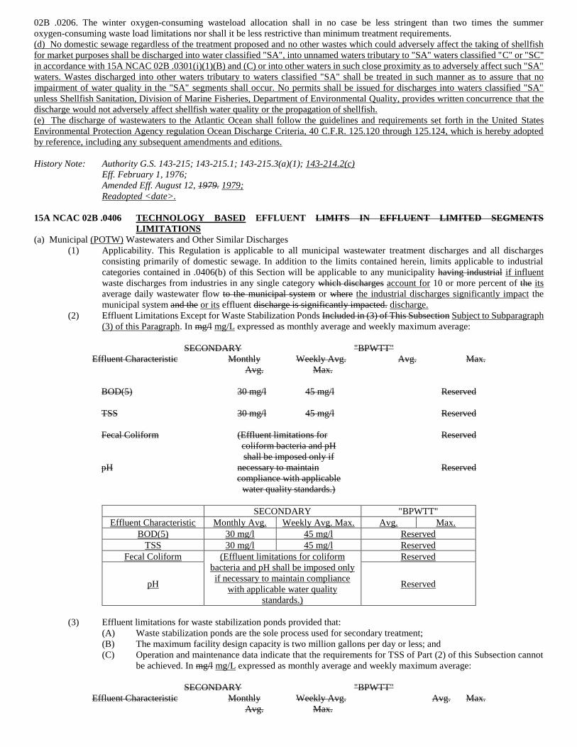
(2) Effluent Limitations Except for Waste Stabilization Ponds Included in (3) of This Subsection Subject to Subparagraph
(3) of this Paragraph. In mg/l mg/L expressed as monthly average and weekly maximum average:
SECONDARY "BPWTT"
Effluent Characteristic Monthly Weekly Avg. Avg. Max.
Avg. Max.
BOD(5) 30 mg/l 45 mg/l Reserved
TSS 30 mg/l 45 mg/l Reserved
Fecal Coliform (Effluent limitations for Reserved
coliform bacteria and pH
shall be imposed only if
pH necessary to maintain Reserved
compliance with applicable
water quality standards.)
SECONDARY "BPWTT"
Effluent Characteristic Monthly Avg. Weekly Avg. Max. Avg. Max.
BOD(5) 30 mg/l 45 mg/l Reserved
TSS 30 mg/l 45 mg/l Reserved
Fecal Coliform (Effluent limitations for coliform
bacteria and pH shall be imposed only
if necessary to maintain compliance
with applicable water quality
standards.)
Reserved
pH Reserved
(3) Effluent limitations for waste stabilization ponds provided that:
(A) Waste stabilization ponds are the sole process used for secondary treatment;
(B) The maximum facility design capacity is two million gallons per day or less; and
(C) Operation and maintenance data indicate that the requirements for TSS of Part (2) of this Subsection cannot
be achieved. In mg/l mg/L expressed as monthly average and weekly maximum average:
SECONDARY "BPWTT"
Effluent Characteristic Monthly Weekly Avg. Avg. Max.
Avg. Max.
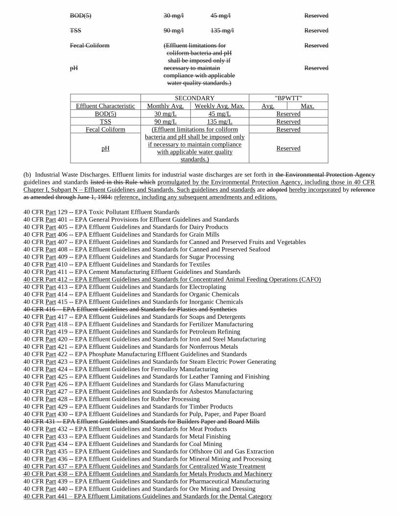
BOD(5) 30 mg/l 45 mg/l Reserved
TSS 90 mg/l 135 mg/l Reserved
Fecal Coliform (Effluent limitations for Reserved
coliform bacteria and pH
shall be imposed only if
pH necessary to maintain Reserved
compliance with applicable
water quality standards.)
SECONDARY "BPWTT"
Effluent Characteristic Monthly Avg. Weekly Avg. Max. Avg. Max.
BOD(5) 30 mg/L 45 mg/L Reserved
TSS 90 mg/L 135 mg/L Reserved
Fecal Coliform (Effluent limitations for coliform
bacteria and pH shall be imposed only
if necessary to maintain compliance
with applicable water quality
standards.)
Reserved
pH Reserved
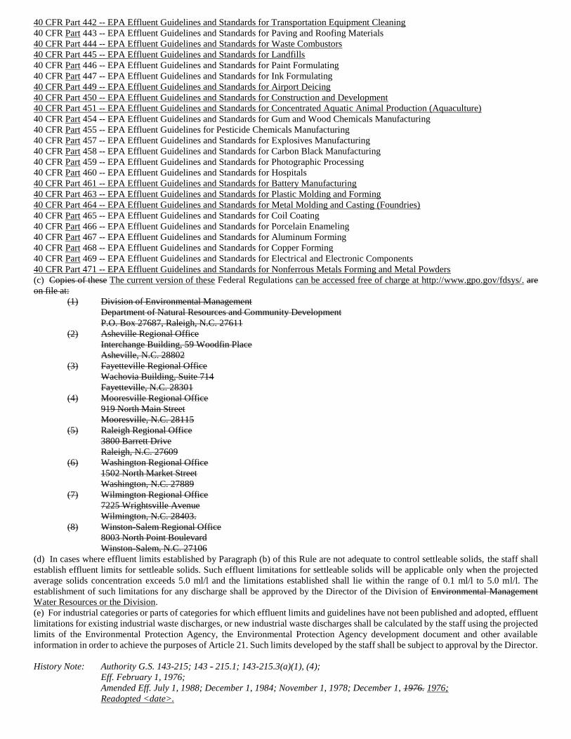
(b) Industrial Waste Discharges. Effluent limits for industrial waste discharges are set forth in the Environmental Protection Agency
guidelines and standards listed in this Rule which promulgated by the Environmental Protection Agency, including those in 40 CFR
Chapter I, Subpart N – Effluent Guidelines and Standards. Such guidelines and standards are adopted hereby incorporated by reference
as amended through June 1, 1984: reference, including any subsequent amendments and editions.
40 CFR Part 129 -- EPA Toxic Pollutant Effluent Standards
40 CFR Part 401 -- EPA General Provisions for Effluent Guidelines and Standards
40 CFR Part 405 -- EPA Effluent Guidelines and Standards for Dairy Products
40 CFR Part 406 -- EPA Effluent Guidelines and Standards for Grain Mills
40 CFR Part 407 -- EPA Effluent Guidelines and Standards for Canned and Preserved Fruits and Vegetables
40 CFR Part 408 -- EPA Effluent Guidelines and Standards for Canned and Preserved Seafood
40 CFR Part 409 -- EPA Effluent Guidelines and Standards for Sugar Processing
40 CFR Part 410 -- EPA Effluent Guidelines and Standards for Textiles
40 CFR Part 411 -- EPA Cement Manufacturing Effluent Guidelines and Standards
40 CFR Part 412 -- EPA Effluent Guidelines and Standards for Concentrated Animal Feeding Operations (CAFO)
40 CFR Part 413 -- EPA Effluent Guidelines and Standards for Electroplating
40 CFR Part 414 -- EPA Effluent Guidelines and Standards for Organic Chemicals
40 CFR Part 415 -- EPA Effluent Guidelines and Standards for Inorganic Chemicals
40 CFR 416 -- EPA Effluent Guidelines and Standards for Plastics and Synthetics
40 CFR Part 417 -- EPA Effluent Guidelines and Standards for Soaps and Detergents
40 CFR Part 418 -- EPA Effluent Guidelines and Standards for Fertilizer Manufacturing
40 CFR Part 419 -- EPA Effluent Guidelines and Standards for Petroleum Refining
40 CFR Part 420 -- EPA Effluent Guidelines and Standards for Iron and Steel Manufacturing
40 CFR Part 421 -- EPA Effluent Guidelines and Standards for Nonferrous Metals
40 CFR Part 422 -- EPA Phosphate Manufacturing Effluent Guidelines and Standards
40 CFR Part 423 -- EPA Effluent Guidelines and Standards for Steam Electric Power Generating
40 CFR Part 424 -- EPA Effluent Guidelines for Ferroalloy Manufacturing
40 CFR Part 425 -- EPA Effluent Guidelines and Standards for Leather Tanning and Finishing
40 CFR Part 426 -- EPA Effluent Guidelines and Standards for Glass Manufacturing
40 CFR Part 427 -- EPA Effluent Guidelines and Standards for Asbestos Manufacturing
40 CFR Part 428 -- EPA Effluent Guidelines for Rubber Processing
40 CFR Part 429 -- EPA Effluent Guidelines and Standards for Timber Products
40 CFR Part 430 -- EPA Effluent Guidelines and Standards for Pulp, Paper, and Paper Board
40 CFR 431 -- EPA Effluent Guidelines and Standards for Builders Paper and Board Mills
40 CFR Part 432 -- EPA Effluent Guidelines and Standards for Meat Products
40 CFR Part 433 -- EPA Effluent Guidelines and Standards for Metal Finishing
40 CFR Part 434 -- EPA Effluent Guidelines and Standards for Coal Mining
40 CFR Part 435 -- EPA Effluent Guidelines and Standards for Offshore Oil and Gas Extraction
40 CFR Part 436 -- EPA Effluent Guidelines and Standards for Mineral Mining and Processing
40 CFR Part 437 -- EPA Effluent Guidelines and Standards for Centralized Waste Treatment
40 CFR Part 438 -- EPA Effluent Guidelines and Standards for Metals Products and Machinery
40 CFR Part 439 -- EPA Effluent Guidelines and Standards for Pharmaceutical Manufacturing
40 CFR Part 440 -- EPA Effluent Guidelines and Standards for Ore Mining and Dressing
40 CFR Part 441 – EPA Effluent Limitations Guidelines and Standards for the Dental Category
40 CFR Part 442 -- EPA Effluent Guidelines and Standards for Transportation Equipment Cleaning
40 CFR Part 443 -- EPA Effluent Guidelines and Standards for Paving and Roofing Materials
40 CFR Part 444 -- EPA Effluent Guidelines and Standards for Waste Combustors
40 CFR Part 445 -- EPA Effluent Guidelines and Standards for Landfills
40 CFR Part 446 -- EPA Effluent Guidelines and Standards for Paint Formulating
40 CFR Part 447 -- EPA Effluent Guidelines and Standards for Ink Formulating
40 CFR Part 449 -- EPA Effluent Guidelines and Standards for Airport Deicing
40 CFR Part 450 -- EPA Effluent Guidelines and Standards for Construction and Development
40 CFR Part 451 -- EPA Effluent Guidelines and Standards for Concentrated Aquatic Animal Production (Aquaculture)
40 CFR Part 454 -- EPA Effluent Guidelines and Standards for Gum and Wood Chemicals Manufacturing
40 CFR Part 455 -- EPA Effluent Guidelines for Pesticide Chemicals Manufacturing
40 CFR Part 457 -- EPA Effluent Guidelines and Standards for Explosives Manufacturing
40 CFR Part 458 -- EPA Effluent Guidelines and Standards for Carbon Black Manufacturing
40 CFR Part 459 -- EPA Effluent Guidelines and Standards for Photographic Processing
40 CFR Part 460 -- EPA Effluent Guidelines and Standards for Hospitals
40 CFR Part 461 -- EPA Effluent Guidelines and Standards for Battery Manufacturing
40 CFR Part 463 -- EPA Effluent Guidelines and Standards for Plastic Molding and Forming
40 CFR Part 464 -- EPA Effluent Guidelines and Standards for Metal Molding and Casting (Foundries)
40 CFR Part 465 -- EPA Effluent Guidelines and Standards for Coil Coating
40 CFR Part 466 -- EPA Effluent Guidelines and Standards for Porcelain Enameling
40 CFR Part 467 -- EPA Effluent Guidelines and Standards for Aluminum Forming
40 CFR Part 468 -- EPA Effluent Guidelines and Standards for Copper Forming
40 CFR Part 469 -- EPA Effluent Guidelines and Standards for Electrical and Electronic Components
40 CFR Part 471 -- EPA Effluent Guidelines and Standards for Nonferrous Metals Forming and Metal Powders
(c) Copies of these The current version of these Federal Regulations can be accessed free of charge at http://www.gpo.gov/fdsys/. are
on file at:
(1) Division of Environmental Management
Department of Natural Resources and Community Development
P.O. Box 27687, Raleigh, N.C. 27611
(2) Asheville Regional Office
Interchange Building, 59 Woodfin Place
Asheville, N.C. 28802
(3) Fayetteville Regional Office
Wachovia Building, Suite 714
Fayetteville, N.C. 28301
(4) Mooresville Regional Office
919 North Main Street
Mooresville, N.C. 28115
(5) Raleigh Regional Office
3800 Barrett Drive
Raleigh, N.C. 27609
(6) Washington Regional Office
1502 North Market Street
Washington, N.C. 27889
(7) Wilmington Regional Office
7225 Wrightsville Avenue
Wilmington, N.C. 28403.
(8) Winston-Salem Regional Office
8003 North Point Boulevard
Winston-Salem, N.C. 27106
(d) In cases where effluent limits established by Paragraph (b) of this Rule are not adequate to control settleable solids, the staff shall
establish effluent limits for settleable solids. Such effluent limitations for settleable solids will be applicable only when the projected
average solids concentration exceeds 5.0 ml/l and the limitations established shall lie within the range of 0.1 ml/l to 5.0 ml/l. The
establishment of such limitations for any discharge shall be approved by the Director of the Division of Environmental Management
Water Resources or the Division.
(e) For industrial categories or parts of categories for which effluent limits and guidelines have not been published and adopted, effluent
limitations for existing industrial waste discharges, or new industrial waste discharges shall be calculated by the staff using the projected
limits of the Environmental Protection Agency, the Environmental Protection Agency development document and other available
information in order to achieve the purposes of Article 21. Such limits developed by the staff shall be subject to approval by the Director.
History Note: Authority G.S. 143-215; 143 - 215.1; 143-215.3(a)(1), (4);
Eff. February 1, 1976;
Amended Eff. July 1, 1988; December 1, 1984; November 1, 1978; December 1, 1976. 1976;
Readopted <date>.
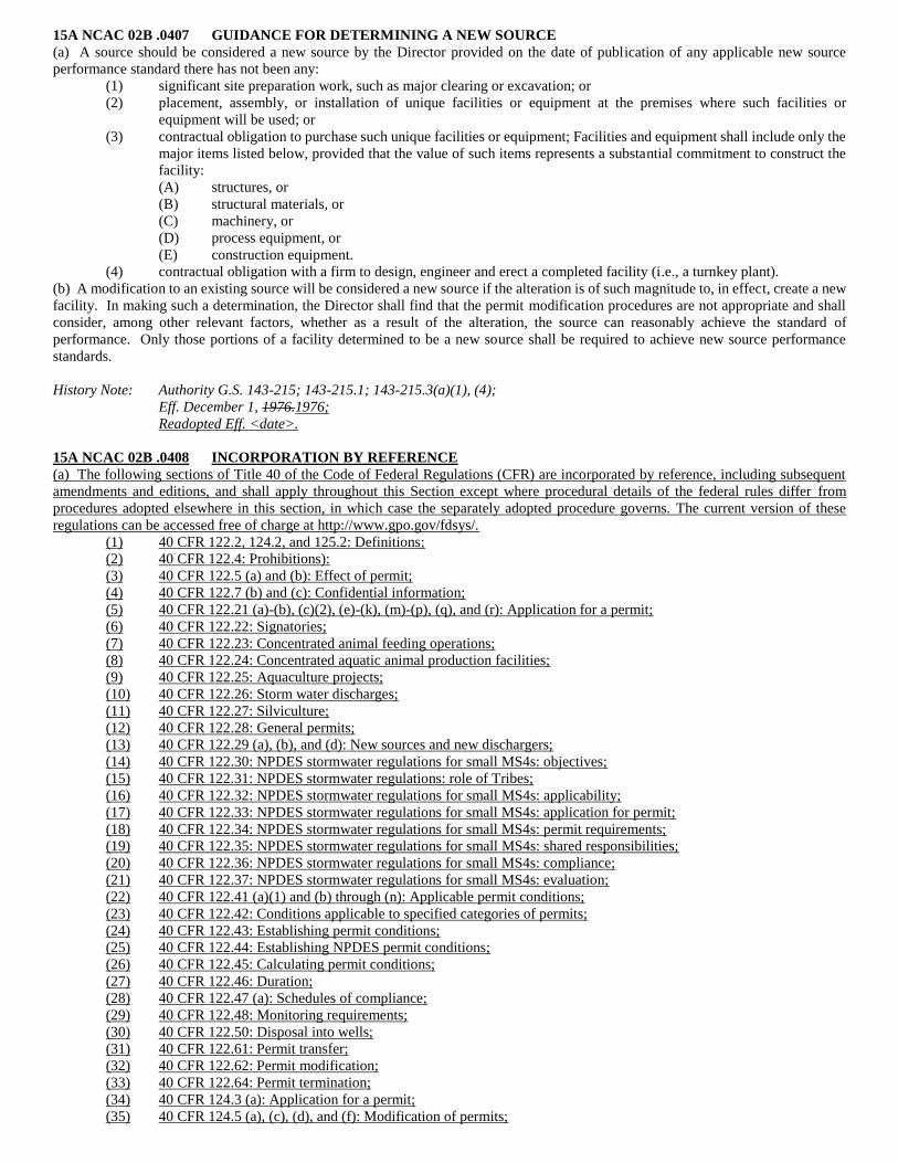
15A NCAC 02B .0407 GUIDANCE FOR DETERMINING A NEW SOURCE
(a) A source should be considered a new source by the Director provided on the date of publication of any applicable new source
performance standard there has not been any:
(1) significant site preparation work, such as major clearing or excavation; or
(2) placement, assembly, or installation of unique facilities or equipment at the premises where such facilities or
equipment will be used; or
(3) contractual obligation to purchase such unique facilities or equipment; Facilities and equipment shall include only the
major items listed below, provided that the value of such items represents a substantial commitment to construct the
facility:
(A) structures, or
(B) structural materials, or
(C) machinery, or
(D) process equipment, or
(E) construction equipment.
(4) contractual obligation with a firm to design, engineer and erect a completed facility (i.e., a turnkey plant).
(b) A modification to an existing source will be considered a new source if the alteration is of such magnitude to, in effect, create a new
facility. In making such a determination, the Director shall find that the permit modification procedures are not appropriate and shall
consider, among other relevant factors, whether as a result of the alteration, the source can reasonably achieve the standard of
performance. Only those portions of a facility determined to be a new source shall be required to achieve new source performance
standards.
History Note: Authority G.S. 143-215; 143-215.1; 143-215.3(a)(1), (4);
Eff. December 1, 1976.1976;
Readopted Eff. <date>.
15A NCAC 02B .0408 INCORPORATION BY REFERENCE
(a) The following sections of Title 40 of the Code of Federal Regulations (CFR) are incorporated by reference, including subsequent
amendments and editions, and shall apply throughout this Section except where procedural details of the federal rules differ from
procedures adopted elsewhere in this section, in which case the separately adopted procedure governs. The current version of these
regulations can be accessed free of charge at http://www.gpo.gov/fdsys/.
(1) 40 CFR 122.2, 124.2, and 125.2: Definitions;
(2) 40 CFR 122.4: Prohibitions):
(3) 40 CFR 122.5 (a) and (b): Effect of permit;
(4) 40 CFR 122.7 (b) and (c): Confidential information;
(5) 40 CFR 122.21 (a)-(b), (c)(2), (e)-(k), (m)-(p), (q), and (r): Application for a permit;
(6) 40 CFR 122.22: Signatories;
(7) 40 CFR 122.23: Concentrated animal feeding operations;
(8) 40 CFR 122.24: Concentrated aquatic animal production facilities;
(9) 40 CFR 122.25: Aquaculture projects;
(10) 40 CFR 122.26: Storm water discharges;
(11) 40 CFR 122.27: Silviculture;
(12) 40 CFR 122.28: General permits;
(13) 40 CFR 122.29 (a), (b), and (d): New sources and new dischargers;
(14) 40 CFR 122.30: NPDES stormwater regulations for small MS4s: objectives;
(15) 40 CFR 122.31: NPDES stormwater regulations: role of Tribes;
(16) 40 CFR 122.32: NPDES stormwater regulations for small MS4s: applicability;
(17) 40 CFR 122.33: NPDES stormwater regulations for small MS4s: application for permit;
(18) 40 CFR 122.34: NPDES stormwater regulations for small MS4s: permit requirements;
(19) 40 CFR 122.35: NPDES stormwater regulations for small MS4s: shared responsibilities;
(20) 40 CFR 122.36: NPDES stormwater regulations for small MS4s: compliance;
(21) 40 CFR 122.37: NPDES stormwater regulations for small MS4s: evaluation;
(22) 40 CFR 122.41 (a)(1) and (b) through (n): Applicable permit conditions;
(23) 40 CFR 122.42: Conditions applicable to specified categories of permits;
(24) 40 CFR 122.43: Establishing permit conditions;
(25) 40 CFR 122.44: Establishing NPDES permit conditions;
(26) 40 CFR 122.45: Calculating permit conditions;
(27) 40 CFR 122.46: Duration;
(28) 40 CFR 122.47 (a): Schedules of compliance;
(29) 40 CFR 122.48: Monitoring requirements;
(30) 40 CFR 122.50: Disposal into wells;
(31) 40 CFR 122.61: Permit transfer;
(32) 40 CFR 122.62: Permit modification;
(33) 40 CFR 122.64: Permit termination;
(34) 40 CFR 124.3 (a): Application for a permit;
(35) 40 CFR 124.5 (a), (c), (d), and (f): Modification of permits;
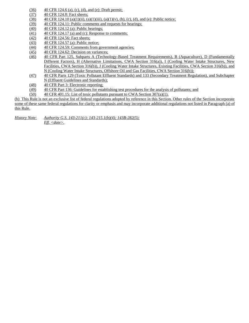
(36) 40 CFR 124.6 (a), (c), (d), and (e): Draft permit;
(37) 40 CFR 124.8: Fact sheets;
(38) 40 CFR 124.10 (a)(1)(ii), (a)(1)(iii), (a)(1)(v), (b), (c), (d), and (e): Public notice;
(39) 40 CFR 124.11: Public comments and requests for hearings;
(40) 40 CFR 124.12 (a): Public hearings;
(41) 40 CFR 124.17 (a) and (c): Response to comments;
(42) 40 CFR 124.56: Fact sheets;
(43) 40 CFR 124.57 (a): Public notice;
(44) 40 CFR 124.59: Comments from government agencies;
(45) 40 CFR 124.62: Decision on variances;
(46) 40 CFR Part 125, Subparts A (Technology-Based Treatment Requirements), B (Aquaculture), D (Fundamentally
Different Factors), H (Alternative Limitations, CWA Section 316(a)), I (Cooling Water Intake Structures, New
Facilities, CWA Section 316(b)), J (Cooling Water Intake Structures, Existing Facilities, CWA Section 316(b)), and
N (Cooling Water Intake Structures, Offshore Oil and Gas Facilities, CWA Section 316(b));
(47) 40 CFR Parts 129 (Toxic Pollutant Effluent Standards) and 133 (Secondary Treatment Regulation), and Subchapter
N (Effluent Guidelines and Standards);
(48) 40 CFR Part 3: Electronic reporting;
(49) 40 CFR Part 136: Guidelines for establishing test procedures for the analysis of pollutants; and
(50) 40 CFR 401.15: List of toxic pollutants pursuant to CWA Section 307(a)(1).
(b) This Rule is not an exclusive list of federal regulations adopted by reference in this Section. Other rules of the Section incorporate
some of these same federal regulations for clarity or emphasis and may incorporate additional regulations not listed in Paragraph (a) of
this Rule.
History Note: Authority G.S. 143-211(c); 143-215.1(b)(4); 143B-282(5);
Eff. <date>.
SECTION .0500 - SURFACE WATER MONITORING: REPORTING
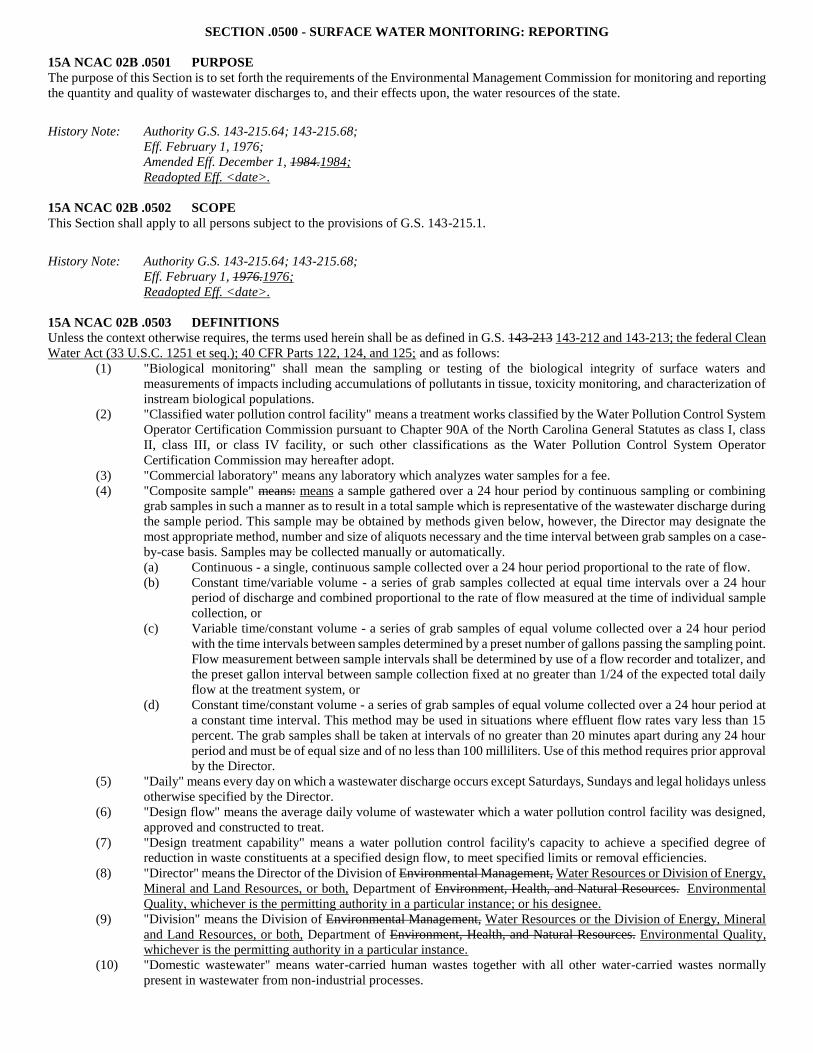
15A NCAC 02B .0501 PURPOSE
The purpose of this Section is to set forth the requirements of the Environmental Management Commission for monitoring and reporting
the quantity and quality of wastewater discharges to, and their effects upon, the water resources of the state.
History Note: Authority G.S. 143-215.64; 143-215.68;
Eff. February 1, 1976;
Amended Eff. December 1, 1984.1984;
Readopted Eff. <date>.
15A NCAC 02B .0502 SCOPE
This Section shall apply to all persons subject to the provisions of G.S. 143-215.1.
History Note: Authority G.S. 143-215.64; 143-215.68;
Eff. February 1, 1976.1976;
Readopted Eff. <date>.
15A NCAC 02B .0503 DEFINITIONS
Unless the context otherwise requires, the terms used herein shall be as defined in G.S. 143-213 143-212 and 143-213; the federal Clean
Water Act (33 U.S.C. 1251 et seq.); 40 CFR Parts 122, 124, and 125; and as follows:
(1) "Biological monitoring" shall mean the sampling or testing of the biological integrity of surface waters and
measurements of impacts including accumulations of pollutants in tissue, toxicity monitoring, and characterization of
instream biological populations.
(2) "Classified water pollution control facility" means a treatment works classified by the Water Pollution Control System
Operator Certification Commission pursuant to Chapter 90A of the North Carolina General Statutes as class I, class
II, class III, or class IV facility, or such other classifications as the Water Pollution Control System Operator
Certification Commission may hereafter adopt.
(3) "Commercial laboratory" means any laboratory which analyzes water samples for a fee.
(4) "Composite sample" means: means a sample gathered over a 24 hour period by continuous sampling or combining
grab samples in such a manner as to result in a total sample which is representative of the wastewater discharge during
the sample period. This sample may be obtained by methods given below, however, the Director may designate the
most appropriate method, number and size of aliquots necessary and the time interval between grab samples on a case-
by-case basis. Samples may be collected manually or automatically.
(a) Continuous - a single, continuous sample collected over a 24 hour period proportional to the rate of flow.
(b) Constant time/variable volume - a series of grab samples collected at equal time intervals over a 24 hour
period of discharge and combined proportional to the rate of flow measured at the time of individual sample
collection, or
(c) Variable time/constant volume - a series of grab samples of equal volume collected over a 24 hour period
with the time intervals between samples determined by a preset number of gallons passing the sampling point.
Flow measurement between sample intervals shall be determined by use of a flow recorder and totalizer, and
the preset gallon interval between sample collection fixed at no greater than 1/24 of the expected total daily
flow at the treatment system, or
(d) Constant time/constant volume - a series of grab samples of equal volume collected over a 24 hour period at
a constant time interval. This method may be used in situations where effluent flow rates vary less than 15
percent. The grab samples shall be taken at intervals of no greater than 20 minutes apart during any 24 hour
period and must be of equal size and of no less than 100 milliliters. Use of this method requires prior approval
by the Director.
(5) "Daily" means every day on which a wastewater discharge occurs except Saturdays, Sundays and legal holidays unless
otherwise specified by the Director.
(6) "Design flow" means the average daily volume of wastewater which a water pollution control facility was designed,
approved and constructed to treat.
(7) "Design treatment capability" means a water pollution control facility's capacity to achieve a specified degree of
reduction in waste constituents at a specified design flow, to meet specified limits or removal efficiencies.
(8) "Director" means the Director of the Division of Environmental Management, Water Resources or Division of Energy,
Mineral and Land Resources, or both, Department of Environment, Health, and Natural Resources.. Environmental
Quality, whichever is the permitting authority in a particular instance; or his designee.
(9) "Division" means the Division of Environmental Management, Water Resources or the Division of Energy, Mineral
and Land Resources, or both, Department of Environment, Health, and Natural Resources. Environmental Quality,
whichever is the permitting authority in a particular instance.
(10) "Domestic wastewater" means water-carried human wastes together with all other water-carried wastes normally
present in wastewater from non-industrial processes.
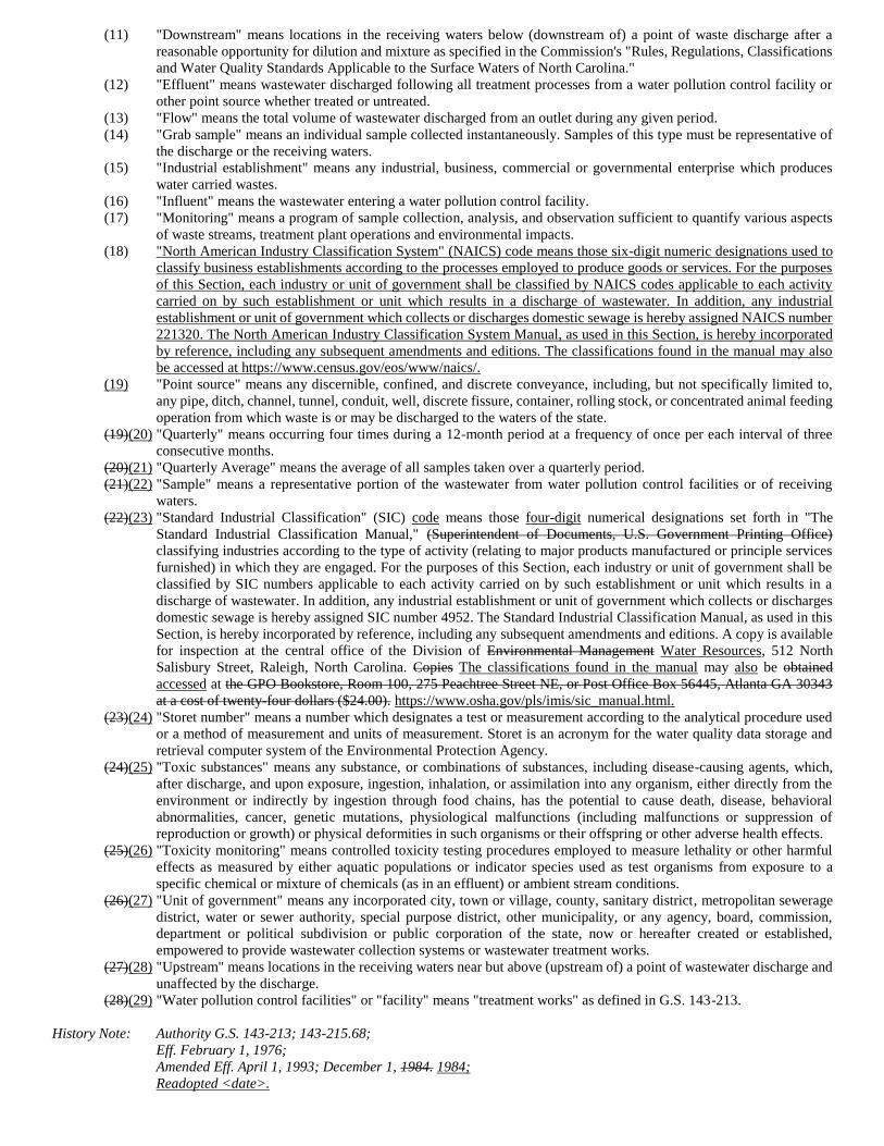
(11) "Downstream" means locations in the receiving waters below (downstream of) a point of waste discharge after a
reasonable opportunity for dilution and mixture as specified in the Commission's "Rules, Regulations, Classifications
and Water Quality Standards Applicable to the Surface Waters of North Carolina."
(12) "Effluent" means wastewater discharged following all treatment processes from a water pollution control facility or
other point source whether treated or untreated.
(13) "Flow" means the total volume of wastewater discharged from an outlet during any given period.
(14) "Grab sample" means an individual sample collected instantaneously. Samples of this type must be representative of
the discharge or the receiving waters.
(15) "Industrial establishment" means any industrial, business, commercial or governmental enterprise which produces
water carried wastes.
(16) "Influent" means the wastewater entering a water pollution control facility.
(17) "Monitoring" means a program of sample collection, analysis, and observation sufficient to quantify various aspects
of waste streams, treatment plant operations and environmental impacts.
(18) "North American Industry Classification System" (NAICS) code means those six-digit numeric designations used to
classify business establishments according to the processes employed to produce goods or services. For the purposes
of this Section, each industry or unit of government shall be classified by NAICS codes applicable to each activity
carried on by such establishment or unit which results in a discharge of wastewater. In addition, any industrial
establishment or unit of government which collects or discharges domestic sewage is hereby assigned NAICS number
221320. The North American Industry Classification System Manual, as used in this Section, is hereby incorporated
by reference, including any subsequent amendments and editions. The classifications found in the manual may also
be accessed at https://www.census.gov/eos/www/naics/.
(19) "Point source" means any discernible, confined, and discrete conveyance, including, but not specifically limited to,
any pipe, ditch, channel, tunnel, conduit, well, discrete fissure, container, rolling stock, or concentrated animal feeding
operation from which waste is or may be discharged to the waters of the state.
(19)(20) "Quarterly" means occurring four times during a 12-month period at a frequency of once per each interval of three
consecutive months.
(20)(21) "Quarterly Average" means the average of all samples taken over a quarterly period.
(21)(22) "Sample" means a representative portion of the wastewater from water pollution control facilities or of receiving
waters.
(22)(23) "Standard Industrial Classification" (SIC) code means those four-digit numerical designations set forth in "The
Standard Industrial Classification Manual," (Superintendent of Documents, U.S. Government Printing Office)
classifying industries according to the type of activity (relating to major products manufactured or principle services
furnished) in which they are engaged. For the purposes of this Section, each industry or unit of government shall be
classified by SIC numbers applicable to each activity carried on by such establishment or unit which results in a
discharge of wastewater. In addition, any industrial establishment or unit of government which collects or discharges
domestic sewage is hereby assigned SIC number 4952. The Standard Industrial Classification Manual, as used in this
Section, is hereby incorporated by reference, including any subsequent amendments and editions. A copy is available
for inspection at the central office of the Division of Environmental Management Water Resources, 512 North
Salisbury Street, Raleigh, North Carolina. Copies The classifications found in the manual may also be obtained
accessed at the GPO Bookstore, Room 100, 275 Peachtree Street NE, or Post Office Box 56445, Atlanta GA 30343
at a cost of twenty-four dollars ($24.00). https://www.osha.gov/pls/imis/sic_manual.html.
(23)(24) "Storet number" means a number which designates a test or measurement according to the analytical procedure used
or a method of measurement and units of measurement. Storet is an acronym for the water quality data storage and
retrieval computer system of the Environmental Protection Agency.
(24)(25) "Toxic substances" means any substance, or combinations of substances, including disease-causing agents, which,
after discharge, and upon exposure, ingestion, inhalation, or assimilation into any organism, either directly from the
environment or indirectly by ingestion through food chains, has the potential to cause death, disease, behavioral
abnormalities, cancer, genetic mutations, physiological malfunctions (including malfunctions or suppression of
reproduction or growth) or physical deformities in such organisms or their offspring or other adverse health effects.
(25)(26) "Toxicity monitoring" means controlled toxicity testing procedures employed to measure lethality or other harmful
effects as measured by either aquatic populations or indicator species used as test organisms from exposure to a
specific chemical or mixture of chemicals (as in an effluent) or ambient stream conditions.
(26)(27) "Unit of government" means any incorporated city, town or village, county, sanitary district, metropolitan sewerage
district, water or sewer authority, special purpose district, other municipality, or any agency, board, commission,
department or political subdivision or public corporation of the state, now or hereafter created or established,
empowered to provide wastewater collection systems or wastewater treatment works.
(27)(28) "Upstream" means locations in the receiving waters near but above (upstream of) a point of wastewater discharge and
unaffected by the discharge.
(28)(29) "Water pollution control facilities" or "facility" means "treatment works" as defined in G.S. 143-213.
History Note: Authority G.S. 143-213; 143-215.68;
Eff. February 1, 1976;
Amended Eff. April 1, 1993; December 1, 1984. 1984;
Readopted <date>.
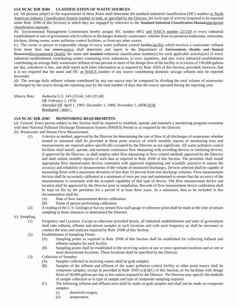
15A NCAC 02B .0504 CLASSIFICATION OF WASTE SOURCES
(a) All persons subject to the requirements of these Rules shall determine the standard industrial classification (SIC) number or North
American Industry Classification System number or both, as specified by the Director, for each type of activity (required to be reported
under Rule .0506 of this Section) in which they are engaged by reference to the Standard Industrial Classification Manualappropriate
classification manuals.
(b) Environmental Management Commission hereby assigns SIC number 4952 and NAICS number 221320 to every industrial
establishment or unit of government which collects or discharges domestic wastewater, whether from on-premises bathrooms, restrooms,
kitchens, dining rooms, water pollution control facilities, or from any other source.
(c) The owner or person in responsible charge of every water pollution control facility,facility which receives a wastewater influent
from more than one source,source shall determine and report to the Department of Environment, Health, and Natural
ResourcesEnvironmental Quality the name and standard industrial classification number(s) for each applicable activity(ies) of every
industrial establishment contributing wastes containing toxic substances, in toxic quantities, and also every industrial establishment
contributing an average daily wastewater influent of one percent or more of the design flow of the facility or in excess of 100,000 gallons
per day, whichever is less, and shall report such other information as is required by Rule .0505 of this Section; provided; however, that
it is not required that the name and SIC or NAICS number of any source contributing domestic sewage influent only be reported
hereunder.
(d) The average daily influent volume contributed by any one source may be computed by dividing the total volume of wastewater
discharged by the source during the reporting year by the total number of days that the source operated during the reporting year.
History Note: Authority G.S. 143-215.64; 143-215.68;
Eff. February 1, 1976;
Amended Eff. April 1, 1993; December 1, 1984; November 1, 1978.1978;
Readopted <date>.
15A NCAC 02B .0505 MONITORING REQUIREMENTS
(a) General. Every person subject to this Section shall be required to establish, operate and maintain a monitoring program consistent
with their National Pollutant Discharge Elimination System (NPDES) Permit or as required by the Director.
(b) Wastewater and Stream Flow Measurement.
(1) A device or method, approved by the Director for determining the rate of flow of all discharges of wastewater whether
treated or untreated shall be provided at those point sources of which monthly reports of monitoring tests and
measurements are required unless specifically excepted by the Director as not significant. All water pollution control
facilities shall install, operate, and maintain continuous flow measuring with recording devices or totalizing devices,
if approved by the Director, or shall employ other flow measuring or flow control methods approved by the Director
and shall submit monthly reports of such data as required in Rule .0506 of this Section. The permittee shall install
appropriate flow measurement devices consistent with approved engineering and scientific practices to ensure the
accuracy and reliability of measurements of the volume of monitored discharges. Devices selected shall be capable of
measuring flows with a maximum deviation of less than 10 percent from true discharge volumes. Flow measurement
devices shall be accurately calibrated at a minimum of once per year and maintained to ensure that the accuracy of the
measurements is consistent with the accepted capability of that type of device. The flow measurement device and
location shall be approved by the Director prior to installation. Records of flow measurement device calibration shall
be kept on file by the permittee for a period of at least three years. At a minimum, data to be included in this
documentation shall be:
(A) Date of flow measurement device calibration
(B) Name of person performing calibration.
(2) A reading of the U.S. Geological Survey stream flow staff gauge or reference point shall be made at the time of stream
sampling in those instances so determined the Director.
(c) Sampling.
(1) Frequency and Location. Except as otherwise provided herein, all industrial establishments and units of government
shall take influent, effluent and stream samples at such locations and with such frequency as shall be necessary to
conduct the tests and analyses required by Rule .0508 of this Section.
(2) Establishment of Sampling Points:
(A) Sampling points as required in Rule .0508 of this Section shall be established for collecting influent and
effluent samples for each facility.
(B) Sampling points shall be established in the receiving waters at one or more upstream locations and at one or
more downstream locations. These locations shall be specified by the Director.
(3) Collection of Samples:
(A) Samples collected in receiving waters shall be grab samples.
(B) Samples of the influent and effluent of the water pollution control facility or other point source shall be
composite samples, except as provided in Rule .0505 (c)(3)(C) of this Section, or for facilities with design
flows of 30,000 gallons per day or less unless required by the Director. The Director may specify the methods
of sample collection as to type of sample and type of composite sampling required.
(C) The following influent and effluent tests shall be made on grab samples and shall not be made on composite
samples:
(i) dissolved oxygen,
(ii) temperature,
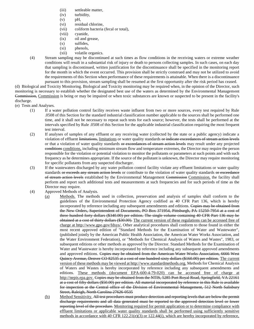
(iii) settleable matter,
(iv) turbidity,
(v) pH,
(vi) residual chlorine,
(vii) coliform bacteria (fecal or total),
(viii) cyanide,
(ix) oil and grease,
(x) sulfides,
(xi) phenols,
(xii) volatile organics.
(4) Stream sampling may be discontinued at such times as flow conditions in the receiving waters or extreme weather
conditions will result in a substantial risk of injury or death to persons collecting samples. In such cases, on each day
that sampling is discontinued, written justification for the discontinuance shall be specified in the monitoring report
for the month in which the event occurred. This provision shall be strictly construed and may not be utilized to avoid
the requirements of this Section when performance of these requirements is attainable. When there is a discontinuance
pursuant to this provision, stream sampling shall be resumed at the first opportunity after the risk period has ceased.
(d) Biological and Toxicity Monitoring. Biological and Toxicity monitoring may be required when, in the opinion of the Director, such
monitoring is necessary to establish whether the designated best use of the waters as determined by the Environmental Management
Commission, Commission is being or may be impaired or when toxic substances are known or suspected to be present in the facility's
discharge.
(e) Tests and Analyses.
(1) If a water pollution control facility receives waste influent from two or more sources, every test required by Rule
.0508 of this Section for the standard industrial classification number applicable to the sources shall be performed one
time, and it shall not be necessary to repeat such tests for each source; however, the tests shall be performed at the
intervals specified by Rule .0508 of this Section for the applicable industrial classification requiring the most frequent
test interval.
(2) If analyses of samples of any effluent or any receiving water (collected by the state or a public agency) indicate a
violation of effluent limitations, limitations or water quality standards or indicate exceedances of stream action levels
or that a violation of water quality standards or exceedances of stream action levels may result under any projected
conditions conditions, including minimum stream flow and temperature extremes, the Director may require the person
responsible for the violation or potential violation to monitor the pollutants or parameters at such points and with such
frequency as he determines appropriate. If the source of the pollutant is unknown, the Director may require monitoring
for specific pollutants from any suspected discharger.
(3) If the wastewaters discharged by any water pollution control facility violate any effluent limitations or water quality
standards or exceeds any stream action levels or contribute to the violation of water quality standards or exceedance
of stream action levels established by the Environmental Management Commission Commission, the facility shall
perform and report such additional tests and measurements at such frequencies and for such periods of time as the
Director may require.
(4) Approved Methods of Analysis.
(a) Methods. The methods used in collection, preservation and analysis of samples shall conform to the
guidelines of the Environmental Protection Agency codified as 40 CFR Part 136, which is hereby
incorporated by reference including any subsequent amendments and editions. Copies may be obtained from
the New Orders, Superintendent of Documents, PO Box 371954, Pittsburgh, PA 15250-7954 at a cost of
three hundred forty dollars ($340.00) per edition. The single volume containing 40 CFR Part 136 may be
obtained at a cost of thirty dollars ($30.00). The current version of these regulations can be accessed free of
charge at http://www.gpo.gov/fdsys/. Other analytical procedures shall conform to those found in either the
most recent approved edition of "Standard Methods for the Examination of Water and Wastewater",
(published jointly by the American Public Health Association, the American Water Works Association, and
the Water Environment Federation), or "Methods for Chemical Analysis of Waters and Wastes", 1983, or
subsequent editions or other methods as approved by the Director. Standard Methods for the Examination of
Water and Wastewater is hereby incorporated by reference including any subsequent approved amendments
and approved editions. Copies may be obtained from the American Water Works Association, 6666 West
Quincy Avenue, Denver CO 82535 at a cost of one hundred sixty dollars ($160.00) per edition. The current
version of these methods may be viewed at http://www.standardmethods.org. Methods for Chemical Analysis
of Waters and Wastes is hereby incorporated by reference including any subsequent amendments and
editions. These methods (document EPA-600-4-79-020) can be accessed free of charge at
http://nepis.epa.gov. Copies may be obtained from the NTIS, 5285 Port Royal Road, Springfield, VA 22161
at a cost of fifty dollars ($50.00) per edition. All material incorporated by reference in this Rule is available
for inspection at the Central office of the Division of Environmental Management, 512 North Salisbury
Street, Raleigh, North Carolina 27626-0535
(b) Method Sensitivity. All test procedures must produce detection and reporting levels that are below the permit
discharge requirements and all data generated must be reported to the approved detection level or lower
reporting level of the procedure. Monitoring required for permit application or to determine compliance with
effluent limitations or applicable water quality standards shall be performed using sufficiently sensitive
methods in accordance with 40 CFR 122.21(e)(3) or 122.44(i), which are hereby incorporated by reference,
including any subsequent amendments and editions. If no approved methods are determined capable of
achieving detection and reporting levels below permit discharge requirements, then the approved method
with the lowest detection and reporting level must be used. Biological testing shall be performed in
accordance with 15A NCAC 02B .0103(b).
(5) Approval of Laboratories. Analytical determinations made pursuant to the monitoring and reporting requirements of
this Section shall be made in adequately equipped laboratories staffed by person(s) competent to perform tests. Only
monitoring programs which provide for the making of analytical determinations by qualified employees of the owner
or by a laboratory certified by the Division under 15A NCAC 02H .0800 or 15A NCAC 02H .1100 will be considered
adequate.
(f) Process Control Monitoring Testing: The Director may require, on a case-by-case basis, process control monitoring testing suitable
for the size and classification of the facility.
History Note: Authority G.S. 143-215.64; 143-215.66; 143-215.68;
Eff. February 1, 1976;
Amended Eff. April 1, 1993; December 1, 1984; November 1, 1978. 1978;
Readopted <date>.
15A NCAC 02B .0506 REPORTING REQUIREMENTS
(a) General:
(1) Every person subject to this Section shall file certified monitoring reports setting forth the results of tests and
measurements conducted pursuant to NPDES permit monitoring requirements.
(A) Monthly monitoring reports shall be filed no later than 30 calendar days after the end of the reporting period
for which the report is made.
(B) Reports filed pursuant to the requirements of Subparagraph (a)(1) of this Rule shall be submitted in a manner
consistent with the requirements of 40 CFR Part 3, which is hereby incorporated by reference including
subsequent amendments and additions. Where submittal of printed documents is allowed, of such submittals
shall be made on forms furnished or in a format provided or approved by the Director and shall be submitted
in duplicate to:
ATTN: CENTRAL FILES
DIVISION OF ENVIRONMENTAL MANAGEMENT WATER RESOURCES
POST OFFICE BOX 29535
MAIL SERVICE CENTER 1617
RALEIGH, NORTH CAROLINA 27626-0535. 27699-1617
(C) A copy of all reports submitted to the Director pursuant to this Section shall be retained by the owner of each
water pollution control permitted facility for a period of at least three years from the date of submission and
be readily available to the Division for inspection.
(D) In order to document information contained in reports submitted to the Director pursuant to this Section, the
owner of each pollution control facility is required to retain or have readily available for inspection by the
Division, Division the following items for a period of at least three years from report submission:
(i) the original laboratory reports from any certified laboratory utilized for sample analysis. Such
reports must be signed by the laboratory supervisor, and must indicate the date and time of sample
collection and analysis, and the analysts' name;
(ii) bench notes and data logs for sample analyses performed by the pollution control facility staff or
operator in responsible charge, whether or not the facility has a certified lab; and
(iii) copies of all process control testing.
(E) In situations where no discharge has occurred from the facility during the report period, the permittee is
required to submit a monthly monitoring report giving all required information and indicating "NO FLOW"
unless the Director agrees to waive the reporting requirement during extended conditions of no discharge.
(2) Every person subject to this Section shall report by telephone to either the central office or appropriate regional office
of the Division as soon as possible but no later than 24 hours after occurrence or on the next working day (however,
if the occurrence is one which may endanger the public health, or fish or wildlife, and contact with the central office
or the appropriate regional office cannot be made, such person shall report as soon as possible to the State Highway
Patrol Warning Point in state 1-800-662-7956 or out of state 919-733-3861) following the occurrence or first
knowledge of the occurrence of any of the following:
(A) Any failure of a collection system, pumping station or treatment facility resulting in a by-pass without
treatment of all or any portion of the wastewater. wastewater;
(B) Any occurrence at the water pollution control facility which results in the discharge of significant amounts
of wastes which are abnormal in quantity or characteristic, such as the dumping of the contents of a sludge
digester, the known passage of a hazardous substance through the facility, or any other unusual
circumstances. circumstances; or
(C) Any process unit failure, due to known or unknown reasons, that renders the facility incapable of adequate
wastewater treatment, such as mechanical or electrical failures of pumps, aerators, compressors, etc. etc.;
except that if the occurrence is one which may endanger the public health or fish or wildlife, and if contact with the
central office or the appropriate regional office cannot be made, such person shall report as soon as possible to the NC
Emergency Operations Center 24/7 at 1-800-858-0368 (toll-free) or 919-733-3300.
(3) Persons reporting such occurrences by telephone shall also provide a written report to the Division in letter or
electronic form setting out the information required in Subparagraph (a)(4) of this Rule and pertinent information
pertaining to the occurrence. This report must be received by the Division within five days following first knowledge
of the occurrence.
(4) All reports required to be filed by this Section shall contain the following information in addition to such other
information as is required for the particular report:
(A) name of facility,
(B) water pollution control facility location,
(C) the class assigned to the water pollution control facility,
(D) the water pollution control facility permit number assigned by the Department of Environment, Health, and
Natural Resources Environmental Quality to the permit or other approval document issued by the
Environmental Management Commission under which the discharge is made,
(E) contact name and name, telephone number number, email address, and mailing address,
(F) estimated nature and extent of environmental damage caused by the incident.
(5) Any person desiring confidentiality for any influent information submitted shall specify the influent information for
which confidentiality is sought and shall justify such request to the Department of Environment, Health, and Natural
Resources, Environmental Quality, and and, if such request is approved by the Director Director, shall by an
appropriate stamp, stamp indicate the location of such information on each report filed thereafter.
(b) Monthly Monitoring Reports:
(1) Every person operating a monitoring system required by this Section shall file a monitoring report once each month
which includes the data for the samples collected during the month. This report shall be filed no later than 30 calendar
days after the end of the reporting period for which the report is made.
(2) Monthly monitoring reports shall be reviewed, compliance status determined, certified by signature, and submitted by
the following:
(A) For a corporation: by a responsible corporate officer. For the purpose of the Section, a responsible corporate
officer means:
(i) a president, secretary, treasurer or vice president of the corporation in charge of a principal business
function, or any other person who performs similar policy or decision-making functions for the
corporation, or
(ii) the manager of one or more manufacturing production or operating facilities employing more than
250 persons or having gross annual sales or expenditures exceeding twenty-five million dollars
($25,000,000)(in second quarter 1980 dollars), if authority to sign documents had been assigned or
delegated to the manager in accordance with corporate procedures.
(B) For a partnership or sole proprietorship: by a general partner or the proprietor, respectively; or
(C) For a municipality, State, Federal, County, or other public agency: by either a principal executive officer or
ranking elected official;
(D) Duly authorized representative of the person described in Paragraphs (b)(2)(A), (B) and (C). A person is a
duly authorized representative only if:
(i) The authorization is made in writing by a person described in Paragraphs (b)(2)(A), (B) and (C);
(ii) The authorization specified either an individual or a position having responsibility for the overall
operation of the regulated facility or activity, such as the position of plant manager, operator of a
well or well field, superintendent, a position of equivalent responsibility, or an individual or position
having overall responsibility for environmental matters for the company. (A duly authorized
representative may thus be either a named individual or any individual occupying a named
position.); and
(iii) The written authorization is submitted to the Permit Issuing Authority. Permittees A permittee
authorizing another individual to sign as representative in no way relinquishes any responsibility for
the permit or his responsibility to remain familiar with the permit conditions, conditions and limits,
including any modifications, and for the compliance data reports for the permit.
(E)(3) Permittee Certification by Signature.
(A) The permittee signing the report certifies to the following statement: "I certify, under penalty of law, that this
document and all attachments were prepared under my direction or supervision in accordance with a system
designed to assure that qualified personnel properly gather and evaluate the information submitted. Based on
my inquiry of the person or persons who managed the system, or those persons directly responsible for
gathering the information, the information submitted is, to the best of my knowledge and belief, true,
accurate, and complete. I am aware that there are significant penalties for submitting false information,
including the possibility of fines and imprisonment for knowing violations."
(B) The monthly report shall also be certified by the operator in responsible charge of a classified treatment
facility or by the manager of an industrial establishment which has a point source of waste discharge and
which does not have a classified water pollution control facility.
(3)(4) In addition to the information required on all reports [see Subparagraph (a)(4) of this Rule] the following information
shall be submitted in monthly monitoring reports:
(A) name Name of person or group collecting sample or making observation;
(B) name Name of person or group that analyzed sample;
(C) name Name of operator in responsible charge of the facility and the grade certificate held;
(D) sampling Sampling point for each sample;
(E) date Date and time (on 2400 hour clock basis) at which each grab sample was collected;
(F) For composite samples:
(i) date on which collection of composite samples is commenced,
(ii) time of starting and ending of composite sample period on 2400 hour clock basis;
(G) wastewater Wastewater flow in million gallons per day (MGD); (MGD), or in units specified in the permit;
(H) Results of analyses (reported to the designated number of figures with a properly placed decimal point as
indicated on each report sheet) together with the proper storet number (to be furnished by the Division) for
the analytical procedure used and the reporting units shall be those specified by the NPDES permit or current
enforcement document, unless modified by the Director;
(I) Only numeric values will be accepted in reporting results of fecal coliform testing. The reporting of "too
numerous to count" (TNTC) as a value will constitute a violation;
(J) The results of all tests on the characteristics of the effluent, including but not limited to NPDES Permit
Monitoring Requirements, shall be reported on monthly report forms;
(K) The monthly average of analysis for each parameter and the maximum and minimum values for the month
shall be reported;
(L) Certification by the Operator in Responsible Charge (ORC) as to the accuracy and completeness of the report
and that he/she has performed and documented the required visitation and process control.
(c) Additional Reporting/Monitoring Requirements:
(1) When a facility is operated on an independent contract basis, the operator in responsible charge shall notify the owner
of the facility in writing of any existing or anticipated conditions at the facility which may interfere with its proper
operation and which need corrective action by the owner. The notice shall include recommendations for corrective
action.
(2) Two copies printed copies, or an electronic copy, of the signed notice to the owner shall be sent to the Division as an
attachment to no later than the next monthly monitoring report.
(3) A log demonstrating visitation at the proper frequency for the assigned classification, including dates and times of
visits, and documentation of proper process control monitoring shall be maintained and shall be submitted to the
Division upon request. Copies of all information must be readily available for inspection for a period of three years.
(d) All information submitted will be classified as public information unless determined otherwise by the Director. Director in
accordance with 15A NCAC 02H .0115.
History Note: Authority G.S. 143-215.1(b); 143-215.64; 143-215.65; 143-215.68;
Eff. February 1, 1976;
Amended Eff. August 2, 1993; April 1, 1993; December 1, 1984; November 1, 1978. 1978;
Readopted <date>.
15A NCAC 02B .0508 TESTS AND MEASUREMENTS APPLICABLE TO SICS
(a) Determination of Type and Frequency of Tests and Measurements:
(1) Introduction. The tables set forth in this Rule are designed to indicate, for any particular water pollution control facility
or point source, the minimum standard tests and measurements which are to be performed, the minimum frequency
with which the tests and measurements are to be conducted, and the location and minimum number of sampling points
that are required.
(2) Determination of Facility Class and SIC Numbers. Before these tables may be applied, the standard industrial
classification(s) of the activities discharging to the water pollution control facility must be determined from The
Standard Industrial Classification Manual. The classification of the facility as determined by the Water Pollution
Control System Operators Certification Commission, must also be known.
(b) Modification of Test(s) or Measurement(s) Requirements:
(1) If it is demonstrated to the satisfaction of the Director that any of the tests and measurements, sampling points, or
frequency of sampling requirements, as required in this Rule for a particular SIC group, are not applicable to the
discharge of a particular water pollution control facility, or if it can be demonstrated that the objectives of this Section
can be achieved by other acceptable means, then such requirements may be waived or modified to the extent that the
Director determines to be appropriate.
(2) In addition to the tests and measurements as listed in this Rule applicable to each of the SIC groups, persons subject
to this Section may be required to perform such additional tests and measurements at such sampling points and with
such frequency as are determined by the Director to be necessary to adequately monitor constituents of the waste
discharge and their effect upon the receiving waters. This monitoring may include, include but not be limited to
weekends and holidays as deemed necessary by the Director to ensure representative sampling and proper operation
and maintenance of any facility.
(c) Unclassified Activities:
(1) Any person owning or operating a water pollution control facility who determines that a major SIC group(s) is not
listed in this Rule for an activity subject to this Section shall so notify the Division.
(2) The Director shall prescribe the number and location of sampling points and the frequency with which tests and
measurements must be made for such pollutant or pollutant effects as it shall deem necessary to properly monitor the
quantity or quality of waste discharges resulting from any activity subject to this Section which is not included in the
major SIC groups set forth in this Rule and to properly monitor effects of the discharges upon the waters of this state.
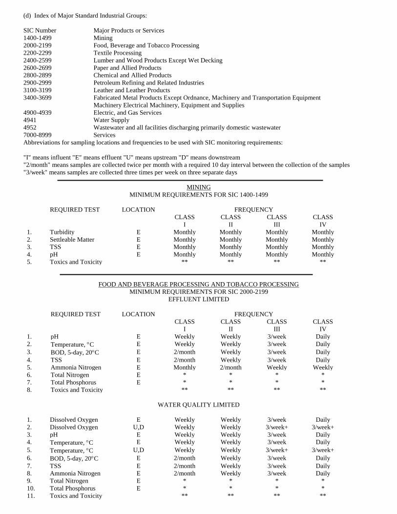
(d) Index of Major Standard Industrial Groups:
SIC Number Major Products or Services
1400-1499 Mining
2000-2199 Food, Beverage and Tobacco Processing
2200-2299 Textile Processing
2400-2599 Lumber and Wood Products Except Wet Decking
2600-2699 Paper and Allied Products
2800-2899 Chemical and Allied Products
2900-2999 Petroleum Refining and Related Industries
3100-3199 Leather and Leather Products
3400-3699 Fabricated Metal Products Except Ordnance, Machinery and Transportation Equipment
Machinery Electrical Machinery, Equipment and Supplies
4900-4939 Electric, and Gas Services
4941 Water Supply
4952 Wastewater and all facilities discharging primarily domestic wastewater
7000-8999 Services
Abbreviations for sampling locations and frequencies to be used with SIC monitoring requirements:
"I" means influent "E" means effluent "U" means upstream "D" means downstream
"2/month" means samples are collected twice per month with a required 10 day interval between the collection of the samples
"3/week" means samples are collected three times per week on three separate days
MINING
MINIMUM REQUIREMENTS FOR SIC 1400-1499
REQUIRED TEST LOCATION FREQUENCY
CLASS CLASS CLASS CLASS
I II III IV
1. Turbidity E Monthly Monthly Monthly Monthly
2. Settleable Matter E Monthly Monthly Monthly Monthly
3. TSS E Monthly Monthly Monthly Monthly
4. pH E Monthly Monthly Monthly Monthly
5. Toxics and Toxicity ** ** ** **
FOOD AND BEVERAGE PROCESSING AND TOBACCO PROCESSING
MINIMUM REQUIREMENTS FOR SIC 2000-2199
EFFLUENT LIMITED
REQUIRED TEST LOCATION FREQUENCY
CLASS CLASS CLASS CLASS
I II III IV
1. pH E Weekly Weekly 3/week Daily
2. Temperature, C E Weekly Weekly 3/week Daily
3. BOD, 5-day, 20C E 2/month Weekly 3/week Daily
4. TSS E 2/month Weekly 3/week Daily
5. Ammonia Nitrogen E Monthly 2/month Weekly Weekly
6. Total Nitrogen E * * * *
7. Total Phosphorus E * * * *
8. Toxics and Toxicity ** ** ** **
WATER QUALITY LIMITED
1. Dissolved Oxygen E Weekly Weekly 3/week Daily
2. Dissolved Oxygen U,D Weekly Weekly 3/week+ 3/week+
3. pH E Weekly Weekly 3/week Daily
4. Temperature, C E Weekly Weekly 3/week Daily
5. Temperature, C U,D Weekly Weekly 3/week+ 3/week+
6. BOD, 5-day, 20C E 2/month Weekly 3/week Daily
7. TSS E 2/month Weekly 3/week Daily
8. Ammonia Nitrogen E 2/month Weekly 3/week Daily
9. Total Nitrogen E * * * *
10. Total Phosphorus E * * * *
11. Toxics and Toxicity ** ** ** **
12. Conductivity E Weekly Weekly 3/week Daily
13. Conductivity U,D Weekly Weekly 3/week+ 3/week+
TEXTILE PROCESSING
MINIMUM REQUIREMENTS FOR SIC 2200-2299
EFFLUENT LIMITED
REQUIRED TEST LOCATION FREQUENCY
CLASS CLASS CLASS CLASS
I II III IV
1. pH E Weekly Weekly 3/week Daily
2. Temperature, C E Weekly Weekly 3/week Daily
3. BOD, 5-day, 20C E 2/month Weekly 3/week Daily
4. COD E 2/month Weekly 3/week Daily
5. TSS E 2/month Weekly 3/week Daily
6. Total Nitrogen E * * * *
7. Total Phosphorus E * * * *
8. Toxics and Toxicity ** ** ** **
WATER QUALITY LIMITED
REQUIRED TEST LOCATION FREQUENCY
CLASS CLASS CLASS CLASS
I II III IV
1. Dissolved Oxygen E Weekly Weekly 3/week Daily
2. Dissolved Oxygen U,D Weekly Weekly 3/week+ 3/week+
3. pH E Weekly Weekly 3/week Daily
4. Temperature, C E Weekly Weekly 3/week Daily
5. Temperature, C U,D Weekly Weekly 3/week+ 3/week+
6. BOD, 5-day, 20C E 2/month Weekly 3/week Daily
7. COD E 2/month Weekly Weekly Weekly
8. TSS E 2/month Weekly 3/week Daily
9. Total Nitrogen E * * * *
10. Total Phosphorus E * * * *
11. Toxics and Toxicity ** ** ** **
12. Conductivity E Weekly Weekly 3/week Daily
13. Conductivity U,D Weekly Weekly 3/week+ 3/week+
LUMBER AND WOOD PRODUCTS (EXCLUDING WET DECKING)
MINIMUM REQUIREMENTS FOR SIC 2400-2599
EFFLUENT LIMITED
REQUIRED TEST LOCATION FREQUENCY
CLASS CLASS CLASS CLASS
I II III IV
1. pH E Weekly Weekly 3/week Daily
2. Temperature, C E Weekly Weekly 3/week Daily
3. BOD, 5-day, 20C E 2/month Weekly 3/week Daily
4. COD E Monthly 2/month Weekly 3/week
5. Total Phenols E 2/month Weekly 3/week Daily
6. TSS E 2/month Weekly 3/week Daily
7. Total Nitrogen E * * * *
8. Total Phosphorus E * * * *
9. Toxics and Toxicity ** ** ** **
WATER QUALITY LIMITED
1. Dissolved Oxygen E Weekly Weekly 3/week Daily
2. Dissolved Oxygen U,D Weekly Weekly 3/week+ 3/week+
3. pH E Weekly Weekly 3/week Daily
4. Temperature, 0C E Weekly Weekly 3/week Daily
5. Temperature, 0C U,D Weekly Weekly 3/week+ 3/week+
6. BOD, 5-day, 200C E 2/month Weekly 3/week Daily
7. COD E 2/month Weekly 3/week Daily
8. Total Phenols E 2/month Weekly 3/week Daily
9. TSS E 2/month Weekly 3/week Daily
10. Total Nitrogen E * * * *
11. Total Phosphorus E * * * *
12. Toxics and Toxicity ** ** ** **
13. Conductivity E Weekly Weekly 3/week Daily
14. Conductivity U,D Weekly Weekly 3/week+ 3/week+
PAPER AND ALLIED PRODUCTS
MINIMUM REQUIREMENTS FOR SIC 2600-2699
EFFLUENT LIMITED
REQUIRED TEST LOCATION FREQUENCY
CLASS CLASS CLASS CLASS
I II III IV
1. pH E Weekly Weekly 3/week Daily
2. Temperature, C E Weekly Weekly 3/week Daily
3. BOD, 5-day, 20C E 2/month Weekly 3/week Daily
4. TSS E 2/month Weekly 3/week Daily
5. Total Nitrogen E * * * *
6. Total Phosphorus E * * * *
7. Toxics and Toxicity ** ** ** **
WATER QUALITY LIMITED
1. Dissolved Oxygen E Weekly Weekly 3/week Daily
2. Dissolved Oxygen U,D Weekly Weekly 3/week+ 3/week+
3. pH E Weekly Weekly 3/week Daily
4. Temperature, C E Weekly Weekly 3/week Daily
5. Temperature, C U,D Weekly Weekly 3/week+ 3/week+
6. BOD, 5-day, 20C E 2/month Weekly 3/week Daily
7. TSS E 2/month Weekly 3/week Daily
8. Total Nitrogen E * * * *
9. Total Phosphorus E * * * *
10. Toxics and Toxicity ** ** ** **
11. Conductivity E Weekly Weekly 3/week Daily
12. Conductivity U,D Weekly Weekly 3/week+ 3/week+
CHEMICAL AND ALLIED PRODUCTS
MINIMUM REQUIREMENTS FOR SIC 2800-2899
EFFLUENT LIMITED
REQUIRED TEST LOCATION FREQUENCY
CLASS CLASS CLASS CLASS
I II III IV
1. pH E Weekly Weekly 3/week Daily
2. Temperature, C E Weekly Weekly 3/week Daily
3. BOD, 5-day, 20C E 2/month Weekly 3/week Daily
4. TSS E 2/month Weekly 3/week Daily
5. Total Nitrogen E * * * *
6. Total Phosphorus E * * * *
7. Toxics and Toxicity ** ** ** **
WATER QUALITY LIMITED
1. Dissolved Oxygen E Weekly Weekly 3/week Daily
2. Dissolved Oxygen U,D Weekly Weekly 3/week+ 3/week+
3. pH E Weekly Weekly 3/week Daily
4. Temperature, C E Weekly Weekly 3/week Daily
5. Temperature, C U,D Weekly Weekly 3/week+ 3/week+
6. BOD, 5-day, 20C E 2/month Weekly 3/week Daily
7. TSS E 2/month Weekly 3/week Daily
8. Total Nitrogen E * * * *
9. Total Phosphorus E * * * *
10. Toxics and Toxicity ** ** ** **
11. Conductivity E Weekly Weekly 3/week Daily
12. Conductivity U,D Weekly Weekly 3/week+ 3/week+
PETROLEUM REFINING AND RELATED INDUSTRIES
MINIMUM REQUIREMENTS FOR SIC 2900-2999
EFFLUENT LIMITED
REQUIRED TEST LOCATION FREQUENCY
CLASS CLASS CLASS CLASS
I II III IV
1. pH E Weekly Weekly 3/week Daily
2. Temperature, C E Weekly Weekly 3/week Daily
3. BOD, 5-day, 20C E 2/month Weekly 3/week Daily
4. TSS E 2/month Weekly 3/week Daily
5. Total Phenols E 2/month Weekly 3/week Daily
6. Oil and Grease E 2/month Weekly 3/week Daily
7. Total Nitrogen E * * * *
8. Total Phosphorus E * * * *
9. Toxics and Toxicity ** ** ** **
WATER QUALITY LIMITED
1. Dissolved Oxygen E Weekly Weekly 3/week Daily
2. Dissolved Oxygen U,D Weekly Weekly 3/week+ 3/week+
3. pH E Weekly Weekly 3/week Daily
4. Temperature, C E Weekly Weekly 3/week Daily
5. Temperature, C U,D Weekly Weekly 3/week+ 3/week+
6. BOD, 5-day, 20C E 2/month Weekly 3/week Daily
7. TSS E 2/month Weekly 3/week Daily
8. Total Phenols E 2/month Weekly 3/week Daily
9. Oil and Grease E 2/month Weekly 3/week Daily
10. Total Nitrogen E * * * *
11. Total Phosphorus E * * * *
12. Toxics and Toxicity ** ** ** **
13. Conductivity E Weekly Weekly 3/week Daily
14. Conductivity U,D Weekly Weekly 3/week+ 3/week+
LEATHER AND LEATHER PRODUCTS
MINIMUM REQUIREMENTS FOR SIC 3100-3199
EFFLUENT LIMITED
REQUIRED TEST LOCATION FREQUENCY
CLASS CLASS CLASS CLASS
I II III IV
1. pH E Weekly Weekly 3/week Daily
2. Temperature, C E Weekly Weekly 3/week Daily
3. BOD, 5-day, 20C E 2/month Weekly 3/week Daily
4. TSS E 2/month Weekly 3/week Daily
5. COD E 2/month Weekly Weekly Daily
6. Ammonia Nitrogen E Monthly Weekly Weekly Weekly
7. Oil and Grease E 2/month Weekly 3/week Daily
8. Turbidity E Weekly 3/week Daily Daily
9. Total Nitrogen E * * * *
10. Total Phosphorus E * * * *
11. Toxics and Toxicity ** ** ** **
WATER QUALITY LIMITED
1. Dissolved Oxygen E Weekly Weekly 3/week Daily
2. Dissolved Oxygen U,D Weekly Weekly 3/week+ 3/week+
3. pH E Weekly Weekly 3/week Daily
4. Temperature, C E Weekly Weekly 3/week Daily
5. Temperature, C U,D Weekly Weekly 3/week+ 3/week+
6. BOD, 5-day, 20C E 2/month Weekly 3/week Daily
7. TSS E 2/month Weekly 3/week Daily
8. COD E 2/month Weekly 3/week Daily
9. Ammonia Nitrogen E 2/month Weekly 3/week Daily
10. Oil and Grease E 2/month Weekly 3/week Daily
11. Turbidity E Weekly Weekly 3/week Daily
12. Total Nitrogen E * * * *
13. Total Phosphorus E * * * *
14. Toxics and Toxicity ** ** ** **
15. Conductivity E Weekly Weekly 3/week Daily
16. Conductivity U,D Weekly Weekly 3/week+ 3/week+
FABRICATED METAL PRODUCTS EXCEPT ORDINANCE:MACHINERY AND TRANSPORTATION EQUIPMENT
MACHINERYELECTRICAL MACHINERY, EQUIPMENT AND SUPPLIES
MINIMUM REQUIREMENTS FOR SIC 3400-3699
EFFLUENT LIMITED
REQUIRED TEST LOCATION FREQUENCY
CLASS CLASS CLASS CLASS
I II III IV
1. pH E Weekly Weekly 3/week Daily
2. Temperature, C E Weekly Weekly 3/week Daily
3. Oil and Grease E 2/month Weekly 3/week Daily
4. Total Nitrogen E * * * *
5. Total Phosphorus E * * * *
6. Toxics and Toxicity ** ** ** **
7. Dissolved Oxygen E Weekly Weekly 3/week Daily
WATER QUALITY LIMITED
1. Dissolved Oxygen E Weekly Weekly 3/week Daily
2. pH E Weekly Weekly 3/week Daily
3. Temperature, C E Weekly Weekly 3/week Daily
4. Oil and Grease E 2/month Weekly 3/week Daily
5. Total Nitrogen E * * * *
6. Total Phosphorus E * * * *
7. Toxics and Toxicity ** ** ** **
ELECTRICAL AND GAS SERVICES
MINIMUM REQUIREMENTS FOR SIC 4900-4939
EFFLUENT LIMITED
REQUIRED TEST LOCATION FREQUENCY
CLASS CLASS CLASS CLASS
I II III IV
1. pH E Weekly Weekly Weekly Weekly
2. Temperature, C E Weekly Weekly Weekly Weekly
3. Total Nitrogen E * * * *
4. Total Phosphorus E * * * *
5. Toxics and Toxicity ** ** ** **
WATER QUALITY LIMITED
1. Dissolved Oxygen E Weekly Weekly Weekly Weekly
2. pH E Weekly Weekly Weekly Weekly
3. Temperature, C E Weekly Weekly Weekly Weekly
4. Total Nitrogen E * * * *
5. Total Phosphorus E * * * *
6. Toxics and Toxicity ** ** ** **
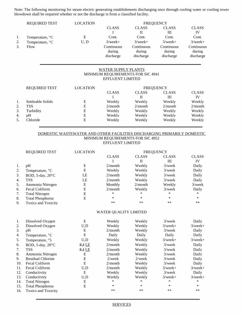
Note: The following monitoring for steam electric generating establishments discharging once through cooling water or cooling tower
blowdown shall be required whether or not the discharge is from a classified facility.
REQUIRED TEST LOCATION FREQUENCY
CLASS CLASS CLASS CLASS
I II III IV
1. Temperature, C E Cont. Cont. Cont. Cont.
2. Temperature, C U, D 3/week+ 3/week+ 3/week+ 3/week+
3. Flow Continuous Continuous Continuous Continuous
during during during during
discharge discharge discharge discharge
WATER SUPPLY PLANTS
MINIMUM REQUIREMENTS FOR SIC 4941
EFFLUENT LIMITED
REQUIRED TEST LOCATION FREQUENCY
CLASS CLASS CLASS CLASS
I II III IV
1. Settleable Solids E Weekly Weekly Weekly Weekly
2. TSS E 2/month 2/month 2/month 2/month
3. Turbidity E Weekly Weekly Weekly Weekly
4. pH E Weekly Weekly Weekly Weekly
5. Chloride E Weekly Weekly Weekly Weekly
DOMESTIC WASTEWATER AND OTHER FACILITIES DISCHARGING PRIMARILY DOMESTIC
MINIMUM REQUIREMENTS FOR SIC 4952
EFFLUENT LIMITED
REQUIRED TEST LOCATION FREQUENCY
CLASS CLASS CLASS CLASS
I II III IV
1. pH E 2/month Weekly 3/week Daily
2. Temperature, C E Weekly Weekly 3/week Daily
3. BOD, 5-day, 20C I,E 2/month Weekly 3/week Daily
4. TSS I,E 2/month Weekly 3/week Daily
5. Ammonia Nitrogen E Monthly 2/month Weekly 3/week
6. Fecal Coliform E 2/month Weekly 3/week Daily
7. Total Nitrogen E * * * *
8. Total Phosphorus E * * * *
9. Toxics and Toxicity ** ** ** **
WATER QUALITY LIMITED
1. Dissolved Oxygen E Weekly Weekly 3/week Daily
2. Dissolved Oxygen U,D Weekly Weekly 3/week+ 3/week+
3. pH E 2/month Weekly 3/week Daily
4. Temperature, C E Daily Daily Daily Daily
5. Temperature, 5 U,D Weekly Weekly 3/week+ 3/week+
6. BOD, 5-day, 20C E,I I,E 2/month Weekly 3/week Daily
7. TSS E,I I,E 2/month Weekly 3/week Daily
8. Ammonia Nitrogen E 2/month Weekly 3/week Daily
9. Residual Chlorine E 2/week 2/week 3/week Daily
10. Fecal Coliform E 2/month Weekly 3/week Daily
11. Fecal Coliform U,D 2/month Weekly 3/week+ 3/week+
12. Conductivity E Weekly Weekly 3/week Daily
13. Conductivity U,D Weekly Weekly 3/week+ 3/week+
14. Total Nitrogen E * * * *
15. Total Phosphorus E * * * *
16. Toxics and Toxicity ** ** ** **
SERVICES
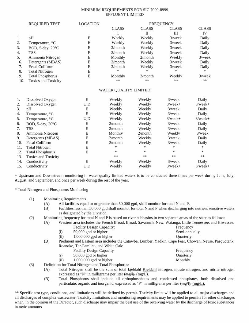
MINIMUM REQUIREMENTS FOR SIC 7000-8999
EFFLUENT LIMITED
REQUIRED TEST LOCATION FREQUENCY
CLASS CLASS CLASS CLASS
I II III IV
1. pH E Weekly Weekly 3/week Daily
2. Temperature, C E Weekly Weekly 3/week Daily
3. BOD, 5-day, 20C E 2/month Weekly 3/week Daily
4. TSS E 2/month Weekly 3/week Daily
5. Ammonia Nitrogen E Monthly 2/month Weekly 3/week
6. Detergents (MBAS) E 2/month Weekly 3/week Daily
7. Fecal Coliform E 2/month Weekly 3/week Daily
8. Total Nitrogen E * * * *
9. Total Phosphorus E Monthly 2/month Weekly 3/week
10. Toxics and Toxicity ** ** ** **
WATER QUALITY LIMITED
1. Dissolved Oxygen E Weekly Weekly 3/week Daily
2. Dissolved Oxygen U,D Weekly Weekly 3/week+ 3/week+
3. pH E Weekly Weekly 3/week Daily
4. Temperature, C E Weekly Weekly 3/week Daily
5. Temperature, C U,D Weekly Weekly 3/week+ 3/week+
6. BOD, 5-day, 20C E 2/month Weekly 3/week Daily
7. TSS E 2/month Weekly 3/week Daily
8. Ammonia Nitrogen E Monthly 2/month Weekly 3/week
9. Detergents (MBAS) E 2/month Weekly 3/week Daily
10. Fecal Coliform E 2/month Weekly 3/week Daily
11. Total Nitrogen E * * * *
12. Total Phosphorus E * * * *
13. Toxics and Toxicity ** ** ** **
14. Conductivity E Weekly Weekly 3/week Daily
15. Conductivity U,D Weekly Weekly 3/week+ 3/week+
+ Upstream and Downstream monitoring in water quality limited waters is to be conducted three times per week during June, July,
August, and September, and once per week during the rest of the year.
* Total Nitrogen and Phosphorus Monitoring
(1) Monitoring Requirements
(A) All facilities equal to or greater than 50,000 gpd, shall monitor for total N and P.
(B) Facilities less than 50,000 gpd shall monitor for total N and P when discharging into nutrient sensitive waters
as designated by the Division.
(2) Monitoring frequency for total N and P is based on river subbasins in two separate areas of the state as follows:
(A) Western area includes the French Broad, Broad, Savannah, New, Watauga, Little Tennessee, and Hiwassee:
Facility Design Capacity: Frequency
(i) 50,000 gpd or higher Semi-annually
(ii) 1,000,000 gpd or higher Quarterly.
(B) Piedmont and Eastern area includes the Catawba, Lumber, Yadkin, Cape Fear, Chowan, Neuse, Pasquotank,
Roanoke, Tar-Pamlico, and White Oak:
Facility Design Capacity Frequency
(i) 50,000 gpd or higher Quarterly
(ii) 1,000,000 gpd or higher Monthly.
(3) Definition for Total Nitrogen and Total Phosphorus:
(A) Total Nitrogen shall be the sum of total kjeldahl Kjeldahl nitrogen, nitrate nitrogen, and nitrite nitrogen
expressed as "N" in milligrams per liter (mg/l). (mg/L).
(B) Total Phosphorus shall include all orthophosphates and condensed phosphates, both dissolved and
particulate, organic and inorganic, expressed as "P" in milligrams per liter (mg/l). (mg/L).
** Specific test type, conditions, and limitations will be defined by permit. Toxicity limits will be applied to all major discharges and
all discharges of complex wastewater. Toxicity limitations and monitoring requirements may be applied to permits for other discharges
when, in the opinion of the Director, such discharge may impair the best use of the receiving water by the discharge of toxic substances
in toxic amounts.
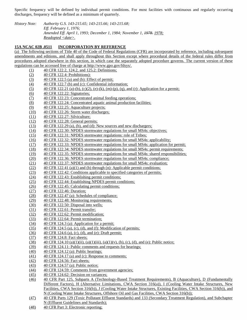
Specific frequency will be defined by individual permit conditions. For most facilities with continuous and regularly occurring
discharges, frequency will be defined as a minimum of quarterly.
History Note: Authority G.S. 143-215.65; 143-215.66; 143-215.68;
Eff. February 1, 1976;
Amended Eff. April 1, 1993; December 1, 1984; November 1, 1978. 1978;
Readopted <date>.
15A NCAC 02B .0511 INCORPORATION BY REFERENCE
(a) The following sections of Title 40 of the Code of Federal Regulations (CFR) are incorporated by reference, including subsequent
amendments and editions, and shall apply throughout this Section except where procedural details of the federal rules differ from
procedures adopted elsewhere in this section, in which case the separately adopted procedure governs. The current version of these
regulations can be accessed free of charge at http://www.gpo.gov/fdsys/.
(1) 40 CFR 122.2, 124.2, and 125.2: Definitions;
(2) 40 CFR 122.4: Prohibitions):
(3) 40 CFR 122.5 (a) and (b): Effect of permit;
(4) 40 CFR 122.7 (b) and (c): Confidential information;
(5) 40 CFR 122.21 (a)-(b), (c)(2), (e)-(k), (m)-(p), (q), and (r): Application for a permit;
(6) 40 CFR 122.22: Signatories;
(7) 40 CFR 122.23: Concentrated animal feeding operations;
(8) 40 CFR 122.24: Concentrated aquatic animal production facilities;
(9) 40 CFR 122.25: Aquaculture projects;
(10) 40 CFR 122.26: Storm water discharges;
(11) 40 CFR 122.27: Silviculture;
(12) 40 CFR 122.28: General permits;
(13) 40 CFR 122.29 (a), (b), and (d): New sources and new dischargers;
(14) 40 CFR 122.30: NPDES stormwater regulations for small MS4s: objectives;
(15) 40 CFR 122.31: NPDES stormwater regulations: role of Tribes;
(16) 40 CFR 122.32: NPDES stormwater regulations for small MS4s: applicability;
(17) 40 CFR 122.33: NPDES stormwater regulations for small MS4s: application for permit;
(18) 40 CFR 122.34: NPDES stormwater regulations for small MS4s: permit requirements;
(19) 40 CFR 122.35: NPDES stormwater regulations for small MS4s: shared responsibilities;
(20) 40 CFR 122.36: NPDES stormwater regulations for small MS4s: compliance;
(21) 40 CFR 122.37: NPDES stormwater regulations for small MS4s: evaluation;
(22) 40 CFR 122.41 (a)(1) and (b) through (n): Applicable permit conditions;
(23) 40 CFR 122.42: Conditions applicable to specified categories of permits;
(24) 40 CFR 122.43: Establishing permit conditions;
(25) 40 CFR 122.44: Establishing NPDES permit conditions;
(26) 40 CFR 122.45: Calculating permit conditions;
(27) 40 CFR 122.46: Duration;
(28) 40 CFR 122.47 (a): Schedules of compliance;
(29) 40 CFR 122.48: Monitoring requirements;
(30) 40 CFR 122.50: Disposal into wells;
(31) 40 CFR 122.61: Permit transfer;
(32) 40 CFR 122.62: Permit modification;
(33) 40 CFR 122.64: Permit termination;
(34) 40 CFR 124.3 (a): Application for a permit;
(35) 40 CFR 124.5 (a), (c), (d), and (f): Modification of permits;
(36) 40 CFR 124.6 (a), (c), (d), and (e): Draft permit;
(37) 40 CFR 124.8: Fact sheets;
(38) 40 CFR 124.10 (a)(1)(ii), (a)(1)(iii), (a)(1)(v), (b), (c), (d), and (e): Public notice;
(39) 40 CFR 124.11: Public comments and requests for hearings;
(40) 40 CFR 124.12 (a): Public hearings;
(41) 40 CFR 124.17 (a) and (c): Response to comments;
(42) 40 CFR 124.56: Fact sheets;
(43) 40 CFR 124.57 (a): Public notice;
(44) 40 CFR 124.59: Comments from government agencies;
(45) 40 CFR 124.62: Decision on variances;
(46) 40 CFR Part 125, Subparts A (Technology-Based Treatment Requirements), B (Aquaculture), D (Fundamentally
Different Factors), H (Alternative Limitations, CWA Section 316(a)), I (Cooling Water Intake Structures, New
Facilities, CWA Section 316(b)), J (Cooling Water Intake Structures, Existing Facilities, CWA Section 316(b)), and
N (Cooling Water Intake Structures, Offshore Oil and Gas Facilities, CWA Section 316(b));
(47) 40 CFR Parts 129 (Toxic Pollutant Effluent Standards) and 133 (Secondary Treatment Regulation), and Subchapter
N (Effluent Guidelines and Standards);
(48) 40 CFR Part 3: Electronic reporting;

(49) 40 CFR Part 136: Guidelines for establishing test procedures for the analysis of pollutants; and
(50) 40 CFR 401.15: List of toxic pollutants pursuant to CWA Section 307(a)(1).
(b) This Rule is not an exclusive list of federal regulations adopted by reference in this Section. Other rules of the Section incorporate
some of these same federal regulations for clarity or emphasis and may incorporate additional regulations not listed in Paragraph (a) of
this Rule.
History Note: Authority G.S. 143-211(c); 143-215.1(b)(4); 143B-282(5);
Eff. <date>.
15A NCAC 02B .0601 SITE SPECIFIC WATER QUALITY MANAGEMENT PLAN FOR THE GOOSE CREEK
WATERSHED (YADKIN PEE-DEE RIVER BASIN): PURPOSE
The Goose Creek watershed in the Yadkin Pee-Dee River Basin provides habitat for an aquatic animal species that is listed as federally
endangered by the U.S. Fish and Wildlife Service under the provisions of the Endangered Species Act, 16 U.S.C. 1531-1544.
Maintenance and recovery of the water quality conditions required to sustain and recover the federally-listed endangered species thereby
protects the biological integrity of the waters. The Goose Creek watershed, which includes Goose Creek (Index # 13-17-18), Stevens
Creek (Index # 13-17-18-1), Paddle Branch (Index # 13-17-18-2), Duck Creek (Index # 13-17-18-3) and all tributaries, shall be protected
by the site-specific management strategy described in Rules .0601 through .0609 .0608 of this Section.
The purpose of the actions required by this site-specific management strategy is for the maintenance and recovery of the water quality
conditions required to sustain and recover the federally endangered Carolina heelsplitter (Lasmigona decorata) species. Management
of the streamside zones to stabilize streambanks and prevent sedimentation are critical measures to restore water quality to sustain and
enable recovery of the federally endangered Carolina heelsplitter. Site-specific management strategies shall be implemented to:
(1) control stormwater for projects disturbing one acre or more of land as described in Rule .0602,.0602 of this Section;
(2) control wastewater discharges as described in Rule .0603, .0603 of this Section;
(3) control toxicity to streams supporting the Carolina heelsplitter as described in Rule .0604, .0604 of this Section; and
(4) maintain riparian buffers as described in Rules .0605 through .0609. .0608 of this Section.
History Note: Authority G.S. 143-214.1; 143-215.3(a)(1); 143-215.8A;
Eff. January 1, 2009.
Readopted Eff. [New Date].
15A NCAC 02B .0602 SITE SPECIFIC WATER QUALITY MANAGEMENT PLAN FOR THE GOOSE CREEK
WATERSHED (YADKIN PEE-DEE RIVER BASIN): STORMWATER CONTROL
REQUIREMENTS
(a) Any new development activity that disturbs one acre or more of land within the Goose Creek watershed and will result in addition
of impervious surface shall control and treat the difference in the stormwater runoff from the predevelopment and post-development
conditions for the one-year, 24-hour storm, with structural stormwater controls, control measures (SCMs), with the exception of NC
Department of Transportation and NC Turnpike Authority activities that shall be regulated in accordance with provisions of that agency's
National Pollutant Discharge Elimination System NPDES (NPDES) Stormwater Permit. Development and redevelopment shall
implement stormwater management measures that promote infiltration of flows and groundwater recharge for the purpose of maintaining
stream base flow or the delegated local government shall maintain a written explanation when it is not practical to use infiltration
methods.
(b) Structural stormwater controls SCMs shall meet the following requirements:
(1) Remove an 85 percent average annual amount of Total Suspended Solids;
(2) Draw down the treatment volume no faster than 48 hours, but no slower than 120 hours, for detention ponds;
(3) Discharge the storage volume at a rate equal or less than the pre-development discharge rate for the one-year, 24-hour
storm; and
(4) Meet Design of Stormwater Management Measures set forth in 15A NCAC 02H .1008. meet the relevant Minimum
Design Criteria (MDC) set forth in 15A NCAC 02H .1050 through .1062.
(c) Local governments may submit a written request to the Commission for authority to implement and enforce the state's stormwater
protection requirements of G.S. 143-214.7 and S.L. 2006-246 within their jurisdiction. The written request shall be accompanied by
information that shows:
(1) The local government has land use jurisdiction for the riparian buffer demonstrated by delineating the local land use
jurisdictional boundary on USGS 1:24,000 topographical map(s) or other finer scale map(s);
(2) The local government has the administrative organization, staff, legal authority, financial and other resources
necessary to implement and enforce the state's stormwater requirements based on its size and projected amount of
development;
(3) The local government has adopted ordinances, resolutions, or regulations necessary to establish and maintain the
state's stormwater requirements; and
(4) The local government has provided a plan to address violations with civil or criminal remedies and actions as well as
remedies that shall restore buffer functions on violation sites and provide a deterrent against the occurrence of future
violations.
(d) Within 90 days after the Commission has received the request for delegation, the Commission shall notify the local government
based on standards as set out in Paragraph (c) of this Rule whether it has been approved, approved with modifications, or denied.
(e) The Commission, upon determination that a delegated local authority is failing to implement or enforce the requirements in keeping
with a delegation, shall notify the delegated local authority in writing of the local program's inadequacies. If the delegated local authority
has not corrected the deficiencies within 90 days of receipt of the written notification, then the Commission shall rescind the delegation
of authority to the local government and shall implement and enforce the state's stormwater requirements.
(f) Limits of delegated local authority are as follows: The Commission shall have jurisdiction to the exclusion of local governments to
implement the state's stormwater protection requirements for the following types of activities:
(1) Activities undertaken by the State;
(2) Activities undertaken by the United States;
(3) Activities undertaken by multiple jurisdictions; and
(4) Activities undertaken by local units of government.
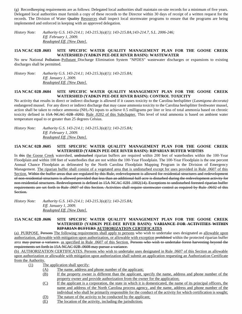
(g) Recordkeeping requirements are as follows: Delegated local authorities shall maintain on-site records for a minimum of five years.
Delegated local authorities must furnish a copy of these records to the Director within 30 days of receipt of a written request for the
records. The Division of Water Quality Resources shall inspect local stormwater programs to ensure that the programs are being
implemented and enforced in keeping with an approved delegation.
History Note: Authority G.S. 143-214.1; 143-215.3(a)(1); 143-215.8A;143-214.7, S.L. 2006-246;
Eff. February 1, 2009.
Readopted Eff. [New Date].
15A NCAC 02B .0603 SITE SPECIFIC WATER QUALITY MANAGEMENT PLAN FOR THE GOOSE CREEK
WATERSHED (YADKIN PEE-DEE RIVER BASIN): WASTEWATER
No new National Pollution Pollutant Discharge Elimination System "NPDES" wastewater discharges or expansions to existing
discharges shall be permitted.
History Note: Authority G.S. 143-214.1; 143-215.3(a)(1); 143-215.8A;
Eff. January 1, 2009.
Readopted Eff. [New Date].
15A NCAC 02B .0604 SITE SPECIFIC WATER QUALITY MANAGEMENT PLAN FOR THE GOOSE CREEK
WATERSHED (YADKIN PEE-DEE RIVER BASIN): CONTROL TOXICITY
No activity that results in direct or indirect discharge is allowed if it causes toxicity to the Carolina heelsplitter (Lasmigona decorata)
endangered mussel. For any direct or indirect discharge that may cause ammonia toxicity to the Carolina heelsplitter freshwater mussel,
action shall be taken to reduce ammonia (NH3-N) inputs to achieve 0.5 milligrams per liter or less of total ammonia based on chronic
toxicity defined in 15A NCAC 02B .0202. Rule .0202 of this Subchapter. This level of total ammonia is based on ambient water
temperature equal to or greater than 25 degrees Celsius.
History Note: Authority G.S. 143-214.1; 143-215.3(a)(1); 143-215.8A;
Eff. February 1, 2009.
Readopted Eff. [New Date].
15A NCAC 02B .0605 SITE SPECIFIC WATER QUALITY MANAGEMENT PLAN FOR THE GOOSE CREEK
WATERSHED (YADKIN PEE-DEE RIVER BASIN): RIPARIAN BUFFER WIDTHS
In this the Goose Creek watershed, undisturbed riparian buffers are required within 200 feet of waterbodies within the 100-Year
Floodplain and within 100 feet of waterbodies that are not within the 100-Year Floodplain. The 100-Year Floodplain is the one percent
Annual Chance Floodplain as delineated by the North Carolina Floodplain Mapping Program in the Division of Emergency
Management. The riparian buffer shall consist of a vegetated area that is undisturbed except for uses provided in Rule .0607 of this
Section. Within the buffer areas that are regulated by this Rule, redevelopment is allowed for residential structures and redevelopment
of non-residential structures is allowed provided that less than an additional half acre is disturbed during the redevelopment activity for
non-residential structures. Redevelopment is defined in 15A NCAC 02H .1002(14). Exceptions to undisturbed forested riparian buffer
requirements are set forth in Rule .0607 of this Section. Activities shall require stormwater control as required by Rule .0602 of this
Section.
History Note: Authority G.S. 143-214.1; 143-215.3(a)(1); 143-215.8A;
Eff. January 1, 2009.
Readopted Eff. [New Date].
15A NCAC 02B .0606 SITE SPECIFIC WATER QUALITY MANAGEMENT PLAN FOR THE GOOSE CREEK
WATERSHED (YADKIN PEE-DEE RIVER BASIN): VARIANCE FOR ACTIVITIES WITHIN
RIPARIAN BUFFERS AUTHORIZATION CERTIFICATES
(a) PURPOSE. Persons The following requirements shall apply to persons who wish to undertake uses designated as allowable upon
authorization, allowable with mitigation upon authorization, or allowable with exception prohibited within the protected riparian buffer
area may pursue a variance. as specified in Rule .0607 of this Section. Persons who wish to undertake forest harvesting beyond the
requirements set forth in 15A NCAC 02B .0608 may pursue a variance.
(b) AUTHORIZATION CERTIFICATES. Persons who wish to undertake uses designated in Rule .0607 of this Section as allowable
upon authorization or allowable with mitigation upon authorization shall submit an application requesting an Authorization Certificate
from the Authority.
(1) The application shall specify:
(A) The name, address and phone number of the applicant;
(B) If the property owner is different than the applicant, specify the name, address and phone number of the
property owner and provide authorization from the owner for the application;
(C) If the applicant is a corporation, the state in which it is domesticated, the name of its principal officers, the
name and address of the North Carolina process agency, and the name, address and phone number of the
individual who shall be primarily responsible for the conduct of the activity for which certification is sought;
(D) The nature of the activity to be conducted by the applicant;
(E) The location of the activity, including the jurisdiction;
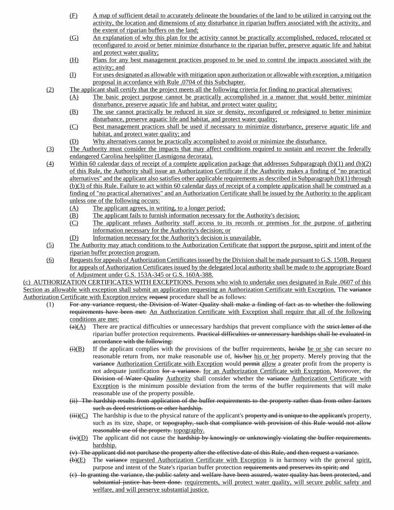
(F) A map of sufficient detail to accurately delineate the boundaries of the land to be utilized in carrying out the
activity, the location and dimensions of any disturbance in riparian buffers associated with the activity, and
the extent of riparian buffers on the land;
(G) An explanation of why this plan for the activity cannot be practically accomplished, reduced, relocated or
reconfigured to avoid or better minimize disturbance to the riparian buffer, preserve aquatic life and habitat
and protect water quality;
(H) Plans for any best management practices proposed to be used to control the impacts associated with the
activity; and
(I) For uses designated as allowable with mitigation upon authorization or allowable with exception, a mitigation
proposal in accordance with Rule .0704 of this Subchapter.
(2) The applicant shall certify that the project meets all the following criteria for finding no practical alternatives:
(A) The basic project purpose cannot be practically accomplished in a manner that would better minimize
disturbance, preserve aquatic life and habitat, and protect water quality;
(B) The use cannot practically be reduced in size or density, reconfigured or redesigned to better minimize
disturbance, preserve aquatic life and habitat, and protect water quality;
(C) Best management practices shall be used if necessary to minimize disturbance, preserve aquatic life and
habitat, and protect water quality; and
(D) Why alternatives cannot be practically accomplished to avoid or minimize the disturbance.
(3) The Authority must consider the impacts that may affect conditions required to sustain and recover the federally
endangered Carolina heelsplitter (Lasmigona decorata).
(4) Within 60 calendar days of receipt of a complete application package that addresses Subparagraph (b)(1) and (b)(2)
of this Rule, the Authority shall issue an Authorization Certificate if the Authority makes a finding of "no practical
alternatives" and the applicant also satisfies other applicable requirements as described in Subparagraph (b)(1) through
(b)(3) of this Rule. Failure to act within 60 calendar days of receipt of a complete application shall be construed as a
finding of "no practical alternatives" and an Authorization Certificate shall be issued by the Authority to the applicant
unless one of the following occurs:
(A) The applicant agrees, in writing, to a longer period;
(B) The applicant fails to furnish information necessary for the Authority's decision;
(C) The applicant refuses Authority staff access to its records or premises for the purpose of gathering
information necessary for the Authority's decision; or
(D) Information necessary for the Authority's decision is unavailable.
(5) The Authority may attach conditions to the Authorization Certificate that support the purpose, spirit and intent of the
riparian buffer protection program.
(6) Requests for appeals of Authorization Certificates issued by the Division shall be made pursuant to G.S. 150B. Request
for appeals of Authorization Certificates issued by the delegated local authority shall be made to the appropriate Board
of Adjustment under G.S. 153A-345 or G.S. 160A-388.
(c) AUTHORIZATION CERTIFICATES WITH EXCEPTIONS. Persons who wish to undertake uses designated in Rule .0607 of this
Section as allowable with exception shall submit an application requesting an Authorization Certificate with Exception. The variance
Authorization Certificate with Exception review request procedure shall be as follows:
(1) For any variance request, the Division of Water Quality shall make a finding of fact as to whether the following
requirements have been met: An Authorization Certificate with Exception shall require that all of the following
conditions are met:
(a)(A) There are practical difficulties or unnecessary hardships that prevent compliance with the strict letter of the
riparian buffer protection requirements. Practical difficulties or unnecessary hardships shall be evaluated in
accordance with the following:
(i)(B) If the applicant complies with the provisions of the buffer requirements, he/she he or she can secure no
reasonable return from, nor make reasonable use of, his/her his or her property. Merely proving that the
variance Authorization Certificate with Exception would permit allow a greater profit from the property is
not adequate justification for a variance. for an Authorization Certificate with Exception. Moreover, the
Division of Water Quality Authority shall consider whether the variance Authorization Certificate with
Exception is the minimum possible deviation from the terms of the buffer requirements that will make
reasonable use of the property possible.
(ii) The hardship results from application of the buffer requirements to the property rather than from other factors
such as deed restrictions or other hardship.
(iii)(C) The hardship is due to the physical nature of the applicant's property and is unique to the applicant's property,
such as its size, shape, or topography, such that compliance with provision of this Rule would not allow
reasonable use of the property. topography.
(iv)(D) The applicant did not cause the hardship by knowingly or unknowingly violating the buffer requirements.
hardship.
(v) The applicant did not purchase the property after the effective date of this Rule, and then request a variance.
(b)(E) The variance requested Authorization Certificate with Exception is in harmony with the general spirit,
purpose and intent of the State's riparian buffer protection requirements and preserves its spirit; and
(c) In granting the variance, the public safety and welfare have been assured, water quality has been protected, and
substantial justice has been done. requirements, will protect water quality, will secure public safety and
welfare, and will preserve substantial justice.
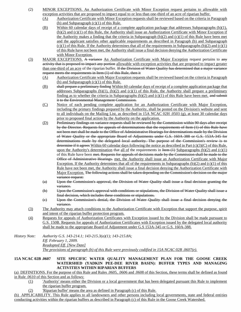
(2) MINOR EXCEPTIONS. An Authorization Certificate with Minor Exception request pertains to allowable with
exception activities that are proposed to impact equal to or less than one-third of an acre of riparian buffer.
(A) Authorization Certificate with Minor Exception requests shall be reviewed based on the criteria in Paragraph
(b) and Subparagraph (c)(1) of this Rule.
(B) Within 60 calendar days of receipt of a complete application package that addresses Subparagraphs (b)(1),
(b)(2) and (c)(1) of this Rule, the Authority shall issue an Authorization Certificate with Minor Exception if
the Authority makes a finding that the criteria in Subparagraph (b)(2) and (c)(1) of this Rule have been met
and the applicant satisfies other applicable requirements as described in Paragraph (b) and Subparagraph
(c)(1) of this Rule. If the Authority determines that all of the requirements in Subparagraphs (b)(2) and (c)(1)
of this Rule have not been met, the Authority shall issue a final decision denying the Authorization Certificate
with Minor Exception.
(3) MAJOR EXCEPTIONS. A variance An Authorization Certificate with Major Exception request pertains to any
activity that is proposed to impact any portion allowable with exception activities that are proposed to impact greater
than one-third of an acre of the riparian buffer. If the Division of Water Quality has determined that a major variance
request meets the requirements in Item (1) of this Rule, then it
(A) Authorization Certificate with Major Exception requests shall be reviewed based on the criteria in Paragraph
(b) and Subparagraph (c)(1) of this Rule.
(B) shall prepare a preliminary finding Within 60 calendar days of receipt of a complete application package that
addresses Subparagraphs (b)(1), (b)(2) and (c)(1) of this Rule, the Authority shall prepare a preliminary
finding as to whether the criteria in Subparagraphs (b)(2) and (c)(1) of this Rule have been met. and submit
it to the Environmental Management Commission.
(C) Notice of each pending complete application for an Authorization Certificate with Major Exception,
including the primary findings prepared by the Authority, shall be posted on the Division's website and sent
to all individuals on the Mailing List, as described in 15A NCAC 02H .0503 (g), at least 30 calendar days
prior to proposed final action by the Authority on the application.
(D) Preliminary findings on variance requests shall be reviewed by the Commission within 90 days after receipt
by the Director. Requests for appeals of determinations that the requirements of Item (1) of this Rule have
not been met shall be made to the Office of Administrative Hearings for determinations made by the Division
of Water Quality or the appropriate Board of Adjustments under G.S. 160A-388 or G.S. 153A-345 for
determinations made by the delegated local authority. The purpose of the Commission's review is to
determine if it agrees Within 60 calendar days following the notice as described in Part (c)(3)(C) of this Rule,
upon the Authority's determination that all of the requirements in Item (1) Subparagraphs (b)(2) and (c)(1)
of this Rule have been met. Requests for appeals of decisions made by the Commission shall be made to the
Office of Administrative Hearings. met, the Authority shall issue an Authorization Certificate with Major
Exception. If the Authority determines that all of the requirements in Subparagraphs (b)(2) and (c)(1) of this
Rule have not been met, the Authority shall issue a final decision denying the Authorization Certificate with
Major Exception. The following actions shall be taken depending on the Commission's decision on the major
variance request:
(a) Upon the Commission's approval, the Division of Water Quality shall issue a final decision granting the
variance.
(b) Upon the Commission's approval with conditions or stipulations, the Division of Water Quality shall issue a
final decision, which includes these conditions or stipulations.
(c) Upon the Commission's denial, the Division of Water Quality shall issue a final decision denying the
variance.
(3) The Authority may attach conditions to the Authorization Certificate with Exception that support the purpose, spirit
and intent of the riparian buffer protection program.
(4) Requests for appeals of Authorization Certificates with Exception issued by the Division shall be made pursuant to
G.S. 150B. Requests for appeals of Authorization Certificates with Exception issued by the delegated local authority
shall be made to the appropriate Board of Adjustment under G.S 153A-345 or G.S. 160A-388.
History Note: Authority G.S. 143-214.1; 143-215.3(a)(1); 143-215.8A;
Eff. February 1, 2009.
Readopted Eff. [New Date]
The provisions of paragraph (b) of this Rule were previously codified in 15A NCAC 02B .0607(e).
15A NCAC 02B .0607 SITE SPECIFIC WATER QUALITY MANAGEMENT PLAN FOR THE GOOSE CREEK
WATERSHED (YADKIN PEE-DEE RIVER BASIN): BUFFER TYPES AND MANAGING
ACTIVITIES WITHIN RIPARIAN BUFFERS
(a) DEFINITIONS. For the purpose of this Rule and Rules .0605, .0606 and .0608 of this Section, these terms shall be defined as found
in Rule .0610 of this Section and as follows:
(1) 'Authority' means either the Division or a local government that has been delegated pursuant this Rule to implement
the riparian buffer program.
(2) 'Riparian buffer' means the area as defined in Paragraph (c) of this Rule.
(b) APPLICABILITY. This Rule applies to all landowners and other persons including local governments, state and federal entities
conducting activities within the riparian buffers as described in Paragraph (c) of this Rule in the Goose Creek Watershed.
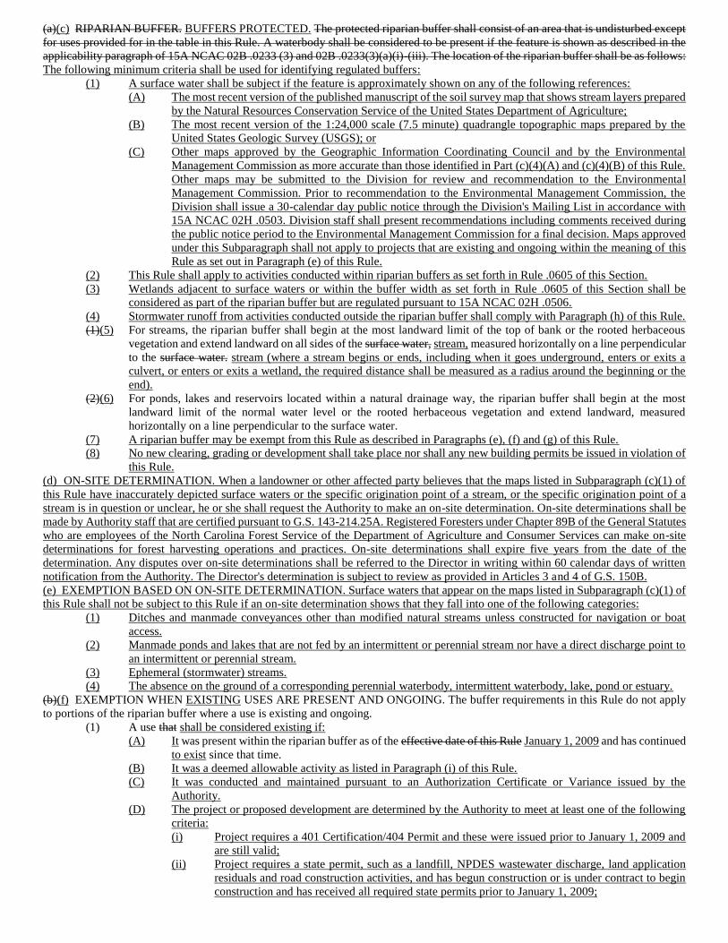
(a)(c) RIPARIAN BUFFER. BUFFERS PROTECTED. The protected riparian buffer shall consist of an area that is undisturbed except
for uses provided for in the table in this Rule. A waterbody shall be considered to be present if the feature is shown as described in the
applicability paragraph of 15A NCAC 02B .0233 (3) and 02B .0233(3)(a)(i)-(iii). The location of the riparian buffer shall be as follows:
The following minimum criteria shall be used for identifying regulated buffers:
(1) A surface water shall be subject if the feature is approximately shown on any of the following references:
(A) The most recent version of the published manuscript of the soil survey map that shows stream layers prepared
by the Natural Resources Conservation Service of the United States Department of Agriculture;
(B) The most recent version of the 1:24,000 scale (7.5 minute) quadrangle topographic maps prepared by the
United States Geologic Survey (USGS); or
(C) Other maps approved by the Geographic Information Coordinating Council and by the Environmental
Management Commission as more accurate than those identified in Part (c)(4)(A) and (c)(4)(B) of this Rule.
Other maps may be submitted to the Division for review and recommendation to the Environmental
Management Commission. Prior to recommendation to the Environmental Management Commission, the
Division shall issue a 30-calendar day public notice through the Division's Mailing List in accordance with
15A NCAC 02H .0503. Division staff shall present recommendations including comments received during
the public notice period to the Environmental Management Commission for a final decision. Maps approved
under this Subparagraph shall not apply to projects that are existing and ongoing within the meaning of this
Rule as set out in Paragraph (e) of this Rule.
(2) This Rule shall apply to activities conducted within riparian buffers as set forth in Rule .0605 of this Section.
(3) Wetlands adjacent to surface waters or within the buffer width as set forth in Rule .0605 of this Section shall be
considered as part of the riparian buffer but are regulated pursuant to 15A NCAC 02H .0506.
(4) Stormwater runoff from activities conducted outside the riparian buffer shall comply with Paragraph (h) of this Rule.
(1)(5) For streams, the riparian buffer shall begin at the most landward limit of the top of bank or the rooted herbaceous
vegetation and extend landward on all sides of the surface water, stream, measured horizontally on a line perpendicular
to the surface water. stream (where a stream begins or ends, including when it goes underground, enters or exits a
culvert, or enters or exits a wetland, the required distance shall be measured as a radius around the beginning or the
end).
(2)(6) For ponds, lakes and reservoirs located within a natural drainage way, the riparian buffer shall begin at the most
landward limit of the normal water level or the rooted herbaceous vegetation and extend landward, measured
horizontally on a line perpendicular to the surface water.
(7) A riparian buffer may be exempt from this Rule as described in Paragraphs (e), (f) and (g) of this Rule.
(8) No new clearing, grading or development shall take place nor shall any new building permits be issued in violation of
this Rule.
(d) ON-SITE DETERMINATION. When a landowner or other affected party believes that the maps listed in Subparagraph (c)(1) of
this Rule have inaccurately depicted surface waters or the specific origination point of a stream, or the specific origination point of a
stream is in question or unclear, he or she shall request the Authority to make an on-site determination. On-site determinations shall be
made by Authority staff that are certified pursuant to G.S. 143-214.25A. Registered Foresters under Chapter 89B of the General Statutes
who are employees of the North Carolina Forest Service of the Department of Agriculture and Consumer Services can make on-site
determinations for forest harvesting operations and practices. On-site determinations shall expire five years from the date of the
determination. Any disputes over on-site determinations shall be referred to the Director in writing within 60 calendar days of written
notification from the Authority. The Director's determination is subject to review as provided in Articles 3 and 4 of G.S. 150B.
(e) EXEMPTION BASED ON ON-SITE DETERMINATION. Surface waters that appear on the maps listed in Subparagraph (c)(1) of
this Rule shall not be subject to this Rule if an on-site determination shows that they fall into one of the following categories:
(1) Ditches and manmade conveyances other than modified natural streams unless constructed for navigation or boat
access.
(2) Manmade ponds and lakes that are not fed by an intermittent or perennial stream nor have a direct discharge point to
an intermittent or perennial stream.
(3) Ephemeral (stormwater) streams.
(4) The absence on the ground of a corresponding perennial waterbody, intermittent waterbody, lake, pond or estuary.
(b)(f) EXEMPTION WHEN EXISTING USES ARE PRESENT AND ONGOING. The buffer requirements in this Rule do not apply
to portions of the riparian buffer where a use is existing and ongoing.
(1) A use that shall be considered existing if:
(A) It was present within the riparian buffer as of the effective date of this Rule January 1, 2009 and has continued
to exist since that time.
(B) It was a deemed allowable activity as listed in Paragraph (i) of this Rule.
(C) It was conducted and maintained pursuant to an Authorization Certificate or Variance issued by the
Authority.
(D) The project or proposed development are determined by the Authority to meet at least one of the following
criteria:
(i) Project requires a 401 Certification/404 Permit and these were issued prior to January 1, 2009 and
are still valid;
(ii) Project requires a state permit, such as a landfill, NPDES wastewater discharge, land application
residuals and road construction activities, and has begun construction or is under contract to begin
construction and has received all required state permits prior to January 1, 2009;
(iii) Project is being reviewed through the Clean Water Act Section 404/National Environmental Policy
Act Merger 01 Process or Safe Accountable Flexible Efficient Transportation Equity Act; a Legacy
for Users (published by the US Army Corps of Engineers and Federal Highway Administration,
2003) or its immediate successor and that have reached agreement with Department on avoidance
and minimization by January 1, 2009; or
(iv) Project is not required to be reviewed by the Clean Water Act Section 404/National Environmental
Policy Act Merger 01 Process or Safe Accountable Flexible Efficient Transportation Equity Act; a
Legacy for Users (published by the US Army Corps of Engineers and Federal Highway
Administration, 2003) or its immediate successor if a Finding of No Significant Impact has been
issued for the project and the project has the written approval of the Division prior to January 1,
2009.
(2) Existing and ongoing uses shall include include, but not be limited to, agriculture, buildings, industrial facilities,
commercial areas, transportation facilities, maintained lawns, (i.e. can be mowed without a chainsaw or bush-hog),
maintained (i.e vegetation management has occurred within the last ten years) utility lines line corridors and on-site
sanitary sewage systems. sewage systems, any of which involve either specific periodic management of vegetation or
displacement of vegetation by structures or regular activity.
(3) Only the portion of the riparian buffer that contains the footprint of the existing and ongoing use is except from the
buffer requirements of this Rule.
(4) Change of ownership through purchase or inheritance is not a change of use.
(5) Activities necessary to maintain existing and ongoing uses are allowed provided that the site remains similarly
vegetated, no impervious surface built upon area is added within the buffer area where it did not exist as of the effective
date of this Rule prior to January 1, 2009, and existing diffuse flow is maintained. the site is in compliance with
Paragraph (h) of this Rule.
(2) A use that can be documented to the Division of Water Quality that meets at least one of the following criteria:
(A) Project requires a 401 Certification/404 Permit, issued prior to the effective date of this Rule and are still
valid;
(B) Project requires a state permit, such as a landfill, NPDES wastewater discharge, land application residuals
and road construction activities, and has begun construction or is under contract to begin construction and
has received all required state permits prior to the effective date of this Rule;
(C) Project is being reviewed through the Clean Water Act Section 404/National Environmental Policy Act
Merger 01 Process or Safe Accountable Flexible Efficient Transportation Equity Act; a Legacy for Users
(published by the US Army Corps of Engineers and Federal Highway Administration, 2003) or its immediate
successor and that have reached agreement with Department of Environment and Natural Resources on
avoidance and minimization by the effective date of this Rule; or
(D) Project is not required to be reviewed by the Clean Water Act Section 404/National Environmental Policy
Act Merger 01 Process or Safe Accountable Flexible Efficient Transportation Equity Act; a Legacy for Users
(published by the US Army Corps of Engineers and Federal Highway Administration, 2003) or its immediate
successor if a Finding of No Significant Impact has been issued for the project and the project has the written
approval of the Division of Water Quality prior to the effective date of this Rule.
(5)(6) At This Rule shall apply at the time an existing and ongoing use is changed to another use. use, the buffer requirement
of this Rule shall apply. Change of use includes the following: Change of use shall involved the initigation of any
activity not defined as existing and ongoing in Subparagraphs (f)(1) through (f)(5) of this Rule.
(A) To add impervious surface within the riparian buffer;
(B) An agricultural operation within the riparian buffer is converted to a non-agricultural; or
(C) a lawn within the riparian buffer ceases to be maintained.
(g) EXEMPTION FOR PONDS CONSTRUCTED AND USED FOR AGRICULTURAL PURPOSES. This Rule shall not apply to a
freshwater pond if all of the following conditions are met:
(1) The property on which the pond is located is used for agriculture as that term is defined in G.S. 106-581.1.
(2) Except for this Rule, the use of the property is in compliance with all other water quality and water quantity statutes
and rules applicable to the property before January 1, 2009.
(3) The pond is not a component of an animal waste management system as defined in G.S. 143-215.10B (3).
(c) DIFFUSE FLOW REQUIREMENT. Diffuse flow of runoff shall be maintained in the riparian buffer by dispersing concentrated
flow and reestablishing vegetation, as follows:
(1) Concentrated runoff from new ditches or manmade conveyances shall be converted to diffuse flow before the runoff
enters the riparian buffer; and
(2) Periodic corrective action to restore diffuse flow shall be taken if necessary to impede the formation of erosion gullies.
(h) STORMWATER RUNOFF THROUGH THE RIPARIAN BUFFER. Drainage conveyances include drainage ditches, roadside
ditches, and stormwater conveyances. The following stormwater conveyances through the riparian buffer are either deemed allowable
or allowable upon authorization, as defined in Subparagraph (i)(1) of this Rule, provided that they do not erode through the buffer and
do not cause erosion to the receiving waterbody. Stormwater conveyances through the riparian buffer that are not listed below shall be
allowable with exception as defined in Part (i)(1)(E) of this Rule
(1) The following are deemed allowable as defined in Part (i)(1)(A) of this Rule:
(A) New drainage conveyances from a Primary SCM, as defined in 15A NCAC 02H .1002, when the Primary
SCM is designed to treat the drainage area to the conveyance and that comply with a stormwater management
plan reviewed and approved under a state stormwater program or a state-approved local government
stormwater program; and
(B) New stormwater flow to existing drainage conveyances provided that the addition of new flow does not result
in the need to alter the conveyance.
(2) The following are allowable upon authorization as defined in Part (i)(1)(B) of this Rule:
(A) New drainage conveyances from a Primary SCM as defined in 15A NCAC 02H .1002 when the Primary
SCM is provided to treat the drainage area to the conveyance but are not approved under a state stormwater
program or a state-approved local government stormwater program;
(B) New drainage conveyances when the flow rate of the conveyance is less than 0.5 cubic feet per second during
the peak flow from the 0.75 inch per hour storm;
(C) New stormwater runoff that has been treated through a level spreader-filter strip that complies with 15A
NCAC 02H .1059;
(D) Realignment of existing drainage conveyances applicable to publicly funded and maintained linear
transportation facilities when retaining or improving the design dimensions provided that no additional travel
lanes are added and the minimum required roadway typical section is used based on traffic and safety
considerations;
(E) Realignment of existing drainage conveyances retaining or improving the design dimensions provided that
the size of the drainage area and the percent built-upon area within the drainage area remain the same;
(F) New or altered drainage conveyances applicable to publicly funded and maintained linear transportation
facilities provided that SCMs, or BMPs from the NCDOT Stormwater Best Management Practices Toolbox,
are employed;
(G) New drainage conveyances applicable to publicly funded and maintained linear transportation facilities that
do not provide a stormwater management facility due to topography constraints provided other measures are
employed to protect downstream water quality to the maximum extent practical; and
(H) New drainage conveyances where the drainage area to the conveyance has no new built-upon area as defined
in 15A NCAC 02H .1002 and the conveyance is necessary for bypass of existing drainage only.
(d)(i) REQUIREMENTS FOR CATEGORIES OF USES AND MITIGATION. USES. Uses within the riparian buffer, or outside the
buffer with hydrological impacts on the riparian buffer, shall be designated as exempt, deemed allowable, potentially allowable,
allowable upon authorization, allowable with mitigation upon authorization, allowable with exception or prohibited. and prohibited
location in the chart of uses in this Rule shall have the following requirements:
(1) Potential new uses shall have the following requirements:
(1)(A) EXEMPT. DEEMED ALLOWABLE. Uses designated as exempt deemed allowable in Subparagraphs (h)(1)
and (i)(3) of this Rule may occur are allowed within the riparian buffer. Exempt Deemed allowable uses shall
be designed, constructed and maintained to minimize vegetation and soil disturbance and to provide the
maximum water quality protection practicable. practicable, including construction, monitoring and
maintenance activities. In addition, exempt deemed allowable uses shall meet requirements listed in the table
Subparagraph (h)(3) of this Rule for the specific use.
(2)(B) POTENTIALLY ALLOWABLE. ALLOWABLE UPON AUTHORIZATION. Uses designated as
potentially allowable upon authorization in Subparagraphs (h)(2) and (i)(3) of this Rule require a written
Authorization Certificate from the Authority for impacts may proceed within the riparian buffer pursuant to
Rule .0606 of this Section. provided that there are no practical alternatives to the requested use pursuant to
this Rule. These uses require written authorization from the Division of Water Quality. Some of these uses
require mitigation, as indicated in the chart in this Rule.
(C) ALLOWABLE WITH MITIGATION UPON AUTHORIZATION. Uses designated as allowable with
mitigation upon authorization in Subparagraph (i)(3) of this Rule require a written Authorization Certificate
from the Authority for impacts within the riparian buffer pursuant to Rule .0606 of this Section and an
appropriate mitigation strategy has received written approval pursuant to Paragraph (j) of this Rule.
(3)(D) PROHIBITED. Uses designated as prohibited or not included in this table in Subparagraph (i)(3) of this Rule
may not proceed within the riparian buffer unless a variance is granted pursuant to Rule .0606. Site-specific
mitigation .0226 of this Subchapter. Mitigation may be required as one a condition of a variance approval.
(E) ALLOWABLE WITH EXCEPTION. Uses not designated as deemed allowable, allowable upon
authorization, allowable with mitigation upon authorization or prohibited in Subparagraph (i)(3) of this Rule
require a written Authorization Certificate with Exception from the Authority for impacts within the riparian
buffer pursuant to Rule .0606 of this Section and an appropriate mitigation strategy that has received written
approval pursuant to Paragraph (j) of this Rule.
(4) MITIGATION. Persons who wish to undertake uses designated as allowable with mitigation shall obtain approval for
a mitigation proposal pursuant to 15A NCAC 02B .0609.
(2) The United States Environmental Protection Agency Endangered Species Protection Program at www.epa.gov/espp
and NC Pesticide Board regulates pesticide application (see rules at 02 NCAC 09L .2201 through .2203).
(3) The following table sets out potential new uses within the riparian buffer, or outside the buffer with hydrological
impacts on the riparian buffer, and designates them as deemed allowable, allowable upon authorization, allowable
with mitigation upon authorization or prohibited:
Deemed
Allowable
Allowable
Upon Autho-
rization
Allowable with
Mitigation
Upon Auth-
orization
Prohibited
Airport facilities:
• Vegetation removal activities necessary to comply with Federal
Aviation Administration requirements (e.g. line of sight
requirements) provided the disturbed areas are stabilized and
revegetated
• Airport facilities that impact equal to or less than one-third of an
acre of riparian buffer
• Airport facilities that impact greater than one-third of an acre of
riparian buffer
X
X
X
Archaeological activities X
Bridges
• Impact equal to or less than one-tenth of an acre of riparian buffer
• Impact greater than one-tenth of an acre of riparian buffer
X
X
Dam maintenance activities
• Dam maintenance activities that do not cause additional riparian
buffer disturbance beyond the footprint of the existing dam
• Dam maintenance activities that do cause additional riparian
buffer disturbance beyond the footprint of the existing dam
X
X
Drainage of a pond subject to Paragraph (c) of this Rule provided that
a new riparian buffer is established by natural regeneration or
planting, within 50 feet of any stream which naturally forms or is
constructed within the drained pond area. Drained ponds shall be
allowed to naturalize for a minimum of six months from completion
of the draining activity before a stream determination is conducted
pursuant to Paragraph (d) of this Rule.
X
Fences:
• Fencing livestock out of surface waters
• Installation does not result in removal of trees
• Installation results in removal of trees
X
X
X
Forest harvesting - see Rule .0608 of this Section
Fertilizer application:
• One-time fertilizer application at agronomic rates to establish
replanted vegetation. This only applies to the one-time application
of fertilizer in the riparian buffer. No runoff from this one-time
application in the riparian buffer is allowed in the applicable
surface water.
• Ongoing fertilizer application
X
X
Greenways, trails, sidewalks or linear pedestrian/bicycle
transportation system:
• In outer riparian buffer (landward of 50 feet) provided that no
built upon area is added within the buffer
• When built upon area is added to the buffer, equal to or less than
10 feet wide with 2 foot wide shoulders. Must be located
landward of 50 feet unless there is no practical alternative
• When built upon area is added to the buffer, greater than 10 feet
wide with 2 foot wide shoulders. Must be located landward of 50
feet unless there is no practical alternative
X
X
X
Historic preservation X
New Landfills as defined by G.S. 130A-290 X
Mining activities:
• Mining activities that are covered by the Mining Act provided that
new riparian buffers that meet the requirements of Paragraph (h)
of this Rule and Rule .0605 of this Section are established
adjacent to the relocated channels
• Wastewater or mining dewatering wells with approved NPDES
permit
X
X
On-site sanitary sewage systems - new ones that use ground
absorption
X
Deemed
Allowable
Allowable
Upon Autho-
rization
Allowable with
Mitigation
Upon Auth-
orization
Prohibited
Maintenance access on modified natural streams or canals: a grassed
travelway on one side of the waterbody when less impacting
alternative forms are not practical. The width and specifications of the
travel way shall be only that needed for equipment access and
operation. The travelway shall be located to maximize stream shading.
X
Pedestrian access trail and associated steps leading to a surface water,
dock, canoe or kayak access, fishing pier, boat ramp or other water
dependent structure:
• Pedestrian access trail equal to or less than six feet wide that does
not result in the removal of any tree(s) within the riparian buffer
and does not result in any built upon area being added to the
riparian buffer
• Pedestrian access trail equal to or less than six feet wide where
the installation or use results in the removal of tree(s) or addition
of built upon area to the riparian buffer
• Pedestrian access trail greater than six six feet wide
X
X
X
Playground equipment:
• Playground equipment on single family lots provided that
installation and use does not result in removal of vegetation
• Playground equipment on single family lots where installation or
use results in the removal of vegetation
• Playground equipment installed on lands other than single-family
lots
X
X
X
Ponds created or modified by impounding streams subject to buffers
pursuant to Paragraph (c) of this Rule and not used as stormwater
control measures (SCMs):
• New ponds provided that a riparian buffer that meets the
requirements of Paragraph (h) of this Rule and Rule .0605 of this
Section is established adjacent to the pond
X
Protection of existing structures and facilities when this requires
additional disturbance of the riparian buffer
X
Public Safety - publicly owned spaces where it has been determined
by the head of the local law enforcement agency with jurisdiction over
that area that the buffers pose a risk to public safety. The head of the
local law enforcement agency shall notify the local government with
land use jurisdiction over the publicly owned space and the Division
of Water Resources of any such determination in writing.
X
Removal of previous fill or debris provided that Paragraph (h) of this
Rule is complied with and any vegetation removed is restored
X
Restoration or enhancement (wetland, stream) as defined in 33 CFR
Part 332 available free of charge on the internet at:
http://water.epa.gov/lawsregs/guidance/wetlands/wetlandsmitigation
_index.cfm:
• Wetland or stream restoration that does not require written
Division approval that results in impacts to the riparian buffer
• Wetland or stream restoration that requires written Division
approval that results in impacts to the riparian buffer
X
X
Road, driveway or railroad impacts other than perpendicular crossings
of streams and other surface waters subject to this Rule
X
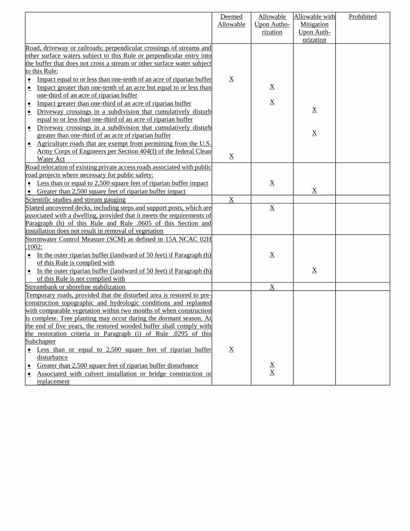
Deemed
Allowable
Allowable
Upon Autho-
rization
Allowable with
Mitigation
Upon Auth-
orization
Prohibited
Road, driveway or railroads: perpendicular crossings of streams and
other surface waters subject to this Rule or perpendicular entry into
the buffer that does not cross a stream or other surface water subject
to this Rule:
• Impact equal to or less than one-tenth of an acre of riparian buffer
• Impact greater than one-tenth of an acre but equal to or less than
one-third of an acre of riparian buffer
• Impact greater than one-third of an acre of riparian buffer
• Driveway crossings in a subdivision that cumulatively disturb
equal to or less than one-third of an acre of riparian buffer
• Driveway crossings in a subdivision that cumulatively disturb
greater than one-third of an acre of riparian buffer
• Agriculture roads that are exempt from permitting from the U.S.
Army Corps of Engineers per Section 404(f) of the federal Clean
Water Act
X
X
X
X
X
X
Road relocation of existing private access roads associated with public
road projects where necessary for public safety:
• Less than or equal to 2,500 square feet of riparian buffer impact
• Greater than 2,500 square feet of riparian buffer impact
X
X
Scientific studies and stream gauging X
Slatted uncovered decks, including steps and support posts, which are
associated with a dwelling, provided that it meets the requirements of
Paragraph (h) of this Rule and Rule .0605 of this Section and
installation does not result in removal of vegetation
X
Stormwater Control Measure (SCM) as defined in 15A NCAC 02H
.1002:
• In the outer riparian buffer (landward of 50 feet) if Paragraph (h)
of this Rule is complied with
• In the outer riparian buffer (landward of 50 feet) if Paragraph (h)
of this Rule is not complied with
X
X
Streambank or shoreline stabilization X
Temporary roads, provided that the disturbed area is restored to pre-
construction topographic and hydrologic conditions and replanted
with comparable vegetation within two months of when construction
is complete. Tree planting may occur during the dormant season. At
the end of five years, the restored wooded buffer shall comply with
the restoration criteria in Paragraph (i) of Rule .0295 of this
Subchapter
• Less than or equal to 2,500 square feet of riparian buffer
disturbance
• Greater than 2,500 square feet of riparian buffer disturbance
• Associated with culvert installation or bridge construction or
replacement
X
X
X
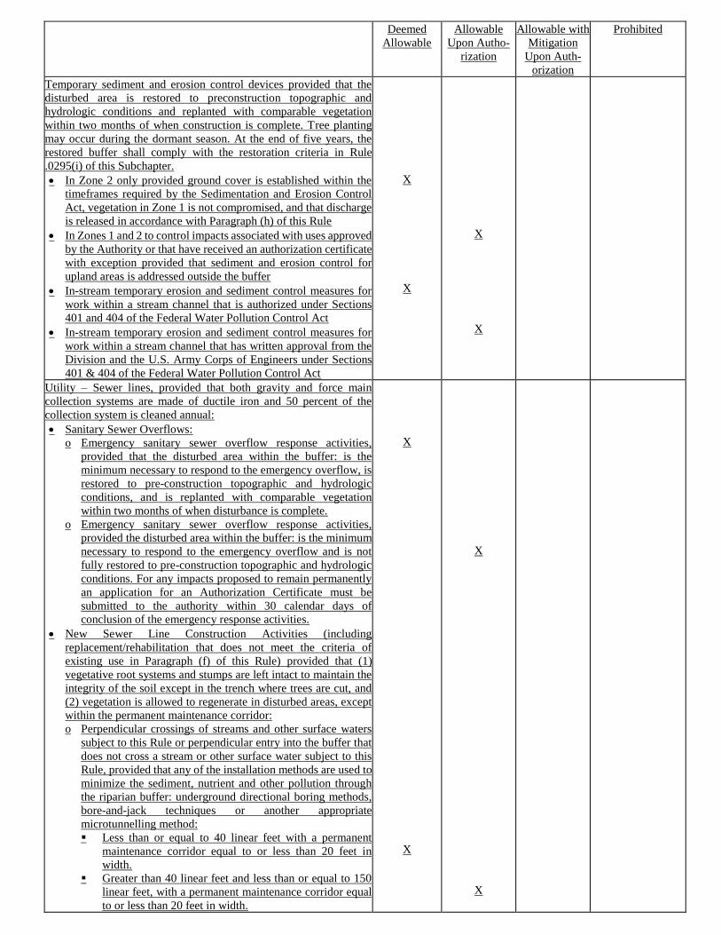
Deemed
Allowable
Allowable
Upon Autho-
rization
Allowable with
Mitigation
Upon Auth-
orization
Prohibited
Temporary sediment and erosion control devices provided that the
disturbed area is restored to preconstruction topographic and
hydrologic conditions and replanted with comparable vegetation
within two months of when construction is complete. Tree planting
may occur during the dormant season. At the end of five years, the
restored buffer shall comply with the restoration criteria in Rule
.0295(i) of this Subchapter.
• In Zone 2 only provided ground cover is established within the
timeframes required by the Sedimentation and Erosion Control
Act, vegetation in Zone 1 is not compromised, and that discharge
is released in accordance with Paragraph (h) of this Rule
• In Zones 1 and 2 to control impacts associated with uses approved
by the Authority or that have received an authorization certificate
with exception provided that sediment and erosion control for
upland areas is addressed outside the buffer
• In-stream temporary erosion and sediment control measures for
work within a stream channel that is authorized under Sections
401 and 404 of the Federal Water Pollution Control Act
• In-stream temporary erosion and sediment control measures for
work within a stream channel that has written approval from the
Division and the U.S. Army Corps of Engineers under Sections
401 & 404 of the Federal Water Pollution Control Act
X
X
X
X
Utility – Sewer lines, provided that both gravity and force main
collection systems are made of ductile iron and 50 percent of the
collection system is cleaned annual:
• Sanitary Sewer Overflows:
o Emergency sanitary sewer overflow response activities,
provided that the disturbed area within the buffer: is the
minimum necessary to respond to the emergency overflow, is
restored to pre-construction topographic and hydrologic
conditions, and is replanted with comparable vegetation
within two months of when disturbance is complete.
o Emergency sanitary sewer overflow response activities,
provided the disturbed area within the buffer: is the minimum
necessary to respond to the emergency overflow and is not
fully restored to pre-construction topographic and hydrologic
conditions. For any impacts proposed to remain permanently
an application for an Authorization Certificate must be
submitted to the authority within 30 calendar days of
conclusion of the emergency response activities.
• New Sewer Line Construction Activities (including
replacement/rehabilitation that does not meet the criteria of
existing use in Paragraph (f) of this Rule) provided that (1)
vegetative root systems and stumps are left intact to maintain the
integrity of the soil except in the trench where trees are cut, and
(2) vegetation is allowed to regenerate in disturbed areas, except
within the permanent maintenance corridor:
o Perpendicular crossings of streams and other surface waters
subject to this Rule or perpendicular entry into the buffer that
does not cross a stream or other surface water subject to this
Rule, provided that any of the installation methods are used to
minimize the sediment, nutrient and other pollution through
the riparian buffer: underground directional boring methods,
bore-and-jack techniques or another appropriate
microtunnelling method:
▪ Less than or equal to 40 linear feet with a permanent
maintenance corridor equal to or less than 20 feet in
width.
▪ Greater than 40 linear feet and less than or equal to 150
linear feet, with a permanent maintenance corridor equal
to or less than 20 feet in width.
X
X
X
X
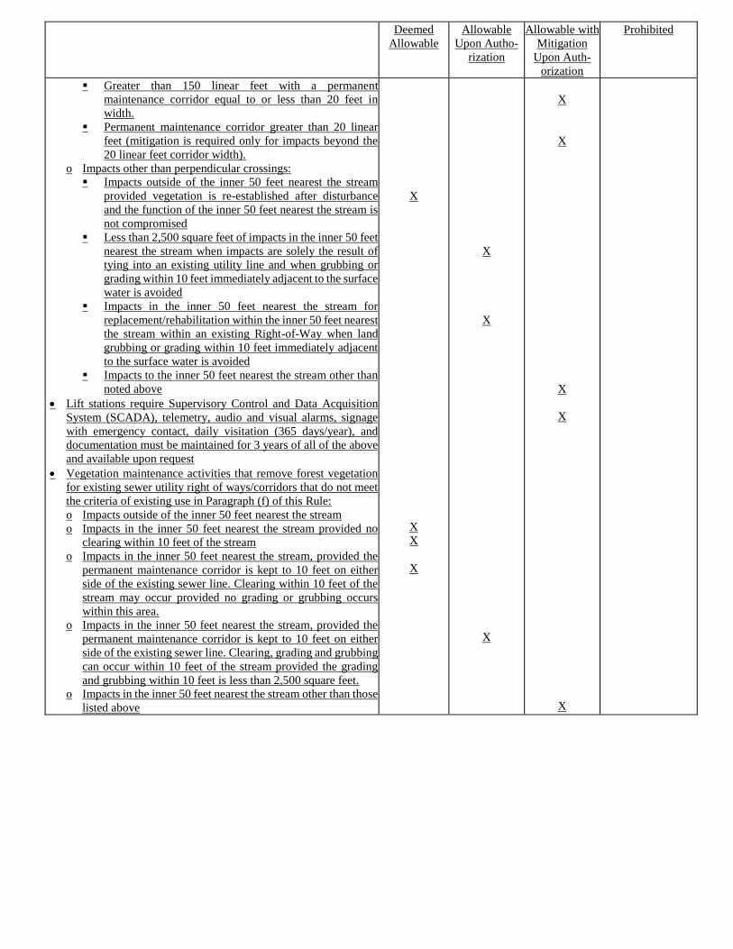
Deemed
Allowable
Allowable
Upon Autho-
rization
Allowable with
Mitigation
Upon Auth-
orization
Prohibited
▪ Greater than 150 linear feet with a permanent
maintenance corridor equal to or less than 20 feet in
width.
▪ Permanent maintenance corridor greater than 20 linear
feet (mitigation is required only for impacts beyond the
20 linear feet corridor width).
o Impacts other than perpendicular crossings:
▪ Impacts outside of the inner 50 feet nearest the stream
provided vegetation is re-established after disturbance
and the function of the inner 50 feet nearest the stream is
not compromised
▪ Less than 2,500 square feet of impacts in the inner 50 feet
nearest the stream when impacts are solely the result of
tying into an existing utility line and when grubbing or
grading within 10 feet immediately adjacent to the surface
water is avoided
▪ Impacts in the inner 50 feet nearest the stream for
replacement/rehabilitation within the inner 50 feet nearest
the stream within an existing Right-of-Way when land
grubbing or grading within 10 feet immediately adjacent
to the surface water is avoided
▪ Impacts to the inner 50 feet nearest the stream other than
noted above
• Lift stations require Supervisory Control and Data Acquisition
System (SCADA), telemetry, audio and visual alarms, signage
with emergency contact, daily visitation (365 days/year), and
documentation must be maintained for 3 years of all of the above
and available upon request
• Vegetation maintenance activities that remove forest vegetation
for existing sewer utility right of ways/corridors that do not meet
the criteria of existing use in Paragraph (f) of this Rule:
o Impacts outside of the inner 50 feet nearest the stream
o Impacts in the inner 50 feet nearest the stream provided no
clearing within 10 feet of the stream
o Impacts in the inner 50 feet nearest the stream, provided the
permanent maintenance corridor is kept to 10 feet on either
side of the existing sewer line. Clearing within 10 feet of the
stream may occur provided no grading or grubbing occurs
within this area.
o Impacts in the inner 50 feet nearest the stream, provided the
permanent maintenance corridor is kept to 10 feet on either
side of the existing sewer line. Clearing, grading and grubbing
can occur within 10 feet of the stream provided the grading
and grubbing within 10 feet is less than 2,500 square feet.
o Impacts in the inner 50 feet nearest the stream other than those
listed above
X
X
X
X
X
X
X
X
X
X
X
X
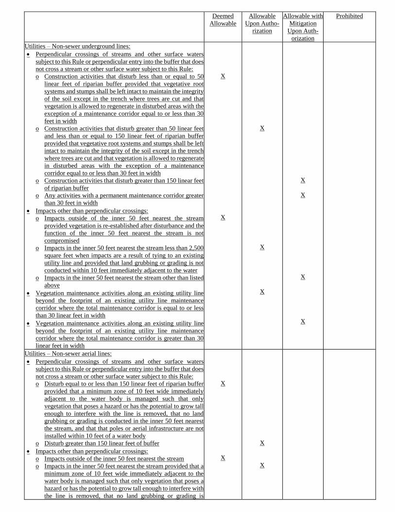
Deemed
Allowable
Allowable
Upon Autho-
rization
Allowable with
Mitigation
Upon Auth-
orization
Prohibited
Utilities – Non-sewer underground lines:
• Perpendicular crossings of streams and other surface waters
subject to this Rule or perpendicular entry into the buffer that does
not cross a stream or other surface water subject to this Rule:
o Construction activities that disturb less than or equal to 50
linear feet of riparian buffer provided that vegetative root
systems and stumps shall be left intact to maintain the integrity
of the soil except in the trench where trees are cut and that
vegetation is allowed to regenerate in disturbed areas with the
exception of a maintenance corridor equal to or less than 30
feet in width
o Construction activities that disturb greater than 50 linear feet
and less than or equal to 150 linear feet of riparian buffer
provided that vegetative root systems and stumps shall be left
intact to maintain the integrity of the soil except in the trench
where trees are cut and that vegetation is allowed to regenerate
in disturbed areas with the exception of a maintenance
corridor equal to or less than 30 feet in width
o Construction activities that disturb greater than 150 linear feet
of riparian buffer
o Any activities with a permanent maintenance corridor greater
than 30 feet in width
• Impacts other than perpendicular crossings:
o Impacts outside of the inner 50 feet nearest the stream
provided vegetation is re-established after disturbance and the
function of the inner 50 feet nearest the stream is not
compromised
o Impacts in the inner 50 feet nearest the stream less than 2,500
square feet when impacts are a result of tying to an existing
utility line and provided that land grubbing or grading is not
conducted within 10 feet immediately adjacent to the water
o Impacts in the inner 50 feet nearest the stream other than listed
above
• Vegetation maintenance activities along an existing utility line
beyond the footprint of an existing utility line maintenance
corridor where the total maintenance corridor is equal to or less
than 30 linear feet in width
• Vegetation maintenance activities along an existing utility line
beyond the footprint of an existing utility line maintenance
corridor where the total maintenance corridor is greater than 30
linear feet in width
X
X
X
X
X
X
X
X
X
Utilities – Non-sewer aerial lines:
• Perpendicular crossings of streams and other surface waters
subject to this Rule or perpendicular entry into the buffer that does
not cross a stream or other surface water subject to this Rule:
o Disturb equal to or less than 150 linear feet of riparian buffer
provided that a minimum zone of 10 feet wide immediately
adjacent to the water body is managed such that only
vegetation that poses a hazard or has the potential to grow tall
enough to interfere with the line is removed, that no land
grubbing or grading is conducted in the inner 50 feet nearest
the stream, and that that poles or aerial infrastructure are not
installed within 10 feet of a water body
o Disturb greater than 150 linear feet of buffer
• Impacts other than perpendicular crossings:
o Impacts outside of the inner 50 feet nearest the stream
o Impacts in the inner 50 feet nearest the stream provided that a
minimum zone of 10 feet wide immediately adjacent to the
water body is managed such that only vegetation that poses a
hazard or has the potential to grow tall enough to interfere with
the line is removed, that no land grubbing or grading is
X
X
X
X
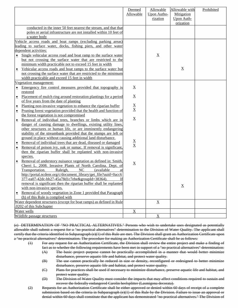
Deemed
Allowable
Allowable
Upon Autho-
rization
Allowable with
Mitigation
Upon Auth-
orization
Prohibited
conducted in the inner 50 feet nearest the stream, and that that
poles or aerial infrastructure are not installed within 10 feet of
a water body
Vehicle access roads and boat ramps (excluding parking areas)
leading to surface water, docks, fishing piers, and other water
dependent activities:
• Single vehicular access road and boat ramp to the surface water
but not crossing the surface water that are restricted to the
minimum width practicable not to exceed 15 feet in width
• Vehicular access roads and boat ramps to the surface water but
not crossing the surface water that are restricted to the minimum
width practicable and exceed 15 feet in width
X
X
Vegetation management:
• Emergency fire control measures provided that topography is
restored
• Placement of mulch ring around restoration plantings for a period
of five years from the date of planting
• Planting non-invasive vegetation to enhance the riparian buffer
• Pruning forest vegetation provided that the health and function of
the forest vegetation is not compromised
• Removal of individual trees, branches or limbs which are in
danger of causing damage to dwellings, existing utility lines,
other structures or human life, or are imminently endangering
stability of the streambank provided that the stumps are left or
ground in place without causing additional land disturbance.
• Removal of individual trees that are dead, diseased or damaged
• Removal of poison ivy, oak or sumac. If removal is significant,
then the riparian buffer shall be replanted with non-invasive
species.
• Removal of understory nuisance vegetation as defined in: Smith,
Cherri L. 2008. Invasive Plants of North Carolina. Dept. of
Transportation. Raleigh, NC (available at
http://portal.ncdenr.org/c/document_library/get_file?uuid=0acc6
377-ea07-42dc-bb27-45a78d1c7ebe&groupId=38364). If
removal is significant then the riparian buffer shall be replanted
with non-invasive species.
• Removal of woody vegetation in Zone 1 provided that Paragraph
(h) of this Rule is complied with
X
X
X
X
X
X
X
X
X
Water dependent structures (except for boat ramps) as defined in Rule
.0202 of this Subchapter
X
Water wells X
Wildlife passage structures X
(e) DETERMINATION OF "NO PRACTICAL ALTERNATIVES." Persons who wish to undertake uses designated as potentially
allowable shall submit a request for a "no practical alternatives" determination to the Division of Water Quality. The applicant shall
certify that the criteria identified in Subparagraph (e)(1) of this Rule are met. The Division shall grant an Authorization Certificate upon
a "no practical alternatives" determination. The procedure for making an Authorization Certificate shall be as follows:
(1) For any request for an Authorization Certificate, the Division shall review the entire project and make a finding of
fact as to whether the following requirements have been met in support of a "no practical alternatives" determination:
(A) The basic project purpose cannot be practically accomplished in a manner that would better minimize
disturbance, preserve aquatic life and habitat, and protect water quality.
(B) The use cannot practically be reduced in size or density, reconfigured or redesigned to better minimize
disturbance, preserve aquatic life and habitat, and protect water quality.
(C) Plans for practices shall be used if necessary to minimize disturbance, preserve aquatic life and habitat, and
protect water quality.
(D) The Division of Water Quality must consider the impacts that may affect conditions required to sustain and
recover the federally endangered Carolin heelsplitter (Lasmigona decorata).
(2) Requests for an Authorization Certificate shall be either approved or denied within 60 days of receipt of a complete
submission based on the criteria in Subparagraph (e)(1) of this Rule by the Division. Failure to issue an approval or
denial within 60 days shall constitute that the applicant has demonstrated "no practical alternatives." The Division of
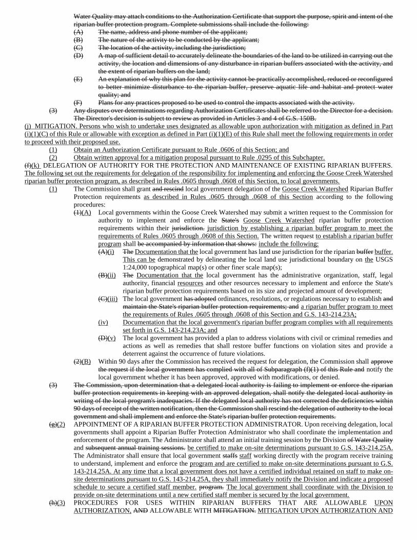
Water Quality may attach conditions to the Authorization Certificate that support the purpose, spirit and intent of the
riparian buffer protection program. Complete submissions shall include the following:
(A) The name, address and phone number of the applicant;
(B) The nature of the activity to be conducted by the applicant;
(C) The location of the activity, including the jurisdiction;
(D) A map of sufficient detail to accurately delineate the boundaries of the land to be utilized in carrying out the
activity, the location and dimensions of any disturbance in riparian buffers associated with the activity, and
the extent of riparian buffers on the land;
(E) An explanation of why this plan for the activity cannot be practically accomplished, reduced or reconfigured
to better minimize disturbance to the riparian buffer, preserve aquatic life and habitat and protect water
quality; and
(F) Plans for any practices proposed to be used to control the impacts associated with the activity.
(3) Any disputes over determinations regarding Authorization Certificates shall be referred to the Director for a decision.
The Director's decision is subject to review as provided in Articles 3 and 4 of G.S. 150B.
(j) MITIGATION. Persons who wish to undertake uses designated as allowable upon authorization with mitigation as defined in Part
(i)(1)(C) of this Rule or allowable with exception as defined in Part (i)(1)(E) of this Rule shall meet the following requirements in order
to proceed with their proposed use.
(1) Obtain an Authorization Certificate pursuant to Rule .0606 of this Section; and
(2) Obtain written approval for a mitigation proposal pursuant to Rule .0295 of this Subchapter.
(f)(k) DELEGATION OF AUTHORITY FOR THE PROTECTION AND MAINTENANCE OF EXISTING RIPARIAN BUFFERS.
The following set out the requirements for delegation of the responsibility for implementing and enforcing the Goose Creek Watershed
riparian buffer protection program, as described in Rules .0605 through .0608 of this Section, to local governments.
(1) The Commission shall grant and rescind local government delegation of the Goose Creek Watershed Riparian Buffer
Protection requirements as described in Rules .0605 through .0608 of this Section according to the following
procedures:
(1)(A) Local governments within the Goose Creek Watershed may submit a written request to the Commission for
authority to implement and enforce the State's Goose Creek Watershed riparian buffer protection
requirements within their jurisdiction. jurisdiction by establishing a riparian buffer program to meet the
requirements of Rules .0605 through .0608 of this Section. The written request to establish a riparian buffer
program shall be accompanied by information that shows: include the following:
(A)(i) The Documentation that the local government has land use jurisdiction for the riparian buffer buffer.
This can be demonstrated by delineating the local land use jurisdictional boundary on the USGS
1:24,000 topographical map(s) or other finer scale map(s);
(B)(ii) The Documentation that the local government has the administrative organization, staff, legal
authority, financial resources and other resources necessary to implement and enforce the State's
riparian buffer protection requirements based on its size and projected amount of development;
(C)(iii) The local government has adopted ordinances, resolutions, or regulations necessary to establish and
maintain the State's riparian buffer protection requirements; and a riparian buffer program to meet
the requirements of Rules .0605 through .0608 of this Section and G.S. 143-214.23A;
(iv) Documentation that the local government's riparian buffer program complies with all requirements
set forth in G.S. 143-214.23A; and
(D)(v) The local government has provided a plan to address violations with civil or criminal remedies and
actions as well as remedies that shall restore buffer functions on violation sites and provide a
deterrent against the occurrence of future violations.
(2)(B) Within 90 days after the Commission has received the request for delegation, the Commission shall approve
the request if the local government has complied with all of Subparagraph (f)(1) of this Rule and notify the
local government whether it has been approved, approved with modifications, or denied.
(3) The Commission, upon determination that a delegated local authority is failing to implement or enforce the riparian
buffer protection requirements in keeping with an approved delegation, shall notify the delegated local authority in
writing of the local program's inadequacies. If the delegated local authority has not corrected the deficiencies within
90 days of receipt of the written notification, then the Commission shall rescind the delegation of authority to the local
government and shall implement and enforce the State's riparian buffer protection requirements.
(g)(2) APPOINTMENT OF A RIPARIAN BUFFER PROTECTION ADMINISTRATOR. Upon receiving delegation, local
governments shall appoint a Riparian Buffer Protection Administrator who shall coordinate the implementation and
enforcement of the program. The Administrator shall attend an initial training session by the Division of Water Quality
and subsequent annual training sessions. be certified to make on-site determinations pursuant to G.S. 143-214.25A.
The Administrator shall ensure that local government staffs staff working directly with the program receive training
to understand, implement and enforce the program and are certified to make on-site determinations pursuant to G.S.
143-214.25A. At any time that a local government does not have a certified individual retained on staff to make on-
site determinations pursuant to G.S. 143-214.25A, they shall immediately notify the Division and indicate a proposed
schedule to secure a certified staff member. program. The local government shall coordinate with the Division to
provide on-site determinations until a new certified staff member is secured by the local government.
(h)(3) PROCEDURES FOR USES WITHIN RIPARIAN BUFFERS THAT ARE ALLOWABLE UPON
AUTHORIZATION, AND ALLOWABLE WITH MITIGATION. MITIGATION UPON AUTHORIZATION AND

ALLOWABLE WITH EXCEPTION. Upon receiving delegation, local governments shall review applications
requesting Authorization Certificate pursuant to the requirements set forth in Rule .0606 of this Section.
(1) Upon receiving delegation, local authorities shall review proposed uses within the riparian buffer and issue approvals
if the uses meet the riparian buffer protection requirements.
(2) Delegated local authorities shall issue an Authorization Certificate for uses if the proposed use meets the requirements
including provisions for mitigation set forth in Rule .0609.
(3) The Division of Water Quality may challenge a decision made by a delegated local authority for a period of 30 days
after the Authorization Certificate is issued. If the Division of Water Quality does not challenge an Authorization
Certificate within 30 days of issuance, then the delegated local authority's decision shall stand.
(i) VARIANCES. After receiving delegation, local governments shall review variance requests and make recommendations to the
Commission for approval.
(j)(4) LIMITS OF DELEGATED LOCAL AUTHORITY. The Commission Division has jurisdiction to the exclusion of
local governments to implement the requirements of this Rule for the following types of activities:
(1)(A) Activities undertaken by the State;
(2)(B) Activities undertaken by the United States;
(3)(C) Activities undertaken by multiple jurisdictions; and
(4)(D) Activities undertaken by local units of government. government;
(E) Forest harvest activities described in Rule .0608 of this Section; and
(F) Agricultural activities.
(k)(5) RECORD-KEEPING REQUIREMENTS. Delegated local authorities governments shall maintain on-site records for
a minimum of five years. Delegated local authorities governments must furnish a copy of these records to the Director
Division within 30 calendar days of receipt of a written request for the records. The Division of the Water Quality
shall inspect local riparian buffer protection programs to ensure that the programs are being implemented and enforced.
Each delegated local authority's government's records shall include the following:
(1)(A) A copy of variance Authorization Certificate with exception requests;
(2)(B) The variance Authorization Certificate with exception request's finding of fact;
(3)(C) The result of the variance Authorization Certificate with exception proceedings;
(4)(D) A record of complaints and action taken as a result of the complaint;
(5)(E) Records for stream origin calls and stream ratings; and
(6)(F) Copies of request for authorization, records approving authorization and Authorization Certificates.
(6) AUDITS OF LOCAL AUTHORITIES. The Division shall regularly audit delegated local governments to ensure the
local programs are being implemented and enforced in keeping with the requirements of Rules .0605 through .0608
of this Section.
(7) PROCEDURES FOR RESCINDING DELEGATION. Upon determination by the Division that a delegated local
government is failing to implement or enforce the Goose Creek Watershed riparian buffer protection requirements in
keeping with the request approved under Part (k)(1)(D) of this Rule, the Commission shall notify the delegated local
government in writing of the local program's inadequacies. If the delegated local government has not corrected the
deficiencies within 90 calendar days of receipt of the written notification, then the Commission shall rescind the
delegation of authority to the local government and the Division shall implement and enforce the Goose Creek
Watershed riparian buffer protection requirements within their jurisdiction.
(8) DELEGATION. The Commission may delegate its duties and powers for granting and rescinding local government
delegation of the Goose Creek Watershed riparian buffer protection requirements, in whole or in part, to the Director.
(l) OTHER LAWS, REGULATIONS AND PERMITS. In all cases, compliance with this Rule does not preclude the requirement to
comply with all federal, state and local regulations and laws.
(l) Riparian buffers along surface waters in this watershed shall be maintained. Some uses within riparian buffers are exempt and some
uses are potentially allowable. Any exempt or potentially allowed use shall require stormwater control as outlined in Rule .0602 if the
one acre threshold is met. The following chart sets out the uses and their designation under this Rule as exempt, potentially allowable
requiring DWQ approval or potentially allowable requiring both DWQ approval and mitigation, or prohibited as described above. The
United States Environmental Protection Agency Endangered Species Protection Program at www.epa.gov/espp and NC Pesticide Board
regulates pesticide application (see rules at 02 NCAC 09L .2201 through .2203).
Exempt
Potentially allowable requiring DWQ
approval or Potentially allowable
requiring both DWQ approval and
mitigation*
Note: the asterisk (X*) identifies those
uses that require both DWQ approval
and mitigation.
Prohibited
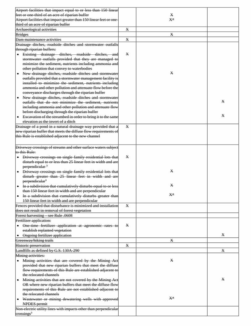
Airport facilities that impact equal to or less than 150 linear
feet or one-third of an acre of riparian buffer
Airport facilities that impact greater than 150 linear feet or one-
third of an acre of riparian buffer
X
X*
Archaeological activities X
Bridges X
Dam maintenance activities X
Drainage ditches, roadside ditches and stormwater outfalls
through riparian buffers:
• Existing drainage ditches, roadside ditches, and
stormwater outfalls provided that they are managed to
minimize the sediment, nutrients including ammonia and
other pollution that convey to waterbodies
• New drainage ditches, roadside ditches and stormwater
outfalls provided that a stormwater management facility is
installed to minimize the sediment, nutrients including
ammonia and other pollution and attenuate flow before the
conveyance discharges through the riparian buffer
• New drainage ditches, roadside ditches and stormwater
outfalls that do not minimize the sediment, nutrients
including ammonia and other pollution and attenuate flow
before discharging through the riparian buffer
• Excavation of the streambed in order to bring it to the same
elevation as the invert of a ditch
X
X
X
X
Drainage of a pond in a natural drainage way provided that a
new riparian buffer that meets the diffuse flow requirements of
this Rule is established adjacent to the new channel
X
Driveway crossings of streams and other surface waters subject
to this Rule:
• Driveway crossings on single family residential lots that
disturb equal to or less than 25 linear feet in width and are
perpendicular 3
• Driveway crossings on single family residential lots that
disturb greater than 25 linear feet in width and are
perpendicular3
• In a subdivision that cumulatively disturbs equal to or less
than 150 linear feet in width and are perpendicular
• In a subdivision that cumulatively disturbs greater than
150 linear feet in width and are perpendicular
X
X
X
X*
Fences provided that disturbance is minimized and installation
does not result in removal of forest vegetation
X
Forest harvesting – see Rule .0608
Fertilizer application:
• One-time fertilizer application at agronomic rates to
establish replanted vegetation
• Ongoing fertilizer application
X
X
Greenway/hiking trails X
Historic preservation X
Landfills as defined by G.S. 130A-290 X
Mining activities:
• Mining activities that are covered by the Mining Act
provided that new riparian buffers that meet the diffuse
flow requirements of this Rule are established adjacent to
the relocated channels
• Mining activities that are not covered by the Mining Act
OR where new riparian buffers that meet the diffuse flow
requirements of this Rule are not established adjacent to
the relocated channels
• Wastewater or mining dewatering wells with approved
NPDES permit
X
X*
X
Non-electric utility lines with impacts other than perpendicular
crossings3
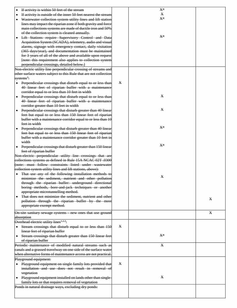
• If activity is within 50 feet of the stream
• If activity is outside of the inner 50 feet nearest the stream
• Wastewater collection system utility lines and lift station
lines may impact the riparian zone if both gravity and force
main collections systems are made of ductile iron and 50%
of the collection system is cleaned annually.
• Lift Stations require Supervisory Control and Data
Acquisition System (SCADA), telemetry, audio and visual
alarms, signage with emergency contact, daily visitation
(365 days/year), and documentation must be maintained
for 3 years of all of the above and available upon request
[note: this requirement also applies to collection system
perpendicular crossings, detailed below.]
X*
X
X*
X*
Non-electric utility line perpendicular crossing of streams and
other surface waters subject to this Rule that are not collection
systems3:
• Perpendicular crossings that disturb equal to or less than
40 linear feet of riparian buffer with a maintenance
corridor equal to or less than 10 feet in width
• Perpendicular crossings that disturb equal to or less than
40 linear feet of riparian buffer with a maintenance
corridor greater than 10 feet in width
• Perpendicular crossings that disturb greater than 40 linear
feet but equal to or less than 150 linear feet of riparian
buffer with a maintenance corridor equal to or less than 10
feet in width
• Perpendicular crossings that disturb greater than 40 linear
feet but equal to or less than 150 linear feet of riparian
buffer with a maintenance corridor greater than 10 feet in
width
• Perpendicular crossings that disturb greater than 150 linear
feet of riparian buffer
Non-electric perpendicular utility line crossings that are
collections systems as defined in Rule 15A NCAC 02T .0300
(note: must follow constraints listed under wastewater
collection system utility lines and lift stations, above):
• That use any of the following installation methods to
minimize the sediment, nutrient and other pollution
through the riparian buffer: underground directional
boring methods, bore-and-jack techniques or another
appropriate microtunnelling method.
• That does not minimize the sediment, nutrient and other
pollution through the riparian buffer by the most
appropriate exempt method.
X
X
X
X*
X*
X
X
On-site sanitary sewage systems - new ones that use ground
absorption
X
Overhead electric utility lines1,2,3:
• Stream crossings that disturb equal to or less than 150
linear feet of riparian buffer
• Stream crossings that disturb greater than 150 linear feet
of riparian buffer
X
X*
Periodic maintenance of modified natural streams such as
canals and a grassed travelway on one side of the surface water
when alternative forms of maintenance access are not practical.
X
Playground equipment:
• Playground equipment on single family lots provided that
installation and use does not result in removal of
vegetation
• Playground equipment installed on lands other than single-
family lots or that requires removal of vegetation
X
X
Ponds in natural drainage ways, excluding dry ponds:
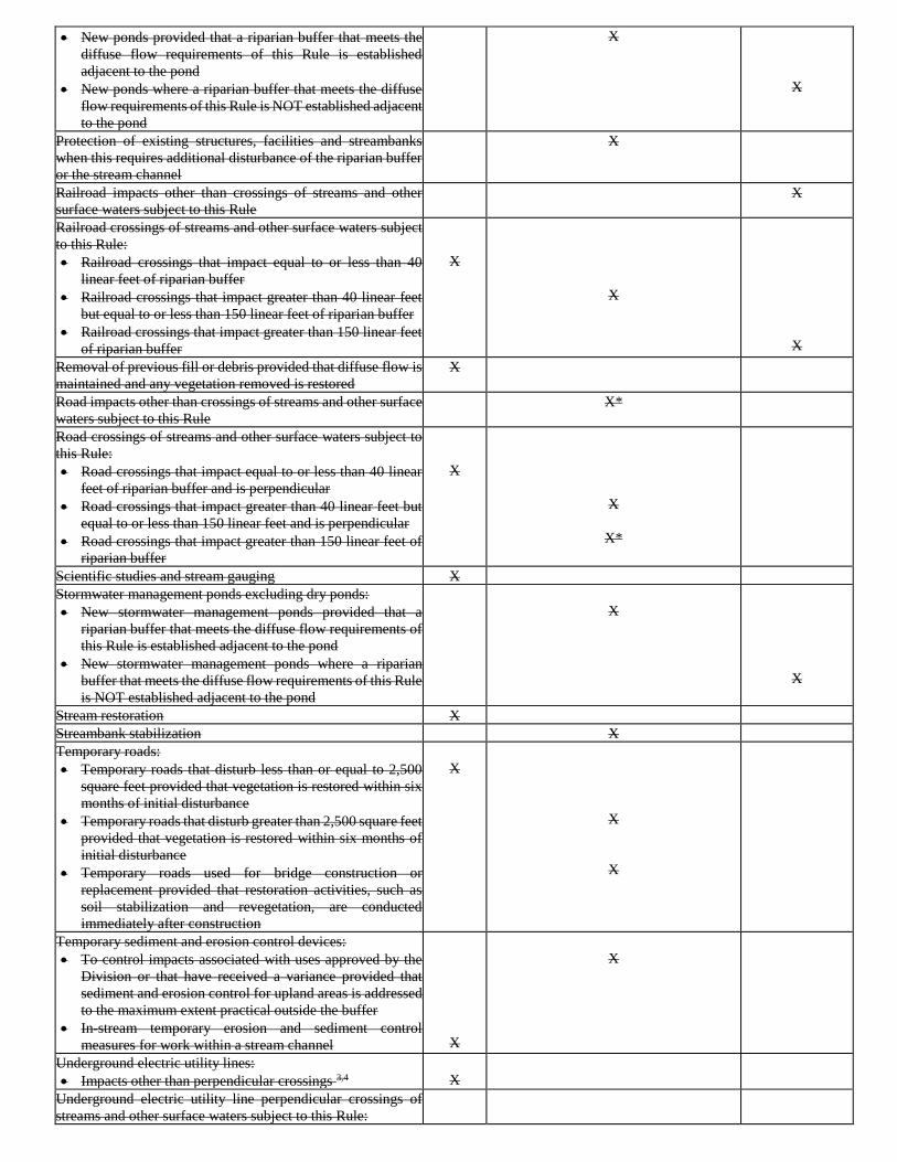
• New ponds provided that a riparian buffer that meets the
diffuse flow requirements of this Rule is established
adjacent to the pond
• New ponds where a riparian buffer that meets the diffuse
flow requirements of this Rule is NOT established adjacent
to the pond
X
X
Protection of existing structures, facilities and streambanks
when this requires additional disturbance of the riparian buffer
or the stream channel
X
Railroad impacts other than crossings of streams and other
surface waters subject to this Rule
X
Railroad crossings of streams and other surface waters subject
to this Rule:
• Railroad crossings that impact equal to or less than 40
linear feet of riparian buffer
• Railroad crossings that impact greater than 40 linear feet
but equal to or less than 150 linear feet of riparian buffer
• Railroad crossings that impact greater than 150 linear feet
of riparian buffer
X
X
X
Removal of previous fill or debris provided that diffuse flow is
maintained and any vegetation removed is restored
X
Road impacts other than crossings of streams and other surface
waters subject to this Rule
X*
Road crossings of streams and other surface waters subject to
this Rule:
• Road crossings that impact equal to or less than 40 linear
feet of riparian buffer and is perpendicular
• Road crossings that impact greater than 40 linear feet but
equal to or less than 150 linear feet and is perpendicular
• Road crossings that impact greater than 150 linear feet of
riparian buffer
X
X
X*
Scientific studies and stream gauging X
Stormwater management ponds excluding dry ponds:
• New stormwater management ponds provided that a
riparian buffer that meets the diffuse flow requirements of
this Rule is established adjacent to the pond
• New stormwater management ponds where a riparian
buffer that meets the diffuse flow requirements of this Rule
is NOT established adjacent to the pond
X
X
Stream restoration X
Streambank stabilization X
Temporary roads:
• Temporary roads that disturb less than or equal to 2,500
square feet provided that vegetation is restored within six
months of initial disturbance
• Temporary roads that disturb greater than 2,500 square feet
provided that vegetation is restored within six months of
initial disturbance
• Temporary roads used for bridge construction or
replacement provided that restoration activities, such as
soil stabilization and revegetation, are conducted
immediately after construction
X
X
X
Temporary sediment and erosion control devices:
• To control impacts associated with uses approved by the
Division or that have received a variance provided that
sediment and erosion control for upland areas is addressed
to the maximum extent practical outside the buffer
• In-stream temporary erosion and sediment control
measures for work within a stream channel
X
X
Underground electric utility lines:
• Impacts other than perpendicular crossings 3,4
X
Underground electric utility line perpendicular crossings of
streams and other surface waters subject to this Rule:
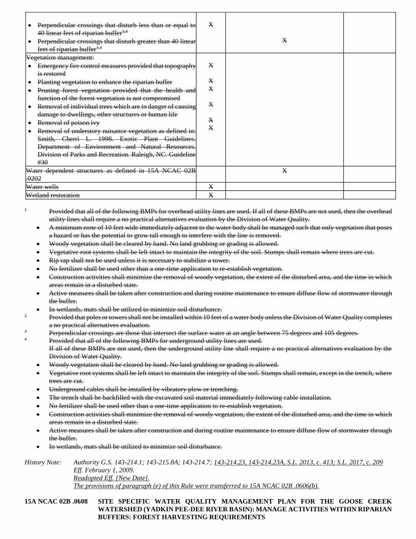
• Perpendicular crossings that disturb less than or equal to
40 linear feet of riparian buffer3,4
• Perpendicular crossings that disturb greater than 40 linear
feet of riparian buffer3,4
X
X
Vegetation management:
• Emergency fire control measures provided that topography
is restored
• Planting vegetation to enhance the riparian buffer
• Pruning forest vegetation provided that the health and
function of the forest vegetation is not compromised
• Removal of individual trees which are in danger of causing
damage to dwellings, other structures or human life
• Removal of poison ivy
• Removal of understory nuisance vegetation as defined in:
Smith, Cherri L. 1998. Exotic Plant Guidelines.
Department of Environment and Natural Resources.
Division of Parks and Recreation. Raleigh, NC. Guideline
#30
X
X
X
X
X
X
Water dependent structures as defined in 15A NCAC 02B
.0202
X
Water wells X
Wetland restoration X
1 Provided that all of the following BMPs for overhead utility lines are used. If all of these BMPs are not used, then the overhead
utility lines shall require a no practical alternatives evaluation by the Division of Water Quality.
• A minimum zone of 10 feet wide immediately adjacent to the water body shall be managed such that only vegetation that poses
a hazard or has the potential to grow tall enough to interfere with the line is removed.
• Woody vegetation shall be cleared by hand. No land grubbing or grading is allowed.
• Vegetative root systems shall be left intact to maintain the integrity of the soil. Stumps shall remain where trees are cut.
• Rip rap shall not be used unless it is necessary to stabilize a tower.
• No fertilizer shall be used other than a one-time application to re-establish vegetation.
• Construction activities shall minimize the removal of woody vegetation, the extent of the disturbed area, and the time in which
areas remain in a disturbed state.
• Active measures shall be taken after construction and during routine maintenance to ensure diffuse flow of stormwater through
the buffer.
• In wetlands, mats shall be utilized to minimize soil disturbance. 2 Provided that poles or towers shall not be installed within 10 feet of a water body unless the Division of Water Quality completes
a no practical alternatives evaluation. 3 Perpendicular crossings are those that intersect the surface water at an angle between 75 degrees and 105 degrees. 4 Provided that all of the following BMPs for underground utility lines are used.
If all of these BMPs are not used, then the underground utility line shall require a no practical alternatives evaluation by the
Division of Water Quality.
• Woody vegetation shall be cleared by hand. No land grubbing or grading is allowed.
• Vegetative root systems shall be left intact to maintain the integrity of the soil. Stumps shall remain, except in the trench, where
trees are cut.
• Underground cables shall be installed by vibratory plow or trenching.
• The trench shall be backfilled with the excavated soil material immediately following cable installation.
• No fertilizer shall be used other than a one-time application to re-establish vegetation.
• Construction activities shall minimize the removal of woody vegetation, the extent of the disturbed area, and the time in which
areas remain in a disturbed state.
• Active measures shall be taken after construction and during routine maintenance to ensure diffuse flow of stormwater through
the buffer.
• In wetlands, mats shall be utilized to minimize soil disturbance.
History Note: Authority G.S. 143-214.1; 143-215.8A; 143-214.7; 143-214.23, 143-214.23A, S.L. 2013, c. 413; S.L. 2017, c. 209
Eff. February 1, 2009.
Readopted Eff. [New Date].
The provisions of paragraph (e) of this Rule were transferred to 15A NCAC 02B .0606(b).
15A NCAC 02B .0608 SITE SPECIFIC WATER QUALITY MANAGEMENT PLAN FOR THE GOOSE CREEK
WATERSHED (YADKIN PEE-DEE RIVER BASIN): MANAGE ACTIVITIES WITHIN RIPARIAN
BUFFERS: FOREST HARVESTING REQUIREMENTS
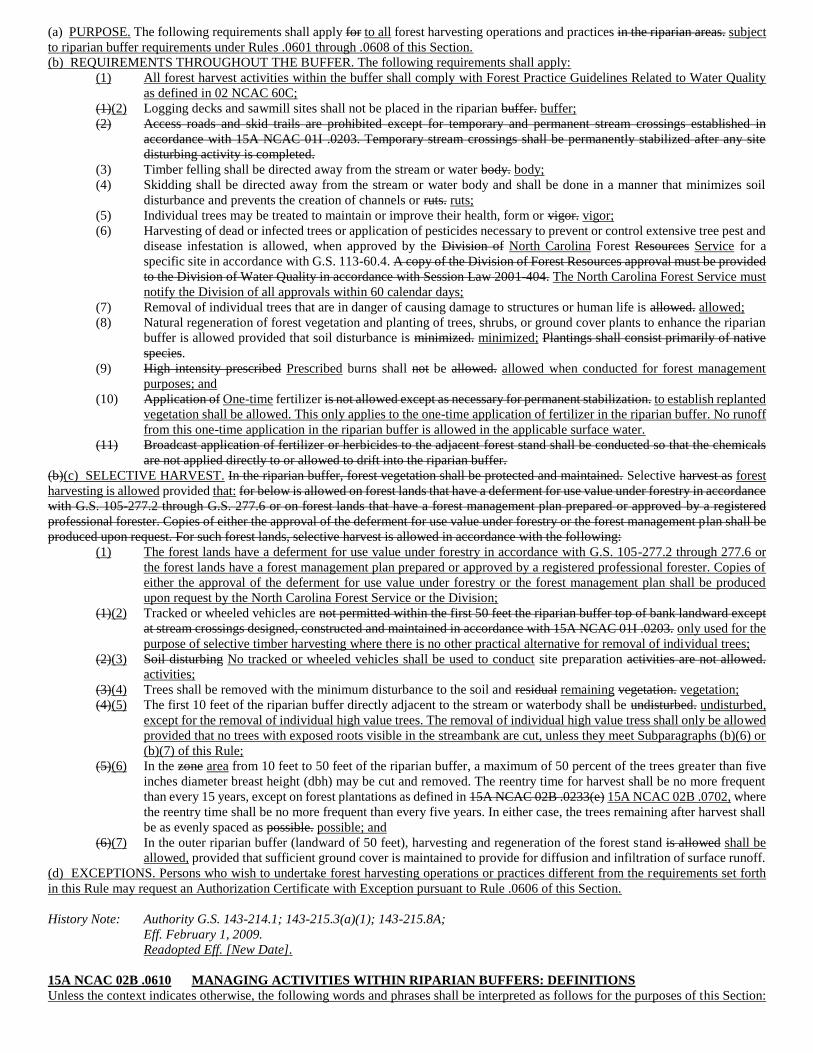
(a) PURPOSE. The following requirements shall apply for to all forest harvesting operations and practices in the riparian areas. subject
to riparian buffer requirements under Rules .0601 through .0608 of this Section.
(b) REQUIREMENTS THROUGHOUT THE BUFFER. The following requirements shall apply:
(1) All forest harvest activities within the buffer shall comply with Forest Practice Guidelines Related to Water Quality
as defined in 02 NCAC 60C;
(1)(2) Logging decks and sawmill sites shall not be placed in the riparian buffer. buffer;
(2) Access roads and skid trails are prohibited except for temporary and permanent stream crossings established in
accordance with 15A NCAC 01I .0203. Temporary stream crossings shall be permanently stabilized after any site
disturbing activity is completed.
(3) Timber felling shall be directed away from the stream or water body. body;
(4) Skidding shall be directed away from the stream or water body and shall be done in a manner that minimizes soil
disturbance and prevents the creation of channels or ruts. ruts;
(5) Individual trees may be treated to maintain or improve their health, form or vigor. vigor;
(6) Harvesting of dead or infected trees or application of pesticides necessary to prevent or control extensive tree pest and
disease infestation is allowed, when approved by the Division of North Carolina Forest Resources Service for a
specific site in accordance with G.S. 113-60.4. A copy of the Division of Forest Resources approval must be provided
to the Division of Water Quality in accordance with Session Law 2001-404. The North Carolina Forest Service must
notify the Division of all approvals within 60 calendar days;
(7) Removal of individual trees that are in danger of causing damage to structures or human life is allowed. allowed;
(8) Natural regeneration of forest vegetation and planting of trees, shrubs, or ground cover plants to enhance the riparian
buffer is allowed provided that soil disturbance is minimized. minimized; Plantings shall consist primarily of native
species.
(9) High intensity prescribed Prescribed burns shall not be allowed. allowed when conducted for forest management
purposes; and
(10) Application of One-time fertilizer is not allowed except as necessary for permanent stabilization. to establish replanted
vegetation shall be allowed. This only applies to the one-time application of fertilizer in the riparian buffer. No runoff
from this one-time application in the riparian buffer is allowed in the applicable surface water.
(11) Broadcast application of fertilizer or herbicides to the adjacent forest stand shall be conducted so that the chemicals
are not applied directly to or allowed to drift into the riparian buffer.
(b)(c) SELECTIVE HARVEST. In the riparian buffer, forest vegetation shall be protected and maintained. Selective harvest as forest
harvesting is allowed provided that: for below is allowed on forest lands that have a deferment for use value under forestry in accordance
with G.S. 105-277.2 through G.S. 277.6 or on forest lands that have a forest management plan prepared or approved by a registered
professional forester. Copies of either the approval of the deferment for use value under forestry or the forest management plan shall be
produced upon request. For such forest lands, selective harvest is allowed in accordance with the following:
(1) The forest lands have a deferment for use value under forestry in accordance with G.S. 105-277.2 through 277.6 or
the forest lands have a forest management plan prepared or approved by a registered professional forester. Copies of
either the approval of the deferment for use value under forestry or the forest management plan shall be produced
upon request by the North Carolina Forest Service or the Division;
(1)(2) Tracked or wheeled vehicles are not permitted within the first 50 feet the riparian buffer top of bank landward except
at stream crossings designed, constructed and maintained in accordance with 15A NCAC 01I .0203. only used for the
purpose of selective timber harvesting where there is no other practical alternative for removal of individual trees;
(2)(3) Soil disturbing No tracked or wheeled vehicles shall be used to conduct site preparation activities are not allowed.
activities;
(3)(4) Trees shall be removed with the minimum disturbance to the soil and residual remaining vegetation. vegetation;
(4)(5) The first 10 feet of the riparian buffer directly adjacent to the stream or waterbody shall be undisturbed. undisturbed,
except for the removal of individual high value trees. The removal of individual high value tress shall only be allowed
provided that no trees with exposed roots visible in the streambank are cut, unless they meet Subparagraphs (b)(6) or
(b)(7) of this Rule;
(5)(6) In the zone area from 10 feet to 50 feet of the riparian buffer, a maximum of 50 percent of the trees greater than five
inches diameter breast height (dbh) may be cut and removed. The reentry time for harvest shall be no more frequent
than every 15 years, except on forest plantations as defined in 15A NCAC 02B .0233(e) 15A NCAC 02B .0702, where
the reentry time shall be no more frequent than every five years. In either case, the trees remaining after harvest shall
be as evenly spaced as possible. possible; and
(6)(7) In the outer riparian buffer (landward of 50 feet), harvesting and regeneration of the forest stand is allowed shall be
allowed, provided that sufficient ground cover is maintained to provide for diffusion and infiltration of surface runoff.
(d) EXCEPTIONS. Persons who wish to undertake forest harvesting operations or practices different from the requirements set forth
in this Rule may request an Authorization Certificate with Exception pursuant to Rule .0606 of this Section.
History Note: Authority G.S. 143-214.1; 143-215.3(a)(1); 143-215.8A;
Eff. February 1, 2009.
Readopted Eff. [New Date].
15A NCAC 02B .0610 MANAGING ACTIVITIES WITHIN RIPARIAN BUFFERS: DEFINITIONS
Unless the context indicates otherwise, the following words and phrases shall be interpreted as follows for the purposes of this Section:
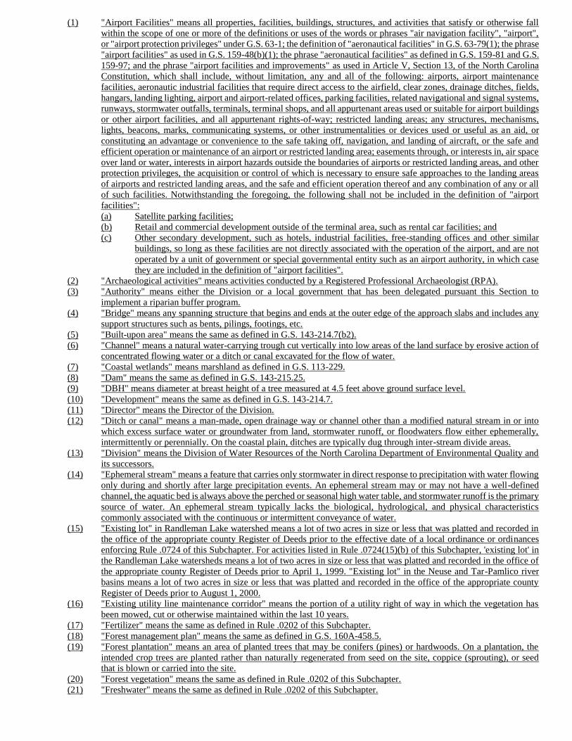
(1) "Airport Facilities" means all properties, facilities, buildings, structures, and activities that satisfy or otherwise fall
within the scope of one or more of the definitions or uses of the words or phrases "air navigation facility", "airport",
or "airport protection privileges" under G.S. 63-1; the definition of "aeronautical facilities" in G.S. 63-79(1); the phrase
"airport facilities" as used in G.S. 159-48(b)(1); the phrase "aeronautical facilities" as defined in G.S. 159-81 and G.S.
159-97; and the phrase "airport facilities and improvements" as used in Article V, Section 13, of the North Carolina
Constitution, which shall include, without limitation, any and all of the following: airports, airport maintenance
facilities, aeronautic industrial facilities that require direct access to the airfield, clear zones, drainage ditches, fields,
hangars, landing lighting, airport and airport-related offices, parking facilities, related navigational and signal systems,
runways, stormwater outfalls, terminals, terminal shops, and all appurtenant areas used or suitable for airport buildings
or other airport facilities, and all appurtenant rights-of-way; restricted landing areas; any structures, mechanisms,
lights, beacons, marks, communicating systems, or other instrumentalities or devices used or useful as an aid, or
constituting an advantage or convenience to the safe taking off, navigation, and landing of aircraft, or the safe and
efficient operation or maintenance of an airport or restricted landing area; easements through, or interests in, air space
over land or water, interests in airport hazards outside the boundaries of airports or restricted landing areas, and other
protection privileges, the acquisition or control of which is necessary to ensure safe approaches to the landing areas
of airports and restricted landing areas, and the safe and efficient operation thereof and any combination of any or all
of such facilities. Notwithstanding the foregoing, the following shall not be included in the definition of "airport
facilities":
(a) Satellite parking facilities;
(b) Retail and commercial development outside of the terminal area, such as rental car facilities; and
(c) Other secondary development, such as hotels, industrial facilities, free-standing offices and other similar
buildings, so long as these facilities are not directly associated with the operation of the airport, and are not
operated by a unit of government or special governmental entity such as an airport authority, in which case
they are included in the definition of "airport facilities".
(2) "Archaeological activities" means activities conducted by a Registered Professional Archaeologist (RPA).
(3) "Authority" means either the Division or a local government that has been delegated pursuant this Section to
implement a riparian buffer program.
(4) "Bridge" means any spanning structure that begins and ends at the outer edge of the approach slabs and includes any
support structures such as bents, pilings, footings, etc.
(5) "Built-upon area" means the same as defined in G.S. 143-214.7(b2).
(6) "Channel" means a natural water-carrying trough cut vertically into low areas of the land surface by erosive action of
concentrated flowing water or a ditch or canal excavated for the flow of water.
(7) "Coastal wetlands" means marshland as defined in G.S. 113-229.
(8) "Dam" means the same as defined in G.S. 143-215.25.
(9) "DBH" means diameter at breast height of a tree measured at 4.5 feet above ground surface level.
(10) "Development" means the same as defined in G.S. 143-214.7.
(11) "Director" means the Director of the Division.
(12) "Ditch or canal" means a man-made, open drainage way or channel other than a modified natural stream in or into
which excess surface water or groundwater from land, stormwater runoff, or floodwaters flow either ephemerally,
intermittently or perennially. On the coastal plain, ditches are typically dug through inter-stream divide areas.
(13) "Division" means the Division of Water Resources of the North Carolina Department of Environmental Quality and
its successors.
(14) "Ephemeral stream" means a feature that carries only stormwater in direct response to precipitation with water flowing
only during and shortly after large precipitation events. An ephemeral stream may or may not have a well-defined
channel, the aquatic bed is always above the perched or seasonal high water table, and stormwater runoff is the primary
source of water. An ephemeral stream typically lacks the biological, hydrological, and physical characteristics
commonly associated with the continuous or intermittent conveyance of water.
(15) "Existing lot" in Randleman Lake watershed means a lot of two acres in size or less that was platted and recorded in
the office of the appropriate county Register of Deeds prior to the effective date of a local ordinance or ordinances
enforcing Rule .0724 of this Subchapter. For activities listed in Rule .0724(15)(b) of this Subchapter, 'existing lot' in
the Randleman Lake watersheds means a lot of two acres in size or less that was platted and recorded in the office of
the appropriate county Register of Deeds prior to April 1, 1999. "Existing lot" in the Neuse and Tar-Pamlico river
basins means a lot of two acres in size or less that was platted and recorded in the office of the appropriate county
Register of Deeds prior to August 1, 2000.
(16) "Existing utility line maintenance corridor" means the portion of a utility right of way in which the vegetation has
been mowed, cut or otherwise maintained within the last 10 years.
(17) "Fertilizer" means the same as defined in Rule .0202 of this Subchapter.
(18) "Forest management plan" means the same as defined in G.S. 160A-458.5.
(19) "Forest plantation" means an area of planted trees that may be conifers (pines) or hardwoods. On a plantation, the
intended crop trees are planted rather than naturally regenerated from seed on the site, coppice (sprouting), or seed
that is blown or carried into the site.
(20) "Forest vegetation" means the same as defined in Rule .0202 of this Subchapter.
(21) "Freshwater" means the same as defined in Rule .0202 of this Subchapter.
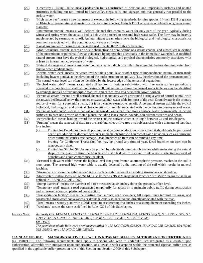
(22) "Greenway / Hiking Trails" means pedestrian trails constructed of pervious and impervious surfaces and related
structures including but not limited to boardwalks, steps, rails, and signage, and that generally run parallel to the
surface water.
(23) "High value tree" means a tree that meets or exceeds the following standards: for pine species, 14-inch DBH or greater
or 18-inch or greater stump diameter; or for non-pine species, 16-inch DBH or greater or 24-inch or greater stump
diameter.
(24) "Intermittent stream" means a well-defined channel that contains water for only part of the year, typically during
winter and spring when the aquatic bed is below the perched or seasonal high water table. The flow may be heavily
supplemented by stormwater runoff. An intermittent stream often lacks the biological and hydrological characteristics
commonly associated with the continuous conveyance of water.
(25) "Local government" means the same as defined in Rule .0202 of this Subchapter.
(26) "Modified natural stream" means an on-site channelization or relocation of a stream channel and subsequent relocation
of the intermittent or perennial flow as evidenced by topographic alterations in the immediate watershed. A modified
natural stream must have the typical biological, hydrological, and physical characteristics commonly associated with
at least an intermittent conveyance of water.
(27) "Natural drainageway" means any water course, channel, ditch or similar physiographic feature draining water from
land to down gradient areas.
(28) "Normal water level" means the water level within a pond, lake or other type of impoundment, natural or man-made
(including beaver ponds), at the elevation of the outlet structure or spillway (i.e., the elevation of the permanent pool).
The normal water level can often be identified by the lowest edge of the terrestrial vegetation.
(29) "Perched water table" means a saturated soil horizon or horizon subdivision, with free water surface periodically
observed in a bore hole or shallow monitoring well, but generally above the normal water table, or may be identified
by drainage mottles or redoximorphic features, and caused by a less permeable lower horizon.
(30) "Perennial stream" means a well-defined channel that contains water year round during a year of normal rainfall with
the aquatic bed located below the perched or seasonal high water table for most of the year. Groundwater is the primary
source of water for a perennial stream, but it also carries stormwater runoff. A perennial stream exhibits the typical
biological, hydrological, and physical characteristics commonly associated with the continuous conveyance of water.
(31) "Perennial waterbody" means a natural or man-made watershed that stores surface water permanently at depths
sufficient to preclude growth of rooted plants, including lakes, ponds, sounds, non-stream estuaries and ocean.
(32) "Perpendicular" means leading toward the nearest subject surface water at an angle between 75 and 105 degrees.
(33) "Pruning" means the removal of dead tree or shrub branches or live tree or shrub branches with a diameter of less than
four inches.
(a) Pruning for Deciduous Trees: If pruning must be done on deciduous trees, then it should only be performed
once a year during the dormant season or immediately following an "act of God" situation, such as a hurricane
or ice storm that causes tree damage. Dead branches on trees can be removed any time.
(b) Pruning for Coniferous Trees: Conifers may be pruned any time of year. Dead branches on trees can be
removed any time.
(c) Pruning for Shrubs: Shrubs may be pruned by selectively removing branches while maintaining the natural
shape of the plant. Cutting the branches of a shrub down to its main trunk is not a selective removal of
branches and could compromise the plant.
(34) "Seasonal high water table" means the highest level that groundwater, at atmospheric pressure, reaches in the soil in
most years. The seasonal high water table is usually detected by the mottling of the soil which results in mineral
leaching.
(35) "Streambank or shoreline stabilization" is the in-place stabilization of an eroding streambank or shoreline.
(36) "Stormwater Control Measure" or "SCM," also known as "Best Management Practice" or "BMP," means the same as
defined in 15A NCAC 02H .1002.
(37) "Stump diameter" means the diameter of a tree measured at six inches above the ground surface level.
(38) "Temporary road" means a road constructed temporarily for access or to maintain public traffic during construction
and is restored upon completion of construction.
(39) "Transportation facility" means the existing road surface, road shoulders, fill slopes, ferry terminal fill areas, and
constructed stormwater conveyances or drainage canals adjacent to and directly associated with the road.
(40) "Tree" means a woody plant with a DBH equal to or exceeding five inches or a stump diameter exceeding six inches.
(41) "Wetlands" means the same as defined in Rule .0202 of this Subchapter.
History Note: Authority G.S. 143-214.1, 143-215.8A, 143-214.7, 143-214.23, 143-214.23A, 143-215.3(a)(1); S.L. 1995, c. 572; S.L.
1999, c. 329; S.L. 2011, c. 394; S.L. 2012, c. 200; S.L. 2013, c. 413, S.L. 2015, c.246
Eff. DATE
The provisions of this Rule were previously codified in 15A NCAC 02B .0233(2), 15A NCAC 02B .0243(2), 15A NCAC
02B .0250(2) and 15A NCAC 02B .0259(2).
15A NCAC 02B .0611 MANAGING ACTIVITIES WITHIN RIPARIAN BUFFERS: AUTHORIZATION CERTIFICATES
(a) PURPOSE. The following requirements shall apply to persons who wish to undertake uses designated as allowable upon
authorization, allowable with mitigation upon authorization, or allowable with exception within the protected riparian buffer area as
specified in the applicable buffer protection rule of this Section and Section .0700 of this Subchapter.
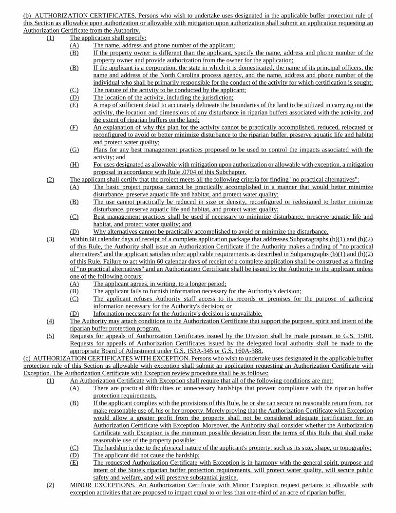
(b) AUTHORIZATION CERTIFICATES. Persons who wish to undertake uses designated in the applicable buffer protection rule of
this Section as allowable upon authorization or allowable with mitigation upon authorization shall submit an application requesting an
Authorization Certificate from the Authority.
(1) The application shall specify:
(A) The name, address and phone number of the applicant;
(B) If the property owner is different than the applicant, specify the name, address and phone number of the
property owner and provide authorization from the owner for the application;
(B) If the applicant is a corporation, the state in which it is domesticated, the name of its principal officers, the
name and address of the North Carolina process agency, and the name, address and phone number of the
individual who shall be primarily responsible for the conduct of the activity for which certification is sought;
(C) The nature of the activity to be conducted by the applicant;
(D) The location of the activity, including the jurisdiction;
(E) A map of sufficient detail to accurately delineate the boundaries of the land to be utilized in carrying out the
activity, the location and dimensions of any disturbance in riparian buffers associated with the activity, and
the extent of riparian buffers on the land;
(F) An explanation of why this plan for the activity cannot be practically accomplished, reduced, relocated or
reconfigured to avoid or better minimize disturbance to the riparian buffer, preserve aquatic life and habitat
and protect water quality;
(G) Plans for any best management practices proposed to be used to control the impacts associated with the
activity; and
(H) For uses designated as allowable with mitigation upon authorization or allowable with exception, a mitigation
proposal in accordance with Rule .0704 of this Subchapter.
(2) The applicant shall certify that the project meets all the following criteria for finding "no practical alternatives":
(A) The basic project purpose cannot be practically accomplished in a manner that would better minimize
disturbance, preserve aquatic life and habitat, and protect water quality;
(B) The use cannot practically be reduced in size or density, reconfigured or redesigned to better minimize
disturbance, preserve aquatic life and habitat, and protect water quality;
(C) Best management practices shall be used if necessary to minimize disturbance, preserve aquatic life and
habitat, and protect water quality; and
(D) Why alternatives cannot be practically accomplished to avoid or minimize the disturbance.
(3) Within 60 calendar days of receipt of a complete application package that addresses Subparagraphs (b)(1) and (b)(2)
of this Rule, the Authority shall issue an Authorization Certificate if the Authority makes a finding of "no practical
alternatives" and the applicant satisfies other applicable requirements as described in Subparagraphs (b)(1) and (b)(2)
of this Rule. Failure to act within 60 calendar days of receipt of a complete application shall be construed as a finding
of "no practical alternatives" and an Authorization Certificate shall be issued by the Authority to the applicant unless
one of the following occurs:
(A) The applicant agrees, in writing, to a longer period;
(B) The applicant fails to furnish information necessary for the Authority's decision;
(C) The applicant refuses Authority staff access to its records or premises for the purpose of gathering
information necessary for the Authority's decision; or
(D) Information necessary for the Authority's decision is unavailable.
(4) The Authority may attach conditions to the Authorization Certificate that support the purpose, spirit and intent of the
riparian buffer protection program.
(5) Requests for appeals of Authorization Certificates issued by the Division shall be made pursuant to G.S. 150B.
Requests for appeals of Authorization Certificates issued by the delegated local authority shall be made to the
appropriate Board of Adjustment under G.S. 153A-345 or G.S. 160A-388.
(c) AUTHORIZATION CERTIFICATES WITH EXCEPTION. Persons who wish to undertake uses designated in the applicable buffer
protection rule of this Section as allowable with exception shall submit an application requesting an Authorization Certificate with
Exception. The Authorization Certificate with Exception review procedure shall be as follows:
(1) An Authorization Certificate with Exception shall require that all of the following conditions are met:
(A) There are practical difficulties or unnecessary hardships that prevent compliance with the riparian buffer
protection requirements.
(B) If the applicant complies with the provisions of this Rule, he or she can secure no reasonable return from, nor
make reasonable use of, his or her property. Merely proving that the Authorization Certificate with Exception
would allow a greater profit from the property shall not be considered adequate justification for an
Authorization Certificate with Exception. Moreover, the Authority shall consider whether the Authorization
Certificate with Exception is the minimum possible deviation from the terms of this Rule that shall make
reasonable use of the property possible;
(C) The hardship is due to the physical nature of the applicant's property, such as its size, shape, or topography;
(D) The applicant did not cause the hardship;
(E) The requested Authorization Certificate with Exception is in harmony with the general spirit, purpose and
intent of the State's riparian buffer protection requirements, will protect water quality, will secure public
safety and welfare, and will preserve substantial justice.
(2) MINOR EXCEPTIONS. An Authorization Certificate with Minor Exception request pertains to allowable with
exception activities that are proposed to impact equal to or less than one-third of an acre of riparian buffer.
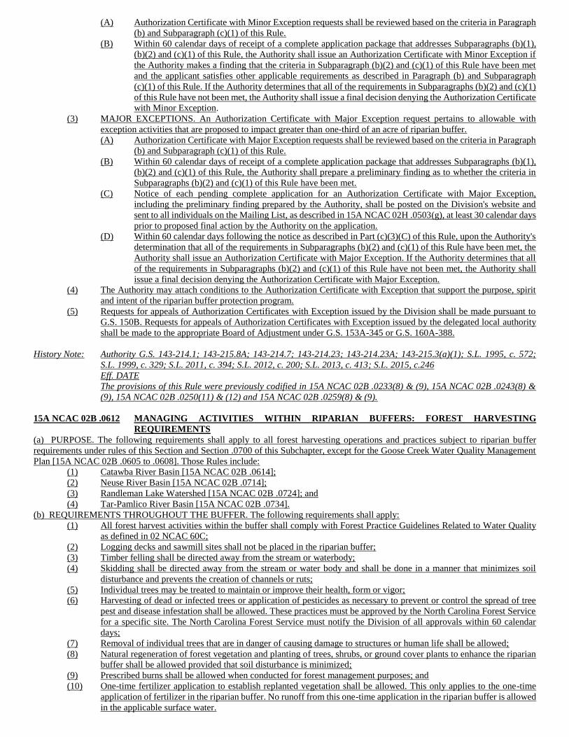
(A) Authorization Certificate with Minor Exception requests shall be reviewed based on the criteria in Paragraph
(b) and Subparagraph (c)(1) of this Rule.
(B) Within 60 calendar days of receipt of a complete application package that addresses Subparagraphs (b)(1),
(b)(2) and (c)(1) of this Rule, the Authority shall issue an Authorization Certificate with Minor Exception if
the Authority makes a finding that the criteria in Subparagraph (b)(2) and (c)(1) of this Rule have been met
and the applicant satisfies other applicable requirements as described in Paragraph (b) and Subparagraph
(c)(1) of this Rule. If the Authority determines that all of the requirements in Subparagraphs (b)(2) and (c)(1)
of this Rule have not been met, the Authority shall issue a final decision denying the Authorization Certificate
with Minor Exception.
(3) MAJOR EXCEPTIONS. An Authorization Certificate with Major Exception request pertains to allowable with
exception activities that are proposed to impact greater than one-third of an acre of riparian buffer.
(A) Authorization Certificate with Major Exception requests shall be reviewed based on the criteria in Paragraph
(b) and Subparagraph (c)(1) of this Rule.
(B) Within 60 calendar days of receipt of a complete application package that addresses Subparagraphs (b)(1),
(b)(2) and (c)(1) of this Rule, the Authority shall prepare a preliminary finding as to whether the criteria in
Subparagraphs (b)(2) and (c)(1) of this Rule have been met.
(C) Notice of each pending complete application for an Authorization Certificate with Major Exception,
including the preliminary finding prepared by the Authority, shall be posted on the Division's website and
sent to all individuals on the Mailing List, as described in 15A NCAC 02H .0503(g), at least 30 calendar days
prior to proposed final action by the Authority on the application.
(D) Within 60 calendar days following the notice as described in Part (c)(3)(C) of this Rule, upon the Authority's
determination that all of the requirements in Subparagraphs (b)(2) and (c)(1) of this Rule have been met, the
Authority shall issue an Authorization Certificate with Major Exception. If the Authority determines that all
of the requirements in Subparagraphs (b)(2) and (c)(1) of this Rule have not been met, the Authority shall
issue a final decision denying the Authorization Certificate with Major Exception.
(4) The Authority may attach conditions to the Authorization Certificate with Exception that support the purpose, spirit
and intent of the riparian buffer protection program.
(5) Requests for appeals of Authorization Certificates with Exception issued by the Division shall be made pursuant to
G.S. 150B. Requests for appeals of Authorization Certificates with Exception issued by the delegated local authority
shall be made to the appropriate Board of Adjustment under G.S. 153A-345 or G.S. 160A-388.
History Note: Authority G.S. 143-214.1; 143-215.8A; 143-214.7; 143-214.23; 143-214.23A; 143-215.3(a)(1); S.L. 1995, c. 572;
S.L. 1999, c. 329; S.L. 2011, c. 394; S.L. 2012, c. 200; S.L. 2013, c. 413; S.L. 2015, c.246
Eff. DATE
The provisions of this Rule were previously codified in 15A NCAC 02B .0233(8) & (9), 15A NCAC 02B .0243(8) &
(9), 15A NCAC 02B .0250(11) & (12) and 15A NCAC 02B .0259(8) & (9).
15A NCAC 02B .0612 MANAGING ACTIVITIES WITHIN RIPARIAN BUFFERS: FOREST HARVESTING
REQUIREMENTS
(a) PURPOSE. The following requirements shall apply to all forest harvesting operations and practices subject to riparian buffer
requirements under rules of this Section and Section .0700 of this Subchapter, except for the Goose Creek Water Quality Management
Plan [15A NCAC 02B .0605 to .0608]. Those Rules include:
(1) Catawba River Basin [15A NCAC 02B .0614];
(2) Neuse River Basin [15A NCAC 02B .0714];
(3) Randleman Lake Watershed [15A NCAC 02B .0724]; and
(4) Tar-Pamlico River Basin [15A NCAC 02B .0734].
(b) REQUIREMENTS THROUGHOUT THE BUFFER. The following requirements shall apply:
(1) All forest harvest activities within the buffer shall comply with Forest Practice Guidelines Related to Water Quality
as defined in 02 NCAC 60C;
(2) Logging decks and sawmill sites shall not be placed in the riparian buffer;
(3) Timber felling shall be directed away from the stream or waterbody;
(4) Skidding shall be directed away from the stream or water body and shall be done in a manner that minimizes soil
disturbance and prevents the creation of channels or ruts;
(5) Individual trees may be treated to maintain or improve their health, form or vigor;
(6) Harvesting of dead or infected trees or application of pesticides as necessary to prevent or control the spread of tree
pest and disease infestation shall be allowed. These practices must be approved by the North Carolina Forest Service
for a specific site. The North Carolina Forest Service must notify the Division of all approvals within 60 calendar
days;
(7) Removal of individual trees that are in danger of causing damage to structures or human life shall be allowed;
(8) Natural regeneration of forest vegetation and planting of trees, shrubs, or ground cover plants to enhance the riparian
buffer shall be allowed provided that soil disturbance is minimized;
(9) Prescribed burns shall be allowed when conducted for forest management purposes; and
(10) One-time fertilizer application to establish replanted vegetation shall be allowed. This only applies to the one-time
application of fertilizer in the riparian buffer. No runoff from this one-time application in the riparian buffer is allowed
in the applicable surface water.
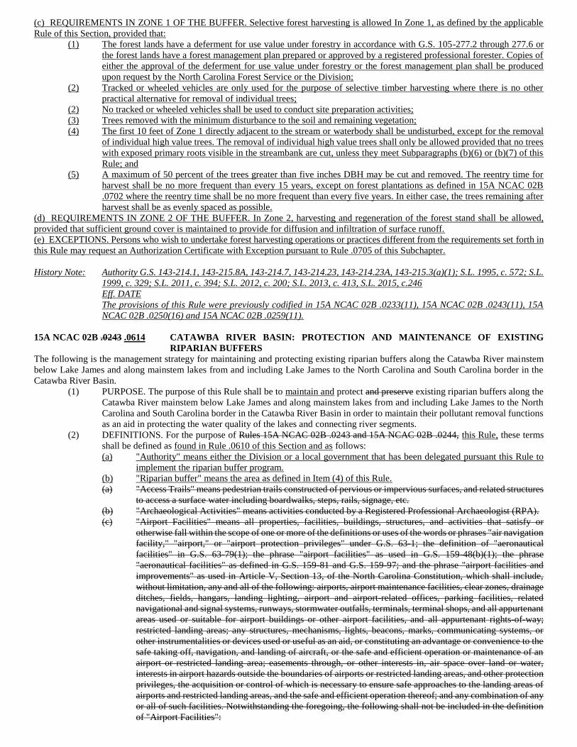
(c) REQUIREMENTS IN ZONE 1 OF THE BUFFER. Selective forest harvesting is allowed In Zone 1, as defined by the applicable
Rule of this Section, provided that:
(1) The forest lands have a deferment for use value under forestry in accordance with G.S. 105-277.2 through 277.6 or
the forest lands have a forest management plan prepared or approved by a registered professional forester. Copies of
either the approval of the deferment for use value under forestry or the forest management plan shall be produced
upon request by the North Carolina Forest Service or the Division;
(2) Tracked or wheeled vehicles are only used for the purpose of selective timber harvesting where there is no other
practical alternative for removal of individual trees;
(2) No tracked or wheeled vehicles shall be used to conduct site preparation activities;
(3) Trees removed with the minimum disturbance to the soil and remaining vegetation;
(4) The first 10 feet of Zone 1 directly adjacent to the stream or waterbody shall be undisturbed, except for the removal
of individual high value trees. The removal of individual high value trees shall only be allowed provided that no trees
with exposed primary roots visible in the streambank are cut, unless they meet Subparagraphs (b)(6) or (b)(7) of this
Rule; and
(5) A maximum of 50 percent of the trees greater than five inches DBH may be cut and removed. The reentry time for
harvest shall be no more frequent than every 15 years, except on forest plantations as defined in 15A NCAC 02B
.0702 where the reentry time shall be no more frequent than every five years. In either case, the trees remaining after
harvest shall be as evenly spaced as possible.
(d) REQUIREMENTS IN ZONE 2 OF THE BUFFER. In Zone 2, harvesting and regeneration of the forest stand shall be allowed,
provided that sufficient ground cover is maintained to provide for diffusion and infiltration of surface runoff.
(e) EXCEPTIONS. Persons who wish to undertake forest harvesting operations or practices different from the requirements set forth in
this Rule may request an Authorization Certificate with Exception pursuant to Rule .0705 of this Subchapter.
History Note: Authority G.S. 143-214.1, 143-215.8A, 143-214.7, 143-214.23, 143-214.23A, 143-215.3(a)(1); S.L. 1995, c. 572; S.L.
1999, c. 329; S.L. 2011, c. 394; S.L. 2012, c. 200; S.L. 2013, c. 413, S.L. 2015, c.246
Eff. DATE
The provisions of this Rule were previously codified in 15A NCAC 02B .0233(11), 15A NCAC 02B .0243(11), 15A
NCAC 02B .0250(16) and 15A NCAC 02B .0259(11).
15A NCAC 02B .0243 .0614 CATAWBA RIVER BASIN: PROTECTION AND MAINTENANCE OF EXISTING
RIPARIAN BUFFERS
The following is the management strategy for maintaining and protecting existing riparian buffers along the Catawba River mainstem
below Lake James and along mainstem lakes from and including Lake James to the North Carolina and South Carolina border in the
Catawba River Basin.
(1) PURPOSE. The purpose of this Rule shall be to maintain and protect and preserve existing riparian buffers along the
Catawba River mainstem below Lake James and along mainstem lakes from and including Lake James to the North
Carolina and South Carolina border in the Catawba River Basin in order to maintain their pollutant removal functions
as an aid in protecting the water quality of the lakes and connecting river segments.
(2) DEFINITIONS. For the purpose of Rules 15A NCAC 02B .0243 and 15A NCAC 02B .0244, this Rule, these terms
shall be defined as found in Rule .0610 of this Section and as follows:
(a) "Authority" means either the Division or a local government that has been delegated pursuant this Rule to
implement the riparian buffer program.
(b) "Riparian buffer" means the area as defined in Item (4) of this Rule.
(a) "Access Trails" means pedestrian trails constructed of pervious or impervious surfaces, and related structures
to access a surface water including boardwalks, steps, rails, signage, etc.
(b) "Archaeological Activities" means activities conducted by a Registered Professional Archaeologist (RPA).
(c) "Airport Facilities" means all properties, facilities, buildings, structures, and activities that satisfy or
otherwise fall within the scope of one or more of the definitions or uses of the words or phrases "air navigation
facility," "airport," or "airport protection privileges" under G.S. 63-1; the definition of "aeronautical
facilities" in G.S. 63-79(1); the phrase "airport facilities" as used in G.S. 159-48(b)(1); the phrase
"aeronautical facilities" as defined in G.S. 159-81 and G.S. 159-97; and the phrase "airport facilities and
improvements" as used in Article V, Section 13, of the North Carolina Constitution, which shall include,
without limitation, any and all of the following: airports, airport maintenance facilities, clear zones, drainage
ditches, fields, hangars, landing lighting, airport and airport-related offices, parking facilities, related
navigational and signal systems, runways, stormwater outfalls, terminals, terminal shops, and all appurtenant
areas used or suitable for airport buildings or other airport facilities, and all appurtenant rights-of-way;
restricted landing areas; any structures, mechanisms, lights, beacons, marks, communicating systems, or
other instrumentalities or devices used or useful as an aid, or constituting an advantage or convenience to the
safe taking off, navigation, and landing of aircraft, or the safe and efficient operation or maintenance of an
airport or restricted landing area; easements through, or other interests in, air space over land or water,
interests in airport hazards outside the boundaries of airports or restricted landing areas, and other protection
privileges, the acquisition or control of which is necessary to ensure safe approaches to the landing areas of
airports and restricted landing areas, and the safe and efficient operation thereof; and any combination of any
or all of such facilities. Notwithstanding the foregoing, the following shall not be included in the definition
of "Airport Facilities":
(i) satellite parking facilities;
(ii) retail and commercial development outside of the terminal area, such as rental car facilities; and
(iii) other secondary development, such as hotels, industrial facilities, free-standing offices and other
similar buildings, so long as these facilities are not directly associated with the operation of the
airport, and are not operated by a unit of government or special governmental entity such as an
airport authority.
(d) "Approved local government" means any government with a riparian buffer ordinance approved by the
Division pursuant to Subparagraph (3)(b) of this Rule.
(e) "Channel" means a natural water-carrying trough cut vertically into low areas of the land surface by erosive
action of concentrated flowing water or a ditch or canal excavated for the flow of water.
(f) "DBH" means diameter at breast height of a tree measured at 4.5 feet above ground surface level.
(g) "Forest plantation" means an area of planted trees that may be conifers (pines) or hardwoods. On a plantation,
the intended crop trees are planted rather than naturally regenerated from seed on the site, coppice (sprouting),
or seed that is blown or carried into the site.
(h)(c) "Full Pond Level" is a term used by Duke Energy Inc. that refers to the project water level, referenced to
mean sea level, for each of the seven mainstem lakes along the Catawba River. The landward edge of the
lakes at full pond level represents the project boundary for each lake.
(i) "Greenway / Hiking Trails" means pedestrian trails constructed of pervious and impervious surfaces and
related structures including but not limited to boardwalks, steps, rails, signage, etc.
(j) "High Value Tree" means a tree whose stump diameter is equal to or exceeding 18-inches.
(k)(d) "Mainstem lakes" means the following impoundments created along the mainstem of the Catawba River:
Lake James, Lake Rhodhiss, Lake Hickory, Lookout Shoals Lake, Lake Norman, Mountain Island Lake and
Lake Wylie (North Carolina portion).
(l) "Riparian buffer enhancement" is defined as the process of converting a non-forested riparian area, where
woody vegetation is sparse (greater than or equal to 100 trees per acre but less than 200 trees per acre) to a
forested riparian buffer area. The enhanced, forested riparian buffer area shall include a minimum of at least
two native hardwood tree species planted at a density sufficient to provide 320 trees per acres at maturity,
and diffuse flow through the riparian buffer shall be maintained.
(m) "Riparian buffer restoration" is defined as the process of converting a non-forested riparian area, where
woody vegetation is absent (less than 100 trees per acre) to a forested riparian buffer area. The restored,
forested riparian buffer area shall include a minimum of at least two native hardwood tree species planted at
a density sufficient to provide 320 trees per acres at maturity, and diffuse flow through the riparian buffer
shall be maintained.
(n) "Shoreline stabilization" is the in-place stabilization of an eroding shoreline. Stabilization techniques which
include "soft" methods or natural materials (such as root wads, or rock vanes) may be considered as part of
a restoration design. However, stabilization techniques that consist primarily of "hard" engineering, such as
concrete lined channels, rip rap, or gabions, while providing bank stabilization, shall not be considered stream
restoration.
(o) "Stream restoration" is defined as the process of converting an unstable, altered or degraded stream corridor,
including adjacent riparian zone and flood-prone areas to its natural or referenced, stable conditions
considering recent and future watershed conditions. This process also includes restoring the geomorphic
dimension, pattern, and profile as well as biological and chemical integrity, including transport of water and
sediment produced by the stream's watershed in order to achieve dynamic equilibrium. "Referenced" or
"referenced reach" means a stable stream that is in dynamic equilibrium with its valley and contributing
watershed. A reference reach can be used to develop natural channel design criteria for stream restoration
projects.
(p) "Stump diameter" means diameter of a tree measured at six inches above ground surface level.
(q) "Surface water" means all waters of the state as defined in G.S. 143-212 except underground waters.
(r) "Temporary road" means a road constructed temporarily for equipment access to build or replace hydraulic
conveyance structures or water dependent structures, or to maintain public traffic during construction.
(s) "Tree" means a woody plant with a DBH equal to or exceeding five inches or a stump diameter equal to or
exceeding six inches.
(3) APPLICABILITY. This Rule applies to all landowners and other persons including local governments, state and
federal entities conducting activities within the riparian buffers as described in Item (4) of this Rule in the Catawba
River Basin.
(4) BUFFERS PROTECTED. The following minimum criteria shall be used for identifying regulated buffers:
(a) This Rule shall apply to activities conducted within a 50-foot wide riparian buffer buffers along the Catawba
River mainstem below Lake James and along the mainstem lakes in the Catawba River Basin, excluding
wetlands.
(b) Wetlands adjacent to surface waters or within 50 feet of surface waters shall be considered as part of the
riparian buffer but are regulated pursuant to 15A NCAC 02H .0506.
(c) Stormwater runoff from activities conducted outside the riparian buffer shall comply with Item (8) of this
Rule.
(d) Riparian The riparian buffers protected by this Rule shall be measured pursuant to Item (4)(7) of this Rule.
(e) A riparian buffer may be exempt from this Rule as described in Items (5) and (6) of this Rule. Riparian
buffers along the Catawba River mainstem below Lake James and along mainstem lakes shall be subject to
this Rule unless one of the following applies.
(f) No new clearing, grading or development shall take place nor shall any new building permits be issued in
violation of this Rule.
(a)(5) EXEMPTION WHEN EXISTING USES ARE PRESENT AND ONGOING. This Rule shall not apply to portions of
the riparian buffer where a use is existing and ongoing. Only the portion of the riparian buffer that contains the
footprint of the existing and ongoing use is exempt from this Rule. The determination of whether a use is existing and
ongoing will be made either by the Division or approved local government; whichever is appropriate according to the
administration of the buffer program. A use is existing and ongoing when it is a completed and maintained activity,
an activity with appropriate valid permits, or an activity with documentation for unexpired vested rights, as described
below:
(i)(a) A use that shall be considered existing if:
(i) It was present within the riparian buffer as of June 30, 2001 and has continued to exist since that
time. time;
(ii) It was a deemed allowable activity as listed in Item (9) of this Rule;
(iii) It was conducted and maintained pursuant to an Authorization Certificate or Variance issued by the
Authority; or
(iv) The project or proposed development are determined by the Authority to meet at least one of the
following criteria:
(A) Project requires a 401 Certification/404 permit and these were issued prior to June 30, 2001
and are still valid;
(B) Projects that require a state permit, such as landfills, NPDES wastewater discharges, land
application of residuals and road construction activities, have begun construction or are
under contract to begin construction and had received all required state permits prior to
June 30, 2001;
(C) Projects that are being reviewed through the Clean Water Act Section 404/National
Environmental Policy Act Merger 01 Process (published by the US Army Corps of
Engineers and Federal Highway Administration, 2003) or its immediate successor and that
have reached agreement with the Department on avoidance and minimization by June 30,
2003; or
(D) Projects that are not required to be reviewed by the Clean Water Act Section 404/National
Environmental Policy Act Merger 01 Process (published by the US Army Corps of
Engineers and Federal Highway Administration, 2003) or its immediate successor if a
Finding of No Significant Impact has been issued for the project and the project has the
written approval of the Division prior to June 30, 2001.
(b) Existing and ongoing uses shall include include, but not be limited to, agriculture, buildings, industrial
facilities, commercial areas, transportation facilities, maintained lawns, lawns (i.e. can be mowed without a
chainsaw or bush-hog), maintained (i.e vegetation management has occurred within the last ten years) utility
lines line corridors and on-site sanitary sewage systems. systems, any of which involve either specific
periodic management of vegetation or displacement of vegetation by structures or regular activity.
(c) Only the portion of the riparian buffer that contains the footprint of the existing and ongoing use is exempt
from this Rule.
(d) Change of ownership through purchase or inheritance is not a change of use.
(e) Activities necessary to maintain existing and ongoing uses are allowed provided that the site remains
similarly vegetated, no impervious surface built upon area is added within 50 feet of the surface water the
riparian buffer where it did not previously exist as of the effective date of the Rule, prior to June 30, 2001,
and existing diffuse flow is maintained. the site is in compliance with Item (8) of this Rule. Grading and
revegetating Zone 2 is allowed provided that the health of the vegetation in Zone 1 is not compromised, the
ground is stabilized and existing diffuse flow is maintained.
(ii) A use that can be documented to the Division or the appropriate approved local government that
meets at least one of the following criteria:
(A) Project requires a 401 Certification/404 Permit, these were issued prior to June 30, 2001
and are still valid;
(B) Projects that require a state permit, such as landfills, NPDES wastewater discharges, land
application of residuals and road construction activities, have begun construction or are
under contract to begin construction and had received all required state permits prior to
June 30, 2001;
(C) Projects that are being reviewed through the Clean Water Act Section 404/National
Environmental Policy Act Merger 01 Process (published by the US Army Corps of
Engineers and Federal Highway Administration, 2003) or its immediate successor and that
have reached agreement with DENR on avoidance and minimization by June 30, 2003; and
(D) Projects that are not required to be reviewed by the Clean Water Act Section 404/National
Environmental Policy Act Merger 01 Process (published by the US Army Corps of
Engineers and Federal Highway Administration, 2003) or its immediate successor if a
Finding of No Significant Impact has been issued for the project and the project has the
written approval of the DWQ prior to June 30, 2001.
(iii)(f) A project that can be documented to the Division or the appropriate approved local government Authority
that has vested rights that were established or recognized for that project under the common law or by G.S.
153A-344(b), 153A-344.1, 160A-385(b), or 160A-385.1 prior to July 1, 2001. This Rule does not confer or
restrict a vested right established or recognized under common law or G.S. 153A-344(b), 153A-344.1, 160A-
385(b), or 160A-385.1.
(iv)(g) This Rule shall apply at the time an existing and ongoing use is changed to another use. Change of use shall
include the following: shall involve the initiation of any activity not defined as existing and ongoing in Sub-
Items (5)(a) through (5)(f) of this Rule
(A) Impervious surface is added to the riparian buffer in locations where it did not exist
previously either on the ground or in proposed site plans showing the locations of proposed
impervious surfaces for uses defined as existing and ongoing in Subitem (3)(a)(ii) or
Subitem (3)(a)(iii) of this Rule; or
(B) An agricultural operation within the riparian buffer is converted to a non-agricultural use.
(6) EXEMPTION FOR PONDS CONSTRUCTED AND USED FOR AGRICULTURAL PURPOSES. This Rule shall
not apply to a freshwater pond if all of the following conditions are met:
(a) The property on which the pond is located is used for agriculture as that term is defined in G.S. 106-581.1.
(b) Except for this Rule, the use of the property is in compliance with all other water quality and water quantity
statutes and rules applicable to the property before July 22, 1997.
(c) The pond is not a component of an animal waste management system as defined in G.S. 143-215.10B (3).
(b) LOCAL GOVERNMENTS THAT HAVE APPROVED RIPARIAN BUFFER ORDINANCES. All local
governments that have land use authority along the Catawba River mainstem below Lake James and along
mainstem lakes in the Catawba River Basin may adopt local riparian buffer ordinances to protect water
quality. The Division shall approve the local riparian buffer ordinance within 30 days after receiving the
request from local governments, if the Division determines that the local riparian buffer ordinance provides
equal to or greater water quality protection than this Rule. This Rule shall not apply in any area where a local
government has obtained the Division's approval of the local riparian buffer ordinance, provided that the
local government is implementing and enforcing the approved local riparian buffer ordinance. The Division,
upon determination that the local government is failing to implement or enforce the approved local buffer
ordinance, shall notify the local government in writing of the local program inadequacies. If the local
government has not corrected the deficiencies within 90 days of receipt of written notification, then the
Division shall implement and enforce the provisions of this Rule.
(c) RIPARIAN AREAS AND ACTIVITIES NOT REGULATED UNDER AN APPROVED LOCAL
GOVERNMENT ORDINANCE. The Division shall be responsible for the implementation of this rule for
all riparian areas and activities not regulated under a Division-approved local government ordinance.
(4)(7) ZONES OF THE RIPARIAN BUFFER. The protected riparian buffer shall have two zones as follows:
(a) Zone 1 shall consist of a forested vegetated area that is undisturbed except for uses provided for in Item (6)(9)
of this Rule. The location of Zone 1 shall be as follows:
(i) For the Catawba River mainstem below Lake James, Zone 1 shall begin at the most landward limit
of the top of the bank and extend landward a distance of 30 feet on all sides of the surface water,
river, measured horizontally on a line perpendicular to a vertical line marking the edge of the top of
the bank. the river.
(ii) For the mainstem lakes located on the Catawba River mainstem, Zone 1 shall begin at the most
landward limit of the full pond level and extend landward a distance of 30 feet, measured
horizontally on a line perpendicular to a vertical line marking the edge of the full pond level. the
lake.
(b) Zone 2 shall consist of a stable, vegetated area that is undisturbed except for uses provided for in Item (6)(9)
of this Rule. Grading and revegetating Zone 2 is allowed provided that the health of the vegetation in Zone
1 is not compromised. Zone 2 shall begin at the outer edge of Zone 1 and extend landward 20 feet as measured
horizontally on a line perpendicular to a vertical line marking the outer edge of Zone 1. the surface water.
The combined width of Zones 1 and 2 shall be 50 feet on all sides of the surface water along the Catawba
River mainstem below Lake James and along mainstem lakes in the Catawba River Basin.
(5) DIFFUSE FLOW REQUIREMENT. Diffuse flow of runoff shall be maintained in the riparian buffer by dispersing
concentrated flow and reestablishing vegetation.
(a) Concentrated runoff from new ditches or manmade conveyances shall be converted to diffuse flow at non-
erosive velocities before the runoff enters Zone 2 of the riparian buffer.
(b) Periodic corrective action to restore diffuse flow shall be taken if necessary to impede the formation of
erosion gullies.
(c) No new stormwater conveyances are allowed through the buffers except for stormwater management ponds
provided for in Item (6) of this Rule.
(8) STORMWATER RUNOFF THROUGH THE RIPARIAN BUFFER. Drainage conveyances include drainage ditches,
roadside ditches, and stormwater conveyances. The following stormwater conveyances through the riparian buffer are
either deemed allowable or allowable upon authorization, as defined in Sub-Item (9)(a) of this Rule, provided that
they do not erode through the buffer and do not cause erosion to the receiving waterbody. Stormwater conveyances
through the riparian buffer that are not listed below shall be allowable with exception as defined in Sub-Item (9)(a)(v)
of this Rule:
(a) The following are deemed allowable as defined in Sub-Item (9)(a)(i) of this Rule:
(i) New drainage conveyances from a Primary SCM, as defined in 15A NCAC 02H .1002, when the
Primary SCM is designed to treat the drainage area to the conveyance and that comply with a
stormwater management plan reviewed and approved under a state stormwater program or a state-
approved local government stormwater program; and
(ii) New stormwater flow to existing drainage conveyances provided that the addition of new flow does
not result in the need to alter the conveyance.
(b) The following are allowable upon authorization as defined in Sub-Item (9)(a)(ii) of this Rule:
(i) New drainage conveyances from a Primary SCM as defined in 15A NCAC 02H .1002 when the
Primary SCM is provided to treat the drainage area to the conveyance but are not approved under a
state stormwater program or a state-approved local government stormwater program;
(ii) New drainage conveyances when the flow rate of the conveyance is less than 0.5 cubic feet per
second during the peak flow from the 0.75 inch per hour storm;
(iii) New stormwater runoff that has been treated through a level spreader-filter strip that complies with
15A NCAC 02H .1059;
(iv) Realignment of existing roadside drainage conveyances applicable to publicly funded and
maintained linear transportation facilities when retaining or improving the design dimensions
provided that no additional travel lanes are added and the minimum required roadway typical section
is used based on traffic and safety considerations;
(v) Realignment of existing drainage conveyances retaining or improving the design dimensions
provided that the size of the drainage area and the percent built-upon area within the drainage area
remain the same;
(vi) New or altered drainage conveyances applicable to publicly funded and maintained linear
transportation facilities provided that SCMs, or BMPs from the NCDOT Stormwater Best
Management Practices Toolbox, are employed;
(vii) New drainage conveyances applicable to publicly funded and maintained linear transportation
facilities that do not provide a stormwater management facility due to topography constraints
provided other measures are employed to protect downstream water quality to the maximum extent
practical; and
(viii) New drainage conveyances where the drainage area to the conveyance has no new built-upon area
as defined in 15A NCAC 02H .1002 and the conveyance is necessary for bypass of existing drainage
only.
(6)(9) TABLE OF USES. Uses within the riparian buffer, or outside the buffer with hydrological impacts on the riparian
buffer, shall be designated as deemed allowable, allowable upon authorization, allowable with mitigation upon
authorization, or prohibited.
(a) Potential new uses shall have the following requirements:
(i) DEEMED ALLOWABLE. Uses designated as deemed allowable in Sub-Items (8)(a) and (9)(b) of
this Rule may occur within the riparian buffer. Deemed allowable uses shall be designed,
constructed and maintained to minimize vegetation and soil disturbance and to provide the
maximum water quality protection practicable, including construction, monitoring, and maintenance
activities. In addition, deemed allowable uses shall meet requirements listed in Sub-Item (9)(b) of
this Rule for the specific use.
(ii) ALLOWABLE UPON AUTHORIZATION. Uses designated as allowable upon authorization in
Sub-Items (8)(b) and (9)(b) of this Rule require a written Authorization Certificate from the
Authority for impacts within the riparian buffer pursuant to Rule .0611 of this Section.
(iii) ALLOWABLE WITH MITIGATION UPON AUTHORIZATION. Uses designated as allowable
with mitigation upon authorization in Sub-Item (9)(b) of this Rule require a written Authorization
Certificate from the Authority for impacts within the riparian buffer pursuant to Rule .0611 of this
Section and an appropriate mitigation strategy has received written approval pursuant to Item (10)
of this Rule.
(iv) PROHIBITED. Uses designated as Prohibited in Sub-Item (9)(b) of this Rule may not proceed
within the riparian buffer unless a Variance is granted pursuant to Rule .0226 of this Subchapter.
Mitigation may be required as a condition of variance approval.
(v) ALLOWABLE WITH EXCEPTION. Uses not designated as deemed allowable, allowable upon
authorization, allowable with mitigation upon authorization or prohibited in Sub-Item (9)(b) of this
Rule require a written Authorization Certificate with Exception from the Authority for impacts
within the riparian buffer pursuant to Rule .0611 of this Section and an appropriate mitigation
strategy that has received written approval pursuant to Item (10) of this Rule.
(b) The following chart table sets out the potential new uses within the riparian buffer, or outside the buffer with
hydrological impacts on the riparian buffer, and their category designation under this Rule designates them
as exempt, allowable, or allowable with mitigation. Any uses, which are not listed in the table, are prohibited.
The requirements for each category listed in the table as well as prohibited uses not set out in the table are
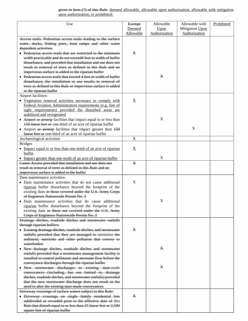
given in Item (7) of this Rule. deemed allowable, allowable upon authorization, allowable with mitigation
upon authorization, or prohibited:
Use Exempt
Deemed
Allowable
Allowable
Upon
Authorization
Allowable with
Mitigation Upon
Authorization
Prohibited
Access trails: Pedestrian access trails leading to the surface
water, docks, fishing piers, boat ramps and other water
dependent activities:
• Pedestrian access trails that are restricted to the minimum
width practicable and do not exceed4 feet in width of buffer
disturbance, and provided that installation and use does not
result in removal of trees as defined in this Rule and no
impervious surface is added to the riparian buffer
• Pedestrian access trails that exceed 4 feet in width of buffer
disturbance, the installation or use results in removal of
trees as defined in this Rule or impervious surface is added
to the riparian buffer
X
X
Airport facilities:
• Vegetation removal activities necessary to comply with
Federal Aviation Administration requirements (e.g. line of
sight requirements) provided the disturbed areas are
stabilized and revegetated
• Airport or airstrip facilities that impact equal to or less than
150 linear feet or one-third of an acre of riparian buffer
• Airport or airstrip facilities that impact greater than 150
linear feet or one-third of an acre of riparian buffer
X
X
X
Archaeological activities X
Bridges
• Impact equal to or less than one-tenth of an acre of riparian
buffer
• Impact greater than one-tenth of an acre of riparian buffer
X
X
Canoe Access provided that installation and use does not
result in removal of trees as defined in this Rule and no
impervious surface is added to the buffer
X
Dam maintenance activities:
• Dam maintenance activities that do not cause additional
riparian buffer disturbance beyond the footprint of the
existing dam or those covered under the U.S. Army Corps
of Engineers Nationwide Permit No. 3
• Dam maintenance activities that do cause additional
riparian buffer disturbance beyond the footprint of the
existing dam or those not covered under the U.S. Army
Corps of Engineers Nationwide Permit No. 3
X
X
Drainage ditches, roadside ditches and stormwater outfalls
through riparian buffers:
• Existing drainage ditches, roadside ditches, and stormwater
outfalls provided that they are managed to minimize the
sediment, nutrients and other pollution that convey to
waterbodies
• New drainage ditches, roadside ditches and stormwater
outfalls provided that a stormwater management facility is
installed to control pollutants and attenuate flow before the
conveyance discharges through the riparian buffer
• New stormwater discharges to existing man-made
conveyances (including, but not limited to, drainage
ditches, roadside ditches, and stormwater outfalls) provided
that the new stormwater discharge does not result in the
need to alter the existing man-made conveyances
X
X
X
Driveway crossings of surface waters subject to this Rule:
• Driveway crossings on single family residential lots
subdivided or recorded prior to the effective date of this
Rule that disturb equal to or less than 25 linear feet or 2,500
square feet of riparian buffer
X

Use Exempt
Deemed
Allowable
Allowable
Upon
Authorization
Allowable with
Mitigation Upon
Authorization
Prohibited
• Driveway crossings on single family residential lots
subdivided or recorded prior to the effective date of this
Rule that disturb greater than 25 linear feet or 2,500 square
feet of riparian buffer
• In a subdivision that cumulatively disturbs equal to or less
than 150 linear feet or one-third of an acre of riparian buffer
• In a subdivision that cumulatively disturbs greater than 150
linear feet or one-third of an acre of riparian buffer
X
X
X
Fences:
• Fencing livestock out of surface waters
• Fences provided that disturbance is minimized and
installation Installation does not result in removal of trees
as defined in this Rule
• Fences provided that disturbance is minimized and
installation Installation results in removal of trees as defined
in this Rule
X
X
X
Forest harvesting - see Item (11) of this Rule .0612 of this
Section
Fertilizer
• One-time fertilizer application to establish replanted
vegetation. This only applies to the one-time application of
fertilizer in the riparian buffer. No runoff from this one-time
application in the riparian buffer is allowed in the applicable
surface water.
• Ongoing fertilizer application
X
X
Grading and revegetation in Zone 2 only provided that diffuse
flow and the health of existing vegetation in Zone 1 is not
compromised compromised, Item (8) of this Rule is complied
with, and disturbed areas are stabilized and revegetated
X
Greenway / hiking trails Greenways, trails, sidewalks or linear
pedestrian/bicycle transportation system:
• On publicly owned property
• In Zone 2 provided that no built upon area is added within
the buffer
• When built upon area is added to the buffer, equal to or less
than 10 feet wide with 2 foot wide shoulders. Must be
located outside Zone 1 unless there is no practical
alternative
• When built upon area is added to the buffer, greater than 10
feet wide with 2 foot wide shoulders. Must be located
outside Zone 1 unless there is no practical alternative
X
X
X
X
Historic preservation X
New Landfills X
Mining activities:
• Mining activities that are covered by the Mining Act
provided that new riparian buffers that meet the
requirements of Items (4) and (5)(7) and (8) of this Rule are
established adjacent to the relocated channels
• Mining activities that are not covered by the Mining Act OR
where new riparian buffers that meet the requirements of
Items (7) and (8)(4) and (5) of this Rule are not established
adjacent to the relocated channels
• Wastewater or mining dewatering wells with approved
NPDES permit
X
X
X
Non-electric utility lines:
• Impacts other than perpendicular crossings in Zone 2 only 1
• Impacts other than perpendicular crossings in Zone 1 1
X
X
Non-electric utility line perpendicular crossings of surface
waters subject to this Rule 1:
X
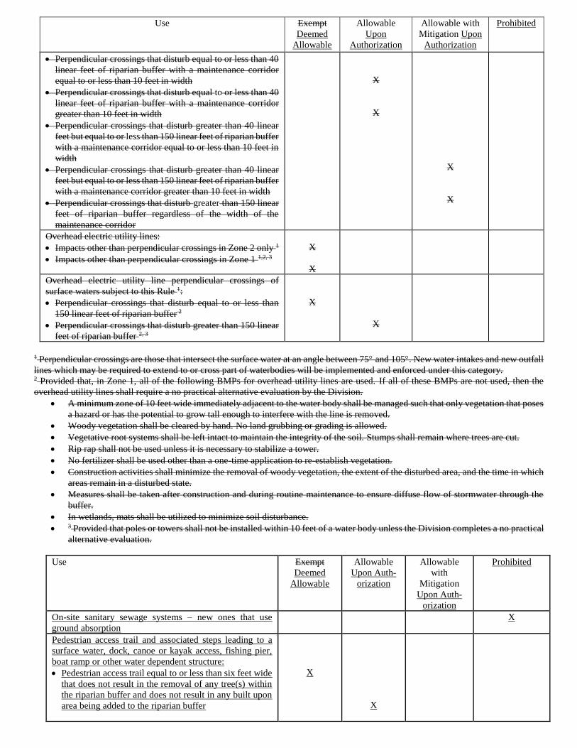
Use Exempt
Deemed
Allowable
Allowable
Upon
Authorization
Allowable with
Mitigation Upon
Authorization
Prohibited
• Perpendicular crossings that disturb equal to or less than 40
linear feet of riparian buffer with a maintenance corridor
equal to or less than 10 feet in width
• Perpendicular crossings that disturb equal to or less than 40
linear feet of riparian buffer with a maintenance corridor
greater than 10 feet in width
• Perpendicular crossings that disturb greater than 40 linear
feet but equal to or less than 150 linear feet of riparian buffer
with a maintenance corridor equal to or less than 10 feet in
width
• Perpendicular crossings that disturb greater than 40 linear
feet but equal to or less than 150 linear feet of riparian buffer
with a maintenance corridor greater than 10 feet in width
• Perpendicular crossings that disturb greater than 150 linear
feet of riparian buffer regardless of the width of the
maintenance corridor
X
X
X
X
Overhead electric utility lines:
• Impacts other than perpendicular crossings in Zone 2 only 1
• Impacts other than perpendicular crossings in Zone 1 1,2, 3
X
X
Overhead electric utility line perpendicular crossings of
surface waters subject to this Rule 1:
• Perpendicular crossings that disturb equal to or less than
150 linear feet of riparian buffer 2
• Perpendicular crossings that disturb greater than 150 linear
feet of riparian buffer 2, 3
X
X
1 Perpendicular crossings are those that intersect the surface water at an angle between 75 and 105. New water intakes and new outfall
lines which may be required to extend to or cross part of waterbodies will be implemented and enforced under this category. 2 Provided that, in Zone 1, all of the following BMPs for overhead utility lines are used. If all of these BMPs are not used, then the
overhead utility lines shall require a no practical alternative evaluation by the Division.
• A minimum zone of 10 feet wide immediately adjacent to the water body shall be managed such that only vegetation that poses
a hazard or has the potential to grow tall enough to interfere with the line is removed.
• Woody vegetation shall be cleared by hand. No land grubbing or grading is allowed.
• Vegetative root systems shall be left intact to maintain the integrity of the soil. Stumps shall remain where trees are cut.
• Rip rap shall not be used unless it is necessary to stabilize a tower.
• No fertilizer shall be used other than a one-time application to re-establish vegetation.
• Construction activities shall minimize the removal of woody vegetation, the extent of the disturbed area, and the time in which
areas remain in a disturbed state.
• Measures shall be taken after construction and during routine maintenance to ensure diffuse flow of stormwater through the
buffer.
• In wetlands, mats shall be utilized to minimize soil disturbance.
• 3 Provided that poles or towers shall not be installed within 10 feet of a water body unless the Division completes a no practical
alternative evaluation.
Use Exempt
Deemed
Allowable
Allowable
Upon Auth-
orization
Allowable
with
Mitigation
Upon Auth-
orization
Prohibited
On-site sanitary sewage systems – new ones that use
ground absorption
X
Pedestrian access trail and associated steps leading to a
surface water, dock, canoe or kayak access, fishing pier,
boat ramp or other water dependent structure:
• Pedestrian access trail equal to or less than six feet wide
that does not result in the removal of any tree(s) within
the riparian buffer and does not result in any built upon
area being added to the riparian buffer
X
X
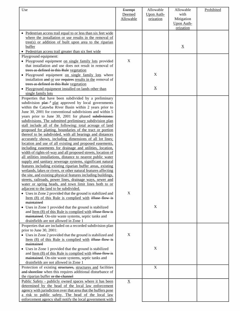
Use Exempt
Deemed
Allowable
Allowable
Upon Auth-
orization
Allowable
with
Mitigation
Upon Auth-
orization
Prohibited
• Pedestrian access trail equal to or less than six feet wide
where the installation or use results in the removal of
tree(s) or addition of built upon area to the riparian
buffer
• Pedestrian access trail greater than six feet wide
X
Playground equipment:
• Playground equipment on single family lots provided
that installation and use does not result in removal of
trees as defined in this Rule vegetation
• Playground equipment on single family lots where
installation and or use requires results in the removal of
trees as defined in this Rule vegetation
• Playground equipment installed on lands other than
single family lots
X
X
X
Properties that have been subdivided by a preliminary
subdivision plat 4 plat approved by local governments
within the Catawba River Basin within 2 years prior to
June 30, 2001 for conventional subdivisions and within 5
years prior to June 30, 2001 for phased subdivisions:
subdivisions. The submitted preliminary subdivision plan
stall include all of the following: total acreage of land
proposed for platting, boundaries of the tract or portion
thereof to be subdivided, with all bearings and distances
accurately shown, including dimensions of all lot lines;
location and use of all existing and proposed easements,
including easements for drainage and utilities, location,
width of rights-of-way and all proposed streets, location of
all utilities installations, distance to nearest public water
supply and sanitary sewerage systems, significant natural
features including existing riparian buffer areas, existing
wetlands, lakes or rivers, or other natural features affecting
the site, and existing physical features including buildings,
streets, railroads, power lines, drainage ways, sewer and
water or spring heads, and town limit lines both to or
adjacent to the land to be subdivided.
• Uses in Zone 2 provided that the ground is stabilized and
Item (8) of this Rule is complied with iffuse flow is
maintained
• Uses in Zone 1 provided that the ground is stabilized
and Item (8) of this Rule is complied with iffuse flow is
maintained. On-site waste systems, septic tanks and
drainfields are not allowed in Zone 1
X
X
Properties that are included on a recorded subdivision plan
prior to June 30, 2001:
• Uses in Zone 2 provided that the ground is stabilized and
Item (8) of this Rule is complied with iffuse flow is
maintained
• Uses in Zone 1 provided that the ground is stabilized
and Item (8) of this Rule is complied with iffuse flow is
maintained. On-site waste systems, septic tanks and
drainfields are not allowed in Zone 1
X
X
Protection of existing structures, structures and facilities
and shoreline when this requires additional disturbance of
the riparian buffer or the channel
X
Public Safety - publicly owned spaces where it has been
determined by the head of the local law enforcement
agency with jurisdiction over that area that the buffers pose
a risk to public safety. The head of the local law
enforcement agency shall notify the local government with
X
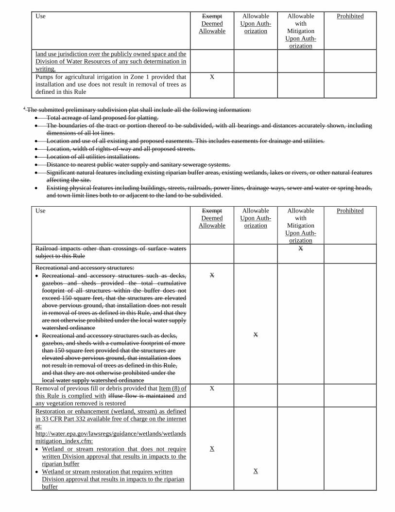
Use Exempt
Deemed
Allowable
Allowable
Upon Auth-
orization
Allowable
with
Mitigation
Upon Auth-
orization
Prohibited
land use jurisdiction over the publicly owned space and the
Division of Water Resources of any such determination in
writing.
Pumps for agricultural irrigation in Zone 1 provided that
installation and use does not result in removal of trees as
defined in this Rule
X
4 The submitted preliminary subdivision plat shall include all the following information:
• Total acreage of land proposed for platting.
• The boundaries of the tract or portion thereof to be subdivided, with all bearings and distances accurately shown, including
dimensions of all lot lines.
• Location and use of all existing and proposed easements. This includes easements for drainage and utilities.
• Location, width of rights-of-way and all proposed streets.
• Location of all utilities installations.
• Distance to nearest public water supply and sanitary sewerage systems.
• Significant natural features including existing riparian buffer areas, existing wetlands, lakes or rivers, or other natural features
affecting the site.
• Existing physical features including buildings, streets, railroads, power lines, drainage ways, sewer and water or spring heads,
and town limit lines both to or adjacent to the land to be subdivided.
Use
Exempt
Deemed
Allowable
Allowable
Upon Auth-
orization
Allowable
with
Mitigation
Upon Auth-
orization
Prohibited
Railroad impacts other than crossings of surface waters
subject to this Rule
X
Recreational and accessory structures:
• Recreational and accessory structures such as decks,
gazebos and sheds provided the total cumulative
footprint of all structures within the buffer does not
exceed 150 square feet, that the structures are elevated
above pervious ground, that installation does not result
in removal of trees as defined in this Rule, and that they
are not otherwise prohibited under the local water supply
watershed ordinance
• Recreational and accessory structures such as decks,
gazebos, and sheds with a cumulative footprint of more
than 150 square feet provided that the structures are
elevated above pervious ground, that installation does
not result in removal of trees as defined in this Rule,
and that they are not otherwise prohibited under the
local water supply watershed ordinance
X
X
Removal of previous fill or debris provided that Item (8) of
this Rule is complied with iffuse flow is maintained and
any vegetation removed is restored
X
Restoration or enhancement (wetland, stream) as defined
in 33 CFR Part 332 available free of charge on the internet
at:
http://water.epa.gov/lawsregs/guidance/wetlands/wetlands
mitigation_index.cfm:
• Wetland or stream restoration that does not require
written Division approval that results in impacts to the
riparian buffer
• Wetland or stream restoration that requires written
Division approval that results in impacts to the riparian
buffer
X
X
Use
Exempt
Deemed
Allowable
Allowable
Upon Auth-
orization
Allowable
with
Mitigation
Upon Auth-
orization
Prohibited
Road Road, driveway or railroad impacts other than
perpendicular crossings of surface waters subject to this
Rule
X
Road Road, driveway or railroads: perpendicular crossings
of surface waters subject to this Rule or perpendicular entry
into the buffer that does not cross a stream or other surface
water subject to this Rule:
• Road crossings that impact Impact equal to or less than
40 linear feet one-tenth of an acre of riparian buffer
• Road crossings that impact Impact greater than 40 linear
feet one-tenth of an acre but equal to or less than 150
linear feet or one-third of an acre of riparian buffer
• Road crossings that impact Impact greater than 150
linear feet or one-third of an acre of riparian buffer
• Driveway crossings in a subdivision that cumulatively
disturb equal to or less than one-third of an acre of
riparian buffer
• Driveway crossings in a subdivision that cumulatively
disturb greater than one-third of an acre of riparian
buffer
• Agriculture roads that are exempt from permitting from
the U.S. Army Corps of Engineers per Section 404(f)
of the federal Clean Water Act
X
X
X
X
X
X
Road relocation of existing private access roads associated
with public road projects where necessary for public
safety:
• Less than or equal to 2,500 square feet of riparian buffer
impact
• Greater than 2,500 square feet of riparian buffer impact
X
X
Scientific studies and gauging station X
Stormwater management ponds excluding dry ponds:
Control Measure (SCM) as defined in 15A NCAC 02H
.1002:
• In Zone 2 if Item (8) of this Rule is complied with New
stormwater management ponds provided that a riparian
buffer that meets the requirements of Items (4) and (5)
of this Rule is established adjacent to the pond
• In Zone 1 New stormwater management ponds where a
riparian buffer that meets the requirements of Items (4)
and (5) of this Rule is NOT established adjacent to the
pond
• Stormwater constructed wetland and bio-retention area
X
X
X
Shoreline stabilization X
Temporary roads: roads, provided that the disturbed area is
restored to pre-construction topographic and hydrologic
conditions and replanted with comparable vegetation
within two months of when construction is complete. Tree
planting may occur during the dormant season. At the end
of five years, the restored wooded buffer shall comply with
the restoration criteria in Rule .0295(i) of this Subchapter:
• Temporary roads that disturb less Less than or equal to
2,500 square feet provided that vegetation is restored
within six months of initial disturbance of riparian buffer
disturbance
• Temporary roads that disturb greater Greater than 2,500
square feet provided that vegetation is restored within
six months of initial disturbance of riparian buffer
disturbance
X
X
Use
Exempt
Deemed
Allowable
Allowable
Upon Auth-
orization
Allowable
with
Mitigation
Upon Auth-
orization
Prohibited
• Temporary roads used for Associated with culvert
installation, bridge construction or replacement
provided that restoration activities, such as soil
stabilization and revegetation, are conducted
immediately after construction
X
Temporary sediment and erosion control devices: devices
provided that the disturbed area is restored to
preconstruction topographic and hydrologic conditions and
replanted with comparable vegetation within two months
of when construction is complete. Tree planting may occur
during the dormant season. At the end of five years, the
restored buffer shall comply with the restoration criteria in
Rule .0295(i) of this Subchapter:
• In Zone 2 only provided ground cover is established
within the timeframes required by the Sedimentation
and Erosion Control Act, that the vegetation in Zone 1
is not compromised and that discharge is released as
diffuse flow in accordance with Item (5)(8) of this Rule
• In Zones 1 and 2 to control impacts associated with uses
approved by the Division Authority or that have
received a variance an authorization with exception
provided that sediment and erosion control for upland
areas is addressed to the maximum extent practical
outside the buffer
• In-stream temporary erosion and sediment control
measures for work within a stream channel that is
authorized under Sections 401 and 404 of the Federal
Water Pollution Control Act
X
X
X
Underground electric utility lines:
• Impacts other than perpendicular crossings in Zone 2
only 1
• Impacts other than perpendicular crossings in Zone 11,5
X
X
Underground electric utility line perpendicular crossings of
surface waters subject to this Rule: 1
• Perpendicular crossings that disturb less than or equal to
40 linear feet of riparian buffer 5
• Perpendicular crossings that disturb greater than 40
linear feet of riparian buffer 5
X
X
Utility – Sewer lines:
• Sanitary Sewer Overflows:
o Emergency sanitary sewer overflow
response activities, provided that the
disturbed area within the buffer: is the
minimum necessary to respond to the
emergency overflow, is restored to pre-
construction topographic and
hydrologic conditions, and is replanted
with comparable vegetation within two
months of when disturbance is
complete.
o Emergency sanitary sewer overflow
response activities, provided the
disturbed area within the buffer: is the
minimum necessary to respond to the
emergency overflow and is not fully
restored to pre-construction topographic
and hydrologic conditions. For any
impacts proposed to remain
permanently an application for an
X
X
Use
Exempt
Deemed
Allowable
Allowable
Upon Auth-
orization
Allowable
with
Mitigation
Upon Auth-
orization
Prohibited
Authorization Certificate must be
submitted to the authority within 30
calendar days of conclusion of the
emergency response activities.
• New Sewer Line Construction Activities (including
replacement/rehabilitation that does not meet the
criteria of existing use in Item (5) of this Rule)
provided that (1) vegetative root systems and stumps
are left intact to maintain the integrity of the soil except
in the trench where trees are cut, and (2) vegetation is
allowed to regenerate in disturbed areas, except within
the permanent maintenance corridor:
o Perpendicular crossings of streams and
other surface waters subject to this Rule
or perpendicular entry into the buffer
that does not cross a stream or other
surface water subject to this Rule:
Less than or equal to 40 linear
feet with a permanent
maintenance corridor equal to
or less than 20 feet in width.
Greater than 40 linear feet and
less than or equal to 150 linear
feet, with a permanent
maintenance corridor equal to
or less than 20 feet in width.
Greater than 150 linear feet
with a permanent maintenance
corridor equal to or less than
20 feet in width.
Permanent maintenance
corridor greater than 20 linear
feet (mitigation is required
only for impacts beyond the 20
linear feet corridor width).
o Impacts other than perpendicular
crossings:
Zone 2 only.
Zone 1 impacts to less than
2,500 square feet when
impacts are solely the result of
tying into an existing utility
line and when grubbing or
grading within10 feet
immediately adjacent to the
surface water is avoided;
Zone 1 impacts for
replacement/rehabilitation
within an existing Right of
Way when land grubbing or
grading within 10 feet
immediately adjacent to the
surface water is avoided;
Zone 1 impacts other than
those listed above.
• Vegetation Maintenance Activities that remove forest
vegetation for existing sewer utility right of
ways/corridors that do not meet the criteria of existing
use in Item (5) of this Rule:
o Zone 2 impacts
X
X
X
X
X
X
X
X
Use
Exempt
Deemed
Allowable
Allowable
Upon Auth-
orization
Allowable
with
Mitigation
Upon Auth-
orization
Prohibited
o Zone 1 impacts provided no clearing
within 10 feet of the stream
o Zone 1 impacts, provided the
permanent maintenance corridor is kept
to 10 feet on either side of the existing
sewer line. Clearing within 10 feet of
the stream may occur provided no
grading or grubbing occurs within this
area.
o Zone 1 impacts, provided the
permanent maintenance corridor is kept
to 10 feet on either side of the existing
sewer line. Clearing, grading and
grubbing can occur within 10 feet of the
stream provided the grading and
grubbing within 10 feet is less than
2,500 square feet.
o Zone 1 impacts other than those listed
above
X
X
X
X
X
Utilities – Non-sewer underground lines:
• Perpendicular crossings of streams and other surface
waters subject to this Rule or perpendicular entry into
the buffer that does not cross a stream or other surface
water subject to this Rule:
o Construction activities that disturb less
than or equal to 50 linear feet of riparian
buffer provided that vegetative root
systems and stumps shall be left intact to
maintain the integrity of the soil except
in the trench where trees are cut and that
vegetation is allowed to regenerate in
disturbed areas with the exception of a
maintenance corridor equal to or less
than 30 feet in width
o Construction activities that disturb
greater than 50 linear feet and less than
or equal to 150 linear feet of riparian
buffer provided that vegetative root
systems and stumps shall be left intact to
maintain the integrity of the soil except
in the trench where trees are cut and that
vegetation is allowed to regenerate in
disturbed areas with the exception of a
maintenance corridor equal to or less
than 30 feet in width
o Construction activities that disturb
greater than 150 linear feet of riparian
buffer
o Any activities with a permanent
maintenance corridor greater than 30
feet in width
• Impacts other than perpendicular crossings:
o Impacts in Zone Two provided
vegetation is re-established after
disturbance and the function of Zone 1 is
not compromised
o Impacts in Zone One less than 2500
square feet when impacts are a result of
tying to an existing utility line and
provided that land grubbing or grading is
X
X
X
X
X
X
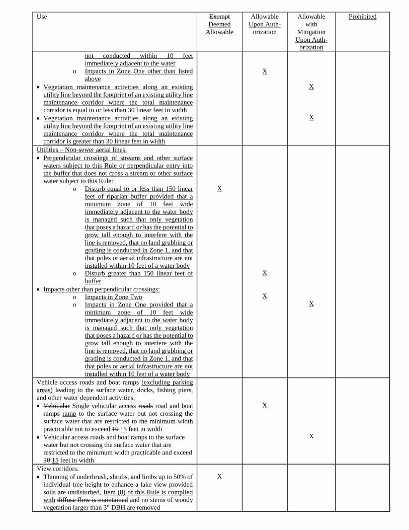
Use
Exempt
Deemed
Allowable
Allowable
Upon Auth-
orization
Allowable
with
Mitigation
Upon Auth-
orization
Prohibited
not conducted within 10 feet
immediately adjacent to the water
o Impacts in Zone One other than listed
above
• Vegetation maintenance activities along an existing
utility line beyond the footprint of an existing utility line
maintenance corridor where the total maintenance
corridor is equal to or less than 30 linear feet in width
• Vegetation maintenance activities along an existing
utility line beyond the footprint of an existing utility line
maintenance corridor where the total maintenance
corridor is greater than 30 linear feet in width
X
X
X
Utilities – Non-sewer aerial lines:
• Perpendicular crossings of streams and other surface
waters subject to this Rule or perpendicular entry into
the buffer that does not cross a stream or other surface
water subject to this Rule:
o Disturb equal to or less than 150 linear
feet of riparian buffer provided that a
minimum zone of 10 feet wide
immediately adjacent to the water body
is managed such that only vegetation
that poses a hazard or has the potential to
grow tall enough to interfere with the
line is removed, that no land grubbing or
grading is conducted in Zone 1, and that
that poles or aerial infrastructure are not
installed within 10 feet of a water body
o Disturb greater than 150 linear feet of
buffer
• Impacts other than perpendicular crossings:
o Impacts in Zone Two
o Impacts in Zone One provided that a
minimum zone of 10 feet wide
immediately adjacent to the water body
is managed such that only vegetation
that poses a hazard or has the potential to
grow tall enough to interfere with the
line is removed, that no land grubbing or
grading is conducted in Zone 1, and that
that poles or aerial infrastructure are not
installed within 10 feet of a water body
X
X
X
X
Vehicle access roads and boat ramps (excluding parking
areas) leading to the surface water, docks, fishing piers,
and other water dependent activities:
• Vehicular Single vehicular access roads road and boat
ramps ramp to the surface water but not crossing the
surface water that are restricted to the minimum width
practicable not to exceed 10 15 feet in width
• Vehicular access roads and boat ramps to the surface
water but not crossing the surface water that are
restricted to the minimum width practicable and exceed
10 15 feet in width
X
X
View corridors:
• Thinning of underbrush, shrubs, and limbs up to 50% of
individual tree height to enhance a lake view provided
soils are undisturbed, Item (8) of this Rule is complied
with diffuse flow is maintained and no stems of woody
vegetation larger than 3" DBH are removed
X
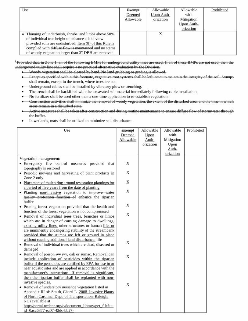
Use
Exempt
Deemed
Allowable
Allowable
Upon Auth-
orization
Allowable
with
Mitigation
Upon Auth-
orization
Prohibited
• Thinning of underbrush, shrubs, and limbs above 50%
of individual tree height to enhance a lake view
provided soils are undisturbed, Item (8) of this Rule is
complied with diffuse flow is maintained and no stems
of woody vegetation larger than 3" DBH are removed
X
5 Provided that, in Zone 1, all of the following BMPs for underground utility lines are used. If all of these BMPs are not used, then the
underground utility line shall require a no practical alternative evaluation by the Division.
• Woody vegetation shall be cleared by hand. No land grubbing or grading is allowed.
• Except as specified within this footnote, vegetative root systems shall be left intact to maintain the integrity of the soil. Stumps
shall remain, except in the trench, where trees are cut.
• Underground cables shall be installed by vibratory plow or trenching.
• The trench shall be backfilled with the excavated soil material immediately following cable installation.
• No fertilizer shall be used other than a one-time application to re-establish vegetation.
• Construction activities shall minimize the removal of woody vegetation, the extent of the disturbed area, and the time in which
areas remain in a disturbed state.
• Active measures shall be taken after construction and during routine maintenance to ensure diffuse flow of stormwater through
the buffer.
• In wetlands, mats shall be utilized to minimize soil disturbance.
Use Exempt
Deemed
Allowable
Allowable
Upon
Auth-
orization
Allowable
with
Mitigation
Upon
Auth-
orization
Prohibited
Vegetation management:
• Emergency fire control measures provided that
topography is restored
• Periodic mowing and harvesting of plant products in
Zone 2 only
• Placement of mulch ring around restoration plantings for
a period of five years from the date of planting
• Planting non-invasive vegetation to improve water
quality protection function of enhance the riparian
buffer
• Pruning forest vegetation provided that the health and
function of the forest vegetation is not compromised
• Removal of individual trees trees, branches or limbs
which are in danger of causing damage to dwellings,
existing utility lines, other structures or human life, or
are imminently endangering stability of the streambank
provided that the stumps are left or ground in place
without causing additional land disturbance. life
• Removal of individual trees which are dead, diseased or
damaged
• Removal of poison ivy ivy, oak or sumac. Removal can
include application of pesticides within the riparian
buffer if the pesticides are certified by EPA for use in or
near aquatic sites and are applied in accordance with the
manufacturer's instructions. If removal is significant,
then the riparian buffer shall be replanted with non-
invasive species.
• Removal of understory nuisance vegetation listed in
Appendix III of: Smith, Cherri L. 2008. Invasive Plants
of North Carolina. Dept. of Transportation. Raleigh,
NC (available at
http://portal.ncdenr.org/c/document_library/get_file?uu
id=0acc6377-ea07-42dc-bb27-
X
X
X
X
X
X
X
X
X
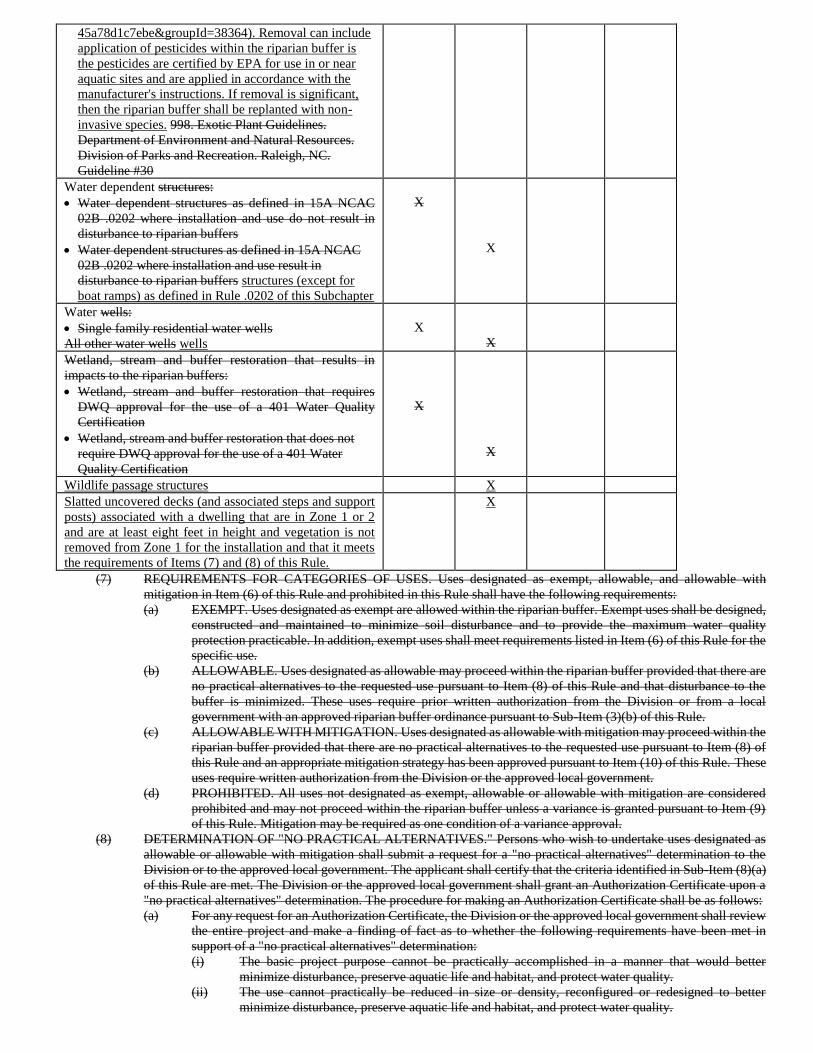
45a78d1c7ebe&groupId=38364). Removal can include
application of pesticides within the riparian buffer is
the pesticides are certified by EPA for use in or near
aquatic sites and are applied in accordance with the
manufacturer's instructions. If removal is significant,
then the riparian buffer shall be replanted with non-
invasive species. 998. Exotic Plant Guidelines.
Department of Environment and Natural Resources.
Division of Parks and Recreation. Raleigh, NC.
Guideline #30
Water dependent structures:
• Water dependent structures as defined in 15A NCAC
02B .0202 where installation and use do not result in
disturbance to riparian buffers
• Water dependent structures as defined in 15A NCAC
02B .0202 where installation and use result in
disturbance to riparian buffers structures (except for
boat ramps) as defined in Rule .0202 of this Subchapter
X
X
Water wells:
• Single family residential water wells
All other water wells wells
X
X
Wetland, stream and buffer restoration that results in
impacts to the riparian buffers:
• Wetland, stream and buffer restoration that requires
DWQ approval for the use of a 401 Water Quality
Certification
• Wetland, stream and buffer restoration that does not
require DWQ approval for the use of a 401 Water
Quality Certification
X
X
Wildlife passage structures X
Slatted uncovered decks (and associated steps and support
posts) associated with a dwelling that are in Zone 1 or 2
and are at least eight feet in height and vegetation is not
removed from Zone 1 for the installation and that it meets
the requirements of Items (7) and (8) of this Rule.
X
(7) REQUIREMENTS FOR CATEGORIES OF USES. Uses designated as exempt, allowable, and allowable with
mitigation in Item (6) of this Rule and prohibited in this Rule shall have the following requirements:
(a) EXEMPT. Uses designated as exempt are allowed within the riparian buffer. Exempt uses shall be designed,
constructed and maintained to minimize soil disturbance and to provide the maximum water quality
protection practicable. In addition, exempt uses shall meet requirements listed in Item (6) of this Rule for the
specific use.
(b) ALLOWABLE. Uses designated as allowable may proceed within the riparian buffer provided that there are
no practical alternatives to the requested use pursuant to Item (8) of this Rule and that disturbance to the
buffer is minimized. These uses require prior written authorization from the Division or from a local
government with an approved riparian buffer ordinance pursuant to Sub-Item (3)(b) of this Rule.
(c) ALLOWABLE WITH MITIGATION. Uses designated as allowable with mitigation may proceed within the
riparian buffer provided that there are no practical alternatives to the requested use pursuant to Item (8) of
this Rule and an appropriate mitigation strategy has been approved pursuant to Item (10) of this Rule. These
uses require written authorization from the Division or the approved local government.
(d) PROHIBITED. All uses not designated as exempt, allowable or allowable with mitigation are considered
prohibited and may not proceed within the riparian buffer unless a variance is granted pursuant to Item (9)
of this Rule. Mitigation may be required as one condition of a variance approval.
(8) DETERMINATION OF "NO PRACTICAL ALTERNATIVES." Persons who wish to undertake uses designated as
allowable or allowable with mitigation shall submit a request for a "no practical alternatives" determination to the
Division or to the approved local government. The applicant shall certify that the criteria identified in Sub-Item (8)(a)
of this Rule are met. The Division or the approved local government shall grant an Authorization Certificate upon a
"no practical alternatives" determination. The procedure for making an Authorization Certificate shall be as follows:
(a) For any request for an Authorization Certificate, the Division or the approved local government shall review
the entire project and make a finding of fact as to whether the following requirements have been met in
support of a "no practical alternatives" determination:
(i) The basic project purpose cannot be practically accomplished in a manner that would better
minimize disturbance, preserve aquatic life and habitat, and protect water quality.
(ii) The use cannot practically be reduced in size or density, reconfigured or redesigned to better
minimize disturbance, preserve aquatic life and habitat, and protect water quality.
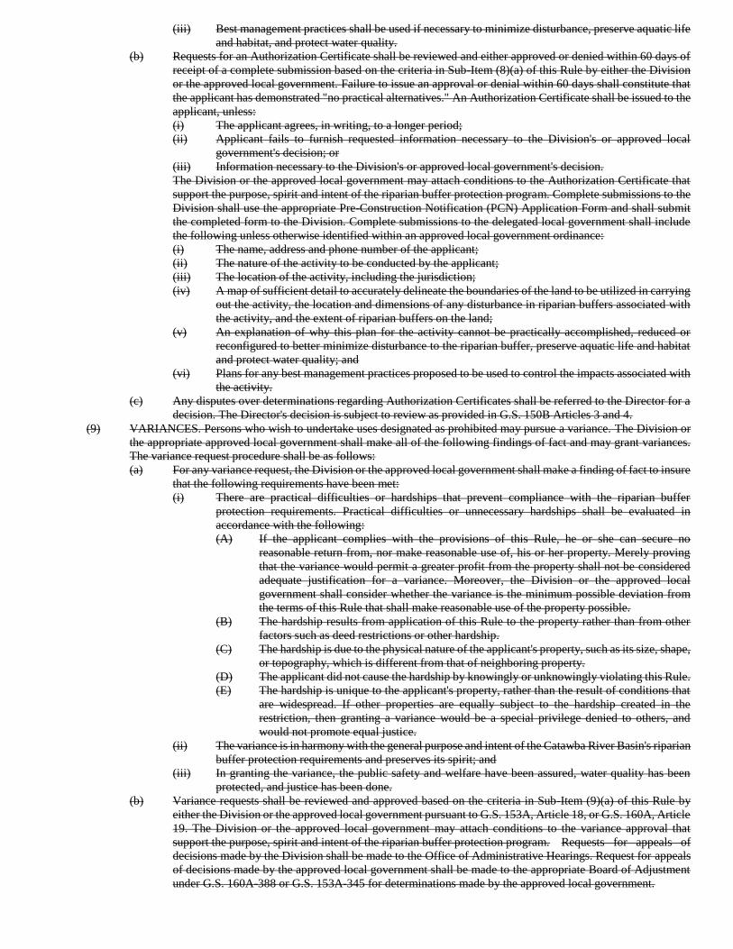
(iii) Best management practices shall be used if necessary to minimize disturbance, preserve aquatic life
and habitat, and protect water quality.
(b) Requests for an Authorization Certificate shall be reviewed and either approved or denied within 60 days of
receipt of a complete submission based on the criteria in Sub-Item (8)(a) of this Rule by either the Division
or the approved local government. Failure to issue an approval or denial within 60 days shall constitute that
the applicant has demonstrated "no practical alternatives." An Authorization Certificate shall be issued to the
applicant, unless:
(i) The applicant agrees, in writing, to a longer period;
(ii) Applicant fails to furnish requested information necessary to the Division's or approved local
government's decision; or
(iii) Information necessary to the Division's or approved local government's decision.
The Division or the approved local government may attach conditions to the Authorization Certificate that
support the purpose, spirit and intent of the riparian buffer protection program. Complete submissions to the
Division shall use the appropriate Pre-Construction Notification (PCN) Application Form and shall submit
the completed form to the Division. Complete submissions to the delegated local government shall include
the following unless otherwise identified within an approved local government ordinance:
(i) The name, address and phone number of the applicant;
(ii) The nature of the activity to be conducted by the applicant;
(iii) The location of the activity, including the jurisdiction;
(iv) A map of sufficient detail to accurately delineate the boundaries of the land to be utilized in carrying
out the activity, the location and dimensions of any disturbance in riparian buffers associated with
the activity, and the extent of riparian buffers on the land;
(v) An explanation of why this plan for the activity cannot be practically accomplished, reduced or
reconfigured to better minimize disturbance to the riparian buffer, preserve aquatic life and habitat
and protect water quality; and
(vi) Plans for any best management practices proposed to be used to control the impacts associated with
the activity.
(c) Any disputes over determinations regarding Authorization Certificates shall be referred to the Director for a
decision. The Director's decision is subject to review as provided in G.S. 150B Articles 3 and 4.
(9) VARIANCES. Persons who wish to undertake uses designated as prohibited may pursue a variance. The Division or
the appropriate approved local government shall make all of the following findings of fact and may grant variances.
The variance request procedure shall be as follows:
(a) For any variance request, the Division or the approved local government shall make a finding of fact to insure
that the following requirements have been met:
(i) There are practical difficulties or hardships that prevent compliance with the riparian buffer
protection requirements. Practical difficulties or unnecessary hardships shall be evaluated in
accordance with the following:
(A) If the applicant complies with the provisions of this Rule, he or she can secure no
reasonable return from, nor make reasonable use of, his or her property. Merely proving
that the variance would permit a greater profit from the property shall not be considered
adequate justification for a variance. Moreover, the Division or the approved local
government shall consider whether the variance is the minimum possible deviation from
the terms of this Rule that shall make reasonable use of the property possible.
(B) The hardship results from application of this Rule to the property rather than from other
factors such as deed restrictions or other hardship.
(C) The hardship is due to the physical nature of the applicant's property, such as its size, shape,
or topography, which is different from that of neighboring property.
(D) The applicant did not cause the hardship by knowingly or unknowingly violating this Rule.
(E) The hardship is unique to the applicant's property, rather than the result of conditions that
are widespread. If other properties are equally subject to the hardship created in the
restriction, then granting a variance would be a special privilege denied to others, and
would not promote equal justice.
(ii) The variance is in harmony with the general purpose and intent of the Catawba River Basin's riparian
buffer protection requirements and preserves its spirit; and
(iii) In granting the variance, the public safety and welfare have been assured, water quality has been
protected, and justice has been done.
(b) Variance requests shall be reviewed and approved based on the criteria in Sub-Item (9)(a) of this Rule by
either the Division or the approved local government pursuant to G.S. 153A, Article 18, or G.S. 160A, Article
19. The Division or the approved local government may attach conditions to the variance approval that
support the purpose, spirit and intent of the riparian buffer protection program. Requests for appeals of
decisions made by the Division shall be made to the Office of Administrative Hearings. Request for appeals
of decisions made by the approved local government shall be made to the appropriate Board of Adjustment
under G.S. 160A-388 or G.S. 153A-345 for determinations made by the approved local government.
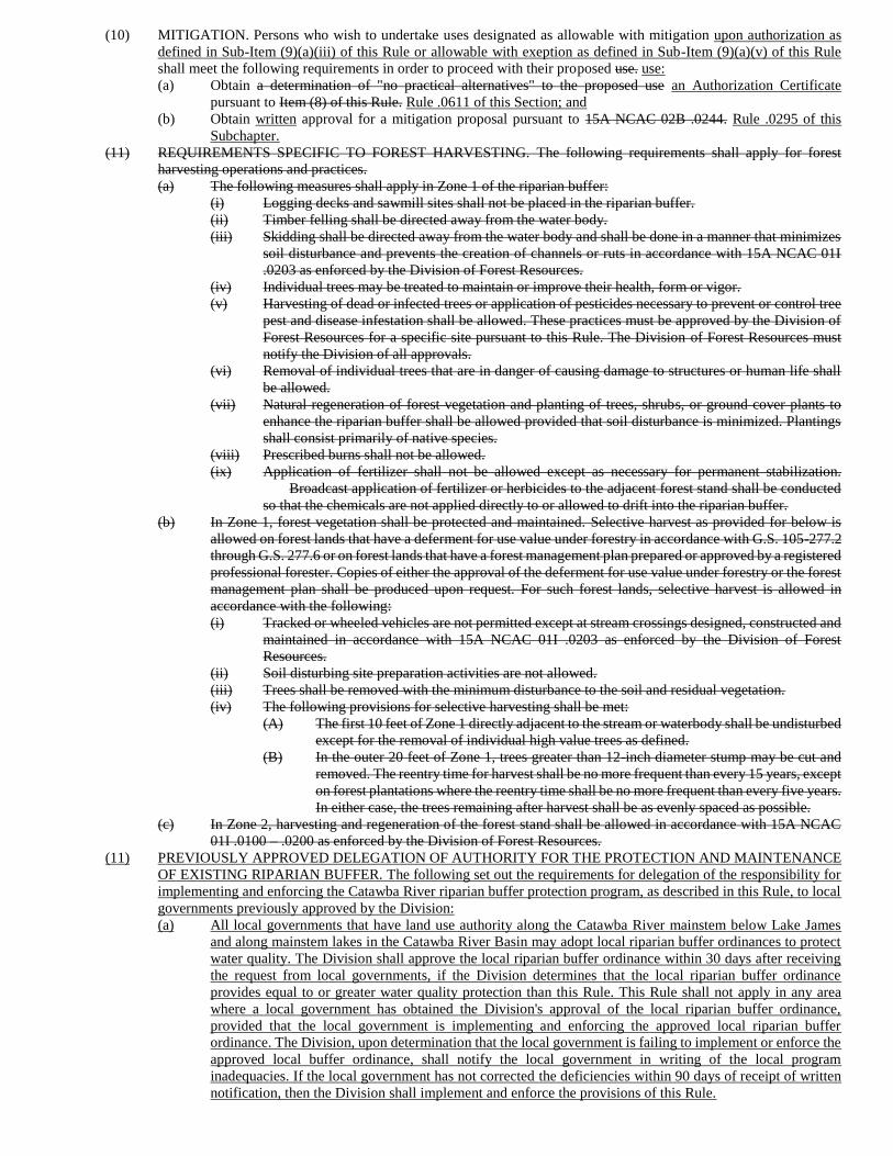
(10) MITIGATION. Persons who wish to undertake uses designated as allowable with mitigation upon authorization as
defined in Sub-Item (9)(a)(iii) of this Rule or allowable with exeption as defined in Sub-Item (9)(a)(v) of this Rule
shall meet the following requirements in order to proceed with their proposed use. use:
(a) Obtain a determination of "no practical alternatives" to the proposed use an Authorization Certificate
pursuant to Item (8) of this Rule. Rule .0611 of this Section; and
(b) Obtain written approval for a mitigation proposal pursuant to 15A NCAC 02B .0244. Rule .0295 of this
Subchapter.
(11) REQUIREMENTS SPECIFIC TO FOREST HARVESTING. The following requirements shall apply for forest
harvesting operations and practices.
(a) The following measures shall apply in Zone 1 of the riparian buffer:
(i) Logging decks and sawmill sites shall not be placed in the riparian buffer.
(ii) Timber felling shall be directed away from the water body.
(iii) Skidding shall be directed away from the water body and shall be done in a manner that minimizes
soil disturbance and prevents the creation of channels or ruts in accordance with 15A NCAC 01I
.0203 as enforced by the Division of Forest Resources.
(iv) Individual trees may be treated to maintain or improve their health, form or vigor.
(v) Harvesting of dead or infected trees or application of pesticides necessary to prevent or control tree
pest and disease infestation shall be allowed. These practices must be approved by the Division of
Forest Resources for a specific site pursuant to this Rule. The Division of Forest Resources must
notify the Division of all approvals.
(vi) Removal of individual trees that are in danger of causing damage to structures or human life shall
be allowed.
(vii) Natural regeneration of forest vegetation and planting of trees, shrubs, or ground cover plants to
enhance the riparian buffer shall be allowed provided that soil disturbance is minimized. Plantings
shall consist primarily of native species.
(viii) Prescribed burns shall not be allowed.
(ix) Application of fertilizer shall not be allowed except as necessary for permanent stabilization.
Broadcast application of fertilizer or herbicides to the adjacent forest stand shall be conducted
so that the chemicals are not applied directly to or allowed to drift into the riparian buffer.
(b) In Zone 1, forest vegetation shall be protected and maintained. Selective harvest as provided for below is
allowed on forest lands that have a deferment for use value under forestry in accordance with G.S. 105-277.2
through G.S. 277.6 or on forest lands that have a forest management plan prepared or approved by a registered
professional forester. Copies of either the approval of the deferment for use value under forestry or the forest
management plan shall be produced upon request. For such forest lands, selective harvest is allowed in
accordance with the following:
(i) Tracked or wheeled vehicles are not permitted except at stream crossings designed, constructed and
maintained in accordance with 15A NCAC 01I .0203 as enforced by the Division of Forest
Resources.
(ii) Soil disturbing site preparation activities are not allowed.
(iii) Trees shall be removed with the minimum disturbance to the soil and residual vegetation.
(iv) The following provisions for selective harvesting shall be met:
(A) The first 10 feet of Zone 1 directly adjacent to the stream or waterbody shall be undisturbed
except for the removal of individual high value trees as defined.
(B) In the outer 20 feet of Zone 1, trees greater than 12-inch diameter stump may be cut and
removed. The reentry time for harvest shall be no more frequent than every 15 years, except
on forest plantations where the reentry time shall be no more frequent than every five years.
In either case, the trees remaining after harvest shall be as evenly spaced as possible.
(c) In Zone 2, harvesting and regeneration of the forest stand shall be allowed in accordance with 15A NCAC
01I .0100 – .0200 as enforced by the Division of Forest Resources.
(11) PREVIOUSLY APPROVED DELEGATION OF AUTHORITY FOR THE PROTECTION AND MAINTENANCE
OF EXISTING RIPARIAN BUFFER. The following set out the requirements for delegation of the responsibility for
implementing and enforcing the Catawba River riparian buffer protection program, as described in this Rule, to local
governments previously approved by the Division:
(a) All local governments that have land use authority along the Catawba River mainstem below Lake James
and along mainstem lakes in the Catawba River Basin may adopt local riparian buffer ordinances to protect
water quality. The Division shall approve the local riparian buffer ordinance within 30 days after receiving
the request from local governments, if the Division determines that the local riparian buffer ordinance
provides equal to or greater water quality protection than this Rule. This Rule shall not apply in any area
where a local government has obtained the Division's approval of the local riparian buffer ordinance,
provided that the local government is implementing and enforcing the approved local riparian buffer
ordinance. The Division, upon determination that the local government is failing to implement or enforce the
approved local buffer ordinance, shall notify the local government in writing of the local program
inadequacies. If the local government has not corrected the deficiencies within 90 days of receipt of written
notification, then the Division shall implement and enforce the provisions of this Rule.
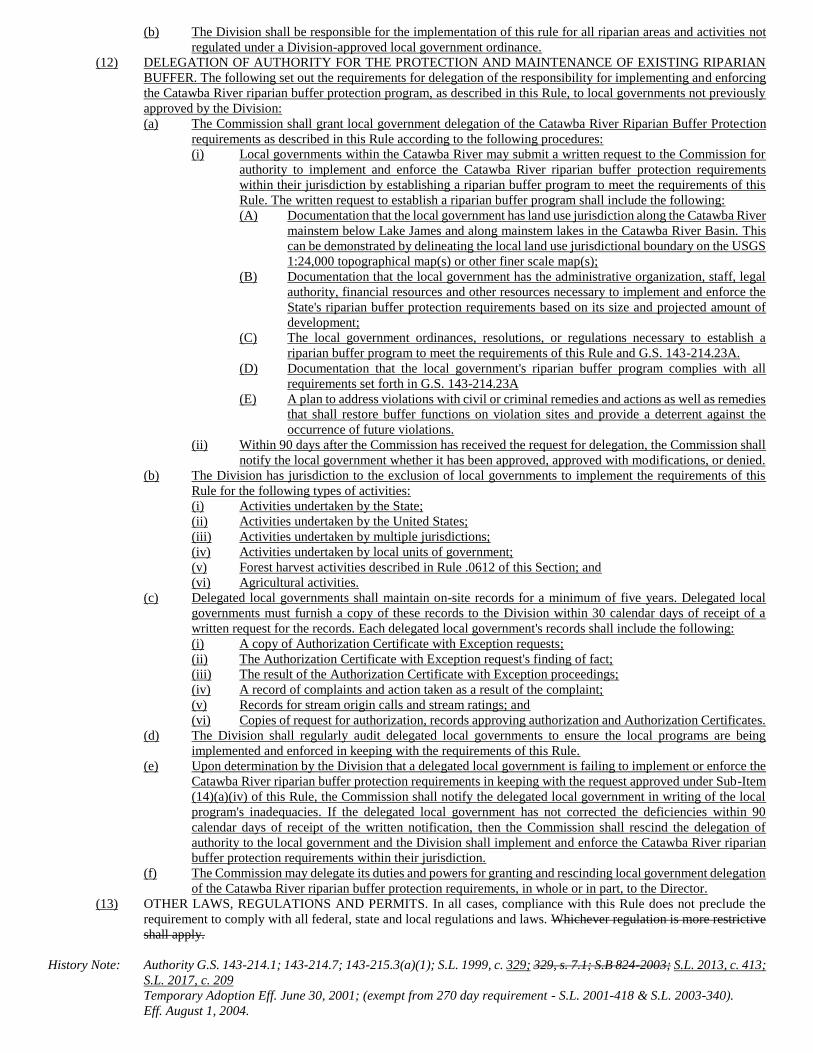
(b) The Division shall be responsible for the implementation of this rule for all riparian areas and activities not
regulated under a Division-approved local government ordinance.
(12) DELEGATION OF AUTHORITY FOR THE PROTECTION AND MAINTENANCE OF EXISTING RIPARIAN
BUFFER. The following set out the requirements for delegation of the responsibility for implementing and enforcing
the Catawba River riparian buffer protection program, as described in this Rule, to local governments not previously
approved by the Division:
(a) The Commission shall grant local government delegation of the Catawba River Riparian Buffer Protection
requirements as described in this Rule according to the following procedures:
(i) Local governments within the Catawba River may submit a written request to the Commission for
authority to implement and enforce the Catawba River riparian buffer protection requirements
within their jurisdiction by establishing a riparian buffer program to meet the requirements of this
Rule. The written request to establish a riparian buffer program shall include the following:
(A) Documentation that the local government has land use jurisdiction along the Catawba River
mainstem below Lake James and along mainstem lakes in the Catawba River Basin. This
can be demonstrated by delineating the local land use jurisdictional boundary on the USGS
1:24,000 topographical map(s) or other finer scale map(s);
(B) Documentation that the local government has the administrative organization, staff, legal
authority, financial resources and other resources necessary to implement and enforce the
State's riparian buffer protection requirements based on its size and projected amount of
development;
(C) The local government ordinances, resolutions, or regulations necessary to establish a
riparian buffer program to meet the requirements of this Rule and G.S. 143-214.23A.
(D) Documentation that the local government's riparian buffer program complies with all
requirements set forth in G.S. 143-214.23A
(E) A plan to address violations with civil or criminal remedies and actions as well as remedies
that shall restore buffer functions on violation sites and provide a deterrent against the
occurrence of future violations.
(ii) Within 90 days after the Commission has received the request for delegation, the Commission shall
notify the local government whether it has been approved, approved with modifications, or denied.
(b) The Division has jurisdiction to the exclusion of local governments to implement the requirements of this
Rule for the following types of activities:
(i) Activities undertaken by the State;
(ii) Activities undertaken by the United States;
(iii) Activities undertaken by multiple jurisdictions;
(iv) Activities undertaken by local units of government;
(v) Forest harvest activities described in Rule .0612 of this Section; and
(vi) Agricultural activities.
(c) Delegated local governments shall maintain on-site records for a minimum of five years. Delegated local
governments must furnish a copy of these records to the Division within 30 calendar days of receipt of a
written request for the records. Each delegated local government's records shall include the following:
(i) A copy of Authorization Certificate with Exception requests;
(ii) The Authorization Certificate with Exception request's finding of fact;
(iii) The result of the Authorization Certificate with Exception proceedings;
(iv) A record of complaints and action taken as a result of the complaint;
(v) Records for stream origin calls and stream ratings; and
(vi) Copies of request for authorization, records approving authorization and Authorization Certificates.
(d) The Division shall regularly audit delegated local governments to ensure the local programs are being
implemented and enforced in keeping with the requirements of this Rule.
(e) Upon determination by the Division that a delegated local government is failing to implement or enforce the
Catawba River riparian buffer protection requirements in keeping with the request approved under Sub-Item
(14)(a)(iv) of this Rule, the Commission shall notify the delegated local government in writing of the local
program's inadequacies. If the delegated local government has not corrected the deficiencies within 90
calendar days of receipt of the written notification, then the Commission shall rescind the delegation of
authority to the local government and the Division shall implement and enforce the Catawba River riparian
buffer protection requirements within their jurisdiction.
(f) The Commission may delegate its duties and powers for granting and rescinding local government delegation
of the Catawba River riparian buffer protection requirements, in whole or in part, to the Director.
(13) OTHER LAWS, REGULATIONS AND PERMITS. In all cases, compliance with this Rule does not preclude the
requirement to comply with all federal, state and local regulations and laws. Whichever regulation is more restrictive
shall apply.
History Note: Authority G.S. 143-214.1; 143-214.7; 143-215.3(a)(1); S.L. 1999, c. 329; 329, s. 7.1; S.B 824-2003; S.L. 2013, c. 413;
S.L. 2017, c. 209
Temporary Adoption Eff. June 30, 2001; (exempt from 270 day requirement - S.L. 2001-418 & S.L. 2003-340).
Eff. August 1, 2004.
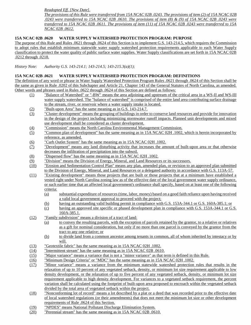
Readopted Eff. [New Date].
The provisions of this Rule were transferred from 15A NCAC 02B .0243. The provisions of item (2) of 15A NCAC 02B
.0243 were transferred to 15A NCAC 02B .0610. The provisions of item (8) & (9) of 15A NCAC 02B .0243 were
transferred to 15A NCAC 02B .0611. The provisions of item (11) of 15A NCAC 02B .0243 were transferred to 15A
NCAC 02B .0612.
15A NCAC 02B .0620 WATER SUPPLY WATERSHED PROTECTION PROGRAM: PURPOSE
The purpose of this Rule and Rules .0621 through .0624 of this Section is to implement G.S. 143-214.5, which requires the Commission
to adopt rules that establish minimum statewide water supply watershed protection requirements applicable to each Water Supply
classification to protect the water quality of public surface water supplies. Water Supply classifications are set forth in 15A NCAC 02B
.0212 through .0218.
History Note: Authority G.S. 143-214.1; 143-214.5; 143-215.3(a)(1);
15A NCAC 02B .0621 WATER SUPPLY WATERSHED PROTECTION PROGRAM: DEFINITIONS
The definition of any word or phrase in Water Supply Watershed Protection Program Rules .0621 through .0624 of this Section shall be
the same as given in Rule .0202 of this Subchapter and Article 21, Chapter 143 of the General Statutes of North Carolina, as amended.
Other words and phrases used in Rules .0622 through .0624 of this Section are defined as follows:
(1) "Balance of Watershed" or "-BW" means the area adjoining and upstream of the critical area in a WS-II and WS-III
water supply watershed. The "balance of watershed" is comprised of the entire land area contributing surface drainage
to the stream, river, or reservoir where a water supply intake is located.
(2) "Built-upon Area" has the same meaning as in G.S. 143-214.7.
(3) "Cluster development" means the grouping of buildings in order to conserve land resources and provide for innovation
in the design of the project including minimizing stormwater runoff impacts. Planned unit developments and mixed
use development shall be considered as cluster development.
(4) "Commission" means the North Carolina Environmental Management Commission.
(5) "Common plan of development" has the same meaning as in 15A NCAC 02H .1002, which is herein incorporated by
reference, as amended.
(6) "Curb Outlet System" has the same meaning as in 15A NCAC 02H .1002.
(7) "Development" means any land disturbing activity that increases the amount of built-upon area or that otherwise
decreases the infiltration of precipitation into the subsoil.
(8) "Dispersed flow" has the same meaning as in 15A NCAC 02H .1002.
(9) "Division" means the Division of Energy, Mineral, and Land Resources or its successors.
(10) "Erosion and Sedimentation Control Plan" means any plan, amended plan, or revision to an approved plan submitted
to the Division of Energy, Mineral, and Land Resources or a delegated authority in accordance with G.S. 113A-57.
(11) "Existing development" means those projects that are built or those projects that at a minimum have established a
vested right under North Carolina zoning law as of the effective date of the local government water supply ordinance,
or such earlier time that an affected local government's ordinance shall specify, based on at least one of the following
criteria:
(a) substantial expenditure of resources (time, labor, money) based on a good faith reliance upon having received
a valid local government approval to proceed with the project;
(b) having an outstanding valid building permit in compliance with G.S. 153A-344.1 or G.S. 160A-385.1; or
(c) having an approved site specific or phased development plan in compliance with G.S. 153A-344.1 or G.S.
160A-385.1.
(12) "Family subdivision" means a division of a tract of land:
(a) to convey the resulting parcels, with the exception of parcels retained by the grantor, to a relative or relatives
as a gift for nominal consideration, but only if no more than one parcel is conveyed by the grantor from the
tract to any one relative; or
(b) to divide land from a common ancestor among tenants in common, all of whom inherited by intestacy or by
will.
(13) "Geotextile fabric" has the same meaning as in 15A NCAC 02H .1002.
(14) "Intermittent stream" has the same meaning as in 15A NCAC 02B .0610.
(15) "Major variance" means a variance that is not a "minor variance" as that term is defined in this Rule.
(16) "Minimum Design Criteria" or "MDC" has the same meaning as in 15A NCAC 02H .1002.
(17) "Minor variance" means a variance from the minimum statewide watershed protection rules that results in the
relaxation of up to 10 percent of any vegetated setback, density, or minimum lot size requirement applicable to low
density development, or the relaxation of up to five percent of any vegetated setback, density, or minimum lot size
requirement applicable to high density development. For variances to a vegetated setback requirement, the percent
variation shall be calculated using the footprint of built-upon area proposed to encroach within the vegetated setback
divided by the total area of vegetated setback within the project.
(18) "Nonconforming lot of record" means a lot described by a plat or a deed that was recorded prior to the effective date
of local watershed regulations (or their amendments) that does not meet the minimum lot size or other development
requirements of Rule .0624 of this Section.
(19) "NPDES" means National Pollutant Discharge Elimination System.
(20) "Perennial stream" has the same meaning as in 15A NCAC 02B .0610.
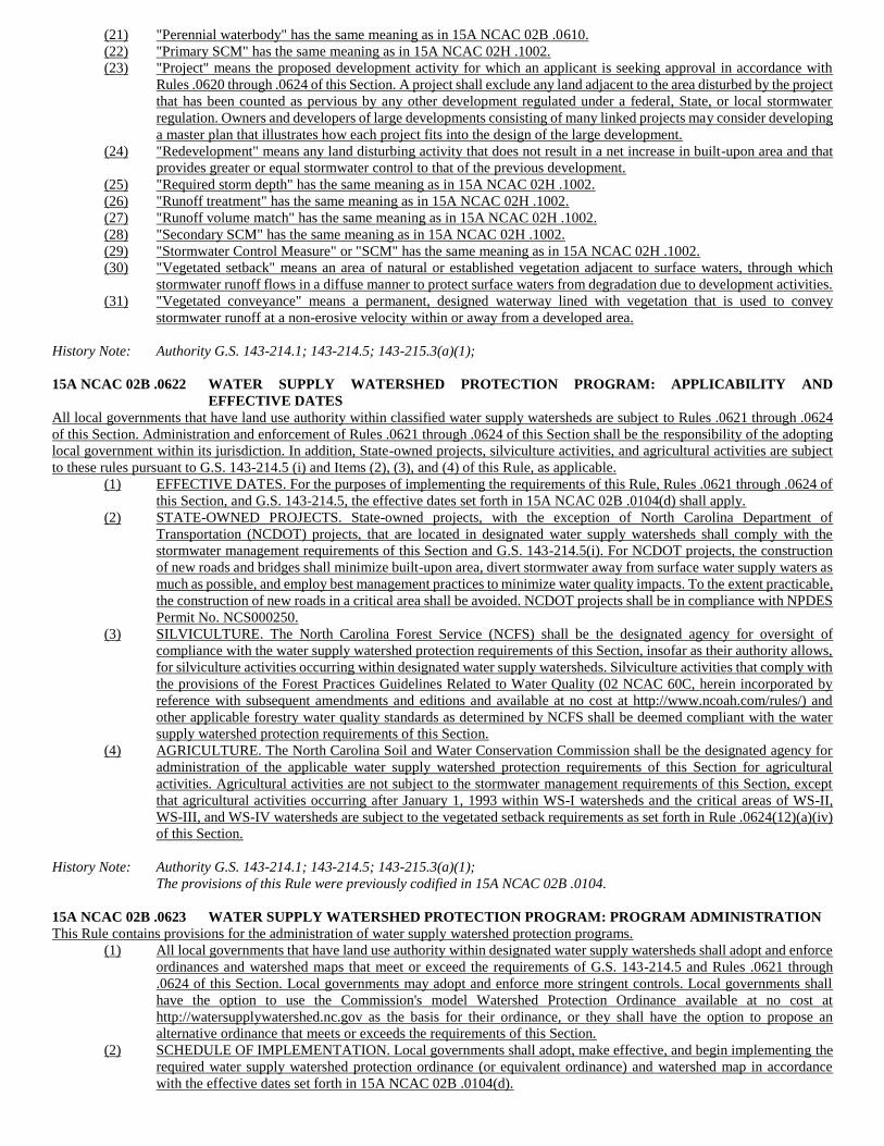
(21) "Perennial waterbody" has the same meaning as in 15A NCAC 02B .0610.
(22) "Primary SCM" has the same meaning as in 15A NCAC 02H .1002.
(23) "Project" means the proposed development activity for which an applicant is seeking approval in accordance with
Rules .0620 through .0624 of this Section. A project shall exclude any land adjacent to the area disturbed by the project
that has been counted as pervious by any other development regulated under a federal, State, or local stormwater
regulation. Owners and developers of large developments consisting of many linked projects may consider developing
a master plan that illustrates how each project fits into the design of the large development.
(24) "Redevelopment" means any land disturbing activity that does not result in a net increase in built-upon area and that
provides greater or equal stormwater control to that of the previous development.
(25) "Required storm depth" has the same meaning as in 15A NCAC 02H .1002.
(26) "Runoff treatment" has the same meaning as in 15A NCAC 02H .1002.
(27) "Runoff volume match" has the same meaning as in 15A NCAC 02H .1002.
(28) "Secondary SCM" has the same meaning as in 15A NCAC 02H .1002.
(29) "Stormwater Control Measure" or "SCM" has the same meaning as in 15A NCAC 02H .1002.
(30) "Vegetated setback" means an area of natural or established vegetation adjacent to surface waters, through which
stormwater runoff flows in a diffuse manner to protect surface waters from degradation due to development activities.
(31) "Vegetated conveyance" means a permanent, designed waterway lined with vegetation that is used to convey
stormwater runoff at a non-erosive velocity within or away from a developed area.
History Note: Authority G.S. 143-214.1; 143-214.5; 143-215.3(a)(1);
15A NCAC 02B .0622 WATER SUPPLY WATERSHED PROTECTION PROGRAM: APPLICABILITY AND
EFFECTIVE DATES
All local governments that have land use authority within classified water supply watersheds are subject to Rules .0621 through .0624
of this Section. Administration and enforcement of Rules .0621 through .0624 of this Section shall be the responsibility of the adopting
local government within its jurisdiction. In addition, State-owned projects, silviculture activities, and agricultural activities are subject
to these rules pursuant to G.S. 143-214.5 (i) and Items (2), (3), and (4) of this Rule, as applicable.
(1) EFFECTIVE DATES. For the purposes of implementing the requirements of this Rule, Rules .0621 through .0624 of
this Section, and G.S. 143-214.5, the effective dates set forth in 15A NCAC 02B .0104(d) shall apply.
(2) STATE-OWNED PROJECTS. State-owned projects, with the exception of North Carolina Department of
Transportation (NCDOT) projects, that are located in designated water supply watersheds shall comply with the
stormwater management requirements of this Section and G.S. 143-214.5(i). For NCDOT projects, the construction
of new roads and bridges shall minimize built-upon area, divert stormwater away from surface water supply waters as
much as possible, and employ best management practices to minimize water quality impacts. To the extent practicable,
the construction of new roads in a critical area shall be avoided. NCDOT projects shall be in compliance with NPDES
Permit No. NCS000250.
(3) SILVICULTURE. The North Carolina Forest Service (NCFS) shall be the designated agency for oversight of
compliance with the water supply watershed protection requirements of this Section, insofar as their authority allows,
for silviculture activities occurring within designated water supply watersheds. Silviculture activities that comply with
the provisions of the Forest Practices Guidelines Related to Water Quality (02 NCAC 60C, herein incorporated by
reference with subsequent amendments and editions and available at no cost at http://www.ncoah.com/rules/) and
other applicable forestry water quality standards as determined by NCFS shall be deemed compliant with the water
supply watershed protection requirements of this Section.
(4) AGRICULTURE. The North Carolina Soil and Water Conservation Commission shall be the designated agency for
administration of the applicable water supply watershed protection requirements of this Section for agricultural
activities. Agricultural activities are not subject to the stormwater management requirements of this Section, except
that agricultural activities occurring after January 1, 1993 within WS-I watersheds and the critical areas of WS-II,
WS-III, and WS-IV watersheds are subject to the vegetated setback requirements as set forth in Rule .0624(12)(a)(iv)
of this Section.
History Note: Authority G.S. 143-214.1; 143-214.5; 143-215.3(a)(1);
The provisions of this Rule were previously codified in 15A NCAC 02B .0104.
15A NCAC 02B .0623 WATER SUPPLY WATERSHED PROTECTION PROGRAM: PROGRAM ADMINISTRATION
This Rule contains provisions for the administration of water supply watershed protection programs.
(1) All local governments that have land use authority within designated water supply watersheds shall adopt and enforce
ordinances and watershed maps that meet or exceed the requirements of G.S. 143-214.5 and Rules .0621 through
.0624 of this Section. Local governments may adopt and enforce more stringent controls. Local governments shall
have the option to use the Commission's model Watershed Protection Ordinance available at no cost at
http://watersupplywatershed.nc.gov as the basis for their ordinance, or they shall have the option to propose an
alternative ordinance that meets or exceeds the requirements of this Section.
(2) SCHEDULE OF IMPLEMENTATION. Local governments shall adopt, make effective, and begin implementing the
required water supply watershed protection ordinance (or equivalent ordinance) and watershed map in accordance
with the effective dates set forth in 15A NCAC 02B .0104(d).
(3) COMMISSION APPROVAL. Local government water supply watershed protection ordinances (or equivalent
ordinances) and watershed maps shall be submitted to the Division for approval by the Commission or its designee no
later than 270 days after receiving notice of a water supply reclassification from the Commission. The Commission
or its designee shall approve the water supply watershed protection ordinance and map if it meets or exceeds the
minimum statewide water supply watershed management requirements adopted pursuant to this Section and G.S. 143-
214.5. The local government may begin implementing the ordinances prior to receiving approval by the Commission.
The following items shall be included in the submission in either paper or electronic format:
(a) one copy of the adopted and effective relevant ordinance;
(b) a cover letter from the local government's legal counsel, municipal or county clerk, or municipal or county
manager certifying that the ordinance meets or exceeds the requirements of this Section and G.S. 143-214.5;
and
(c) one copy of a watershed map showing the local government corporate and extraterritorial jurisdictional
boundaries, the Commission's adopted watershed boundaries, the local government's interpreted watershed
boundaries, and U.S. Geological Survey 1:24,000 (7.5 minute) scale topographic contour lines and
hydrography.
(4) WATERSHED BOUNDARY INTERPRETATION. Major landmarks such as highways or property lines may be
used to delineate the outer boundary of the critical and protected areas if these landmarks are immediately adjacent to
the appropriate outer boundary of 1/2 mile for the critical area or five or ten miles for the protected area. Local
governments may extend the critical and protected area boundaries beyond the minimum distance required; however,
these extended local boundaries shall not affect administration of state permits unless the boundaries are also adopted
by the Commission. Local governments shall delineate the approximate normal pool elevation for backwaters of water
supply reservoirs for the purposes of determining the critical and protected area boundaries as appropriate. Local
governments shall rely primarily on U.S. Geological Survey topographic maps, land surveys conducted by licensed
surveyors, Lidar data, or information from the U.S. Army Corps of Engineers in approximating the location of
backwaters.
(5) REVISIONS TO ORDINANCES AND MAPS. Revisions to local watershed supply watershed protection ordinances
and watershed maps shall be submitted to the Commission or its designee for approval. The submission requirements
set forth in Item (3) of this Rule shall apply to all subject revisions. In addition, revisions to ordinances shall be
submitted in a format that identifies the changes adopted or being proposed, as applicable. The local government may
adopt and begin implementing the revised ordinance prior to receiving approval by the Commission or its designee;
however, revisions (expansions or deletions) to watershed maps shall be approved by the Commission or its designee
prior to local government adoption.
(6) VARIANCES. For all proposed major and minor variances, as those terms are defined in Rule .0621 of this Section,
from the minimum statewide watershed protection rules, the local Watershed Review Board, or equivalent quasi-
judicial body, shall make findings of fact in accordance with the procedures of S.L. 2013-126 and Article 18 of G.S.
153A or Article 19 of G.S. 160A, as appropriate, showing that:
(a) there are practical difficulties or unnecessary hardships that prevent compliance with the strict letter of the
ordinance;
(b) the variance is in harmony with the general purpose and intent of the local watershed protection ordinance
and preserves its spirit; and
(c) in granting the variance, the public safety and welfare have been assured and substantial justice has been
done.
For all proposed major and minor variances, the local government considering or requesting the variance shall notify
and allow a reasonable comment period for all other local governments having jurisdiction within the watershed area
governed by these Rules and the entity using the water supply for consumption. The local Watershed Review Board
may attach conditions to the major or minor variance approval that support the purpose of the local watershed
protection ordinance. The local Watershed Review Board, or equivalent local quasi-judicial body, shall have the power
to authorize minor variances for development activities on a case-by-case basis. For major variances, if the local
Watershed Review Board decides in favor of granting the major variance, the Board shall then prepare a preliminary
record of the hearing and submit it to the Commission for review. If the Commission approves the major variance or
approves the variance with conditions or stipulations added, then the Commission shall prepare a decision that
authorizes the local Watershed Review Board to issue a final decision that includes any conditions or stipulations
added by the Commission. If the Commission denies the major variance, then the Commission shall prepare a decision
to be sent to the local Watershed Review Board. The local Watershed Review Board shall prepare a final decision
denying the major variance. Appeals from the local government decision on a major or minor variance request shall
be made on certiorari to the local Superior Court. Appeals from the Commission decision on a major variance request
are made on judicial review to Superior Court. When local ordinances are more stringent than the state's minimum
watershed protection requirements, a variance to the local government's ordinance is not considered a major variance
as long as the result of the variance is not less stringent than the state's minimum watershed protection requirements.
(7) RECORDKEEPING REQUIREMENTS. Local governments shall maintain the following records and furnish a copy
of these records to the Division upon request:
(a) a copy of all variance requests and associated documents;
(b) findings of fact on all variance requests;
(c) a description of all projects for which the local government has granted a variance to the requirements of this
Section;
(d) an accounting of projects approved under the local government's 10/70 Option (as described in Rule .0624
of this Section), as applicable; and
(e) records of inspections of SCMs pursuant to Item (8) of this Rule.
(8) OPERATION AND MAINTENANCE OF SCMS. Wherever in this Section it is provided that local governments
assume responsibility for operation and maintenance of engineered SCMs, this shall be construed to require
responsible local governments to either inspect such SCMs or require the owners of such SCMs to inspect such SCMs
at least once per year to determine whether the SCMs are performing as designed and intended. Records of inspections
shall be maintained on forms made available by the Division at http://watersupplywatershed.nc.gov/ or the local
government. The inspection form shall include the following:
(a) project name;
(b) owner name and address;
(c) name and classification of the water supply watershed where the project is located;
(d) type(s) of SCMs at the project site;
(e) summary of repairs or maintenance needed; and
(f) estimated timeframe for completion of the repairs or maintenance.
In the event an inspection shows that an SCM is not performing as designed and intended, the local government shall
order the owning entity to take corrective actions. If the entity fails to take corrective actions, the local government
may impose civil penalties and pursue other available remedies in accordance with State and local law, including
without limitation: G.S. 14-4; G.S. 77-13; G.S. 77-14; G.S. 143-214.7; G.S. 143-215.6A; G.S. 153A-123; G.S. 160A-
459; and G.S. 160A-175.
(9) Local governments shall, as the existing laws allow, develop, implement, and enforce comprehensive nonpoint source
and stormwater discharge control programs to reduce water pollution from activities within water supply watersheds
such as development, landfills, mining, on-site sanitary sewage systems which utilize ground adsorption, toxic and
hazardous materials, transportation, and water-based recreation.
(10) In the event that the Commission determines that a local government program has failed to adopt or implement its
program in compliance with the water supply watershed protection requirements of this Section and G.S. 143-214.5,
the Commission shall take appropriate enforcement action in accordance with G.S. 143-214.5 and G.S. 143-215.6A(e).
When the Commission assumes a local water supply watershed protection program as specified under G.S. 143-
214.5(e), all local permits authorizing construction and development activities as regulated by the statewide minimum
water supply watershed protection requirements of this Section shall be approved by the Commission or its designee
prior to local government issuance.
(11) The Commission may delegate such matters as variance approval, extension of deadlines for submission of ordinances,
and assessment of civil penalties pursuant to G.S. 143-214.5(e) to the Director.
History Note: Authority G.S. 143-214.1; 143-214.5; 143-215.3(a)(1);
The provisions of this Rule were previously codified in 15A NCAC 2B .0104.
15A NCAC 02B .0624 WATER SUPPLY WATERSHED PROTECTION PROGRAM: NONPOINT SOURCE AND
STORMWATER POLLUTION CONTROL
The purpose of this Rule is to minimize the impact of stormwater runoff from development on the water quality of public surface water
supplies and to protect their designated uses as public water supplies.
(1) IMPLEMENTING AUTHORITY. The requirements of this Rule shall be implemented by local governments with
land use authority in one or more designated water supply watersheds. State agencies shall also comply with this Rule
insofar as required by G.S. 143-214.5 and in accordance with Rule .0622 of this Section.
(2) APPLICABILITY. This Rule shall apply to all new development projects that lie within a designated water supply
watershed, except in a Class WS-IV watershed where this Rule applies only to new development projects that require
an Erosion and Sedimentation Control Plan.
(3) EXCLUSIONS. The following shall not be subject to this Rule:
(a) existing development;
(b) redevelopment, as that term is defined in Rule. 0621 of this Section;
(c) single-family residential redevelopment even if there is a net increase in built-upon area or if stormwater
controls are not equal to that of the previous single-family residential development;
(d) expansions to single-family residential existing development unless the expansion is part of a larger common
plan of development that is subject to this Rule;
(e) nonconforming lot of record that is not contiguous to any other lot owned by the same party and if it is to be
developed for single-family residential purposes. Local governments may require the combination of
contiguous nonconforming lots of record owned by the same party in order to establish a lot or lots that meet
or nearly meet the development restrictions of this Section;
(f) any lot or parcel created as part of a family subdivision after the effective date of the local watershed
ordinance if it is to be developed for one single-family detached residence and if it is exempt from a local
subdivision ordinance. Any lot or parcel created as part of any other type of subdivision that is exempt from
a local subdivision ordinance shall be subject to this Rule, except that such a lot or parcel shall meet the
vegetated setback requirements set forth in Item (12) of this Rule to the maximum extent practicable. In
determining whether this criteria has been met, the local government shall take into account site-specific
factors including technical and cost considerations as well as protection of water quality;
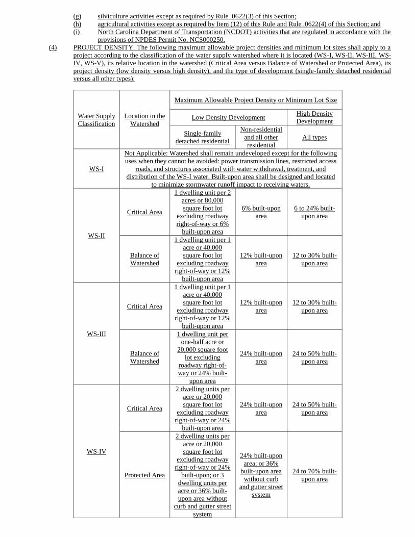
(g) silviculture activities except as required by Rule .0622(3) of this Section;
(h) agricultural activities except as required by Item (12) of this Rule and Rule .0622(4) of this Section; and
(i) North Carolina Department of Transportation (NCDOT) activities that are regulated in accordance with the
provisions of NPDES Permit No. NCS000250.
(4) PROJECT DENSITY. The following maximum allowable project densities and minimum lot sizes shall apply to a
project according to the classification of the water supply watershed where it is located (WS-I, WS-II, WS-III, WS-
IV, WS-V), its relative location in the watershed (Critical Area versus Balance of Watershed or Protected Area), its
project density (low density versus high density), and the type of development (single-family detached residential
versus all other types):
Water Supply
Classification
Location in the
Watershed
Maximum Allowable Project Density or Minimum Lot Size
Low Density Development High Density
Development
Single-family
detached residential
Non-residential
and all other
residential
All types
WS-I
Not Applicable: Watershed shall remain undeveloped except for the following
uses when they cannot be avoided: power transmission lines, restricted access
roads, and structures associated with water withdrawal, treatment, and
distribution of the WS-I water. Built-upon area shall be designed and located
to minimize stormwater runoff impact to receiving waters.
WS-II
Critical Area
1 dwelling unit per 2
acres or 80,000
square foot lot
excluding roadway
right-of-way or 6%
built-upon area
6% built-upon
area
6 to 24% built-
upon area
Balance of
Watershed
1 dwelling unit per 1
acre or 40,000
square foot lot
excluding roadway
right-of-way or 12%
built-upon area
12% built-upon
area
12 to 30% built-
upon area
WS-III
Critical Area
1 dwelling unit per 1
acre or 40,000
square foot lot
excluding roadway
right-of-way or 12%
built-upon area
12% built-upon
area
12 to 30% built-
upon area
Balance of
Watershed
1 dwelling unit per
one-half acre or
20,000 square foot
lot excluding
roadway right-of-
way or 24% built-
upon area
24% built-upon
area
24 to 50% built-
upon area
WS-IV
Critical Area
2 dwelling units per
acre or 20,000
square foot lot
excluding roadway
right-of-way or 24%
built-upon area
24% built-upon
area
24 to 50% built-
upon area
Protected Area
2 dwelling units per
acre or 20,000
square foot lot
excluding roadway
right-of-way or 24%
built-upon; or 3
dwelling units per
acre or 36% built-
upon area without
curb and gutter street
system
24% built-upon
area; or 36%
built-upon area
without curb
and gutter street
system
24 to 70% built-
upon area
WS-V Not Applicable
(5) CALCULATION OF PROJECT DENSITY. The following requirements shall apply to the calculation of project
density:
(a) Project density shall be calculated as the total built-upon area divided by the total project area;
(b) A project with "existing development," as that term is defined in Rule .0621 of this Section, may use the
calculation method in Sub-Item (a) of this Item or shall have the option of calculating project density as the
difference of total built-upon area minus existing built-upon area divided by the difference of total project
area minus existing built-upon area. Expansions to existing development shall be subject to this Rule except
as excluded in Sub-Item (3)(d) of this Rule. Where there is a net increase of built-upon area, only the area of
net increase shall be subject to this Rule. Where existing development is being replaced with new built-upon
area, and there is a net increase of built-upon area, only the area of net increase shall be subject to this Rule;
(c) Total project area shall exclude the following:
(i) areas below the Normal High Water Line (NHWL); and
(ii) areas defined as "coastal wetlands" pursuant to 15A NCAC 07H .0205, herein incorporated by
reference, including subsequent amendments and editions, and available at no cost at
http://reports.oah.state.nc.us/ncac.asp, as measured landward from the NHWL; and
(d) Projects under a common plan of development shall be considered as a single project for purposes of density
calculation except that on a case-by-case basis, local governments shall have the option to allow projects to
be considered to have both high and low density areas based on one or more of the following criteria:
(i) natural drainage area boundaries;
(ii) variations in land use throughout the project; or
(iii) construction phasing.
(6) LOW DENSITY PROJECTS. In addition to complying with the project density requirements of Item (4) of this Rule,
low density projects shall comply with the following:
(a) VEGETATED CONVEYANCES. Stormwater runoff from the project shall be released to vegetated areas
as dispersed flow or transported by vegetated conveyances to the maximum extent practicable. In determining
whether this criteria has been met, the local government shall take into account site-specific factors such as
topography and site layout as well as protection of water quality. Vegetated conveyances shall be maintained
in perpetuity to ensure that they function as designed. Vegetated conveyances that meet the following criteria
shall be deemed to satisfy the requirements of this Sub-Item:
(i) Side slopes shall be no steeper than 3:1 (horizontal to vertical) unless it is demonstrated to the local
government that the soils and vegetation will remain stable in perpetuity based on engineering
calculations and on-site soil investigation; and
(ii) The conveyance shall be designed so that it does not erode during the peak flow from the 10-year
storm event as demonstrated by engineering calculations.
(b) CURB OUTLET SYSTEMS. In lieu of vegetated conveyances, low density projects shall have the option to
use curb and gutter with outlets to convey stormwater to grassed swales or vegetated areas. Requirements for
these curb outlet systems shall be as follows:
(i) The curb outlets shall be located such that the swale or vegetated area can carry the peak flow from
the 10-year storm and at a non-erosive velocity;
(ii) The longitudinal slope of the swale or vegetated area shall not exceed five percent except where not
practical due to physical constraints. In these cases, devices to slow the rate of runoff and encourage
infiltration to reduce pollutant delivery shall be provided;
(iii) The swale's cross section shall be trapezoidal with a minimum bottom width of two feet;
(iv) The side slopes of the swale or vegetated area shall be no steeper than 3:1 (horizontal to vertical);
(v) The minimum length of the swale or vegetated area shall be 100 feet; and
(vi) Low density projects may use treatment swales designed in accordance with 15A NCAC 02H .1061
in lieu of the requirements specified in Sub-Items (i) through (v) of this Sub-Item.
(7) HIGH DENSITY PROJECTS. In addition to complying with the project density requirements of Item (4) of this Rule,
high density projects shall comply with the following:
(a) SCMs shall be designed, constructed, and maintained so that the project achieves either "runoff treatment"
or "runoff volume match" as those terms are defined in Rule .0621 of this Section;
(b) REQUIRED STORM DEPTH. For high density projects designed to achieve runoff treatment, the required
storm depth shall be one inch. Applicants shall have the option to design projects to achieve runoff volume
match in lieu of runoff treatment.
(c) OFF-SITE STORMWATER. Stormwater runoff from off-site areas and "existing development," as that term
is defined in Rule .0621 of this Section, shall not be required to be treated in the SCM. Runoff from off-site
areas or existing development that is not bypassed shall be included in sizing of on-site SCMs;
(d) MDC FOR SCMS. SCMs shall meet the relevant MDC set forth in 15A NCAC 02H .1050 through .1062.
(e) STORMWATER OUTLETS. Stormwater outlets shall be designed so that they do not cause erosion
downslope of the discharge point during the peak flow from the 10-year storm event as shown by engineering
calculations.
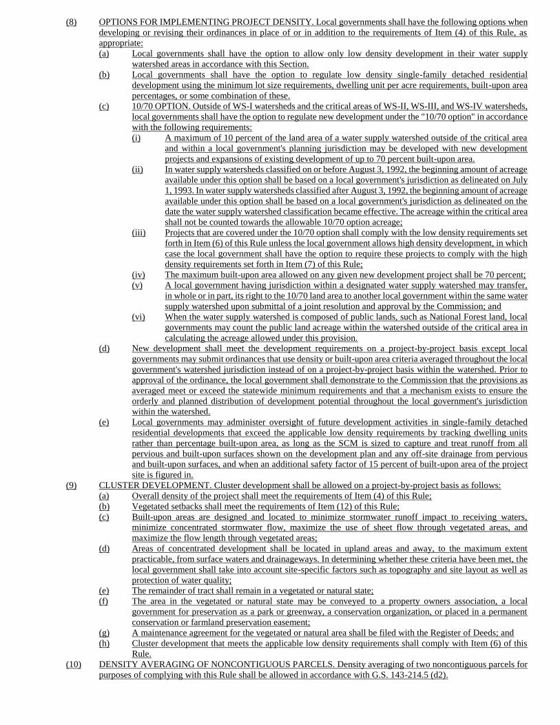
(8) OPTIONS FOR IMPLEMENTING PROJECT DENSITY. Local governments shall have the following options when
developing or revising their ordinances in place of or in addition to the requirements of Item (4) of this Rule, as
appropriate:
(a) Local governments shall have the option to allow only low density development in their water supply
watershed areas in accordance with this Section.
(b) Local governments shall have the option to regulate low density single-family detached residential
development using the minimum lot size requirements, dwelling unit per acre requirements, built-upon area
percentages, or some combination of these.
(c) 10/70 OPTION. Outside of WS-I watersheds and the critical areas of WS-II, WS-III, and WS-IV watersheds,
local governments shall have the option to regulate new development under the "10/70 option" in accordance
with the following requirements:
(i) A maximum of 10 percent of the land area of a water supply watershed outside of the critical area
and within a local government's planning jurisdiction may be developed with new development
projects and expansions of existing development of up to 70 percent built-upon area.
(ii) In water supply watersheds classified on or before August 3, 1992, the beginning amount of acreage
available under this option shall be based on a local government's jurisdiction as delineated on July
1, 1993. In water supply watersheds classified after August 3, 1992, the beginning amount of acreage
available under this option shall be based on a local government's jurisdiction as delineated on the
date the water supply watershed classification became effective. The acreage within the critical area
shall not be counted towards the allowable 10/70 option acreage;
(iii) Projects that are covered under the 10/70 option shall comply with the low density requirements set
forth in Item (6) of this Rule unless the local government allows high density development, in which
case the local government shall have the option to require these projects to comply with the high
density requirements set forth in Item (7) of this Rule;
(iv) The maximum built-upon area allowed on any given new development project shall be 70 percent;
(v) A local government having jurisdiction within a designated water supply watershed may transfer,
in whole or in part, its right to the 10/70 land area to another local government within the same water
supply watershed upon submittal of a joint resolution and approval by the Commission; and
(vi) When the water supply watershed is composed of public lands, such as National Forest land, local
governments may count the public land acreage within the watershed outside of the critical area in
calculating the acreage allowed under this provision.
(d) New development shall meet the development requirements on a project-by-project basis except local
governments may submit ordinances that use density or built-upon area criteria averaged throughout the local
government's watershed jurisdiction instead of on a project-by-project basis within the watershed. Prior to
approval of the ordinance, the local government shall demonstrate to the Commission that the provisions as
averaged meet or exceed the statewide minimum requirements and that a mechanism exists to ensure the
orderly and planned distribution of development potential throughout the local government's jurisdiction
within the watershed.
(e) Local governments may administer oversight of future development activities in single-family detached
residential developments that exceed the applicable low density requirements by tracking dwelling units
rather than percentage built-upon area, as long as the SCM is sized to capture and treat runoff from all
pervious and built-upon surfaces shown on the development plan and any off-site drainage from pervious
and built-upon surfaces, and when an additional safety factor of 15 percent of built-upon area of the project
site is figured in.
(9) CLUSTER DEVELOPMENT. Cluster development shall be allowed on a project-by-project basis as follows:
(a) Overall density of the project shall meet the requirements of Item (4) of this Rule;
(b) Vegetated setbacks shall meet the requirements of Item (12) of this Rule;
(c) Built-upon areas are designed and located to minimize stormwater runoff impact to receiving waters,
minimize concentrated stormwater flow, maximize the use of sheet flow through vegetated areas, and
maximize the flow length through vegetated areas;
(d) Areas of concentrated development shall be located in upland areas and away, to the maximum extent
practicable, from surface waters and drainageways. In determining whether these criteria have been met, the
local government shall take into account site-specific factors such as topography and site layout as well as
protection of water quality;
(e) The remainder of tract shall remain in a vegetated or natural state;
(f) The area in the vegetated or natural state may be conveyed to a property owners association, a local
government for preservation as a park or greenway, a conservation organization, or placed in a permanent
conservation or farmland preservation easement;
(g) A maintenance agreement for the vegetated or natural area shall be filed with the Register of Deeds; and
(h) Cluster development that meets the applicable low density requirements shall comply with Item (6) of this
Rule.
(10) DENSITY AVERAGING OF NONCONTIGUOUS PARCELS. Density averaging of two noncontiguous parcels for
purposes of complying with this Rule shall be allowed in accordance with G.S. 143-214.5 (d2).
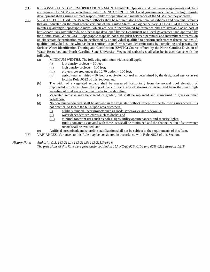
(11) RESPONSIBILITY FOR SCM OPERATION & MAINTENANCE. Operation and maintenance agreements and plans
are required for SCMs in accordance with 15A NCAC 02H .1050. Local governments that allow high density
development shall assume ultimate responsibility for operation and maintenance of the SCMs that they approve.
(12) VEGETATED SETBACKS. Vegetated setbacks shall be required along perennial waterbodies and perennial streams
that are indicated on the most recent versions of the United States Geological Survey (USGS) 1:24,000 scale (7.5
minute) quadrangle topographic maps, which are herein incorporated by reference and are available at no cost at
http://www.usgs.gov/pubprod/, or other maps developed by the Department or a local government and approved by
the Commission. Where USGS topographic maps do not distinguish between perennial and intermittent streams, an
on-site stream determination may be performed by an individual qualified to perform such stream determinations. A
qualified individual is one who has been certified to perform stream determinations by completing and passing the
Surface Water Identification Training and Certification (SWITC) Course offered by the North Carolina Division of
Water Resources and North Carolina State University. Vegetated setbacks shall also be in accordance with the
following:
(a) MINIMUM WIDTHS. The following minimum widths shall apply:
(i) low density projects – 30 feet;
(ii) high density projects – 100 feet;
(iii) projects covered under the 10/70 option – 100 feet;
(iv) agricultural activities – 10 feet, or equivalent control as determined by the designated agency as set
forth in Rule .0622 of this Section; and
(b) The width of a vegetated setback shall be measured horizontally from the normal pool elevation of
impounded structures, from the top of bank of each side of streams or rivers, and from the mean high
waterline of tidal waters, perpendicular to the shoreline;
(c) Vegetated setbacks may be cleared or graded, but shall be replanted and maintained in grass or other
vegetation;
(d) No new built-upon area shall be allowed in the vegetated setback except for the following uses where it is
not practical to locate the built-upon area elsewhere:
(i) publicly-funded linear projects such as roads, greenways, and sidewalks;
(ii) water dependent structures such as docks; and
(iii) minimal footprint uses such as poles, signs, utility appurtenances, and security lights.
Built-upon area associated with these uses shall be minimized and the channelization of stormwater
runoff shall be avoided; and
(e) Artificial streambank and shoreline stabilization shall not be subject to the requirements of this Item.
(13) VARIANCES. Variances to this Rule may be considered in accordance with Rule .0623 of this Section.
History Note: Authority G.S. 143-214.1; 143-214.5; 143-215.3(a)(1);
The provisions of this Rule were previously codified in 15A NCAC 02B .0104 and 02B .0212 through .0218.
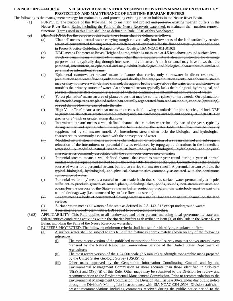
15A NCAC 02B .0233 .0714 NEUSE RIVER BASIN: NUTRIENT SENSITIVE WATERS MANAGEMENT STRATEGY:
PROTECTION AND MAINTENANCE OF EXISTING RIPARIAN BUFFERS
The following is the management strategy for maintaining and protecting existing riparian buffers in the Neuse River Basin.
(1) PURPOSE. The purpose of this Rule shall be to maintain and protect and preserve existing riparian buffers in the
Neuse River Basin Basin, including the Falls of the Neuse Reservoir watershed, to maintain their nutrient removal
functions. Terms used in this Rule shall be as defined in Rule .0610 of this Subchapter.
(2) DEFINITIONS. For the purpose of this Rule, these terms shall be defined as follows:
(a) 'Channel' means a natural water-carrying trough cut vertically into low areas of the land surface by erosive
action of concentrated flowing water or a ditch or canal excavated for the flow of water. (current definition
in Forest Practice Guidelines Related to Water Quality, 15A NCAC 01I .0102)
(b) 'DBH' means Diameter at Breast Height of a tree, which is measured at 4.5 feet above ground surface level.
(c) 'Ditch or canal' means a man-made channel other than a modified natural stream constructed for drainage
purposes that is typically dug through inter-stream divide areas. A ditch or canal may have flows that are
perennial, intermittent, or ephemeral and may exhibit hydrological and biological characteristics similar to
perennial or intermittent streams.
(d) 'Ephemeral (stormwater) stream' means a feature that carries only stormwater in direct response to
precipitation with water flowing only during and shortly after large precipitation events. An ephemeral stream
may or may not have a well-defined channel, the aquatic bed is always above the water table, and stormwater
runoff is the primary source of water. An ephemeral stream typically lacks the biological, hydrological, and
physical characteristics commonly associated with the continuous or intermittent conveyance of water.
(e) 'Forest plantation' means an area of planted trees that may be conifers (pines) or hardwoods. On a plantation,
the intended crop trees are planted rather than naturally regenerated from seed on the site, coppice (sprouting),
or seed that is blown or carried into the site.
(f) 'High Value Tree' means a tree that meets or exceeds the following standards: for pine species, 14-inch DBH
or greater or 18-inch or greater stump diameter; and, for hardwoods and wetland species, 16-inch DBH or
greater or 24-inch or greater stump diameter.
(g) 'Intermittent stream' means a well-defined channel that contains water for only part of the year, typically
during winter and spring when the aquatic bed is below the water table. The flow may be heavily
supplemented by stormwater runoff. An intermittent stream often lacks the biological and hydrological
characteristics commonly associated with the conveyance of water.
(h) 'Modified natural stream' means an on-site channelization or relocation of a stream channel and subsequent
relocation of the intermittent or perennial flow as evidenced by topographic alterations in the immediate
watershed. A modified natural stream must have the typical biological, hydrological, and physical
characteristics commonly associated with the continuous conveyance of water.
(i) 'Perennial stream' means a well-defined channel that contains water year round during a year of normal
rainfall with the aquatic bed located below the water table for most of the year. Groundwater is the primary
source of water for a perennial stream, but it also carries stormwater runoff. A perennial stream exhibits the
typical biological, hydrological, and physical characteristics commonly associated with the continuous
conveyance of water.
(j) 'Perennial waterbody' means a natural or man-made basin that stores surface water permanently at depths
sufficient to preclude growth of rooted plants, including lakes, ponds, sounds, non-stream estuaries and
ocean. For the purpose of the State=s riparian buffer protection program, the waterbody must be part of a
natural drainageway (i.e., connected by surface flow to a stream).
(k) 'Stream' means a body of concentrated flowing water in a natural low area or natural channel on the land
surface.
(l) 'Surface water' means all waters of the state as defined in G.S. 143-212 except underground waters.
(m) 'Tree' means a woody plant with a DBH equal to or exceeding five inches.
(3)(2) APPLICABILITY. This Rule applies to all landowners and other persons including local governments, state and
federal entities conducting activities within the riparian buffers as described in Item (3) of this Rule in the Neuse River
Basin, including the Falls of the Neuse Reservoir watershed.
(3) BUFFERS PROTECTED. The following minimum criteria shall be used for identifying regulated buffers:
(a) A surface water shall be subject to this Rule if the feature is approximately shown on any of the following
references:
(i) The most recent version of the published manuscript of the soil survey map that shows stream layers
prepared by the Natural Resources Conservation Service of the United States Department of
Agriculture;
(ii) The most recent version of the 1:24,000 scale (7.5 minute) quadrangle topographic maps prepared
by the United States Geologic Survey (USGS); or
(iii) Other maps approved by the Geographic Information Coordinating Council and by the
Environmental Management Commission as more accurate than those identified in Sub-Item
(3)(a)(i) and (3)(a)(ii) of this Rule. Other maps may be submitted to the Division for review and
recommendation to the Environmental Management Commission. Prior to recommendation to the
Environmental Management Commission, the Division shall issue a 30-calendar day public notice
through the Division's Mailing List in accordance with 15A NCAC 02H .0503. Division staff shall
present recommendations including comments received during the public notice period to the
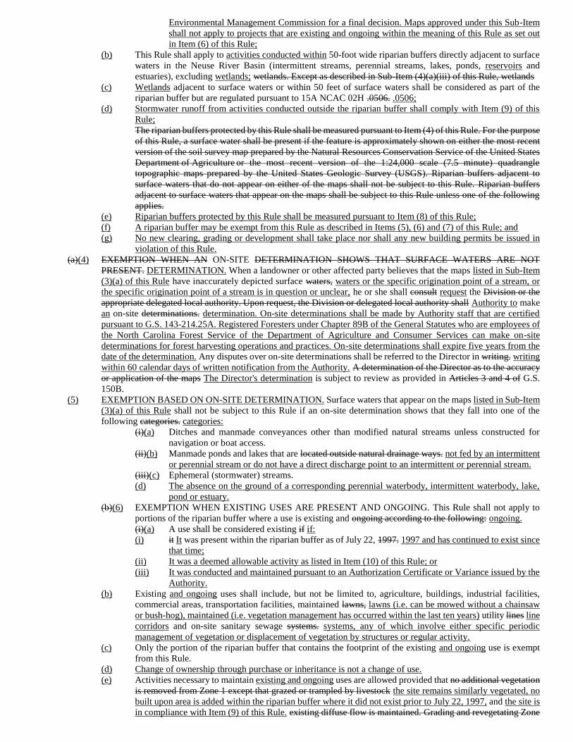
Environmental Management Commission for a final decision. Maps approved under this Sub-Item
shall not apply to projects that are existing and ongoing within the meaning of this Rule as set out
in Item (6) of this Rule;
(b) This Rule shall apply to activities conducted within 50-foot wide riparian buffers directly adjacent to surface
waters in the Neuse River Basin (intermittent streams, perennial streams, lakes, ponds, reservoirs and
estuaries), excluding wetlands; wetlands. Except as described in Sub-Item (4)(a)(iii) of this Rule, wetlands
(c) Wetlands adjacent to surface waters or within 50 feet of surface waters shall be considered as part of the
riparian buffer but are regulated pursuant to 15A NCAC 02H .0506. .0506;
(d) Stormwater runoff from activities conducted outside the riparian buffer shall comply with Item (9) of this
Rule;
The riparian buffers protected by this Rule shall be measured pursuant to Item (4) of this Rule. For the purpose
of this Rule, a surface water shall be present if the feature is approximately shown on either the most recent
version of the soil survey map prepared by the Natural Resources Conservation Service of the United States
Department of Agriculture or the most recent version of the 1:24,000 scale (7.5 minute) quadrangle
topographic maps prepared by the United States Geologic Survey (USGS). Riparian buffers adjacent to
surface waters that do not appear on either of the maps shall not be subject to this Rule. Riparian buffers
adjacent to surface waters that appear on the maps shall be subject to this Rule unless one of the following
applies.
(e) Riparian buffers protected by this Rule shall be measured pursuant to Item (8) of this Rule;
(f) A riparian buffer may be exempt from this Rule as described in Items (5), (6) and (7) of this Rule; and
(g) No new clearing, grading or development shall take place nor shall any new building permits be issued in
violation of this Rule.
(a)(4) EXEMPTION WHEN AN ON-SITE DETERMINATION SHOWS THAT SURFACE WATERS ARE NOT
PRESENT. DETERMINATION. When a landowner or other affected party believes that the maps listed in Sub-Item
(3)(a) of this Rule have inaccurately depicted surface waters, waters or the specific origination point of a stream, or
the specific origination point of a stream is in question or unclear, he or she shall consult request the Division or the
appropriate delegated local authority. Upon request, the Division or delegated local authority shall Authority to make
an on-site determinations. determination. On-site determinations shall be made by Authority staff that are certified
pursuant to G.S. 143-214.25A. Registered Foresters under Chapter 89B of the General Statutes who are employees of
the North Carolina Forest Service of the Department of Agriculture and Consumer Services can make on-site
determinations for forest harvesting operations and practices. On-site determinations shall expire five years from the
date of the determination. Any disputes over on-site determinations shall be referred to the Director in writing. writing
within 60 calendar days of written notification from the Authority. A determination of the Director as to the accuracy
or application of the maps The Director's determination is subject to review as provided in Articles 3 and 4 of G.S.
150B.
(5) EXEMPTION BASED ON ON-SITE DETERMINATION. Surface waters that appear on the maps listed in Sub-Item
(3)(a) of this Rule shall not be subject to this Rule if an on-site determination shows that they fall into one of the
following categories. categories:
(i)(a) Ditches and manmade conveyances other than modified natural streams unless constructed for
navigation or boat access.
(ii)(b) Manmade ponds and lakes that are located outside natural drainage ways. not fed by an intermittent
or perennial stream or do not have a direct discharge point to an intermittent or perennial stream.
(iii)(c) Ephemeral (stormwater) streams.
(d) The absence on the ground of a corresponding perennial waterbody, intermittent waterbody, lake,
pond or estuary.
(b)(6) EXEMPTION WHEN EXISTING USES ARE PRESENT AND ONGOING. This Rule shall not apply to
portions of the riparian buffer where a use is existing and ongoing according to the following: ongoing.
(i)(a) A use shall be considered existing if if:
(i) it It was present within the riparian buffer as of July 22, 1997. 1997 and has continued to exist since
that time;
(ii) It was a deemed allowable activity as listed in Item (10) of this Rule; or
(iii) It was conducted and maintained pursuant to an Authorization Certificate or Variance issued by the
Authority.
(b) Existing and ongoing uses shall include, but not be limited to, agriculture, buildings, industrial facilities,
commercial areas, transportation facilities, maintained lawns, lawns (i.e. can be mowed without a chainsaw
or bush-hog), maintained (i.e. vegetation management has occurred within the last ten years) utility lines line
corridors and on-site sanitary sewage systems. systems, any of which involve either specific periodic
management of vegetation or displacement of vegetation by structures or regular activity.
(c) Only the portion of the riparian buffer that contains the footprint of the existing and ongoing use is exempt
from this Rule.
(d) Change of ownership through purchase or inheritance is not a change of use.
(e) Activities necessary to maintain existing and ongoing uses are allowed provided that no additional vegetation
is removed from Zone 1 except that grazed or trampled by livestock the site remains similarly vegetated, no
built upon area is added within the riparian buffer where it did not exist prior to July 22, 1997, and the site is
in compliance with Item (9) of this Rule. existing diffuse flow is maintained. Grading and revegetating Zone
2 is allowed provided that the health of the vegetation in Zone 1 is not compromised, the ground is stabilized
and existing diffuse flow is maintained.
(f) This Rule shall apply at the time an existing and ongoing use is changed to another use. Change of use shall
involve the initiation of any activity not defined as existing and ongoing in Sub-Items (6)(a) through (6)(e)
of this Rule.
(ii) At the time an existing use is proposed to be converted to another use, this Rule shall apply. An
existing use shall be considered to be converted to another use if any of the following applies:
(A) Impervious surface is added to the riparian buffer in locations where it did not exist
previously.
(B) An agricultural operation within the riparian buffer is converted to a non-agricultural use.
(C) A lawn within the riparian buffer ceases to be maintained.
(7) EXEMPTION FOR PONDS CONSTRUCTED AND USED FOR AGRICULTURAL PURPOSES. This Rule shall
not apply to a freshwater pond if all of the following conditions are met:
(a) The property on which the pond is located is used for agriculture as that term is defined in G.S. 106-581.1.
(b) Except for this Rule, the use of the property is in compliance with all other water quality and water quantity
statutes and rules applicable to the property before July 22, 1997.
(c) The pond is not a component of an animal waste management system as defined in G.S. 143-215.10B (3).
(4)(8) ZONES OF THE RIPARIAN BUFFER. The protected riparian buffer shall have two zones as follows:
(a) Zone 1 shall consist of a vegetated area that is undisturbed except for uses provided for in Item (6)(10) of
this Rule. The location of Zone 1 shall be as follows:
(i) For intermittent and perennial streams, Zone 1 shall begin at the most landward limit of the top of
bank or the rooted herbaceous vegetation and extend landward a distance of 30 feet on all sides of
the surface water, stream, measured horizontally on a line perpendicular to the surface water. stream
(where an intermittent or perennial stream begins or ends, including when it goes underground,
enters or exits a culvert, or enters or exits a wetland, the required distance shall be measured as a
radius around the beginning or the end).
(ii) For ponds, lakes and reservoirs located within a natural drainage way, Zone 1 shall begin at the most
landward limit of the normal water level or the rooted herbaceous vegetation and extend landward
a distance of 30 feet, measured horizontally on a line perpendicular to the surface water.
(iii) For surface waters within the 20 Coastal Counties (defined in 15A NCAC 02B .0202) Rule .0202
of this Subchapter) and within the jurisdiction of the Division of Coastal Management, Zone 1 shall
begin at the most landward limit of:
(A) the normal high water level;
(B) the normal water level; or
(C) the landward limit of coastal wetlands as defined by the Division of Coastal Management;
of the normal high water level or the normal water level and extend landward a distance of
30 feet, measured horizontally on a line perpendicular to the surface water, whichever is
more restrictive.
(b) Zone 2 shall consist of a stable, vegetated area that is undisturbed except for activities and uses provided for
in Item (6)(10) of this Rule. Grading and revegetating Zone 2 is allowed provided that the health of the
vegetation in Zone 1 is not compromised. Zone 2 shall begin at the outer edge of Zone 1 and extend landward
20 feet as measured horizontally on a line perpendicular to the surface water. The combined width of Zones
1 and 2 shall be 50 feet on all sides of the surface water.
(5) DIFFUSE FLOW REQUIREMENT. Diffuse flow of runoff shall be maintained in the riparian buffer by dispersing
concentrated flow and reestablishing vegetation.
(a) Concentrated runoff from new ditches or manmade conveyances shall be converted to diffuse flow before
the runoff enters the Zone 2 of the riparian buffer.
(b) Periodic corrective action to restore diffuse flow shall be taken if necessary to impede the formation of
erosion gullies.
(9) STORMWATER RUNOFF THROUGH THE RIPARIAN BUFFER. Drainage conveyances include drainage ditches,
roadside ditches, and stormwater conveyances. The following stormwater conveyances through the riparian buffer are
either deemed allowable or allowable upon authorization, as defined in Sub-Item (10)(a) of this Rule, provided that
they do not erode through the buffer and do not cause erosion to the receiving waterbody. Stormwater conveyances
through the riparian buffer that are not listed below shall be allowable with exception as defined in Sub-Item (10)(a)(v)
of this Rule.
(a) The following are deemed allowable as defined in Sub-Item (10)(a)(i) of this rule:
(i) New drainage conveyances from a Primary SCM, as defined in 15A NCAC 02H .1002, when the
Primary SCM is designed to treat the drainage area to the conveyance and that comply with a
stormwater management plan reviewed and approved under a state stormwater program or a state-
approved local government stormwater program; and
(ii) New stormwater flow to existing drainage conveyances provided that the addition of new flow does
not result in the need to alter the conveyance.
(b) The following are allowable upon authorization as defined in Sub-Item (10)(a)(ii) of this Rule:
(i) New drainage conveyances from a Primary SCM as defined in 15A NCAC 02H .1002 when the
Primary SCM is provided to treat the drainage area to the conveyance but are not approved under a
state stormwater program or a state-approved local government stormwater program;
(ii) New drainage conveyances when the drainage area to the conveyance is demonstrated via approved
nutrient calculation methodologies to meet the nutrient loading goal of 3.6 pounds per acre per year
of Nitrogen (N) outside of the Falls of the Neuse Reservoir Watershed. Within the Falls of the Neuse
Reservoir Watershed, new drainage conveyances when the drainage area to the conveyance is
demonstrated via approved nutrient calculation methodologies to meet the nutrient loading goal of
2.2 pounds per acre per year of Nitrogen (N) and 0.33 pounds per acre per year of Phosphorus (P);
(iii) New drainage conveyances when the flow rate of the conveyance is less than 0.5 cubic feet per
second during the peak flow from the 0.75 inch per hour storm;
(iv) New stormwater runoff that has been treated through a level spreader-filter strip that complies with
15A NCAC 02H .1059;
(v) Realignment of existing drainage conveyances applicable to publicly funded and maintained linear
transportation facilities when retaining or improving the design dimensions provided that no
additional travel lanes are added and the minimum required roadway typical section is used based
on traffic and safety considerations;
(vi) Realignment of existing drainage conveyances retaining or improving the design dimensions
provided that the size of the drainage area and the percent built-upon area within the drainage area
remain the same;
(vii) New or altered drainage conveyances applicable to publicly funded and maintained linear
transportation facilities provided that SCMs, or BMPs from the NCDOT Stormwater Best
Management Practices Toolbox, are employed;
(viii) New drainage conveyances applicable to publicly funded and maintained linear transportation
facilities that do not provide a stormwater management facility due to topography constraints
provided other measures are employed to protect downstream water quality to the maximum extent
practical; and
(ix) New drainage conveyances where the drainage area to the conveyance has no new built-upon area
as defined in 15A NCAC 02H .1002 and the conveyance is necessary for bypass of existing drainage
only.
(6)(10) TABLE OF USES. Uses within the riparian buffer, or outside the buffer with hydrological impacts on the riparian
buffer, shall be designated as deemed allowable, allowable upon authorization, allowable with mitigation upon
authorization, allowable with exception or prohibited.
(a) Potential new uses shall have the following requirements:
(i) DEEMED ALLOWABLE. Uses designated as deemed allowable in Sub-Items (9)(a) and (10)(b) of
this Rule may occur within the riparian buffer. Deemed allowable uses shall be designed,
constructed and maintained to minimize vegetation and soil disturbance and to provide the
maximum water quality protection practicable, including construction, monitoring, and maintenance
activities. In addition, deemed allowable uses shall meet the requirements listed in Sub-Item (10)(b)
of this Rule for the specific use.
(ii) ALLOWABLE UPON AUTHORIZATION. Uses designated as allowable upon authorization in
Sub-Items (9)(b) and (10)(b) of this Rule require a written Authorization Certificate from the
Authority for impacts within the riparian buffer pursuant to Rule .0611 of this Subchapter.
(iii) ALLOWABLE WITH MITIGATION UPON AUTHORIZATION. Uses designated as allowable
with mitigation upon authorization in Sub-Item (10)(b) of this Rule require a written Authorization
Certificate from the Authority for impacts within the riparian buffer pursuant to Rule .0611 of this
Subchapter and an appropriate mitigation strategy that has received written approval pursuant to
Item (11) of this Rule.
(iv) PROHIBITED. Uses designated as prohibited in Sub-Item (10)(b) of this Rule may not proceed
within the riparian buffer unless a Variance is granted pursuant to Rule .0226 of this Subchapter.
Mitigation may be required as a condition of variance approval.
(v) ALLOWABLE WITH EXCEPTION. Uses not designated as deemed allowable, allowable upon
authorization, allowable with mitigation upon authorization or prohibited in Sub-Item (10)(b) of this
Rule require a written Authorization Certificate with Exception from the Authority for impacts
within the riparian buffer pursuant to Rule .0611 of this Subchapter and an appropriate mitigation
strategy that has received written approval pursuant to Item (11) of this Rule.
(b) The following chart table sets out the potential new uses within the riparian buffer, or outside the buffer with
hydrological impacts on the riparian buffer, and their designation under this Rule designates them as exempt,
deemed allowable, allowable, allowable upon authorization, allowable with mitigation, or prohibited.
mitigation upon authorization, or prohibited: The requirements for each category are given in Item (7) of this
Rule.
Exempt
Deemed
Allowable
Allowable
Upon
Authorization
Allowable with
Mitigation Upon
Authorization
Prohibited
Airport facilities:
• Vegetation removal activities necessary to comply with Federal
Aviation Administration requirements (e.g. line of sight requirements)
provided the disturbed areas are stabilized and revegetated
• Airport facilities that impact equal to or less than 150 linear feet or
one-third of an acre of riparian buffer
• Airport facilities that impact greater than 150 linear feet or one-third
of an acre of riparian buffer
X
X
X
Archaeological activities X
Bridges
• Impact equal to or less than one-tenth of an acre of riparian buffer
• Impact greater than one-tenth of an acre of riparian buffer
X
X
Dam maintenance activities
• Dam maintenance activities that do not cause additional riparian buffer
disturbance beyond the footprint of the existing dam
• Dam maintenance activities that do cause additional riparian buffer
disturbance beyond the footprint of the existing dam
X
X
Drainage ditches, roadside ditches and stormwater outfalls through riparian
buffers:
• Existing drainage ditches, roadside ditches, and stormwater outfalls
provided that they are managed to minimize the sediment, nutrients and
other pollution that convey to waterbodies
• New drainage ditches, roadside ditches and stormwater outfalls
provided that a stormwater management facility is installed to control
nitrogen and attenuate flow before the conveyance discharges through
the riparian buffer
• New drainage ditches, roadside ditches and stormwater outfalls that do
not provide control for nitrogen before discharging through the riparian
buffer
• Excavation of the streambed in order to bring it to the same elevation
as the invert of a ditch
X
X
X
X
Drainage of a pond in a natural drainage way subject to Item (3) of this Rule
provided that a new riparian buffer that meets the requirements of Items (4) and
(5) of this Rule is established adjacent to the new channel by natural regeneration
or planting, within 50 feet of any stream which naturally forms or is constructed
within the drained pond area. Drained ponds shall be allowed to naturalize for a
minimum of six months from completion of the draining activity before a stream
determination is conducted pursuant to Item (4) of this Rule.
X
Driveway crossings of streams and other surface waters subject to this Rule:
• Driveway crossings on single family residential lots that disturb equal
to or less than 25 linear feet or 2, 500 square feet of riparian buffer
• Driveway crossings on single family residential lots that disturb greater
than 25 linear feet or 2,500 square feet of riparian buffer
• In a subdivision that cumulatively disturb equal to or less than 150
linear feet or one-third of an acre of riparian buffer
• In a subdivision that cumulatively disturb greater than 150 linear feet
or one-third of an acre of riparian buffer
X
X
X
X
Fences:
• Fencing livestock out of surface waters
• Fences provided that disturbance is minimized and installation
Installation does not result in removal of forest vegetation trees
• Installation results in removal of trees
X
X
X
Forest harvesting - see Item (11) of this Rule .0612 of this Subchapter
Fertilizer application:
• One-time fertilizer application to establish replanted vegetation
vegetation. This only applies to the one-time application of fertilizer in
the riparian buffer. No runoff from this one-time application in the
riparian buffer is allowed in the applicable surface water.
• Ongoing fertilizer application
X
X
Exempt
Deemed
Allowable
Allowable
Upon
Authorization
Allowable with
Mitigation Upon
Authorization
Prohibited
Grading and revegetation in Zone 2 only provided that diffuse flow and the
health of existing vegetation in Zone 1 is not compromised compromised, Item
(9) of this Rule is complied with, and disturbed areas are stabilized and
revegetated
X
Greenway/hiking trails Greenways, trails, sidewalks or linear pedestrian/bicycle
transportation system:
• In Zone 2 provided that no built upon area is added within the buffer
• When built upon area is added to the buffer, equal to or less than 10
feet wide with 2 foot wide shoulders. Must be located outside Zone 1
unless there is no practical alternative
• When built upon area is added to the buffer, greater than 10 feet wide
with 2 foot wide shoulders. Must be located outside Zone 1 unless
there is no practical alternative
X
X
X
Historic preservation X
New Landfills as defined by G.S. 130A-290 X
Mining activities:
• Mining activities that are covered by the Mining Act provided that new
riparian buffers that meet the requirements of Items (4)(8) and (5)(9) of
this Rule are established adjacent to the relocated channels
• Mining activities that are not covered by the Mining Act OR where new
riparian buffers that meet the requirements or Items (4)(8) and (5)(9) of
this Rule are not established adjacent to the relocated channels
• Wastewater or mining dewatering wells with approved NPDES
permit
X
X
X
Non-electric utility lines:
• Impacts other than perpendicular crossings in Zone 2 only3
• Impacts other than perpendicular crossings in Zone 13
X
X
Non-electric utility line perpendicular crossing of streams and other surface
waters subject to this Rule3:
• Perpendicular crossings that disturb equal to or less than 40 linear feet
of riparian buffer with a maintenance corridor equal to or less than 10
feet in width
• Perpendicular crossings that disturb greater than 40 linear feet of
riparian buffer with a maintenance corridor greater than 10 feet in width
• Perpendicular crossings that disturb greater than 40 linear feet but equal
to or less than 150 linear feet of riparian buffer with a maintenance
corridor equal to or less than 10 feet in width
• Perpendicular crossings that disturb greater than 40 linear feet but equal
to or less than 150 linear feet of riparian buffer with a maintenance
corridor greater than 10 feet in width
• Perpendicular crossings that disturb greater than 150 linear feet of
riparian buffer
X
X
X
X
X
On-site sanitary sewage systems - new ones that use ground absorption X
Overhead electric utility lines:
• Impacts other than perpendicular crossings in Zone 2 only3
• Impacts other than perpendicular crossings in Zone 1 1,2,3
X
X
Overhead electric utility line perpendicular crossings of streams and other
surface waters subject to this Rule3
• Perpendicular crossings that disturb equal to or less than 150 linear feet
of riparian buffer 1
• Perpendicular crossings that disturb greater than 150 linear feet of
riparian buffer 1, 2
X
X
Periodic maintenance of Maintenance access on modified natural streams such
as canals or canals: and a grassed travelway on one side of the surface water
body when less impacting alternative forms of maintenance access are not
practical. The width and specifications of the travel way shall be only that
needed for equipment access and operation. The travelway shall be located to
maximize stream shading.
X
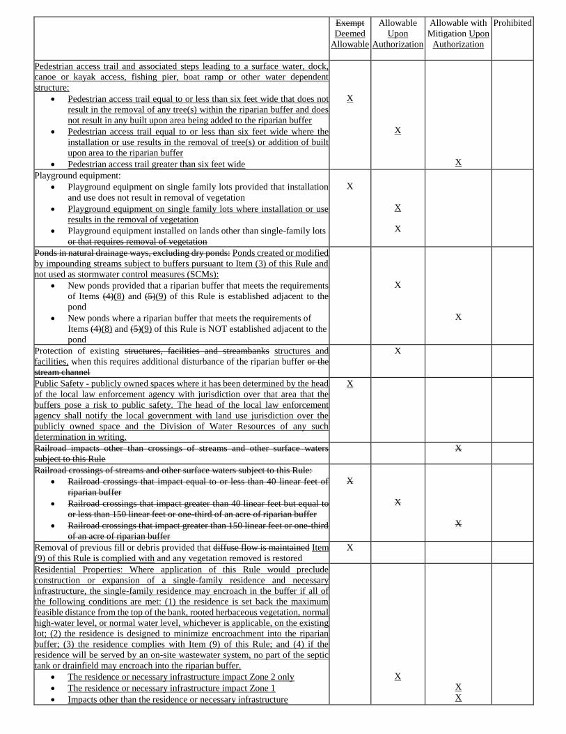
Exempt
Deemed
Allowable
Allowable
Upon
Authorization
Allowable with
Mitigation Upon
Authorization
Prohibited
Pedestrian access trail and associated steps leading to a surface water, dock,
canoe or kayak access, fishing pier, boat ramp or other water dependent
structure:
• Pedestrian access trail equal to or less than six feet wide that does not
result in the removal of any tree(s) within the riparian buffer and does
not result in any built upon area being added to the riparian buffer
• Pedestrian access trail equal to or less than six feet wide where the
installation or use results in the removal of tree(s) or addition of built
upon area to the riparian buffer
• Pedestrian access trail greater than six feet wide
X
X
X
Playground equipment:
• Playground equipment on single family lots provided that installation
and use does not result in removal of vegetation
• Playground equipment on single family lots where installation or use
results in the removal of vegetation
• Playground equipment installed on lands other than single-family lots
or that requires removal of vegetation
X
X
X
Ponds in natural drainage ways, excluding dry ponds: Ponds created or modified
by impounding streams subject to buffers pursuant to Item (3) of this Rule and
not used as stormwater control measures (SCMs):
• New ponds provided that a riparian buffer that meets the requirements
of Items (4)(8) and (5)(9) of this Rule is established adjacent to the
pond
• New ponds where a riparian buffer that meets the requirements of
Items (4)(8) and (5)(9) of this Rule is NOT established adjacent to the
pond
X
X
Protection of existing structures, facilities and streambanks structures and
facilities, when this requires additional disturbance of the riparian buffer or the
stream channel
X
Public Safety - publicly owned spaces where it has been determined by the head
of the local law enforcement agency with jurisdiction over that area that the
buffers pose a risk to public safety. The head of the local law enforcement
agency shall notify the local government with land use jurisdiction over the
publicly owned space and the Division of Water Resources of any such
determination in writing.
X
Railroad impacts other than crossings of streams and other surface waters
subject to this Rule
X
Railroad crossings of streams and other surface waters subject to this Rule:
• Railroad crossings that impact equal to or less than 40 linear feet of
riparian buffer
• Railroad crossings that impact greater than 40 linear feet but equal to
or less than 150 linear feet or one-third of an acre of riparian buffer
• Railroad crossings that impact greater than 150 linear feet or one-third
of an acre of riparian buffer
X
X
X
Removal of previous fill or debris provided that diffuse flow is maintained Item
(9) of this Rule is complied with and any vegetation removed is restored
X
Residential Properties: Where application of this Rule would preclude
construction or expansion of a single-family residence and necessary
infrastructure, the single-family residence may encroach in the buffer if all of
the following conditions are met: (1) the residence is set back the maximum
feasible distance from the top of the bank, rooted herbaceous vegetation, normal
high-water level, or normal water level, whichever is applicable, on the existing
lot; (2) the residence is designed to minimize encroachment into the riparian
buffer; (3) the residence complies with Item (9) of this Rule; and (4) if the
residence will be served by an on-site wastewater system, no part of the septic
tank or drainfield may encroach into the riparian buffer.
• The residence or necessary infrastructure impact Zone 2 only
• The residence or necessary infrastructure impact Zone 1
• Impacts other than the residence or necessary infrastructure
X
X
X
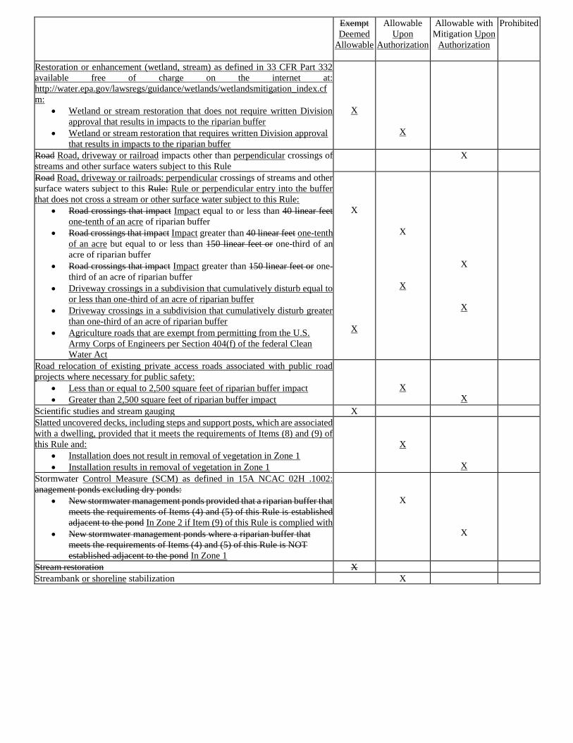
Exempt
Deemed
Allowable
Allowable
Upon
Authorization
Allowable with
Mitigation Upon
Authorization
Prohibited
Restoration or enhancement (wetland, stream) as defined in 33 CFR Part 332
available free of charge on the internet at:
http://water.epa.gov/lawsregs/guidance/wetlands/wetlandsmitigation_index.cf
m:
• Wetland or stream restoration that does not require written Division
approval that results in impacts to the riparian buffer
• Wetland or stream restoration that requires written Division approval
that results in impacts to the riparian buffer
X
X
Road Road, driveway or railroad impacts other than perpendicular crossings of
streams and other surface waters subject to this Rule
X
Road Road, driveway or railroads: perpendicular crossings of streams and other
surface waters subject to this Rule: Rule or perpendicular entry into the buffer
that does not cross a stream or other surface water subject to this Rule:
• Road crossings that impact Impact equal to or less than 40 linear feet
one-tenth of an acre of riparian buffer
• Road crossings that impact Impact greater than 40 linear feet one-tenth
of an acre but equal to or less than 150 linear feet or one-third of an
acre of riparian buffer
• Road crossings that impact Impact greater than 150 linear feet or one-
third of an acre of riparian buffer
• Driveway crossings in a subdivision that cumulatively disturb equal to
or less than one-third of an acre of riparian buffer
• Driveway crossings in a subdivision that cumulatively disturb greater
than one-third of an acre of riparian buffer
• Agriculture roads that are exempt from permitting from the U.S.
Army Corps of Engineers per Section 404(f) of the federal Clean
Water Act
X
X
X
X
X
X
Road relocation of existing private access roads associated with public road
projects where necessary for public safety:
• Less than or equal to 2,500 square feet of riparian buffer impact
• Greater than 2,500 square feet of riparian buffer impact
X
X
Scientific studies and stream gauging X
Slatted uncovered decks, including steps and support posts, which are associated
with a dwelling, provided that it meets the requirements of Items (8) and (9) of
this Rule and:
• Installation does not result in removal of vegetation in Zone 1
• Installation results in removal of vegetation in Zone 1
X
X
Stormwater Control Measure (SCM) as defined in 15A NCAC 02H .1002:
anagement ponds excluding dry ponds:
• New stormwater management ponds provided that a riparian buffer that
meets the requirements of Items (4) and (5) of this Rule is established
adjacent to the pond In Zone 2 if Item (9) of this Rule is complied with
• New stormwater management ponds where a riparian buffer that
meets the requirements of Items (4) and (5) of this Rule is NOT
established adjacent to the pond In Zone 1
X
X
Stream restoration X
Streambank or shoreline stabilization X
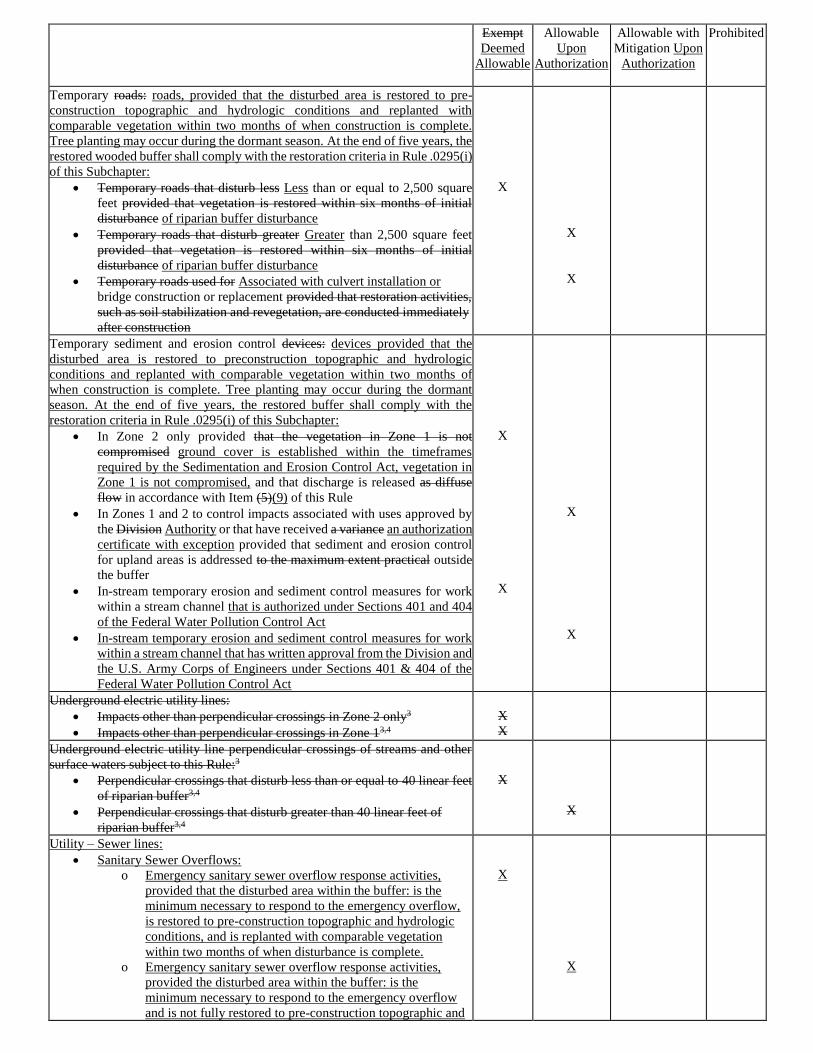
Exempt
Deemed
Allowable
Allowable
Upon
Authorization
Allowable with
Mitigation Upon
Authorization
Prohibited
Temporary roads: roads, provided that the disturbed area is restored to pre-
construction topographic and hydrologic conditions and replanted with
comparable vegetation within two months of when construction is complete.
Tree planting may occur during the dormant season. At the end of five years, the
restored wooded buffer shall comply with the restoration criteria in Rule .0295(i)
of this Subchapter:
• Temporary roads that disturb less Less than or equal to 2,500 square
feet provided that vegetation is restored within six months of initial
disturbance of riparian buffer disturbance
• Temporary roads that disturb greater Greater than 2,500 square feet
provided that vegetation is restored within six months of initial
disturbance of riparian buffer disturbance
• Temporary roads used for Associated with culvert installation or
bridge construction or replacement provided that restoration activities,
such as soil stabilization and revegetation, are conducted immediately
after construction
X
X
X
Temporary sediment and erosion control devices: devices provided that the
disturbed area is restored to preconstruction topographic and hydrologic
conditions and replanted with comparable vegetation within two months of
when construction is complete. Tree planting may occur during the dormant
season. At the end of five years, the restored buffer shall comply with the
restoration criteria in Rule .0295(i) of this Subchapter:
• In Zone 2 only provided that the vegetation in Zone 1 is not
compromised ground cover is established within the timeframes
required by the Sedimentation and Erosion Control Act, vegetation in
Zone 1 is not compromised, and that discharge is released as diffuse
flow in accordance with Item (5)(9) of this Rule
• In Zones 1 and 2 to control impacts associated with uses approved by
the Division Authority or that have received a variance an authorization
certificate with exception provided that sediment and erosion control
for upland areas is addressed to the maximum extent practical outside
the buffer
• In-stream temporary erosion and sediment control measures for work
within a stream channel that is authorized under Sections 401 and 404
of the Federal Water Pollution Control Act
• In-stream temporary erosion and sediment control measures for work
within a stream channel that has written approval from the Division and
the U.S. Army Corps of Engineers under Sections 401 & 404 of the
Federal Water Pollution Control Act
X
X
X
X
Underground electric utility lines:
• Impacts other than perpendicular crossings in Zone 2 only3
• Impacts other than perpendicular crossings in Zone 13,4
X
X
Underground electric utility line perpendicular crossings of streams and other
surface waters subject to this Rule:3
• Perpendicular crossings that disturb less than or equal to 40 linear feet
of riparian buffer3,4
• Perpendicular crossings that disturb greater than 40 linear feet of
riparian buffer3,4
X
X
Utility – Sewer lines:
• Sanitary Sewer Overflows:
o Emergency sanitary sewer overflow response activities,
provided that the disturbed area within the buffer: is the
minimum necessary to respond to the emergency overflow,
is restored to pre-construction topographic and hydrologic
conditions, and is replanted with comparable vegetation
within two months of when disturbance is complete.
o Emergency sanitary sewer overflow response activities,
provided the disturbed area within the buffer: is the
minimum necessary to respond to the emergency overflow
and is not fully restored to pre-construction topographic and
X
X
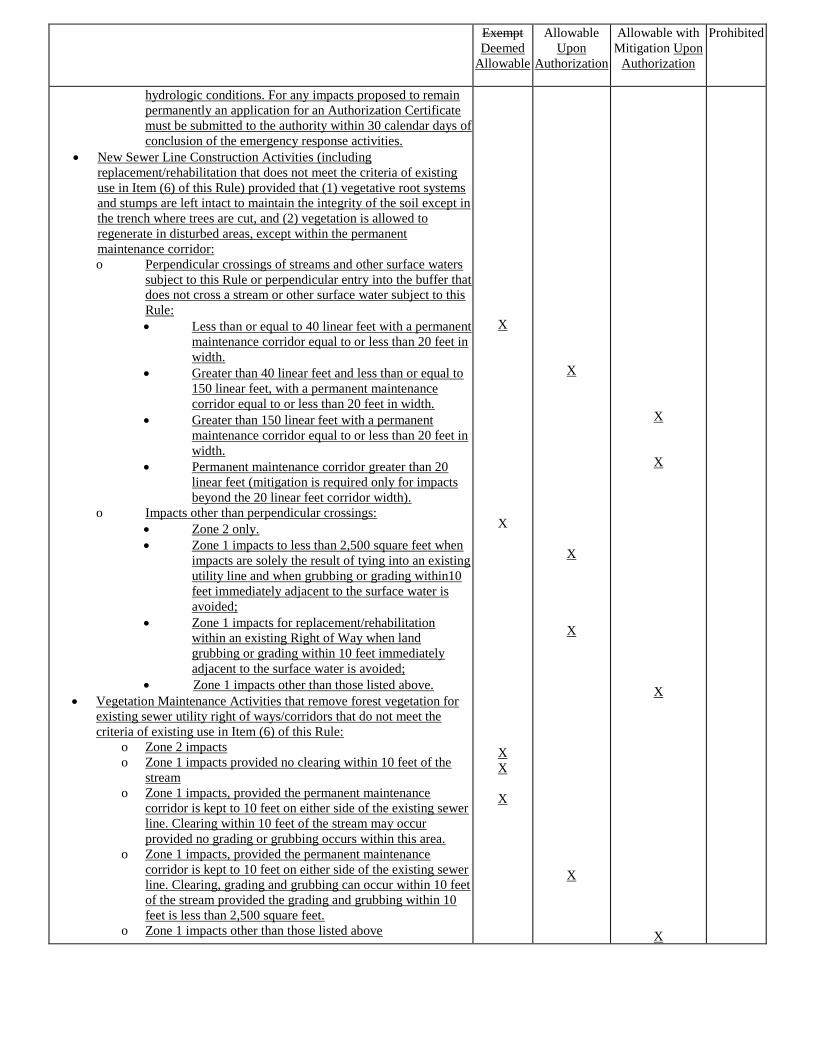
Exempt
Deemed
Allowable
Allowable
Upon
Authorization
Allowable with
Mitigation Upon
Authorization
Prohibited
hydrologic conditions. For any impacts proposed to remain
permanently an application for an Authorization Certificate
must be submitted to the authority within 30 calendar days of
conclusion of the emergency response activities.
• New Sewer Line Construction Activities (including
replacement/rehabilitation that does not meet the criteria of existing
use in Item (6) of this Rule) provided that (1) vegetative root systems
and stumps are left intact to maintain the integrity of the soil except in
the trench where trees are cut, and (2) vegetation is allowed to
regenerate in disturbed areas, except within the permanent
maintenance corridor:
o Perpendicular crossings of streams and other surface waters
subject to this Rule or perpendicular entry into the buffer that
does not cross a stream or other surface water subject to this
Rule:
• Less than or equal to 40 linear feet with a permanent
maintenance corridor equal to or less than 20 feet in
width.
• Greater than 40 linear feet and less than or equal to
150 linear feet, with a permanent maintenance
corridor equal to or less than 20 feet in width.
• Greater than 150 linear feet with a permanent
maintenance corridor equal to or less than 20 feet in
width.
• Permanent maintenance corridor greater than 20
linear feet (mitigation is required only for impacts
beyond the 20 linear feet corridor width).
o Impacts other than perpendicular crossings:
• Zone 2 only.
• Zone 1 impacts to less than 2,500 square feet when
impacts are solely the result of tying into an existing
utility line and when grubbing or grading within10
feet immediately adjacent to the surface water is
avoided;
• Zone 1 impacts for replacement/rehabilitation
within an existing Right of Way when land
grubbing or grading within 10 feet immediately
adjacent to the surface water is avoided;
• Zone 1 impacts other than those listed above.
• Vegetation Maintenance Activities that remove forest vegetation for
existing sewer utility right of ways/corridors that do not meet the
criteria of existing use in Item (6) of this Rule:
o Zone 2 impacts
o Zone 1 impacts provided no clearing within 10 feet of the
stream
o Zone 1 impacts, provided the permanent maintenance
corridor is kept to 10 feet on either side of the existing sewer
line. Clearing within 10 feet of the stream may occur
provided no grading or grubbing occurs within this area.
o Zone 1 impacts, provided the permanent maintenance
corridor is kept to 10 feet on either side of the existing sewer
line. Clearing, grading and grubbing can occur within 10 feet
of the stream provided the grading and grubbing within 10
feet is less than 2,500 square feet.
o Zone 1 impacts other than those listed above
X
X
X
X
X
X
X
X
X
X
X
X
X
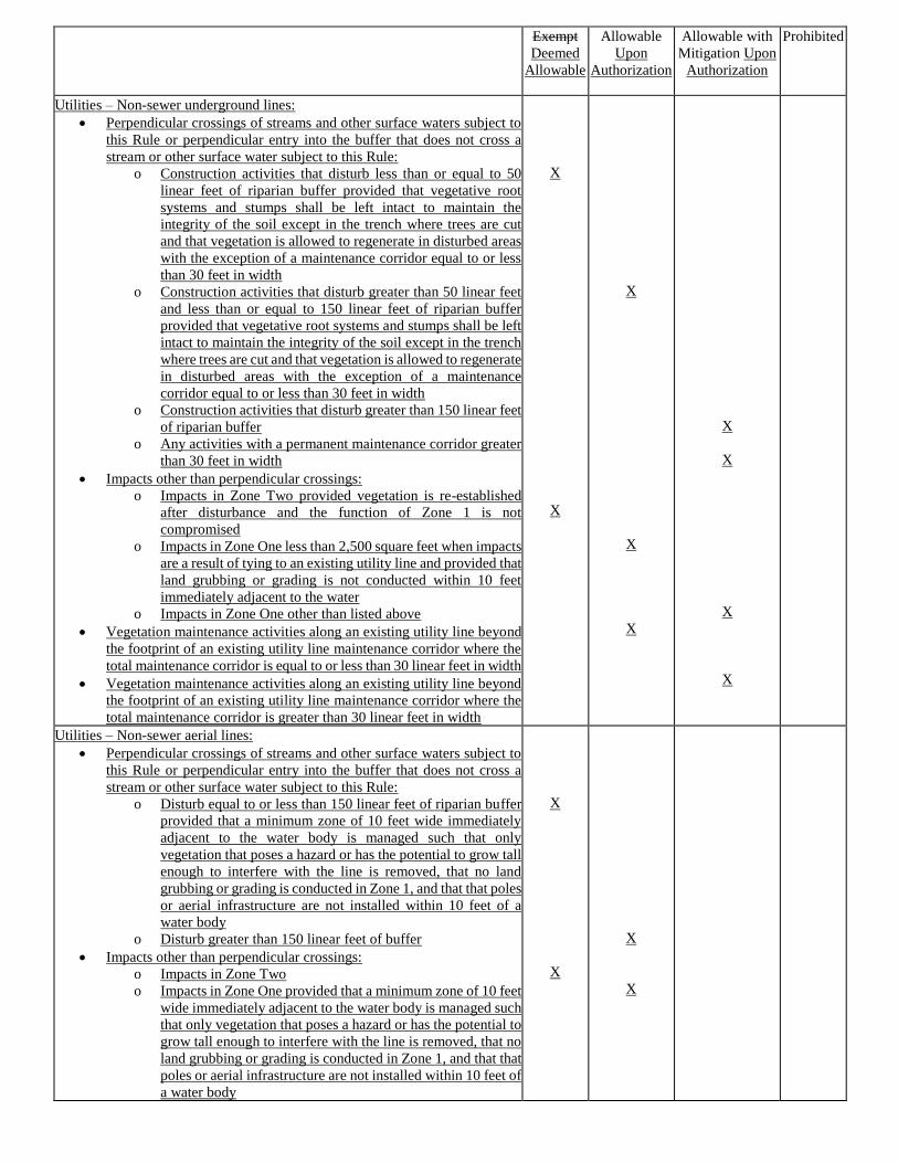
Exempt
Deemed
Allowable
Allowable
Upon
Authorization
Allowable with
Mitigation Upon
Authorization
Prohibited
Utilities – Non-sewer underground lines:
• Perpendicular crossings of streams and other surface waters subject to
this Rule or perpendicular entry into the buffer that does not cross a
stream or other surface water subject to this Rule:
o Construction activities that disturb less than or equal to 50
linear feet of riparian buffer provided that vegetative root
systems and stumps shall be left intact to maintain the
integrity of the soil except in the trench where trees are cut
and that vegetation is allowed to regenerate in disturbed areas
with the exception of a maintenance corridor equal to or less
than 30 feet in width
o Construction activities that disturb greater than 50 linear feet
and less than or equal to 150 linear feet of riparian buffer
provided that vegetative root systems and stumps shall be left
intact to maintain the integrity of the soil except in the trench
where trees are cut and that vegetation is allowed to regenerate
in disturbed areas with the exception of a maintenance
corridor equal to or less than 30 feet in width
o Construction activities that disturb greater than 150 linear feet
of riparian buffer
o Any activities with a permanent maintenance corridor greater
than 30 feet in width
• Impacts other than perpendicular crossings:
o Impacts in Zone Two provided vegetation is re-established
after disturbance and the function of Zone 1 is not
compromised
o Impacts in Zone One less than 2,500 square feet when impacts
are a result of tying to an existing utility line and provided that
land grubbing or grading is not conducted within 10 feet
immediately adjacent to the water
o Impacts in Zone One other than listed above
• Vegetation maintenance activities along an existing utility line beyond
the footprint of an existing utility line maintenance corridor where the
total maintenance corridor is equal to or less than 30 linear feet in width
• Vegetation maintenance activities along an existing utility line beyond
the footprint of an existing utility line maintenance corridor where the
total maintenance corridor is greater than 30 linear feet in width
X
X
X
X
X
X
X
X
X
Utilities – Non-sewer aerial lines:
• Perpendicular crossings of streams and other surface waters subject to
this Rule or perpendicular entry into the buffer that does not cross a
stream or other surface water subject to this Rule:
o Disturb equal to or less than 150 linear feet of riparian buffer
provided that a minimum zone of 10 feet wide immediately
adjacent to the water body is managed such that only
vegetation that poses a hazard or has the potential to grow tall
enough to interfere with the line is removed, that no land
grubbing or grading is conducted in Zone 1, and that that poles
or aerial infrastructure are not installed within 10 feet of a
water body
o Disturb greater than 150 linear feet of buffer
• Impacts other than perpendicular crossings:
o Impacts in Zone Two
o Impacts in Zone One provided that a minimum zone of 10 feet
wide immediately adjacent to the water body is managed such
that only vegetation that poses a hazard or has the potential to
grow tall enough to interfere with the line is removed, that no
land grubbing or grading is conducted in Zone 1, and that that
poles or aerial infrastructure are not installed within 10 feet of
a water body
X
X
X
X
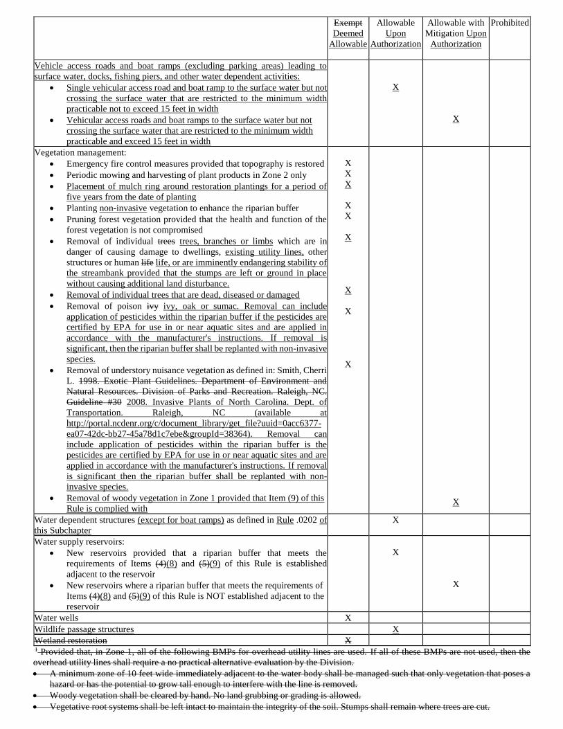
Exempt
Deemed
Allowable
Allowable
Upon
Authorization
Allowable with
Mitigation Upon
Authorization
Prohibited
Vehicle access roads and boat ramps (excluding parking areas) leading to
surface water, docks, fishing piers, and other water dependent activities:
• Single vehicular access road and boat ramp to the surface water but not
crossing the surface water that are restricted to the minimum width
practicable not to exceed 15 feet in width
• Vehicular access roads and boat ramps to the surface water but not
crossing the surface water that are restricted to the minimum width
practicable and exceed 15 feet in width
X
X
Vegetation management:
• Emergency fire control measures provided that topography is restored
• Periodic mowing and harvesting of plant products in Zone 2 only
• Placement of mulch ring around restoration plantings for a period of
five years from the date of planting
• Planting non-invasive vegetation to enhance the riparian buffer
• Pruning forest vegetation provided that the health and function of the
forest vegetation is not compromised
• Removal of individual trees trees, branches or limbs which are in
danger of causing damage to dwellings, existing utility lines, other
structures or human life life, or are imminently endangering stability of
the streambank provided that the stumps are left or ground in place
without causing additional land disturbance.
• Removal of individual trees that are dead, diseased or damaged
• Removal of poison ivy ivy, oak or sumac. Removal can include
application of pesticides within the riparian buffer if the pesticides are
certified by EPA for use in or near aquatic sites and are applied in
accordance with the manufacturer's instructions. If removal is
significant, then the riparian buffer shall be replanted with non-invasive
species.
• Removal of understory nuisance vegetation as defined in: Smith, Cherri
L. 1998. Exotic Plant Guidelines. Department of Environment and
Natural Resources. Division of Parks and Recreation. Raleigh, NC.
Guideline #30 2008. Invasive Plants of North Carolina. Dept. of
Transportation. Raleigh, NC (available at
http://portal.ncdenr.org/c/document_library/get_file?uuid=0acc6377-
ea07-42dc-bb27-45a78d1c7ebe&groupId=38364). Removal can
include application of pesticides within the riparian buffer is the
pesticides are certified by EPA for use in or near aquatic sites and are
applied in accordance with the manufacturer's instructions. If removal
is significant then the riparian buffer shall be replanted with non-
invasive species.
• Removal of woody vegetation in Zone 1 provided that Item (9) of this
Rule is complied with
X
X
X
X
X
X
X
X
X
X
Water dependent structures (except for boat ramps) as defined in Rule .0202 of
this Subchapter
X
Water supply reservoirs:
• New reservoirs provided that a riparian buffer that meets the
requirements of Items (4)(8) and (5)(9) of this Rule is established
adjacent to the reservoir
• New reservoirs where a riparian buffer that meets the requirements of
Items (4)(8) and (5)(9) of this Rule is NOT established adjacent to the
reservoir
X
X
Water wells X
Wildlife passage structures X
Wetland restoration X 1 Provided that, in Zone 1, all of the following BMPs for overhead utility lines are used. If all of these BMPs are not used, then the
overhead utility lines shall require a no practical alternative evaluation by the Division.
• A minimum zone of 10 feet wide immediately adjacent to the water body shall be managed such that only vegetation that poses a
hazard or has the potential to grow tall enough to interfere with the line is removed.
• Woody vegetation shall be cleared by hand. No land grubbing or grading is allowed.
• Vegetative root systems shall be left intact to maintain the integrity of the soil. Stumps shall remain where trees are cut.
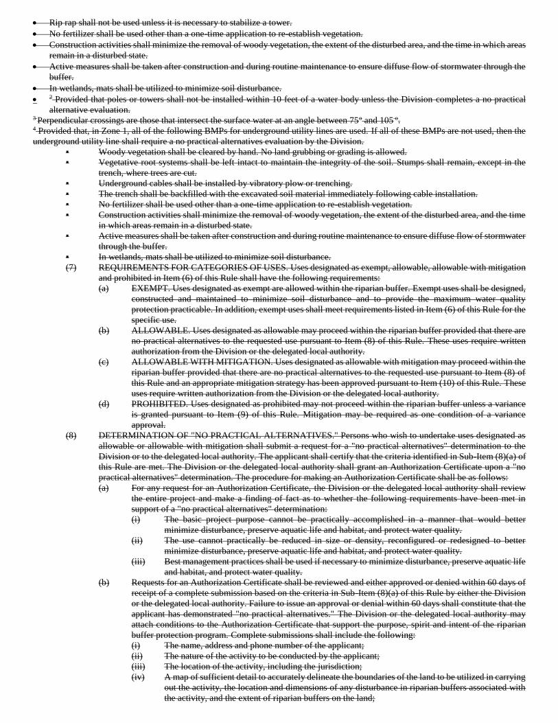
• Rip rap shall not be used unless it is necessary to stabilize a tower.
• No fertilizer shall be used other than a one-time application to re-establish vegetation.
• Construction activities shall minimize the removal of woody vegetation, the extent of the disturbed area, and the time in which areas
remain in a disturbed state.
• Active measures shall be taken after construction and during routine maintenance to ensure diffuse flow of stormwater through the
buffer.
• In wetlands, mats shall be utilized to minimize soil disturbance.
• 2 Provided that poles or towers shall not be installed within 10 feet of a water body unless the Division completes a no practical
alternative evaluation. 3 Perpendicular crossings are those that intersect the surface water at an angle between 75o and 105 o. 4 Provided that, in Zone 1, all of the following BMPs for underground utility lines are used. If all of these BMPs are not used, then the
underground utility line shall require a no practical alternatives evaluation by the Division.
▪ Woody vegetation shall be cleared by hand. No land grubbing or grading is allowed.
▪ Vegetative root systems shall be left intact to maintain the integrity of the soil. Stumps shall remain, except in the
trench, where trees are cut.
▪ Underground cables shall be installed by vibratory plow or trenching.
▪ The trench shall be backfilled with the excavated soil material immediately following cable installation.
▪ No fertilizer shall be used other than a one-time application to re-establish vegetation.
▪ Construction activities shall minimize the removal of woody vegetation, the extent of the disturbed area, and the time
in which areas remain in a disturbed state.
▪ Active measures shall be taken after construction and during routine maintenance to ensure diffuse flow of stormwater
through the buffer.
▪ In wetlands, mats shall be utilized to minimize soil disturbance.
(7) REQUIREMENTS FOR CATEGORIES OF USES. Uses designated as exempt, allowable, allowable with mitigation
and prohibited in Item (6) of this Rule shall have the following requirements:
(a) EXEMPT. Uses designated as exempt are allowed within the riparian buffer. Exempt uses shall be designed,
constructed and maintained to minimize soil disturbance and to provide the maximum water quality
protection practicable. In addition, exempt uses shall meet requirements listed in Item (6) of this Rule for the
specific use.
(b) ALLOWABLE. Uses designated as allowable may proceed within the riparian buffer provided that there are
no practical alternatives to the requested use pursuant to Item (8) of this Rule. These uses require written
authorization from the Division or the delegated local authority.
(c) ALLOWABLE WITH MITIGATION. Uses designated as allowable with mitigation may proceed within the
riparian buffer provided that there are no practical alternatives to the requested use pursuant to Item (8) of
this Rule and an appropriate mitigation strategy has been approved pursuant to Item (10) of this Rule. These
uses require written authorization from the Division or the delegated local authority.
(d) PROHIBITED. Uses designated as prohibited may not proceed within the riparian buffer unless a variance
is granted pursuant to Item (9) of this Rule. Mitigation may be required as one condition of a variance
approval.
(8) DETERMINATION OF "NO PRACTICAL ALTERNATIVES." Persons who wish to undertake uses designated as
allowable or allowable with mitigation shall submit a request for a "no practical alternatives" determination to the
Division or to the delegated local authority. The applicant shall certify that the criteria identified in Sub-Item (8)(a) of
this Rule are met. The Division or the delegated local authority shall grant an Authorization Certificate upon a "no
practical alternatives" determination. The procedure for making an Authorization Certificate shall be as follows:
(a) For any request for an Authorization Certificate, the Division or the delegated local authority shall review
the entire project and make a finding of fact as to whether the following requirements have been met in
support of a "no practical alternatives" determination:
(i) The basic project purpose cannot be practically accomplished in a manner that would better
minimize disturbance, preserve aquatic life and habitat, and protect water quality.
(ii) The use cannot practically be reduced in size or density, reconfigured or redesigned to better
minimize disturbance, preserve aquatic life and habitat, and protect water quality.
(iii) Best management practices shall be used if necessary to minimize disturbance, preserve aquatic life
and habitat, and protect water quality.
(b) Requests for an Authorization Certificate shall be reviewed and either approved or denied within 60 days of
receipt of a complete submission based on the criteria in Sub-Item (8)(a) of this Rule by either the Division
or the delegated local authority. Failure to issue an approval or denial within 60 days shall constitute that the
applicant has demonstrated "no practical alternatives." The Division or the delegated local authority may
attach conditions to the Authorization Certificate that support the purpose, spirit and intent of the riparian
buffer protection program. Complete submissions shall include the following:
(i) The name, address and phone number of the applicant;
(ii) The nature of the activity to be conducted by the applicant;
(iii) The location of the activity, including the jurisdiction;
(iv) A map of sufficient detail to accurately delineate the boundaries of the land to be utilized in carrying
out the activity, the location and dimensions of any disturbance in riparian buffers associated with
the activity, and the extent of riparian buffers on the land;
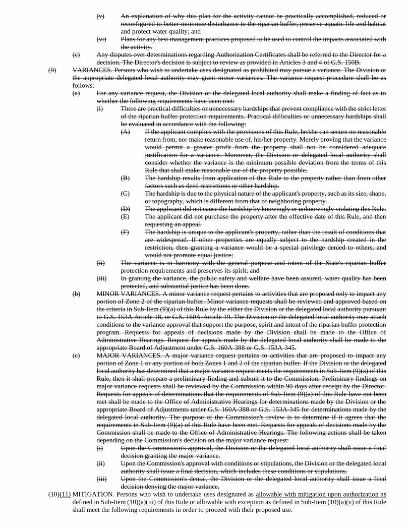
(v) An explanation of why this plan for the activity cannot be practically accomplished, reduced or
reconfigured to better minimize disturbance to the riparian buffer, preserve aquatic life and habitat
and protect water quality; and
(vi) Plans for any best management practices proposed to be used to control the impacts associated with
the activity.
(c) Any disputes over determinations regarding Authorization Certificates shall be referred to the Director for a
decision. The Director's decision is subject to review as provided in Articles 3 and 4 of G.S. 150B.
(9) VARIANCES. Persons who wish to undertake uses designated as prohibited may pursue a variance. The Division or
the appropriate delegated local authority may grant minor variances. The variance request procedure shall be as
follows:
(a) For any variance request, the Division or the delegated local authority shall make a finding of fact as to
whether the following requirements have been met:
(i) There are practical difficulties or unnecessary hardships that prevent compliance with the strict letter
of the riparian buffer protection requirements. Practical difficulties or unnecessary hardships shall
be evaluated in accordance with the following:
(A) If the applicant complies with the provisions of this Rule, he/she can secure no reasonable
return from, nor make reasonable use of, his/her property. Merely proving that the variance
would permit a greater profit from the property shall not be considered adequate
justification for a variance. Moreover, the Division or delegated local authority shall
consider whether the variance is the minimum possible deviation from the terms of this
Rule that shall make reasonable use of the property possible.
(B) The hardship results from application of this Rule to the property rather than from other
factors such as deed restrictions or other hardship.
(C) The hardship is due to the physical nature of the applicant's property, such as its size, shape,
or topography, which is different from that of neighboring property.
(D) The applicant did not cause the hardship by knowingly or unknowingly violating this Rule.
(E) The applicant did not purchase the property after the effective date of this Rule, and then
requesting an appeal.
(F) The hardship is unique to the applicant's property, rather than the result of conditions that
are widespread. If other properties are equally subject to the hardship created in the
restriction, then granting a variance would be a special privilege denied to others, and
would not promote equal justice;
(ii) The variance is in harmony with the general purpose and intent of the State's riparian buffer
protection requirements and preserves its spirit; and
(iii) In granting the variance, the public safety and welfare have been assured, water quality has been
protected, and substantial justice has been done.
(b) MINOR VARIANCES. A minor variance request pertains to activities that are proposed only to impact any
portion of Zone 2 of the riparian buffer. Minor variance requests shall be reviewed and approved based on
the criteria in Sub-Item (9)(a) of this Rule by the either the Division or the delegated local authority pursuant
to G.S. 153A Article 18, or G.S. 160A-Article 19. The Division or the delegated local authority may attach
conditions to the variance approval that support the purpose, spirit and intent of the riparian buffer protection
program. Requests for appeals of decisions made by the Division shall be made to the Office of
Administrative Hearings. Request for appeals made by the delegated local authority shall be made to the
appropriate Board of Adjustment under G.S. 160A-388 or G.S. 153A-345.
(c) MAJOR VARIANCES. A major variance request pertains to activities that are proposed to impact any
portion of Zone 1 or any portion of both Zones 1 and 2 of the riparian buffer. If the Division or the delegated
local authority has determined that a major variance request meets the requirements in Sub-Item (9)(a) of this
Rule, then it shall prepare a preliminary finding and submit it to the Commission. Preliminary findings on
major variance requests shall be reviewed by the Commission within 90 days after receipt by the Director.
Requests for appeals of determinations that the requirements of Sub-Item (9)(a) of this Rule have not been
met shall be made to the Office of Administrative Hearings for determinations made by the Division or the
appropriate Board of Adjustments under G.S. 160A-388 or G.S. 153A-345 for determinations made by the
delegated local authority. The purpose of the Commission's review is to determine if it agrees that the
requirements in Sub-Item (9)(a) of this Rule have been met. Requests for appeals of decisions made by the
Commission shall be made to the Office of Administrative Hearings. The following actions shall be taken
depending on the Commission's decision on the major variance request:
(i) Upon the Commission's approval, the Division or the delegated local authority shall issue a final
decision granting the major variance.
(ii) Upon the Commission's approval with conditions or stipulations, the Division or the delegated local
authority shall issue a final decision, which includes these conditions or stipulations.
(iii) Upon the Commission's denial, the Division or the delegated local authority shall issue a final
decision denying the major variance.
(10)(11) MITIGATION. Persons who wish to undertake uses designated as allowable with mitigation upon authorization as
defined in Sub-Item (10)(a)(iii) of this Rule or allowable with exception as defined in Sub-Item (10)(a)(v) of this Rule
shall meet the following requirements in order to proceed with their proposed use.
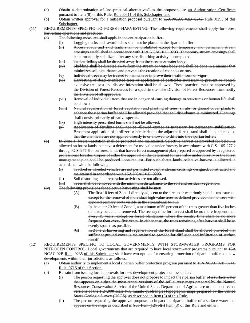
(a) Obtain a determination of "no practical alternatives" to the proposed use an Authorization Certificate
pursuant to Item (8) of this Rule. Rule .0611 of this Subchapter; and
(b) Obtain written approval for a mitigation proposal pursuant to 15A NCAC 02B .0242. Rule .0295 of this
Subchapter.
(11) REQUIREMENTS SPECIFIC TO FOREST HARVESTING. The following requirements shall apply for forest
harvesting operations and practices.
(a) The following measures shall apply in the entire riparian buffer:
(i) Logging decks and sawmill sites shall not be placed in the riparian buffer.
(ii) Access roads and skid trails shall be prohibited except for temporary and permanent stream
crossings established in accordance with 15A NCAC 01I .0203. Temporary stream crossings shall
be permanently stabilized after any site disturbing activity is completed.
(iii) Timber felling shall be directed away from the stream or water body.
(iv) Skidding shall be directed away from the stream or water body and shall be done in a manner that
minimizes soil disturbance and prevents the creation of channels or ruts.
(v) Individual trees may be treated to maintain or improve their health, form or vigor.
(vi) Harvesting of dead or infected trees or application of pesticides necessary to prevent or control
extensive tree pest and disease infestation shall be allowed. These practices must be approved by
the Division of Forest Resources for a specific site. The Division of Forest Resources must notify
the Division of all approvals.
(vii) Removal of individual trees that are in danger of causing damage to structures or human life shall
be allowed.
(viii) Natural regeneration of forest vegetation and planting of trees, shrubs, or ground cover plants to
enhance the riparian buffer shall be allowed provided that soil disturbance is minimized. Plantings
shall consist primarily of native species.
(ix) High intensity prescribed burns shall not be allowed.
(x) Application of fertilizer shall not be allowed except as necessary for permanent stabilization.
Broadcast application of fertilizer or herbicides to the adjacent forest stand shall be conducted so
that the chemicals are not applied directly to or allowed to drift into the riparian buffer.
(b) In Zone 1, forest vegetation shall be protected and maintained. Selective harvest as provided for below is
allowed on forest lands that have a deferment for use value under forestry in accordance with G.S. 105-277.2
through G.S. 277.6 or on forest lands that have a forest management plan prepared or approved by a registered
professional forester. Copies of either the approval of the deferment for use value under forestry or the forest
management plan shall be produced upon request. For such forest lands, selective harvest is allowed in
accordance with the following:
(i) Tracked or wheeled vehicles are not permitted except at stream crossings designed, constructed and
maintained in accordance with 15A NCAC 01I .0203.
(ii) Soil disturbing site preparation activities are not allowed.
(iii) Trees shall be removed with the minimum disturbance to the soil and residual vegetation.
(iv) The following provisions for selective harvesting shall be met:
(A) The first 10 feet of Zone 1 directly adjacent to the stream or waterbody shall be undisturbed
except for the removal of individual high value trees as defined provided that no trees with
exposed primary roots visible in the streambank be cut.
(B) In the outer 20 feet of Zone 1, a maximum of 50 percent of the trees greater than five inches
dbh may be cut and removed. The reentry time for harvest shall be no more frequent than
every 15 years, except on forest plantations where the reentry time shall be no more
frequent than every five years. In either case, the trees remaining after harvest shall be as
evenly spaced as possible.
(C) In Zone 2, harvesting and regeneration of the forest stand shall be allowed provided that
sufficient ground cover is maintained to provide for diffusion and infiltration of surface
runoff.
(12) REQUIREMENTS SPECIFIC TO LOCAL GOVERNMENTS WITH STORMWATER PROGRAMS FOR
NITROGEN CONTROL. Local governments that are required to have local stormwater programs pursuant to 15A
NCAC 02B Rule .0235 of this Subchapter shall have two options for ensuring protection of riparian buffers on new
developments within their jurisdictions as follows.
(a) Obtain authority to implement a local riparian buffer protection program pursuant to 15A NCAC 02B .0241.
Rule .0715 of this Section.
(b) Refrain from issuing local approvals for new development projects unless either:
(i) The person requesting the approval does not propose to impact the riparian buffer of a surface water
that appears on either the most recent versions of the soil survey maps prepared by the Natural
Resources Conservation Service of the United States Department of Agriculture or the most recent
versions of the 1:24,000 scale (7.5 minute quadrangle) topographic maps prepared by the United
States Geologic Survey (USGS). as described in Item (3) of this Rule.
(ii) The person requesting the approval proposes to impact the riparian buffer of a surface water that
appears on the maps as described in Sub-Item (12)(b)(i) Item (3) of this Rule and either:
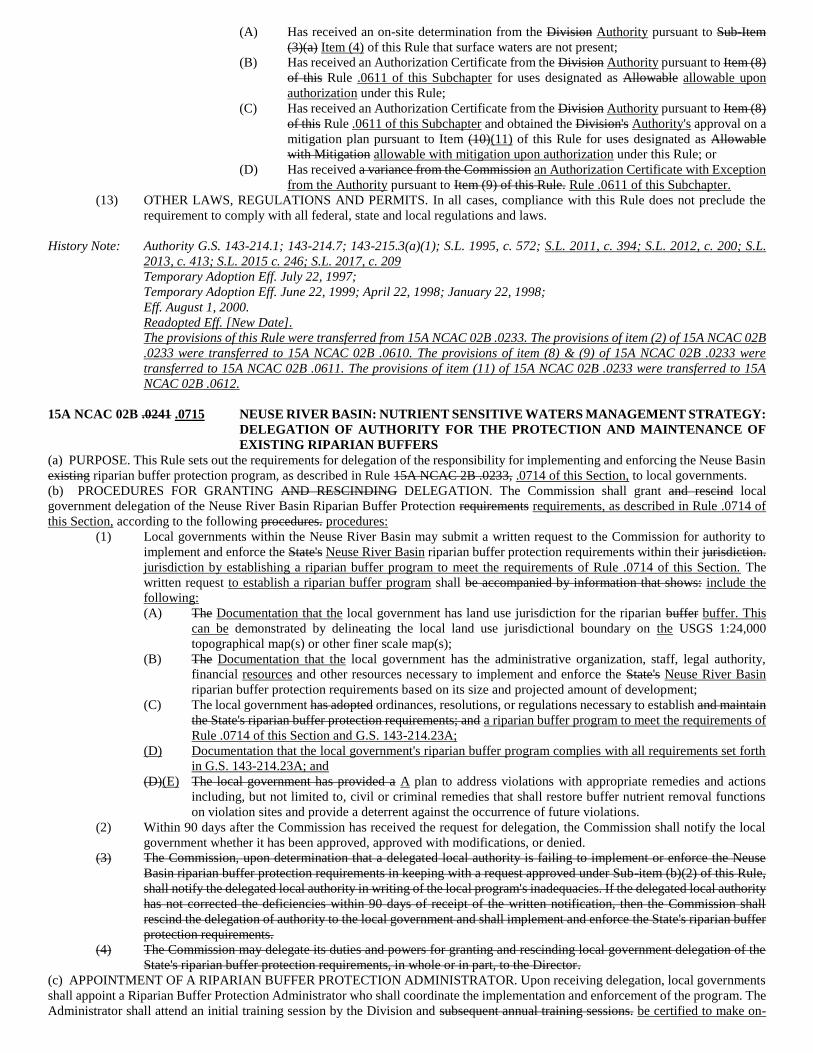
(A) Has received an on-site determination from the Division Authority pursuant to Sub-Item
(3)(a) Item (4) of this Rule that surface waters are not present;
(B) Has received an Authorization Certificate from the Division Authority pursuant to Item (8)
of this Rule .0611 of this Subchapter for uses designated as Allowable allowable upon
authorization under this Rule;
(C) Has received an Authorization Certificate from the Division Authority pursuant to Item (8)
of this Rule .0611 of this Subchapter and obtained the Division's Authority's approval on a
mitigation plan pursuant to Item (10)(11) of this Rule for uses designated as Allowable
with Mitigation allowable with mitigation upon authorization under this Rule; or
(D) Has received a variance from the Commission an Authorization Certificate with Exception
from the Authority pursuant to Item (9) of this Rule. Rule .0611 of this Subchapter.
(13) OTHER LAWS, REGULATIONS AND PERMITS. In all cases, compliance with this Rule does not preclude the
requirement to comply with all federal, state and local regulations and laws.
History Note: Authority G.S. 143-214.1; 143-214.7; 143-215.3(a)(1); S.L. 1995, c. 572; S.L. 2011, c. 394; S.L. 2012, c. 200; S.L.
2013, c. 413; S.L. 2015 c. 246; S.L. 2017, c. 209
Temporary Adoption Eff. July 22, 1997;
Temporary Adoption Eff. June 22, 1999; April 22, 1998; January 22, 1998;
Eff. August 1, 2000.
Readopted Eff. [New Date].
The provisions of this Rule were transferred from 15A NCAC 02B .0233. The provisions of item (2) of 15A NCAC 02B
.0233 were transferred to 15A NCAC 02B .0610. The provisions of item (8) & (9) of 15A NCAC 02B .0233 were
transferred to 15A NCAC 02B .0611. The provisions of item (11) of 15A NCAC 02B .0233 were transferred to 15A
NCAC 02B .0612.
15A NCAC 02B .0241 .0715 NEUSE RIVER BASIN: NUTRIENT SENSITIVE WATERS MANAGEMENT STRATEGY:
DELEGATION OF AUTHORITY FOR THE PROTECTION AND MAINTENANCE OF
EXISTING RIPARIAN BUFFERS
(a) PURPOSE. This Rule sets out the requirements for delegation of the responsibility for implementing and enforcing the Neuse Basin
existing riparian buffer protection program, as described in Rule 15A NCAC 2B .0233, .0714 of this Section, to local governments.
(b) PROCEDURES FOR GRANTING AND RESCINDING DELEGATION. The Commission shall grant and rescind local
government delegation of the Neuse River Basin Riparian Buffer Protection requirements requirements, as described in Rule .0714 of
this Section, according to the following procedures. procedures:
(1) Local governments within the Neuse River Basin may submit a written request to the Commission for authority to
implement and enforce the State's Neuse River Basin riparian buffer protection requirements within their jurisdiction.
jurisdiction by establishing a riparian buffer program to meet the requirements of Rule .0714 of this Section. The
written request to establish a riparian buffer program shall be accompanied by information that shows: include the
following:
(A) The Documentation that the local government has land use jurisdiction for the riparian buffer buffer. This
can be demonstrated by delineating the local land use jurisdictional boundary on the USGS 1:24,000
topographical map(s) or other finer scale map(s);
(B) The Documentation that the local government has the administrative organization, staff, legal authority,
financial resources and other resources necessary to implement and enforce the State's Neuse River Basin
riparian buffer protection requirements based on its size and projected amount of development;
(C) The local government has adopted ordinances, resolutions, or regulations necessary to establish and maintain
the State's riparian buffer protection requirements; and a riparian buffer program to meet the requirements of
Rule .0714 of this Section and G.S. 143-214.23A;
(D) Documentation that the local government's riparian buffer program complies with all requirements set forth
in G.S. 143-214.23A; and
(D)(E) The local government has provided a A plan to address violations with appropriate remedies and actions
including, but not limited to, civil or criminal remedies that shall restore buffer nutrient removal functions
on violation sites and provide a deterrent against the occurrence of future violations.
(2) Within 90 days after the Commission has received the request for delegation, the Commission shall notify the local
government whether it has been approved, approved with modifications, or denied.
(3) The Commission, upon determination that a delegated local authority is failing to implement or enforce the Neuse
Basin riparian buffer protection requirements in keeping with a request approved under Sub-item (b)(2) of this Rule,
shall notify the delegated local authority in writing of the local program's inadequacies. If the delegated local authority
has not corrected the deficiencies within 90 days of receipt of the written notification, then the Commission shall
rescind the delegation of authority to the local government and shall implement and enforce the State's riparian buffer
protection requirements.
(4) The Commission may delegate its duties and powers for granting and rescinding local government delegation of the
State's riparian buffer protection requirements, in whole or in part, to the Director.
(c) APPOINTMENT OF A RIPARIAN BUFFER PROTECTION ADMINISTRATOR. Upon receiving delegation, local governments
shall appoint a Riparian Buffer Protection Administrator who shall coordinate the implementation and enforcement of the program. The
Administrator shall attend an initial training session by the Division and subsequent annual training sessions. be certified to make on-
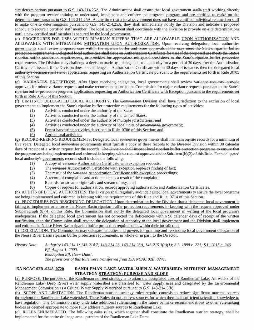
site determinations pursuant to G.S. 143-214.25A. The Administrator shall ensure that local government staffs staff working directly
with the program receive training to understand, implement and enforce the program. program and are certified to make on-site
determinations pursuant to G.S. 143-214.25A. At any time that a local government does not have a certified individual retained on staff
to make on-site determinations pursuant to G.S. 143-214.25A, they shall immediately notify the Division and indicate a proposed
schedule to secure a certified staff member. The local government shall coordinate with the Division to provide on-site determinations
until a new certified staff member is secured by the local government.
(d) PROCEDURES FOR USES WITHIN RIPARIAN BUFFERS THAT ARE ALLOWABLE UPON AUTHORIZATION AND
ALLOWABLE WITH MITIGATION. MITIGATION UPON AUTHORIZATION. Upon receiving delegation, local authorities
governments shall review proposed uses within the riparian buffer and issue approvals if the uses meet the State's riparian buffer
protection requirements. Delegated local authorities shall issue an Authorization Certificate for uses if the proposed use meets the State's
riparian buffer protection requirements, or provides for appropriate mitigated provisions to the State's riparian buffer protection
requirements. The Division may challenge a decision made by a delegated local authority for a period of 30 days after the Authorization
Certificate is issued. If the Division does not challenge an Authorization Certificate within 30 days of issuance, then the delegated local
authority's decision shall stand. applications requesting an Authorization Certificate pursuant to the requirements set forth in Rule .0705
of this Section.
(e) VARIANCES. EXCEPTIONS. After Upon receiving delegation, local governments shall review variance requests, provide
approvals for minor variance requests and make recommendations to the Commission for major variance requests pursuant to the State's
riparian buffer protection program. applications requesting an Authorization Certificate with Exception pursuant to the requirements set
forth in Rule .0705 of this Section.
(f) LIMITS OF DELEGATED LOCAL AUTHORITY. The Commission Division shall have jurisdiction to the exclusion of local
governments to implement the State's riparian buffer protection requirements for the following types of activities:
(1) Activities conducted under the authority of the State;
(2) Activities conducted under the authority of the United States;
(3) Activities conducted under the authority of multiple jurisdictions; and
(4) Activities conducted under the authority of local units of government. government;
(5) Forest harvesting activities described in Rule .0706 of this Section; and
(6) Agricultural activities.
(g) RECORD-KEEPING REQUIREMENTS. Delegated local authorities governments shall maintain on-site records for a minimum of
five years. Delegated local authorities governments must furnish a copy of these records to the Director Division within 30 calendar
days of receipt of a written request for the records. The Division shall inspect local riparian buffer protection programs to ensure that
the programs are being implemented and enforced in keeping with a request approved under Sub-item (b)(2) of this Rule. Each delegated
local authority's governments records shall include the following:
(1) A copy of variance Authorization Certificate with exception requests;
(2) The variance Authorization Certificate with exception request's finding of fact;
(3) The result of the variance Authorization Certificate with exception proceedings;
(4) A record of complaints and action taken as a result of the complaint;
(5) Records for stream origin calls and stream ratings; and
(6) Copies of request for authorization, records approving authorization and Authorization Certificates.
(h) AUDITS OF LOCAL AUTHORITIES. The Division shall regularly audit delegated local governments to ensure the local programs
are being implemented and enforced in keeping with the requirements of this Rule and Rule .0714 of this Section.
(i) PROCEDURES FOR RESCINDING DELEGATION. Upon determination by the Division that a delegated local government is
failing to implement or enforce the Neuse Basin riparian buffer protection requirements in keeping with the request approved under
Subparagraph (b)(4) of this Rule, the Commission shall notify the delegated local government in writing of the local program's
inadequacies. If the delegated local government has not corrected the deficiencies within 90 calendar days of receipt of the written
notification, then the Commission shall rescind the delegation of authority to the local government and the Division shall implement
and enforce the Neuse River Basin riparian buffer protection requirements within their jurisdiction.
(j) DELEGATION. The Commission may delegate its duties and powers for granting and rescinding local government delegation of
the Neuse River Basin riparian buffer protection requirements, in whole or in part, to the Director.
History Note: Authority 143-214.1; 143-214.7; 143-214.23, 143-214.23A, 143-215.3(a)(1); S.L. 1998 c. 221; S.L. 2015 c. 246
Eff. August 1, 2000.
Readoption Eff. [New Date].
The provisions of this Rule were transferred from 15A NCAC 02B .0241.
15A NCAC 02B .0248 .0720 RANDLEMAN LAKE WATER SUPPLY WATERSHED: NUTRIENT MANAGEMENT
STRATEGY STRATEGY: PURPOSE AND SCOPE
(a) PURPOSE. The purpose of the Randleman nutrient strategy is to attain the designated uses of Randleman Lake. All waters of the
Randleman Lake (Deep River) water supply watershed are classified for water supply uses and designated by the Environmental
Management Commission as a Critical Water Supply Watershed pursuant to G.S. 143-214.5(b).
(b) SCOPE AND LIMITATION. The Randleman nutrient strategy rules require controls to reduce significant nutrient sources
throughout the Randleman Lake watershed. These Rules do not address sources for which there is insufficient scientific knowledge to
base regulation. The Commission may undertake additional rulemaking in the future or make recommendations to other rulemaking
bodies as deemed appropriate to more fully address nutrient sources to Randleman Lake.
(c) RULES ENUMERATED. The following rules rules, which together shall constitute the Randleman nutrient strategy, shall be
implemented for the entire drainage area upstream of the Randleman Lake Dam:
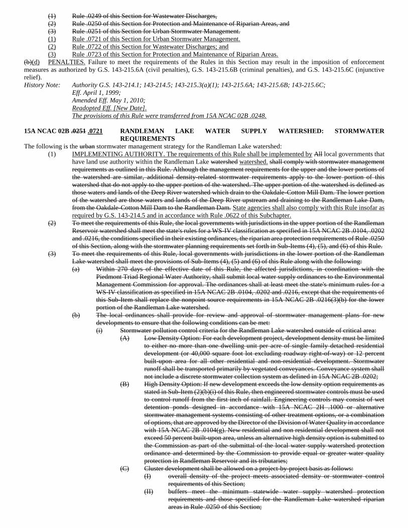
(1) Rule .0249 of this Section for Wastewater Discharges,
(2) Rule .0250 of this Section for Protection and Maintenance of Riparian Areas, and
(3) Rule .0251 of this Section for Urban Stormwater Management.
(1) Rule .0721 of this Section for Urban Stormwater Management.
(2) Rule .0722 of this Section for Wastewater Discharges; and
(3) Rule .0723 of this Section for Protection and Maintenance of Riparian Areas.
(b)(d) PENALTIES. Failure to meet the requirements of the Rules in this Section may result in the imposition of enforcement
measures as authorized by G.S. 143-215.6A (civil penalties), G.S. 143-215.6B (criminal penalties), and G.S. 143-215.6C (injunctive
relief).
History Note: Authority G.S. 143-214.1; 143-214.5; 143-215.3(a)(1); 143-215.6A; 143-215.6B; 143-215.6C;
Eff. April 1, 1999;
Amended Eff. May 1, 2010;
Readopted Eff. [New Date].
The provisions of this Rule were transferred from 15A NCAC 02B .0248.
15A NCAC 02B .0251 .0721 RANDLEMAN LAKE WATER SUPPLY WATERSHED: STORMWATER
REQUIREMENTS
The following is the urban stormwater management strategy for the Randleman Lake watershed:
(1) IMPLEMENTING AUTHORITY. The requirements of this Rule shall be implemented by All local governments that
have land use authority within the Randleman Lake watershed watershed. shall comply with stormwater management
requirements as outlined in this Rule. Although the management requirements for the upper and the lower portions of
the watershed are similar, additional density-related stormwater requirements apply to the lower portion of this
watershed that do not apply to the upper portion of the watershed. The upper portion of the watershed is defined as
those waters and lands of the Deep River watershed which drain to the Oakdale-Cotton Mill Dam. The lower portion
of the watershed are those waters and lands of the Deep River upstream and draining to the Randleman Lake Dam,
from the Oakdale-Cotton Mill Dam to the Randleman Dam. State agencies shall also comply with this Rule insofar as
required by G.S. 143-214.5 and in accordance with Rule .0622 of this Subchapter.
(2) To meet the requirements of this Rule, the local governments with jurisdictions in the upper portion of the Randleman
Reservoir watershed shall meet the state's rules for a WS-IV classification as specified in 15A NCAC 2B .0104, .0202
and .0216, the conditions specified in their existing ordinances, the riparian area protection requirements of Rule .0250
of this Section, along with the stormwater planning requirements set forth in Sub-Items (4), (5), and (6) of this Rule.
(3) To meet the requirements of this Rule, local governments with jurisdictions in the lower portion of the Randleman
Lake watershed shall meet the provisions of Sub-Items (4), (5) and (6) of this Rule along with the following:
(a) Within 270 days of the effective date of this Rule, the affected jurisdictions, in coordination with the
Piedmont Triad Regional Water Authority, shall submit local water supply ordinances to the Environmental
Management Commission for approval. The ordinances shall at least meet the state's minimum rules for a
WS-IV classification as specified in 15A NCAC 2B .0104, .0202 and .0216, except that the requirements of
this Sub-Item shall replace the nonpoint source requirements in 15A NCAC 2B .0216(3)(b) for the lower
portion of the Randleman Lake watershed.
(b) The local ordinances shall provide for review and approval of stormwater management plans for new
developments to ensure that the following conditions can be met:
(i) Stormwater pollution control criteria for the Randleman Lake watershed outside of critical area:
(A) Low Density Option: For each development project, development density must be limited
to either no more than one dwelling unit per acre of single family detached residential
development (or 40,000 square foot lot excluding roadway right-of-way) or 12 percent
built-upon area for all other residential and non-residential development. Stormwater
runoff shall be transported primarily by vegetated conveyances. Conveyance system shall
not include a discrete stormwater collection system as defined in 15A NCAC 2B .0202;
(B) High Density Option: If new development exceeds the low density option requirements as
stated in Sub-Item (2)(b)(i) of this Rule, then engineered stormwater controls must be used
to control runoff from the first inch of rainfall. Engineering controls may consist of wet
detention ponds designed in accordance with 15A NCAC 2H .1000 or alternative
stormwater management systems consisting of other treatment options, or a combination
of options, that are approved by the Director of the Division of Water Quality in accordance
with 15A NCAC 2B .0104(g). New residential and non residential development shall not
exceed 50 percent built-upon area, unless an alternative high density option is submitted to
the Commission as part of the submittal of the local water supply watershed protection
ordinance and determined by the Commission to provide equal or greater water quality
protection in Randleman Reservoir and its tributaries;
(C) Cluster development shall be allowed on a project-by-project basis as follows:
(I) overall density of the project meets associated density or stormwater control
requirements of this Section;
(II) buffers meet the minimum statewide water supply watershed protection
requirements and those specified for the Randleman Lake watershed riparian
areas in Rule .0250 of this Section;
(III) built-upon areas are designed and located to minimize stormwater runoff impact
to the receiving waters, minimize concentrated stormwater flow, maximize the
use of sheet flow through vegetated areas, and maximize the flow length through
vegetated areas;
(IV) areas of concentrated development are located in upland areas and away, to the
maximum extent practicable, from surface waters and drainageways;
(V) remainder of tract to remain in vegetated or natural state by utilization of one of
the methods provided in Sub-Item 3(b)(i)(C)(VI) of this Rule;
(VI) area in the vegetated or natural state may be conveyed to a property owners
association; a local government for preservation as a park or greenway; a
conservation organization; or placed in a permanent conservation or farmland
preservation easement;
(VII) a maintenance agreement for the vegetated or natural area shall be filed with the
Register of Deeds; and
(VIII) cluster development that meets the applicable low density option requirements
shall transport stormwater runoff from the development by vegetated conveyances
to the maximum extent practicable;
(D) If local governments choose the high density development option which requires
engineered stormwater controls, then they shall assume ultimate responsibility for
operation and maintenance of the required controls as outlined in Rule .0104 of this
Subchapter;
(E) Impervious cover shall be minimized to the maximum extent practical through clustering,
narrower and shorter paved areas (streets, driveways, sidewalks, cul-de-sacs, and parking
lots), and spreading rooftop and other impervious area runoff over pervious areas. Land
clearing during the construction process shall be limited to the maximum extent practical.
The local government permit shall require recorded deed restrictions and protective
covenants to ensure that development activities maintain the development consistent with
the plans and specifications approved by the local governments;
(F) The project is in compliance with the riparian area protection requirements as specified in
15A NCAC 2B .0250 (Randleman Lake riparian area rule);
(G) No new development shall be allowed within 50 feet of waters affected by the Randleman
riparian area rule 15A NCAC 2B .0250;
(H) New development meeting the high density option shall be located at least 100 feet from
perennial waters as identified on topo or soil survey maps; however, within the area
between 50 and 100 feet adjacent to the perennial water body, water dependent structures,
or other structures, such as flag poles, signs and security lights, which result in only
diminimus increases in impervious area and public projects such as road crossings and
greenways may be allowed where no practicable alternative exists; these activities shall
minimize built-upon surface area, divert runoff away from surface waters and maximize
the utilization of BMPs;
(I) For local governments that do not use the high density option, a maximum of 10 percent
of each jurisdiction's portion of the watershed outside of the critical area as delineated on
April 1, 1999 may be developed with new development projects and expansions to existing
development of up to 70 percent built-upon surface area in addition to the new development
approved in compliance with the appropriate requirements of Sub-Item (3)(b)(ii)(A) of this
Rule. For expansions to existing development, the existing built-upon surface area shall
not be counted toward the allowed 70 percent built-upon surface area. A local government
having jurisdiction within the watershed may transfer, in whole or in part, its right to the
10 percent/70 percent land area to local government within the watershed upon submittal
of a joint resolution for review by the Commission. When the designated water supply
watershed area is composed of public land, such as National Forest land, local governments
may count the public land acreage within the designated watershed area outside of the
critical area in figuring the acreage allowed under this provision. Each project shall, to the
maximum extent practicable, minimize built-upon surface area, direct stormwater runoff
away from surface waters and incorporate best management practices to minimize water
quality impacts;
(ii) Stormwater pollution control criteria for critical areas of the watershed:
(A) Low Density Option: Development density must be limited to either no more than one
dwelling unit per two acres of single family detached residential development (or 80,000
square foot lot excluding roadway right-of-way) or six percent built-upon area for all other
residential and non-residential development. Stormwater runoff shall be transported
primarily by vegetated conveyances to the maximum extent practicable;
(B) High Density Option: If new development exceeds the low density option requirements as
stated in Sub-Item (3)(b)(ii) of this Rule, then engineered stormwater controls must be used
to control runoff from the first inch of rainfall. New residential and non residential
development shall not exceed 30 percent built-upon area;
(C) No new permitted sites for land application of residuals or petroleum contaminated soils
shall be allowed;
(D) No new landfills shall be allowed; and
(E) Sub-Items (3)(b)(i)(C)-(H) of this Rule also apply to the critical area.
(2) SUBWATERSHEDS. For the purpose of this Rule, the Randleman Lake Watershed is divided into subwatersheds as
follows:
(a) the upper portion of the watershed is defined as those waters and lands of the Deep River watershed which
drain to the Oakdale-Cotton Mill Dam;
(b) the lower portion of the watershed are those waters and lands of the Deep River upstream and draining to the
Randleman Lake Dam, from the Oakdale-Cotton Mill Dam to the Randleman Dam;
(c) Oak Hollow Lake subwatershed is defined as all land areas draining to Oak Hollow Lake;
(d) High Point Lake subwatershed is defined as all land areas draining to High Point Lake, East Fork Deep River
and West Fork Deep River from Oak Hollow Lake Dam; and
(e) Deep River 1 subwatershed is defined as all land areas draining to the Deep River from High Point Lake
Dam to Freeman Mill Dam.
(4)(3) COMPREHENSIVE STORMWATER MANAGEMENT PLANS. Within 12 months of the effective date of adoption
of this Rule, all All local governments with jurisdictions jurisdiction in the Randleman Lake watershed shall develop
implement and maintain comprehensive stormwater management plans and submit those plans to the Commission for
review and approval. Comprehensive stormwater management plans meeting that meet or exceed the criteria set forth
in Subparts (4)(a) through (4)(f) Sub-Items (3)(a) through (3)(f) of this Rule shall be approved. Rule. Within six
months of the Commission's approval of the local plan, subject local governments shall adopt and implement their
approved plan. Those Stormwater management plans shall include, but not be limited to, the following:
(a) Evaluation evaluation of existing land use within Oak Hollow Lake subwatershed, High Point Lake
subwatershed and Deep River 1 subwatershed in the Randleman Lake watershed with recommendations that
show how overall built-upon area (for existing and future development) for each subwatershed can be
minimized and high intensity land uses can be targeted away from surface waters and sensitive areas. Oak
Hollow Lake subwatershed is defined as all land areas draining to Oak Hollow Lake. High Point Lake
subwatershed is defined as all land areas draining to High Point Lake, East Fork Deep River and West Fork
Deep River from Oak Hollow Lake Dam. Deep River 1 subwatershed is defined as all land areas draining to
the Deep River from High Point Lake Dam to Freeman Mill Dam. This evaluation shall be done by the local
governments having jurisdiction in those watersheds, working in cooperation with the PTRWA; Piedmont
Triad Regional Water Authority;
(b) Coordination coordination between all affected jurisdictions to encourage their development in the existing
urban areas. The planning effort shall include provisions for areas of contiguous open space to be protected
through conservation easements or other long-term protection measures and provisions to direct
infrastructure growth towards existing urban development corridors rather than to rural lands;
(c) Evaluation evaluation of existing ordinances, municipal programs (maintenance, street cleaning, etc.) and
other local policies to identify opportunities for stormwater quality improvements including reducing the
amount of built-upon area that is required for uses such as parking, building setbacks, road widths and cul-
de-sacs. The evaluations shall consider development options such as multiple story buildings, mixed use to
encourage pedestrian travel and mass transit and an identification of municipal activities and procedures that
may be modified to allow for stormwater pollution prevention opportunities;
(d) Implementation implementation of watershed protection public education programs;
(e) Identification identification and removal of illegal discharges; and
(f) Identification identification of suitable locations for potential stormwater retrofits (such as riparian areas)
that could be funded by various sources.
(5) Local governments may submit a more stringent local stormwater management program plan. Local stormwater
management programs and modifications to these programs shall be kept on file by the Division of Water Quality.
(6) If a local government fails to submit an acceptable local stormwater management program plan within the time frames
established in this Rule or fails to properly implement an approved plan, then stormwater management requirements
for existing and new urban areas within its jurisdiction shall be administered through the NPDES municipal
stormwater permitting program per 15A NCAC 2H .0126 which shall include at a minimum:
(a) Subject local governments shall be required to develop and implement comprehensive stormwater
management programs for both existing and new development.
(b) These stormwater management programs shall provide all components that are required of local government
stormwater programs in this Rule.
(c) Local governments that are subject to an NPDES permit shall be covered by the permit for at least one
permitting cycle (five years) before they are eligible to submit a revised local stormwater management
component of their water supply watershed protection program for consideration and approval by the EMC.
(4) RANDLEMAN LAKE WATERSHED ORDINANCES. Local governments with jurisdiction in the Randleman Lake
watershed shall implement local ordinances that meet or exceed the provisions of Items (5) and (6) of this Rule in
accordance with their location in the Randleman Lake watershed and in coordination with the Piedmont Triad
Regional Water Authority. All revisions to these local ordinances shall be submitted to the Commission for review
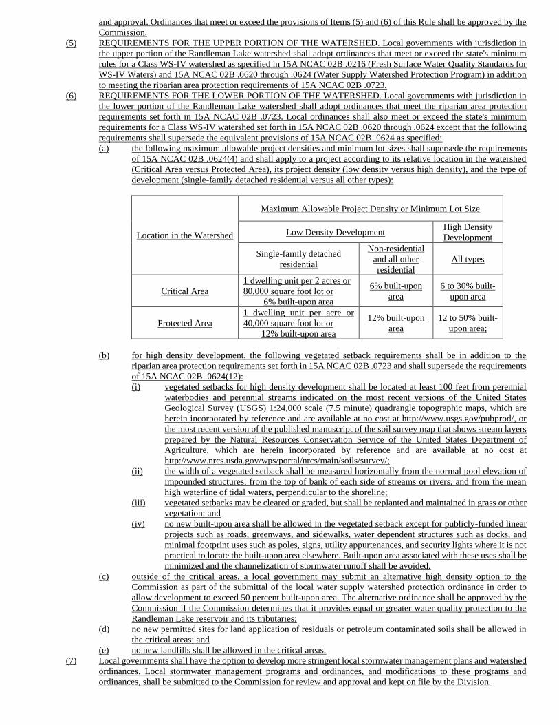
and approval. Ordinances that meet or exceed the provisions of Items (5) and (6) of this Rule shall be approved by the
Commission.
(5) REQUIREMENTS FOR THE UPPER PORTION OF THE WATERSHED. Local governments with jurisdiction in
the upper portion of the Randleman Lake watershed shall adopt ordinances that meet or exceed the state's minimum
rules for a Class WS-IV watershed as specified in 15A NCAC 02B .0216 (Fresh Surface Water Quality Standards for
WS-IV Waters) and 15A NCAC 02B .0620 through .0624 (Water Supply Watershed Protection Program) in addition
to meeting the riparian area protection requirements of 15A NCAC 02B .0723.
(6) REQUIREMENTS FOR THE LOWER PORTION OF THE WATERSHED. Local governments with jurisdiction in
the lower portion of the Randleman Lake watershed shall adopt ordinances that meet the riparian area protection
requirements set forth in 15A NCAC 02B .0723. Local ordinances shall also meet or exceed the state's minimum
requirements for a Class WS-IV watershed set forth in 15A NCAC 02B .0620 through .0624 except that the following
requirements shall supersede the equivalent provisions of 15A NCAC 02B .0624 as specified:
(a) the following maximum allowable project densities and minimum lot sizes shall supersede the requirements
of 15A NCAC 02B .0624(4) and shall apply to a project according to its relative location in the watershed
(Critical Area versus Protected Area), its project density (low density versus high density), and the type of
development (single-family detached residential versus all other types):
Location in the Watershed
Maximum Allowable Project Density or Minimum Lot Size
Low Density Development High Density
Development
Single-family detached
residential
Non-residential
and all other
residential
All types
Critical Area
1 dwelling unit per 2 acres or
80,000 square foot lot or
6% built-upon area
6% built-upon
area
6 to 30% built-
upon area
Protected Area
1 dwelling unit per acre or
40,000 square foot lot or
12% built-upon area
12% built-upon
area
12 to 50% built-
upon area;
(b) for high density development, the following vegetated setback requirements shall be in addition to the
riparian area protection requirements set forth in 15A NCAC 02B .0723 and shall supersede the requirements
of 15A NCAC 02B .0624(12):
(i) vegetated setbacks for high density development shall be located at least 100 feet from perennial
waterbodies and perennial streams indicated on the most recent versions of the United States
Geological Survey (USGS) 1:24,000 scale (7.5 minute) quadrangle topographic maps, which are
herein incorporated by reference and are available at no cost at http://www.usgs.gov/pubprod/, or
the most recent version of the published manuscript of the soil survey map that shows stream layers
prepared by the Natural Resources Conservation Service of the United States Department of
Agriculture, which are herein incorporated by reference and are available at no cost at
http://www.nrcs.usda.gov/wps/portal/nrcs/main/soils/survey/;
(ii) the width of a vegetated setback shall be measured horizontally from the normal pool elevation of
impounded structures, from the top of bank of each side of streams or rivers, and from the mean
high waterline of tidal waters, perpendicular to the shoreline;
(iii) vegetated setbacks may be cleared or graded, but shall be replanted and maintained in grass or other
vegetation; and
(iv) no new built-upon area shall be allowed in the vegetated setback except for publicly-funded linear
projects such as roads, greenways, and sidewalks, water dependent structures such as docks, and
minimal footprint uses such as poles, signs, utility appurtenances, and security lights where it is not
practical to locate the built-upon area elsewhere. Built-upon area associated with these uses shall be
minimized and the channelization of stormwater runoff shall be avoided.
(c) outside of the critical areas, a local government may submit an alternative high density option to the
Commission as part of the submittal of the local water supply watershed protection ordinance in order to
allow development to exceed 50 percent built-upon area. The alternative ordinance shall be approved by the
Commission if the Commission determines that it provides equal or greater water quality protection to the
Randleman Lake reservoir and its tributaries;
(d) no new permitted sites for land application of residuals or petroleum contaminated soils shall be allowed in
the critical areas; and
(e) no new landfills shall be allowed in the critical areas.
(7) Local governments shall have the option to develop more stringent local stormwater management plans and watershed
ordinances. Local stormwater management programs and ordinances, and modifications to these programs and
ordinances, shall be submitted to the Commission for review and approval and kept on file by the Division.
(8) If a local government fails to properly implement an approved plan, then stormwater management requirements for
existing and new urban areas within its jurisdiction shall be administered through the NPDES municipal stormwater
permitting program per 15A NCAC 02H .0126 which shall include at a minimum:
(a) subject local governments shall be required to develop and implement comprehensive stormwater
management programs for both existing and new development;
(b) these stormwater management programs shall provide all components that are required of local government
stormwater programs in this Rule; and
(c) local governments that are subject to an NPDES permit shall be covered by the permit for at least one
permitting cycle (five years) before they are eligible to submit a revised local stormwater management
component of their water supply watershed protection program for consideration and approval by the
Commission.
History Note: Authority G.S. 143-214.1; 143-214.5; 143-214.7; 143-215.1; 143-215.3(a)(1);
Eff. April 1, 1999.
Readopted Eff. [New Date].
The provisions of this Rule were transferred from 15A NCAC 02B .0251.
15A NCAC 02B .0249 .0722 RANDLEMAN LAKE WATER SUPPLY WATERSHED: WASTEWATER DISCHARGE
REQUIREMENTS
The following is the National Pollutant Discharge Elimination System (NPDES) wastewater discharge management strategy for the
Randleman Lake watershed. For purposes of this Rule, permitted wastewater discharges means those facilities permitted to discharge
domestic wastewater or wastewaters containing phosphorus:
(1) The City of High Point=s Eastside facility Point East Side Eastside Wastewater Treatment Plant (WWTP) shall meet
a total phosphorus concentration predicted to provide a level of water quality in the Randleman Lake which meets all
designated uses of those waters.
(2) There shall be no new or expanding permitted wastewater discharges in the watershed with the exception that the City
of High Point Eastside wastewater treatment plant WWTP may be allowed to expand provided that any new permit
contains concentration and mass limits predicted to provide a level of water quality in the Randleman Lake which
meets all designated uses of those waters.
History Note: Authority G. S. 143-214.1; 143-214.5; 143-215.3(a)(1);
Eff. April 1, 1999. 1999;
Readopted Eff. [New Date].
The provisions of this Rule were transferred from 15A NCAC 02B .0249.
15A NCAC 02B .0250 .0724 RANDLEMAN LAKE WATER SUPPLY WATERSHED: PROTECTION AND
MAINTENANCE OF EXISTING RIPARIAN BUFFERS
Protection of the pollutant removal and other water quality services provided by riparian buffers throughout the watershed is an important
element of the overall Randleman water supply pollutant strategy. The following is the management strategy for maintaining and
protecting riparian areas in the Randleman Lake watershed:
(1) PURPOSE. The purposes of this Rule shall be for the local governments listed in this Rule, and in certain cases stated
in this Rule the Division, to maintain and protect and preserve existing riparian buffers throughout the Randleman
Lake watershed as generally described in this Rule, in order to maintain their nutrient removal and stream protection
functions. Additionally this Rule will help protect the water supply uses of Randleman Lake and of designated water
supplies throughout the Randleman Lake water supply watershed. Terms used in this Rule shall be as defined in Rule
.0610 of this Subchapter. Local governments with jurisdictions in Randleman Lake watershed shall establish programs
to meet or exceed the minimum requirements of this Rule. However, the Division shall assume responsibility for
applying the requirements of this Rule to activities listed in Item (3) of this Rule. The requirements of this Rule shall
supersede all buffer requirements stated in Rules 15A NCAC 02B .0214 through .0216 as applied to WS-II, WS-III,
and WS-IV waters in the Randleman Lake watershed. Parties subject to this Rule may choose to implement more
stringent rules, including the one-hundred foot buffer requirement set out in Sub-item (3)(b)(i) of Rules 15A NCAC
02B .0214 through .0216 for high-density developments.
(2) DEFINITIONS. For the purpose of this Rule, these terms shall be defined as follows:
(a) 'Access Trails' means pedestrian trails constructed of pervious or impervious surfaces, and related structures
to access a surface water including (but not limited to) boardwalks, steps, rails, signage;
(b) 'Archaeological Activities' means activities conducted by a Registered Professional Archaeologist (RPA);
(c) 'Airport Facilities' means all properties, facilities, buildings, structures, and activities that satisfy or otherwise
fall within the scope of one or more of the definition or uses of the words or phrases 'air navigation facility',
'airport', or 'airport protection privileges' under G.S. 63-1; the definition of 'aeronautical facilities' in G.S. 63-
79(1); the phrase 'airport facilities' as used in G.S. 159-48(b)(1); the phrase 'aeronautical facilities' as defined
in G.S. 159-81 and G.S. 159-97; and the phrase 'airport facilities and improvements' as used in Article V,
Section 13, of the North Carolina Constitution. Airport facilities shall include without limitation, any and all
of the following: airports, airport maintenance facilities, clear zones, drainage ditches, fields, hangars, landing
lighting, airport and airport-related offices, parking facilities, related navigational and signal systems,
runways, stormwater outfalls, terminals, terminal shops, and all appurtenant areas used or suitable for airport
buildings or other airport facilities, and all appurtenant rights-of-way; restricted landing areas; any structures,
mechanisms, lights, beacons, marks, communicating systems, or other instrumentalities or devices used or
useful as an aid, or constituting an advantage or convenience to the safe taking off, navigation, and landing
of aircraft, or the safe and efficient operation or maintenance of an airport or restricted landing area;
easements through, or interests in, air space over land or water, interests in airport hazards outside the
boundaries of airports or restricted landing areas, and other protection privileges, the acquisition or control
of which is necessary to ensure safe approaches to the landing areas of airports and restricted landing areas,
and the safe and efficient operation thereof and any combination of any or all of such facilities.
Notwithstanding the foregoing, the following shall not be included in the definition of 'airport facilities':
(i) Satellite parking facilities;
(ii) Retail and commercial development outside of the terminal area, such as rental car facilities; and
(iii) Other secondary development, such as hotels, industrial facilities, free-standing offices and other
similar buildings, so long as these facilities are not directly associated with the operation of the
airport, and are not operated by a unit of government or special governmental entity such as an
airport authority;
(d) 'Channel' means a natural water-carrying trough cut vertically into low areas of the land surface by erosive
action of concentrated flowing water or a ditch or canal excavated for the flow of water;
(e) 'DBH' means diameter at breast height of a tree measured at 4.5 feet above ground surface level;
(f) Ditch means a man-made, open drainage way in or into which excess surface water or groundwater from
land, stormwater runoff, or floodwaters flow either continuously or intermittently;
(g) 'Ephemeral stream' means a feature that carries stormwater in direct response to precipitation with water
flowing only during and shortly after large precipitation events. An ephemeral stream may or may not have
a well-defined channel, the aquatic bed is always above the water table, and stormwater runoff is the primary
source of water. An ephemeral stream typically lacks the biological, hydrological, and physical
characteristics commonly associated with the continuous or intermittent conveyance of water;
(h) 'Forest plantation' means an area of planted trees that may be conifers (pines) or hardwoods. On a plantation,
the intended crop trees are planted rather than naturally regenerated from seed on the site, coppice (sprouting),
or seed that is blown or carried into the site;
(i) 'Greenway / Hiking Trails' means pedestrian trails constructed of pervious and impervious surfaces and
related structures including but not limited to boardwalks, steps, rails, and signage, and that generally run
parallel to the surface water;
(j) 'High Value Tree' means a tree that meets or exceeds the following standards: for pine species, 14 inch DBH
or greater or 18 inch or greater stump diameter; and, for hardwoods and wetland species, 16 inch DBH or
greater or 24 inch or greater stump diameter;
(k) 'Intermittent stream' means a well-defined channel that contains a continuous flow of water for only part of
the year, typically during winter and spring when the aquatic bed is below the water table. The flow may be
heavily supplemented by stormwater runoff. An intermittent stream often lacks the biological and
hydrological characteristics commonly associated with the continuous conveyance of water;
(l) 'Modified natural stream' means an on-site channelization or relocation of a stream channel and subsequent
relocation of the intermittent or perennial flow as evidenced by topographic alterations in the immediate
watershed. A modified natural stream must have the typical biological, hydrological, and physical
characteristics commonly associated with the continuous conveyance of water;
(m) 'Perennial stream' means a well-defined channel that contains water year round during a year of normal
rainfall with the aquatic bed located below the water table for most of the year. Groundwater is the primary
source of water for a perennial stream, but it also carries stormwater runoff. A perennial stream exhibits the
typical biological, hydrological, and physical characteristics commonly associated with the continuous
conveyance of water;
(n) 'Perennial waterbody' means a natural or man-made watershed that stores surface water permanently at depths
sufficient to preclude growth of rooted plants, including lakes, ponds, sounds, non-stream estuaries and
ocean. For the purpose of the State's riparian buffer protection program, the waterbody must be part of a
natural drainage way (i.e., connected by surface flow to a stream);
(o) 'Shoreline stabilization' is the in-place stabilization of an eroding shoreline. Stabilization techniques which
include "soft" methods or natural materials (such as root wads, or rock vanes) may be considered as part of
a restoration design. However, stabilization techniques that consist primarily of "hard" engineering, such as
concrete lined channels, rip rap, or gabions, while providing bank stabilization, shall not be considered stream
restoration;
(p) 'Stream restoration' is defined as the process of converting an unstable, altered or degraded stream corridor,
including adjacent riparian zone and flood-prone areas to its natural or referenced, stable conditions
considering recent and future watershed conditions. This process also includes restoring the geomorphic
dimension, pattern, and profile as well as biological and chemical integrity, including transport of water and
sediment produced by the stream's watershed in order to achieve dynamic equilibrium. 'Referenced' or
'referenced reach' means a stable stream that is in dynamic equilibrium with its valley and contributing
watershed. A reference reach can be used to develop natural channel design criteria for stream restoration
projects. 'Stream' means a body of concentrated flowing water in a natural low area or natural channel on the
land surface;
(q) 'Stump diameter' means the diameter of a tree measured at six inches above the ground surface level;
(r) 'Surface waters' means all waters of the state as defined in G.S. 143-212 except underground waters and
wetlands;
(s) 'Temporary road' means a road constructed temporarily for equipment access to build or replace hydraulic
conveyance structures such as bridges, culverts or pipes or water dependent structures, or to maintain public
traffic during construction; and
(t) 'Tree' means a woody plant with a DBH equal to or exceeding five inches or a stump diameter exceeding six
inches.
(3)(2) APPLICABILITY. This Rule shall apply to all local governments with jurisdictions landowners and other persons
including local governments, state and federal entities conducting activities within the riparian buffers as described in
Item (3) of this Rule in the Randleman Lake watershed. Local governments shall develop riparian buffer protection
programs for approval by the Division incorporating the minimum standards set out throughout this Rule and shall
apply the requirements of this Rule throughout their jurisdictions within the Randleman watershed except where the
Division shall exercise jurisdiction. For the following types of buffer activities in the Randleman watershed, wherever
local governments are referenced in this Rule, the Division shall implement applicable requirements to the exclusion
of local governments:
(a) Activities conducted under authority of the State;
(b) Activities conducted under the authority of the United States;
(c) Activities conducted under the authority of multiple jurisdictions;
(d) Activities conducted under the authority of local units of government;
(e) Forest harvesting activities described in Item 16 of this Rule; and
(f) Agricultural activities.
(4)(3) REQUIREMENTS. BUFFERS PROTECTED. The following minimum criteria shall be used for identifying regulated
buffers: buffers. All local governments subject to this Rule shall develop riparian buffer protection programs and
ordinances for approval by the Commission, incorporating the minimum standards contained in Rule.
(a) A surface water shall be subject to this Rule if the feature is approximately shown on any of the following
references, or if there is other site specific evidence that indicates to the Authority the presence of waters not
shown on any of these references:
(i) The most recent version of the United States Geological Survey (USGS) 1:24,000 scale (7.5 minute
quadrangle) topographic maps;
(ii) The most recent version of the published manuscript of the soil survey map that shows stream layers
prepared by the Natural Resource Conservation Service of the United States Department of
Agriculture; or
(iii) Other maps approved by the Geographic Information Coordinating Council and by the
Environmental Management Commission as more accurate than those identified in Sub-Item
(3)(a)(i) and (3)(a)(ii) of this Rule. Other maps may be submitted to the Division for review and
recommendation to the Environmental Management Commission. Prior to recommendation to the
Environmental Management Commission, the Division shall issue a 30-day public notice through
the Division's Mailing List in accordance with 15A NCAC 02H .0503. Division staff shall present
recommendations including comments received during the public notice period to the
Environmental Management Commission for a final decision. Maps approved under this Sub-Item
shall not apply to projects that are existing and ongoing within the meaning of this Rule as set out
in Item (6) of this Rule;
(b) This Rule shall apply to activities conducted within 50 foot wide riparian buffers directly adjacent to surface
waters in the Randleman watershed (intermittent and perennial streams, lakes, reservoirs, and ponds)
excluding wetlands. wetlands;
(c) Wetlands adjacent to surface waters or within 50 feet of surface waters, waters shall be considered as part of
the riparian buffer but are regulated pursuant to 15A NCAC 02H. 0506. 02H .0506;
(d) Stormwater runoff from activities conducted outside the riparian buffer shall comply with Item (9) of this
Rule;
(a) Surface waters shall be subject to this Rule if the feature is approximately shown on any of the following
references, or if there is other site specific evidence that indicates to the Division or local government the
presence of waters not shown on any of these maps:
(i) The most recent version of the United States Geological Survey 1:24,000 scale (7.5 minute
quadrangle) topographic maps;
(ii) The most recent version of the hardcopy soil survey maps developed by USDA-Natural Resource
Conservation Service; or
(iii) A map approved by the Geographic Information Coordinating Council and by the Commission.
Prior to approving a map under this sub-division the Commission shall provide a 30-day public
notice and opportunity for comment;
(e) Riparian buffers protected by this Rule shall be measured pursuant to Item (8) of this Rule;
(f) A riparian buffer may be exempt from this Rule as described in Items (5), (6) and (7) of this Rule; and
(g) No new clearing, grading, or development shall take place nor shall any new building permits be issued in
violation of this Rule.
(b) Where the specific origination point of an intermittent or perennial stream is in question, parties subject to
this Rule shall use the Division publication, Identification Methods for the Origins of Intermittent and
Perennial Streams, v 3.1 February 28, 2005 available at:
http://portal.ncdenr.org/web/wq/swp/ws/401/waterresources/streamdeterminations to establish that point;
(c) Local governments may develop stream network maps for the watershed based on maps referenced in Sub-
Item (4)(a) of this Rule or criteria identified in Sub-Item (4)(b) and of this Rule. These maps shall be
submitted to the Director for review to establish that proper methods were used by any local government
wishing to use such maps for implementation of riparian area protection. The local map must be at least as
accurate as the map identified in Sub-Items (4)(a)(i) and (4)(a)(ii) and must use the stream identification
manual as referenced in Item (4)(b) of this Rule. Riparian areas shall be protected and maintained in
accordance with this Rule on all sides of surface waters in the Randleman Lake watershed as delineated on
these approved stream network maps;
(d) Personnel from delegated local governments that are assigned to perform stream determinations, shall
successfully complete the Division's Surface Water Identification Training and Certification Class within
three years of the effective revision date of this Rule. A delegated local government shall retain personnel on
staff who have successfully completed the Division's class at all times with the exception of staff vacancies
and class scheduling problems. At any time that a local government does not have a certified individual
retained on staff they shall notify the Division and indicate a proposed schedule to secure a certified staff
member;
(e) All local governments that have land use authority within the Randleman Lake water supply watershed shall
adopt and enforce this Rule through local water supply and other local ordinances. Ordinances shall require
that all riparian protection areas are recorded on new or modified plats. No new clearing, grading, or
development shall take place and no new building permits shall be issued in violation of this Rule; and
(f) Parties subject to this Rule shall abide by all State rules and laws regarding waters of the state including Rules
15A NCAC 02H .0500, 15A NCAC 02H .1300, and Sections 401 and 404 of the Federal Clean Water Act.
(5)(4) EXEMPTION REQUIREMENTS TO WHEN AN ON-SITE DETERMINATION SHOWS THAT SURFACE
WATERS ARE NOT PRESENT. DETERMINATION. When a landowner or other affected party believes that the
maps listed in Sub-Item (3)(a) of this Rule have inaccurately depicted surface waters, waters or the specific origination
point of a stream, or the specific origination point of a stream is in question or unclear, he or she shall consult request
the delegated local authority. Upon request, the delegated local authority shall Authority to make an onsite on-site
determinations. determination. On-site determinations shall be made by Authority staff that are certified pursuant to
G.S. 143-214.25A. Registered Foresters under Chapter 89B of the General Statutes who are employees of the North
Carolina Forest Service of the Department of Agriculture and Consumer Services can make on-site determinations for
forest harvesting operations and practices. Local governments may also accept the results of site assessments an on-
site determination made by other parties who have successfully completed the Division's Surface Water Identification
Training Certification course, its successor, or other equivalent training curriculum approved by the Division. course
and are sanctioned by the Division to make such determinations. On-site determinations shall expire five years from
the date of the determination. Any disputes over on-site determinations shall be referred to the local Board of
Adjustment or other local appeals process in writing. For projects proposed for state and federal lands, any disputes
shall be referred to the Director in writing. writing within 60 calendar days of written notification from the Authority.
A determination of the Director as to the accuracy or application of the maps The Director's determination is subject
to review as provided in Articles 3 and 4 of G.S. 150B.
(5) EXEMPTION BASED ON ON-SITE DETERMINATION. Surface waters that appear on the maps listed in Sub-Item
(3)(a) of this Rule shall not be subject to this Rule if an on-site determination shows that they fall into one of the
following categories:
(a) Ditches and manmade conveyances, to include manmade stormwater conveyances, other than modified
natural streams, unless the ditch or manmade conveyance delivers untreated stormwater runoff from an
adjacent source directly to an intermittent or perennial stream;
(b) Areas mapped as intermittent streams, perennial streams, lakes, ponds, or estuaries on the most recent
versions of United States Geological Survey 1:24,000 scale (7.5 minute quadrangle) topographic maps, hard-
copy soil survey maps or other EMC approved stream maps where no The absence on the ground of a
corresponding perennial waterbody, intermittent waterbody, lake, reservoir or pond; pond or estuary actually
exists on the ground;
(c) Ephemeral streams; and
(d) Ponds Manmade ponds and lakes created for animal watering, irrigation, or other agricultural uses that are
not part of a natural drainage way that is classified in accordance with 15A NCAC 02B .0100. Ponds are part
of a natural drainage way when they are hydrologically connected (i.e. the pond is fed by an intermittent or
perennial stream) stream nor or when they have a direct discharge point to an intermittent or perennial stream.
(6) EXEMPTION TO REQUIREMENTS WHEN EXISTING USES ARE PRESENT AND ONGOING. This Rule shall
not apply to portions of the riparian buffer where a use is existing and ongoing according to the following: ongoing.
(a) A use shall be considered existing and ongoing if if:
(i) it It was present within the riparian buffer as of the effective date of the local ordinance or local
ordinances enforcing this Rule and has continued to exist since that time. For state and federal
entities, activities listed in Sub-Item (12)(b), a use shall be considered existing and ongoing if it was
present within the riparian buffer as of the effective date of this Rule April 1, 1999 and has continued
to exist since that time. time;
(ii) It was a deemed allowable activity as listed in Item (10) of this Rule; or
(iii) It was conducted and maintained pursuant to an Authorization Certificate or Variance issued by the
Authority; or
(iv) The project or proposed development are determined by the Authority to meet at least one of the
following criteria:
(A) Project requires a 401 Certification/404 permit and these were issued prior to the effective
date of the local ordinance or ordinances enforcing this Rule, or for activities listed in Sub-
Item (12)(b), prior to April 1, 1999, and are still valid;
(B) Projects that require a state permit, such as landfills, NPDES wastewater discharges, land
application of residuals and road construction activities, and have begun construction or
are under contract to begin construction, and have received all required state permits and
certifications prior to the effective date of the local ordinance or ordinances implementing
this Rule, or for activities listed in Sub-Item (12)(b), prior to April 1, 1999;
(C) Projects that are being reviewed through the Clean Water Act Section 404/National
Environmental Policy Act Merger 01 Process (published by the US Army Corps of
Engineers and Federal Highway Administration, 2003) or its immediate successor and that
have reached agreement with the Department on avoidance and minimization prior to April
1, 1999; or
(D) Projects that are not required to be reviewed by the Clean Water Act Section 404/National
Environmental Policy Act Merger 01 Process (published by the US Army Corps of
Engineers and Federal Highway Administration, 2003) or its immediate successor if a
Finding of No Significant Impact has been issued for the project and the project has the
written approval of the Division prior to April 1, 1999.
(b) Existing and ongoing uses shall include, but not be limited to, agriculture, buildings, industrial facilities,
commercial areas, transportation facilities, maintained lawns, lawns (i.e. can be mowed without a chainsaw
or bush-hog), maintained (i.e. vegetation management has occurred within the last 10 years) utility lines line
corridors and on-site sanitary sewage systems systems, any of which involve either specific, periodic
management of vegetation or displacement of vegetation by structures or regular activity.
(c) Only the portion of the riparian buffer that contains the footprint of the existing and ongoing use is exempt
from this Rule.
(d) Change of ownership through purchase or inheritance is not a change of use.
(e) Activities necessary to maintain existing and ongoing uses are allowed provided that the site remains
similarly vegetated, no impervious surface built upon area is added within 50 feet of the surface water the
riparian buffer where it did not previously exist as of prior to the effective date of the local ordinance or local
ordinances enforcing this Rule, or for activities listed in Sub-Item (12)(b) prior to April 1, 1999, and the site
is in compliance with Item (9) of this Rule. existing diffuse flow is maintained. Grading and revegetating
Zone 2 is allowed provided that the health of the vegetation in Zone 1 is not compromised, the ground is
stabilized and existing diffuse flow is maintained;
(b) A use shall be considered existing if projects or proposed development are determined by the local
government, or the Director for the cases involving state or federal entities, to meet at least one of the
following criteria:
(i) Project requires a 401 Certification/404 permit and these were issued prior to the effective date of
the local program enforcing this Rule, and prior to the effective date of this Rule for Division-
administered activities listed in Item (3) of this Rule;
(ii) Projects that require a state permit, such as landfills, NPDES wastewater discharges, land
application of residuals and road construction activities, have begun construction or are under
contract to begin construction and had received all required state permits and certifications prior to
the effective date of the local program implementing this Rule, and prior to the effective date of this
Rule for Division-administered activities listed in Item (3) of this Rule;
(iii) Projects that are being reviewed through the Clean Water Act Section 404/National Environmental
Policy Act Merger 01 Process (published by the US Army Corps of Engineers and Federal Highway
Administration, 2003) or its immediate successor and that have reached agreement with DENR on
avoidance and minimization by the effective date of the local program enforcing this Rule, and prior
to the effective date of this Rule for state and federal entities; or
(iv) Projects that are not required to be reviewed by the Clean Water Act Section 404/National
Environmental Policy Act Merger 01 Process (published by the US Army Corps of Engineers and
Federal Highway Administration, 2003) or its immediate successor if a Finding of No Significant
Impact has been issued for the project and the project has the written approval of the local
government prior to the effective date of the local program enforcing this Rule, or the written
approval of the Division prior to the effective date of this Rule for state and federal entities: and
(c)(f) This Rule shall apply at the time an existing use is changed to another use. Change of use shall include, but
not limited to involve the initiation of any activity not defined as existing and ongoing in either Sub-Item
(6)(a) or (6)(b) Sub-Items (6)(a) through (6)(e) of this Rule.
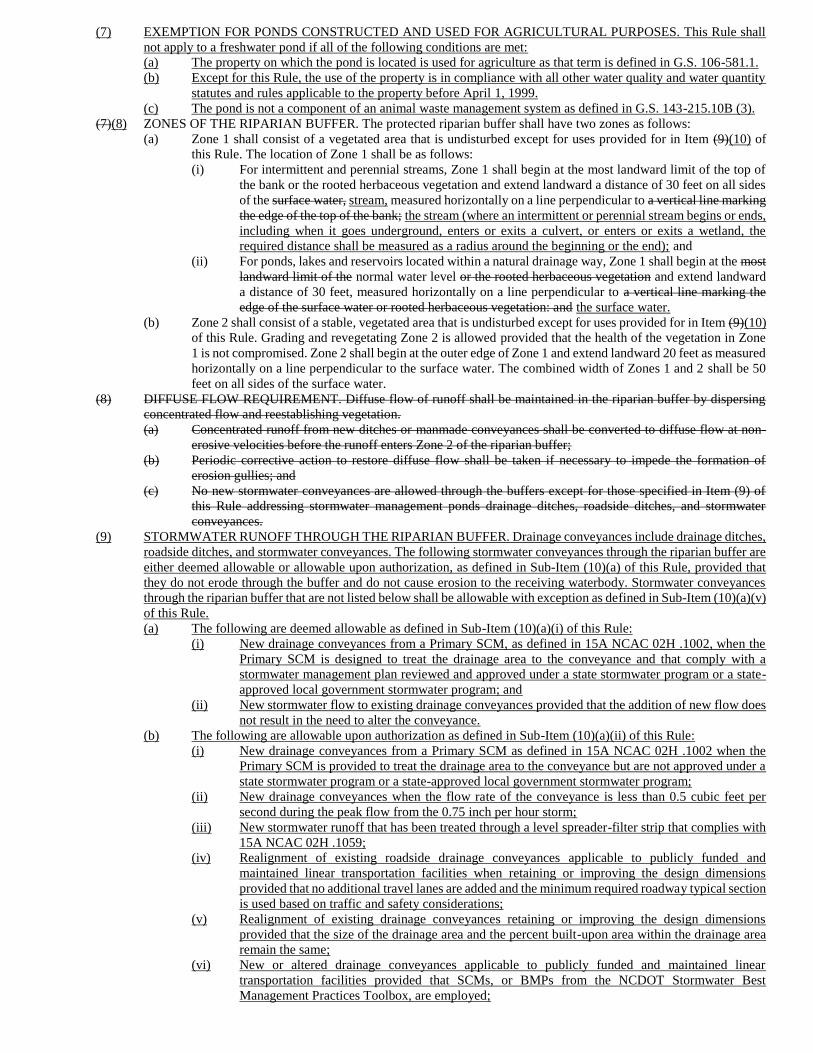
(7) EXEMPTION FOR PONDS CONSTRUCTED AND USED FOR AGRICULTURAL PURPOSES. This Rule shall
not apply to a freshwater pond if all of the following conditions are met:
(a) The property on which the pond is located is used for agriculture as that term is defined in G.S. 106-581.1.
(b) Except for this Rule, the use of the property is in compliance with all other water quality and water quantity
statutes and rules applicable to the property before April 1, 1999.
(c) The pond is not a component of an animal waste management system as defined in G.S. 143-215.10B (3).
(7)(8) ZONES OF THE RIPARIAN BUFFER. The protected riparian buffer shall have two zones as follows:
(a) Zone 1 shall consist of a vegetated area that is undisturbed except for uses provided for in Item (9)(10) of
this Rule. The location of Zone 1 shall be as follows:
(i) For intermittent and perennial streams, Zone 1 shall begin at the most landward limit of the top of
the bank or the rooted herbaceous vegetation and extend landward a distance of 30 feet on all sides
of the surface water, stream, measured horizontally on a line perpendicular to a vertical line marking
the edge of the top of the bank; the stream (where an intermittent or perennial stream begins or ends,
including when it goes underground, enters or exits a culvert, or enters or exits a wetland, the
required distance shall be measured as a radius around the beginning or the end); and
(ii) For ponds, lakes and reservoirs located within a natural drainage way, Zone 1 shall begin at the most
landward limit of the normal water level or the rooted herbaceous vegetation and extend landward
a distance of 30 feet, measured horizontally on a line perpendicular to a vertical line marking the
edge of the surface water or rooted herbaceous vegetation: and the surface water.
(b) Zone 2 shall consist of a stable, vegetated area that is undisturbed except for uses provided for in Item (9)(10)
of this Rule. Grading and revegetating Zone 2 is allowed provided that the health of the vegetation in Zone
1 is not compromised. Zone 2 shall begin at the outer edge of Zone 1 and extend landward 20 feet as measured
horizontally on a line perpendicular to the surface water. The combined width of Zones 1 and 2 shall be 50
feet on all sides of the surface water.
(8) DIFFUSE FLOW REQUIREMENT. Diffuse flow of runoff shall be maintained in the riparian buffer by dispersing
concentrated flow and reestablishing vegetation.
(a) Concentrated runoff from new ditches or manmade conveyances shall be converted to diffuse flow at non-
erosive velocities before the runoff enters Zone 2 of the riparian buffer;
(b) Periodic corrective action to restore diffuse flow shall be taken if necessary to impede the formation of
erosion gullies; and
(c) No new stormwater conveyances are allowed through the buffers except for those specified in Item (9) of
this Rule addressing stormwater management ponds drainage ditches, roadside ditches, and stormwater
conveyances.
(9) STORMWATER RUNOFF THROUGH THE RIPARIAN BUFFER. Drainage conveyances include drainage ditches,
roadside ditches, and stormwater conveyances. The following stormwater conveyances through the riparian buffer are
either deemed allowable or allowable upon authorization, as defined in Sub-Item (10)(a) of this Rule, provided that
they do not erode through the buffer and do not cause erosion to the receiving waterbody. Stormwater conveyances
through the riparian buffer that are not listed below shall be allowable with exception as defined in Sub-Item (10)(a)(v)
of this Rule.
(a) The following are deemed allowable as defined in Sub-Item (10)(a)(i) of this Rule:
(i) New drainage conveyances from a Primary SCM, as defined in 15A NCAC 02H .1002, when the
Primary SCM is designed to treat the drainage area to the conveyance and that comply with a
stormwater management plan reviewed and approved under a state stormwater program or a state-
approved local government stormwater program; and
(ii) New stormwater flow to existing drainage conveyances provided that the addition of new flow does
not result in the need to alter the conveyance.
(b) The following are allowable upon authorization as defined in Sub-Item (10)(a)(ii) of this Rule:
(i) New drainage conveyances from a Primary SCM as defined in 15A NCAC 02H .1002 when the
Primary SCM is provided to treat the drainage area to the conveyance but are not approved under a
state stormwater program or a state-approved local government stormwater program;
(ii) New drainage conveyances when the flow rate of the conveyance is less than 0.5 cubic feet per
second during the peak flow from the 0.75 inch per hour storm;
(iii) New stormwater runoff that has been treated through a level spreader-filter strip that complies with
15A NCAC 02H .1059;
(iv) Realignment of existing roadside drainage conveyances applicable to publicly funded and
maintained linear transportation facilities when retaining or improving the design dimensions
provided that no additional travel lanes are added and the minimum required roadway typical section
is used based on traffic and safety considerations;
(v) Realignment of existing drainage conveyances retaining or improving the design dimensions
provided that the size of the drainage area and the percent built-upon area within the drainage area
remain the same;
(vi) New or altered drainage conveyances applicable to publicly funded and maintained linear
transportation facilities provided that SCMs, or BMPs from the NCDOT Stormwater Best
Management Practices Toolbox, are employed;
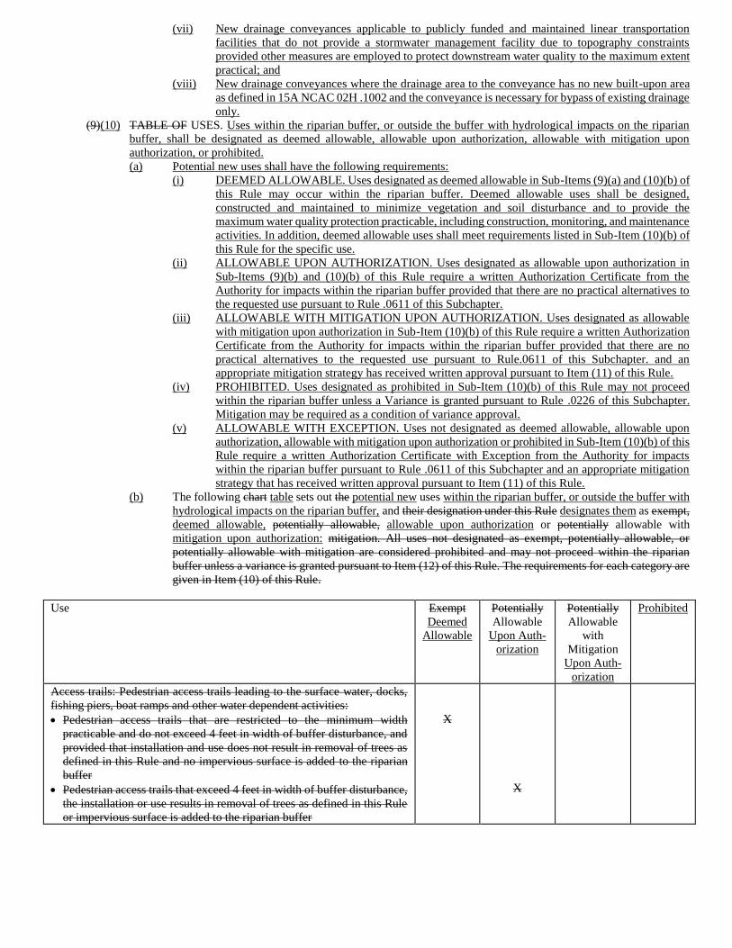
(vii) New drainage conveyances applicable to publicly funded and maintained linear transportation
facilities that do not provide a stormwater management facility due to topography constraints
provided other measures are employed to protect downstream water quality to the maximum extent
practical; and
(viii) New drainage conveyances where the drainage area to the conveyance has no new built-upon area
as defined in 15A NCAC 02H .1002 and the conveyance is necessary for bypass of existing drainage
only.
(9)(10) TABLE OF USES. Uses within the riparian buffer, or outside the buffer with hydrological impacts on the riparian
buffer, shall be designated as deemed allowable, allowable upon authorization, allowable with mitigation upon
authorization, or prohibited.
(a) Potential new uses shall have the following requirements:
(i) DEEMED ALLOWABLE. Uses designated as deemed allowable in Sub-Items (9)(a) and (10)(b) of
this Rule may occur within the riparian buffer. Deemed allowable uses shall be designed,
constructed and maintained to minimize vegetation and soil disturbance and to provide the
maximum water quality protection practicable, including construction, monitoring, and maintenance
activities. In addition, deemed allowable uses shall meet requirements listed in Sub-Item (10)(b) of
this Rule for the specific use.
(ii) ALLOWABLE UPON AUTHORIZATION. Uses designated as allowable upon authorization in
Sub-Items (9)(b) and (10)(b) of this Rule require a written Authorization Certificate from the
Authority for impacts within the riparian buffer provided that there are no practical alternatives to
the requested use pursuant to Rule .0611 of this Subchapter.
(iii) ALLOWABLE WITH MITIGATION UPON AUTHORIZATION. Uses designated as allowable
with mitigation upon authorization in Sub-Item (10)(b) of this Rule require a written Authorization
Certificate from the Authority for impacts within the riparian buffer provided that there are no
practical alternatives to the requested use pursuant to Rule.0611 of this Subchapter. and an
appropriate mitigation strategy has received written approval pursuant to Item (11) of this Rule.
(iv) PROHIBITED. Uses designated as prohibited in Sub-Item (10)(b) of this Rule may not proceed
within the riparian buffer unless a Variance is granted pursuant to Rule .0226 of this Subchapter.
Mitigation may be required as a condition of variance approval.
(v) ALLOWABLE WITH EXCEPTION. Uses not designated as deemed allowable, allowable upon
authorization, allowable with mitigation upon authorization or prohibited in Sub-Item (10)(b) of this
Rule require a written Authorization Certificate with Exception from the Authority for impacts
within the riparian buffer pursuant to Rule .0611 of this Subchapter and an appropriate mitigation
strategy that has received written approval pursuant to Item (11) of this Rule.
(b) The following chart table sets out the potential new uses within the riparian buffer, or outside the buffer with
hydrological impacts on the riparian buffer, and their designation under this Rule designates them as exempt,
deemed allowable, potentially allowable, allowable upon authorization or potentially allowable with
mitigation upon authorization: mitigation. All uses not designated as exempt, potentially allowable, or
potentially allowable with mitigation are considered prohibited and may not proceed within the riparian
buffer unless a variance is granted pursuant to Item (12) of this Rule. The requirements for each category are
given in Item (10) of this Rule.
Use Exempt
Deemed
Allowable
Potentially
Allowable
Upon Auth-
orization
Potentially
Allowable
with
Mitigation
Upon Auth-
orization
Prohibited
Access trails: Pedestrian access trails leading to the surface water, docks,
fishing piers, boat ramps and other water dependent activities:
• Pedestrian access trails that are restricted to the minimum width
practicable and do not exceed 4 feet in width of buffer disturbance, and
provided that installation and use does not result in removal of trees as
defined in this Rule and no impervious surface is added to the riparian
buffer
• Pedestrian access trails that exceed 4 feet in width of buffer disturbance,
the installation or use results in removal of trees as defined in this Rule
or impervious surface is added to the riparian buffer
X
X
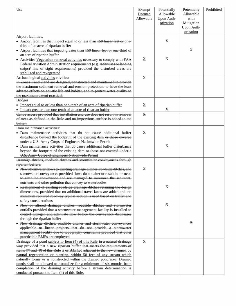
Use Exempt
Deemed
Allowable
Potentially
Allowable
Upon Auth-
orization
Potentially
Allowable
with
Mitigation
Upon Auth-
orization
Prohibited
Airport facilities:
• Airport facilities that impact equal to or less than 150 linear feet or one-
third of an acre of riparian buffer
• Airport facilities that impact greater than 150 linear feet or one-third of
an acre of riparian buffer
• Activities Vegetation removal activities necessary to comply with FAA
Federal Aviation Administration requirements (e.g. radar uses or landing
strips)1 line of sight requirements) provided the disturbed areas are
stabilized and revegetated
X
X
X
X
Archaeological activities ctivities:
In Zones 1 and 2 and are designed, constructed and maintained to provide
the maximum sediment removal and erosion protection, to have the least
adverse effects on aquatic life and habitat, and to protect water quality to
the maximum extent practical.
X
Bridges
• Impact equal to or less than one-tenth of an acre of riparian buffer
• Impact greater than one-tenth of an acre of riparian buffer
X
X
Canoe access provided that installation and use does not result in removal
of trees as defined in the Rule and no impervious surface is added to the
buffer.
X
Dam maintenance activities:
• Dam maintenance activities that do not cause additional buffer
disturbance beyond the footprint of the existing dam or those covered
under a U.S. Army Corps of Engineers Nationwide Permit
• Dam maintenance activities that do cause additional buffer disturbance
beyond the footprint of the existing dam or those not covered under a
U.S. Army Corps of Engineers Nationwide Permit
X
X
Drainage ditches, roadside ditches and stormwater conveyances through
riparian buffers:
• New stormwater flows to existing drainage ditches, roadside ditches, and
stormwater conveyances provided flows do not alter or result in the need
to alter the conveyance and are managed to minimize the sediment,
nutrients and other pollution that convey to waterbodies
• Realignment of existing roadside drainage ditches retaining the design
dimensions, provided that no additional travel lanes are added and the
minimum required roadway typical section is used based on traffic and
safety considerations
• New or altered drainage ditches, roadside ditches and stormwater
outfalls provided that a stormwater management facility is installed to
control nitrogen and attenuate flow before the conveyance discharges
through the riparian buffer
• New drainage ditches, roadside ditches and stormwater conveyances
applicable to linear projects that do not provide a stormwater
management facility due to topography constraints provided that other
practicable BMPs are employed
X
X
X
X
Drainage of a pond subject to Item (4) of this Rule in a natural drainage
way provided that a new riparian buffer that meets the requirements of
Items (7) and (8) of this Rule is established adjacent to the new channel. by
natural regeneration or planting, within 50 feet of any stream which
naturally forms or is constructed within the drained pond area. Drained
ponds shall be allowed to naturalize for a minimum of six months from
completion of the draining activity before a stream determination is
conducted pursuant to Item (4) of this Rule.
X
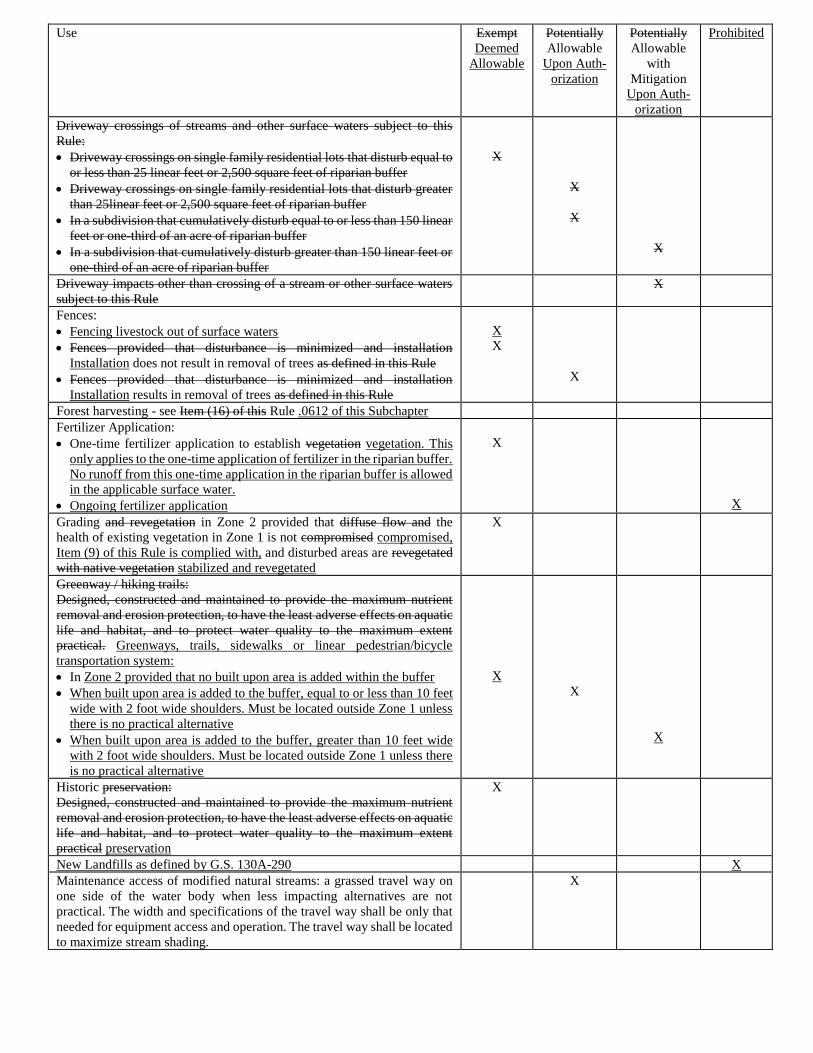
Use Exempt
Deemed
Allowable
Potentially
Allowable
Upon Auth-
orization
Potentially
Allowable
with
Mitigation
Upon Auth-
orization
Prohibited
Driveway crossings of streams and other surface waters subject to this
Rule:
• Driveway crossings on single family residential lots that disturb equal to
or less than 25 linear feet or 2,500 square feet of riparian buffer
• Driveway crossings on single family residential lots that disturb greater
than 25linear feet or 2,500 square feet of riparian buffer
• In a subdivision that cumulatively disturb equal to or less than 150 linear
feet or one-third of an acre of riparian buffer
• In a subdivision that cumulatively disturb greater than 150 linear feet or
one-third of an acre of riparian buffer
X
X
X
X
Driveway impacts other than crossing of a stream or other surface waters
subject to this Rule
X
Fences:
• Fencing livestock out of surface waters
• Fences provided that disturbance is minimized and installation
Installation does not result in removal of trees as defined in this Rule
• Fences provided that disturbance is minimized and installation
Installation results in removal of trees as defined in this Rule
X
X
X
Forest harvesting - see Item (16) of this Rule .0612 of this Subchapter
Fertilizer Application:
• One-time fertilizer application to establish vegetation vegetation. This
only applies to the one-time application of fertilizer in the riparian buffer.
No runoff from this one-time application in the riparian buffer is allowed
in the applicable surface water.
• Ongoing fertilizer application
X
X
Grading and revegetation in Zone 2 provided that diffuse flow and the
health of existing vegetation in Zone 1 is not compromised compromised,
Item (9) of this Rule is complied with, and disturbed areas are revegetated
with native vegetation stabilized and revegetated
X
Greenway / hiking trails:
Designed, constructed and maintained to provide the maximum nutrient
removal and erosion protection, to have the least adverse effects on aquatic
life and habitat, and to protect water quality to the maximum extent
practical. Greenways, trails, sidewalks or linear pedestrian/bicycle
transportation system:
• In Zone 2 provided that no built upon area is added within the buffer
• When built upon area is added to the buffer, equal to or less than 10 feet
wide with 2 foot wide shoulders. Must be located outside Zone 1 unless
there is no practical alternative
• When built upon area is added to the buffer, greater than 10 feet wide
with 2 foot wide shoulders. Must be located outside Zone 1 unless there
is no practical alternative
X
X
X
Historic preservation:
Designed, constructed and maintained to provide the maximum nutrient
removal and erosion protection, to have the least adverse effects on aquatic
life and habitat, and to protect water quality to the maximum extent
practical preservation
X
New Landfills as defined by G.S. 130A-290 X
Maintenance access of modified natural streams: a grassed travel way on
one side of the water body when less impacting alternatives are not
practical. The width and specifications of the travel way shall be only that
needed for equipment access and operation. The travel way shall be located
to maximize stream shading.
X
Use Exempt
Deemed
Allowable
Potentially
Allowable
Upon Auth-
orization
Potentially
Allowable
with
Mitigation
Upon Auth-
orization
Prohibited
Mining activities:
• Mining activities that are covered by the Mining Act provided that new
riparian buffers that meet the requirements of Items (7)(8) and (8)(9) of
this Rule are established adjacent to the relocated channels
• Mining activities that are not covered by the Mining Act or where new
riparian buffers that meet the requirements or Items (7)(8) and (8)(9) of
this Rule are not established adjacent to the relocated channels
• Wastewater or mining dewatering wells with approved NPDES permit
X
X
X
Pedestrian access trail and associated steps leading to a surface water, dock,
canoe or kayak access, fishing pier, boat ramp or other water dependent
structure:
• Pedestrian access trail equal to or less than six feet wide that does not
result in the removal of any tree(s) within the riparian buffer and does
not result in any built upon area being added to the riparian buffer
• Pedestrian access trail equal to or less than six feet wide where the
installation or use results in the removal of tree(s) or addition of built
upon area to the riparian buffer
• Pedestrian access trail greater than six feet wide
X
X
X
Playground equipment:
• Playground equipment on single family lots provided that installation
and use does not result in removal of vegetation
• Playground equipment on single family lots where installation or use
results in the removal of vegetation
• Playground equipment installed on lands other than single-family lots or
that requires removal of vegetation
X
X
X
Ponds in natural drainage ways, excluding dry ponds: created or modified
by impounding streams subject to buffer pursuant to Item (3) of this Rule
and not used at stormwater control measures (SCMs):
• New ponds provided that a riparian buffer that meets the requirements
of Items (7)(8) & (8)(9) of this Rule is established adjacent to the pond
• New ponds where a riparian buffer that meets the requirements of Items
(7)(8) & (8)(9) of this Rule is NOT established adjacent to the pond
X
X
Protection of existing structures, facilities and stream banks structures and
facilities, when this requires additional disturbance of the riparian buffer or
the stream channel
X
Public Safety - publicly owned spaces where it has been determined by the
head of the local law enforcement agency with jurisdiction over that area
that the buffers pose a risk to public safety. The head of the local law
enforcement agency shall notify the local government with land use
jurisdiction over the publicly owned space and the Division of Water
Resources of any such determination in writing.
X
Railroad impacts other than crossings of streams and other surface waters
subject to this Rule.
X
Railroad crossings of streams and other surface waters subject to this Rule:
• Railroad crossings that impact equal to or less than 40 linear feet of
riparian buffer
• Railroad crossings that impact greater than 40 linear feet but equal to or
less than 150 linear feet or one-third of an acre of riparian buffer
• Railroad crossings that impact greater than 150 linear feet or one-third
of an acre of riparian buffer
X
X
X
Use Exempt
Deemed
Allowable
Potentially
Allowable
Upon Auth-
orization
Potentially
Allowable
with
Mitigation
Upon Auth-
orization
Prohibited
Recreational and accessory structures:
• Total footprint of gazebos and sheds in Zone 2, provided they are not
prohibited under local water supply ordinance less than or equal to 150
square feet per lot
• Total footprint gazebos and sheds in Zone 2, provided they are not
prohibited under local water supply ordinance of more than 150 square
feet per lot
• Wooden-slatted decks (and associated steps) that are at least 8 feet in
height and vegetation is not removed from Zone 1 for the installation and
that it meets the requirements of Items (7) and (8) of this Rule
• Wooden-slatted decks (and associated steps) that are not at least 8 feet in
height or vegetation is removed from Zone 1 for the installation and that
it meets the requirements of Items (7) and (8) of this Rule
X
X
X
X
Removal of previous fill or debris provided that Item (9) of this Rule is
complied with iffuse flow is maintained and any vegetation removed is
restored
X
Residential Properties: Where application of this Rule would preclude
construction of a single-family residence and necessary infrastructure, the
single-family residence may encroach in the buffer if all of the following
conditions are met: (1) the residence is set back the maximum feasible
distance from the top of the bank, rooted herbaceous vegetation, normal
high-water level, or normal water level, whichever is applicable, on the
existing lot; (2) the residence is designed to minimize encroachment into
the riparian buffer; (3) the residence complies with Item (9) of this Rule;
and if the residence will be served by an on-site wastewater system, no part
of the septic tank or drainfield may encroach into the riparian buffer.
• The residence and necessary infrastructure impact Zone 2 only
• The residence or necessary infrastructure impact Zone 1
• Impacts other than the residence or necessary infrastructure
X
X
X
Restoration or enhancement (wetland, stream) as defined in 33 CFR Part
332 available free of charge on the internet at:
http://water.epa.gov/lawsregs/guidance/wetlands/wetlandsmitigation_inde
x.cfm
• Wetland or stream restoration that does not require written Division
approval results in impacts to the riparian buffer
• Wetland or stream restoration that does require written Division approval
that results in impacts to the riparian buffer
X
X
Road Road, driveway or railroad: perpendicular crossings of streams and
other surface waters subject to this Rule or perpendicular entry into the
buffer that does not cross a stream or other surface water subject to this
Rule:
• Road crossings that impact Impact equal to or less than 40 linear feet
one-tenth of an acre of riparian buffer
• Road crossings that impact Impact greater than one-tenth of an acre 0
linear feet but equal to or less than 150 linear feet or one-third of an acre
of riparian buffer
• Road crossings that impact Impact greater than 150 linear feet or one-
third of an acre of riparian buffer
• Driveway crossings in a subdivision that cumulatively disturb equal to
or less than one-third of an acre of riparian buffer
• Driveway crossings in a subdivision that cumulatively disturb greater
than one-third of an acre of riparian buffer
• Agriculture roads that are exempt from permitting from the U.S. Army
Corps of Engineers per Section 404(f) of the federal Clean Water Act
X
X
X
X
X
X
Road Road, driveway or railroad impacts other than perpendicular
crossings of streams and other surface waters subject to this Rule
X
Use Exempt
Deemed
Allowable
Potentially
Allowable
Upon Auth-
orization
Potentially
Allowable
with
Mitigation
Upon Auth-
orization
Prohibited
Road relocation of existing private access roads associated with public road
projects where necessary for public safety:
• Less than or equal to 2,500 square feet of buffer impact
• Greater than 2,500 square feet of buffer impact
X
X
Stormwater BMPs: Control Measure (SCM) as defined in 15A NCAC 02H
.1002:
• In Zone 2 if Item (9) of this Rule is complied with et detention,
bioretention, and constructed wetlands in Zone 2 if diffuse flow of
discharge is provided into Zone 1
• Wet detention, bioretention, and constructed wetlands in In Zone 1
X
X
Scientific studies and stream gauging:
In Zones 1 and 2 if they are designed, constructed and maintained to protect
water quality to the maximum extent practical. gauging
X
Streambank or shoreline stabilization X
Temporary roads provided that the disturbed area is restored to pre-
construction topographic and hydrologic conditions immediately after
construction is complete and replanted immediately with comparable
vegetation within two months of when construction is complete. vegetation,
except that the tree Tree planting may occur during the dormant season. A
one time application of fertilizer may be utilized to establish vegetation. At
the end of five years years, the restored buffer shall comply with the
restoration criteria Item (9) of Rule 15A NCAC 02B .0252: Rule .0295(i)
of this Subchapter:
• Less than or equal to 2,500 square feet of buffer disturbance
• Greater than 2,500 square feet of buffer disturbance
• Associated with culvert installation, bridge construction or replacement
X
X
X
Temporary sediment and erosion control devices provided that the
disturbed area is restored to pre-construction topographic and hydrologic
conditions immediately after construction is complete and replanted
immediately with comparable vegetation, except that tree vegetation within
two months of when construction is complete. Tree planting may occur
during the dormant season. A one-time application of fertilizer may be used
to establish vegetation. At the end of five years years, the restored buffer
shall comply with the restoration criteria in Item (9) of Rule 15A NCAC
02B .0252: Rule .0295(i) of this Subchapter:
• In Zone 2 only provided ground cover is established within the
timeframes required by the Sedimentation and Erosion Control Act and
that Act, the vegetation in Zone 1 is not compromised and that discharge
is released as diffuse flow in accordance with Item (8)(9) of this Rule
• In Zones 1 and 2 to control impacts associated with uses approved by the
local government Authority or that have received a variance an exception
provided that sediment and erosion control for upland areas is addressed
to the maximum extent practical outside the buffer
• In-stream temporary erosion and sediment control measures for work
within a stream channel that is authorized under Section 401 and 404 of
the Federal Water Pollution Control Act
• In-stream temporary erosion and sediment control measures for
authorized work within a stream channel In-stream temporary erosion
and sediment control measures for work within a stream that has written
approval from the Division and the U.S. Army Corps of Engineers under
Sections 401 & 404 of the Federal Water Pollution Control Act
X
X
X
X
Utility- Non-electric utility lines:
• Impacts other than perpendicular crossings in Zone 2 only4, 5
• Impacts other than perpendicular crossings in Zone 1 only4, 5
X
X
Use Exempt
Deemed
Allowable
Potentially
Allowable
Upon Auth-
orization
Potentially
Allowable
with
Mitigation
Upon Auth-
orization
Prohibited
Utility-Non-electric utility line perpendicular crossings of streams and
other surface waters subject to this Rule4, 5:
• Perpendicular crossings that disturb equal to or less than 40 linear feet of
riparian buffer with a maintenance corridor equal to or less than 10 feet
in width
• Perpendicular crossings that disturb equal to or less than 40 linear feet of
riparian buffer with a maintenance corridor greater than 10 feet in width
• Perpendicular crossings that disturb greater than 40 linear feet but equal
to or less than 150 linear feet of riparian buffer with a maintenance
corridor equal to or less than 10 feet in width
• Perpendicular crossings that disturb greater than 40 linear feet but equal
to or less than 150 linear feet of riparian buffer with a maintenance
corridor greater than 10 feet in width
• Perpendicular crossings that disturb greater than 150 linear feet of
riparian buffer
X
X
X
X
X
Utility-Overhead electric utility lines:
• Impacts other than perpendicular crossings in Zone 2 only4, 5
• Impacts other than perpendicular crossings in Zone 1 2,3,4, 5
X
X
Utility-Overhead electric utility line perpendicular crossings of streams and
other surface waters subject to this Rule 2, 3,4, 5:
• Perpendicular crossings that disturb equal to or less than 150 linear feet
of riparian buffer
•Perpendicular crossings that disturb greater than 150 linear feet of
riparian buffer
X
X
Utility-Underground electric utility lines:
• Impacts other than perpendicular crossings in Zone 2 only2
• Impacts other than perpendicular crossings in Zone 11,4
X
X
Utility-Underground electric utility line perpendicular crossings of streams
and other surface waters subject to this Rule:
• Perpendicular crossings that disturb less than or equal to 40 linear feet of
riparian buffer3, 4, 5
• Perpendicular crossings that disturb greater than 40 linear feet of riparian
buffer3, 4, 5
X
X
Utility – Sewer lines:
• Sanitary Sewer Overflows:
o Emergency sanitary sewer overflow response activities,
provided that the disturbed area within the buffer: is the
minimum necessary to respond to the emergency
overflow, is restored to pre-construction topographic and
hydrologic conditions, and is replanted with comparable
vegetation within two months of when disturbance is
complete.
o Emergency sanitary sewer overflow response activities,
provided the disturbed area within the buffer: is the
minimum necessary to respond to the emergency
overflow and is not fully restored to pre-construction
topographic and hydrologic conditions. For any impacts
proposed to remain permanently an application for an
Authorization Certificate must be submitted to the
authority within 30 calendar days of conclusion of the
emergency response activities.
• New Sewer Line Construction Activities (including
replacement/rehabilitation that does not meet the criteria of existing use
in Item (6) of this Rule) provided that (1) vegetative root systems and
stumps are left intact to maintain the integrity of the soil except in the
trench where trees are cut, and (2) vegetation is allowed to regenerate in
disturbed areas, except within the permanent maintenance corridor:
X
X
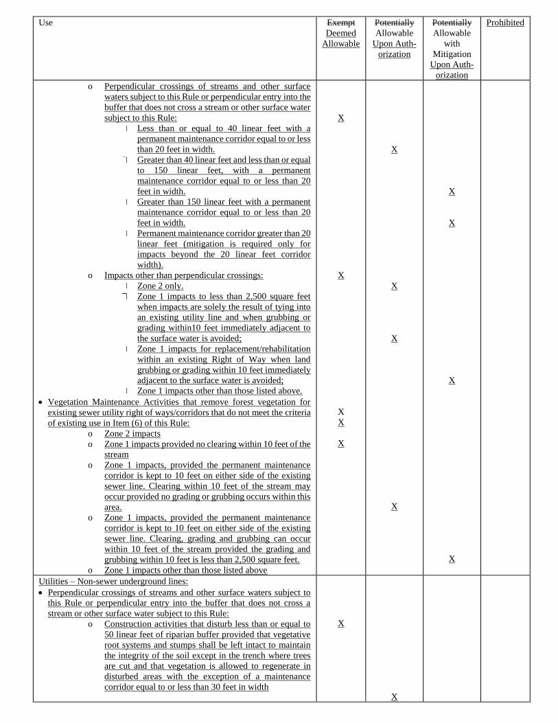
Use Exempt
Deemed
Allowable
Potentially
Allowable
Upon Auth-
orization
Potentially
Allowable
with
Mitigation
Upon Auth-
orization
Prohibited
o Perpendicular crossings of streams and other surface
waters subject to this Rule or perpendicular entry into the
buffer that does not cross a stream or other surface water
subject to this Rule:
Less than or equal to 40 linear feet with a
permanent maintenance corridor equal to or less
than 20 feet in width.
Greater than 40 linear feet and less than or equal
to 150 linear feet, with a permanent
maintenance corridor equal to or less than 20
feet in width.
Greater than 150 linear feet with a permanent
maintenance corridor equal to or less than 20
feet in width.
Permanent maintenance corridor greater than 20
linear feet (mitigation is required only for
impacts beyond the 20 linear feet corridor
width).
o Impacts other than perpendicular crossings:
Zone 2 only.
Zone 1 impacts to less than 2,500 square feet
when impacts are solely the result of tying into
an existing utility line and when grubbing or
grading within10 feet immediately adjacent to
the surface water is avoided;
Zone 1 impacts for replacement/rehabilitation
within an existing Right of Way when land
grubbing or grading within 10 feet immediately
adjacent to the surface water is avoided;
Zone 1 impacts other than those listed above.
• Vegetation Maintenance Activities that remove forest vegetation for
existing sewer utility right of ways/corridors that do not meet the criteria
of existing use in Item (6) of this Rule:
o Zone 2 impacts
o Zone 1 impacts provided no clearing within 10 feet of the
stream
o Zone 1 impacts, provided the permanent maintenance
corridor is kept to 10 feet on either side of the existing
sewer line. Clearing within 10 feet of the stream may
occur provided no grading or grubbing occurs within this
area.
o Zone 1 impacts, provided the permanent maintenance
corridor is kept to 10 feet on either side of the existing
sewer line. Clearing, grading and grubbing can occur
within 10 feet of the stream provided the grading and
grubbing within 10 feet is less than 2,500 square feet.
o Zone 1 impacts other than those listed above
X
X
X
X
X
X
X
X
X
X
X
X
X
Utilities – Non-sewer underground lines:
• Perpendicular crossings of streams and other surface waters subject to
this Rule or perpendicular entry into the buffer that does not cross a
stream or other surface water subject to this Rule:
o Construction activities that disturb less than or equal to
50 linear feet of riparian buffer provided that vegetative
root systems and stumps shall be left intact to maintain
the integrity of the soil except in the trench where trees
are cut and that vegetation is allowed to regenerate in
disturbed areas with the exception of a maintenance
corridor equal to or less than 30 feet in width
X
X
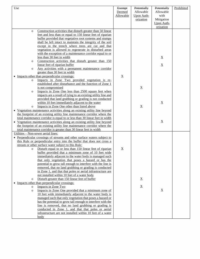
Use Exempt
Deemed
Allowable
Potentially
Allowable
Upon Auth-
orization
Potentially
Allowable
with
Mitigation
Upon Auth-
orization
Prohibited
o Construction activities that disturb greater than 50 linear
feet and less than or equal to 150 linear feet of riparian
buffer provided that vegetative root systems and stumps
shall be left intact to maintain the integrity of the soil
except in the trench where trees are cut and that
vegetation is allowed to regenerate in disturbed areas
with the exception of a maintenance corridor equal to or
less than 30 feet in width
o Construction activities that disturb greater than 150
linear feet of riparian buffer
o Any activities with a permanent maintenance corridor
greater than 30 feet in width
• Impacts other than perpendicular crossings:
o Impacts in Zone Two provided vegetation is re-
established after disturbance and the function of Zone 1
is not compromised
o Impacts in Zone One less than 2500 square feet when
impacts are a result of tying to an existing utility line and
provided that land grubbing or grading is not conducted
within 10 feet immediately adjacent to the water
o Impacts in Zone One other than listed above
• Vegetation maintenance activities along an existing utility line beyond
the footprint of an existing utility line maintenance corridor where the
total maintenance corridor is equal to or less than 30 linear feet in width
• Vegetation maintenance activities along an existing utility line beyond
the footprint of an existing utility line maintenance corridor where the
total maintenance corridor is greater than 30 linear feet in width
X
X
X
X
X
X
X
Utilities – Non-sewer aerial lines:
• Perpendicular crossings of streams and other surface waters subject to
this Rule or perpendicular entry into the buffer that does not cross a
stream or other surface water subject to this Rule:
o Disturb equal to or less than 150 linear feet of riparian
buffer provided that a minimum zone of 10 feet wide
immediately adjacent to the water body is managed such
that only vegetation that poses a hazard or has the
potential to grow tall enough to interfere with the line is
removed, that no land grubbing or grading is conducted
in Zone 1, and that that poles or aerial infrastructure are
not installed within 10 feet of a water body
o Disturb greater than 150 linear feet of buffer
• Impacts other than perpendicular crossings:
o Impacts in Zone Two
o Impacts in Zone One provided that a minimum zone of
10 feet wide immediately adjacent to the water body is
managed such that only vegetation that poses a hazard or
has the potential to grow tall enough to interfere with the
line is removed, that no land grubbing or grading is
conducted in Zone 1, and that that poles or aerial
infrastructure are not installed within 10 feet of a water
body
X
X
X
X
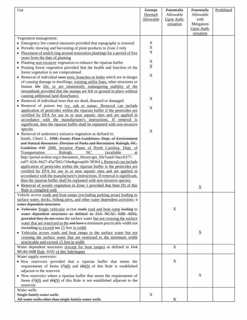
Use Exempt
Deemed
Allowable
Potentially
Allowable
Upon Auth-
orization
Potentially
Allowable
with
Mitigation
Upon Auth-
orization
Prohibited
Vegetation management:
• Emergency fire control measures provided that topography is restored
• Periodic mowing and harvesting of plant products in Zone 2 only
• Placement of mulch ring around restoration plantings for a period of five
years from the date of planting
• Planting non-invasive vegetation to enhance the riparian buffer
• Pruning forest vegetation provided that the health and function of the
forest vegetation is not compromised
• Removal of individual trees trees, branches or limbs which are in danger
of causing damage to dwellings, existing utility lines, other structures or
human life life, or are imminently endangering stability of the
streambank provided that the stumps are left or ground in place without
causing additional land disturbance.
• Removal of individual trees that are dead, diseased or damaged.
• Removal of poison ivy ivy, oak or sumac. Removal can include
application of pesticides within the riparian buffer if the pesticides are
certified by EPA for use in or near aquatic sites and are applied in
accordance with the manufacturer's instructions. If removal is
significant, then the riparian buffer shall be replanted with non-invasive
species
• Removal of understory nuisance vegetation as defined in:
Smith, Cherri L. 1998. Exotic Plant Guidelines. Dept. of Environment
and Natural Resources. Division of Parks and Recreation. Raleigh, NC.
Guideline #30 2008. Invasive Plants of North Carolina. Dept. of
Transportation. Raleigh, NC (available at
http://portal.ncdenr.org/c/document_library/get_file?uuid=0acc6377-
ea07-42dc-bb27-45a78d1c7ebe&groupId=38364 ). Removal can include
application of pesticides within the riparian buffer is the pesticides are
certified by EPA for use in or near aquatic sites and are applied in
accordance with the manufacturer's instructions. If removal is significant,
then the riparian buffer shall be replanted with non-invasive species.
• Removal of woody vegetation in Zone 1 provided that Item (9) of this
Rule is complied with
X
X
X
X
X
X
X
X
X
X
Vehicle access roads and boat ramps (excluding parking areas) leading to
surface water, docks, fishing piers, and other water dependent activities: o
water dependent structures
• Vehicular Single vehicular access roads road and boat ramp leading to
water dependent structures as defined in 15A NCAC 02B .0202,
provided they do not cross the surface water but not crossing the surface
water that are restricted to the and have a minimum practicable width not
exceeding to exceed ten 15 feet in width
• Vehicular access roads and boat ramps to the surface water but not
crossing the surface water that are restricted to the minimum width
practicable and exceed 15 feet in width
X
X
Water dependent structures (except for boat ramps) as defined in 15A
NCAC 02B Rule .0202 of this Subchapter
X
Water supply reservoirs:
•New reservoirs provided that a riparian buffer that meets the
requirements of Items (7)(8) and (8)(9) of this Rule is established
adjacent to the reservoir
• New reservoirs where a riparian buffer that meets the requirements of
Items (7)(8) and (8)(9) of this Rule is not established adjacent to the
reservoir
X
X
Water wells
Single family water wells
All water wells other than single family water wells
X
X
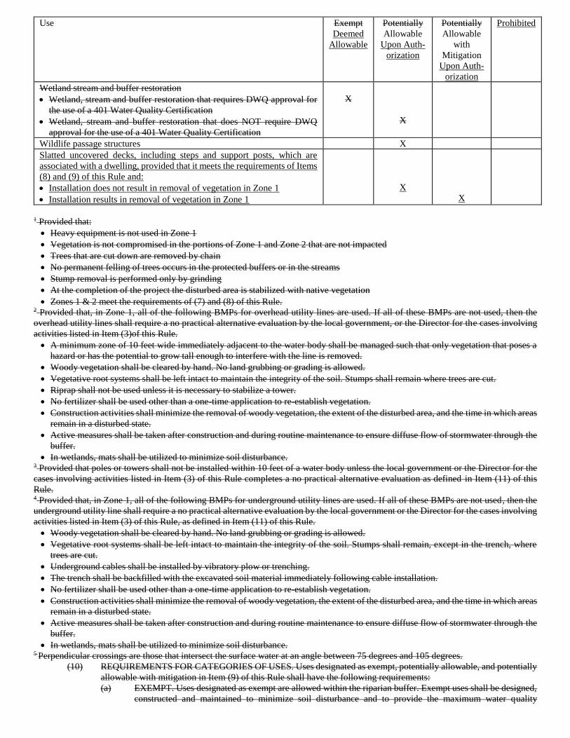
Use Exempt
Deemed
Allowable
Potentially
Allowable
Upon Auth-
orization
Potentially
Allowable
with
Mitigation
Upon Auth-
orization
Prohibited
Wetland stream and buffer restoration
• Wetland, stream and buffer restoration that requires DWQ approval for
the use of a 401 Water Quality Certification
• Wetland, stream and buffer restoration that does NOT require DWQ
approval for the use of a 401 Water Quality Certification
X
X
Wildlife passage structures X
Slatted uncovered decks, including steps and support posts, which are
associated with a dwelling, provided that it meets the requirements of Items
(8) and (9) of this Rule and:
• Installation does not result in removal of vegetation in Zone 1
• Installation results in removal of vegetation in Zone 1
X
X
1 Provided that:
• Heavy equipment is not used in Zone 1
• Vegetation is not compromised in the portions of Zone 1 and Zone 2 that are not impacted
• Trees that are cut down are removed by chain
• No permanent felling of trees occurs in the protected buffers or in the streams
• Stump removal is performed only by grinding
• At the completion of the project the disturbed area is stabilized with native vegetation
• Zones 1 & 2 meet the requirements of (7) and (8) of this Rule. 2 Provided that, in Zone 1, all of the following BMPs for overhead utility lines are used. If all of these BMPs are not used, then the
overhead utility lines shall require a no practical alternative evaluation by the local government, or the Director for the cases involving
activities listed in Item (3)of this Rule.
• A minimum zone of 10 feet wide immediately adjacent to the water body shall be managed such that only vegetation that poses a
hazard or has the potential to grow tall enough to interfere with the line is removed.
• Woody vegetation shall be cleared by hand. No land grubbing or grading is allowed.
• Vegetative root systems shall be left intact to maintain the integrity of the soil. Stumps shall remain where trees are cut.
• Riprap shall not be used unless it is necessary to stabilize a tower.
• No fertilizer shall be used other than a one-time application to re-establish vegetation.
• Construction activities shall minimize the removal of woody vegetation, the extent of the disturbed area, and the time in which areas
remain in a disturbed state.
• Active measures shall be taken after construction and during routine maintenance to ensure diffuse flow of stormwater through the
buffer.
• In wetlands, mats shall be utilized to minimize soil disturbance. 3 Provided that poles or towers shall not be installed within 10 feet of a water body unless the local government or the Director for the
cases involving activities listed in Item (3) of this Rule completes a no practical alternative evaluation as defined in Item (11) of this
Rule. 4 Provided that, in Zone 1, all of the following BMPs for underground utility lines are used. If all of these BMPs are not used, then the
underground utility line shall require a no practical alternative evaluation by the local government or the Director for the cases involving
activities listed in Item (3) of this Rule, as defined in Item (11) of this Rule.
• Woody vegetation shall be cleared by hand. No land grubbing or grading is allowed.
• Vegetative root systems shall be left intact to maintain the integrity of the soil. Stumps shall remain, except in the trench, where
trees are cut.
• Underground cables shall be installed by vibratory plow or trenching.
• The trench shall be backfilled with the excavated soil material immediately following cable installation.
• No fertilizer shall be used other than a one-time application to re-establish vegetation.
• Construction activities shall minimize the removal of woody vegetation, the extent of the disturbed area, and the time in which areas
remain in a disturbed state.
• Active measures shall be taken after construction and during routine maintenance to ensure diffuse flow of stormwater through the
buffer.
• In wetlands, mats shall be utilized to minimize soil disturbance. 5 Perpendicular crossings are those that intersect the surface water at an angle between 75 degrees and 105 degrees.
(10) REQUIREMENTS FOR CATEGORIES OF USES. Uses designated as exempt, potentially allowable, and potentially
allowable with mitigation in Item (9) of this Rule shall have the following requirements:
(a) EXEMPT. Uses designated as exempt are allowed within the riparian buffer. Exempt uses shall be designed,
constructed and maintained to minimize soil disturbance and to provide the maximum water quality
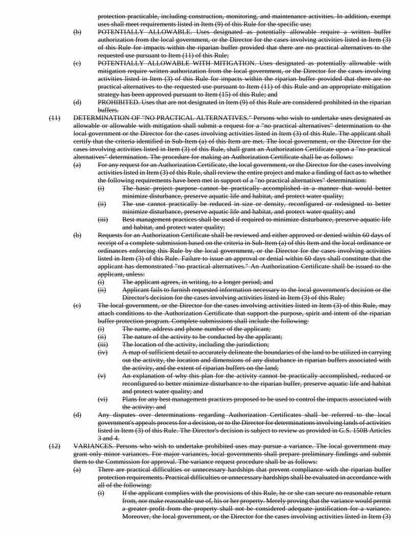
protection practicable, including construction, monitoring, and maintenance activities. In addition, exempt
uses shall meet requirements listed in Item (9) of this Rule for the specific use;
(b) POTENTIALLY ALLOWABLE. Uses designated as potentially allowable require a written buffer
authorization from the local government, or the Director for the cases involving activities listed in Item (3)
of this Rule for impacts within the riparian buffer provided that there are no practical alternatives to the
requested use pursuant to Item (11) of this Rule;
(c) POTENTIALLY ALLOWABLE WITH MITIGATION. Uses designated as potentially allowable with
mitigation require written authorization from the local government, or the Director for the cases involving
activities listed in Item (3) of this Rule for impacts within the riparian buffer provided that there are no
practical alternatives to the requested use pursuant to Item (11) of this Rule and an appropriate mitigation
strategy has been approved pursuant to Item (15) of this Rule; and
(d) PROHIBITED. Uses that are not designated in Item (9) of this Rule are considered prohibited in the riparian
buffers.
(11) DETERMINATION OF "NO PRACTICAL ALTERNATIVES." Persons who wish to undertake uses designated as
allowable or allowable with mitigation shall submit a request for a "no practical alternatives" determination to the
local government or the Director for the cases involving activities listed in Item (3) of this Rule. The applicant shall
certify that the criteria identified in Sub-Item (a) of this Item are met. The local government, or the Director for the
cases involving activities listed in Item (3) of this Rule, shall grant an Authorization Certificate upon a "no practical
alternatives" determination. The procedure for making an Authorization Certificate shall be as follows:
(a) For any request for an Authorization Certificate, the local government, or the Director for the cases involving
activities listed in Item (3) of this Rule, shall review the entire project and make a finding of fact as to whether
the following requirements have been met in support of a "no practical alternatives" determination:
(i) The basic project purpose cannot be practically accomplished in a manner that would better
minimize disturbance, preserve aquatic life and habitat, and protect water quality;
(ii) The use cannot practically be reduced in size or density, reconfigured or redesigned to better
minimize disturbance, preserve aquatic life and habitat, and protect water quality; and
(iii) Best management practices shall be used if required to minimize disturbance, preserve aquatic life
and habitat, and protect water quality;
(b) Requests for an Authorization Certificate shall be reviewed and either approved or denied within 60 days of
receipt of a complete submission based on the criteria in Sub-Item (a) of this Item and the local ordinance or
ordinances enforcing this Rule by the local government, or the Director for the cases involving activities
listed in Item (3) of this Rule. Failure to issue an approval or denial within 60 days shall constitute that the
applicant has demonstrated "no practical alternatives." An Authorization Certificate shall be issued to the
applicant, unless:
(i) The applicant agrees, in writing, to a longer period; and
(ii) Applicant fails to furnish requested information necessary to the local government's decision or the
Director's decision for the cases involving activities listed in Item (3) of this Rule;
(c) The local government, or the Director for the cases involving activities listed in Item (3) of this Rule, may
attach conditions to the Authorization Certificate that support the purpose, spirit and intent of the riparian
buffer protection program. Complete submissions shall include the following:
(i) The name, address and phone number of the applicant;
(ii) The nature of the activity to be conducted by the applicant;
(iii) The location of the activity, including the jurisdiction;
(iv) A map of sufficient detail to accurately delineate the boundaries of the land to be utilized in carrying
out the activity, the location and dimensions of any disturbance in riparian buffers associated with
the activity, and the extent of riparian buffers on the land;
(v) An explanation of why this plan for the activity cannot be practically accomplished, reduced or
reconfigured to better minimize disturbance to the riparian buffer, preserve aquatic life and habitat
and protect water quality; and
(vi) Plans for any best management practices proposed to be used to control the impacts associated with
the activity: and
(d) Any disputes over determinations regarding Authorization Certificates shall be referred to the local
government's appeals process for a decision, or to the Director for determinations involving lands of activities
listed in Item (3) of this Rule. The Director's decision is subject to review as provided in G.S. 150B Articles
3 and 4.
(12) VARIANCES. Persons who wish to undertake prohibited uses may pursue a variance. The local government may
grant only minor variances. For major variances, local governments shall prepare preliminary findings and submit
them to the Commission for approval. The variance request procedure shall be as follows:
(a) There are practical difficulties or unnecessary hardships that prevent compliance with the riparian buffer
protection requirements. Practical difficulties or unnecessary hardships shall be evaluated in accordance with
all of the following:
(i) If the applicant complies with the provisions of this Rule, he or she can secure no reasonable return
from, nor make reasonable use of, his or her property. Merely proving that the variance would permit
a greater profit from the property shall not be considered adequate justification for a variance.
Moreover, the local government, or the Director for the cases involving activities listed in Item (3)
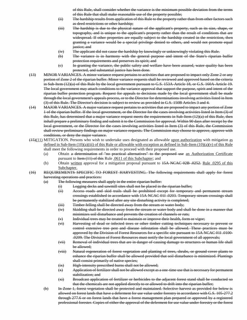
of this Rule, shall consider whether the variance is the minimum possible deviation from the terms
of this Rule that shall make reasonable use of the property possible;
(ii) The hardship results from application of this Rule to the property rather than from other factors such
as deed restrictions or other hardship;
(iii) The hardship is due to the physical nature of the applicant's property, such as its size, shape, or
topography, and is unique to the applicant's property rather than the result of conditions that are
widespread. If other properties are equally subject to the hardship created in the restriction, then
granting a variance would be a special privilege denied to others, and would not promote equal
justice; and
(iv) The applicant did not cause the hardship by knowingly or unknowingly violating this Rule.
(b) The variance is in harmony with the general purpose and intent of the State's riparian buffer
protection requirements and preserves its spirit; and
(c) In granting the variance, the public safety and welfare have been assured, water quality has been
protected, and substantial justice has been done.
(13) MINOR VARIANCES. A minor variance request pertains to activities that are proposed to impact only Zone 2 or any
portion of Zone 2 of the riparian buffer. Minor variance requests shall be reviewed and approved based on the criteria
in Sub-Item (12)(a) of this Rule by the local government pursuant to G.S. 153A-Article 18, or G.S. 160A-Article 19.
The local government may attach conditions to the variance approval that support the purpose, spirit and intent of the
riparian buffer protection program. Request for appeals to decisions made by the local government shall be made
through the local government's appeals process, or to the Director for determinations involving activities listed in Item
(3) of this Rule. The Director's decision is subject to review as provided in G.S. 150B Articles 3 and 4.
(14) MAJOR VARIANCES. A major variance request pertains to activities that are proposed to impact any portion of Zone
1 of the riparian buffer. If the local government, or the Director for the cases involving activities listed in Item (3) of
this Rule, has determined that a major variance request meets the requirements in Sub-Item (12)(a) of this Rule, then
itshall prepare a preliminary finding and submit it to the Commission for approval. Within 90 days after receipt by the
local government, or the Director for the cases involving activities listed in Item (3) of this Rule, the Commission
shall review preliminary findings on major variance requests. The Commission may choose to approve, approve with
conditions, or deny the major variance.
(15)(11) MITIGATION. Persons who wish to undertake uses designated as allowable upon authorization with mitigation as
defined in Sub-Item (10)(a)(iii) of this Rule or allowable with exception as defined in Sub-Item (10)(a)(v) of this Rule
shall meet the following requirements in order to proceed with their proposed use.
(a) Obtain a determination of "no practical alternatives" to the proposed use an Authorization Certificate
pursuant to Item (11) of this Rule .0611 of this Subchapter; and
(b) Obtain written approval for a mitigation proposal pursuant to 15A NCAC 02B .0252. Rule .0295 of this
Subchapter.
(16) REQUIREMENTS SPECIFIC TO FOREST HARVESTING. The following requirements shall apply for forest
harvesting operations and practices:
(a) The following measures shall apply in the entire riparian buffer:
(i) Logging decks and sawmill sites shall not be placed in the riparian buffer;
(ii) Access roads and skid trails shall be prohibited except for temporary and permanent stream
crossings established in accordance with 15A NCAC 01I .0203. Temporary stream crossings shall
be permanently stabilized after any site disturbing activity is completed;
(iii) Timber felling shall be directed away from the stream or water body;
(iv) Skidding shall be directed away from the stream or water body and shall be done in a manner that
minimizes soil disturbance and prevents the creation of channels or ruts;
(v) Individual trees may be treated to maintain or improve their health, form or vigor;
(vi) Harvesting of dead or infected trees or other timber cutting techniques necessary to prevent or
control extensive tree pest and disease infestation shall be allowed. These practices must be
approved by the Division of Forest Resources for a specific site pursuant to 15A NCAC 01I .0100-
.0209. The Division of Forest Resources must notify the local government of all approvals;
(vii) Removal of individual trees that are in danger of causing damage to structures or human life shall
be allowed;
(viii) Natural regeneration of forest vegetation and planting of trees, shrubs, or ground cover plants to
enhance the riparian buffer shall be allowed provided that soil disturbance is minimized. Plantings
shall consist primarily of native species;
(ix) High-intensity prescribed burns shall not be allowed;
(x) Application of fertilizer shall not be allowed except as a one-time use that is necessary for permanent
stabilization; and
(xi) Broadcast application of fertilizer or herbicides to the adjacent forest stand shall be conducted so
that the chemicals are not applied directly to or allowed to drift into the riparian buffer;
(b) In Zone 1, forest vegetation shall be protected and maintained. Selective harvest as provided for below is
allowed on forest lands that have a deferment for use value under forestry in accordance with G.S. 105-277.2
through 277.6 or on forest lands that have a forest management plan prepared or approved by a registered
professional forester. Copies of either the approval of the deferment for use value under forestry or the forest
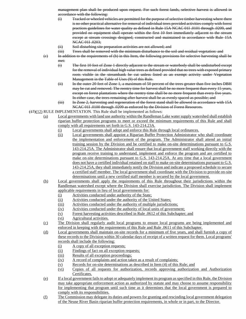
management plan shall be produced upon request. For such forest lands, selective harvest is allowed in
accordance with the following:
(i) Tracked or wheeled vehicles are permitted for the purpose of selective timber harvesting where there
is no other practical alternative for removal of individual trees provided activities comply with forest
practices guidelines for water quality as defined in Rule 15A NCAC 01I .0101 through .0209, and
provided no equipment shall operate within the first 10 feet immediately adjacent to the stream
except at stream crossings designed, constructed and maintained in accordance with Rule 15A
NCAC 01I .0203;
(ii) Soil disturbing site preparation activities are not allowed; and
(iii) Trees shall be removed with the minimum disturbance to the soil and residual vegetation: and
(c) In addition to the requirements of (b) in this Item, the following provisions for selective harvesting shall be
met:
(i) The first 10 feet of Zone 1 directly adjacent to the stream or waterbody shall be undisturbed except
for the removal of individual high value trees as defined provided that no trees with exposed primary
roots visible in the streambank be cut unless listed as an exempt activity under Vegetation
Management in the Table of Uses (9) of this Rule.
(ii) In the outer 20 feet of Zone 1, a maximum of 50 percent of the trees greater than five inches DBH
may be cut and removed. The reentry time for harvest shall be no more frequent than every 15 years,
except on forest plantations where the reentry time shall be no more frequent than every five years.
In either case, the trees remaining after harvest shall be as evenly spaced as possible; and
(iii) In Zone 2, harvesting and regeneration of the forest stand shall be allowed in accordance with 15A
NCAC 01I .0100 through .0209 as enforced by the Division of Forest Resources.
(17)(12) RULE IMPLEMENTATION. This Rule shall be implemented as follows:
(a) Local governments with land use authority within the Randleman Lake water supply watershed shall establish
riparian buffer protection programs to meet or exceed the minimum requirements of this Rule and shall
comply with all requirements set forth in G.S. 143-214.23A.
(i) Local governments shall adopt and enforce this Rule through local ordinances.
(ii) Local governments shall appoint a Riparian Buffer Protection Administrator who shall coordinate
the implementation and enforcement of the program. The Administrator shall attend an initial
training session by the Division and be certified to make on-site determinations pursuant to G.S.
143-214.25A. The Administrator shall ensure that local government staff working directly with the
program receive training to understand, implement and enforce the program and are certified to
make on-site determinations pursuant to G.S. 143-214.25A. At any time that a local government
does not have a certified individual retained on staff to make on-site determinations pursuant to G.S.
143-214.25A, they shall immediately notify the Division and indicate a proposed schedule to secure
a certified staff member. The local government shall coordinate with the Division to provide on-site
determinations until a new certified staff member is secured by the local government.
(b) Local governments shall apply the requirements of this Rule throughout their jurisdictions within the
Randleman watershed except where the Division shall exercise jurisdiction. The Division shall implement
applicable requirements in lieu of local governments for:
(i) Activities conducted under authority of the State;
(ii) Activities conducted under the authority of the United States;
(iii) Activities conducted under the authority of multiple jurisdictions;
(iv) Activities conducted under the authority of local units of government;
(v) Forest harvesting activities described in Rule .0612 of this Subchapter; and
(vi) Agricultural activities.
(c) The Division shall regularly audit local programs to ensure local programs are being implemented and
enforced in keeping with the requirements of this Rule and Rule .0611 of this Subchapter.
(d) Local governments shall maintain on-site records for a minimum of five years, and shall furnish a copy of
these records to the Division within 30 calendar days of receipt of a written request for them. Local programs'
records shall include the following:
(i) A copy of all exception requests;
(ii) Findings of fact on all exception requests;
(iii) Results of all exception proceedings;
(iv) A record of complaints and action taken as a result of complaints;
(v) Records for on-site determinations as described in Item (4) of this Rule; and
(vi) Copies of all requests for authorization, records approving authorization and Authorization
Certificates.
(e) If a local government fails to adopt or adequately implement its program as specified in this Rule, the Division
may take appropriate enforcement action as authorized by statute and may choose to assume responsibility
for implementing that program until such time as it determines that the local government is prepared to
comply with its responsibilities.
(f) The Commission may delegate its duties and powers for granting and rescinding local government delegation
of the Neuse River Basin riparian buffer protection requirements, in whole or in part, to the Director.
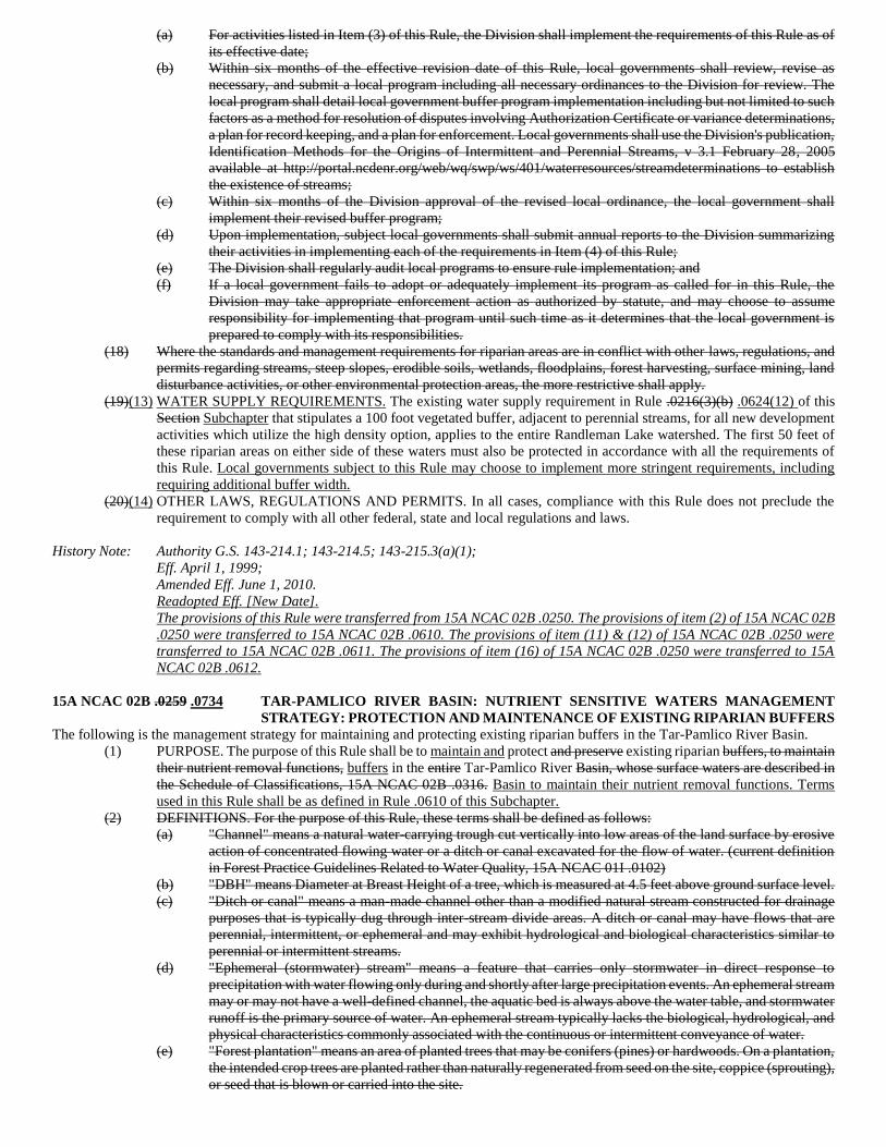
(a) For activities listed in Item (3) of this Rule, the Division shall implement the requirements of this Rule as of
its effective date;
(b) Within six months of the effective revision date of this Rule, local governments shall review, revise as
necessary, and submit a local program including all necessary ordinances to the Division for review. The
local program shall detail local government buffer program implementation including but not limited to such
factors as a method for resolution of disputes involving Authorization Certificate or variance determinations,
a plan for record keeping, and a plan for enforcement. Local governments shall use the Division's publication,
Identification Methods for the Origins of Intermittent and Perennial Streams, v 3.1 February 28, 2005
available at http://portal.ncdenr.org/web/wq/swp/ws/401/waterresources/streamdeterminations to establish
the existence of streams;
(c) Within six months of the Division approval of the revised local ordinance, the local government shall
implement their revised buffer program;
(d) Upon implementation, subject local governments shall submit annual reports to the Division summarizing
their activities in implementing each of the requirements in Item (4) of this Rule;
(e) The Division shall regularly audit local programs to ensure rule implementation; and
(f) If a local government fails to adopt or adequately implement its program as called for in this Rule, the
Division may take appropriate enforcement action as authorized by statute, and may choose to assume
responsibility for implementing that program until such time as it determines that the local government is
prepared to comply with its responsibilities.
(18) Where the standards and management requirements for riparian areas are in conflict with other laws, regulations, and
permits regarding streams, steep slopes, erodible soils, wetlands, floodplains, forest harvesting, surface mining, land
disturbance activities, or other environmental protection areas, the more restrictive shall apply.
(19)(13) WATER SUPPLY REQUIREMENTS. The existing water supply requirement in Rule .0216(3)(b) .0624(12) of this
Section Subchapter that stipulates a 100 foot vegetated buffer, adjacent to perennial streams, for all new development
activities which utilize the high density option, applies to the entire Randleman Lake watershed. The first 50 feet of
these riparian areas on either side of these waters must also be protected in accordance with all the requirements of
this Rule. Local governments subject to this Rule may choose to implement more stringent requirements, including
requiring additional buffer width.
(20)(14) OTHER LAWS, REGULATIONS AND PERMITS. In all cases, compliance with this Rule does not preclude the
requirement to comply with all other federal, state and local regulations and laws.
History Note: Authority G.S. 143-214.1; 143-214.5; 143-215.3(a)(1);
Eff. April 1, 1999;
Amended Eff. June 1, 2010.
Readopted Eff. [New Date].
The provisions of this Rule were transferred from 15A NCAC 02B .0250. The provisions of item (2) of 15A NCAC 02B
.0250 were transferred to 15A NCAC 02B .0610. The provisions of item (11) & (12) of 15A NCAC 02B .0250 were
transferred to 15A NCAC 02B .0611. The provisions of item (16) of 15A NCAC 02B .0250 were transferred to 15A
NCAC 02B .0612.
15A NCAC 02B .0259 .0734 TAR-PAMLICO RIVER BASIN: NUTRIENT SENSITIVE WATERS MANAGEMENT
STRATEGY: PROTECTION AND MAINTENANCE OF EXISTING RIPARIAN BUFFERS
The following is the management strategy for maintaining and protecting existing riparian buffers in the Tar-Pamlico River Basin.
(1) PURPOSE. The purpose of this Rule shall be to maintain and protect and preserve existing riparian buffers, to maintain
their nutrient removal functions, buffers in the entire Tar-Pamlico River Basin, whose surface waters are described in
the Schedule of Classifications, 15A NCAC 02B .0316. Basin to maintain their nutrient removal functions. Terms
used in this Rule shall be as defined in Rule .0610 of this Subchapter.
(2) DEFINITIONS. For the purpose of this Rule, these terms shall be defined as follows:
(a) "Channel" means a natural water-carrying trough cut vertically into low areas of the land surface by erosive
action of concentrated flowing water or a ditch or canal excavated for the flow of water. (current definition
in Forest Practice Guidelines Related to Water Quality, 15A NCAC 01I .0102)
(b) "DBH" means Diameter at Breast Height of a tree, which is measured at 4.5 feet above ground surface level.
(c) "Ditch or canal" means a man-made channel other than a modified natural stream constructed for drainage
purposes that is typically dug through inter-stream divide areas. A ditch or canal may have flows that are
perennial, intermittent, or ephemeral and may exhibit hydrological and biological characteristics similar to
perennial or intermittent streams.
(d) "Ephemeral (stormwater) stream" means a feature that carries only stormwater in direct response to
precipitation with water flowing only during and shortly after large precipitation events. An ephemeral stream
may or may not have a well-defined channel, the aquatic bed is always above the water table, and stormwater
runoff is the primary source of water. An ephemeral stream typically lacks the biological, hydrological, and
physical characteristics commonly associated with the continuous or intermittent conveyance of water.
(e) "Forest plantation" means an area of planted trees that may be conifers (pines) or hardwoods. On a plantation,
the intended crop trees are planted rather than naturally regenerated from seed on the site, coppice (sprouting),
or seed that is blown or carried into the site.
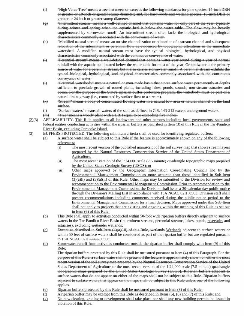
(f) "High Value Tree" means a tree that meets or exceeds the following standards: for pine species, 14-inch DBH
or greater or 18-inch or greater stump diameter; and, for hardwoods and wetland species, 16-inch DBH or
greater or 24-inch or greater stump diameter.
(g) "Intermittent stream" means a well-defined channel that contains water for only part of the year, typically
during winter and spring when the aquatic bed is below the water table. The flow may be heavily
supplemented by stormwater runoff. An intermittent stream often lacks the biological and hydrological
characteristics commonly associated with the conveyance of water.
(h) "Modified natural stream" means an on-site channelization or relocation of a stream channel and subsequent
relocation of the intermittent or perennial flow as evidenced by topographic alterations in the immediate
watershed. A modified natural stream must have the typical biological, hydrological, and physical
characteristics commonly associated with the continuous conveyance of water.
(i) "Perennial stream" means a well-defined channel that contains water year round during a year of normal
rainfall with the aquatic bed located below the water table for most of the year. Groundwater is the primary
source of water for a perennial stream, but it also carries stormwater runoff. A perennial stream exhibits the
typical biological, hydrological, and physical characteristics commonly associated with the continuous
conveyance of water.
(j) "Perennial waterbody" means a natural or man-made basin that stores surface water permanently at depths
sufficient to preclude growth of rooted plants, including lakes, ponds, sounds, non-stream estuaries and
ocean. For the purpose of the State's riparian buffer protection program, the waterbody must be part of a
natural drainageway (i.e., connected by surface flow to a stream).
(k) "Stream" means a body of concentrated flowing water in a natural low area or natural channel on the land
surface.
(l) "Surface waters" means all waters of the state as defined in G.S. 143-212 except underground waters.
(m) "Tree" means a woody plant with a DBH equal to or exceeding five inches.
(2)(3) APPLICABILITY. This Rule applies to all landowners and other persons including local governments, state and
federal entities conducting activities within the riparian buffers as described in Item (3) of this Rule in the Tar-Pamlico
River Basin, excluding Ocracoke Island.
(3) BUFFERS PROTECTED. The following minimum criteria shall be used for identifying regulated buffers:
(a) A surface water shall be subject to this Rule if the feature is approximately shown on any of the following
references:
(i) The most recent version of the published manuscript of the soil survey map that shows stream layers
prepared by the Natural Resources Conservation Service of the United States Department of
Agriculture;
(ii) The most recent version of the 1:24,000 scale (7.5 minute) quadrangle topographic maps prepared
by the United States Geologic Survey (USGS); or
(iii) Other maps approved by the Geographic Information Coordinating Council and by the
Environmental Management Commission as more accurate than those identified in Sub-Item
(3)(a)(i) and (3)(a)(ii) of this Rule. Other maps may be submitted to the Division for review and
recommendation to the Environmental Management Commission. Prior to recommendation to the
Environmental Management Commission, the Division shall issue a 30-calendar day public notice
through the Division's Mailing List in accordance with 15A NCAC 02H .0503. Division staff shall
present recommendations including comments received during the public notice period to the
Environmental Management Commission for a final decision. Maps approved under this Sub-Item
shall not apply to projects that are existing and ongoing within the meaning of this Rule as set out
in Item (6) of this Rule;
(b) This Rule shall apply to activities conducted within 50-foot wide riparian buffers directly adjacent to surface
waters in the Tar-Pamlico River Basin (intermittent streams, perennial streams, lakes, ponds, reservoirs and
estuaries), excluding wetlands. wetlands;
(c) Except as described in Sub-Item (4)(a)(iii) of this Rule, wetlands Wetlands adjacent to surface waters or
within 50 feet of surface waters shall be considered as part of the riparian buffer but are regulated pursuant
to 15A NCAC 02H .0506. .0506;
(d) Stormwater runoff from activities conducted outside the riparian buffer shall comply with Item (9) of this
Rule;
The riparian buffers protected by this Rule shall be measured pursuant to Item (4) of this Paragraph. For the
purpose of this Rule, a surface water shall be present if the feature is approximately shown on either the most
recent version of the soil survey map prepared by the Natural Resources Conservation Service of the United
States Department of Agriculture or the most recent version of the 1:24,000 scale (7.5 minute) quadrangle
topographic maps prepared by the United States Geologic Survey (USGS). Riparian buffers adjacent to
surface waters that do not appear on either of the maps shall not be subject to this Rule. Riparian buffers
adjacent to surface waters that appear on the maps shall be subject to this Rule unless one of the following
applies.
(e) Riparian buffers protected by this Rule shall be measured pursuant to Item (8) of this Rule;
(f) A riparian buffer may be exempt from this Rule as described in Items (5), (6) and (7) of this Rule; and
(g) No new clearing, grading or development shall take place nor shall any new building permits be issued in
violation of this Rule.
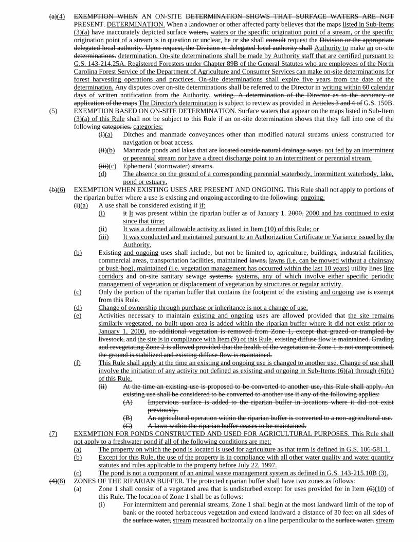
(a)(4) EXEMPTION WHEN AN ON-SITE DETERMINATION SHOWS THAT SURFACE WATERS ARE NOT
PRESENT. DETERMINATION. When a landowner or other affected party believes that the maps listed in Sub-Items
(3)(a) have inaccurately depicted surface waters, waters or the specific origination point of a stream, or the specific
origination point of a stream is in question or unclear, he or she shall consult request the Division or the appropriate
delegated local authority. Upon request, the Division or delegated local authority shall Authority to make an on-site
determinations. determination. On-site determinations shall be made by Authority staff that are certified pursuant to
G.S. 143-214.25A. Registered Foresters under Chapter 89B of the General Statutes who are employees of the North
Carolina Forest Service of the Department of Agriculture and Consumer Services can make on-site determinations for
forest harvesting operations and practices. On-site determinations shall expire five years from the date of the
determination. Any disputes over on-site determinations shall be referred to the Director in writing within 60 calendar
days of written notification from the Authority. writing. A determination of the Director as to the accuracy or
application of the maps The Director's determination is subject to review as provided in Articles 3 and 4 of G.S. 150B.
(5) EXEMPTION BASED ON ON-SITE DETERMINATION. Surface waters that appear on the maps listed in Sub-Item
(3)(a) of this Rule shall not be subject to this Rule if an on-site determination shows that they fall into one of the
following categories. categories:
(i)(a) Ditches and manmade conveyances other than modified natural streams unless constructed for
navigation or boat access.
(ii)(b) Manmade ponds and lakes that are located outside natural drainage ways. not fed by an intermittent
or perennial stream nor have a direct discharge point to an intermittent or perennial stream.
(iii)(c) Ephemeral (stormwater) streams.
(d) The absence on the ground of a corresponding perennial waterbody, intermittent waterbody, lake,
pond or estuary.
(b)(6) EXEMPTION WHEN EXISTING USES ARE PRESENT AND ONGOING. This Rule shall not apply to portions of
the riparian buffer where a use is existing and ongoing according to the following: ongoing.
(i)(a) A use shall be considered existing if if:
(i) it It was present within the riparian buffer as of January 1, 2000. 2000 and has continued to exist
since that time;
(ii) It was a deemed allowable activity as listed in Item (10) of this Rule; or
(iii) It was conducted and maintained pursuant to an Authorization Certificate or Variance issued by the
Authority.
(b) Existing and ongoing uses shall include, but not be limited to, agriculture, buildings, industrial facilities,
commercial areas, transportation facilities, maintained lawns, lawns (i.e. can be mowed without a chainsaw
or bush-hog), maintained (i.e. vegetation management has occurred within the last 10 years) utility lines line
corridors and on-site sanitary sewage systems. systems, any of which involve either specific periodic
management of vegetation or displacement of vegetation by structures or regular activity.
(c) Only the portion of the riparian buffer that contains the footprint of the existing and ongoing use is exempt
from this Rule.
(d) Change of ownership through purchase or inheritance is not a change of use.
(e) Activities necessary to maintain existing and ongoing uses are allowed provided that the site remains
similarly vegetated, no built upon area is added within the riparian buffer where it did not exist prior to
January 1, 2000, no additional vegetation is removed from Zone 1, except that grazed or trampled by
livestock, and the site is in compliance with Item (9) of this Rule. existing diffuse flow is maintained. Grading
and revegetating Zone 2 is allowed provided that the health of the vegetation in Zone 1 is not compromised,
the ground is stabilized and existing diffuse flow is maintained.
(f) This Rule shall apply at the time an existing and ongoing use is changed to another use. Change of use shall
involve the initiation of any activity not defined as existing and ongoing in Sub-Items (6)(a) through (6)(e)
of this Rule.
(ii) At the time an existing use is proposed to be converted to another use, this Rule shall apply. An
existing use shall be considered to be converted to another use if any of the following applies:
(A) Impervious surface is added to the riparian buffer in locations where it did not exist
previously.
(B) An agricultural operation within the riparian buffer is converted to a non-agricultural use.
(C) A lawn within the riparian buffer ceases to be maintained.
(7) EXEMPTION FOR PONDS CONSTRUCTED AND USED FOR AGRICULTURAL PURPOSES. This Rule shall
not apply to a freshwater pond if all of the following conditions are met:
(a) The property on which the pond is located is used for agriculture as that term is defined in G.S. 106-581.1.
(b) Except for this Rule, the use of the property is in compliance with all other water quality and water quantity
statutes and rules applicable to the property before July 22, 1997.
(c) The pond is not a component of an animal waste management system as defined in G.S. 143-215.10B (3).
(4)(8) ZONES OF THE RIPARIAN BUFFER. The protected riparian buffer shall have two zones as follows:
(a) Zone 1 shall consist of a vegetated area that is undisturbed except for uses provided for in Item (6)(10) of
this Rule. The location of Zone 1 shall be as follows:
(i) For intermittent and perennial streams, Zone 1 shall begin at the most landward limit of the top of
bank or the rooted herbaceous vegetation and extend landward a distance of 30 feet on all sides of
the surface water, stream measured horizontally on a line perpendicular to the surface water. stream
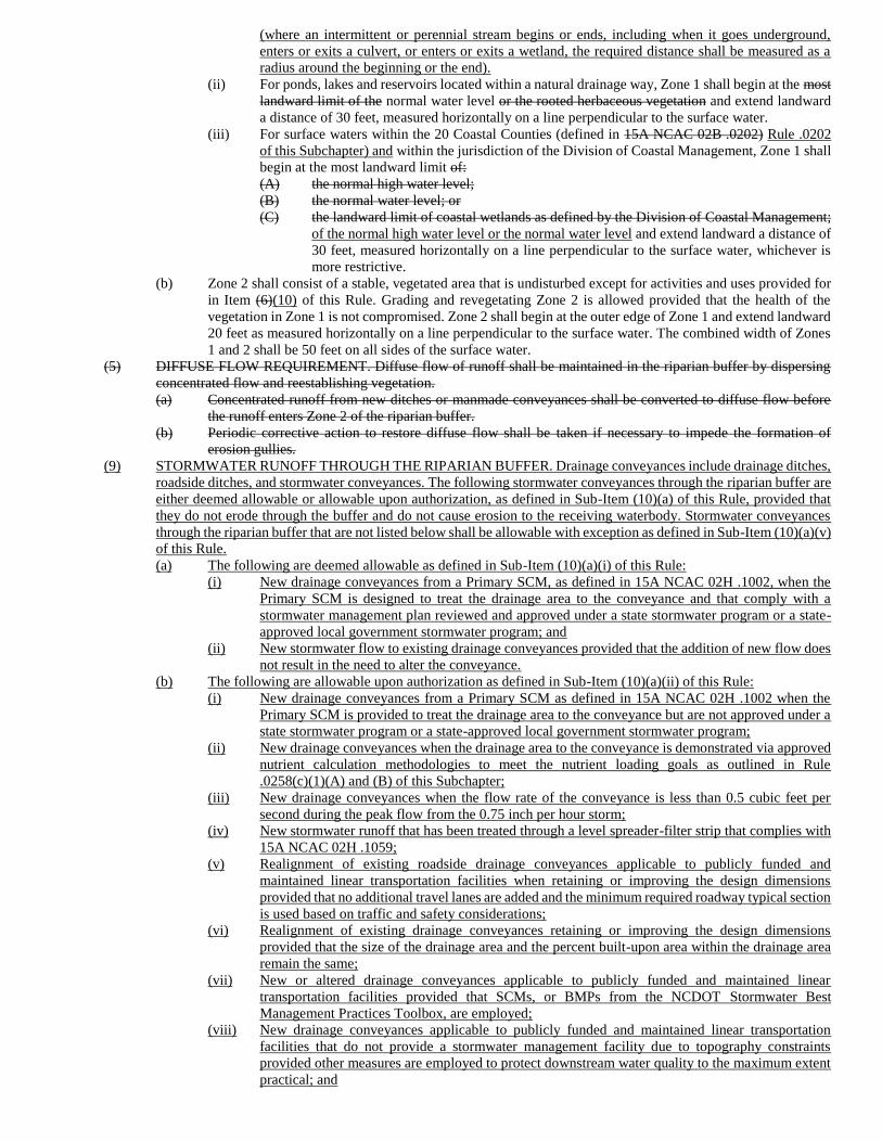
(where an intermittent or perennial stream begins or ends, including when it goes underground,
enters or exits a culvert, or enters or exits a wetland, the required distance shall be measured as a
radius around the beginning or the end).
(ii) For ponds, lakes and reservoirs located within a natural drainage way, Zone 1 shall begin at the most
landward limit of the normal water level or the rooted herbaceous vegetation and extend landward
a distance of 30 feet, measured horizontally on a line perpendicular to the surface water.
(iii) For surface waters within the 20 Coastal Counties (defined in 15A NCAC 02B .0202) Rule .0202
of this Subchapter) and within the jurisdiction of the Division of Coastal Management, Zone 1 shall
begin at the most landward limit of:
(A) the normal high water level;
(B) the normal water level; or
(C) the landward limit of coastal wetlands as defined by the Division of Coastal Management;
of the normal high water level or the normal water level and extend landward a distance of
30 feet, measured horizontally on a line perpendicular to the surface water, whichever is
more restrictive.
(b) Zone 2 shall consist of a stable, vegetated area that is undisturbed except for activities and uses provided for
in Item (6)(10) of this Rule. Grading and revegetating Zone 2 is allowed provided that the health of the
vegetation in Zone 1 is not compromised. Zone 2 shall begin at the outer edge of Zone 1 and extend landward
20 feet as measured horizontally on a line perpendicular to the surface water. The combined width of Zones
1 and 2 shall be 50 feet on all sides of the surface water.
(5) DIFFUSE FLOW REQUIREMENT. Diffuse flow of runoff shall be maintained in the riparian buffer by dispersing
concentrated flow and reestablishing vegetation.
(a) Concentrated runoff from new ditches or manmade conveyances shall be converted to diffuse flow before
the runoff enters Zone 2 of the riparian buffer.
(b) Periodic corrective action to restore diffuse flow shall be taken if necessary to impede the formation of
erosion gullies.
(9) STORMWATER RUNOFF THROUGH THE RIPARIAN BUFFER. Drainage conveyances include drainage ditches,
roadside ditches, and stormwater conveyances. The following stormwater conveyances through the riparian buffer are
either deemed allowable or allowable upon authorization, as defined in Sub-Item (10)(a) of this Rule, provided that
they do not erode through the buffer and do not cause erosion to the receiving waterbody. Stormwater conveyances
through the riparian buffer that are not listed below shall be allowable with exception as defined in Sub-Item (10)(a)(v)
of this Rule.
(a) The following are deemed allowable as defined in Sub-Item (10)(a)(i) of this Rule:
(i) New drainage conveyances from a Primary SCM, as defined in 15A NCAC 02H .1002, when the
Primary SCM is designed to treat the drainage area to the conveyance and that comply with a
stormwater management plan reviewed and approved under a state stormwater program or a state-
approved local government stormwater program; and
(ii) New stormwater flow to existing drainage conveyances provided that the addition of new flow does
not result in the need to alter the conveyance.
(b) The following are allowable upon authorization as defined in Sub-Item (10)(a)(ii) of this Rule:
(i) New drainage conveyances from a Primary SCM as defined in 15A NCAC 02H .1002 when the
Primary SCM is provided to treat the drainage area to the conveyance but are not approved under a
state stormwater program or a state-approved local government stormwater program;
(ii) New drainage conveyances when the drainage area to the conveyance is demonstrated via approved
nutrient calculation methodologies to meet the nutrient loading goals as outlined in Rule
.0258(c)(1)(A) and (B) of this Subchapter;
(iii) New drainage conveyances when the flow rate of the conveyance is less than 0.5 cubic feet per
second during the peak flow from the 0.75 inch per hour storm;
(iv) New stormwater runoff that has been treated through a level spreader-filter strip that complies with
15A NCAC 02H .1059;
(v) Realignment of existing roadside drainage conveyances applicable to publicly funded and
maintained linear transportation facilities when retaining or improving the design dimensions
provided that no additional travel lanes are added and the minimum required roadway typical section
is used based on traffic and safety considerations;
(vi) Realignment of existing drainage conveyances retaining or improving the design dimensions
provided that the size of the drainage area and the percent built-upon area within the drainage area
remain the same;
(vii) New or altered drainage conveyances applicable to publicly funded and maintained linear
transportation facilities provided that SCMs, or BMPs from the NCDOT Stormwater Best
Management Practices Toolbox, are employed;
(viii) New drainage conveyances applicable to publicly funded and maintained linear transportation
facilities that do not provide a stormwater management facility due to topography constraints
provided other measures are employed to protect downstream water quality to the maximum extent
practical; and
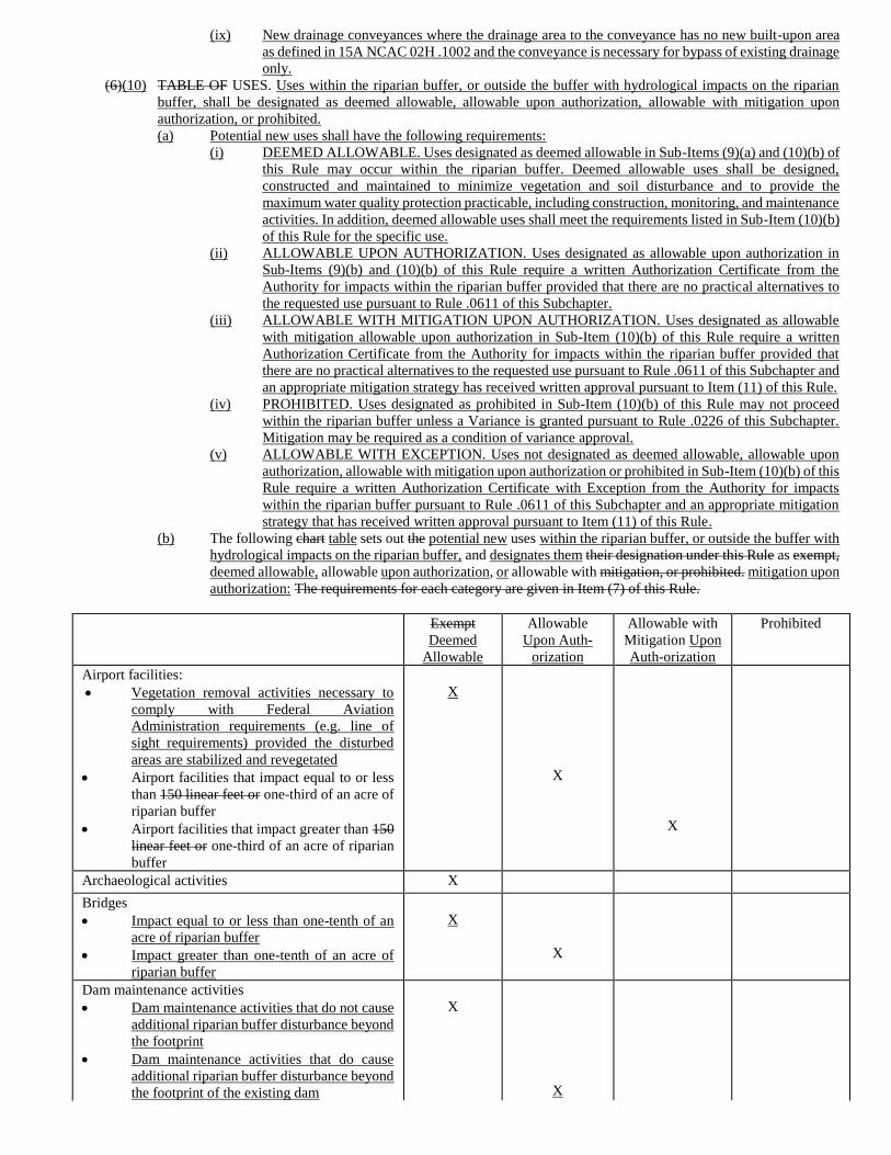
(ix) New drainage conveyances where the drainage area to the conveyance has no new built-upon area
as defined in 15A NCAC 02H .1002 and the conveyance is necessary for bypass of existing drainage
only.
(6)(10) TABLE OF USES. Uses within the riparian buffer, or outside the buffer with hydrological impacts on the riparian
buffer, shall be designated as deemed allowable, allowable upon authorization, allowable with mitigation upon
authorization, or prohibited.
(a) Potential new uses shall have the following requirements:
(i) DEEMED ALLOWABLE. Uses designated as deemed allowable in Sub-Items (9)(a) and (10)(b) of
this Rule may occur within the riparian buffer. Deemed allowable uses shall be designed,
constructed and maintained to minimize vegetation and soil disturbance and to provide the
maximum water quality protection practicable, including construction, monitoring, and maintenance
activities. In addition, deemed allowable uses shall meet the requirements listed in Sub-Item (10)(b)
of this Rule for the specific use.
(ii) ALLOWABLE UPON AUTHORIZATION. Uses designated as allowable upon authorization in
Sub-Items (9)(b) and (10)(b) of this Rule require a written Authorization Certificate from the
Authority for impacts within the riparian buffer provided that there are no practical alternatives to
the requested use pursuant to Rule .0611 of this Subchapter.
(iii) ALLOWABLE WITH MITIGATION UPON AUTHORIZATION. Uses designated as allowable
with mitigation allowable upon authorization in Sub-Item (10)(b) of this Rule require a written
Authorization Certificate from the Authority for impacts within the riparian buffer provided that
there are no practical alternatives to the requested use pursuant to Rule .0611 of this Subchapter and
an appropriate mitigation strategy has received written approval pursuant to Item (11) of this Rule.
(iv) PROHIBITED. Uses designated as prohibited in Sub-Item (10)(b) of this Rule may not proceed
within the riparian buffer unless a Variance is granted pursuant to Rule .0226 of this Subchapter.
Mitigation may be required as a condition of variance approval.
(v) ALLOWABLE WITH EXCEPTION. Uses not designated as deemed allowable, allowable upon
authorization, allowable with mitigation upon authorization or prohibited in Sub-Item (10)(b) of this
Rule require a written Authorization Certificate with Exception from the Authority for impacts
within the riparian buffer pursuant to Rule .0611 of this Subchapter and an appropriate mitigation
strategy that has received written approval pursuant to Item (11) of this Rule.
(b) The following chart table sets out the potential new uses within the riparian buffer, or outside the buffer with
hydrological impacts on the riparian buffer, and designates them their designation under this Rule as exempt,
deemed allowable, allowable upon authorization, or allowable with mitigation, or prohibited. mitigation upon
authorization: The requirements for each category are given in Item (7) of this Rule.
Exempt
Deemed
Allowable
Allowable
Upon Auth-
orization
Allowable with
Mitigation Upon
Auth-orization
Prohibited
Airport facilities:
• Vegetation removal activities necessary to
comply with Federal Aviation
Administration requirements (e.g. line of
sight requirements) provided the disturbed
areas are stabilized and revegetated
• Airport facilities that impact equal to or less
than 150 linear feet or one-third of an acre of
riparian buffer
• Airport facilities that impact greater than 150
linear feet or one-third of an acre of riparian
buffer
X
X
X
Archaeological activities X
Bridges
• Impact equal to or less than one-tenth of an
acre of riparian buffer
• Impact greater than one-tenth of an acre of
riparian buffer
X
X
Dam maintenance activities
• Dam maintenance activities that do not cause
additional riparian buffer disturbance beyond
the footprint
• Dam maintenance activities that do cause
additional riparian buffer disturbance beyond
the footprint of the existing dam
X
X
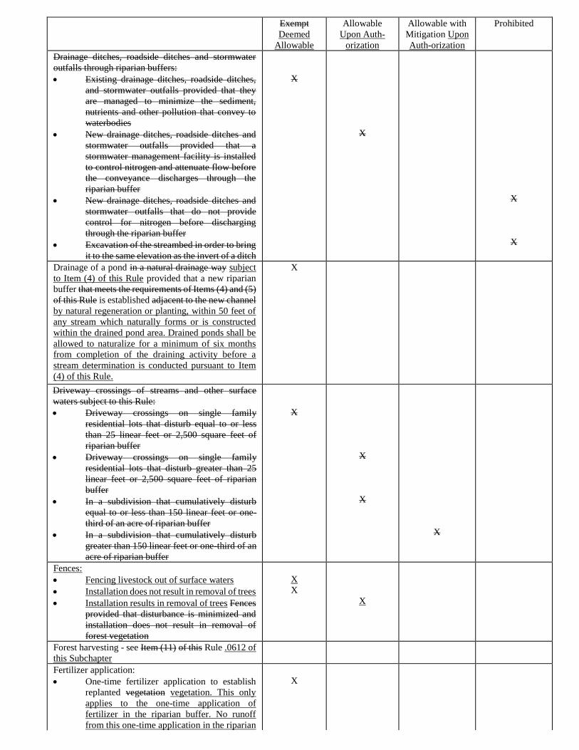
Exempt
Deemed
Allowable
Allowable
Upon Auth-
orization
Allowable with
Mitigation Upon
Auth-orization
Prohibited
Drainage ditches, roadside ditches and stormwater
outfalls through riparian buffers:
• Existing drainage ditches, roadside ditches,
and stormwater outfalls provided that they
are managed to minimize the sediment,
nutrients and other pollution that convey to
waterbodies
• New drainage ditches, roadside ditches and
stormwater outfalls provided that a
stormwater management facility is installed
to control nitrogen and attenuate flow before
the conveyance discharges through the
riparian buffer
• New drainage ditches, roadside ditches and
stormwater outfalls that do not provide
control for nitrogen before discharging
through the riparian buffer
• Excavation of the streambed in order to bring
it to the same elevation as the invert of a ditch
X
X
X
X
Drainage of a pond in a natural drainage way subject
to Item (4) of this Rule provided that a new riparian
buffer that meets the requirements of Items (4) and (5)
of this Rule is established adjacent to the new channel
by natural regeneration or planting, within 50 feet of
any stream which naturally forms or is constructed
within the drained pond area. Drained ponds shall be
allowed to naturalize for a minimum of six months
from completion of the draining activity before a
stream determination is conducted pursuant to Item
(4) of this Rule.
X
Driveway crossings of streams and other surface
waters subject to this Rule:
• Driveway crossings on single family
residential lots that disturb equal to or less
than 25 linear feet or 2,500 square feet of
riparian buffer
• Driveway crossings on single family
residential lots that disturb greater than 25
linear feet or 2,500 square feet of riparian
buffer
• In a subdivision that cumulatively disturb
equal to or less than 150 linear feet or one-
third of an acre of riparian buffer
• In a subdivision that cumulatively disturb
greater than 150 linear feet or one-third of an
acre of riparian buffer
X
X
X
X
Fences:
• Fencing livestock out of surface waters
• Installation does not result in removal of trees
• Installation results in removal of trees Fences
provided that disturbance is minimized and
installation does not result in removal of
forest vegetation
X
X
X
Forest harvesting - see Item (11) of this Rule .0612 of
this Subchapter
Fertilizer application:
• One-time fertilizer application to establish
replanted vegetation vegetation. This only
applies to the one-time application of
fertilizer in the riparian buffer. No runoff
from this one-time application in the riparian
X
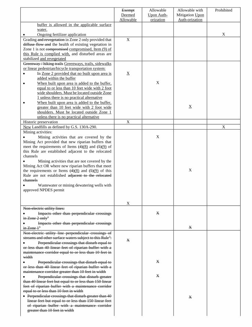
Exempt
Deemed
Allowable
Allowable
Upon Auth-
orization
Allowable with
Mitigation Upon
Auth-orization
Prohibited
buffer is allowed in the applicable surface
water.
• Ongoing fertilizer application
X
Grading and revegetation in Zone 2 only provided that
diffuse flow and the health of existing vegetation in
Zone 1 is not compromised compromised, Item (9) of
this Rule is complied with, and disturbed areas are
stabilized and revegetated
X
Greenway / hiking trails Greenways, trails, sidewalks
or linear pedestrian/bicycle transportation system:
• In Zone 2 provided that no built upon area is
added within the buffer
• When built upon area is added to the buffer,
equal to or less than 10 feet wide with 2 foot
wide shoulders. Must be located outside Zone
1 unless there is no practical alternative
• When built upon area is added to the buffer,
greater than 10 feet wide with 2 foot wide
shoulders. Must be located outside Zone 1
unless there is no practical alternative
X
X
X
Historic preservation X
New Landfills as defined by G.S. 130A-290. X
Mining activities:
• Mining activities that are covered by the
Mining Act provided that new riparian buffers that
meet the requirements of Items (4)(8) and (5)(9) of
this Rule are established adjacent to the relocated
channels
• Mining activities that are not covered by the
Mining Act OR where new riparian buffers that meet
the requirements or Items (4)(8) and (5)(9) of this
Rule are not established adjacent to the relocated
channels
• Wastewater or mining dewatering wells with
approved NPDES permit
X
X
X
Non-electric utility lines:
• Impacts other than perpendicular crossings
in Zone 2 only3
• Impacts other than perpendicular crossings
in Zone 13
X
X
Non-electric utility line perpendicular crossings of
streams and other surface waters subject to this Rule3:
• Perpendicular crossings that disturb equal to
or less than 40 linear feet of riparian buffer with a
maintenance corridor equal to or less than 10 feet in
width
• Perpendicular crossings that disturb equal to
or less than 40 linear feet of riparian buffer with a
maintenance corridor greater than 10 feet in width
• Perpendicular crossings that disturb greater
than 40 linear feet but equal to or less than 150 linear
feet of riparian buffer with a maintenance corridor
equal to or less than 10 feet in width
• Perpendicular crossings that disturb greater than 40
linear feet but equal to or less than 150 linear feet
of riparian buffer with a maintenance corridor
greater than 10 feet in width
X
X
X
X
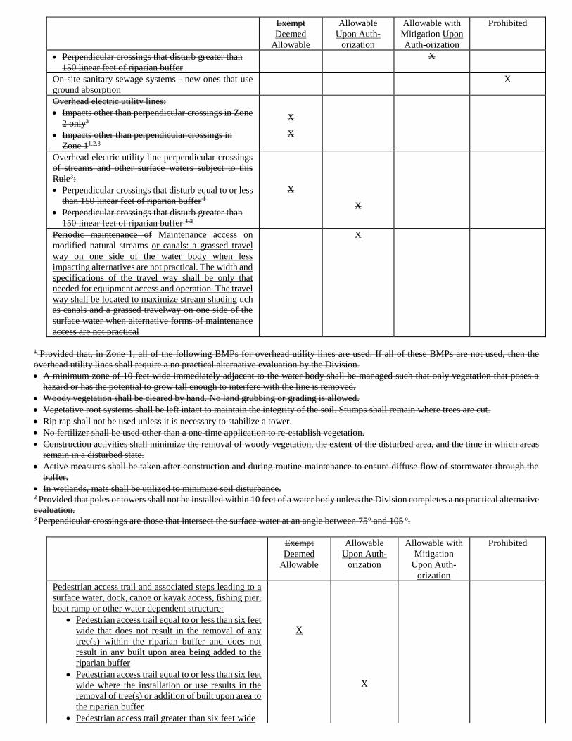
Exempt
Deemed
Allowable
Allowable
Upon Auth-
orization
Allowable with
Mitigation Upon
Auth-orization
Prohibited
• Perpendicular crossings that disturb greater than
150 linear feet of riparian buffer
X
On-site sanitary sewage systems - new ones that use
ground absorption
X
Overhead electric utility lines:
• Impacts other than perpendicular crossings in Zone
2 only3
• Impacts other than perpendicular crossings in
Zone 11,2,3
X
X
Overhead electric utility line perpendicular crossings
of streams and other surface waters subject to this
Rule3:
• Perpendicular crossings that disturb equal to or less
than 150 linear feet of riparian buffer 1
• Perpendicular crossings that disturb greater than
150 linear feet of riparian buffer 1,2
X
X
Periodic maintenance of Maintenance access on
modified natural streams or canals: a grassed travel
way on one side of the water body when less
impacting alternatives are not practical. The width and
specifications of the travel way shall be only that
needed for equipment access and operation. The travel
way shall be located to maximize stream shading uch
as canals and a grassed travelway on one side of the
surface water when alternative forms of maintenance
access are not practical
X
1 Provided that, in Zone 1, all of the following BMPs for overhead utility lines are used. If all of these BMPs are not used, then the
overhead utility lines shall require a no practical alternative evaluation by the Division.
• A minimum zone of 10 feet wide immediately adjacent to the water body shall be managed such that only vegetation that poses a
hazard or has the potential to grow tall enough to interfere with the line is removed.
• Woody vegetation shall be cleared by hand. No land grubbing or grading is allowed.
• Vegetative root systems shall be left intact to maintain the integrity of the soil. Stumps shall remain where trees are cut.
• Rip rap shall not be used unless it is necessary to stabilize a tower.
• No fertilizer shall be used other than a one-time application to re-establish vegetation.
• Construction activities shall minimize the removal of woody vegetation, the extent of the disturbed area, and the time in which areas
remain in a disturbed state.
• Active measures shall be taken after construction and during routine maintenance to ensure diffuse flow of stormwater through the
buffer.
• In wetlands, mats shall be utilized to minimize soil disturbance. 2 Provided that poles or towers shall not be installed within 10 feet of a water body unless the Division completes a no practical alternative
evaluation. 3 Perpendicular crossings are those that intersect the surface water at an angle between 75o and 105 o.
Exempt
Deemed
Allowable
Allowable
Upon Auth-
orization
Allowable with
Mitigation
Upon Auth-
orization
Prohibited
Pedestrian access trail and associated steps leading to a
surface water, dock, canoe or kayak access, fishing pier,
boat ramp or other water dependent structure:
• Pedestrian access trail equal to or less than six feet
wide that does not result in the removal of any
tree(s) within the riparian buffer and does not
result in any built upon area being added to the
riparian buffer
• Pedestrian access trail equal to or less than six feet
wide where the installation or use results in the
removal of tree(s) or addition of built upon area to
the riparian buffer
• Pedestrian access trail greater than six feet wide
X
X
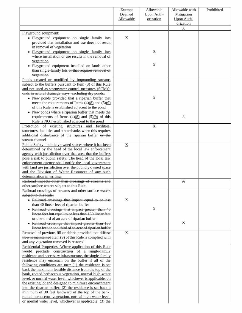
Exempt
Deemed
Allowable
Allowable
Upon Auth-
orization
Allowable with
Mitigation
Upon Auth-
orization
Prohibited
X
Playground equipment:
• Playground equipment on single family lots
provided that installation and use does not result
in removal of vegetation
• Playground equipment on single family lots
where installation or use results in the removal of
vegetation
• Playground equipment installed on lands other
than single-family lots or that requires removal of
vegetation
X
X
X
Ponds created or modified by impounding streams
subject to the buffers pursuant to Item (3) of this Rule
and not used as stormwater control measures (SCMs):
onds in natural drainage ways, excluding dry ponds:
• New ponds provided that a riparian buffer that
meets the requirements of Items (4)(8) and (5)(9)
of this Rule is established adjacent to the pond
• New ponds where a riparian buffer that meets the
requirements of Items (4)(8) and (5)(9) of this
Rule is NOT established adjacent to the pond
X
X
Protection of existing structures and facilities,
structures, facilities and streambanks when this requires
additional disturbance of the riparian buffer or the
stream channel
X
Public Safety - publicly owned spaces where it has been
determined by the head of the local law enforcement
agency with jurisdiction over that area that the buffers
pose a risk to public safety. The head of the local law
enforcement agency shall notify the local government
with land use jurisdiction over the publicly owned space
and the Division of Water Resources of any such
determination in writing.
X
Railroad impacts other than crossings of streams and
other surface waters subject to this Rule.
X
Railroad crossings of streams and other surface waters
subject to this Rule:
• Railroad crossings that impact equal to or less
than 40 linear feet of riparian buffer
• Railroad crossings that impact greater than 40
linear feet but equal to or less than 150 linear feet
or one-third of an acre of riparian buffer
• Railroad crossings that impact greater than 150
linear feet or one-third of an acre of riparian buffer
X
X
X
Removal of previous fill or debris provided that diffuse
flow is maintained Item (9) of this Rule is complied with
and any vegetation removed is restored
X
Residential Properties: Where application of this Rule
would preclude construction of a single-family
residence and necessary infrastructure, the single-family
residence may encroach on the buffer if all of the
following conditions are met: (1) the residence is set
back the maximum feasible distance from the top of the
bank, rooted herbaceous vegetation, normal high-water
level, or normal water level, whichever is applicable, on
the existing lot and designed to minimize encroachment
into the riparian buffer; (2) the residence is set back a
minimum of 30 feet landward of the top of the bank,
rooted herbaceous vegetation, normal high-water level,
or normal water level, whichever is applicable; (3) the
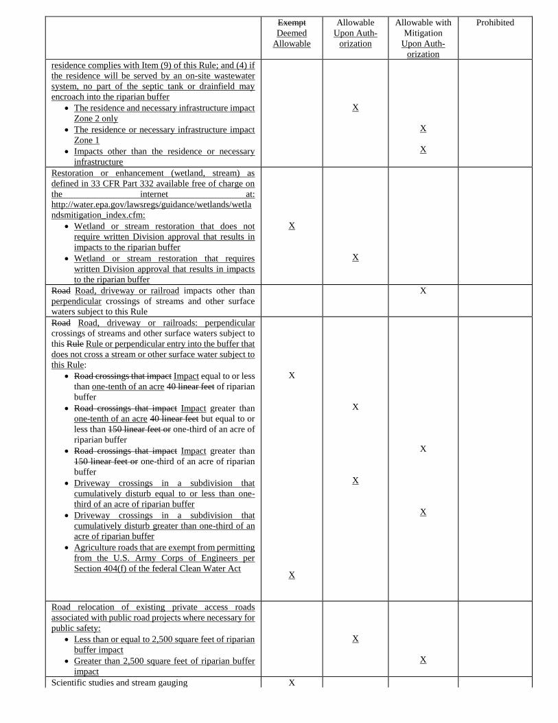
Exempt
Deemed
Allowable
Allowable
Upon Auth-
orization
Allowable with
Mitigation
Upon Auth-
orization
Prohibited
residence complies with Item (9) of this Rule; and (4) if
the residence will be served by an on-site wastewater
system, no part of the septic tank or drainfield may
encroach into the riparian buffer
• The residence and necessary infrastructure impact
Zone 2 only
• The residence or necessary infrastructure impact
Zone 1
• Impacts other than the residence or necessary
infrastructure
X
X
X
Restoration or enhancement (wetland, stream) as
defined in 33 CFR Part 332 available free of charge on
the internet at:
http://water.epa.gov/lawsregs/guidance/wetlands/wetla
ndsmitigation_index.cfm:
• Wetland or stream restoration that does not
require written Division approval that results in
impacts to the riparian buffer
• Wetland or stream restoration that requires
written Division approval that results in impacts
to the riparian buffer
X
X
Road Road, driveway or railroad impacts other than
perpendicular crossings of streams and other surface
waters subject to this Rule
X
Road Road, driveway or railroads: perpendicular
crossings of streams and other surface waters subject to
this Rule Rule or perpendicular entry into the buffer that
does not cross a stream or other surface water subject to
this Rule:
• Road crossings that impact Impact equal to or less
than one-tenth of an acre 40 linear feet of riparian
buffer
• Road crossings that impact Impact greater than
one-tenth of an acre 40 linear feet but equal to or
less than 150 linear feet or one-third of an acre of
riparian buffer
• Road crossings that impact Impact greater than
150 linear feet or one-third of an acre of riparian
buffer
• Driveway crossings in a subdivision that
cumulatively disturb equal to or less than one-
third of an acre of riparian buffer
• Driveway crossings in a subdivision that
cumulatively disturb greater than one-third of an
acre of riparian buffer
• Agriculture roads that are exempt from permitting
from the U.S. Army Corps of Engineers per
Section 404(f) of the federal Clean Water Act
X
X
X
X
X
X
Road relocation of existing private access roads
associated with public road projects where necessary for
public safety:
• Less than or equal to 2,500 square feet of riparian
buffer impact
• Greater than 2,500 square feet of riparian buffer
impact
X
X
Scientific studies and stream gauging X
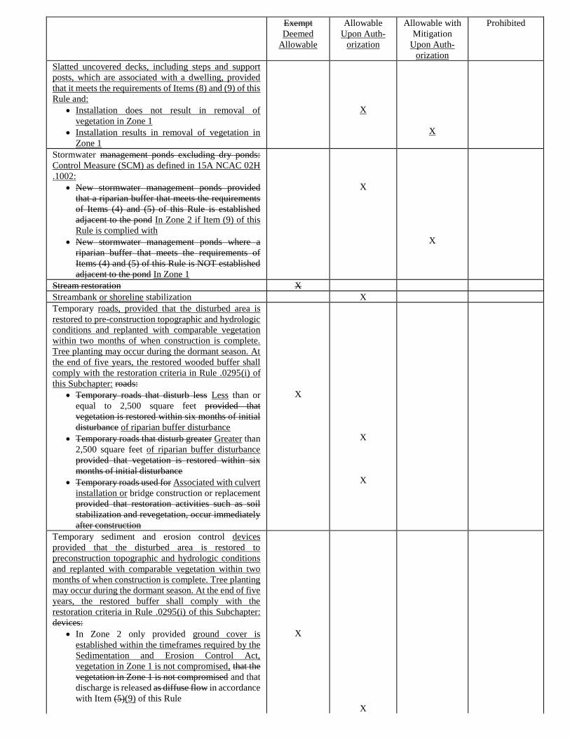
Exempt
Deemed
Allowable
Allowable
Upon Auth-
orization
Allowable with
Mitigation
Upon Auth-
orization
Prohibited
Slatted uncovered decks, including steps and support
posts, which are associated with a dwelling, provided
that it meets the requirements of Items (8) and (9) of this
Rule and:
• Installation does not result in removal of
vegetation in Zone 1
• Installation results in removal of vegetation in
Zone 1
X
X
Stormwater management ponds excluding dry ponds:
Control Measure (SCM) as defined in 15A NCAC 02H
.1002:
• New stormwater management ponds provided
that a riparian buffer that meets the requirements
of Items (4) and (5) of this Rule is established
adjacent to the pond In Zone 2 if Item (9) of this
Rule is complied with
• New stormwater management ponds where a
riparian buffer that meets the requirements of
Items (4) and (5) of this Rule is NOT established
adjacent to the pond In Zone 1
X
X
Stream restoration X
Streambank or shoreline stabilization X
Temporary roads, provided that the disturbed area is
restored to pre-construction topographic and hydrologic
conditions and replanted with comparable vegetation
within two months of when construction is complete.
Tree planting may occur during the dormant season. At
the end of five years, the restored wooded buffer shall
comply with the restoration criteria in Rule .0295(i) of
this Subchapter: roads:
• Temporary roads that disturb less Less than or
equal to 2,500 square feet provided that
vegetation is restored within six months of initial
disturbance of riparian buffer disturbance
• Temporary roads that disturb greater Greater than
2,500 square feet of riparian buffer disturbance
provided that vegetation is restored within six
months of initial disturbance
• Temporary roads used for Associated with culvert
installation or bridge construction or replacement
provided that restoration activities such as soil
stabilization and revegetation, occur immediately
after construction
X
X
X
Temporary sediment and erosion control devices
provided that the disturbed area is restored to
preconstruction topographic and hydrologic conditions
and replanted with comparable vegetation within two
months of when construction is complete. Tree planting
may occur during the dormant season. At the end of five
years, the restored buffer shall comply with the
restoration criteria in Rule .0295(i) of this Subchapter:
devices:
• In Zone 2 only provided ground cover is
established within the timeframes required by the
Sedimentation and Erosion Control Act,
vegetation in Zone 1 is not compromised, that the
vegetation in Zone 1 is not compromised and that
discharge is released as diffuse flow in accordance
with Item (5)(9) of this Rule
X
X
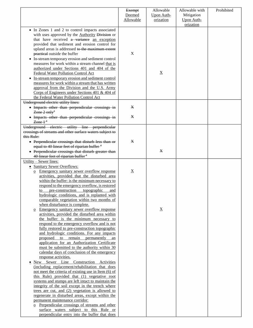
Exempt
Deemed
Allowable
Allowable
Upon Auth-
orization
Allowable with
Mitigation
Upon Auth-
orization
Prohibited
• In Zones 1 and 2 to control impacts associated
with uses approved by the Authority Division or
that have received a variance an exception
provided that sediment and erosion control for
upland areas is addressed to the maximum extent
practical outside the buffer
• In-stream temporary erosion and sediment control
measures for work within a stream channel that is
authorized under Sections 401 and 404 of the
Federal Water Pollution Control Act
• In-stream temporary erosion and sediment control
measures for work within a stream that has written
approval from the Division and the U.S. Army
Corps of Engineers under Sections 401 & 404 of
the Federal Water Pollution Control Act
X
X
Underground electric utility lines:
• Impacts other than perpendicular crossings in
Zone 2 only3
• Impacts other than perpendicular crossings in
Zone 1 4
X
X
Underground electric utility line perpendicular
crossings of streams and other surface waters subject to
this Rule:
• Perpendicular crossings that disturb less than or
equal to 40 linear feet of riparian buffer 4
• Perpendicular crossings that disturb greater than
40 linear feet of riparian buffer 4
X
X
Utility – Sewer lines:
• Sanitary Sewer Overflows:
o Emergency sanitary sewer overflow response
activities, provided that the disturbed area
within the buffer: is the minimum necessary to
respond to the emergency overflow, is restored
to pre-construction topographic and
hydrologic conditions, and is replanted with
comparable vegetation within two months of
when disturbance is complete.
o Emergency sanitary sewer overflow response
activities, provided the disturbed area within
the buffer: is the minimum necessary to
respond to the emergency overflow and is not
fully restored to pre-construction topographic
and hydrologic conditions. For any impacts
proposed to remain permanently an
application for an Authorization Certificate
must be submitted to the authority within 30
calendar days of conclusion of the emergency
response activities.
• New Sewer Line Construction Activities
(including replacement/rehabilitation that does
not meet the criteria of existing use in Item (6) of
this Rule) provided that (1) vegetative root
systems and stumps are left intact to maintain the
integrity of the soil except in the trench where
trees are cut, and (2) vegetation is allowed to
regenerate in disturbed areas, except within the
permanent maintenance corridor:
o Perpendicular crossings of streams and other
surface waters subject to this Rule or
perpendicular entry into the buffer that does
X
X
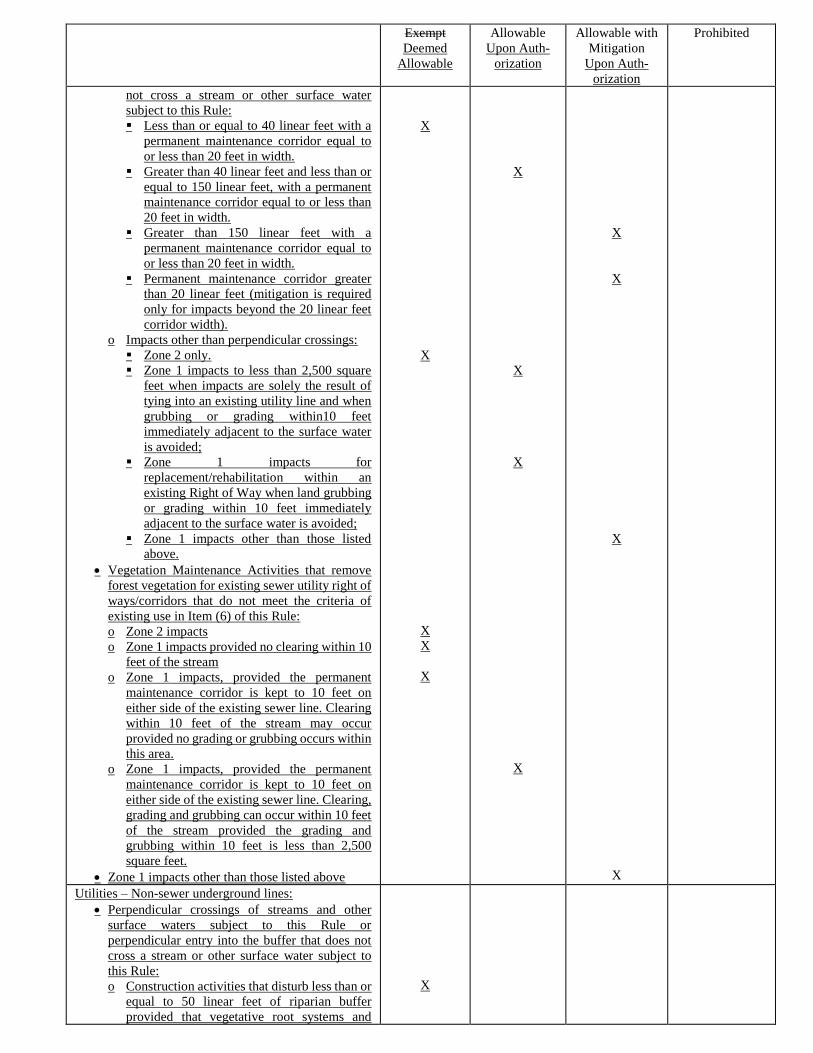
Exempt
Deemed
Allowable
Allowable
Upon Auth-
orization
Allowable with
Mitigation
Upon Auth-
orization
Prohibited
not cross a stream or other surface water
subject to this Rule:
▪Less than or equal to 40 linear feet with a
permanent maintenance corridor equal to
or less than 20 feet in width.
▪Greater than 40 linear feet and less than or
equal to 150 linear feet, with a permanent
maintenance corridor equal to or less than
20 feet in width.
▪Greater than 150 linear feet with a
permanent maintenance corridor equal to
or less than 20 feet in width.
▪Permanent maintenance corridor greater
than 20 linear feet (mitigation is required
only for impacts beyond the 20 linear feet
corridor width).
o Impacts other than perpendicular crossings:
▪Zone 2 only.
▪Zone 1 impacts to less than 2,500 square
feet when impacts are solely the result of
tying into an existing utility line and when
grubbing or grading within10 feet
immediately adjacent to the surface water
is avoided;
▪Zone 1 impacts for
replacement/rehabilitation within an
existing Right of Way when land grubbing
or grading within 10 feet immediately
adjacent to the surface water is avoided;
▪Zone 1 impacts other than those listed
above.
• Vegetation Maintenance Activities that remove
forest vegetation for existing sewer utility right of
ways/corridors that do not meet the criteria of
existing use in Item (6) of this Rule:
o Zone 2 impacts
o Zone 1 impacts provided no clearing within 10
feet of the stream
o Zone 1 impacts, provided the permanent
maintenance corridor is kept to 10 feet on
either side of the existing sewer line. Clearing
within 10 feet of the stream may occur
provided no grading or grubbing occurs within
this area.
o Zone 1 impacts, provided the permanent
maintenance corridor is kept to 10 feet on
either side of the existing sewer line. Clearing,
grading and grubbing can occur within 10 feet
of the stream provided the grading and
grubbing within 10 feet is less than 2,500
square feet.
• Zone 1 impacts other than those listed above
X
X
X
X
X
X
X
X
X
X
X
X
X
Utilities – Non-sewer underground lines:
• Perpendicular crossings of streams and other
surface waters subject to this Rule or
perpendicular entry into the buffer that does not
cross a stream or other surface water subject to
this Rule:
o Construction activities that disturb less than or
equal to 50 linear feet of riparian buffer
provided that vegetative root systems and
X
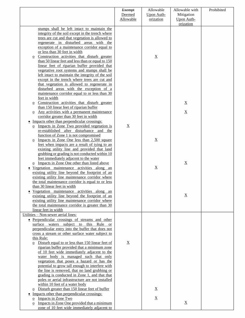
Exempt
Deemed
Allowable
Allowable
Upon Auth-
orization
Allowable with
Mitigation
Upon Auth-
orization
Prohibited
stumps shall be left intact to maintain the
integrity of the soil except in the trench where
trees are cut and that vegetation is allowed to
regenerate in disturbed areas with the
exception of a maintenance corridor equal to
or less than 30 feet in width
o Construction activities that disturb greater
than 50 linear feet and less than or equal to 150
linear feet of riparian buffer provided that
vegetative root systems and stumps shall be
left intact to maintain the integrity of the soil
except in the trench where trees are cut and
that vegetation is allowed to regenerate in
disturbed areas with the exception of a
maintenance corridor equal to or less than 30
feet in width
o Construction activities that disturb greater
than 150 linear feet of riparian buffer
o Any activities with a permanent maintenance
corridor greater than 30 feet in width
• Impacts other than perpendicular crossings:
o Impacts in Zone Two provided vegetation is
re-established after disturbance and the
function of Zone 1 is not compromised
o Impacts in Zone One less than 2,500 square
feet when impacts are a result of tying to an
existing utility line and provided that land
grubbing or grading is not conducted within 10
feet immediately adjacent to the water
o Impacts in Zone One other than listed above
• Vegetation maintenance activities along an
existing utility line beyond the footprint of an
existing utility line maintenance corridor where
the total maintenance corridor is equal to or less
than 30 linear feet in width
• Vegetation maintenance activities along an
existing utility line beyond the footprint of an
existing utility line maintenance corridor where
the total maintenance corridor is greater than 30
linear feet in width
X
X
X
X
X
X
X
X
Utilities – Non-sewer aerial lines:
• Perpendicular crossings of streams and other
surface waters subject to this Rule or
perpendicular entry into the buffer that does not
cross a stream or other surface water subject to
this Rule:
o Disturb equal to or less than 150 linear feet of
riparian buffer provided that a minimum zone
of 10 feet wide immediately adjacent to the
water body is managed such that only
vegetation that poses a hazard or has the
potential to grow tall enough to interfere with
the line is removed, that no land grubbing or
grading is conducted in Zone 1, and that that
poles or aerial infrastructure are not installed
within 10 feet of a water body
o Disturb greater than 150 linear feet of buffer
• Impacts other than perpendicular crossings:
o Impacts in Zone Two
o Impacts in Zone One provided that a minimum
zone of 10 feet wide immediately adjacent to
X
X
X
X
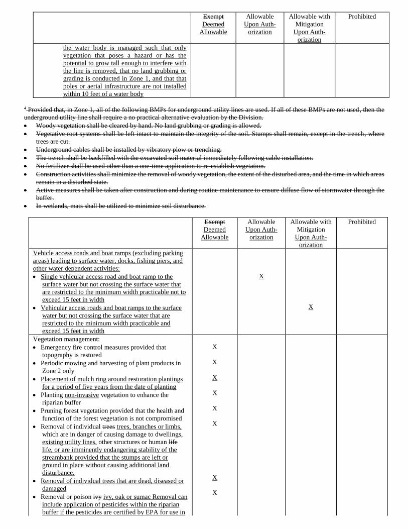
Exempt
Deemed
Allowable
Allowable
Upon Auth-
orization
Allowable with
Mitigation
Upon Auth-
orization
Prohibited
the water body is managed such that only
vegetation that poses a hazard or has the
potential to grow tall enough to interfere with
the line is removed, that no land grubbing or
grading is conducted in Zone 1, and that that
poles or aerial infrastructure are not installed
within 10 feet of a water body
4 Provided that, in Zone 1, all of the following BMPs for underground utility lines are used. If all of these BMPs are not used, then the
underground utility line shall require a no practical alternative evaluation by the Division.
• Woody vegetation shall be cleared by hand. No land grubbing or grading is allowed.
• Vegetative root systems shall be left intact to maintain the integrity of the soil. Stumps shall remain, except in the trench, where
trees are cut.
• Underground cables shall be installed by vibratory plow or trenching.
• The trench shall be backfilled with the excavated soil material immediately following cable installation.
• No fertilizer shall be used other than a one-time application to re-establish vegetation.
• Construction activities shall minimize the removal of woody vegetation, the extent of the disturbed area, and the time in which areas
remain in a disturbed state.
• Active measures shall be taken after construction and during routine maintenance to ensure diffuse flow of stormwater through the
buffer.
• In wetlands, mats shall be utilized to minimize soil disturbance.
Exempt
Deemed
Allowable
Allowable
Upon Auth-
orization
Allowable with
Mitigation
Upon Auth-
orization
Prohibited
Vehicle access roads and boat ramps (excluding parking
areas) leading to surface water, docks, fishing piers, and
other water dependent activities:
• Single vehicular access road and boat ramp to the
surface water but not crossing the surface water that
are restricted to the minimum width practicable not to
exceed 15 feet in width
• Vehicular access roads and boat ramps to the surface
water but not crossing the surface water that are
restricted to the minimum width practicable and
exceed 15 feet in width
X
X
Vegetation management:
• Emergency fire control measures provided that
topography is restored
• Periodic mowing and harvesting of plant products in
Zone 2 only
• Placement of mulch ring around restoration plantings
for a period of five years from the date of planting
• Planting non-invasive vegetation to enhance the
riparian buffer
• Pruning forest vegetation provided that the health and
function of the forest vegetation is not compromised
• Removal of individual trees trees, branches or limbs,
which are in danger of causing damage to dwellings,
existing utility lines, other structures or human life
life, or are imminently endangering stability of the
streambank provided that the stumps are left or
ground in place without causing additional land
disturbance.
• Removal of individual trees that are dead, diseased or
damaged
• Removal or poison ivy ivy, oak or sumac Removal can
include application of pesticides within the riparian
buffer if the pesticides are certified by EPA for use in
X
X
X
X
X
X
X
X
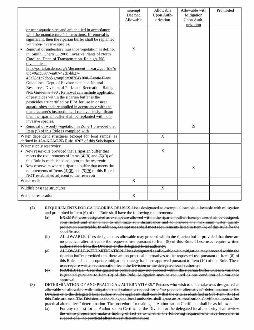
Exempt
Deemed
Allowable
Allowable
Upon Auth-
orization
Allowable with
Mitigation
Upon Auth-
orization
Prohibited
or near aquatic sites and are applied in accordance
with the manufacturer's instructions. If removal is
significant, then the riparian buffer shall be replanted
with non-invasive species.
• Removal of understory nuisance vegetation as defined
in: Smith, Cherri L. 2008. Invasive Plants of North
Carolina. Dept. of Transportation. Raleigh, NC
(available at
http://portal.ncdenr.org/c/document_library/get_file?u
uid=0acc6377-ea07-42dc-bb27-
45a78d1c7ebe&groupId=38364) 998. Exotic Plant
Guidelines. Dept. of Environment and Natural
Resources. Division of Parks and Recreation. Raleigh,
NC. Guideline #30 . Removal can include application
of pesticides within the riparian buffer is the
pesticides are certified by EPA for use in or near
aquatic sites and are applied in accordance with the
manufacturer's instructions. If removal is significant
then the riparian buffer shall be replanted with non-
invasive species.
• Removal of woody vegetation in Zone 1 provided that
Item (9) of this Rule is complied with
X
X
Water dependent structures (except for boat ramps) as
defined in 15A NCAC 2B Rule .0202 of this Subchapter
X
Water supply reservoirs:
• New reservoirs provided that a riparian buffer that
meets the requirements of Items (4)(8) and (5)(9) of
this Rule is established adjacent to the reservoir
• New reservoirs where a riparian buffer that meets the
requirements of Items (4)(8) and (5)(9) of this Rule is
NOT established adjacent to the reservoir
X
X
Water wells X
Wildlife passage structures X
Wetland restoration X
(7) REQUIREMENTS FOR CATEGORIES OF USES. Uses designated as exempt, allowable, allowable with mitigation
and prohibited in Item (6) of this Rule shall have the following requirements:
(a) EXEMPT. Uses designated as exempt are allowed within the riparian buffer. Exempt uses shall be designed,
constructed and maintained to minimize soil disturbance and to provide the maximum water quality
protection practicable. In addition, exempt uses shall meet requirements listed in Item (6) of this Rule for the
specific use.
(b) ALLOWABLE. Uses designated as allowable may proceed within the riparian buffer provided that there are
no practical alternatives to the requested use pursuant to Item (8) of this Rule. These uses require written
authorization from the Division or the delegated local authority.
(c) ALLOWABLE WITH MITIGATION. Uses designated as allowable with mitigation may proceed within the
riparian buffer provided that there are no practical alternatives to the requested use pursuant to Item (8) of
this Rule and an appropriate mitigation strategy has been approved pursuant to Item (10) of this Rule. These
uses require written authorization from the Division or the delegated local authority.
(d) PROHIBITED. Uses designated as prohibited may not proceed within the riparian buffer unless a variance
is granted pursuant to Item (9) of this Rule. Mitigation may be required as one condition of a variance
approval.
(8) DETERMINATION OF ANO PRACTICAL ALTERNATIVES." Persons who wish to undertake uses designated as
allowable or allowable with mitigation shall submit a request for a "no practical alternatives" determination to the
Division or to the delegated local authority. The applicant shall certify that the criteria identified in Sub-Item (8)(a) of
this Rule are met. The Division or the delegated local authority shall grant an Authorization Certificate upon a "no
practical alternatives" determination. The procedure for making an Authorization Certificate shall be as follows:
(a) For any request for an Authorization Certificate, the Division or the delegated local authority shall review
the entire project and make a finding of fact as to whether the following requirements have been met in
support of a "no practical alternatives" determination:
(i) The basic project purpose cannot be practically accomplished in a manner that would better
minimize disturbance, preserve aquatic life and habitat, and protect water quality.
(ii) The use cannot practically be reduced in size or density, reconfigured or redesigned to better
minimize disturbance, preserve aquatic life and habitat, and protect water quality.
(iii) Best management practices shall be used if necessary to minimize disturbance, preserve aquatic life
and habitat, and protect water quality.
(b) Requests for an Authorization Certificate shall be reviewed and either approved or denied within 60 days of
receipt of a complete submission based on the criteria in Sub-Item (8)(a) of this Rule by either the Division
or the delegated local authority. Failure to issue an approval or denial within 60 days shall constitute that the
applicant has demonstrated "no practical alternatives." The Division or the delegated local authority may
attach conditions to the Authorization Certificate that support the purpose, spirit and intent of the riparian
buffer protection program. Complete submissions shall include the following:
(i) The name, address and phone number of the applicant;
(ii) The nature of the activity to be conducted by the applicant;
(iii) The location of the activity, including the jurisdiction;
(iv) A map of sufficient detail to accurately delineate the boundaries of the land to be utilized in carrying
out the activity, the location and dimensions of any disturbance in riparian buffers associated with
the activity, and the extent of riparian buffers on the land;
(v) An explanation of why this plan for the activity cannot be practically accomplished, reduced or
reconfigured to better minimize disturbance to the riparian buffer, preserve aquatic life and habitat
and protect water quality; and
(vi) Plans for any best management practices proposed to be used to control the impacts associated with
the activity.
(c) Any disputes over determinations regarding Authorization Certificates shall be referred to the Director for a
decision. The Director's decision is subject to review as provided in Articles 3 and 4 of G.S. 150B.
(9) VARIANCES. Persons who wish to undertake uses designated as prohibited may pursue a variance. The Division or
the appropriate delegated local authority may grant minor variances. The variance request procedure shall be as
follows:
(a) For any variance request, the Division or the delegated local authority shall make a finding of fact as to
whether the following requirements have been met:
(i) There are practical difficulties or unnecessary hardships that prevent compliance with the strict letter
of the riparian buffer protection requirements. Practical difficulties or unnecessary hardships shall
be evaluated in accordance with the following:
(A) If the applicant complies with the provisions of this Rule, he/she can secure no reasonable return
from, nor make reasonable use of, his/her property. Merely proving that the variance would permit
a greater profit from the property shall not be considered adequate justification for a variance.
Moreover, the Division or delegated local authority shall consider whether the variance is the
minimum possible deviation from the terms of this Rule that shall make reasonable use of the
property possible.
(B) The hardship results from application of this Rule to the property rather than from other factors such
as deed restrictions or other hardship.
(C) The hardship is due to the physical nature of the applicant's property, such as its size, shape, or
topography, which is different from that of neighboring property.
(D) The applicant did not cause the hardship by knowingly or unknowingly violating this Rule.
(E) The applicant did not purchase the property after the effective date of this Rule, and then request an
appeal.
(F) The hardship is unique to the applicant's property, rather than the result of conditions that are
widespread. If other properties are equally subject to the hardship created in the restriction, then
granting a variance would be a special privilege denied to others, and would not promote equal
justice;
(ii) The variance is in harmony with the general purpose and intent of the State's riparian buffer
protection requirements and preserves its spirit; and
(iii) In granting the variance, the public safety and welfare have been assured, water quality has been
protected, and substantial justice has been done.
(b) MINOR VARIANCES. A minor variance request pertains to activities that are proposed only to impact any
portion of Zone 2 of the riparian buffer. Minor variance requests shall be reviewed and approved based on
the criteria in Sub-Item (9)(a) of this Rule by the either the Division or the delegated local authority pursuant
to G.S. 153A-Article 18, or G.S. 160A-Article 19. The Division or the delegated local authority may attach
conditions to the variance approval that support the purpose, spirit and intent of the riparian buffer protection
program. Requests for appeals of decisions made by the Division shall be made to the Office of
Administrative Hearings. Request for appeals made by the delegated local authority shall be made to the
appropriate Board of Adjustment under G.S. 160A-388 or G.S. 153A-345.
(c) MAJOR VARIANCES. A major variance request pertains to activities that are proposed to impact any
portion of Zone 1 or any portion of both Zones 1 and 2 of the riparian buffer. If the Division or the delegated
local authority has determined that a major variance request meets the requirements in Sub-Item (9)(a) of this
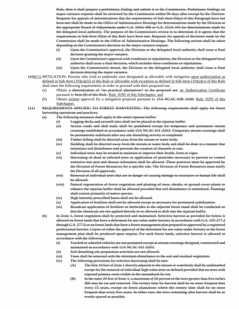
Rule, then it shall prepare a preliminary finding and submit it to the Commission. Preliminary findings on
major variance requests shall be reviewed by the Commission within 90 days after receipt by the Director.
Requests for appeals of determinations that the requirements of Sub-Item (9)(a) of this Paragraph have not
been met shall be made to the Office of Administrative Hearings for determinations made by the Division or
the appropriate Board of Adjustments under G.S. 160A-388 or G.S. 153A-345 for determinations made by
the delegated local authority. The purpose of the Commission's review is to determine if it agrees that the
requirements in Sub-Item (9)(a) of this Rule have been met. Requests for appeals of decisions made by the
Commission shall be made to the Office of Administrative Hearings. The following actions shall be taken
depending on the Commission's decision on the major variance request:
(i) Upon the Commission's approval, the Division or the delegated local authority shall issue a final
decision granting the major variance.
(ii) Upon the Commission's approval with conditions or stipulations, the Division or the delegated local
authority shall issue a final decision, which includes these conditions or stipulations.
(iii) Upon the Commission's denial, the Division or the delegated local authority shall issue a final
decision denying the major variance.
(10)(11) MITIGATION. Persons who wish to undertake uses designated as allowable with mitigation upon authorization as
defined in Sub-Item (10)(a)(iii) of this Rule or allowable with exception as defined in Sub-Item (10)(a)(v) of this Rule
shall meet the following requirements in order to proceed with their proposed use.
(a) Obtain a determination of "no practical alternatives" to the proposed use an Authorization Certificate
pursuant to Item (8) of this Rule. Rule .0295 of this Subchapter; and
(b) Obtain written approval for a mitigation proposal pursuant to 15A NCAC 02B .0260. Rule .0295 of this
Subchapter.
(11) REQUIREMENTS SPECIFIC TO FOREST HARVESTING. The following requirements shall apply for forest
harvesting operations and practices.
(a) The following measures shall apply in the entire riparian buffer:
(i) Logging decks and sawmill sites shall not be placed in the riparian buffer.
(ii) Access roads and skid trails shall be prohibited except for temporary and permanent stream
crossings established in accordance with 15A NCAC 01I .0203. Temporary stream crossings shall
be permanently stabilized after any site disturbing activity is completed.
(iii) Timber felling shall be directed away from the stream or water body.
(iv) Skidding shall be directed away from the stream or water body and shall be done in a manner that
minimizes soil disturbance and prevents the creation of channels or ruts.
(v) Individual trees may be treated to maintain or improve their health, form or vigor.
(vi) Harvesting of dead or infected trees or application of pesticides necessary to prevent or control
extensive tree pest and disease infestation shall be allowed. These practices must be approved by
the Division of Forest Resources for a specific site. The Division of Forest Resources must notify
the Division of all approvals.
(vii) Removal of individual trees that are in danger of causing damage to structures or human life shall
be allowed.
(viii) Natural regeneration of forest vegetation and planting of trees, shrubs, or ground cover plants to
enhance the riparian buffer shall be allowed provided that soil disturbance is minimized. Plantings
shall consist primarily of native species.
(ix) High intensity prescribed burns shall not be allowed.
(x) Application of fertilizer shall not be allowed except as necessary for permanent stabilization.
(xi) Broadcast application of fertilizer or herbicides to the adjacent forest stand shall be conducted so
that the chemicals are not applied directly to or allowed to drift into the riparian buffer.
(b) In Zone 1, forest vegetation shall be protected and maintained. Selective harvest as provided for below is
allowed on forest lands that have a deferment for use value under forestry in accordance with G.S. 105-277.2
through G.S. 277.6 or on forest lands that have a forest management plan prepared or approved by a registered
professional forester. Copies of either the approval of the deferment for use value under forestry or the forest
management plan shall be produced upon request. For such forest lands, selective harvest is allowed in
accordance with the following:
(i) Tracked or wheeled vehicles are not permitted except at stream crossings designed, constructed and
maintained in accordance with 15A NCAC 01I .0203.
(ii) Soil disturbing site preparation activities are not allowed.
(iii) Trees shall be removed with the minimum disturbance to the soil and residual vegetation.
(iv) The following provisions for selective harvesting shall be met:
(A) The first 10 feet of Zone 1 directly adjacent to the stream or waterbody shall be undisturbed
except for the removal of individual high value trees as defined provided that no trees with
exposed primary roots visible in the streambank be cut.
(B) In the outer 20 feet of Zone 1, a maximum of 50 percent of the trees greater than five inches
dbh may be cut and removed. The reentry time for harvest shall be no more frequent than
every 15 years, except on forest plantations where the reentry time shall be no more
frequent than every five years. In either case, the trees remaining after harvest shall be as
evenly spaced as possible.
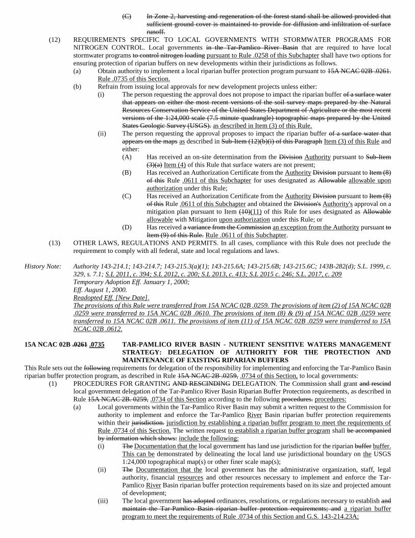
(C) In Zone 2, harvesting and regeneration of the forest stand shall be allowed provided that
sufficient ground cover is maintained to provide for diffusion and infiltration of surface
runoff.
(12) REQUIREMENTS SPECIFIC TO LOCAL GOVERNMENTS WITH STORMWATER PROGRAMS FOR
NITROGEN CONTROL. Local governments in the Tar-Pamlico River Basin that are required to have local
stormwater programs to control nitrogen loading pursuant to Rule .0258 of this Subchapter shall have two options for
ensuring protection of riparian buffers on new developments within their jurisdictions as follows.
(a) Obtain authority to implement a local riparian buffer protection program pursuant to 15A NCAC 02B .0261.
Rule .0735 of this Section.
(b) Refrain from issuing local approvals for new development projects unless either:
(i) The person requesting the approval does not propose to impact the riparian buffer of a surface water
that appears on either the most recent versions of the soil survey maps prepared by the Natural
Resources Conservation Service of the United States Department of Agriculture or the most recent
versions of the 1:24,000 scale (7.5 minute quadrangle) topographic maps prepared by the United
States Geologic Survey (USGS). as described in Item (3) of this Rule.
(ii) The person requesting the approval proposes to impact the riparian buffer of a surface water that
appears on the maps as described in Sub-Item (12)(b)(i) of this Paragraph Item (3) of this Rule and
either:
(A) Has received an on-site determination from the Division Authority pursuant to Sub-Item
(3)(a) Item (4) of this Rule that surface waters are not present;
(B) Has received an Authorization Certificate from the Authority Division pursuant to Item (8)
of this Rule .0611 of this Subchapter for uses designated as Allowable allowable upon
authorization under this Rule;
(C) Has received an Authorization Certificate from the Authority Division pursuant to Item (8)
of this Rule .0611 of this Subchapter and obtained the Division's Authority's approval on a
mitigation plan pursuant to Item (10)(11) of this Rule for uses designated as Allowable
allowable with Mitigation upon authorization under this Rule; or
(D) Has received a variance from the Commission an exception from the Authority pursuant to
Item (9) of this Rule. Rule .0611 of this Subchapter.
(13) OTHER LAWS, REGULATIONS AND PERMITS. In all cases, compliance with this Rule does not preclude the
requirement to comply with all federal, state and local regulations and laws.
History Note: Authority 143-214.1; 143-214.7; 143-215.3(a)(1); 143-215.6A; 143-215.6B; 143-215.6C; 143B-282(d); S.L. 1999, c.
329, s. 7.1; S.L 2011, c. 394; S.L 2012, c. 200; S.L 2013, c. 413; S.L 2015 c. 246; S.L. 2017, c. 209
Temporary Adoption Eff. January 1, 2000;
Eff. August 1, 2000.
Readopted Eff. [New Date].
The provisions of this Rule were transferred from 15A NCAC 02B .0259. The provisions of item (2) of 15A NCAC 02B
.0259 were transferred to 15A NCAC 02B .0610. The provisions of item (8) & (9) of 15A NCAC 02B .0259 were
transferred to 15A NCAC 02B .0611. The provisions of item (11) of 15A NCAC 02B .0259 were transferred to 15A
NCAC 02B .0612.
15A NCAC 02B .0261 .0735 TAR-PAMLICO RIVER BASIN - NUTRIENT SENSITIVE WATERS MANAGEMENT
STRATEGY: DELEGATION OF AUTHORITY FOR THE PROTECTION AND
MAINTENANCE OF EXISTING RIPARIAN BUFFERS
This Rule sets out the following requirements for delegation of the responsibility for implementing and enforcing the Tar-Pamlico Basin
riparian buffer protection program, as described in Rule 15A NCAC 2B .0259, .0734 of this Section, to local governments:
(1) PROCEDURES FOR GRANTING AND RESCINDING DELEGATION. The Commission shall grant and rescind
local government delegation of the Tar-Pamlico River Basin Riparian Buffer Protection requirements, as described in
Rule 15A NCAC 2B. 0259, .0734 of this Section according to the following procedures. procedures:
(a) Local governments within the Tar-Pamlico River Basin may submit a written request to the Commission for
authority to implement and enforce the Tar-Pamlico River Basin riparian buffer protection requirements
within their jurisdiction. jurisdiction by establishing a riparian buffer program to meet the requirements of
Rule .0734 of this Section. The written request to establish a riparian buffer program shall be accompanied
by information which shows: include the following:
(i) The Documentation that the local government has land use jurisdiction for the riparian buffer buffer.
This can be demonstrated by delineating the local land use jurisdictional boundary on the USGS
1:24,000 topographical map(s) or other finer scale map(s);
(ii) The Documentation that the local government has the administrative organization, staff, legal
authority, financial resources and other resources necessary to implement and enforce the Tar-
Pamlico River Basin riparian buffer protection requirements based on its size and projected amount
of development;
(iii) The local government has adopted ordinances, resolutions, or regulations necessary to establish and
maintain the Tar-Pamlico Basin riparian buffer protection requirements; and a riparian buffer
program to meet the requirements of Rule .0734 of this Section and G.S. 143-214.23A;
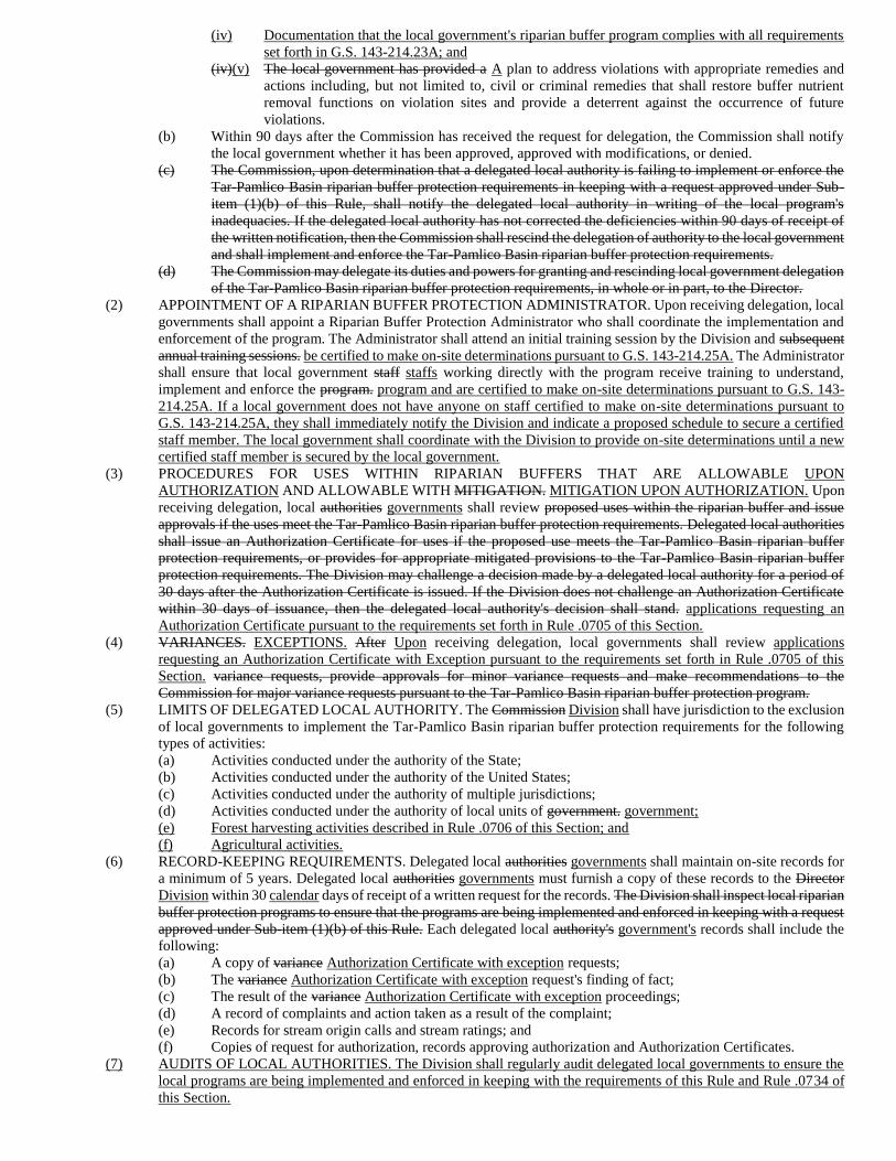
(iv) Documentation that the local government's riparian buffer program complies with all requirements
set forth in G.S. 143-214.23A; and
(iv)(v) The local government has provided a A plan to address violations with appropriate remedies and
actions including, but not limited to, civil or criminal remedies that shall restore buffer nutrient
removal functions on violation sites and provide a deterrent against the occurrence of future
violations.
(b) Within 90 days after the Commission has received the request for delegation, the Commission shall notify
the local government whether it has been approved, approved with modifications, or denied.
(c) The Commission, upon determination that a delegated local authority is failing to implement or enforce the
Tar-Pamlico Basin riparian buffer protection requirements in keeping with a request approved under Sub-
item (1)(b) of this Rule, shall notify the delegated local authority in writing of the local program's
inadequacies. If the delegated local authority has not corrected the deficiencies within 90 days of receipt of
the written notification, then the Commission shall rescind the delegation of authority to the local government
and shall implement and enforce the Tar-Pamlico Basin riparian buffer protection requirements.
(d) The Commission may delegate its duties and powers for granting and rescinding local government delegation
of the Tar-Pamlico Basin riparian buffer protection requirements, in whole or in part, to the Director.
(2) APPOINTMENT OF A RIPARIAN BUFFER PROTECTION ADMINISTRATOR. Upon receiving delegation, local
governments shall appoint a Riparian Buffer Protection Administrator who shall coordinate the implementation and
enforcement of the program. The Administrator shall attend an initial training session by the Division and subsequent
annual training sessions. be certified to make on-site determinations pursuant to G.S. 143-214.25A. The Administrator
shall ensure that local government staff staffs working directly with the program receive training to understand,
implement and enforce the program. program and are certified to make on-site determinations pursuant to G.S. 143-
214.25A. If a local government does not have anyone on staff certified to make on-site determinations pursuant to
G.S. 143-214.25A, they shall immediately notify the Division and indicate a proposed schedule to secure a certified
staff member. The local government shall coordinate with the Division to provide on-site determinations until a new
certified staff member is secured by the local government.
(3) PROCEDURES FOR USES WITHIN RIPARIAN BUFFERS THAT ARE ALLOWABLE UPON
AUTHORIZATION AND ALLOWABLE WITH MITIGATION. MITIGATION UPON AUTHORIZATION. Upon
receiving delegation, local authorities governments shall review proposed uses within the riparian buffer and issue
approvals if the uses meet the Tar-Pamlico Basin riparian buffer protection requirements. Delegated local authorities
shall issue an Authorization Certificate for uses if the proposed use meets the Tar-Pamlico Basin riparian buffer
protection requirements, or provides for appropriate mitigated provisions to the Tar-Pamlico Basin riparian buffer
protection requirements. The Division may challenge a decision made by a delegated local authority for a period of
30 days after the Authorization Certificate is issued. If the Division does not challenge an Authorization Certificate
within 30 days of issuance, then the delegated local authority's decision shall stand. applications requesting an
Authorization Certificate pursuant to the requirements set forth in Rule .0705 of this Section.
(4) VARIANCES. EXCEPTIONS. After Upon receiving delegation, local governments shall review applications
requesting an Authorization Certificate with Exception pursuant to the requirements set forth in Rule .0705 of this
Section. variance requests, provide approvals for minor variance requests and make recommendations to the
Commission for major variance requests pursuant to the Tar-Pamlico Basin riparian buffer protection program.
(5) LIMITS OF DELEGATED LOCAL AUTHORITY. The Commission Division shall have jurisdiction to the exclusion
of local governments to implement the Tar-Pamlico Basin riparian buffer protection requirements for the following
types of activities:
(a) Activities conducted under the authority of the State;
(b) Activities conducted under the authority of the United States;
(c) Activities conducted under the authority of multiple jurisdictions;
(d) Activities conducted under the authority of local units of government. government;
(e) Forest harvesting activities described in Rule .0706 of this Section; and
(f) Agricultural activities.
(6) RECORD-KEEPING REQUIREMENTS. Delegated local authorities governments shall maintain on-site records for
a minimum of 5 years. Delegated local authorities governments must furnish a copy of these records to the Director
Division within 30 calendar days of receipt of a written request for the records. The Division shall inspect local riparian
buffer protection programs to ensure that the programs are being implemented and enforced in keeping with a request
approved under Sub-item (1)(b) of this Rule. Each delegated local authority's government's records shall include the
following:
(a) A copy of variance Authorization Certificate with exception requests;
(b) The variance Authorization Certificate with exception request's finding of fact;
(c) The result of the variance Authorization Certificate with exception proceedings;
(d) A record of complaints and action taken as a result of the complaint;
(e) Records for stream origin calls and stream ratings; and
(f) Copies of request for authorization, records approving authorization and Authorization Certificates.
(7) AUDITS OF LOCAL AUTHORITIES. The Division shall regularly audit delegated local governments to ensure the
local programs are being implemented and enforced in keeping with the requirements of this Rule and Rule .0734 of
this Section.
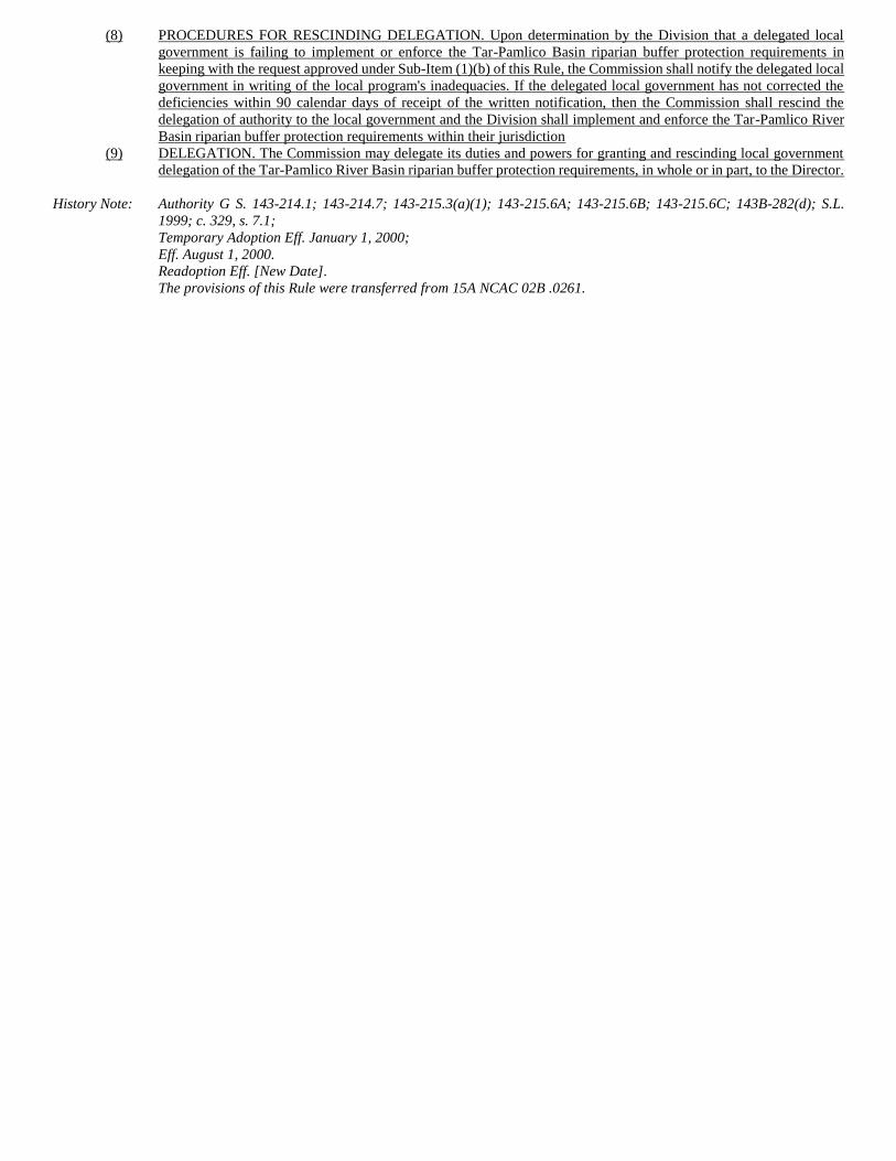
(8) PROCEDURES FOR RESCINDING DELEGATION. Upon determination by the Division that a delegated local
government is failing to implement or enforce the Tar-Pamlico Basin riparian buffer protection requirements in
keeping with the request approved under Sub-Item (1)(b) of this Rule, the Commission shall notify the delegated local
government in writing of the local program's inadequacies. If the delegated local government has not corrected the
deficiencies within 90 calendar days of receipt of the written notification, then the Commission shall rescind the
delegation of authority to the local government and the Division shall implement and enforce the Tar-Pamlico River
Basin riparian buffer protection requirements within their jurisdiction
(9) DELEGATION. The Commission may delegate its duties and powers for granting and rescinding local government
delegation of the Tar-Pamlico River Basin riparian buffer protection requirements, in whole or in part, to the Director.
History Note: Authority G S. 143-214.1; 143-214.7; 143-215.3(a)(1); 143-215.6A; 143-215.6B; 143-215.6C; 143B-282(d); S.L.
1999; c. 329, s. 7.1;
Temporary Adoption Eff. January 1, 2000;
Eff. August 1, 2000.
Readoption Eff. [New Date].
The provisions of this Rule were transferred from 15A NCAC 02B .0261.
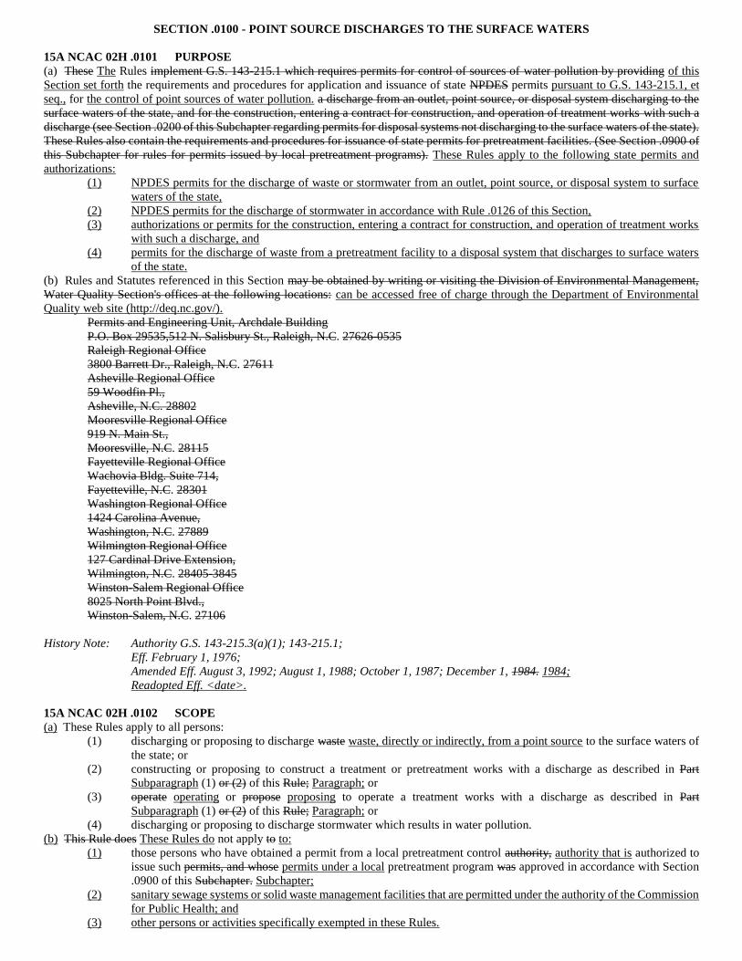
SECTION .0100 - POINT SOURCE DISCHARGES TO THE SURFACE WATERS
15A NCAC 02H .0101 PURPOSE
(a) These The Rules implement G.S. 143-215.1 which requires permits for control of sources of water pollution by providing of this
Section set forth the requirements and procedures for application and issuance of state NPDES permits pursuant to G.S. 143-215.1, et
seq., for the control of point sources of water pollution. a discharge from an outlet, point source, or disposal system discharging to the
surface waters of the state, and for the construction, entering a contract for construction, and operation of treatment works with such a
discharge (see Section .0200 of this Subchapter regarding permits for disposal systems not discharging to the surface waters of the state).
These Rules also contain the requirements and procedures for issuance of state permits for pretreatment facilities. (See Section .0900 of
this Subchapter for rules for permits issued by local pretreatment programs). These Rules apply to the following state permits and
authorizations:
(1) NPDES permits for the discharge of waste or stormwater from an outlet, point source, or disposal system to surface
waters of the state,
(2) NPDES permits for the discharge of stormwater in accordance with Rule .0126 of this Section,
(3) authorizations or permits for the construction, entering a contract for construction, and operation of treatment works
with such a discharge, and
(4) permits for the discharge of waste from a pretreatment facility to a disposal system that discharges to surface waters
of the state.
(b) Rules and Statutes referenced in this Section may be obtained by writing or visiting the Division of Environmental Management,
Water Quality Section's offices at the following locations: can be accessed free of charge through the Department of Environmental
Quality web site (http://deq.nc.gov/).
Permits and Engineering Unit, Archdale Building
P.O. Box 29535,512 N. Salisbury St., Raleigh, N.C. 27626-0535
Raleigh Regional Office
3800 Barrett Dr., Raleigh, N.C. 27611
Asheville Regional Office
59 Woodfin Pl.,
Asheville, N.C. 28802
Mooresville Regional Office
919 N. Main St.,
Mooresville, N.C. 28115
Fayetteville Regional Office
Wachovia Bldg. Suite 714,
Fayetteville, N.C. 28301
Washington Regional Office
1424 Carolina Avenue,
Washington, N.C. 27889
Wilmington Regional Office
127 Cardinal Drive Extension,
Wilmington, N.C. 28405-3845
Winston-Salem Regional Office
8025 North Point Blvd.,
Winston-Salem, N.C. 27106
History Note: Authority G.S. 143-215.3(a)(1); 143-215.1;
Eff. February 1, 1976;
Amended Eff. August 3, 1992; August 1, 1988; October 1, 1987; December 1, 1984. 1984;
Readopted Eff. <date>.
15A NCAC 02H .0102 SCOPE
(a) These Rules apply to all persons:
(1) discharging or proposing to discharge waste waste, directly or indirectly, from a point source to the surface waters of
the state; or
(2) constructing or proposing to construct a treatment or pretreatment works with a discharge as described in Part
Subparagraph (1) or (2) of this Rule; Paragraph; or
(3) operate operating or propose proposing to operate a treatment works with a discharge as described in Part
Subparagraph (1) or (2) of this Rule; Paragraph; or
(4) discharging or proposing to discharge stormwater which results in water pollution.
(b) This Rule does These Rules do not apply to to:
(1) those persons who have obtained a permit from a local pretreatment control authority, authority that is authorized to
issue such permits, and whose permits under a local pretreatment program was approved in accordance with Section
.0900 of this Subchapter. Subchapter;
(2) sanitary sewage systems or solid waste management facilities that are permitted under the authority of the Commission
for Public Health; and
(3) other persons or activities specifically exempted in these Rules.
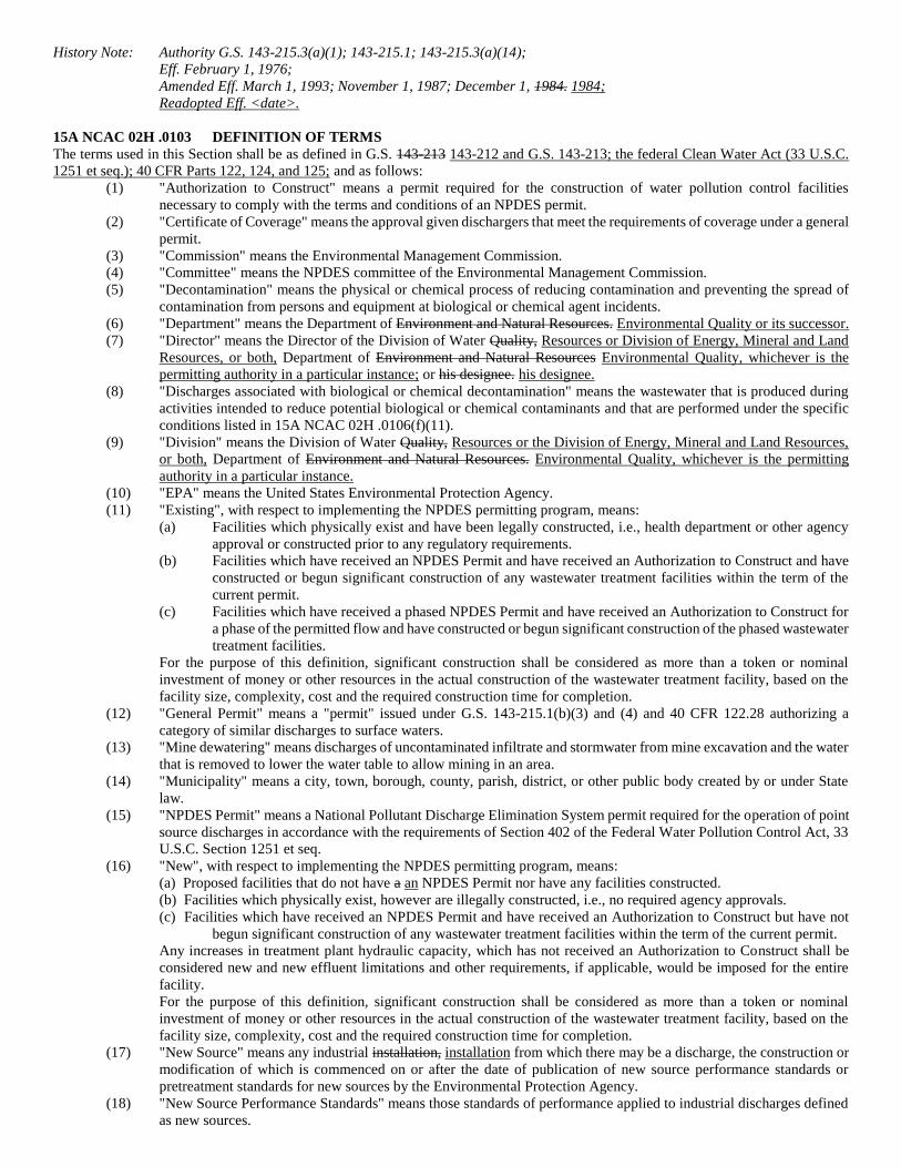
History Note: Authority G.S. 143-215.3(a)(1); 143-215.1; 143-215.3(a)(14);
Eff. February 1, 1976;
Amended Eff. March 1, 1993; November 1, 1987; December 1, 1984. 1984;
Readopted Eff. <date>.
15A NCAC 02H .0103 DEFINITION OF TERMS
The terms used in this Section shall be as defined in G.S. 143-213 143-212 and G.S. 143-213; the federal Clean Water Act (33 U.S.C.
1251 et seq.); 40 CFR Parts 122, 124, and 125; and as follows:
(1) "Authorization to Construct" means a permit required for the construction of water pollution control facilities
necessary to comply with the terms and conditions of an NPDES permit.
(2) "Certificate of Coverage" means the approval given dischargers that meet the requirements of coverage under a general
permit.
(3) "Commission" means the Environmental Management Commission.
(4) "Committee" means the NPDES committee of the Environmental Management Commission.
(5) "Decontamination" means the physical or chemical process of reducing contamination and preventing the spread of
contamination from persons and equipment at biological or chemical agent incidents.
(6) "Department" means the Department of Environment and Natural Resources. Environmental Quality or its successor.
(7) "Director" means the Director of the Division of Water Quality, Resources or Division of Energy, Mineral and Land
Resources, or both, Department of Environment and Natural Resources Environmental Quality, whichever is the
permitting authority in a particular instance; or his designee. his designee.
(8) "Discharges associated with biological or chemical decontamination" means the wastewater that is produced during
activities intended to reduce potential biological or chemical contaminants and that are performed under the specific
conditions listed in 15A NCAC 02H .0106(f)(11).
(9) "Division" means the Division of Water Quality, Resources or the Division of Energy, Mineral and Land Resources,
or both, Department of Environment and Natural Resources. Environmental Quality, whichever is the permitting
authority in a particular instance.
(10) "EPA" means the United States Environmental Protection Agency.
(11) "Existing", with respect to implementing the NPDES permitting program, means:
(a) Facilities which physically exist and have been legally constructed, i.e., health department or other agency
approval or constructed prior to any regulatory requirements.
(b) Facilities which have received an NPDES Permit and have received an Authorization to Construct and have
constructed or begun significant construction of any wastewater treatment facilities within the term of the
current permit.
(c) Facilities which have received a phased NPDES Permit and have received an Authorization to Construct for
a phase of the permitted flow and have constructed or begun significant construction of the phased wastewater
treatment facilities.
For the purpose of this definition, significant construction shall be considered as more than a token or nominal
investment of money or other resources in the actual construction of the wastewater treatment facility, based on the
facility size, complexity, cost and the required construction time for completion.
(12) "General Permit" means a "permit" issued under G.S. 143-215.1(b)(3) and (4) and 40 CFR 122.28 authorizing a
category of similar discharges to surface waters.
(13) "Mine dewatering" means discharges of uncontaminated infiltrate and stormwater from mine excavation and the water
that is removed to lower the water table to allow mining in an area.
(14) "Municipality" means a city, town, borough, county, parish, district, or other public body created by or under State
law.
(15) "NPDES Permit" means a National Pollutant Discharge Elimination System permit required for the operation of point
source discharges in accordance with the requirements of Section 402 of the Federal Water Pollution Control Act, 33
U.S.C. Section 1251 et seq.
(16) "New", with respect to implementing the NPDES permitting program, means:
(a) Proposed facilities that do not have a an NPDES Permit nor have any facilities constructed.
(b) Facilities which physically exist, however are illegally constructed, i.e., no required agency approvals.
(c) Facilities which have received an NPDES Permit and have received an Authorization to Construct but have not
begun significant construction of any wastewater treatment facilities within the term of the current permit.
Any increases in treatment plant hydraulic capacity, which has not received an Authorization to Construct shall be
considered new and new effluent limitations and other requirements, if applicable, would be imposed for the entire
facility.
For the purpose of this definition, significant construction shall be considered as more than a token or nominal
investment of money or other resources in the actual construction of the wastewater treatment facility, based on the
facility size, complexity, cost and the required construction time for completion.
(17) "New Source" means any industrial installation, installation from which there may be a discharge, the construction or
modification of which is commenced on or after the date of publication of new source performance standards or
pretreatment standards for new sources by the Environmental Protection Agency.
(18) "New Source Performance Standards" means those standards of performance applied to industrial discharges defined
as new sources.
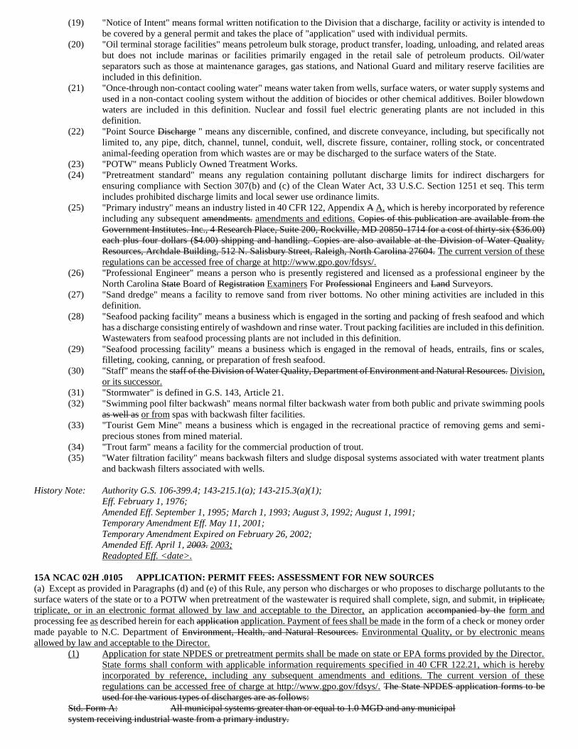
(19) "Notice of Intent" means formal written notification to the Division that a discharge, facility or activity is intended to
be covered by a general permit and takes the place of "application" used with individual permits.
(20) "Oil terminal storage facilities" means petroleum bulk storage, product transfer, loading, unloading, and related areas
but does not include marinas or facilities primarily engaged in the retail sale of petroleum products. Oil/water
separators such as those at maintenance garages, gas stations, and National Guard and military reserve facilities are
included in this definition.
(21) "Once-through non-contact cooling water" means water taken from wells, surface waters, or water supply systems and
used in a non-contact cooling system without the addition of biocides or other chemical additives. Boiler blowdown
waters are included in this definition. Nuclear and fossil fuel electric generating plants are not included in this
definition.
(22) "Point Source Discharge " means any discernible, confined, and discrete conveyance, including, but specifically not
limited to, any pipe, ditch, channel, tunnel, conduit, well, discrete fissure, container, rolling stock, or concentrated
animal-feeding operation from which wastes are or may be discharged to the surface waters of the State.
(23) "POTW" means Publicly Owned Treatment Works.
(24) "Pretreatment standard" means any regulation containing pollutant discharge limits for indirect dischargers for
ensuring compliance with Section 307(b) and (c) of the Clean Water Act, 33 U.S.C. Section 1251 et seq. This term
includes prohibited discharge limits and local sewer use ordinance limits.
(25) "Primary industry" means an industry listed in 40 CFR 122, Appendix A A, which is hereby incorporated by reference
including any subsequent amendments. amendments and editions. Copies of this publication are available from the
Government Institutes. Inc., 4 Research Place, Suite 200, Rockville, MD 20850-1714 for a cost of thirty-six ($36.00)
each plus four dollars ($4.00) shipping and handling. Copies are also available at the Division of Water Quality,
Resources, Archdale Building, 512 N. Salisbury Street, Raleigh, North Carolina 27604. The current version of these
regulations can be accessed free of charge at http://www.gpo.gov/fdsys/.
(26) "Professional Engineer" means a person who is presently registered and licensed as a professional engineer by the
North Carolina State Board of Registration Examiners For Professional Engineers and Land Surveyors.
(27) "Sand dredge" means a facility to remove sand from river bottoms. No other mining activities are included in this
definition.
(28) "Seafood packing facility" means a business which is engaged in the sorting and packing of fresh seafood and which
has a discharge consisting entirely of washdown and rinse water. Trout packing facilities are included in this definition.
Wastewaters from seafood processing plants are not included in this definition.
(29) "Seafood processing facility" means a business which is engaged in the removal of heads, entrails, fins or scales,
filleting, cooking, canning, or preparation of fresh seafood.
(30) "Staff" means the staff of the Division of Water Quality, Department of Environment and Natural Resources. Division,
or its successor.
(31) "Stormwater" is defined in G.S. 143, Article 21.
(32) "Swimming pool filter backwash" means normal filter backwash water from both public and private swimming pools
as well as or from spas with backwash filter facilities.
(33) "Tourist Gem Mine" means a business which is engaged in the recreational practice of removing gems and semi-
precious stones from mined material.
(34) "Trout farm" means a facility for the commercial production of trout.
(35) "Water filtration facility" means backwash filters and sludge disposal systems associated with water treatment plants
and backwash filters associated with wells.
History Note: Authority G.S. 106-399.4; 143-215.1(a); 143-215.3(a)(1);
Eff. February 1, 1976;
Amended Eff. September 1, 1995; March 1, 1993; August 3, 1992; August 1, 1991;
Temporary Amendment Eff. May 11, 2001;
Temporary Amendment Expired on February 26, 2002;
Amended Eff. April 1, 2003. 2003;
Readopted Eff. <date>.
15A NCAC 02H .0105 APPLICATION: PERMIT FEES: ASSESSMENT FOR NEW SOURCES
(a) Except as provided in Paragraphs (d) and (e) of this Rule, any person who discharges or who proposes to discharge pollutants to the
surface waters of the state or to a POTW when pretreatment of the wastewater is required shall complete, sign, and submit, in triplicate,
triplicate, or in an electronic format allowed by law and acceptable to the Director, an application accompanied by the form and
processing fee as described herein for each application application. Payment of fees shall be made in the form of a check or money order
made payable to N.C. Department of Environment, Health, and Natural Resources. Environmental Quality, or by electronic means
allowed by law and acceptable to the Director.
(1) Application for state NPDES or pretreatment permits shall be made on state or EPA forms provided by the Director.
State forms shall conform with applicable information requirements specified in 40 CFR 122.21, which is hereby
incorporated by reference, including any subsequent amendments and editions. The current version of these
regulations can be accessed free of charge at http://www.gpo.gov/fdsys/. The State NPDES application forms to be
used for the various types of discharges are as follows:
Std. Form A: All municipal systems greater than or equal to 1.0 MGD and any municipal
system receiving industrial waste from a primary industry.
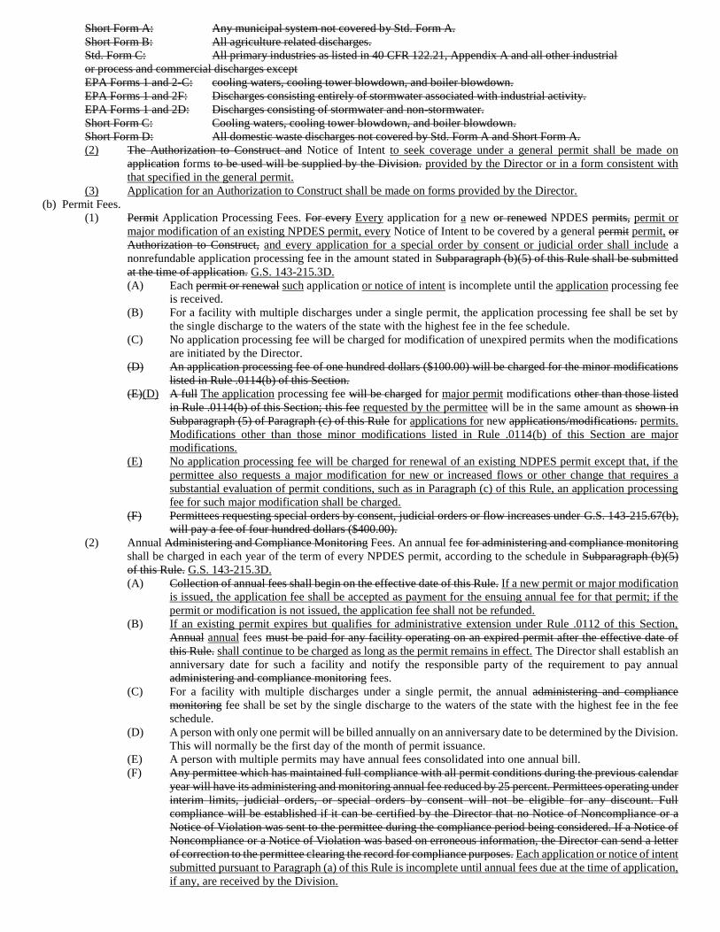
Short Form A: Any municipal system not covered by Std. Form A.
Short Form B: All agriculture related discharges.
Std. Form C: All primary industries as listed in 40 CFR 122.21, Appendix A and all other industrial
or process and commercial discharges except
EPA Forms 1 and 2-C: cooling waters, cooling tower blowdown, and boiler blowdown.
EPA Forms 1 and 2F: Discharges consisting entirely of stormwater associated with industrial activity.
EPA Forms 1 and 2D: Discharges consisting of stormwater and non-stormwater.
Short Form C: Cooling waters, cooling tower blowdown, and boiler blowdown.
Short Form D: All domestic waste discharges not covered by Std. Form A and Short Form A.
(2) The Authorization to Construct and Notice of Intent to seek coverage under a general permit shall be made on
application forms to be used will be supplied by the Division. provided by the Director or in a form consistent with
that specified in the general permit.
(3) Application for an Authorization to Construct shall be made on forms provided by the Director.
(b) Permit Fees.
(1) Permit Application Processing Fees. For every Every application for a new or renewed NPDES permits, permit or
major modification of an existing NPDES permit, every Notice of Intent to be covered by a general permit permit, or
Authorization to Construct, and every application for a special order by consent or judicial order shall include a
nonrefundable application processing fee in the amount stated in Subparagraph (b)(5) of this Rule shall be submitted
at the time of application. G.S. 143-215.3D.
(A) Each permit or renewal such application or notice of intent is incomplete until the application processing fee
is received.
(B) For a facility with multiple discharges under a single permit, the application processing fee shall be set by
the single discharge to the waters of the state with the highest fee in the fee schedule.
(C) No application processing fee will be charged for modification of unexpired permits when the modifications
are initiated by the Director.
(D) An application processing fee of one hundred dollars ($100.00) will be charged for the minor modifications
listed in Rule .0114(b) of this Section.
(E)(D) A full The application processing fee will be charged for major permit modifications other than those listed
in Rule .0114(b) of this Section; this fee requested by the permittee will be in the same amount as shown in
Subparagraph (5) of Paragraph (c) of this Rule for applications for new applications/modifications. permits.
Modifications other than those minor modifications listed in Rule .0114(b) of this Section are major
modifications.
(E) No application processing fee will be charged for renewal of an existing NDPES permit except that, if the
permittee also requests a major modification for new or increased flows or other change that requires a
substantial evaluation of permit conditions, such as in Paragraph (c) of this Rule, an application processing
fee for such major modification shall be charged.
(F) Permittees requesting special orders by consent, judicial orders or flow increases under G.S. 143-215.67(b),
will pay a fee of four hundred dollars ($400.00).
(2) Annual Administering and Compliance Monitoring Fees. An annual fee for administering and compliance monitoring
shall be charged in each year of the term of every NPDES permit, according to the schedule in Subparagraph (b)(5)
of this Rule. G.S. 143-215.3D.
(A) Collection of annual fees shall begin on the effective date of this Rule. If a new permit or major modification
is issued, the application fee shall be accepted as payment for the ensuing annual fee for that permit; if the
permit or modification is not issued, the application fee shall not be refunded.
(B) If an existing permit expires but qualifies for administrative extension under Rule .0112 of this Section,
Annual annual fees must be paid for any facility operating on an expired permit after the effective date of
this Rule. shall continue to be charged as long as the permit remains in effect. The Director shall establish an
anniversary date for such a facility and notify the responsible party of the requirement to pay annual
administering and compliance monitoring fees.
(C) For a facility with multiple discharges under a single permit, the annual administering and compliance
monitoring fee shall be set by the single discharge to the waters of the state with the highest fee in the fee
schedule.
(D) A person with only one permit will be billed annually on an anniversary date to be determined by the Division.
This will normally be the first day of the month of permit issuance.
(E) A person with multiple permits may have annual fees consolidated into one annual bill.
(F) Any permittee which has maintained full compliance with all permit conditions during the previous calendar
year will have its administering and monitoring annual fee reduced by 25 percent. Permittees operating under
interim limits, judicial orders, or special orders by consent will not be eligible for any discount. Full
compliance will be established if it can be certified by the Director that no Notice of Noncompliance or a
Notice of Violation was sent to the permittee during the compliance period being considered. If a Notice of
Noncompliance or a Notice of Violation was based on erroneous information, the Director can send a letter
of correction to the permittee clearing the record for compliance purposes. Each application or notice of intent
submitted pursuant to Paragraph (a) of this Rule is incomplete until annual fees due at the time of application,
if any, are received by the Division.
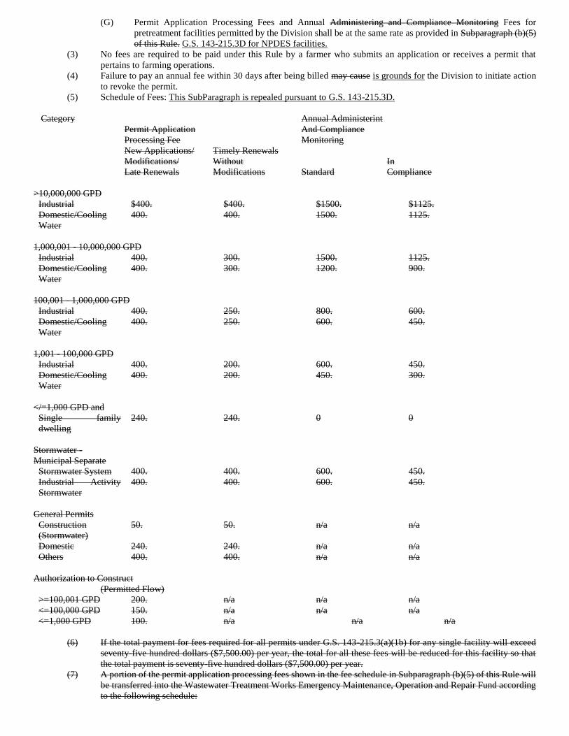
(G) Permit Application Processing Fees and Annual Administering and Compliance Monitoring Fees for
pretreatment facilities permitted by the Division shall be at the same rate as provided in Subparagraph (b)(5)
of this Rule. G.S. 143-215.3D for NPDES facilities.
(3) No fees are required to be paid under this Rule by a farmer who submits an application or receives a permit that
pertains to farming operations.
(4) Failure to pay an annual fee within 30 days after being billed may cause is grounds for the Division to initiate action
to revoke the permit.
(5) Schedule of Fees: This SubParagraph is repealed pursuant to G.S. 143-215.3D.
Category Annual Administerint
And Compliance
Monitoring
Permit Application
Processing Fee
New Applications/ Timely Renewals
Modifications/ Without In
Late Renewals Modifications Standard Compliance
>10,000,000 GPD
Industrial $400. $400. $1500. $1125.
Domestic/Cooling
Water
400. 400. 1500. 1125.
1,000,001 - 10,000,000 GPD
Industrial 400. 300. 1500. 1125.
Domestic/Cooling
Water
400. 300. 1200. 900.
100,001 - 1,000,000 GPD
Industrial 400. 250. 800. 600.
Domestic/Cooling
Water
400. 250. 600. 450.
1,001 - 100,000 GPD
Industrial 400. 200. 600. 450.
Domestic/Cooling
Water
400. 200. 450. 300.
</=1,000 GPD and
Single family
dwelling
240. 240. 0 0
Stormwater -
Municipal Separate
Stormwater System 400. 400. 600. 450.
Industrial Activity
Stormwater
400. 400. 600. 450.
General Permits
Construction
(Stormwater)
50. 50. n/a n/a
Domestic 240. 240. n/a n/a
Others 400. 400. n/a n/a
Authorization to Construct
(Permitted Flow)
>=100,001 GPD 200. n/a n/a n/a
<=100,000 GPD 150. n/a n/a n/a
<=1,000 GPD 100. n/a n/a n/a
(6) If the total payment for fees required for all permits under G.S. 143-215.3(a)(1b) for any single facility will exceed
seventy-five hundred dollars ($7,500.00) per year, the total for all these fees will be reduced for this facility so that
the total payment is seventy-five hundred dollars ($7,500.00) per year.
(7) A portion of the permit application processing fees shown in the fee schedule in Subparagraph (b)(5) of this Rule will
be transferred into the Wastewater Treatment Works Emergency Maintenance, Operation and Repair Fund according
to the following schedule:
(A) All nonmunicipal facilities treating wastewater which is predominantly domestic waste with design flows of
100,000 gallons per day or less, except single family dwellings, seventy-five dollars ($75.00);
(B) Single family dwellings, forty dollars ($40.00);
(C) All other facilities, zero.
(8) When the total value of the Wastewater Treatment Works Emergency Maintenance, Operation and Repair Fund, as
certified by the State Treasurer, is at least seven hundred fifty thousand dollars ($750,000.00) at the end of a quarter,
the permit application processing fees for facilities with discharges of one hundred thousand gallons per day (100,000
GPD) or less shall be reduced by the amounts being transferred under Subparagraph (7) of this Paragraph. This
reduction shall continue until, at the end of some subsequent quarter, the State Treasurer certifies that the fund's
balance is less than seven hundred fifty thousand dollars ($750,000.00), in which case the full amount of the permit
application processing fees as listed in Subparagraph (b)(5) of this Rule shall be charged.
(9) In order to avoid violation of the statutory limit that total permit fees collected in any year not exceed 30 percent of
the total budgets from all sources of environmental permitting and compliance programs, the Division shall in the first
half of each state fiscal year project revenues from all sources including fees for the next fiscal year. If this projection
shows that the statutory limit will be exceeded, rulemaking shall be commenced in order to have an appropriately
adjusted fee schedule which will avoid excessive revenue collection from permit fees.
(10)(6) Any applicant whose facility qualifies for a general permit under Rule .0127 of this Section may pay the lower fees
set in Subparagraph (b)(5) of this Rule shall be charged the amount provided in G.S. 143-215.3D for the appropriate
general permit.
(c) Engineering Alternatives Analysis. Applicants for new NPDES permits for new or expanding discharges requiring construction of
water pollution control facilities shall in addition to applications required in Paragraph (a) of this Rule, file, in triplicate, triplicate or in
an electronic format allowed by law and acceptable to the Director, an engineering proposal setting forth the following information:
(1) a description of the origin, type and flow of waste which is proposed to be discharged. Justification The proposal shall
include a rationale and a demonstration of need shall be provided for expected the projected flow volumes. Flow shall
be determined in accordance with 15A NCAC 2H .0219(1); 02T .0114;
(2) a summary of the available waste treatment and disposal options that were considered and why the proposed system
and point of discharge were selected; the summary should have sufficient detail to assure establish that the most
environmentally sound alternative was selected from the reasonably cost effective options; in all cases where
connection to an area-wide sewerage system is feasible, such connection thereto shall be required;
(3) a narrative description of the proposed treatment works including type and arrangement of major components, in
sufficient detail to assure that the proposed facility has the capability to comply with the permit limits; for commonly
used treatment system or components or those with well established treatment capabilities, detailed plans and
specifications need not be submitted until the application for the authorization to construct; however, detailed plans
and specifications shall be required with the permit application for any system or component without well established
treatment capabilities for the nature type of waste to be treated or degree of treatment needed to meet the permit limits;
(4) a general location map, showing orientation of the facility with reference to at least two geographic references
(numbered roads, named streams/rivers, etc.);
(5) a scale location plan of the site showing location of the proposed treatment works and the proposed point of discharge;
(6) special studies or modeling may be required in cases where the impacts of the discharge cannot be readily determined
by the Division;
(7) a statement to demonstrate financial qualification and substantial previous compliance with federal and state laws,
regulations, and rules for the protection of the environment as required by G.S. 143-215.1(b)(4)(b).
(d) Applicants for new individual NPDES permits requiring construction of stormwater control facilities shall in addition to applications
required in Paragraph (a) of this Rule, design and construct the facilities in accordance with criteria approved by the Director, Director
or shall file in triplicate, an engineering proposal setting forth the information required in Paragraph (c) of this Rule.
(e) Applications for permit renewals shall be accomplished made by filing the appropriate application form or forms, as listed in
Paragraph (a) of this Rule, with the applicable processing fee described herein in the form of a check or money order made payable to
N.C. Department of Environment, Health, and Natural Resources, fee, if any, as specified in Paragraph (b) of this Rule, at least 180 days
prior to expiration of a permit. Renewal requests received less than 180 days prior to permit expiration will be required to pay the new
application/modification/late renewal fee rather than the timely renewal without modification fee. Payment shall be in the form of a
check or money order made payable to the N.C. Department of Environmental Quality or made by other lawful means acceptable to the
Director. The notice and public participation procedures set forth in Rules .0109 and .0111 of this Section shall be followed for each
request for permit renewal. An acceptable residuals management plan shall be submitted with the application for permit renewal in
accordance with Rule .0138(b)(8) of this Section. Authorizations to Construct permits for wastewater control facilities will not be subject
to the notice and public participation procedures set forth in Rules .0109 and .0111 of this Section. Authorizations to Construct may be
issued for any length of time, however, the NPDES permit must be in effect at time of construction. All applications are incomplete
until required processing fees are received, and incomplete applications may be returned to the applicant.
(f) Applications for permits for pretreatment facilities shall be made in triplicate upon forms approved by the Director and submitted
along with applicable supporting information to the Division of Environmental Management. Water Resources.
(g) Applications for permits for new or modified discharges which propose to discharge industrial process or domestic wastewater in
excess of 500,000 gallons per day or 10 MGD of cooling water to the surface waters that meet the criteria established in or pursuant to
G.S. 113A, Article 1, shall file, include, in addition to the applications application forms, fees, and supporting documents required in
Paragraphs (a) and (b)(e) of this Rule, an environmental assessment which shall meet the requirements of 1 01 NCAC 25 .0502. .0500.
Any assessment which is required by any other state agency or any federal agency shall be deemed to comply with requirements of this
Subsection provided aquatic impacts are adequately addressed.
(h) Permits which result in construction of facilities which will be funded by public monies may require environmental documentation
pursuant to North Carolina Environmental Policy Act, G.S. 113A. NPDES permit applications for which such documentation is required
will be considered incomplete until supported by the required documentation.
(i) Applicants for permits for new nonmunicipal domestic wastewater discharges shall file a notarized statement indicating whether or
not each city or county government having jurisdiction over any part of the lands on which the proposed facility is to be located has a
zoning or subdivision ordinance in effect, and, if such an ordinance is in effect, whether or not the proposed facility is consistent with
the ordinance.
(j) For NPDES permits, a full disclosure of all known toxic components that can be reasonably expected to be in the discharge, including
but not limited to those contained in a priority pollutant analysis, must be submitted for all primary industrial direct discharges in
accordance with 40 CFR 122.21 Appendix D D, which are is hereby incorporated by reference including any subsequent amendments
and editions, and for other direct discharges as required by the Director. This material is available for inspection at the Department of
Environment, Health, and Natural Resources, Division of Environmental Management, 512 N. Salisbury Street, Raleigh, North Carolina.
Copies may be obtained from the Superintendent of Documents, U.S. Government Printing Office, Washington D.C. 20402-9325 at a
cost of thirty dollars ($30.00). The current version of these regulations can be accessed free of charge at http://www.gpo.gov/fdsys/.
History Note: Authority G.S. 143-215.1(c); 143-215.1(c)(6); 143-215.3(a); 143-215.3B; 143-215.3D;
Eff. February 1, 1976;
Amended Eff. March 1, 1993; August 1, 1991; October 1, 1990; August 1, 1988. 1988;
Readopted Eff. <date>.
15A NCAC 02H .0106 FILING APPLICATIONS
(a) Permit applications shall be filed with the Director, Division of Water Quality, Resources, 1617 Mail Service Center, Raleigh, North
Carolina, 27699-1617.
(b) All NPDES permit applications, except those addressed in Paragraph (d) of this Rule, shall be filed at least 180 days in advance of
the date on which an existing permit expires or in sufficient time prior to the proposed commencement of a waste discharge to ensure
compliance with all legal procedures. before the date on which the discharge is to commence and, thereafter, at least 180 days before
the expiration date of the existing permit, unless permission for a later date has been granted by the Director. Persons proposing a new
discharge are encouraged to submit their applications in advance of the 180-day requirement.
(c) All Authorization to Construct applications shall be filed at least 90 days in advance of the proposed commencement date of
construction of water pollution control facilities but no earlier than the establishment of effluent limitations.
(d) All NPDES stormwater construction permit applications shall be filed in advance of the proposed commencement date of land
disturbing activity which results in a stormwater discharge.
(e) Permit applications filed with the Director shall be signed as follows:
(1) in the case of corporations, by a principal executive officer of at least the level of vice-president, or his duly authorized
representative, if such representative is responsible for the overall operation of the facility from which the discharge
described in the permit application form originates;
(2) in the case of a partnership or a limited partnership, by a general partner;
(3) in the case of a sole proprietorship, by the proprietor; and
(4) in the case of a municipal, state, or other public entity by either a principal executive officer, ranking elected official
or other duly authorized employee.
(f) The following discharges are deemed to be permitted pursuant to G.S. 143-215.1(c) provided that no water quality standards are
contravened, or expected to be contravened, and it shall not be necessary for the Division to issue separate permits for these activities:
(1) filter backwash and draining associated with swimming pools;
(2) filter backwash from raw water intake screening devices;
(3) condensate from residential or commercial air conditioning units;
(4) individual non-commercial vehicle washing operations;
(5) flushing and hydrostatic testing water associated with utility distribution systems;
(6) discharges associated with emergency removal and treatment activities for spilled oil authorized by the federal or state
on-scene coordinator when such removals are undertaken to minimize overall environmental damage due to an oil
spill;
(7) groundwaters generated by well construction or other construction activities;
(8) landscape irrigation, foundation or footing drains, or water from crawl space pumps;
(9) street wash water;
(10) flows from fire fighting; and
(11) excluding the provision in Subparagraph (f)(6) of this Rule, discharges associated with biological or chemical
decontamination activities performed as a result of an emergency declared by the Governor or the Director of the
Division of Emergency Management and that are conducted by or under the direct supervision of the federal or state
on-scene coordinator and that meet the following specific conditions:
(A) the volume of discharge produced by the decontamination activity is too large to be contained on-site;
(B) the Division of Water Quality Resources is informed prior to commencement of the discharge from the
decontamination activity;
(C) overland flow or other non-discharge options are deemed to be impractical by the authorities conducting the
decontamination activity; and
(D) the discharge is not radiologically contaminated.
(g) Continued Applicability of Permit. A wastewater treatment facility or treatment unit that is taken out of service but contains waste
or residuals that could be discharged to surface waters or otherwise present an environmental or public health risk under foreseeable
circumstances, including severe weather events, shall remain subject to NPDES permit requirements until such materials are properly
disposed.
History Note: Authority G.S. 106-399.4; 143-215.1(c); 143-215.1(b)(3); 143-215.3(a)(1);
Eff. February 1, 1976;
Amended Eff. March 1, 1993; November 1, 1987; January 1, 1984; November 1, 1978;
Temporary Amendment Eff. May 11, 2001;
Temporary Amendment Expired on February 26, 2002;
Amended Eff. April 1, 2003. 2003;
Readopted Eff. <date>.
15A NCAC 02H .0107 STAFF REVIEW AND EVALUATION
(a) The Director is authorized to accept applications for the Commission and shall refer all applications to the staff for review and
evaluation. Additionally, the Director shall refer NPDES Permit applications for the discharge of waste into waters classified as sources
of public water supply (WS classification) and shellfish waters classified SA to the Public Water Supply Section, Division of Water
Resources, and the Shellfish Sanitation Program, Division of Environmental Health, Marine Fisheries, respectively, both of the
Department of Environment, Health, and Natural Resources, Environmental Quality, for review and written approval.
(b) The Director shall acknowledge receipt of a complete an NPDES or Authorization to Construct permit application upon verifying
that the application is administratively complete, that is, includes the completed and signed application forms specified in Rule .0105(a)
of this Section, any necessary supplemental information, and any associated fees in accordance with Rules .0105 and .0106 of this
Section.
(1) If an application is or, if not administratively complete, the Director may return the application to the applicant as
incomplete or request the additional information required. The applicant may be given up to 60 days to provide the
information to make the application complete.
(2) If technical review of the application reveals that additional information is necessary for staff to properly evaluate the
proposed discharge, the Director will notify the applicant of the additional information required. The applicant may
be given up to 60 days to provide the information to make the application complete.
(c) Tentative Determination and Draft individual NPDES Permit.
(1) The staff shall conduct a site investigation and shall prepare its written evaluation and tentative determination to issue
or deny the NPDES permit. On-site investigations will not be necessary for Authorization to Construct permits,
activities covered under general permits permits, and renewal of individual permits with no modifications.
modifications warranting such investigation.
(2) If the staff's tentative determination in Paragraph Subparagraph (1) of this Subdivision Paragraph is to issue the permit,
it shall if necessary make the following additional determinations in writing:
(A) proposed effluent limitations for those pollutants proposed to be limited;
(B) a proposed schedule of compliance, including interim dates and requirements, for meeting the proposed
effluent limitations; and
(C) a brief description of any other proposed special conditions which will have significant impact upon the
discharge described in the application.
(3) The staff shall organize the determinations made pursuant to Paragraphs Subparagraphs (1) and (2) of this Subdivision
Paragraph into a draft permit.
(d) In the case of permits for which notice of intent Notice of Intent is given on forms as described in Rule .0105(a) of this Section, a
Certificate of Coverage under a general permit may be prepared and issued directly to the applicant in lieu of any other acknowledgment.
If the Notice of Intent is unacceptable, it will be returned to the applicant with an explanation of the inadequacies.
History Note: Authority G.S. 130-161; 143-215.3(a)(1); 143-215.3(a)(4); 143-215.1(a);
143-215.1(c);
Eff. February 1, 1976;
Amended Eff. March 1, 1993; August 1, 1991; August 1, 1988; October 1, 1987. 1987;
Readopted Eff. <date>.
15A NCAC 02H .0108 FACT SHEETS
(a) For all discharges which do not qualify for a general NPDES permit and which have a total volume of 500,000 or more gallons on
any day, a fact sheet providing a brief synopsis of the application shall be prepared by the staff and made available upon request following
issuance of the public notice. The contents of such fact sheets shall include at least the following information:
(1) a sketch sketch, map, or detailed description of the location of the discharge described in the application;
(2) a quantitative and qualitative description of the discharge described in the application which includes at least the
following:
(A) the rate or frequency of the proposed discharge; if the discharge is continuous, the average daily flow in
gallons per day or million gallons per day;
(B) for thermal discharges subject to limitation under the act, the average summer and winter temperatures in
degrees Fahrenheit; and
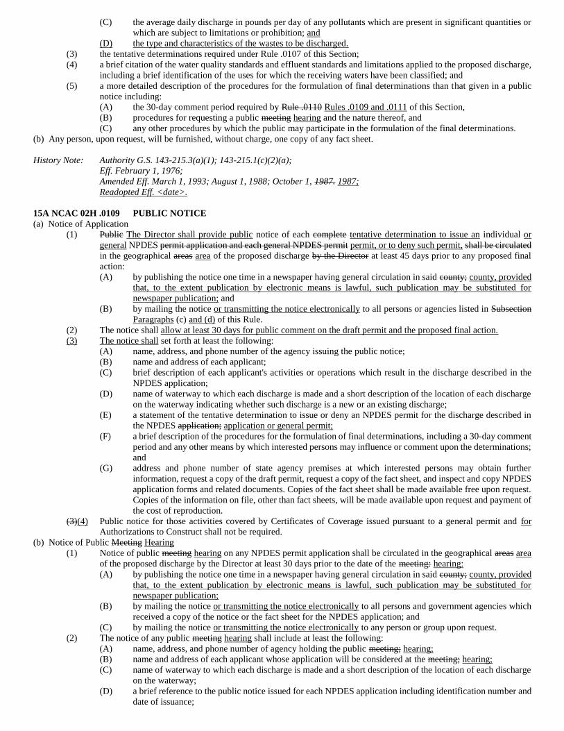
(C) the average daily discharge in pounds per day of any pollutants which are present in significant quantities or
which are subject to limitations or prohibition; and
(D) the type and characteristics of the wastes to be discharged.
(3) the tentative determinations required under Rule .0107 of this Section;
(4) a brief citation of the water quality standards and effluent standards and limitations applied to the proposed discharge,
including a brief identification of the uses for which the receiving waters have been classified; and
(5) a more detailed description of the procedures for the formulation of final determinations than that given in a public
notice including:
(A) the 30-day comment period required by Rule .0110 Rules .0109 and .0111 of this Section,
(B) procedures for requesting a public meeting hearing and the nature thereof, and
(C) any other procedures by which the public may participate in the formulation of the final determinations.
(b) Any person, upon request, will be furnished, without charge, one copy of any fact sheet.
History Note: Authority G.S. 143-215.3(a)(1); 143-215.1(c)(2)(a);
Eff. February 1, 1976;
Amended Eff. March 1, 1993; August 1, 1988; October 1, 1987. 1987;
Readopted Eff. <date>.
15A NCAC 02H .0109 PUBLIC NOTICE
(a) Notice of Application
(1) Public The Director shall provide public notice of each complete tentative determination to issue an individual or
general NPDES permit application and each general NPDES permit permit, or to deny such permit, shall be circulated
in the geographical areas area of the proposed discharge by the Director at least 45 days prior to any proposed final
action:
(A) by publishing the notice one time in a newspaper having general circulation in said county; county, provided
that, to the extent publication by electronic means is lawful, such publication may be substituted for
newspaper publication; and
(B) by mailing the notice or transmitting the notice electronically to all persons or agencies listed in Subsection
Paragraphs (c) and (d) of this Rule.
(2) The notice shall allow at least 30 days for public comment on the draft permit and the proposed final action.
(3) The notice shall set forth at least the following:
(A) name, address, and phone number of the agency issuing the public notice;
(B) name and address of each applicant;
(C) brief description of each applicant's activities or operations which result in the discharge described in the
NPDES application;
(D) name of waterway to which each discharge is made and a short description of the location of each discharge
on the waterway indicating whether such discharge is a new or an existing discharge;
(E) a statement of the tentative determination to issue or deny an NPDES permit for the discharge described in
the NPDES application; application or general permit;
(F) a brief description of the procedures for the formulation of final determinations, including a 30-day comment
period and any other means by which interested persons may influence or comment upon the determinations;
and
(G) address and phone number of state agency premises at which interested persons may obtain further
information, request a copy of the draft permit, request a copy of the fact sheet, and inspect and copy NPDES
application forms and related documents. Copies of the fact sheet shall be made available free upon request.
Copies of the information on file, other than fact sheets, will be made available upon request and payment of
the cost of reproduction.
(3)(4) Public notice for those activities covered by Certificates of Coverage issued pursuant to a general permit and for
Authorizations to Construct shall not be required.
(b) Notice of Public Meeting Hearing
(1) Notice of public meeting hearing on any NPDES permit application shall be circulated in the geographical areas area
of the proposed discharge by the Director at least 30 days prior to the date of the meeting: hearing:
(A) by publishing the notice one time in a newspaper having general circulation in said county; county, provided
that, to the extent publication by electronic means is lawful, such publication may be substituted for
newspaper publication;
(B) by mailing the notice or transmitting the notice electronically to all persons and government agencies which
received a copy of the notice or the fact sheet for the NPDES application; and
(C) by mailing the notice or transmitting the notice electronically to any person or group upon request.
(2) The notice of any public meeting hearing shall include at least the following:
(A) name, address, and phone number of agency holding the public meeting; hearing;
(B) name and address of each applicant whose application will be considered at the meeting; hearing;
(C) name of waterway to which each discharge is made and a short description of the location of each discharge
on the waterway;
(D) a brief reference to the public notice issued for each NPDES application including identification number and
date of issuance;
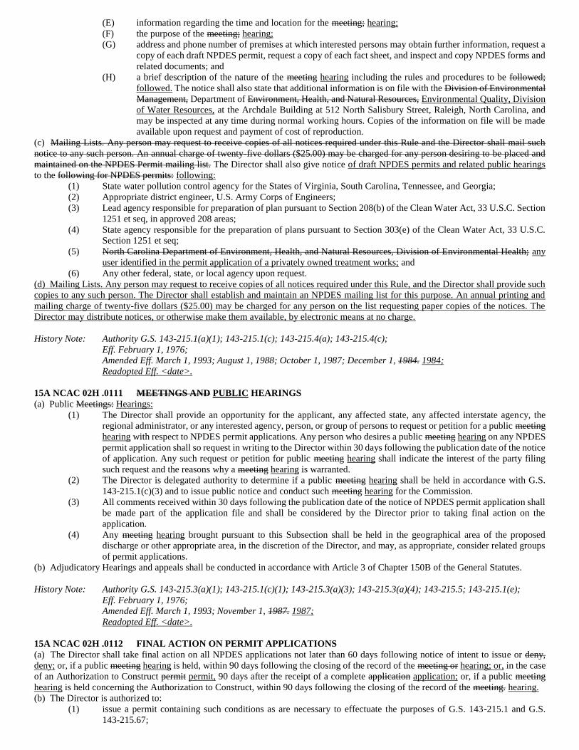
(E) information regarding the time and location for the meeting; hearing;
(F) the purpose of the meeting; hearing;
(G) address and phone number of premises at which interested persons may obtain further information, request a
copy of each draft NPDES permit, request a copy of each fact sheet, and inspect and copy NPDES forms and
related documents; and
(H) a brief description of the nature of the meeting hearing including the rules and procedures to be followed;
followed. The notice shall also state that additional information is on file with the Division of Environmental
Management, Department of Environment, Health, and Natural Resources, Environmental Quality, Division
of Water Resources, at the Archdale Building at 512 North Salisbury Street, Raleigh, North Carolina, and
may be inspected at any time during normal working hours. Copies of the information on file will be made
available upon request and payment of cost of reproduction.
(c) Mailing Lists. Any person may request to receive copies of all notices required under this Rule and the Director shall mail such
notice to any such person. An annual charge of twenty-five dollars ($25.00) may be charged for any person desiring to be placed and
maintained on the NPDES Permit mailing list. The Director shall also give notice of draft NPDES permits and related public hearings
to the following for NPDES permits: following:
(1) State water pollution control agency for the States of Virginia, South Carolina, Tennessee, and Georgia;
(2) Appropriate district engineer, U.S. Army Corps of Engineers;
(3) Lead agency responsible for preparation of plan pursuant to Section 208(b) of the Clean Water Act, 33 U.S.C. Section
1251 et seq, in approved 208 areas;
(4) State agency responsible for the preparation of plans pursuant to Section 303(e) of the Clean Water Act, 33 U.S.C.
Section 1251 et seq;
(5) North Carolina Department of Environment, Health, and Natural Resources, Division of Environmental Health; any
user identified in the permit application of a privately owned treatment works; and
(6) Any other federal, state, or local agency upon request.
(d) Mailing Lists. Any person may request to receive copies of all notices required under this Rule, and the Director shall provide such
copies to any such person. The Director shall establish and maintain an NPDES mailing list for this purpose. An annual printing and
mailing charge of twenty-five dollars ($25.00) may be charged for any person on the list requesting paper copies of the notices. The
Director may distribute notices, or otherwise make them available, by electronic means at no charge.
History Note: Authority G.S. 143-215.1(a)(1); 143-215.1(c); 143-215.4(a); 143-215.4(c);
Eff. February 1, 1976;
Amended Eff. March 1, 1993; August 1, 1988; October 1, 1987; December 1, 1984. 1984;
Readopted Eff. <date>.
15A NCAC 02H .0111 MEETINGS AND PUBLIC HEARINGS
(a) Public Meetings: Hearings:
(1) The Director shall provide an opportunity for the applicant, any affected state, any affected interstate agency, the
regional administrator, or any interested agency, person, or group of persons to request or petition for a public meeting
hearing with respect to NPDES permit applications. Any person who desires a public meeting hearing on any NPDES
permit application shall so request in writing to the Director within 30 days following the publication date of the notice
of application. Any such request or petition for public meeting hearing shall indicate the interest of the party filing
such request and the reasons why a meeting hearing is warranted.
(2) The Director is delegated authority to determine if a public meeting hearing shall be held in accordance with G.S.
143-215.1(c)(3) and to issue public notice and conduct such meeting hearing for the Commission.
(3) All comments received within 30 days following the publication date of the notice of NPDES permit application shall
be made part of the application file and shall be considered by the Director prior to taking final action on the
application.
(4) Any meeting hearing brought pursuant to this Subsection shall be held in the geographical area of the proposed
discharge or other appropriate area, in the discretion of the Director, and may, as appropriate, consider related groups
of permit applications.
(b) Adjudicatory Hearings and appeals shall be conducted in accordance with Article 3 of Chapter 150B of the General Statutes.
History Note: Authority G.S. 143-215.3(a)(1); 143-215.1(c)(1); 143-215.3(a)(3); 143-215.3(a)(4); 143-215.5; 143-215.1(e);
Eff. February 1, 1976;
Amended Eff. March 1, 1993; November 1, 1987. 1987;
Readopted Eff. <date>.
15A NCAC 02H .0112 FINAL ACTION ON PERMIT APPLICATIONS
(a) The Director shall take final action on all NPDES applications not later than 60 days following notice of intent to issue or deny,
deny; or, if a public meeting hearing is held, within 90 days following the closing of the record of the meeting or hearing; or, in the case
of an Authorization to Construct permit permit, 90 days after the receipt of a complete application application; or, if a public meeting
hearing is held concerning the Authorization to Construct, within 90 days following the closing of the record of the meeting. hearing.
(b) The Director is authorized to:
(1) issue a permit containing such conditions as are necessary to effectuate the purposes of G.S. 143-215.1 and G.S.
143-215.67;
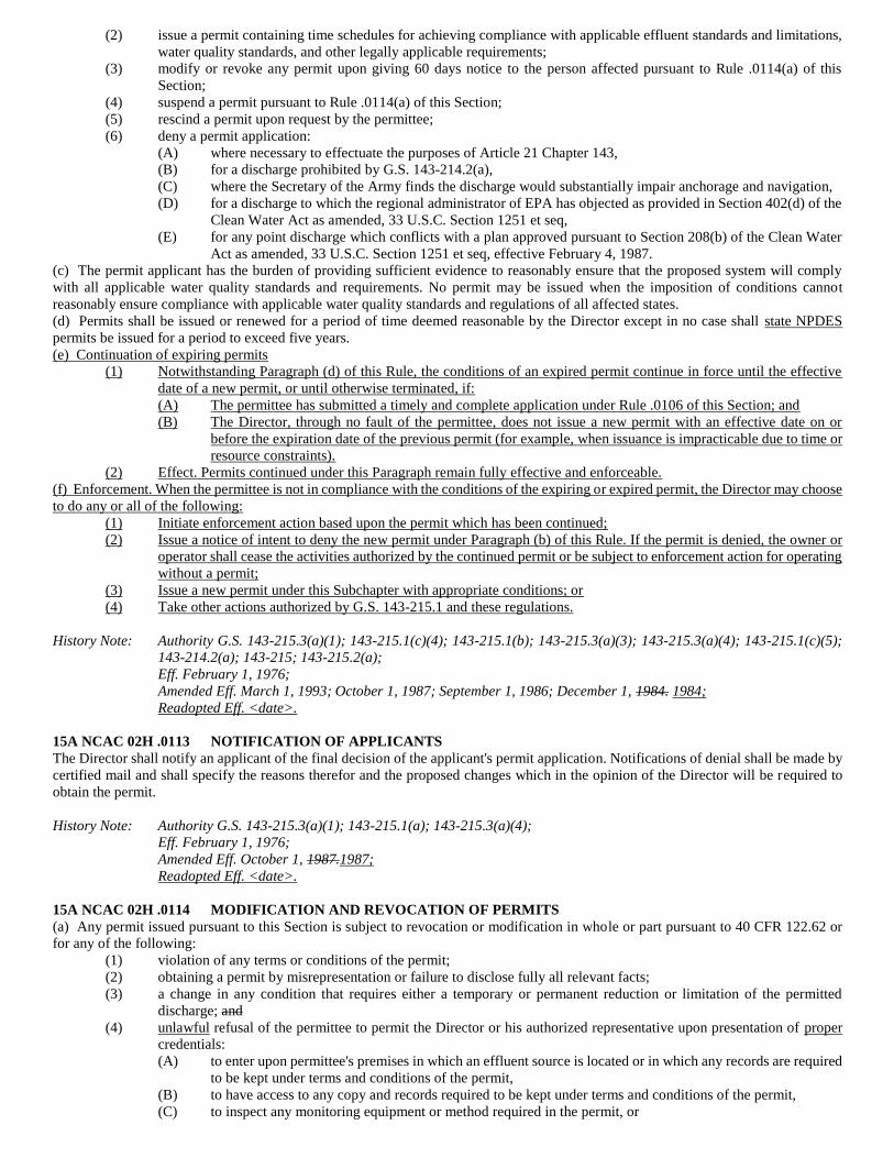
(2) issue a permit containing time schedules for achieving compliance with applicable effluent standards and limitations,
water quality standards, and other legally applicable requirements;
(3) modify or revoke any permit upon giving 60 days notice to the person affected pursuant to Rule .0114(a) of this
Section;
(4) suspend a permit pursuant to Rule .0114(a) of this Section;
(5) rescind a permit upon request by the permittee;
(6) deny a permit application:
(A) where necessary to effectuate the purposes of Article 21 Chapter 143,
(B) for a discharge prohibited by G.S. 143-214.2(a),
(C) where the Secretary of the Army finds the discharge would substantially impair anchorage and navigation,
(D) for a discharge to which the regional administrator of EPA has objected as provided in Section 402(d) of the
Clean Water Act as amended, 33 U.S.C. Section 1251 et seq,
(E) for any point discharge which conflicts with a plan approved pursuant to Section 208(b) of the Clean Water
Act as amended, 33 U.S.C. Section 1251 et seq, effective February 4, 1987.
(c) The permit applicant has the burden of providing sufficient evidence to reasonably ensure that the proposed system will comply
with all applicable water quality standards and requirements. No permit may be issued when the imposition of conditions cannot
reasonably ensure compliance with applicable water quality standards and regulations of all affected states.
(d) Permits shall be issued or renewed for a period of time deemed reasonable by the Director except in no case shall state NPDES
permits be issued for a period to exceed five years.
(e) Continuation of expiring permits
(1) Notwithstanding Paragraph (d) of this Rule, the conditions of an expired permit continue in force until the effective
date of a new permit, or until otherwise terminated, if:
(A) The permittee has submitted a timely and complete application under Rule .0106 of this Section; and
(B) The Director, through no fault of the permittee, does not issue a new permit with an effective date on or
before the expiration date of the previous permit (for example, when issuance is impracticable due to time or
resource constraints).
(2) Effect. Permits continued under this Paragraph remain fully effective and enforceable.
(f) Enforcement. When the permittee is not in compliance with the conditions of the expiring or expired permit, the Director may choose
to do any or all of the following:
(1) Initiate enforcement action based upon the permit which has been continued;
(2) Issue a notice of intent to deny the new permit under Paragraph (b) of this Rule. If the permit is denied, the owner or
operator shall cease the activities authorized by the continued permit or be subject to enforcement action for operating
without a permit;
(3) Issue a new permit under this Subchapter with appropriate conditions; or
(4) Take other actions authorized by G.S. 143-215.1 and these regulations.
History Note: Authority G.S. 143-215.3(a)(1); 143-215.1(c)(4); 143-215.1(b); 143-215.3(a)(3); 143-215.3(a)(4); 143-215.1(c)(5);
143-214.2(a); 143-215; 143-215.2(a);
Eff. February 1, 1976;
Amended Eff. March 1, 1993; October 1, 1987; September 1, 1986; December 1, 1984. 1984;
Readopted Eff. <date>.
15A NCAC 02H .0113 NOTIFICATION OF APPLICANTS
The Director shall notify an applicant of the final decision of the applicant's permit application. Notifications of denial shall be made by
certified mail and shall specify the reasons therefor and the proposed changes which in the opinion of the Director will be required to
obtain the permit.
History Note: Authority G.S. 143-215.3(a)(1); 143-215.1(a); 143-215.3(a)(4);
Eff. February 1, 1976;
Amended Eff. October 1, 1987.1987;
Readopted Eff. <date>.
15A NCAC 02H .0114 MODIFICATION AND REVOCATION OF PERMITS
(a) Any permit issued pursuant to this Section is subject to revocation or modification in whole or part pursuant to 40 CFR 122.62 or
for any of the following:
(1) violation of any terms or conditions of the permit;
(2) obtaining a permit by misrepresentation or failure to disclose fully all relevant facts;
(3) a change in any condition that requires either a temporary or permanent reduction or limitation of the permitted
discharge; and
(4) unlawful refusal of the permittee to permit the Director or his authorized representative upon presentation of proper
credentials:
(A) to enter upon permittee's premises in which an effluent source is located or in which any records are required
to be kept under terms and conditions of the permit,
(B) to have access to any copy and records required to be kept under terms and conditions of the permit,
(C) to inspect any monitoring equipment or method required in the permit, or
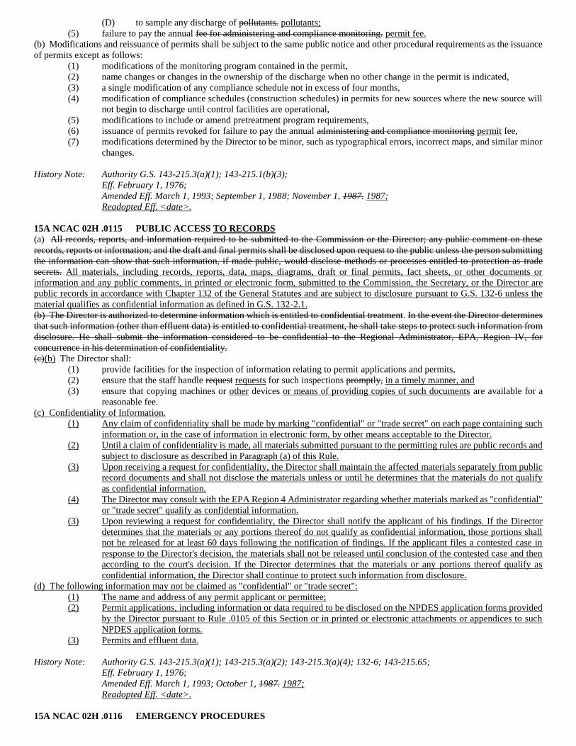
(D) to sample any discharge of pollutants. pollutants;
(5) failure to pay the annual fee for administering and compliance monitoring. permit fee.
(b) Modifications and reissuance of permits shall be subject to the same public notice and other procedural requirements as the issuance
of permits except as follows:
(1) modifications of the monitoring program contained in the permit,
(2) name changes or changes in the ownership of the discharge when no other change in the permit is indicated,
(3) a single modification of any compliance schedule not in excess of four months,
(4) modification of compliance schedules (construction schedules) in permits for new sources where the new source will
not begin to discharge until control facilities are operational,
(5) modifications to include or amend pretreatment program requirements,
(6) issuance of permits revoked for failure to pay the annual administering and compliance monitoring permit fee,
(7) modifications determined by the Director to be minor, such as typographical errors, incorrect maps, and similar minor
changes.
History Note: Authority G.S. 143-215.3(a)(1); 143-215.1(b)(3);
Eff. February 1, 1976;
Amended Eff. March 1, 1993; September 1, 1988; November 1, 1987. 1987;
Readopted Eff. <date>.
15A NCAC 02H .0115 PUBLIC ACCESS TO RECORDS
(a) All records, reports, and information required to be submitted to the Commission or the Director; any public comment on these
records, reports or information; and the draft and final permits shall be disclosed upon request to the public unless the person submitting
the information can show that such information, if made public, would disclose methods or processes entitled to protection as trade
secrets. All materials, including records, reports, data, maps, diagrams, draft or final permits, fact sheets, or other documents or
information and any public comments, in printed or electronic form, submitted to the Commission, the Secretary, or the Director are
public records in accordance with Chapter 132 of the General Statutes and are subject to disclosure pursuant to G.S. 132-6 unless the
material qualifies as confidential information as defined in G.S. 132-2.1.
(b) The Director is authorized to determine information which is entitled to confidential treatment. In the event the Director determines
that such information (other than effluent data) is entitled to confidential treatment, he shall take steps to protect such information from
disclosure. He shall submit the information considered to be confidential to the Regional Administrator, EPA, Region IV, for
concurrence in his determination of confidentiality.
(c)(b) The Director shall:
(1) provide facilities for the inspection of information relating to permit applications and permits,
(2) ensure that the staff handle request requests for such inspections promptly, in a timely manner, and
(3) ensure that copying machines or other devices or means of providing copies of such documents are available for a
reasonable fee.
(c) Confidentiality of Information.
(1) Any claim of confidentiality shall be made by marking "confidential" or "trade secret" on each page containing such
information or, in the case of information in electronic form, by other means acceptable to the Director.
(2) Until a claim of confidentiality is made, all materials submitted pursuant to the permitting rules are public records and
subject to disclosure as described in Paragraph (a) of this Rule.
(3) Upon receiving a request for confidentiality, the Director shall maintain the affected materials separately from public
record documents and shall not disclose the materials unless or until he determines that the materials do not qualify
as confidential information.
(4) The Director may consult with the EPA Region 4 Administrator regarding whether materials marked as "confidential"
or "trade secret" qualify as confidential information.
(3) Upon reviewing a request for confidentiality, the Director shall notify the applicant of his findings. If the Director
determines that the materials or any portions thereof do not qualify as confidential information, those portions shall
not be released for at least 60 days following the notification of findings. If the applicant files a contested case in
response to the Director's decision, the materials shall not be released until conclusion of the contested case and then
according to the court's decision. If the Director determines that the materials or any portions thereof qualify as
confidential information, the Director shall continue to protect such information from disclosure.
(d) The following information may not be claimed as "confidential" or "trade secret":
(1) The name and address of any permit applicant or permittee;
(2) Permit applications, including information or data required to be disclosed on the NPDES application forms provided
by the Director pursuant to Rule .0105 of this Section or in printed or electronic attachments or appendices to such
NPDES application forms.
(3) Permits and effluent data.
History Note: Authority G.S. 143-215.3(a)(1); 143-215.3(a)(2); 143-215.3(a)(4); 132-6; 143-215.65;
Eff. February 1, 1976;
Amended Eff. March 1, 1993; October 1, 1987. 1987;
Readopted Eff. <date>.
15A NCAC 02H .0116 EMERGENCY PROCEDURES
If the Director determines any threatened or continuing violations exist which warrant immediate action, the Director shall so notify the
Commission or the secretary who in order that they may exercise the emergency powers granted them pursuant to G.S. 143-215.3(a)(8),
143-215.13(d), 143-215.6(c), 143-215.6C, or 143-215.3(a)(12).
History Note: Authority G.S. 143-215.3(a)(8); 143-215.13(d); 143-215.6(c); 143-215.6C; 143-215.3(a)(12);
Eff. February 1, 1976;
Amended Eff. December 1, 1984; November 1, 1978. 1978;
Readopted Eff. <date>.
15A NCAC 02H .0117 INVESTIGATIONS: MONITORING: AND REPORTING
(a) Staff of the Department of Environment, Health, and Natural Resources Environmental Quality are authorized to conduct any
investigations as provided in G.S. 143-215.3(a)(2), (7), and (9) for the purpose of determining compliance with water quality standards,
effluent limitations, permit conditions and any duly adopted rule of the Commission.
(b) Any person subject to the provisions of G.S. 143-215.1 shall comply with the monitoring and reporting requirements of Rules in
Section 15A NCAC 02B .0500.
(c) Any person subject to the provisions of G.S. 143-215.1 shall allow the Director or his authorized representative upon presentation
of proper credentials and other necessary documents as may be required by law:
(1) to enter upon permittee's premises in which an effluent source is located or in which any records are required to be
kept under terms and conditions of the permit,
(2) to have access to any copy and records required to be kept under terms and conditions of the permit,
(3) to inspect any monitoring equipment or method required in the permit, or
(4) to sample any discharge of pollutants.
History Note: Authority G.S. 143-215.3(a)(1); 143-215.3(a)(4); 143-215.3(a)(2); 143-215.3(a)(7);
143-215.1(b)(1); 143-215.3(a)(9); 143-215.63;
Eff. February 1, 1976;
Amended Eff. March 1, 1993; October 1, 1987; December 1, 1984; November 1, 1978. 1978;
Readopted Eff. <date>.
15A NCAC 02H .0118 EFFLUENT LIMITATIONS AND STANDARDS
Any state NPDES permit will contain effluent limitations and standards required by 15A NCAC 2B 02B .0400 and the Clean Water Act
which is hereby incorporated by reference including any subsequent amendments and editions. This material is available for inspection
at the Department of Environment, Health, and Natural Resources, Division of Environmental Management, 512 N. Salisbury Street,
Raleigh, North Carolina. 15A NCAC 02B .0400 contains the effluent standards and limitations for ensuring compliance with Sections
301, 302, 306, and 307 of the Clean Water Act (33 USC 1251, et seq.). For water quality limited stream segments, the rules provide that
effluent limitations be calculated by the staff, and approved by the Director, to comply with Section 301(b)(1)(C) of the federal act. The
current version of the state rules can be accessed free of charge at http://www.oah.state.nc.us/rules/. Copies of the The Clean Water Act
may (33 U.S.C. 1251, et seq.) can be obtained from the Superintendent of Documents, U.S. Government Printing Office, Washington
D.C. 20402-9325 at a cost of fifty dollars ($50.00). accessed free of charge at http://www.gpo.gov/fdsys/. That rule contains the effluent
standards and limitations for ensuring compliance with Sections 301, 302, 306, and 307 of the Clean Water Act. For effluent limited
stream segments, the rule incorporates by reference federal effluent limitations and guidelines as state effluent limitations and guidelines.
For water quality limited stream segments, the rules provide that effluent limitations be calculated by the staff and approved by the
Director, to comply with Section 301(b)(1)(C) of the federal act.
History Note: Authority G.S. 143-213(23); 143-215; 143-215.1(b)(1); 143-215.3(a)(1);
Eff. February 1, 1976;
Amended Eff. March 1, 1993; November 1, 1987. 1987;
Readopted Eff. <date>.
15A NCAC 02H .0120 LIMITATION ON DELEGATION
The Director is authorized to delegate any or all of the functions contained in this Section except the following:
(1) denial of a permit application,
(2) suspension of a permit,
(3) revocation of a permit not requested by the permittee,
(4) modification of a permit where initiated by the Division and which does not fall within the exceptions listed in Rule
.0114(b) of this Section, or
(5) determination of confidentiality.
History Note: Authority G.S. 143-215.3(a)(1); 143-215.3(a)(4);
Eff. February 1, 1976;
Amended Eff. March 1, 1993.1993;
Readopted Eff. <date>.
15A NCAC 02H .0121 SUSPENSION OF REQUIREMENT FOR STATE NPDES PERMITS
(a) The Commission finds that an NPDES Permit issued by the U.S. Environmental Protection Agency will serve in lieu of a State
Permit under 15A NCAC 2H .0104 and G.S. 143-215.1 so long as the Federal Permit is valid.
(b) Nothing in this Rule shall prevent the Commission from enforcing laws and regulations which by their terms are applicable without
a G.S. 143-215.1 permit.
History Note: Authority G.S. 143-215.3(a)(1); 143-215.1; 143B-282;
Eff. December 1, 1976;
Amended Eff. December 1, 1984.1984;
Readopted Eff. <date>.
15A NCAC 02H .0124 RELIABILITY
All facilities shall provide adequate reliability measures, which, in the opinion of the Director, will insure ensure continued treatment
and disinfection where the interruption of such treatment would render the waters unsafe for their best intended uses. The reliability
measures shall include the following:
(1) For new or hydraulically expanding facilities with mechanically operated components, and for any facility designated
by the Director, multiple (dual at a minimum) components such as pumps, chemical feed systems, aeration equipment
and disinfection equipment; and
(2) At least one of the following:
(a) dual or standby power supply on site, or
(b) approval by the Director that the facility:
(i) serves a private water distribution system which has automatic shut-off at power failure and no
elevated water storage tanks, and
(ii) has sufficient storage capacity that no potential for overflow exists, or
(iii) can tolerate septic wastewater due to prolonged detention, and
(iv) would have de minimus impacts as a result of power failure, or
(c) a demonstration that the waters that would be impacted by a power failure are classified as C Waters, the
applicant may be allowed to show a history of power reliability that would demonstrate that an alternative
power source would not be needed or demonstrate other measures which provide comparable assurances that
surface waters will not be impacted during power failures;
(3) For new or hydraulically expanding mechanical facilities, the treatment plant must contain parallel units for
components in the liquid line (screening, primary sedimentation, biological treatment units, chemical and physical
treatment units, clarifiers, disinfection and effluent filters), unless the applicant can demonstrate to the satisfaction of
the Director that this requirement is unwarranted for a particular case; and
(4) For mechanical facilities with a design capacity equal to or greater than 5.0 mgd, continuous operation, 24 hours,
seven days per week, with each shift staffed by at least one certified wastewater operator shall be provided on or
before October 1, 1993, unless the applicant can demonstrate to the satisfaction of the Director that this requirement
is unwarranted for a particular case; and
(5) For facilities permitted under this Section, the permittee must designate an Operator in Responsible Charge and a
back-up operator as required by the Water Pollution Control System Operators Certification Commission as
established in 15A NCAC 8A .0202; 08G .0201; and
(6) In order to insure ensure the proper operation and maintenance of facilities permitted under this Section, the Operator
in Responsible Charge, or back-up operator when appropriate, must operate and visit the facility as required by the
Water Pollution Control System Operators Certification Commission as established in 15A NCAC 8A .0202; 08G
.0200 et seq.; and
(7) Compliance with other reliability measures that, in the opinion of the Director, are necessary in a particular case.
History Note: Authority G.S. 143-214.1; 143-215.1(b); 143-215.3(a)(1);
Eff. December 1, 1984;
Amended Eff. March 1, 1993; October 1, 1987. 1987;
Readopted Eff. <date>.
15A NCAC 02H .0125 PERMIT REQUIREMENTS FOR PEAT MINING
(a) Policy. Studies on peat mining in North Carolina have identified effects that could adversely impact the existing uses of the waters
of the state. As there is no experience with peat mining in similar ecological systems, the effectiveness of proposed control and mitigation
measures has not been demonstrated and must be estimated by using methods of analyses that are not well tested by experience. Many
of the impacts of large-scale peat mining and subsequent reclamation may be irreversible and may not be realized until years or decades
after peat mining is initiated. In addition, the estuarine/wetland systems have intricate interconnections which are not well understood
at present and which are essential to the viability of the very valuable public estuarine resources. Recognizing the unknowns associated
with peat mining, this Rule specifies procedures and requirements that are necessary to ensure compliance with the water quality
standards and protection of the uses of the waters affected by peat mining operations. The water quality standards and uses of the waters
shall be protected during all phases of a peat mining project, and the cumulative impacts of other peat mining or land uses shall be
considered in the evaluation of each permit.
(b) Applicability. The requirements of this Rule are to be met during mining, reclamation, and, to the extent necessary to protect water
quality standards, after reclamation for all peat mining operations that could contribute significant increases in pollution (including
freshwater) into estuarine nursery areas, or any other area, identified by the Commission on a case-by-case basis when it is determined
that potential exists for significant adverse effects on water quality and existing uses. Estuarine nursery areas are areas that function as
important breeding or development grounds for estuarine or marine fishes, crustaceans or molluscs. These areas include:
(1) all designated Primary Nursery Areas,
(2) all designated Secondary Nursery Areas,
(3) all anadromous fish spawning grounds and nursery areas identified in publications of the N.C. Division of Marine
Fisheries, and
(4) all other nursery areas designated or otherwise identified by the Marine Fisheries Commission, or the Wildlife
Resources Commission.
(c) Drainage:
(1) Canals draining peat mines shall not outlet directly into estuarine nursery areas and shall be directed towards
appropriate freshwater bodies if possible.
(2) If the drainage could contribute significant flow, directly or indirectly, into estuarine nursery areas or other areas
determined by the Commission to require this protection, the project must be designed such that the total annual water
released from the site would not exceed that expected from the site covered with mature natural vegetation. Mature
natural vegetation is the assemblage of indigenous plants expected to occur on a proposed project site if it were allowed
to develop undisturbed. This expectation may include periodic disturbance by fire at natural frequencies and
intensities. Also, the peak flows from the site shall be controlled by the use of basins or other management techniques
which moderate release rates so that flows do not exceed those expected from the site undrained and with mature
natural vegetation. For purposes of this Rule, undrained is the state of the proposed project site without structures or
features imposed by human agency intended to facilitate removal of surface or subsurface water. In modelling or other
analysis required by this Rule, major canals existing at the time of rule adoption, at a density no greater than one per
mile by one per 1/2 mile (or 320 acre blocks), may be allowed at the discretion of the Commission when it is
determined that accurate evaluation of "undrained" conditions is not practicable. Water management systems must be
designed to meet these criteria utilizing models or other quantitative methods in accordance with Paragraph (g) of this
Rule and considering a wide range of rainfall conditions. The frequency-duration distribution for flows leaving the
site during and after mining should as much as possible match the distribution that would occur if the site were
undrained and covered with mature natural vegetation.
(3) An initial transition period may be allowed such that the entire permitted mining site comes into compliance with
these limitations within four years. Reduction in runoff volumes must occur at a rate achieving constant yearly
improvements as stipulated in the permit, and at no time exceed those expected under conditions existing at the time
of permit issuance.
(d) Nutrients. The project shall be designed so that nutrient loadings discharged from the site are no greater than would occur if the site
were covered with mature natural vegetation. An initial transition period may be allowed such that the entire permitted mining site
comes into compliance within four years, and shows constant yearly improvements in nutrient loadings as outlined in the proposed
project plan. However, in accordance with Rule .0404(c) of this Subchapter, more stringent conditions may be established for nutrient
discharges to waters that are excessively eutrophic.
(e) Sediment. Best management practices, including settling basins on field ditches, should be utilized to control sediment in drainage
waters. The levels of sediment discharged must be predicted for the different stages of the operation and evidence provided that these
levels will not adversely affect the uses of the receiving waters. The deposition of windblown dust into both drainage and adjacent waters
and the effects during and after fires must be included in this analysis. Details on the rate of sediment buildup and the frequency and
procedures for removal in the various components for the water control system, including canals and settling basins, must be provided.
Adequate sediment controls must be provided during maintenance and expansion of canals and water control structures.
(f) Other pollutants. The characteristics of the drainage water leaving the site must be described fully for all phases of the project. Any
substances which may be discharged during some phase of the project must be evaluated as part of the application and adequately
controlled to comply with the water quality standards and to protect the uses of the waters. Possible runoff or leachate from storage piles
of peat, ash, or other substances on site must be included in this analysis. Adequate means of disposal of solid wastes must be assured
and discussed in the application in order to assure reliable control of pollution from on-site storage piles.
(g) Quantitative methods of evaluation. The design and evaluation of proposed peat mining projects relies on predictive models to an
unusual degree since there is no experience with large-scale peat mining or the effectiveness of pollution control measures in similar
situations. Modelling or quantitative methods of analyses must, at a minimum, meet the following requirements:
(1) All factors which may affect the quality or quantity of the discharge must be included in the design and evaluation of
the water control system, including factors such as very large storm events, sequential storm events, fires, various land
uses during different stages of the project, recharge or discharge to the groundwater, and construction, expansion,
filling-in and maintenance of ditches, canals, settling basins, and impoundments;
(2) The complete assumptions for each analysis or condition must be listed and possible errors and the effects of such
errors, including interactions, must be evaluated for each assumption;
(3) Situations under which the predictions would be inaccurate must be identified and evaluated;
(4) Conditions under which the proposed water control system would fail to provide adequate controls must be evaluated,
including mechanical failures, and descriptions of the storage and flow capacities of all system components along with
the intensities and durations of storms which would be expected to exceed the capacity of the various components
during each phase of the project. The impact of such failures on water quality and flows must be evaluated;
(5) To provide maximum information about the operation of the proposed system under all conditions and to minimize
the possibility of error or inapplicable assumptions, various methods of analyses should be utilized, including detailed
models using historical rainfall data, as well as methods based on individual design storms and runoff coefficients.
(h) Wetland or swamp discharges. While wetlands and swamps are waters of the state and cannot be considered as part of a treatment
and disposal system, their assimilative capacity and water storage capabilities may play a role in protecting the uses of downstream
waters. For purposes of this Rule, wetlands are as defined in the federal NPDES regulations in 40 CFR 122.2, as existing on July 1,
1985. including any subsequent amendments and editions. The current version of these regulations can be accessed free of charge at
http://www.gpo.gov/fdsys/. Copies may be obtained from the Director, Division of Environmental Management, Raleigh. Where
available, determinations of wetland status by the U.S. Environmental Protection Agency or the U.S. Army Corps of Engineers may be
used in making wetland evaluations. The Commission may also make determinations of wetland status in defining where water quality
standards and uses must be protected. A discharge to a wetland or swamp must protect the uses of these waters. The water quality
benefits of a wetland filter area should be estimated conservatively. Detailed information on the size, topography, soils, flows, water
depths, channels, vegetation, wildlife resources, uses by wildlife and man, and other characteristics of a proposed filter area must be
provided in order to demonstrate that the discharge will flow in the desired direction, that sheet flow and water quality benefits will be
maintained over the long-term, and that water quality and existing uses of the area will not be threatened. The effects of storms or high
water levels on these benefits and characteristics must also be evaluated. A description of the means of diffusion to provide sheet flow
is particularly important. The terms wildlife and wildlife resources are used as defined in G.S. 113-129.
(i) Effects on groundwater. The impacts of the proposed project and water control system on groundwater must be fully evaluated and
found to ensure compliance with Title 15A, Subchapter 2L, Classification and Water Quality Standards Applicable to the Groundwaters
of North Carolina. Groundwater monitoring wells may be required to verify compliance with this requirement.
(j) Effects on adjacent landowners. The effects of the proposed project on water quality in adjacent lands and nearby wildlife refuges,
parks, and other publicly owned lands, must be evaluated. Hydrologic and other alterations must not threaten the uses in nearby waters.
A brief description of the project and summary of the expected impacts on water quality and uses must be sent to adjacent landowners
and a copy attached to the permit application.
(k) Assurance of continued operation. As part of the permit application, legal mechanisms must be developed to assure continuous
proper long-term use and operation and maintenance of water control systems during all times when permitted peat mining or
reclamation activities are being carried out that could adversely impact the waters of the state and thereafter where no other acceptable
options are available to protect water quality. These mechanisms must include paying for the costs of operating and maintaining the
system. These assurances must be provided by current owners and will be required through all changes in ownership during this time.
Assurances of implementation of these mechanisms prior to the initiation of mining activity shall be a condition of the permit.
(l) Abandonment. The consequences of abandonment of the drainage and water control systems must be fully described for each phase
of the project and particularly after the reclamation plan is implemented. If the area of the project is abandoned at any time, the drainage
discharges must come into compliance with the design requirements of this Rule within four years or on a schedule approved by the
Commission such that pollution never exceeds levels existing at the start of the project. The analyses must verify that the mining bond
and reclamation plan after the bond is released are both adequate to meet this condition. Further, it must be determined whether the
mined area would flood, and if so, the depth of the water and points and rates of overflow must be described along with the impacts on
adjacent lands and waters.
(m) Characteristics of treatment systems. If an impoundment lagoon, canal or ditch does not meet all of the characteristics listed in
Subparagraphs (1) through (4) of this Paragraph, the water in the structure may be considered classified waters of the state. Standards
are not required to be met in waste treatment systems. However, if public uses were established, such as fishing, the Commission may
determine that continual protection of that use be achieved which could preclude some benefits desired as a waste treatment system. The
characteristics of a treatment system are that the structure:
(1) is manmade and is utilized primarily for water management and water pollution control;
(2) is entirely on a single tract of privately owned land with the owner or owners controlling the inflows and outflows;
(3) has controls at the outlet(s) so water may flow out, but under normal hydrological conditions not into the structure or
facility through the outlet(s);
(4) is not an integral part of the ecosystem of the receiving waters so that if the operation causing the pollution is
discontinued, the structure or facility can be removed from use without adversely impacting the hydrology or water
quality of the receiving waters.
(n) Identification of outlet points. Water in treatment systems need not meet the water quality standards nor maintain public uses. Waters
downstream from an outlet point must be protected to meet the standards and public uses. Canals are generally classified waters of the
state, either as named stream segments in the Schedule of Classifications or as unnamed tributaries. The following factors can be used
as guidance in determining the outlet point:
(1) The outlet point must be entirely on the property of the permit applicant;
(2) The outlet point must be selected so that the owner can block, obstruct, or open the outlet point:
(A) without removing any established uses of the waters including navigation, fishing, and wildlife, and
(B) without adversely affecting drainage by other landowners;
(3) Once a point has been designated as an outlet, the receiving waters cannot be obstructed by any landowner without
approval and a permit modification by the Commission;
(4) Outlet designations may require declassifications.
(o) Application Information. The permit application must contain full information to evaluate and assure compliance with the
requirements of this Rule, including maps, diagrams, calculations, assumptions, engineering specifications, and any proposed deed
restrictions, easements, contracts or other legal means of assuring long-term compliance. Applications for all permits required by G.S.
143-215.1 for the project site, including permits for waste disposal for sanitary facilities, on-site power plants, or energy conversion
facilities, should be submitted together where possible in order to evaluate the full impacts of the proposed project.
History Note: Authority G.S. 143-214.1; 143-215(a); 143-215(b); 143-215.1; 143-215.3(a)(1);
Eff. September 1, 1986. 1986;
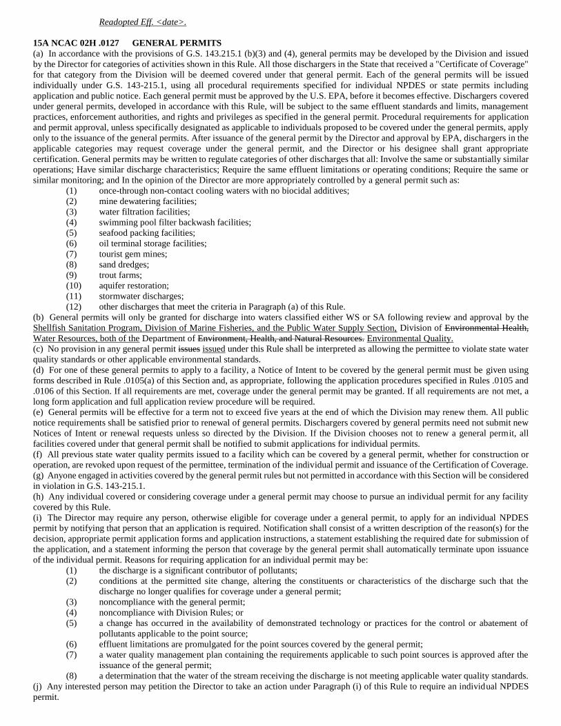
Readopted Eff. <date>.
15A NCAC 02H .0127 GENERAL PERMITS
(a) In accordance with the provisions of G.S. 143.215.1 (b)(3) and (4), general permits may be developed by the Division and issued
by the Director for categories of activities shown in this Rule. All those dischargers in the State that received a "Certificate of Coverage"
for that category from the Division will be deemed covered under that general permit. Each of the general permits will be issued
individually under G.S. 143-215.1, using all procedural requirements specified for individual NPDES or state permits including
application and public notice. Each general permit must be approved by the U.S. EPA, before it becomes effective. Dischargers covered
under general permits, developed in accordance with this Rule, will be subject to the same effluent standards and limits, management
practices, enforcement authorities, and rights and privileges as specified in the general permit. Procedural requirements for application
and permit approval, unless specifically designated as applicable to individuals proposed to be covered under the general permits, apply
only to the issuance of the general permits. After issuance of the general permit by the Director and approval by EPA, dischargers in the
applicable categories may request coverage under the general permit, and the Director or his designee shall grant appropriate
certification. General permits may be written to regulate categories of other discharges that all: Involve the same or substantially similar
operations; Have similar discharge characteristics; Require the same effluent limitations or operating conditions; Require the same or
similar monitoring; and In the opinion of the Director are more appropriately controlled by a general permit such as:
(1) once-through non-contact cooling waters with no biocidal additives;
(2) mine dewatering facilities;
(3) water filtration facilities;
(4) swimming pool filter backwash facilities;
(5) seafood packing facilities;
(6) oil terminal storage facilities;
(7) tourist gem mines;
(8) sand dredges;
(9) trout farms;
(10) aquifer restoration;
(11) stormwater discharges;
(12) other discharges that meet the criteria in Paragraph (a) of this Rule.
(b) General permits will only be granted for discharge into waters classified either WS or SA following review and approval by the
Shellfish Sanitation Program, Division of Marine Fisheries, and the Public Water Supply Section, Division of Environmental Health,
Water Resources, both of the Department of Environment, Health, and Natural Resources. Environmental Quality.
(c) No provision in any general permit issues issued under this Rule shall be interpreted as allowing the permittee to violate state water
quality standards or other applicable environmental standards.
(d) For one of these general permits to apply to a facility, a Notice of Intent to be covered by the general permit must be given using
forms described in Rule .0105(a) of this Section and, as appropriate, following the application procedures specified in Rules .0105 and
.0106 of this Section. If all requirements are met, coverage under the general permit may be granted. If all requirements are not met, a
long form application and full application review procedure will be required.
(e) General permits will be effective for a term not to exceed five years at the end of which the Division may renew them. All public
notice requirements shall be satisfied prior to renewal of general permits. Dischargers covered by general permits need not submit new
Notices of Intent or renewal requests unless so directed by the Division. If the Division chooses not to renew a general permit, all
facilities covered under that general permit shall be notified to submit applications for individual permits.
(f) All previous state water quality permits issued to a facility which can be covered by a general permit, whether for construction or
operation, are revoked upon request of the permittee, termination of the individual permit and issuance of the Certification of Coverage.
(g) Anyone engaged in activities covered by the general permit rules but not permitted in accordance with this Section will be considered
in violation in G.S. 143-215.1.
(h) Any individual covered or considering coverage under a general permit may choose to pursue an individual permit for any facility
covered by this Rule.
(i) The Director may require any person, otherwise eligible for coverage under a general permit, to apply for an individual NPDES
permit by notifying that person that an application is required. Notification shall consist of a written description of the reason(s) for the
decision, appropriate permit application forms and application instructions, a statement establishing the required date for submission of
the application, and a statement informing the person that coverage by the general permit shall automatically terminate upon issuance
of the individual permit. Reasons for requiring application for an individual permit may be:
(1) the discharge is a significant contributor of pollutants;
(2) conditions at the permitted site change, altering the constituents or characteristics of the discharge such that the
discharge no longer qualifies for coverage under a general permit;
(3) noncompliance with the general permit;
(4) noncompliance with Division Rules; or
(5) a change has occurred in the availability of demonstrated technology or practices for the control or abatement of
pollutants applicable to the point source;
(6) effluent limitations are promulgated for the point sources covered by the general permit;
(7) a water quality management plan containing the requirements applicable to such point sources is approved after the
issuance of the general permit;
(8) a determination that the water of the stream receiving the discharge is not meeting applicable water quality standards.
(j) Any interested person may petition the Director to take an action under Paragraph (i) of this Rule to require an individual NPDES
permit.
(k) General permits may be modified, terminated, or revoked and reissued in accordance with the authority and requirements of Rules
.0112 and .0114 of this Section.
History Note: Authority G.S. 143-215(1); 143-215.3(a)(1);
Eff. October 1, 1987;
Amended Eff. March 1, 1993; August 1, 1991; August 1, 1988. 1988;
Readopted Eff. <date>.
15A NCAC 02H .0138 AUTHORIZATION TO CONSTRUCT PERMITS
(a) Authorization Required.
(1) After an NPDES permit has been issued by the Division of Environmental Management Water Resources in
accordance with this Section, construction of wastewater treatment facilities or additions thereto shall not begin until
final plans and specifications have been submitted to and an Authorization to Construct has been issued to the
permittee by the Division of Environmental Management. Water Resources, except as provided in Subparagraph (2)
of this Paragraph.
(2) No Authorization to Construct shall be required for facilities intended to treat principally waste or sewage from an
industrial facility whose discharge is authorized pursuant to an NPDES permit.
(3) If an Authorization to Construct has not been applied for in accordance with the requirements of the NPDES permit
during the term of the permit, the permit will be considered void upon expiration and future actions will be considered
as a new application.
(b) Application. An application for an Authorization to Construct shall include the following:
(1) Application for Authorizations to Construct must be made in triplicate on official forms completely filled out, where
applicable, provided by the Director either in printed form or in an electronic format allowed by law and acceptable
to the Director. Application forms shall be complete and fully executed. The signature of the consulting engineer or
other agent will be accepted as representing the permittee on the application only if accompanied by a letter of
authorization from the permittee.
(2) Required sets of plans Plans and specifications: The applicant shall provide one printed set and one electronic copy,
in a format acceptable to the Director,
(A) regular projects -- five sets of detailed plans and specifications, specifications for the proposed facilities or
facility modifications.
(B) federal and state grants/loan projects -- four sets of detailed plans and specifications plus federal assurances
required by appropriate federal agency;
(3) Specifications Additional specifications describing all materials to be used, methods of construction and means for
assuring ensuring the quality and integrity of the finished project.
(4) When required, required by the Director, a statement submitted that the wastewater treatment facility involved will be
properly disconnected and the wastewater discharged into an adequate district or municipal system when it becomes
available.
(5) If a Sedimentation and Erosion Control Plan is required by the Division of Energy, Mineral, Mineral and Land
Resources or their designee, documentation shall be provided verifying that the applicant has developed and submitted
to the governing agency the required Plan.
(6) A Documentation that a 110 volt power source and a potable water supply, equipped with backflow prevention, must
be are available at the treatment system to allow for maintenance, clean-up and sampling. In cases where this is not
reasonable or economically achievable, an exception may be granted by the Water Quality Permitting Section Chief.
(7) For those wastewater disposal facilities which have the potential to cause a contravention of groundwater standards,
hydrogeologic information must be provided as specified in Rule 2H .0205 of this Subchapter. 15A NCAC 02T .0504.
(8) A residuals management plan must be submitted for all plan, if the wastewater treatment systems that generate
residuals and system generates residuals. The plan must include the following:
(A) A detailed explanation as to how the residuals will be stabilized. In addition if the residuals are generated
from a system treating sewage, the explanation must show that the stabilization process meets the
Environmental Protection Agency's criteria for a Class B residual as defined in 40 CFR 503 or for a Process
to Significantly Reduce Pathogens (PSRP) as defined in 40 CFR Part 257 Appendix II, hereby incorporated
by reference including any subsequent amendments and editions. This material is available for inspection at
the Department of Environment, Health, and Natural Resources, Division of Environmental Management,
512 N. Salisbury Street, Raleigh, North Carolina. Copies may be obtained from the Superintendent of
Documents, U.S. Government Printing Office, Washington D.C. 20402-9325 at a cost of thirty six dollars
($36.00). The current version of these regulations can be accessed free of charge at
http://www.gpo.gov/fdsys/.
(B) An evaluation of the residual storage requirements for the treatment facility. A minimum of 30 days storage
will be required on all facilities, unless the applicant can demonstrate to the satisfaction of the Director that
this requirement is unwarranted for a particular case. Storage shall be calculated based upon average sludge
production rate and shall be process units that are separate from the treatment system, i.e., not the clarifiers
or aeration basins. Additional storage may be required based upon the method of final disposal/utilization.
(C) A residuals commitment. No authorization to construct will be issued unless the application package includes
a commitment from a DEM DWR- approved residual disposal/utilization site for the acceptance of the
residual and which demonstrates that the DEM DWR- approved site has adequate capacity to accept the
residuals.
(9) A construction sequence plan must be submitted with applications for an Authorization to Construct for modification
of for any project that will modify existing wastewater treatment facilities. The plan must outline the construction
sequence to ensure continuous operation of the treatment system.
(c) Fees for Authorization to Construct Permits
(1) For every application for a new or modified construction permit, for facilities with a permitted flow of greater than
100,000 gallons per day, a nonrefundable application processing fee of two hundred dollars ($200.00) must be
submitted.
(2) For every application for a new or modified construction permit, for facilities with a permitted flow of equal to or less
than 100,000 gallons per day but greater than 1,000 gallons per day, a nonrefundable application processing fee of
one hundred and fifty dollars ($150.00) must be submitted.
(3) For every application for a new or modified construction permit, for facilities with a permitted flow of equal to or less
than 1,000 gallons per day, a nonrefundable application processing fee of one hundred dollars ($100.00) must be
submitted.
History Note: Authority G.S. 143-215.1(c)(1);
Eff. October 1, 1987;
Amended Eff. August 1, 2012 (see S.L. 2012-14, 3 s.1.(f)); 2012-194, s.33; March 1, 1993; August 3, 1992. 1992;
Readopted Eff. <date>.
15A NCAC 02H .0139 MINIMUM DESIGN REQUIREMENTS
All facilities requiring a permit pursuant to this Section shall be designed following good engineering practice and comply with the
minimum design requirements specified in Rule 2H .0219 of this Subchapter. 15A NCAC 02T .0105 and .0114. The plans and
specifications must be stamped and sealed by a Professional Engineer licensed in North Carolina unless all three of the following
conditions are met:
(1) the plans and specifications are for domestic waste from a single family dwelling with flows of 1000 1,000 gallons
per day or less, and
(2) the plans and specifications are prepared by the homeowner, and contain complete information needed to evaluate the
proposed facility, and
(3) the effluent limitations are for secondary treatment.
History Note: Authority G.S. 143-215.1(c)(1);
Eff. October 1, 1987. 1987;
Readopted Eff. <date>.
15A NCAC 02H .0140 CERTIFICATION OF COMPLETION
Prior to operation of any treatment works or disposal system permitted in accordance with this Section, a certification must be received
from a professional engineer certifying that the treatment works or disposal system has been installed in accordance with the approved
plans and specifications. For facilities with phased construction or where there is a need to operate certain equipment under actual
operating conditions prior to certification, additional certification may be needed as follow-ups to the initial, pre-operation, certification.
In cases where the treatment works or disposal system was designed by a homeowner rather than a professional engineer, either the
permittee or a professional engineer must submit this certification.
History Note: Authority G.S. 143-215.1(c)(1);
Eff. October 1, 1987.1987;
Readopted Eff. <date>.
15A NCAC 02H .0141 OPERATIONAL AGREEMENTS
Prior to issuance or reissuance of a permit pursuant to this Section for a wastewater facility as specified in G.S. 143-215.1(d1), the
applicant must either provide evidence to show that the applicant has been designated as a public utility by the State Utilities Commission
or enter into a properly executed operational agreement with the Division of Environmental Management.Water Resources. The
requirement for assurance of financial solvency will be made on a case by case determination.
History Note: Authority G.S. 143-215.1(d1);
Eff. October 1, 1987.1987;
Readopted Eff. <date>.
15A NCAC 02H .0142 USE/WASTEWATER TRTMT WORKS EMGCY MAIN: OPER/REPAIR FUND
(a) In cases in which water quality standards are violated or an environmental health threat exists, monies from the Wastewater
Treatment Works Emergency Maintenance, Operation and Repair Fund may be used at the discretion of the Director to correct the cause
of such conditions.
(b) In this, the Director shall:
(1) Ensure the fiscal integrity of the fund;
(2) Use the fund only as a measure of last resort to protect water quality or public health when all other compliance and
enforcement procedures have failed;
(3) Limit the use of the fund to wastewater treatment works with design flow capacities of less than or equal to one
hundred thousand gallons per day (100,000 GPD);
(4) Notify the permittee by certified mail of the intention to take emergency corrective action and to recoup monies spent;
(5) Make every effort to recoup fund expenditures, including collection costs, from the parties responsible;
(6) Coordinate use of the fund with the program of the Public Utilities Commission when a permittee is also a regulated
utility; and
(7) Provide a quarterly accounting of the fund to the Commission.
History Note: Authority G.S. 143-215.3(a); 143-215.3B(c); 143-215.3B(e);
Eff. August 1, 1988. 1988;
Repealed Eff. <date> (S.L. 2005-454, §8, effective January 1, 2006).
15A NCAC 02H .0143 INCORPORATION BY REFERENCE
(a) The following sections of Title 40 of the Code of Federal Regulations (CFR) are incorporated by reference, including subsequent
amendments and editions, and shall apply throughout this Section except where procedural details of the federal rules differ from
procedures adopted elsewhere in this section, in which case the separately adopted procedure governs. The current version of these
regulations can be accessed free of charge at http://www.gpo.gov/fdsys/.
(1) 40 CFR 122.2, 124.2, and 125.2: Definitions;
(2) 40 CFR 122.4: Prohibitions):
(3) 40 CFR 122.5 (a) and (b): Effect of permit;
(4) 40 CFR 122.7 (b) and (c): Confidential information;
(5) 40 CFR 122.21 (a)-(b), (c)(2), (e)-(k), (m)-(p), (q), and (r): Application for a permit;
(6) 40 CFR 122.22: Signatories;
(7) 40 CFR 122.23: Concentrated animal feeding operations;
(8) 40 CFR 122.24: Concentrated aquatic animal production facilities;
(9) 40 CFR 122.25: Aquaculture projects;
(10) 40 CFR 122.26: Storm water discharges;
(11) 40 CFR 122.27: Silviculture;
(12) 40 CFR 122.28: General permits;
(13) 40 CFR 122.29 (a), (b), and (d): New sources and new dischargers;
(14) 40 CFR 122.30: NPDES stormwater regulations for small MS4s: objectives;
(15) 40 CFR 122.31: NPDES stormwater regulations: role of Tribes;
(16) 40 CFR 122.32: NPDES stormwater regulations for small MS4s: applicability;
(17) 40 CFR 122.33: NPDES stormwater regulations for small MS4s: application for permit;
(18) 40 CFR 122.34: NPDES stormwater regulations for small MS4s: permit requirements;
(19) 40 CFR 122.35: NPDES stormwater regulations for small MS4s: shared responsibilities;
(20) 40 CFR 122.36: NPDES stormwater regulations for small MS4s: compliance;
(21) 40 CFR 122.37: NPDES stormwater regulations for small MS4s: evaluation;
(22) 40 CFR 122.41 (a)(1) and (b) through (n): Applicable permit conditions;
(23) 40 CFR 122.42: Conditions applicable to specified categories of permits;
(24) 40 CFR 122.43: Establishing permit conditions;
(25) 40 CFR 122.44: Establishing NPDES permit conditions;
(26) 40 CFR 122.45: Calculating permit conditions;
(27) 40 CFR 122.46: Duration;
(28) 40 CFR 122.47 (a): Schedules of compliance;
(29) 40 CFR 122.48: Monitoring requirements;
(30) 40 CFR 122.50: Disposal into wells;
(31) 40 CFR 122.61: Permit transfer;
(32) 40 CFR 122.62: Permit modification;
(33) 40 CFR 122.64: Permit termination;
(34) 40 CFR 124.3 (a): Application for a permit;
(35) 40 CFR 124.5 (a), (c), (d), and (f): Modification of permits;
(36) 40 CFR 124.6 (a), (c), (d), and (e): Draft permit;
(37) 40 CFR 124.8: Fact sheets;
(38) 40 CFR 124.10 (a)(1)(ii), (a)(1)(iii), (a)(1)(v), (b), (c), (d), and (e): Public notice;
(39) 40 CFR 124.11: Public comments and requests for hearings;
(40) 40 CFR 124.12 (a): Public hearings;
(41) 40 CFR 124.17 (a) and (c): Response to comments;
(42) 40 CFR 124.56: Fact sheets;
(43) 40 CFR 124.57 (a): Public notice;
(44) 40 CFR 124.59: Comments from government agencies;
(45) 40 CFR 124.62: Decision on variances;
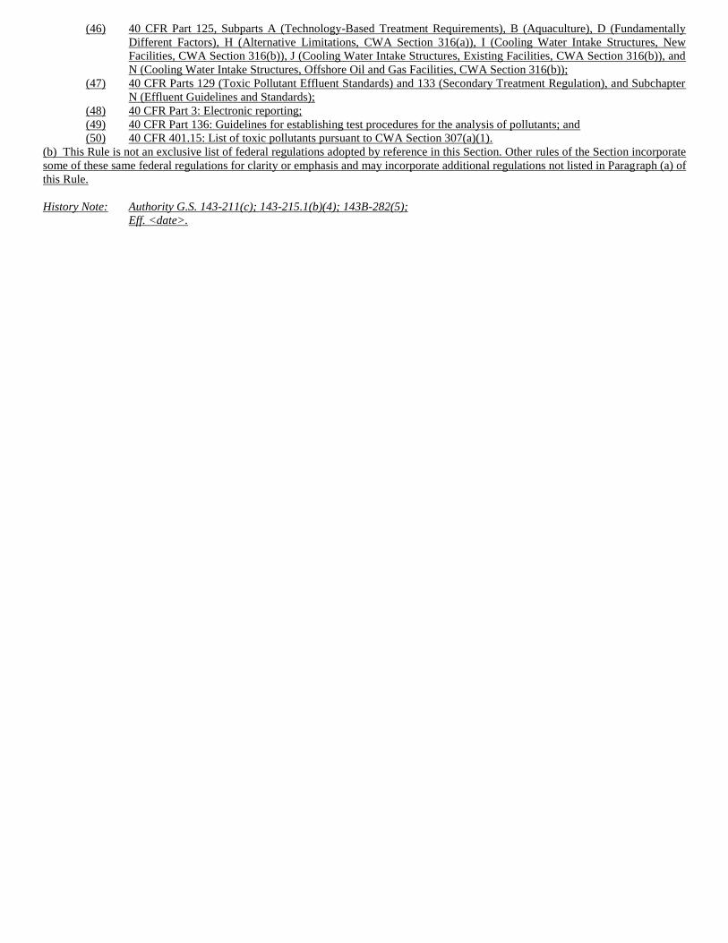
(46) 40 CFR Part 125, Subparts A (Technology-Based Treatment Requirements), B (Aquaculture), D (Fundamentally
Different Factors), H (Alternative Limitations, CWA Section 316(a)), I (Cooling Water Intake Structures, New
Facilities, CWA Section 316(b)), J (Cooling Water Intake Structures, Existing Facilities, CWA Section 316(b)), and
N (Cooling Water Intake Structures, Offshore Oil and Gas Facilities, CWA Section 316(b));
(47) 40 CFR Parts 129 (Toxic Pollutant Effluent Standards) and 133 (Secondary Treatment Regulation), and Subchapter
N (Effluent Guidelines and Standards);
(48) 40 CFR Part 3: Electronic reporting;
(49) 40 CFR Part 136: Guidelines for establishing test procedures for the analysis of pollutants; and
(50) 40 CFR 401.15: List of toxic pollutants pursuant to CWA Section 307(a)(1).
(b) This Rule is not an exclusive list of federal regulations adopted by reference in this Section. Other rules of the Section incorporate
some of these same federal regulations for clarity or emphasis and may incorporate additional regulations not listed in Paragraph (a) of
this Rule.
History Note: Authority G.S. 143-211(c); 143-215.1(b)(4); 143B-282(5);
Eff. <date>.
SECTION .0400 - COASTAL WASTE TREATMENT DISPOSAL
15A NCAC 02H .0401 STATEMENT OF POLICY
It is hereby declared to be the policy of the Environmental Management Commission that all wastewater generated in the State of North
Carolina shall be treated to such an extent as to insure the compliance with water quality standards promulgated by the Commission. It
is further the policy of the Commission that regional and area-wide wastewater collection and treatment facilities shall be promoted to
the fullest practicable extent. The Commission recognizes, however, that development of area-wide and regional sewerage systems is
not always in keeping with the demands for growth within the areas and that interim regulations are necessary to insure that water quality
standards are not violated. In keeping with this policy, the Commission adopts these Regulations of this Section.
History Note: Authority G.S. 143-215.3(a)(1); 143-211; 143-215.1(a); 143-215.1(b)(1);
Eff. February 1, 1976. 1976:
Repealed Eff. <date>.
15A NCAC 02H .0402 APPLICABILITY
These Regulations shall apply to treatment and disposal of waste from all installations located within the coastal areas which are subject
to the regulations of the Environmental Management Commission.
History Note: Authority G.S. 143-215.3(a)(1); 143-211; 143-215.1(a); 143-215.1(b)(1);
Eff. February 1, 1976;
Amended Eff. September 13, 1981. 1981:
Repealed Eff. <date>.
15A NCAC 02H .0403 DEFINITION OF COASTAL AREAS
The coastal areas for the purposes of these Regulations are defined to include:
(1) the Outer Banks;
(2) those land areas bordering the coastal waters, including all waters assigned a salt water "S" classification and all
tributaries that have experienced excessive growths of microscopic or macroscopic vegetation or that, because of their
relative size and lack of water exchange are found by the Commission to be subject to such excessive growths; and
(3) land areas bordering all natural impoundments situated east of the line established by the North Carolina
Environmental Management Commission to designate coastal waters, said land being described as follows:
"Extends from a point on the North Carolina/South Carolina state line near Calabash, North Carolina, generally along the lines of the
Atlantic Coast Line Railroad and Norfolk Southern Railway, northeasterly and northerly to River Mile 66.0 (Lock No. 1) on the Cape
Fear River; thence northerly to River Mile 30.0 on Black River; thence easterly to River Mile 48 on the North East Cape Fear River;
thence northerly and easterly to River Mile 22.5 in New River; thence easterly and northerly to River Mile 25.0 on White Oak River
(Atlantic Coast Line Railroad Bridge); thence northerly and easterly to River Mile 38.9 on Neuse River (Norfolk Southern Railway
Bridge); thence northerly to River Mile 44.6 on Pamlico River (Norfolk Southern Railway Bridge); thence northeasterly and northerly
crossing Albemarle Sound along Norfolk Southern Railway Bridge; at Tunis; thence northerly and easterly to River Mile 13.5 on
Perquimans River (Norfolk Southern Railway Bridge); thence easterly to River Mile 20.0 on Pasquotank River (Norfolk Southern
Railway Bridge); and thence northerly to the North Carolina/Virginia state line near Moyock, North Carolina."
History Note: Authority G.S. 143-215.3(a)(1); 143-211; 143-215.1(a); 143-215.1(b)(1);
Eff. February 1, 1976;
Amended Eff. September 13, 1981. 1981:
Repealed Eff. <date>.
15A NCAC 02H .0404 FACILITY LOCATION AND DESIGN
(a) No domestic sewage regardless of the treatment proposed and no other wastes which could adversely affect the taking of shellfish
for market purposes shall be discharged into water classified "SA", into unnamed waters tributary to "SA" waters classified "C" or "SC"
in accordance with Rule 2B .0301(i)(1)(B) and (C), or into other waters in such close proximity as to adversely affect such "SA" waters.
Wastes discharged into other waters tributary to waters classified "SA" shall be treated in such manner as to assure that no impairment
of water quality in the "SA" segments shall occur. No permits shall be issued for discharges into waters classified "SA" unless Shellfish
Sanitation, Environmental Health Section, Department of Human Resources, provides written concurrence that the discharge would not
adversely affect shellfish water quality or the propagation of shellfish.
(b) No wastes shall be discharged to waters classified "SB" unless these wastes are treated to the extent necessary to assure protection
of assigned water quality standards.
(c) The Director may prohibit or limit any discharge of waste into surface waters if, in the opinion of the Director, the surface waters
experience or the discharge would result in:
(1) growths of microscopic vegetation such that chlorophyll a values are greater than 40 ug/l; or
(2) growths of microscopic or macroscopic vegetation which substantially impair the intended best usage of the waters.
(d) The discharge of wastewaters to the Atlantic Ocean shall follow the guidelines and requirements set forth in the United States
Environmental Protection Agency regulation Ocean Discharge Criteria, 40 C.F.R. 125.120 through 125.124, which is specifically
adopted by reference as promulgated on October 3, 1980.
(e) In all cases where connection to an area-wide sewerage system is feasible, such connection thereto shall be required.
(f) Septic tank systems shall not be approved in high density areas. For purposes of this Regulation high density areas are defined as
those areas producing more than 1,200 gallons of waste per acre per day or which contain more than three residential units per acre. For
purposes of this Regulation a septic tank system is defined as a ground absorption sewage disposal system consisting of a holding or
settling tank and a ground absorption field. Septic tank systems shall be designed and constructed in accordance with Environmental
Management Commission regulations governing septic tank systems.
(g) Interim Treatment and Disposal Facilities. In those cases where an approved area-wide collection and treatment system is not
available, and where discharge to the surface waters is prohibited in Paragraphs (a), (b), (c), and (d), and where use of a septic tank
system is prohibited by paragraph (f), in Subchapters 02T or 02U of this Chapter, interim treatment and disposal facilities may be
approved subject to their meeting the following requirements.
(1) Wastes other than those disposed of by spray irrigation shall receive tertiary treatment followed by adequate
bactericidal treatment. For purposes of this Regulation tertiary treatment shall constitute biological treatment followed
by acceptable solids removal to the extent accomplished by filtration. Also, flow equalization will be required unless
it can be adequately demonstrated that either the wastewater influent flow rate will be of a uniform nature or that the
proposed treatment units are designed such that they can adequately treat this wastewater without experiencing
hydraulic overload.
(2) Waste treatment facilities (except septic tank-surface sand filter systems) shall be located at least 10 feet from adjacent
property under separate ownership, developed or undeveloped and at least 10 feet from on-property residential units
if these units are to be sold, e.g., condominiums, residential subdivision houses. Septic tank-surface sand filter systems
shall be located at least 200 feet from on-property residential units if these units are to be sold and at least 200 feet
from adjacent property under separate ownership.
(3) Waste treatment facilities shall be equipped with effective noise and odor control devices and are to be enclosed by a
solid or semi-solid structure or other approved structure. An automatically activated standby power source shall be
provided. All essential treatment and disposal units shall be provided in duplicate.
(4) Treated wastes may be disposed of in on-site disposal facilities, which shall be located at least 500 feet from any
impounded public surface water supply or public shallow (less than 50 feet deep) ground water supply, and at least
100 feet from a private ground water supply except when a study of the soil would indicate a lesser separation
acceptable.
(5) Waste disposal facilities shall be located at least 100 feet from any waters classified SA and at least 50 feet from any
other waters. In the case of drainage ditches that are normally dry this distance may be reduced to 25 feet.
(6) Waste disposal facilities are to be designed on the basis of site conditions and soil percolation rates. In Parts (A), (B),
and (C) of this Subparagraph are given the maximum loading rates for three different treatment systems. Higher
loading rates or other methods of waste disposal may be approved by the Director based upon data submitted by the
applicant.
(A) Subsurface Disposal Trench. One and one-half gallons per day per square foot of trench bottom based on
maximum trench width of three feet. Trenches shall be separated at least eight feet center to center.
(B) Low Pressure Distribution System. One gallon per day per square foot of effective absorption area
encompassed by the distribution system. The calculation of the amount of effective absorption area required
shall be based on a maximum distribution line separation of five feet center to center.
(C) Rotary Distributors. Ten gallons per day per square foot of surface area.
(7) Waste disposal areas are to contain at least 1,000 square feet of open "green area" for each residential unit served, or
2,500 square feet per thousand gallons per day of waste flow, whichever is less. The term "green area" contained
herein is defined as an area suitable for waste disposal, either in its natural state or which has been modified by planting
vegetative cover of grasses or low growing shrubbery. Green areas shall not include street or roadway right-of-ways
or areas not available for waste disposal. Not more than 25 percent of the required area may be covered with non-traffic
bearing paved surfaces such as walkways or patios. Subsurface disposal areas shall not be used as parking lots,
driveways, or for other vehicular traffic uses.
(8) Wastes that are to be disposed of by spray irrigation shall receive a level of treatment which will not render either the
irrigation system or the disposal area unworkable. Spray irrigation systems shall be located at least 200 feet from any
adjoining property, buffered by trees to prevent excessive drift. Such areas shall be surrounded by fencing with
warning signs to discourage human use or trespass, and designed according to good engineering practices with the
application rate not to exceed one and three fourth inches per week-unless the Director determines, based on data
submitted by the applicant, that a higher application rate is justified.
History Note: Authority G.S. 143-211; 143-214.2(c); 143-215; 143-215.1(a);
143-215.1(b)(1); 143-215.3(a)(1);
Eff. February 1, 1976;
Amended Eff. November 1, 1986; April 1, 1983; September 13, 1981; May 11, 1980. 1980;
Repealed Eff. <date>.
15A NCAC 02H .0405 PRIVATELY OWNED INSTALLATIONS
(a) Privately owned waste collection treatment and disposal systems serving establishments existing on the effective date of these
Regulations shall comply with the requirements enumerated in these Regulations unless impossible. If adherence to the guides is not
possible, the highest level of control technology consistent with site limitations shall be employed. No expansion of the load tributary
to existing non-public facilities will be allowed until compliance with the guides established in these Regulations is obtained.
(b) Privately owned wastewater collection, treatment and disposal systems serving establishments not in existence on the effective date
of these Regulations shall comply with the provisions of these Regulations.
History Note: Authority G.S. 143-215.3(a)(1); 143-211; 143-215.1(a); 143-215.1(b)(1);
Eff. February 1, 1976;
Amended Eff. September 13, 1981. 1981;
Repealed Eff. <date>.
15A NCAC 02H .0406 PUBLICLY OWNED SEWERAGE FACILITIES
(a) Existing publicly owned waste collection, treatment, and disposal facilities shall comply with the requirements of these Regulations
unless such compliance is determined by the Commission to be "not in the public interest." Such a finding would result when
requirements of these Regulations could not be met even after "best available control technology economically achievable" has been
provided.
(b) New publicly owned waste collection, treatment, and disposal facilities shall comply with the provisions of these Regulations, and
any other applicable regulations of the Commission.
History Note: Authority G.S. 143-215.3(a)(1); 143-211; 143-215.1(a); 143-215.1(b)(1);
Eff. February 1, 1976;
Amended Eff. September 13, 1981. 1981;
Repealed Eff. <date>.
15A NCAC 02H .0407 EXCEPTIONS FROM REQUIREMENTS
No exception from the requirements of these Regulations shall be made until such exception is approved by the Commission.
History Note: Authority G.S. 143-215.3(a)(1); 143-211; 143-215.1(a); 143-215.1(b)(1);
Eff. February 1, 1976. 1976;
Repealed Eff. <date>.
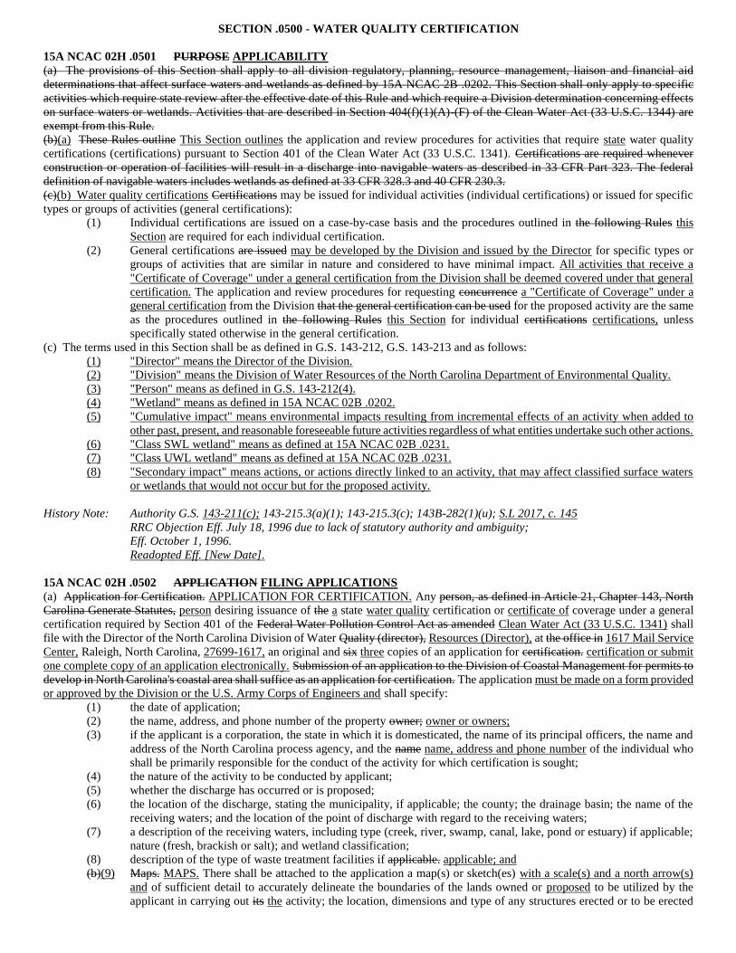
SECTION .0500 - WATER QUALITY CERTIFICATION
15A NCAC 02H .0501 PURPOSE APPLICABILITY
(a) The provisions of this Section shall apply to all division regulatory, planning, resource management, liaison and financial aid
determinations that affect surface waters and wetlands as defined by 15A NCAC 2B .0202. This Section shall only apply to specific
activities which require state review after the effective date of this Rule and which require a Division determination concerning effects
on surface waters or wetlands. Activities that are described in Section 404(f)(1)(A)-(F) of the Clean Water Act (33 U.S.C. 1344) are
exempt from this Rule.
(b)(a) These Rules outline This Section outlines the application and review procedures for activities that require state water quality
certifications (certifications) pursuant to Section 401 of the Clean Water Act (33 U.S.C. 1341). Certifications are required whenever
construction or operation of facilities will result in a discharge into navigable waters as described in 33 CFR Part 323. The federal
definition of navigable waters includes wetlands as defined at 33 CFR 328.3 and 40 CFR 230.3.
(c)(b) Water quality certifications Certifications may be issued for individual activities (individual certifications) or issued for specific
types or groups of activities (general certifications):
(1) Individual certifications are issued on a case-by-case basis and the procedures outlined in the following Rules this
Section are required for each individual certification.
(2) General certifications are issued may be developed by the Division and issued by the Director for specific types or
groups of activities that are similar in nature and considered to have minimal impact. All activities that receive a
"Certificate of Coverage" under a general certification from the Division shall be deemed covered under that general
certification. The application and review procedures for requesting concurrence a "Certificate of Coverage" under a
general certification from the Division that the general certification can be used for the proposed activity are the same
as the procedures outlined in the following Rules this Section for individual certifications certifications, unless
specifically stated otherwise in the general certification.
(c) The terms used in this Section shall be as defined in G.S. 143-212, G.S. 143-213 and as follows:
(1) "Director" means the Director of the Division.
(2) "Division" means the Division of Water Resources of the North Carolina Department of Environmental Quality.
(3) "Person" means as defined in G.S. 143-212(4).
(4) "Wetland" means as defined in 15A NCAC 02B .0202.
(5) "Cumulative impact" means environmental impacts resulting from incremental effects of an activity when added to
other past, present, and reasonable foreseeable future activities regardless of what entities undertake such other actions.
(6) "Class SWL wetland" means as defined at 15A NCAC 02B .0231.
(7) "Class UWL wetland" means as defined at 15A NCAC 02B .0231.
(8) "Secondary impact" means actions, or actions directly linked to an activity, that may affect classified surface waters
or wetlands that would not occur but for the proposed activity.
History Note: Authority G.S. 143-211(c); 143-215.3(a)(1); 143-215.3(c); 143B-282(1)(u); S.L 2017, c. 145
RRC Objection Eff. July 18, 1996 due to lack of statutory authority and ambiguity;
Eff. October 1, 1996.
Readopted Eff. [New Date].
15A NCAC 02H .0502 APPLICATION FILING APPLICATIONS
(a) Application for Certification. APPLICATION FOR CERTIFICATION. Any person, as defined in Article 21, Chapter 143, North
Carolina Generate Statutes, person desiring issuance of the a state water quality certification or certificate of coverage under a general
certification required by Section 401 of the Federal Water Pollution Control Act as amended Clean Water Act (33 U.S.C. 1341) shall
file with the Director of the North Carolina Division of Water Quality (director), Resources (Director), at the office in 1617 Mail Service
Center, Raleigh, North Carolina, 27699-1617, an original and six three copies of an application for certification. certification or submit
one complete copy of an application electronically. Submission of an application to the Division of Coastal Management for permits to
develop in North Carolina's coastal area shall suffice as an application for certification. The application must be made on a form provided
or approved by the Division or the U.S. Army Corps of Engineers and shall specify:
(1) the date of application;
(2) the name, address, and phone number of the property owner; owner or owners;
(3) if the applicant is a corporation, the state in which it is domesticated, the name of its principal officers, the name and
address of the North Carolina process agency, and the name name, address and phone number of the individual who
shall be primarily responsible for the conduct of the activity for which certification is sought;
(4) the nature of the activity to be conducted by applicant;
(5) whether the discharge has occurred or is proposed;
(6) the location of the discharge, stating the municipality, if applicable; the county; the drainage basin; the name of the
receiving waters; and the location of the point of discharge with regard to the receiving waters;
(7) a description of the receiving waters, including type (creek, river, swamp, canal, lake, pond or estuary) if applicable;
nature (fresh, brackish or salt); and wetland classification;
(8) description of the type of waste treatment facilities if applicable. applicable; and
(b)(9) Maps. MAPS. There shall be attached to the application a map(s) or sketch(es) with a scale(s) and a north arrow(s)
and of sufficient detail to accurately delineate the boundaries of the lands owned or proposed to be utilized by the
applicant in carrying out its the activity; the location, dimensions and type of any structures erected or to be erected
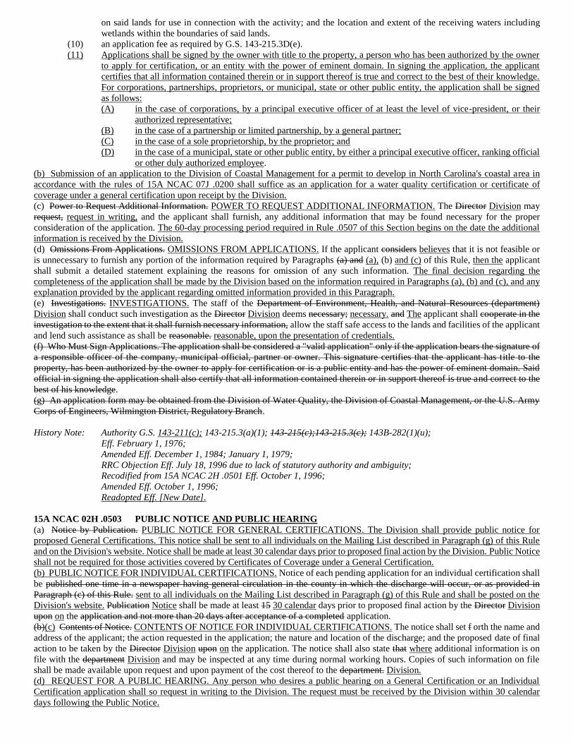
on said lands for use in connection with the activity; and the location and extent of the receiving waters including
wetlands within the boundaries of said lands.
(10) an application fee as required by G.S. 143-215.3D(e).
(11) Applications shall be signed by the owner with title to the property, a person who has been authorized by the owner
to apply for certification, or an entity with the power of eminent domain. In signing the application, the applicant
certifies that all information contained therein or in support thereof is true and correct to the best of their knowledge.
For corporations, partnerships, proprietors, or municipal, state or other public entity, the application shall be signed
as follows:
(A) in the case of corporations, by a principal executive officer of at least the level of vice-president, or their
authorized representative;
(B) in the case of a partnership or limited partnership, by a general partner;
(C) in the case of a sole proprietorship, by the proprietor; and
(D) in the case of a municipal, state or other public entity, by either a principal executive officer, ranking official
or other duly authorized employee.
(b) Submission of an application to the Division of Coastal Management for a permit to develop in North Carolina's coastal area in
accordance with the rules of 15A NCAC 07J .0200 shall suffice as an application for a water quality certification or certificate of
coverage under a general certification upon receipt by the Division.
(c) Power to Request Additional Information. POWER TO REQUEST ADDITIONAL INFORMATION. The Director Division may
request, request in writing, and the applicant shall furnish, any additional information that may be found necessary for the proper
consideration of the application. The 60-day processing period required in Rule .0507 of this Section begins on the date the additional
information is received by the Division.
(d) Omissions From Applications. OMISSIONS FROM APPLICATIONS. If the applicant considers believes that it is not feasible or
is unnecessary to furnish any portion of the information required by Paragraphs (a) and (a), (b) and (c) of this Rule, then the applicant
shall submit a detailed statement explaining the reasons for omission of any such information. The final decision regarding the
completeness of the application shall be made by the Division based on the information required in Paragraphs (a), (b) and (c), and any
explanation provided by the applicant regarding omitted information provided in this Paragraph.
(e) Investigations. INVESTIGATIONS. The staff of the Department of Environment, Health, and Natural Resources (department)
Division shall conduct such investigation as the Director Division deems necessary; necessary. and The applicant shall cooperate in the
investigation to the extent that it shall furnish necessary information, allow the staff safe access to the lands and facilities of the applicant
and lend such assistance as shall be reasonable. reasonable, upon the presentation of credentials.
(f) Who Must Sign Applications. The application shall be considered a "valid application" only if the application bears the signature of
a responsible officer of the company, municipal official, partner or owner. This signature certifies that the applicant has title to the
property, has been authorized by the owner to apply for certification or is a public entity and has the power of eminent domain. Said
official in signing the application shall also certify that all information contained therein or in support thereof is true and correct to the
best of his knowledge.
(g) An application form may be obtained from the Division of Water Quality, the Division of Coastal Management, or the U.S. Army
Corps of Engineers, Wilmington District, Regulatory Branch.
History Note: Authority G.S. 143-211(c); 143-215.3(a)(1); 143-215(c);143-215.3(c); 143B-282(1)(u);
Eff. February 1, 1976;
Amended Eff. December 1, 1984; January 1, 1979;
RRC Objection Eff. July 18, 1996 due to lack of statutory authority and ambiguity;
Recodified from 15A NCAC 2H .0501 Eff. October 1, 1996;
Amended Eff. October 1, 1996;
Readopted Eff. [New Date].
15A NCAC 02H .0503 PUBLIC NOTICE AND PUBLIC HEARING
(a) Notice by Publication. PUBLIC NOTICE FOR GENERAL CERTIFICATIONS. The Division shall provide public notice for
proposed General Certifications. This notice shall be sent to all individuals on the Mailing List described in Paragraph (g) of this Rule
and on the Division's website. Notice shall be made at least 30 calendar days prior to proposed final action by the Division. Public Notice
shall not be required for those activities covered by Certificates of Coverage under a General Certification.
(b) PUBLIC NOTICE FOR INDIVIDUAL CERTIFICATIONS. Notice of each pending application for an individual certification shall
be published one time in a newspaper having general circulation in the county in which the discharge will occur, or as provided in
Paragraph (c) of this Rule. sent to all individuals on the Mailing List described in Paragraph (g) of this Rule and shall be posted on the
Division's website. Publication Notice shall be made at least 15 30 calendar days prior to proposed final action by the Director Division
upon on the application and not more than 20 days after acceptance of a completed application.
(b)(c) Contents of Notice. CONTENTS OF NOTICE FOR INDIVIDUAL CERTIFICATIONS. The notice shall set f orth the name and
address of the applicant; the action requested in the application; the nature and location of the discharge; and the proposed date of final
action to be taken by the Director Division upon on the application. The notice shall also state that where additional information is on
file with the department Division and may be inspected at any time during normal working hours. Copies of such information on file
shall be made available upon request and upon payment of the cost thereof to the department. Division.
(d) REQUEST FOR A PUBLIC HEARING. Any person who desires a public hearing on a General Certification or an Individual
Certification application shall so request in writing to the Division. The request must be received by the Division within 30 calendar
days following the Public Notice.
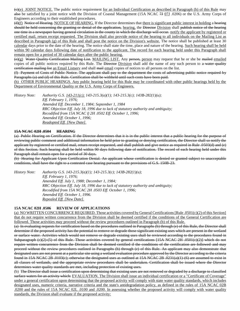
(c)(e) JOINT NOTICE. The public notice requirement for an Individual Certification as described in Paragraph (b) of this Rule may
also be satisfied by a joint notice with the Division of Coastal Management (15A NCAC 7J 07J .0206) or the U.S. Army Corps of
Engineers according to their established procedures.
(d)(f) Notice of Hearing. NOTICE OF HEARING. If the Director determines that there is significant public interest in holding a hearing
should be held concerning the granting or denial of the application, hearing, the Director Division shall publish notice of the hearing
one time in a newspaper having general circulation in the county in which the discharge will occur. notify the applicant by registered or
certified mail, return receipt requested. The Division shall also provide notice of the hearing to all individuals on the Mailing List as
described in Paragraph (g) of this Rule and shall post the notice on the Division's website. The notice shall be published at least 30
calendar days prior to the date of the hearing. The notice shall state the time, place and nature of the hearing. Such hearing shall be held
within 90 calendar days following date of notification to the applicant. The record for each hearing held under this Paragraph shall
remain open for a period of 30 calendar days after the public hearing.
(e)(g) Water Quality Certification Mailing List. MAILING LIST. Any person, person may request that he or she be mailed emailed
copies of all public notices required by this Rule. The Director Division shall add the name of any such person to a water quality
certification mailing list an Email Listserv and shall mail email copies of notices to all persons on the list.
(f) Payment of Costs of Public Notice. The applicant shall pay to the department the costs of advertising public notice required by
Paragraphs (a) and (d) of this Rule. Certification shall be withheld until such costs have been paid.
(h) OTHER PUBLIC HEARINGS. Any public hearing held for this Rule may be coordinated with other public hearings held by the
Department of Environmental Quality or the U.S. Army Corps of Engineers.
History Note: Authority G.S. 143-211(c); 143-215.3(a)(1); 143-215.3(c); 143B-282(1)(u);
Eff. February 1, 1976;
Amended Eff. December 1, 1984; September 1, 1984
RRC Objection Eff. July 18, 1996 due to lack of statutory authority and ambiguity;
Recodified from 15A NCAC 0 2H .0502 Eff. October 1, 1996;
Amended Eff. October 1, 1996;
Readopted Eff. [New Date].
15A NCAC 02H .0504 HEARING
(a) Public Hearing on Certification. If the Director determines that it is in the public interest that a public hearing for the purpose of
reviewing public comment and additional information be held prior to granting or denying certification, the Director shall so notify the
applicant by registered or certified mail, return receipt requested, and shall publish and give notice as required in Rule .0503(d) and (e)
of this Section. Such hearing shall be held within 90 days following date of notification. The record of each hearing held under this
Paragraph shall remain open for a period of 30 days.
(b) Hearing for Applicant Upon Certification Denial. An applicant whose certification is denied or granted subject to unacceptable
conditions, shall have the right to a contested case hearing pursuant to the provisions of G.S. 150B-23.
History Note: Authority G.S. 143-215.3(a)(1); 143-215.3(c); 143B-282(1)(u);
Eff. February 1, 1976;
Amended Eff. July 1, 1988; December 1, 1984;
RRC Objection Eff. July 18, 1996 due to lack of statutory authority and ambiguity;
Recodified from 15A NCAC 2H .0503 Eff. October 1, 1996;
Amended Eff. October 1, 1996.
Repealed Eff. [New Date].
15A NCAC 02H .0506 REVIEW OF APPLICATIONS
(a) NO WRITTEN CONCURRENCE REQUIRED. Those activities covered by General Certifications [Rule .0501(c)(2) of this Section]
that do not require written concurrence from the Division shall be deemed certified if the conditions of the General Certification are
followed. Those activities may proceed without the review procedures outlined in Paragraph (b) of this Rule.
(a) In evaluating requests for certification based on the procedures outlined in Paragraphs (b) through (e) of this Rule, the Director shall
determine if the proposed activity has the potential to remove or degrade those significant existing uses which are present in the wetland
or surface water. Activities which would not remove or degrade existing uses shall be reviewed according to the procedures found in
Subparagraph (c)(2)-(5) of this Rule. Those activities covered by general certifications [15A NCAC 2H .0501(c)(2)] which do not
require written concurrence from the Division shall be deemed certified if the conditions of the certification are followed and may
proceed without the review procedures outlined in Paragraphs (b) through (e) of this Rule. An applicant may also demonstrate that
designated uses are not present at a particular site using a wetland evaluation procedure approved by the Director according to the criteria
found in 15A NCAC 2B .0103(c); otherwise the designated uses as outlined at 15A NCAC 2B .0231(a)(1)-(6) are assumed to exist in
all classes of wetlands, and the appropriate review procedures shall be undertaken. Certification shall be issued where the Director
determines water quality standards are met, including protection of existing uses.
(b) The Director shall issue a certification upon determining that existing uses are not removed or degraded by a discharge to classified
surface waters for an activity which: EVALUATION. The Division shall issue an individual certification or a "Certificate of Coverage"
under a general certification upon determining that the proposed activity will comply with state water quality standards, which includes
designated uses, numeric criteria, narrative criteria and the state's antidegradation policy, as defined in the rules of 15A NCAC 02B
.0200 and the rules of 15A NCAC 02L .0100 and .0200. In assessing whether the proposed activity will comply with water quality
standards, the Division shall evaluate if the proposed activity:
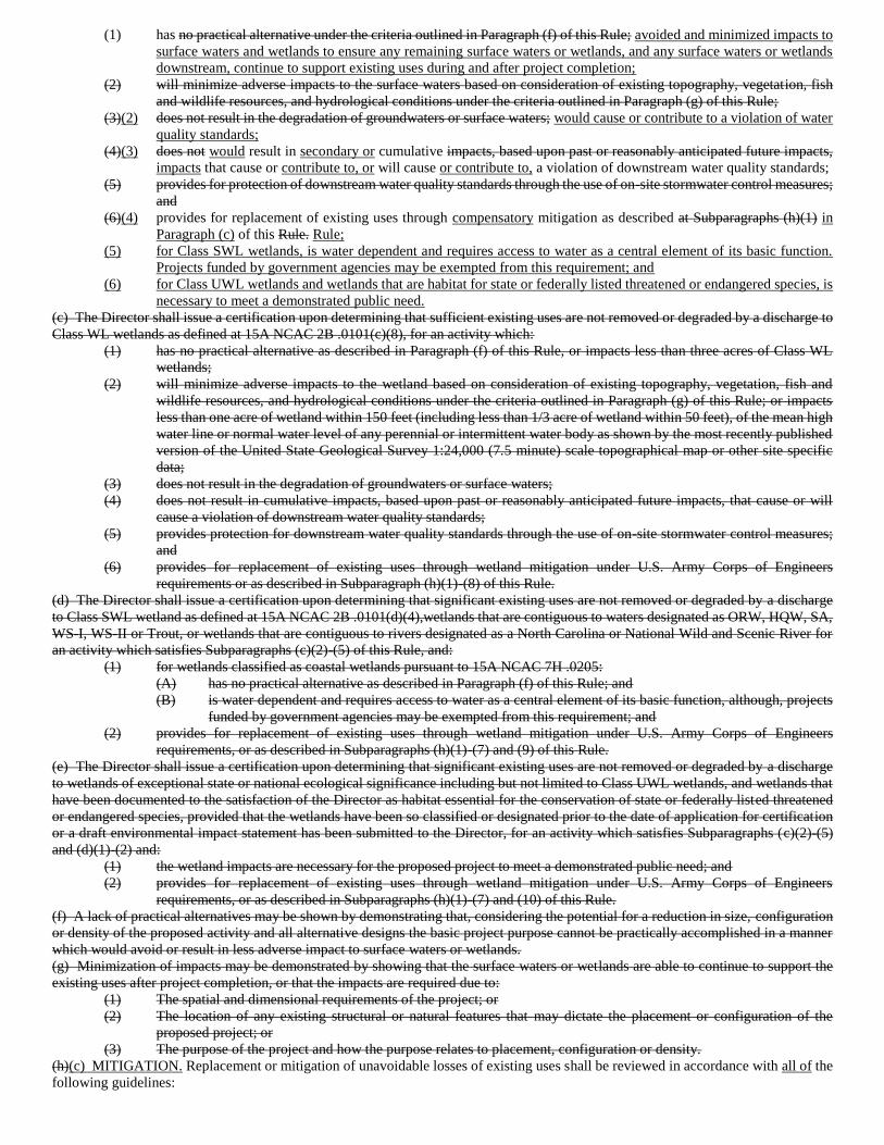
(1) has no practical alternative under the criteria outlined in Paragraph (f) of this Rule; avoided and minimized impacts to
surface waters and wetlands to ensure any remaining surface waters or wetlands, and any surface waters or wetlands
downstream, continue to support existing uses during and after project completion;
(2) will minimize adverse impacts to the surface waters based on consideration of existing topography, vegetation, fish
and wildlife resources, and hydrological conditions under the criteria outlined in Paragraph (g) of this Rule;
(3)(2) does not result in the degradation of groundwaters or surface waters; would cause or contribute to a violation of water
quality standards;
(4)(3) does not would result in secondary or cumulative impacts, based upon past or reasonably anticipated future impacts,
impacts that cause or contribute to, or will cause or contribute to, a violation of downstream water quality standards;
(5) provides for protection of downstream water quality standards through the use of on-site stormwater control measures;
and
(6)(4) provides for replacement of existing uses through compensatory mitigation as described at Subparagraphs (h)(1) in
Paragraph (c) of this Rule. Rule;
(5) for Class SWL wetlands, is water dependent and requires access to water as a central element of its basic function.
Projects funded by government agencies may be exempted from this requirement; and
(6) for Class UWL wetlands and wetlands that are habitat for state or federally listed threatened or endangered species, is
necessary to meet a demonstrated public need.
(c) The Director shall issue a certification upon determining that sufficient existing uses are not removed or degraded by a discharge to
Class WL wetlands as defined at 15A NCAC 2B .0101(c)(8), for an activity which:
(1) has no practical alternative as described in Paragraph (f) of this Rule, or impacts less than three acres of Class WL
wetlands;
(2) will minimize adverse impacts to the wetland based on consideration of existing topography, vegetation, fish and
wildlife resources, and hydrological conditions under the criteria outlined in Paragraph (g) of this Rule; or impacts
less than one acre of wetland within 150 feet (including less than 1/3 acre of wetland within 50 feet), of the mean high
water line or normal water level of any perennial or intermittent water body as shown by the most recently published
version of the United State Geological Survey 1:24,000 (7.5 minute) scale topographical map or other site specific
data;
(3) does not result in the degradation of groundwaters or surface waters;
(4) does not result in cumulative impacts, based upon past or reasonably anticipated future impacts, that cause or will
cause a violation of downstream water quality standards;
(5) provides protection for downstream water quality standards through the use of on-site stormwater control measures;
and
(6) provides for replacement of existing uses through wetland mitigation under U.S. Army Corps of Engineers
requirements or as described in Subparagraph (h)(1)-(8) of this Rule.
(d) The Director shall issue a certification upon determining that significant existing uses are not removed or degraded by a discharge
to Class SWL wetland as defined at 15A NCAC 2B .0101(d)(4),wetlands that are contiguous to waters designated as ORW, HQW, SA,
WS-I, WS-II or Trout, or wetlands that are contiguous to rivers designated as a North Carolina or National Wild and Scenic River for
an activity which satisfies Subparagraphs (c)(2)-(5) of this Rule, and:
(1) for wetlands classified as coastal wetlands pursuant to 15A NCAC 7H .0205:
(A) has no practical alternative as described in Paragraph (f) of this Rule; and
(B) is water dependent and requires access to water as a central element of its basic function, although, projects
funded by government agencies may be exempted from this requirement; and
(2) provides for replacement of existing uses through wetland mitigation under U.S. Army Corps of Engineers
requirements, or as described in Subparagraphs (h)(1)-(7) and (9) of this Rule.
(e) The Director shall issue a certification upon determining that significant existing uses are not removed or degraded by a discharge
to wetlands of exceptional state or national ecological significance including but not limited to Class UWL wetlands, and wetlands that
have been documented to the satisfaction of the Director as habitat essential for the conservation of state or federally listed threatened
or endangered species, provided that the wetlands have been so classified or designated prior to the date of application for certification
or a draft environmental impact statement has been submitted to the Director, for an activity which satisfies Subparagraphs (c)(2)-(5)
and (d)(1)-(2) and:
(1) the wetland impacts are necessary for the proposed project to meet a demonstrated public need; and
(2) provides for replacement of existing uses through wetland mitigation under U.S. Army Corps of Engineers
requirements, or as described in Subparagraphs (h)(1)-(7) and (10) of this Rule.
(f) A lack of practical alternatives may be shown by demonstrating that, considering the potential for a reduction in size, configuration
or density of the proposed activity and all alternative designs the basic project purpose cannot be practically accomplished in a manner
which would avoid or result in less adverse impact to surface waters or wetlands.
(g) Minimization of impacts may be demonstrated by showing that the surface waters or wetlands are able to continue to support the
existing uses after project completion, or that the impacts are required due to:
(1) The spatial and dimensional requirements of the project; or
(2) The location of any existing structural or natural features that may dictate the placement or configuration of the
proposed project; or
(3) The purpose of the project and how the purpose relates to placement, configuration or density.
(h)(c) MITIGATION. Replacement or mitigation of unavoidable losses of existing uses shall be reviewed in accordance with all of the
following guidelines:
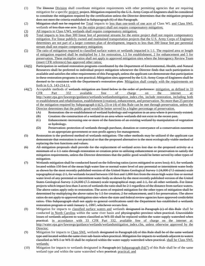
(1) The Director Division shall coordinate mitigation requirements with other permitting agencies that are requiring
mitigation for a specific project; project. Mitigation required by the U.S. Army Corps of Engineers shall be considered
to constitute the mitigation required by the certification unless the Director determines that the mitigation proposal
does not meet the criteria established in Subparagraph (6) of this Paragraph.
(2) Mitigation shall not be required for Total impacts to less than one-tenth of one acre of Class WL and Class SWL
wetlands of less than one acre. for the entire project shall not require compensatory mitigation;
(3) All impacts to Class UWL wetlands shall require compensatory mitigation;
(4) Total impacts to less than 300 linear feet of perennial streams for the entire project shall not require compensatory
mitigation. For linear publicly owned and maintained transportation projects that the U.S. Army Corps of Engineers
determines are not part of a larger common plan of development, impacts to less than 300 linear feet per perennial
stream shall not require compensatory mitigation;
(5) The ratio of mitigation required to classified surface waters or wetlands impacted is 1:1. The required area or length
of mitigation required shall be multiplied by 1 for restoration, 1.5 for establishment, 2 for enhancement and 5 for
preservation. These multiplier ratios shall not apply to approved mitigation sites where the Interagency Review Team
(insert CFR reference) has approved other ratios;
(3)(6) Participation in wetland restoration programs coordinated by the Department of Environmental, Health, and Natural
Resources shall be preferred to individual project mitigation whenever the Director finds that such participation is
available and satisfies the other requirements of this Paragraph, unless the applicant can demonstrate that participation
in these restoration programs is not practical. Mitigation sites approved by the U.S. Army Corps of Engineers shall be
deemed to be consistent with the Department's restoration plan. Mitigation shall comply with the requirements set
forth in G.S. 143-214.11;
(4)(7) Acceptable methods of wetlands mitigation are listed below in the order of preference: mitigation, as defined in 33
CFR Part 332 available free of charge on the internet at:
http://water.epa.gov/lawsregs/guidance/wetlands/wetlandsmitigation_index.cfm, include restoration, including both
re-establishment and rehabilitation, establishment (creation), enhancement, and preservation. No more than 25 percent
of the mitigation required by Subparagraph (c)(2), (3) or (4) of this Rule can be met through preservation, unless the
Director determines that the public good would be better served by a higher percentage of preservation.
(A) Restoration: the re-establishment of wetland hydrology and vegetation in an area where it previously existed.
(B) Creation: the construction of a wetland in an area where wetlands did not exist in the recent past.
(C) Enhancement: increasing one or more of the functions of an existing wetland by manipulation of vegetation
or hydrology.
(D) Preservation: protection of wetlands through purchase, donation or conveyance of a conservation easement
to an appropriate government or non-profit agency for management.
(5) Restoration is the preferred method of wetlands mitigation. The other methods may be utilized if the applicant can
demonstrate that restoration is not practical or that the proposed alternative is the most ecologically viable method of
replacing the lost functions and values.
(6) All mitigation proposals shall provide for the replacement of wetland acres lost due to the proposed activity at a
minimum of a 1:1 ratio through restoration or creation prior to utilizing enhancement or preservation to satisfy the
mitigation requirements, unless the Director determines that the public good would be better served by other types of
mitigation.
(7) Wetlands mitigation shall be conducted based on the following ratios (acres mitigated to acres loss); 4:1, for wetlands
located within 150 feet of the mean high water line or normal water level of any perennial or intermittent water body
as shown by the most recently published version of the United States Geological Survey 1:24,000 (7.5 minute) scale
topographical map; 2:1, for wetlands located between 150 feet and 1,000 feet from the mean high water line or normal
water level of any perennial or intermittent water body as shown by the most recently published version of the United
States Geological Survey 1:24,000 (7.5 minute) scale topographical map; and 1:1, for all other wetlands. For linear
projects which impact less than 3 acres of wetlands the ratio shall be 2:1 regardless of the distance from surface waters.
The above ratios apply only to restoration. The acres of required mitigation for the other types of mitigation shall be
determined by multiplying the above ratios by 1.5 for creation, 2 for enhancement, and 5 for preservation. The above
ratios do not apply to approved mitigation sites where the state and federal review agencies have approved credit/debit
ratios. This Subparagraph shall not apply to general certifications until the Department has established a wetlands
restoration program or until January 1, 1997, whichever occurs first.
(8) Mitigation for impacts to classified surface waters and wetlands designated in Paragraph (c) of this Rule shall be
conducted in North Carolina within the same river basin and physiographic province when practical. Unavoidable
losses of wetlands adjacent to waters classified as WS-III shall be replaced within the water supply watershed when
practical. in accordance with 33 CFR Part 332, available free of charge on the internet at:
http://water.epa.gov/lawsregs/guidance/wetlands/wetlandsmitigation_index.cfm, unless otherwise approved by the
Director;
(9) Mitigation for impacts to Class SWL wetlands designated in Paragraph (d) of this Rule shall be of the same wetland
type and located within the same river sub-basin when practical. Mitigation for impacts to wetlands adjacent to waters
classified as WS-I or WS-II shall be replaced within the water supply watershed when practical. shall be Class SWL
wetlands;
(10) Mitigation for impacts to wetlands designated in Paragraph (e) Subparagraph (b)(7) of this Rule shall be of the same
wetland type and within the same watershed when practical. practical; and

(11) Mitigation for impacts to surface waters classified as WS-I, WS-II or WS-III and wetlands adjacent to waters classified
as WS-I, WS-II or WS-III shall be within the same water supply watershed when practical.
(i) The Director shall not duplicate the site-specific application of any guidelines employed by the United State Army Corps of Engineers
in evaluating permit applications under 33 U.S.C. 1344 and applicable federal regulations.
History Note: Authority G.S. 143-211(c); 143-214.7C; 143-215.3(a)(1); 143-215.3(c); 143B-282(1)(u); S.L. 2015, c. 286; S.L 2017,
c. 10
RRC Objection Eff. July 18, 1996 due to lack of statutory authority and ambiguity;
Eff. October 1, 1996.
Readopted Eff. [New Date].
15A NCAC 02H .0507 ISSUANCE OF DECISION ON APPLICATION FOR CERTIFICATION
(a) Time Limit for Final Action on Certification Application. FINAL ACTION ON APPLICATION. All applications for certification
The Director shall be granted issue or denied deny within 60 calendar days after receipt of a complete application for certification
electronically or at the offices of the Director in 1617 Mail Service Center, Raleigh, North Carolina. Carolina, 27699-1617. Failure to
take final action within 60 calendar days shall result in a waiver of the certification requirement by the Director, unless:
(1) The applicant agrees, in writing, to a longer period;
(2) Final decision is to be made pursuant to a public hearing;
(3) Applicant The applicant fails to furnish information necessary to for the Director's decision;
(4) Applicant The applicant refuses the staff access to its records or premises for the purpose of gathering information
necessary to for the Director's decision or;
(5) Information necessary to for the Director's decision is unavailable.
(b) Time Limit for Final Action on Certification Application After Hearing. FINAL ACTION AFTER HEARING. All applications for
certification The Director shall be granted issue or denied deny the complete application for certification within 60 calendar days after
following the close of the record for the public hearing. Failure to take final action within 60 calendar days shall result in a waiver of
the certification requirement by the Director Director, unless the applicant otherwise agrees in writing, or unless Subparagraph
Subparagraphs (a)(3), (a)(1), (3), (4), or (5) of this Rule shall apply.
(c) Conditions of Certification. CONDITIONS OF CERTIFICATION. Any certification issued pursuant to this Rule Section may
contain such conditions as the Director shall deem necessary to insure ensure compliance with Sections 301, 302, 303, 306, and 307 of
the Federal Water Pollution Control Act Amendments. Section 401 of the Clean Water Act (33 U.S.C. 1341). The certification shall
become enforceable when the federal permit or license is issued.
(d) Modification or Revocation of Certification MODIFICATION OR REVOCATION. Modification or Revocation of Certification:
(1) Any certification issued pursuant to this Rule Section shall may be subject to revocation or modification for violation
of conditions of 301, 302, 303, 306, and 307 of the Federal Water Pollution Control Act Amendments.
(2) Any certification issued pursuant to this Rule Section shall may be subject to revocation or modification upon a
determination that information contained in the application or presented in support thereof is incorrect or if conditions
under which the certification was made have changed.
(e) Notification of Unapproved Application. NOTIFICATION OF FINAL ACTION. The Division shall notify the applicant of the final
action to issue or deny the application. In the event that the Director denies the application for certification or for any reason is unable
to approve the application, the Director shall so notify the applicant by certified or registered mail, return receipt requested, specifying
in such notification specify the reasons for the denial or inability to approve; and a approve. A copy of the notification shall be mailed
sent to the appropriate federal licensing or permitting agency and EPA.
(f) CONTESTED CASE HEARING. An applicant whose certification is denied or granted subject to unacceptable conditions shall
have the right to seek a contested case hearing pursuant to the provisions of G.S. 150B-23.
History Note: Authority G.S. 143-211(c); 143-215.3(a)(1); 143-215.3(c); 143B-282(1)(u);
Eff. February 1, 1976;
Amended Eff. July 1, 1988; December 1, 1984;
RRC Objection Eff. July 18, 1996 due to lack of statutory authority and ambiguity;
Recodifed from 15A NCAC 2H .0504 Eff. October 1, 1996;
Amended Eff. October 1, 1996;
Readopted Eff. [New Date].
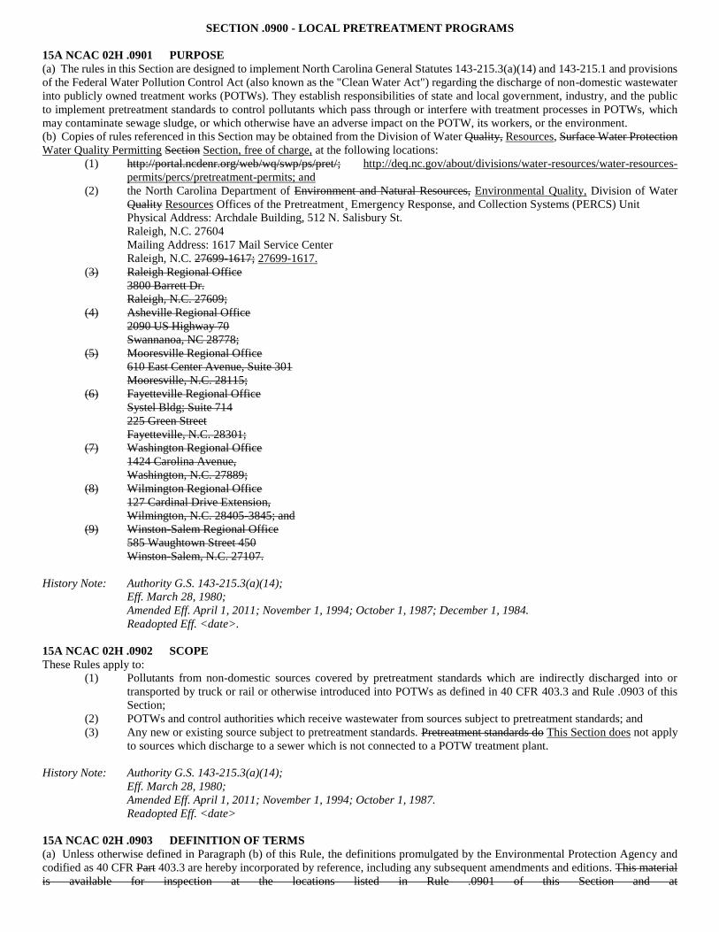
SECTION .0900 - LOCAL PRETREATMENT PROGRAMS
15A NCAC 02H .0901 PURPOSE
(a) The rules in this Section are designed to implement North Carolina General Statutes 143-215.3(a)(14) and 143-215.1 and provisions
of the Federal Water Pollution Control Act (also known as the "Clean Water Act") regarding the discharge of non-domestic wastewater
into publicly owned treatment works (POTWs). They establish responsibilities of state and local government, industry, and the public
to implement pretreatment standards to control pollutants which pass through or interfere with treatment processes in POTWs, which
may contaminate sewage sludge, or which otherwise have an adverse impact on the POTW, its workers, or the environment.
(b) Copies of rules referenced in this Section may be obtained from the Division of Water Quality, Resources, Surface Water Protection
Water Quality Permitting Section Section, free of charge, at the following locations:
(1) http://portal.ncdenr.org/web/wq/swp/ps/pret/; http://deq.nc.gov/about/divisions/water-resources/water-resources-
permits/percs/pretreatment-permits; and
(2) the North Carolina Department of Environment and Natural Resources, Environmental Quality, Division of Water
Quality Resources Offices of the Pretreatment¸ Emergency Response, and Collection Systems (PERCS) Unit
Physical Address: Archdale Building, 512 N. Salisbury St.
Raleigh, N.C. 27604
Mailing Address: 1617 Mail Service Center
Raleigh, N.C. 27699-1617; 27699-1617.
(3) Raleigh Regional Office
3800 Barrett Dr.
Raleigh, N.C. 27609;
(4) Asheville Regional Office
2090 US Highway 70
Swannanoa, NC 28778;
(5) Mooresville Regional Office
610 East Center Avenue, Suite 301
Mooresville, N.C. 28115;
(6) Fayetteville Regional Office
Systel Bldg; Suite 714
225 Green Street
Fayetteville, N.C. 28301;
(7) Washington Regional Office
1424 Carolina Avenue,
Washington, N.C. 27889;
(8) Wilmington Regional Office
127 Cardinal Drive Extension,
Wilmington, N.C. 28405-3845; and
(9) Winston-Salem Regional Office
585 Waughtown Street 450
Winston-Salem, N.C. 27107.
History Note: Authority G.S. 143-215.3(a)(14);
Eff. March 28, 1980;
Amended Eff. April 1, 2011; November 1, 1994; October 1, 1987; December 1, 1984.
Readopted Eff. <date>.
15A NCAC 02H .0902 SCOPE
These Rules apply to:
(1) Pollutants from non-domestic sources covered by pretreatment standards which are indirectly discharged into or
transported by truck or rail or otherwise introduced into POTWs as defined in 40 CFR 403.3 and Rule .0903 of this
Section;
(2) POTWs and control authorities which receive wastewater from sources subject to pretreatment standards; and
(3) Any new or existing source subject to pretreatment standards. Pretreatment standards do This Section does not apply
to sources which discharge to a sewer which is not connected to a POTW treatment plant.
History Note: Authority G.S. 143-215.3(a)(14);
Eff. March 28, 1980;
Amended Eff. April 1, 2011; November 1, 1994; October 1, 1987.
Readopted Eff. <date>
15A NCAC 02H .0903 DEFINITION OF TERMS
(a) Unless otherwise defined in Paragraph (b) of this Rule, the definitions promulgated by the Environmental Protection Agency and
codified as 40 CFR Part 403.3 are hereby incorporated by reference, including any subsequent amendments and editions. This material
is available for inspection at the locations listed in Rule .0901 of this Section and at
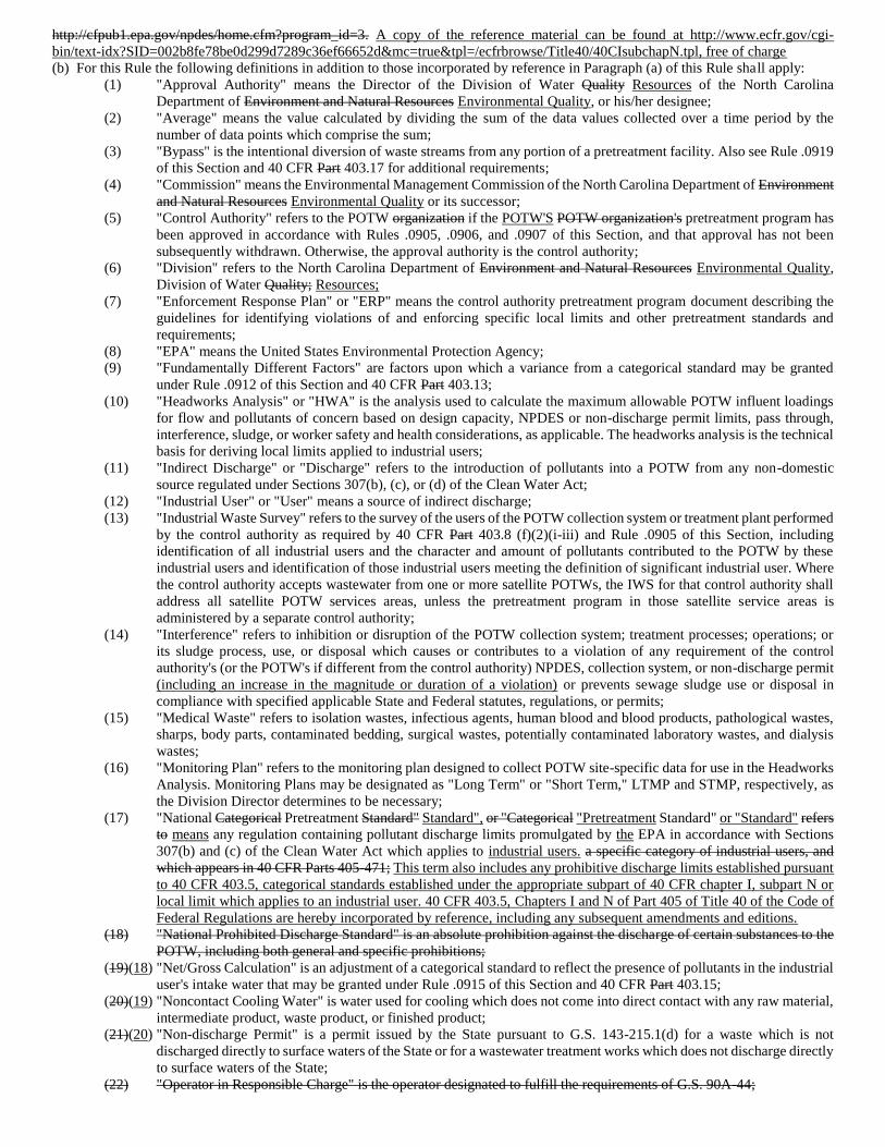
http://cfpub1.epa.gov/npdes/home.cfm?program_id=3. A copy of the reference material can be found at http://www.ecfr.gov/cgi-
bin/text-idx?SID=002b8fe78be0d299d7289c36ef66652d&mc=true&tpl=/ecfrbrowse/Title40/40CIsubchapN.tpl, free of charge
(b) For this Rule the following definitions in addition to those incorporated by reference in Paragraph (a) of this Rule shall apply:
(1) "Approval Authority" means the Director of the Division of Water Quality Resources of the North Carolina
Department of Environment and Natural Resources Environmental Quality, or his/her designee;
(2) "Average" means the value calculated by dividing the sum of the data values collected over a time period by the
number of data points which comprise the sum;
(3) "Bypass" is the intentional diversion of waste streams from any portion of a pretreatment facility. Also see Rule .0919
of this Section and 40 CFR Part 403.17 for additional requirements;
(4) "Commission" means the Environmental Management Commission of the North Carolina Department of Environment
and Natural Resources Environmental Quality or its successor;
(5) "Control Authority" refers to the POTW organization if the POTW'S POTW organization's pretreatment program has
been approved in accordance with Rules .0905, .0906, and .0907 of this Section, and that approval has not been
subsequently withdrawn. Otherwise, the approval authority is the control authority;
(6) "Division" refers to the North Carolina Department of Environment and Natural Resources Environmental Quality,
Division of Water Quality; Resources;
(7) "Enforcement Response Plan" or "ERP" means the control authority pretreatment program document describing the
guidelines for identifying violations of and enforcing specific local limits and other pretreatment standards and
requirements;
(8) "EPA" means the United States Environmental Protection Agency;
(9) "Fundamentally Different Factors" are factors upon which a variance from a categorical standard may be granted
under Rule .0912 of this Section and 40 CFR Part 403.13;
(10) "Headworks Analysis" or "HWA" is the analysis used to calculate the maximum allowable POTW influent loadings
for flow and pollutants of concern based on design capacity, NPDES or non-discharge permit limits, pass through,
interference, sludge, or worker safety and health considerations, as applicable. The headworks analysis is the technical
basis for deriving local limits applied to industrial users;
(11) "Indirect Discharge" or "Discharge" refers to the introduction of pollutants into a POTW from any non-domestic
source regulated under Sections 307(b), (c), or (d) of the Clean Water Act;
(12) "Industrial User" or "User" means a source of indirect discharge;
(13) "Industrial Waste Survey" refers to the survey of the users of the POTW collection system or treatment plant performed
by the control authority as required by 40 CFR Part 403.8 (f)(2)(i-iii) and Rule .0905 of this Section, including
identification of all industrial users and the character and amount of pollutants contributed to the POTW by these
industrial users and identification of those industrial users meeting the definition of significant industrial user. Where
the control authority accepts wastewater from one or more satellite POTWs, the IWS for that control authority shall
address all satellite POTW services areas, unless the pretreatment program in those satellite service areas is
administered by a separate control authority;
(14) "Interference" refers to inhibition or disruption of the POTW collection system; treatment processes; operations; or
its sludge process, use, or disposal which causes or contributes to a violation of any requirement of the control
authority's (or the POTW's if different from the control authority) NPDES, collection system, or non-discharge permit
(including an increase in the magnitude or duration of a violation) or prevents sewage sludge use or disposal in
compliance with specified applicable State and Federal statutes, regulations, or permits;
(15) "Medical Waste" refers to isolation wastes, infectious agents, human blood and blood products, pathological wastes,
sharps, body parts, contaminated bedding, surgical wastes, potentially contaminated laboratory wastes, and dialysis
wastes;
(16) "Monitoring Plan" refers to the monitoring plan designed to collect POTW site-specific data for use in the Headworks
Analysis. Monitoring Plans may be designated as "Long Term" or "Short Term," LTMP and STMP, respectively, as
the Division Director determines to be necessary;
(17) "National Categorical Pretreatment Standard" Standard", or "Categorical "Pretreatment Standard" or "Standard" refers
to means any regulation containing pollutant discharge limits promulgated by the EPA in accordance with Sections
307(b) and (c) of the Clean Water Act which applies to industrial users. a specific category of industrial users, and
which appears in 40 CFR Parts 405-471; This term also includes any prohibitive discharge limits established pursuant
to 40 CFR 403.5, categorical standards established under the appropriate subpart of 40 CFR chapter I, subpart N or
local limit which applies to an industrial user. 40 CFR 403.5, Chapters I and N of Part 405 of Title 40 of the Code of
Federal Regulations are hereby incorporated by reference, including any subsequent amendments and editions.
(18) "National Prohibited Discharge Standard" is an absolute prohibition against the discharge of certain substances to the
POTW, including both general and specific prohibitions;
(19)(18) "Net/Gross Calculation" is an adjustment of a categorical standard to reflect the presence of pollutants in the industrial
user's intake water that may be granted under Rule .0915 of this Section and 40 CFR Part 403.15;
(20)(19) "Noncontact Cooling Water" is water used for cooling which does not come into direct contact with any raw material,
intermediate product, waste product, or finished product;
(21)(20) "Non-discharge Permit" is a permit issued by the State pursuant to G.S. 143-215.1(d) for a waste which is not
discharged directly to surface waters of the State or for a wastewater treatment works which does not discharge directly
to surface waters of the State;
(22) "Operator in Responsible Charge" is the operator designated to fulfill the requirements of G.S. 90A-44;
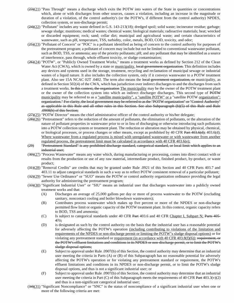
(23)(21) "Pass Through" means a discharge which exits the POTW into waters of the State in quantities or concentrations
which, alone or with discharges from other sources, causes a violation, including an increase in the magnitude or
duration of a violation, of the control authority's (or the POTW's, if different from the control authority) NPDES,
collection system, or non-discharge permit;
(24)(22) "Pollutant" includes any waste defined in G.S. 143-213(18); dredged spoil; solid waste; incinerator residue; garbage;
sewage sludge; munitions; medical wastes; chemical waste; biological materials; radioactive materials; heat; wrecked
or discarded equipment; rock; sand; cellar dirt; municipal and agricultural waste; and certain characteristics of
wastewater, such as pH, temperature, TSS, turbidity, color, metals, BOD, COD, toxicity, and odor;
(25)(23) "Pollutant of Concern" or "POC" is a pollutant identified as being of concern to the control authority for purposes of
the pretreatment program; a pollutant of concern may include but not be limited to conventional wastewater pollutant,
such as BOD, TSS, or ammonia; any of the priority pollutants; pH; and any pollutant that may be identified as a source
of interference, pass through, whole effluent toxicity, or sludge contamination;
(26)(24) "POTW", or "Publicly Owned Treatment Works," means a treatment works as defined by Section 212 of the Clean
Water Act (CWA), which is owned by a state or municipality. local government organization. This definition includes
any devices and systems used in the storage, treatment, recycling and reclamation of municipal sewage or industrial
wastes of a liquid nature. It also includes the collection system, only if it conveys wastewater to a POTW treatment
plant. Also see 15A NCAC 02T .0402. The term also means the local government organization, or municipality, as
defined in Section 502(4) of the CWA, which has jurisdiction over indirect discharges to and the discharges from such
a treatment works. In this context, the organization The municipality may be the owner of the POTW treatment plant
or the owner of the collection system into which an indirect discharger discharges. This second type of POTW
municipality may be referred to as a "satellite municipality", a "satellite POTW" or a "satellite POTW organization";
organization." For clarity, the local government may be referred to as the "POTW organization" or "Control Authority"
as applicable in this Rule and all other rules in this Section. See also Subparagraph (b)(5) of this Rule and Rule
.0908(h) of this Section;
(27)(25) "POTW Director" means the chief administrative officer of the control authority or his/her delegate;
(28)(26) "Pretreatment" refers to the reduction of the amount of pollutants, the elimination of pollutants, or the alteration of the
nature of pollutant properties in wastewater prior to or in lieu of discharging or otherwise introducing such pollutants
into a POTW collection system or treatment plant. The reduction or alteration may be obtained by physical, chemical,
or biological processes, or process changes or other means, except as prohibited by 40 CFR Part 403.6(d); 403.6(d).
Where wastewater from a regulated process is mixed with unregulated wastewater or with wastewater from another
regulated process, the pretreatment limit must be calculated in accordance with 40 CFR 403.6(e);
(29) "Pretreatment Standard" is any prohibited discharge standard, categorical standard, or local limit which applies to an
industrial user;
(30)(27) "Process Wastewater" means any water which, during manufacturing or processing, comes into direct contact with or
results from the production or use of any raw material, intermediate product, finished product, by-product, or waste
product;
(31)(28) "Removal Credits" are credits that may be granted under Rule .0921 of this Section and 40 CFR Parts 403.7 and
403.11 to adjust categorical standards in such a way as to reflect POTW consistent removal of a particular pollutant;
(32)(29) "Sewer Use Ordinance" or "SUO" means the POTW or control authority organization ordinance providing the legal
authority for administering the pretreatment program;
(33)(30) "Significant Industrial User" or "SIU" means an industrial user that discharges wastewater into a publicly owned
treatment works and that:
(A) Discharges an average of 25,000 gallons per day or more of process wastewater to the POTW (excluding
sanitary, noncontact cooling and boiler blowdown wastewaters);
(B) Contributes process wastewater which makes up five percent or more of the NPDES or non-discharge
permitted flow limit or organic capacity of the POTW treatment plant. In this context, organic capacity refers
to BOD, TSS and ammonia;
(C) Is subject to categorical standards under 40 CFR Part 403.6 and 40 CFR Chapter I, Subpart N; Parts 405-
471;
(D) is designated as such by the control authority on the basis that the industrial user has a reasonable potential
for adversely affecting the POTW's operation (including contributing to violations of the limitation and
requirements of the NPDES or non-discharge permit or limiting the POTW"s sludge disposal options) or for
violating any pretreatment standard or requirement (in accordance with 40 CFR 403.8(f)(6)); requirement, or
the POTW's effluent limitations and conditions in its NPDES or non-discharge permit, or to limit the POTW's
sludge disposal options;
(E) Subject to approval under Rule .0907(b) of this Section, the control authority may determine that an industrial
user meeting the criteria in Parts (A) or (B) of this Subparagraph has no reasonable potential for adversely
affecting the POTW's operation or for violating any pretreatment standard or requirement, the POTW's
effluent limitations and conditions in its NPDES or non-discharge permit, or to limit the POTW's sludge
disposal options, and thus is not a significant industrial user; or
(F) Subject to approval under Rule .0907(b) of this Section, the control authority may determine that an industrial
user meeting the criteria in Part (C) of this Subparagraph meets the requirements of 40 CFR Part 403.3(v)(2)
and thus is a non-significant categorical industrial user;
(34)(31) "Significant Noncompliance" or "SNC" is the status of noncompliance of a significant industrial user when one or
more of the following criteria are met:
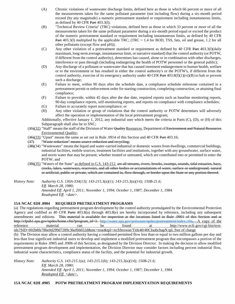
(A) Chronic violations of wastewater discharge limits, defined here as those in which 66 percent or more of all
the measurements taken for the same pollutant parameter (not including flow) during a six-month period
exceed (by any magnitude) a numeric pretreatment standard or requirement including instantaneous limits,
as defined by 40 CFR Part 403.3(l);
(B) "Technical Review Criteria" (TRC) violations, defined here as those in which 33 percent or more of all the
measurements taken for the same pollutant parameter during a six-month period equal or exceed the product
of the numeric pretreatment standard or requirement including instantaneous limits, as defined by 40 CFR
Part 403.3(l) multiplied by the applicable TRC; (TRC = 1.4 for BOD, TSS, fats, oil and grease, 1.2 for all
other pollutants (except flow and pH));
(C) Any other violation of a pretreatment standard or requirement as defined by 40 CFR Part 403.3(l)(daily
maximum, long-term average, instantaneous limit, or narrative standard) that the control authority (or POTW,
if different from the control authority), determines has caused, alone or in combination with other discharges,
interference or pass through (including endangering the health of POTW personnel or the general public);
(D) Any discharge of a pollutant or wastewater that has caused imminent endangerment to human health, welfare
or to the environment or has resulted in either the control authority's or the POTW's, if different from the
control authority, exercise of its emergency authority under 40 CFR Part 403.8(f)(1)(vi)(B) to halt or prevent
such a discharge;
(E) Failure to meet, within 90 days after the schedule date, a compliance schedule milestone contained in a
pretreatment permit or enforcement order for starting construction, completing construction, or attaining final
compliance;
(F) Failure to provide, within 45 days after the due date, required reports such as baseline monitoring reports,
90-day compliance reports, self-monitoring reports, and reports on compliance with compliance schedules;
(G) Failure to accurately report noncompliance; or
(H) Any other violation or group of violations that the control authority or POTW determines will adversely
affect the operation or implementation of the local pretreatment program;
Additionally, effective January 1, 2012, any industrial user which meets the criteria in Parts (C), (D), or (H) of this
Subparagraph shall also be in SNC;
(35)(32) "Staff" means the staff of the Division of Water Quality Resources, Department of Environment and Natural Resources
Environmental Quality;
(36)(33) "Upset" means the same as set out in Rule .0914 of this Section and 40 CFR Part 403.16;
(37) "Waste reduction" means source reduction and recycling;
(38)(34) "Wastewater" means the liquid and water-carried industrial or domestic wastes from dwellings, commercial buildings,
industrial facilities, mobile sources, treatment facilities and institutions, together with any groundwater, surface water,
and storm water that may be present, whether treated or untreated, which are contributed into or permitted to enter the
POTW; and
(39)(35) "Waters of the State" as defined in G.S. 143-212. are all streams, rivers, brooks, swamps, sounds, tidal estuaries, bays,
creeks, lakes, waterways, reservoirs, and all other bodies or accumulations of water, surface or underground, natural
or artificial, public or private, which are contained in, flow through, or border upon the State or any portion thereof.
History Note: Authority G.S. 130A-334(13); 143-215.3(a)(1); 143-215.3(a)(14); 150B-21.6;
Eff. March 28, 1980;
Amended Eff. April 1, 2011; November 1, 1994; October 1, 1987; December 1, 1984.
Readopted Eff. <date>.
15A NCAC 02H .0904 REQUIRED PRETREATMENT PROGRAMS
(a) The regulations regarding pretreatment program development by the control authority promulgated by the Environmental Protection
Agency and codified as 40 CFR Parts 403.8(a) through 403.8(e) are hereby incorporated by reference, including any subsequent
amendments and editions. This material is available for inspection at the locations listed in Rule .0901 of this Section and at
http://cfpub1.epa.gov/npdes/home.cfm?program_id=3. http://water.epa.gov/polwaste/npdes/pretreatment/index.cfm. A copy of the
reference material can be found at http://www.ecfr.gov/cgi-bin/text-
idx?SID=002b8fe78be0d299d7289c36ef66652d&mc=true&tpl=/ecfrbrowse/Title40/40CIsubchapN.tpl, free of charge
(b) The Division may allow a control authority having a combined permitted flow less than or equal to two million gallons per day and
less than four significant industrial users to develop and implement a modified pretreatment program that encompasses a portion of the
requirements in Rules .0905 and .0906 of this Section, as designated by the Division Director. In making the decision to allow modified
pretreatment program development and implementation, the Division Director may consider factors including percent industrial flow,
industrial waste characteristics, compliance status of the facility, and the potential for industrial growth.
History Note: Authority G.S. 143-215.1(a); 143-215.1(b); 143-215.3(a)(14); 150B-21.6;
Eff. March 28, 1980;
Amended Eff. April 1, 2011; November 1, 1994; October 1, 1987; December 1, 1984.
Readopted Eff. <date>.
15A NCAC 02H .0905 POTW PRETREATMENT PROGRAM IMPLEMENTATION REQUIREMENTS
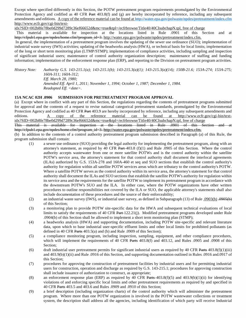
Except where specified differently in this Section, the POTW pretreatment program requirements promulgated by the Environmental
Protection Agency and codified as 40 CFR Part 403.8(f) and (g) are hereby incorporated by reference, including any subsequent
amendments and editions. A copy of the reference material can be found at http://water.epa.gov/polwaste/npdes/pretreatment/index.cfm
http://www.ecfr.gov/cgi-bin/text-
idx?SID=002b8fe78be0d299d7289c36ef66652d&mc=true&tpl=/ecfrbrowse/Title40/40CIsubchapN.tpl, free of charge
This material is available for inspection at the locations listed in Rule .0901 of this Section and at
http://cfpub1.epa.gov/npdes/home.cfm?program_id=3. http://water.epa.gov/polwaste/npdes/pretreatment/index.cfm.
In general, the implementation of a pretreatment program involves the updating of the sewer use ordinance (SUO); implementation of
industrial waste survey (IWS) activities; updating of the headworks analysis (HWA), or technical basis for local limits; implementation
of the long or short term monitoring plan (LTMP/STMP); implementation of compliance activities, including sampling and inspection
of significant industrial users; maintenance of control authority organization description; maintenance of staffing and funding
information; implementation of the enforcement response plan (ERP), and reporting to the Division on pretreatment program activities.
History Note: Authority G.S. 143-215.1(a); 143-215.1(b); 143-215.3(a)(1); 143-215.3(a)(14); 150B-21.6; 153A-274; 153A-275;
160A-311; 160A-312;
Eff. March 28, 1980;
Amended Eff. April 1, 2011; November 1, 1994; October 1, 1987; December 1, 1984.
Readopted Eff. <date>.
15A NCAC 02H .0906 SUBMISSION FOR PRETREATMENT PROGRAM APPROVAL
(a) Except where in conflict with any part of this Section, the regulations regarding the contents of pretreatment programs submitted
for approval and the contents of a request to revise national categorical pretreatment standards, promulgated by the Environmental
Protection Agency and codified as 40 CFR Part 403.9 are hereby incorporated by reference, including any subsequent amendments and
editions. A copy of the reference material can be found at http://www.ecfr.gov/cgi-bin/text-
idx?SID=002b8fe78be0d299d7289c36ef66652d&mc=true&tpl=/ecfrbrowse/Title40/40CIsubchapN.tpl, free of charge
This material is available for inspection at the locations listed in Rule .0901 of this Section and at
http://cfpub1.epa.gov/npdes/home.cfm?program_id=3. http://water.epa.gov/polwaste/npdes/pretreatment/index.cfm.
(b) In addition to the contents of a control authority pretreatment program submission described in Paragraph (a) of this Rule, the
program submission shall contain:
(1) a sewer use ordinance (SUO) providing the legal authority for implementing the pretreatment program, along with an
attorney's statement, as required by 40 CFR Part 403.8 (f)(1) and Rule .0905 of this Section. Where the control
authority accepts wastewater from one or more satellite POTWs and is the control authority within the satellite
POTW's service area, the attorney's statement for that control authority shall document the interlocal agreements
(ILAs) authorized by G.S. 153A-278 and 160A-460 et seq and SUO sections that establish the control authority's
authority for regulation within all satellite POTW services areas which are tributary to the control authority's POTW.
Where a satellite POTW serves as the control authority within its service area, the attorney's statement for that control
authority shall document the ILAs and SUO sections that establish the satellite POTW's authority for regulation within
its service area and the requirements for the satellite POTW to implement its pretreatment program in accordance with
the downstream POTW's SUO and the ILA. In either case, where the POTW organizations have other written
procedures to outline responsibilities not covered by the ILA or SUO, the applicable attorney's statements shall also
include documentation of these procedures and the source of their enforceability;
(2) an industrial waste survey (IWS), or industrial user survey, as defined in Subparagraph (13) of Rule .0903(b) .0905(b)
of this Section;
(3) a monitoring plan to provide POTW site-specific data for the HWA and subsequent technical evaluations of local
limits to satisfy the requirements of 40 CFR Part 122.21(j). Modified pretreatment programs developed under Rule
.0904(b) of this Section shall be allowed to implement a short term monitoring plan (STMP);
(4) a headworks analysis (HWA) and supporting documentation, including POTW site-specific and relevant literature
data, upon which to base industrial user-specific effluent limits and other local limits for prohibited pollutants (as
defined in 40 CFR Parts 403.5(a) and (b) and Rule .0909 of this Section);
(5) a compliance monitoring program, including inspection, sampling, equipment, and other compliance procedures,
which will implement the requirements of 40 CFR Parts 403.8(f) and 403.12, and Rules .0905 and .0908 of this
Section;
(6) draft industrial user pretreatment permits for significant industrial users as required by 40 CFR Parts 403.8(f)(1)(iii)
and 403.9(b)(1)(ii) and Rule .0916 of this Section, and supporting documentation outlined in Rules .0916 and.0917 of
this Section;
(7) procedures for approving the construction of pretreatment facilities by industrial users and for permitting industrial
users for construction, operation and discharge as required by G.S. 143-215.1; procedures for approving construction
shall include issuance of authorization to construct, as appropriate;
(8) an enforcement response plan (ERP) as required by 40 CFR Parts 403.8(f)(5) and 403.9(b)(1)(ii) for identifying
violations of and enforcing specific local limits and other pretreatment requirements as required by and specified in
40 CFR Parts 403.5 and 403.6 and Rules .0909 and .0910 of this Section;
(9) a brief description (including organization charts) of the control authority which will administer the pretreatment
program. Where more than one POTW organization is involved in the POTW wastewater collections or treatment
system, the description shall address all the agencies, including identification of which party will receive Industrial
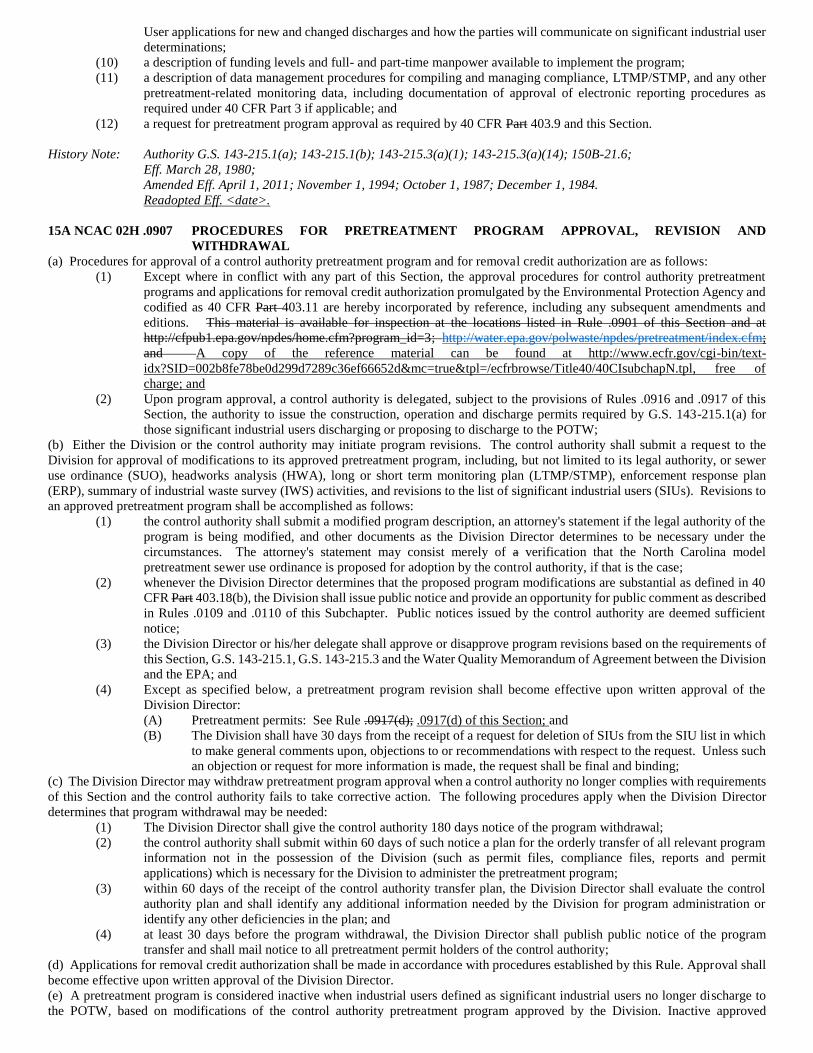
User applications for new and changed discharges and how the parties will communicate on significant industrial user
determinations;
(10) a description of funding levels and full- and part-time manpower available to implement the program;
(11) a description of data management procedures for compiling and managing compliance, LTMP/STMP, and any other
pretreatment-related monitoring data, including documentation of approval of electronic reporting procedures as
required under 40 CFR Part 3 if applicable; and
(12) a request for pretreatment program approval as required by 40 CFR Part 403.9 and this Section.
History Note: Authority G.S. 143-215.1(a); 143-215.1(b); 143-215.3(a)(1); 143-215.3(a)(14); 150B-21.6;
Eff. March 28, 1980;
Amended Eff. April 1, 2011; November 1, 1994; October 1, 1987; December 1, 1984.
Readopted Eff. <date>.
15A NCAC 02H .0907 PROCEDURES FOR PRETREATMENT PROGRAM APPROVAL, REVISION AND
WITHDRAWAL
(a) Procedures for approval of a control authority pretreatment program and for removal credit authorization are as follows:
(1) Except where in conflict with any part of this Section, the approval procedures for control authority pretreatment
programs and applications for removal credit authorization promulgated by the Environmental Protection Agency and
codified as 40 CFR Part 403.11 are hereby incorporated by reference, including any subsequent amendments and
editions. This material is available for inspection at the locations listed in Rule .0901 of this Section and at
http://cfpub1.epa.gov/npdes/home.cfm?program_id=3; http://water.epa.gov/polwaste/npdes/pretreatment/index.cfm;
and A copy of the reference material can be found at http://www.ecfr.gov/cgi-bin/text-
idx?SID=002b8fe78be0d299d7289c36ef66652d&mc=true&tpl=/ecfrbrowse/Title40/40CIsubchapN.tpl, free of
charge; and
(2) Upon program approval, a control authority is delegated, subject to the provisions of Rules .0916 and .0917 of this
Section, the authority to issue the construction, operation and discharge permits required by G.S. 143-215.1(a) for
those significant industrial users discharging or proposing to discharge to the POTW;
(b) Either the Division or the control authority may initiate program revisions. The control authority shall submit a request to the
Division for approval of modifications to its approved pretreatment program, including, but not limited to its legal authority, or sewer
use ordinance (SUO), headworks analysis (HWA), long or short term monitoring plan (LTMP/STMP), enforcement response plan
(ERP), summary of industrial waste survey (IWS) activities, and revisions to the list of significant industrial users (SIUs). Revisions to
an approved pretreatment program shall be accomplished as follows:
(1) the control authority shall submit a modified program description, an attorney's statement if the legal authority of the
program is being modified, and other documents as the Division Director determines to be necessary under the
circumstances. The attorney's statement may consist merely of a verification that the North Carolina model
pretreatment sewer use ordinance is proposed for adoption by the control authority, if that is the case;
(2) whenever the Division Director determines that the proposed program modifications are substantial as defined in 40
CFR Part 403.18(b), the Division shall issue public notice and provide an opportunity for public comment as described
in Rules .0109 and .0110 of this Subchapter. Public notices issued by the control authority are deemed sufficient
notice;
(3) the Division Director or his/her delegate shall approve or disapprove program revisions based on the requirements of
this Section, G.S. 143-215.1, G.S. 143-215.3 and the Water Quality Memorandum of Agreement between the Division
and the EPA; and
(4) Except as specified below, a pretreatment program revision shall become effective upon written approval of the
Division Director:
(A) Pretreatment permits: See Rule .0917(d); .0917(d) of this Section; and
(B) The Division shall have 30 days from the receipt of a request for deletion of SIUs from the SIU list in which
to make general comments upon, objections to or recommendations with respect to the request. Unless such
an objection or request for more information is made, the request shall be final and binding;
(c) The Division Director may withdraw pretreatment program approval when a control authority no longer complies with requirements
of this Section and the control authority fails to take corrective action. The following procedures apply when the Division Director
determines that program withdrawal may be needed:
(1) The Division Director shall give the control authority 180 days notice of the program withdrawal;
(2) the control authority shall submit within 60 days of such notice a plan for the orderly transfer of all relevant program
information not in the possession of the Division (such as permit files, compliance files, reports and permit
applications) which is necessary for the Division to administer the pretreatment program;
(3) within 60 days of the receipt of the control authority transfer plan, the Division Director shall evaluate the control
authority plan and shall identify any additional information needed by the Division for program administration or
identify any other deficiencies in the plan; and
(4) at least 30 days before the program withdrawal, the Division Director shall publish public notice of the program
transfer and shall mail notice to all pretreatment permit holders of the control authority;
(d) Applications for removal credit authorization shall be made in accordance with procedures established by this Rule. Approval shall
become effective upon written approval of the Division Director.
(e) A pretreatment program is considered inactive when industrial users defined as significant industrial users no longer discharge to
the POTW, based on modifications of the control authority pretreatment program approved by the Division. Inactive approved
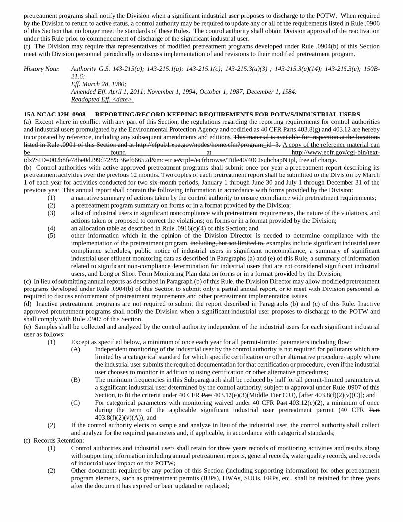
pretreatment programs shall notify the Division when a significant industrial user proposes to discharge to the POTW. When required
by the Division to return to active status, a control authority may be required to update any or all of the requirements listed in Rule .0906
of this Section that no longer meet the standards of these Rules. The control authority shall obtain Division approval of the reactivation
under this Rule prior to commencement of discharge of the significant industrial user.
(f) The Division may require that representatives of modified pretreatment programs developed under Rule .0904(b) of this Section
meet with Division personnel periodically to discuss implementation of and revisions to their modified pretreatment program.
History Note: Authority G.S. 143-215(a); 143-215.1(a); 143-215.1(c); 143-215.3(a)(3) ; 143-215.3(a)(14); 143-215.3(e); 150B-
21.6;
Eff. March 28, 1980;
Amended Eff. April 1, 2011; November 1, 1994; October 1, 1987; December 1, 1984.
Readopted Eff. <date>.
15A NCAC 02H .0908 REPORTING/RECORD KEEPING REQUIREMENTS FOR POTWS/INDUSTRIAL USERS
(a) Except where in conflict with any part of this Section, the regulations regarding the reporting requirements for control authorities
and industrial users promulgated by the Environmental Protection Agency and codified as 40 CFR Parts 403.8(g) and 403.12 are hereby
incorporated by reference, including any subsequent amendments and editions. This material is available for inspection at the locations
listed in Rule .0901 of this Section and at http://cfpub1.epa.gov/npdes/home.cfm?program_id=3. A copy of the reference material can
be found at http://www.ecfr.gov/cgi-bin/text-
idx?SID=002b8fe78be0d299d7289c36ef66652d&mc=true&tpl=/ecfrbrowse/Title40/40CIsubchapN.tpl, free of charge.
(b) Control authorities with active approved pretreatment programs shall submit once per year a pretreatment report describing its
pretreatment activities over the previous 12 months. Two copies of each pretreatment report shall be submitted to the Division by March
1 of each year for activities conducted for two six-month periods, January 1 through June 30 and July 1 through December 31 of the
previous year. This annual report shall contain the following information in accordance with forms provided by the Division:
(1) a narrative summary of actions taken by the control authority to ensure compliance with pretreatment requirements;
(2) a pretreatment program summary on forms or in a format provided by the Division;
(3) a list of industrial users in significant noncompliance with pretreatment requirements, the nature of the violations, and
actions taken or proposed to correct the violations; on forms or in a format provided by the Division;
(4) an allocation table as described in Rule .0916(c)(4) of this Section; and
(5) other information which in the opinion of the Division Director is needed to determine compliance with the
implementation of the pretreatment program, including, but not limited to, examples include significant industrial user
compliance schedules, public notice of industrial users in significant noncompliance, a summary of significant
industrial user effluent monitoring data as described in Paragraphs (a) and (e) of this Rule, a summary of information
related to significant non-compliance determination for industrial users that are not considered significant industrial
users, and Long or Short Term Monitoring Plan data on forms or in a format provided by the Division;
(c) In lieu of submitting annual reports as described in Paragraph (b) of this Rule, the Division Director may allow modified pretreatment
programs developed under Rule .0904(b) of this Section to submit only a partial annual report, or to meet with Division personnel as
required to discuss enforcement of pretreatment requirements and other pretreatment implementation issues.
(d) Inactive pretreatment programs are not required to submit the report described in Paragraphs (b) and (c) of this Rule. Inactive
approved pretreatment programs shall notify the Division when a significant industrial user proposes to discharge to the POTW and
shall comply with Rule .0907 of this Section.
(e) Samples shall be collected and analyzed by the control authority independent of the industrial users for each significant industrial
user as follows:
(1) Except as specified below, a minimum of once each year for all permit-limited parameters including flow:
(A) Independent monitoring of the industrial user by the control authority is not required for pollutants which are
limited by a categorical standard for which specific certification or other alternative procedures apply where
the industrial user submits the required documentation for that certification or procedure, even if the industrial
user chooses to monitor in addition to using certification or other alternative procedures;
(B) The minimum frequencies in this Subparagraph shall be reduced by half for all permit-limited parameters at
a significant industrial user determined by the control authority, subject to approval under Rule .0907 of this
Section, to fit the criteria under 40 CFR Part 403.12(e)(3)(Middle Tier CIU), [after 403.8(f)(2)(v)(C)]; and
(C) For categorical parameters with monitoring waived under 40 CFR Part 403.12(e)(2), a minimum of once
during the term of the applicable significant industrial user pretreatment permit (40 CFR Part
403.8(f)(2)(v)(A)); and
(2) If the control authority elects to sample and analyze in lieu of the industrial user, the control authority shall collect
and analyze for the required parameters and, if applicable, in accordance with categorical standards;
(f) Records Retention:
(1) Control authorities and industrial users shall retain for three years records of monitoring activities and results along
with supporting information including annual pretreatment reports, general records, water quality records, and records
of industrial user impact on the POTW;
(2) Other documents required by any portion of this Section (including supporting information) for other pretreatment
program elements, such as pretreatment permits (IUPs), HWAs, SUOs, ERPs, etc., shall be retained for three years
after the document has expired or been updated or replaced;
(3) A summary of all significant industrial user effluent monitoring data reported to the control authority by the industrial
user or obtained by the control authority shall be maintained on forms or in a format provided by the Division for
review by the Division; and
(4) Also see Rule .0805 of this Subchapter for laboratory records retention requirements.
(g) Forms or format deviating from Division provided forms or format for all documents and supporting information required by any
portion of this Section shall contain all required information in a logical order or, if appropriate, in a computer-compatible format.
(h) In the case where the receiving POTW treatment plant is not owned by the same local governmental organization as the control
authority, all information required to be reported to the industrial user's control authority by this Section shall also be submitted to the
POTW treatment plant governmental organization.
(i) In the case where the control authority accepts electronic reporting, the reporting shall comply with 40 CFR Part 3, and the control
authority shall maintain documentation of approval as required under 40 CFR Part 3.
History Note: Authority G.S. 143-215.1(a); 143-215.1(b); 143-215.2; 143-215.3(a)(2); 143-215.3(a)(14); 143-215.6(a)(1); 143-
215.63 through 143-215.69; 150B-21.6;
Eff. March 28, 1980;
Amended Eff. April 1, 2011; November 1, 1994; October 1, 1987; December 1, 1984.
Readopted Eff. <date>.
15A NCAC 02H .0909 NATIONAL PRETREATMENT STANDARDS: PROHIBITED DISCHARGES
The regulations regarding national prohibited pretreatment standards and local limits development and enforcement promulgated by the
Environmental Protection Agency and codified as 40 CFR Part 403.5 are hereby incorporated by reference, including any subsequent
amendments and editions. This material is available for inspection at the locations listed in Rule .0901 of this Section and at
http://cfpub1.epa.gov/npdes/home.cfm?program_id=3. http://water.epa.gov/polwaste/npdes/pretreatment/index.cfm. A copy of the
reference material can be found at http://www.ecfr.gov/cgi-bin/text-
idx?SID=002b8fe78be0d299d7289c36ef66652d&mc=true&tpl=/ecfrbrowse/Title40/40CIsubchapN.tpl, free of charge.
History Note: Authority G.S. 143-215.1(a)(7); 143-215.1(b); 143-215.3(a)(1); 143-215.3(a)(14); 150B-21.6;
Eff. March 28, 1980;
Amended Eff. March 1, 2011; November 1, 1994; October 1, 1987; December 1, 1984.
Readopted Eff. <date>.
15A NCAC 02H .0910 NATIONAL PRETREATMENT STANDARDS: CATEGORICAL STANDARDS
The regulations regarding national categorical pretreatment standards promulgated by the Environmental Protection Agency and
codified as pursuant to 40 CFR Part 403.6 are hereby incorporated by reference, including any subsequent amendments and editions.
This material is available for inspection at the locations listed in Rule .0901 of this Section and at
http://cfpub1.epa.gov/npdes/home.cfm?program_id=3. http://water.epa.gov/polwaste/npdes/pretreatment/index.cfm. A copy of the
reference material can be found at http://www.ecfr.gov/cgi-bin/text-
idx?SID=002b8fe78be0d299d7289c36ef66652d&mc=true&tpl=/ecfrbrowse/Title40/40CIsubchapN.tpl, free of charge.
History Note: Authority G.S. 143-215.1(a)(7); 143-215.1(b); 143-215.3(a)(14); 150B-21.6;
Eff. March 28, 1980;
Amended Eff. March 1, 2011; November 1, 1994; October 1, 1987; December 1, 1984.
Readopted Eff. <date>.
15A NCAC 02H .0912 ADJUSTMENTS FOR FUNDAMENTALLY DIFFERENT FACTORS
The regulations regarding variances from national categorical pretreatment standards for fundamentally different factors promulgated
by the Environmental Protection Agency and codified as 40 CFR Part 403.13 are hereby incorporated by reference, including any
subsequent amendments and editions. This material is available for inspection at the locations listed in Rule .0901 of this Section and
at http://cfpub1.epa.gov/npdes/home.cfm?program_id=3. http://water.epa.gov/polwaste/npdes/pretreatment/index.cfm. A copy of the
reference material can be found at http://www.ecfr.gov/cgi-bin/text-
idx?SID=002b8fe78be0d299d7289c36ef66652d&mc=true&tpl=/ecfrbrowse/Title40/40CIsubchapN.tpl, free of charge.
History Note: Authority G.S. 143-215(a); 143-215.1(a); 143-215.1(b); 143-215.3(a)(14); 143-215.3(e); 150B-21.6;
Eff. March 28, 1980;
Amended Eff. March 1, 2011; November 1, 1994; October 1, 1987; December 1, 1984.
Readopted Eff. <date>.
15A NCAC 02H .0913 PUBLIC ACCESS TO INFORMATION
(a) Information and data provided by an industrial user to the POTW Director pursuant to this Section, identifying the nature and
frequency of a discharge, shall be available to the public without restriction. All other information which may be so submitted by an
industrial user to the POTW Director in connection with any required reports shall also be available to the public unless the industrial
user or other interested person specifically identifies the information as confidential upon submission and is able to demonstrate to the
satisfaction of the POTW Director that the disclosure of such information or a particular part thereof to the general public would divulge
methods or processes entitled to protection as trade secrets.
(b) Information and data provided by an industrial user to the Division Director shall be subject to the processes set forth in G.S. 143-
215.3C.
(c) Information provided by an industrial user to a control authority that is determined to be entitled to confidential treatment shall be
made available upon written request to the Division or any state agency for uses related to the pretreatment program, the National
Pollutant Discharge Elimination System (NPDES) permit, collection system permit, stormwater permit, or non-discharge permit, and
for uses related to judicial review or enforcement proceedings involving the person furnishing the report.
(d) Information and data received by the Division or other state agency under Paragraph (c) of this Rule shall be subject to the processes
set forth in G.S. 143-215.3C.
History Note: Authority G.S. 132-1.2; 132-6; 132-9; 143-215.1; 143-215.3; 143-215.3C;
Eff. March 28, 1980;
Amended Eff. April 1, 2011; October 1, 1987.
Readopted Eff. <date>.
15A NCAC 02H .0914 UPSET PROVISION
The upset provision promulgated by the Environmental Protection Agency and codified as 40 CFR Part 403.16 is hereby incorporated
by reference, including any subsequent amendments and editions. This material is available for inspection at the locations listed in Rule
.0901 of this Section and at http://cfpub1.epa.gov/npdes/home.cfm?program_id=3.
http://water.epa.gov/polwaste/npdes/pretreatment/index.cfm. A copy of the reference material can be found at http://www.ecfr.gov/cgi-
bin/text-idx?SID=002b8fe78be0d299d7289c36ef66652d&mc=true&tpl=/ecfrbrowse/Title40/40CIsubchapN.tpl, free of charge.
History Note: Authority G.S. 143-215.3(a)(1); 143-215.3(a)(14); 150B-21.6;
Eff. December 1, 1984;
Amended Eff. March 1, 2011; November 1, 1994; October 1, 1987.
Readopted Eff. <date>.
15A NCAC 02H .0915 NET/GROSS CALCULATION
The net/gross calculation provisions promulgated by the Environmental Protection Agency and codified as 40 CFR Part 403.15 are
hereby incorporated by reference, including any subsequent amendments and editions. This material is available for inspection at the
locations listed in Rule .0901 of this Section and at http://cfpub1.epa.gov/npdes/home.cfm?program_id=3.
http://water.epa.gov/polwaste/npdes/pretreatment/index.cfm. A copy of the reference material can be found at http://www.ecfr.gov/cgi-
bin/text-idx?SID=002b8fe78be0d299d7289c36ef66652d&mc=true&tpl=/ecfrbrowse/Title40/40CIsubchapN.tpl, free of charge.
History Note: Authority G.S. 143-215.3(a)(1); 143-215.3(a)(14); 150B-21.6;
Eff. December 1, 1984;
Amended Eff. March 1, 2011; November 1, 1994; October 1, 1987.
Readopted Eff. <date>.
15A NCAC 02H .0916 PRETREATMENT PERMITS
(a) All significant industrial users who discharge waste into a POTW or who construct or operate a pretreatment facility shall obtain a
permit from the control authority.
(b) Where the Division is the control authority, permits shall be issued in accordance with Section .0100 of this Subchapter.
(c) Where the control authority is a POTW organization, significant industrial user permits shall be issued as follows:
(1) Application: any significant industrial user required to obtain a permit in Paragraph (a) of this Rule shall be required
to complete, sign and submit to the control authority a permit application. Application fees and procedures may be
prescribed by the control authority. All pretreatment permit applications shall include as a minimum:
(A) name of industrial user;
(B) address of industrial user;
(C) standard industrial classification (SIC) code(s) or expected classification and industrial user category;
(D) wastewater flow;
(E) types and concentrations (or mass) of pollutants contained in the discharge;
(F) major products manufactured or services supplied;
(G) description of existing on-site pretreatment facilities and practices;
(H) locations of discharge points;
(I) raw materials used or stored at the site;
(J) flow diagram or sewer map for the industrial user;
(K) number of employees;
(L) operation and production schedules; and
(M) description of current and projected waste reduction activities in accordance with G.S. 143-215.1(g);
(M) a written description of current and projected waste reduction activities in accordance with G.S. 143-215.1
(g). The written description shall not be considered part of the permit application and shall not serve as a
basis for denial of a permit.
(2) Renewals: Applications for pretreatment permit renewals shall be accomplished by filing an application form as listed
in Subparagraph (c)(1) of this Rule prior to permit expiration. The number of days prior to expiration by which the
application shall be filed shall be established by the control authority;
(3) Review and Evaluation:
(A) The POTW Director is authorized to accept applications for the Commission and shall refer all applications
to the control authority staff for review and evaluation;
(B) The POTW Director shall acknowledge receipt of a complete application, or if not complete, shall return the
application to the applicant with a statement of what additional information is required;
(C) The control authority staff shall include documentation of the most recent on site on-site inspection of the
industrial user and any existing wastewater pretreatment system as part of the permit record for new and
renewed permits; and
(D) The control authority staff shall conduct an evaluation and make a tentative determination to issue or deny
the permit. If the control authority staff's tentative determination is to issue the permit, it shall make the
following additional determinations in writing and transmit them to the industrial user:
(i) proposed effluent limitations for those pollutants proposed to be limited;
(ii) a proposed schedule of compliance, including interim dates and requirements, for meeting the
proposed effluent limitations; and
(iii) a description of any other proposed special conditions which will have significant impact upon the
discharge described in the application;
The control authority staff shall organize the determinations made into a pretreatment permit;
(4) Permit supporting documentation. The control authority staff shall prepare the following documents for all significant
industrial user permits:
(A) An allocation table (AT) listing permit information for all significant industrial users, including but not
limited to permit limits, permit effective and expiration dates, and a comparison of total permitted flows and
loads with Division approved maximum allowable loadings of the POTW, including flow, on forms or in a
format provided by the Division. The AT shall be updated as permits are issued or renewed, and as permits
are modified where the permitted limits or other AT information is revised;
(B) The basis, or rationale, for the pretreatment limitations, including documentation of categorical
determination, including documentation of any calculations used in applying categorical standards; and
(C) Documentation of the rationale of any parameters for which monitoring has been waived under 40 CFR Part
403.12(e)(2);
(5) Final Action on Permit Applications:
(A) The POTW Director shall take final action on all applications by either issuing a pretreatment permit or by
denying the discharge not later than 90 days following the receipt of a complete application. If, following the
30 day period required by Rules .0917(d) and .0922 of this Section, no written demand for hearing, objection,
or request for more information under Rule .0917(f)(2) of this Section has been made, the permit shall become
final and binding;
(B) The POTW Director is authorized to:
(i) issue a permit containing such conditions as are necessary to effectuate the purposes of G.S. 143-
215.1;
(ii) issue a permit containing time schedules for achieving compliance with applicable pretreatment
standards and limitations and other legally applicable requirements;
(iii) modify or revoke any permit pursuant to Subparagraph (c)(6) of this Rule;
(iv) deny a permit application;
(v) issue permits to industrial users not identified as significant industrial users using procedures
prescribed by the control authority; and authority.
(vi) require industrial users to develop a waste reduction plan and implement waste reduction techniques
and technologies;
(C) Permits shall be issued or renewed for a period of time deemed reasonable by the POTW Director but in no
case shall the period exceed five years; and
(D) The POTW Director shall notify an applicant by certified or registered mail of the denial of his/her permit
application. Notifications of denial shall specify the reasons for the denial and the proposed changes which
in the opinion of the POTW Director will be required to obtain the permit;
(6) Modification and Revocation of Permits:
(A) Any permit issued pursuant to this Rule is subject to revocation or modification in whole or part as outlined
in the control authority's sewer use ordinance; and
(B) Modifications of permits may be initiated by the control authority or the significant industrial user and shall
be subject to the same procedural requirements as the issuance of permits. except as follows: Permit
modification requests made by the significant industrial user must be made in writing and can be by letter or
by application form as determined by the control authority.
(i) permit modification requests made by the significant industrial user must be made in writing and
can be in the form of a letter or by application form as determined by the control authority; and
changes in the ownership of the discharge when no other change in the permit is indicated;
(ii) a single modification of any compliance schedule not in excess of four months;
(iii) modification of compliance schedules (construction schedules) in permits for new sources where
the new source will not begin to discharge until control facilities are operational; or
(iv) modifications of the monitoring requirements in the permit; and
(7) Permit effective dates and modification effective dates shall not be retroactive.
History Note: Authority G.S. 143-215(a); 143-215.1(a); 143-215.1(c); 143-215.1(g); 143-215.3(a)(3); 143-215.3(a)(14);
143-215.3(e);
Eff. October 1, 1987;
Amended Eff. April 1, 2011; November 1, 1994.
Readopted Eff. <date>.
15A NCAC 02H .0917 PRETREATMENT PERMIT SUBMISSION AND REVIEW
(a) Thirty days prior to the effective date Upon issuance, each control authority shall transmit to the Division copies of all issued
significant industrial user pretreatment permits.
(b) Permits and permit renewal submissions to the Division for significant industrial users shall include the supporting information
listed below. Permit modification submissions for significant industrial users shall include updated versions of this supporting
information listed below as applicable to that modification:
(1) the rationale for limits and allocation table required by Rule .0916(c)(4) of this Section;
(2) a copy of the completed application required in Rule .0916(c)(1) of this Section; and
(3) a copy of the record of the inspection required in Rule .0916(c)(3)(C) of this Section;
(c) The Division Director may waive some or all of the requirements in Paragraphs (a) and (b) of this Rule. In making the decision to
waive these requirements, the Division Director may consider certain factors. including but not limited to Examples include training
levels of control authority staff, quality of previous pretreatment permit submissions, percent maximum allowable headworks loading
capacity remaining, percent industrial user flow, industrial user waste characteristics, and compliance status of the POTW and its
respective environmental permits.
(d) The Division shall have 30 days from the receipt of pretreatment permits in which to make general comments upon, objections to
or recommendations with respect to the permit. Unless such an objection or request for more information in accordance with Paragraph
(g) of this Rule is made, the permit shall be final and binding.
(e) Within 30 days of the receipt of a pretreatment permit to which the Division Director has objected the Division staff shall set forth
in writing and transmit to the control authority:
(1) A statement of the reasons for the objection, including the rules or regulations that support the objection; and
(2) The actions which shall be taken by the control authority to eliminate the objection including the effluent limitations
and conditions which the permit would include if it were issued by the Division;
(f) The Division Director's objection to the issuance of a pretreatment permit shall be based upon one or more of the following grounds:
(1) the permit fails to apply or to ensure compliance with any applicable requirement of this Section;
(2) the procedures followed in connection with formulation of the pretreatment permit failed to comply with the
procedures required by state statute or by the control authority's approved pretreatment program;
(3) a finding made by the control authority in connection with the pretreatment permit which misinterprets any categorical
standard or pretreatment regulation or misapplies them to the facts; and
(4) the provisions of the pretreatment permit relating to the maintenance of records, monitoring or sampling by the control
authority and the industrial user are, in the judgment of the Division Director, inadequate to assure compliance with
permit conditions or applicable pretreatment standards;
(g) Prior to notifying the control authority of an objection, the Division Director:
(1) shall consider all data transmitted pursuant to Rules.0916 and .0917 of this Section;
(2) may, if more information is needed to determine whether the permit is adequate, request the control authority to make
available to the Division staff the complete record of permit proceedings, or any portions of the record that the Division
Director determines are necessary for review. Requests shall be made within 30 days of the Division's receipt of the
permit under Rule .0916 of this Section, and shall suspend the 30 day review period in Paragraph (d) of this Rule.
When the Division staff has obtained the requested records or portions of the record, the Division staff shall have an
additional 30 days for review; and
(3) may, to the extent feasible within the period of time available, afford interested persons the opportunity to comment
on the basis for the objection; and
(h) If within 60 days of the receipt of the Division Director's objection the control authority does not resubmit a permit revised to meet
the Division Director's objection, the Division Director may issue the permit in accordance with Section .0100 of this Subchapter.
Exclusive authority to issue the permit required by G.S. 143-215.1(a) passes to the Division when this time expires.
History Note: Authority G.S. 143-215(a); 143-215.1(a); 143-215.1(c); 143-215.3(a)(3) ; 143-215.3(a)(14); 143-215.3(e);
Eff. October 1, 1987;
Amended Eff. April 1, 2011; November 1, 1994.
Readopted Eff. <date>.
15A NCAC 02H .0918 LOCAL LAW
Nothing in the rules of this Section is intended to affect any pretreatment requirements, including any standards or prohibitions,
established by local law as long as the local requirements are not less stringent than any set forth in National Pretreatment Standards, or
any other requirements or prohibitions established under the Clean Water Act, the North Carolina General Statutes, or the rules of this
Section.
History Note: Authority G.S. 143-215.1(a), (b); 143-215.3(a)(1), (14); 153A-274; 153A-275;
160A-311; 160A-312;
Eff. November 1, 1994.
Readopted Eff. <date>.
15A NCAC 02H .0919 BYPASS
The regulations regarding the bypass provisions promulgated by the Environmental Protection Agency and codified as 40 CFR Part
403.17 are hereby incorporated by reference. including any subsequent amendments and editions. This material is available for
inspection at the locations listed in Rule .0901 of this Section and at http://cfpub1.epa.gov/npdes/home.cfm?program_id=3.
http://water.epa.gov/polwaste/npdes/pretreatment/index.cfm. A copy of the reference material can be found at http://www.ecfr.gov/cgi-
bin/text-idx?SID=002b8fe78be0d299d7289c36ef66652d&mc=true&tpl=/ecfrbrowse/Title40/40CIsubchapN.tpl, free of charge.
History Note: Authority G.S. 143-215.1(a)(1); 143-215.3(a)(14); 150B-21.6;
Eff. November 1, 1994;
Amended Eff. March 1, 2011.
Readopted Eff. <date>.
15A NCAC 02H .0920 PRETREATMENT FACILITY OPERATION AND MAINTENANCE
History Note: Authority G.S. 143-215.3;
Eff. November 1, 1994;
Amended Eff. April 1, 2011.
Repealed Eff. <date>.
15A NCAC 02H .0921 REVISION TO REFLECT POTW REMOVAL OF POLLUTANT
The regulations regarding removal credits promulgated by the Environmental Protection Agency and codified as 40 CFR Part 403.7 are
hereby incorporated by reference, including any subsequent amendments and editions. This material is available for inspection at the
locations listed in Rule .0901 of this Section and at http://cfpub1.epa.gov/npdes/home.cfm?program_id=3.
http://water.epa.gov/polwaste/npdes/pretreatment/index.cfm. A copy of the reference material can be found at http://www.ecfr.gov/cgi-
bin/text-idx?SID=002b8fe78be0d299d7289c36ef66652d&mc=true&tpl=/ecfrbrowse/Title40/40CIsubchapN.tpl, free of charge.
History Note: Authority G.S. 143-215.1(a); 143-215.1(b); 143-215.3(a)(14); 150B-21.6;
Eff. November 1, 1994;
Amended Eff. March 1, 2011.
Readopted Eff. <date>.
15A NCAC 02H .0922 HEARINGS
(a) The control authority sewer use ordinance (SUO) and attorney's statement required under Rule .0906(b)(1) shall provide for the
effective enforcement and compliance with its pretreatment program in accordance with the provisions of G.S. 160A-175 for
municipalities, G.S. 153A-123 for counties, G.S. 162A-9.1 for water and sewer authorities and G.S. 162A-81 for metropolitan sewerage
districts. This shall include:
(1) providing industrial users assessed civil penalties by the control authority for violations of its pretreatment program
with the opportunity to request review of the penalty in accordance with the provisions of G.S. 143-215.6A(k); and
(2) providing industrial users the opportunity to request review of other actions taken by the control authority to administer
and enforce its pretreatment program. Such control authority actions may include denial or termination of a
pretreatment permit or other permission to discharge, issuance of a permit or other permission to discharge subject to
conditions the industrial users deems unacceptable, and the issuance of an administrative order subject to conditions
the industrial users deems unacceptable. The opportunity to request review may include the right to request a review
of a control authority action with the local government as established in that local government's SUO, or to request a
review by the superior court having local jurisdiction.
(b) If the control authority elects to provide industrial users with the opportunity for local government reviews under Subparagraphs
(a)(1) and (a)(2) of this Rule, the control authority may establish procedures and requirements for the review process. These procedures
may include the number of days after receipt of an action by which the industrial user must request the review, the contents or form of
the request, and which party or parties will conduct local government hearings.
History Note: Authority G.S. 143-215(a); 143-215.1(a); 143-215.1(c); 143-215.1(g); 143-215.2(b); 143-215.3(a)(3); 143-
215.3(a)(14); 143-214.3(e); 143-215.6A(j); 143-215.6A(k); 153A-123; 160A-175; 162A-9.1; 162A-81;
Eff. April 1, 2011.
Readopted Eff. <date>.
SECTION .1200 - SPECIAL ORDERS
15A NCAC 02H .1201 PURPOSE
The purpose of this Section is to implement the provisions of G.S. 143-215.2 and G.S. 143-215.110 pertaining to the issuance of surface
water, ground water and air quality Special Orders by the Environmental Management Commission.
History Note: Authority G.S. 143-215.2; 143-215.3(a)(1); 143-215.110;
Eff. October 1, 1990.1990;
Readopted Eff. <date>.
15A NCAC 02H .1202 DEFINITIONS
The terms used herein shall be as defined in G.S. 143-212 and G.S. 143-213. Other terms used in this Section are defined as follows:
(1)(2) "Consent Order" or "Special Order by Consent" means a type of Special Order where the Commission enters into an
agreement with the person responsible for water or air pollution to achieve some stipulated actions designed to reduce,
eliminate, or prevent air or water quality degradation.
(3)(2) "Director" means the Director of the Division of Environmental Management.Water Resources.
(1)(3) "Special Order" means a directive of the Commission to any person whom it finds responsible for causing or
contributing to any pollution of the air or waters of the State. The term includes all orders or instruments issued by the
Commission pursuant to G.S. 143-215.2 or G.S. 143-215.110.
History Note: Authority G.S. 143-212; 143-213; 143-215.2; 143-215.3(a)(1); 143-215.110;
Eff. October 1, 1990.1990;
Readopted Eff. <date>.
15A NCAC 02H .1203 PUBLIC NOTICE
(a) Notice of proposed Consent Order:
(1) The Director is delegated the authority to prepare the notice of the proposed Consent Order and shall advertise it as
specified in G.S. 143-215.2(a1)(1) at least 45 days prior to any final action by the Commission or the Director.
(2) The Notice shall include at least the following:
(A) name, address, and phone number of the agency issuing the public notice;
(B) name and address of the person to whom the order is directed;
(C) a brief summary of the proposed conditions of the agreement including a disclosure of the final compliance
date and the major permit conditions which the permittee will be allowed to exceed;
(D) a brief description of the procedures to be followed by the Commission or Director in reaching a final
determination on the proposed agreement. This shall include explanations of the comment period and how
interested persons may influence or comment on the proposal along with procedures to request a public
meeting. The description shall specify that requests for a public meeting and comments are to be received by
the Division within 30 days following the newspaper publication of the public notice;
(E) a description of the information available for public review, where it can be found, and procedures for
obtaining copies of pertinent documents.
(b) Notice of public meetings for proposed Consent Order:
(1) The Director shall consider all requests for a public meeting and if he determines that there is significant public interest,
then he will cause such a meeting to be held.
(2) Public meetings shall be noticed by the Director at least 30 days prior to the meeting.
(3) The Notice shall be advertised in a local newspaper and provided to those persons specified in G.S. 143-215.2(a1)(2)
for water quality special orders and G.S. 143-215.110(a1)(2) for air quality special orders.
(4) The Notice shall include the information specified in (a)(2)(A), (B), (C) and (E) of this Rule relative to the
identification of the parties involved, the conditions of the proposal, how to obtain additional information and the
procedures to be followed by the Commission in reaching a final determination. It should also provide full information
regarding the time and location for the meeting along with procedures for the various methods of providing comment.
(c) Any person may request to receive copies of all notices required by this Rule, and the Director shall mail copies of notices to those
who have submitted a request.
(d) The Director may combine the requirements in Paragraphs (a) and (b) of this Rule with a combination comment period and public
meeting notice.
(e) Any Special Order by Consent may be amended by the Director to incorporate minor modifications, such as reallocations of
allowable flows, modification of standard conditions to reflect updated versions, correct typographical errors and interim date
extensions, in a consent order without public notice provided that the said modifications may not extend final compliance date by more
than four months.
(f) The requirements of this Rule for public notice and public meeting were developed to apply to Special Orders by Consent. The
Commission may specify other conditions for Special Orders issued without consent.
History Note: Authority G.S. 143-215.2; 143-215.3(a)(1); 143-215.3(a)(3);
143-215.3(a)(4); 143-215.110;
Eff. November 1, 1990;
Amended Eff. August 3, 1992.1992;
Readopted Eff. <date>.
15A NCAC 02H .1204 FINAL ACTION ON SPECIAL ORDERS BY CONSENT
The Director is authorized to take final action for the Commission on Special Orders by Consent except in those cases where a public
meeting is held as provided in 15A NCAC 2H .1203. The final action on the proposed order shall be taken no later than 60 days following
publication of the notice or, if a public meeting is held, within 90 days following the meeting.
History Note: Authority G.S. 143-215.2; 143-215.3(a)(1); 143-215.3(a)(4); 143-215.110;
Eff. October 1, 1990.1990;
Readopted Eff. <date>.
15A NCAC 02H .1205 ACTION ON SPECIAL ORDERS ISSUED WITHOUT CONSENT
The Commission may issue a proposed Special Order without the consent of the person affected. The Commission shall notify the
affected person of the procedure set out in G.S. 150B-23 to contest the proposed Special Order.
History Note: Authority G.S. 143-215.2(b); 143-215.3(a)(1); 143-215.110(b);
Eff. October 1, 1990;
Amended Eff. August 3, 1992.1992;
Readopted Eff. <date>.
15A NCAC 02H .1206 WATER QUALITY SPECIAL ORDERS BY CONSENT
(a) Requests for Water Quality Special Orders by Consent:
(1) Requests by permittees must be made in triplicate on forms supplied by the Division of Environmental Management
Water Resources along with a nonrefundable four hundred dollars ($400.00) fee and all other required information.
(2) Requests found to be incomplete will be returned to the permittee with an explanation of deficiencies.
(3) Requests must be signed as follows:
(A) in the case of corporations, by a principal executive officer of at least the level of vice-president, or his duly
authorized representative, if such representative is responsible for the overall operation of the facility for
which the Order is being requested;
(B) in the case of a partnership, by a general partner and in the case of a limited partnership, by a general partner;
(C) in the case of a sole proprietorship, by the proprietor;
(D) in the case of a municipal, state, or other public entity by either a principal executive officer, ranking elected
official or other duly authorized employee.
(b) Evaluation of the requests:
(1) Requests will not be evaluated unless it is demonstrated by the permittee to the satisfaction of the Director that
noncompliance is not due to failure by the permittee to properly operate, manage and maintain the wastewater
treatment system and that the existing wastewater treatment system is being operated in such a way as to attain the
highest degree of treatment possible under the existing conditions. The demonstration must also evaluate all
reasonably available low-capital-cost interim improvements, even though they may not be directly related to the final
treatment option. This demonstration must If the applicant does not make this demonstration to the satisfaction of the
Director, the Director may require that the demonstration be made in the form of a report prepared by an independent
consultant (a professional with expertise in wastewater treatment).
(2) Requests will not be evaluated unless the permittee can demonstrate to the satisfaction of the Director that:
(A) funds needed to meet the requirements of the proposed order are available or will be available to meet the
compliance schedule and any interim effluent limitations; or
(B) that the permittee can adopt specific alternative steps to achieve compliance where the permittee cannot
assure total financing of needed facilities.
(c) Development of the Special Order:
(1) The compliance schedule in the order must be sufficiently detailed to insure ensure that the permittee is constantly
progressing toward final compliance. This schedule will normally include, but not be limited to, activities such as
submission of plans and specifications, starting of construction, completion of construction and achievement of final
compliance.
(2) The interim effluent limitations must be based on the optimum expected efficiency of the existing treatment system.
In cases of phased construction or expected interim treatment facility improvements, the interim limitations shall
reflect these expected improvements. Likewise, if treatment units must be taken off line due to construction, the
interim limitations may be modified during the period of actual outage.
(3) To insure ensure compliance with all schedules dates and interim effluent limitations, all orders must contain stipulated
penalties for violations of specified requirements. Also a monetary settlement will normally be included in the order
to settle previous violations.
(4) The order must contain a condition that advises the permittee that it is responsible for funding the treatment system
improvements and that lack of funds will not be a defense in contesting stipulated penalties.
(d) Acceptance of additional wastewater into a wastewater treatment system owned or operated by a unit of government, in accordance
with G.S. 143-215.67(b).
(1) Additional flows will only be allowed as part of a consent Order when the following demonstrations can be made:
(A) New or improved wastewater treatment facilities will be constructed in the near future that will adequately
treat the existing and additional waste or the permittee can adopt specific alternative steps to offset the adverse
effects of the additional waste.
(B) The flows are needed to provide minimum reasonable service to identified new residential, commercial and
industrial sources or equivalent substitutions for those sources as approved by the Director.
(C) The nature of the additional flows is such that the waste characteristics do not exceed those generally
associated with domestic waste or are pretreated to domestic strengths. Waste of greater than normal domestic
strength may be accepted if the parameter(s) are not those for which interim limitations have been developed
and it can be demonstrated to the satisfaction of the Director that the additional waste will not adversely
affect the treatment efficiency of the treatment system for any modified parameter or result in the violation
of any other permit limitation.
(D) All new and proposed industrial waste tributary to the system must be controlled using all needed
mechanisms including but not limited to adoption and implementation of industrial waste control and
pretreatment ordinances.
(E) The cumulative impacts of wastewater allowed under the order will not result in any significant degradation
in the quality of the waters ultimately receiving the wastewater during flow conditions between and including
the 7-day, 10-year minimum flow (7Q10) and the average flow. The division must consider any special or
protected waters such as but not limited to, High Quality Waters, Water Supply Waters, Trout Waters and
Shellfish Waters in conducting this evaluation. Significant degradation shall be defined to include but not be
limited to the following:
(i) A predictive decrease in dissolved oxygen of 0.5 mg/l or greater at the point of maximum dissolved
oxygen sag. In cases where existing (prior to adding the requested wastewater) dissolved oxygen
conditions are above 3.0 mg/l at or above 7Q10 conditions, the amount of wastewater added will
not be allowed to depress oxygen levels below 3.0 mg/l at the corresponding stream flow levels. No
additional wastewater will be allowed if measured or predicted dissolved oxygen levels at any
stream flow at or above 7Q10 are less than 3.0 mg/l unless specific approval is granted by the
Environmental Management Commission. In making this decision, the Commission will consider
criteria such as but not limited to naturally occurring background dissolved oxygen levels, projected
duration of impacts and stream miles impacted. In cases when adequate models do not exist to allow
the prediction of instream dissolved oxygen impacts, no additional wastewater will be allowed into
the system; or
(ii) A predictive increase in the length of the affected segment (that segment in which the predicted
dissolved oxygen is less than dissolved oxygen standards) of 0.5 miles or greater; or
(iii) An increase in coliform bacteria density predicted to exceed applicable water quality standards; or
(iv) Increases in the coliform density, decreases in dissolved oxygen, or changes in any other water
quality parameters which are predicted to result in mortality of fish or other aquatic life, closing of
swimming areas or significant impact on other water uses, regardless of compliance with conditions
Subparts (d)(1)(E)(i)-(iii) of this Rule;
(v) The proposed addition of toxic pollutants in quantities not generally associated with domestic
wastewater characteristics, unless the acceptance of the additional wastewater can be supported
through appropriate analyses acceptable to the Director.
(2) Approvals of additional wastewater flows may be immediately rescinded by the Director for any schedule or condition
violation, or limit violations in two consecutive months, or any other violation he considers sufficiently severe to
warrant such action. In determining violations to be sufficiently severe, the Director will consider factors such as but
not limited to the parameter(s) being violated, the magnitude of the violation(s), the projected duration of the
violation(s), the waters being impacted or projected to be impacted and the reasons for the violation(s). In the
notification to the permittee that the flow has been rescinded, the Director will identify the factor(s) that made the
decision necessary.
History Note: Authority G.S. 143-215.2; 143-215.3(a)(1);
Eff. August 3, 1992. 1992;
Readopted Eff. <date>.