Embed Size (px)
Citation preview

Ryan Field Flyout
Southeast US - 2014

Contents
DisclaimerTrip Overview & AgendaAirfield Descriptions & AccommodationsBackcountry Safety & EtiquettePreparationsPacking Resources

DisclaimerAll of the information presented in this document is for
informational purposes only and shall not be used for navigation.
As pilot-in-command you assume all risks associated with this program and are furthermore encouraged to seek FAA certified
instruction and information as part of your planning and preflight process.
The Recreational Aviation Foundation, it’s members, officials, and assignees are not official sources of aviation knowledge or
information.

Ryan Field Annual Fly-in Information
• Attendance to the annual fly-in is only open to donor-level RAF members: http://theraf.org/support-team-raf
• Registration is required, although not yet open. Check the events calendar: http://theraf.org/events/2014-06
• Receipt and review of the Ryan Field Pilot Briefing document is required
• Visit the RAF website for site details: http://theraf.org/ryan-field-pilot-info

Trip Overview
140 NM
49 NM
55 NM67 NM
44 NM
Sunday June 22nd Bozeman (KBZN)
Mon.-Tues. June 22nd & 23rd Benchmark (3U7)
Thursday June 25th Schaefer Meadow (8U2)
Fri.-Sun. June 27th – 29th Ryan Field (2MT1)
Saturday June 21st Depart SE
1419 NM from KPDK
Thursday June 25th Kalispel City (S27)Fuel & Provisions
Wednesday June 24th Meadow Creek (0S1)

June 21st – 22nd Southeast to Bozeman
June 21st – Depart the southeast for Bozeman (KBZN). Overnight as required.
June 22nd – Arrive at Bozeman pilot shelter. Cookout. Camp. Overnight.

Bozeman Pilot Shelter
• Camp on grass• Showers• Grill• Electric
Pilot Shelter

Bozeman to Bencmark
140 NM
Sunday June 22nd Bozeman (KBZN)
Mon.-Tues. June 22nd & 23rd Benchmark (3U7)

June 23rd (Monday)Bozeman to Benchmark (3U7)
Morning launch for Benchmark• Plan to arrive by
10am.• 140 NM VFR route
along Missouri River, NE of Helena
Not for Navigation

Benchmark

Benchmark Layout
Hike or Horseback to Patrol Mountain FS Outpost @ 8081 ft.
Benchmark Airfield (3U7)6000’x100’ asphaltElev: 5316’Rwy: 12/302% slope up toward south
Trout fishing at Straight Creek
Van de Riet Campground adjacent to runway
Benchmark RanchHorseback & Fishing Expeditions ¼ mile
south of runway

Approach into Benchmark
• Enter drainage from the east. • Follow Ford Creek.• Left downwind. • Land to the south (upslope)• http://youtu.be/RnrAK7t6rms
Not for Navigation

Benchmark Downwind RWY 12

Benchmark Downwind RWY 12about to turn base
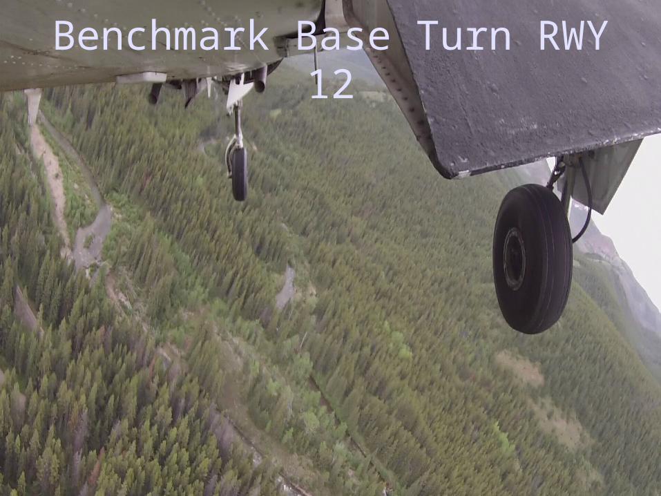
Benchmark Base Turn RWY 12

Benchmark Final RWY 12

Benchmark to Meadow Creek
49 NM
Mon.-Tues. June 22nd & 23rd Benchmark (3U7)
Wednesday June 24th Meadow Creek (0S1)

June 25th (Wednesday) Benchmark to Meadow
Creek (0S1)
Morning launch for Meadow Creek (0S1)• Plan to arrive by
10am.• 49 NM VFR route,
cross Continental Divide then north along South Fork River
Not for Navigation

Meadow Creek

Meadow Creek Layout
Meadow Creek Airfield (0S1)2830’ x 100’ turfElev: 3984’Rwy: 17/35
Campsites and fire pit at NW cornerOuthouse between runway and Harrison Creek
Trail to Meadow Creek Trailhead is located off the south end of the strip. Approximately 45 minute walk. Bring water shoes for this hike.
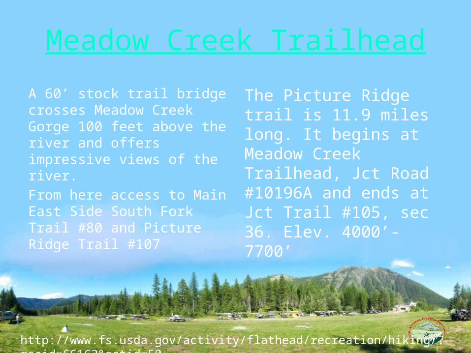
Meadow Creek Trailhead
A 60’ stock trail bridge crosses Meadow Creek Gorge 100 feet above the river and offers impressive views of the river.
From here access to Main East Side South Fork Trail #80 and Picture Ridge Trail #107
The Picture Ridge trail is 11.9 miles long. It begins at Meadow Creek Trailhead, Jct Road #10196A and ends at Jct Trail #105, sec 36. Elev. 4000’-7700’
http://www.fs.usda.gov/activity/flathead/recreation/hiking/?recid=66162&actid=50

Meadow Creek to Kalispell City &
Schaefer Meadow
55 NM67 NM
Wednesday June 24th Meadow Creek (0S1)
Thursday June 25th Kalispel City (S27)Fuel & Provisions
Thursday June 25th Schaefer Meadow (8U2)

June 26th (Thursday)Meadow Creek to Kalispell City (S27)
Morning launch for Kalispell City for provisions and fuel.• Plan to arrive by 8 am.• 55 NM VFR route north along South
Fork River & Hungry Horse Reservoir.• Grocery store Rosauers (open at
5am) and fuel on field
Not for Navigation

June 26th (Thursday)Kalispell City to Schaefer Meadow (8U2)
Morning launch for Schaefer Meadow• Plan to arrive by
10am.• 67 NM VFR route
from West Glacier south along Middle Fork River
Not for Navigation

Schaefer Meadow Layout
USFS Housing
Camp sites
Tie down area
Schaefer Meadow (8U2)3200’ x 60’ turfElev: 4856’Rwy: 7/25

Flotilla Lake Hike
There is essentially zero elevation change from the airstrip to Scott Lake. The hike is 5.5 miles one way. The trail is great and well marked. I would bring a handheld GPS to mark your hike as you go along just so you feel comfortable. There are trail maps available.
44 NM
Scott Lake
Flotilla Lake
Schaefer Meadow

Schaefer Meadow to Ryan Field
44 NM
Thursday June 25th Schaefer Meadow (8U2)
Fri.-Sun. June 27th – 29th Ryan Field (2MT1)

June 27th (Friday)Schaefer Meadow to Ryan Field (2MT1)
Morning launch for Ryan Field• Plan to arrive by
10am.• 44 NM VFR route
north along Middle Fork River toward West Glacier
Not for Navigation

Ryan Field Approach From SW
Ryan FieldIf runway is visible on downwind to RWY 15, you’re probably too high.

Ryan FieldLeft Base RWY 15
Avoid flying north of highway as helicopter traffic follows the river.

Ryan Field Final RWY 15 (don’t be this high!)

RYAN FIELD FLY-IN
2500 x 65 ft.
Elevation: 3660 ft
Runway 15/33
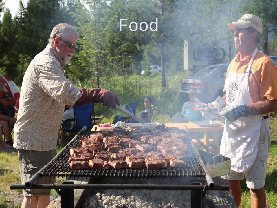
Food

Planes

Music

Fun

Hiking

Shelter

Friends

Ryan Field Amenities & Activities
• 24’ X 30’ camping shelter with wood cook stove and wood supply
• Large outdoor masonry BBQ with grill
• Picnic tables & fire pit• Level, grassy tent camping sites• Regulation sized horseshoe pits
with shoes and game instructions• Vault toilet• Drinking water is available at the
caretaker’s house.
• Three steel food storage containers
• Several hiking trails to nearby overlooks as well as to West Glacier
• Courtesy Car• White water rafting information
(customer pick up and return)• Menu for Belton Chalet
restaurant in West Glacier (excellent food and drink)See http://theraf.org/ryan-field-pilot-info for complete details

FLYING THE BACKCOUNTRY

Backcountry Flying Ethics
• Keep the noise signature of the aircraft to a safe minimum. • Practice “leave no trace” camping. Fly it in, fly it out. • Avoid very early morning departures unless safety of flight
demands a deviation.• Do not use wilderness airstrips for training purposes.• Keep the aircraft clean of noxious weed seed.
Remember that the example we set through our actions as aviators could greatly contribute to (or detract from) the non-flying public’s perceptions and views of aviation.

Mountain Flying
• Have charts available and be familiar with the route, especially when flying canyons.
• Avoid flying high DA or high winds (i.e. fly in the mornings or evening hours)
• Fly on the upslope side of canyons.• Approach ridges at a 45-degree angle.• Tie down your cargo. You don’t want it visiting you if you encounter
rough air.• Fly slow. This will reduce your noise signature and help you in the event
you need a make a 180 in a dead-end canyon.• Enjoy the scenery!

Communicate
• Flying safely in the mountains requires constant vigilance.
• Unless a different frequency is published, use backcountry radio 122.9.
• Make periodic position reports.
Johnson Creek Accident on June 28th, 2013. Two aircraft collide on short final. 3 adults injured and one infant killed.

Before Takeoff
• Walk the airstrip looking for hazards and mark the halfway point.
• Don’t startup with your AC near other tents. Others will be glad to help you reposition.
• Avoid prolonged run-ups. Become proficient in doing this while taxing for takeoff.

Takeoff
• During the TO run you should be at 70% of Vr by midfield. If not, abort.
• Stay in ground effect to achieve Vx
• Many strips are tree constrained and the winds may shift above or beyond the tree line

Approach to Landing
• Know the airfield environment before you get there. Study using Google Earth.
• Note whether this is a one-way strip and if there is a go-around option.
• Approach the field at pattern altitude. Don’t circle down from above.

Use the spot landing technique, touching down short and at the slowest possible airspeed.• At higher DAs your groundspeed will be
higher than you’re used to seeing.• Don’t be fooled by this and slow down.• V speeds are the same IAS no matter what
DA you’re flying.
Landing

After Landing
• Clear the runway but avoid taxing in areas where the ground state is unknown.
• Shut down if necessary and walk the route. You don’t want a bent prop, here especially.

THINGS TO SEE

The Chinese Wall

PREPARATIONS

Flight ReadinessThings you can do to prepare
• Practice slow flight and stalls• Know the minimum controllable airspeed of
your aircraft in all configurations• Practice 45 degree bank turns• Practice spot landings• Go to a grass strip and measure your takeoff
roll and landing distances

Pack Light!
Remember we will be operating at density altitudes that most of us are not used to flying.• The single most important thing you can do
to combat DA is to lighten your load: cargo, fuel, or people.
• Make multiple trips if necessary

Survival KitWater Purifier
Fisherman’s Vest
Survival Manual
Compass
Wool Cap
Plastic Leaf Bags
Whistle
Rescue Blanket
Toilet Tissue
Knife
Waterproof Matches
Fire Starter Kit (Vaseline Impregnated Cotton Balls)
Signal Mirror
Snare Wire (50’ 24-AWG)
Fish Hooks
Saw
Flashlight
Nylon cord or rope (50’)
+
http://www.mountaincanyonflying.com/survival.html

Personal Locator Beacon
Delorme inReach• SOS Function activates
Search & Rescue• Bread Crumbs
– Others can track your progress.
• Two-way text– Keep others advised of your
status– Receive WX information

WX
Many of the places you will be don’t have terrestrial communications networks.
In such places, the only option is some form of satellite based solution.
The Garmin 696 is a great option. If you don’t own one, perhaps you can borrow one for your trip.
Another option is to use you’re a two-way satellite text service to ask a friend to send you WX information.
Don’t forget 800-WX-BRIEF if you’re someplace with a landline.
Garmin 696 with XM
subscription

Storing Food in Grizzly CountryStore ALL food, including canned food and beverages, garbage, pet food and toiletries such as soap and toothpaste in a bear resistant manner.
None of these materials shall be buried, discarded, or burned in an open campfire. Fly it in… Fly it out!
http://www.fs.usda.gov/
Mountain Flying Online Resources
• AOPA Pilot Resources – Mountain Flying:
http://www.aopa.org/Pilot-Resources/PIC-archive/Mountain-Flying
• AOPA Air Safety Institute Mountain Flying Course:
http://flash.aopa.org/asf/mountainflying/html/flash.cfm?
• FAA AIM section 7-5-6 Mountain Flying:
http://www.faa.gov/air_traffic/publications/atpubs/aim/aim0705.html
• Mountain Airdance Flight Instruction:
http://www.mountainairdancellc.com/
• Montana Pilots Association: http://www.montanapilots.org
• Idaho Aviation Association: http://idahoaviation.com

THANK YOU