Embed Size (px)
Citation preview
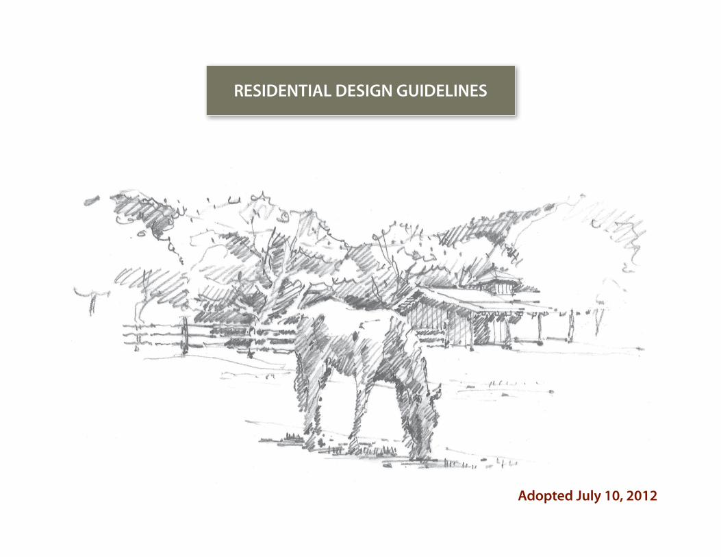
RESIDENTIAL DESIGN GUIDELINES
Adopted July 10, 2012

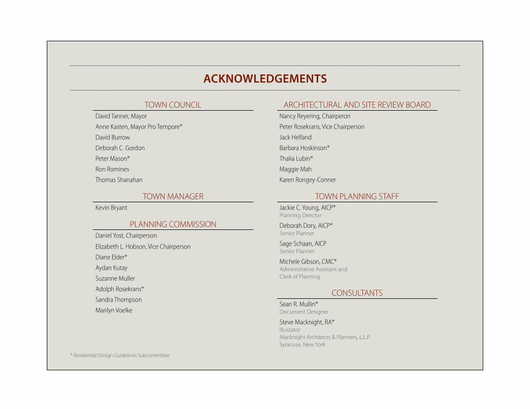
TOWN COUNCILDavid Tanner, Mayor
Anne Kasten, Mayor Pro Tempore*
David Burrow
Deborah C. Gordon
Peter Mason*
Ron Romines
Thomas Shanahan
TOWN MANAGERKevin Bryant
PLANNING COMMISSIONDaniel Yost, Chairperson
Elizabeth L. Hobson, Vice Chairperson
Diane Elder*
Aydan Kutay
Suzanne Muller
Adolph Rosekrans*
Sandra Thompson
Marilyn Voelke
ARCHITECTURAL AND SITE REVIEW BOARDNancy Reyering, Chairperon
Peter Rosekrans, Vice Chairperson
Jack Helfand
Barbara Hoskinson*
Thalia Lubin*
Maggie Mah
Karen Rongey-Conner
TOWN PLANNING STAFFJackie C. Young, AICP* Planning Director
Deborah Dory, AICP* Senior Planner
Sage Schaan, AICPSenior Planner
Michele Gibson, CMC* Administrative Assistant and Clerk of Planning
CONSULTANTSSean R. Mullin*Document Designer
Steve Macknight, RA*IllustatorMacknight Architects & Planners, L.L.P.Syracuse, New York
AckNowLEDGEmENTS
* Residential Design Guidelines Subcommittee

i i i
T O W N O F W O O D S I D E RESIDENTIAL DESIGN GUIDELINES
INTRODUCTIONCOM
MUNITY
CHARACTERSITE
PLANNINGBUILDING
DESIGNLANDSCAPE ELEM
ENTSAPPENDICES
i v
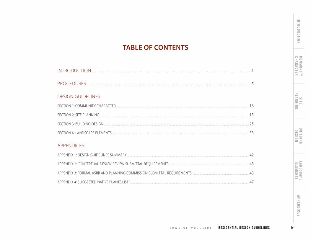
INTRODUCTION .....................................................................................................................................................................................................................1
PROCEDURES ...........................................................................................................................................................................................................................5
DESIGN GUIDELINES
SECTIoN 1: CoMMuNITY CHARACTER ................................................................................................................................................................................. 13
SECTIoN 2: SITE PLANNING ....................................................................................................................................................................................................... 15
SECTIoN 3: BuILDING DESIGN ................................................................................................................................................................................................. 25
SECTIoN 4: LANDSCAPE ELEMENTS ...................................................................................................................................................................................... 33
APPENDICES
APPENDIx 1: DESIGN GuIDELINES SuMMARY................................................................................................................................................................... 42
APPENDIx 2: CoNCEPTuAL DESIGN REVIEw SuBMITTAL REquIREMENTS ........................................................................................................... 43
APPENDIx 3: FoRMAL ASRB AND PLANNING CoMMISSIoN SuBMITTAL REquIREMENTS ........................................................................... 43
APPENDIx 4: SuGGESTED NATIVE PLANTS LIST ................................................................................................................................................................ 47
TAbLE of coNTENTS

v

T O W N O F W O O D S I D E RESIDENTIAL DESIGN GUIDELINES
INTRODUCTIONCOM
MUNITY
CHARACTERSITE
PLANNINGBUILDING
DESIGNLANDSCAPE ELEM
ENTSAPPENDICES
1
INTRODUCTION
THE wooDSIDE ENVIRoNMENT .......................................................................................................................................................................................................... 2
PuRPoSE ........................................................................................................................................................................................................................................................... 2
RELATIoNSHIP BETwEEN GuIDELINES, THE GENERAL PLAN, THE MuNICIPAL CoDE ............................................................................................... 3
INTRoDUcTIoN

2 I n t r o d u c t i o n
PurPosePurpose
The principal goal of these Guidelines is to advise homeowners and de-
signers about ways to locate and design development that maintains the
character of the community and the natural setting. The essence of the
Woodside community derives, in part, from an acknowledgement that pro-
tecting the natural environment is paramount. In some cases, there will be
conflict between guidelines on a particular site. Through the Conceptual
Review process, applicants will be able to discuss and prioritize guidelines
specific to their individual property, but the overall development design
must be sensitive to the natural environment.
The building styles and trends in Woodside have evolved over time. The
Residential Design Guidelines have been crafted by the community to en-
sure quality development which is integrated into the fabric of the Town.
In some cases, there are existing structures that do not meet the current
Residential Design Guidelines; accordingly, applicants should design new
structures to meet these Guidelines rather than pointing to examples of
structures in the Town that do not.
The Guidelines are to be used by homeowners and their designers to assist
in preparing proposals for residential development. The Guidelines will be
used by Woodside’s Planning Department, Architectural and Site Review
Board (ASRB), and Planning Commission to evaluate the merits of a residen-
tial proposal.
INTRoDUcTIoN
The Woodside environmenTThe Woodside Environment
The Town of Woodside was incorporated in 1956. In 1958, the first Wood-
side General Plan was adopted with the stated purpose to “maintain Wood-
side as a rural residential community.” The current General Plan adopted in
2012 continues this community aspiration.
Woodside is comprised of eleven square miles and includes rolling wood-
lands east of Interstate 280, a rural valley of oaks and grasslands, and red-
wood forest of the western coastal range. Within these natural habitats,
there are approximately 2,000 existing homes. The majority of these homes
occupy large lots, ranging from 1 to 5 acres, where most of the improve-
ments blend into the native terrain and vegetation. It is the desire of the
community to design structures and property improvements with respect
for the natural setting.
The peaceful rural character of Woodside makes it a desirable place to live.
It is a goal of these Guidelines to perpetuate and enhance the harmoni-
ous relationship between Woodside’s natural beauty and the manmade
environment by careful integration of homes and accessory structures into
the natural landscape. It is also a goal of these Guidelines to perpetuate
Woodside’s heritage by preserving, protecting, and enhancing its historical,
architectural, and aesthetic resources. Woodside encourages a harmoni-
ous mixture of old and new. By allowing sensitive change, the Town’s rural
character, integrity, and sense of place are preserved.
T O W N O F W O O D S I D E RESIDENTIAL DESIGN GUIDELINES
INTRODUCTIONCOM
MUNITY
CHARACTERSITE
PLANNINGBUILDING
DESIGNLANDSCAPE ELEM
ENTSAPPENDICES
3
INTRODUCTION
relaTionshiP beTWeen residenTial design guidelines, The general Plan, and Woodside municiPal code
Relationship between Guidelines, The General Plan, The Municipal Code
The Residential Design Guidelines, General Plan, Zoning Ordinance, Site
Development Ordinance, and Specific Plans provide guidance which, if fol-
lowed by an applicant, allows Woodside's decision makers to act favorably
on a development proposal, with minimum delay or associated costs, be-
cause the applicant's proposal represents an appropriate addition to the
Woodside community.
The General Plan is a general planning guide for the future development
of Woodside. It contains goals for the preservation and enhancement of
Woodside as "a scenic, rural residential community". These Design Guide-
lines suggest ways of locating and designing a home that achieve those
goals.
The Zoning Ordinance (Chapter 153 of the Woodside Municipal Code) con-
tains regulations to promote and protect the public health, safety, peace,
comfort, convenience and general welfare of Woodside residents.
The Site Development Ordinance (Chapter 151 of the Woodside Municipal
Code) has been adopted by Woodside to "protect public and private lands
from erosion, earth movement, flooding and degradation of water quality
and ensure the maximum preservation of the natural and scenic character
of the Town.” The Site Development Ordinance was also adopted "to ensure
that site development work on each site relates harmoniously to adjacent
lands and minimizes physical problems which could result in safety hazards
and increased maintenance costs.”
The Residential Design Guidelines were developed to be consistent with
the goals and policies of Woodside's General Plan and the regulations con-
tained in the Municipal Code, which change from time to time. Should any
conflict arise between these Design Guidelines and those goals, policies
and regulations, the General Plan and Municipal Code shall prevail.
In addition, there are Specific Plans for two neighborhoods: the Glens
neighborhood (located east of Cañada Road), and the Emerald Lake Hills
neighborhood (located in northernmost Woodside to the northwest of Jef-
ferson Avenue). Applicants should review these Plans if their property is
located in one of these neighborhoods.
For some projects it will be necessary for the applicant to demonstrate
compliance with applicable State regulations, such as projects with pro-
posed impacts to endangered species, or projects which impact structures
with potential eligibility for historical listing (CEQA).
4 I n t r o d u c t i o n
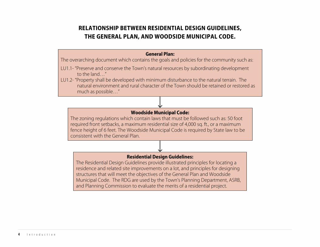
RELATIONSHIP BETWEEN RESIDENTIAL DESIGN GUIDELINES,THE GENERAL PLAN, AND WOODSIDE MUNICIPAL CODE.
General Plan:The overarching document which contains the goals and policies for the community such as:
LU1.1- “Preserve and conserve the Town’s natural resources by subordinating development to the land…” LU1.2- “Property shall be developed with minimum disturbance to the natural terrain. The natural environment and rural character of the Town should be retained or restored as much as possible…”
Residential Design Guidelines:The Residential Design Guidelines provide illustrated principles for locating a residence and related site improvements on a lot, and principles for designing structures that will meet the objectives of the General Plan and Woodside Municipal Code. The RDG are used by the Town’s Planning Department, ASRB, and Planning Commission to evaluate the merits of a residential project.
Woodside Municipal Code:The zoning regulations which contain laws that must be followed such as: 50 foot required front setbacks, a maximum residential size of 4,000 sq. ft., or a maximum fence height of 6 feet. The Woodside Municipal Code is required by State law to be consistent with the General Plan.
T O W N O F W O O D S I D E RESIDENTIAL DESIGN GUIDELINES
INTRODUCTIONCOM
MUNITY
CHARACTERSITE
PLANNINGBUILDING
DESIGNLANDSCAPE ELEM
ENTSAPPENDICES
5
INTRODUCTION
How To uSE THIS DoCuMENT ............................................................................................................................................................................................................. 6
APPLICABILITY ............................................................................................................................................................................................................................................... 6
DEVELoPMENT REVIEw PRoCESS ........................................................................................................................................................................................................ 8
PRocEDURES
6 P r o c e d u r e s
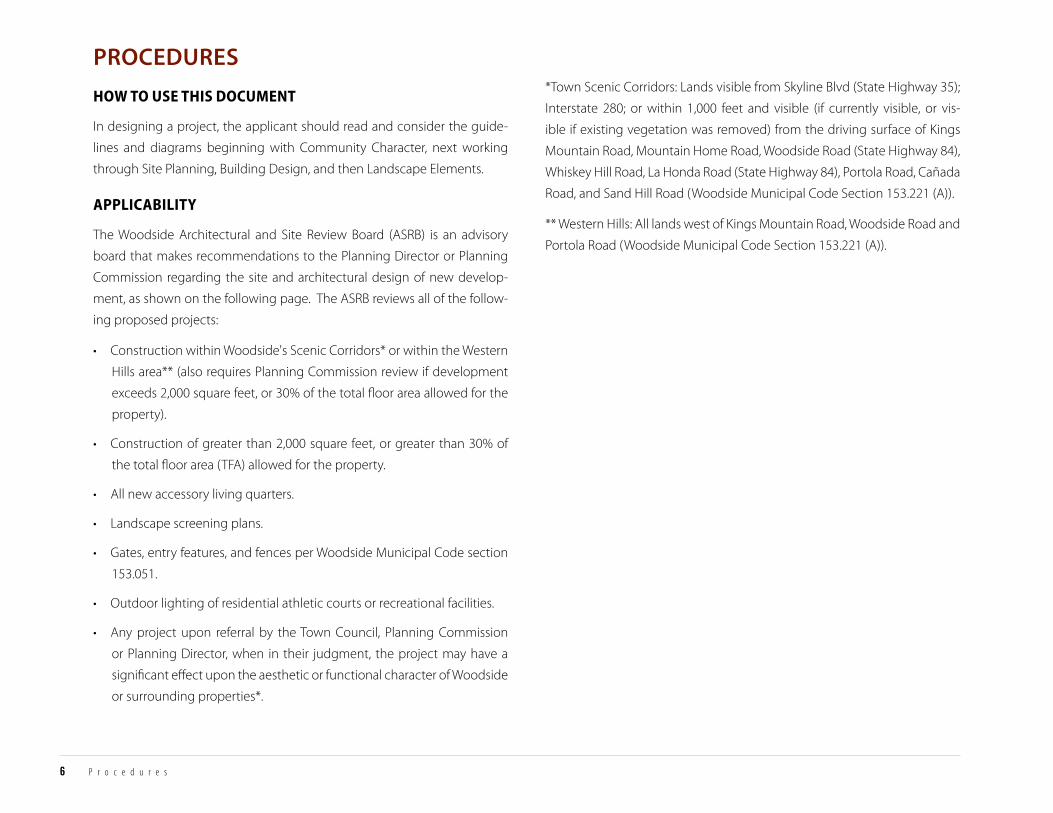
*Town Scenic Corridors: Lands visible from Skyline Blvd (State Highway 35);
Interstate 280; or within 1,000 feet and visible (if currently visible, or vis-
ible if existing vegetation was removed) from the driving surface of Kings
Mountain Road, Mountain Home Road, Woodside Road (State Highway 84),
Whiskey Hill Road, La Honda Road (State Highway 84), Portola Road, Cañada
Road, and Sand Hill Road (Woodside Municipal Code Section 153.221 (A)).
** Western Hills: All lands west of Kings Mountain Road, Woodside Road and
Portola Road (Woodside Municipal Code Section 153.221 (A)).
PRocEDURES
hoW To use This documenTHow to Use this Document
In designing a project, the applicant should read and consider the guide-
lines and diagrams beginning with Community Character, next working
through Site Planning, Building Design, and then Landscape Elements.
aPPlicabiliTyApplicability
The Woodside Architectural and Site Review Board (ASRB) is an advisory
board that makes recommendations to the Planning Director or Planning
Commission regarding the site and architectural design of new develop-
ment, as shown on the following page. The ASRB reviews all of the follow-
ing proposed projects:
• Construction within Woodside's Scenic Corridors* or within the Western
Hills area** (also requires Planning Commission review if development
exceeds 2,000 square feet, or 30% of the total floor area allowed for the
property).
• Construction of greater than 2,000 square feet, or greater than 30% of
the total floor area (TFA) allowed for the property.
• All new accessory living quarters.
• Landscape screening plans.
• Gates, entry features, and fences per Woodside Municipal Code section
153.051.
• Outdoor lighting of residential athletic courts or recreational facilities.
• Any project upon referral by the Town Council, Planning Commission
or Planning Director, when in their judgment, the project may have a
significant effect upon the aesthetic or functional character of Woodside
or surrounding properties*.

Map P1: Scenic Corridors Map
±
EmeraldLakeHills
(Uninc.)
Rural Midcoast(Unincorporated)
HuddartPark
WunderlichPark
Portola Valley
Jasper Ridge(Stanford Lands)
AthertonSan MateoCounty
Redwood City
MenloPark
WOODSIDE
Sky Londa(Uninc.)
Cañada
Woodside
King
s Mou
ntain
Tripp
Woodside
M ountain HomeWhiske
y Hill
Sand Hill
Por
tola
L a HondaOld La Honda
Skyline
Skyline
S k ylin
e
Portola
·|}ÿ35
§̈¦280
·|}ÿ84
§̈¦280
§̈¦280
·|}ÿ35
·|}ÿ35
·|}ÿ84·|}ÿ84
·|}ÿ84
·|}ÿ84
Woodside
Bear Gu lch
SearsvilleLake
Bear GulchReservoir
0 0.5 10.25Miles
Scenic Roads and Highways
Town Boundary
Scenic Corridors
Western Hills
Scenic Corridor and Western Hills
Sphere of Influence
Source: Town of Woodside 7/12
T O W N O F W O O D S I D E RESIDENTIAL DESIGN GUIDELINES
INTRODUCTIONCOM
MUNITY
CHARACTERSITE
PLANNINGBUILDING
DESIGNLANDSCAPE ELEM
ENTSAPPENDICES
7
INTRODUCTION
8 I n t r o d u c t i o n
develoPmenT revieW ProcessDevelopment Review Process
1. Attend a pre-application meeting with the Planning Department.
2. Discuss project ideas with neighbors.
3. Submit a Conceptual Review Application for staff review.
4. Meet with Citizen Advisory Subcommittee(s), as directed by staff.
5. ASRB review of Conceptual Design.
6. Submit an application for Formal Design Review, after considering
feedback from staff, ASRB, and neighbors on Conceptual Design. (Staff
will review the full application for completeness before scheduling the
project for Formal Design Review).
7. Present proposed project to ASRB and or Planning Commission for
evaluation and approval.
8. Submit application(s) for Building Permit(s), after the end of any appeal
period(s).
Woodside municiPal code evaluaTion criTeriaIf the Planning Director (after receiving any required recommendation from
the Architectural and Site Review Board), or the Planning Commission (if ap-
plicable) can meet all four evaluation criteria, the project shall be approved
(ref. WMC 153.227).
1. community character
That the project is designed in a manner that is in keeping with and
contributes to the rural character and aesthetics of the Town, respects the
character of scenic corridors and vistas, and supports equestrian facilities
where applicable.
2. site Planning
That the site plan is designed in a manner which preserves natural features,
respects and preserves the Town’s rural residential character, considers safe
circulation, neighborhood compatibility, fire safety, and sustainability.
3. building design
That the architectural design is consistent with the Town’s rural character
and development patterns; is architecturally cohesive and understated;
that the materials, color, and details are well-composed and understated;
and that the architectural design is fire safe and sustainable.
4. landscape elements
That the landscape design minimizes grading, preserves natural and scenic
features; that the planting design respects existing native and mature
vegetation and is informal in design; that the fencing and entry features are
open and rural in design; that exterior lighting is minimized; and that the
landscape design is fire safe and sustainable.

T O W N O F W O O D S I D E RESIDENTIAL DESIGN GUIDELINES
INTRODUCTIONCOM
MUNITY
CHARACTERSITE
PLANNINGBUILDING
DESIGNLANDSCAPE ELEM
ENTSAPPENDICES
9
INTRODUCTION
ASRB Review
1. Attend Pre-Application Meeting with Planning Department(Discussion of project goals, zoning interpretations, Residential Design Guidelines,
and other applicable documents with staff )
4. ASRB Review of Conceptual Design (public meeting)
3. Applicant Meets with Citizen Advisory Subcommittee(s), if Applicable (Such as Open Space Subcommittee, Trails Subcommittee)
6. Submit Application for Building and Site Development Permit(s)
Planning Director DeterminesNo Discretionary Review is Required(such as, permits for interior remodel,
re-roof, small addition that is not in the western hills or a scenic corridor)
Project is Approved with Conditions and No Formal Design Review is Required
(such as, minor remodels and minor additions)
develoPmenT revieW Process
Town Council Decision(public meeting)
Planning Director Decision (10 Day Appeal Period)
Planning Commission Decision (10 Day Appeal Period)(public meeting)
ASRB Review and Recommendation (public meeting)
Appeal No Appeal
Appeal No Appeal
ASRB Review and Recommendation (public meeting)
Town Council Decision (public meeting)
Planning Commission Decision(10 Day Appeal Period, plus CEQA)
(public meeting)
Initial Study and CEQA Documentation Prepared and Routed, if Necessary
No Appeal Appeal
ASRB & Planning Commision Review
(If Approved)
2. Staff Review of Conceptual Review Application for Completeness(refer to Appendix 2 for submittal requirements)
5. Submit Application for Formal Design Review(refer to Appendix 3 for submittal requirements)

10
T O W N O F W O O D S I D E RESIDENTIAL DESIGN GUIDELINES
INTRODUCTIONCOM
MUNITY
CHARACTERSITE
PLANNINGBUILDING
DESIGNLANDSCAPE ELEM
ENTSAPPENDICES
11
DESIGN GUIDELINES
SECTION 1: COMMUNITY CHARACTERINTRoDuCTIoN ..................................................................................................................................13
1. RuRAL CHARACTER AND CoMMuNITY AESTHETICS ................................................13
2. SCENIC CoRRIDoRS AND VISTAS ..........................................................................................14
3. NATuRAL ENVIRoNMENT .........................................................................................................14
4. EquESTRIAN LIFESTYLE .............................................................................................................14
SECTION 2: SITE PLANNING INTRoDuCTIoN ..................................................................................................................................15
1. SITE CoNSTRAINTS AND FEATuRES ....................................................................................15
2. NATuRAL FEATuRE CoNSERVATIoN ...................................................................................18
3. SITE uSAGE AND BuILDING SITING .....................................................................................19
4. SITE CIRCuLATIoN ........................................................................................................................20
5. NEIGHBoRHooD AND CoMMuNITY CoMPATIBILITY ...............................................21
6. FIRE SAFE DESIGN .........................................................................................................................22
7. SuSTAINABILITY.............................................................................................................................23
SECTION 3: BUILDING DESIGNINTRoDuCTIoN ..................................................................................................................................25
1. SETTING AND ARCHITECTuRAL STYLE ..............................................................................25
2. BuILDING FoRM ............................................................................................................................26
3. MATERIALS, CoLoR, AND DETAILS .......................................................................................29
4. FIRE SAFETY .....................................................................................................................................31
5. SuSTAINABILITY.............................................................................................................................32
SECTION 4: LANDSCAPE ELEMENTSINTRoDuCTIoN ..................................................................................................................................33
1. GRADING, DRAINAGE , AND HARDSCAPE ........................................................................33
2. PLANTING DESIGN .......................................................................................................................34
3. FENCES ...............................................................................................................................................36
4. ENTRY FEATuRES ...........................................................................................................................38
5. LIGHTING .........................................................................................................................................39
6. FIRE SAFE DESIGN .........................................................................................................................40
7. SuSTAINABILITY.............................................................................................................................40

12 C o m m u n i t y C h a r a c t e r
T O W N O F W O O D S I D E RESIDENTIAL DESIGN GUIDELINES
INTRODUCTIONCOM
MUNITY
CHARACTERSITE
PLANNINGBUILDING
DESIGNLANDSCAPE ELEM
ENTSAPPENDICES
13
COMM
UNITY CHARACTER
SECTION 1: COMMUNITY CHARACTERSection 1: Community Character
inTroducTionIntroduction
Woodside is committed to preserving the rural residential character of the
Town. This section addresses the Town’s natural and built environment as
viewed from roads, scenic corridors, trails, and adjacent properties. Each
development project impacts the neighborhood, as well as the fabric of the
community as a whole. The Community supports quality architectural and
site design that is consistent with community expectations (ref. GP-4).
1. rural characTer and communiTy aesTheTics1. Rural Character and Community Aesthetics
Properties shall be developed in a manner that is in keeping with the rural
character and aesthetics of the Town.
a. Town character and values
The Woodside Community is dedicated to preserving and enhancing
the Town’s character as a rural, scenic, unique, and historic community
(ref. GP-1 & GP LUE-2).
b. natural terrain
Properties should be developed with minimum disturbance to the natural
terrain (ref. GP LU1.2).
c. built environment
The built environment should be subordinate, sensitive, and complemen-
tary to the natural environment and specific site conditions in order to mini-
mize disturbance to terrain, conserve natural resources, and protect open
space (ref. GP-4).
d. natural setting
Ensure that the scale of buildings, the siting of structures, and the design and
materials of construction are harmonious with the natural setting so that
the visual quality of open spaces is not unreasonably impaired (ref. GP OS1.1.4).
e. equestrian lifestyle
The Woodside Community recognizes and supports the equestrian heri-
tage, lifestyle, and facilities as unique and defining attributes of the Town
(ref. GP-2).
f. Project impacts
Homeowners wishing to develop their property should communicate with
adjacent neighbors to discuss plans and project goals. Projects should be
designed with consideration of offsite impacts both during and after con-
struction. (ref. GP-9).
g. resource conservation
The Woodside Community seeks to be a good steward of the land by pro-
moting the conservation of resources and utilizing sustainable practices
which recognize the connection to, and interdependence with, the envi-
ronment (ref. GP-10).

14 C o m m u n i t y C h a r a c t e r
2. scenic corridors and visTas2. Scenic Corridors and Vistas
Properties shall be developed in a manner which respects the character of
scenic corridors and vistas.
a. natural hillsides and wooded areas
Preserve the natural hillsides and wooded areas so that development is per-
ceived as natural and rural (ref. GP LUE-6).
b. scenic corridors
Maintain and enhance the natural environment, preserve open space, and
design with sensitivity along scenic corridors. Consider the cumulative im-
pacts of development along a scenic corridor, particularly as viewed both
onto and through the property from the road and trails (ref. GP OS1.5.1).
c. vistas and views
When designing new structures, respect vistas from adjacent properties
toward the Western Hills, the bay, and valleys. Protect vistas of the West-
ern Hills by designing structures that blend into the hillside and woodlands
(ref. GP LUE-4).
3. naTural environmenT3. Natural Environment
Properties shall be developed in a manner that preserves natural features.
a. natural features
The Woodside Community seeks to preserve, enhance, and restore the
Town’s riparian corridors, woodlands, significant stands of native vegeta-
tion, hillsides, other areas of special ecological significance, wildlife and
natural habitats (ref. GP-3 & GP OS1.1).
b. rural character
Development should be in harmony with the rural character of the Town.
Optimize opportunities to preserve open space through imaginative plan-
ning, good conservation practices and, where appropriate, the dedication
of open space, conservation, trails, or scenic easements (ref. GP OS1.1 & GP LU1.1).
4. equesTrian lifesTyle4. Equestrian Lifestyle
Properties shall be developed in a manner which preserves and supports
equestrian facilities and the Woodside trails network.
a. equestrian heritage
Protect the Town’s equestrian heritage by preserving and enhancing the
equestrian trail system, and by encouraging and preserving equestrian fa-
cilities (ref. GP CL4.1).
b. visibility of equestrian facilities
The visibility of equestrian facilities is an important component of the rural
character of the Town (ref. GP LU1.2.6).
T O W N O F W O O D S I D E RESIDENTIAL DESIGN GUIDELINES
INTRODUCTIONCOM
MUNITY
CHARACTERSITE
PLANNINGBUILDING
DESIGNLANDSCAPE ELEM
ENTSAPPENDICES
15
SITE PLANNING
SECTION 2: SITE PLANNINGSection 2: Site Planning
inTroducTionIntroduction
Site Planning is the initial design activity. It requires the preparation of an
inventory of on-site and off-site conditions, an analysis of development op-
portunities and constraints, and the preparation of a diagrammatic design
study of optimum locations, orientations, and configurations for buildings,
driveways, yards, agricultural or equestrian uses, and conservation areas.
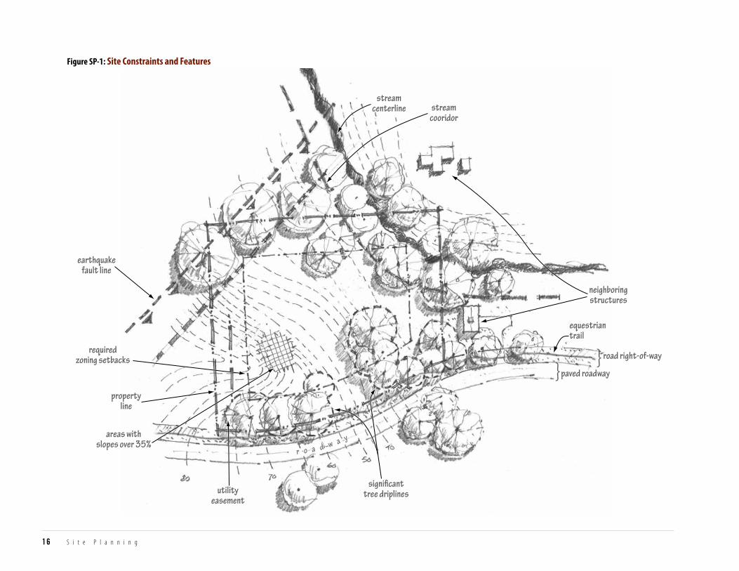
1. siTe consTrainTs and feaTures1. Site Constraints and Features
Building location and site improvements shall be based on a clear
understanding of the property’s natural features, regulatory constraints,
and relationships to adjacent properties.
These conditions should be mapped to form a basis for further analysis and
decision-making. Refer to Appendix 3 for formal submittal requirements.
Consider the following:
a. review development standards (ref. WMC Chapter 153)
Zoning setbacks, height regulations, total floor area limit, paved area limit,
hillside development regulations, natural state, and similar development
standards.
b. identify easements
Equestrian, open space, conservation, utility, and scenic easements
(ref. WMC 153.058 & GP OS1.2).
c. identify natural hazards
Earthquake faults, landslide hazards, flood zones, and potential fire hazards
(ref. GP NH1.1, GP NH1.3, GP NH1.6, & GP NH1.9).
d. identify natural features
Site topography showing contours, riparian and wildlife corridors, rock out-
croppings, meadows; areas with steep slopes (over 35%) that restrict devel-
opment, and other significant elements on the terrain that influence site
planning (ref. WMC Chapter 139.153 & GP LUE-3).
e. identify trees and vegetation
Significant trees and tree groupings showing drip lines. Include significant
vegetation abutting or extending over property lines that influence site
planning or that provide privacy or similar amenities to abutting properties
(ref. WMC 153.170).
f. identify historical resources and existing structures to remain
Any on-site historic resources and any existing conforming or nonconform-
ing structures that will remain (ref. WMC Chapter 153.295).
earthquakefault line
streamcooridor
streamcenterline
neighboringstructures
road right-of-way
paved roadway
equestriantrail
requiredzoning setbacks
propertyline
utilityeasement
signi�canttree driplines
areas withslopes over 35%
}}
r o a d w a y
Figure SP-1: Site Constraints and Features
16 S i t e P l a n n i n g
Preserve the views and privacyof others.
new design neighbornew design
garage andparking area onneighbor’s property
identify needfor privacy forliving spaces
privacy betweenswimming pools
neighbor
r o a d w a y
Figure SP-2: Locate Neighboring Development and Features
Figure SP-3: Identify Views and Vistas
T O W N O F W O O D S I D E RESIDENTIAL DESIGN GUIDELINES
INTRODUCTIONCOM
MUNITY
CHARACTERSITE
PLANNINGBUILDING
DESIGNLANDSCAPE ELEM
ENTSAPPENDICES
17
SITE PLANNING
g. locate utilities
Possible locations and sizes for septic fields (where applicable) given site
conditions and topography, as well as existing and future utilities connec-
tions (ref. WMC 153.050).
h. locate neighboring development and features
The location of improvements on adjacent properties that may impact
development such as residential structures (including living and private
spaces), exterior living areas, swimming pools, recreational courts, barns,
significant trees, solar collectors, etc. (ref. GP GP-9, GP LU1.2, & GP LU1.4).
i. identify vistas and views
The direction of the most desirable scenic views from the roadway to points
of interest on the site or beyond (ref. GP LUE-4 & GP LU1.4).
18 S i t e P l a n n i n g
d. Protect wildlife corridors and habitat
Protect wildlife corridors and habitat as follows: (ref. GP OS1.2)
i. Maintain or establish wildlife corridors through the property, with
particular emphasis on connecting to wildlife corridors on adjoining
properties, especially in riparian areas.
ii. Avoid habitat fragmentation by maintaining or establishing natural
areas adjacent to similar habitats on adjoining properties.
iii. Avoid fencing types and locations which negatively impact wildlife
corridors and habitat.
e. maintain vistas and views
Subordinate building location to the natural setting while limiting the vis-
ibility of residential and recreational buildings from the roadway. Maintain
visibility to hillcrests and similar natural features of the site and keep these
vistas free from development (ref. GP LU1.3, GP LUE-4, & GP OS1.5).
2. naTural feaTure conservaTion2. Natural Feature Conservation
Site development shall conserve the property’s open space, natural features,
vegetation, and wildlife by subordinating development to the site’s natural
conditions.
a. conserve topography
Conserve hillsides, knolls, native soil, and other natural features on the prop-
erty. Minimize grading for buildings and driveways by locating these facili-
ties close to and parallel with natural hillside contours (ref. GP CV1.1 & GP LU1.2).
b. Preserve trees and vegetation
Preserve and minimize development within the drip lines of significant
trees and areas of natural vegetation (ref. WMC 153.170).
c. Protect stream corridors
Stream corridors, ponds, and wetlands must be kept free of structures and
maintained in a natural condition, except to provide for erosion and flood
control measures or other uses beneficial to the water regimen (ref. GP LU1.1).
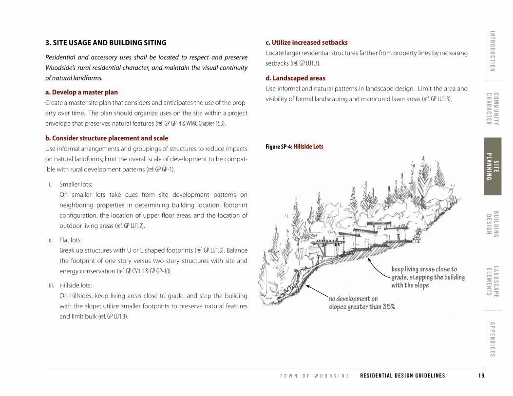
keep living areas close tograde, stepping the buildingwith the slope
no development onslopes greater than 35%
Figure SP-4: Hillside Lots
T O W N O F W O O D S I D E RESIDENTIAL DESIGN GUIDELINES
INTRODUCTIONCOM
MUNITY
CHARACTERSITE
PLANNINGBUILDING
DESIGNLANDSCAPE ELEM
ENTSAPPENDICES
19
SITE PLANNING
3. siTe usage and building siTing3. Site Usage and Building Siting
Residential and accessory uses shall be located to respect and preserve
Woodside’s rural residential character, and maintain the visual continuity
of natural landforms.
a. develop a master plan
Create a master site plan that considers and anticipates the use of the prop-
erty over time. The plan should organize uses on the site within a project
envelope that preserves natural features (ref. GP GP-4 & WMC Chapter 153).
b. consider structure placement and scale
Use informal arrangements and groupings of structures to reduce impacts
on natural landforms; limit the overall scale of development to be compat-
ible with rural development patterns (ref. GP GP-1).
i. Smaller lots:
On smaller lots take cues from site development patterns on
neighboring properties in determining building location, footprint
configuration, the location of upper floor areas, and the location of
outdoor living areas (ref. GP LU1.2).
ii. Flat lots:
Break up structures with U or L shaped footprints (ref. GP LU1.3). Balance
the footprint of one story versus two story structures with site and
energy conservation (ref. GP CV1.1 & GP GP-10).
iii. Hillside lots:
On hillsides, keep living areas close to grade, and step the building
with the slope; utilize smaller footprints to preserve natural features
and limit bulk (ref. GP LU1.3).
c. utilize increased setbacks
Locate larger residential structures farther from property lines by increasing
setbacks (ref. GP LU1.3).
d. landscaped areas
Use informal and natural patterns in landscape design. Limit the area and
visibility of formal landscaping and manicured lawn areas (ref. GP LU1.3).

swimmingpool hiddenfrom view
equestrian facilitiesvisible from roadway
r o a d w a y
Figure SP-5: Equestrian Facilities
20 S i t e P l a n n i n g
e. recreational facilities
Limit the size and visibility from roads of recreational facilities, such as pools
and sport courts (ref. GP LU1.4).
f. equestrian facilities
Locating equestrian facilities to be visible from the roadway is desirable,
where feasible. Factors to consider when siting equestrian facilities include
gentle topography, protection of mature trees and riparian corridors, health
and safety of the horses, and functionality of location (ref. GP GP-2).
g. livestock and agricultural uses
Livestock and agricultural uses should be appropriately located, propor-
tional to the site, balanced with the other desired site improvements and
uses, and considerate of adjacent properties (ref. GP LU1.4).
4. siTe circulaTion4. Site Circulation
Driveways, garages, parking areas, trails, and pathways shall be located and
designed to be safe, minimally visible from the roadway, and subordinate to
the site’s natural features.
a. Provide safe access
Provide safe vehicular, pedestrian, and equestrian access to the site. Lo-
cate driveway entry points to be visible from the road for safety yet visually
understated. Integrate emergency vehicle access and turnaround areas.
Avoid siting potentially incompatible uses, such as dog runs, along eques-
trian trails (ref. GP GP-5).
b. driveways and Parking
Where possible, locate driveways and parking areas away from public view
and neighboring properties. Consider site development patterns on neigh-
boring lots in planning garage and safe driveway locations (ref. GP LU1.2.4).
i. Larger lots:
On larger lots, design driveways to visually blend with the site’s natural
contours and reinforce its rural or natural character. Garages and
parking areas should be screened from view (ref. GP LU1.2 & GP NH1.7).
ii. Flat lots:
Minimize paving and development, and minimize visibility of parking
areas (ref. WMC 153.170 & GP NH1.7).
iii. Hillside lots:
On hillside lots, locate driveways and garages to minimize grading and
their visual impact from roadways (ref. GP LU1.2).

minimizepaving area
landscapescreening
garage doorsangled awayfrom roadway
r o a d w a y
Figure SP-6: Minimize Visibility of Driveways and Parking
T O W N O F W O O D S I D E RESIDENTIAL DESIGN GUIDELINES
INTRODUCTIONCOM
MUNITY
CHARACTERSITE
PLANNINGBUILDING
DESIGNLANDSCAPE ELEM
ENTSAPPENDICES
21
SITE PLANNING
c. minimize paving
Minimize the amount of paved coverage, and the prominence and visual
impact of parking areas, driveways, carports, and garages. Conserve trees
by minimizing paving within driplines (ref. WMC 153.170). Rural paving materi-
als, such as gravel, are preferred where feasible (ref. GP NH1.7).
d. equestrian and pedestrian trails
Extend and connect existing equestrian and pedestrian trails (ref. GP CL4.1).
Provide safe driveway crossings at trails and paths.
5. neighborhood and communiTy comPaTibiliTy5. Neighborhood and Community Compatibility
The location, scale, and orientation of site improvements shall complement
and be consistent with neighborhood and community development
patterns.
a. use compatible building size and scale
The size and scale of development projects should be compatible with the
natural site and the rural character of the community (ref. GP GP-1 & 3).
b. review placement of buildings and site improvements
The location of structures and the layout of driveways, paths, and other site
improvements should be compatible with the neighborhood (ref. GP LU1.2.4).
i. Smaller lots (ref. GP LU1.3 & GP LU1.4):
1. Preserve neighborhood harmony in smaller lot neighborhoods.
2. Relate the scale and silhouette of the proposed home to the scale
and silhouette of adjacent and nearby homes.
3. Locate the driveway and garage to minimize visibility from the
roadway, and to relate to existing neighbor patterns.
4. Create natural areas of screening between structures.
ii. Flat lots:
1. Preserve neighborhood harmony by minimizing two story
elements near adjacent homes (ref. GP LU1.4).
iii. Hillside lots:
1. Preserve the rural harmony of open hillsides by locating structures
so they do not create a silhouette against the sky when viewed
from roads and neighboring properties. Use one-story building
forms, or a mix of one and two-story building forms, to connect
the residence to the hillside (ref. GP LU1.3).
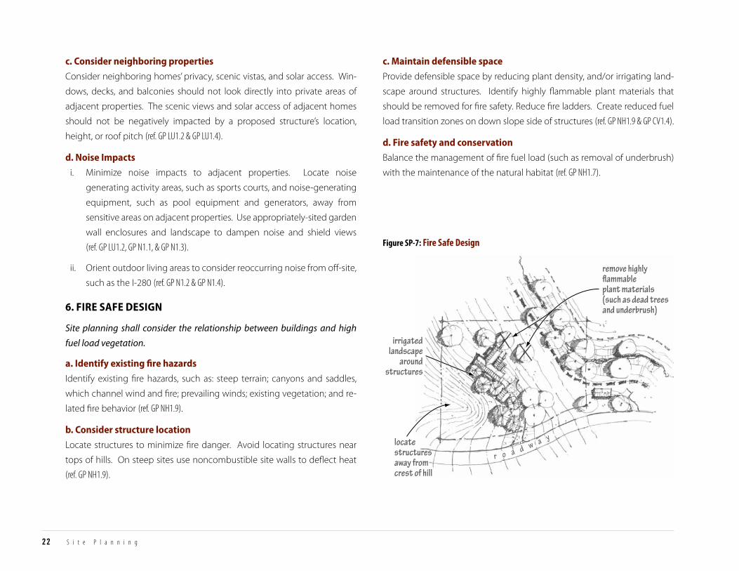
irrigatedlandscape
aroundstructures
remove highly�ammableplant materials(such as dead treesand underbrush)
locatestructuresaway fromcrest of hill
r o a d w a y
Figure SP-7: Fire Safe Design
22 S i t e P l a n n i n g
c. consider neighboring properties
Consider neighboring homes’ privacy, scenic vistas, and solar access. Win-
dows, decks, and balconies should not look directly into private areas of
adjacent properties. The scenic views and solar access of adjacent homes
should not be negatively impacted by a proposed structure’s location,
height, or roof pitch (ref. GP LU1.2 & GP LU1.4).
d. noise impacts
i. Minimize noise impacts to adjacent properties. Locate noise
generating activity areas, such as sports courts, and noise-generating
equipment, such as pool equipment and generators, away from
sensitive areas on adjacent properties. Use appropriately-sited garden
wall enclosures and landscape to dampen noise and shield views
(ref. GP LU1.2, GP N1.1, & GP N1.3).
ii. Orient outdoor living areas to consider reoccurring noise from off-site,
such as the I-280 (ref. GP N1.2 & GP N1.4).
6. fire safe design6. Fire Safe Design
Site planning shall consider the relationship between buildings and high
fuel load vegetation.
a. identify existing fire hazards
Identify existing fire hazards, such as: steep terrain; canyons and saddles,
which channel wind and fire; prevailing winds; existing vegetation; and re-
lated fire behavior (ref. GP NH1.9).
b. consider structure location
Locate structures to minimize fire danger. Avoid locating structures near
tops of hills. On steep sites use noncombustible site walls to deflect heat
(ref. GP NH1.9).
c. maintain defensible space
Provide defensible space by reducing plant density, and/or irrigating land-
scape around structures. Identify highly flammable plant materials that
should be removed for fire safety. Reduce fire ladders. Create reduced fuel
load transition zones on down slope side of structures (ref. GP NH1.9 & GP CV1.4).
d. fire safety and conservation
Balance the management of fire fuel load (such as removal of underbrush)
with the maintenance of the natural habitat (ref. GP NH1.7).

deciduous trees plantedon south side providesummmer shade, and
allow winter solar heat gain
trellis providessummer shade
solar panelsfacing south/southwest
residence orientedto bene�t from
solar energy
undergroundrain watercollection
cistern r o a d w a y
Figure SP-8: Sustainable Conditions
T O W N O F W O O D S I D E RESIDENTIAL DESIGN GUIDELINES
INTRODUCTIONCOM
MUNITY
CHARACTERSITE
PLANNINGBUILDING
DESIGNLANDSCAPE ELEM
ENTSAPPENDICES
23
SITE PLANNING
7. susTainabiliTy7. Sustainability
Site planning shall incorporate sustainable strategies to conserve and
minimize energy consumption in the construction and use of structures.
a. support reuse
Reuse existing buildings, portions of buildings, or building materials to con-
serve resources (ref. GP S2.2).
b. Preserve historic resources
Preserve historic and cultural resources which contribute to the community
fabric. Consider adaptive re-use for those buildings which cannot be pre-
served in their entirety (ref. GP S2.2).
c. consider solar design
Orient buildings to incorporate passive and active solar design features.
Placement of solar panels on roofs is preferred over ground placement. Lo-
cate solar panels away from public and neighbors’ views. Locate solar pan-
els on out buildings, accessory buildings, and agricultural buildings where
such placement reduces their visibility (ref. GP PU2.2 & GP S2.2).
d. utilize passive heating and cooling
Orient structures to take advantage of prevailing wind patterns for cooling.
Locate deciduous trees and incorporate passive measures to manage heat
gain, yet allow for solar heat gain in winter. (ref. GP PU2.2 & GP S2.2).
e. implement renewable technologies
Use renewable technologies throughout site development and building
design, such as rainwater collection, graywater systems, and geothermal
systems (ref. GP PU2.2 & GP S2.2).

24
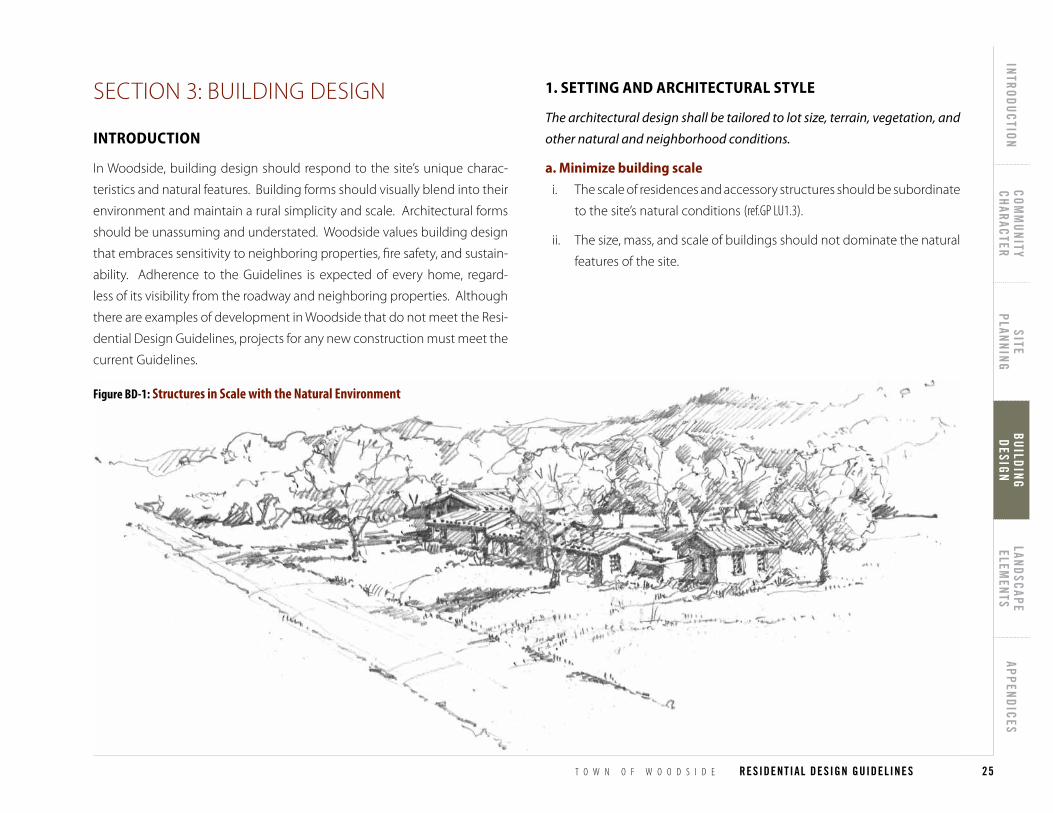
Figure BD-1: Structures in Scale with the Natural Environment
T O W N O F W O O D S I D E RESIDENTIAL DESIGN GUIDELINES
INTRODUCTIONCOM
MUNITY
CHARACTERSITE
PLANNINGBUILDING
DESIGNLANDSCAPE ELEM
ENTSAPPENDICES
25
BUILDING DESIGN
SECTION 3: BUILDING DESIGNSection 3: Building Design
inTroducTionIntroduction
In Woodside, building design should respond to the site’s unique charac-
teristics and natural features. Building forms should visually blend into their
environment and maintain a rural simplicity and scale. Architectural forms
should be unassuming and understated. Woodside values building design
that embraces sensitivity to neighboring properties, fire safety, and sustain-
ability. Adherence to the Guidelines is expected of every home, regard-
less of its visibility from the roadway and neighboring properties. Although
there are examples of development in Woodside that do not meet the Resi-
dential Design Guidelines, projects for any new construction must meet the
current Guidelines.
1. seTTing and archiTecTural sTyle1. Setting and Architectural Style
The architectural design shall be tailored to lot size, terrain, vegetation, and
other natural and neighborhood conditions.
a. minimize building scale
i. The scale of residences and accessory structures should be subordinate
to the site’s natural conditions (ref.GP LU1.3).
ii. The size, mass, and scale of buildings should not dominate the natural
features of the site.
26 B u i l d i n g D e s i g n
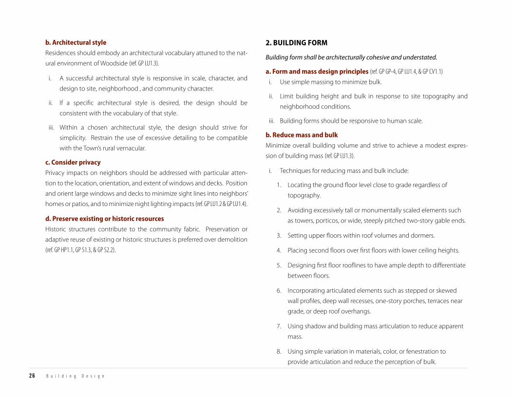
2. building form2. Building Form
Building form shall be architecturally cohesive and understated.
a. form and mass design principles (ref. GP GP-4, GP LU1.4, & GP CV1.1)
i. Use simple massing to minimize bulk.
ii. Limit building height and bulk in response to site topography and
neighborhood conditions.
iii. Building forms should be responsive to human scale.
b. reduce mass and bulk
Minimize overall building volume and strive to achieve a modest expres-
sion of building mass (ref. GP LU1.3).
i. Techniques for reducing mass and bulk include:
1. Locating the ground floor level close to grade regardless of
topography.
2. Avoiding excessively tall or monumentally scaled elements such
as towers, porticos, or wide, steeply pitched two-story gable ends.
3. Setting upper floors within roof volumes and dormers.
4. Placing second floors over first floors with lower ceiling heights.
5. Designing first floor rooflines to have ample depth to differentiate
between floors.
6. Incorporating articulated elements such as stepped or skewed
wall profiles, deep wall recesses, one-story porches, terraces near
grade, or deep roof overhangs.
7. Using shadow and building mass articulation to reduce apparent
mass.
8. Using simple variation in materials, color, or fenestration to
provide articulation and reduce the perception of bulk.
b. architectural style
Residences should embody an architectural vocabulary attuned to the nat-
ural environment of Woodside (ref. GP LU1.3).
i. A successful architectural style is responsive in scale, character, and
design to site, neighborhood , and community character.
ii. If a specific architectural style is desired, the design should be
consistent with the vocabulary of that style.
iii. Within a chosen architectural style, the design should strive for
simplicity. Restrain the use of excessive detailing to be compatible
with the Town’s rural vernacular.
c. consider privacy
Privacy impacts on neighbors should be addressed with particular atten-
tion to the location, orientation, and extent of windows and decks. Position
and orient large windows and decks to minimize sight lines into neighbors’
homes or patios, and to minimize night lighting impacts (ref. GP LU1.2 & GP LU1.4).
d. Preserve existing or historic resources
Historic structures contribute to the community fabric. Preservation or
adaptive reuse of existing or historic structures is preferred over demolition
(ref. GP HP1.1, GP S1.3, & GP S2.2).
two-story,longer portion of the buildingangled away from the roadway
one-story,shorter length of thebuilding facing the road
deep wallrecesses
ro
ad
wa
y
use shadowsto reduceapparent mass
top of ridgeundisturbed
structures locatedbelow the ridgeline
keep living areas close tograde, stepping the building
with the slope
Figure BD-3: Mass Reduction on a Hillside
Figure BD-2: Minimize Mass and Bulk
T O W N O F W O O D S I D E RESIDENTIAL DESIGN GUIDELINES
INTRODUCTIONCOM
MUNITY
CHARACTERSITE
PLANNINGBUILDING
DESIGNLANDSCAPE ELEM
ENTSAPPENDICES
27
BUILDING DESIGN
ii. Smaller lot techniques:
1. On smaller lots, design buildings to be compatible with the
height, mass, and scale of adjacent homes and neighborhood
pattern (ref. GP LU1.3).
iii. Flat lot techniques:
1. Limit the amount of mass facing the road.
2. Use predominately one-story massing, particularly when using
steeper pitched roofs.
3. Use variations in height to minimize bulk (ref. GP LU1.3).
iv. Hillside lot techniques:
1. Do not locate structures on ridgelines which silhouette against
the sky (ref. GP LU1.3).
2. Use stepped or divided massing to relate the house to the hillside;
avoid using large, monolithic masses. Use elongated building
forms that run parallel to land contours or multiple semi-detached
forms, each set close to the hillside, to limit the visual impact of
the home on the hillside. Step interior living levels as necessary
to keep floor levels close to grade, thereby minimizing skirt wall
usage and height. Use one-story building forms and terraces to
visually connect the house with the hillside (ref. GP LU1.3).
3. On some very steep hillsides with tall, mature trees, vertical
massing may be appropriate. The use of tall, thin multiple
story building forms can preserve the hillside and vegetation
(ref. GP LU1.3).
garageconnecting trellisresidence
barn
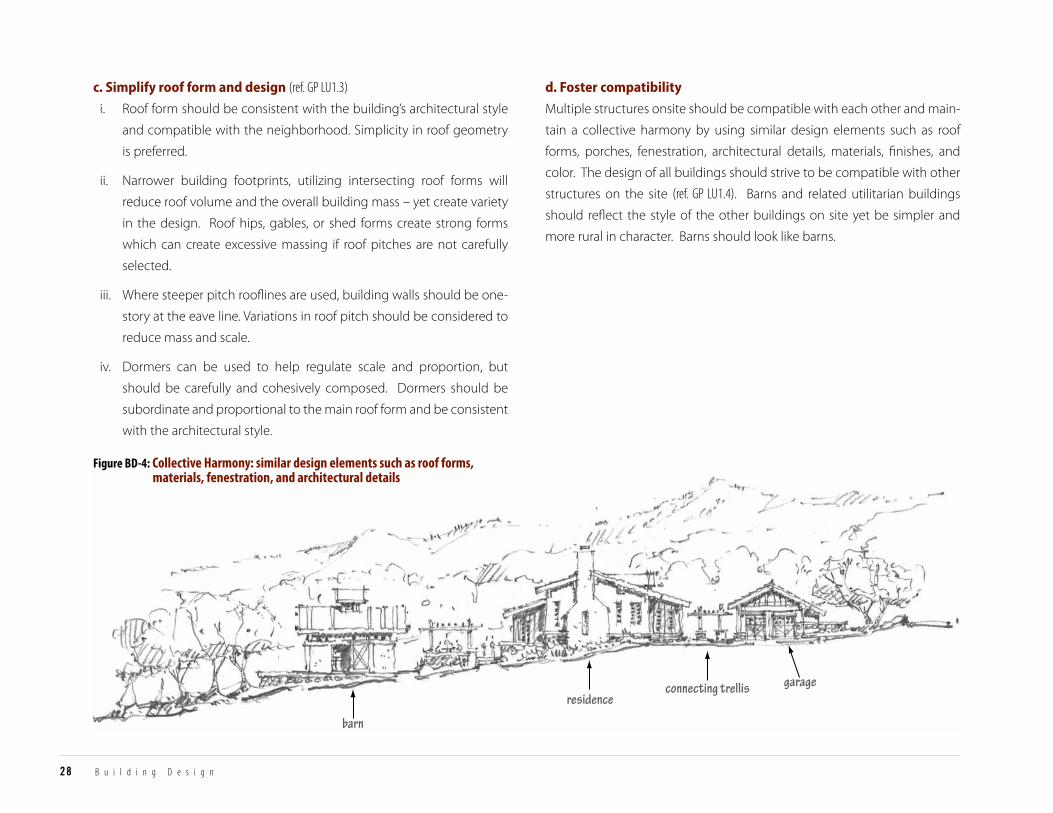
Figure BD-4: Collective Harmony: similar design elements such as roof forms, materials, fenestration, and architectural details
28 B u i l d i n g D e s i g n
c. simplify roof form and design (ref. GP LU1.3)
i. Roof form should be consistent with the building’s architectural style
and compatible with the neighborhood. Simplicity in roof geometry
is preferred.
ii. Narrower building footprints, utilizing intersecting roof forms will
reduce roof volume and the overall building mass – yet create variety
in the design. Roof hips, gables, or shed forms create strong forms
which can create excessive massing if roof pitches are not carefully
selected.
iii. Where steeper pitch rooflines are used, building walls should be one-
story at the eave line. Variations in roof pitch should be considered to
reduce mass and scale.
iv. Dormers can be used to help regulate scale and proportion, but
should be carefully and cohesively composed. Dormers should be
subordinate and proportional to the main roof form and be consistent
with the architectural style.
d. foster compatibility
Multiple structures onsite should be compatible with each other and main-
tain a collective harmony by using similar design elements such as roof
forms, porches, fenestration, architectural details, materials, finishes, and
color. The design of all buildings should strive to be compatible with other
structures on the site (ref. GP LU1.4). Barns and related utilitarian buildings
should reflect the style of the other buildings on site yet be simpler and
more rural in character. Barns should look like barns.
T O W N O F W O O D S I D E RESIDENTIAL DESIGN GUIDELINES
INTRODUCTIONCOM
MUNITY
CHARACTERSITE
PLANNINGBUILDING
DESIGNLANDSCAPE ELEM
ENTSAPPENDICES
29
BUILDING DESIGN
3. maTerials, color, and deTails3. Materials, Color, and Details
Material, color, and detail shall be used to enhance the architectural style in
a well-composed, understated manner.
a. consider building materials
Walls, roofs, as well as trim should favor natural and fire resistant materi-
als. Materials for roofs, wall surfaces, windows, railings, and other features
should be non-reflective and compatible with the natural and neighbor-
hood conditions. Simple variations in materials and finishes may be used
to define building scale and proportion (ref. GP LU1.3).
b. determine color and materials (ref. GP LU1.3)
i. Select colors and materials which fit with the natural environment, the
site, and the neighborhood. Materials which retain the appearance
of their natural finish are preferred. Lighter colors should be used in
settings where they are appropriate, such as meadows as opposed to
redwood forest.
ii. The use of lighter colors may be appropriate for structures that relate
to the historic vernacular of Woodside.
iii. Color and material choices should be consistent with the building’s
architectural style, building location, and mass. Muted colors that
complement the surrounding natural landscape are preferred.
Excessive variation in color is discouraged.
iv. Roof colors should be inconspicuous when viewed from a distance.
Select roof colors and materials that limit glare.
c. use consistent architectural details
Use design details that are consistent with the architectural style. Avoid ex-
cessive embellishment (ref. GP LU1.3).
d. utilize appropriate fenestration
i. Fenestration should be consistent with the building’s architectural
style, detailing, and materials. The arrangement of windows, doors,
and other openings should be thoughtfully composed on each façade.
ii. The size and proportion of window and door glazing panes should be
consistent across all façades (ref. GP LU1.3).
iii. Reflective glass is not permitted.
iv. The placement and size of windows and skylights, should be designed
to prevent offsite glare as seen from adjacent properties, the roadway,
and from distant views.

Figure BD-5: Exterior Lighting
30 B u i l d i n g D e s i g n
e. lighting (see landscape elements section for additional require-
ments)
Exterior building lighting should be minimized. Exterior lighting should
be designed to prevent offsite glare as seen from adjacent properties, the
roadway, and distant views (ref. GP LU1.2).
i. Light fixtures shall shield the light source from view.
ii. Lighting fixtures should be consistent with the architectural style of
the building.
iii. Avoid general area illumination and wall-washing.
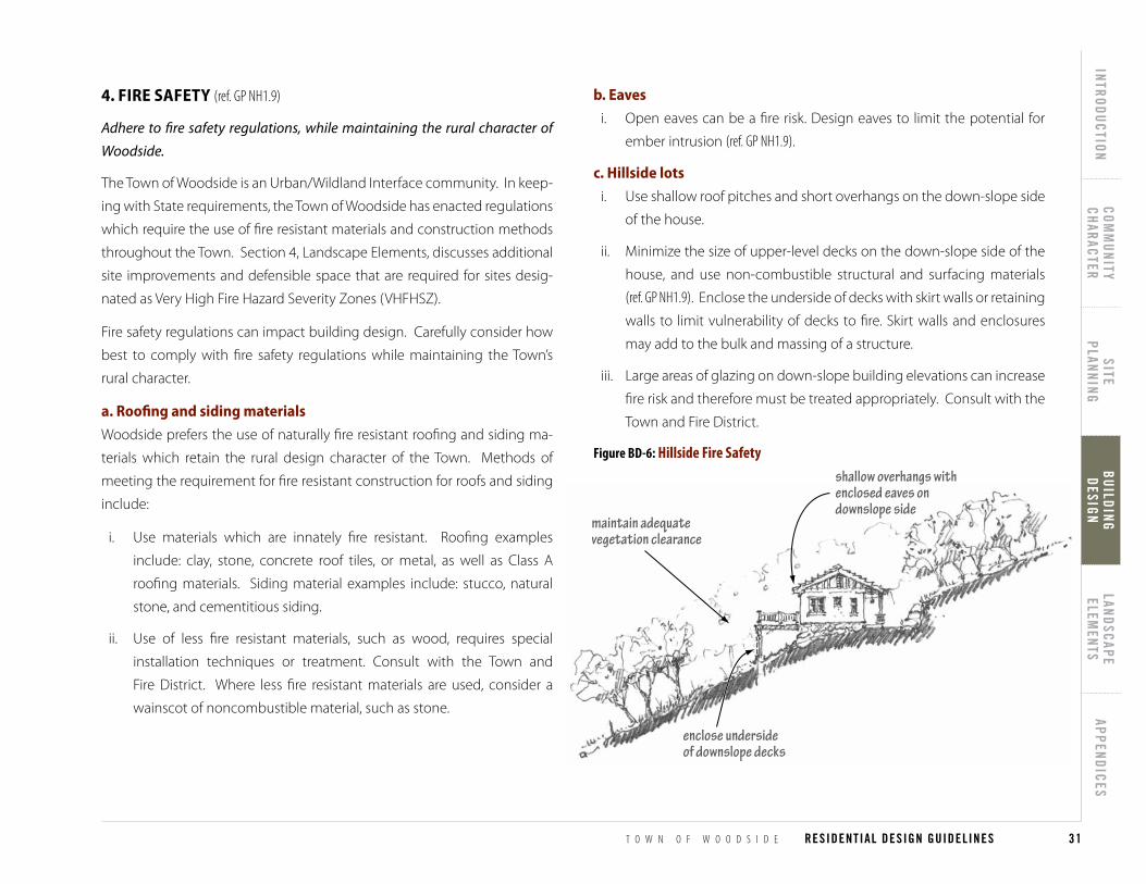
shallow overhangs withenclosed eaves ondownslope side
enclose undersideof downslope decks
maintain adequatevegetation clearance
Figure BD-6: Hillside Fire Safety
T O W N O F W O O D S I D E RESIDENTIAL DESIGN GUIDELINES
INTRODUCTIONCOM
MUNITY
CHARACTERSITE
PLANNINGBUILDING
DESIGNLANDSCAPE ELEM
ENTSAPPENDICES
31
BUILDING DESIGN
b. eaves
i. Open eaves can be a fire risk. Design eaves to limit the potential for
ember intrusion (ref. GP NH1.9).
c. hillside lots
i. Use shallow roof pitches and short overhangs on the down-slope side
of the house.
ii. Minimize the size of upper-level decks on the down-slope side of the
house, and use non-combustible structural and surfacing materials
(ref. GP NH1.9). Enclose the underside of decks with skirt walls or retaining
walls to limit vulnerability of decks to fire. Skirt walls and enclosures
may add to the bulk and massing of a structure.
iii. Large areas of glazing on down-slope building elevations can increase
fire risk and therefore must be treated appropriately. Consult with the
Town and Fire District.
4. fire safeTy (ref. GP NH1.9)4. Fire Safety
Adhere to fire safety regulations, while maintaining the rural character of
Woodside.
The Town of Woodside is an Urban/Wildland Interface community. In keep-
ing with State requirements, the Town of Woodside has enacted regulations
which require the use of fire resistant materials and construction methods
throughout the Town. Section 4, Landscape Elements, discusses additional
site improvements and defensible space that are required for sites desig-
nated as Very High Fire Hazard Severity Zones (VHFHSZ).
Fire safety regulations can impact building design. Carefully consider how
best to comply with fire safety regulations while maintaining the Town’s
rural character.
a. roofing and siding materials
Woodside prefers the use of naturally fire resistant roofing and siding ma-
terials which retain the rural design character of the Town. Methods of
meeting the requirement for fire resistant construction for roofs and siding
include:
i. Use materials which are innately fire resistant. Roofing examples
include: clay, stone, concrete roof tiles, or metal, as well as Class A
roofing materials. Siding material examples include: stucco, natural
stone, and cementitious siding.
ii. Use of less fire resistant materials, such as wood, requires special
installation techniques or treatment. Consult with the Town and
Fire District. Where less fire resistant materials are used, consider a
wainscot of noncombustible material, such as stone.
32 B u i l d i n g D e s i g n
5. susTainabiliTy5. Sustainability
Sustainable building practices shall be considered in project design.
a. integrate sustainable design
Consider the integration of sustainable design features and elements into
the building early in the design process (ref. GP Sustainability Element).
b. utilize passive heating and cooling
Building placement and massing should consider the potential for passive
heating and cooling techniques such as (ref. GP S1.2 & GP S2.1):
i. Orienting building volumes to minimize large areas of south or west
facing windows to reduce summer sun exposure.
ii. Using appropriately sized overhangs, trellises, porches, or vegetation,
such as deciduous trees, on south, southeast, and southwest facing
building sides to reduce heat gain on exposed walls and windows.
iii. Using south-facing windows unshaded in winter to maximize solar
heat gain.
iv. Using the thermal mass of floors and walls to maximize thermal
storage and moderate daily temperature swings.
v. Providing cross-ventilation by locating operable windows and
skylights to catch prevailing breezes.
c. specify sustainable building materials
Specify recycled, sustainably harvested, or locally sourced building materi-
als such as siding, paving, decking, and insulation (ref.GP S1.3 & GP S2.2).
d. adaptive reuse and recycling
Preservation and/or adaptive reuse of structures is preferred over de-
molition. Recycling and reuse of materials on-site from dismantling
and/or demolition of a building or site improvements is also preferred
(ref. GP S1.3, GP HP1.1, & GP S2.2).
e. incorporate sustainable roofs
i. Consider using a green roof on flat or low sloped roof areas. Green
roofs are installed by placing earth and plant cover over waterproof
membranes. Green roofs have an insulating effect and allow for storm
water recharge.
ii. Heat reflecting roof systems can also be considered to reduce roof
heat gain. Balance the benefits of light colored roofs with aesthetics
as they can produce unwanted glare and conflict with the natural rural
aesthetic.
f. integrate solar
Incorporate alternative energy generation into the design of building forms
and roofs. Establish effective locations for solar panels: south and west fac-
ing roofs are best (ref. GP S1.2). Locate solar panels on out buildings, accessory
buildings, and agricultural buildings where such placement reduces their
visibility Ground mounted solar collectors do not contribute to the Town’s
rural aesthetic and should be avoided.
g. support water conservation
Consider utilizing graywater systems and rainwater collection systems for
on-site irrigation and water conservation (ref. GP S1.1).
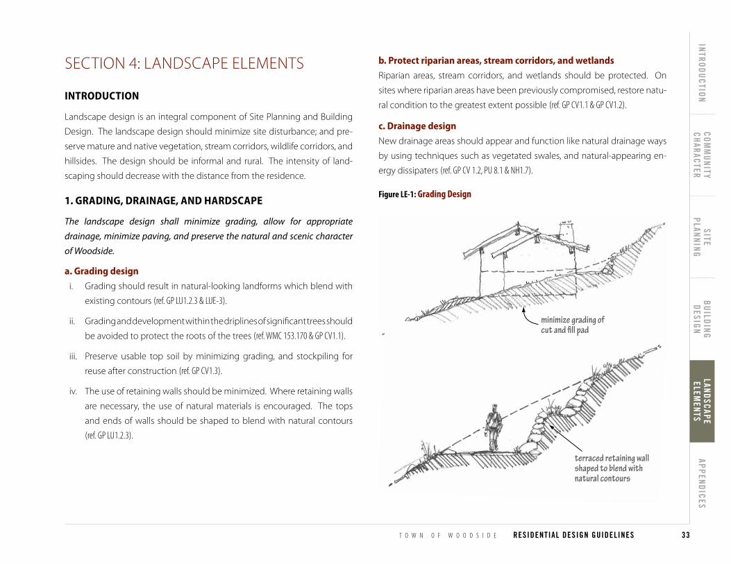
Figure LE-1: Grading Design
minimize grading ofcut and �ll pad
terraced retaining wallshaped to blend withnatural contours
T O W N O F W O O D S I D E RESIDENTIAL DESIGN GUIDELINES
INTRODUCTIONCOM
MUNITY
CHARACTERSITE
PLANNINGBUILDING
DESIGNLANDSCAPE ELEM
ENTSAPPENDICES
33
LANDSCAPE ELEM
ENTS
SECTION 4: LANDSCAPE ELEMENTSSection 4: Landscape Elements
inTroducTionIntroduction
Landscape design is an integral component of Site Planning and Building
Design. The landscape design should minimize site disturbance; and pre-
serve mature and native vegetation, stream corridors, wildlife corridors, and
hillsides. The design should be informal and rural. The intensity of land-
scaping should decrease with the distance from the residence.
1. grading, drainage, and hardscaPe1. Grading, Drainage , and Hardscape
The landscape design shall minimize grading, allow for appropriate
drainage, minimize paving, and preserve the natural and scenic character
of Woodside.
a. grading design
i. Grading should result in natural-looking landforms which blend with
existing contours (ref. GP LU1.2.3 & LUE-3).
ii. Grading and development within the driplines of significant trees should
be avoided to protect the roots of the trees (ref. WMC 153.170 & GP CV1.1).
iii. Preserve usable top soil by minimizing grading, and stockpiling for
reuse after construction (ref. GP CV1.3).
iv. The use of retaining walls should be minimized. Where retaining walls
are necessary, the use of natural materials is encouraged. The tops
and ends of walls should be shaped to blend with natural contours
(ref. GP LU1.2.3).
b. Protect riparian areas, stream corridors, and wetlands
Riparian areas, stream corridors, and wetlands should be protected. On
sites where riparian areas have been previously compromised, restore natu-
ral condition to the greatest extent possible (ref. GP CV1.1 & GP CV1.2).
c. drainage design
New drainage areas should appear and function like natural drainage ways
by using techniques such as vegetated swales, and natural-appearing en-
ergy dissipaters (ref. GP CV 1.2, PU 8.1 & NH1.7).
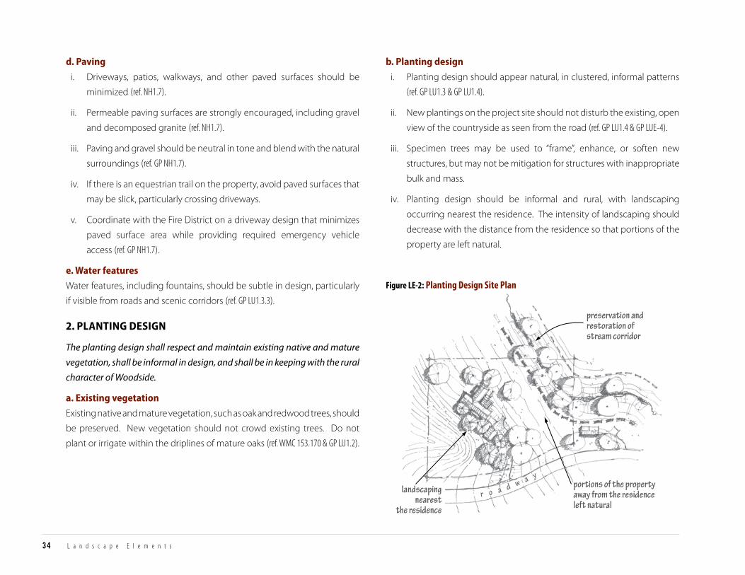
preservation andrestoration ofstream corridor
portions of the propertyaway from the residenceleft natural
landscapingnearest
the residence
r o a d w a y
Figure LE-2: Planting Design Site Plan
34 L a n d s c a p e E l e m e n t s
d. Paving
i. Driveways, patios, walkways, and other paved surfaces should be
minimized (ref. NH1.7).
ii. Permeable paving surfaces are strongly encouraged, including gravel
and decomposed granite (ref. NH1.7).
iii. Paving and gravel should be neutral in tone and blend with the natural
surroundings (ref. GP NH1.7).
iv. If there is an equestrian trail on the property, avoid paved surfaces that
may be slick, particularly crossing driveways.
v. Coordinate with the Fire District on a driveway design that minimizes
paved surface area while providing required emergency vehicle
access (ref. GP NH1.7).
e. Water features
Water features, including fountains, should be subtle in design, particularly
if visible from roads and scenic corridors (ref. GP LU1.3.3).
2. PlanTing design2. Planting Design
The planting design shall respect and maintain existing native and mature
vegetation, shall be informal in design, and shall be in keeping with the rural
character of Woodside.
a. existing vegetation
Existing native and mature vegetation, such as oak and redwood trees, should
be preserved. New vegetation should not crowd existing trees. Do not
plant or irrigate within the driplines of mature oaks (ref. WMC 153.170 & GP LU1.2).
b. Planting design
i. Planting design should appear natural, in clustered, informal patterns
(ref. GP LU1.3 & GP LU1.4).
ii. New plantings on the project site should not disturb the existing, open
view of the countryside as seen from the road (ref. GP LU1.4 & GP LUE-4).
iii. Specimen trees may be used to “frame”, enhance, or soften new
structures, but may not be mitigation for structures with inappropriate
bulk and mass.
iv. Planting design should be informal and rural, with landscaping
occurring nearest the residence. The intensity of landscaping should
decrease with the distance from the residence so that portions of the
property are left natural.
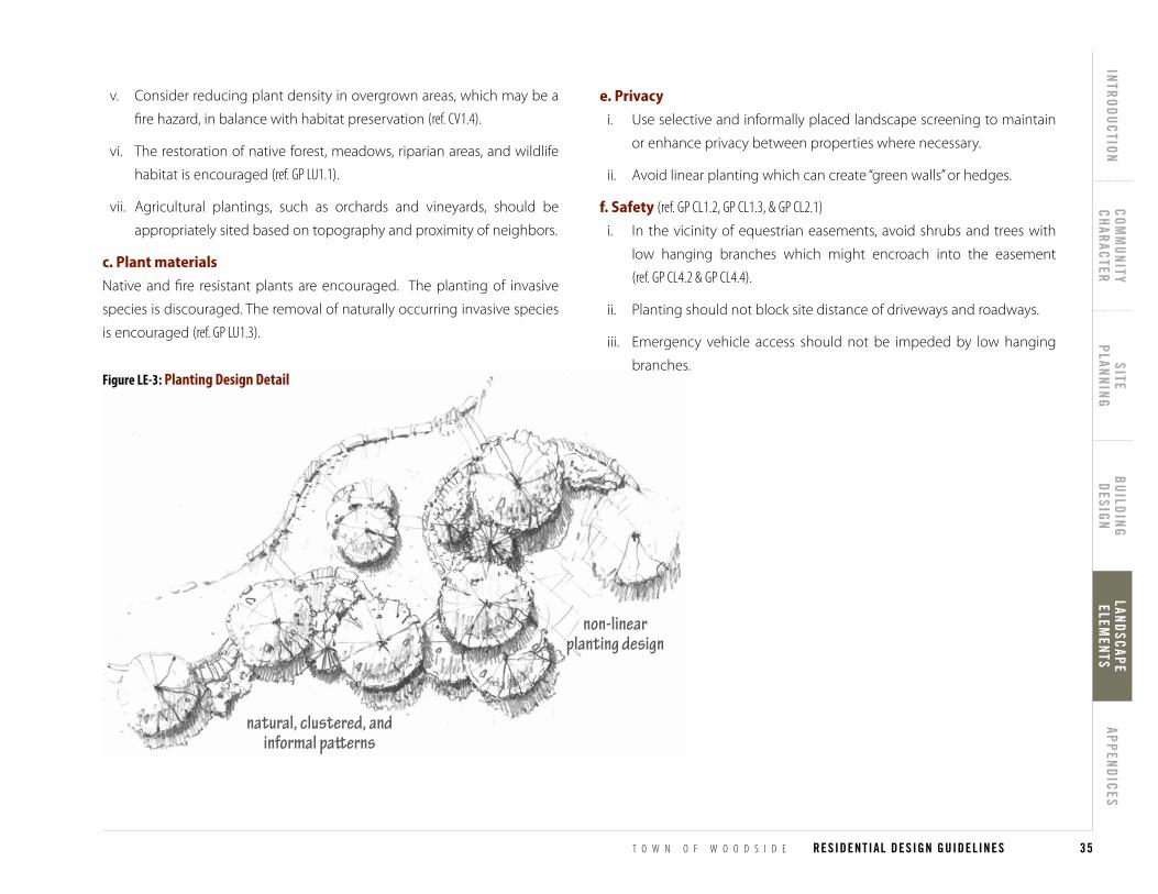
natural, clustered, andinformal pa�erns
non-linearplanting design
natural, clustered, andinformal pa�erns
non-linearplanting design
Figure LE-3: Planting Design Detail
T O W N O F W O O D S I D E RESIDENTIAL DESIGN GUIDELINES
INTRODUCTIONCOM
MUNITY
CHARACTERSITE
PLANNINGBUILDING
DESIGNLANDSCAPE ELEM
ENTSAPPENDICES
35
LANDSCAPE ELEM
ENTS
e. Privacy
i. Use selective and informally placed landscape screening to maintain
or enhance privacy between properties where necessary.
ii. Avoid linear planting which can create “green walls” or hedges.
f. safety (ref. GP CL1.2, GP CL1.3, & GP CL2.1)
i. In the vicinity of equestrian easements, avoid shrubs and trees with
low hanging branches which might encroach into the easement
(ref. GP CL4.2 & GP CL4.4).
ii. Planting should not block site distance of driveways and roadways.
iii. Emergency vehicle access should not be impeded by low hanging
branches.
v. Consider reducing plant density in overgrown areas, which may be a
fire hazard, in balance with habitat preservation (ref. CV1.4).
vi. The restoration of native forest, meadows, riparian areas, and wildlife
habitat is encouraged (ref. GP LU1.1).
vii. Agricultural plantings, such as orchards and vineyards, should be
appropriately sited based on topography and proximity of neighbors.
c. Plant materials
Native and fire resistant plants are encouraged. The planting of invasive
species is discouraged. The removal of naturally occurring invasive species
is encouraged (ref. GP LU1.3).
36 L a n d s c a p e E l e m e n t s
3. fences3. Fences
Fencing shall be open in design and compatible with the rural character of
Woodside (ref. WMC 153.051).
Woodside’s rural character includes views of oak woodlands, mixed ever-
green forests, meadows, the Western Hills, and the valley floor. The loca-
tion and design of fencing is critical in maintaining these views. Fences also
impact properties as seen from public roadways. Low, open design fences
contribute to the rural experience of Woodside.
a. minimize fencing
Minimize fencing to the greatest extent possible.
b. fence siting
Locate fencing at least the required setback from the road and blend it into
the existing landscape (ref. WMC 153.051). Avoid creating fenced “tunnels”, par-
ticularly along equestrian trails.
c. natural feature protection
i. Locate fencing outside of stream corridor setbacks, riparian areas and
any known wildlife habitats and migratory corridors (ref. GP OS1.2).
ii. Locate fencing to avoid impacts to trees and other natural features
(ref. WMC 153.170).
d. design (ref. WMC 153.051)
i. Open design: Fencing should be visually open. Fencing that allows
for wildlife migration, such as open rail, is preferred. Fencing that is
visually open, such as wood posts and welded wire is encouraged if
wildlife friendly fencing is not feasible.
ii. Fence materials: Rural styles, those that emphasize the use of natural
materials such as wood, wood posts and welded wire with wood posts,
natural stone or brick, and which utilize natural colors, such as brown,
grey or green, are strongly encouraged. Other types of fencing, such
as chain link, stucco, brick and solid walls are strongly discouraged.
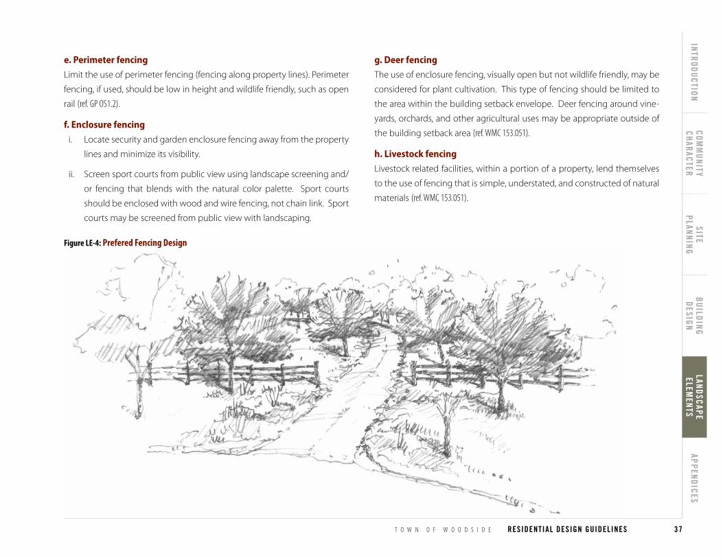
Figure LE-4: Prefered Fencing Design
T O W N O F W O O D S I D E RESIDENTIAL DESIGN GUIDELINES
INTRODUCTIONCOM
MUNITY
CHARACTERSITE
PLANNINGBUILDING
DESIGNLANDSCAPE ELEM
ENTSAPPENDICES
37
LANDSCAPE ELEM
ENTS
e. Perimeter fencing
Limit the use of perimeter fencing (fencing along property lines). Perimeter
fencing, if used, should be low in height and wildlife friendly, such as open
rail (ref. GP OS1.2).
f. enclosure fencing
i. Locate security and garden enclosure fencing away from the property
lines and minimize its visibility.
ii. Screen sport courts from public view using landscape screening and/
or fencing that blends with the natural color palette. Sport courts
should be enclosed with wood and wire fencing, not chain link. Sport
courts may be screened from public view with landscaping.
g. deer fencing
The use of enclosure fencing, visually open but not wildlife friendly, may be
considered for plant cultivation. This type of fencing should be limited to
the area within the building setback envelope. Deer fencing around vine-
yards, orchards, and other agricultural uses may be appropriate outside of
the building setback area (ref. WMC 153.051).
h. livestock fencing
Livestock related facilities, within a portion of a property, lend themselves
to the use of fencing that is simple, understated, and constructed of natural
materials (ref. WMC 153.051).
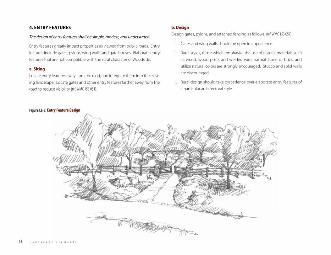
Figure LE-5: Entry Feature Design
38 L a n d s c a p e E l e m e n t s
b. design
Design gates, pylons, and attached fencing as follows: (ref. WMC 153.051)
i. Gates and wing walls should be open in appearance.
ii. Rural styles, those which emphasize the use of natural materials such
as wood, wood posts and welded wire, natural stone or brick, and
utilize natural colors are strongly encouraged. Stucco and solid walls
are discouraged.
iii. Rural design should take precedence over elaborate entry features of
a particular architectural style.
4. enTry feaTures4. Entry Features
The design of entry features shall be simple, modest, and understated.
Entry features greatly impact properties as viewed from public roads. Entry
features include gates, pylons, wing walls, and gate houses. Elaborate entry
features that are not compatible with the rural character of Woodside.
a. siting
Locate entry features away from the road, and integrate them into the exist-
ing landscape. Locate gates and other entry features farther away from the
road to reduce visibility (ref. WMC 153.051).

Figure LE-6: Minimize landscape lighting
T O W N O F W O O D S I D E RESIDENTIAL DESIGN GUIDELINES
INTRODUCTIONCOM
MUNITY
CHARACTERSITE
PLANNINGBUILDING
DESIGNLANDSCAPE ELEM
ENTSAPPENDICES
39
LANDSCAPE ELEM
ENTS
iv. Pylons and wing walls should provide an unobtrusive transition
between the adjacent fencing and the gate.
v. Locate gate operating mechanisms to the inside of gates, whenever
feasible.
c. landscape screening
Screen mechanical and utility equipment by using natural groupings
of native plantings. Screening is particularly important for up-sloping
driveways where the view from the road has greater visual prominence
(ref. WMC 153.051 & WMC 156.050.B.3).
5. lighTing 5. Lighting
Woodside values dark night skies and limited lighting. Lighting on private
property, especially if visible offsite, shall be minimized to maintain the rural
experience.
Exterior lighting should be limited in quantity and overall illumination in-
tensity.
a. site and landscape lighting
i. Lighting for site circulation should be kept to the fewest number
of fixtures necessary. Fixtures should be shielded to illuminate only
the surface of pathways and steps. Limit driveway illumination
(ref. WMC 153.049H & GP LU1.2).
ii. All lighting should be limited to the lowest wattage necessary to
perform the practical function of illuminating entranceways and
providing safe passage through the property (ref. WMC 153.049H & GP LU1.2).
iii. Decorative landscape lighting should be avoided. The uplighting of
trees, or lighting within the canopy of trees, is not permitted.
iv. The lighting of sport courts is discouraged (ref. WMC 153.049H & GP LU1.2).
b. minimize exterior fixtures
The number of fixtures on the exterior of buildings should be limited to the
minimum requirements of the building code for safety. Wall washing with
light is not permitted (ref. GP LU1.2).
c. fixture style and design
Light fixtures should be simple and consistent with the design of the resi-
dence. Light sources must be shielded. Low voltage and low illumination
fixtures are encouraged. Utilize lighting controls to benefit dark night skies
and reduce energy use (ref. GP LU1.2).
d. lighting of entry features
Pylon lighting may contain an illuminated street number, limited in size
and wattage to comply with the minimum standards required by the Fire
District. Subtle, low wattage lighting may be considered on pylons for the
primary function of identifying the entrance to the property for visitors. Do
not place lights on top of pylons (ref. WMC 153.049H & GP LU1.2).
40 L a n d s c a p e E l e m e n t s
6. fire safe design6. Fire Safe Design
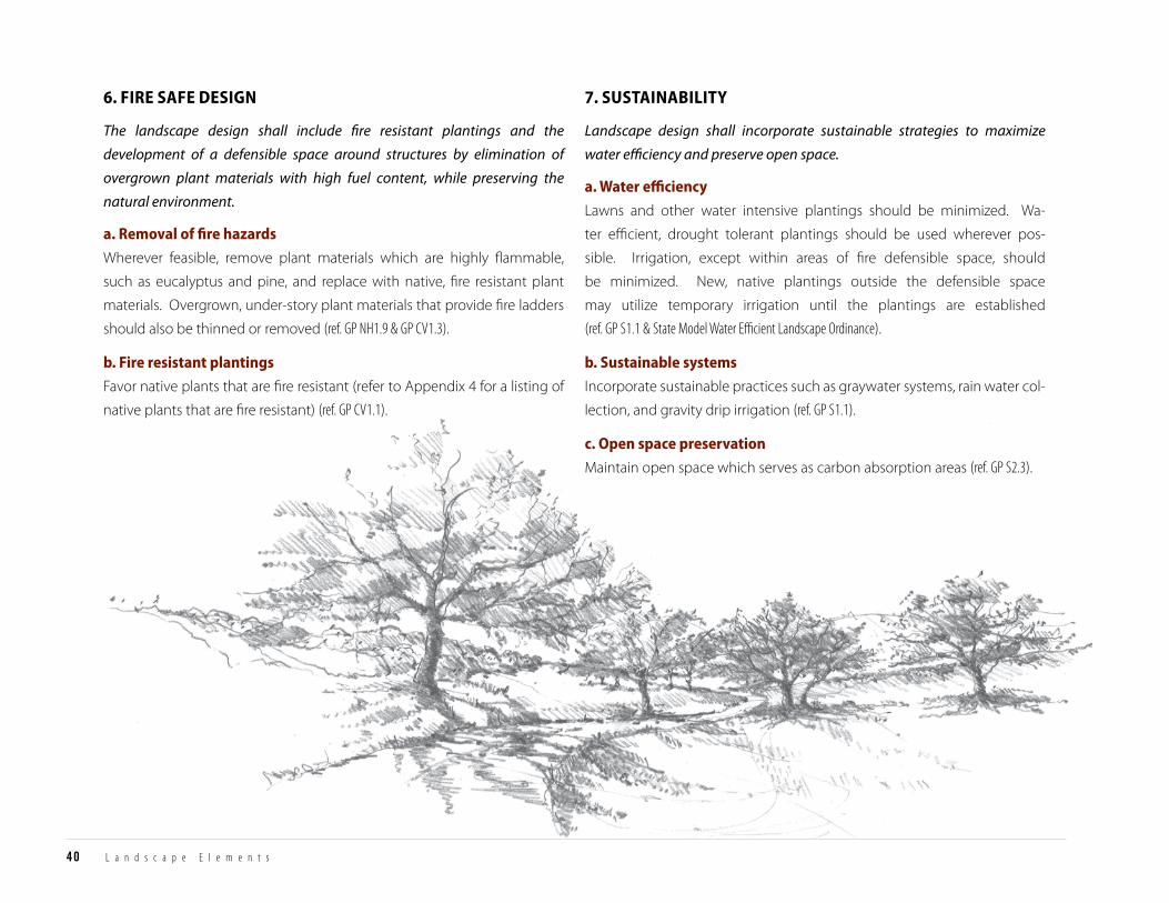
The landscape design shall include fire resistant plantings and the
development of a defensible space around structures by elimination of
overgrown plant materials with high fuel content, while preserving the
natural environment.
a. removal of fire hazards
Wherever feasible, remove plant materials which are highly flammable,
such as eucalyptus and pine, and replace with native, fire resistant plant
materials. Overgrown, under-story plant materials that provide fire ladders
should also be thinned or removed (ref. GP NH1.9 & GP CV1.3).
b. fire resistant plantings
Favor native plants that are fire resistant (refer to Appendix 4 for a listing of
native plants that are fire resistant) (ref. GP CV1.1).
7. susTainabiliTy7. Sustainability
Landscape design shall incorporate sustainable strategies to maximize
water efficiency and preserve open space.
a. Water efficiency
Lawns and other water intensive plantings should be minimized. Wa-
ter efficient, drought tolerant plantings should be used wherever pos-
sible. Irrigation, except within areas of fire defensible space, should
be minimized. New, native plantings outside the defensible space
may utilize temporary irrigation until the plantings are established
(ref. GP S1.1 & State Model Water Efficient Landscape Ordinance).
b. sustainable systems
Incorporate sustainable practices such as graywater systems, rain water col-
lection, and gravity drip irrigation (ref. GP S1.1).
c. open space preservation
Maintain open space which serves as carbon absorption areas (ref. GP S2.3).
T O W N O F W O O D S I D E RESIDENTIAL DESIGN GUIDELINES
INTRODUCTIONCOM
MUNITY
CHARACTERSITE
PLANNINGBUILDING
DESIGNLANDSCAPE ELEM
ENTSAPPENDICES
41
APPENDICES
APPENDIx 1: DESIGN GuIDELINES SuMMARY .............................................................................................................................................................................42
APPENDIx 2: CoNCEPTuAL DESIGN REVIEw SuBMITTAL REquIREMENTS ..................................................................................................................43
APPENDIx 3: FoRMAL ASRB AND PLANNING CoMMISSIoN SuBMITTAL REquIREMENTS ................................................................................43
APPENDIx 4: SuGGESTED NATIVE PLANTS LIST ..........................................................................................................................................................................47
APPENDIcES
42 A p p e n d i c e s
APPENDIx 1: DESIGN GUIDELINES SUMMARYAppendix 1: Design Guidelines Summary
The following is a summary of the Residential Design Guidelines found throughout this document, and provides review criteria for projects. This summary is available in PDF form at www.woodsidetown.org.
secTion 1: communiTy characTer1. rural characTer and communiTy aesTheTics
F Properties shall be developed in a manner that is in keeping with the rural character and aesthetics of the Town.
2. scenic corridors and visTas F Properties shall be developed in a manner which respects the character of scenic corridors and
vistas.
3. naTural environmenT F Properties shall be developed in a manner that preserves natural features.
4. equesTrian lifesTyle F Properties shall be developed in a manner which preserves and supports equestrian facilities and
the Woodside trails network.
secTion 2: siTe Planning1. siTe consTrainTs and feaTures
F Building location and site improvements shall be based on a clear understanding of the property’s natural features, regulatory constraints, and relationships to adjacent properties.
2. naTural feaTure conservaTion F Site development shall conserve the property’s open space, natural features, vegetation, and
wildlife by subordinating development to the site’s natural conditions.
3. siTe usage and building siTing F Residential and accessory uses shall be located to respect and preserve Woodside’s rural residential
character, and maintain the visual continuity of natural landforms.
4. siTe circulaTion F Driveways, garages, parking areas, trails, and pathways shall be located and designed to be safe,
minimally visible from the roadway, and subordinate to the site’s natural features.
5. neighborhood and communiTy comPaTibiliTy F The location, scale, and orientation of site improvements shall complement and be consistent with
neighborhood and community development patterns.
6. fire safe design F Site planning shall consider the relationship between buildings and high fuel load vegetation.
7. susTainabiliTy F Site planning shall incorporate sustainable strategies to conserve and minimize energy
consumption in the construction and use of structures.
secTion 3: building design1. seTTing and archiTecTural sTyle
F The architectural design shall be tailored to lot size, terrain, vegetation, and other natural and neighborhood conditions.
2. building form F Building form shall be architecturally cohesive and understated.
3. maTerials, color, and deTails F Material, color, and detail shall be used to enhance the architectural style in a well-composed,
understated manner.
4. fire safeTy F Adhere to fire safety regulations, while maintaining the rural character of Woodside.
5. susTainabiliTy F Sustainable building practices shall be considered in project design.
secTion 4: landscaPe elemenTs1. grading, drainage, and hardscaPe
F The landscape design shall minimize grading, allow for appropriate drainage, minimize paving, and preserve the natural and scenic character of Woodside.
2. PlanTing design F The planting design shall respect and maintain existing native and mature vegetation, shall be
informal in design, and shall be in keeping with the rural character of Woodside.
3. fences F Fencing shall be open in design and compatible with the rural character of Woodside (ref. WMC
153.051).
4. enTry feaTures F The design of entry features shall be simple, modest, and understated.
5. lighTing F Lighting on private property, especially if visible offsite, shall be minimized to maintain the rural
experience.
6. fire safe design F The landscape design shall include fire resistant plantings and the development of a defensible
space around structures by elimination of overgrown plant materials with high fuel content, while preserving the natural environment.
7. susTainabiliTy F Landscape design shall incorporate sustainable strategies to maximize water efficiency and
preserve open space.

T O W N O F W O O D S I D E RESIDENTIAL DESIGN GUIDELINES
INTRODUCTIONCOM
MUNITY
CHARACTERSITE
PLANNINGBUILDING
DESIGNLANDSCAPE ELEM
ENTSAPPENDICES
43
APPENDICES
APPENDIx 2: CONCEPTUAL DESIGN REVIEW SUBMITTAL REQUIREMENTS
Appendix 2: Conceptual Design Review Submittal Requirements
F Topographical survey of existing site conditions (show contours,
easements, slopes in excess of 35 percent, stream corridors, significant
trees, earthquake faults, trails etc.).
F Aerial image of the property and neighborhood.
F Photographs of site.
F Proposed building style, massing, and location(s) on the site.
F Optional: Add story poles.
APPENDIx 3: FORMAL ASRB AND PLANNING COMMISSION SUBMITTAL REQUIREMENTS
Appendix 3: Formal ASRB and Planning Commission Submittal Requirements
The following information is needed for most development projects requir-
ing ASRB and/or Planning Commission review. Please contact the Planning
Department with specific questions related to a project.
aPPlicaTion
F Application form, available at Building/Planning counter and on the
Town’s website, to be completed by the applicant (an authorization
letter is required if the applicant is not the owner).
F Current title report.
TiTle Page The following information is typically shown on the cover page of the plans
set:
F Zoning and General Plan designation.
F Assessor’s Parcel Number(s)
F Total floor area and main residence floor area (allowed and proposed).
F Paved Area calculations (allowed and proposed).
F Total parking spaces.
F Vicinity map.
F Names and contact information (property owner and design
professionals).
F Sheet legend.
1 The ASRB will not refer a project from Conceptual Design Review to staff without story poles being erected unless the project is exempt from Formal Review pursuant to WMC Section 153.221(B).
1
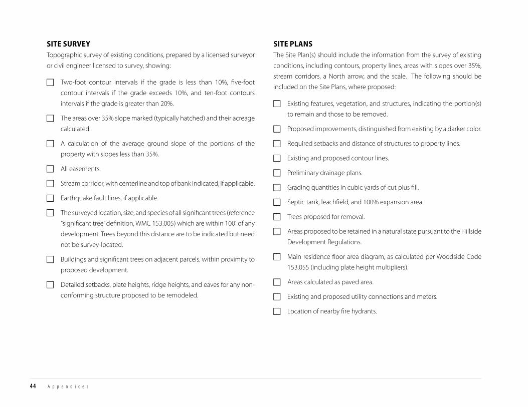
44 A p p e n d i c e s
siTe surveyTopographic survey of existing conditions, prepared by a licensed surveyor
or civil engineer licensed to survey, showing:
F Two-foot contour intervals if the grade is less than 10%, five-foot
contour intervals if the grade exceeds 10%, and ten-foot contours
intervals if the grade is greater than 20%.
F The areas over 35% slope marked (typically hatched) and their acreage
calculated.
F A calculation of the average ground slope of the portions of the
property with slopes less than 35%.
F All easements.
F Stream corridor, with centerline and top of bank indicated, if applicable.
F Earthquake fault lines, if applicable.
F The surveyed location, size, and species of all significant trees (reference
“significant tree” definition, WMC 153.005) which are within 100' of any
development. Trees beyond this distance are to be indicated but need
not be survey-located.
F Buildings and significant trees on adjacent parcels, within proximity to
proposed development.
F Detailed setbacks, plate heights, ridge heights, and eaves for any non-
conforming structure proposed to be remodeled.
siTe PlansThe Site Plan(s) should include the information from the survey of existing
conditions, including contours, property lines, areas with slopes over 35%,
stream corridors, a North arrow, and the scale. The following should be
included on the Site Plans, where proposed:
F Existing features, vegetation, and structures, indicating the portion(s)
to remain and those to be removed.
F Proposed improvements, distinguished from existing by a darker color.
F Required setbacks and distance of structures to property lines.
F Existing and proposed contour lines.
F Preliminary drainage plans.
F Grading quantities in cubic yards of cut plus fill.
F Septic tank, leachfield, and 100% expansion area.
F Trees proposed for removal.
F Areas proposed to be retained in a natural state pursuant to the Hillside
Development Regulations.
F Main residence floor area diagram, as calculated per Woodside Code
153.055 (including plate height multipliers).
F Areas calculated as paved area.
F Existing and proposed utility connections and meters.
F Location of nearby fire hydrants.
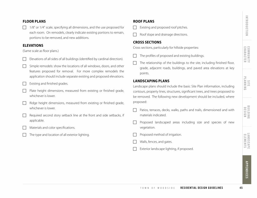
T O W N O F W O O D S I D E RESIDENTIAL DESIGN GUIDELINES
INTRODUCTIONCOM
MUNITY
CHARACTERSITE
PLANNINGBUILDING
DESIGNLANDSCAPE ELEM
ENTSAPPENDICES
45
APPENDICES
roof Plans
F Existing and proposed roof pitches.
F Roof slope and drainage directions.
cross secTionsCross sections, particularly for hillside properties:
F The profiles of proposed and existing buildings.
F The relationship of the buildings to the site, including finished floor,
grade, adjacent roads, buildings, and paved area elevations at key
points.
landscaPing PlansLandscape plans should include the basic Site Plan information, including
contours, property lines, structures, significant trees, and trees proposed to
be removed. The following new development should be included, where
proposed:
F Patios, terraces, decks, walks, paths and trails, dimensioned and with
materials indicated.
F Proposed landscaped areas including size and species of new
vegetation.
F Proposed method of irrigation.
F Walls, fences, and gates.
F Exterior landscape lighting, if proposed.
floor Plans
F 1/8" or 1/4" scale, specifying all dimensions, and the use proposed for
each room. On remodels, clearly indicate existing portions to remain,
portions to be removed, and new additions.
elevaTions(Same scale as floor plans.)
F Elevations of all sides of all buildings (identified by cardinal direction).
F Simple remodels: show the locations of all windows, doors, and other
features proposed for removal. For more complex remodels the
application should include separate existing and proposed elevations.
F Existing and finished grades.
F Plate height dimensions, measured from existing or finished grade,
whichever is lower.
F Ridge height dimensions, measured from existing or finished grade,
whichever is lower.
F Required second story setback line at the front and side setbacks, if
applicable.
F Materials and color specifications.
F The type and location of all exterior lighting.
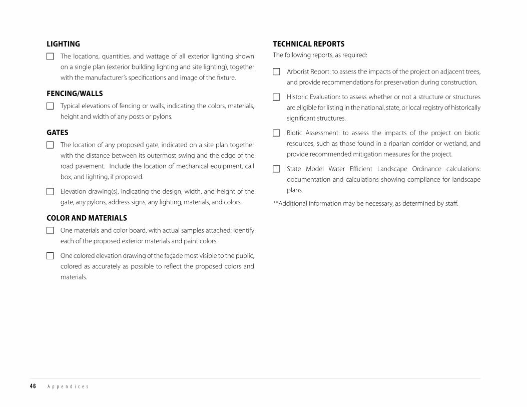
46 A p p e n d i c e s
lighTing
F The locations, quantities, and wattage of all exterior lighting shown
on a single plan (exterior building lighting and site lighting), together
with the manufacturer’s specifications and image of the fixture.
fencing/Walls
F Typical elevations of fencing or walls, indicating the colors, materials,
height and width of any posts or pylons.
gaTes
F The location of any proposed gate, indicated on a site plan together
with the distance between its outermost swing and the edge of the
road pavement. Include the location of mechanical equipment, call
box, and lighting, if proposed.
F Elevation drawing(s), indicating the design, width, and height of the
gate, any pylons, address signs, any lighting, materials, and colors.
color and maTerials
F One materials and color board, with actual samples attached: identify
each of the proposed exterior materials and paint colors.
F One colored elevation drawing of the façade most visible to the public,
colored as accurately as possible to reflect the proposed colors and
materials.
Technical rePorTsThe following reports, as required:
F Arborist Report: to assess the impacts of the project on adjacent trees,
and provide recommendations for preservation during construction.
F Historic Evaluation: to assess whether or not a structure or structures
are eligible for listing in the national, state, or local registry of historically
significant structures.
F Biotic Assessment: to assess the impacts of the project on biotic
resources, such as those found in a riparian corridor or wetland, and
provide recommended mitigation measures for the project.
F State Model Water Efficient Landscape Ordinance calculations:
documentation and calculations showing compliance for landscape
plans.
**Additional information may be necessary, as determined by staff.
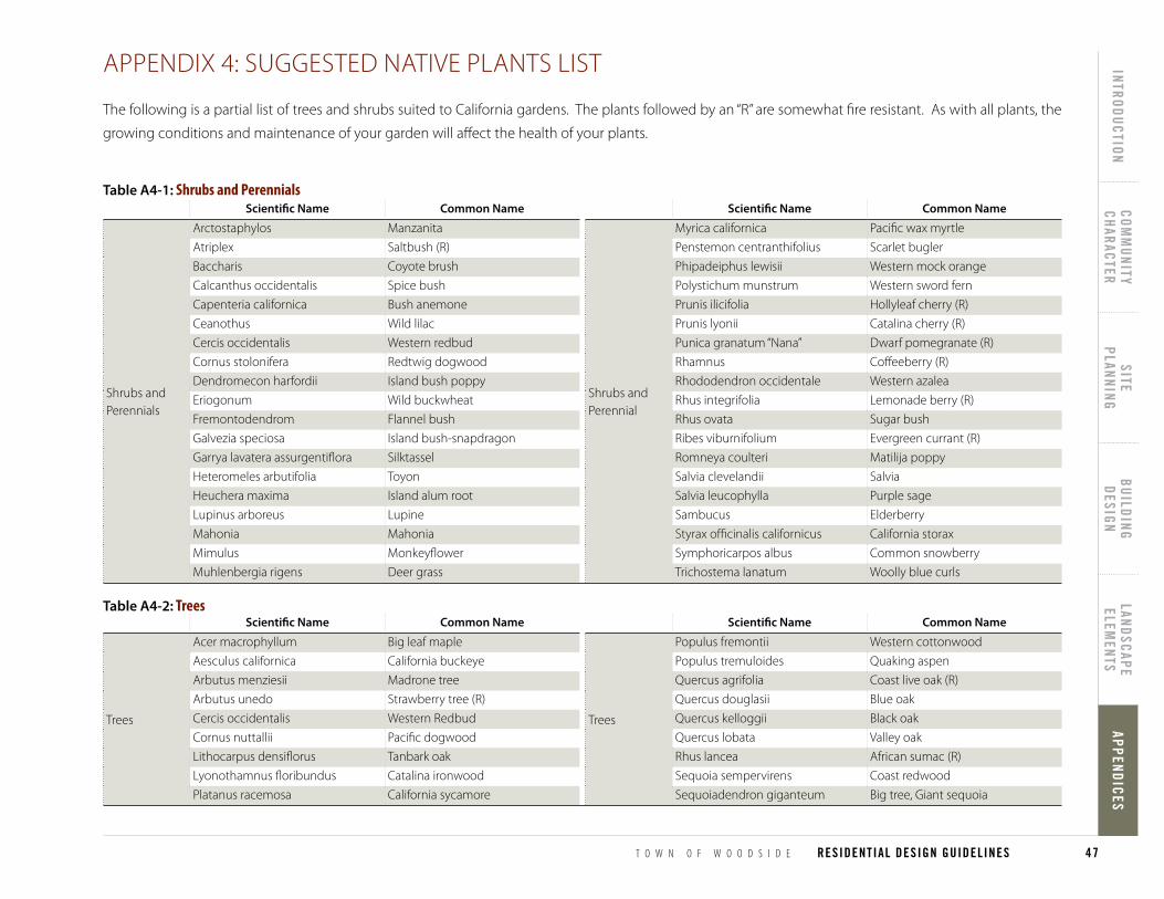
T O W N O F W O O D S I D E RESIDENTIAL DESIGN GUIDELINES
INTRODUCTIONCOM
MUNITY
CHARACTERSITE
PLANNINGBUILDING
DESIGNLANDSCAPE ELEM
ENTSAPPENDICES
47
APPENDICES
Table A4-2: TreesScientific Name common Name
Trees
Acer macrophyllum Big leaf maple
Aesculus californica California buckeye
Arbutus menziesii Madrone tree
Arbutus unedo Strawberry tree (R)
Cercis occidentalis Western Redbud
Cornus nuttallii Pacific dogwood
Lithocarpus densiflorus Tanbark oak
Lyonothamnus floribundus Catalina ironwood
Platanus racemosa California sycamore
Scientific Name common Name
Trees
Populus fremontii Western cottonwood
Populus tremuloides Quaking aspen
Quercus agrifolia Coast live oak (R)
Quercus douglasii Blue oak
Quercus kelloggii Black oak
Quercus lobata Valley oak
Rhus lancea African sumac (R)
Sequoia sempervirens Coast redwood
Sequoiadendron giganteum Big tree, Giant sequoia
Table A4-1: Shrubs and Perennials
APPENDIx 4: SUGGESTED NATIVE PLANTS LISTAppendix 4: Suggested Native Plants List
The following is a partial list of trees and shrubs suited to California gardens. The plants followed by an “R” are somewhat fire resistant. As with all plants, the
growing conditions and maintenance of your garden will affect the health of your plants.
Scientific Name common Name
Shrubs and Perennials
Arctostaphylos Manzanita
Atriplex Saltbush (R)
Baccharis Coyote brush
Calcanthus occidentalis Spice bush
Capenteria californica Bush anemone
Ceanothus Wild lilac
Cercis occidentalis Western redbud
Cornus stolonifera Redtwig dogwood
Dendromecon harfordii Island bush poppy
Eriogonum Wild buckwheat
Fremontodendrom Flannel bush
Galvezia speciosa Island bush-snapdragon
Garrya lavatera assurgentiflora Silktassel
Heteromeles arbutifolia Toyon
Heuchera maxima Island alum root
Lupinus arboreus Lupine
Mahonia Mahonia
Mimulus Monkeyflower
Muhlenbergia rigens Deer grass
Scientific Name common Name
Shrubs and Perennial
Myrica californica Pacific wax myrtle
Penstemon centranthifolius Scarlet bugler
Phipadeiphus lewisii Western mock orange
Polystichum munstrum Western sword fern
Prunis ilicifolia Hollyleaf cherry (R)
Prunis lyonii Catalina cherry (R)
Punica granatum “Nana” Dwarf pomegranate (R)
Rhamnus Coffeeberry (R)
Rhododendron occidentale Western azalea
Rhus integrifolia Lemonade berry (R)
Rhus ovata Sugar bush
Ribes viburnifolium Evergreen currant (R)
Romneya coulteri Matilija poppy
Salvia clevelandii Salvia
Salvia leucophylla Purple sage
Sambucus Elderberry
Styrax officinalis californicus California storax
Symphoricarpos albus Common snowberry
Trichostema lanatum Woolly blue curls