Embed Size (px)
Citation preview

Maximizing Benefits from Municipal GIS Operations The GIS Management Institute®
and the GIS Capability Maturity Model
South Ural State University Chelyabinsk, Russia 20-21 January 2014
Greg Babinski, MA, GISP URISA Past-President URISA GMI Committee Chair COGO Secretary Finance & Marketing Manager King County GIS Center Seattle, WA USA

Greeting from the Urban and Regional Information Systems Association (URISA)
URISA Board of Directors Officers
President: Allen Ibaugh AICP, GISP - Data Transfer Solutions
President-Elect: Carl Anderson, GISP
- Spatial Focus
Immediate Past President: Al Butler, GISP - City of Ocoee, FL
Treasurer - Doug Adams, GISP -
Baltimore County, MD
Secretary - Danielle Ayan, GISP -
Georgia Tech Research Institute
URISA Board Directors at Large
Jochen Albrecht - Hunter College,
Department of Geography, New York, NY
Tripp Corbin, GISP - eGIS Associates,
Inc., GA
Amy Esnard, GISP - Hood River, OR
Ashley Hitt, GISP - Connected Nation, Louisville, KY
Claudia Paskauskas, GISP -
Altamonte Springs, FL
Cindy Post, University of Alberta,
Edmonton, AB
Teresa Townsend, AICP, - Planning
Communities LLC., NC
Non-Voting Board Member/Chapter Advisory Board Chair:
Cy Smith, GISP, State of Oregon
Executive Director: Wendy Nelson

Greeting from the King County GIS Center Seattle, Washington USA
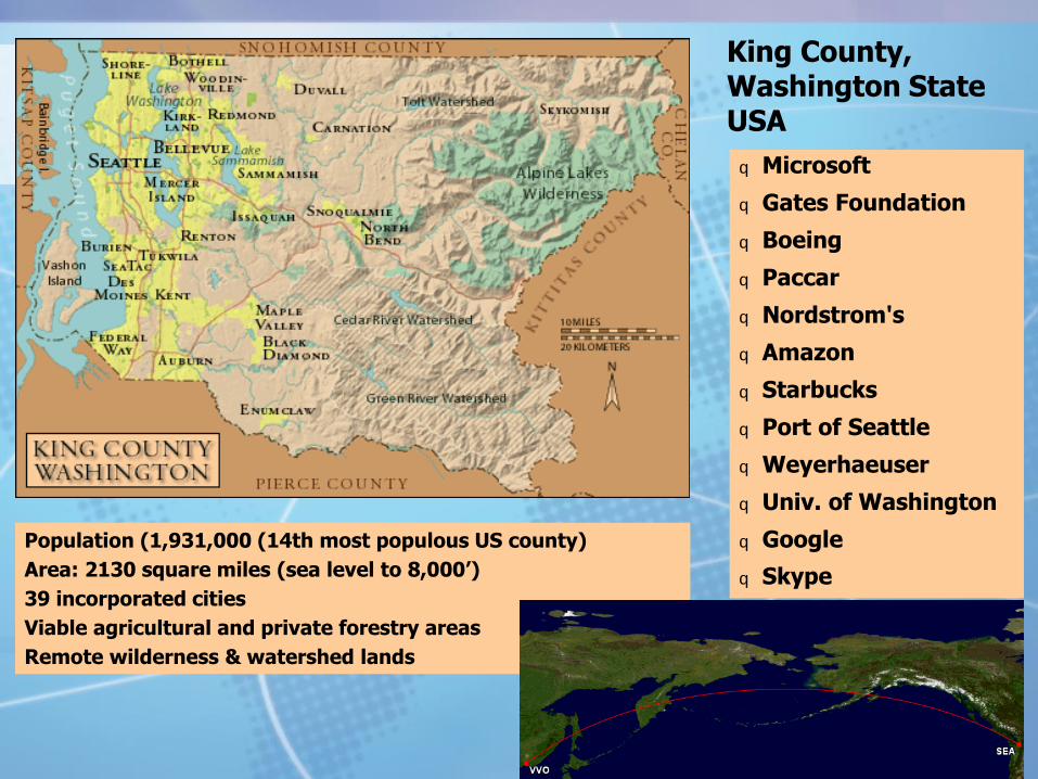
King County, Washington State USA
q Microsoft
q Gates Foundation
q Boeing
q Paccar
q Nordstrom's
q Amazon
q Starbucks
q Port of Seattle
q Weyerhaeuser
q Univ. of Washington
q Google
q Skype
Population (1,931,000 (14th most populous US county)
Area: 2130 square miles (sea level to 8,000’)
39 incorporated cities
Viable agricultural and private forestry areas
Remote wilderness & watershed lands

The last 50 years have seen a Geospatial Revolution
Developed upon a foundation of geographic theory
Enabled by the development of modern computers and information technology
Built upon digital data with location attributes
Aided by allied geospatial technology
Turned into a viable business support tool by geospatial software
Supported by an emerging geospatial profession
Maximizing Benefits from Municipal GIS Operations The GIS Management Institute® and the GIS Capability Maturity Model
The current state of the Geospatial Revolution
How does geospatial technology aid municipal administration?
What benefits does GIS provide to municipal jurisdictions and to the citizens that they serve?
Maximizing Benefits from Municipal GIS Operations The GIS Management Institute® and the GIS Capability Maturity Model
The next 50 years of the Geospatial Revolution
Geospatial technology will aid municipal administration in new and unanticipated ways.
GIS will continue to provide financial benefits to municipal jurisdictions and to the citizens they serve.
How can we measure the effectiveness of enterprise GIS operations?
What can we as geospatial professionals do to improve the future benefits to society from geospatial technology and municipal GIS operations?
Maximizing Benefits from Municipal GIS Operations The GIS Management Institute® and the GIS Capability Maturity Model

Agenda:
1. Innovative uses of geospatial technology for municipal administration: GIS Effectiveness
2. Understanding the financial benefits of GIS for municipal jurisdictions: Return on Investment (ROI)
3. Measuring the effective of enterprise GIS operations: The URISA GIS Capability Maturity Model (GISCMM)
4. Improving future benefits from geospatial technology: The GIS Management Institute
Maximizing Benefits from Municipal GIS Operations The GIS Management Institute® and the GIS Capability Maturity Model

Maximizing Benefits from Municipal GIS Operations The GIS Management Institute® and the GIS Capability Maturity Model
1. Innovative uses of geospatial technology for municipal administration: GIS Effectiveness Foundations of GIS
Geographic theory:
Cartographic theory
Locational analysis
Urban focus
Modern computers and information technology
Faster and cheaper
Networked computing
Database management systems
The Internet
Nanotechnology

Maximizing Benefits from Municipal GIS Operations The GIS Management Institute® and the GIS Capability Maturity Model
1. Innovative uses of geospatial technology for municipal administration: GIS Effectiveness Foundations of GIS
Modern computers and information technology
Faster and cheaper

Maximizing Benefits from Municipal GIS Operations The GIS Management Institute® and the GIS Capability Maturity Model
1. Innovative uses of geospatial technology for municipal administration: GIS Effectiveness Foundations of GIS
Digital data with location attributes
80% to 90% of all municipal data has locational identity
Conversion of national census data to digital format
Digital ortho-photography
Satellite imagery and sensed data
Maximizing Benefits from Municipal GIS Operations The GIS Management Institute® and the GIS Capability Maturity Model
1. Innovative uses of geospatial technology for municipal administration: GIS Effectiveness Foundations of GIS
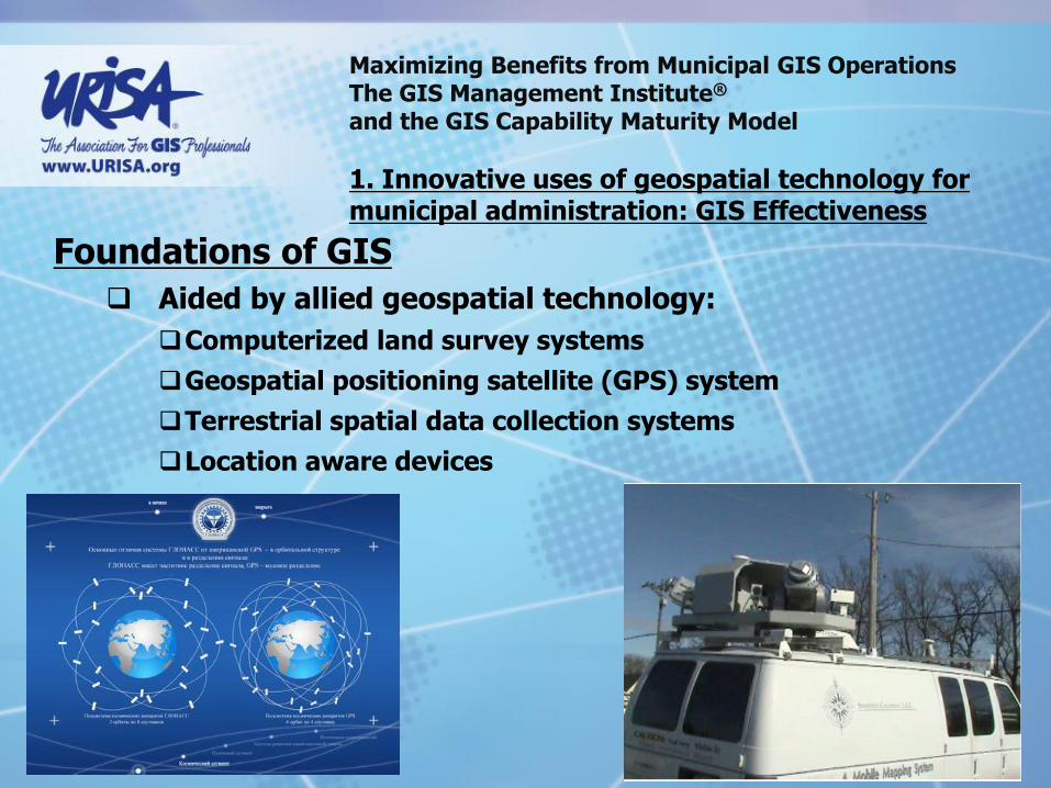
Aided by allied geospatial technology:
Computerized land survey systems
Geospatial positioning satellite (GPS) system
Terrestrial spatial data collection systems
Location aware devices

Maximizing Benefits from Municipal GIS Operations The GIS Management Institute® and the GIS Capability Maturity Model
1. Innovative uses of geospatial technology for municipal administration: GIS Effectiveness Foundations of GIS
Turned into a viable business support tool by geospatial software

Maximizing Benefits from Municipal GIS Operations The GIS Management Institute® and the GIS Capability Maturity Model
1. Innovative uses of geospatial technology for municipal administration: GIS Effectiveness Foundations of GIS
The origins of the Urban and Regional Information Systems Association
The origins of geospatial software for municipal administration: Esri (Environmental Systems Research Institute)

Maximizing Benefits from Municipal GIS Operations The GIS Management Institute® and the GIS Capability Maturity Model
1. Innovative uses of geospatial technology for municipal administration: GIS Effectiveness Foundations of GIS
The origins of the Urban and Regional Information Systems Association
Dr. Edgar M. Horwood
Professor of Civil Engineering and Urban Planning
University of Washington School of Engineering
URISA Founder
Professor Horwood’s simple but disruptive question to the U.S. Census Bureau in 1962:
“Can you let me have the 1960 census data for the U.S. on digital tape?’

Maximizing Benefits from Municipal GIS Operations The GIS Management Institute® and the GIS Capability Maturity Model
Edgar Horwood and the birth of URISA:
Working with University of Washington Geography Department – established a short course on data mapping presented in 1962 and 1963
1963 to 1966 Urban Planning Information Systems and Programs Conferences for short course alumni
1963 Conference considered first URISA Annual Conference
In 1966 the Urban and Regional Information Systems Association (URISA) was formally established with Dr. Horwood as first President.

Maximizing Benefits from Municipal GIS Operations The GIS Management Institute® and the GIS Capability Maturity Model
URISA and the development of geospatial technology:
URISA short course 1963 graduate Howard Fischer assumed the challenge to develop an improved card mapping system
Fischer developed SYMAP for automated chloropleth and contour mapping
In 1965 Fischer established the Harvard Computer Graphics Laboratory where he released computer mapping source code
Jack Dangermond developed ArcInfo from the Harvard R&D program, leading to the development of Esri

Maximizing Benefits from Municipal GIS Operations The GIS Management Institute® and the GIS Capability Maturity Model
1. Innovative uses of geospatial technology for municipal administration: GIS Effectiveness Foundations of GIS
The origins of geospatial software for municipal administration: Esri (Environmental Systems Research Institute)
Jack Dangermond was an early member of URISA
In 1969 Dangermond was awarded a Master of Arts Degree in Landscape Architecture from Harvard University
Dangermond conducted research into the geographic aspects of municipal administration

Maximizing Benefits from Municipal GIS Operations The GIS Management Institute® and the GIS Capability Maturity Model
1. Innovative uses of geospatial technology for municipal administration: GIS Effectiveness Foundations of GIS
At Harvard, Dangermond identified 32 geographic functions of municipal operations
1. Acquire and dispose of property
2. Process and issue permits
3. Perform inspections
4. Issue work orders
5. Issue licenses
6. Conduct street naming
7. Manage mailing lists
8. Review and approve site plans
9. Review and approve subdivisions
10. Perform street addressing
11. Perform event recording
12. Dispatch vehicles
13. Perform vehicle routing
14. Conduct traffic analysis
15. Allocate human resources
16. Site facilities
17. Conduct area districting
18. Manage and survey facilities
19. Manage inventories
20. Manage resources
21. Administer zoning bylaws
22. Prepare official and secondary plans
23. Conduct engineering design
24. Conduct drafting
25. Maintain topographic data base
26. Manage drawings
27. Disseminate public information
28. Conduct development tracking
29. Respond to public enquiries
30. Conduct title searches
31. Bill and collect taxes and fees
32. Manage data bases and systems

Maximizing Benefits from Municipal GIS Operations The GIS Management Institute® and the GIS Capability Maturity Model
Foundations of GIS
Dangermond identified 32 geographic functions of municipal operations
Obtained access to geospatial software code while working at Harvard’s Laboratory for Computer Graphics and Spatial Analysis
Founded Esri and developed ArcInfo GIS software to aid each of the 32 geographic-based municipal functions

Maximizing Benefits from Municipal GIS Operations The GIS Management Institute® and the GIS Capability Maturity Model
Jack Dangermond develops ArcGIS and Esri

Maximizing Benefits from Municipal GIS Operations The GIS Management Institute® and the GIS Capability Maturity Model
Jack Dangermond develops ArcGIS and Esri

Maximizing Benefits from Municipal GIS Operations The GIS Management Institute® and the GIS Capability Maturity Model
1. Innovative uses of geospatial technology for municipal administration: GIS Effectiveness Foundations of GIS
Esri ArcGIS software supports geographic functions of municipal operations
Esri now has at least 30% share of the global GIS software market.

Maximizing Benefits from Municipal GIS Operations The GIS Management Institute® and the GIS Capability Maturity Model
1. Innovative uses of geospatial technology for municipal administration: GIS Effectiveness Foundations of GIS
Supported by an emerging geospatial profession
A recent Esri publication identified ‘20 Essential Skills for GIS’

Maximizing Benefits from Municipal GIS Operations The GIS Management Institute® and the GIS Capability Maturity Model
1. Innovative uses of geospatial technology for municipal administration: GIS Effectiveness
1. Create Reference Maps:
Layers
Symbols
Labels
Layouts
Example shows King County and City of Seattle Sewer outfall locations

Maximizing Benefits from Municipal GIS Operations The GIS Management Institute® and the GIS Capability Maturity Model
1. Innovative uses of geospatial technology for municipal administration: GIS Effectiveness
2. Create Well Designed Map Layouts:
Map Container
Map content
Marginalia
Example shows King County GIS standard map template

Maximizing Benefits from Municipal GIS Operations The GIS Management Institute® and the GIS Capability Maturity Model
1. Innovative uses of geospatial technology for municipal administration: GIS Effectiveness
3. Project Multiple Data Sources Correctly:
Shape
Area
Direction
Distance
Example shows variations in jurisdiction area calculations based on projection chosen.

Maximizing Benefits from Municipal GIS Operations The GIS Management Institute® and the GIS Capability Maturity Model
1. Innovative uses of geospatial technology for municipal administration: GIS Effectiveness 4. Prepare Data
for GIS
Example shows hand held field data collection device.
Maximizing Benefits from Municipal GIS Operations The GIS Management Institute® and the GIS Capability Maturity Model
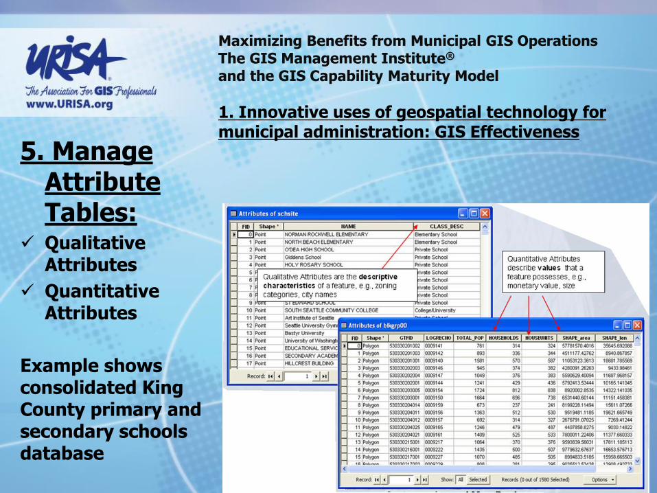
1. Innovative uses of geospatial technology for municipal administration: GIS Effectiveness 5. Manage
Attribute Tables:
Qualitative Attributes
Quantitative Attributes
Example shows consolidated King County primary and secondary schools database

Maximizing Benefits from Municipal GIS Operations The GIS Management Institute® and the GIS Capability Maturity Model
1. Innovative uses of geospatial technology for municipal administration: GIS Effectiveness
6. Join Data to Maps:
Transit routes
Real time bus arrival
Example shows real-time King County Metro bus routing and arrival data
Maximizing Benefits from Municipal GIS Operations The GIS Management Institute® and the GIS Capability Maturity Model
1. Innovative uses of geospatial technology for municipal administration: GIS Effectiveness
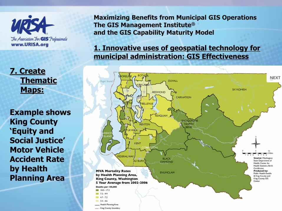
7. Create Thematic Maps:
Example shows King County ‘Equity and Social Justice’ Motor Vehicle Accident Rate by Health Planning Area

Maximizing Benefits from Municipal GIS Operations The GIS Management Institute® and the GIS Capability Maturity Model
1. Innovative uses of geospatial technology for municipal administration: GIS Effectiveness
8. Create Categorical Maps:
Example shows King County Noxious weeds locations

Maximizing Benefits from Municipal GIS Operations The GIS Management Institute® and the GIS Capability Maturity Model
1. Innovative uses of geospatial technology for municipal administration: GIS Effectiveness 9. Import
GPS Data to Maps:
Example shows King County GIS Center staff member collecting recreational trail data

Maximizing Benefits from Municipal GIS Operations The GIS Management Institute® and the GIS Capability Maturity Model
1. Innovative uses of geospatial technology for municipal administration: GIS Effectiveness 10. Create
Address Maps:
Examples show:
Library Patrons (based on patron data)
Transit Car Park Lot Users (based on vehicle registration data)

Maximizing Benefits from Municipal GIS Operations The GIS Management Institute® and the GIS Capability Maturity Model
1. Innovative uses of geospatial technology for municipal administration: GIS Effectiveness
11. Edit Boundaries:
Example shows King County Land Acquisition planning map
Maximizing Benefits from Municipal GIS Operations The GIS Management Institute® and the GIS Capability Maturity Model
1. Innovative uses of geospatial technology for municipal administration: GIS Effectiveness
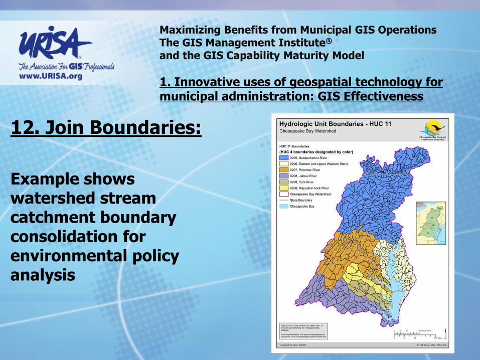
12. Join Boundaries:
Example shows watershed stream catchment boundary consolidation for environmental policy analysis

Maximizing Benefits from Municipal GIS Operations The GIS Management Institute® and the GIS Capability Maturity Model
1. Innovative uses of geospatial technology for municipal administration: GIS Effectiveness
13. Join Aerial Photography:
Example shows King County Urban forestry planning map with aerial imagery overlay

Maximizing Benefits from Municipal GIS Operations The GIS Management Institute® and the GIS Capability Maturity Model
1. Innovative uses of geospatial technology for municipal administration: GIS Effectiveness
14. Digitize Paper Maps:
Examples show maps digitized in 2013 to plan new tunnel under the city of Seattle

Maximizing Benefits from Municipal GIS Operations The GIS Management Institute® and the GIS Capability Maturity Model
1. Innovative uses of geospatial technology for municipal administration: GIS Effectiveness
15. Query Attributes:
Example shows a multi-jurisdictional municipal GIS application for commercial and industrial property sale and lease
Maximizing Benefits from Municipal GIS Operations The GIS Management Institute® and the GIS Capability Maturity Model
1. Innovative uses of geospatial technology for municipal administration: GIS Effectiveness
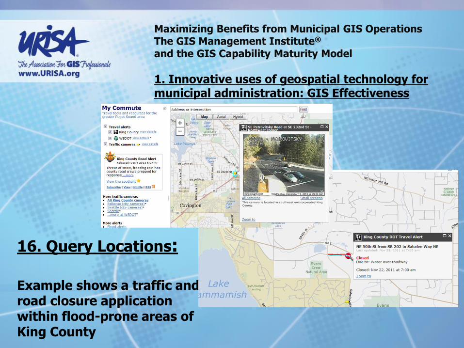
16. Query Locations:
Example shows a traffic and road closure application within flood-prone areas of King County

Maximizing Benefits from Municipal GIS Operations The GIS Management Institute® and the GIS Capability Maturity Model
1. Innovative uses of geospatial technology for municipal administration: GIS Effectiveness
17. Create Reports:
Example shows King County’s internal Real Estate Portfolio System reporting capability (Note absence of map view)

Maximizing Benefits from Municipal GIS Operations The GIS Management Institute® and the GIS Capability Maturity Model
1. Innovative uses of geospatial technology for municipal administration: GIS Effectiveness
18. Create Buffers:
Identify Features
Create Mailing Lists
This capability from the King County GIS public web site

Maximizing Benefits from Municipal GIS Operations The GIS Management Institute® and the GIS Capability Maturity Model
1. Innovative uses of geospatial technology for municipal administration: GIS Effectiveness
19. Publish Maps:
Example shows bus route maps published from GIS data

Maximizing Benefits from Municipal GIS Operations The GIS Management Institute® and the GIS Capability Maturity Model
1. Innovative uses of geospatial technology for municipal administration: GIS Effectiveness
20. Create Geodatabases:
Example shows geodatabase developed and maintained for a suburban jurisdiction by the King County GIS Center

Maximizing Benefits from Municipal GIS Operations The GIS Management Institute® and the GIS Capability Maturity Model
1. Innovative uses of geospatial technology for municipal administration: GIS Effectiveness
21. Port Maps to Multiple Platforms:
Develop GIS applications for mobile devices first!

Maximizing Benefits from Municipal GIS Operations The GIS Management Institute® and the GIS Capability Maturity Model
1. Innovative uses of geospatial technology for municipal administration: GIS Effectiveness
22. Create 3D Images or Video:
Example from King County GIS Center Watershed pollution remediation planning program.
http://www.youtube.com/watch?v=TeVsZ0nda68#t=11

Maximizing Benefits from Municipal GIS Operations The GIS Management Institute® and the GIS Capability Maturity Model
1. Innovative uses of geospatial technology for municipal administration: GIS Effectiveness
Summary Comments: For 50 years geospatial technology has steadily advanced in
capability Geospatial technology is cheaper to acquire and easier to
use than ever New applications for GIS are developed and proven
continuously Once the domain of GIS professionals, increasingly
geospatial technology is being used by the common man.

Maximizing Benefits from Municipal GIS Operations The GIS Management Institute® and the GIS Capability Maturity Model
1. Innovative uses of geospatial technology for municipal administration: GIS Effectiveness
Questions and Discussion?
Maximizing Benefits from Municipal GIS Operations The GIS Management Institute® and the GIS Capability Maturity Model
2. Understanding the financial benefits of GIS for municipal jurisdictions: Return on Investment (ROI)
For all of its benefits, geospatial technology is expensive to develop, implement, operate and maintain. Society allocates finite financial resources for municipal administration. How does GIS justify a share of those financial resources?

Maximizing Benefits from Municipal GIS Operations The GIS Management Institute® and the GIS Capability Maturity Model
2. Understanding the financial benefits of GIS for municipal jurisdictions: Return on Investment (ROI)
King County GIS Organizational Structure, supports 35 county departments and offices, plus outside customers

Maximizing Benefits from Municipal GIS Operations The GIS Management Institute® and the GIS Capability Maturity Model
2. Understanding the financial benefits of GIS for municipal jurisdictions: Return on Investment (ROI)
King County GIS Center has 28 professional staff and a budget of over $5 million per year.
Maximizing Benefits from Municipal GIS Operations The GIS Management Institute® and the GIS Capability Maturity Model
2. Understanding the financial benefits of GIS for municipal jurisdictions: Return on Investment (ROI)
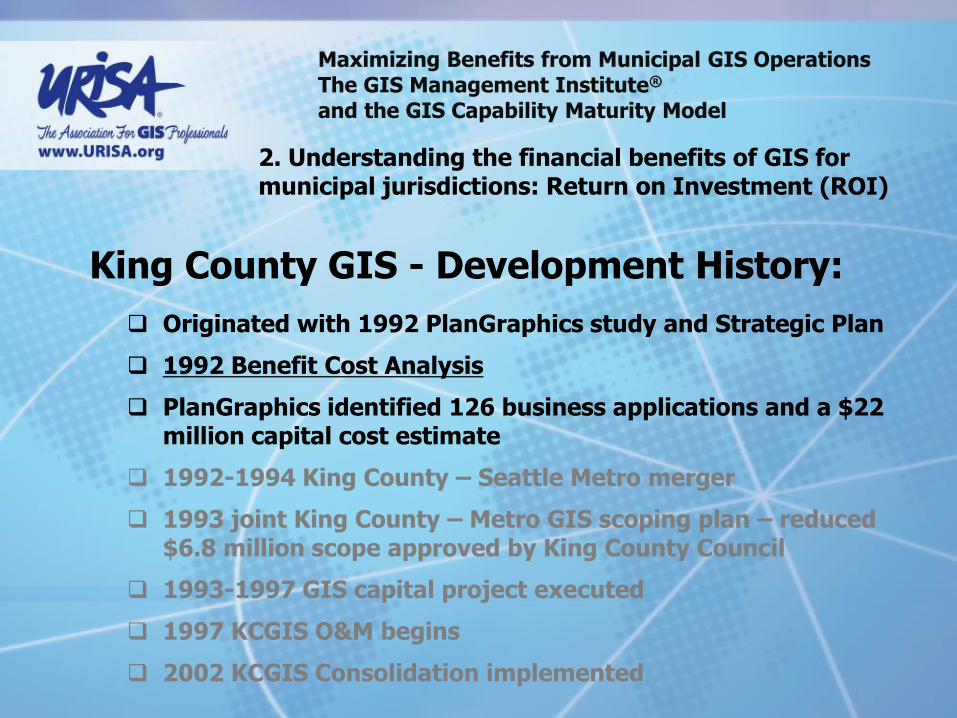
Originated with 1992 PlanGraphics study and Strategic Plan
1992 Benefit Cost Analysis
PlanGraphics identified 126 business applications and a $22 million capital cost estimate
1992-1994 King County – Seattle Metro merger
1993 joint King County – Metro GIS scoping plan – reduced $6.8 million scope approved by King County Council
1993-1997 GIS capital project executed
1997 KCGIS O&M begins
2002 KCGIS Consolidation implemented
King County GIS - Development History:

Maximizing Benefits from Municipal GIS Operations The GIS Management Institute® and the GIS Capability Maturity Model
2. Understanding the financial benefits of GIS for municipal jurisdictions: Return on Investment (ROI)
1992 Return on Investment study predicted recovery of development and operations costs in 7 year After 10 years, a 1.00:1.49 return on investment for a total net return of $11 million

Maximizing Benefits from Municipal GIS Operations The GIS Management Institute® and the GIS Capability Maturity Model
2. Understanding the financial benefits of GIS for municipal jurisdictions: Return on Investment (ROI)
Originated with 1992 PlanGraphics study
1992 Benefit Cost Analysis
PlanGraphics identified 126 business applications and a $22 million capital cost estimate
1992-1994 King County – Seattle Metro merger
1993 joint King County – Metro GIS scoping plan – reduced $6.8 million scope approved by King County Council
1993-1997 GIS capital project executed
1997 KCGIS O&M begins
2002 KCGIS Consolidation implemented

Maximizing Benefits from Municipal GIS Operations The GIS Management Institute® and the GIS Capability Maturity Model
2. Understanding the financial benefits of GIS for municipal jurisdictions: Return on Investment (ROI)
2010 King County GIS State of Development:
500+/- desktop GIS users
100,000 annual internal web based GIS user sessions
2.2 million annual external web based GIS user sessions
50 GIS professionals
GIS use expanded from 12 to 35 county departments and offices
But where are we really on the optimal development of GIS in King County?
What was (is) our ROI?
Maximizing Benefits from Municipal GIS Operations The GIS Management Institute® and the GIS Capability Maturity Model
2. Understanding the financial benefits of GIS for municipal jurisdictions: Return on Investment (ROI)
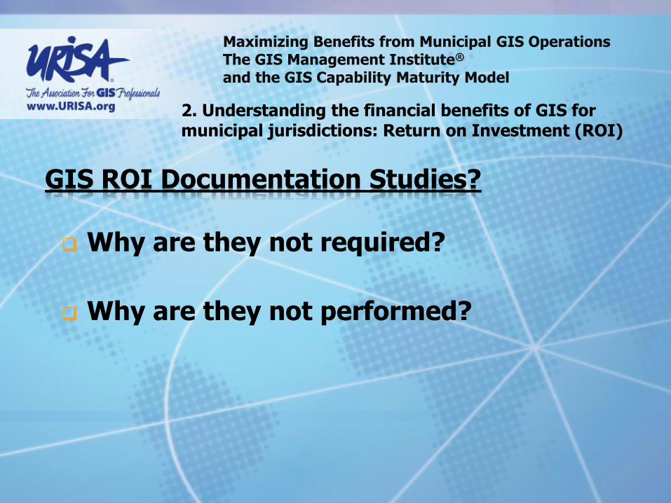
GIS ROI Documentation Studies?
Why are they not required?
Why are they not performed?

Maximizing Benefits from Municipal GIS Operations The GIS Management Institute® and the GIS Capability Maturity Model
2. Understanding the financial benefits of GIS for municipal jurisdictions: Return on Investment (ROI)
GIS ROI Documentation Studies? Baltimore County, MD 168% return on investment reported by GIS and IT staff

Maximizing Benefits from Municipal GIS Operations The GIS Management Institute® and the GIS Capability Maturity Model
2. Understanding the financial benefits of GIS for municipal jurisdictions: Return on Investment (ROI)
Why GIS ROI Documentation Studies? State of Oregon

Maximizing Benefits from Municipal GIS Operations The GIS Management Institute® and the GIS Capability Maturity Model
2. Understanding the financial benefits of GIS for municipal jurisdictions: Return on Investment (ROI)
Why GIS ROI Documentation Studies? State of Oregon
Return on investment deemed not credible because developed by a GIS consulting company.
Maximizing Benefits from Municipal GIS Operations The GIS Management Institute® and the GIS Capability Maturity Model
2. Understanding the financial benefits of GIS for municipal jurisdictions: Return on Investment (ROI)
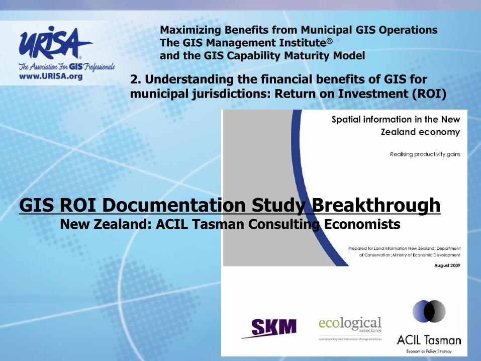
GIS ROI Documentation Study Breakthrough New Zealand: ACIL Tasman Consulting Economists
Maximizing Benefits from Municipal GIS Operations The GIS Management Institute® and the GIS Capability Maturity Model
2. Understanding the financial benefits of GIS for municipal jurisdictions: Return on Investment (ROI)
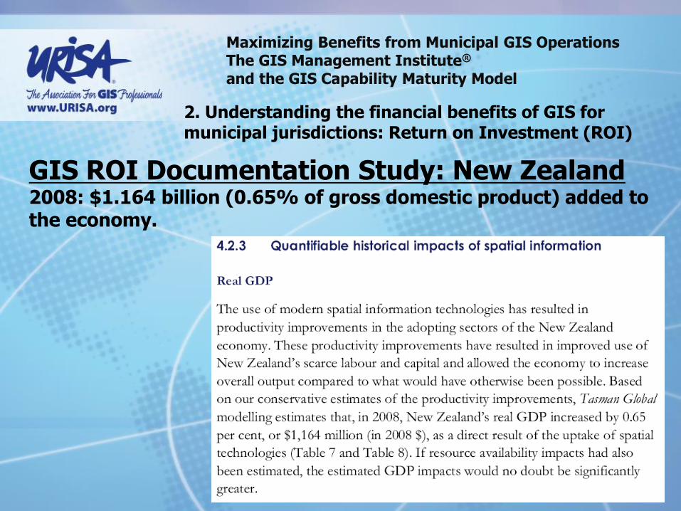
GIS ROI Documentation Study: New Zealand 2008: $1.164 billion (0.65% of gross domestic product) added to the economy.

Maximizing Benefits from Municipal GIS Operations The GIS Management Institute® and the GIS Capability Maturity Model
2. Understanding the financial benefits of GIS for municipal jurisdictions: Return on Investment (ROI)
King County GIS GIS ROI Study Project
Could we determine the historical ROI from a local government agency?
Conceived during 2009 URISA Annual Conference in Anaheim
Approach finalized during 2009 ULA in Seattle
State of Oregon & King County joint funding
KCGIS 2010 Priority Initiative
Managed by KCGIS Center

Maximizing Benefits from Municipal GIS Operations The GIS Management Institute® and the GIS Capability Maturity Model
2. Understanding the financial benefits of GIS for municipal jurisdictions: Return on Investment (ROI)
KCGIS GIS ROI Study Consultant Team from UW Evans School of Public Affairs, Benefit-Cost
Analysis Center:
Prof. Richard W. Zerbe
Danielle Fumia & Travis Reynolds
Pradeep Singh & Tyler Scott

Maximizing Benefits from Municipal GIS Operations The GIS Management Institute® and the GIS Capability Maturity Model
2. Understanding the financial benefits of GIS for municipal jurisdictions: Return on Investment (ROI)
KCGIS GIS ROI Study
Consultant Team from University of Washington Evans School of Public Affairs:
Benefit-Cost Analysis Center

Maximizing Benefits from Municipal GIS Operations The GIS Management Institute® and the GIS Capability Maturity Model
2. Understanding the financial benefits of GIS for municipal jurisdictions: Return on Investment (ROI)
KCGIS GIS ROI Study
Scope of Work:
Literature Review
Qualitative Interviews (n = 30)
Quantitative Survey (n = 200)
Final ROI Report
Revised Interview/Survey Instruments for future studies
Maximizing Benefits from Municipal GIS Operations The GIS Management Institute® and the GIS Capability Maturity Model
2. Understanding the financial benefits of GIS for municipal jurisdictions: Return on Investment (ROI)
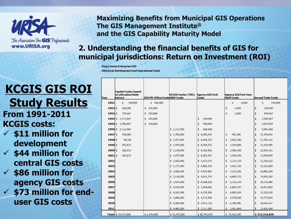
KCGIS GIS ROI Study Results
From 1991-2011 KCGIS costs: $11 million for
development $44 million for
central GIS costs $86 million for
agency GIS costs $73 million for end-
user GIS costs

Maximizing Benefits from Municipal GIS Operations The GIS Management Institute® and the GIS Capability Maturity Model
2. Understanding the financial benefits of GIS for municipal jurisdictions: Return on Investment (ROI)
Zerbe Methodology:
‘With versus without” research design.
What would have happened if KCGIS applications had not been implemented and how is King County better off having them?
Literature review and qualitative interviews will identify key benefits associated with GIS applications (e.g., increased productivity).
Questionnaire will allow assessment of the extent to which these benefits have been realized across different groups of users of GIS applications, as opposed to what these users would have done in the absence of GIS applications.
By comparing the “with and without” scenarios, we can assess and monetize the added value of the GIS applications to compare to the costs of implementation, maintenance, and/or additional training.
KCGIS GIS ROI Study

Maximizing Benefits from Municipal GIS Operations The GIS Management Institute® and the GIS Capability Maturity Model
2. Understanding the financial benefits of GIS for municipal jurisdictions: Return on Investment (ROI)
With or without survey methodology:
How has GIS altered agency output levels?
Benefits associated with FTE reductions to produce the same (pre-GIS) level of output
Benefits associated with enhanced production with the same FTE levels
Three stage analysis:
Interview agency heads and key employees to assess the types of applications and business uses. Interviews were used to build an employee survey.
Employees and managers across King County responded to the survey to record their pre and current (or with vs. without) GIS productivity by output types.
Interview and survey results were compiled by output type, agency, and productivity levels. Results were then monetized.
Monetized benefits compared to detailed GIS capital O&M, and end-user costs
KCGIS GIS ROI Study: Methodology

Maximizing Benefits from Municipal GIS Operations The GIS Management Institute® and the GIS Capability Maturity Model
2. Understanding the financial benefits of GIS for municipal jurisdictions: Return on Investment (ROI)
30 Detailed Interviews Completed
175 Survey Responses (some partial responses)
KCGIS GIS ROI Study: Methodology

Maximizing Benefits from Municipal GIS Operations The GIS Management Institute® and the GIS Capability Maturity Model
2. Understanding the financial benefits of GIS for municipal jurisdictions: Return on Investment (ROI)
PERTINENT SURVEY QUESTIONS Please estimate the number of each output you currently produce (in 2010), being clear about the time frame (per day, per year, etc.). Also state the total number of outputs from your agency (if known), and the number of employees and full-time employees (FTEs) currently working on producing this output. If you answered that you did not produce a given output in the previous section, you may skip the personal production questions.
How many units of this output do you personally produce? Choose # of units:
How many units of this output do you personally produce Per Unit of Time:
What percent of your time do you spend producing each output now? (%)
What percent of your time do you spend producing each output now: Per Unit of Time:
Number of Employees in your workgroup (including you) currently producing this output:
Total FTEs in your workgroup (including you) currently producing this output:
Maximizing Benefits from Municipal GIS Operations The GIS Management Institute® and the GIS Capability Maturity Model
2. Understanding the financial benefits of GIS for municipal jurisdictions: Return on Investment (ROI)
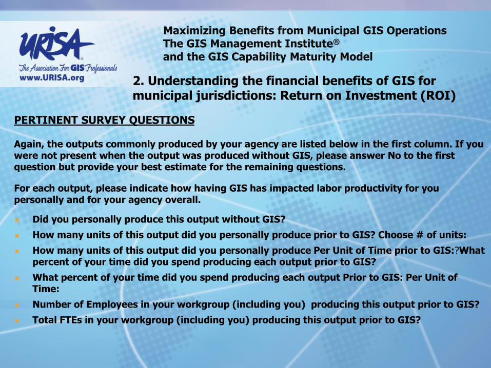
PERTINENT SURVEY QUESTIONS
Again, the outputs commonly produced by your agency are listed below in the first column. If you were not present when the output was produced without GIS, please answer No to the first question but provide your best estimate for the remaining questions.
For each output, please indicate how having GIS has impacted labor productivity for you personally and for your agency overall.
Did you personally produce this output without GIS?
How many units of this output did you personally produce prior to GIS? Choose # of units:
How many units of this output did you personally produce Per Unit of Time prior to GIS:?What percent of your time did you spend producing each output prior to GIS?
What percent of your time did you spend producing each output Prior to GIS: Per Unit of Time:
Number of Employees in your workgroup (including you) producing this output prior to GIS?
Total FTEs in your workgroup (including you) producing this output prior to GIS?

Maximizing Benefits from Municipal GIS Operations The GIS Management Institute® and the GIS Capability Maturity Model
2. Understanding the financial benefits of GIS for municipal jurisdictions: Return on Investment (ROI)
KCGIS GIS ROI Study Results

Maximizing Benefits from Municipal GIS Operations The GIS Management Institute® and the GIS Capability Maturity Model
2. Understanding the financial benefits of GIS for municipal jurisdictions: Return on Investment (ROI)
“The most conservative estimate presented finds that the use of GIS has produced approximately
$775 million in net benefits over the eighteen year period from 1992 to 2010….
Thus a reasonable estimate of total gains is between $180 million and $87 million in 2010.”
KCGIS GIS ROI Study Results

Maximizing Benefits from Municipal GIS Operations The GIS Management Institute® and the GIS Capability Maturity Model
2. Understanding the financial benefits of GIS for municipal jurisdictions: Return on Investment (ROI)
KCGIS GIS ROI Study Results
Theoretical basis for cost and benefit calculations

Maximizing Benefits from Municipal GIS Operations The GIS Management Institute® and the GIS Capability Maturity Model
2. Understanding the financial benefits of GIS for municipal jurisdictions: Return on Investment (ROI)
Questions & Answers:
At what stage is KCGIS in the total potential business use of GIS?
Are the KCGIS results ‘good’?
How do we know?
Do we need similar studies of other large counties?
Proposed single ‘latitudinal’ study of 15-20 mid-sized cities in Washington, Oregon & British Columbia
Are government agency officials not now compelled to pursue full GIS development?
KCGIS GIS ROI Study
Maximizing Benefits from Municipal GIS Operations The GIS Management Institute® and the GIS Capability Maturity Model
2. Understanding the financial benefits of GIS for municipal jurisdictions: Return on Investment (ROI)
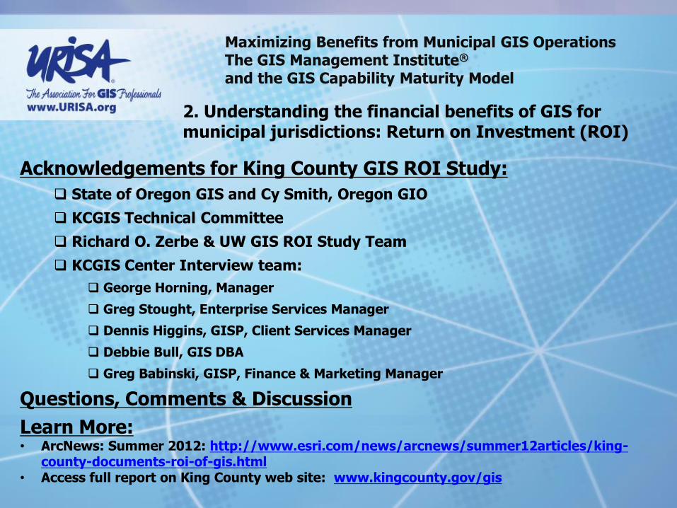
Acknowledgements for King County GIS ROI Study:
State of Oregon GIS and Cy Smith, Oregon GIO
KCGIS Technical Committee
Richard O. Zerbe & UW GIS ROI Study Team
KCGIS Center Interview team:
George Horning, Manager
Greg Stought, Enterprise Services Manager
Dennis Higgins, GISP, Client Services Manager
Debbie Bull, GIS DBA
Greg Babinski, GISP, Finance & Marketing Manager
Questions, Comments & Discussion
Learn More: • ArcNews: Summer 2012: http://www.esri.com/news/arcnews/summer12articles/king-
county-documents-roi-of-gis.html • Access full report on King County web site: www.kingcounty.gov/gis
Maximizing Benefits from Municipal GIS Operations The GIS Management Institute® and the GIS Capability Maturity Model
2. Understanding the financial benefits of GIS for municipal jurisdictions: Return on Investment (ROI)
King County, WA – GIS ROI Study http://www.kingcounty.gov/operations/GIS/News.aspx
Spatial Information in the New Zealand Economy
http://www.geospatial.govt.nz/productivityreport
Review of the Value of Spatial Information in Australia
The Value of Spatial Information for Tasmania
http://www.aciltasman.com.au
The Value of Danish Address Data
http://www.adresseinfo.dk/Portals/2/Benefit/Value_Assessment_Danish_Address_Data_UK_2010-07-07b.pdf
Iowa Geospatial Infrastructure
http://www.iowagic.org/igi/documents
Geographic Information & Technology Association (GITA). 2007. Building a Business Case for Geospatial Technology: A Practitioner’s Guide to Financial and Strategic Analysis.
Other GIS ROI literature:
Maximizing Benefits from Municipal GIS Operations The GIS Management Institute® and the GIS Capability Maturity Model
2. Understanding the financial benefits of GIS for municipal jurisdictions: Return on Investment (ROI)
Questions and Discussion?

Agenda:
1. Innovative uses of geospatial technology for municipal administration: GIS Effectiveness
2. Understanding the financial benefits of GIS for municipal jurisdictions: Return on Investment (ROI)
3. Measuring the effective of enterprise GIS operations: The URISA GIS Capability Maturity Model (GISCMM)
4. Improving future benefits from geospatial technology: The GIS Management Institute
Maximizing Benefits from Municipal GIS Operations The GIS Management Institute® and the GIS Capability Maturity Model

Maximizing Benefits from Municipal GIS Operations The GIS Management Institute® and the GIS Capability Maturity Model
Day 2 topics: What is a capability maturity model?
Origins of the GIS Capability Maturity Model
URISA Steps in and Babinski’s Theory of GIS Management
The URISA Geospatial Management Competency Model
Development of the revised, peer-reviewed URISA GIS Capability Maturity Model
The URISA GIS Capability Maturity Model – Step by Step
The pivotal role of the GIS CMM in the GIS Management Institute®
The role of the GIS Management Institute® in enhancing sustainable Enterprise GIS
The role of the GIS Management Institute® in developing professional GIS managers
The GIS Management Institute® - next steps

Maximizing Benefits from Municipal GIS Operations The GIS Management Institute® and the GIS Capability Maturity Model
What is a Capability Maturity Model? A tool to assess an organization’s ability to accomplish a
defined task or set of tasks
Originated with the Software Engineering Institute
Objective evaluation of software contractors
SEI published Managing the Software Process 1989
SEI CMM is process focused
Other applications of the capability maturity model concept:
System engineering
Project management
Risk management
Information technology service providers

Maximizing Benefits from Municipal GIS Operations The GIS Management Institute® and the GIS Capability Maturity Model
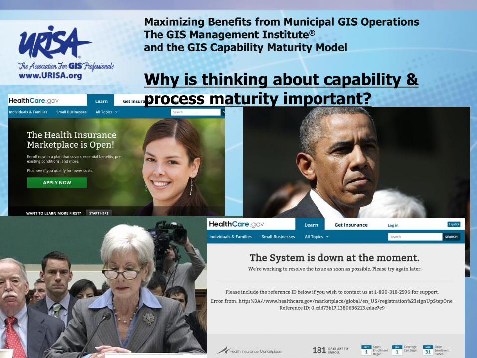
Why is thinking about capability & process maturity important?
Maximizing Benefits from Municipal GIS Operations The GIS Management Institute® and the GIS Capability Maturity Model
Why is thinking about capability & process maturity important?

Maximizing Benefits from Municipal GIS Operations The GIS Management Institute® and the GIS Capability Maturity Model
The Capability Maturity Model Institute
The Carnegie Mellon Software Engineering Institute (SEI) is a federally funded research and development center headquartered on the campus of Carnegie Mellon University in Pittsburgh, Pennsylvania, United States. SEI also has offices in Arlington, Virginia, and Frankfurt, Germany. The SEI operates with major funding from the U.S. Department of Defense. The SEI also works closely with industry and academia through research collaborations.

Maximizing Benefits from Municipal GIS Operations The GIS Management Institute® and the GIS Capability Maturity Model
Origins of the GIS Capability Maturity Model
What causes variation in enterprise GIS Operations?
Each agency is unique
City, county, or agency business focus often varies
Population
Nature and level of economic development
Level of development resources provided?
Variations in our ability to use GIS resources?
Forgetting where we are in the development cycle?
But GIS operations with similar resources get different results! Why?

Maximizing Benefits from Municipal GIS Operations The GIS Management Institute® and the GIS Capability Maturity Model
Origins of the GIS Capability Maturity Model
When is our GIS Development done?
There are many ways we might answer:
With an external focus?
Best practices
Benchmarking
With a theoretical focus?
Ideal design
Academic state of the art
With a capability focus?
With a maturity level focus?

2009 Academic Exercise:
Maturity for the proposed model indicates progression of an
organization towards GIS capability that maximizes:
Potential for the use of state of the art GIS technology
Commonly recognized quality data
Organizational best practices appropriate for municipal business use
The Municipal GIS Capability Maturity Model assumes two broad areas of GIS operational development:
Enabling capability
Execution ability
Maximizing Benefits from Municipal GIS Operations The GIS Management Institute® and the GIS Capability Maturity Model
Origins of the GIS Capability Maturity Model

Maximizing Benefits from Municipal GIS Operations The GIS Management Institute® and the GIS Capability Maturity Model
Origins of the GIS Capability Maturity Model
Enabling Capability Components:
What we buy or acquire for our GIS operation…

Maximizing Benefits from Municipal GIS Operations The GIS Management Institute® and the GIS Capability Maturity Model
Origins of the GIS Capability Maturity Model
Execution Ability Components:
How we utilize what we have acquired for our GIS
Maximizing Benefits from Municipal GIS Operations The GIS Management Institute® and the GIS Capability Maturity Model
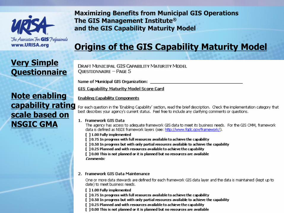
Origins of the GIS Capability Maturity Model
Very Simple Questionnaire
Note enabling capability rating scale based on NSGIC GMA

Maximizing Benefits from Municipal GIS Operations The GIS Management Institute® and the GIS Capability Maturity Model
Origins of the GIS Capability Maturity Model
Very Simple Questionnaire
Note execution ability rating scale based on SEI CMM

Maximizing Benefits from Municipal GIS Operations The GIS Management Institute® and the GIS Capability Maturity Model
Origins of the GIS Capability Maturity Model
2009 State of Washington Survey Results Presented at URISA Annual Conference:
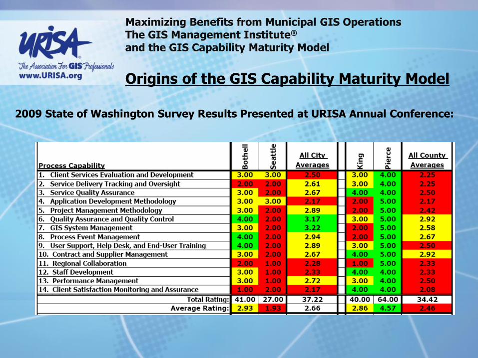
Maximizing Benefits from Municipal GIS Operations The GIS Management Institute® and the GIS Capability Maturity Model
Origins of the GIS Capability Maturity Model
2009 State of Washington Survey Results Presented at URISA Annual Conference:

Maximizing Benefits from Municipal GIS Operations The GIS Management Institute® and the GIS Capability Maturity Model
URISA Steps In and Adopts the GIS Capability Maturity Model

Maximizing Benefits from Municipal GIS Operations The GIS Management Institute® and the GIS Capability Maturity Model
URISA Steps In
2010 ArcNews Article in URISA GIS Management Column
Babinski’s Theory of GIS Management: As GIS Operational Maturity Improves, ROI Increases
Maximizing Benefits from Municipal GIS Operations The GIS Management Institute® and the GIS Capability Maturity Model
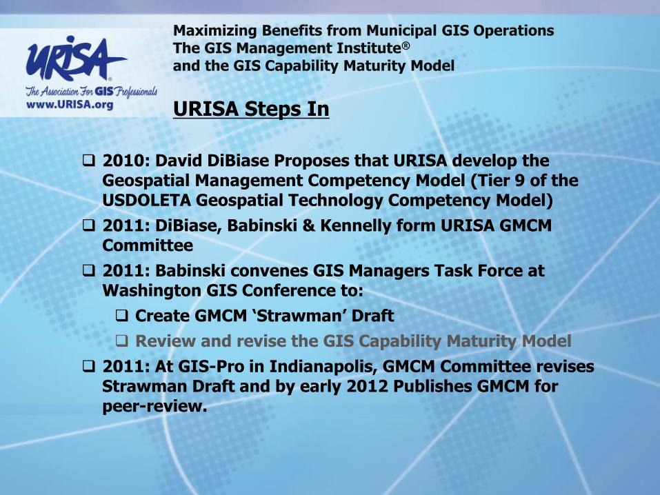
URISA Steps In
2010: David DiBiase Proposes that URISA develop the
Geospatial Management Competency Model (Tier 9 of the USDOLETA Geospatial Technology Competency Model)
2011: DiBiase, Babinski & Kennelly form URISA GMCM Committee
2011: Babinski convenes GIS Managers Task Force at Washington GIS Conference to:
Create GMCM ‘Strawman’ Draft
Review and revise the GIS Capability Maturity Model
2011: At GIS-Pro in Indianapolis, GMCM Committee revises Strawman Draft and by early 2012 Publishes GMCM for peer-review.

Maximizing Benefits from Municipal GIS Operations The GIS Management Institute® and the GIS Capability Maturity Model
URISA Develops the Geospatial Management Competency Model for the U.S. Department of Labor
Final Peer-Reviewed URISA GMCM: Published in June 2012 Adopted by USDOLETA August 2012 18 Competency Clusters 74 individual competencies

Maximizing Benefits from Municipal GIS Operations The GIS Management Institute® and the GIS Capability Maturity Model
The ‘Ah-ha!’ moment (Part 1):
GIS operational process maturity (aka the GIS Capability Maturity Model)
and…
GIS management capability (aka the Geospatial Management Competency Model)
Can both best be defined against…
A body of geospatial management best practices and standards, or the GIS Management Body of Knowledge

Maximizing Benefits from Municipal GIS Operations The GIS Management Institute® and the GIS Capability Maturity Model
The ‘Ah-ha!’ moment (Part 2):
No one has ever defined
geospatial management best practices and standards

Maximizing Benefits from Municipal GIS Operations The GIS Management Institute® and the GIS Capability Maturity Model
URISA Steps In
2010: David DiBiase Proposes that URISA develop the
Geospatial Management Competency Model (Tier 9 of the USDOLETA Geospatial Technology Competency Model)
2011: DiBiase, Babinski & Kennelly form URISA GMCM Committee
2011: Babinski convenes GIS Managers Task Force at Washington GIS Conference to:
Create GMCM ‘Strawman’ Draft
Review and revise the GIS Capability Maturity Model
2011: At GIS-Pro in Indianapolis, GMCM Committee revises Strawman Draft and by early 2012 Publishes GMCM for peer-review.

Maximizing Benefits from Municipal GIS Operations The GIS Management Institute® and the GIS Capability Maturity Model
Developing the revised, peer-reviewed URISA GIS Capability Maturity Model
2011 Washington State GIS Managers Task Force

Maximizing Benefits from Municipal GIS Operations The GIS Management Institute® and the GIS Capability Maturity Model
Developing the revised, peer-reviewed URISA GIS Capability Maturity Model
2012 – 2013 GMI Committee: Incorporated 2011 GIS Managers Task Force Recommendations Correlated 74 GMCM competencies Prompted for assessing ‘Characteristics’ via questions

Maximizing Benefits from Municipal GIS Operations The GIS Management Institute® and the GIS Capability Maturity Model
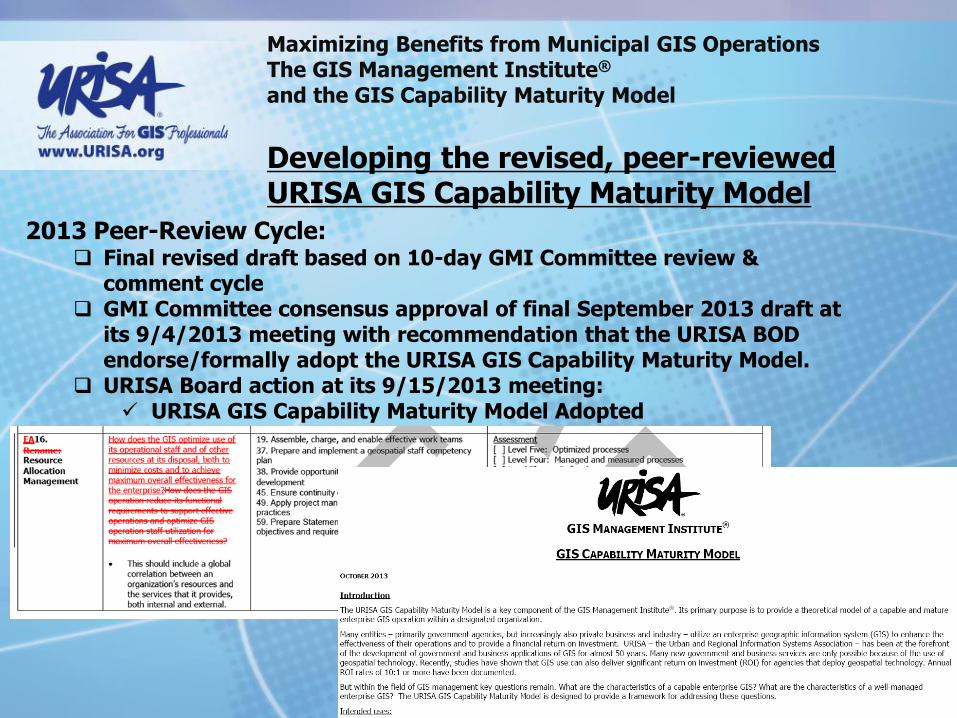
Developing the revised, peer-reviewed URISA GIS Capability Maturity Model
2013 Peer-Review Cycle: 6-weeks for public review via online questionnaire Adequate high-quality responses Responses consolidated by Hilary Perkins and Greg Babinski Greg Babinski drafted initial recommendations to address/resolve
comments Final 10-day GMI Committee review & comment cycle

Maximizing Benefits from Municipal GIS Operations The GIS Management Institute® and the GIS Capability Maturity Model
Developing the revised, peer-reviewed URISA GIS Capability Maturity Model
2013 Peer-Review Cycle:
Enabling Capability (EC) Component EC1. Framework GIS Data EC2. Framework GIS Data Maintenance EC3. Business GIS Data EC4. Business GIS Data Maintenance EC5. GIS Data Coordination EC6. Metadata EC7. Spatial Data Warehouse EC8. Architectural Design EC9. Technical Infrastructure EC10. Replacement Plan EC11. GIS Software Maintenance EC12. Data back-up and security EC13. GIS Application Portfolio EC14. GIS Application Portfolio Management EC15. GIS Application Portfolio O&M EC16. Professional GIS Management EC17. Professional GIS Operations Staff EC18. GIS Staff Training and Professional Development EC19. GIS Governance Structure EC20. GIS is Linked to Agency Strategic Goals EC21. GIS Budget EC22. GIS Funding EC23. GIS Financial Plan
Execution Ability (EA) Component EA1. New Client Services Evaluation and Development EA2. User Support, Help Desk, and End-User Training EA3. Service Delivery Tracking and Oversight EA4. Service Quality Assurance EA5. Application Development or Procurement Methodology EA6. Project Management Methodology EA7. Quality Assurance and Quality Control EA8. GIS System Management EA9. Process Event Management EA10. Contract and Supplier Management EA11. Regional Collaboration EA12. Staff Development EA13. Operation Performance Management EA14. Individual GIS Staff Performance Management EA15. Client Satisfaction Monitoring and Assurance EA16. Resource Allocation Management EA17. GIS data sharing EA18. GIS Software License Sharing EA19. GIS data inter-operability EA20. Legal and policy affairs management EA21. Balancing minimal privacy with maximum data usage EA22. Service to the community and to the profession
Maximizing Benefits from Municipal GIS Operations The GIS Management Institute® and the GIS Capability Maturity Model
Developing the revised, peer-reviewed URISA GIS Capability Maturity Model
2013 Peer-Review Cycle: Final revised draft based on 10-day GMI Committee review &
comment cycle GMI Committee consensus approval of final September 2013 draft at
its 9/4/2013 meeting with recommendation that the URISA BOD endorse/formally adopt the URISA GIS Capability Maturity Model.
URISA Board action at its 9/15/2013 meeting: URISA GIS Capability Maturity Model Adopted

Maximizing Benefits from Municipal GIS Operations The GIS Management Institute® and the GIS Capability Maturity Model
Enabling Capability Components
For each question in the ‘Enabling Capability’ section, read the brief description.
Check the implementation category
[ ] 1.00 Fully implemented
[ ] 0.80 In progress with full resources available to achieve the capability
[ ] 0.60 In progress but with only partial resources available to achieve the
capability
[ ] 0.40 Planned and with resources available to achieve the capability
[ ] 0.20 Planned but with no resources available to achieve the capability
[ ] 0.00 This desired, but is not planned
[ ] Not Applicable (This is a non-numeric response that requires an explanation
of why this component should not be considered in assessing the operation.)
3. Measuring the effective of enterprise GIS operations: The URISA GIS Capability Maturity Model (GISCMM)

Maximizing Benefits from Municipal GIS Operations The GIS Management Institute® and the GIS Capability Maturity Model
3. Measuring the effective of enterprise GIS operations: The URISA GIS Capability Maturity Model (GISCMM)
EC1. Framework GIS Data
Complete assessment for each data layer:
a. Geodetic Control
b. Cadastral
c. Orthoimagery
d. Elevation
e. Hydrography
f. Administrative Units
g. Transportation
Does the agency have access to adequate framework GIS data to meet its business needs? For the GISCMM, framework data corresponds to jurisdiction-wide common base layers as defined by the agency to meet its business needs.
For reference, refer to the NSDI framework data layers (see http://www.fgdc.gov/framework/).
See also EC2, below)
EC2. Framework GIS Data Maintenance
Complete assessment for each data layer:
a. Geodetic Control
b. Cadastral
c. Orthoimagery
d. Elevation
e. Hydrography
f. Administrative Units
g. Transportation
Are data stewards defined for each framework GIS data layer and the data is maintained (kept up to date) to meet business needs?
Refer to EC6 for description of the ideal data environment.
There could very likely be multiple stewards
The Enterprise GIS responsibility is that there are no gaps in coverage
In performing the assessment, every framework component should be covered

Maximizing Benefits from Municipal GIS Operations The GIS Management Institute® and the GIS Capability Maturity Model
3. Measuring the effective of enterprise GIS operations: The URISA GIS Capability Maturity Model (GISCMM)
EC3. Business GIS Data
Complete assessment for each data layer:
a. Example: situs address
b. Name:
c. Name:
d. Name:
e. Name:
Does the agency have access to adequate business data (non-framework GIS data) to meet its business needs?
Need for data based on agency business needs, therefore this data will vary from agency to agency; specific business data layers will not be comparable from agency to agency
Agency completing the assessment should name at least 5 but no more than 10 business data types. These business data layers should also be assessed under EC4, below.
EC4. Business GIS Data Maintenance
Complete assessment for each data layer:
a. Example: situs address
b. Name:
c. Name:
d. Name:
e. Name:
Does the agency have data stewards defined for each business GIS data layer and is the data is maintained (kept up to date) to meet business needs?
Also refer to EC3 above for business Refer to EC7 below, for ideal data environment

Maximizing Benefits from Municipal GIS Operations The GIS Management Institute® and the GIS Capability Maturity Model
3. Measuring the effective of enterprise GIS operations: The URISA GIS Capability Maturity Model (GISCMM)
EC5. GIS Data Coordination Is there an enterprise GIS data coordination function and/or committee to rationalize framework and business GIS data development, access, and maintenance?
This could be a function of a GIO (chief geographic information officer), a governance function, or an enterprise GIS office function, depending on desired level of formality or institutionalization.
EC6. Metadata
Is metadata available and maintained for all framework and business data layers?
Is there a rationale for accepting any data without metadata?

Maximizing Benefits from Municipal GIS Operations The GIS Management Institute® and the GIS Capability Maturity Model
3. Measuring the effective of enterprise GIS operations: The URISA GIS Capability Maturity Model (GISCMM)
EC7. Spatial Data Warehouse
Is an enterprise spatial data infrastructure in place that includes a centralized production database environment available for GIS data stewards to compile the official version of framework and business spatial data?
Is a separate spatial data warehouse available for GIS users to access and download the official published version of the data for GIS applications?
Is there a consistent data structure and are there consistent practices for effective data maintenance, posting and processing?
Is the enterprise GIS the authoritative source of spatial data for the organization?
EC8. Architectural Design
Does an architectural design exist that defines the current state and planned future development of the technical infrastructure? Does the architectural design guide the investment in GIS technical infrastructure?
Does the GIS Architectural design support the business architecture and all business activities, per the Zachman Framework (or similar)?
Does it align with agency IT standards and architecture?
Does the agency analyze architectural gaps and drive IT standards and architectural design criteria?
Note that architectural design(8) and Technical infrastructure (9) are interrelated

Maximizing Benefits from Municipal GIS Operations The GIS Management Institute® and the GIS Capability Maturity Model
3. Measuring the effective of enterprise GIS operations: The URISA GIS Capability Maturity Model (GISCMM)
EC9. Technical Infrastructure
Is there technical infrastructure in place to maintain and operate the GIS and to meet the agency business needs?
Meeting agency business needs should be defined against agreed performance criteria. Technical infrastructure includes hardware (servers, storage, desktops, input and output peripherals), network components, operating system, and GIS software.
Note that architectural design(8) and Technical infrastructure (9) are interrelated
EC10. Replacement Plan Is there a plan in place and implemented to replace technical infrastructure components (hardware, network components, current imagery, and other procured data) that have a defined ‘end of useful life?

Maximizing Benefits from Municipal GIS Operations The GIS Management Institute® and the GIS Capability Maturity Model
3. Measuring the effective of enterprise GIS operations: The URISA GIS Capability Maturity Model (GISCMM)
EC11. GIS Software Maintenance
Is GIS software available and adequate to meet agency business needs and is it under maintenance to ensure long term support and development?
If open-source’ GIS software is used, is alternate support and development capability available and are the real costs of operation and maintenance accounted for?
EC12. Data back-up and security
Is a computer back-up system in place to ensure the security of GIS data and applications?
Is the backup system is tested periodically by tests to restore sample data?
Is system security in place to control internal and external access to GIS data and applications as appropriate?
Is a GIS data archiving and preservation program in place?
EC13. GIS Application Portfolio If required to meet the needs of agency GIS users/clients, is a
portfolio of custom or off-the-shelf GIS or GIS enabled applications available?

Maximizing Benefits from Municipal GIS Operations The GIS Management Institute® and the GIS Capability Maturity Model
3. Measuring the effective of enterprise GIS operations: The URISA GIS Capability Maturity Model (GISCMM)
EC14. GIS Application Portfolio Management
Is the agency’s GIS application portfolio managed to a common design and development framework?
EC15. GIS Application Portfolio O&M
Is the agency’s GIS application portfolio kept viable via ongoing support and application maintenance?
EC16. Professional GIS Management
Is the agency GIS managed by a qualified manager with appropriate education, experience, and credentials?
EC17. Professional GIS Operations Staff
Is the agency GIS operated and maintained by an adequate staff with appropriate professional qualifications?
For purposes of the GISCMM, adequate operational staffing is defined as meeting the ‘roles’ defined by the Geospatial Technology Competency Model – see: http://www.careeronestop.org/CompetencyModel/pyramid.aspx?GEO=Y.
EC18. GIS Staff Training and Professional Development
Do the agency GIS manager and other professional staff have access to on-going training to maintain and develop their technical and operational knowledge, skills, and abilities?

Maximizing Benefits from Municipal GIS Operations The GIS Management Institute® and the GIS Capability Maturity Model
3. Measuring the effective of enterprise GIS operations: The URISA GIS Capability Maturity Model (GISCMM)
EC19. GIS Governance Structure
Does the agency have a formal GIS governance structure that links the GIS operation both to users and to key decision makers?
For some agencies (very small or with well-oiled enterprise GIS) a formal committee structure may not be required. A formal committee is a traditional practice, but in everyday practice, many agencies proceed without such a formal committee structure.
Does the agency’s governance address:
Long-range planning
Stakeholder satisfaction
Ability for business stakeholders to leverage initiatives
EC20. GIS is Linked to Agency Strategic Goals
Does the GIS as it exists have a defined responsibility and a clearly defined role in supporting the strategic goals of the agency?

Maximizing Benefits from Municipal GIS Operations The GIS Management Institute® and the GIS Capability Maturity Model
3. Measuring the effective of enterprise GIS operations: The URISA GIS Capability Maturity Model (GISCMM)
EC21. GIS Budget Does the GIS operation develop a comprehensive budget that includes (at a minimum) labor, hardware, software, data, consulting, and training costs?
This mean either a separate GIS budget or embedded budget components that the GIS manager has input on and can base planning and programs upon as the budget is expended.
EC22. GIS Funding Does the GIS organization have adequate funding for (at a minimum) labor, hardware, software, data, consulting, and training costs?
EC23. GIS Financial Plan Does the GIS organization have a financial plan that includes a funding model (where the money is coming from) and that also projects future episodic costs for equipment, imagery, and other data replacement?

Maximizing Benefits from Municipal GIS Operations The GIS Management Institute® and the GIS Capability Maturity Model
3. Measuring the effective of enterprise GIS operations: The URISA GIS Capability Maturity Model (GISCMM)
Execution Ability Components
For each question in the ‘Execution Ability’ section, read the brief question and description. Check the implementation category that best describes your agency’s current status. Feel free to include any clarifying comments or questions.
[ ] Level Five: Optimized processes
[ ] Level Four: Managed and measured processes
[ ] Level Three: Defined processes
[ ] Level Two: Repeatable processes
[ ] Level One: Ad-hoc processes

Maximizing Benefits from Municipal GIS Operations The GIS Management Institute® and the GIS Capability Maturity Model
3. Measuring the effective of enterprise GIS operations: The URISA GIS Capability Maturity Model (GISCMM)
EA1. New Client Services Evaluation and Development
How does the GIS operation evaluate new agency business needs for GIS services and develop plans to respond to new client service requests?
This component should include a timeline/turn-around response focus.
Are new services evaluated against the agency strategic plan?
Are new services evaluated against ROI criteria…does it make financial sense?
Level 5 – optimized process – requires looking at existing services also and evaluating them to provide optimized services.
EA2. User Support, Help Desk, and End-User Training
How does the GIS operation support end users, including user guides, help documentation, training, and ad-hoc help-desk and/or on-site support?
This component should include a timeline/turn-around response focus
This should include a ‘train-the-trainer program.

Maximizing Benefits from Municipal GIS Operations The GIS Management Institute® and the GIS Capability Maturity Model
3. Measuring the effective of enterprise GIS operations: The URISA GIS Capability Maturity Model (GISCMM)
EA3. Service Delivery Tracking and Oversight
How does the GIS unit monitor and evaluate client service delivery?
EA4. Service Quality Assurance
How does the GIS operation ensure the quality of services provided to clients?
This should also recognize the quality that can be provided may be dependent upon the time available to meet the client’s needs
EA5. Application Development or Procurement Methodology
How does the GIS operation develop custom GIS applications?
Do GIS applications align with and support business needs?
How does the GIS Operation preform requirements development and development execution strategy, including build vs. buy decision?
How does the GIS Operation manage GIS application development when in-house programming is not included within the GIS operation?
This should also recognize the quality that can be provided may be dependent upon the time available to meet the client’s needs

Maximizing Benefits from Municipal GIS Operations The GIS Management Institute® and the GIS Capability Maturity Model
3. Measuring the effective of enterprise GIS operations: The URISA GIS Capability Maturity Model (GISCMM)
EA6. Project Management Methodology
How does the GIS operation manage projects for which it is responsible?
Projects could be either executed in-house or by an outside contractor.
EA7. Quality Assurance and Quality Control
How does the GIS operation assure a reasonable and appropriate level of quality for projects and for ongoing GIS system operation, to meet defined business needs?
System operations include database maintenance and spatial data warehouse processes.
Data is a key enterprise GIS component for effective QA/QC.
Perhaps there are several processes against which this maturity component should be applied.
EA8. GIS System Management
How does the GIS operation manage the core GIS systems that it is responsible for?
GIS system management includes system administration, database administration, network administration, system security, data backup, security, and restore processes, etc.
If these functions are managed within the GIS Operation, there should be defined procedures/best practices. But if the functions are provided outside the GIS operation, these procedures and best practices should form the basis for well-defined service level agreements.

Maximizing Benefits from Municipal GIS Operations The GIS Management Institute® and the GIS Capability Maturity Model
3. Measuring the effective of enterprise GIS operations: The URISA GIS Capability Maturity Model (GISCMM)
EA9. Process Event Management
How does the GIS operation manage GIS system process events?
Typical process events include planned hardware and software upgrades, unplanned hardware failure and data loss and restore events.
This should include well defined change management best practices, for both routine/batch processes, and for significant system upgrades/modifications.
EA10. Contract and Supplier Management
How does the GIS operation manage its purchasing and contracting processes to ensure the best value for the supplies and services that it acquires?
EA11. Regional Collaboration How does the GIS operation manage regional collaboration to ensure that opportunities to share in the development and operation of data, infrastructure, and applications are pursued, and that the agency’s GIS is leveraged to benefit other potential local partners?
Maximizing Benefits from Municipal GIS Operations The GIS Management Institute® and the GIS Capability Maturity Model
3. Measuring the effective of enterprise GIS operations: The URISA GIS Capability Maturity Model (GISCMM)
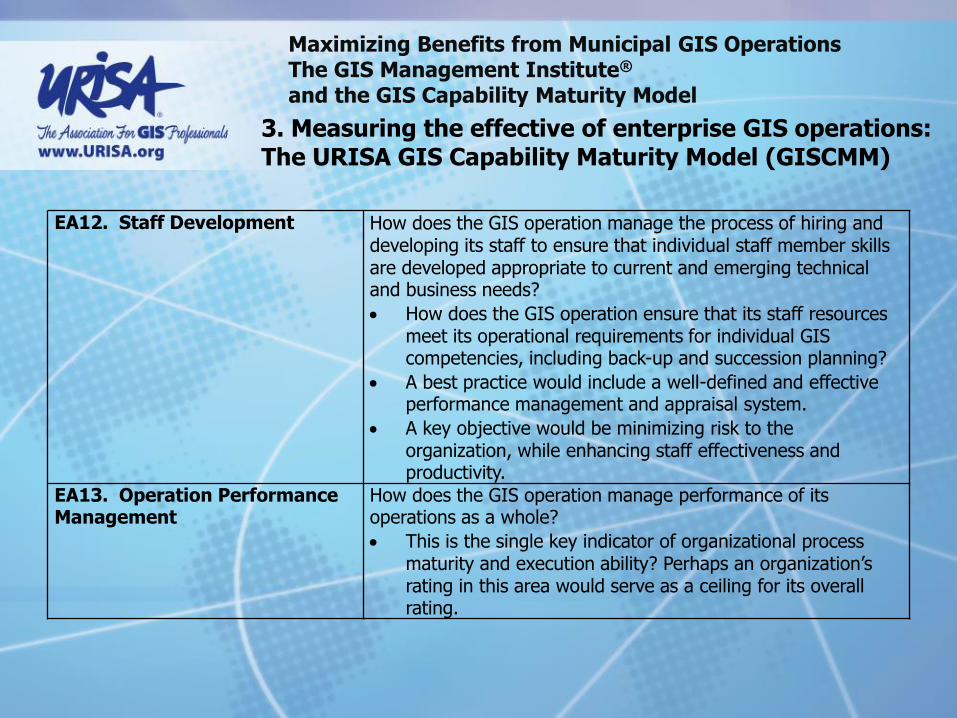
EA12. Staff Development How does the GIS operation manage the process of hiring and developing its staff to ensure that individual staff member skills are developed appropriate to current and emerging technical and business needs?
How does the GIS operation ensure that its staff resources meet its operational requirements for individual GIS competencies, including back-up and succession planning?
A best practice would include a well-defined and effective performance management and appraisal system.
A key objective would be minimizing risk to the organization, while enhancing staff effectiveness and productivity.
EA13. Operation Performance Management
How does the GIS operation manage performance of its operations as a whole?
This is the single key indicator of organizational process maturity and execution ability? Perhaps an organization’s rating in this area would serve as a ceiling for its overall rating.

Maximizing Benefits from Municipal GIS Operations The GIS Management Institute® and the GIS Capability Maturity Model
3. Measuring the effective of enterprise GIS operations: The URISA GIS Capability Maturity Model (GISCMM)
EA14. Individual GIS Staff Performance Management
How does the GIS operation manage individual employee staff performance?
EA15. Client Satisfaction Monitoring and Assurance
How does the GIS operation monitor, assess, and assure the satisfaction of its clients?
Ideally, clients should be surveyed to indicate their satisfaction with individual projects and with the enterprise GIS operation as a whole.
EA16.
Resource Allocation Management
How does the GIS optimize use of its operational staff and of other resources at its disposal, both to minimize costs and to achieve maximum overall effectiveness for the enterprise?
This should include a global correlation between an organization’s resources and the services that it provides, both internal and external.

Maximizing Benefits from Municipal GIS Operations The GIS Management Institute® and the GIS Capability Maturity Model
3. Measuring the effective of enterprise GIS operations: The URISA GIS Capability Maturity Model (GISCMM)
EA17. GIS data sharing Is GIS data sharable and is it shared? How does the GIS operation leverage shared and sharable GIS data to maintain effectiveness and minimize cost and redundant functions?
EA18. GIS Software License Sharing
Are GIS software licenses sharable and are they shared?
How does the GIS operation leverage shared and sharable GIS software to maintain effectiveness and minimize cost and redundant services?
EA19. GIS data inter-operability
Are agency framework and business geospatial data sources capable of being integrated and accessed in a technically appropriate and efficient manner?
Maximizing Benefits from Municipal GIS Operations The GIS Management Institute® and the GIS Capability Maturity Model
3. Measuring the effective of enterprise GIS operations: The URISA GIS Capability Maturity Model (GISCMM)
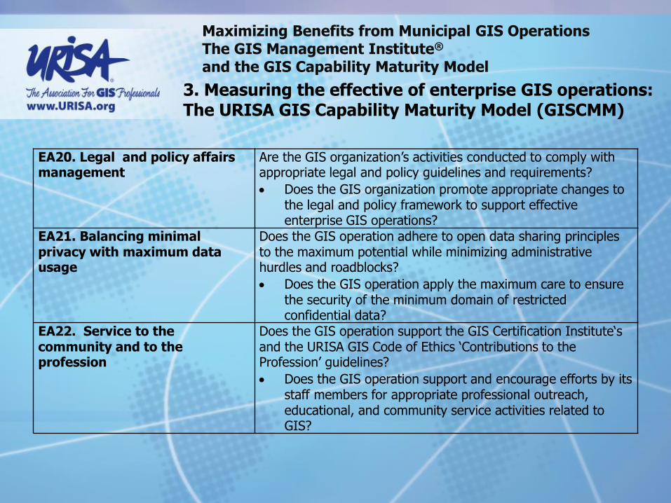
EA20. Legal and policy affairs management
Are the GIS organization’s activities conducted to comply with appropriate legal and policy guidelines and requirements?
Does the GIS organization promote appropriate changes to the legal and policy framework to support effective enterprise GIS operations?
EA21. Balancing minimal privacy with maximum data usage
Does the GIS operation adhere to open data sharing principles to the maximum potential while minimizing administrative hurdles and roadblocks?
Does the GIS operation apply the maximum care to ensure the security of the minimum domain of restricted confidential data?
EA22. Service to the community and to the profession
Does the GIS operation support the GIS Certification Institute‘s and the URISA GIS Code of Ethics ‘Contributions to the Profession’ guidelines?
Does the GIS operation support and encourage efforts by its staff members for appropriate professional outreach, educational, and community service activities related to GIS?

Maximizing Benefits from Municipal GIS Operations The GIS Management Institute® and the GIS Capability Maturity Model
3. Measuring the effective of enterprise GIS operations: The URISA GIS Capability Maturity Model (GISCMM)
Questions and Discussion?

Maximizing Benefits from Municipal GIS Operations The GIS Management Institute® and the GIS Capability Maturity Model
4. Improving future benefits from geospatial technology: The GIS Management Institute
URISA GIS Management Institute®
GMI Goal:
The GIS Management Institute® helps organizations identify and implement enterprise GIS management practice improvements.
GIS managers, anywhere in the world, will increase return on investment and maximize the effective use of GIS for their enterprise business goals with GMI products and services.
URISA Received GIS Management Institute Charter from the U.S. Patent and Trademark Office in 2013.

Maximizing Benefits from Municipal GIS Operations The GIS Management Institute® and the GIS Capability Maturity Model
4. Improving future benefits from geospatial technology: The GIS Management Institute
URISA GIS Management Institute®
Business Need:
GIS professionals and practitioners invest considerable time and money for their initial education and continual training, yet recognized professional practice standards and guidelines are lacking in the GIS profession.
Public agencies and private entities have invested very large sums of money to develop and operate their enterprise GIS and program specific GIS operations, yet best-practices and investment validation for GIS operations are both lacking.
Worldwide, most GIS managers, professionals, and practitioners continue to deliver value to society through the work that they do.
But there remains a need for an environment where best practices and professional standards can be developed, validated, and promoted to maximize the value and effectiveness of GIS operations.
These are the needs that the GIS Management Institute® will meet.

Maximizing Benefits from Municipal GIS Operations The GIS Management Institute® and the GIS Capability Maturity Model
4. Improving future benefits from geospatial technology: The GIS Management Institute
URISA GIS Management Institute®
GMI Core Products and Services:
The GIS Management Institute® already has two key products that are central to its core strategy:
• The Geospatial Management Competency Model (GMCM) for mangers
• The GIS Capability Maturity Model. (GISCMM) for GIS organizations
The GIS Management Body of Knowledge (GMBOK) will be a third key product of the GMI. The GMBOK is intended to be a GMI product that generates substantial revenue.

Maximizing Benefits from Municipal GIS Operations The GIS Management Institute® and the GIS Capability Maturity Model
4. Improving future benefits from geospatial technology: The GIS Management Institute
URISA GIS Management Institute®
GMI Core Products and Services:
The GISCMM and the GMBOK will also be used to develop an on-line subscription based organizational assessment and accreditation service for enterprise GIS operations anywhere in the world. This will be the primary revenue generating GMI service.
Subscribers to the service will populate the GMI database with metrics on their own GIS configuration, maturity assessment, and performance metrics.
Their subscription will then provide them access to the GMI database to analyze the effectiveness of individual GIS management best practices and to compare their GIS operations against peer agencies worldwide.
Maximizing Benefits from Municipal GIS Operations The GIS Management Institute® and the GIS Capability Maturity Model
4. Improving future benefits from geospatial technology: The GIS Management Institute
URISA GIS Management Institute®
GMI Core Products and Services:
The GISCMM, GMCM, and the GMBOK will also be used to develop a revenue-generating, subscription-based GIS educational program accreditation service.
The GMCM and the GMBOK will be used in cooperation with GISCI, to develop a revenue generating GIS Management Certification Program.
Maximizing Benefits from Municipal GIS Operations The GIS Management Institute® and the GIS Capability Maturity Model
4. Improving future benefits from geospatial technology: The GIS Management Institute
URISA GIS Management Institute®
GMI Core Strategy:
The GMI core strategy is to help those who deploy, operate, and manage GIS organizations enhance their personal competency, and improve the effectiveness and ROI from their investment in GIS.
The GMI will mobilize volunteer GIS professionals (to be called GMI Associates) to create the GMBOK, comprised of individual GIS Best Practices.
The GMBOK will be developed by starting with frameworks that have already been developed by URISA, such as the GMCM and the GISCMM.
Topics for individual GIS Management Best Practices will be developed from the 23 capability and 22 maturity components of the GISCMM.
Each topic will include a narrative of the best practice, a policy template, recommended metrics, a description of required professional competencies to support the best practice, and recommended learning objectives to inform the development of a curriculum to teach the best practice.

Maximizing Benefits from Municipal GIS Operations The GIS Management Institute® and the GIS Capability Maturity Model
4. Improving future benefits from geospatial technology: The GIS Management Institute
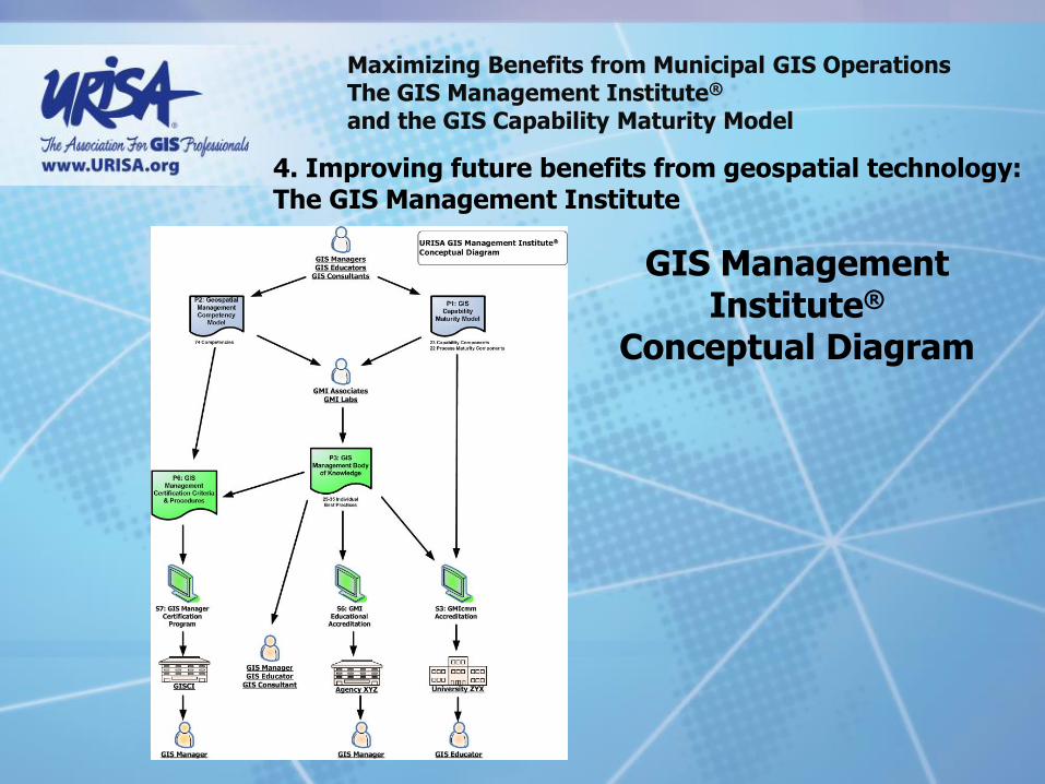
GIS Management Institute®
Conceptual Diagram
Maximizing Benefits from Municipal GIS Operations The GIS Management Institute® and the GIS Capability Maturity Model
4. Improving future benefits from geospatial technology: The GIS Management Institute
GIS Management Institute®
Conceptual Diagram

Maximizing Benefits from Municipal GIS Operations The GIS Management Institute® and the GIS Capability Maturity Model
4. Improving future benefits from geospatial technology: The GIS Management Institute
GIS Management
Institute® Operational
Diagram

Maximizing Benefits from Municipal GIS Operations The GIS Management Institute® and the GIS Capability Maturity Model
Submit completed GISCMM self assessments to GMI
Annual GMI Report on the state of Enterprise GIS
New URISA GMI Service: Enterprise GIS Assessment/Accreditation:
Online survey instrument
Self assessment with validation mechanisms
Compilation of bench marking metrics
Evaluation against GISCMM
Manager assessment against GMCM
Feedback report with benchmark analysis and development recommendations
GMIcmm Maturity Level Accreditation
4. Improving future benefits from geospatial technology: The GIS Management Institute

Maximizing Benefits from Municipal GIS Operations The GIS Management Institute® and the GIS Capability Maturity Model
Enhancing sustainable Enterprise GIS
4. Improving future benefits from geospatial technology: The GIS Management Institute

Maximizing Benefits from Municipal GIS Operations The GIS Management Institute® and the GIS Capability Maturity Model
Enhancing sustainable Enterprise GIS
4. Improving future benefits from geospatial technology: The GIS Management Institute
Enterprise GIS Capability Assessment Report Template

Maximizing Benefits from Municipal GIS Operations The GIS Management Institute® and the GIS Capability Maturity Model
Enhancing sustainable Enterprise GIS
4. Improving future benefits from geospatial technology: The GIS Management Institute
Enterprise GIS Maturity Assessment Report Template

Maximizing Benefits from Municipal GIS Operations The GIS Management Institute® and the GIS Capability Maturity Model
Enhancing professionalism for GIS managers
The competency of the GIS manager is one of the key success factors for an effective enterprise GIS

Maximizing Benefits from Municipal GIS Operations The GIS Management Institute® and the GIS Capability Maturity Model
Enhancing professionalism for GIS managers
Assessing the competency of a GIS manager against the Geospatial Management Competency Model
4. Improving future benefits from geospatial technology: The GIS Management Institute

Maximizing Benefits from Municipal GIS Operations The GIS Management Institute® and the GIS Capability Maturity Model
GISCMM Development Contributors:

Maximizing Benefits from Municipal GIS Operations The GIS Management Institute® and the GIS Capability Maturity Model
Contributors:

Maximizing Benefits from Municipal GIS Operations The GIS Management Institute® and the GIS Capability Maturity Model
The GIS Capability Maturity Model and the GIS Management Institute®
Attendee Discussion and Feedback Do you have any:
Questions?
Suggestions?
Criticisms?
Ideas for using the GISCMM of the GIS Management Institute?
Other comments?

Maximizing Benefits from Municipal GIS Operations The GIS Management Institute® and the GIS Capability Maturity Model
Greg Babinski, MA, GISP
URISA Past-President URISA GMI Committee Chair COGO Secretary W: www.urisa.org/main/gis-management-institute/ Finance & Marketing Manager
King County GIS Center 201 South Jackson Street MS: KSC-IT-0706 Seattle, WA 98104 USA P: 206-477-4402 F: 206-263-3145 E: [email protected] T: @gbabinski W: www.kingcounty.gov/gis