Embed Size (px)
Citation preview
Rocks and Waters: Cleveland Heights deep history
by Roy Larick, Bluestone Heights
Each May, since 2002, Cleveland Heights has celebrated
National Preservation Month. Since 2013, the annual
activities have featured a walking tour series called Cleveland
Heights Rocks and Waters.
The tours pose questions about the places in which we live.
How does a neighborhood landscape come to be? What does
nature provide? Can humans live in ways to honor the gift?
Rocks and Waters finds answers along neighborhood stream
courses. At such places, natural and human forces combine to
shape landscapes. The resulting mixture always makes for an
intriguing visit. On such visits, we gain insights on local life
issues and on the good and bad of place planning. We see
what once was, what we now have, and how it could be better.
Deep History Rocks and Waters looks for the elemental
forces giving rise to natural landforms. We also seek the
weave of natural and human actions that make current places
special—and sometimes startling. Stated simply, the walks
explore the deep history of small-scale Heights landscapes.
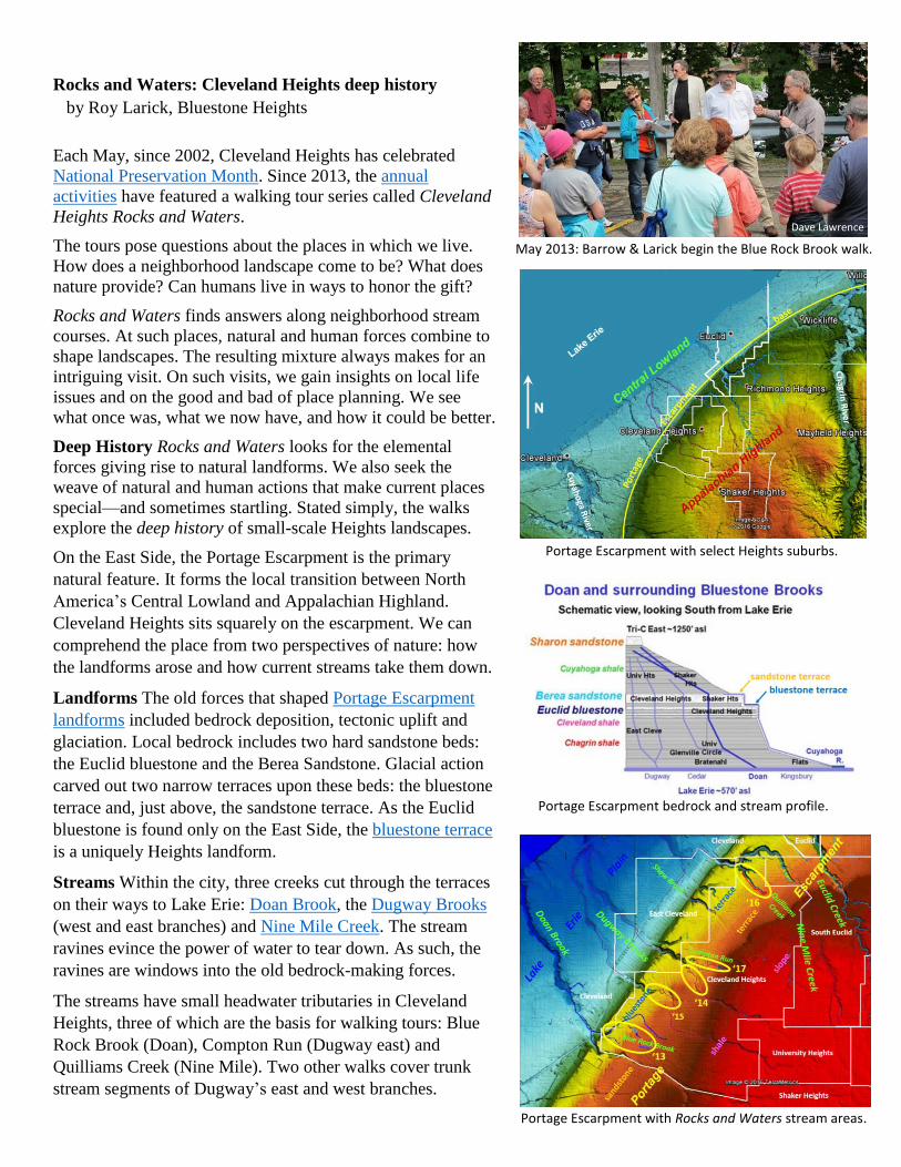
On the East Side, the Portage Escarpment is the primary
natural feature. It forms the local transition between North
America’s Central Lowland and Appalachian Highland.
Cleveland Heights sits squarely on the escarpment. We can
comprehend the place from two perspectives of nature: how
the landforms arose and how current streams take them down.
Landforms The old forces that shaped Portage Escarpment
landforms included bedrock deposition, tectonic uplift and
glaciation. Local bedrock includes two hard sandstone beds:
the Euclid bluestone and the Berea Sandstone. Glacial action
carved out two narrow terraces upon these beds: the bluestone
terrace and, just above, the sandstone terrace. As the Euclid
bluestone is found only on the East Side, the bluestone terrace
is a uniquely Heights landform.
Streams Within the city, three creeks cut through the terraces
on their ways to Lake Erie: Doan Brook, the Dugway Brooks
(west and east branches) and Nine Mile Creek. The stream
ravines evince the power of water to tear down. As such, the
ravines are windows into the old bedrock-making forces.
The streams have small headwater tributaries in Cleveland
Heights, three of which are the basis for walking tours: Blue
Rock Brook (Doan), Compton Run (Dugway east) and
Quilliams Creek (Nine Mile). Two other walks cover trunk
stream segments of Dugway’s east and west branches.
Portage Escarpment with select Heights suburbs.
May 2013: Barrow & Larick begin the Blue Rock Brook walk.
Portage Escarpment with Rocks and Waters stream areas.
Portage Escarpment bedrock and stream profile.
Dave Lawrence
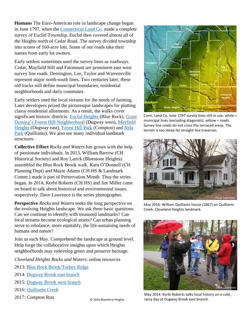
Humans The Euro-American role in landscape change began
in June 1797, when the Connecticut Land Co. made a complete
survey of Euclid Township. Euclid then covered almost all of
the Heights north of Cedar Road. The survey divided township
into scores of 160-acre lots. Some of our roads take their
names from early lot owners.
Early settlers sometimes used the survey lines as roadways.
Cedar, Mayfield Hill and Fairmount are prominent east-west
survey line roads. Demington, Lee, Taylor and Warrensville
represent major north-south lines. Two centuries later, these
old tracks still define municipal boundaries, residential
neighborhoods and daily commutes.
Early settlers used the local streams for the needs of farming.
Later developers prized the picturesque landscapes for platting
classy residential allotments. As a result, the walks cover
significant historic districts: Euclid Heights (Blue Rock), Grant
Deming’s Forest Hill Neighborhood (Dugway west), Mayfield
Heights (Dugway east), Forest Hill Park (Compton) and Nela
Park (Quilliams). We also see many individual landmark
structures.
Collective Effort Rocks and Waters has grown with the help
of passionate individuals. In 2013, William Barrow (CH
Historical Society) and Roy Larick (Bluestone Heights)
assembled the Blue Rock Brook walk. Kara O’Donnell (CH
Planning Dept) and Mazie Adams (CH HS & Landmark
Comm.) made it part of Preservation Month. Thus the series
began. In 2014, Korbi Roberts (CH HS) and Jim Miller came
on board to talk about historical and environmental issues,
respectively. Dave Lawrence is the series photographer.
Perspective Rocks and Waters seeks the long perspective on
the evolving Heights landscape. We ask three basic questions:
Can we continue to identify with treasured landmarks? Can
local streams become ecological assets? Can urban planning
serve to rebalance, more equitably, the life-sustaining needs of
humans and nature?
Join us each May. Comprehend the landscape at ground level.
Help forge the collaborative insights upon which Heights
neighborhoods may redevelop green and preserve heritage.
Cleveland Heights Rocks and Waters: online resources
2013: Blue Rock Brook/Turkey Ridge
2014: Dugway Brook east branch
2015: Dugway Brook west branch
2016: Quilliams Creek
2017: Compton Run
Conn. Land Co. June 1797 survey lines still in use: white = municipal lines (excluding diagonals); yellow = roads. Survey line roads do not cross the terraced areas. The terrain is too steep for straight line traverses.
May 2014: Korbi Roberts talks local history on a cold, rainy day at Dugway Brook east branch.
May 2016: William Quilliams house (1867) on Quilliams Creek. Cleveland Heights landmark.
Dave Lawrence
Dave Lawrence
© 2016 Bluestone Heights