Embed Size (px)
Citation preview
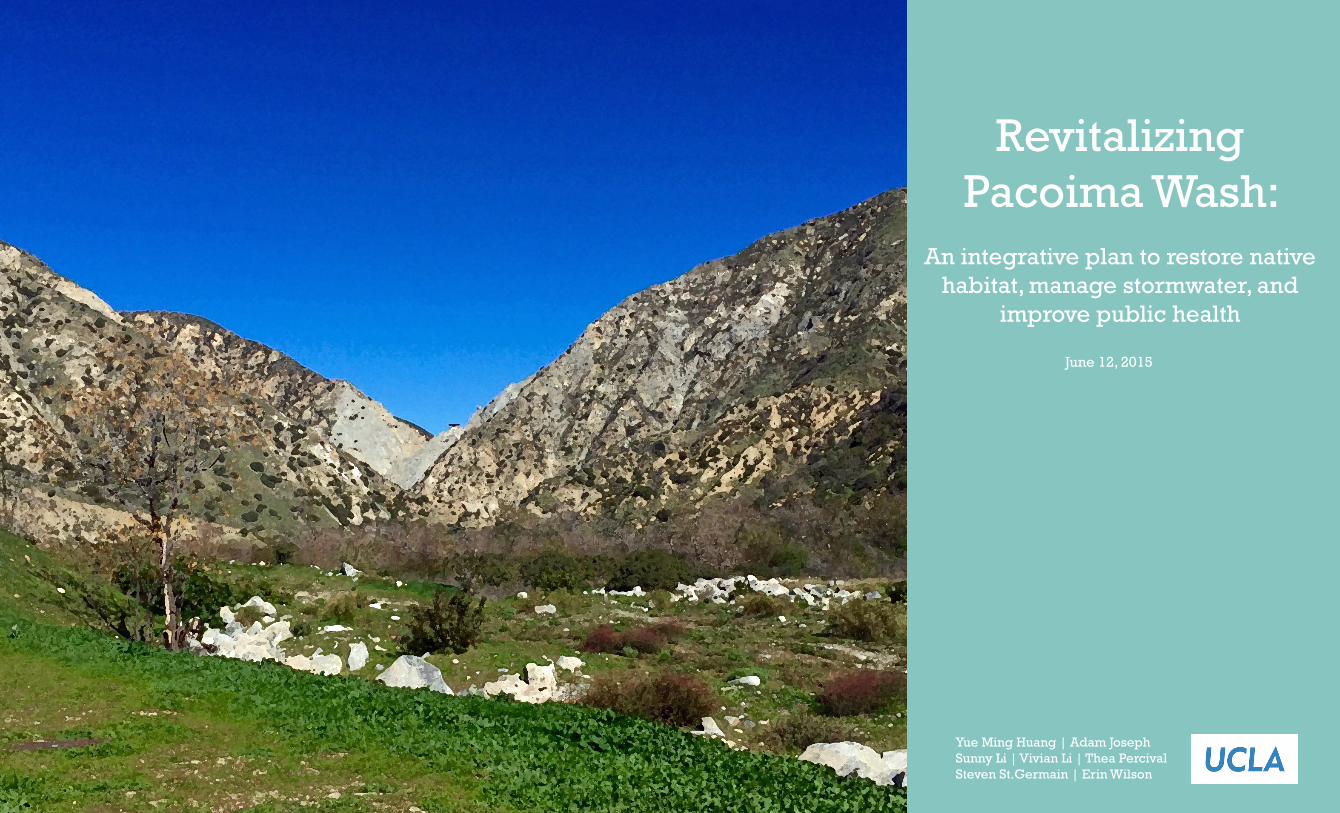
June 12, 2015
Revitalizing Pacoima Wash:
An integrative plan to restore native habitat, manage stormwater, and
improve public health
Yue Ming Huang | Adam Joseph Sunny Li | Vivian Li | Thea Percival Steven St.Germain | Erin Wilson
2 Revitalizing Pacoima Wash
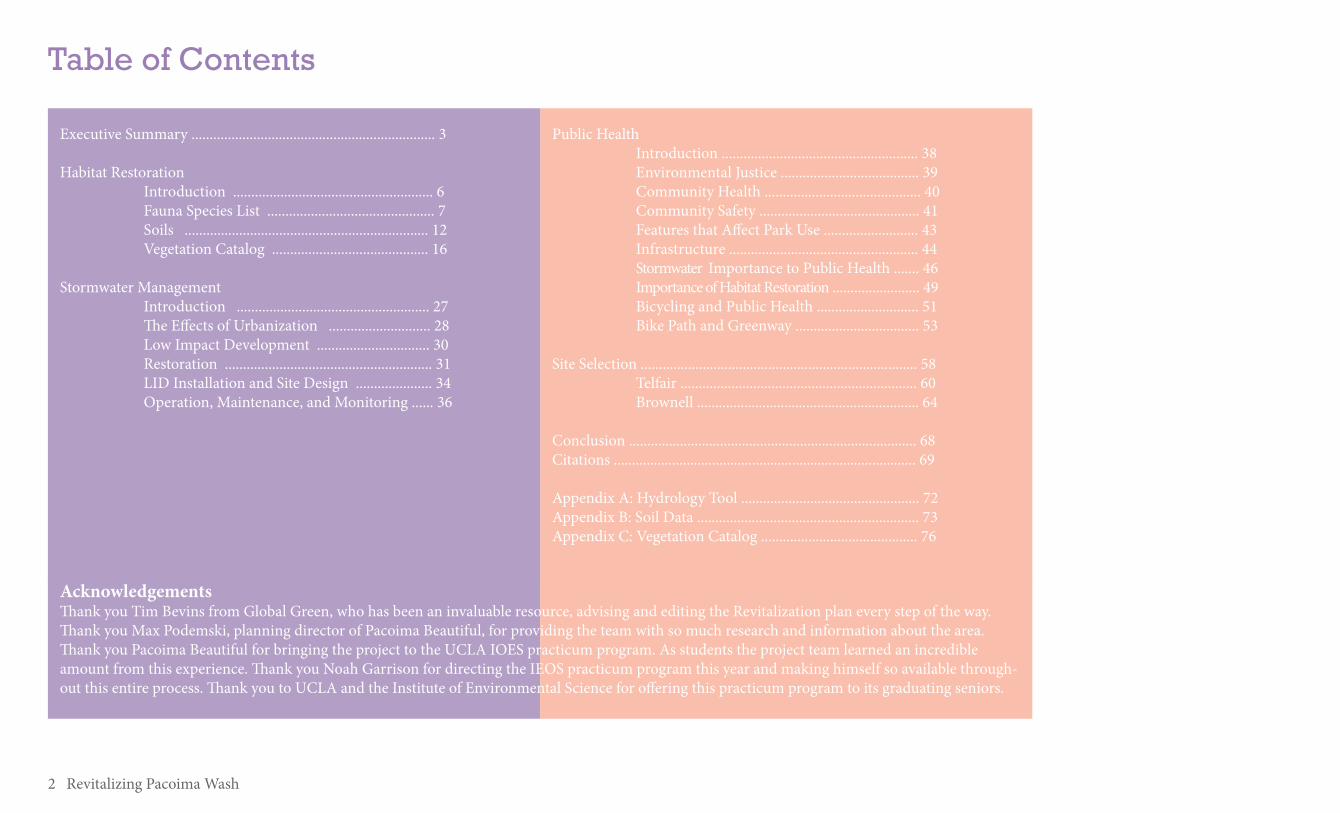
Table of Contents
Public Health Introduction ...................................................... 38 Environmental Justice ...................................... 39 Community Health ........................................... 40 Community Safety ............................................ 41 Features that Affect Park Use .......................... 43 Infrastructure .................................................... 44 Stormwater Importance to Public Health ....... 46 Importance of Habitat Restoration ........................ 49 Bicycling and Public Health ............................ 51 Bike Path and Greenway .................................. 53 Site Selection ............................................................................ 58 Telfair ................................................................. 60 Brownell ............................................................. 64
Conclusion ............................................................................... 68Citations ................................................................................... 69
Appendix A: Hydrology Tool ................................................. 72Appendix B: Soil Data ............................................................. 73Appendix C: Vegetation Catalog ........................................... 76
Executive Summary ................................................................... 3
Habitat Restoration Introduction ....................................................... 6 Fauna Species List .............................................. 7 Soils ................................................................... 12 Vegetation Catalog ........................................... 16
Stormwater Management Introduction ..................................................... 27 The Effects of Urbanization ............................ 28 Low Impact Development ............................... 30 Restoration ......................................................... 31 LID Installation and Site Design ..................... 34 Operation, Maintenance, and Monitoring ...... 36
Acknowledgements Thank you Tim Bevins from Global Green, who has been an invaluable resource, advising and editing the Revitalization plan every step of the way. Thank you Max Podemski, planning director of Pacoima Beautiful, for providing the team with so much research and information about the area. Thank you Pacoima Beautiful for bringing the project to the UCLA IOES practicum program. As students the project team learned an incredible amount from this experience. Thank you Noah Garrison for directing the IEOS practicum program this year and making himself so available through-out this entire process. Thank you to UCLA and the Institute of Environmental Science for offering this practicum program to its graduating seniors.
Executive Summary 3
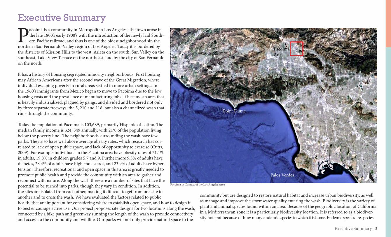
Pacoima is a community in Metropolitan Los Angeles. The town arose in the late 1800’s early 1900’s with the introduction of the newly laid South-ern Pacific railroad, and thus is one of the oldest neighborhood sin the
northern San Fernando Valley region of Los Angeles. Today it is bordered by the districts of Mission Hills to the west, Arleta on the south, Sun Valley on the southeast, Lake View Terrace on the northeast, and by the city of San Fernando on the north.
It has a history of housing segregated minority neighborhoods. First housing may African Americans after the second wave of the Great Migration, where individual escaping poverty in rural areas settled in more urban settings. In the 1960’s immigrants from Mexico began to move to Pacoima due to the low housing costs and the prevalence of manufacturing jobs. It became an area that is heavily industrialized, plagued by gangs, and divided and bordered not only by three separate freeways, the 5, 210 and 118, but also a channelized wash that runs through the community.
Today the population of Pacoima is 103,689, primarily Hispanic of Latino. The median family income is $24, 549 annually, with 21% of the population living below the poverty line. The neighborhoods surrounding the wash have few parks. They also have well above average obesity rates, which research has cor-related to lack of open public space, and lack of opportunity to exercise (Cutts, 2009). For example individuals in the Pacoima area have obesity rates of 21.1% in adults, 19.8% in children grades 5,7 and 9. Furthermore 9.3% of adults have diabetes, 28.4% of adults have high cholesterol, and 23.9% of adults have hyper-tension. Therefore, recreational and open space in this area is greatly needed to promote public health and provide the community with an area to gather and reconnect with nature. Along the wash there are a number of sites that have the potential to be turned into parks, though they vary in condition. In addition, the sites are isolated from each other, making it difficult to get from one site to another and to cross the wash. We have evaluated the factors related to public health, that are important for considering where to establish open space, and how to design it to best encourage active use. Our project proposes site designs for two locations along the wash, connected by a bike path and greenway running the length of the wash to provide connectivity and access to the community and wildlife. Our parks will not only provide natural space to the
community but are designed to restore natural habitat and increase urban biodiversity, as well as manage and improve the stormwater quality entering the wash. Biodiversity is the variety of plant and animal species found within an area. Because of the geographic location of California in a Mediterranean zone it is a particularly biodiversity location. It is referred to as a biodiver-sity hotspot because of how many endemic species to which it is home. Endemic species are species
Executive Summary
Pacoima in Context of the Los Angeles Area
Point Dume
Palos Verdes
Pacoima Area
4 Revitalizing Pacoima Wash
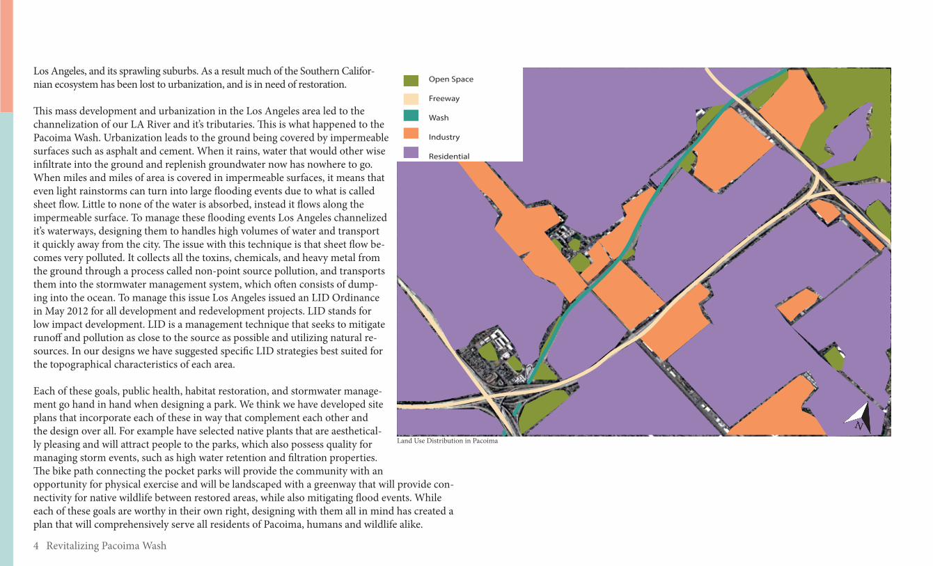
Los Angeles, and its sprawling suburbs. As a result much of the Southern Califor-nian ecosystem has been lost to urbanization, and is in need of restoration.
This mass development and urbanization in the Los Angeles area led to the channelization of our LA River and it’s tributaries. This is what happened to the Pacoima Wash. Urbanization leads to the ground being covered by impermeable surfaces such as asphalt and cement. When it rains, water that would other wise infiltrate into the ground and replenish groundwater now has nowhere to go. When miles and miles of area is covered in impermeable surfaces, it means that even light rainstorms can turn into large flooding events due to what is called sheet flow. Little to none of the water is absorbed, instead it flows along the impermeable surface. To manage these flooding events Los Angeles channelized it’s waterways, designing them to handles high volumes of water and transport it quickly away from the city. The issue with this technique is that sheet flow be-comes very polluted. It collects all the toxins, chemicals, and heavy metal from the ground through a process called non-point source pollution, and transports them into the stormwater management system, which often consists of dump-ing into the ocean. To manage this issue Los Angeles issued an LID Ordinance in May 2012 for all development and redevelopment projects. LID stands for low impact development. LID is a management technique that seeks to mitigate runoff and pollution as close to the source as possible and utilizing natural re-sources. In our designs we have suggested specific LID strategies best suited for the topographical characteristics of each area.
Each of these goals, public health, habitat restoration, and stormwater manage-ment go hand in hand when designing a park. We think we have developed site plans that incorporate each of these in way that complement each other and the design over all. For example have selected native plants that are aesthetical-ly pleasing and will attract people to the parks, which also possess quality for managing storm events, such as high water retention and filtration properties. The bike path connecting the pocket parks will provide the community with an opportunity for physical exercise and will be landscaped with a greenway that will provide con-nectivity for native wildlife between restored areas, while also mitigating flood events. While each of these goals are worthy in their own right, designing with them all in mind has created a plan that will comprehensively serve all residents of Pacoima, humans and wildlife alike.
Open Space
Freeway
Wash
Industry
Residential
Land Use Distribution in Pacoima
Habitat Restoration
6 Revitalizing Pacoima Wash
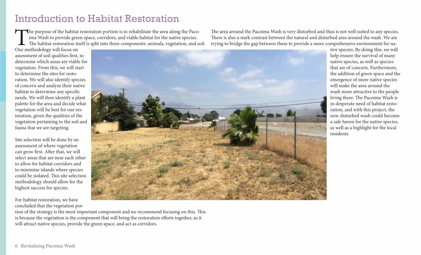
The purpose of the habitat restoration portion is to rehabilitate the area along the Paco-ima Wash to provide green space, corridors, and viable habitat for the native species. The habitat restoration itself is split into three components: animals, vegetation, and soil.
Our methodology will focus on assessment of soil qualities first, to determine which areas are viable for vegetation. From this, we will start to determine the sites for resto-ration. We will also identify species of concern and analyze their native habitat to determine any specific needs. We will then identify a plant palette for the area and decide what vegetation will be best for our res-toration, given the qualities of the vegetation pertaining to the soil and fauna that we are targeting.
Site selection will be done by an assessment of where vegetation can grow first. After that, we will select areas that are near each other to allow for habitat corridors and to minimize islands where species could be isolated. This site selection methodology should allow for the highest success for species.
For habitat restoration, we have concluded that the vegetation por-tion of the strategy is the most important component and we recommend focusing on this. This is because the vegetation is the component that will bring the restoration efforts together, as it will attract native species, provide the green space, and act as corridors.
The area around the Pacoima Wash is very disturbed and thus is not well suited to any species. There is also a stark contrast between the natural and disturbed area around the wash. We are trying to bridge the gap between these to provide a more comprehensive environment for na-
tive species. By doing this, we will help ensure the survival of many native species, as well as species that are of concern. Furthermore, the addition of green space and the emergence of more native species will make the area around the wash more attractive to the people living there. The Pacoima Wash is in desperate need of habitat resto-ration, and with this project, the now disturbed wash could become a safe haven for the native species, as well as a highlight for the local residents.
Introduction to Habitat Restoration
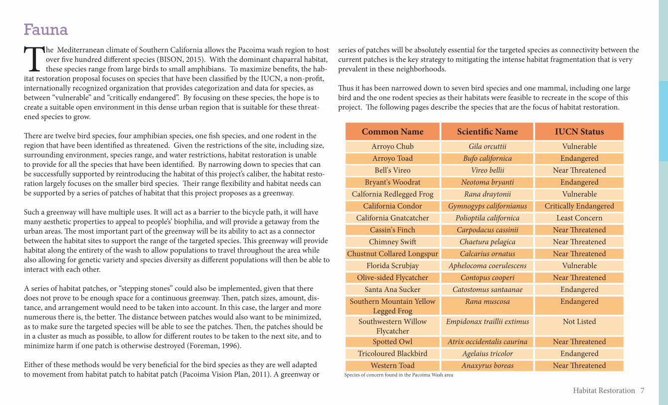
The Mediterranean climate of Southern California allows the Pacoima wash region to host over five hundred different species (BISON, 2015). With the dominant chaparral habitat, these species range from large birds to small amphibians. To maximize benefits, the hab-
itat restoration proposal focuses on species that have been classified by the IUCN, a non-profit, internationally recognized organization that provides categorization and data for species, as between “vulnerable” and “critically endangered”. By focusing on these species, the hope is to create a suitable open environment in this dense urban region that is suitable for these threat-ened species to grow. There are twelve bird species, four amphibian species, one fish species, and one rodent in the region that have been identified as threatened. Given the restrictions of the site, including size, surrounding environment, species range, and water restrictions, habitat restoration is unable to provide for all the species that have been identified. By narrowing down to species that can be successfully supported by reintroducing the habitat of this project’s caliber, the habitat resto-ration largely focuses on the smaller bird species. Their range flexibility and habitat needs can be supported by a series of patches of habitat that this project proposes as a greenway.
Such a greenway will have multiple uses. It will act as a barrier to the bicycle path, it will have many aesthetic properties to appeal to people’s’ biophilia, and will provide a getaway from the urban areas. The most important part of the greenway will be its ability to act as a connector between the habitat sites to support the range of the targeted species. This greenway will provide habitat along the entirety of the wash to allow populations to travel throughout the area while also allowing for genetic variety and species diversity as different populations will then be able to interact with each other.
A series of habitat patches, or “stepping stones” could also be implemented, given that there does not prove to be enough space for a continuous greenway. Then, patch sizes, amount, dis-tance, and arrangement would need to be taken into account. In this case, the larger and more numerous there is, the better. The distance between patches would also want to be minimized, as to make sure the targeted species will be able to see the patches. Then, the patches should be in a cluster as much as possible, to allow for different routes to be taken to the next site, and to minimize harm if one patch is otherwise destroyed (Foreman, 1996).
Either of these methods would be very beneficial for the bird species as they are well adapted to movement from habitat patch to habitat patch (Pacoima Vision Plan, 2011). A greenway or
series of patches will be absolutely essential for the targeted species as connectivity between the current patches is the key strategy to mitigating the intense habitat fragmentation that is very prevalent in these neighborhoods.
Thus it has been narrowed down to seven bird species and one mammal, including one large bird and the one rodent species as their habitats were feasible to recreate in the scope of this project. The following pages describe the species that are the focus of habitat restoration.
Species of concern found in the Pacoima Wash area
Habitat Restoration 7
Fauna
Common Name Scientific Name IUCN StatusArroyo Chub Gila orcuttii VulnerableArroyo Toad Bufo californica EndangeredBell's Vireo Vireo bellii Near Threatened
Bryant's Woodrat Neotoma bryanti EndangeredCalfornia Redlegged Frog Rana draytonii Vulnerable
California Condor Gymnogyps californianus Critically EndangeredCalifornia Gnatcatcher Polioptila californica Least Concern
Cassin's Finch Carpodacus cassinii Near ThreatenedChimney Swift Chaetura pelagica Near Threatened
Chustnut Collared Longspur Calcarius ornatus Near ThreatenedFlorida Scrubjay Aphelocoma coerulescens Vulnerable
Olive-sided Flycatcher Contopus cooperi Near ThreatenedSanta Ana Sucker Catostomus santaanae Endangered
Southern Mountain Yellow Legged Frog
Rana muscosa Endangered
Southwestern Willow Flycatcher
Empidonax traillii extimus Not Listed
Spotted Owl Atrix occidentalis caurina Near ThreatenedTricoloured Blackbird Agelaius tricolor Endangered
Western Toad Anaxyrus boreas Near Threatened
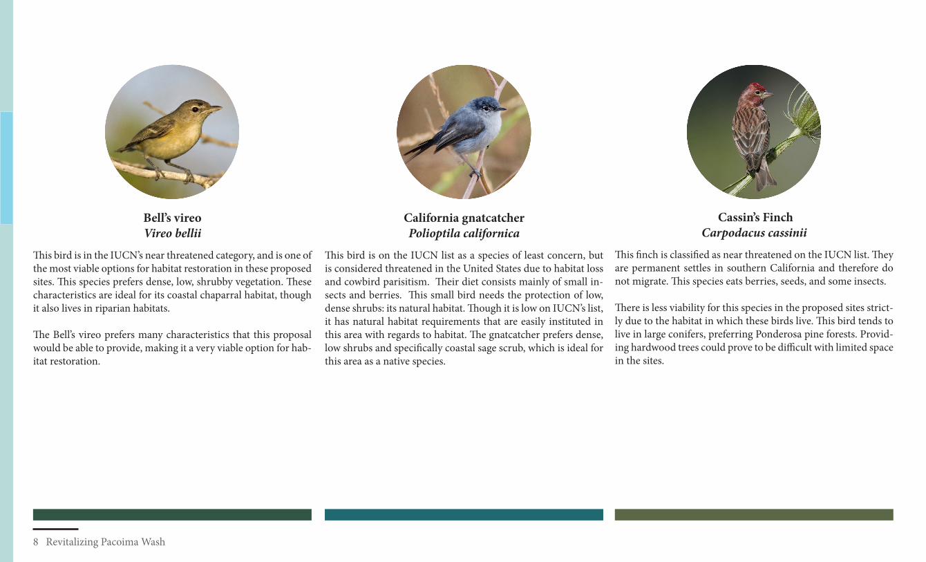
This bird is on the IUCN list as a species of least concern, but is considered threatened in the United States due to habitat loss and cowbird parisitism. Their diet consists mainly of small in-sects and berries. This small bird needs the protection of low, dense shrubs: its natural habitat. Though it is low on IUCN’s list, it has natural habitat requirements that are easily instituted in this area with regards to habitat. The gnatcatcher prefers dense, low shrubs and specifically coastal sage scrub, which is ideal for this area as a native species.
California gnatcatcherPolioptila californica
This bird is in the IUCN’s near threatened category, and is one of the most viable options for habitat restoration in these proposed sites. This species prefers dense, low, shrubby vegetation. These characteristics are ideal for its coastal chaparral habitat, though it also lives in riparian habitats.
The Bell’s vireo prefers many characteristics that this proposal would be able to provide, making it a very viable option for hab-itat restoration.
Bell’s vireoVireo bellii
This finch is classified as near threatened on the IUCN list. They are permanent settles in southern California and therefore do not migrate. This species eats berries, seeds, and some insects.
There is less viability for this species in the proposed sites strict-ly due to the habitat in which these birds live. This bird tends to live in large conifers, preferring Ponderosa pine forests. Provid-ing hardwood trees could prove to be difficult with limited space in the sites.
Cassin’s FinchCarpodacus cassinii
8 Revitalizing Pacoima Wash
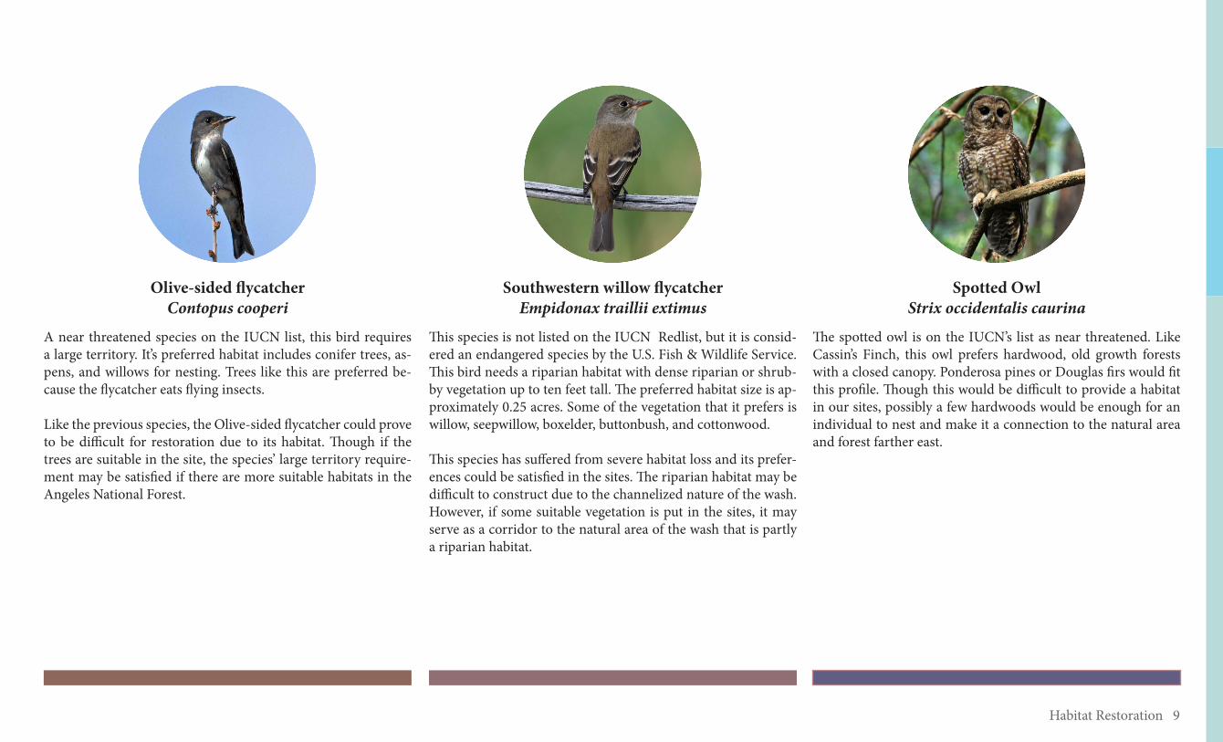
A near threatened species on the IUCN list, this bird requires a large territory. It’s preferred habitat includes conifer trees, as-pens, and willows for nesting. Trees like this are preferred be-cause the flycatcher eats flying insects.
Like the previous species, the Olive-sided flycatcher could prove to be difficult for restoration due to its habitat. Though if the trees are suitable in the site, the species’ large territory require-ment may be satisfied if there are more suitable habitats in the Angeles National Forest.
The spotted owl is on the IUCN’s list as near threatened. Like Cassin’s Finch, this owl prefers hardwood, old growth forests with a closed canopy. Ponderosa pines or Douglas firs would fit this profile. Though this would be difficult to provide a habitat in our sites, possibly a few hardwoods would be enough for an individual to nest and make it a connection to the natural area and forest farther east.
This species is not listed on the IUCN Redlist, but it is consid-ered an endangered species by the U.S. Fish & Wildlife Service. This bird needs a riparian habitat with dense riparian or shrub-by vegetation up to ten feet tall. The preferred habitat size is ap-proximately 0.25 acres. Some of the vegetation that it prefers is willow, seepwillow, boxelder, buttonbush, and cottonwood.
This species has suffered from severe habitat loss and its prefer-ences could be satisfied in the sites. The riparian habitat may be difficult to construct due to the channelized nature of the wash. However, if some suitable vegetation is put in the sites, it may serve as a corridor to the natural area of the wash that is partly a riparian habitat.
Olive-sided flycatcherContopus cooperi
Spotted OwlStrix occidentalis caurina
Southwestern willow flycatcherEmpidonax traillii extimus
Habitat Restoration 9
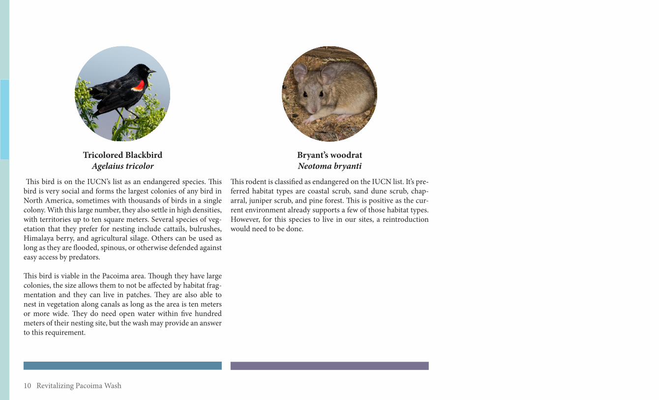
This bird is on the IUCN’s list as an endangered species. This bird is very social and forms the largest colonies of any bird in North America, sometimes with thousands of birds in a single colony. With this large number, they also settle in high densities, with territories up to ten square meters. Several species of veg-etation that they prefer for nesting include cattails, bulrushes, Himalaya berry, and agricultural silage. Others can be used as long as they are flooded, spinous, or otherwise defended against easy access by predators.
This bird is viable in the Pacoima area. Though they have large colonies, the size allows them to not be affected by habitat frag-mentation and they can live in patches. They are also able to nest in vegetation along canals as long as the area is ten meters or more wide. They do need open water within five hundred meters of their nesting site, but the wash may provide an answer to this requirement.
Tricolored BlackbirdAgelaius tricolor
This rodent is classified as endangered on the IUCN list. It’s pre-ferred habitat types are coastal scrub, sand dune scrub, chap-arral, juniper scrub, and pine forest. This is positive as the cur-rent environment already supports a few of those habitat types. However, for this species to live in our sites, a reintroduction would need to be done.
Bryant’s woodratNeotoma bryanti
10 Revitalizing Pacoima Wash
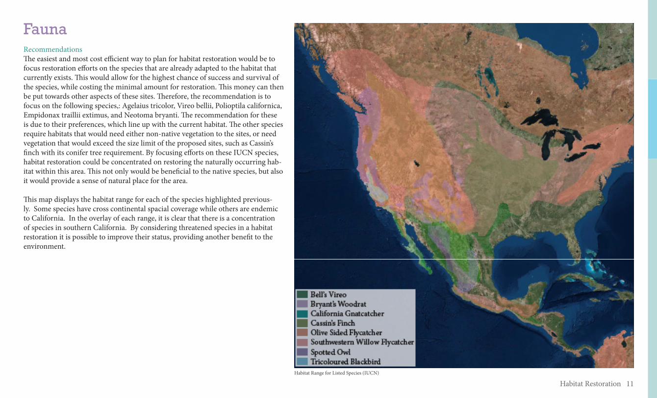
RecommendationsThe easiest and most cost efficient way to plan for habitat restoration would be to focus restoration efforts on the species that are already adapted to the habitat that currently exists. This would allow for the highest chance of success and survival of the species, while costing the minimal amount for restoration. This money can then be put towards other aspects of these sites. Therefore, the recommendation is to focus on the following species,: Agelaius tricolor, Vireo bellii, Polioptila californica, Empidonax traillii extimus, and Neotoma bryanti. The recommendation for these is due to their preferences, which line up with the current habitat. The other species require habitats that would need either non-native vegetation to the sites, or need vegetation that would exceed the size limit of the proposed sites, such as Cassin’s finch with its conifer tree requirement. By focusing efforts on these IUCN species, habitat restoration could be concentrated on restoring the naturally occurring hab-itat within this area. This not only would be beneficial to the native species, but also it would provide a sense of natural place for the area.
This map displays the habitat range for each of the species highlighted previous-ly. Some species have cross continental spacial coverage while others are endemic to California. In the overlay of each range, it is clear that there is a concentration of species in southern California. By considering threatened species in a habitat restoration it is possible to improve their status, providing another benefit to the environment.
Habitat Range for Listed Species (IUCN)
Habitat Restoration 11
Fauna
12 Revitalizing Pacoima Wash
Soils
The first aspect of vegetation is soil chemistry. The soil needs to be suitable for the vegetation to maximize plant growth and further succession. Fortunately, the current
soil situation is nearly ideal for the types of vegetation we are suggesting. Though there is not a full set of soil characteristics for all of the sites, there is data for the natural part of the wash and in several small areas along the wash. The characteristics from all of these sites are the same, which lets us generalize that there is little change over the course of the wash with regards to sol composition. Therefore, we can predict what the com-position is like at our proposed sites with high confidence and structure our recommendations off of this data.
First, data was collected on the soil composition of Paxton Park, which includes a baseball park along the wash. Then, we looked at the Pacoima Wash Nature Park at the El Dorado site, fol-lowed by an analysis of the natural area of the wash. All three of these sites contain soil that have a neutral pH, are well drained resulting in low runoff potential. All three of these sites expe-rience the same average temperature (59 degrees F- 66 degrees F), the same average rainfall (10 in- 30 in), and same amount of frost free days (200- 365 days). Paxton Park and the El Dorado site contain soils that are loamy, and the natural area has more sandy soil. With these characteristics, there are low limitations to park creation or to vegetative establishment. Furthermore, as can be seen, the soil qualities are very similar, once again allow-ing them to be treated in the same manner.
After establishing the likeness of the soils along the wash, more practical analyses could be done. Three main criteria were considered when assessing the soil in this
area. These criteria took into account a holistic view of the soils, us-ing their biology and chemistry to assess the qualities. These char-acteristics can be seen in the suitability maps and tables that follow.
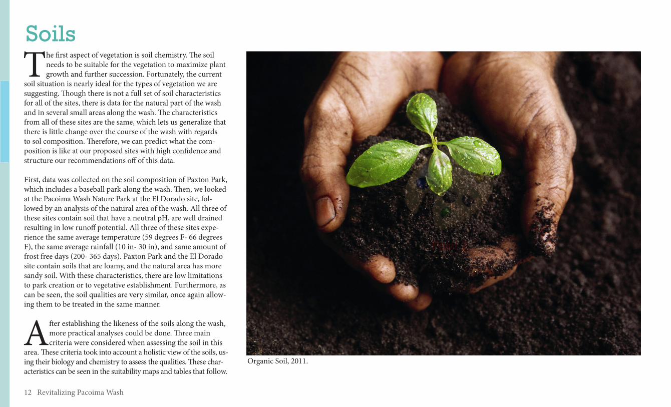
Organic Soil, 2011.
Habitat Restoration 13
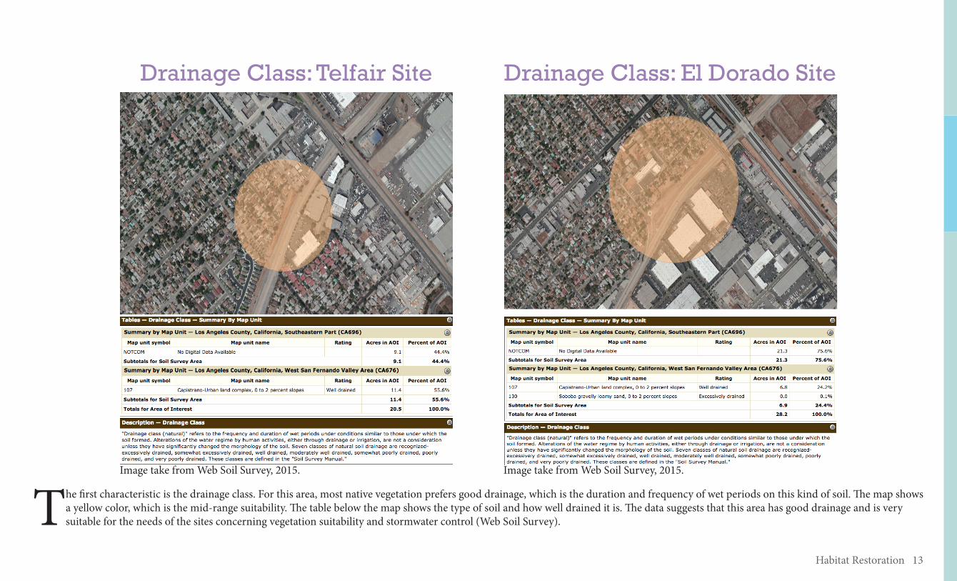
The first characteristic is the drainage class. For this area, most native vegetation prefers good drainage, which is the duration and frequency of wet periods on this kind of soil. The map shows a yellow color, which is the mid-range suitability. The table below the map shows the type of soil and how well drained it is. The data suggests that this area has good drainage and is very suitable for the needs of the sites concerning vegetation suitability and stormwater control (Web Soil Survey).
Drainage Class: Telfair Site Drainage Class: El Dorado Site
Image take from Web Soil Survey, 2015. Image take from Web Soil Survey, 2015.
14 Revitalizing Pacoima Wash
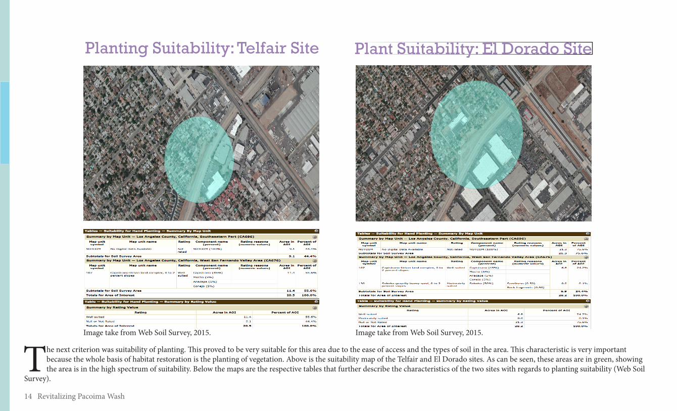
The next criterion was suitability of planting. This proved to be very suitable for this area due to the ease of access and the types of soil in the area. This characteristic is very important because the whole basis of habitat restoration is the planting of vegetation. Above is the suitability map of the Telfair and El Dorado sites. As can be seen, these areas are in green, showing the area is in the high spectrum of suitability. Below the maps are the respective tables that further describe the characteristics of the two sites with regards to planting suitability (Web Soil
Survey).
Planting Suitability: Telfair Site Plant Suitability: El Dorado Site
Image take from Web Soil Survey, 2015. Image take from Web Soil Survey, 2015.
Habitat Restoration 15
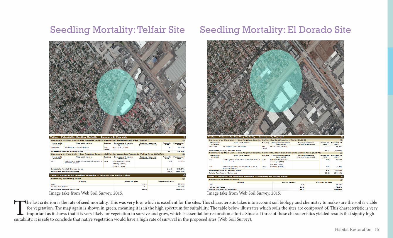
The last criterion is the rate of seed mortality. This was very low, which is excellent for the sites. This characteristic takes into account soil biology and chemistry to make sure the soil is viable for vegetation. The map again is shown in green, meaning it is in the high spectrum for suitability. The table below illustrates which soils the sites are composed of. This characteristic is very important as it shows that it is very likely for vegetation to survive and grow, which is essential for restoration efforts. Since all three of these characteristics yielded results that signify high
suitability, it is safe to conclude that native vegetation would have a high rate of survival in the proposed sites (Web Soil Survey).
Seedling Mortality: Telfair Site Seedling Mortality: El Dorado Site
Image take from Web Soil Survey, 2015. Image take from Web Soil Survey, 2015.
16 Revitalizing Pacoima Wash
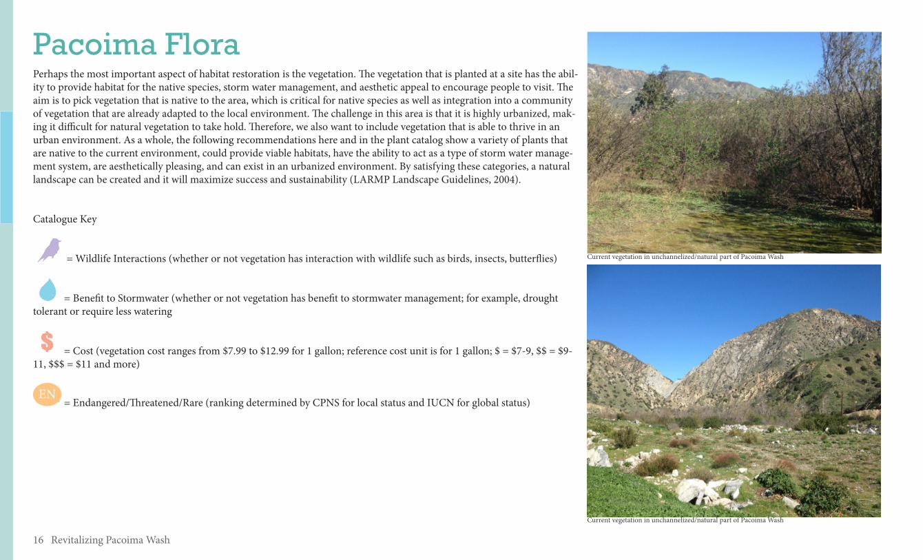
Perhaps the most important aspect of habitat restoration is the vegetation. The vegetation that is planted at a site has the abil-ity to provide habitat for the native species, storm water management, and aesthetic appeal to encourage people to visit. The aim is to pick vegetation that is native to the area, which is critical for native species as well as integration into a community of vegetation that are already adapted to the local environment. The challenge in this area is that it is highly urbanized, mak-ing it difficult for natural vegetation to take hold. Therefore, we also want to include vegetation that is able to thrive in an urban environment. As a whole, the following recommendations here and in the plant catalog show a variety of plants that are native to the current environment, could provide viable habitats, have the ability to act as a type of storm water manage-ment system, are aesthetically pleasing, and can exist in an urbanized environment. By satisfying these categories, a natural landscape can be created and it will maximize success and sustainability (LARMP Landscape Guidelines, 2004).
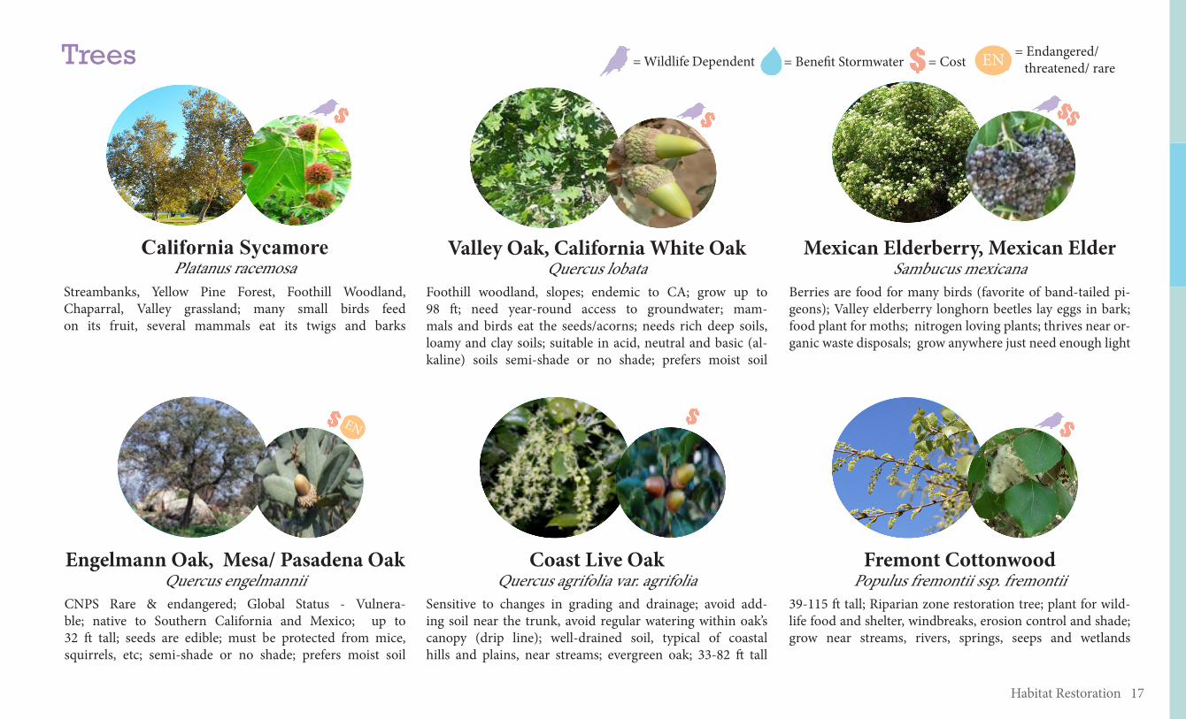
Catalogue Key
= Wildlife Interactions (whether or not vegetation has interaction with wildlife such as birds, insects, butterflies)
= Benefit to Stormwater (whether or not vegetation has benefit to stormwater management; for example, drought tolerant or require less watering
= Cost (vegetation cost ranges from $7.99 to $12.99 for 1 gallon; reference cost unit is for 1 gallon; $ = $7-9, $$ = $9-11, $$$ = $11 and more)
EN = Endangered/Threatened/Rare (ranking determined by CPNS for local status and IUCN for global status)
Pacoima Flora
Current vegetation in unchannelized/natural part of Pacoima Wash
Current vegetation in unchannelized/natural part of Pacoima Wash
Habitat Restoration 17
Streambanks, Yellow Pine Forest, Foothill Woodland, Chaparral, Valley grassland; many small birds feed on its fruit, several mammals eat its twigs and barks
Valley Oak, California White Oak
Berries are food for many birds (favorite of band-tailed pi-geons); Valley elderberry longhorn beetles lay eggs in bark; food plant for moths; nitrogen loving plants; thrives near or-ganic waste disposals; grow anywhere just need enough light
Mexican Elderberry, Mexican Elder
Foothill woodland, slopes; endemic to CA; grow up to 98 ft; need year-round access to groundwater; mam-mals and birds eat the seeds/acorns; needs rich deep soils, loamy and clay soils; suitable in acid, neutral and basic (al-kaline) soils semi-shade or no shade; prefers moist soil
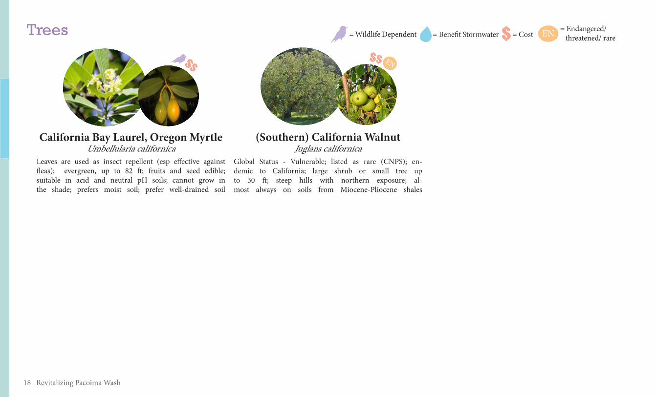
= Wildlife Dependent = Benefit Stormwater = Cost EN = Endangered/ threatened/ rare Trees
California SycamorePlatanus racemosa Quercus lobata Sambucus mexicana
EN
39-115 ft tall; Riparian zone restoration tree; plant for wild-life food and shelter, windbreaks, erosion control and shade; grow near streams, rivers, springs, seeps and wetlands
Fremont Cottonwood Populus fremontii ssp. fremontii
CNPS Rare & endangered; Global Status - Vulnera-ble; native to Southern California and Mexico; up to 32 ft tall; seeds are edible; must be protected from mice, squirrels, etc; semi-shade or no shade; prefers moist soil
Engelmann Oak, Mesa/ Pasadena Oak Quercus engelmannii
Sensitive to changes in grading and drainage; avoid add-ing soil near the trunk, avoid regular watering within oak’s canopy (drip line); well-drained soil, typical of coastal hills and plains, near streams; evergreen oak; 33-82 ft tall
Coast Live Oak Quercus agrifolia var. agrifolia
18 Revitalizing Pacoima Wash
= Wildlife Dependent = Benefit Stormwater = Cost EN = Endangered/ threatened/ rare
Trees
Leaves are used as insect repellent (esp effective against fleas); evergreen, up to 82 ft; fruits and seed edible; suitable in acid and neutral pH soils; cannot grow in the shade; prefers moist soil; prefer well-drained soil
California Bay Laurel, Oregon MyrtleUmbellularia californica
Global Status - Vulnerable; listed as rare (CNPS); en-demic to California; large shrub or small tree up to 30 ft; steep hills with northern exposure; al-most always on soils from Miocene-Pliocene shales
(Southern) California Walnut Juglans californica
EN
Habitat Restoration 19
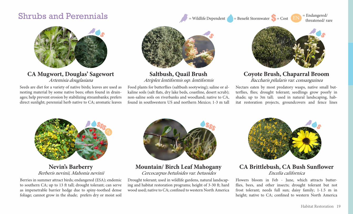
Shrubs and Perennials = Wildlife Dependent = Benefit Stormwater = Cost EN = Endangered/ threatened/ rare
Seeds are diet for a variety of native birds; leaves are used as nesting material by some native bees; often found in drain-ages; help prevent erosion by stabilizing streambanks; prefers direct sunlight; perennial herb native to CA; aromatic leaves
Saltbush, Quail Brush
Nectars eaten by most predatory wasps, native small but-terflies, flies; drought tolerant; seedlings grow poorly in shade; up to 3m tall; used in natural landscaping, hab-itat restoration projects, groundcovers and fence lines
Coyote Brush, Chaparral Broom
Food plants for butterflies (saltbush sootywing); saline or al-kaline soils (salt flats, dry lake beds, coastline, desert scrub); non-saline soils on riverbanks and woodland; native to CA, found in southwestern US and northern Mexico; 1-3 m tall
CA Mugwort, Douglas’ SagewortArtemisia douglasiana Atriplex lentiformis ssp. lentiformis Baccharis pilularis var. consanguinea
Flowers bloom in Feb - June, which attracts butter-flies, bees, and other insects; drought tolerant but not frost tolerant; needs full sun; daisy family; 1-1.5 m in height; native to CA; confined to western North America
CA Brittlebush, CA Bush SunflowerEncelia californica
Berries in summer attract birds; endangered (ESA); endemic to southern CA; up to 13 ft tall; drought tolerant; can serve as impenetrable barrier hedge due to spiny-toothed dense foliage; cannot grow in the shade; prefers dry or moist soil
Nevin’s BarberryBerberis nevinii, Mahonia nevinii
Drought tolerant; used in wildlife gardens, natural landscap-ing and habitat restoration programs; height of 3-30 ft; hard wood used; native to CA; confined to western North America
Mountain/ Birch Leaf MahoganyCercocarpus betuloides var. betuoides
EN
20 Revitalizing Pacoima Wash
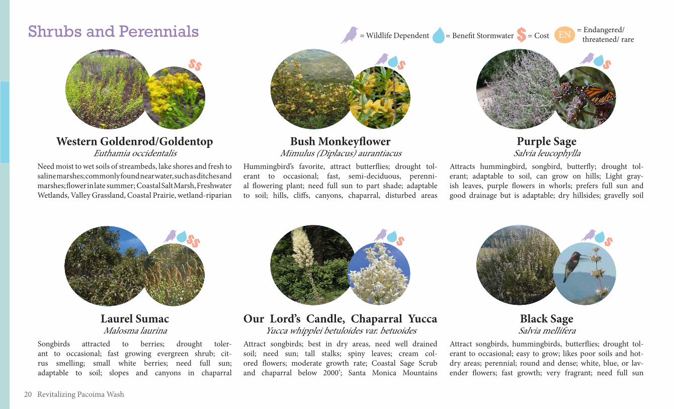
= Wildlife Dependent = Benefit Stormwater = Cost EN = Endangered/ threatened/ rare Shrubs and Perennials
Need moist to wet soils of streambeds, lake shores and fresh to saline marshes; commonly found near water, such as ditches and marshes; flower in late summer; Coastal Salt Marsh, Freshwater Wetlands, Valley Grassland, Coastal Prairie, wetland-riparian
Bush Monkeyflower
Attracts hummingbird, songbird, butterfly; drought tol-erant; adaptable to soil, can grow on hills; Light gray-ish leaves, purple flowers in whorls; prefers full sun and good drainage but is adaptable; dry hillsides; gravelly soil
Purple Sage
Hummingbird’s favorite, attract butterflies; drought tol-erant to occasional; fast, semi-deciduous, perenni-al flowering plant; need full sun to part shade; adaptable to soil; hills, cliffs, canyons, chaparral, disturbed areas
Western Goldenrod/GoldentopEuthamia occidentalis Mimulus (Diplacus) aurantiacus Salvia leucophylla
Attract songbirds, hummingbirds, butterflies; drought tol-erant to occasional; easy to grow; likes poor soils and hot-dry areas; perennial; round and dense; white, blue, or lav-ender flowers; fast growth; very fragrant; need full sun
Black Sage Salvia mellifera
Songbirds attracted to berries; drought toler-ant to occasional; fast growing evergreen shrub; cit-rus smelling; small white berries; need full sun; adaptable to soil; slopes and canyons in chaparral
Laurel SumacMalosma laurina
Attract songbirds; best in dry areas, need well drained soil; need sun; tall stalks; spiny leaves; cream col-ored flowers; moderate growth rate; Coastal Sage Scrub and chaparral below 2000’; Santa Monica Mountains
Our Lord’s Candle, Chaparral Yucca Yucca whipplei betuloides var. betuoides
Habitat Restoration 21
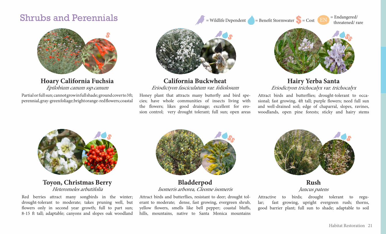
Shrubs and Perennials = Wildlife Dependent = Benefit Stormwater = Cost EN = Endangered/ threatened/ rare
Partial or full sun; cannot grow in full shade; ground cover to 3 ft; perennial, gray-green foliage; bright orange-red flowers; coastal
California Buckwheat
Honey plant that attracts many butterfly and bird spe-cies; have whole communities of insects living with the flowers; likes good drainage; excellent for ero-sion control; very drought tolerant; full sun; open areas
Hoary California Fuchsia Epilobium canum ssp.canum Eriodictyon fasciculatum var. foliolosum
Red berries attract many songbirds in the winter; drought-tolerant to moderate; takes pruning well, but flowers only in second year growth; full to part sun; 8-15 ft tall; adaptable; canyons and slopes oak woodland
Toyon, Christmas Berry Heteromeles arbutifolia
Attract birds and butterflies, resistant to deer; drought tol-erant to moderate; dense, fast growing, evergreen shrub, yellow flowers, smells like bell pepper; coastal bluffs, hills, mountains, native to Santa Monica mountains
BladderpodIsomeris arborea, Cleome isomeris
Hairy Yerba Santa
Attract birds and butterflies; drought-tolerant to occa-sional; fast growing, 4ft tall; purple flowers; need full sun and well-drained soil; edge of chaparral, slopes, ravines, woodlands, open pine forests; sticky and hairy stems
Eriodictyon trichocalyx var. trichocalyx
Attractive to birds; drought tolerant to regu-lar; fast growing, upright evergreen rush; thorns, good barrier plant; full sun to shade; adaptable to soil
RushJuncus patens
22 Revitalizing Pacoima Wash
= Wildlife Dependent = Benefit Stormwater = Cost EN = Endangered/ threatened/ rare
Shrubs and Perennials
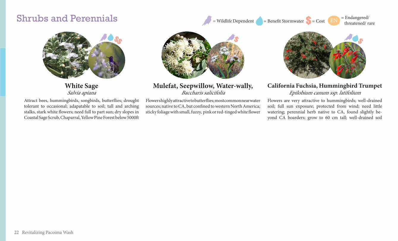
Attract bees, hummingbirds, songbirds, butterflies; drought tolerant to occasional; adapatable to soil; tall and arching stalks, stark white flowers; need full to part sun; dry slopes in Coastal Sage Scrub, Chaparral, Yellow Pine Forest below 5000ft
Mulefat, Seepwillow, Water-wally,
Flowers are very attractive to hummingbirds; well-drained soil; full sun exposure; protected from wind; need little watering; perennial herb native to CA, found slightly be-yond CA boarders; grow to 60 cm tall; well-drained soil
California Fuchsia, Hummingbird Trumpet
Flower s highly attractive to butterflies; most common near water sources; native to CA, but confined to western North America; sticky foliage with small, fuzzy, pink or red-tinged white flower
White SageSalvia apiana Baccharis salicifolia Epilobium canum ssp. latifolium
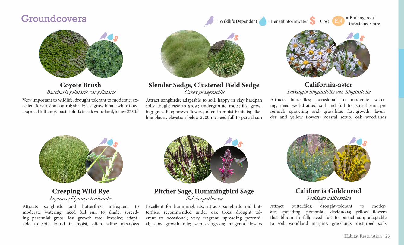
Habitat Restoration 23
= Wildlife Dependent = Benefit Stormwater = Cost EN = Endangered/ threatened/ rare
Very important to wildlife; drought tolerant to moderate; ex-cellent for erosion control; shrub; fast growth rate; white flow-ers; need full sun; Coastal bluffs to oak woodland, below 2250ft
Slender Sedge, Clustered Field Sedge
Attract songbirds; adaptable to soil, happy in clay hardpan soils; tough; easy to grow; underground roots; fast grow-ing; grass-like; brown flowers; often in moist habitats; alka-line places, elevation below 2700 m; need full to partial sun
Coyote BrushBaccharis pilularis var pilularis Carex praegracilis
Attracts songbirds and butterflies; infrequent to moderate watering; need full sun to shade; spread-ing perennial grass; fast growth rate; invasive; adapt-able to soil; found in moist, often saline meadows
Creeping Wild Rye Leymus (Elymus) triticoides
Excellent for hummingbirds; attracts songbirds and but-terflies; recommended under oak trees; drought tol-erant to occasional; very fragrant; spreading perenni-al; slow growth rate; semi-evergreen; magenta flowers
Pitcher Sage, Hummingbird SageSalvia spathacea
California-aster
Attracts butterflies; occasional to moderate water-ing; need well-drained soil and full to partial sun; pe-rennial; sprawling and grass-like; fast-growth; laven-der and yellow flowers; coastal scrub, oak woodlands
Lessingia filaginifolia var. filaginifolia
Attract butterflies; drought-tolerant to moder-ate; spreading, perennial, deciduous; yellow flowers that bloom in fall; need full to partial sun; adaptable to soil; woodland margins, grasslands, disturbed soils
California GoldenrodSolidago californica
Groundcovers
24 Revitalizing Pacoima Wash
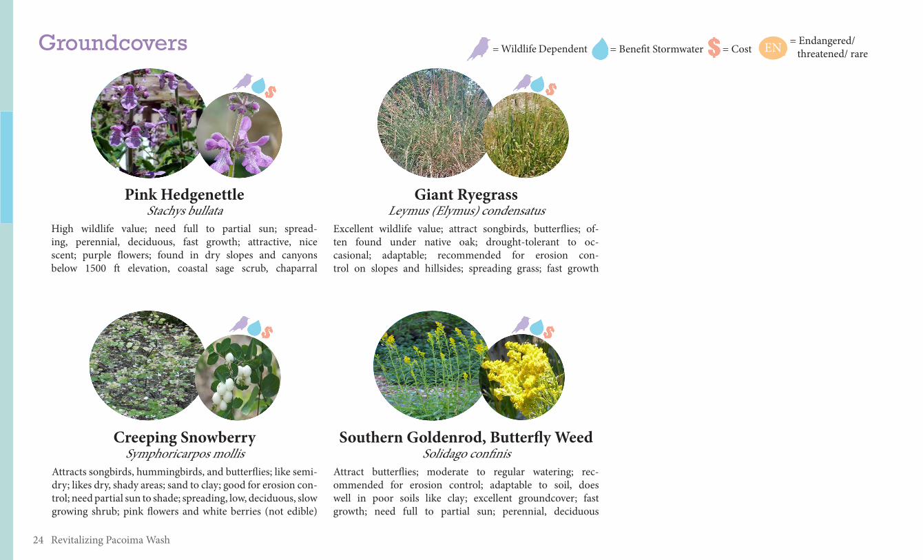
= Wildlife Dependent = Benefit Stormwater = Cost EN = Endangered/ threatened/ rare Groundcovers
High wildlife value; need full to partial sun; spread-ing, perennial, deciduous, fast growth; attractive, nice scent; purple flowers; found in dry slopes and canyons below 1500 ft elevation, coastal sage scrub, chaparral
Giant Ryegrass
Excellent wildlife value; attract songbirds, butterflies; of-ten found under native oak; drought-tolerant to oc-casional; adaptable; recommended for erosion con-trol on slopes and hillsides; spreading grass; fast growth
Pink HedgenettleStachys bullata Leymus (Elymus) condensatus
Attracts songbirds, hummingbirds, and butterflies; like semi-dry; likes dry, shady areas; sand to clay; good for erosion con-trol; need partial sun to shade; spreading, low, deciduous, slow growing shrub; pink flowers and white berries (not edible)
Creeping SnowberrySymphoricarpos mollis
Attract butterflies; moderate to regular watering; rec-ommended for erosion control; adaptable to soil, does well in poor soils like clay; excellent groundcover; fast growth; need full to partial sun; perennial, deciduous
Southern Goldenrod, Butterfly WeedSolidago confinis
Habitat Restoration 25
= Wildlife Dependent = Benefit Stormwater = Cost EN = Endangered/ threatened/ rare
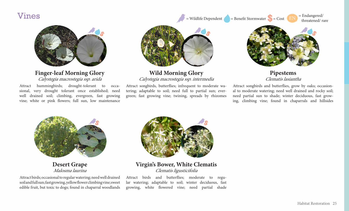
Vines
Attract hummingbirds; drought-tolerant to occa-sional, very drought tolerant once established; need well drained soil; climbing, evergreen, fast growing vine; white or pink flowers; full sun, low maintenance
Wild Morning Glory
Attract songbirds and butterflies, grow by oaks; occasion-al to moderate watering; need well drained and rocky soil; need partial sun to shade; winter deciduous, fast grow-ing, climbing vine; found in chaparrals and hillsides
Pipestems
Attract songbirds, butterflies; infrequent to moderate wa-tering; adaptable to soil; need full to partial sun; ever-green; fast growing vine; twining, spreads by rhizomes
Finger-leaf Morning GloryCalystegia macrostegia ssp. arida Calystegia macrostegia ssp. intermedia Clematis lasiantha
Attract birds; occasional to regular watering; need well drained soil and full sun; fast growing, yellow flower climbing vine; sweet edible fruit, but toxic to dogs; found in chaparral woodlands
Desert GrapeMalosma laurina
Attract birds and butterflies; moderate to regu-lar watering; adaptable to soil; winter deciduous, fast growing, white flowered vine; need partial shade
Virgin’s Bower, White ClematisClematis ligusticifolia

Stormwater Management
Stormwater Management 27
The two main consequences of urbanization and stormwater runoff in Pacoima are flood risk and accumulated trash at the bottom of the Wash. To mitigate these issues, a com-bination of Low Impact Development (LID) and Best Management Practices (BMPs)
should be applied to the suggested parks. Low Impact Development is a land management and site design strategy that will protect against flooding events, improve ecosys-tem health and water quality, and subsequently increase public health. BMPs are temporary, simply de-signed devices to deal with storm-water management, not necessar-ily incorporated into overall site design.
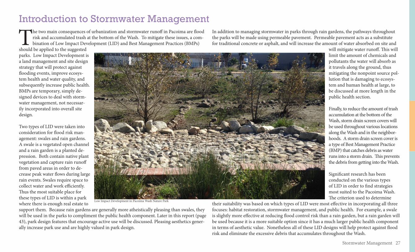
Two types of LID were taken into consideration for flood risk man-agement: swales and rain gardens. A swale is a vegetated open channel and a rain garden is a planted de-pression. Both contain native plant vegetation and capture rain runoff from paved areas in order to de-crease peak water flows during large rain events. Swales require space to collect water and work efficiently. Thus the most suitable place for these types of LID is within a park where there is enough real estate to support them. Because rain gardens are generally more atheistically pleasing than swales, they will be used in the parks to compliment the public health component. Later in this report (page 43), park design features that encourage active use will be discussed. Pleasing aesthetics gener-ally increase park use and are highly valued in park design.
In addition to managing stormwater in parks through rain gardens, the pathways throughout the parks will be made using permeable pavement. Permeable pavement acts as a substitute for traditional concrete or asphalt, and will increase the amount of water absorbed on site and
will mitigate water runoff. This will limit the amount of chemicals and pollutants the water will absorb as it travels along the ground, thus mitigating the nonpoint source pol-lution that is damaging to ecosys-tem and human health at large, to be discussed at more length in the public health section.
Finally, to reduce the amount of trash accumulation at the bottom of the Wash, storm drain screen covers will be used throughout various locations along the Wash and in the neighbor-hoods. A storm drain screen cover is a type of Best Management Practice (BMP) that catches debris as water runs into a storm drain. This prevents the debris from getting into the Wash.
Significant research has been conducted on the various types of LID in order to find strategies most suited to the Pacoima Wash. The criterion used to determine
their suitability was based on which types of LID were most effective in incorporating all three focuses: habitat restoration, stormwater management, and public health. For example, a swale is slightly more effective at reducing flood control risk than a rain garden, but a rain garden will be used because it is a more suitable option since it has a much larger public health component in terms of aesthetic value. Nonetheless all of these LID designs will help protect against flood risk and eliminate the excessive debris that accumulates throughout the Wash.
Introduction to Stormwater Management
Low Impact Development in Pacoima Wash Nature Park
28 Revitalizing Pacoima Wash
Currently there are problems regarding the configuration of the Pacoima Wash because it is a stream that is surrounded by urbanization. Urbanization has
destructive impacts on the natural environments and ecosystems of the area because it decreases the permeability of natural surfaces. This leads to increased runoff and subsequent flood control issues and Wash pollution.
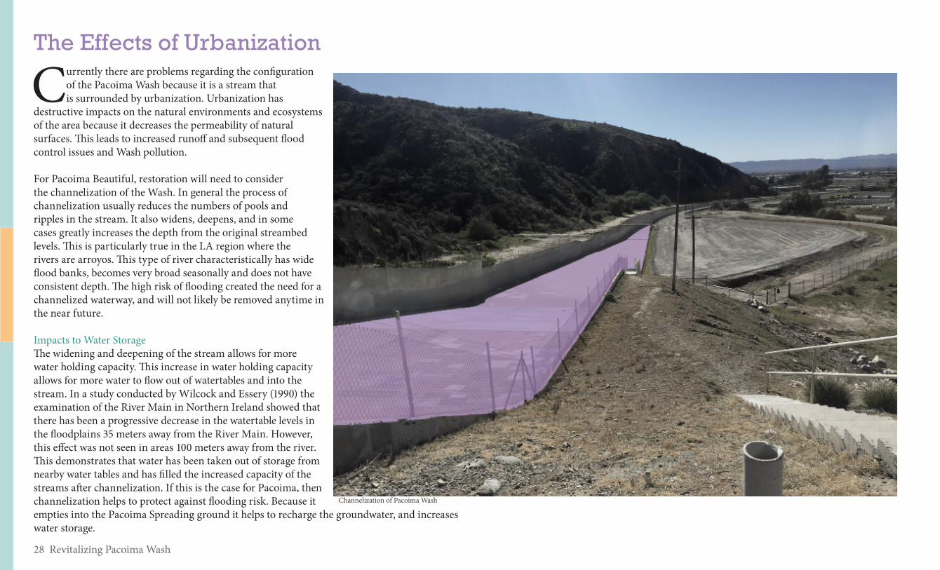
For Pacoima Beautiful, restoration will need to consider the channelization of the Wash. In general the process of channelization usually reduces the numbers of pools and ripples in the stream. It also widens, deepens, and in some cases greatly increases the depth from the original streambed levels. This is particularly true in the LA region where the rivers are arroyos. This type of river characteristically has wide flood banks, becomes very broad seasonally and does not have consistent depth. The high risk of flooding created the need for a channelized waterway, and will not likely be removed anytime in the near future.
Impacts to Water StorageThe widening and deepening of the stream allows for more water holding capacity. This increase in water holding capacity allows for more water to flow out of watertables and into the stream. In a study conducted by Wilcock and Essery (1990) the examination of the River Main in Northern Ireland showed that there has been a progressive decrease in the water table levels in the floodplains 35 meters away from the River Main. However, this effect was not seen in areas 100 meters away from the river. This demonstrates that water has been taken out of storage from nearby water tables and has filled the increased capacity of the streams after channelization. If this is the case for Pacoima, then channelization helps to protect against flooding risk. Because it empties into the Pacoima Spreading ground it helps to recharge the groundwater, and increases water storage.
The Effects of Urbanization
Channelization of Pacoima Wash
Stormwater Management 29
Impacts to Water Velocity & Flow Characteristics/HydrologyChannelization has shown effects to decrease water flow velocity of streams. This is because of the meandering channels caused by channelization that increase the length of flow, which ultimately reduces water velocity. In the River Main, the process of channelization caused the channel slope to increase by about 30%, the hydraulic radius to increase by 69%, and the channel roughness to decrease by about 50%. All these changes to the channel’s geometry and frictional drag will increase the channel velocity. Impacts on Suspended SedimentsChannelization excavates stream bank walls, which causes sediments to be dislodged and then released into the stream systems. Assimilation and mineralization of organic loads are slowed down, which increases suspended sediments in the stream. The turbidity increases, which caused less light penetration, reducing productivity in the stream (ie: algal production). The suspended sediments can impede biological processes by blocking off oxygen flow that is necessary for eggs and young larvae in the water. Coarse sediments allow movement of water thus increasing water exchange in transient storage zones. Fine sediments limits opportunities for water exchange due to low hydraulic conductivity.
Stream flow Impacts & Impacts to nutrient uptakeMost channelized streams are lined with concrete or other non permeable material. This prevents water from permeating the surface and infiltrating the ground. There is also a reduction in frequency of overbank flooding and seepage. However channelization increases water velocity; high water velocity equals fewer opportunities for nutrient removal, and low velocity gives higher potential for nutrient retention. Slowing the removal of water and increasing in situ water absorption mitigates the transport downstream of nutrients. Excess nutrients in the water system is very damaging to intact ecosystems. The microorganisms take advantage of the extra nutrients in what are usually nutrient limited systems. The algae reproduces rapidly in what is called an algal bloom. All of the extra algae use of the dissolved oxygen in the water system. Larger animals suffocate as a result. Channelization causes a reduction of natural variation in velocity and condition of substrate that will decrease transient storage and nutrient retention.
Taking all of these factors into consideration, it will be very effective to implement LID throughout the Wash and surrounding neighborhoods. The Geosyntec hydrology report has assisted in determining the locations of pollution sources and the most polluted areas along the Wash.
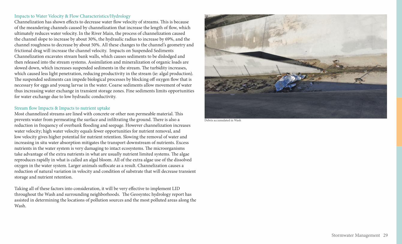
Debris accumulated in Wash
30 Revitalizing Pacoima Wash
Low Impact Development Overview
In order to prevent the consequences of urbanization, low impact development (LID) can be used to keep the hydrology of an ecosystem as natural as possible. “Low impact develop-ment (LIDs) is a land development strategy for managing stormwater at the source” (Ahiab-
lame, 2012). There are a wide variety of practices that are considered to be LIDs and each one is used to perform different solutions to problems with stormwater management.
In particular, LID is capable of managing flooding during large rain events and improving the quality and health of an ecosystem. Bioretention is an LID that is helpful for managing water during large rain events. It typically consists of “a trench filled with a highly permeable soil medium that supports vegetation” (Daly, 2011). An example of bioretention is a rain garden. Native plant vegetation should be used because it is the easiest to maintain and is “capable of handling the local weather and rain amount” (Lam, 2011). Bioretention “has been proven to decrease peak flow rates and volumes, promote infiltration and evapotranspiration and im-prove water quality by removing sediments, nutrients and other pollutants from stormwater” (Debusk, 2011). Thus it is useful in managing water during large rain events because it can re-duce peak flows and encourage groundwater recharge through infiltration, which will decrease or eliminate flooding dangers. Bioretention can be placed on a larger plot of land, such as a park area. In fact, “In highly urbanized watersheds, bioretention is often one of the few retrofit options that can be cost- effectively employed by modifying existing landscaped areas, con-verting islands or under-used parking areas, or integrating into the resurfacing of a parking lot. Applications of bioretention systems in urban environments include planter boxes, residential on- lot landscaping, parking lots, roadways, and industrial and commercial applications, which can capture both site and roof runoff ” (Philadelphia Stormwater Manual, 2014).
In terms of improving the quality of the ecosystem, LID can reduce pollutants and trash that are carried into a stream from stormwater runoff. Urbanized streams are susceptible to storm-water runoff because their impermeable surfaces allow water from rain events to run into the stream, rather than immediately infiltrating into the ground if it were permeable. Effective LIDs to reduce pollution are riparian buffers and catch basin screens.
Riparian buffers include bioswales and vegetative buffer strips. These will most effectively be placed in greenways connecting different parks along the Wash. Bioswales “consist of a swaled drainage course filled with vegetation, compost and/or riprap” (Xiao, 2011). Vegetative buffer strips are bands of land that can have close grown vegetation planted in them (Arora, 1996). Both bioswales and vegetated buffer strips are located between pollutant sources and the re-
ceiving waters and work through “mechanisms of interception , adsorption, infiltration, and/or by sediment deposition” (Arora, 1996). Vegetated buffer strips are used to prevent phosphorus from entering streams (Roberts, 2012) and can be used to reduce nitrate -nitrogen concentra-tion (Johnson, 2013). Narrower buffers are generally more effective than wider ones, but the “landscape position and hydrology are the major indicators of potential buffer success for pro-viding water quality benefit” (Johnson, 2013). Riparian buffers are suitable for narrow stretches of land directly next to the Wash.
Storm drain screens catch debris as stormwater runs into a storm drain (Jarvis, 2012). This pre-vents trash from making its way into the stream. Specifically, “the screen system permits water to flow therethrough and prevents solid objects of predetermined size and shape from passing there through into an outlet of a storm drain catch basin” (Jarvis, 2012).
Permeable pavements can be used for walkways or bike paths along the Wash. They act as a substitute for traditional concrete or asphalt, with the goal of allowing water to infiltrate into the ground so that it does not runoff the surface and into the stream. Permeable pavements in-clude “pervious concrete, porous asphalt, permeable paver blocks, or other manufactured ma-terials” (Lee, 2014). Through infiltration, permeable pavement acts to improve the water quality of streams because they infiltrate virtually all water from storms (Brattebo, 2003). Unfortunate-ly the lifespan of permeable pavements is shorter than that of impermeable pavements. This is due to “deterioration by runoff, air infiltration, and subsequent stripping and oxidation, as well as hardening of binder” (Scholz, 2007). Another disadvantage of permeable pavements is that “porous asphalt and porous concrete pavement systems are prone to clogging usually within three years after installation” (Scholz, 2007). This means that they induce high maintenance costs and require frequent replacement.
LID is the key to effectively managing stormwater because it “focus[es] on prevention rather than mitigation and remediation” (Ahiablame, 2012) and is useful in restoring the health of an ecosystem because it significantly reduces pollutants. There is still a lot of research to do on LIDs, particularly because there are inconsistencies across practices and geography. Areas of research that could be expanded upon are: how well each LID applies to a particular geographic region; how long each type of LID lasts, in addition to the time it lasts in particular environ-ments; and research on how LIDs will be effective with current and future climate change. Overall, LIDs are an excellent solution to the negative effects of urbanization on streams.
Stormwater Management 31
Restoration
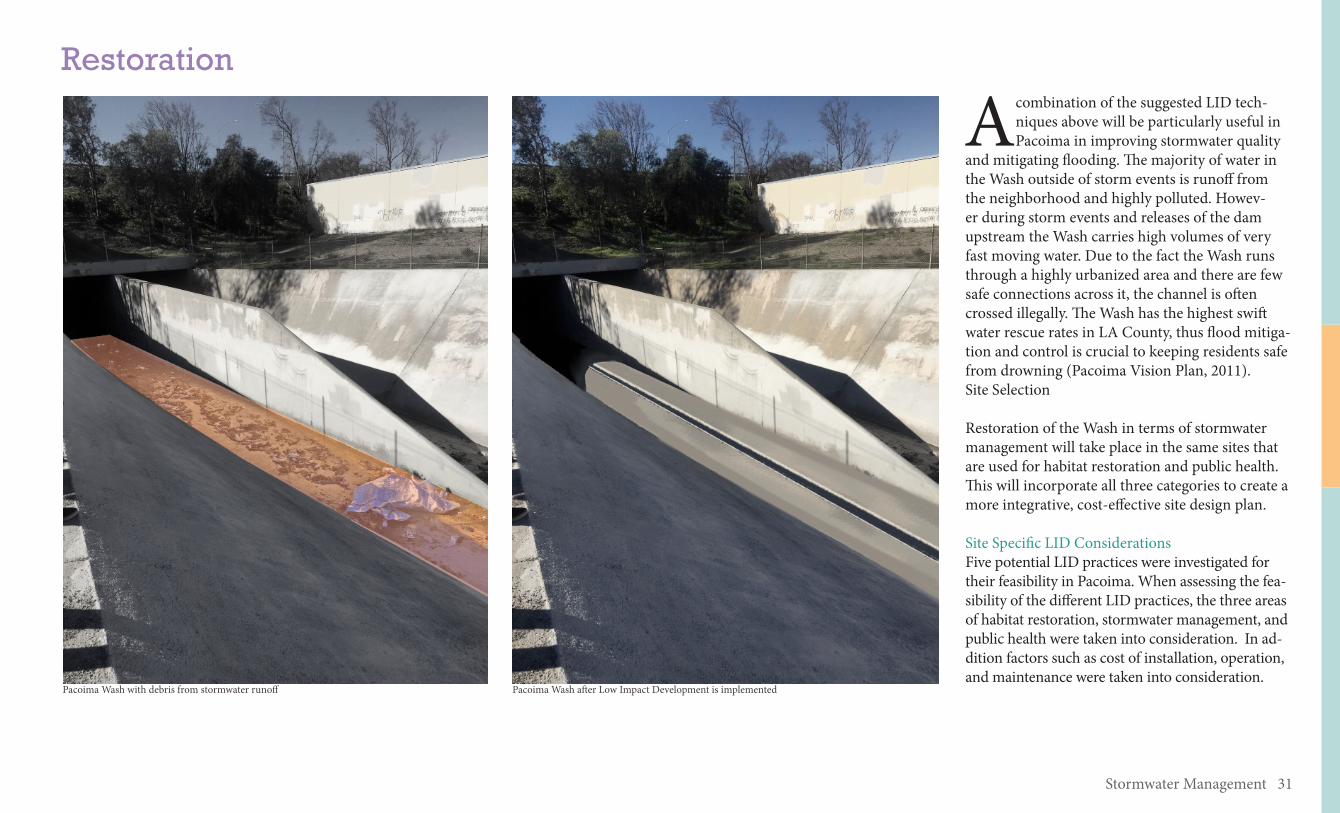
Pacoima Wash with debris from stormwater runoff Pacoima Wash after Low Impact Development is implemented
A combination of the suggested LID tech-niques above will be particularly useful in Pacoima in improving stormwater quality
and mitigating flooding. The majority of water in the Wash outside of storm events is runoff from the neighborhood and highly polluted. Howev-er during storm events and releases of the dam upstream the Wash carries high volumes of very fast moving water. Due to the fact the Wash runs through a highly urbanized area and there are few safe connections across it, the channel is often crossed illegally. The Wash has the highest swift water rescue rates in LA County, thus flood mitiga-tion and control is crucial to keeping residents safe from drowning (Pacoima Vision Plan, 2011).Site Selection
Restoration of the Wash in terms of stormwater management will take place in the same sites that are used for habitat restoration and public health. This will incorporate all three categories to create a more integrative, cost-effective site design plan.
Site Specific LID ConsiderationsFive potential LID practices were investigated for their feasibility in Pacoima. When assessing the fea-sibility of the different LID practices, the three areas of habitat restoration, stormwater management, and public health were taken into consideration. In ad-dition factors such as cost of installation, operation, and maintenance were taken into consideration.
32 Revitalizing Pacoima Wash
Flood ControlTwo LID practices that were considered for flood control management were swales and rain gardens. These types of LID are similar, but a swale is slightly more practical and less aestheti-cally pleasing than a rain garden. The cost of installing a swale and a rain garden vary depend-ing on their size and specific plants used. However, the cost to maintain them is generally a similar amount after the first year of installation. During the first year after installation, rain gardens require more attention in the form of watering the vegetation to ensure successful es-tablishment. (Philadelphia Stormwater Manual, 2014)
SwaleA swale is an open channel that is constructed parallel to concrete walkways or roads, designed to infiltrate water runoff and reduce peak flows. It is constructed with native plant vegetation, soil, and if needed, stones and an underdrain to further enhance infiltration. A swale provides medium flood control, but is not very aesthetically pleasing, especially in comparison to a rain garden. It functions more as a tool to direct the flow of water than to provide landscape en-hancement.
Rain GardenA rain garden is a vegetated depression, usually 8 inches deep or less used for effectively infil-trating water. They require relatively large plots of land and provide low/medium flood control. A rain garden is constructed with planting soil, mulch, native plants, and storage stone, similar materials used in swales. However, the design and the vegetation used in rain gardens are more aesthetically pleasing and the large areas of the parks could accommodate rain gardens.
Permeable PavementPermeable pavement has the ability to indirectly prevent flood risk, in that it is not specifically designed to infiltrate large amounts of water as swales and rain gardens are, but it is better for infiltration than traditional concrete or asphalt. In addition, permeable pavements will help to prevent nutrients from entering the Wash, which will reduce poor water quality in the water-shed downstream.
All permeable pavements have the same or similar effectiveness in reducing the volume and rate of stormwater runoff and pollution, and have the same underlying storage and support structure (EPA, 2014). Because of this, the permeable pavement that is selected for Pacoima is based on cost and aesthetic value.
Pervious concrete is recommended instead of porous asphalt or permeable interlocking con-
crete pavers because overall it is the most cost-effective and aesthetically pleasing. Permeable interlocking concrete pavers are more expensive than pervious concrete and porous asphalt, even though less expensive than pervious concrete, is not as aesthetically pleasing, particularly in the context of a park.
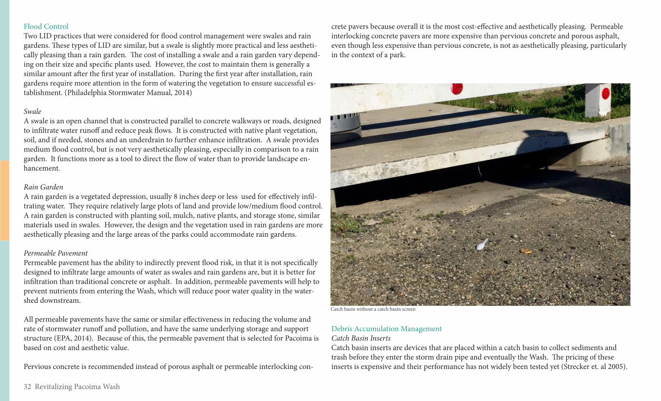
Debris Accumulation ManagementCatch Basin InsertsCatch basin inserts are devices that are placed within a catch basin to collect sediments and trash before they enter the storm drain pipe and eventually the Wash. The pricing of these inserts is expensive and their performance has not widely been tested yet (Strecker et. al 2005).
Catch basin without a catch basin screen
Stormwater Management 33
As well, these inserts are very costly to monitor because they need to be emptied especially di-rectly after a storm event, otherwise they will clog and become ineffective.
Storm Drain Screen CoverA different approach to managing the pollution in the Wash will be to insert storm drain screen covers over the storm drains. Storm drain screen covers are designed to catch large pieces of trash so that it doesn’t enter the storm drain pipe. Rather than being placed inside the catch basin, these are placed on the outside of the storm drain, visible to the street. While catch basin inserts are able to prevent sediments from entering the Wash, storm drain screen covers only prevent large pieces of trash from making their way into the Wash. The costs of storm drain screen covers are less expensive than catch basin inserts, and easier to monitor.
After doing research and taking into consideration the specific needs of the Pacoima Wash, the types of LID to be installed in the parks and throughout the neighborhood are rain gardens, permeable pavement, and storm drain covers. Rain gardens and perme-
able pavement will be installed in parks because the parks are being designed for habitat remedi-ation and public health benefits, and these LID practices will able to assist with these aspects as well as account for stormwater management. In addition, since site design work is already being implemented in the parks, it will be effective to incorporate LID into the site design plans. Rain gardens will not only help to manage stormwater and thus improve the conditions of the Wash, but they will also add aesthetic and ecological value to the parks. As mentioned previously aesthetics increase park usage, and thus physical activity within the community. In addition LID areas such as rain gardens can also be restored habitat if native plants are used, or plants that will support native fauna.
In regards to storm drain screen covers, they will be used throughout the neighborhood because they are a less expensive way to keep trash out of the Wash. Even though they do not catch sed-iment like catch basin inserts do, screen covers catch large pieces of trash which is more preva-lent issue in terms of Pacoima Wash since on average there is no water in the Wash but instead a large amount of trash accumulated at the bottom. Also, the rain gardens installed in the parks can help to catch sediments and nutrients from runoff that may contribute to poor water qual-ity further down the watershed, so it is not critical that the storm drain screen covers have this function.
34 Revitalizing Pacoima Wash
LID Installation and Site Design
The project team has designed two parks at the end of Telfair Ave, and Brownell Ave, to address stormwater management, habitat restoration, and public health. Pacoima Beautiful has already re-
ceived the site design for the El Dorado park by an outside contractor, so it was used as a model to assist design of Telfair Park and Brownell Park. El Dorado Park has been designed with California Native landscaping. It includes stormwater management feature such as bioswales and catch basins. The site design incorporates features such as open space with picnic tables, fitness stations, and sculptures to attract the community.
A brief overview of the key elements, materials, and suggestions for the installations of rain gardens, permeable pavement, and storm drain screen covers is outlined below. Further specifics for construction should be researched before going forward with site reconfiguration.
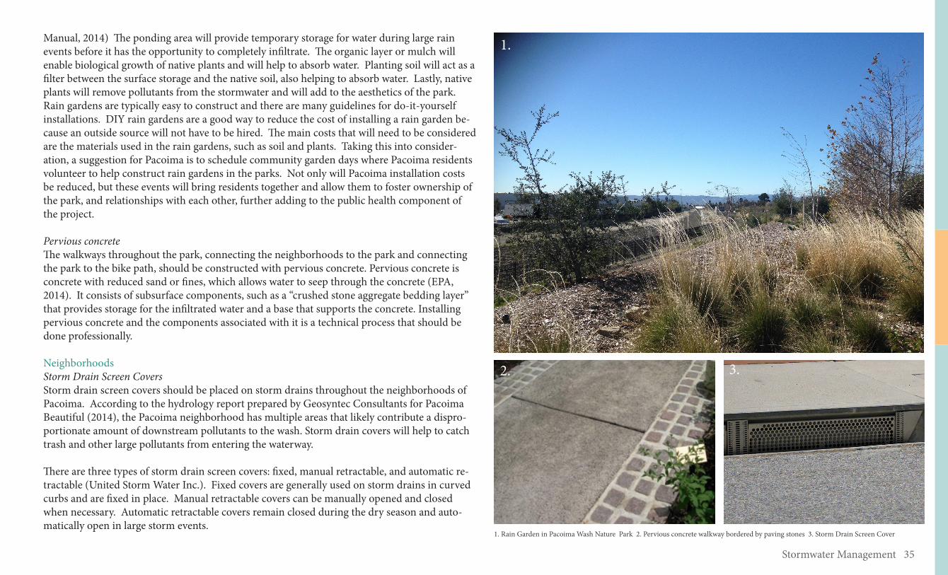
ParksRain gardensThe largest areas of land available should be dedicated to the installation of rain gardens to ensure maximum infiltration. In particular, areas of the park adjacent to streets of Pacoima will be used for rain gardens because they will capture stormwater runoff immediately from the asphalt and infiltrate it before it makes its way into the Wash. In order to do this, there must be a flow entrance or inlet that the water can flow through to make its way into the rain garden. As well, the area of the rain garden should be depressed 4-8 inches into the ground.
The rain garden itself will consist of a ponding area, an organic layer or mulch, planting soil, and native plantings. (Philadelphia Stormwater
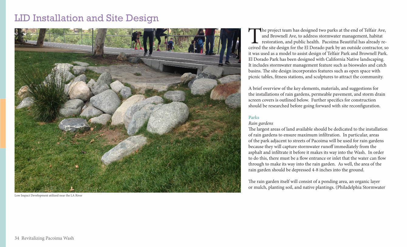
Low Impact Development utilized near the LA River
Stormwater Management 35
Manual, 2014) The ponding area will provide temporary storage for water during large rain events before it has the opportunity to completely infiltrate. The organic layer or mulch will enable biological growth of native plants and will help to absorb water. Planting soil will act as a filter between the surface storage and the native soil, also helping to absorb water. Lastly, native plants will remove pollutants from the stormwater and will add to the aesthetics of the park. Rain gardens are typically easy to construct and there are many guidelines for do-it-yourself installations. DIY rain gardens are a good way to reduce the cost of installing a rain garden be-cause an outside source will not have to be hired. The main costs that will need to be considered are the materials used in the rain gardens, such as soil and plants. Taking this into consider-ation, a suggestion for Pacoima is to schedule community garden days where Pacoima residents volunteer to help construct rain gardens in the parks. Not only will Pacoima installation costs be reduced, but these events will bring residents together and allow them to foster ownership of the park, and relationships with each other, further adding to the public health component of the project.
Pervious concreteThe walkways throughout the park, connecting the neighborhoods to the park and connecting the park to the bike path, should be constructed with pervious concrete. Pervious concrete is concrete with reduced sand or fines, which allows water to seep through the concrete (EPA, 2014). It consists of subsurface components, such as a “crushed stone aggregate bedding layer” that provides storage for the infiltrated water and a base that supports the concrete. Installing pervious concrete and the components associated with it is a technical process that should be done professionally.
NeighborhoodsStorm Drain Screen CoversStorm drain screen covers should be placed on storm drains throughout the neighborhoods of Pacoima. According to the hydrology report prepared by Geosyntec Consultants for Pacoima Beautiful (2014), the Pacoima neighborhood has multiple areas that likely contribute a dispro-portionate amount of downstream pollutants to the wash. Storm drain covers will help to catch trash and other large pollutants from entering the waterway.
There are three types of storm drain screen covers: fixed, manual retractable, and automatic re-tractable (United Storm Water Inc.). Fixed covers are generally used on storm drains in curved curbs and are fixed in place. Manual retractable covers can be manually opened and closed when necessary. Automatic retractable covers remain closed during the dry season and auto-matically open in large storm events.
1. Rain Garden in Pacoima Wash Nature Park 2. Pervious concrete walkway bordered by paving stones 3. Storm Drain Screen Cover
1.
2. 3.
36 Revitalizing Pacoima Wash
After designing and constructing the parks, operation, maintenance and monitoring must be taken into consideration. Fortunately, the goal of LID is to develop a self sustaining system to manage the stormwater. If well designed they should require little
maintenance.
Rain GardensIf the correct materials and vegetation are used in for the construction of rain gardens, then they should be mostly self-sustainable, after the first year of installation. Within the first year of installation, vegetation should be water regularly to ensure successful establishment (Philadel-phia Stormwater Manual, 2014). After that, leaves and debris will need to be cleared from the garden on a monthly basis. Trees and shrubs should be inspected twice a year and replaced if necessary. Once a year, mulch should be added and the garden should be inspected for sedi-ment buildup and erosion. This maintenance could easily be turned into regular community events where residents volunteer to clean the gardens.
Permeable PavementPermeable pavement is expected to last 15 to 30 years, depending on the site and maintenance done on it (California Coastal Commission, 2013). Maintenance includes vacuum sweeping the surface to remove sediment, inspecting the surface annually for deterioration, and corre-spondingly fixing potholes and cracks (California Coastal Commission, 2013). Permeable pavements are prone to erosion and clogging as fine particles can clog the pores of the pavement, causing the infiltration rates to decrease as the pavement ages. Despite this, infil-tration capacity remains high even with clogging, and can usually accommodate large stormwa-ter events (EPA).
Storm Drain Screen CoversTrash must be collected from screen covers on a regular basis and after large storm events to ensure that they do not get clogged and that the trash is effectively disposed of. In addition to the operation and maintenance of LID, a way to measure the effectiveness of the site recon-figuration will be to mail surveys to Pacoima residents. These could ask community members to report any pooling of water or minor flood events that will indicate the effectiveness of the water management. In addition it could ask how the LID affected the community member’s ex-perience in the parks, if they felt that it enhanced their experience, hindered it or was a neutral feature. This will provide feedback on their views of the parks in particular, which is important because ultimately these retrofits are being made on their behalf.
Operation, Maintenance, and Monitoring
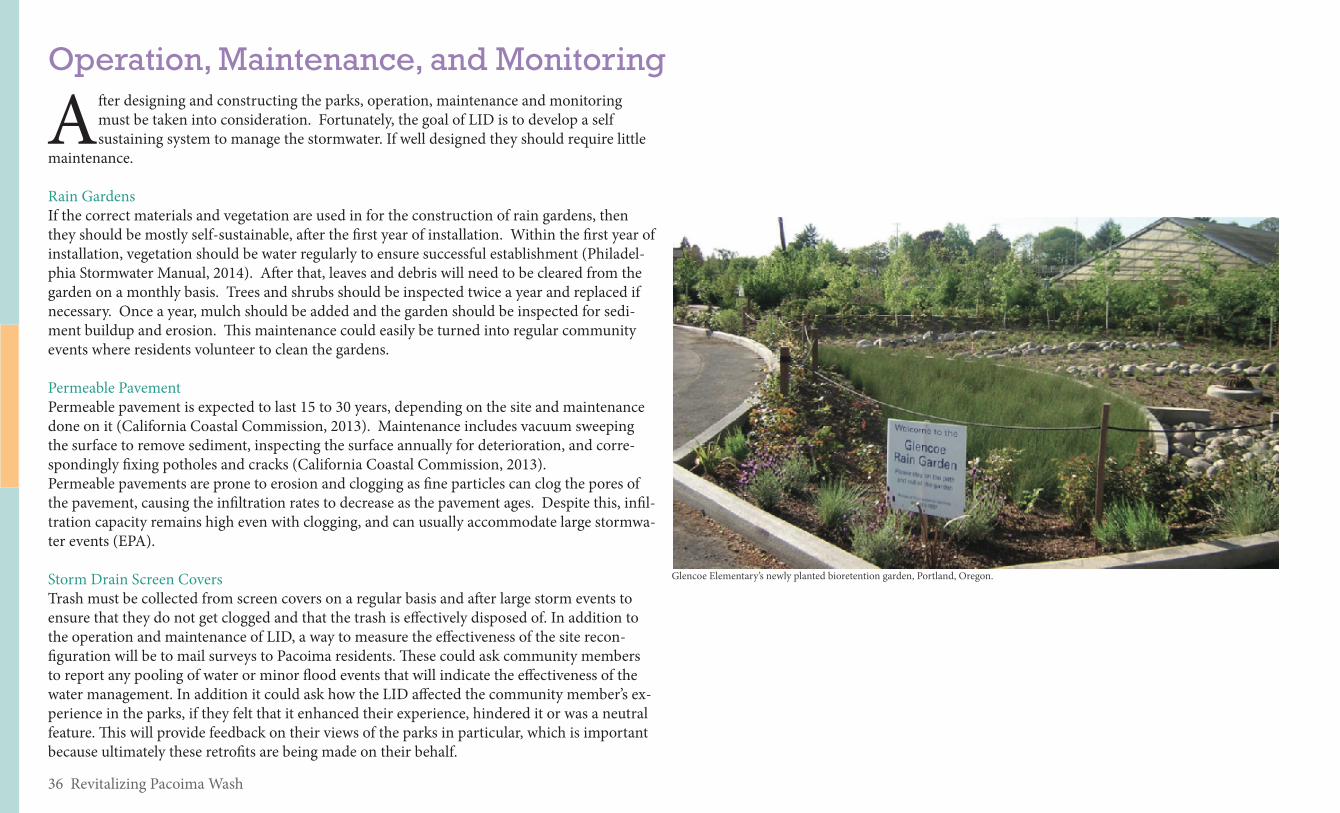
Glencoe Elementary’s newly planted bioretention garden, Portland, Oregon.
Public Health
38 Revitalizing Pacoima Wash
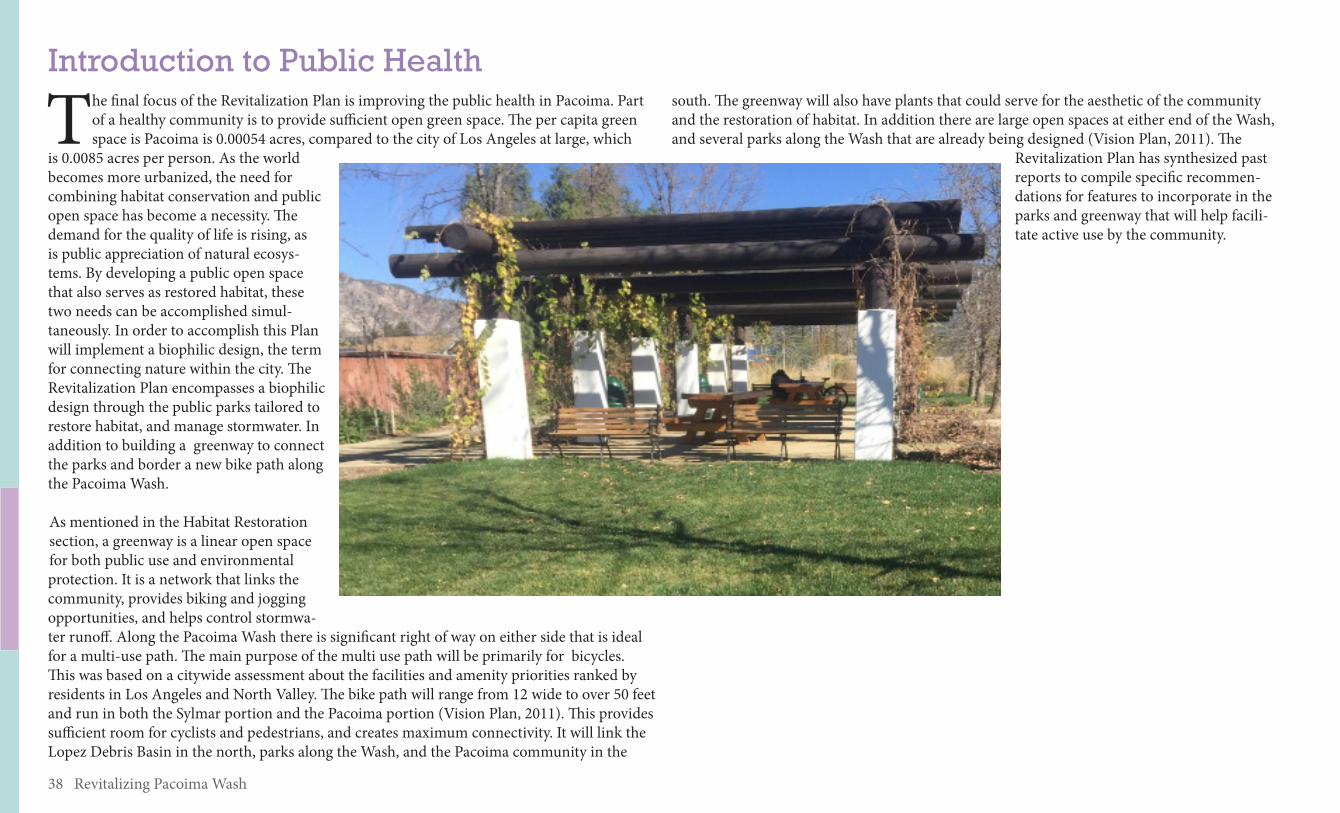
The final focus of the Revitalization Plan is improving the public health in Pacoima. Part of a healthy community is to provide sufficient open green space. The per capita green space is Pacoima is 0.00054 acres, compared to the city of Los Angeles at large, which
is 0.0085 acres per person. As the world becomes more urbanized, the need for combining habitat conservation and public open space has become a necessity. The demand for the quality of life is rising, as is public appreciation of natural ecosys-tems. By developing a public open space that also serves as restored habitat, these two needs can be accomplished simul-taneously. In order to accomplish this Plan will imple ment a biophilic design, the term for connecting nature within the city. The Revitalization Plan encompasses a biophilic design through the public parks tailored to restore habitat, and manage stormwater. In addition to building a greenway to connect the parks and border a new bike path along the Pacoima Wash.
As mentioned in the Habitat Restoration section, a greenway is a linear open space for both public use and environmental protection. It is a network that links the community, provides biking and jogging opportunities, and helps control stormwa-ter runoff. Along the Pa coima Wash there is significant right of way on either side that is ideal for a multi-use path. The main purpose of the multi use path will be primarily for bicycles. This was based on a citywide assessment about the facili ties and amenity priorities ranked by residents in Los Angeles and North Valley. The bike path will range from 12 wide to over 50 feet and run in both the Sylmar por tion and the Pacoima portion (Vision Plan, 2011). This provides sufficient room for cyclists and pedestrians, and creates maximum connectiv ity. It will link the Lopez Debris Basin in the north, parks along the Wash, and the Pacoima community in the
south. The greenway will also have plants that could serve for the aes thetic of the community and the restoration of habitat. In addition there are large open spaces at either end of the Wash, and several parks along the Wash that are already being designed (Vision Plan, 2011). The
Revitalization Plan has synthesized past reports to compile specific recommen-dations for features to incorporate in the parks and greenway that will help facili-tate active use by the community.
Introduction to Public Health
Public Health 39
Environmental Justice
Pacoima s a low-income, working-class community disproportionately inhabited by mi-norities compared to the city with about 83.5% Hispanic population in Pacoima. It is an area that is park poor, with a per capita open space of 0.00054. Development of the parks
and greenway will be a great opportunity in promoting community involvement and addressing the topic of environmental justice. One issue addressed will be the air pollution caused by the disproportionate distribution of urban structures in the form of industry, and freeways. Three main transportation routes in the Pacoima neighborhood are San Fernando Road, Van Nuys Boulevard and Laurel Canyon Boulevard. The major freeways across the area are I-5 (Gold-en State), I-20(Foothill) and California State Route 118 (Ronald Reagan). The high density of roads increases the traffic density, and cause the residents to endure a higher risk of exposure to vehicle-related pollutants. The main pollutants produced by the transportation emissions are carbon monoxide, volatile organic compounds and nitrogen oxides, which are associated with several adverse health impacts. An article written by Houston in 2004, highlights the structural disparities of urban traffic in Southern California. Infrastructure such as freeways is often built through disadvantaged communities, such as Pacoima. This exposes them to disproportionate environmental hazards.
Using the CalEnvrioScreen 2.0 tool, the Pacoima Area ranks in the 71-80% percentiles for combined pollution burden scores. The 12 indicators that make up this score are: air quali-ty:ozone, air quality: fine particles, diesel particulate emissions, drinking water contaminants,
pesticide use, toxic release from facilities, traffic density, cleanup sites, groundwater threats, hazardous waste site and facilities, impaired water bodies, and solid waste sites and facilities. The CalEnviroScreen tool puts Pacoima in the in the bottom tenth percentile for population characteristics score. The five criteria for this score are: asthma emergency department visits, low education attainment, linguistic isolation, poverty and unemployment. CalEnvironScreen 2.0 uses census tract data to rank the public health threats for all of California. It combines the two rankings of pollution burden, and population characteristics. The combined ranking puts Pacoima in the top ten percent for most environmentally hazard burdened areas.
Minority areas are disproportionately burdened. Industries and corporation target ethnic communities such as Pacoima because land is less expensive (Pastor, Sadd, Hipp, 2011). In addition there is less push back from the communities because areas of color tend to have lower income. They may be working longer hours, or multiple jobs and not have the time or financial resources to lobby to protect their neighborhoods. There is an increased challenge of linguistic ability in making themselves heard at organized events like communities meetings if they are not fluent in English, or it is their second language (Schelley, Stetesky, 2009). Imple-mentation of the Revitalization Plan will work to mitigate the injustice in this area. It plans to improve the air quality in the Pacoima area with restoration that includes air filtering vegeta-tion within the selected park sites.This will address inordinate environmental exposure experi-enced by the disadvantaged neighborhood.
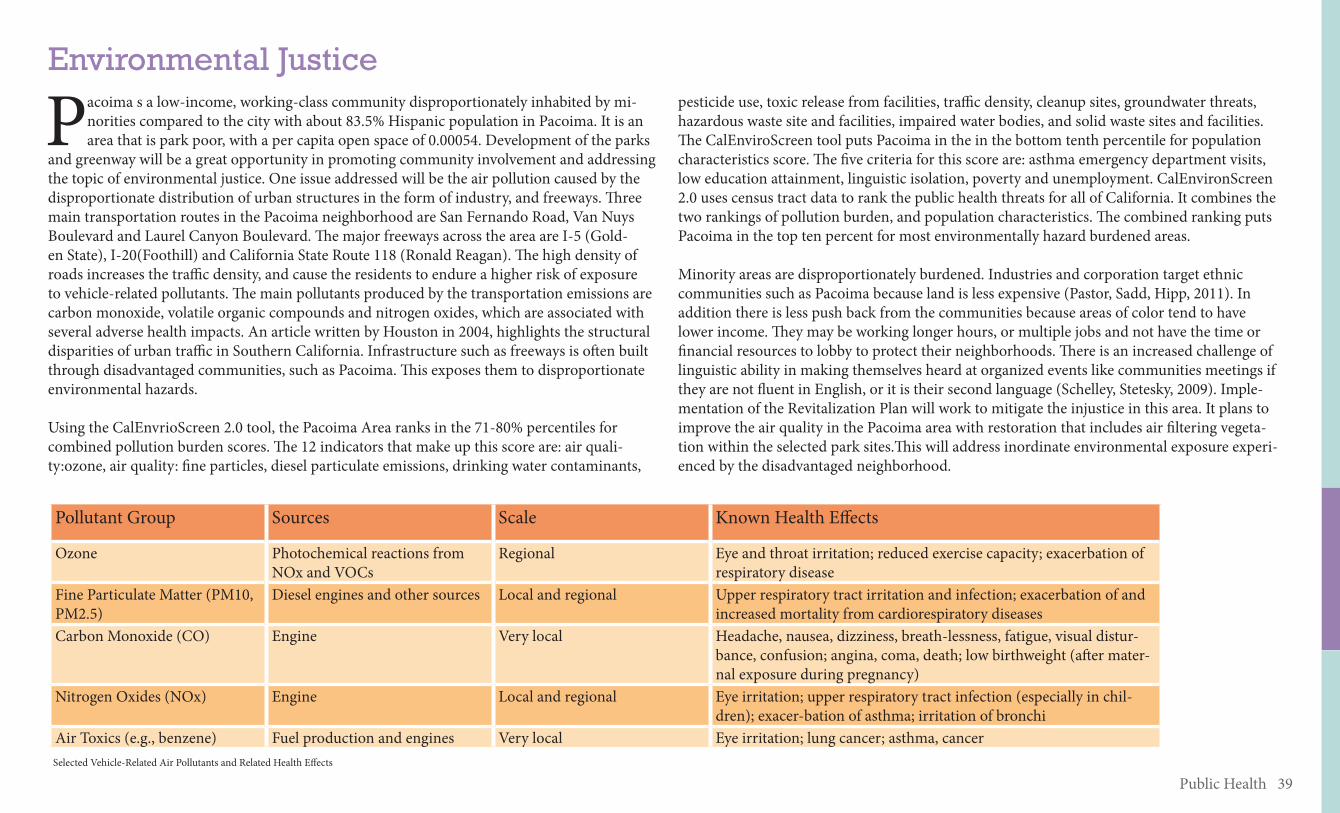
Pollutant Group Sources Scale Known Health Effects
Ozone Photochemical reactions from NOx and VOCs
Regional Eye and throat irritation; reduced exercise capacity; exacerbation of respiratory disease
Fine Particulate Matter (PM10, PM2.5)
Diesel engines and other sources Local and regional Upper respiratory tract irritation and infection; exacerbation of and increased mortality from cardiorespiratory diseases
Carbon Monoxide (CO) Engine Very local Headache, nausea, dizziness, breath-lessness, fatigue, visual distur-bance, confusion; angina, coma, death; low birthweight (after mater-nal exposure during pregnancy)
Nitrogen Oxides (NOx) Engine Local and regional Eye irritation; upper respiratory tract infection (especially in chil-dren); exacer-bation of asthma; irritation of bronchi
Air Toxics (e.g., benzene) Fuel production and engines Very local Eye irritation; lung cancer; asthma, cancerSelected Vehicle-Related Air Pollutants and Related Health Effects
40 Revitalizing Pacoima Wash
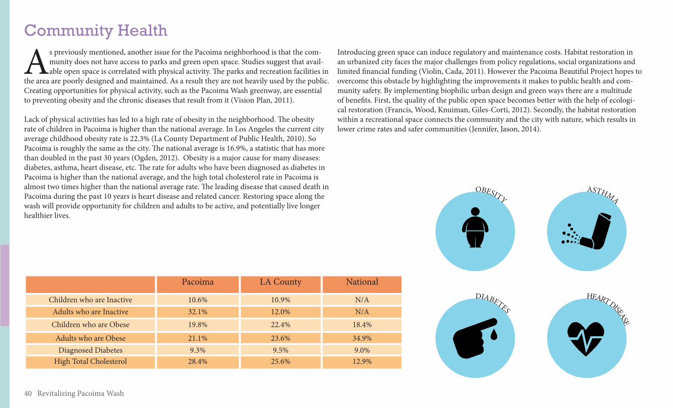
As previously mentioned, another issue for the Pacoima neighborhood is that the com-munity does not have access to parks and green open space. Studies suggest that avail-able open space is correlated with physical activity. The parks and recreation facilities in
the area are poorly designed and maintained. As a result they are not heavily used by the public. Creating opportunities for physical activity, such as the Pacoima Wash greenway, are essential to preventing obesity and the chronic diseases that result from it (Vision Plan, 2011).
Lack of physi cal activities has led to a high rate of obesity in the neighborhood. The obesity rate of children in Pacoima is higher than the national average. In Los Angeles the current city average childhood obesity rate is 22.3% (La County Department of Public Health, 2010). So Pacoima is roughly the same as the city. The national average is 16.9%, a statistic that has more than doubled in the past 30 years (Ogden, 2012). Obesity is a major cause for many dis eases: diabetes, asthma, heart disease, etc. The rate for adults who have been diagnosed as di abetes in Pacoima is higher than the national average, and the high total cholesterol rate in Pacoima is almost two times higher than the national average rate. The leading disease that caused death in Pacoima during the past 10 years is heart disease and related cancer. Restoring space along the wash will provide opportunity for children and adults to be active, and potentially live longer healthier lives.
Introducing green space can induce regulatory and maintenance costs. Habitat restoration in an urbanized city faces the major challenges from policy regulations, social organiza tions and limited financial funding (Violin, Cada, 2011). However the Pacoima Beautiful Project hopes to overcome this obstacle by highlighting the improvements it makes to public health and com-munity safety. By implementing biophilic urban design and green ways there are a multitude of benefits. First, the quality of the public open space becomes better with the help of ecologi-cal restoration (Francis, Wood, Knuiman, Giles-Corti, 2012). Secondly, the hab itat restoration within a recreational space connects the community and the city with nature, which results in lower crime rates and safer communities (Jennifer, Jason, 2014).
Community Health
OBESITY
DIABETES
HEART DISEASE
ASTHMA
Pacoima LA County National
Children who are Inactive 10.6% 10.9% N/AAdults who are Inactive 32.1% 12.0% N/AChildren who are Obese 19.8% 22.4% 18.4%
Adults who are Obese 21.1% 23.6% 34.9%Diagnosed Diabetes 9.3% 9.5% 9.0%
High Total Cholesterol 28.4% 25.6% 12.9%
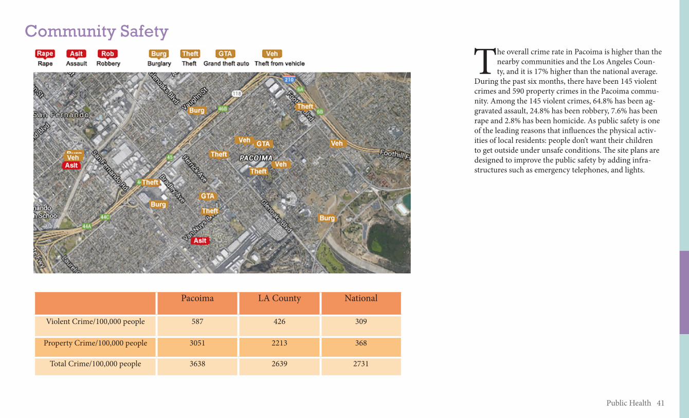
Public Health 41
Community Safety
The overall crime rate in Pacoima is higher than the nearby communities and the Los Angeles Coun-ty, and it is 17% higher than the national average.
During the past six months, there have been 145 violent crimes and 590 property crimes in the Pacoima commu-nity. Among the 145 violent crimes, 64.8% has been ag-gravated assault, 24.8% has been robbery, 7.6% has been rape and 2.8% has been homicide. As public safety is one of the leading rea sons that influences the physical activ-ities of local residents: people don’t want their children to get outside un der unsafe conditions. The site plans are designed to improve the public safety by adding infra-structures such as emergency telephones, and lights.
Pacoima LA County National
Violent Crime/100,000 people 587 426 309
Property Crime/100,000 people 3051 2213 368
Total Crime/100,000 people 3638 2639 2731
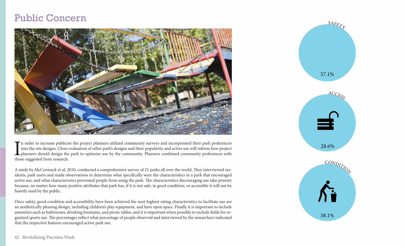
42 Revitalizing Pacoima Wash
Public Concern
In order to increase publicise the project planners utilized community surveys and incorporated their park preferences into the site designs. Close evaluation of other park’s designs and their popularity and active use will inform how project planners should design the park to optimize use by the community. Planners combined community preferences with
those suggested from research.
A study by McCormack et al, 2010, conducted a comprehensive sur vey of 21 parks all over the world. They interviewed res-idents, park users and made observations to determine what spe cifically were the characteristics in a park that encouraged active use, and what char acteristics prevented people from using the park. The characteristics discouraging use take priority because, no matter how many positive attributes that park has, if it is not safe, in good condition, or accessible it will not be heavily used by the public.
Once safety, good condition and accessibility have been achieved the next highest rating characteristics to facilitate use are an aesthetically pleasing design, including children’s play equipment, and have open space. Fi nally it is important to include amenities such as bathrooms, drinking fountains, and picnic tables, and it is important when possible to include fields for or-ganized sports use. The percentages reflect what percentage of people observed and interviewed by the researchers indicated that the respec tive features encouraged active park use.
SAFETY
57.1%
CONDITION
38.1%
ACCESS
28.6%
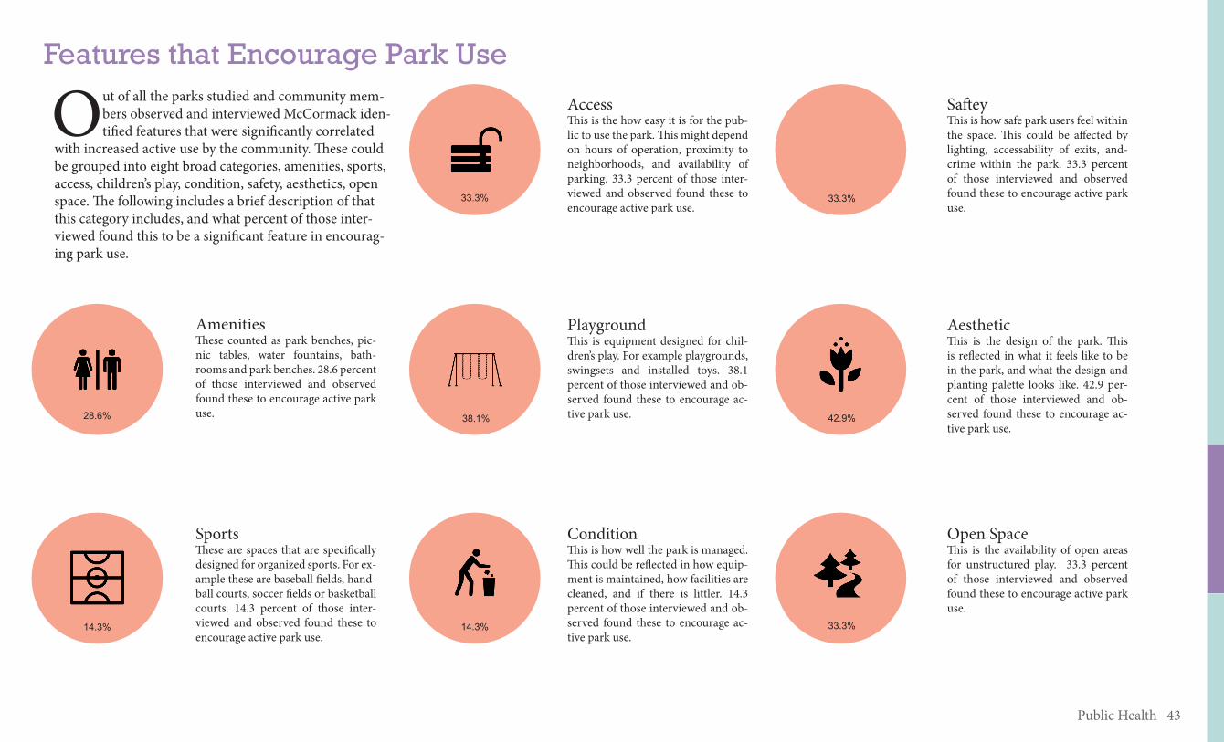
Public Health 43
Features that Encourage Park Use
28.6% 38.1% 42.9%
AmenitiesThese counted as park benches, pic-nic tables, water fountains, bath-rooms and park benches. 28.6 percent of those interviewed and observed found these to encourage active park use.
33.3%
AccessThis is the how easy it is for the pub-lic to use the park. This might depend on hours of operation, proximity to neighborhoods, and availability of parking. 33.3 percent of those inter-viewed and observed found these to encourage active park use.
PlaygroundThis is equipment designed for chil-dren’s play. For example playgrounds, swingsets and installed toys. 38.1 percent of those interviewed and ob-served found these to encourage ac-tive park use.
33.3%
SafteyThis is how safe park users feel within the space. This could be affected by lighting, accessability of exits, and-crime within the park. 33.3 percent of those interviewed and observed found these to encourage active park use.
AestheticThis is the design of the park. This is reflected in what it feels like to be in the park, and what the design and planting palette looks like. 42.9 per-cent of those interviewed and ob-served found these to encourage ac-tive park use.
33.3%
Open SpaceThis is the availability of open areas for unstructured play. 33.3 percent of those interviewed and observed found these to encourage active park use.
Out of all the parks studied and community mem-bers observed and interviewed McCormack iden-tified features that were significantly correlated
with increased active use by the community. These could be grouped into eight broad categories, amenities, sports, access, children’s play, condition, safety, aesthetics, open space. The following includes a brief description of that this category includes, and what percent of those inter-viewed found this to be a significant feature in encourag-ing park use.
SportsThese are spaces that are specifically designed for organized sports. For ex-ample these are baseball fields, hand-ball courts, soccer fields or basketball courts. 14.3 percent of those inter-viewed and observed found these to encourage active park use.
14.3%
ConditionThis is how well the park is managed. This could be reflected in how equip-ment is maintained, how facilities are cleaned, and if there is littler. 14.3 percent of those interviewed and ob-served found these to encourage ac-tive park use.
14.3%
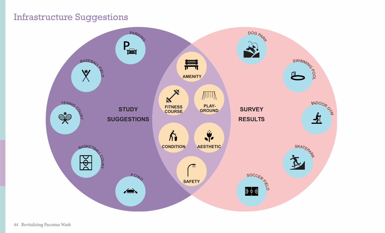
44 Revitalizing Pacoima Wash
Infrastructure SuggestionsPARKING
BASEBALL FIELD
TENNIS COURT
POND
DOG PARK
SWIMMING POO
L
INDOOR GYM
SKATEPARK
SOCCER FIELD
BASKETBALL COU
RT
PLAY-GROUND
AMENITY
FITNESS COURSE
CONDITION AESTHETIC
SAFETY
STUDYSUGGESTIONS
SURVEYRESULTS
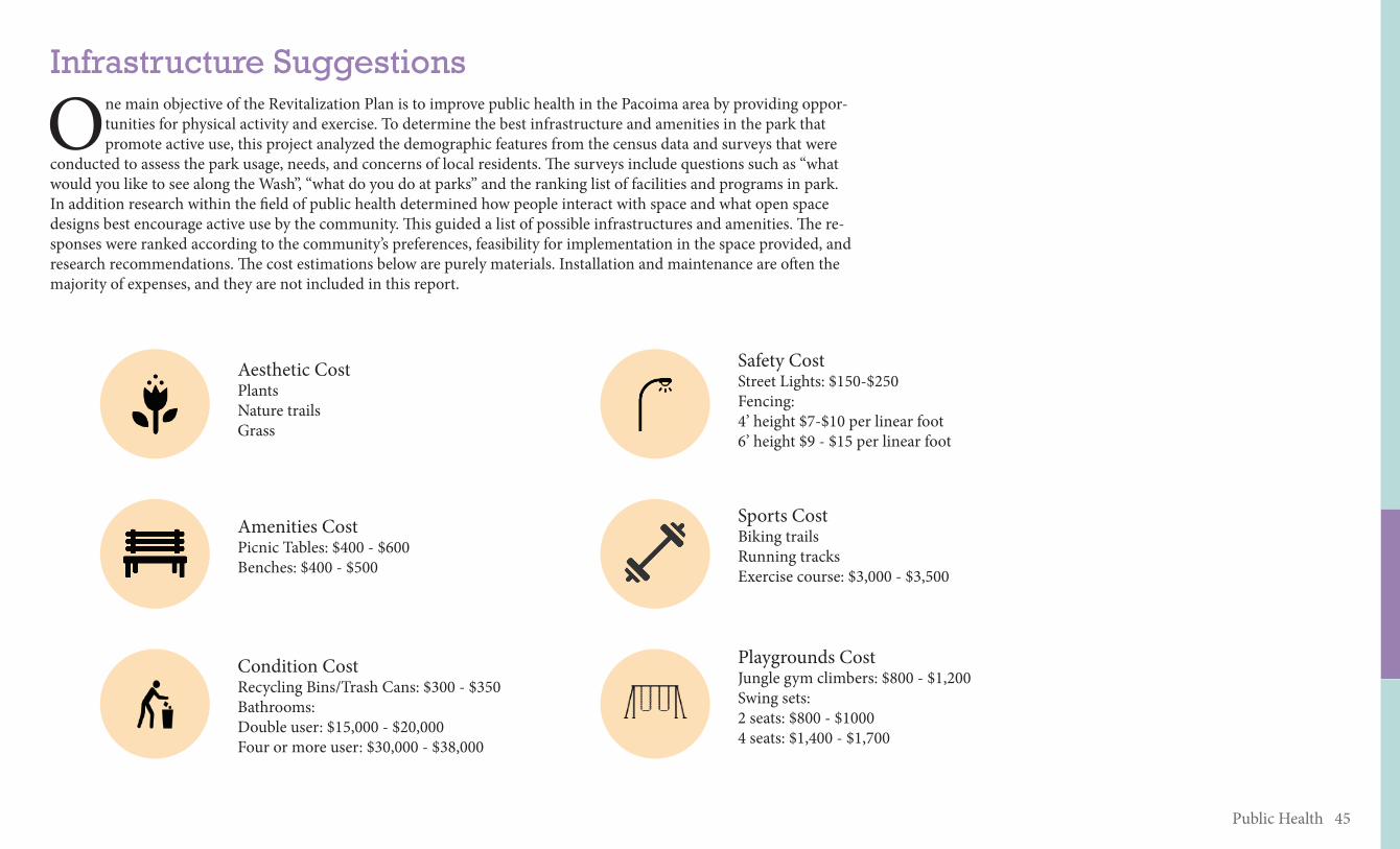
Public Health 45
One main objective of the Revitalization Plan is to improve public health in the Pacoima area by providing oppor-tunities for physical activity and exercise. To determine the best infrastructure and amenities in the park that promote active use, this project analyzed the demographic features from the census data and surveys that were
conducted to assess the park usage, needs, and concerns of local residents. The surveys include questions such as “what would you like to see along the Wash”, “what do you do at parks” and the ranking list of facilities and programs in park. In addition research within the field of public health determined how people interact with space and what open space designs best encourage active use by the community. This guided a list of possible infrastructures and amenities. The re-sponses were ranked according to the community’s preferences, feasibility for implementation in the space provided, and research recommendations. The cost estimations below are purely materials. Installation and maintenance are often the majority of expenses, and they are not included in this report.
Amenities CostPicnic Tables: $400 - $600Benches: $400 - $500
Aesthetic CostPlants Nature trails Grass
Condition CostRecycling Bins/Trash Cans: $300 - $350Bathrooms: Double user: $15,000 - $20,000Four or more user: $30,000 - $38,000
Safety CostStreet Lights: $150-$250Fencing: 4’ height $7-$10 per linear foot6’ height $9 - $15 per linear foot
Sports CostBiking trailsRunning tracksExercise course: $3,000 - $3,500
Playgrounds CostJungle gym climbers: $800 - $1,200Swing sets: 2 seats: $800 - $10004 seats: $1,400 - $1,700
Infrastructure Suggestions
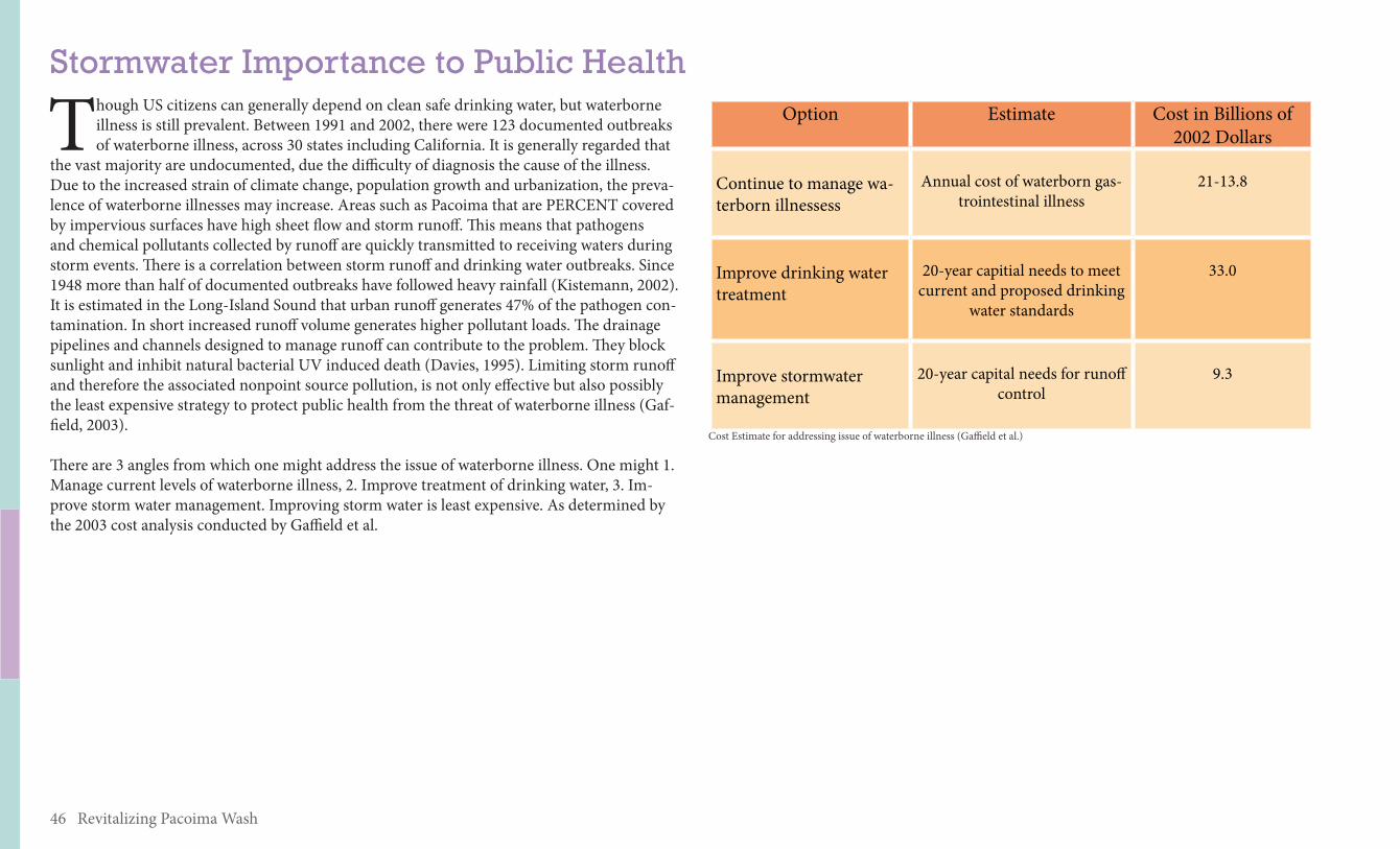
46 Revitalizing Pacoima Wash
Stormwater Importance to Public Health
Though US citizens can generally depend on clean safe drinking water, but waterborne illness is still prevalent. Between 1991 and 2002, there were 123 documented outbreaks of waterborne illness, across 30 states including California. It is generally regarded that
the vast majority are undocumented, due the difficulty of diagnosis the cause of the illness. Due to the increased strain of climate change, population growth and urbanization, the preva-lence of waterborne illnesses may increase. Areas such as Pacoima that are PERCENT covered by impervious surfaces have high sheet flow and storm runoff. This means that pathogens and chemical pollutants collected by runoff are quickly transmitted to receiving waters during storm events. There is a correlation between storm runoff and drinking water outbreaks. Since 1948 more than half of documented outbreaks have followed heavy rainfall (Kistemann, 2002). It is estimated in the Long-Island Sound that urban runoff generates 47% of the pathogen con-tamination. In short increased runoff volume generates higher pollutant loads. The drainage pipelines and channels designed to manage runoff can contribute to the problem. They block sunlight and inhibit natural bacterial UV induced death (Davies, 1995). Limiting storm runoff and therefore the associated nonpoint source pollution, is not only effective but also possibly the least expensive strategy to protect public health from the threat of waterborne illness (Gaf-field, 2003).
There are 3 angles from which one might address the issue of waterborne illness. One might 1. Manage current levels of waterborne illness, 2. Improve treatment of drinking water, 3. Im-prove storm water management. Improving storm water is least expensive. As determined by the 2003 cost analysis conducted by Gaffield et al.
Option Estimate Cost in Billions of 2002 Dollars
Continue to manage wa-terborn illnessess
Annual cost of waterborn gas-trointestinal illness
21-13.8
Improve drinking water treatment
20-year capitial needs to meet current and proposed drinking
water standards
33.0
Improve stormwater management
20-year capital needs for runoff control
9.3
Cost Estimate for addressing issue of waterborne illness (Gaffield et al.)
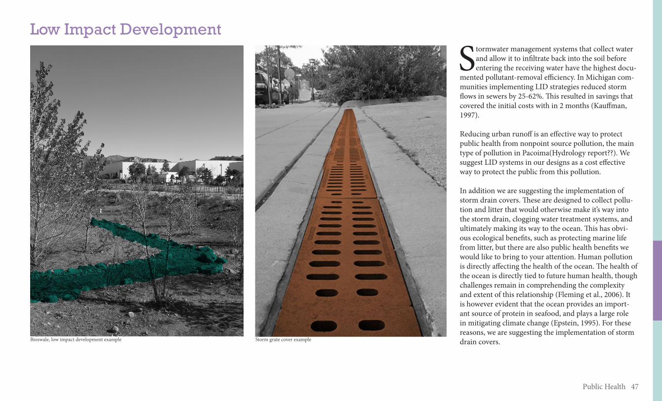
Public Health 47
Low Impact Development
Stormwater management systems that collect water and allow it to infiltrate back into the soil before entering the receiving water have the highest docu-
mented pollutant-removal efficiency. In Michigan com-munities implementing LID strategies reduced storm flows in sewers by 25-62%. This resulted in savings that covered the initial costs with in 2 months (Kauffman, 1997).
Reducing urban runoff is an effective way to protect public health from nonpoint source pollution, the main type of pollution in Pacoima(Hydrology report??). We suggest LID systems in our designs as a cost effective way to protect the public from this pollution.
In addition we are suggesting the implementation of storm drain covers. These are designed to collect pollu-tion and litter that would otherwise make it’s way into the storm drain, clogging water treatment systems, and ultimately making its way to the ocean. This has obvi-ous ecological benefits, such as protecting marine life from litter, but there are also public health benefits we would like to bring to your attention. Human pollution is directly affecting the health of the ocean. The health of the ocean is directly tied to future human health, though challenges remain in comprehending the complexity and extent of this relationship (Fleming et al., 2006). It is however evident that the ocean provides an import-ant source of protein in seafood, and plays a large role in mitigating climate change (Epstein, 1995). For these reasons, we are suggesting the implementation of storm drain covers.Storm grate cover exampleBioswale, low impact development example
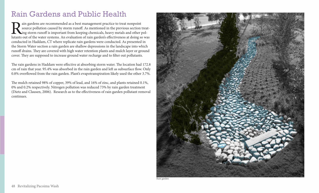
48 Revitalizing Pacoima Wash
Rain gardens are recommended as a best management practice to treat nonpoint source pollution caused by storm runoff. As mentioned in the previous section treat-ing storm runoff is important from keeping chemicals, heavy metals and other pol-
lutants out of the water systems. An evaluation of rain garden’s effectiveness at doing so was conducted in Haddam, CT where replicate rain gardens were conducted. As presented in the Storm Water section a rain garden are shallow depressions in the landscape into which runoff drains. They are covered with high water retention plants and mulch layer or ground cover. They are supposed to increase ground water recharge and to filter out pollutants.
The rain gardens in Haddam were effective at absorbing storm water. The location had 172.8 cm of rain that year. 95.4% was absorbed in the rain garden and left as subsurface flow. Only 0.8% overflowed from the rain garden. Plant’s evapotranspiration likely used the other 3.7%.
The mulch retained 98% of copper, 39% of lead, and 16% of zinc, and plants retained 0.1%, 0% and 0.2% respectively. Nitrogen pollution was reduced 73% by rain garden treatment (Dietz and Clausen, 2006). Research as to the effectiveness of rain garden pollutant removal continues.
Rain Gardens and Public Health
Rain garden
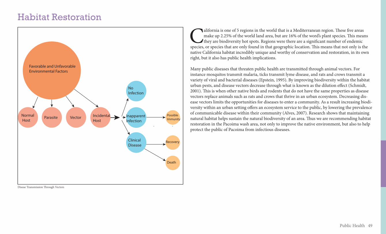
Public Health 49
C alifornia is one of 5 regions in the world that is a Mediterranean region. These five areas make up 2.25% of the world land area, but are 16% of the word’s plant species. This means they are biodiversity hot spots. Regions were there are a significant number of endemic
species, or species that are only found in that geographic location. This means that not only is the native California habitat incredibly unique and worthy of conservation and restoration, in its own right, but it also has public health implications.
Many public diseases that threaten public health are transmitted through animal vectors. For instance mosquitos transmit malaria, ticks transmit lyme disease, and rats and crows transmit a variety of viral and bacterial diseases (Epstein, 1995). By improving biodiversity within the habitat urban pests, and disease vectors decrease through what is known as the dilution effect (Schmidt, 2001). This is when other native birds and rodents that do not have the same properties as disease vectors replace animals such as rats and crows that thrive in an urban ecosystem. Decreasing dis-ease vectors limits the opportunities for diseases to enter a community. As a result increasing biodi-versity within an urban setting offers an ecosystem service to the public, by lowering the prevalence of communicable disease within their community (Alves, 2007). Research shows that maintaining natural habitat helps sustain the natural biodiversity of an area. Thus we are recommending habitat restoration in the Pacoima wash area, not only to improve the native environment, but also to help protect the public of Pacoima from infectious diseases.
Habitat Restoration
Favorable and Unfavorable Environmental Factors
Normal Host
Parasite Vector IncidentalHost
No Infection
InapparentInfection
Clinical Disease
Death
Recovery
Possible Immunity
Diseae Transmission Through Vectors
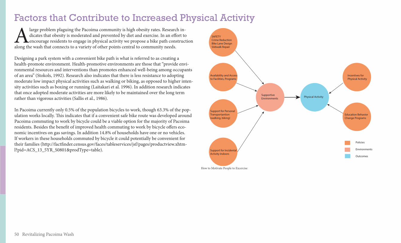
50 Revitalizing Pacoima Wash
A large problem plaguing the Pacoima community is high obesity rates. Research in-dicates that obesity is moderated and prevented by diet and exercise. In an effort to encourage residents to engage in physical activity we propose a bike path construction
along the wash that connects to a variety of other points central to community needs.
Designing a park system with a convenient bike path is what is referred to as creating a health-promote environment. Health-promotive environments are those that “provide envi-ronmental resources and interventions than promotes enhanced well-being among occupants of an area” (Stokols, 1992). Research also indicates that there is less resistance to adopting moderate low impact physical activities such as walking or biking, as opposed to higher inten-sity activities such as boxing or running (Laitakari et al. 1996). In addition research indicates that once adopted moderate activities are more likely to be maintained over the long term rather than vigorous activities (Sallis et al., 1986).
In Pacoima currently only 0.5% of the population bicycles to work, though 63.3% of the pop-ulation works locally. This indicates that if a convenient safe bike route was developed around Pacoima commuting to work by bicycle could be a viable option for the majority of Pacoima residents. Besides the benefit of improved health commuting to work by bicycle offers eco-nomic incentives on gas savings. In addition 14.8% of households have one or no vehicles. If workers in these households commuted by bicycle it could potentially be convenient for their families (http://factfinder.census.gov/faces/tableservices/jsf/pages/productview.xhtm-l?pid=ACS_13_5YR_S0801&prodType=table).
How to Motivate People to Excercise
Support for Incidental Activity Indoors
Physical Activity
Incentives for Physical Activity
Education Behavior Change Programs
SAFETYCrime ReductionBike Lane DesignSildwalk Repair
Availability and Access to Facilities, Programs
Support for PersonalTransportantion(walking, biking)
SupportiveEnvironments
Policies
Environments
Outcomes
Factors that Contribute to Increased Physical Activity
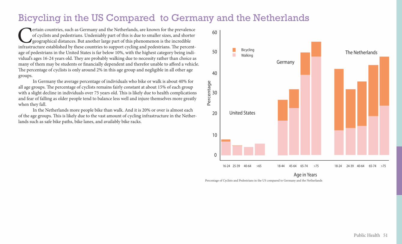
Public Health 51
United States
Germany
The Netherlands
Perc
enta
ge
50
60
40
30
20
10
0
16-24 25-39 40-64 >65 18-44 45-64 65-74 >75 18-24 24-39 40-64 65-74 >75
Age in Years
BicyclingWalking
Percentage of Cyclists and Pedestrians in the US compared to Germany and the Netherlands
Certain countries, such as Germany and the Netherlands, are known for the prevalence of cyclists and pedestrians. Undeniably part of this is due to smaller sizes, and shorter geographical distances. But another large part of this phenomenon is the incredible
infrastructure established by these countries to support cycling and pedestrians. The percent-age of pedestrians in the United States is far below 10%, with the highest category being indi-vidual’s ages 16-24 years old. They are probably walking due to necessity rather than choice as many of them may be students or financially dependent and therefor unable to afford a vehicle. The percentage of cyclists is only around 2% in this age group and negligible in all other age groups. In Germany the average percentage of individuals who bike or walk is about 40% for all age groups. The percentage of cyclists remains fairly constant at about 15% of each group with a slight decline in individuals over 75 years old. This is likely due to health complications and fear of falling as older people tend to balance less well and injure themselves more greatly when they fall. In the Netherlands more people bike than walk. And it is 20% or over is almost each of the age groups. This is likely due to the vast amount of cycling infrastructure in the Nether-lands such as safe bike paths, bike lanes, and availably bike racks.
Bicycling in the US Compared to Germany and the Netherlands
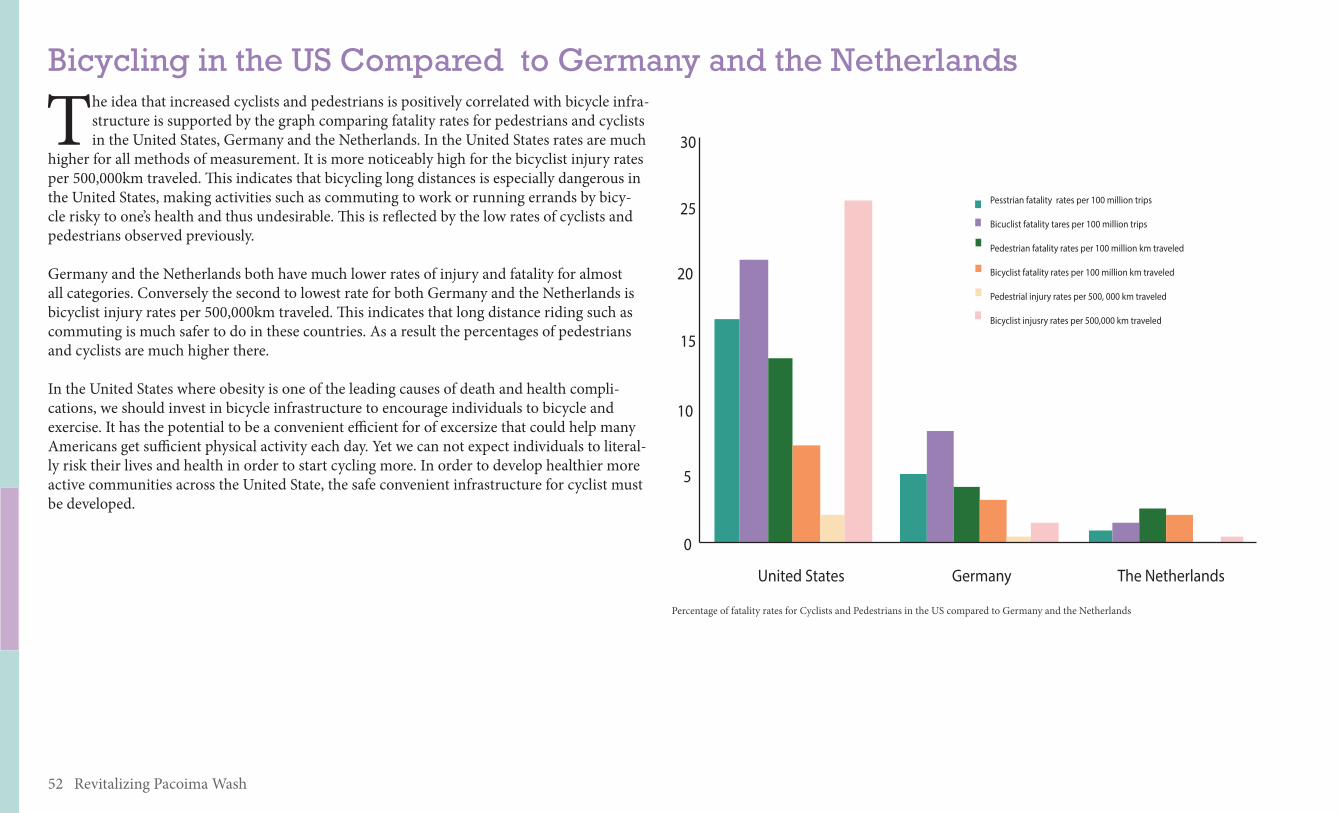
52 Revitalizing Pacoima Wash
The idea that increased cyclists and pedestrians is positively correlated with bicycle infra-structure is supported by the graph comparing fatality rates for pedestrians and cyclists in the United States, Germany and the Netherlands. In the United States rates are much
higher for all methods of measurement. It is more noticeably high for the bicyclist injury rates per 500,000km traveled. This indicates that bicycling long distances is especially dangerous in the United States, making activities such as commuting to work or running errands by bicy-cle risky to one’s health and thus undesirable. This is reflected by the low rates of cyclists and pedestrians observed previously.
Germany and the Netherlands both have much lower rates of injury and fatality for almost all categories. Conversely the second to lowest rate for both Germany and the Netherlands is bicyclist injury rates per 500,000km traveled. This indicates that long distance riding such as commuting is much safer to do in these countries. As a result the percentages of pedestrians and cyclists are much higher there.
In the United States where obesity is one of the leading causes of death and health compli-cations, we should invest in bicycle infrastructure to encourage individuals to bicycle and exercise. It has the potential to be a convenient efficient for of excersize that could help many Americans get sufficient physical activity each day. Yet we can not expect individuals to literal-ly risk their lives and health in order to start cycling more. In order to develop healthier more active communities across the United State, the safe convenient infrastructure for cyclist must be developed.
Bicycling in the US Compared to Germany and the Netherlands
Percentage of fatality rates for Cyclists and Pedestrians in the US compared to Germany and the Netherlands
United States Germany The Netherlands
30
25
20
15
10
5
0
Pesstrian fatality rates per 100 million trips
Bicuclist fatality tares per 100 million trips
Pedestrian fatality rates per 100 million km traveled
Bicyclist fatality rates per 100 million km traveled
Pedestrial injury rates per 500, 000 km traveled
Bicyclist injusry rates per 500,000 km traveled
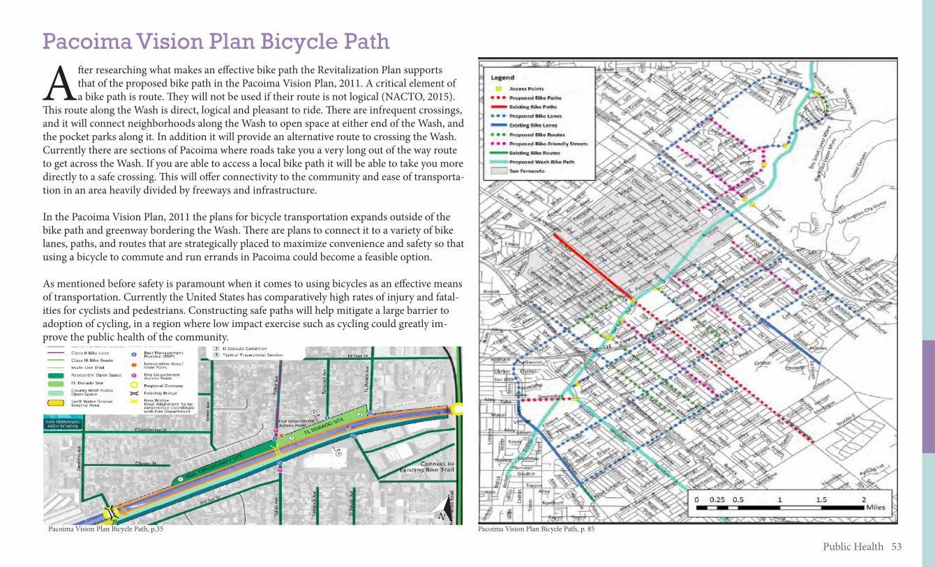
Public Health 53
Pacoima Vision Plan Bicycle Path
After researching what makes an effective bike path the Revitalization Plan supports that of the proposed bike path in the Pacoima Vision Plan, 2011. A critical element of a bike path is route. They will not be used if their route is not logical (NACTO, 2015).
This route along the Wash is direct, logical and pleasant to ride. There are infrequent crossings, and it will connect neighborhoods along the Wash to open space at either end of the Wash, and the pocket parks along it. In addition it will provide an alternative route to crossing the Wash. Currently there are sections of Pacoima where roads take you a very long out of the way route to get across the Wash. If you are able to access a local bike path it will be able to take you more directly to a safe crossing. This will offer connectivity to the community and ease of transporta-tion in an area heavily divided by freeways and infrastructure.
In the Pacoima Vision Plan, 2011 the plans for bicycle transportation expands outside of the bike path and greenway bordering the Wash. There are plans to connect it to a variety of bike lanes, paths, and routes that are strategically placed to maximize convenience and safety so that using a bicycle to commute and run errands in Pacoima could become a feasible option.
As mentioned before safety is paramount when it comes to using bicycles as an effective means of transportation. Currently the United States has comparatively high rates of injury and fatal-ities for cyclists and pedestrians. Constructing safe paths will help mitigate a large barrier to adoption of cycling, in a region where low impact exercise such as cycling could greatly im-prove the public health of the community.
Pacoima Vision Plan Bicycle Path, p,35 Pacoima Vision Plan Bicycle Path, p. 85
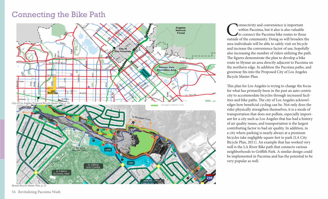
54 Revitalizing Pacoima Wash
Connecting the Bike Path
Connectivity and convenience is important within Pacoima, but it also is also valuable to connect the Pacoima bike routes to those
outside of the community. Doing so will broaden the area individuals will be able to safely visit on bicycle and increase the convenience factor of use, hopefully also increasing the number of riders utilizing the path. The figures demonstrate the plan to develop a bike route in Slymar an area directly adjacent to Pacoima on the northern edge. In addition the Pacoima paths, and greenway fits into the Proposed City of Los Angeles Bicycle Master Plan.
This plan for Los Angeles is trying to change the focus for what has primarily been in the past an auto centric city to accommodate bicycles through increased facil-ities and bike paths. The city of Los Angeles acknowl-edges how beneficial cycling can be. Not only does the rider physically strengthen themselves, it is a mode of transportation that does not pollute, especially import-ant for a city such as Los Angeles that has had a history of air quality issues, and transportation is the largest contributing factor to bad air quality. In addition, in a city where parking is nearly always at a premium bicycles take negligible square feet to park (LA City Bicycle Plan, 2011). An example that has worked very well is the LA River Bike path that connects various neighborhoods to Griffith Park. A similar design could be implemented in Pacoima and has the potential to be very popular as well.
Slymar Bicycle Master Plan, p. 23
City of Los Angeles Proposed Bicycle Master Plan, p. 19
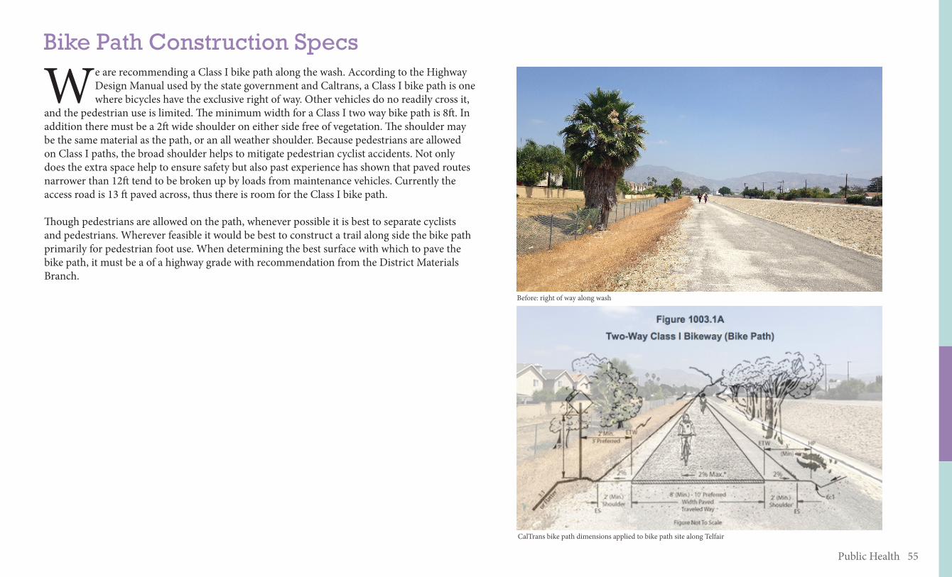
Public Health 55
Bike Path Construction Specs
We are recommending a Class I bike path along the wash. According to the Highway Design Manual used by the state government and Caltrans, a Class I bike path is one where bicycles have the exclusive right of way. Other vehicles do no readily cross it,
and the pedestrian use is limited. The minimum width for a Class I two way bike path is 8ft. In addition there must be a 2ft wide shoulder on either side free of vegetation. The shoulder may be the same material as the path, or an all weather shoulder. Because pedestrians are allowed on Class I paths, the broad shoulder helps to mitigate pedestrian cyclist accidents. Not only does the extra space help to ensure safety but also past experience has shown that paved routes narrower than 12ft tend to be broken up by loads from maintenance vehicles. Currently the access road is 13 ft paved across, thus there is room for the Class I bike path.
Though pedestrians are allowed on the path, whenever possible it is best to separate cyclists and pedestrians. Wherever feasible it would be best to construct a trail along side the bike path primarily for pedestrian foot use. When determining the best surface with which to pave the bike path, it must be a of a highway grade with recommendation from the District Materials Branch.
CalTrans bike path dimensions applied to bike path site along Telfair
Before: right of way along wash
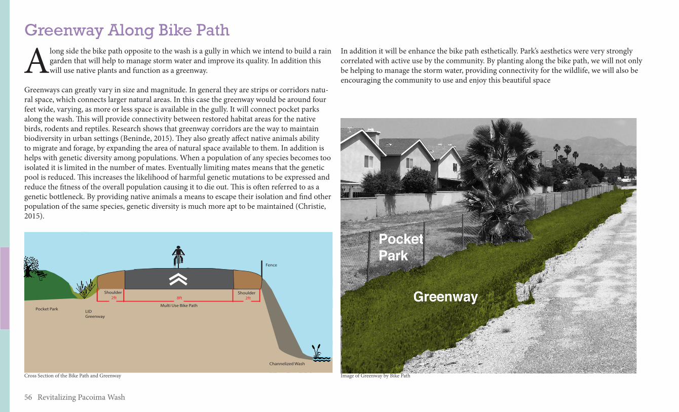
56 Revitalizing Pacoima Wash
Greenway Along Bike Path
Along side the bike path opposite to the wash is a gully in which we intend to build a rain garden that will help to manage storm water and improve its quality. In addition this will use native plants and function as a greenway.
Greenways can greatly vary in size and magnitude. In general they are strips or corridors natu-ral space, which connects larger natural areas. In this case the greenway would be around four feet wide, varying, as more or less space is available in the gully. It will connect pocket parks along the wash. This will provide connectivity between restored habitat areas for the native birds, rodents and reptiles. Research shows that greenway corridors are the way to maintain biodiversity in urban settings (Beninde, 2015). They also greatly affect native animals ability to migrate and forage, by expanding the area of natural space available to them. In addition is helps with genetic diversity among populations. When a population of any species becomes too isolated it is limited in the number of mates. Eventually limiting mates means that the genetic pool is reduced. This increases the likelihood of harmful genetic mutations to be expressed and reduce the fitness of the overall population causing it to die out. This is often referred to as a genetic bottleneck. By providing native animals a means to escape their isolation and find other population of the same species, genetic diversity is much more apt to be maintained (Christie, 2015).
In addition it will be enhance the bike path esthetically. Park’s aesthetics were very strongly correlated with active use by the community. By planting along the bike path, we will not only be helping to manage the storm water, providing connectivity for the wildlife, we will also be encouraging the community to use and enjoy this beautiful space
Cross Section of the Bike Path and Greenway Image of Greenway by Bike Path
Pocket Park LIDGreenway
Shoulder
Multi Use Bike Path
Shoulder
Fence
Channelized Wash
8ft2ft 2ft
Public Health 57
Image of Greenway by Bike Path
Site Selection
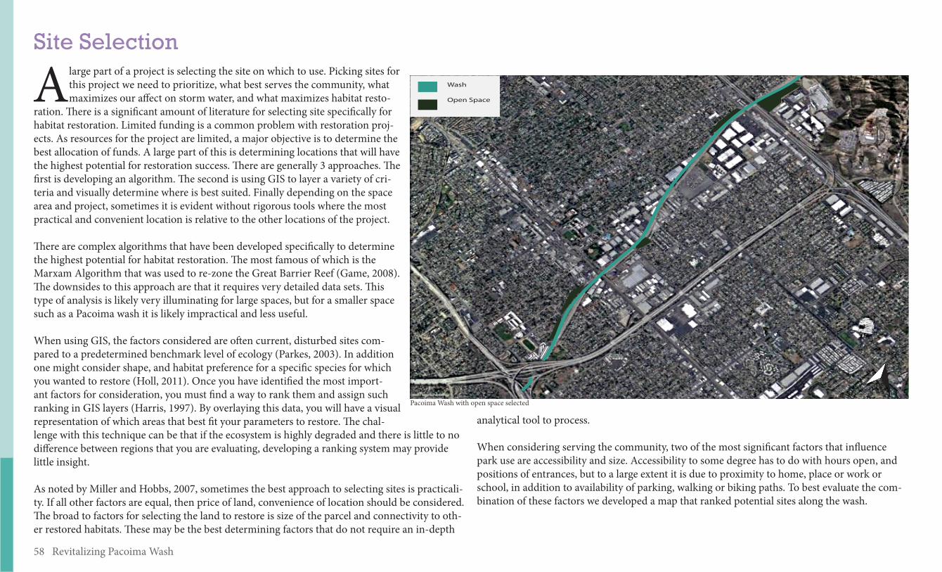
58 Revitalizing Pacoima Wash
A large part of a project is selecting the site on which to use. Picking sites for this project we need to prioritize, what best serves the community, what maximizes our affect on storm water, and what maximizes habitat resto-
ration. There is a significant amount of literature for selecting site specifically for habitat restoration. Limited funding is a common problem with restoration proj-ects. As resources for the project are limited, a major objective is to determine the best allocation of funds. A large part of this is determining locations that will have the highest potential for restoration success. There are generally 3 approaches. The first is developing an algorithm. The second is using GIS to layer a variety of cri-teria and visually determine where is best suited. Finally depending on the space area and project, sometimes it is evident without rigorous tools where the most practical and convenient location is relative to the other locations of the project.
There are complex algorithms that have been developed specifically to determine the highest potential for habitat restoration. The most famous of which is the Marxam Algorithm that was used to re-zone the Great Barrier Reef (Game, 2008). The downsides to this approach are that it requires very detailed data sets. This type of analysis is likely very illuminating for large spaces, but for a smaller space such as a Pacoima wash it is likely impractical and less useful.
When using GIS, the factors considered are often current, disturbed sites com-pared to a predetermined benchmark level of ecology (Parkes, 2003). In addition one might consider shape, and habitat preference for a specific species for which you wanted to restore (Holl, 2011). Once you have identified the most import-ant factors for consideration, you must find a way to rank them and assign such ranking in GIS layers (Harris, 1997). By overlaying this data, you will have a visual representation of which areas that best fit your parameters to restore. The chal-lenge with this technique can be that if the ecosystem is highly degraded and there is little to no difference between regions that you are evaluating, developing a ranking system may provide little insight.
As noted by Miller and Hobbs, 2007, sometimes the best approach to selecting sites is practicali-ty. If all other factors are equal, then price of land, convenience of location should be considered. The broad to factors for selecting the land to restore is size of the parcel and connectivity to oth-er restored habitats. These may be the best determining factors that do not require an in-depth
analytical tool to process.
When considering serving the community, two of the most significant factors that influence park use are accessibility and size. Accessibility to some degree has to do with hours open, and positions of entrances, but to a large extent it is due to proximity to home, place or work or school, in addition to availability of parking, walking or biking paths. To best evaluate the com-bination of these factors we developed a map that ranked potential sites along the wash.
Wash
Open Space
Site Selection
Pacoima Wash with open space selected
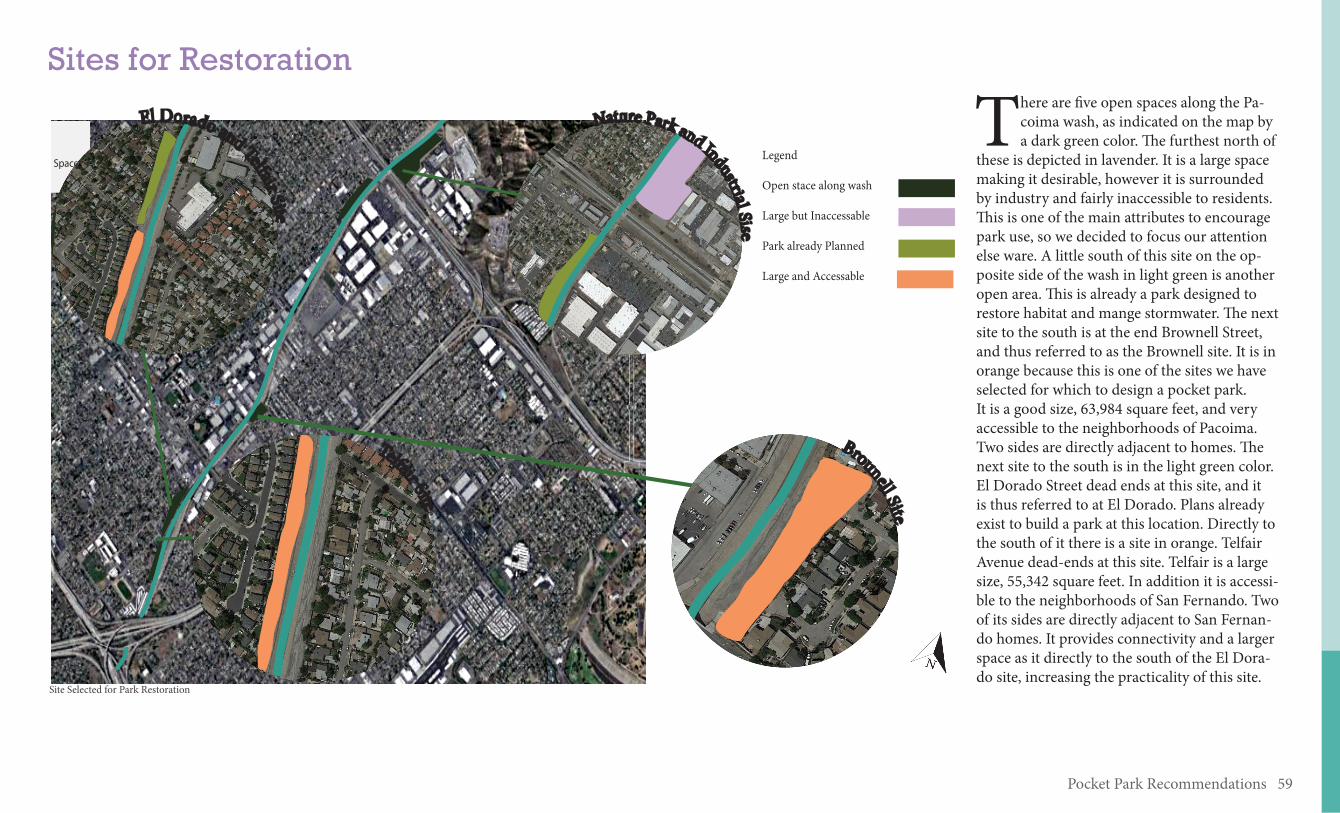
Pocket Park Recommendations 59
Sites for Restoration
Site Selected for Park Restoration
There are five open spaces along the Pa-coima wash, as indicated on the map by a dark green color. The furthest north of
these is depicted in lavender. It is a large space making it desirable, however it is surrounded by industry and fairly inaccessible to residents. This is one of the main attributes to encourage park use, so we decided to focus our attention else ware. A little south of this site on the op-posite side of the wash in light green is another open area. This is already a park designed to restore habitat and mange stormwater. The next site to the south is at the end Brownell Street, and thus referred to as the Brownell site. It is in orange because this is one of the sites we have selected for which to design a pocket park. It is a good size, 63,984 square feet, and very accessible to the neighborhoods of Pacoima. Two sides are directly adjacent to homes. The next site to the south is in the light green color. El Dorado Street dead ends at this site, and it is thus referred to at El Dorado. Plans already exist to build a park at this location. Directly to the south of it there is a site in orange. Telfair Avenue dead-ends at this site. Telfair is a large size, 55,342 square feet. In addition it is accessi-ble to the neighborhoods of San Fernando. Two of its sides are directly adjacent to San Fernan-do homes. It provides connectivity and a larger space as it directly to the south of the El Dora-do site, increasing the practicality of this site.
Wash
Open Space
Telfair Sitee
Nature Park and Industrial Sise
El Dorado and Telfair Site
Brounell Site
Legend
Open stace along wash
Large but Inaccessable
Park already Planned
Large and Accessable
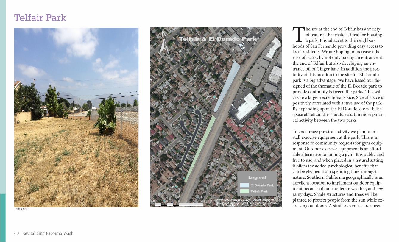
60 Revitalizing Pacoima Wash
The site at the end of Telfair has a variety of features that make it ideal for housing a park. It is adjacent to the neighbor-
hoods of San Fernando providing easy access to local residents. We are hoping to increase this ease of access by not only having an entrance at the end of Telfair but also developing an en-trance off of Ginger lane. In addition the prox-imity of this location to the site for El Dorado park is a big advantage. We have based our de-signed of the thematic of the El Dorado park to provide continuity between the parks. This will create a larger recreational space. Size of space is positively correlated with active use of the park. By expanding upon the El Dorado site with the space at Telfair, this should result in more physi-cal activity between the two parks.
To encourage physical activity we plan to in-stall exercise equipment at the park. This is in response to community requests for gym equip-ment. Outdoor exercise equipment is an afford-able alternative to joining a gym. It is public and free to use, and when placed in a natural setting it offers the added psychological benefits that can be gleaned from spending time amongst nature. Southern California geographically is an excellent location to implement outdoor equip-ment because of our moderate weather, and few rainy days. Shade structures and trees will be planted to protect people from the sun while ex-ercising out doors. A similar exercise area been
Telfair Site
Telfair Park
Source: Esri, DigitalGlobe, GeoEye, Earthstar Geographics,CNES/Airbus DS, USDA, USGS, AEX, Getmapping, Aerogrid,IGN, IGP, swisstopo, and the GIS User Community
400 0 400200 Feet
± Telfair & El Dorado Park
LegendEl Dorado Park
Telfair Park
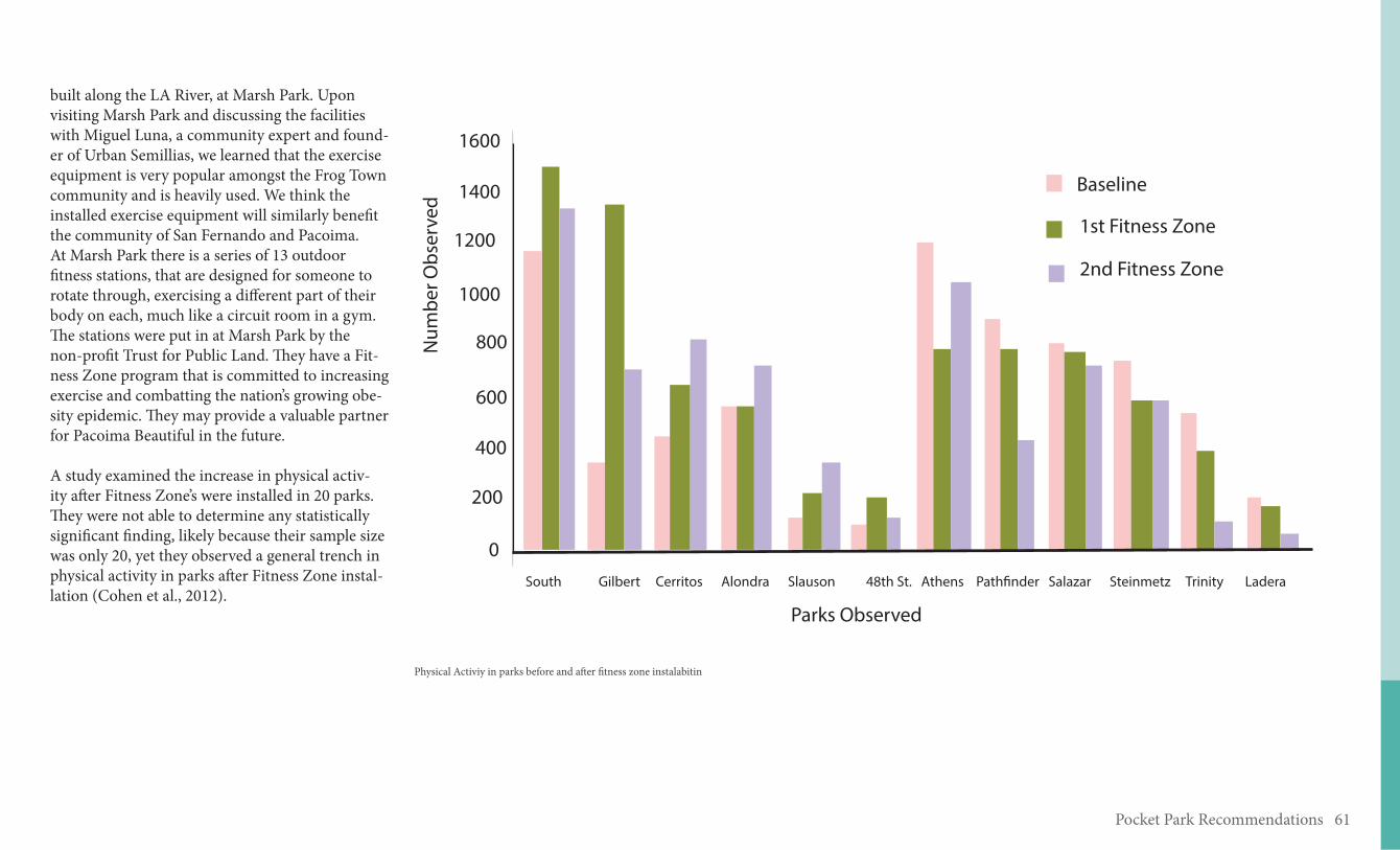
Pocket Park Recommendations 61
built along the LA River, at Marsh Park. Upon visiting Marsh Park and discussing the facilities with Miguel Luna, a community expert and found-er of Urban Semillias, we learned that the exercise equipment is very popular amongst the Frog Town community and is heavily used. We think the installed exercise equipment will similarly benefit the community of San Fernando and Pacoima. At Marsh Park there is a series of 13 outdoor fitness stations, that are designed for someone to rotate through, exercising a different part of their body on each, much like a circuit room in a gym. The stations were put in at Marsh Park by the non-profit Trust for Public Land. They have a Fit-ness Zone program that is committed to increasing exercise and combatting the nation’s growing obe-sity epidemic. They may provide a valuable partner for Pacoima Beautiful in the future.
A study examined the increase in physical activ-ity after Fitness Zone’s were installed in 20 parks. They were not able to determine any statistically significant finding, likely because their sample size was only 20, yet they observed a general trench in physical activity in parks after Fitness Zone instal-lation (Cohen et al., 2012).
South Gilbert Cerritos Alondra Slauson 48th St. Athens Path�nder Salazar Steinmetz Trinity Ladera
Parks Observed
Baseline
1st Fitness Zone
2nd Fitness Zone
1600
1400
1200
1000
800
600
400
200
0
Num
ber O
bser
ved
Physical Activiy in parks before and after fitness zone instalabitin
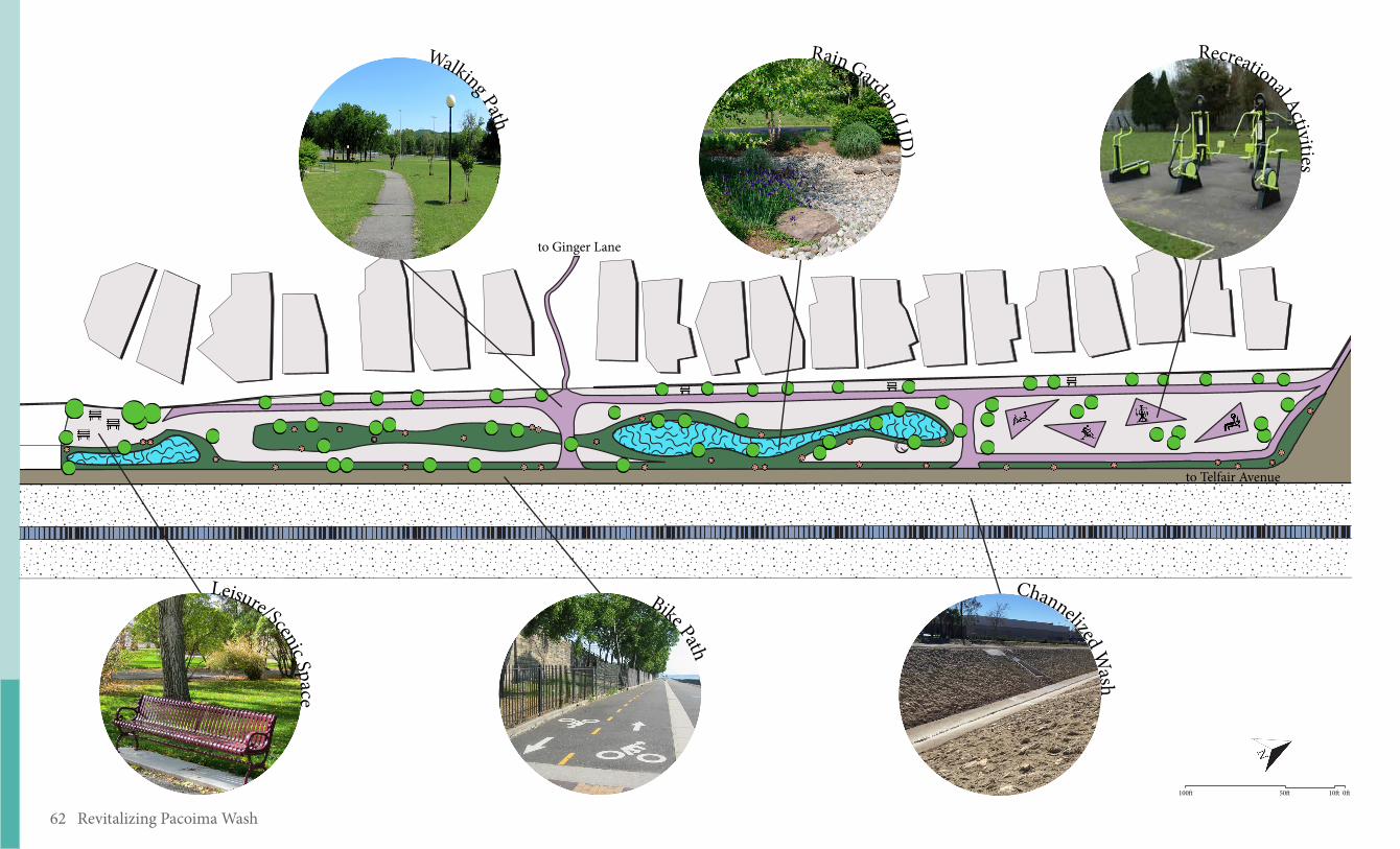
62 Revitalizing Pacoima Wash
100� 50� 10� 0�
Walking Path
Recreational Activities
Leisure/Scenic Space
Rain Garden (LID)
Bike Path
Channelized Wash
to Telfair Avenue
to Ginger Lane
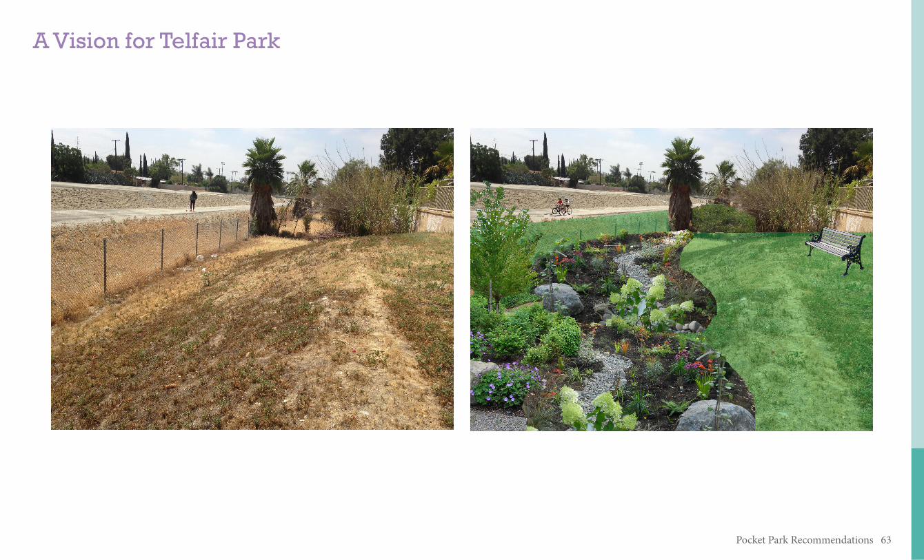
Pocket Park Recommendations 63
A Vision for Telfair Park
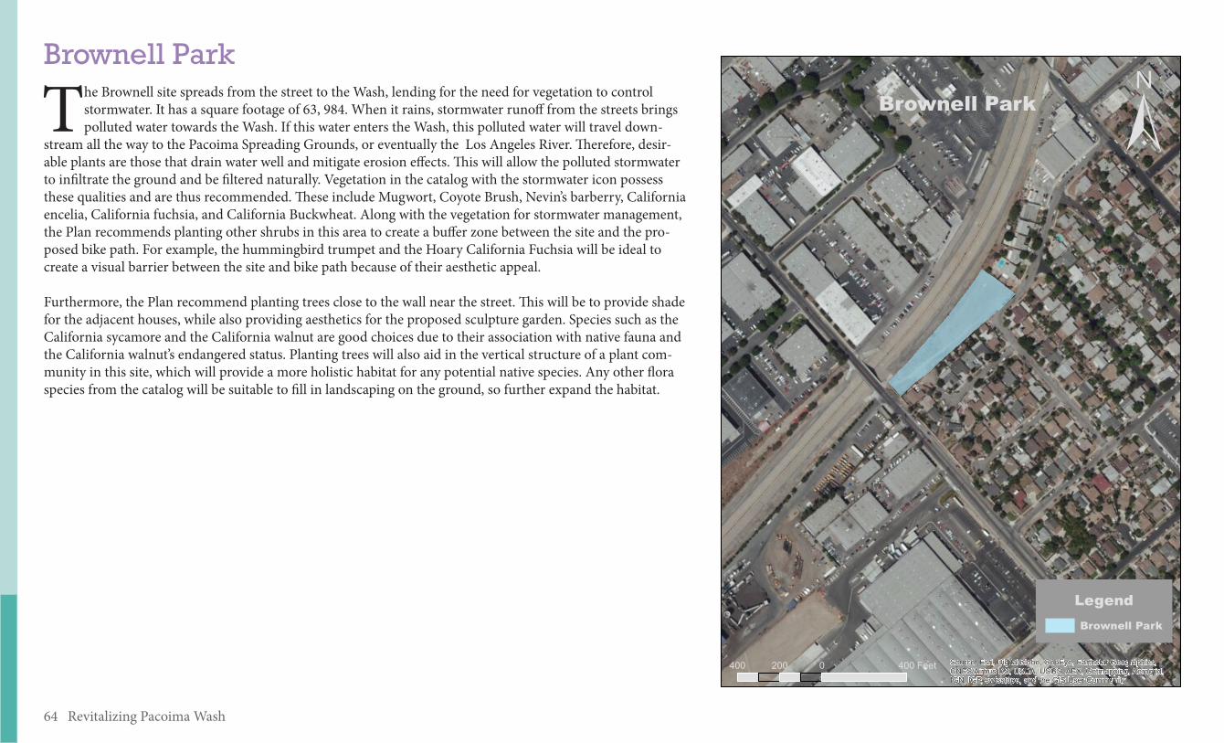
64 Revitalizing Pacoima Wash
Brownell Park
The Brownell site spreads from the street to the Wash, lending for the need for vegetation to control stormwater. It has a square footage of 63, 984. When it rains, stormwater runoff from the streets brings polluted water towards the Wash. If this water enters the Wash, this polluted water will travel down-
stream all the way to the Pacoima Spreading Grounds, or eventually the Los Angeles River. Therefore, desir-able plants are those that drain water well and mitigate erosion effects. This will allow the polluted stormwater to infiltrate the ground and be filtered naturally. Vegetation in the catalog with the stormwater icon possess these qualities and are thus recommended. These include Mugwort, Coyote Brush, Nevin’s barberry, California encelia, California fuchsia, and California Buckwheat. Along with the vegetation for stormwater management, the Plan recommends planting other shrubs in this area to create a buffer zone between the site and the pro-posed bike path. For example, the hummingbird trumpet and the Hoary California Fuchsia will be ideal to create a visual barrier between the site and bike path because of their aesthetic appeal.
Furthermore, the Plan recommend planting trees close to the wall near the street. This will be to provide shade for the adjacent houses, while also providing aesthetics for the proposed sculpture garden. Species such as the California sycamore and the California walnut are good choices due to their association with native fauna and the California walnut’s endangered status. Planting trees will also aid in the vertical structure of a plant com-munity in this site, which will provide a more holistic habitat for any potential native species. Any other flora species from the catalog will be suitable to fill in landscaping on the ground, so further expand the habitat.
Source: Esri, DigitalGlobe, GeoEye, Earthstar Geographics,CNES/Airbus DS, USDA, USGS, AEX, Getmapping, Aerogrid,IGN, IGP, swisstopo, and the GIS User Community
400 0 400200 Feet
±Brownell Park
LegendBrownell Park
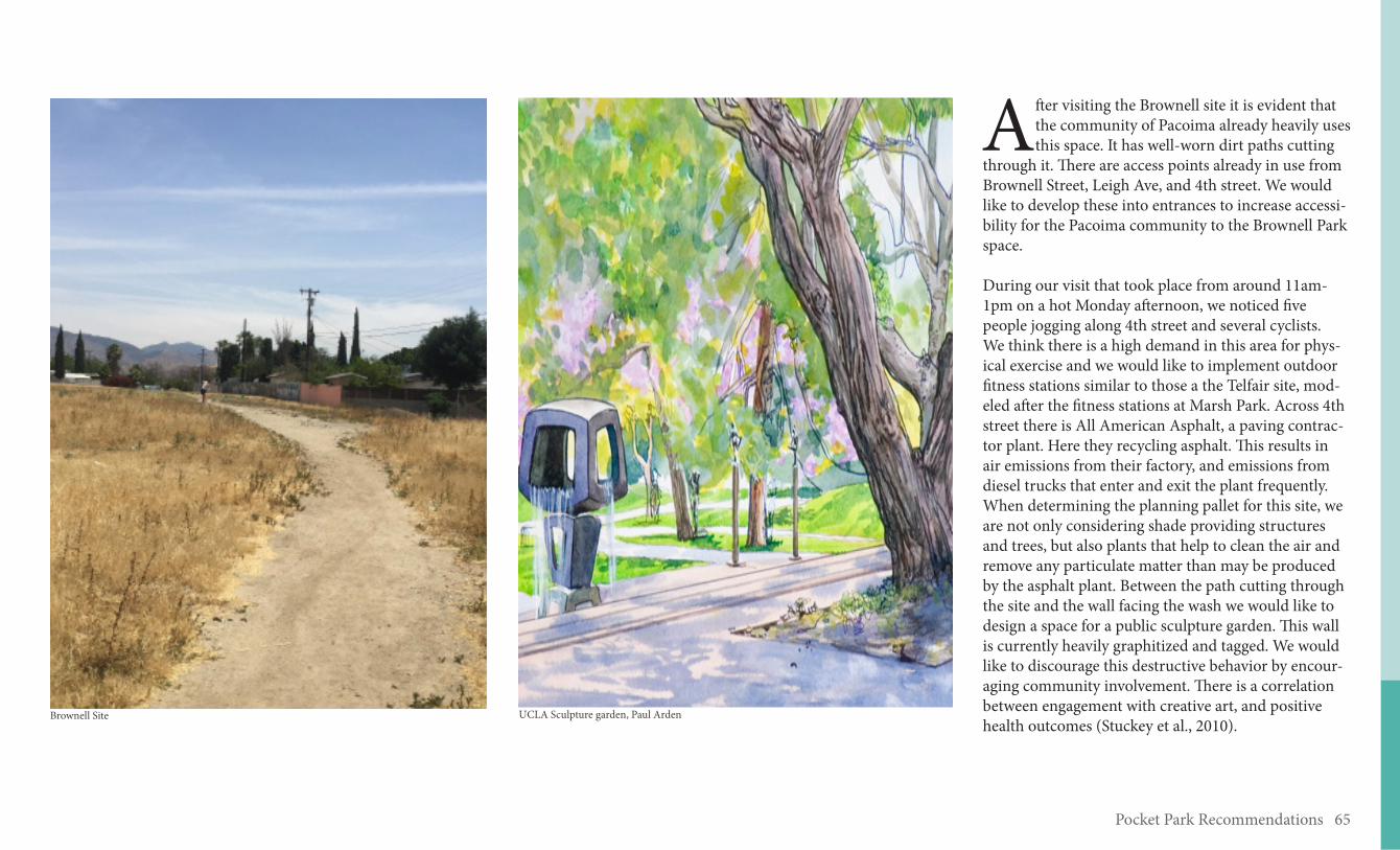
Pocket Park Recommendations 65
After visiting the Brownell site it is evident that the community of Pacoima already heavily uses this space. It has well-worn dirt paths cutting
through it. There are access points already in use from Brownell Street, Leigh Ave, and 4th street. We would like to develop these into entrances to increase accessi-bility for the Pacoima community to the Brownell Park space.
During our visit that took place from around 11am-1pm on a hot Monday afternoon, we noticed five people jogging along 4th street and several cyclists. We think there is a high demand in this area for phys-ical exercise and we would like to implement outdoor fitness stations similar to those a the Telfair site, mod-eled after the fitness stations at Marsh Park. Across 4th street there is All American Asphalt, a paving contrac-tor plant. Here they recycling asphalt. This results in air emissions from their factory, and emissions from diesel trucks that enter and exit the plant frequently. When determining the planning pallet for this site, we are not only considering shade providing structures and trees, but also plants that help to clean the air and remove any particulate matter than may be produced by the asphalt plant. Between the path cutting through the site and the wall facing the wash we would like to design a space for a public sculpture garden. This wall is currently heavily graphitized and tagged. We would like to discourage this destructive behavior by encour-aging community involvement. There is a correlation between engagement with creative art, and positive health outcomes (Stuckey et al., 2010).
Brownell Site UCLA Sculpture garden, Paul Arden
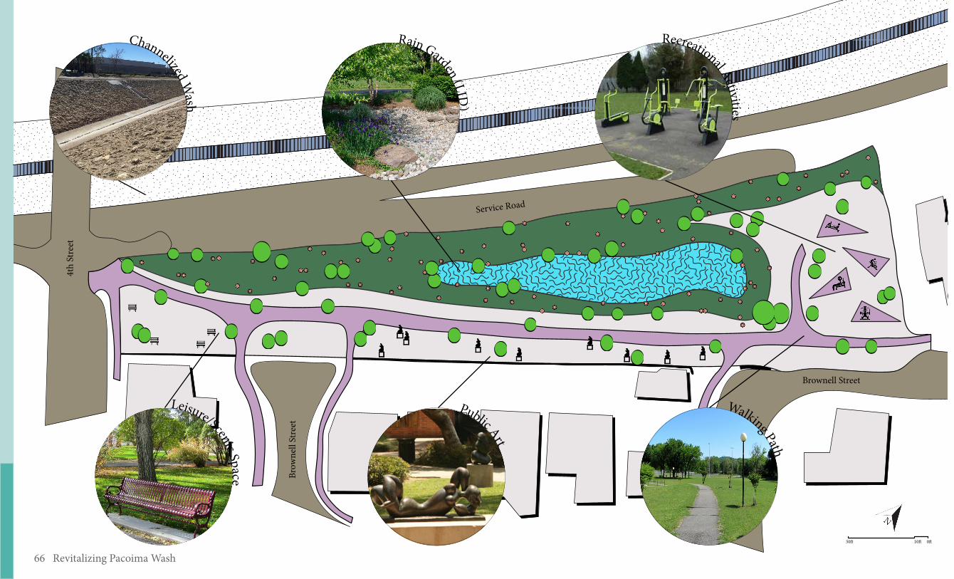
66 Revitalizing Pacoima Wash
Brow
nell
Stre
et
Brownell Street
4th
Stre
et
Service Road
Walking Path
Recreational Activities
Leisure/Scenic Space
Rain Garden (LID)
Public Art
Channelized Wash
50� 10� 0�
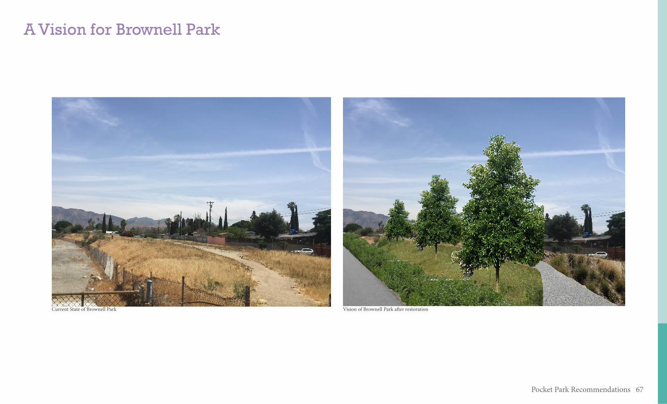
Pocket Park Recommendations 67
Current State of Brownell Park Vision of Brownell Park after restoration
A Vision for Brownell Park
68 Revitalizing Pacoima Wash
Conclusion
Revitalizing the Pacoima Wash has developed a three-pronged approach to improve living conditions for community members and wildlife in Pacoima. Pacoima is a heavily indus-trialized urban area, with 0.054 acres of park space per 1000 residents. It is an area that
has suffered historic marginalization, the consequences of which the community is still suffering today. Working with the non-profit Pacoima Beautiful, whose focus is environmental justice through beautification, the Revitalization project integrated their 2011 Vision Plan, with tech-nical reports such as those conducted by Geosyntec, and inspiration from the LA River Revi-talization plan. In doing so the Revitalization Plan is a specific set of suggestions and guidelines for how to restore habitat along the Wash, which simultaneously will provide much needed park space to the disadvantaged area, and will assist in the management of the stormwater for which the wash was originally constructed
In order to select sites for restoration, first the Planning team identified all potential open space along the Wash. Then they prioritized larger spaces. As previously mentioned there is a positive correlation between size of area restored and success of the restoration. In addition restored spaces need to be large enough to support the native fauna. The stormwater management strat-egy is rain gardens, these too need to be of sufficient size in order collect water and to function efficiently. Finally for public health there is a relationship with size of park and active use by the public. The planning team also prioritized location. They eliminated sites isolated by industry and prioritized those adjacent to residential areas and neighborhoods. This is to facilitate acces-sibility for the community. After this analysis was conducted the two sites, Brownell and Telfair, were selected.
The site design for these locations was the application of all background research. As displayed in the site designs there is a balance between restored area, rain gardens, and facilities for the public. Restored area has specific recommendations for plants and the types of wildlife they will support. Rain gardens follow the natural topography of the sites. They have been to designed to manage water where is would naturally collect. These areas are depressed and likely not attrac-tive for public use, so development of this infrastructure is not limiting space for the public. Finally suggestions for public health include the essential basic park facilities such as benches and picnic tables, but they also incorporate an outdoor fitness circuit. This is modeled after the one at Marsh Park along the LA River which has been very popular with the community. These site designs will be connected by a bike path running along the existing right of way bordering the wash. It will be landscaped with native vegetation that also provides natural stormwater management. This landscaping strip will serve as a greenway connecting the restored park areas
and providing connectivity between them for wildlife.
The bike path and greenway is an excellent example of the integration of the three focuses hab-itat restoration, stormwater, and public health. They are very complementary in most aspects of the design. By designing through multiple lenses, the Revitalization Plan has developed a robust complex design that maximizes efficiency of space and aesthetic value.
Appendix 69
BibliographyÁlvarez-Castañeda, S.T., Castro-Arellano, I., Lacher, T. & Vázquez, E. 2008. Neotoma bryanti. The IUCN Red List of Threatened Species. Version 2014.3. <www.iucnredlist.org>. 14 May 2015.
Alves, Rômulo RN, and Ierecê ML Rosa. “Biodiversity, traditional medicine and public health: where do they meet?.” Journal of ethnobiology and ethnomedicine 3.1 (2007): 14.
BirdLife International 2012. Agelaius tricolor. The IUCN Red List of Threatened Species. Version 2014.3. <www.iucnredlist.org>. 14 May 2015.
BirdLife International 2012. Carpodacus cassinii. The IUCN Red List of Threatened Species. Version 2014.3. <www.iucnredlist.org>. 14 May 2015.
BirdLife International 2012. Contopus cooperi. The IUCN Red List of Threatened Species. Ver-sion 2014.3. <www.iucnredlist.org>. 14 May 2015.
BirdLife International 2012. Polioptila californica. The IUCN Red List of Threatened Species. Version 2014.3. <www.iucnredlist.org>. 14 May 2015.
BirdLife International 2013. Strix occidentalis. The IUCN Red List of Threatened Species. Ver-sion 2014.3. <www.iucnredlist.org>. 14 May 2015.
BirdLife International 2012. Vireo bellii. The IUCN Red List of Threatened Species. Version 2014.3. <www.iucnredlist.org>. 14 May 2015.
Beatley, T. (2011). Biophilic cities: integrating nature into urban design and planning. Island Press. Beninde, J., M. Veith, and A. Hochkirch. 2015. Biodiversity in cities needs space: a meta-anal-ysis of factors determining intra-urban biodiversity variation. Ecology Letters. DOI 10.1111/ele.12427.
“California Native Plant Library.” California Native Plant Database. Theodore Payne Foundation for Wild Flowers and Native Plants, n.d. Web. 5 May 2015. Census Bureau. “American FactFinder.” American FactFinder. US Department of Commerce,
n.d. Web. 20 May 2015. CHAPTER 1000 BIKEWAY PLANNING AND DESIGN (n.d.): n. pag. CalTrans. Web. 26, 2006 June. Christie, M. R. and L. L. Knowles. 2015. Habitat corridors facilitate genetic resilience irrespec-tive of species dispersal abilities or population sizes.Evolutionary Applications. DOI: 10.1111/eva.12255. “Comparison of Permeable Pavement Types: Hydrology, Design, Installation, Maintenance and Cost.”Transportation Synthesis Report (2013): n. pag. Wisconsin Department of Transportation. CTC & Associates LLC. Web. <http://ntl.bts.gov/lib/43000/43500/43570/TSR-2011-perme-able-pavements.pdf>. “Curb Inlet Screen Covers.” United Storm Water Inc. N.p., n.d. Web. <http%3A%2F%2Fwww.unitedstormwater.com%2FscreenCovers.html>. Davies, Cheryl M., et al. “Survival of fecal microorganisms in marine and freshwater sediments.” Applied and Environmental Microbiology 61.5 (1995): 1888-1896. Dugan, Sheila A. “Exercise for preventing childhood obesity.” Physical medicine and rehabilita-tion clinics of North America 19.2 (2008): 205-216. Dietz, Michael E., and John C. Clausen. “Saturation to improve pollutant retention in a rain gar-den.” Environmental science & technology 40.4 (2006): 1335-1340. Epstein, Paul R. “Emerging diseases and ecosystem instability: new threats to public health.” American journal of public health 85.2 (1995): 168-172. Fleming, L. E., et al. “Oceans and human health: emerging public health risks in the marine en-vironment.” Marine pollution bulletin 53.10 (2006): 545-560. Francis, J., Wood, L. J., Knuiman, M., & Giles-Corti, B. (2012). Quality or quantity? Exploring the relationship between Public Open Space attributes and mental health in Perth, Western Aus-tralia. Social science & medicine, 74(10), 1570-1577.
70 Revitalizing Pacoima Wash
Frank, Lawrence D., and Peter O. Engelke. “The built environment and human activity pat-terns: exploring the impacts of urban form on public health.” Journal of Planning Literature 16.2 (2001): 202-218.
Gaffield, S. J., Goo, R. L., Richards, L. a., & Jackson, R. J. (2003). Public Health Effects of Inad-equately Managed Stormwater Runoff. American Journal of Public Health, 93(9), 1527–1533. http://doi.org/10.2105/AJPH.93.9.1527
Gordon-Larsen, Penny, et al. “Inequality in the built environment underlies key health dispari-ties in physical activity and obesity.” Pediatrics 117.2 (2006): 417-424.
Harris, R., & Olson, C. (1997). Two-Stage System for Prioritizing Riparian Restoration at the Stream Reach and Community Scales. Restoration Ecology, 5(4S), 34–42. http://doi.org/10.1111/j.1526-100X.1997.00034.x
Holl, K. D., & Aide, T. M. (2011). When and where to actively restore ecosystems? Forest Ecolo-gy and Management, 261(10), 1558–1563. http://doi.org/10.1016/j.foreco.2010.07.004
Houston, Douglas, et al. “Structural disparities of urban traffic in southern California: Implica-tions for vehicle related air pollution exposure in minority and high‐poverty neighborhoods.” Journal of Urban Affairs 26.5 (2004): 565-592. Jakicic, John M., and Amy D. Otto. “Physical activity considerations for the treatment and pre-vention of obesity.” The American journal of clinical nutrition82.1 (2005): 226S-229S. Kaufman MM. Wurtz M. Hudraulic and economic benefits of downspout diversion. J Am Water Resources Assoc. 1997;33:491-497
Kiesecker, J. M., Copeland, H., Pocewicz, A., Nibbelink, N., McKenney, B., Dahlke, J. Stroud, D. (2009). A Framework for Implementing Biodiversity Offsets: Selecting Sites and Determining Scale. BioScience, 59(1), 77–84. http://doi.org/10.1525/bio.2009.59.1.11
Kistemann, Thomas, et al. “Microbial load of drinking water reservoir tributaries during extreme rainfall and runoff.” Applied and environmental microbiology68.5 (2002): 2188-2197. Laitakari, Jukka, Ilkka Vuori, and Pekka Oja. “Is long-term maintenance of health-related phys-ical activity possible? An analysis of concepts and evidence.” Health education research 11.4
(1996): 463-477.
“Los Angeles River Master Plan: Landscaping Guidelines and Plant Palettes.” Los Angeles Coun-ty Department of Public Works (2004): 22-38. Los Angeles Department of Public Works, Jan. 2004. Web.
Miller, J. R., & Hobbs, R. J. (2007). Habitat Restoration?Do We Know What We?re Doing? Resto-ration Ecology, 15(3), 382–390. http://doi.org/10.1111/j.1526-100X.2007.00234.x“Our History | Pacoima Chamber.” Pacoima Chamber. N.p., n.d. Web. 20 May 2015. Parkes, D., Newell, G., & Cheal, D. (2003). Assessing the quality of native vegetation: The “habitat hectares” approach. Ecological Management & Restoration, 4, S29–S38. http://doi.org/10.1046/j.1442-8903.4.s.4.x “Permeable Pavement: What’s It Doing on My Street?--Booklet.” (n.d.): n. pag. California Coast-al Commission. Web. <http://www.coastal.ca.gov/nps/lid/PermeablePavement-What%27sitDo-ingonMyStreet.pdf>. Pacoima Beautiful. Pacoima Wash Vision Plan Pucher, John, and Lewis Dijkstra. “Promoting safe walking and cycling to improve public health: lessons from the Netherlands and Germany.” American journal of public health 93.9 (2003): 1509-1516. Sallis, James F., et al. “Aggregation of physical activity habits in Mexican-American and Anglo families.” Journal of behavioral medicine 11.1 (1988): 31-41. Santa Clara Valley. Catch Basin Inserts. N.p.: Santa Clara Valley, n.d. Pollution Prevention Pro-gram. Web. <http://www.scvurppp-w2k.com/trash_bmp_toolbox_2007/Catch%20Basin%20Inserts.pdf>. Schmidt, Kenneth A., and Richard S. Ostfeld. “Biodiversity and the dilution effect in disease ecology.” Ecology 82.3 (2001): 609-619.
“Southwestern Willow Flycatcher.” Southwestern Willow Flycatcher. U.S Fish and Wildlife Ser-vice, 16 Apr. 2014. Web. 14 May 2015.

Appendix 71
Stokols, Daniel. “Environmental quality, human development, and health: An ecological view.” Journal of applied developmental psychology 13.2 (1992): 121-124. “Stormwater Management Practice Design Guidelines.” Philadelphia Stormwater Manual. N.p., n.d. Web. <http://www.pwdplanreview.org/WICLibrary/chapter%207.pdf>. Stuckey, Heather L., and Jeremy Nobel. “The connection between art, healing, and public health: A review of current literature.” American journal of public health 100.2 (2010): 254. Violin, C. R., Cada, P., Sudduth, E. B., Hassett, B. A., Penrose, D. L., & Bernhardt, E. S. (2011). Effects of urbanization and urban stream restoration on the physical and biological structure of stream ecosystems. Ecological Applications, 21(6), 1932-1949.
“Web Soil Survey.” Web Soil Survey. N.p., n.d. Web. <http://websoilsurvey.sc.egov.usda.gov/App/WebSoilSurvey.aspx>. Williams, Timothy. “Poverty, Pride--and Power In Line for Federal Help, Pacoima Hides Prob-lems Below Neat Surface”, Los Angeles Times, April 10, 1994 Wolch, J. R., Byrne, J., & Newell, J. P. (2014). Urban green space, public health, and environmen-tal justice: The challenge of making cities ‘just green enough’. Landscape and Urban Planning, 125, 234-244.
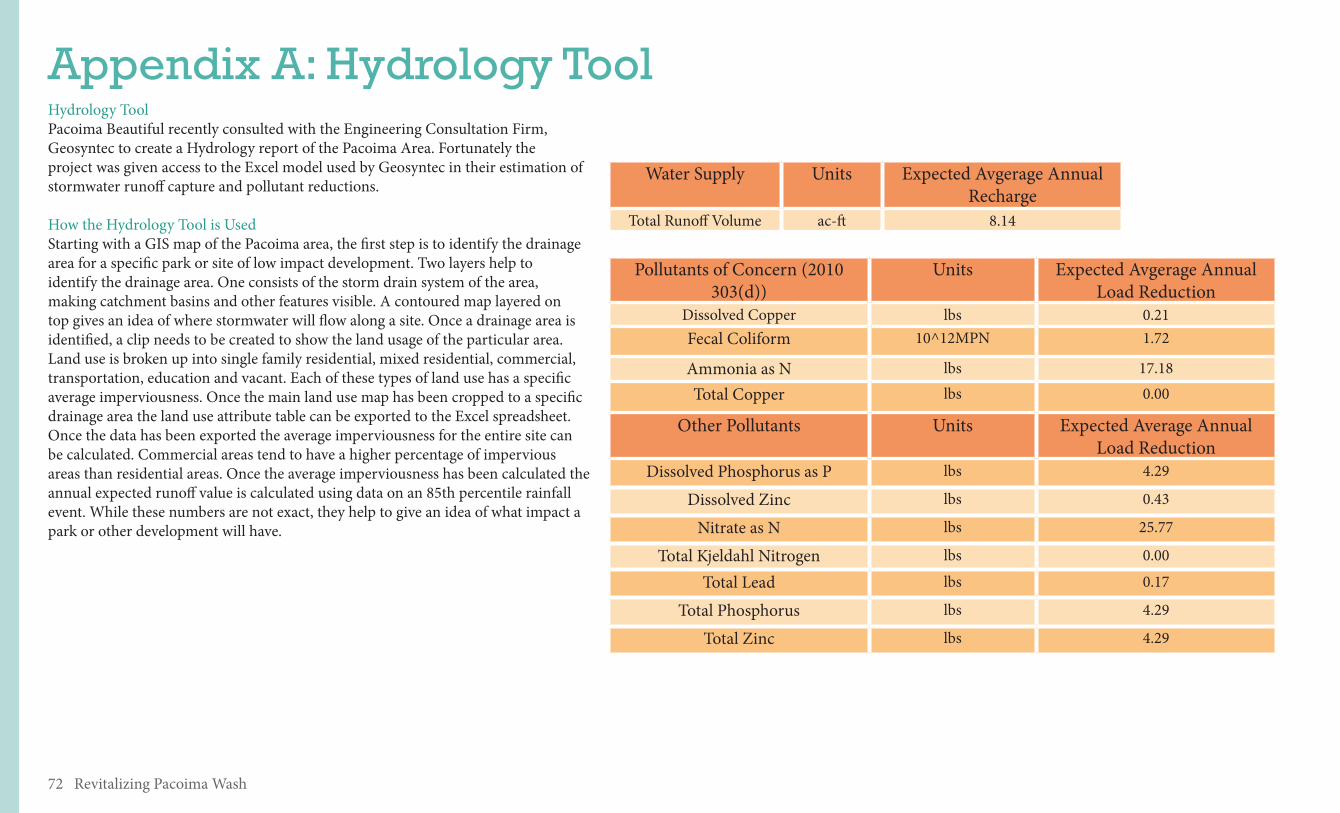
72 Revitalizing Pacoima Wash
Appendix A: Hydrology ToolHydrology ToolPacoima Beautiful recently consulted with the Engineering Consultation Firm, Geosyntec to create a Hydrology report of the Pacoima Area. Fortunately the project was given access to the Excel model used by Geosyntec in their estimation of stormwater runoff capture and pollutant reductions.
How the Hydrology Tool is UsedStarting with a GIS map of the Pacoima area, the first step is to identify the drainage area for a specific park or site of low impact development. Two layers help to identify the drainage area. One consists of the storm drain system of the area, making catchment basins and other features visible. A contoured map layered on top gives an idea of where stormwater will flow along a site. Once a drainage area is identified, a clip needs to be created to show the land usage of the particular area. Land use is broken up into single family residential, mixed residential, commercial, transportation, education and vacant. Each of these types of land use has a specific average imperviousness. Once the main land use map has been cropped to a specific drainage area the land use attribute table can be exported to the Excel spreadsheet. Once the data has been exported the average imperviousness for the entire site can be calculated. Commercial areas tend to have a higher percentage of impervious areas than residential areas. Once the average imperviousness has been calculated the annual expected runoff value is calculated using data on an 85th percentile rainfall event. While these numbers are not exact, they help to give an idea of what impact a park or other development will have.
Pollutants of Concern (2010 303(d))
Units Expected Avgerage Annual Load Reduction
Dissolved Copper lbs 0.21Fecal Coliform 10^12MPN 1.72
Ammonia as N lbs 17.18
Total Copper lbs 0.00
Other Pollutants Units Expected Average Annual Load Reduction
Dissolved Phosphorus as P lbs 4.29
Dissolved Zinc lbs 0.43
Nitrate as N lbs 25.77
Total Kjeldahl Nitrogen lbs 0.00
Total Lead lbs 0.17
Total Phosphorus lbs 4.29
Total Zinc lbs 4.29
Water Supply Units Expected Avgerage Annual Recharge
Total Runoff Volume ac-ft 8.14
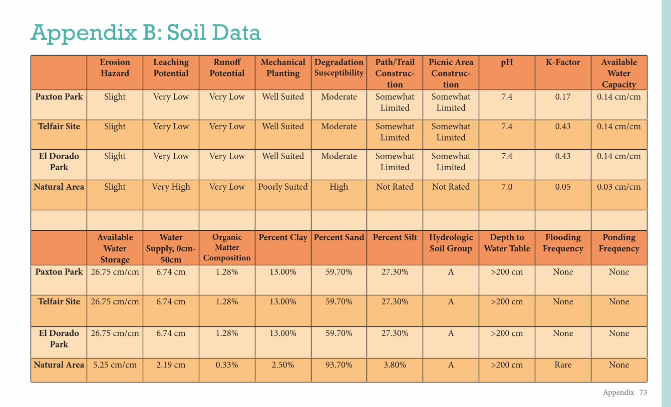
Appendix 73
Appendix B: Soil DataErosionHazard
Leaching Potential
Runoff Potential
Mechanical Planting
Degradation Susceptibility
Path/Trail Construc-
tion
Picnic Area Construc-
tion
pH K-Factor Available Water
CapacityPaxton Park Slight Very Low Very Low Well Suited Moderate Somewhat
LimitedSomewhat
Limited7.4 0.17 0.14 cm/cm
Telfair Site Slight Very Low Very Low Well Suited Moderate Somewhat Limited
Somewhat Limited
7.4 0.43 0.14 cm/cm
El Dorado Park
Slight Very Low Very Low Well Suited Moderate Somewhat Limited
Somewhat Limited
7.4 0.43 0.14 cm/cm
Natural Area Slight Very High Very Low Poorly Suited High Not Rated Not Rated 7.0 0.05 0.03 cm/cm
Available Water
Storage
Water Supply, 0cm-
50cm
Organic Matter
Composition
Percent Clay Percent Sand Percent Silt Hydrologic Soil Group
Depth to Water Table
Flooding Frequency
Ponding Frequency
Paxton Park 26.75 cm/cm 6.74 cm 1.28% 13.00% 59.70% 27.30% A >200 cm None None
Telfair Site 26.75 cm/cm 6.74 cm 1.28% 13.00% 59.70% 27.30% A >200 cm None None
El Dorado Park
26.75 cm/cm 6.74 cm 1.28% 13.00% 59.70% 27.30% A >200 cm None None
Natural Area 5.25 cm/cm 2.19 cm 0.33% 2.50% 93.70% 3.80% A >200 cm Rare None
74 Revitalizing Pacoima Wash
Appendix B: Soil DataErosion Hazard: The ratings in this interpretation indicate the hazard of soil loss from off-road and off-trail areas after disturbance activities that expose the soil surface. The ratings are based on slope and soil erosion factor K. The soil loss is caused by sheet or rill erosion in off-road or off-trail areas where 50 to 75 percent of the surface has been exposed by logging, grazing, mining, or other kinds of disturbance (Definition from Web Soil Survey, 2015).
Leaching Potential: The ratings for Pesticide Loss Potential-Leaching are used for evaluating and determining the potential of the soil to transmit pesticides through the profile and the likelihood of the contamination of ground-water supplies. Evaluations consider movement of water through the soil and underlying fractured bedrock. Ratings are for soils in their natural condition and do not consider pres-ent land use. The properties that affect the pesticide loss potential include the soil’s hydrologic group, depth to water table, saturated hydraulic conductivity at different depths, and the possibility of water movement in fractured bedrock (Definition from Web Soil Survey, 2015).
Runoff Potential: The ratings for Pesticide Loss Potential-Soil Surface Runoff are used for evaluating and determining the potential of the soil to transmit pesticides through surface runoff and the likeli-hood of the contamination of surface waters. Ratings are for soils in their natural condition and do not consider present land use. The properties that affect the pesticide loss potential include the occurrence of permafrost, surface ponding, flooding, and slope (Definition from Web Soil Survey, 2015).
Mechanical Planting: The ratings in this interpretation indicate the expected difficulty of planting trees or shrubs using a mechanical planter. The ratings are based on slope, depth to a restrictive layer, content of sand, plasticity index, rock fragments on or below the surface, depth to a water table, and ponding. It is assumed that necessary site preparation is completed before seedlings are planted (Defini-tion from Web Soil Survey, 2015).
Path/Trail Construction: Paths and trails for hiking and horseback riding should require little or no slope modification through cutting and filling. The ratings are based on the soil properties that affect trafficability and erodibility. These properties are stoniness, depth to a water table, ponding, flooding, slope, and texture of the surface layer (Definition from Web Soil Survey, 2015).
Degradation Potential: This interpretation rates each soil for its susceptibility for soil degradation to occur during disturbance, which is a function of resistance to degradation. Resistance to degrada-tion of a rangeland or woodland site is a measure of its ability to function without change throughout a disturbance. The magnitude of decline in the capacity to function determines the degree of resistance to change. Resistance to degradation thus could be described as an area’s buffering capacity. This depends
upon soil type, vegetation, climate, land use, disturbance regime, temporal and spatial scales. The distur-bance regime determines the type of stresses placed upon the soil, vegetation, and wildlife components of the site. Thus, soil factors of vulnerability will vary based upon the disturbance regime for a particular site (Definition from Web Soil Survey, 2015).
Picnic Area Construction: Picnic areas are natural or landscaped tracts used primarily for pre-paring meals and eating outdoors. These areas are subject to heavy foot traffic. Most vehicular traffic is confined to access roads and parking areas. The ratings are based on the soil properties that affect the ease of developing picnic areas and that influence trafficability and the growth of vegetation after development. Slope and stoniness are the main concerns affecting the development of picnic areas. For good trafficability, the surface of picnic areas should absorb rainfall readily, remain firm under heavy foot traffic, and not be dusty when dry. The soil properties that influence trafficability are texture of the surface layer, depth to a water table, ponding, flooding, saturated hydraulic conductivity (Ksat), and large stones. The soil properties that affect the growth of plants are depth to bedrock or a cemented pan, saturated hydraulic conductivity (Ksat), and toxic substances in the soil (Definition from Web Soil Survey, 2015).
Available Water Capacity: Available water capacity (AWC) refers to the quantity of water that the soil is capable of storing for use by plants. The capacity for water storage is given in centimeters of water per centimeter of soil for each soil layer. The capacity varies, depending on soil properties that affect retention of water. The most important properties are the content of organic matter, soil texture, bulk density, and soil structure, with corrections for salinity and rock fragments. Available water capacity is an important factor in the choice of plants or crops to be grown and in the design and management of irrigation systems. It is not an estimate of the quantity of water actually available to plants at any given time (Definition from Web Soil Survey, 2015).
Available Water Storage: Available water supply (AWS) is computed as AWC times the thickness of the soil. For example, if AWC is 0.15 cm/cm, the available water supply for 25 centimeters of soil would be 0.15 x 25, or 3.75 centimeters of water. Accumulates the AWC for a specified depth range. Used to produce data for the muaggatt table (Definition from Web Soil Survey, 2015).
Water Supply, 0cm-50cm: Available water supply (AWS) is the total volume of water (in centime-ters) that should be available to plants when the soil, inclusive of rock fragments, is at field capacity. It is commonly estimated as the amount of water held between field capacity and the wilting point, with corrections for salinity, rock fragments, and rooting depth. AWS is reported as a single value (in cen-timeters) of water for the specified depth of the soil. AWS is calculated as the available water capacity
Appendix 75
times the thickness of each soil horizon to a specified depth (Definition from Web Soil Survey, 2015).
Organic Matter: Organic matter is the Plant and animal residue in the soil at various stages of decomposition. The estimated content of organic matter is expressed as a percentage, by weight, of the soil material that is less than 2 millimeters in diameter. The content of organic matter in a soil can be maintained by returning crop residue to the soil. Organic matter has a positive effect on available water capacity, water infiltration, soil organism activity, and tilth. It is a source of nitrogen and other nutrients for crops and soil organisms. An irregular distribution of organic carbon with depth may indicate dif-ferent episodes of soil deposition or soil formation. Soils that are very high in organic matter have poor engineering properties and subside upon drying (Definition from Web Soil Survey, 2015).
Percent Sand: Sand as a soil separate consists of mineral soil particles that are 0.05 millimeter to 2 millimeters in diameter. In the database, the estimated sand content of each soil layer is given as a per-centage, by weight, of the soil material that is less than 2 millimeters in diameter. The content of sand, silt, and clay affects the physical behavior of a soil. Particle size is important for engineering and agro-nomic interpretations, for determination of soil hydrologic qualities, and for soil classification (Defini-tion from Web Soil Survey, 2015).
Percent Clay: Clay as a soil separate consists of mineral soil particles that are less than 0.002 millime-ter in diameter. The estimated clay content of each soil layer is given as a percentage, by weight, of the soil material that is less than 2 millimeters in diameter. The amount and kind of clay affect the fertility and physical condition of the soil and the ability of the soil to adsorb cations and to retain moisture. They influence shrink-swell potential, saturated hydraulic conductivity (Ksat), plasticity, the ease of soil dispersion, and other soil properties. The amount and kind of clay in a soil also affect tillage and earth-moving operations (Definition from Web Soil Survey, 2015).
Percent Silt: Silt as a soil separate consists of mineral soil particles that are 0.002 to 0.05 millimeter in diameter. In the database, the estimated silt content of each soil layer is given as a percentage, by weight, of the soil material that is less than 2 millimeters in diameter. The content of sand, silt, and clay affects the physical behavior of a soil. Particle size is important for engineering and agronomic interpretations, for determination of soil hydrologic qualities, and for soil classification (Definition from Web Soil Sur-vey, 2015).
Hydrologic Soil Group: Hydrologic soil groups are based on estimates of runoff potential. Soils are assigned to one of four groups according to the rate of water infiltration when the soils are not protected by vegetation, are thoroughly wet, and receive precipitation from long-duration storms. Group A. Soils having a high infiltration rate (low runoff potential) when thoroughly wet. These consist mainly of deep, well drained to excessively drained sands or gravelly sands. These soils have a high rate of water transmission (Definition from Web Soil Survey, 2015).
Flooding Frequency: Flooding is the temporary inundation of an area caused by overflowing streams, by runoff from adjacent slopes, or by tides. Water standing for short periods after rainfall or snowmelt is not considered flooding, and water standing in swamps and marshes is considered ponding rather than flooding. “None” means that flooding is not probable. The chance of flooding is nearly 0 per-cent in any year. Flooding occurs less than once in 500 years. “Rare” means that flooding is unlikely but possible under unusual weather conditions. The chance of flooding is 1 to 5 percent in any year (Defini-tion from Web Soil Survey, 2015).
Ponding Frequency: Ponding is standing water in a closed depression. The water is removed only by deep percolation, transpiration, or evaporation or by a combination of these processes. Ponding frequency classes are based on the number of times that ponding occurs over a given period. Frequency is expressed as none, rare, occasional, and frequent. “None” means that ponding is not probable. The chance of ponding is nearly 0 percent in any year (Definition from Web Soil Survey, 2015).
76 Revitalizing Pacoima Wash
Appendix C: Vegetation CatalogRare and Endangered California Plants in PacoimaListed below is a list of rare and endangered California native plants found in the Pacoima Can-yon, Angeles National Forest, the lower foothills of the San Gabriel Mountains, upper Pacoima Wash and Lopez Debris Basin. (“Draft Pacoima Wash Greenway Project Plan” and “Pacoima Wash Greenway Project Master Plan”) Plants that are listed as rare and threatened by the Cali-fornia Native Plant Society will be indicated by the acronym “CNPS”.
Davidson’s Bushmallow (Malacothamnus davidsonii)Habitat: Chaparral RiparianEndangerment: CNPS, native rare, endemic to CA; Global status - imperiledProperties: Shrub from the San Gabriel Mountains and San Fernando ValleySpecific Needs: Overall threat impact very high; vulnerable and does not bounce back from dis-turbance; specialist & narrow environmentSoil needs: Slopes, sandy washes and flats, wooded riparian areas
Greta’s Aster (Symphyotrichum/Aster greatae)Habitat: Chaparral RiparianEndangerment: CNPS, threatened or endangered in CA and elsewhere; native and endemic to CA; Global Status - imperiledProperties: Flowering vascular plant in Aster Family; dicot, perennial herb (rhizomatous)Soil needs: Moist sites in canyons; Found within in a variety of plant communities
Jepson’s Bedstraw (Galium jepsonii)Habitat: Lower & Upper MontaneEndangerment: CNPS, limited distribution; endemic to CA; Global status - vulnerableProperties: Dicot, perennial herb (rhizomatous); flowering vascular plant in Madder family
Johnston’s Bedstraw (Galium johnstonii)Habitat: Widely DispersedEndangerment: CNPS, limited distribution; endemic to CA; Global status - vulnerableProperties:Dicot, perennial herb (rhizomatous); flowering vascular plant in Madder family
Johnston’s/Interior Bush Lupine (Lupinus excubitus var. johnstonii)Habitat:ChaparralEndangerment: CNPS, limited distribution; endemic to CA; Global status - vulnerable
Properties: Dicot, shrub; flowering vascular plant in Pea familySoil needs: Dry slopes under pinesNevin’s Brickellbush (Brickellia nevinii)Habitat: Chaparral RiparianEndangerment: CNPS, native and endemic to CA; Global Status - vulnerableProperties: Dicot, shrub; flowering vascular plant in Aster family; reaches height between 3-5m, dense, tangling branches and foliageSpecific Needs: Restricted to desert and mountain shrub habitat
Tehachapi Ragwort (Packera/Senecio inophyllum)Habitat: Lower & Upper MontaneEndangerment: CNPS, limited distribution; endemic to CA; Global Status - vulnerableProperties: Dicot, perennial herb; flowering vascular plant in Aster family; one or more erect stem up to 30-50cm
(Frosted/Frosty) Indian Paintbrush (Castilleja pruinosa)Habitat: Pinyon-JuniperEndangerment: native to CA but can be found in CA & OR, confined to western North America; Global Status - apparently secureProperties: Dicot, perennial herb (hemiparasitic); flowering vascular plant in Figwort family; grow up to 80cm; densely hairy, gray-green in color, bright red or orange-red bracts
(Pine) Green gentian (Frasera/Swertia neglecta)Habitat:Yellow Pine ForestEndangerment: CNPS (CA Rare 1/1982), limited distribution; native and endemic to CA; Global Status - vulnerableProperties: Dicot, perennial herb; flowering vascular plant in Gentian family; reach up to 1m tall, one or more erect stems from a rosetted base
San Fernando/Parry’s Spineflower; San Fernando Valley Chorizanthe (Chorizanthe parryi var. Fernandina)Habitat: Coastal Sage ScrubEndangerment: Listed as “species of concern” by State of CA and Federal Gov; CNPS; native to CA, extirpated in Orange and San Fernando Counties; Global status - critically imperiled; seri-ously endangered in CA
Appendix 77
Urn-flower Alumroot (Heuchera elegans)Habitat: Lower & Upper Montane, Yellow pine forest, red fir forestEndangerment: CNPS, limited distribution; endemic to CA; Global status - vulnerableProperties: Dicot, perennial herb (rhizomatous); flowering vascular plant in Saxifrage family; uncommon in the wild, but cultivated as ornamental garden and natural landscaping plant
Roundleaf Brookfoam (Boykinia rotundifolia)Habitat:Chaparral RiparianEndangerment: CNPS; native and endemic to CA; Global status - vulnerableProperties: Dicot, perennial herb; flowering vascular plant in Saxifrage family; rounded, lobed leaves up to 30cm long; inflorescence up to 3ft tall on a thin stem; many small white flowersSpecific Needs: grows in shady forested areas near streams in mountains
Plants found in unchannelized portion of WashStarting from the dam to the Lopez debris basin, this portion of Pacoima Wash is unchannel-ized. This area is natural with free growing plants and free flowing water that is not surrounded by concrete. Listed below are plants found in the Lopez dam by the Army Corp of Engineers.
Castor Bean (Ricinus communis)Endangerment: Not native to CA; CIPC - limited potential impact on native ecosystemProperties: Dicot, shrub or small tree that reaches 5m tall; flowering vascular plant in Spurge family; exotic, found around US; seeds produce castor oil (economic benefit); oil and seed have been used for folk remediesRelations to animal: Seeds poisonous to people, animal and insects
Russian thistle, tumbleweed, wind witch (Salsola kali)Habitat: Widely distributed (common along seabeaches, disturbed grasslands and desert, semi-arid regions)Endangerment: Not native to CA; exotic to North AmericaProperties: Used for hay, helped when hay failed during Dust BowlSpecific Needs: Optimum temperature 44-50 degrees FahrenheitRelations to animal: Eaten by cattle & sheep (less than 10% of diet for bison, mule deer, and elk), important prairie dog food; eaten by at least 8 species of granivorous birds (such as scaled and Gambel’s quail); small mammals also eat the seedsSoil needs: Any type of well-drained, uncompacted soil with sunny exposure; alkaline or saline soils; cannot tolerate saturated soil for extended periods of time
Fire ecology: Aids in spreading fire, burns easily
Pineapple Weed, Wild Chamomile, Disc mayweed (Matricaria discoidea)Endangerment: Not native to CA; found in North America; Global status - SecureProperties: Dicot, annual herb; flowering vascular plant in Aster family; flowers exude a chamo-mile/pineapple aroma when crushed; edible, used in salads and herbal tea; medicinal uses (such as relief gastrointestinal upset, infected sores, fevers and postpartum anemiaSoil needs: well in disturbed areas, especially in poor and compacted soil; footpaths, roadsides
(Rusty) Popcornflower (Plagiobothrys nothofulvus)Habitat: Foothill woodland, valley grassland, coastal sage scrubEndangerment: Not listed; native to CA; confined to western North AmericaProperties:Annual herb; common spring wildflower in grassy meadows/ woodlands; 20-70 cm; white flower with purple sap; rusty red and bleeding purple when crushedJimson Weed, Sacred Datura (Datura wrightii)Habitat: Sandy or gravelly dryEndangerment: Not listed; found throughout CAProperties: Fast spreading, vine-like; need full to part sun; enormous white trumpet flowers with sweet smell; all parts poisonousSoil needs: Well-draining soilBenefits for Water Management: Drought-tolerant to moderate
Nevin’s barberry (Berberis/Mahonia/Odostemon nevinii)Habitat: Chaparral, Foothill Woodland, coastal sage scrub, riparianEndangerment: CNPS; rare, listed as endangered by State of CA and Federal Government; native and endemic CAProperties: 6-10 ft tall; gray-blue foliage; bright yellow flowersSpecific Needs: Full sun or light shadeRelations to animal: Red berries attractive to birdsSoil needs: Well-drained soil with little to occasional irrigation
CA buckwheat scrub (Eriogonum fasciculatum)Habitat: Dry slopes, washes and canyons in Coastal Sage Scrub, chaparral, deserts below 8000 ftEndangerment: Not listedProperties: Fast growing dense and upright shrub; evergreen; cream colored flowers in the sum-mer; excellent for erosion controlRelations to animal: Very important nectar and food source for many butterflies
78 Revitalizing Pacoima Wash
Benefits for Water Management: drought-tolerant to moderate
Scalebroom-hairy yerba, Santa-chaparral yucca (Eriodictyon trichocalyx)Habitat: Edges of chaparralEndangerment: Not listed; native to CA; confined to western North AmericaProperties: Fast and upright growing shrub; aromatic leaves; light purple flowers in spring/sum-mer; great for soil stabilization and erosion controlSoil needs: Well-drainingBenefits for Water Management: Drought-tolerant to occasional
CA Sagebrush scrub (Artemisia californica)Habitat: Coastal scrub, chaparral, dry foothills near coast:Endangerment: Not listed, found throughout Central West, Southwest, and Northern BajaProperties: Fast growing upright, loose and woody shrub; evergreen; strong scented foliage; grey-green flowers in the summer; recommended for erosion controlBenefits for Water Management: drought-tolerant to moderate
Evening primrose (Oenothera spp)Habitat: Dunes, roadsides, waste areas, railway embankmentsEndangerment: Not listed; native to CAProperties: Flowers open in the evening; commonly have yellow flowersRelations to animal: Pollinated by insects (moths and bees); used as food plants by Lepidoptera species; exclusively fed on by flower mothsSoil needs: Quickly germinate in disturbed soils

Appendix 79