Embed Size (px)
Citation preview
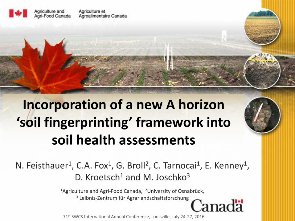
71st SWCS International Annual Conference, Louisville, July 24-27, 2016
Incorporation of a new A horizon‘soil fingerprinting’ framework into
soil health assessments
N. Feisthauer1, C.A. Fox1, G. Broll2, C. Tarnocai1, E. Kenney1, D. Kroetsch1 and M. Joschko3
1Agriculture and Agri-Food Canada, 2University of Osnabrück, 3 Leibniz-Zentrum für Agrarlandschaftsforschung

Soil Health
Healthy soil is fundamental to:
• Diverse soil biological community
• Optimal soil function
• Provision of services (i.e., growing crops!)
betterground.org

Soil Quality/Health
vro.depi.vic.gov.aubetterground.org

How do we measure soil health?Chemistry
• Organic carbon, pH, CEC, nutrients, etc.
Function
• Nutrient/carbon cycling
Ecotoxicity
• Toxicity to earthworms, plants, arthropods, microbes
Ecology
• Plant, invertebrate and microbial populations
Physical components
• Texture, bulk density, % moisture, water holding capacity, structure

Soil Structure = Soil Architecture
• Physical habitat for soil organisms
• Structure for air circulation
• Soil moisture retention/release
• Key dynamic soil characteristic
• Sensitive to management practices/soil remediation
• Indicator for soil quality

How to simply and consistently describe characteristics related to soil health?
We often have to consider:
• Multiple lines of evidence (yield, chemistry, etc.)
• Qualitative and quantitative data
• Contextual information
– Soil/landscape/ecozone context
Soil taxonomy has limited descriptive capacity, e.g.,
• Soil A horizon (topsoil) restricted to Ap, Ae, A1, etc.

Soil ‘fingerprint’ Framework
• AAFC has developed an enhanced soil A horizon descriptor methodology to systematically track and record change in soil physical, chemical and biological characteristics
• Using syntax and symbology rulesets, the characteristics of a soil sample are described in a single line of code that is unique to that soil sample at the time it was collected
• Analogous to a ‘fingerprint’ of that sample

Soil ‘fingerprint’ Framework
• The current framework includes 5 levels of information with specific syntax for writing the soil fingerprint: 1. Soil process, parent materials and mode of deposition
2. Soil structure attributes* and bulk density*
3. Percentage organic carbon*
4. pH* / electrical conductivity*
5. Soil and landscape context.
• Can generate simple or detailed fingerprints
*West et al. (2010)

Environment
Prefixes
Soil Process
Suffixes
Soil
Structure;
Bulk Density
Organic
Carbon
pH/Electrical
Conductivity
Soil/Land Context
Information
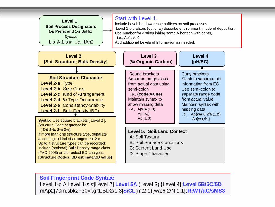
Level 1-p A Level 1-s [Level 2] (Level 3) {Level 4}Level 5:
A, B,C, D
Unique Soil Fingerprint Code: Enhanced A Horizon Designation Syntax
Level 1-p A Level 1-s # [Level 2] Level 5A (Level 3) {Level 4};Level 5B/Level 5C/Level 5D
Required Any of Designator Levels 1-p and 2 to 5 can be added +
Basic A Horizon ‘Fingerprint’ Framework

Level 1 Soil Process Designators
1-p Prefix and 1-s Suffix
Syntax:
1-p A 1-s # i.e., fAh2
Start with Level 1.
Include Level 1-s, lowercase suffixes on soil processes.
Level 1-p prefixes (optional) describe environment, mode of deposition.
Use number for distinguishing same A horizon with depth,
i.e., Ap1, Ap2
Add additional Levels of Information as needed.
Soil Fingerprint Code Syntax:
Level 1-p A Level 1-s #
mAp2

Level 1 Soil Process Designators
1-p Prefix and 1-s Suffix
Syntax:
1-p A 1-s # i.e., fAh2
Level 2
[Soil Structure; Bulk Density]
Start with Level 1.
Include Level 1-s, lowercase suffixes on soil processes.
Level 1-p prefixes (optional) describe environment, mode of deposition.
Use number for distinguishing same A horizon with depth,
i.e., Ap1, Ap2
Add additional Levels of Information as needed.
Soil Structure Character
Level 2-a Type
Level 2-b Size Class
Level 2-c Kind of Arrangement
Level 2-d % Type Occurrence
Level 2-e Consistency-Stability
Level 2-f Bulk Density (BD)
Syntax: Use square brackets [ Level 2 ].
Structure Code sequence is:
[ 2-d 2-b. 2-a 2-e]
If more than one structure type, separate
according to kind of arrangement 2-c.
Up to 4 structure types can be recorded.
Include (optional) Bulk Density range class
(FAO 2006) and/or actual BD analyses.
[Structure Codes; BD estimate/BD value]
Soil Fingerprint Code Syntax:
Level 1-p A Level 1-s # [Level 2]
mAp2[70m.sbk2+30vf.gr1;BD2/1.3]

Level 1 Soil Process Designators
1-p Prefix and 1-s Suffix
Syntax:
1-p A 1-s # i.e., fAh2
Level 2
[Soil Structure; Bulk Density]
Level 3
(% Organic Carbon)
Start with Level 1. Include Level 1-s, lowercase suffixes on soil processes.
Level 1-p prefixes (optional) describe environment, mode of deposition.
Use number for distinguishing same A horizon with depth,
i.e., Ap1, Ap2
Add additional Levels of Information as needed.
Soil Structure Character
Level 2-a Type
Level 2-b Size Class
Level 2-c Kind of Arrangement
Level 2-d % Type Occurrence
Level 2-e Consistency-Stability
Level 2-f Bulk Density (BD)
Round brackets.
Separate range class
from actual data using
semi-colon,
i.e., (code;value)
Maintain syntax to
show missing data i.e., Ap(lw;1.3)
Ap(lw;)
Ap(;1.3)Syntax: Use square brackets [ Level 2 ].
Structure Code sequence is:
[ 2-d 2-b. 2-a 2-e]
If more than one structure type, separate
according to kind of arrangement 2-c.
Up to 4 structure types can be recorded.
Include (optional) Bulk Density range class
(FAO 2006) and/or actual BD analyses.
[Structure Codes; BD estimate/BD value]
Soil Fingerprint Code Syntax:
Level 1-p A Level 1-s # [Level 2] (Level 3)
mAp2[70m.sbk2+30vf.gr1;BD2/1.3] (m;2.1)

Level 1 Soil Process Designators
1-p Prefix and 1-s Suffix
Syntax:
1-p A 1-s # i.e., fAh2
Level 2
[Soil Structure; Bulk Density]
Level 3
(% Organic Carbon)
Level 4
{pH/EC}
Start with Level 1. Include Level 1-s, lowercase suffixes on soil processes.
Level 1-p prefixes (optional) describe environment, mode of deposition.
Use number for distinguishing same A horizon with depth,
i.e., Ap1, Ap2
Add additional Levels of Information as needed.
Soil Structure Character
Level 2-a Type
Level 2-b Size Class
Level 2-c Kind of Arrangement
Level 2-d % Type Occurrence
Level 2-e Consistency-Stability
Level 2-f Bulk Density (BD)
Round brackets.
Separate range class
from actual data using
semi-colon,
i.e., (code;value)
Maintain syntax to
show missing data i.e., Ap(lw;1.3)
Ap(lw;)
Ap(;1.3)
Curly brackets
Slash to separate pH
information from EC
Use semi-colon to
separate range code
from actual value
Maintain syntax with
missing datai.e., Ap{wa;6.2/N;1.2}
Ap{wa;/N;}Syntax: Use square brackets [ Level 2 ].
Structure Code sequence is:
[ 2-d 2-b. 2-a 2-e]
If more than one structure type, separate
according to kind of arrangement 2-c.
Up to 4 structure types can be recorded.
Include (optional) Bulk Density range class
(FAO 2006) and/or actual BD analyses.
[Structure Codes; BD estimate/BD value]
Soil Fingerprint Code Syntax:
Level 1-p A Level 1-s # [Level 2] (Level 3) {Level 4}
mAp2[70m.sbk2+30vf.gr1;BD2/1.3] (m;2.1){wa;6.2/N;1.1}
Level 1 Soil Process Designators
1-p Prefix and 1-s Suffix
Syntax:
1-p A 1-s # i.e., fAh2
Level 2
[Soil Structure; Bulk Density]
Level 3
(% Organic Carbon)
Level 4
{pH/EC}
Start with Level 1. Include Level 1-s, lowercase suffixes on soil processes.
Level 1-p prefixes (optional) describe environment, mode of deposition.
Use number for distinguishing same A horizon with depth,
i.e., Ap1, Ap2
Add additional Levels of Information as needed.
Soil Structure Character
Level 2-a Type
Level 2-b Size Class
Level 2-c Kind of Arrangement
Level 2-d % Type Occurrence
Level 2-e Consistency-Stability
Level 2-f Bulk Density (BD)
Round brackets.
Separate range class
from actual data using
semi-colon,
i.e., (code;value)
Maintain syntax to
show missing data i.e., Ap(lw;1.3)
Ap(lw;)
Ap(;1.3)
Curly brackets
Slash to separate pH
information from EC
Use semi-colon to
separate range code
from actual value
Maintain syntax with
missing datai.e., Ap{wa;6.2/N;1.2}
Ap{wa;/N;}Syntax: Use square brackets [ Level 2 ].
Structure Code sequence is:
[ 2-d 2-b. 2-a 2-e]
If more than one structure type, separate
according to kind of arrangement 2-c.
Up to 4 structure types can be recorded.
Include (optional) Bulk Density range class
(FAO 2006) and/or actual BD analyses.
[Structure Codes; BD estimate/BD value]
Level 5: Soil/Land Context
A: Soil Texture
B: Soil Surface Conditions
C: Current Land Use
D: Slope Character
Soil Fingerprint Code Syntax:
Level 1-p A Level 1-s #[Level 2] Level 5A (Level 3) {Level 4};Level 5B/5C/5D
mAp2[70m.sbk2+30vf.gr1;BD2/1.3]SiCL(m;2.1){wa;6.2/N;1.1};R;WT/aC/sMS3

Electronic Field Form with Soil Fingerprint Codes © Fox, C., Tarnocai, C., Broll, G., Joschko, M., Kroetsch, D. and Kenney, E. 2014. Enhanced A Horizon Framework and Field Form for
detailed field scale monitoring of dynamic soil properties. Canadian Journal Soil Science 94: May Issue
Date: Name: Site Location:
GPS CoordinatesField Field Field Level 5-A Level 5-C
Ref. Latitude Longitude Site Plot Repl. A A Hor. Mod. Mod. Mod. Soil % Org. Carbon Land Kind of Slope Gradient
No. Datum: NAD83 Upper Lower 1st 2nd 3rd Hor 1st 2nd 3rd 4th No. % Class Type Cons. Symb. % Class Type Cons. Symb. % Class Type Cons. Symb. % Class Type Cons. Est. Lab An. Texture Est. Lab An. Est. Lab An. Est. Lab An. 1 2 Use Slope Position %
A
A
A
A
A
A
A
A
A
A
A
A
Notes: Notes*********** Note: Before moving Soil Fingerprint Codes to new worksheet, or other application: Copy, Paste Special, then highlight Values to remove background cell formula.
Field Plot Repl.
Site
Upper Lower
Level 5-D Slope Character
(cm) Environment Prefixes Process Suffixes Structure 1 Stucture 2 Structure 3 Structure 4 Bulk Density pH in CaCl 2
Depth Level 1 : Horizon Designators [Level 2 ] Soil Structure Characterization (up to maximum of 4 types) and Bulk Density (Level 3) {Level 4} Level 5-B
EC Salinity Surface Cond.
Depth (cm)Ref. No. Soil Fingerprint Code: Enhanced Detail Mode: All levels and Options Ref. No. Soil Fingerprint Code: Minimum Detail: Dynamic Soil Properties
A [ ;/] (;) {;/;};;// A [ ;] ( ) {/}
A [ ;/] (;) {;/;};;// A [ ;] ( ) {/}
A [ ;/] (;) {;/;};;// A [ ;] ( ) {/}
A [ ;/] (;) {;/;};;// A [ ;] ( ) {/}
A [ ;/] (;) {;/;};;// A [ ;] ( ) {/}
A [ ;/] (;) {;/;};;// A [ ;] ( ) {/}
A [ ;/] (;) {;/;};;// A [ ;] ( ) {/}
A [ ;/] (;) {;/;};;// A [ ;] ( ) {/}
A [ ;/] (;) {;/;};;// A [ ;] ( ) {/}
A [ ;/] (;) {;/;};;// A [ ;] ( ) {/}
A [ ;/] (;) {;/;};;// A [ ;] ( ) {/}
A [ ;/] (;) {;/;};;// A [ ;] ( ) {/}

Name: Site Location:
Mod. Mod. Mod.
% Class Type Cons. Symb. % Class Type Cons. Symb. % Class Type Cons. Symb. % Class Type Cons. Est. Lab An.
c. sbk 1 + m. pt 1 BD2 1.22
mc. sbk 2 + mc. gr 2 BD2 1.36
mc. sbk 2 + m. gr 2 BD3 1.40
mc. abk 2 + m. gr 2 BD2 1.20
Gobles Soil (GO)C. Fox
Structure 1 Stucture 2 Structure 3 Structure 4 Bulk Density
[Level 2 ] Soil Structure Characterization (up to maximum of 4 types) and Bulk Density
Structure Type Code
Structureless
1. massive/amorphous m
2. single grain sg
3. layered (sediments) sd
Platy pt
Lenticular nt
Wedge w
Prismatic pr
Columnar cpr
Blocky
1. Blocky bk
2. Angular blocky abk
3. Subangular blocky sbk
4. Polyhedral py
Granular gr
Very porous peds pc
Cast (i.e. biota) ct
Mechanically Formed
1. Cloddy cd
2. Lumpy lu
3. Crumbly cr
Structure Types were adopted and based on various
soil field description systems. Canadian (Expert
Committee on Soil Survey, 1983); Australian,
National Committee on Soil and Terrain (MacDonald
and Isbell, 2009); New Zealand Soil Bureau (Taylor
and Pohlen, 1970); USDA-NRCS (Schoeneberger et

Field Plot Repl.Site
Upper Lower
Bayham EAWD006 Soy 0 20
S.Dorch. LWSD029 Soy 0 13
Norfolk 1402 Rd. Cut 0 9
Delhi 565 Pasture 0 32
Depth (cm)Ref. No. Soil Fingerprint Code: Enhanced Detail Mode: All levels and Options
1 mtX1Ap [c.sbk1 +m.pt1;BD2/1.22] SiCL (m;2.32) {ma;6/N;0.2};;/aC/c2
2 mtAp [mc.sbk2 +mc.gr2;BD2/1.36] SiL (m;1.86) {n;7.1/N;0.3};;/aC/c3
4 mtX1Ap [mc.abk2 +m.gr2;BD2/1.2] L (h;3.65) {n;7.3/N;0.1};;/aG/5
A [ ;/] (;) {;/;};;//
A [ ;/] (;) {;/;};;//
3 mtX1Ap [mc.sbk2 +m.gr2;BD3/1.4] L (m;1.97) {n;7.1/N;0.2};;/sRc/4
Ref.
No.Soil Fingerprint Code: Minimum Detail: Dynamic Soil Properties
1 Ap [sbk +pt;BD2] (m ) {ma/N}
2 Ap [sbk +gr;BD2] (m ) {n/N}
3 Ap [sbk +gr;BD3] (m ) {n/N}
4 Ap [abk +gr;BD2] (h ) {n/N}
A [ ;] ( ) {/}
A [ ;] ( ) {/}

Integration of information
An Ap horizon with morainal deposition with coarse subangularblocky structure with a bulk density estimate of 1.2 -1.4 and a measured value of 1.3 Mg m-3; it is a heavy clay soil with an estimated medium level of organic carbon and a measured value of 2.1%. It is weakly acidic with a pH range of 6.1-6.5 and a measured value of 6.2 and is considered non-saline with a measured conductivity value of 1.2 dS/m. It has been recently cultivated and subjected to wheel traffic from its agricultural land use cultivating cereal crops on a simple 3% slope at the toe-slope position.
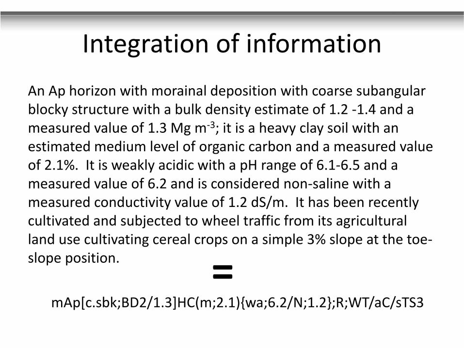
mAp[c.sbk;BD2/1.3]HC(m;2.1){wa;6.2/N;1.2};R;WT/aC/sTS3
=

Key Design Components
• Designed to be complementarily used with all international soil classification systems

Key Design Components
• Designed to be complementarily used with all international soil classification systems
• Database of fingerprints can be statistically compared over time/among locations

Key Design Components
• Designed to be complementarily used with all international soil classification systems
• Database of fingerprints can be statistically compared over time/among locations
• Flexible and modular:
– User can add or remove any level to customize fingerprints to record data that meets study objectives/required level of detail

Crop type, yield, rotation; tillage; pesticide use, etc.Level 6: Cropland © Agriculture and Agri-Food Canada
Reference
Field Site Plot Repl. No.Depth (cm) Level 6: Cropland
Number Tillage Crop Cropping Current Yield
Identifier Upper Lower System System Method Crop Est.
Tillage System
CN Conventional (moldboard plow)CV Conservation (Minimum tillage, disk)NT No-tillZT Zone tillRT Ridge tillageCH Chisel plowRD Reduced tillage (shallower plow depth)SF Summer Fallow
Cropping Method
Ym Monocropping2Y 2-year rotation3Y 3-year rotation4Y 4-year rotation
Current Crop
W Wheat R Rye Ps Pasture Cl CloverS Soybeans sB Sugar beets V GrapesCf Field Corn Hp Peppers Bk BuckwheatT Tomatoes Oa Apples Sp Specialty cropP Potatoes Op Peaches Bn Beans - PulsesAf Alfalfa Oc Cherries Fx FlaxB Barley Ops Pears M MustardCn Canola Hr Raspberries Sn SunflowerO Oats Hs Strawberries Tb TobaccoCs Sweet Corn Rp Rapeseed N Nursery
Crop System
c conventionalor organicipm integrated managementin industrial (biofuels)
Yield Estimate
xh Extremely Highh Highav Averagelw Lowxl Extremely Low

Comparison Study (since 1959): Different Crop Rotations on Same Soil Type
Conventional Tillage; silty clay loam; Humic Gleysol (Woodslee, Ontario, Canada)
Ahp[fm.gr+pc/fm.sbk;BD1](6.0) Apfn[bk-sbk+py+gr;BD2](2.8) Apg[cd-sbk;BD3](2.3)
C.A. Fox, Agriculture and Agri-Food Canada

Podzol
Coniferous
Forest (Ae)
Deciduous forest
(Ahe)
Sandy clay loamBraunerde
Field crops,
(triticale,
rape)
Sandy loam
Gley
Long-term
grassland
(loam);
field crops,
with seepage
Sandy Loam
Braunerde
Field crops;
triticale,
corn (2 yrs)
Sandy
Loam
Deciduous
Forest
Clay
Ae[sg]SCL(vh;6.78){xa;2.9}
Aph[cd-sbk]SL(lw;1.26){sa;5.1}
Field
crops
Sandy
Loam
Rendzina
Agph[sbk-pc]SL(m;2.82){ma;5.6}
Ap[cd-sbk-pc]SL(lw;1.31){xa;4.5}
Aph[gr]SL(m;2.12){n;6.8}
Ah[sbk-gr]C(vh;6.12){ma;5.8}
CATENA STUDY: Osnabrück, Germany
Ahe[sbk-pc]SCL(vh;5.59){xa;3.1}
Ahgp[cd-sbk-gr]L(vh;5.48){n;7.0}
G. Broll, Universität Osnabrück

• Development of guidance materials for use with a focus on:
– Soil structure
– Use by non-soilscientists
– Interpretation of fingerprint changes
• Additional fingerprint levels for different end uses
Next Steps
INTERPRETATION for crop growth potential particularly root growth/penetration into soilDraft Ideas for Scoring dynamic soil properties for interpreting state of soil quality for crop growth - Catherine Fox (AAFC)
Structure type (random together)* m cd sg w & pt abk sbk, py, pr gr pc
Assigned Rating from 1-10 1 2 3 4 6 8 10 10
% observation
Rating (Rating x % Obs.) 0 0 0 0 0 0 0 0
* See below for Structure Breaking To
Organic carbon <0.5 0.5 to <1.5 1.5 to <3 3 to <5 5 to <10 10 to ? 17
Range code level xl lw m h vh xh
Assigned Rating 10 30 80 100 70 50
Record Rating for Observed Level
pH range ? 4.5 4.6 to 5.5 5.6 to 6.0 6.1 to 6.5 6.6 to 7.3 7.4 to 7.8 7.9 to 8.4 ? 8.5
Range code level xa sa ma wa n wk mk sk
Assigned Rating 10 50 80 100 100 40 0 0
Record rating for pH range level
Total EW Pores Total Abundance Abundance Abundance
Middens/m2 Horizontal view Earthworm L. terrestris L. terrestris A. caliginosa
Upper Lower at 5 cm depth Abundance (Adults) (Juveniles) (Adults)
1234 ABC 456 2 0 15 C c 60 20 10 18
Level 9: Soil Biota Characterization
Soil Biota Characterization
Depth (cm)Reference
Number
Identifier
Field Site PlotReplicate
Number
Earthworm Pores in 10 x 10 cm square
vf Very Few 1
f Few 2-3c Common 4-5m Many > 6
No of Middens on Surface [In 60 x 60 cm square ( average of 3 replicates, random placement of
square]
N None 0VF Very Few 1 or less
F Few 2-4C Common 5-10P Plentiful >10


Fox, C.A., Tarnocai, C., Broll, G., Joschko, M., Kroetsch, D. and Kenney, E. 2014
Enhanced A Horizon Framework and Field Form for detailed field scale monitoring of dynamic soil properties.
Canadian Journal of Soil Science 94: 189-208 (May Issue)
Contact: [email protected]

Thank you!