Embed Size (px)
Citation preview

Impact of agricultural stream restoration on hydrology and
biogeochemistry
Sara McMillan, Gavin Downs, Maria Laura Ortiz de ZaratePurdue University
Philippe Vidon, Molly WelshSUNY-ESF

Pristine Impaire
d
Restored?
Rationale & project goals Restoration goals AND practices focus on stream channel stability and reduced sediment transport Channel construction, engineered structures designed to achieve stability, grade control and bank stabilization.
- How do physical changes influence near-stream hydrology?- What is the effect of restoration on water quality (NO3, NH4, PO4) and GHG emissions (CH4, N2O, CO2) in streams
& riparian zones?- Drivers of N, P and C cycling in the stream-riparian system?

Stream-Floodplain-Riparian SystemRiparian buffer function: Transform and remove nutrients from adjacent uplandsFloodplain function: Overbank flow + enhanced hyporheic exchange attenuates peak flow and
retains/transforms nutrients & sedimentStream function: Hyporheic flow & retention in deep pools retains and transforms nutrients
OC input (leaves)
Nutrient transport
Nutrient, sediment input during floods
NO3- transport
Nitrification,root uptake
DOC transport
Debris dam
Cross vane
OM accumLateral hyporheic
flow
Denitrification
OM accumFlow

Grassy Creek-Horne Creek Watershed
Unrestored – Forested BufferDrainage area = 5 km2
Middle Fisher River Watershed
1 2
3
Agriculture
HerbaceousForested
Open Space
RestoredDrainage area = 1.5 km2
Unrestored – Mixed BufferDrainage area = 4.5 km2
Study Sites
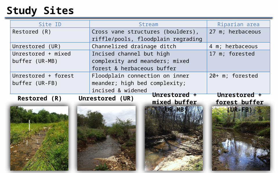
Study SitesSite ID Stream Riparian area
Restored (R) Cross vane structures (boulders), riffle/pools, floodplain regrading
27 m; herbaceous
Unrestored (UR) Channelized drainage ditch 4 m; herbaceousUnrestored + mixed buffer (UR-MB)
Incised channel but high complexity and meanders; mixed forest & herbaceous buffer
17 m; forested
Unrestored + forest buffer (UR-FB)
Floodplain connection on inner meander; high bed complexity; incised & widened
20+ m; forested
Restored (R) Unrestored (UR) Unrestored + mixed buffer (UR-
MB)
Unrestored + forest buffer
(UR-FB)

Approach & Methods1) Riparian & Floodplain
a. Seasonal & event-based hydrology, water quality and GHG fluxes
2) Stream & Hyporheic Zone:a. Seasonal hydrology, water qualityb. Potential denitrification ratesc. Reach scale nutrient retention
3) Stream-Floodplain-Riparian connectivity a. High temporal resolution: water table, stream
height & soil moisture

RiffleA2
B1C
D1
E
F
G2H2
I1
1
2
3
4
5
7
8
6
A1Riffle
B2D2
G1H1
I2
Piez. Color Code Red = Well (W) Orange = Deep (D) Yellow = Mid (M) Green = Shallow (S)
2” well
RunRiffleRunRun4
J2/5
J1/6K/7Pool8
Run
910
Example of monitoring framework – Restored site
LegendIn-stream piezometer
Staff Gage
Rocks
Piezometer nest
Static chamber
Soil Moisture Sensors/ Silicone chambers

STREAM-FLOODPLAIN-RIPARIAN CONNECTIVITY
What is the influence of restoration on trade-offs between nutrient removal and greenhouse gas
emissions?

Greenhouse Gases: Riparian Function Highly variable; both
nitrification & denitrification contribute to total flux
U-Forest is net sink/zero Restored = lowest rate
likely because low soil OM + compacted riparian zones
Highest rates in summer/fall (warm temperatures)
U-Forested site is a sink Restored site = source. No
pattern with hillslope position or restoration feature.
Spr 1
3 SuFa
ll 13Win
13Sp
r 14 Su
Fall 1
4Win
14Sp
r 15 Su
-1.5-1
-0.50
0.51
1.52
R U U-FB
N2O
mg
N/m
2/d
Spr 1
3 SuFa
ll 13 Wi
Spr 1
4 SuFa
ll 14 Wi
Spr 1
5 Su-20-10
010203040
CH4
mg
C/m
2/d
NSNSNS
Sp Su Fal Wi Sp Su Fa
l Wi Sp Su-2-101234
CO2
g C/
m2/
d
ND
ND
ND
ND
ND
ND

Storm events – Restored site
-0.50
0.51
1.52
2.53
N2O
(m
g N
/m2/
day)
PRE 24h 72h
00.5
11.5
22.5
33.5
4
CO2
(g C
/m
2/da
y)
PRE 24h 72h-60-40-20
0204060
CH4
(mg
C/m
2/da
y)
PRE 24h 72h
N2O – Uplands source post event
CH4 – Near stream shifts from sink to source post event.
CO2 – No change

Hillslope position affects riparian-stream denitrification
Denitrification in riparian zones > stream sediments
Near-stream zones = higher rates in restored sites
Highest rates associated with higher soil moisture & organic carbon

R UR UR-MB
UR-FB
aPool Riffle Run Point
bar
DEA
(ng
N/g
DM/h
r)
sandy clay
loamy sand
fine sand
sand coarse sand
0
50
100
150
200
250
300
DEA
(ng
N/g
DM
/h)
DEA by texture (in-stream locations)
Geomorphology & sediment drive instream denitrification
Highest rates associated with fine textured sediments Pools high in unrestored sites Riffles high/variable in all sites
100
200
0

Sw (m) 324Vf (mm min-1) 0.95U (mg m-2 h-1) 14.5
Residuals
Riffles/shallow runs
Deep pools
- Sink
+ Source
Reach scale retention: Restored stream

Sw (m) 151Vf (mm min-1) 2.75U (mg m-2 h-1) 138
Reach scale retention: U-Forested Riparian
- Sink
+ Source
Residuals

Conclusions, challenges and opportunities Consider the entire stream-riparian
system for restoration design & assessment of function• Denitrification and GHG patterns
varied with landscape position• Denitrification: Riparian >> stream• Instream DEA & nutrient uptake
depended upon geomorphology. Construction process =
disturbance• Vegetation removal, stream/riparian
regrading, soil compaction. • Reduced water quality function• Failures are common = maintenance

Thanks! Questions?