Embed Size (px)
Citation preview

COLLEGE OF ENGINEERING
DEPARTMENT OF GEOLOGICAL ENGINEERING
ASSIGNMENT ON FAILURE MODES ON A SLOPE FACE USING DIPS APPLICATION
AND
STANDARD FORMATTING PROCEDURES ON SOME GIVEN QUESTIONS
NAME: DZAKLO COURAGE KWASI
INDEX NUMBER 7739312
COURSE
COURSE CODE
COMPUTER APPLICATION (INCLUDING ENG. GEOLOGY)
G E D 359
ASSIGNMENT TYPE MIDSEMESTER EXAMS
DATE 26/11/2014

1 | C O M P U T E R A P P L I C A T I O N S
Table of Contents
1 CHAPTER ONE: DETERMINATION OF TYPE FAILURE THAT WILL OCCUR IN
A GIVEN SLOPE. ..................................................................................................................... 4
1.1 DATA FOR THE ANALYSIS: .................................................................................. 4
1.2 STEREONETS PLOTTED: ........................................................................................ 4
1.2.1 TOPPLING failure analysis: ................................................................................ 5
1.2.2 PLANAR SLIDING failure analysis: .................................................................. 6
1.2.3 WEDGE SLIDING failure analysis: .................................................................... 7
1.3 CONCLUSION: .......................................................................................................... 7
2 CHAPTER TWO: THE CONTRIBUTION OF AN ENGINEERING GEOLOGIST IN
NATIONAL DEVELOPMENT ................................................................................................ 8
2.1 Engineering: ................................................................................................................ 8
2.2 Geologist: .................................................................................................................... 8
2.3 Engineering geologist:................................................................................................. 8
2.4 Contributions of engineering geologist in national development: .............................. 8
2.5 Conclusion:.................................................................................................................. 9
3 CHAPTER THREE: STAGES OF INVESTIGATION IN ENGINEERING GEOLOGY.
9
3.1 Introduction: ................................................................................................................ 9
3.2 Project conception stage: ............................................................................................. 9
3.3 Preliminary investigation stage: ................................................................................ 10
3.4 Main investigation stage: .......................................................................................... 10
3.5 Construction investigation stage: .............................................................................. 10
3.6 Post construction stage investigation: ....................................................................... 11
3.7 CONCLUSION: ........................................................................................................ 11
4 CHAPTER FOUR: TROPICAL WEATHERING, LATERITIZATION PROCESS AND
LATERITES. ........................................................................................................................... 11
4.1 Weathering of rocks: ................................................................................................. 11
4.2 Tropical weathering: ................................................................................................. 12
4.3 Lateritization process: ............................................................................................... 12
4.4 Laterites: .................................................................................................................... 14
4.5 CONCLUSION: ........................................................................................................ 14
5 CHAPTER FIVE: EFFECTS OF WATER ON THE ENGINEERING PERFORMANCE
OF ROCKS AND SOIL MASSES. ......................................................................................... 15
5.1 Water, soils and engineering: .................................................................................... 15
5.2 Water, Rocks and engineering: ................................................................................. 15

2 | C O M P U T E R A P P L I C A T I O N S
5.3 Effects of water on the engineering performance of rocks and soil masses: ............ 15
5.4 CONCLUSION: ........................................................................................................ 16
6 CHAPTER SIX: ENGINEERING SIGNIFICANCE OF FOLDS AND FAULTS: ....... 17
6.1 Folds: ......................................................................................................................... 17
6.2 Faults: ........................................................................................................................ 18
6.3 Engineering significance of folds and faults: ............................................................ 18
6.4 CONCLUSION: ........................................................................................................ 18
7 CHAPTER SEVEN: FOUR FACTORS THAT AFFECT THE STRENGTH OF ROCK
MATERIALS. .......................................................................................................................... 19
7.1 Strength of rock materials: ........................................................................................ 19
7.1.1 TEMPERATURE: ............................................................................................. 19
7.1.2 CONFINING PRESSURE: ................................................................................ 19
7.1.3 ROCK TYPES: .................................................................................................. 19
7.1.4 TIME: ................................................................................................................. 19
7.2 CONCLUSION: ........................................................................................................ 19
8 CHAPTER EIGHT: ENGINEERING PROBLEMS ENCOUNTERED ON SOME SOIL
DEPOSITS DURING CONTRUCTION:................................................................................ 20
8.1 GLACIAL DEPOSITS:............................................................................................. 20
8.2 ALLUVIAL DEPOSITS: .......................................................................................... 20
8.3 SWAMPY/PEATY DEPOSITS: .............................................................................. 21
8.4 CONCLUSION: ........................................................................................................ 21
REFERENCES: …………………………………………………………………………….

3 | C O M P U T E R A P P L I C A T I O N S
LIST OF STEREONETS
STEREONET 1-1: TOPPLING FAILURE DIAGRAM. .......................................................... 5
STEREONET 1-2: PLANAR SLIDING FAILURE DIAGRAM. ............................................ 6
STEREONET 1-3: WEDGE SLIDING DIAGRAM. ................................................................ 7
LIST OF TABLES
Table 1-1: data for the analysis including the types of structures.............................................. 4
LIST OF FIGURES
Figure 1-1: cross-section of the pit slope and various benches ................................................. 5
Figure 4-1: A represent SOIL; B represent laterite; C represent saprolite, a less-weathered
regolith; D represent bedrock................................................................................................... 13
Figure 4-2: laterite-saprolite cross-section............................................................................... 13
Figure 4-3: a man cutting laterites into bricks. ........................................................................ 14
Figure 5-2: illustration of pore water pressure on porous rocks. ............................................. 16
Figure 6-1: A TYPICAL DIAGRAM OF A FOLD. ............................................................... 17
Figure 6-2:A DIAGRAM OF A FAULTING RESULTS. ...................................................... 18
Figure 8-1:ALLUVIAL DEPOSIT. ......................................................................................... 20

4 | C O M P U T E R A P P L I C A T I O N S
1 CHAPTER ONE: DETERMINATION OF TYPE FAILURE THAT WILL
OCCUR IN A GIVEN SLOPE.
1.1 DATA FOR THE ANALYSIS: N0. ORIENT 1 ORIENT 2 QUANTITY TRAVERSE TYPE
1 219 84 1 1 joint
2 350 77 1 1 joint
3 247 84 1 1 joint
4 353 66 1 1 joint
5 241 84 1 1 joint
6 355 62 1 1 joint
7 104 77 1 1 joint
8 338 64 1 1 joint
9 359 68 1 1 bedding
10 211 76 1 1 joint
11 182 66 2 1 joint
12 348 34 1 1 joint
13 213 69 1 1 bedding
14 353 61 1 1 joint
15 216 76 1 1 joint
16 206 59 1 1 joint
17 123 84 1 1 joint
18 87 74 1 1 joint
19 356 63 1 1 bedding
20 213 76 1 1 joint
21 215 77 2 1 joint
22 92 61 1 1 joint
23 97 69 1 1 joint
24 209 5 1 1 bedding
25 3 65 1 1 joint
26 359 67 1 1 shear
27 146 56 1 1 joint
28 346 78 1 1 shear
29 343 76 1 1 joint
30 350 68 1 1 joint
31 350 68 1 1 bedding Table 1-1: data for the analysis including the types of structures.
1.2 STEREONETS PLOTTED: Three stereonets were plotted to identify which type of failure is a risk to the failing of the pit
slope. The overall pit slope angle is 45 degrees. The only traverse in this analysis is the plane
of pit slope which have a dip of 45 degrees and dip direction of 135 degrees. Below is a diagram
of the cross- section of the pit slope with the various benches.

5 | C O M P U T E R A P P L I C A T I O N S
Figure 1-1: cross-section of the pit slope and various benches
1.2.1 TOPPLING failure analysis:
The stereonet diagram from the dips application is display below:
STEREONET 1-1: TOPPLING FAILURE DIAGRAM.
The deepened part of the diagram is the pole toppling region which has no joint pole occurring
there, this means that the pit slope is not at the risk of failing by toppling.

6 | C O M P U T E R A P P L I C A T I O N S
1.2.2 PLANAR SLIDING failure analysis:
The diagram below shows the stereonet for the planar sliding from the dips application;
STEREONET 1-2: PLANAR SLIDING FAILURE DIAGRAM.
From the stereonet above, since there no pole of joint falling in the planar sliding zone, the pit
slope is not at the risk of failing by planar sliding.
7 | C O M P U T E R A P P L I C A T I O N S
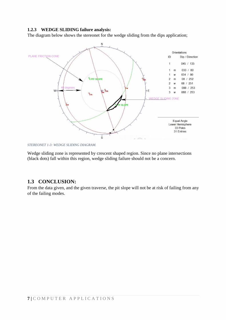
1.2.3 WEDGE SLIDING failure analysis:
The diagram below shows the stereonet for the wedge sliding from the dips application;
STEREONET 1-3: WEDGE SLIDING DIAGRAM.
Wedge sliding zone is represented by crescent shaped region. Since no plane intersections
(black dots) fall within this region, wedge sliding failure should not be a concern.
1.3 CONCLUSION: From the data given, and the given traverse, the pit slope will not be at risk of failing from any
of the failing modes.
8 | C O M P U T E R A P P L I C A T I O N S
2 CHAPTER TWO: THE CONTRIBUTION OF AN ENGINEERING
GEOLOGIST IN NATIONAL DEVELOPMENT
2.1 ENGINEERING: Engineering is a discipline that deals in designing of structures, machines and
electronics through the application of scientific knowledge and ingenuity.
2.2 Geologist: The scientist who has knowledge about rocks and soils which made up the Earth and
how they have changed since the Earth was formed.
2.3 ENGINEERING GEOLOGIST: A scientist who is charged to plan, design and construct geological engineering projects.
Engineering geologists commonly work with civil engineers, architects and planners, to ensure
that the geologic factors affecting the location, design, construction, operation and maintenance
of engineering works are recognized and adequately provided for. In other words, is concerned
with the study of geological materials and processes that may affect the construction, for
instance, dams, tunnels, mines, roads and buildings to ensure the safe development of
infrastructure.
2.4 CONTRIBUTIONS OF ENGINEERING GEOLOGIST IN NATIONAL
DEVELOPMENT: This caliber of engineers were given birth to, purposely, to combine knowledge from two
essential fields of studies which are geology and engineering. The main reason for this initiative
was as a result of the challenges geologist and engineers went through in the quest to administer
their skills at the job market and notwithstanding the quality of finished products they
produced. At the job market, say a building firm, geologist are solely interested in the make-
up of the Earth materials and putting names on them whilst the engineers on site are waiting
patiently for these geological names so as to apply their “so-called” mechanics on these Earth
materials. Little do they know that, they are linking two different aspects of science without
knowing the after effects of their actions. This is to affirm that, the composition of Earth
materials is not static at all locations on the Earth, so as their reactions to applied loads. The
strength and stability of some minerals are more desired than others. For the above reason,
“engineering geology” is included in the academic curriculum at higher institutions purposely
to trained scientist that are adequately equipped to collect data, interprets these data and design
an engineering solution to geological engineering projects.
The establishment of engineering geology as a sub-discipline of both geology and engineering
has seen so much achievements and desired more in the near future. Some failures that
surfaced before the existence of engineering geology are subsidence of structures, collapse of
buildings and failing of earth retaining walls, just to mention a few. These abysmal failures
accounted for loss of human lives, properties and money. An engineering geologist knows the
information to seek at the site, at any location and to interpret it accurately and advise the
engineer or design a model to solve the problem. With the help of engineering geologists,

9 | C O M P U T E R A P P L I C A T I O N S
projects such as construction of railroads, dams, highways, buildings and bridges have seen
great improvements relative to the past. This was achieved because of the inner understanding
of geology of the grounds and their specific geologic environments to engineering projects.
For instance, if a geologist says “granite”, an engineer taught of it as a very strong rock which
withstands adverse weather conditions and use it as such. But this same granite can contain
minerals that weathers easily with time, negatively affecting the strength of the rock, hence
the project. Currently, remote sensing, modelling of ground profile into three dimensional
shapes, among others are the technologies used by engineering geologists to improve their
working conditions. Overseeing the progress of specific contracts, planning detailed field
investigations by drilling and analyzing samples of deposits or bedrock and supervising site
and ground investigations are some contributions of engineering geologist.
2.5 CONCLUSION: Engineering geologists serve as a bridge between engineers and geologists. They contributed a
lot in diverse ways such as hydrogeology, civil engineering projects and environmental
protections projects as well. The achievements of engineering geologist in our society leaves
no doubt that they have really contributed to national development.
3 CHAPTER THREE: STAGES OF INVESTIGATION IN
ENGINEERING GEOLOGY.
3.1 INTRODUCTION: For any engineering geology project, investigation is one of the most important part which
reveals the real problems on the site. The data collected from these investigations either prior
to or after the project are put into model which will be studied to determine data viability. The
various stages of investigation in engineering geology are;
a. Project conception stage
b. Preliminary investigation stage
c. Main investigation stage
d. Construction investigation stage
e. Post construction stage investigation
Details of these investigations stages are given below;
3.2 PROJECT CONCEPTION STAGE: After the decision to initiate a project has been taken, a desk study is undertaken of all available
geotechnical, geological and topographical data. The proposed site and its environs should be
examined by an experienced engineering geologist. Collection of relevant information on
salient features of the project and layout map on regional scale on 1:50,000 and 1:250,000

10 | C O M P U T E R A P P L I C A T I O N S
depending on the size of the project. Collection of relevant drawings such as topographical
sheet, contour map prepared by the project if any showing reference points and bench marks
verifying the same on the ground, collection of observed cross sections, longitudinal sections.
Other information necessary for this stage:
1. All available geological and hydrogeological maps, memoirs and published articles in
the scientific journals aerial photographs at all scales.
2. Records of natural hazards such as earthquakes, hurricanes and avalanches.
3. Site investigation and construction reports for adjacent engineering projects.
4. Published articles on the geotechnical properties of the geological units to be found on
the site, hydrogeological and hydrological data, records of any past, present and future
human activities.
3.3 PRELIMINARY INVESTIGATION STAGE: The evaluation of a project at its conception stage may reveal significant gaps in basic
knowledge of the site, so that no recognition of likely problems is possible. In such a case some
preliminary investigation may be required to establish that basic knowledge. This would be
undertaken using relatively simple and inexpensive techniques, such as existing records (maps,
photographs, etc.), geological and engineering geological mapping, geophysics and perhaps
some boreholes. The boreholes could be undertaken partly as an experiment to determine the
best method for the boring, sampling and in situ testing to be undertaken in the main stage of
investigation. At the end of this stage there should be sufficient knowledge of the site to allow
design of the main ground investigation. The first two stages of investigation are sometimes
described as the reconnaissance investigation or feasibility investigation. If a number of sites
are being investigated prior to choosing one for development the feasibility investigation may
give sufficient information to allow the choice to be made.
3.4 MAIN INVESTIGATION STAGE: In the main investigation stage the work done should recover the information required to design
the engineering project. This information is obtained by whatever means are appropriate to the
ground conditions and the nature of the engineering work. It is possible that some of the
investigation work may be difficult and expensive to undertake because of problems of access
to the locations of boreholes or in situ tests. Often these problems are easier to overcome during
the construction of the project when earthmoving equipment is readily available and there is a
great temptation to postpone necessary investigation until construction begins. This temptation
should be resisted for it is possible that postponed items of the main investigation could reveal
ground conditions which would invalidate project design. The client always pays for a ground
investigation; the cheapest way is to commission one and the most expensive.
3.5 CONSTRUCTION INVESTIGATION STAGE: One of the unfortunate facts of site investigation is that the prognoses made in the investigation
reports resulting from the main investigation are seldom absolutely and totally correct. The
construction of the project quite often reveals discrepancies between the ground conditions
forecast and the ground conditions encountered. However, if the investigation is well done the
client will have been warned that some variations in particular aspects of the ground (e.g. depth
to bedrock) must be allowed for and in this way these variations need not cause significant

11 | C O M P U T E R A P P L I C A T I O N S
project re-design and can be accommodated in the contract. The ground conditions encountered
must be monitored, recorded and assessed. If no satisfactory assessment can be made on the
basis of the information recorded then additional investigations must be undertaken to obtain
further data and thence resolve any anomalies. Preparation of large scale 1:100/200 geological
map showing all geological discontinuities, elevation of foundation level as per block size of
the dam and dimension of other appurtenances, recommendation of treatment measures of
shear zones, fault zones in consultation with design engineers based on orientation, severity
and criticality of the features recording the same pictorially and in the text for future reference
and behaviour of structure. Suggestion of additional measures for enhancing safety and
competency of the structure, rock/structure inter relationship. Thorough evaluation of grouting
data and suggestion of additional holes and the sequence of grouting. Correlation of core
recovery, permeability and grout intake, analysis and recording of conclusion. In case of
tunnels, logging on 1:100/200 scale, suggestion of additional/reduction in support measures
concurrent with excavation and in case of large underground excavation verifying of projected
discontinuities in various components and to record their deviation/ change if any and re-
interpretation of the same. Checking up with stress data and to record distresses if
any and recommendation of remedial measures. Identification of appropriate locales for
instrumentation and to gather data on background information. Checking up prognostications
made regarding adverse features/conditions and their actual place of occurrence and suggestion
of final remedial measures. Constantly interacting with design/construction engineers for
suggestion of appropriate measures timely on a day-to-day basis.
3.6 POST CONSTRUCTION STAGE INVESTIGATION:
Adhering to codes on filling and emptying schedule while the structure is put into operation
for the first time. Observation of distress, analysis and suggestion of remedial measures.
Gathering instrumental data for analysis and assurance. In case of alarm signals, attempting
rectification in consultation with design/ construction engineers.
3.7 CONCLUSION: In conclusion, all the various stages of investigations have their peculiar significance to the
total investigation process. Also it can be deduced that without a serious detailed investigation
on a particular project, the project in question stand a great chance of failing. The investigation
process includes the parameters affecting the atmospheric conditions on the project, the
underground parameters are also thoroughly considered and the purpose of the entire project is
also considered. All this make the investigation process an important tool in all projects.
4 CHAPTER FOUR: TROPICAL WEATHERING, LATERITIZATION
PROCESS AND LATERITES.
4.1 WEATHERING OF ROCKS: Weathering of rocks is brought about by physical disintegration, chemical decomposition and
biological activity. The type of weathering which predominates in a region is largely dependent
upon climate, which also affects the rate at which weathering proceeds. The latter is also
influenced by the stability of the rock mass concerned, which in turn depends upon its mineral

12 | C O M P U T E R A P P L I C A T I O N S
composition, texture and porosity, and the incidence of discontinuities within it. Many rocks
were originally formed at high temperatures and pressures and a large part of the weathering
process consists of an attempt to reach a new stability under atmospheric conditions. High
temperature minerals occur in the ultrabasic and basic igneous rocks. Hence such rocks tend to
offer less resistance to weathering than the acid igneous rocks which are largely composed of
soda and potash feldspar, quartz and, to a lesser extent, mica. The latter two minerals are
particularly stable. Generally coarse grained rocks weather more rapidly than do fine grained
types of similar mineral composition.
4.2 TROPICAL WEATHERING: It is a prolonged process of chemical weathering which produces a wide variety in the
thickness, grade, chemistry and ore mineralogy of the resulting soils. The majority of the land
area containing laterites is between the tropics of Cancer and Capricorn.
4.3 LATERITIZATION PROCESS: Laterites are the products of intensive and long lasting tropical rock weathering which is
intensified by high rainfall and elevated temperatures. For a proper understanding of laterite
formation we must focus on the chemical reactions between the rocks exposed at the surface
and the infiltrated rain water. These reactions are above all controlled by the mineral
composition of the rocks and their physical properties (cleavage, porosity) which favour the
access of water. The second relevant factor for the formation of laterites are the properties of
the reacting water (dissolved constituents, temperature, acidity (pH), redox potential (Eh)
which are themselves controlled by the climate, vegetation and the morphology of the
landscape. Tropical and subtropical areas show generally a rather high annual precipitation but
its temporal distribution varies strongly from countries with pronounced and long lasting dry
seasons to equatorial areas with a more continuous precipitation. Chemical weathering slows
down in dry seasons at least above the fluctuating water table. Aqueous dissolution of minerals
proceeds when a chemical equilibrium is not arrived i.e. when the dissolved constituents are
removed in the water.
The chemical reactions are further controlled by the activity of water which is equal to one in
freely moving water but lowered within small pores in the soil. Stability and reaction rate vary
from mineral to mineral; e.g. quartz is more stable than feldspar. Minerals of the same species
e.g. kaolinite can show different crystallinity which equally controls their stability.
Strongest alteration proceeds at the surface of the parent rock whereas it is lower in the
regolith above the rock. The principal effects of the various factors on laterite formation are
well known but it is difficult to determine them in space and time in the field. In the practise
of laterite research most valuable information are obtained by detailed studies of complete
weathering sections (laterite profiles) reaching from the unweathered parent rock to the
strongly altered surface layer. Sections showing physical disturbances as erosion or importation
of transported material should be omitted to exclude effects other than weathering. An adequate
number of laterite profiles on different parent rocks has been analysed which enable a clear
understanding of the basic processes of lateritization.
A modern laterite definition should comprise all products of intensive tropical weathering
independent of their parent rocks, which strongly control the composition and the property of
the weathering product. Redbrown laterites on granites, granitic gneisses, clays and shale are

13 | C O M P U T E R A P P L I C A T I O N S
generally hard or harden after drying, whereas laterites and basalts are commonly friable and
show an intensive reddish colour. Lateritization on alkaline rocks (nepheline syenites,
phonolites) often results in formation of highly aluminous laterites (bauxites) with light colour.
On ultramafic rocks (serpentines etc.) forms very soft, yellow-brown Ni-bearing goethite
(nickel limonite ore). The described weathering products are formed by the same fundamental
weathering process and can therefore be interpreted as different members of a laterite family. A
scientific definition proposed in former papers of the author includes all laterite varieties but
excludes weaker weathering products (saprolites). Laterites are here defined as
advanced tropical weathering products with Si: (Al + Fe) ratios below definite limits which on
their part depend on the parent rock composition. This definition is criticized by Australian
geoscientists who prefer a definition allowing a clear identification in the field possibly by a
hand specimen. This request can indeed not be fulfilled considering the broad variety of the
lateritic weathering products. Even the most widespread laterites on acidic rocks cannot be
distinguished from many bog iron ores only by their appearance without additional information
allowing genetic conclusions. The figures below illustrate the formation processes of laterites:
Figure 4-1: A represent SOIL; B represent laterite; C represent saprolite, a less-weathered regolith; D represent bedrock.
Figure 4-2: laterite-saprolite cross-section.

14 | C O M P U T E R A P P L I C A T I O N S
4.4 LATERITES:
Laterites are soil types rich in iron and aluminium, formed in hot and wet tropical areas. Nearly
all laterites are rusty-red because of iron oxides. Historically, laterite was cut into brick-like
shapes and used in monument-building. After 1000 CE, construction at Angkor Wat and other
Southeast Asian sites changed to rectangular temple enclosures made of laterite, brick and
stone. Since the mid-1970s, some trial sections of bituminous-surfaced, low-volume roads have
used laterite in place of stone as a base course. Thick laterite layers are porous and slightly
permeable, so the layers can function as aquifers in rural areas. Locally available laterites have
been used in an acid solution, followed by precipitation to remove phosphorus and heavy
metals at sewage-treatment facilities. Laterites are a source of aluminium ore; the ore exists
largely in clay minerals and the hydroxides, gibbsite, boehmite, and diaspore, which resembles
the composition of bauxite. In Northern Ireland they once provided a major source of iron and
aluminium ores. Laterite ores also were the early major source of nickel. The picture below
shows a typical use of laterites:
Figure 4-3: a man cutting laterites into bricks.
4.5 CONCLUSION: Tropical weathering mostly occurs in the tropics, where there is much rainfall and sunshine to
speed up the process. Given the right conditions, the reactions between the rocks and the agents
of weathering can prolong to form laterites. The formation is a complex chemical reactions
where all types of chemical weathering can take place. Laterites on the other hand are useful
in building in the ancient times and even now in some communities.

15 | C O M P U T E R A P P L I C A T I O N S
5 CHAPTER FIVE: EFFECTS OF WATER ON THE ENGINEERING
PERFORMANCE OF ROCKS AND SOIL MASSES.
5.1 WATER, SOILS AND ENGINEERING: Soils consist of grains (mineral grains, rock fragments, etc.) with water and air in the voids
between grains. The water and air contents are readily changed by changes in conditions and
location: soils can be perfectly dry (have no water content) or be fully saturated (have no air
content) or be partly saturated (with both air and water present). Although the size and shape
of the solid (granular) content rarely changes at a given point, they can vary considerably from
point to point. First of all, consider soil as an engineering material - it is not a coherent solid
material like steel and concrete, but is a particulate material. It is important to understand the
significance of particle size, shape and composition, and of a soil's internal structure or fabric.
The term "soil" means different things to different people: To a geologist it represents the
products of past surface processes. To a pedologist it represents currently occurring physical
and chemical processes. To an engineer it is a material that can be:
Built on :( foundations to buildings and bridges).
Built in: (tunnels, culverts, basements).
Built with :( roads, runways, embankments, dams).
Supported: (retaining walls, quays).
Soils may be described in different ways by different people for their different purposes.
Engineers' descriptions give engineering terms that will convey some sense of a soil's current
state and probable susceptibility to future changes (e.g. in loading, drainage, structure, surface
level). Engineers are primarily interested in a soil's mechanical properties such
as: strength, stiffness, permeability. These depend primarily on the nature of the soil grains, the
current stress, the water content and unit weight.
5.2 WATER, ROCKS AND ENGINEERING: Rocks are considered to be hard and durable materials. By an excavation point of view, Rocks
are the earth materials that cannot be excavated without blasting. This definition clearly
excludes other kinds of earth materials such as soils, and glacial tills, etc. Here is another
engineering definition of rocks: The earth materials that do not slake when soaked into water.
For example, a thick loess deposit is regarded as rock geologically and regarded as soil in
engineering. Water finds its ways into rocks as a results some geological structures (fractures,
seams, fissures) serving as channels. They somewhat exert pressure on the rock. Rocks are
widely used in projects such as dams, buildings and roads.
5.3 EFFECTS OF WATER ON THE ENGINEERING PERFORMANCE OF ROCKS AND
SOIL MASSES: The strength of soils and rocks are affected when these engineering materials are saturated with
water. Consider a fully saturated clayey soil under a weight of a building, the building will be
subjected to subsidence since the soil will undergo consolidation (i.e. the removal of water
from the soil which results in a decrease in volume).

16 | C O M P U T E R A P P L I C A T I O N S
The influence of pore-water pressure on the behaviour of porous rock in the triaxial
compression tests is illustrated by Figure 5-1. A series of triaxial compression tests was carried
out on a limestone with a constant confining pressure of 69 MPa, but with various level of pore
pressure (0-69 MPa). There is a transition from ductile to brittle behaviour as pore pressure is
increased from 0 to 69 MPa. In this case, mechanical response is controlled by the effective
confining stress (σ3' = σ3 – u).
Figure 5-2: illustration of pore water pressure on porous rocks.
Water content in rocks and soil also turn to dissolve minerals in the materials and reduces the
strength and durability of them. For instance when a limestone is exposed to water, the calcium
carbonate in it dissolves into solution thereby rendering the limestone insufficient for
engineering projects. Most minerals that form the integral part of the rocks are dissolved. The
results of dissolving of minerals results in chemical weathering of the rocks into soils which
will eventually be eroded away.
Sub-soils of civil engineering projects which contain clay-size particles should be well noted
since saturated clayey materials will turn to have fit engineering properties at the beginning but
will eventually reduce in strength due to the removal of water from the pores. In dry seasons,
the ground water table reduces and the amount of water in the soil also reduced which implies
that the when investigations are done, they can be modelled and eventually used.
5.4 CONCLUSION: Water in rocks and soils can be of advantage or disadvantage on the engineering
properties/performance of the rocks and the soil masses.

17 | C O M P U T E R A P P L I C A T I O N S
6 CHAPTER SIX: ENGINEERING SIGNIFICANCE OF FOLDS AND
FAULTS:
6.1 FOLDS: A fold is a structure produced when an originally planar structure becomes bent or curved as a
result of deformation. Folds are an expression of a more ductile type of deformation that
produces gradual and more continuous changes in a rock layer, both in its attitude and
internally, as the rock accommodates to changes in shape. Below is typical diagram of a fold;
Figure 6-1: A TYPICAL DIAGRAM OF A FOLD.

18 | C O M P U T E R A P P L I C A T I O N S
6.2 FAULTS: A fault is a structure along which displacement has taken place. A fault plane can be vertical,
horizontal or at some angle in between whose orientation can be described by a strike and dip
measurement. If a fault plane (surface along which movement has taken place) is inclined to
the horizontal, the rock mass above it is the hanging wall and below it is the footwall. Below
is a typical diagram of a fault:
Figure 6-2:A DIAGRAM OF A FAULTING RESULTS.
6.3 ENGINEERING SIGNIFICANCE OF FOLDS AND FAULTS: They contribute to the permeability of rocks, which influences groundwater flow,
petroleum migration and accumulation.
They also allow the passage of hydrothermal fluids, some of which may carry valuable
metals and they serve as traps for mineral deposits.
Faults in particular can cause problems during constructions of deep-seated foundations
of sensitive infrastructures (plants of mines, tarmac) as they turn to weaken and creates
geological uncertainty in the design.
They also affect the total design of a project when encountered during excavations at
the site.
6.4 CONCLUSION: Folds are very important in petroleum engineering whilst geologist and mining engineers also
are very happy when they come across faults. But in civil engineering projects, faults poses
danger when they have come across them during excavation to foundations.

19 | C O M P U T E R A P P L I C A T I O N S
7 CHAPTER SEVEN: FOUR FACTORS THAT AFFECT THE
STRENGTH OF ROCK MATERIALS.
7.1 STRENGTH OF ROCK MATERIALS: The maximum stress a rock material can withstand at failure is its strength. The strength of a
particular rock type depends on some factors such as temperature, rock type, confining pressure
and time. These factors are briefly discussed in the following:
7.1.1 TEMPERATURE:
When temperature is high (deep in Earth's crust), rocks tend to deform ductilely and flow.
When this is low (at or near the surface) rocks tend to behave like brittle solids and
fractures. Temperatures also causes differential expansion and contractions in rocks, hence
causing ex-foliations. In tropical regions, where there is much sunshine and rainfall, it
speeds up weathering of the rocks. For instance, given the climate, basalt in the temperate
zones can be very strong due to the low sunshine whilst basalt in the tropics will weather
quickly as a results of the difference in climatic factors.
7.1.2 CONFINING PRESSURE:
Buried rocks are subjected to forces are applied equally in all directions. This "squeezes"
the materials in Earth's crust. Therefore, rocks that are deeply buried are "held together" by
the immense pressure and tend to flow rather than fracture. The strength of the rock is then
reduced.
7.1.3 ROCK TYPES:
Weak rocks that are most likely to behave in a ductile manner when subjected to different
stress, include rock salt, shale, schist, and limestone. Some rocks contain stable minerals
(quartz, feldspar) which are resistant to rock weathering whilst others contain unstable
minerals (pyroxene, olivine) which are less resistant to weathering. The strength of rocks
also depends on the arrangement of discontinuities in the rock.
7.1.4 TIME:
When forces are applied slowly over rocks for a longer span, rocks tend to display ductile
behavior and deform by flowing and folding.
7.2 CONCLUSION: All the factors that the strength of rocks are interrelated in the real situations. For instance,
when the rock type is made of weak/less resistant rock forming minerals, and is not subjected
to adverse weather conditions, the rock seems to be a stable one. On the contrary, this rock will
break down in no time, e.g. BASALT.

20 | C O M P U T E R A P P L I C A T I O N S
8 CHAPTER EIGHT: ENGINEERING PROBLEMS ENCOUNTERED
ON SOME SOIL DEPOSITS DURING CONTRUCTION:
8.1 GLACIAL DEPOSITS: A glacier, during its expansion, erodes the bottom and the sides of a valley, and when it retreats,
it leaves deposits of sediments called glacial drifts. Today glaciers cover about ten percent of
the Earth’s surface, but they were more extensive during the Pleistocene Epoch (which started
two million years ago). Their extension fluctuated several times and the last extensive one
occurred 20,000 to 15,000 years ago.
Melting of glaciers results in deposition of debris and creates a variety of landforms: bottom
moraines result from materials dropped directly from ice melting; lateral moraines originate
from debris eroded from valley sides, debris avalanches and rockfalls; medial moraines
originate when a tributary glacier merges with the main glacier; the arc-like ridge at the end of
glacier is called terminal moraine.
A common feature of moraine deposits is the spreaded grain size distribution curve. Since the
included materials range from cobbles to clays, these deposits are difficult to characterize in
terms of geotechnical properties.
Glacial lake deposits are usually composed of fine-grained materials and a relevant example is
represented by varved clays, alternating layers of grey inorganic silts and darker silty clays (of
a thickness less than 10 mm), transported I fresh water lakes by melt water. Usually the varve
consists of a lower part of coarsest particles deposited in summer and a finer-grained upper part
that sedimented in winter.
8.2 ALLUVIAL DEPOSITS: The Latin term alluvium was being used in antiquity to indicate the material left in place by a
river a flood event. For this reason alluvial deposits include detrital materials (gravel, sand, silt,
clay and mixtures of these) deposited permanently or in transit by flowing water. This
definition applies to deposits of streams in their channel as well as in the floodplain.
The alternating regime and the pattern of flow dictate the main features of these deposits: lateral
discontinuity and heterogeneity, presence of lenticular beds, of cross-bedded or evenly bedded
sands, silts and gravels and the spread of fine silts and clays across the floodplain.
Figure 8-1:ALLUVIAL DEPOSIT.

21 | C O M P U T E R A P P L I C A T I O N S
8.3 SWAMPY/PEATY DEPOSITS: Peat is an accumulation of partially decayed vegetation or organic matter that is unique to
natural areas called peatlands or mires. The peatland ecosystem is the most efficient carbon
sink on the planet because peatland plants capture the CO2 which is naturally released from
the peat maintaining an equilibrium. In natural peatlands the "annual rate of biomass production
is greater than the rate of decomposition" but it takes "thousands of years for peatlands to
develop the deposits of 1.5 to 2.3 m, although many other plants can contribute. Soils that
contain mostly peat are known as a histosol. Peat forms in wetland conditions, where flooding
obstructs flows of oxygen from the atmosphere, slowing rates of decomposition.
Landscapes covered in peat also have specific kinds of plants. Since organic matter
accumulates over thousands of years, peat deposits also provide records of past vegetation and
climates stored in plant remains, particularly pollen. Hence they allow humans to reconstruct
past environments and changes in human land use.
During constructions, swampy deposits have to be remove before foundations can be laid.
There is a lot of carbon dioxide gas inside peats which can react with the building materials to
reduce its efficiency. They increased the cost of the project through their removal from the site.
The design have to be change to suit the ground conditions.
8.4 CONCLUSION: In every construction, the location and climate determines the type of deposits that should be
expected and their problems to the project. Building in the temperate zones say Antarctica, the
type of deposit underlying the project should be glacier deposits. Building also in areas
susceptible to flooding, the deposit should be alluvial and a particular engineering design
should be use to suit the underlying soil.

22 | C O M P U T E R A P P L I C A T I O N S
REFERENCES:
1. Muckel, GB (editor) . Understanding Soil Risks and Hazards: Using Soil Survey to
Identify Areas With Risks and Hazards to Human Life and Property A report by the
United States Department of Agriculture, Natural Resources Conservation Service
and National Soil Survey Center, Lincoln, Nebraska (2004). Available online at:
ftp://ftp‐fc.sc.egov.usda.gov/NSSC/Soil_Risks/risk_low_res.pdf
2. Lawton EC, Fragaszy RJ, and Hetherington MD. "Review of Wetting-Induced
Collapse in Compacted Soil," Journal of Geotechnical Engineering, ASCE, 118-9
(1992) 1376-94.
3. Coduto, DP (2005) Foundation Design: Principles and Practices 2nd Ed. Prentice‐Hall (1999).