Embed Size (px)
Citation preview

Aerospace Applications of Perl
Presented by Ian KluftSilicon Valley Perl
Santa Clara, CaliforniaMarch 3, 2016

Aerospace Applications of Perl
● Perl and its libraries on CPAN are versatile● Aerospace applications cover lots of topics
– Navigation/mapping
– Aviation
– Satellites
– Astronomy
● Also some examples from my own projects

Introducing the presenter
● Hi! I'm Ian Kluft● From San Jose and a native
of the Bay Area● Software engineer
– Primarily Perl & C/C++ on servers & embedded/IoT
– Perl is my favorite language
● Currently working on my MBA
● Aerospace enthusiast– Commerical pilot & flight
instructor– Co-founder of Stratofox
Aerospace Tracking Team
– Participated in world records for amateur aerospace
● 1st amateur rocket launch to space (CSXT 2004, Nevada)
● 1st transcontinental/transoceanic Ham Radio balloon (CNSP 2011)

Navigation & Mapping
● I presented a year ago at SVPerl on Geographic Computation● Quick overview here because positioning is integral to
aerospace– Next 7 slides are a review from last year's presentation
● Then we'll move on to look at aviation, satellites & astronomy

Coordinate systemLatitude and longitude
● Any position on Earth has a coordinate● 3-dimensional positioning uses 3 numbers
– Latitude (north/south)
– Longitude (east/west)
– Altitude (relative to mean sea level/MSL)
● Latitude & longitude are specified in degrees● Altitude is specified in distance

Latitude and longitudeWhat kind of degrees?
● Not from a university● Not related to temperature● They are angles!● More precisely, angles from the
center of the Earth● Latitude = 0-90° up or down● Longitude = 0-180° either way
around
7
Earth is not a perfect sphere
● Earth is an ellipsoid: bulges out at equator– Centrifugal force from rotation causes this
● Geoid: mathematical models for Earth ellipsoid– Good models come from satellite measurement
● Coordinates must use the same geographic reference system– Otherwise comparing apples and oranges
– WGS84 most widely used coordinate system today
● Sea level and altitude are relative to this model

8
Lots of angles in Geospatial Data
● Many computations involve angles– Latitude and longitude are angles
● Manipulations use trigonometric functions● Trig functions use radians
– So numbers in degrees must be converted to and from radians
– One circle = 360 degrees = 2 * pi radians
– Radians derive 2 * pi from distance around circle relative to radius
● Math::Trig module on CPAN can do this for you

9
Great Circle Routes
● Great Circle: direct route over Earth's surface– Along a line that goes around
the sphere
– i.e. from San Jose to London crosses Greenland
– Flat-projection maps distort great circle routes to look like curves
Map generated by the Great Circle Mapper copyright © Karl L. Swartz. http://www.gcmap.com/

10
Great Circle Formulas
● See “Aviation Formulary” sitehttp://williams.best.vwh.net/avform.htm
● Distance between points● Course between points● Latitude of point on GC● Lat/lon given radial & dist● Intersection of 2 radials● Max latitude of a GC
● GC crossing a parallel● Intermediate points on a GC● Cross track error● Along track distance● Point known offset from GC
Many of these are in Math::Trig

11
Example: Great CircleDistance between points
● From scratch:
d=acos(sin(lat1)*sin(lat2)+cos(lat1)*cos(lat2)*cos(lon1-lon2))
● In Perl:
use Math::Trig 'great_circle_distance';
$distance = great_circle_distance($lon1, $lat1, $lon2, $lat2, $radius);
● Convert angles to radians● For the radius of the Earth, use 6366.71 km
– Don't forget to convert result from km to miles if needed

12
Navigation related Perl modules
● Net::GPSD3 – connect to GPSD v3 server so multiple processes can use a single GPS on laptop, IoT, drone, etc
● Geo::Coder – use online search sites to look up address of current location
● Geo::Cache – Look up geocaching sites nearby● Ham::APRS::IS – receive Ham Radio APRS positioning data,
open-sourced by the APRS.FI Ham Radio tracking web site● Many more
13
Aviation applications
● Adding to the navigation/planning capabilities…● Geo::METAR – decode text from airport weather observations● Geo::TAF – decode text from airport weather forecasts● Geo::ICAO – encode/decode international airport codes● And other variants of these

14
Aviation example:METAR weather observation (1/5)
#!/usr/bin/perl
use strict;
use warnings;
use Getopt::Long;
use LWP::UserAgent;
use HTTP::Response;
use XML::Simple;
my $url = "http://www.aviationweather.noaa.gov/adds/dataserver_current/httpparam?dataSource=metars&requestType=retrieve&format=xml&stationString=%s&hoursBeforeNow=4";
my @metar_fields = qw(observation_time temp_c dewpoint_c wind_dir_degrees
wind_speed_kt wind_gust_kt visibility_statute_mi altim_in_hg
sea_level_pressure_mb three_hr_pressure_tendency_mb wx_string
sky_condition vert_vis_ft maxT_c minT_c maxT24hr_c minT24hr_c precip_in
pcp3hr_in pcp6hr_in pcp24hr_in snow_in quality_control_flags
flight_category
);
my $ua = LWP::UserAgent->new();

15
Aviation example: METAR weather observation (2/5)
# convert temperature C to C & F
sub tempC2CF
{
my ( $tempc ) = @_;
my $tempf = int($tempc * 9 / 5 + 32 + .5); # .5 = round off
return sprintf "%dC/%dF", $tempc, $tempf;
}
# turn a sky condition structure into a string
sub sky2str
{
my ( $sky ) = @_;
if ( ref $sky eq "ARRAY" ) {
# handle arrays of cloud layers by recursive calls
my @result;
foreach my $layer ( @$sky ) {
push @result, sky2str( $layer );
}
return join " ", @result;
}
# report cloud layer
return $sky->{sky_cover}."@".$sky->{cloud_base_ft_agl};
}

16
Aviation example:METAR weather observation (3/5)
# get_metar function - download METAR by airport code
sub get_metar
{
my ( $code ) = @_;
my $url_with_code = sprintf( $url, $code );
print $url_with_code."\n";
my $response = $ua->get( $url_with_code );
if ( $response->is_error()) {
printf "%s failed: %s\n", $code, $response->status_line;
} else {
my $content = $response->content();
my $metar_tree = XMLin( $content );
print "$code:\n";
if ((!exists $metar_tree→{data})or (!exists $metar_tree→})
or (!exists $metar_tree->{data}{METAR})) {
print "unrecognized data: $content\n";
} else {
my $metar_ref = $metar_tree->{data}{METAR};
foreach my $metar ( @$metar_ref ) {
foreach my $field ( @metar_fields ) {
if ( exists $metar->{$field}) {
if ( $field eq "observation_time" ) {
print $metar->{$field}." ";
} elsif ( $field eq "sky_condition" ) {
print "sky: ".sky2str($metar->{$field})." ";
} elsif ( $field =~ /^(.*)_c$/ ) {
my $name = $1;
print "$name:".tempC2CF($metar->{$field})." ";
} elsif ( $field =~ /^(.*)_(kt|statute_mi|in_hg|degrees)$/ ) {
my $name = $1; my $unit = $2;
print "$name:".$metar->{$field}."$unit ";
} else {
print "$field:".$metar->{$field}." ";
}
}
}
print "\n";
}
}
}
}

17
Aviation example:METAR weather observation (4/5)
# main - get airport codes from command line, loop through them and get METARs
my $arg;
foreach $arg ( @ARGV ) {
get_metar( $arg );
}

18
Aviation example:METAR weather observation (5/5)
● Example usage: get_metar KRHV
krhv:
2016-03-04T01:51:00Z temp:19C/66F dewpoint:14C/57F wind_dir:320degrees wind_speed:4kt visibility:10.0statute_mi altim:30.050198in_hg sky: OVC@5000 flight_category:VFR
2016-03-04T00:51:00Z temp:19C/66F dewpoint:14C/57F wind_dir:0degrees wind_speed:4kt visibility:10.0statute_mi altim:30.050198in_hg sky: OVC@3500 flight_category:VFR
2016-03-03T23:53:00Z temp:21C/70F dewpoint:13C/55F wind_dir:320degrees wind_speed:11kt visibility:10.0statute_mi altim:30.041338in_hg sky: BKN@4000 OVC@6000 flight_category:VFR
2016-03-03T22:53:00Z temp:22C/72F dewpoint:13C/55F wind_dir:0degrees wind_speed:4kt visibility:10.0statute_mi altim:30.059055in_hg sky: BKN@4000 OVC@6000 flight_category:VFR

19
Satellite tracking
● Why would you want to track a satellite?– See visible passes of International Space Station (or Iridium Flares),
nighttime only– Ham Radio communication via OSCARs (Orbiting Satellite Carrying
Amateur Radio), day or night– If you make a commercial or research satellite, you'll build your own
ground station, day or night
● Astro::SpaceTrack – downloads satellite orbital elements● Astro::satpass – makes satellite pass predictions● Astro::App::SatPass2 – makes satellite pass predictions

20
Astronomy
● Astro::Sunrise – compute sunrise/sunset for your location/date● Astro::MoonPhase – compute phase of the moon for a date● Astro::Telescope – for astronomers accessing remote
telescopes● Various celestial database searches

21
Example: Missing rocket payloadat Black Rock Desert
Location: Black Rock Desert, Nevada
Problem: Rocket launched, payload missing● Soka University (Japan) students needed data● Payload was a “CanSat”, size of a soda can● AeroPac club knew rocket landing coordinates● Turned to Stratofox Aerospace Tracking Team● Transmitter batteries died before they contacted us● I wrote a Perl script to generate a grid search

22
Perl Script to Plot Search Grid
● Search area was 3x3 mile parallelogram– Top/bottom side east-west for typical non-storm wind direction
– Right/left sides NNE/SSW for typical storm wind direction
● Each side divided into 10 sections, 1584' long● 10x10 loop projects each computed waypoint● Command-line controls output to text or GPX● “gpsbabel” open source utility turns GPX into many formats
– Raw Garmin waypoint data for upload to GPS
– KML for display on Google Earth

23
Projecting Search Grid Waypoints
● Nested loop: i = 0-10 over, j = 0-10 up● Over = 270° heading, up = 330° heading● Convert lat/lon from degrees to radians● Use Great Circle projection formula
– Compute intermediate point from i “over”
– Compute final point from j “up”
● Convert new lat/lon from radians to degrees● Code available at slideshare.com with slides

24
Sample codeconvert feet to radians
● Convert distance in feet to radians over Earth's surface● Radians are angles – this is a tiny angle from center of Earth# conversion: distance in feet to radians
sub dist_ft2rad
{
my $ft = shift;
my $km = $ft / 3280.8399; # ft/km
return $km/6371.0; # divide by FAI standard Earth radius in km
}
25
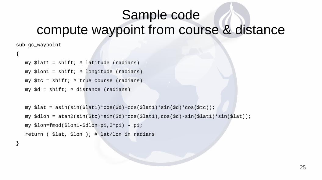
Sample codecompute waypoint from course & distance
sub gc_waypoint
{
my $lat1 = shift; # latitude (radians)
my $lon1 = shift; # longitude (radians)
my $tc = shift; # true course (radians)
my $d = shift; # distance (radians)
my $lat = asin(sin($lat1)*cos($d)+cos($lat1)*sin($d)*cos($tc));
my $dlon = atan2(sin($tc)*sin($d)*cos($lat1),cos($d)-sin($lat1)*sin($lat));
my $lon=fmod($lon1-$dlon+pi,2*pi) - pi;
return ( $lat, $lon ); # lat/lon in radians
}

26
Example codecompute coordinates of search grid point
# project a waypoint in the search area
# shape of a parallelogram with sides at headings 030 (NNE) and 090 (east)
# sides are on heading 1 (030 degrees) and heading 2 (090 degrees)
# increments are 0-10
# each increment is 1584 ft so that 10 of them is 3 miles
sub project_waypoint
{
my $h1_inc = shift;
my $h2_inc = shift;
# compute intermediate point on the first side of parallelogram
my ( $lat_r1, $lon_r1 ) = gc_waypoint (
deg2rad( $point_start[0]), deg2rad( $point_start[1]),
$h1_heading, $rad_per_increment * $h1_inc );

27
Example code (continued)compute coordinates of search grid point
# compute final projected waypoint in search area
my ( $lat_r2, $lon_r2 ) = gc_waypoint (
$lat_r1, $lon_r1,
$h2_heading, $rad_per_increment * $h2_inc );
# convert radians to degrees
my $lat = rad2deg( $lat_r2 );
my $lon = rad2deg( $lon_r2 );
return ( $lat, $lon );
}

28
Search Area Grid Map
Result of the script shown on Google Earth

29
Result: Success!!!
Expected to be worse than needle in a haystack
Payload found 2500' west of rocket landing site
30
Conclusions
● The sky is not the limit● You can have fun and learn a lot solving problems like these
Q & A