Embed Size (px)
DESCRIPTION
URBAN BASICS Urbanization and development: Historical Perspective An Academic Presentation to BdevS, Center for Development Studies Kathmamndu University 2014 Rajendra P Sharma [email protected]
Citation preview

URBAN BASICS Urbanization and development: Historical
Perspective
Rajendra P Sharma
An Academic Presentation to BdevS, Center for Development Studies
Kathmamndu University
2014
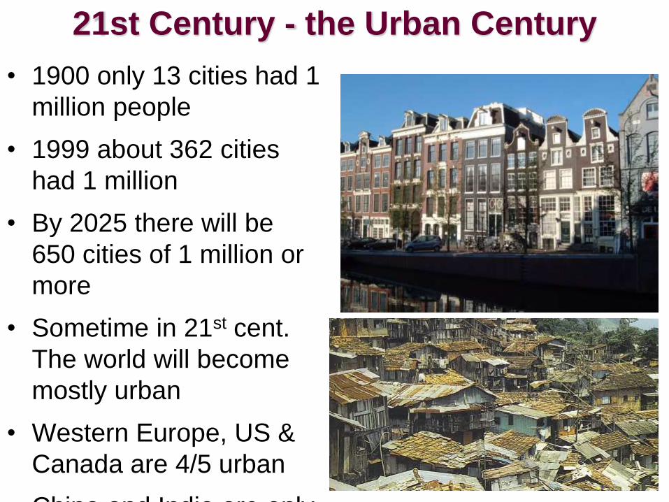
21st Century - the Urban Century
• 1900 only 13 cities had 1
million people
• 1999 about 362 cities
had 1 million
• By 2025 there will be
650 cities of 1 million or
more
• Sometime in 21st cent.
The world will become
mostly urban
• Western Europe, US &
Canada are 4/5 urban
• China and India are only

Urban Definitions
• Urban-The buildup of the central city and the suburban realm – the city and the surrounding environs connected to the city (a general term for towns, cities and suburban areas)
• City- a conglomeration of people and buildings clustered together to serve as a center of politics, culture, and economics (nucleated settlement with many functions and a central business district)
• Town-small than a city-less complex

Urban Definitions 2
• Central City-main city around which suburbs have grown
• Urbanized area-continuously built up area with buildings & population density with no reference to political boundaries
• Metropolitan area-a large scale functional entity containing several urbanized areas that are integrated as an economic

Urban
Morphology
The layout of a city,
its physical form
and structure.
Berlin, Germany
With wall (above)
And without wall
(right)

Ancient Cities
• Hearth Between 7,000 & 5,000 b.p. agricultural societies became more complex with irrigation & larger scale farming
• Stratified societies developed with priests, merchants, administrators, soldiers and farmers
• Central authority or the state developed which led to the rise of ancient civilizations such as Egypt, Greece & the

Attributes of Cities
• Centers of political power
• Centers of industrial power
• Centers of technology
• A market place for goods
• Specialization in products and services
• Cultural and Artistic
pursuits
• Centers of education
and research
• Entertainment of all
types
• Sports teams, arenas
and parks
• Medical advances

Five hearth of Urbanization
• Mesopotamia, 3500 BCE
• Nile River Valley, 3200 BCE
• Indus River Valley, 2200 BCE
• Huang He and Wei River Valleys, 1500 BCE
• Mesoamerica, 200 BCE

Five Hearths of Urbanization
In each of these hearths, an agricultural surplus and social stratification created the conditions
necessary for cities to form and be maintained.

Function & Location
Earliest civilizations probably
developed with the need for
organization to create
irrigation and provide enough
food
Availability of water, good
farmland and defensible
sites helped certain towns
thrive
Positions on travel & trade
routes created urban growth.
Urban elites or decision
makers evolved.


Theocratic Centers
• God-kings or theocratic rulers developed in some ancient cities.
• Priests, temples and shrines took center stage in the Yucatan, Guatemala and Honduras.
• They also served as educational centers with teachers and philosophers

Harappa and
Mohenjo-Daro were
two of the first cities of
the Indus River Valley.
- intricately
planned
- houses equal
in size
- no palaces
- no monuments
Indus River Valley

The Earliest Civilization

Roman Urban
System
• The Romans
created the largest
urban system with
an excellent
transportation
system
• The Romans were
masters of
engineering
efficiency creating
aqueducts, sewers,
roads, bridges and
great public


Nimes, France
Roman Road constructionRoman Road


Urban Growth
• China-rapid growth in the Han Dynasty period-Xian became the Rome of East Asia.
• Timbuktu developed in West Africa in the 14th
cent. While Meroe on the upper Nile developed advanced metallurgy.
• Tenochtitlan, the Aztec capital was the most advanced city in the world with 100,000 by the 16th cent.
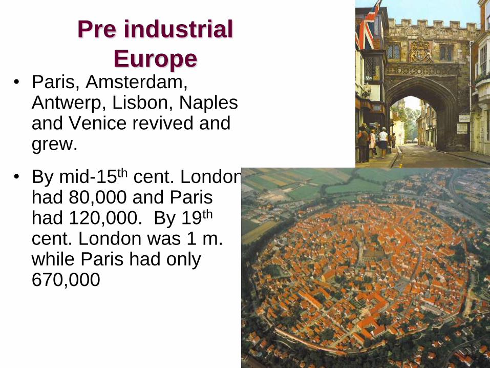
Pre industrial
Europe• Paris, Amsterdam,
Antwerp, Lisbon, Naples and Venice revived and grew.
• By mid-15th cent. London had 80,000 and Paris had 120,000. By 19th
cent. London was 1 m. while Paris had only 670,000

Urban Environments
• By 17th cent.
Europe’s cities were:
– Slum ridden
– Unsanitary
– Fire traps
– Plagued by
frequent epidemics
– Crime ridden
– Places of social
dislocation

Primate Cities
• Gideon Sjoberg was also
the first to study the
primate city.
• A nation’s leading city in
size that serves as an
expression of national
culture.
– Not necessarily large
– Dominated by religious
and govt. buildings
– Spacious with wealth near
the center
– Less privileged near the

The Modern Western City
• Medieval city was bleak and grimy with narrow dangerous streets.
• Unpaved streets provided poor sanitation
• The tallest buildings were the Church & Castle
• Mercantile cities of the 16th & 17th cent. were nodes of regional, national and international trade
• Great cities like London, Amsterdam, Lisbon and

The Second Urban Revolution
A large scale movement of people to cities to work in manufacturing. Made possible by:
1. second agricultural revolution that improved food production and created a larger surplus
2. industrialization, which encouraged growth of cities near industrial resources

The Modern Western City
• Manufacturing city
first developed in
Britain, later Western
Europe and North
America.
• Rapidly growing factory
system with railroads
and tenement slums
• Sanitary systems, water
supplies and housing
were overwhelmed with
rapid growth and

The Modern Western City
• Modernization of American cities took place in late 19th
cent.
• Electric trolley and other forms of mass transportation transformed cities-transport systems became circumferential and radial.
• Suburbanization of the city became possible with 1920s revolution of the automobile
• Modern cities of North America are sprawling expanses of suburbs,

• Hinterland - a German
word that means land
behind the city
• Spacing of cities-large
cities lie farther apart-
smaller settlements are
closer to each other
• Industrial Revolution
began in Europe-arrived
in the US around 1870-in
only 50 yrs. US surpassed
Europe
• 25 million European
immigrants arrived in

Urbanization and Location
• 1800-despite Ind. Rev. Europe was still rural-by 1950 Europe was 50% urban-today 85% urban
• World today is 50% urban
• Agglomeration-clustering of industries for mutual benefit
• Specialization-certain industries dominate certain regions-

• Urban Planners look at:
– How cities are arranged
– What cities look like
– Transport & communications
– Why people move from place to place
within the city
• Hinterland: the surrounding service area of
a city that includes smaller villages and
hamlets
• Centrality: the economic power or draw of a
place compared to its competition

• Hamlet-small collection of houses-may have services.
• Village-several dozen services-stores, gas stations and so forth
• Town-larger than a village-higher level of specialization-banks, schools, libraries, specialized stores-furniture, appliances, hardware, etc.
• City-more functional specialization-larger hinterland, greater centrality, well defined CBD and suburbs
• Metropolis or Metropolitan area-urban area larger than a city

Site and Situation
Site
absolute location of
a city
a city’s static
location, often
chosen for trade,
defense, or
religion.
Situation
relative location of
a city
a city’s place in the
region and the
world around it.

• Paris-situational
advantage-grew
as the hinterland
prospered;
became
multifunctional-
religious,
cultural, political,
industrial center;
today a
megacity of 10
million; the next
largest city is
Lyon, France at
1/7th the size
• A primate city

Eiffel Tower
built for the
1889 World’s
Fair

Paris’s 450 parks and gardens cover over 7,400 acres-
almost 30% of the city-one of Europe’s greenest cities.
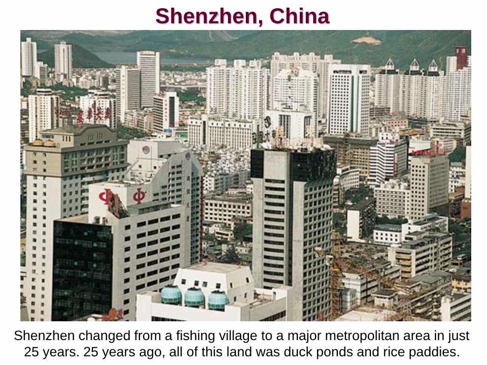
Shenzhen changed from a fishing village to a major metropolitan area in just
25 years. 25 years ago, all of this land was duck ponds and rice paddies.
Shenzhen, China

Modern Urbanization
Highest level of Urbanization-Western Europe, North America, Japan & Australia
70% & higher-Mexico, Cuba, France
Former Soviet Union-Russia-73%, Ukraine-70%, Transcaucasus-55%, Central Asia-28%
South America-cone of Argentina, Chile & Uruguay-highest urbanization-next Brazil & Venezuela, Paraguay, Bolivia, Guyana, Suriname & French Guiana lag behind.
Sub-Saharan Africa-some of the world’s lowest urbanization rates-Nigeria-16%, Ethiopia, Rwanda, Burundi & Uganda are even lower. Tropical Africa-only a few nations that are 40% or higher-South Africa-57% due to mining and industry.

Southwest Asia-North Africa-great variety of
urbanization.
Much of Middle East, esp. Arabian Peninsula are
highly urbanized due to nucleation of the oil
industry.
Jordan an exception-no oil wealth-but urban due
to long tradition
Southern Arabia is oil poor and rural
Contrast-oil rich Libya is urban, oil poor
Afghanistan is rural

South Asia-low in urbanization, despite huge
cities like Mumbai and Calcutta
Most nations in South Asia are under 30% urban
India-26%
Pakistan-28%
Bangladesh-16%
Subsistence farming
dominates life here

Southeast Asia- Singapore is the only 100%
urban state
Brunei & Malaysia are the only other nations with
over 50% urban
Indonesia-31%
Myanmar-25%
Vietnam-20%
Thailand-19%
Subsistence farming
dominates life here

East Asia- Averages 36%
Only Japan, South Korea and
Taiwan are highly urbanized in
East Asia
China below-25%
Yet Shanghai & Beijing
Have 25 million between
Them, however most of
China’s 1.2 m. are rural

Great Cities
• North America-several megalopolitan regions: Boston -Washington, DC
– Chicago-Detroit-Pittsburgh
– San Francisco-Los Angeles-San Diego
– Montreal-Toronto-Windsor
– Miami-Fort Lauderdale-West Palm Beach
• Europe:
– London-20 m. in Metro area
– Germany-Ruhr, Rhine zone of Dusseldorf-Essen & Cologne
– Poland-Saxony & Silesia
– Also Moscow, St. Petersburg & Madrid-not yet

• Asia-Tokyo-Yokohama, Osaka-Kobe-Kyoto
• Mega Cities:
• UN says by 2025 at least 15 cities will be over
20 million
– Many of the world’s most populous cities are found
in the poorest nations-Mexico City, Shanghai,
Calcutta, Mumbai & Cairo
– Close are Bangkok, Indonesia; Lima-Callao, Peru;
Saigon-Cholon, Vietnam
– Mexico City, Sao Paulo and Shanghai will have
over 30 million by 2025


Urban Problems
• Zoning laws are
lacking in many poor
countries
• Squatters occupy any
open space on the
outskirts of the city
• Sharp contrast between
fancy hotels of
downtown and slums
on outskirts


Urban Function
• Every city or town has an economic base.
• Basic sector-workers who produce goods for export or local consumption
• Non Basic sector or Service sector-workers who maintain the city, work in offices and provide services for others
• The number of Non basic sector workers is always greater than Basic sector workers-as cities increase in size the ratio increases
• Most large cities have a ratio of 1 to 2
• Multiplier Effect-if a business adds 50 manufacturing jobs-another 100 non-basic workers will be added to the work force

Central Place Theory• Central Places-hierarchy is based on population,
function & services.
• Economic reach-how functions & services attract
customers from areas beyond the urban limits.
• Centrality-the central position & ability to attract
customers to a village, town or city.
• Range of Sale-the distance people are willing to
travel to buy goods or services

Central Place Theory
• Christaller tried to determine the degree of centrality of various places.
• He created a model to show how central places in the urban hierarchy are spatially distributed.
• He assumed:
– No physical barriers
– Soil and surface of equal quality
– Even distribution of population

Hexagonal Hinterlands
C = city
T =
town
V =
village
H =

Functional Zonation
The division of the city into certain regions (zones) for certain purposes (functions).
Cairo, Egypt
Central city (above)
Housing projects (right)

Problems in Urbanization
200 years ago only 5% of world was urbanized
Today about 50% is urban
Germany, Spain & Belgium are over 90%
urban
World wide urban problems are:
pollution
poor sanitation
drugs and crime
congestion and noise
substandard housing & slums

Problems cont..
• With urban sprawl and
expanding suburbs-inner
city shrinks
• CBD is often reduced to
serving just the inner
metro area
• As basic sector jobs
leave-large cities have
shifted to service
industries
• Loss of tax base as
businesses, industries
and services leave

Urban Nepal : Then and Now

New Urbanism
• Development, urban revitalization, and
suburban reforms that create walkable
neighborhoods with a diversity of housing
and jobs.
• some are concerned over privatization of
public spaces
– some are concerned that they do nothing
to break down the social conditions that
create social ills of the cities
– some believe they work against urban
sprawl
Adopt and Execute appropriate
plan locally ..!
Thank you