Embed Size (px)
Citation preview

Spatial Thinking With Geotechnologies
Sara DamonStillwater Junior High School Minnesota Alliance For Geographic Education (MAGE)GeoJourneys K-12 GIS

Presentation and Resources
http://geotechk-12.wikispaces.com/home


Thinking Spatially …
Considering how people, places, phenomena are
organized and arranged on the surface of the Earth.
The “Whys” of “Where”

At A Variety Of Scales …

http://www.esri.com

Global Positioning Systems (GPS)
Remote Sensing
What Are Geotechnologies?
Geographic Information Systems (GIS)

Everyday Geotechnologies

Global Positioning System (GPS)

Remote Sensing• Gathering information
about something without touching it – Aerial photos– Satellite photos


Geographic Information SystemSoftware that captures, stores, analyzes,
manages and displays spatial data
Virtual Globes Web Maps Desktop GIS


ESRI =Environmental Systems
Research Institute

MN Now Has A Statewide ESRI License
http://tinyurl.com/pcd3hd3

K-12 ESRI State of Minnesota Site License Agreement
http://tinyurl.com/o7rjnsu
• ArcGIS Organizational Account (vs. Public)• ArcGIS Desktop• ESRI Virtual Campus Courses

MDE Partnering With GIS Professionals To Offer Teacher
Workshops This Summer

Connect ED
http://tinyurl.com/mtv6hmn

http://tinyurl.com/no599yn

“ArcGIS” Is Not Just One Tool

Pre-Made ArcGIS Maps
http://tinyurl.com/p5o3hz2

Story Maps
http://tinyurl.com/o3yl6wf

“Scripted Activities”
http://tinyurl.com/pvrdtcl

ArcGIS Online
http://tinyurl.com/nntdjtk

ArcGIS Online
http://tinyurl.com/nzuhahp

“ArcGIS” Is Not Just One Tool

ArcGIS Desktop
http://tinyurl.com/nzuhahp

Beyond This Week …
MAGE Professional Development

http://tinyurl.com/cczqmvn

U-Spatial
http://tinyurl.com/nzno99k

http://tinyurl.com/qykh5eb

Online Courses
http://tinyurl.com/owjpvsv

MOOCs
http://tinyurl.com/c686fma
http://tinyurl.com/qy7hn6e
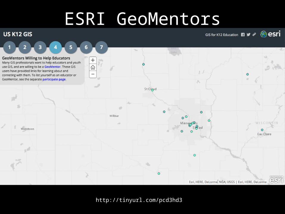
ESRI GeoMentors
http://tinyurl.com/pcd3hd3

ESRI Education User Conference
http://tinyurl.com/n8tn7y5

ESRI T3G Institute Summer 2016
http://tinyurl.com/mqz2bqr

http://video.esri.com/watch/3665/connecting-gis-with-education 4:35

Questions?

Tutorials#1: ArcGIS Online 5x5 (from ESRI)
#2: Make Your First Map With ArcGIS Online#3: Adding An ArcGIS Online Map to a WeExplore Expedition#4: Mapping CSV & GPX Data in ArcGIS Online#5: Creating A Landscape Change Over Time Lesson Relevant To Your School Location & Student Population#6: Make Your First WebApp With ArcGIS Online #7: Storytelling With ESRI Story Maps (from Joseph Kerski of ESRI)