Embed Size (px)
Citation preview

Plate TectonicsPart 1
Dr. Mark McGinleyHonors College and Department of Biological
SciencesTexas Tech University

Scientific Revolutions
• Sometimes a new viewpoint revolutionizes how we look at the world– Copernican Revolution
• Altered how we look at Astronomy
– Atomic Revolution• Altered how we look at Chemistry
– Darwinian Revolution• Altered how we look at Biology
– Plate Tectonics• Altered how we look at Geology

Plate Tectonics
• So far we have learned– The Earth is very old– Earth has change over time
• The position of the continents has changed over time!!!

Plate Tectonics
• History of the idea– Alfred Wegner• Continental drift
• What has happened?• Why it happens?– Mechanisms
• What plate tectonics allows us to understand?

Alfred Wegener
• German Meteorologist– 1880 – 1930

Wegener- Continental Drift
• The jigsaw fit of the continents, especially South America and Africa, suggest that they were together at one time
http://www.eoearth.org/article/Wegener,_Alfred

Wegener- Continental Drift
Mountain ranges and rock types match when South America and Africa are fit together, providing additional support that they were once connected. • In Wegener’s words “It is just as if we were to refit the
torn pieces of a newspaper by matching their edges and then check whether the lines of print run smoothly across”

Wegener- Continental Drift
Plants and animals are similar in Africa and South America, suggesting a connection in the past; this connection is better explained by drifting continents than by the prevailing theory of the time that a land bridge across the Atlantic has sunk below sea level. – http://www.classzone.com/books/earth_science/t
erc/content/investigations/es0802/es0802page02.cfm?chapter_no=investigation

Wegener- Continental Drift
Evidence for climates of the past, like glacial deposits in tropical regions, suggests that the continents must have been in different locations in previous times.

Wegner- Continental Drift
• To explain the drift, he argued that the continents are large blocks floating on the ocean crust, somewhat like icebergs floating in the ocean. – A possible driving mechanism for the movement is the
force of the spinning earth driving the continents away from the poles and toward the equator.
– He knew that this was the weakest part of his theory and he later replaced it with the suggestion of others that convection currents in the mantle are the cause, an idea now generally accepted as the most likely explanation.

Wegener- Continental Drift
• Wegener’s ideas were largely rejected by geologists of the day
• Continental Drift was not take seriously until the 1960s

Plate Tectonics
• http://www.youtube.com/watch?v=QDqskltCixA


Evidence

Good Info About Plate Tectonics
• http://www.bbc.co.uk/schools/gcsebitesize/science/21c_pre_2011/earth_and_space/continentaldriftrev1.shtml
• http://www.ucmp.berkeley.edu/geology/tectonics.html
• http://www.classzone.com/books/earth_science/terc/content/investigations/es0802/es0802page06.cfm?chapter_no=investigation
• http://pubs.usgs.gov/gip/dynamic/dynamic.html#anchor19978839

What is a Tectonic Plate?
• A tectonic plate (also called lithospheric plate) is a massive, irregularly shaped slab of solid rock, generally composed of both continental and oceanic lithosphere.
• Plate size can vary greatly, from a few hundred to thousands of kilometers across– the Pacific and Antarctic Plates are among the largest.
• Plate thickness also varies greatly– ranging from less than 15 km for young oceanic lithosphere to
about 200 km or more for ancient continental lithosphere (for example, the interior parts of North and South America).
http://pubs.usgs.gov/gip/dynamic/dynamic.html#anchor19978839

Tectonic Plates• How do these massive slabs
of solid rock float despite their tremendous weight?
• Continental crust is composed of granitic rocks which are relatively lightweight
• Oceanic crust is composed of basaltic rocks, which are much denser and heavier.
• Because continental rocks are much lighter, the crust under the continents is much thicker (as much as 100 km) whereas the crust under the oceans is generally only about 5 km thick

mechanism
• http://www.youtube.com/watch?v=ryrXAGY1dmE

Tectonic Plates
What’s Going on With the Ocean Floor?
• In 1947, seismologists on the U.S. research ship Atlantis found that the sediment layer on the floor of the Atlantic was much thinner than originally thought.
• Scientists had previously believed that the oceans have existed for at least 4 billion years, so therefore the sediment layer should have been very thick.
• Why then was there so little accumulation of sedimentary rock and debris on the ocean floor?

Mid-Ocean Ridge

Mid-Ocean Ridge• In the 1950s, oceanic exploration greatly expanded. • Data gathered by oceanographic surveys conducted by many nations led
to the discovery that a great mountain range on the ocean floor virtually encircled the Earth.
• Called the global mid-ocean ridge, this immense submarine mountain chain -- more than 50,000 kilometers (km) long and, in places, more than 800 km across -- zig-zags between the continents, winding its way around the globe like the seam on a baseball.
• Rising an average of about 4,500 meters(m) above the sea floor, the mid-ocean ridge overshadows all the mountains in the United States except for Mount McKinley (Denali) in Alaska (6,194 m). Though hidden beneath the ocean surface, the global mid-ocean ridge system is the most prominent topographic feature on the surface of our planet.

Mid-Ocean Ridges

Magnetic Striping• Beginning in the 1950s, scientists, using magnetic
instruments (magnetometers) adapted from airborne devices developed during World War II to detect submarines, began recognizing odd magnetic variations across the ocean floor.
• This finding, though unexpected, was not entirely surprising because it was known that basalt -- the iron-rich, volcanic rock making up the ocean floor-- contains a strongly magnetic mineral (magnetite) and can locally distort compass readings.
• This distortion was recognized by Icelandic mariners as early as the late 18th century. More important, because the presence of magnetite gives the basalt measurable magnetic properties, these newly discovered magnetic variations provided another means to study the deep ocean floor.

Magnetic Striping

Magnetic Reversals
• The Earth has a magnetic field, as can be seen by using a magnetic compass.
• It is mainly generated in the very hot molten core of the planet and has probably existed throughout most of the Earth's lifetime.
• The magnetic field is largely that of a dipole, by which we mean that it has one North pole and one South pole. At these places, a compass needle will point straight down, or up, respectively. It is often described as being similar in nature to the field of a bar (e.g. fridge) magnet.
• By magnetic reversal, or 'flip', we mean the process by which the North pole is transformed into a South pole and the South pole becomes a North pole.
Seafloor Spreading
• How does the magnetic striping pattern form?• Why are the stripes symmetrical around the crests of the
mid-ocean ridges? • In 1961, scientists began to theorize that mid-ocean ridges
mark structurally weak zones where the ocean floor was being ripped in two lengthwise along the ridge crest. – New magma from deep within the Earth rises easily through
these weak zones and eventually erupts along the crest of the ridges to create new oceanic crust.
– This process, later called seafloor spreading, operating over many millions of years has built the 50,000 km-long system of mid-ocean ridges.

Seafloor Spreading

Seafloor Spreading
• This hypothesis was supported by several lines of evidence.– (1) at or near the crest of the ridge, the rocks are very
young, and they become progressively older away from the ridge crest
– (2) the youngest rocks at the ridge crest always have present-day (normal) polarity
– (3) stripes of rock parallel to the ridge crest alternated in magnetic polarity (normal-reversed-normal, etc.), suggesting that the Earth's magnetic field has flip-flopped many times.
Seafloor Spreading
• By explaining both the zebralike magnetic striping and the construction of the mid-ocean ridge system, the seafloor spreading hypothesis quickly gained converts and represented another major advance in the development of the plate-tectonics theory.

Plate Boundaries
• Plates are moving so what happens at the boundaries between two plates?– Divergent boundaries -- where new crust is
generated as the plates pull away from each other.– Convergent boundaries -- where crust is destroyed
as one plate dives under another.– Transform boundaries -- where crust is neither
produced nor destroyed as the plates slide horizontally past each other.

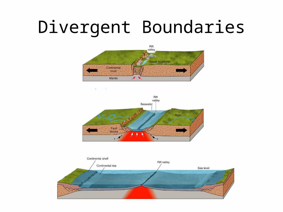
Divergent Boundaries
• Divergent boundaries occur along spreading centers where plates are moving apart and new crust is created by magma pushing up from the mantle.

Review of the Mechanisms Again
• http://www.youtube.com/watch?v=ryrXAGY1dmE

Divergent Boundaries
• Perhaps the best known of the divergent boundaries is the Mid-Atlantic Ridge. – This submerged mountain range, which extends from the Arctic
Ocean to beyond the southern tip of Africa, is but one segment of the global mid-ocean ridge system that encircles the Earth.
– The rate of spreading along the Mid-Atlantic Ridge averages about 2.5 centimeters per year (cm/yr), or 25 km in a million years.
– Seafloor spreading over the past 100 to 200 million years has caused the Atlantic Ocean to grow from a tiny inlet of water between the continents of Europe, Africa, and the Americas into the vast ocean that exists today.
Divergent Boundaries

Convergent Boundaries
• The size of the Earth has not changed significantly during the past 600 million years, and very likely not since shortly after its formation 4.6 billion years ago.
• The Earth's unchanging size implies that the crust must be destroyed at about the same rate as it is being created, as Harry Hess surmised.

Convergent Boundaries
• Such destruction (recycling) of crust takes place along convergent boundaries where plates are moving toward each other, and sometimes one plate sinks (is subducted) under another. The location where sinking of a plate occurs is called a subduction zone.

Convergent Boundaries
• The type of that takes place between plates depends on the kind of lithosphere involved. – oceanic and a continental plate– two oceanic plates– between two continental plates

Oceanic-Continental Convergence

Oceanic-Oceanic Convergence
• two oceanic plates converge, one is usually subducted under the other– in the process a
trench is formed

Mariana Trench• The Marianas Trench
(paralleling the Mariana Islands), for example, marks where the fast-moving Pacific Plate converges against the slower moving Philippine Plate.
• The Challenger Deep, at the southern end of the Marianas Trench, plunges deeper into the Earth's interior (nearly 11,000 m) than Mount Everest, the world's tallest mountain, rises above sea level (about 8,854 m).

Continental-Continental Convergence
• When two continents meet head-on, neither is subducted because the continental rocks are relatively light and, like two colliding icebergs, resist downward motion.
• Instead, the crust tends to buckle and be pushed upward or sideways

Continental-Continental Convergence
• The collision of India into Asia 50 million years ago caused the Indian and Eurasian Plates to crumple up along the collision zone.
• After the collision, the slow continuous convergence of these two plates over millions of years pushed up the Himalayas and the Tibetan Plateau to their present heights. Most of this growth occurred during the past 10 million years.

Mountain Building
• http://www.youtube.com/watch?v=loFxYSHxTf0

The Himalayas• The Himalayas, towering as
high as 8,854 m above sea level, form the highest continental mountains in the world.
• Moreover, the neighboring Tibetan Plateau, at an average elevation of about 4,600 m, is higher than all the peaks in the Alps except for Mont Blanc and Monte Rosa, and is well above the summits of most mountains in the United States.

Transform Boundaries
• The zone between two plates sliding horizontally past one another is called a transform-fault boundary, or simply a transform boundary.

Transform Boundaries
• Most transform faults are found on the ocean floor. They commonly offset the active spreading ridges, producing zig-zag plate margins, and are generally defined by shallow earthquakes.

Transform Boundaries
• However, a few occur on land, for example the San Andreas fault zone in California. This transform fault connects the East Pacific Rise, a divergent boundary to the south, with the South Gorda -- Juan de Fuca -- Explorer Ridge, another divergent boundary to the north.

San Andreas Fault
http://www.youtube.com/watch?v=ZxPTLmg0ZCw&feature=related

Summary of Convergence Zones