Embed Size (px)
Citation preview


Climate of Pakistan
A Presentation
ByMr. Allah Dad
Khan

Pakistan Introduction
The geography of Pakistan (Urdu ِک�ستان پا is a profound (جغرافیۂblend of landscapes varying from plains to deserts, forests, hills, and plateaus ranging from the coastal areas of the Arabian Sea in the south to the mountains of the Karakoram range in the north. Pakistan geologically overlaps both with the Indian and the Eurasian tectonic plates where its Sindh and Punjab provinces lie on the north-western corner of the Indian plate while Balochistan and most of the Khyber-Pakhtunkhwa lie within the Eurasian plate which mainly comprises the Iranian plateau, some parts of the Middle East and Central Asia. Gilgit-Baltistan and Azad Kashmir lie mainly in Central Asia along the edge of the Indian plate and hence are prone to violent earthquakes where the two tectonic plates collide.

Location of Pakistan
Pakistan is bordered by Afghanistan to the north-west and Iran to the west while the People's Republic of China borders the country in the north and India to the east. The nation is geopolitically placed within some of the most controversial regional boundaries which share disputes and have many-a-times escalated military tensions between the nations, e.g., that of Kashmir with India and the Durand Line with Afghanistan. Its western borders include the Khyber Pass and Bolan Pass that have served as traditional migration routes between Central Eurasia and South Asia


Water Resources
Hydrological power is a renewable resource which benefits Pakistan a lot. After the Indus Water Treaty on 1960 World Bank decided that River Sutlej, Ravi and Beas water will be used by India and River Indus, Jhelum and Chenab water will be used by Pakistan. Pakistan was told to built 2 Dams one Tarbela And second Mangla, 5 Barrages, 8 Link Canals and one gated siphon. For this India was told to Participate 60% while Pakistan will participate 40%. Pakistan is considering to develop wind turbines to fulfill the demand for electricity.solar power is now slowly flourishing but it is still installed on a small scale.

Water Resources
Pakistan Largest River is known as River Indus which Flows from Tibet China and Enters through Pakistan by KPK. River Indus Systen is Known as Indus System. It is divided Into Two Plains. Upper Indus Plain Which Starts From Northern Pakistan and ends Up to Mithankot. River Indus has Tributaries on both western and eastern side. River Indus eastern tributaries are River Jhelum, Chenab, Sutlej, Ravi and Beas. these Four Rivers Flow in Punjab. These four Rivers meet at Panjnad from where they are known as River Panjnad. River Indus western Tributaries are River Swat, Kabul, Kurrram, Tochi, Gomal, Zhob. These rivers join River Indus at KPK. At Mithankot these Rivers Finally Meet with River Indus. After this River Indus Flows Alone Through Lower Indus Plain. Lower Indus Plain Starts from Mithankot up to Thatta where River Indus Meets with Arabian Sea. This place is also known as Indus Delta.


Climate of Pakistan

Climate Of Pakistan
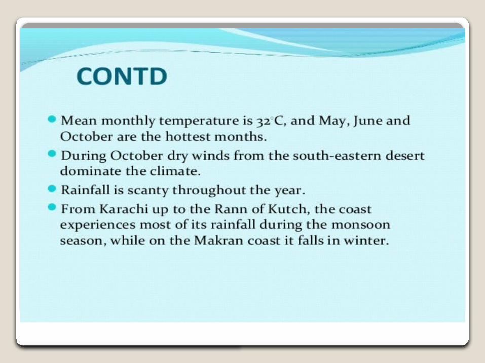
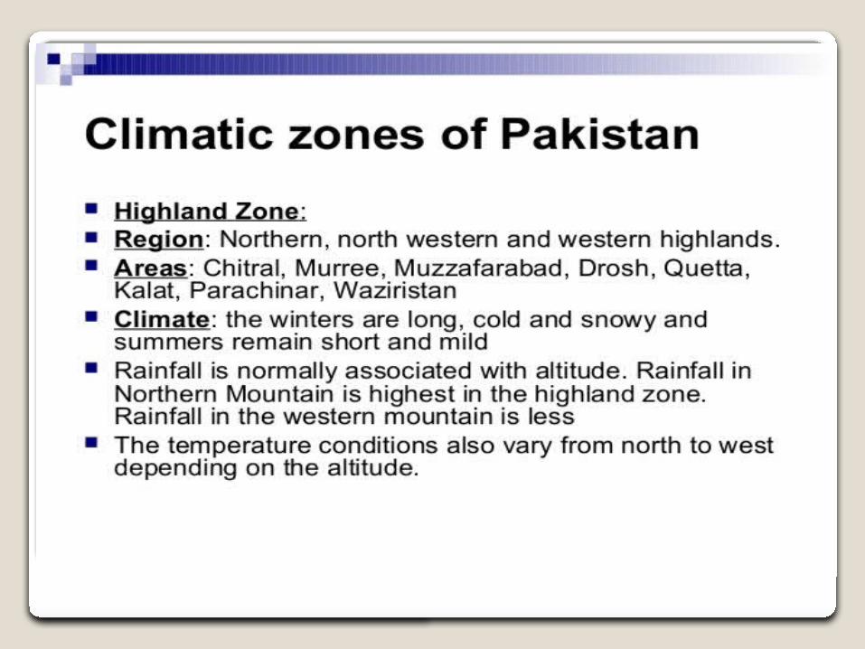
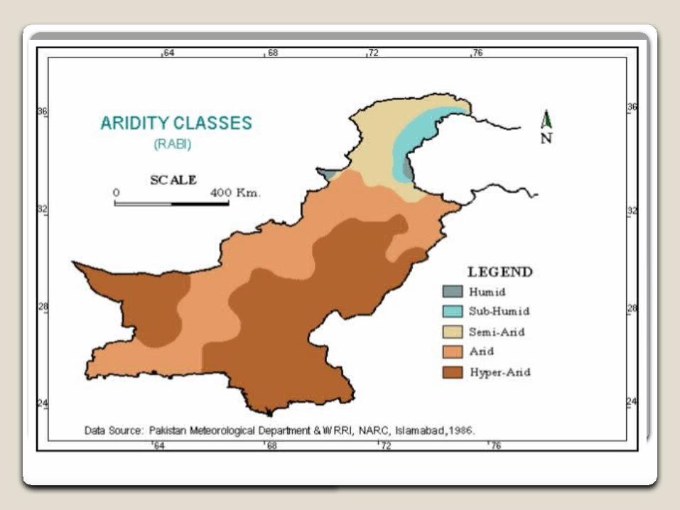
Pakistan lies in the temperatezone, immediately above thetropic of cancer. The climate varies from tropical to temperate. Arid conditions exist in the coastal south, characterized by a monsoonseason with adequate rainfall and a dry season with lesser rainfall, while abundant rainfall is experienced by the province ofPunjab, and wide variations between extremes of temperature at given locations. Rainfall varies from as little as less than 10 inches a year to over 150 inches a year, in various parts of the nation. These generalizations should not, however, obscure the distinct differences existing among particular locations. For example, the coastal area along the Arabian Sea is usually warm, whereas the frozen snow-covered ridges of the Karakoram Range and of other mountains of the far north are so cold year round that they are only accessible by world-class climbers for a few weeks in May and June of each year

Climate Of Pakistan
Pakistan is vulnerable to climate change because it is located in a region where temperature increases are expected to be higher than the global averages. The land area is mostly arid and semi-arid and the Himalayan glaciers, which are reported to be receding, primarily feed its rivers and its economy is largely based on agriculture. The country faces risks of variability in monsoon rains, floods and extended droughts.