The Pestalozzi Programme
Council of Europe Training Programme for education professionals
Pestalozzi
MEDIA LITERACY BASED ON HUMAN RIGHTS (ML)
“Redefining place and belonging through locative media and
digital storytelling”
by
Author: Ana Boa Ventura – Portugal
Editor: Pascale Mompoint-Gaillard
Training Resources
2
Pestalozzi Training Resources
MEDIA LITERACY BASED ON HUMAN RIGHTS (ML)
“Redefining place and belonging through locative media and
digital storytelling”
by
Author: Ana Boa Ventura – Portugal
Editor: Pascale Mompoint-Gaillard
Last edition: December 2012
The opinions expressed in this work are the responsibility of the authors and do not necessarily reflect the official policy of the
Council of Europe.
3
Pestalozzi Training Resources
Theme: Locative media and digital storytelling
Expected outcome
To explore the concepts of “place” and “displacement” in the context of mobility in Europe.
To understand the concept of Internally Displaced People (IDP) in Europe and in the world, today and in the past.
To become familiar with mobile storytelling, ‘geotagging’ and the use of locative media.
To promote civic responsibility and political engagement.
Target group
Brief description of the unit
Never before has mobility been so prevalent in Europe. The opening of borders (Schengen convention), economic exchanges
and reciprocity agreements among Europe countries have created a continental rather than a national scale, where job seekers,
families, students, etc., have become increasingly mobile. As these economic, technological and regulatory scenarios develop,
individuals are confronted with relocation, and becoming acquainted with a new neighbourhood, a new “locale”. Communities
are faced with the task of welcoming new populations; a reflection on Roma communities will be particularly relevant to the
reflection on new media and human rights.
How are these proliferating relocations affecting youth today? How are they appropriating the phenomena with fresh roots, new
language and shifting identities? The aim of this unit is to re-examine the concept of place and displacement in Europe. It stem
Type of training School level / age Subject area
Initial and in-service training Secondary All subjects, history, geography,
language, mathematics
4
Pestalozzi Training Resources
from the premise that documenting a place through storytelling (narratives posted online and geographically referenced)
stimulates one’s identification with a place and represents an opportunity to claim shared ownership and responsibility for it.
With sense of place comes a sense of belonging to a community that can counterbalance phenomena of social exclusion and
discrimination.
Methods/techniques used
On site, offsite and online collaborative work
Small and whole group discussion
Online research
Presentations
Time 34 hours (11 in meeting, 7 in field work, 16 online)
Activity 1 240 minutes
Activity 2 180 minutes
Activity 3 6 hours
Activity 4 120 minutes
Activity 5 12 hrs online
Activity 6 3 hours
Tips for trainers:
See tips in activities.
5
Pestalozzi Training Resources
Resources
Laptops + sufficient broadband internet access + fast computer
processors
Websites on story mapping, mobile storytelling and GPs drawing Appendix 1
Links to documents: IDP, mobility and locative media Appendix 2
On the social uses of imaging and personal photography Appendix 3
Playing Naval army w/GPS Appendix 4
Preparatory activity
Participants should complete the pre-reading prior to the training session (see appendix 1).
6
Pestalozzi Training Resources
Activity 1 Sense of place, sense of displacement and implications for social and political (dis)engagement
180 minutes
Notes
General aim:
To explore the concept of “place” in the current European socio-economic context.
To explore intersections between locative media (the technology), digital storytelling (the media
literacy dimension) and social engagement (the human rights aspect).
Specific aims:
To explore the concept of ”displacement” in the context of mobility in Europe.
To understand the concept of IDPs - Internally displaced People - in some regions in Europe today
and in the past.
Resources:
Online platform
Sufficient broadband internet connection
Websites on story mapping, mobile storytelling and GPs drawing (appendix1)
Links to documents: IDP, mobility, and locative media (appendix 2)
Flipchart or mind mapping software on main projector
Practical arrangements:
The room should be set up for group work with 1 computer/3 participants and one computer for
the trainers.
Instructions/procedure:
Present the session, its aims, processes and learning outcomes. Participants must have access to an
7
Pestalozzi Training Resources
online platform and consult the documents only before this activity.
Explain to the participants that they need to report on the online platform at least once a day
during the duration of the project.
In small groups, based on Docs 1, and 2 (appendix1), as well as on site self-guided online research,
they identify cases of IDPs in Europe. Participants should link this to their own experience and add
information accordingly.
In the large group, propose an overview of the possible causes for IDPs and human rights under
threat for these groups.
In small groups, based on Doc 3, they discuss about the redefinitions of the senses of “place” and
“displacement” in the context of job mobility in Europe today.
Whole group discussion on possible civic and political rights under threat, namely through a self-
disengagement with political life and social responsibility - due to “displacement”.
Start mapping concepts around 3 main areas – GPS, storytelling, place. Any participant can take the
floor and add elements. The result will be three clusters around the 3 modes (which coincide with
the three main areas of this topic). The facilitator can use a visual ‘mind mapping software’ (such as
Inspiration software) on main computer with projector or, if unavailable, use a flipchart.
The trainer discusses the material in the online platform and the participants are encouraged to
login and explore the platform prior to the next session.
Tips to trainers/anticipated difficulties:
Although the ultimate target group of this training unit is youth, the topic is to be discussed in a
framework that is engaging and relevant to the present audience: adults. For example, mobility in
Europe, as one of the causes for youngsters’ renegotiation of a sense of place, should be framed
from the point of view of the teacher / parent / professional.
Some of the topics are politically sensitive – such as the existence of high numbers of IDPS in
Europe – and should be dealt with tactfully.
Doc 1 on the Roma communities will be particularly relevant to the reflection on new media and
human rights.
8
Pestalozzi Training Resources
Debriefing/reflecting:
How is a “sense of place” being renegotiated in Europe today?
What relationship could there be between displacement and the disengagement with social and
political lives of the community?
How do mobile technologies affect the sense of place and/or displacement?
Can storytelling constitute a type of ownership of a place – and hence promote a sense of
belonging?
How can this counteract discrimination and promote social inclusion?
Can you think of innovative ways to represent a place in which you personally have a story/history
and that you would like to share with others? Can you give some examples based on today’s
session?
9
Pestalozzi Training Resources
Activity 2 Referencing places: ‘geotagging’
240 minutes + 1 hour online
Notes
General aim:
To reflect on the use of image in social work.
To become familiar with ‘geotagging’.
Specific aims:
To explore and define ‘geotags’ on Flickr and Google Earth.
To learn how to manipulate a GPS device for field work.
Resources:
On the social uses of imaging and personal photography (Appendix 3)
Instructions/procedure:
The trainer should engage the participants in a discussion to reflect on the issue of the use of
image in social work. Divide the large group into groups of 4. Give them selected topics. Each group
deals with a different topic. The facilitator may use questions involving the suggested aspects listed
below, adapted from Nancy Van House, Marc Davis, Morgan Ames, Megan Finn, Vijay Viswanathan,
(2005)1:
o Virtually everyone is in some way affected by personal photography – as photographer, subject,
or viewer. Personal photography is of great importance to many: as a record of important life
events, of children’s growing up, and of daily life. Among the few things that people rush to save
when their houses burn are their photos.
1 Nancy Van House, Marc Davis, Morgan Ames, Megan Finn, Vijay Viswanathan, (2005), The Uses of Personal Networked Digital Imaging: An Empirical Study of Cameraphone
Photos and Sharing. University of California at Berkeley and School of Information Management and Systems. Berkeley, CA, USA
10
Pestalozzi Training Resources
o Understanding the social uses of personal photography is of paramount importance today.
Demonstrating how people may use digital images when they have a camera, identifying how
ubiquitous networked digital image-capture and sharing may substantially change the ways that
people use personal photography; examining diverse social uses, in the context of networked
photo sharing: creating and maintaining social relationships; constructing personal and group
memory; developing self-presentation (influencing others’ view of oneself) and self-expression,
(Kindberg et al., 2005). Personal and group memory, relationships, self-orientation are but a few.
o Analysing the comfort level of different individuals with imaging: the potential risks implied
(respect of privacy, legal implications); risks involved with identification in context of citizenship
and legally documented residency (in the case of illegal immigration.), etc.
Have the groups share their findings in the large group and discuss the implication regarding this
particular training session.
The trainer conducts a short tutorial on the use of Flickr and namely its geotagging feature.
The participants are encouraged to explore this feature of Flickr individually by choosing a theme (a
thread) and gathering photo information about it.
To illustrate that Flickr is one among many similar tools, the trainer briefly showcases Picasa.
The trainer conducts a tutorial on the use of Google Earth.
The participants explore Google Earth looking for their particular neighbourhood.
The participants go outside to take photos, and are invited to later post them on their Flickr
account along with more pictures of the city they live in. Those who are more at ease with the
technology, will ‘geotag’ pictures by other participants.
The participants work in small teams exploring the resources in the Moodle Platform for the day.
Remind the participants to take pictures of the city they live in and post them on Flickr with the
day’s pictures under an account with their name.
Upload on the platform some resources for participants to browse: examples to showcase include
abstract and representational drawing (field work with a GPS device) to be included in the platform
from this source: www.gpsdrawing.com.
11
Pestalozzi Training Resources
Tips to trainers/anticipated difficulties:
Another option is for you to upload a collection of pictures of your own relative to the city where
the training is taking place. The participants could then be free to view them and, if applicable, tag
the photos in a way that is personally meaningful for them.
Be aware Google Earth’s resources are heavy and therefore may not run smoothly if the processor
of the computer you are using is not fast enough. Test, test, test.
Remind the participants that they will need to take some pictures and post them onto Flickr before
the upcoming session.
Debriefing/reflecting:
What is ‘geotagging’ and how can it be used with digital storytelling?
Explore other image sharing and video sharing online services that offer geotagging and post them
on the platform.
Discuss the costs of these services, the burden of keeping up to date with the technologies and
possible ways of dealing with this issue.
In what ways might you explore Google Earth in your own professional area?
12
Pestalozzi Training Resources
Activity 3 “The Human Pencil” - GPS Drawing: Describing a place using GPS (field work)
6 hours of filed work + 1 hour online
Notes
General aim:
To use one’s whole body as an interface (hence the expression “human pen”) between the GPS and
the space to explore (participants will draw their paths as they walk).
Specific aims:
To become familiar with possible outputs of the data collected with the GPS.
To understand how a GPS device works in ways that go beyond standard ways.
To explore scale on a GPS tracked walk.
Resources:
Detailed exploration of www.gpsdrawing.com
a GPS2
Instructions/procedure:
Each participant (or pair/group of participants depending on resources) is equipped with a simple
GPS device and walks following a pattern decided by her/him/them. Example: the railway of
tramways, the border of the planted area of a garden, individuals found along the path (by circling
them), etc.
Initial drawings are compared (outside, informally, around a table…).
Each participant learns how to download the initial drawing to a laptop.
2 For example: Garmin XXX. Having access to a GPS is not trivial. Some companies in Europe or smaller local stores may lend you some devices with the expectation that they
may get new customers. Some participants may be interested in acquiring these devices. If access is a problem, have larger teams working together.

13
Pestalozzi Training Resources
Participants in groups of 3 are to draw a composition – and must coordinate between them to
achieve the desired figure.
All participants proceed to a room where they now download the new drawings on their own.
Drawing of first walks (following physical structures) are shown by the facilitator as a slide-show,
while participants discuss how this descriptive language of a space can be characterized:
approximation, imprecision, scale, compromise, negotiation, teamwork.
Tips to trainers/anticipated difficulties:
It is important that the participants will be self-sufficient to turn on and off the device, switch
between representation modes on visor and download data (the result of the walk) to a laptop.
Using one’s body is not customary to many adults. There will be some first barriers to break. Be
sure everyone understands that there is no right or wrong way to do it.
Debriefing/reflecting:
Some individuals have described the activity we just did as GPS Drawing – as our bodies were acting
as a “giant pencil”. Did you have that feeling? Was the experience fun?
During the 1st walk, you were asked to follow a pattern. You selected a physical structure on the
terrain that you were interested in exploring and walked around it or marked that area in some way.
Let us revise all the physical structures that the participants covered here.
During the 2nd walk there was some teamwork involved and you were asked to literally draw
something. How was that experience compared to the first one? What role did scale play in
facilitating the project or making it harder?
What are the implication and possible uses of this activity in your professional contexts?
14
Pestalozzi Training Resources
Activity 4 Mobile storytelling project – planning and design
120 minutes + Field work + 1 hour online
Notes
General aim:
To explore intersections of civic/human and political rights – in the forms of civic responsibility and
political participation – and the appropriation of place (sense of place and sense of belonging).
Specific aims:
To identify stages in a mobile storytelling project that may serve as anchors for the project design
and production.
To promote the critical selection of process according to the umbrella concept to be explored.
Resources:
Large sheets of paper and crayons
Digital camera
Practical arrangements:
Set up the room for groups of 2.
Instructions/procedure:
Divide the group into pairs.
Given the technologies discussed, the participants can choose between three main directions: an
exploratory field work with GPS Drawing, using Google Earth, and/or a photo sharing service.
Independently of the locative medium chosen, there will be a story to be told about the chosen
place. This story can be told through photos or videos (cell phone or digital camera) and
supplemented with text.
15
Pestalozzi Training Resources
Make up a timeline that everyone agrees on for the next activity that will be completed online.
Tips to trainers/anticipated difficulties:
Prior to this activity, encourage the participants to revisit the projects showcased during the module.
Producing is only part of the work. The participants’ learning process is important but the work is
not concluded until it is disseminated – uploaded to the web. Therefore, the way of representing
data should not be ignored. Substance yes but form is a key element too. Aesthetics are important
as they may facilitate legibility. Insist on publication and distribution. Help the participants to think
about ways of presenting the results to an online audience so that it has an impact; the ‘product’
should be informative and elegantly designed.
Debriefing/reflecting:
Is the place you chose to document via GPS meaningful to you?
How important do you think it is that the place bears meaning to you?
How does this project design and implementation differ from other IT projects you may have worked
on?
In all of your project production, keep thinking about how it can promote a sense of place and/or
of belonging and how you can modify it to enhance that angle.
16
Pestalozzi Training Resources
Activity 5 Presentations and evaluation
12 hours online
Notes
General aim:
To become familiar with current projects in the field through self-guided and peer-guided online
research.
Specific aims:
To become independent in exploring GPS technology.
Resources:
Computers with Google Earth installed, and access to Flickr
Sufficient computer processor speed and broadband internet
Instructions/procedure:
The participants will upload on the platform a revised version of the draft written on the previous
onsite activity, along with proposed representation of story (and GPS data).
Each team has 48 hours to post feedback on two other teams of their choice.
The trainer is to post feedback for all teams.
Teams post revised plans and conduct the practical work.
Tips to trainers/anticipated difficulties:
Send reminders every day for those that may have not posted peer feedback in time.
Tell the participants that they may email you privately for specific matters that may not interest the
group or that they prefer to deal with one on one.
Debriefing/reflecting:
What are the specific challenges in designing an activity like this?
Is peer review proving useful?
17
Pestalozzi Training Resources
Activity 6 Presenting our projects and their relevance to the topic
180 minutes
Notes
General aim:
To re-frame the topic of place and displacement in the context of civic and political rights through
the promotion of civic engagement and political participation.
Specific aims:
To become very comfortable with emerging technologies used to innovatively describe place.
To become confident and self-sufficient with GPS technology in Education.
To discuss the redefinition of “sense of place” for youngsters today.
Resources:
Presentations made by participants
Assessment survey (see following page)
Practical arrangements:
Arrangements depend on whether you have a public forum or not. Please see tips below.
Instructions/procedure:
Group the participants so as to make small groupings, with no more than 4 projects per group.
Either mix groups who have not worked together on the platform and therefore are not familiar with
each other’s work, or organized a public forum. (See tips below).
Each group presents they projects for the other members (15 minutes per group = 1 hour maximum).
Questions for clarification are fine here, but discussion is left for later.
The whole group can now discuss the projects. The facilitator orient the discussion along specific
lines, following the expected outcomes of the training unit:
18
Pestalozzi Training Resources
o How are civic and political rights advanced through the promotion of civic engagement and
political participation in the projects?
o Do some of these projects address issues of discrimination or exclusion?
o What limitations can you foresee in the implementation of such learning activities with
youngsters in formal and non-formal education contexts?
o How can the projects be used within a school curriculum?
o What type of cross curricular approaches can be envisioned?
o What subject matters can be best used to piggy back?
o ...
The participants complete the survey.
Tips to trainers/anticipated difficulties:
When possible, the presentation is to be held in a public forum – for practice dissemination and
immediate feedback.
If finding a public forum proves to be difficult, alternatively the participants may present in a “studio”
setting to a team of 2 or 3 external experts (trainers’ guests) that would ask questions and provide
feedback.
Debriefing/reflecting:
Do you feel capable of conducting your own module on GPS storytelling?
Was there a process you particularly enjoyed (GPS Drawing, Google Earth, ‘Geotagging’ photos) and
why? Do you anticipate your trainers to have that same preference? How about the youngsters?
Was the ratio time/quantity of content right?
If we were to assign more time to one of the modules – what should that be?
19
Pestalozzi Training Resources
Debriefing/ Evaluation and assessment
The whole of activity 6 is an evaluation and assessment session, but the following survey questions can help the trainer
evaluate the whole unit and make improvements:
What can be improved? - for trainer
What would I do differently next time? - for participants
References
Brocklehurst M., (2003) Excerpt of Self And Place: A Critique Of The ‘Boundaryless Career - Stream 1: Identity:
Constructed, Consumed and Politicised ,The Business School, Imperial College
International Crisis Group (2002) - Return to Uncertainty: Kosovo
http://www.crisisgroup.org/en/regions/europe/balkans/kosovo/139-return-to-uncertainty-kosovos-internally-displaced-and-
the-return-process.aspx
Joyce Chang, May 15, 2008 blog post: Learning the Limits of Locative Media
http://www.pbs.org/mediashift/2008/05/learning-the-limits-of-locative-media136.html#
Van House N, Davis M. , Ames M., Finn M., Viswanathan V., (2005), The Uses of Personal Networked Digital Imaging: An
Empirical Study of Cameraphone Photos and Sharing University of California at Berkeley and School of Information
Management and Systems
UNDP Regional Bureau for Europe and the CIS (2006) At Risk: Roma and the Displaced in Southeast Europe” - new
report from http://europeandcis.undp.org/go/vulnerability
20
Pestalozzi Training Resources
Appendix 1: Websites for Activity 1
Story mapping
http://www.storymapping.org/
GPS + Storytelling
http://gps.bootchec.com/index_login.php?action=register
Mobile Storytelling How the World sees America
http://newsweek.washingtonpost.com/postglobal/america/england/
GPS drawing
www.gpsdrawing.com/gallery.htm
21
Pestalozzi Training Resources
Appendix 2: Documents for Activity 1
o On Internally Displaced People (IDP)
Doc1 UNDP Regional Bureau for Europe and the CIS (2006) At Risk: Roma and the Displaced in Southeast Europe” -
new report from http://europeandcis.undp.org/go/vulnerability
2006_romavuln_summary.pdf
Doc 2 International Crisis Group (2002) - Return to Uncertainty: Kosovo
http://www.crisisgroup.org/en/regions/europe/balkans/kosovo/139-return-to-uncertainty-kosovos-internally-displaced-and-
the-return-process.aspx
o On Job Mobility
Doc 3 Brocklehurst M., (2003) Excerpt of Self And Place: A Critique Of The ‘Boundaryless Career - Stream 1: Identity:
Constructed, Consumed and Politicised, The Business School, Imperial College:
“Drawing on evidence from a group of middle managers who had experienced a wide variety in terms of geographical
and job mobility, the paper indicates that career is not up to the task of providing a source of meaning and that the
boundaries provided by a sense of place are assuming an increasing significance.”
http://www.mngt.waikato.ac.nz/ejrot/cmsconference/2003/proceedings/identity/brocklehurst.pdf
brocklehurst.pdf
o On Locative Media
Doc 4 Learning the Limits of Locative Media – blog post by Joyce Chang, May 15, 2008
http://www.pbs.org/mediashift/2008/05/learning-the-limits-of-locative-media136.html#
22
Pestalozzi Training Resources
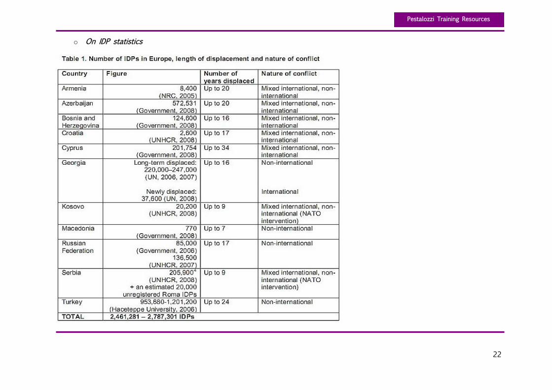
o On IDP statistics
23
Pestalozzi Training Resources
Appendix 3: On the social uses of imaging and personal photography (Activity 2)
o Virtually everyone is in some way affected by personal photography – as photographer, subject, or viewer. Personal
photography is of great importance to many: as a record of important life events, of children’s growing up, and of
daily life. Among the few things that people rush to save when their houses burn are their photos.
o Understanding the social uses of personal photography is of paramount importance today. Demonstrating how people
may use digital images when they have a camera, identifying how ubiquitous networked digital image-capture and
sharing may substantially change the ways that people use personal photography; examining diverse social uses, in
the context of networked photo sharing: creating and maintaining social relationships; constructing personal and group
memory; developing self-presentation (influencing others’ view of oneself) and self-expression (Kindberg et al., 2005).
Personal and group memory, relationships, self-orientation are but a few.
o Analysing the comfort level of different individuals with imaging: the potential risks implied (respect of privacy, legal
implications); the risks involved with identification in context of citizenship and legally documented residency (in the
case of illegal immigration.), etc.
Adapted from: http://www.stanford.edu/~morganya/research/chi2005-photos.pdf
Nancy Van House, Marc Davis, Morgan Ames, Megan Finn, Vijay Viswanathan, (2005), The Uses of Personal Networked Digital
Imaging: An Empirical Study of Cameraphone Photos and Sharing
University of California at Berkeley and School of Information Management and Systems
Berkeley, CA, USA
social use-photos.pdf
24
Pestalozzi Training Resources
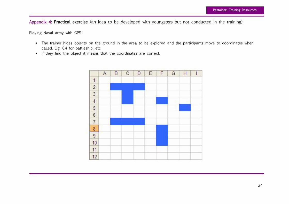
Appendix 4: Practical exercise (an idea to be developed with youngsters but not conducted in the training)
Playing Naval army with GPS
The trainer hides objects on the ground in the area to be explored and the participants move to coordinates when
called. E.g. C4 for battleship, etc
If they find the object it means that the coordinates are correct.
Recommended