Science MissionDirectorate
Suborbital Science Program
R&A Retreat30 March 2006 Cheryl Yuhas
2
Suborbital Science Programs
Objectives•Development of new space sensors and new remote-sensing techniques.
•Satellite calibration/validation.
• Targeted observations of ephemeral phenomena with variable temporal and spatial scales.
•Atmosphere/near-space in-situ observations.
•Improvement and evaluation of predictive Earth process models using satellite data.
•Next-generation scientists with hands-on sensor hardware and field experiment experience.
Add to the understanding and prediction of the Earth system. Suborbital observations fill time and space gap between surface observing networks and orbital platforms.
Sounding Rocket Program
Balloon Program
Aircraft & UAS Program

3
Restructure Objectives
Support focused science missions for satellite cal/valand process understandingMaintain and evolve an adaptive suite of platforms selected according to requirements of the science focus areas.Infuse new airborne technologies based on advances and developments in aeronautics, information technologies and sensor systems.Transfer proven capabilities to research, operational or commercial operators as widely available facilities for community-driven experiments or operational decision support systems.

4
Program Overview
Successful science missions accomplished & new capabilities introducedNew structure & team in place, with added focus on technology infusion of new capabilitiesRenew emphasis on improving reliability and responsiveness now that restructure is complete

5
Agenda
MissionsAircraft CatalogNew Technology PlatformAirborne SensorsInteragency activitiesPlans
Suborbital Science
Program Mgt & ScienceMissions
Catalog Aircraft
New Platform Capability
Dev
Airborne Sensors

2005 Suborbital Science Missions
Realmuto, Hook
ORCaravanMASTER, Optech LidarEarth Surface & Interior
Mount St HelensOct
HoodCosta Rica
ER-29 sensorsWeatherTropical Cloud Systems and Processes
Jun-Jul
KrabillAK, CATwin OtterATM/GPSClimateHubbard Glacier and Yakutat Foreland
Sept
SchoeberlNHDC-821 sensorsAtm. CompPolar AVEJan
SutharMS, LAWB-57AVIRIS, DCSCollaborationHurrican KatrianaDamage Assessment
Sept
NewmanTXWB-5719 sensorsAtm. CompHouston AVEJun
JensenTXWB-57IRIS, Harvard H2O, ALIAS, ARGUS, Panther
Atm. CompIsotope Intercomparison
Jun-Jul
WangCAER-2CoSMIR, MASCollaborationValidation of SSMIS w/ CoSMIR
Oct-Nov
FaheyCAAltairOC-PMVS, GCOI, DCS, REVEAL
CollaborationNOAA Altair Flt DemoApr-Nov
BlairCosta Rica
B-200LVISCollaborationLidar RS of Topography and VegStructure
Mar
Andres-DiazCosta Rica
WB-57MASTER, HYMAP, AVEMS, RC-30
CollaborationCARTA-IIFeb-Apr
KrabillGreenland, Arctic CA
Twin OtterATM/GPSClimateArctic Ice Mapping and ICESAT Cal/Val
May
AsnerHITwin OtterAVIRISCarbonNASA LBA-NACP Imaging Spec Studies
Jan
InvestigatorLocationPlatformINSTRUMENTFOCUS AREA
TITLEDATE

7
2006 SMD Missions
Costa Rica AVEStardust Re-entryINTEX-BArctic 2006Maldives AUAV Campaign (NSF w/NOAA & NASA)Low-altitude AVIRISWildfire Response Cloudsat/Calipso ValidationNASA-African Monsoon Multidisciplinary AnalysisNOAA/NASA Aerosonde low-level hurricane sampling

8
INTEX-B Mexico City Pollution from DC-8, Mar 16
March 19 Flight Plan:•Intercomparison with NSF C-130•Coordinated spiral with J-31•Validation of EOS Aura TES & OMI
SUBORBITAL SCIENCE UPDATE - INTEX-BNASA DC-8, Sky Research J-31, NSF C-130, DOE G-I, LaRC B200
Intercontinental Chemical Transport Experiment (Part B) – Deployment Schedule:Houston: Mar 1-20Hawaii: Apr 18-27Alaska: May 1-12
21 sensors•11 probes•2 lasers •Species measured:
•HOX, NOX,HNO4, SO2, O3, HCHO, H2O, CO, CO2, CH4•Aerosols

9
SUBORBITAL SCIENCE UPDATE – Arctic 2006NASA P3-B
Chukchi – 21 Mar
Alaska & Greenland:•P3-B with Kansas U snow radar, NOAA PSR, IIP D2P radar altimeter, ATM 4 laser altimeter•Validate EOS Aqua AMSR-E, ICESat, Envisat
10
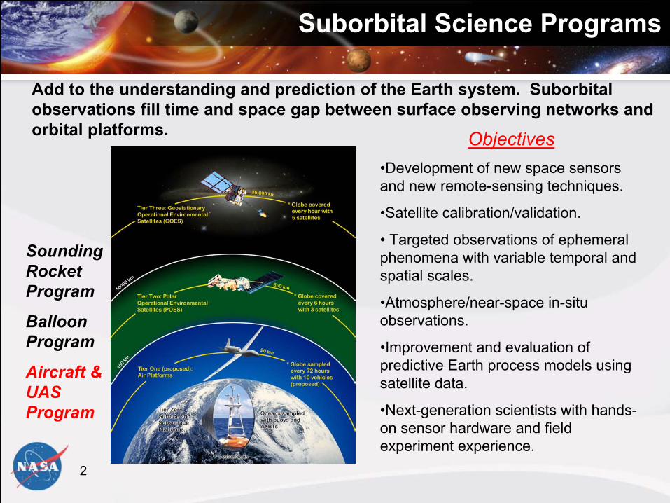
SUBORBITAL SCIENCE UPDATE – NSF Maldives Autonomous UAV Campaign, ACR Manta UAS
Maldives Hanimadhoo Island•3 Manta UAS in stacked formation, above, in, and below cloud•Aerosol properties•Black carbon•cloud microphysics•Broadband & spectral irradiances
NASA contributed funding, advised on mission success and flight operations procedures.
Lessons learned report coming.
Manta UAS•Advanced Ceramics Research, Arizona•Payload 15 lbs, 775 cu.in.•Endurance 6+ hours•Ceiling 16K ft•Airspeed 40kts

11
Catalog Aircraft
Hrly RateNASA
ER-2 DFRC $3700WB-57 JSC $3500 DC-8 UND $5000P-3 WFF $3000
Other NASA G-3, S-3, Learjet, KingAir $1K-$4K
CommercialTwin Otter/J-31/Caravan $1K-$2.5K
Other GovtDOE, NRL, NSF, NOAA $2.5K-$8K
12
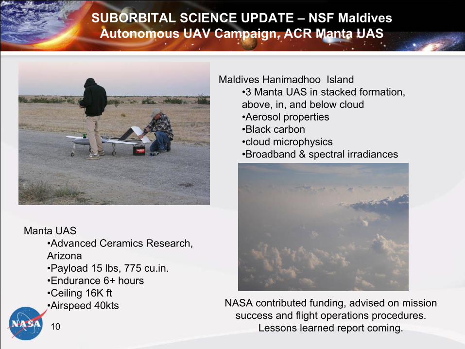
ER-2 Update
Periodic Depot Maintenance (PDM) complete on NASA 806New Business Model: Integration of ER2 into Dryden Aircraft Pool
• More cost savings through sharing of personnel and resourcesUSAF U2 phased fleet retirement—potential to be “windfall” for ER2:
• Free spare parts • Potential to take possession of engines, will eliminate lease fee paid to the
USAF

13
WB-57 Upgrades Status
Avionics Upgrade (accomplished)Main Landing Gear Upgrade (in work)Gross Weight Increase (in-work – funding approved)Superpods (in-work – funding approved)Autopilot with RVSM (on hold))

14
P-3 Back in Service!
Maintenance issues finally resolved, new aircraft services arrangedCompleted Arctic 2006 missionDue for Overhaul within next year

15
DC-8 Transition - ObjectiveEstablish the National Suborbital Education and Research Center to expand access to and
utilization of the DC-8 flying laboratory to a broader segment of the Airborne ScienceCommunity. Seek efficiencies in operating cost and explore the effectiveness of
collaborative operations embedding a NASA aircraft in a research university setting.

Science MissionDirectorate
DC-8 Transition - Accomplishments• Agency team approach to try this new model for airborne research
utilizing expertise & capabilities across Centers • Maintained rigorous safety standards which produced a history of
safe DC-8 operations & missions while at Ames and Dryden• Key experienced maintenance personnel and pilots continued with
the program to provide continuity of corporate knowledge• Safely and successfully executed DC-8 Stardust Mission and first
phase of INTEX-B mission

17
DC-8 Transition - Challenges• Demonstrating the ability to perform new science on the aircraft while reducing cost to
NASA (how large is the science demand for the DC-8 without NASA subsidized rates?)• Providing a reliable long-term housing plan for the aircraft which is not subject to impact by
Air Force priorities• Delegating appropriate responsibility to UND to allow innovation while preserving standard
of excellence in safety and mission success• Effective management structure clearly defining roles and responsibilities at NASA and UND

18
New Platform Technology Infusion
Earth Science Capability Demonstrations (ESCD) Project
The ESCD project is a partnership between the Science Mission Directorate and Aeronautics Research Mission Directorate
ESCD Projects:Precision Trajectories (UAVSAR)UAS Mission DemonstrationsUAS PlatformsCivil UAS Capability Assessment Over-the-Horizon Communications Development
19
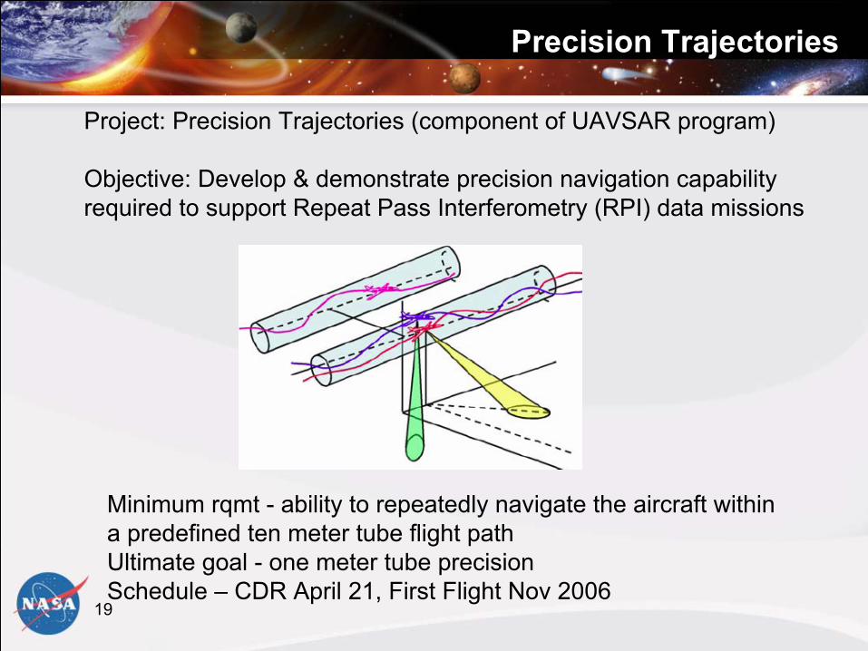
Precision Trajectories
Project: Precision Trajectories (component of UAVSAR program)
Objective: Develop & demonstrate precision navigation capabilityrequired to support Repeat Pass Interferometry (RPI) data missions
Minimum rqmt - ability to repeatedly navigate the aircraft within a predefined ten meter tube flight path Ultimate goal - one meter tube precision Schedule – CDR April 21, First Flight Nov 2006
20
UAS Mission Demonstrations
NOAA/NASA Altair UAV Demo (2005)NOAA/NASA Aerosonde Ophelia Demo (2005)REASoN WRAP Project (2006)• Small UAS Demo - June• Western States Fire Mission - August
Joint NOAA/NASA Hurricane Boundary Layer Sampling (2006)UAS Aura Validation Experiment (2007)Potential IPY experiment (2008?)

21
UAS Platforms
Objective: Acquire/operate UAS platforms for science missions
2005 Accomplishments:•Altair lease supported NASA/NOAA UAV Demo Mission•Ikhana (Predator B)
• July 06 delivery of Aircraft & Ground Control Station (ARMD Funded)
• Aircraft to be flown by NASA pilots•Small UAS: Aerosonde, Sierra•Global Hawk
• Completed Operations Concept Study • Continued discussions with Air Force to acquire flight test aircraft

22
Airborne Sensors
Airborne Science & Technology Lab Overview:
Resides in the NASA Ames University-Affiliated Research Center under the Ames Earth Science Division
Staffed by Univ. of California, Santa Cruz
Joint funding from Suborbital, EOS, and other programs
Provides Earth science mission support through:- Instrument/platform integration services- Data collections with Digital Tracking Cameras (DCS), MODIS
and ASTER Airborne Simulators (MAS, MASTER)- Community use of POS/AV precision navigation systems - Development of interface standards & cross-platform portability- Enabling technologies for UAV instruments & sensor webs- NIST-traceable calibration lab for spectro-radiometers
23
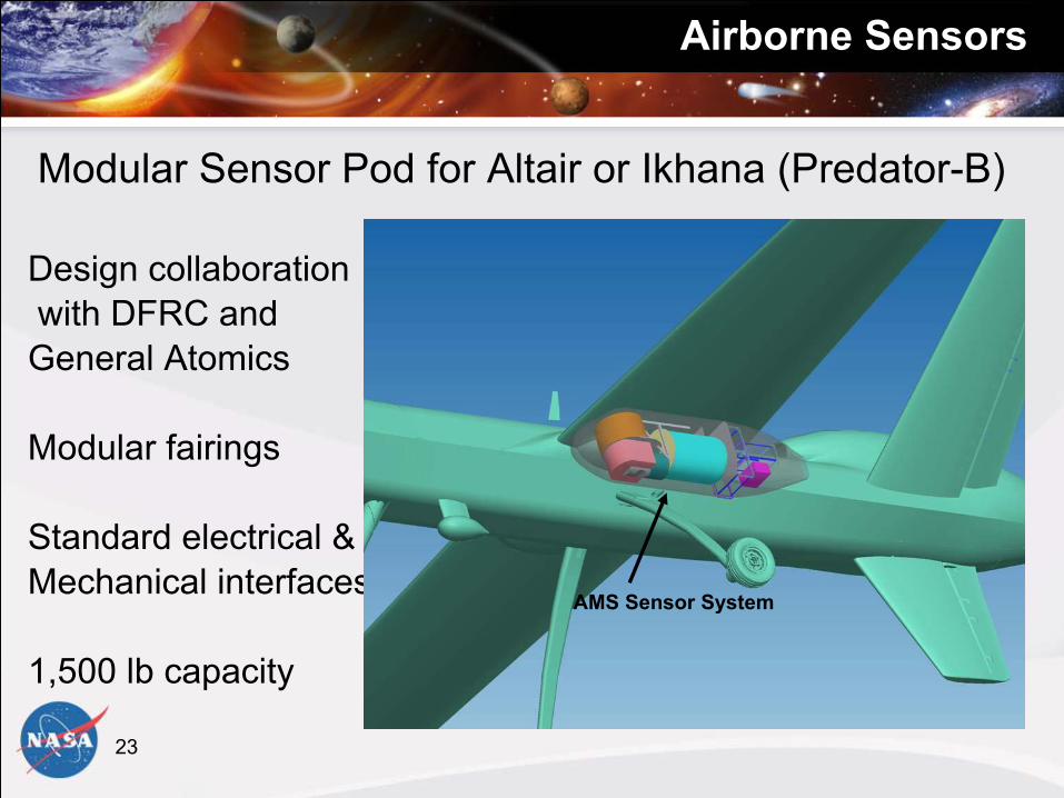
Airborne Sensors
Modular Sensor Pod for Altair or Ikhana (Predator-B)
Design collaborationwith DFRC and General Atomics
Modular fairings
Standard electrical &Mechanical interfaces
1,500 lb capacity
AMS Sensor System
24
Airborne Sensors
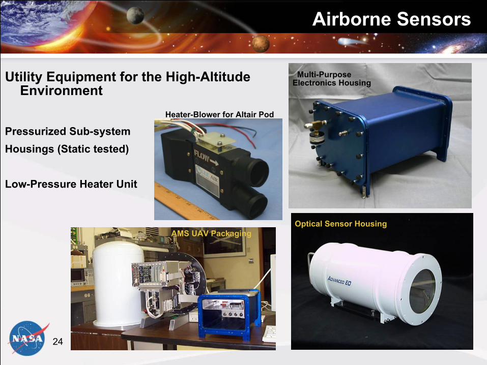
Utility Equipment for the High-Altitude Environment
Pressurized Sub-system Housings (Static tested)
Low-Pressure Heater Unit
Optical Sensor Housing
Multi-Purpose Electronics Housing
Heater-Blower for Altair Pod
AMS UAV Packaging
25
Interagency Activities
NOAA/NASA/DOE collaboration on UAS • MOU in final review• Workshops
http://uas.noaa.gov/interagency/index.html• Collaborative missions (Maldives, etc)
Interagency Coordinating Committee for Airborne Geoscience Research & Applications (ICCAGRA)• NSF, NOAA, NRL, ONR/CIRPAS, DOE, USGS• Data Systems subcommittee/interoperability
standards• Next meeting May 23 Monterey, CA at CIRPAS
26
Plans
Call Letter/website April 7, improve coordination with ROSESStudies & Requirements Analyses • Congressional UAS Report: March• Civil UAS Assessment: April• Telemetry/Communications Requirements: May• 5-Year plan: June• Altair/Ikhana Polar Operations Feasibility Study: September• Gap Analysis and Technology Roadmap in 2007
2007 platforms anticipated to be same as 2006, with the additionof the Ikhana UAS; priority is to balance platform availability with science mission prioritiesRemaining major 2006 missions:• Cloudsat/Calipso Validation• N-AMMA• Western States Fire • NOAA/NASA Aerosonde low-level hurricane sampling

Science MissionDirectorate
Suborbital Science Backup
28
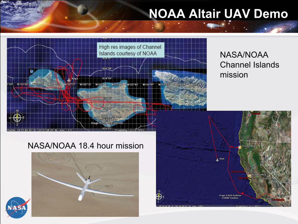
NOAA Altair UAV Demo
NASA/NOAA 18.4 hour mission
NASA/NOAA Channel Islandsmission

29
Low-level Hurricane WindsAerosonde Flight - Ophelia 16 Sep. 2005
•NOAA WP-3D Stepped Frequency Microwave Radiometer (SFMR) Surface winds in light blue, Aerosonde winds in black, buoy winds in dark blue.
•Aerosonde closest approach to wind center was 30 nm southwest and 25 nm northeast. Peak winds at 2500 ft were 65 kt southeast of center and 75 kt north of center.
•Excellent agreement was found between buoy, SFMR and Aerosonde winds adjusted to surface values. SFMR winds SW of center were within 10 min of aerosonde.
FIRST EVER UAV TO FLY INTO A TROPICAL CYCLONE
30
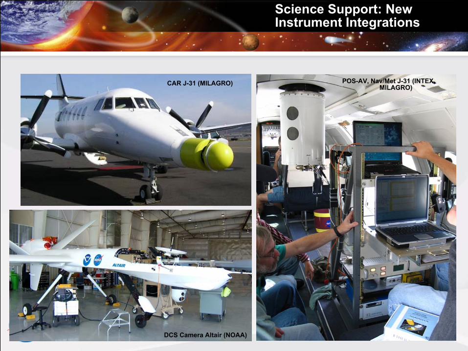
Science Support: New Instrument Integrations
CAR J-31 (MILAGRO)
DCS Camera Altair (NOAA)
POS-AV, Nav/Met J-31 (INTEX, MILAGRO)
31
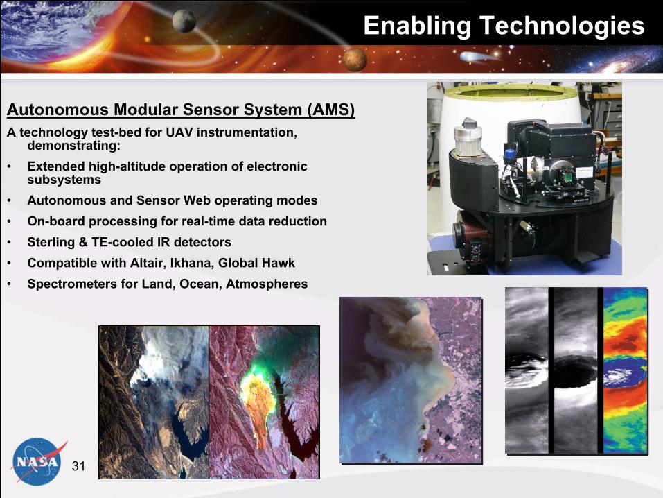
Enabling TechnologiesEnabling Technologies
Autonomous Modular Sensor System (AMS)A technology test-bed for UAV instrumentation,
demonstrating:• Extended high-altitude operation of electronic
subsystems• Autonomous and Sensor Web operating modes• On-board processing for real-time data reduction• Sterling & TE-cooled IR detectors• Compatible with Altair, Ikhana, Global Hawk • Spectrometers for Land, Ocean, Atmospheres

32
Enabling Technologies
Telemetry Link Module:
A Universal Interface to the Altair Ku-Band Telemetry SystemInputs for >20 instruments; Up To 40 Mbs ThroughputS/W Configurable, Multiple Interface ProtocolsFast CPUs & Solid State Storage For Experimenter Data & AlgorithmsDeveloped under the UAV Wildfire REASON-CAN & AMS Sensor ProjectInitial deployment on the Western States Fire Mission
Recommended