Embed Size (px)
Citation preview
Forest Stewardship Council®
Ecosystem Services Programme
January 2016
1 of 24
FSC International Center GmbH · http://ic.fsc.org/ · FSC® F000100
Charles de Gaulle Strasse 5 · 53113 Bonn · Germany
T +49 (0) 228 367 660 · F +49 (0) 228 367 66 30
Geschäftsführer | Director: Dr Hans-Joachim Droste
Handelsregister | Commercial Register: Bonn HRB12589
Ecosystem Services Certification Document (ESCD) for Sesaot forest, Lombok island, Indonesia
Introduction
FSC-STD-60-004 International Generic Indicators (IGI) specifies that when a certified forest management organization
makes FSC claims regarding the maintenance and/or enhancement of ecosystem services, Annex C is followed regarding
additional requirements, including the development of a publicly available Ecosystem Services Certification Document.
In the Ecosystem Services Certification Document, the certified forest management organization shall list the declared
ecosystem service(s), state the desired ecosystem service(s) claim, and describe: the status and management of, and
threats to, the declared ecosystem service(s); the methodology used to evaluate the impacts of management activities on the
declared ecosystem service(s); the results of impact assessment; a list of those involved in activities related to the declared
ecosystem service(s); and a summary of culturally appropriate engagement with Indigenous Peoples and local communities.
The Ecosystem Services Certification Document, along with FSC claims for the maintenance and/or enhancement of
ecosystem services, can be used to improve market access to ecosystem service payments by increasing the confidence of
potential buyers or investors.
The Ecosystem Services Certification Document is subject to assessment as part of a forest management evaluation by
certification bodies.
2 of 24
Ecosystem Services Certification Document (ESCD) for Sesaot forest, Lombok island, Indonesia
Part I: Information regarding the demonstration of impact
Declaration of the ecosystem services for which a claim is being or will be made
Please state the ecosystem service(s) for which you are making or plan to make FSC claims for the maintenance and/or
enhancement of ecosystem services. You can choose more than one option.
Carbon sequestration and storage
Watershed services
Biological diversity conservation
Soil conservation
Recreational services
1. Core information regarding the demonstration of impact
Declared
ecosystem
service (ES)
FSC ecosystem
service claim (from
Annex I of FSC-
PRO-30-002 –
ForCES field
testing draft)
Associated
impact indicator
for the claim
(from Annex I of
FSC-PRO-30-
002)
Baseline level
of the impact
indicator
Verifiable target
for the impact
indicator
Key management activities and
strategies to reduce threats and
maintain and/or enhance the
ecosystem service
Results of
impact
assessment
(see section 6)
Watershed
Services
Enhance water
quality (forest
cover)
Area of forest
cover
2009 Land
cover based
on normalized
difference
vegetation
index (NDVI):
Increased
planting in
degraded areas
with the target of
600 trees/ha or
125–150 trees
• Plant non-timber forest
products (NTFPs) and multi-
purpose tree species (MPTS) in
the degraded forest
NDVI in 2016:
Increase in
‘middle
vegetation’
forest class
from 22.3 ha
3 of 24
22.3 ha
classified as
‘middle
vegetation’
class forest
per person in the
area to be
certified
• Set buffer zones to protect
springs
• Protect springs through
replanting of adjacent areas
(e.g. planting bamboos)
• Map deforested areas to
identify planting areas around
the springs
• Monitor high conservation value
(HCV) area to conserve areas
with high diversity and areas
that potentially have other water
springs
• Collect data on and monitor
temperature, soil type, and river
flow to support the analysis of
water flow and debit
• Created nursery with quality
seedlings
• Intensive ground check for
degraded areas in the KMPH
areas, which would be
replanted in the short term
• Intensive monitoring of
hydrology (water debit,
temperature, and rainfall)
• Conducted ground check in the
field to verify the composition of
tree planting
(2009 baseline)
to 35.8 ha
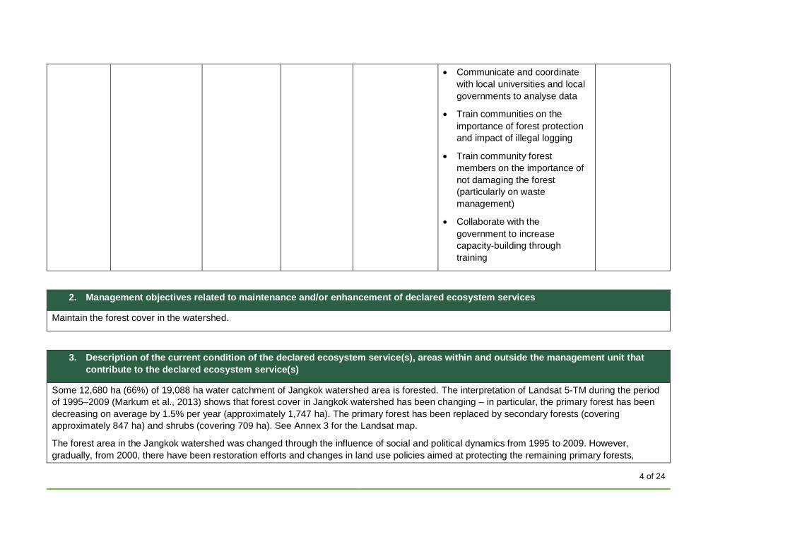
4 of 24
• Communicate and coordinate
with local universities and local
governments to analyse data
• Train communities on the
importance of forest protection
and impact of illegal logging
• Train community forest
members on the importance of
not damaging the forest
(particularly on waste
management)
• Collaborate with the
government to increase
capacity-building through
training
2. Management objectives related to maintenance and/or enhancement of declared ecosystem services
Maintain the forest cover in the watershed.
3. Description of the current condition of the declared ecosystem service(s), areas within and outside the management unit that
contribute to the declared ecosystem service(s)
Some 12,680 ha (66%) of 19,088 ha water catchment of Jangkok watershed area is forested. The interpretation of Landsat 5-TM during the period
of 1995–2009 (Markum et al., 2013) shows that forest cover in Jangkok watershed has been changing – in particular, the primary forest has been
decreasing on average by 1.5% per year (approximately 1,747 ha). The primary forest has been replaced by secondary forests (covering
approximately 847 ha) and shrubs (covering 709 ha). See Annex 3 for the Landsat map.
The forest area in the Jangkok watershed was changed through the influence of social and political dynamics from 1995 to 2009. However,
gradually, from 2000, there have been restoration efforts and changes in land use policies aimed at protecting the remaining primary forests,
5 of 24
especially in Sesaot forest areas. These changes were prompted by droughts and water shortage that affected the relatively fragile ecosystem of
Lombok.
One of these measures was the establishment of HKM (community forest management) to implement agroforestry practices. The HKM has planted
MPTS such as cocoa, coffee, fruits, trees for wood, bananas, and other crops that have at the same time relatively high economic values and
provide a diversity of products that increase the financial resilience of the communities (not relying on just one product). Many restoration
programmes have been conducted by the local government and other actors (e.g. civil society organizations [CSOs], nongovernmental
organizations [NGOs], private sector). All programmes in the Sesaot area are organized or led by the community forest management: this shows
that the community is well structured and organized.
Furthermore, based on climate data analysis in several regions on the island of Lombok, average rainfall decreased over the 12 years 1998–2010.
This trend is in line with changes in the hydrological parameters of Jangkok watershed (Sesaot forest area). According Markum et al. (2013), in
Seasot, from 1998 to 2010, the river flow decreased by 61% (5% per year) and the flow regime coefficient decreased by 114% (9% per year).
During the period of the last 18 years (1998–2015), the fluctuation of water discharge in Jangkok watershed of the Aiknyet River reached a
maximum of 4.94 m3/s and a minimum of 0.15 m3/sec; the average of water discharge was approximately 1.37 m3/s.
Water discharge condition has been influenced by various factors, including the amount of precipitation, infiltration, runoff, and evapotranspiration in
the region (district, island). In the period 1992–2000, the water discharge in the Aiknyet River was decreasing; average water discharge was
1.54 m3/s. Then between 2001 and 2010, water discharge decreased to 1.24 m3/s. The data from those 20 years show that water discharge has
been constantly decreasing.
Historically, Sesaot was a natural production forest. The community has been managing the Sesaot forest since 1957, starting with planting
Moluccan albizia (sengon, Falcataria moluccana) and MPTS. During the period 1968–1969, the forest community planted coffee in the forest area
(mixed planting). In 1982, the status of Sesoat forest changed to protected forest (Minister of Agriculture Decree No. 756/Kpts/UM/1982).
Rehabilitation once again focused on planting MPTS and Moluccan albizia. In 1995, the local government in West Lombok (Head of District) started
a programme to manage 25 ha of the forest in cooperation with communities (community forest management). This programme was considered
successful by the local authorities, who considered the area better protected. Consequently, the community forest management was expanded to
the current 185 ha.
Administratively, Sesaot forest areas are located in the Narmada and Lingsar sub-districts of West Lombok, these districts include seven villages
(Sesaot, Lebah Sepage, Sedau, Baru Mekar, Pakuan, Suranadi, and Buwun Sejati). In total, Sesaot forests cover 5,990 ha, located in the western
section of the Gunung Rinjani National Park. The Sesaot forests are within the water catchment of the Dodokan watershed, Jangkok sub-
watershed. This area has 44 springs that flow into six rivers (Jangkok, Eat Kumbi, Kali Tembiras, Kali Sesaot, Kali Betuang, and Kali Binsuwe), the
water of which is used for irrigation and as a source of clean water for local people in West Lombok, Mataram city, and Central Lombok. These
springs are also used as the source of drinking water by the local government water company (Perusahaan Daerah Air Minum, PDAM), which
serves 98,000 people.
6 of 24
The forest community group (KMPH) is already managing the 3,857 ha area within the Seasot landscape. It has been conducting restoration
activities, planting 70% of the forest area with MPTS and the other 30% with other trees. This proportion is required by the forest community to
achieve positive impact of rehabilitation of the water catchment area. Based on SWOT (strengths, weaknesses, opportunities, and threats)
analysis, reforestation should be implemented to reduce the risk of climate-induced disasters, such as floods and droughts in the Jangkok
watershed, as parts of the watershed have experienced major changes in forest cover.
The forest communities manage forest areas to improve the local economy. This goal, when achieved sustainably, can be in line with conservation
activities. The goal also requires collaboration with KPH (Kesatuan Pengelolaan Hutan) or TAHURA (Taman Hutan Rakyat). Kesatuan Pengelolaan
Hutan Produksi (KPHP) is a governmental forest management unit with legal responsibility for areas of Rinjani Mountain.
Forest Conservation Community (KMPH) is one of the community groups that has obtained the legal right to manage Sesaot forest areas. The
forest areas managed by KMPH are 185 ha, managed by 1,224 KMPH members (between 0.25 and 0.5 ha per member). The legal permit was
issued on 4 August 2009 by decree of IUPHKm (forest community in protected forest) No. 445 / Menhut-II / 2009. The areas managed by KMPH
have 12 water springs, so the regulation of KMPH has required its members to plant trees with the composition of 70% MPTS and 30% NTFPs to
preserve the forests and protect these springs. These springs are also important as a direct source of water for communities in four villages
surrounding the forest areas.
Currently, KMPH has been planting in around 60 ha forest area with commercial species, either an NTFP species or an MPTS. These 60 ha are
located within the 185 ha for which the community has received legal tenure and for which the FSC forest management evaluation is being
conducted.
In 2013, KMPH received funds to conduct reforestation activities in 30 ha with 3,300 tree seeds. By 2015, KMPH had successfully planted
35,412 trees (including durian Durio spp., purple mangosteen Garcinia mangostana, candlenut Aleurites moluccanus, rambutan Nephelium
lappaceum, and avocado Persea americana); approximately 8,000 of those trees have been planted around water spring areas.
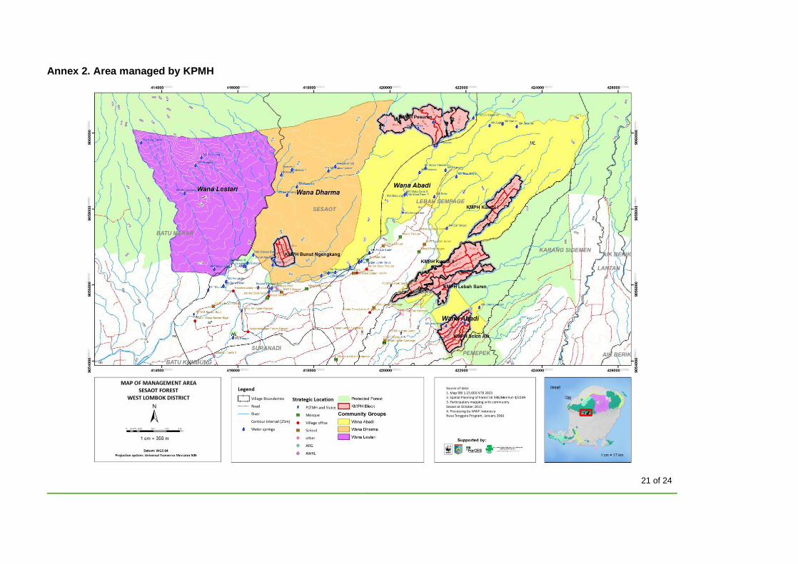
The working area of KMPH in Narmada sub-district covers three sub-villages of West Lombok District, namely Sesaot, Lebah Sempaga, and
Sedau. At Sesaot, the village areas that border the forest, which became the focus of activities, are Sesaot Lauk, Sesaot Daye, Batu Asak, Aik
Nyet, Gubuk Bajur, Pembuwun, Gontoran, Penangke, Repok Temas, and Sambik Baru sub-villages. Lebah Sempage village areas consist of
Lebah Munte, Tatar Lauk, Tatar Daye, Pesantek, Jurang Malang, Kumbi, Pesorongan Jukung, and Lebah Sempage sub-villages. While Sedau
village areas consist of Lembah Suren, Selen Aik, Paok Gading, Sedau Dese, Sedau Gondang, and Eyat Bintang sub-villages. For detailed
information please refer to Annex 2.
To date, Jangkok watershed has eight water springs and seven barrages used for small-scale hydropower. The activities of KMPH in the protected
forest area have positive impacts on forest cover and protect the water catchment area. The water discharge of the river has tended to increase, as
shown by results of monitoring carried out by the community and supported by data from an automatic water-level recorder.
7 of 24
These areas have vital functions in regulating the water (extreme rain) and influencing the availability of the water (especially during the dry
season). Moreover, historical data show that Jangkok watershed frequently experiences extreme rainfall with precipitation of more than 50 mm/day,
and this can cause flood.
Lombok island has 3,490 km2 of potential groundwater basin – 36.83% of the total groundwater basin in West Nusa Tenggara (9,475 km2).
According to groundwater basin and sub-watershed zonation on Lombok island, the Mataram–Selong groundwater basin is located in the
Menganga and Dodokan sub-watersheds, while Tanjung–Sambelia groundwater basin is located at Putih sub-watershed. Jelateng sub-watershed
is not located in a groundwater basin area, as it is located in Aquifer zonation.
Water supply and demand on Lombok island (National Disaster Management Authority, 2016): surface water resources in Lombok island
watershed are 90.18 m3/s, of which 77.50% were utilized for irrigation, 15.72% for domestic purposes (household, and urban uses), 6.61% for
fisheries, and 0.16% for livestock. Demand for freshwater will probably increase in conjunction with population and economic growth. According to
a study by the Ministry of Environment (2007), in 2015 the freshwater availability in Lombok island was still more than the basic demand, with
3,509 million m3 available per year, while the freshwater demand reached 2,519 million m3 in that year. But the water demand has steadily
increased over several decades, as it was just 1,629 million m3 in 1995. At current rates, Lombok could face a water crisis in years to come, if this
trend continues – hence the importance of the KMPH management scheme.
4. Threats to the declared ecosystem service(s) within and outside of the management unit
• Encroachment into protected forest areas by local people outside of the community who convert forest to plantation.
• Illegal logging of timber (trees) that has an impact on forest cover, creating openings and reducing forest canopy.
• Some members of the forest community cleared the forest area without replanting, which can result in an area becoming barren, so it does not
function optimally as a water catchment.
• Tourists visiting the water springs may cause some negative impacts on the watershed (litter may pollute the water and clog channels).
• Forest fires may occur during the dry season, reducing the forest cover.
• Land clearing activities in the forest area at the edge of hillsides can cause soil erosion that may affect the water springs.

8 of 24
5. Description of the methodology used to demonstrate the impact for each selected claim (including more information on baseline
if necessary)
Sustainable forest management has an impact on the improvement of water management in Jangkok watershed and Dodokan sub-watershed.
Reforestation activities conducted by KMPH can improve forest vegetation cover in Sesaot areas.
Increasing forest vegetation provides key functions as forest is a regulator of water flow (stream flow regulator), including maintaining the water flow
during the dry season. Vegetation has an important function as a regulator of groundwater, hydrology, flooding control, and dryness (Marsono,
2008). This function is determined by the structure and composition of the constituent plant communities. Morphological and physiological
characteristics of the plants influence their role in the hydrological system (Klepper, 1991). Physiological characteristics that may affect the water
system are the processes of evapotranspiration, stem transport of water and nutrients, and root absorption of the same. Evapotranspiration affects
the amount of groundwater reserves, especially in regions with low rainfall intensity, or in places with soil and rock properties that cannot store
water (Asdak, 1995).
Julia I. Burton, S.S. Perakis, and K.J. Puettmann (personal communication, 2009) explain that reducing the area of understorey and leaf litter may
increase the erosion up to 2 to 2.5 fold.
Therefore, increasing forest cover simultaneously contributes to maintaining water flow during the dry season and to reducing erosion. These facts
are particularly relevant for the forest areas in KMPH: the area is not flat and a reduction of forest cover may cause a significant increase in erosion,
affecting the quantity and quality of the water. For this reason, a methodology based on the NDVI using satellite images is proposed to demonstrate
an increase in forested area.
The multi-temporal Landsat image was used to assess the vegetation cover. All Landsat images used have same data source, same condition, and
low cloud coverage.
The data used were Landsat 7 image of band 3 / band red (RED) and band 4 / band near infrared (NIR). The near infrared is able to detect
vegetation, while the red band detects land. Landsat 7 is available from 2002 up to the present, while the new Landsat 8 is available from mid-
2013.
NDVI is calculated using the formula:
NDVI = (NIR – RED) / (NIR + RED)
Calculations were by calculator or software in processing of remote sensing. Values are represented in range –1 to +1. NDVI is separated into five
classes:
Class 1: NDVI < 0 Non-vegetation class (water, shadow, and Landsat stripes)
9 of 24
Class 2: NDVI = 0–0.2 Low vegetation (grass, soil, and open land)
Class 3: NDVI = 0.2–0.4 Middle vegetation (forest low density, sauch as shrubs)
Class 4: NDVI = 0.4–0.6 High vegetation (forest middle density)
Class 5: NDVI > 0.6 Very high vegetation (forest high density).
Because the Landsat 7 images have stripes (imperfections in the recording), the area with no data is entered into the classification (class 0). The
striping error from Landsate 7 was corrected and mitigated through focal analysis. The model focal analysis with Median Filter is useful for reducing
noise such as random spikes in data sets, dead sensor striping, and other impulse imperfections in any type of image. It is also useful for
enhancing thematic images. This method is designed to modify neighbouring pixels in a single Landsat 7 SLC-off scene, creating a final aesthetic
image, so the stripe area can have a digital number derived from comparison with neighbouring pixels. Class vegetation index or NIR is derived
from the reflection of green leaves in the process of photosynthesis. Ideally, the green colour produced by photosynthesis comes from vascular
plants and vascular plants with cambium tissues. In general, the composition of forest is dominated by vascular plants (Campbell et al., 2010):
NDVI classifies land cover based on the green colour, so the higher the value, the greener the area. Greener areas are associated with denser
forests (Huete et al., 2011). NDVI also enables estimation of several vegetation parameters such as leaf index and biomass. High levels of such
parameters can be expected for the class division of forest vegetation (Yang et al., 1998; Liliesand and Kiefer, 1990). In addition, a ground check
was conducted to ascertain the actual condition of the forests.
The temporal series of data used were: Landsat 7 Path 116/66 of 22 April 2009 (as baseline), Landsat 7 Path 116/66 of 30 April 2012, Landsat 7
Path 116/66 of 20 April 2014, and Landsat 7 Path 116/66 of 25 April 2016.
The technical process is:
• Download the image series in open source from http://usgs.glovis.gov/
• Combine the RED and NIR bands for processing the layer stack
• Process to produce a raster image and raster NDVI values by using ERDAS software
• Cut (clip) the study areas with the boundary of Sesaot and KMPH areas
• Make classification (reclassification) of NDVI values into the five classes
• Convert raster to polygon, raster to vector data
• Repeat the same process for another series each year
• Combine (union) the four data into data series based on year
• Analyse the extent of each class and change each data series to generate data tables.
10 of 24
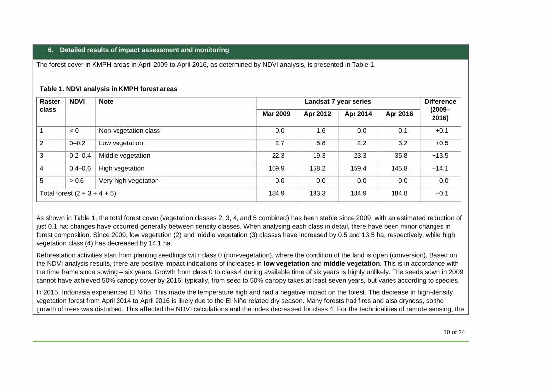
6. Detailed results of impact assessment and monitoring
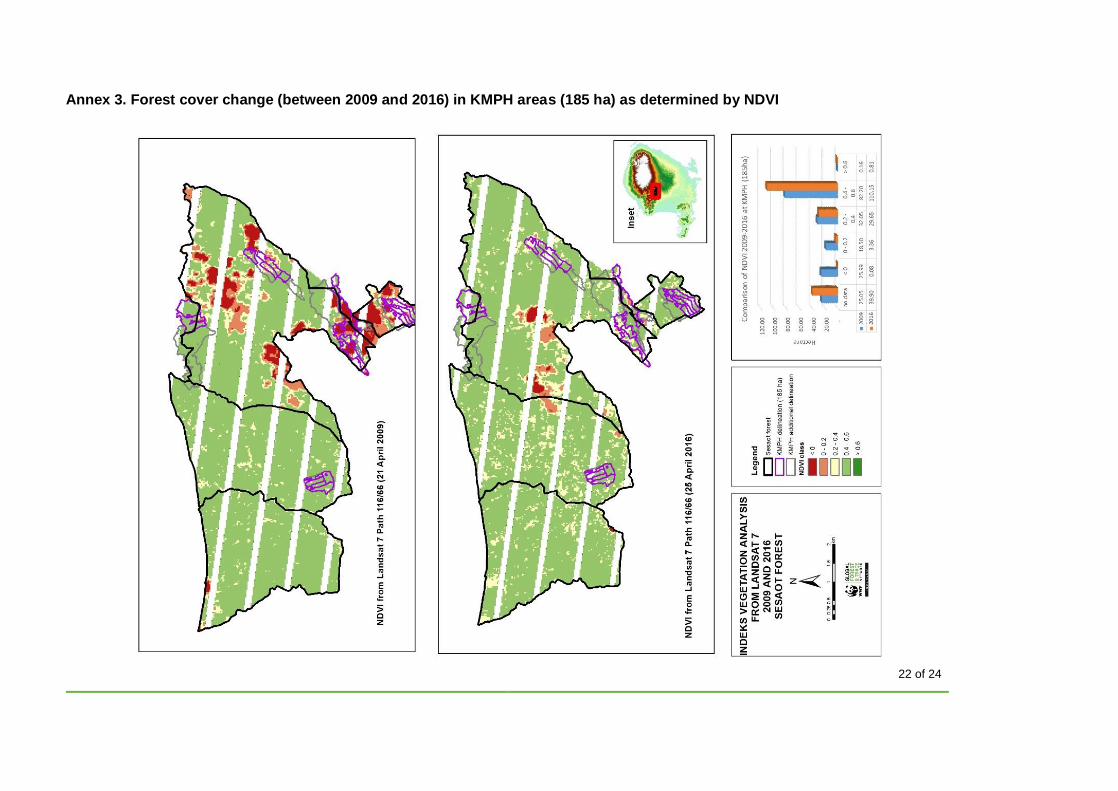
The forest cover in KMPH areas in April 2009 to April 2016, as determined by NDVI analysis, is presented in Table 1.
Table 1. NDVI analysis in KMPH forest areas
Raster
class
NDVI Note Landsat 7 year series Difference
(2009–
2016) Mar 2009 Apr 2012 Apr 2014 Apr 2016
1 < 0 Non-vegetation class 0.0 1.6 0.0 0.1 +0.1
2 0–0.2 Low vegetation 2.7 5.8 2.2 3.2 +0.5
3 0.2–0.4 Middle vegetation 22.3 19.3 23.3 35.8 +13.5
4 0.4–0.6 High vegetation 159.9 158.2 159.4 145.8 –14.1
5 > 0.6 Very high vegetation 0.0 0.0 0.0 0.0 0.0
Total forest (2 + 3 + 4 + 5) 184.9 183.3 184.9 184.8 –0.1
As shown in Table 1, the total forest cover (vegetation classes 2, 3, 4, and 5 combined) has been stable since 2009, with an estimated reduction of
just 0.1 ha: changes have occurred generally between density classes. When analysing each class in detail, there have been minor changes in
forest composition. Since 2009, low vegetation (2) and middle vegetation (3) classes have increased by 0.5 and 13.5 ha, respectively; while high
vegetation class (4) has decreased by 14.1 ha.
Reforestation activities start from planting seedlings with class 0 (non-vegetation), where the condition of the land is open (conversion). Based on
the NDVI analysis results, there are positive impact indications of increases in low vegetation and middle vegetation. This is in accordance with
the time frame since sowing – six years. Growth from class 0 to class 4 during available time of six years is highly unlikely. The seeds sown in 2009
cannot have achieved 50% canopy cover by 2016; typically, from seed to 50% canopy takes at least seven years, but varies according to species.
In 2015, Indonesia experienced El Niño. This made the temperature high and had a negative impact on the forest. The decrease in high-density
vegetation forest from April 2014 to April 2016 is likely due to the El Niño related dry season. Many forests had fires and also dryness, so the
growth of trees was disturbed. This affected the NDVI calculations and the index decreased for class 4. For the technicalities of remote sensing, the
11 of 24
long dry season is not optimal as leaves are not in their best (reflective) condition to estimate canopy of forest stratification; the dry season affects
the ability of leaves to reflect light, which may cause the forest to appear less dense in satellite imagery.
Part 2: Management information
1. Name of the Organization
Kelompok Masyarat Pelestari Hutan (KMPH) (forest conservation communities) Mitra Sesoat
This project is associated with FSC Forest Management certificate SCS-FM-005890, under the FSC Harmonised Certification Bodies’ Forest
Stewardship Standard for the Republic of Indonesia (V1.0).
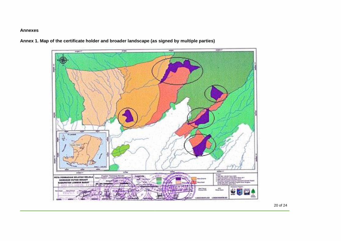
2. Location of the management unit
According to the administration, the management area of KMPH is in Sedau, Lebag Sempage, Pakuan, and Sesoat vilages, West Lombok District,
West Nusa Tenggara Province, Indonesia.
See Annex 1 for a map of the management area.
3. Type of certification
Please tick all the options that apply to the management unit:
Size:
Large scale Conventional SLIMF (small and low-intensity managed forest)
Type of organization certified:
Individual Private company Public organization Indigenous Peoples Local communities Management group
12 of 24
4. Characteristics of the certificate
Please give the following information:
Management unit area (in hectares): 185 ha
Number of members (if applicable): N/A
FSC Certificate Code: Associated FSC Forest Management certificate SCS-FM-005890 with FSC Forest Management Licence code FSC-C134304
First issue date: 27 February 2017
Last issue date: 27 February 2017
Expiry date: 26 February 2022
5. Organization contact information
Please provide relevant contact information:
Email:
Postal address: KM 13 of Pengkoak street, Pakuan village, West Lombok District, Nusa Tenggara Barat Province, Indonesia
Telephone number: +62 81805296041
Contact name: Rahman, Chairman of KMPH
6. Legal tenure to manage and/or use the forest, or other legal right to receive payments for declared ecosystem services
In accordance with decree No. IUPHKm 445 / Menhut-II / 2009, dated 4 August 2009, KMPH obtained the legal right to manage an area of 185 ha
of forests to protect the forest as the forest community group Sesaot RTK.1 Rinjani. KMPH obtained the licence from the Ministry of Forestry to
manage the area with restoration activities. Under its licence, KMPH does not have permission to cut down trees, only to plant trees and collect
NTFPs (including fruits).
13 of 24
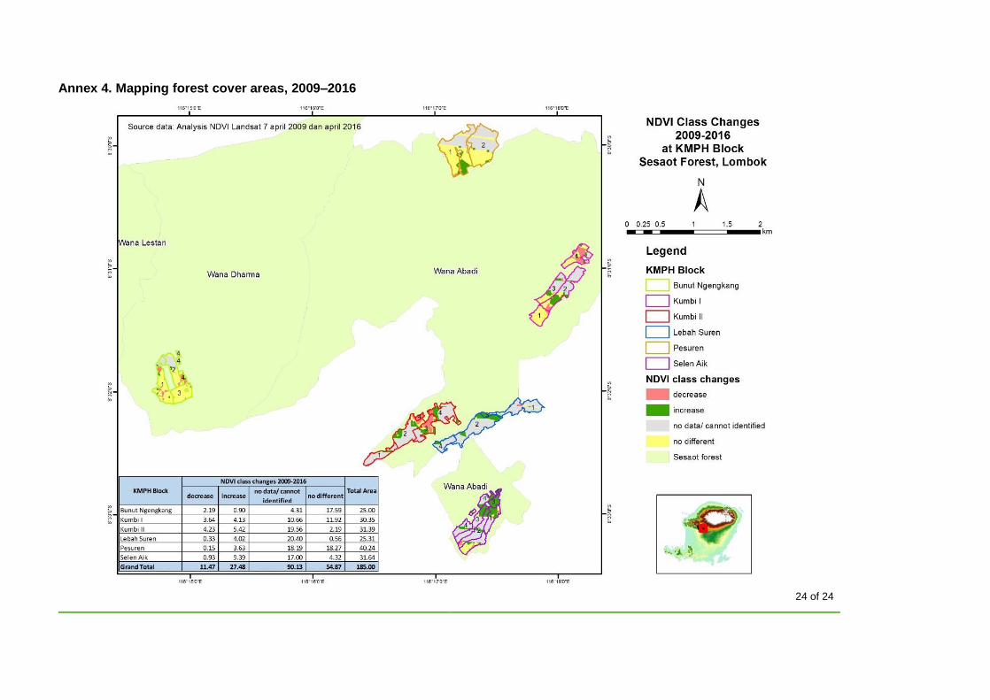
The management area is divided into six regions with 37 large blocks. Bunung Ngengkang consists of five blocks; Pesuren area consists of six
blocks; Pesorongan area consists of nine blocks; Kumbi II area consists of six blocks; Lebah Suren area consists of six blocks; and Selen Aik area
consists of six blocks.
In practice, the forest community has activities in over 3,587 ha with four forest community groups (KMPH, Wana Abadi, Wana Lestari, and Wana
Dharma); however, only KMPH (with 185 ha, mentioned above) has obtained legality for its management. The other communities are working
together with the authorities to obtain the legal management rights over the entire area (3,587 ha); however, this process may take some years.
7. List of communities and other organizations involved in activities related to the declared ecosystem service(s)
• NGOs Fauna & Flora International (FFI), and SAMANTA Foundation (Yayasan Masyarakat Nusa Tenggara), and multi-party institutions are
working in collaboration; they are strategic partners in the field and contributed to the Payment for Ecosystem Services (PES) implementation
campaign to all stakeholders.
• Local governments (district and provincial) are strategic partners to implement regional policy and to help encourage the implementation of PES
at national level. In addition, local governments have the important role of strengthening multi-party institutions, which is one of the main types of
organization supporting Lombok PES.
• Development Planning Agency at subnational level, Forestry agency, Public Infrastructure agency, Geology agency, heads of villages (Sesaot,
Sedahu, Pakuan, and Lebah Sepage).
• Ministry of Forestry (MoF): Indirect role – MoF supported lobbying at the national level. It is pushing regulations related to ecosystem services.
One of the main regulations driven is Peraturan Pemerintah (goverment regulations) economic instruments developed from the success of PES
implementation in Lombok.
• Forest management units of government (KPHL of West Rinjani): Some part of the management area of KMPH is located within the KPHL of
West Rinjani. We hope we can implement collaboration to manage the KPHL area (forest community has a plan to scale up the management
area). By this scheme, we hope to decrease social conflict with the local community.
• PDAM (local government water company) is helping and supporting the implementation of the PES scheme on Lombok island. PDAM is also
helping to collect the PES funds from the urban people (in the city).
14 of 24
8. Summary of culturally appropriate engagement with Indigenous Peoples and local communities, related to the declared
ecosystem service(s) – including ecosystem services access and use, and benefit sharing – consistent with FSC
Principles 3 and 4
The local community conducted restoration activities in the upper forest. These activities had positive impact in producing clean water for the local
city. Before this scheme was implemented on Lombok island, the parliament and local government did not support PES, because in the regulation it
is not permitted to collect funds for environmental services. This situation encouraged local communities to re-think the restoration of the large area.
But, the local community only focused on forest conservation rather than clean water. However, the restoration activities conducted by the forest
community in the upper forest area can bring positive impact on the water discharge.
Who is getting benefit from ecosystem services? Local community in around of forest and people in Mataram city. Most local people in the
villages in and around the forest are the members of forest community (KMPH).
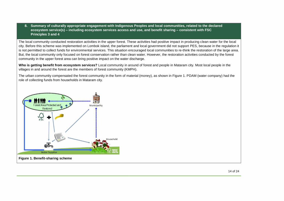
The urban community compensated the forest community in the form of material (money), as shown in Figure 1. PDAM (water company) had the
role of collecting funds from households in Mataram city.
Figure 1. Benefit-sharing scheme
15 of 24
This process took from 2004 to 2006 to get approval from parliament and government. And then, in 2007, the Regent of West Lombok released the
regulation on PES, Peraturan Daerah Kabupaten Lombok Barat No. 4 tahun 2007 Tentang Jasa Lingkungan (Local Regulation of West Lombok
Regency No. 4 year 2007 concerning Payment for Environment Services in West Lombok). The regulation has had positive impact: the government
in Mataram city has commited to give funds in the amount of IDR500 million per year as PES.
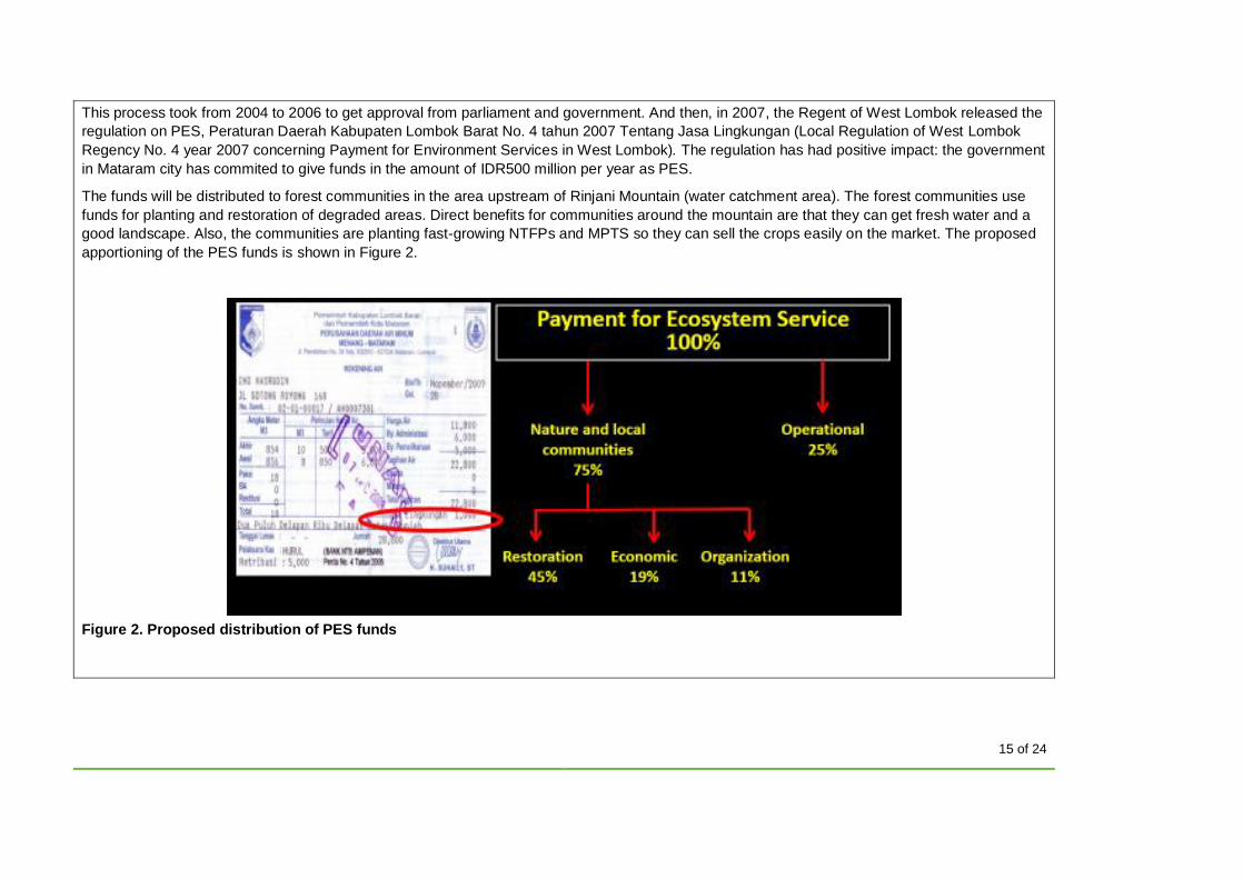
The funds will be distributed to forest communities in the area upstream of Rinjani Mountain (water catchment area). The forest communities use
funds for planting and restoration of degraded areas. Direct benefits for communities around the mountain are that they can get fresh water and a
good landscape. Also, the communities are planting fast-growing NTFPs and MPTS so they can sell the crops easily on the market. The proposed
apportioning of the PES funds is shown in Figure 2.
Figure 2. Proposed distribution of PES funds
16 of 24
Figure 2 shows the proportional distribution of funds from ecosystem service (water): 75% goes to the forest community, with 45% for planting
(restoration activity), 19% for socio-economic projects in the local community, and 11% for capacity-building of the forest community. Funds
collected by the water company (PDAM) must be sent to IMP (multi-party institution) for distribution to the communities.
The benefit-sharing mechanism has been implemented for restoration activities by the forest community. The community and villages around the
forest area have been compensated. This process is a part of free, prior, and informed consent (FPIC) – the community always keeps all parties
(directly and indirectly) involved informed. The FPIC process has been conducted by KMPH and IMP, and included information about funding and
activities. Because these activities did not bring negative impact to the local community, they were considered acceptable. To ensure that the
benefit-sharing mechanism is implemented, FPIC is still bring conducted by KMPH. The process is dynamic: in the future it may need to be revised;
development of the mechanism depends on the socio-demographic condition in each village.
9. A description of management activities to reduce the threats to declared ecosystem services within and outside of the
management unit
• Encroachment into protected forest areas by local people outside of the community who convert forest to plantation.
Activities to mitigate threat:
o Cooperate with relevant parties, such as forestry agency, law enforcement officers of national park, police, and CSOs, for joint patrols and monitoring
o Make rules or agreements with all partner parties (as above) with guidelines for managing agroforestry in the forest area o Disseminate regulations that forbid management of the protected area by the public and local community o Place a prohibition notice on converting protected forest areas on the information board.
• Illegal logging of timber (trees) that has an impact on forest cover, creating openings and reducing forest canopy.
Activities to mitigate threat:
o Police and KMPH conduct joint patrols and monitoring in the KMPH areas o Provide information on the government regulation that prohibits illegal logging by local communities o Place a notice of the prohibition of illegal logging with the attributable punishment on the information board.
17 of 24
• Some members of the forest community cleared the forest area without replanting, which can result in an area becoming barren, so it does not
function optimally as a water catchment.
Activities to mitigate threat:
o Map the forest areas that was cleared and then hold discussion meetings with forest owners and KMPH members o Identify the location of cleared areas to be planted through funding proposal by IMP.
• Tourists visiting the water springs may cause some negative impacts on the watershed (litter may pollute the water and clog channels).
Activities to mitigate threats:
o Prepare appropriate litter disposal facilities o Place a notice of the prohibition of littering on the information board o Appoint a warden for the tourist area in collaboration with communities and tour operators.
• Forest fires may occur during the dry season, reducing the forest cover.
Activities to mitigate threats:
o Teach local communities not to burn the forest areas or light fires carelessly, especially in the dry season o Patrol and monitor together with all the parties involved o Establish voluntary group for fire monitoring around villages and forest area o Put information about forest areas susceptible to forest fire on the information board.
• Land clearing activities in the forest area at the edge of hillsides can cause soil erosion that may affect the water springs.
Activities to mitigate threats:
o Establish rules to prevent soil erosion on the hillside areas in agreement with the community o Ensure forest community is aware that it must plant MPTS on hillside areas o Establish coordination and cooperation with research institutes related to soil survey o Conduct monitoring of land and forest cover in the eroded area.
18 of 24
References
Asdak, C. (1995) Hydrology and Managed the Watershed. University of Gadjah Mada, Yogyakarta.
Campbell, N.A., Reece, J.B., Taylor, M.R., Dickey, J.L., and Simon, E.J. (2010) Biology: Concepts and Connections, 6th Edn. Benjamin-
Cummings, San Francisco.
Huete, A., Didan, K., Leeuwen, W.V., Miura, T., and Glenn, E. (2011) MODIS Vegetation Indices. Land Remote Sensing and Global
Environmental Change. Springer, New York.
Klepper, B. (1991) Root–shoot relationships. In: Waisel, Y., Eshel, A., and Kafkafi, U. (eds) Plant Roots: The Hidden Half. Marcel
Dekker, New York.
Liliesand, T.M., and Kiefer, R.W. (1990) Penginderaan Jauh dan Interpretasi Citra.Terjemahan dari: Remote Sensing and Image
Interpretation. Gadjah Mada University Press, Yogyakarta.
Markum, Arisoesilaningsih, E., Suprayogo, D., and Hairiah, K. (2013) Plant species diversity in relation to carbon stocks at Jangkok
watershed, Lombok Island. Bogor. Agrivita 35(3): 207–217.
Marsono, D. (2008) Keharusan Basis Ekosistem dalam Pengelolaan Hutan dan Lahan. Pidato Dies Natalis Fakultas Kehutanan UGM
ke-45 tanggal 7 November 2008. Yogyakarta.
Ministry of Environment (2007) Data Keseimbangan Ketersediaan dan kebutuhan Air per Pulau di Indonesia. Kementerian Lingkungan
Hidup, Jakarta.
National Disaster Management Authority (2016) Data dan Informasi Bencana Indonesia. Badan Nasional Penanggulangan Bencana,
Jakarta.
Yang, L., Wylie, B.K., Tieszen, L.L., and Reed, B.C. (1998) An analysis of relationships among climate forcing and time-integrated NDVI
of grasslands over the U.S. northern and central Great Plains. Remote Sensing of Environment 65: 25–37.
The following referenced documents are relevant for the application of this document. For references with specific version, only the
edition cited applies. For other references, the latest edition of the referenced document (including any amendments) applies.
FSC-STD-01-001 V5-2 FSC Principles and Criteria for Forest Stewardship
19 of 24
FSC-STD-01-002 Glossary of Terms
FSC-STD-50-001 Requirements for use of the FSC Trademarks by Certificate Holders
FSC-STD-60-004 International Generic Indicators (IGI)
FSC-PRO-30-002 Demonstrating the Impact of Forest Stewardship on Ecosystem Services (field testing draft)
FSC-PRO-60-006 Development and Transfer of National Forest Stewardship Standards to the FSC Principles and Criteria Version 5-1
FSC-GUI-xx-xxx Maintaining and Enhancing Ecosystem Services (under development)
Terms and Definitions
For the purposes of this template, the terms and definitions given in FSC-STD-01-002 Glossary of Terms, FSC-STD-01-001 FSC
Principles and Criteria for Forest Stewardship, and FSC-STD-60-004 International Generic Indicators are used.
20 of 24
Annexes
Annex 1. Map of the certificate holder and broader landscape (as signed by multiple parties)
21 of 24
Annex 2. Area managed by KPMH
22 of 24
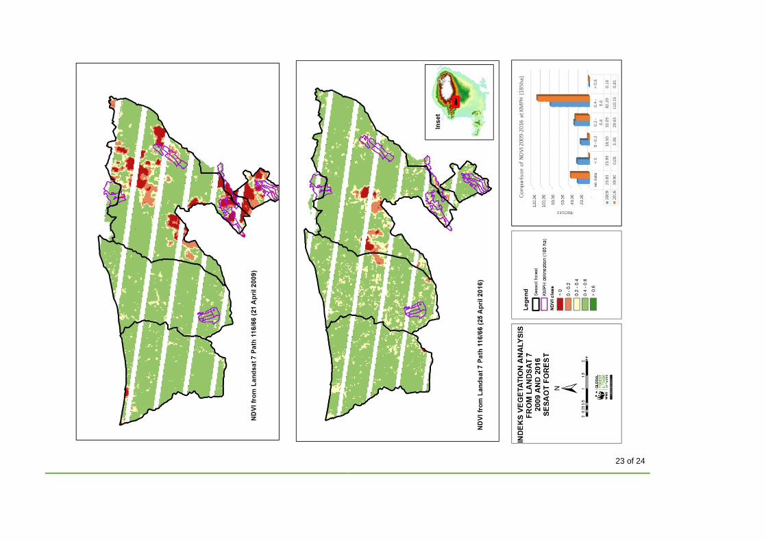
Annex 3. Forest cover change (between 2009 and 2016) in KMPH areas (185 ha) as determined by NDVI
23 of 24
24 of 24
Annex 4. Mapping forest cover areas, 2009–2016